Embed Size (px)
Citation preview
The Geodetic Infrastructure Management via Web–Based Mapping Technology in Morocco, (6979) Moha El-Ayachi, Khalid El Hajari, Said Alaoui and Omar Jellabi (Morocco) FIG Congress 2014 Engaging the Challenges – Enhancing the Relevance Kuala Lumpur, Malaysia 16-21 June 2014
1/7
The Geodetic Infrastructure Management Via Web-Based Mapping Technology in Morocco
Moha EL-AYACHI, Khalid EL HAJARI, Said ALAOUI, and Omar JELLABI,
Morocco
Key words: infrastructure, web mapping, governance, dissemination SUMMARY The value of the web mapping technology is to illustrate for the professionals and customer the effective way on the quick dissemination and sharing of collected data. The geodetic infrastructure is a backbone of spatial data related to various projects such as cartography, cadastre, territorial management, navigation, and urbanism. For many surveyors, the traditional ways of managing the geodetic infrastructure is time and cost consuming. This paper has the goal to establish an analysis of the value of the web-based mapping technology in the improvement of the geodetic infrastructure for professionals in Morocco. A study of the current circumstances has been carried out to be aware of the real shortcoming that causes delays in many development projects. An online user friendly platform has been designed and developed to meet the new requirements in terms of spatial data integration, information sharing and dissemination, and metadata generating. The new solution will be discussed to assess the benefit of such product in the enhancement of the geodetic infrastructure management.
The Geodetic Infrastructure Management via Web–Based Mapping Technology in Morocco, (6979) Moha El-Ayachi, Khalid El Hajari, Said Alaoui and Omar Jellabi (Morocco) FIG Congress 2014 Engaging the Challenges – Enhancing the Relevance Kuala Lumpur, Malaysia 16-21 June 2014
2/7
The Geodetic Infrastructure Management Via Web-Based Mapping Technology in Morocco
Moha EL-AYACHI, Khalid EL HAJARI, Said ALAOUI, and Omar JELLABI,
Morocco 1. INTRODUCTION The Moroccan geodetic infrastructure goes back to the first decade of twentieth century when there was a need for conducting quick mapping activities. The earlier geodetic network went back to the first decade of the twentieth century (El Fettah, 2003). The existing geodetic infrastructure knows a series of shortcoming linked to the deterioration of monuments, weak maintenance, and to the multiplicity of more local systems for some surveying purposes. The GNSS technique could be used but at limited level because of the heterogeneity of the former network frames. Thus, it is necessary to set up ground control point as reference stations to various planning project such as infrastructure engineering, mapping, cadastral surveys, and navigational purposes. The choice of these reference stations is time consuming and has a direct impact on the quality of conducted operations on the field. Surveyors are facing challenges to perform the main tasks of the local geodetic infrastructure densification. They need to easily select suitable location for the new geodetic points; which shall serve as tied references. The traditional paper based approaches of designing a local geodetic densification is evolving into a digital era that enables taking benefits of the new web mapping based technologies. Nowadays, many private surveying companies express several real needs and considerable requirements on the opportunities of evaluating the web-based mapping technology in the improvement of the geodetic infrastructure management in Morocco. A study of the current circumstances has been carried out to be aware of the real shortcoming that causes delays in many development projects. An online user friendly platform has been designed and developed to meet the new requirements in terms of spatial data integration, information sharing and dissemination, and metadata generating. The new solution is discussed to assess the benefit of such product in the enhancement of the geodetic infrastructure management within a private professional enterprise. 2. MATERIAL AND METHODS 2.1 Functional Architecture In order to achieve this study, it is required to adopt a series of tools that enable developing a friendly user platform facilitating the management of the geodetic infrastructure. An 3-tiers logic architecture has been adopted. The spatial data are merged in the server tier for managing the spatial database using PostgreSQL and its spatial module PostGIS. The logic tier is based on the Apache web server and the MapGuide open source as cartographic server. Free software called MapGuide Maestro is also adopted to enable preparing geospatial data and integrating them in the web (Rogozhnikova, 2011; Ijjouk, 2012). The MapGuide as a cartographic server functioning is utilized a service to access to data within the server or to
The Geodetic Infrastructure Management via Web–Based Mapping Technology in Morocco, (6979) Moha El-Ayachi, Khalid El Hajari, Said Alaoui and Omar Jellabi (Morocco) FIG Congress 2014 Engaging the Challenges – Enhancing the Relevance Kuala Lumpur, Malaysia 16-21 June 2014
3/7
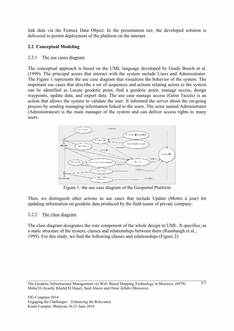
link data via the Feature Data Object. In the presentation tier, the developed solution is delivered to permit deployment of the platform on the internet. 2.2 Conceptual Modeling 2.2.1 The use cases diagram The conceptual approach is based on the UML language developed by Grady Booch et al. (1999). The principal actors that interact with the system include Users and Administrator. The Figure 1 represents the use case diagram that visualizes the behavior of the system. The important use cases that describe a set of sequences and actions relating actors to the system can be identified as Locate geodetic point, find a geodetic point, manage access, design waypoints, update data, and export data. The use case manage access (Gérer l'accés) is an action that allows the system to validate the user. It informed the server about the on-going process by sending managing information linked to the users. The actor named Administrator (Administrateur) is the main manager of the system and can deliver access rights to many users.
Figure 1: the use case diagram of the Geoportal Platform
Then, we distinguish other actions as use cases that include Update (Mettre à jour) for updating information on geodetic data produced by the field teams of private company. 2.2.2 The class diagram
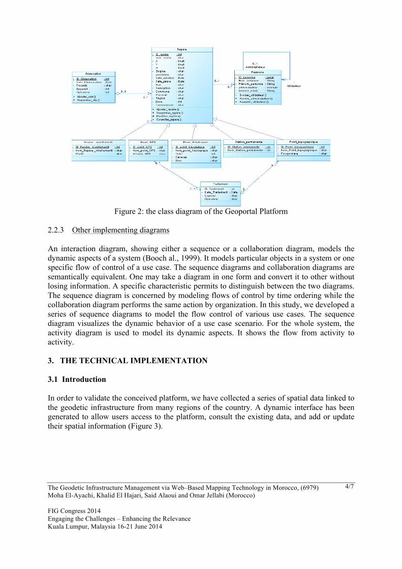
The class diagram designates the core component of the whole design in UML. It specifies, as a static structure of the system, classes and relationships between them (Rumbaugh et al., 1999). For this study, we find the following classes and relationships (Figure 2):
The Geodetic Infrastructure Management via Web–Based Mapping Technology in Morocco, (6979) Moha El-Ayachi, Khalid El Hajari, Said Alaoui and Omar Jellabi (Morocco) FIG Congress 2014 Engaging the Challenges – Enhancing the Relevance Kuala Lumpur, Malaysia 16-21 June 2014
4/7
Figure 2: the class diagram of the Geoportal Platform
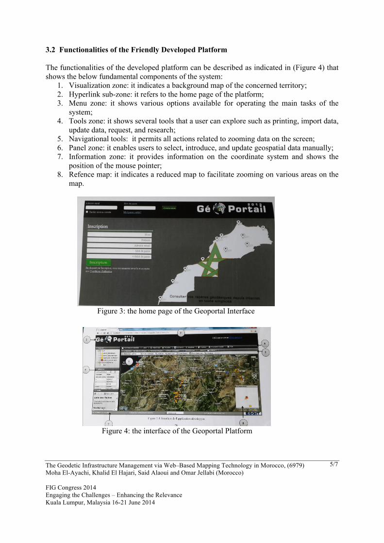
2.2.3 Other implementing diagrams An interaction diagram, showing either a sequence or a collaboration diagram, models the dynamic aspects of a system (Booch al., 1999). It models particular objects in a system or one specific flow of control of a use case. The sequence diagrams and collaboration diagrams are semantically equivalent. One may take a diagram in one form and convert it to other without losing information. A specific characteristic permits to distinguish between the two diagrams. The sequence diagram is concerned by modeling flows of control by time ordering while the collaboration diagram performs the same action by organization. In this study, we developed a series of sequence diagrams to model the flow control of various use cases. The sequence diagram visualizes the dynamic behavior of a use case scenario. For the whole system, the activity diagram is used to model its dynamic aspects. It shows the flow from activity to activity. 3. THE TECHNICAL IMPLEMENTATION 3.1 Introduction In order to validate the conceived platform, we have collected a series of spatial data linked to the geodetic infrastructure from many regions of the country. A dynamic interface has been generated to allow users access to the platform, consult the existing data, and add or update their spatial information (Figure 3).
The Geodetic Infrastructure Management via Web–Based Mapping Technology in Morocco, (6979) Moha El-Ayachi, Khalid El Hajari, Said Alaoui and Omar Jellabi (Morocco) FIG Congress 2014 Engaging the Challenges – Enhancing the Relevance Kuala Lumpur, Malaysia 16-21 June 2014
5/7
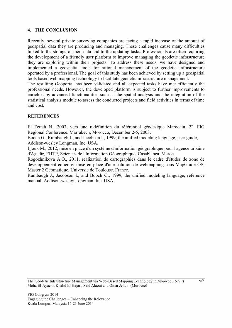
3.2 Functionalities of the Friendly Developed Platform The functionalities of the developed platform can be described as indicated in (Figure 4) that shows the below fundamental components of the system:
1. Visualization zone: it indicates a background map of the concerned territory; 2. Hyperlink sub-zone: it refers to the home page of the platform; 3. Menu zone: it shows various options available for operating the main tasks of the
system; 4. Tools zone: it shows several tools that a user can explore such as printing, import data,
update data, request, and research; 5. Navigational tools: it permits all actions related to zooming data on the screen; 6. Panel zone: it enables users to select, introduce, and update geospatial data manually; 7. Information zone: it provides information on the coordinate system and shows the
position of the mouse pointer; 8. Refence map: it indicates a reduced map to facilitate zooming on various areas on the
map.
Figure 3: the home page of the Geoportal Interface
Figure 4: the interface of the Geoportal Platform
The Geodetic Infrastructure Management via Web–Based Mapping Technology in Morocco, (6979) Moha El-Ayachi, Khalid El Hajari, Said Alaoui and Omar Jellabi (Morocco) FIG Congress 2014 Engaging the Challenges – Enhancing the Relevance Kuala Lumpur, Malaysia 16-21 June 2014
6/7
4. THE CONCLUSION Recently, several private surveying companies are facing a rapid increase of the amount of geospatial data they are producing and managing. These challenges cause many difficulties linked to the storage of their data and to the updating tasks. Professionals are often requiring the development of a friendly user platform to improve managing the geodetic infrastructure they are exploring within their projects. To address these needs, we have designed and implemented a geospatial tools for rational management of the geodetic infrastructure operated by a professional. The goal of this study has been achieved by setting up a geospatial tools based web mapping technology to facilitate geodetic infrastructure management. The resulting Geoportal has been validated and all expected tasks have met efficiently the professional needs. However, the developed platform is subject to further improvements to enrich it by advanced functionalities such as the spatial analysis and the integration of the statistical analysis module to assess the conducted projects and field activities in terms of time and cost. REFERENCES El Fettah N., 2003, vers une redéfinition du référentiel géodésique Marocain, 2nd FIG Regional Conference. Marrakech, Morocco, December 2-5, 2003. Booch G., Rumbaugh J., and Jacobson I., 1999, the unified modeling language, user guide, Addison-wesley Longman, Inc. USA. Ijjouk M., 2012, mise en place d'un système d'information géographique pour l'agence urbaine d'Agadir, EHTP, Sciences de l'Information Géographique, Casablanca, Maroc. Rogozhnikova A.O., 2011, realization de cartographies dans le cadre d'études de zone de développement éolien et mise en place d'une solution de webmapping sous MapGuide OS, Master 2 Géomatique, Universié de Toulouse. France. Rumbaugh J., Jacobson I., and Booch G., 1999, the unified modeling language, reference manual. Addison-wesley Longman, Inc. USA.
The Geodetic Infrastructure Management via Web–Based Mapping Technology in Morocco, (6979) Moha El-Ayachi, Khalid El Hajari, Said Alaoui and Omar Jellabi (Morocco) FIG Congress 2014 Engaging the Challenges – Enhancing the Relevance Kuala Lumpur, Malaysia 16-21 June 2014
7/7
BIOGRAPHICAL NOTES CONTACTS Moha EL-AYACHI, Professor & EL HAJARI Khalid, PhD Student, Tel: +212662124657, [email protected] Institute of Agronomy and Veterinary Medecine Department of Geodetic Sciences, Rabat, Morocco Said ALAOUI, Surveying Engineer Private Company Temara, Morocco Omar JELLABI, Licensed surveyor Service of Cadastre Morocco