Embed Size (px)
Citation preview
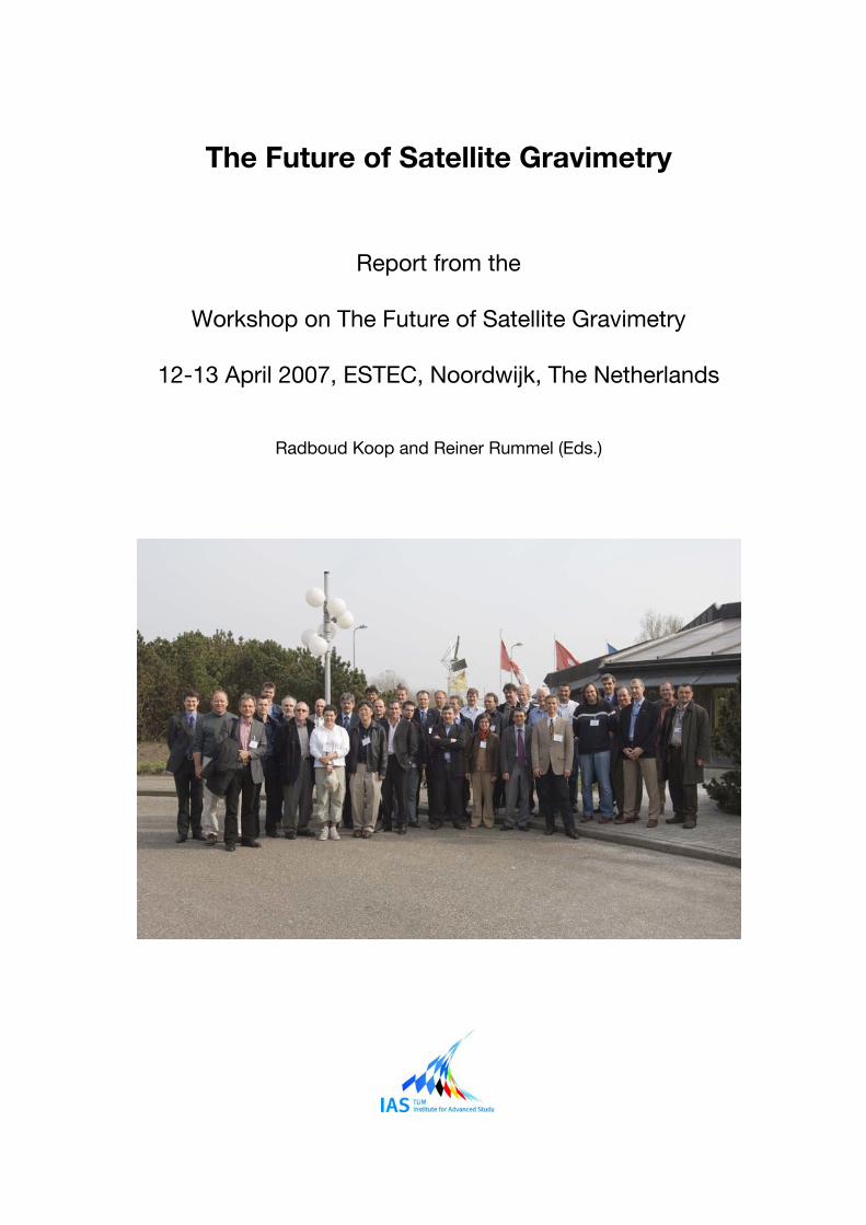
The Future of Satellite Gravimetry
Report from the
Workshop on The Future of Satellite Gravimetry
12-13 April 2007, ESTEC, Noordwijk, The Netherlands
Radboud Koop and Reiner Rummel (Eds.)
Workshop on the Future of
Satellite Gravimetry Final Report
2/27/2008
Page 1 of 21
The Future of Satellite Gravimetry
Report from the
Workshop on The Future of Satellite Gravimetry
12-13 April 2007, ESTEC, Noordwijk, The Netherlands
Radboud Koop and Reiner Rummel (Eds.)
Workshop on the Future of
Satellite Gravimetry Final Report
2/27/2008
Page 2 of 21
Table of Contents
1 Resolutions ........................................................................................................................................3
2 Introduction........................................................................................................................................4
3 Geophysical Applications ..................................................................................................................6
4 Separability and de-aliasing ............................................................................................................11
5 Future Mission Concepts.................................................................................................................15
6 Candidate Technology.....................................................................................................................17
7 Appendix 1: List of Participants ......................................................................................................20
8 Appendix 2: Abbreviations and Acronyms ......................................................................................21
Editors information: Dr. Radboud Koop Until 01/07/2007 at SRON Netherlands Institute for Space Research From 01/07/2007 at NIVR Netherlands Agency for Aerospace Programmes Email: [email protected] Prof. Dr. Reiner Rummel Institute for Astronomical and Physical Geodesy, Technische Universität München Email: [email protected] Acknowledgement: Printing of this report kindly was supported by the Technische Universität München, Institute for Advanced Study
Workshop on the Future of
Satellite Gravimetry Final Report
2/27/2008
Page 3 of 21
1 Resolutions
On 12-13 April 2007 an International Workshop on The Future of Satellite Gravimetry took place at
ESA/ESTEC, Noordwijk, The Netherlands. About 50 leaders from Earth sciences, fundamental physics
and technology related to the field of satellite gravimetry participated. In a unanimous vote the
workshop participants came to the following recommendations:
1 GRACE is demonstrating very successfully to provide monthly time series of changes in the
Earth’s gravity field. This adds a new – and very central – parameter set to the study of Global
Change phenomena such as deglaciation in the large ice shields of Antarctica and Greenland
or the variations of the global water cycle.
2 GOCE – to be launched 2008 – is expected to deliver the global static gravity field and geoid
with unprecedented precision and spatial resolution. It will in particular serve as reference for
global ocean circulation studies by altimetry.
3a In view of science achievements and the current performance of GRACE the participants of the
workshop strongly support the idea of a GRACE follow-on mission based on the present
configuration, with emphasis on the uninterrupted continuation of time series of global gravity
changes. This should be short-term (Launch ~2011 TBD) priority one.
3b In parallel, investigations into the reduction of the aliasing problem offers even greater science
benefits by increased spatial resolution and accuracy and should therefore have high priority.
4 Medium term priority should be focused on higher precision and higher resolution in space and
time. This step requires (1) the reduction of the current level of aliasing (of high frequency
phenomena, in particular tides, into the time series), (2) the elimination of systematic distortions
(caused by the peculiar non-isotropic sensitivity of a single pair low-low SST), and (3) the
improvement of the separability of the observed geophysical signals.
Elements of a strategy in this direction are configuration flights, multi-satellite systems,
improved data processing methodologies and improved and comprehensive Earth System
modeling.
This will open the door to a more efficient use of improved sensor systems, such as optical
ranging systems, quantum gravity sensors, and active angular and drag-free control.
5 The long term strategy should include the gravimetric use of advanced clocks (ground based
and flying clocks), micro-satellite systems, and space-qualified quantum gravity sensors.
6 The participants of the workshop support the activities and developments towards a future
satellite gravity mission.
7 The workshop results will be offered to national and international space agencies and other
relevant institutions.
8 The initiative will be taken to set up an international steering/working group or platform to
coordinate the future activities and actions in this field.
9 Links between the geodetic and Earth science community with the communities from
fundamental physics will be strengthened and/or established.
Workshop on the Future of
Satellite Gravimetry Final Report
2/27/2008
Page 4 of 21
2 Introduction
By Radboud Koop and Reiner Rummel
With CHAMP and GRACE successfully in operation and with the GOCE launch shortly ahead,
remarkable progress in scientific fields exploiting the strongly improved global gravity field knowledge
is currently being made.
At the same time new and improved technologies – like laser metrology, accelerometry, position
sensing, micro-propulsion systems – are currently under development, most noticeable related to the
LISA, LISA Pathfinder, GRACE follow-on and Laser Doppler Interferometry (LDI) mission proposals.
Although the technologies to be implemented in a future gravity mission are still subject of ongoing
discussion, development and selection, it can be expected (and it is actually the aim to achieve) that
the data coming from such a mission will be of very high quality, having a very high spatial and
temporal resolution and a very high accuracy.
Major achievements in the fields of hydrology, solid Earth geophysics, oceanography, glaciology and
geodesy are within reach as the user community exploits these data to the fullest extent possible.
Over the years the scientific community has clearly identified what are the most important
requirements for future progress in this field, related to geoscientific modeling, data processing,
analysis, methodology and interpretation. This includes questions related to topics like the separation
of geophysical signals in the gravity data, temporal and spatial de-aliasing, availability of
complementary data and models, etc.
This challenging scientific progress is a necessary step towards the definition of realistic scientific and
mission requirements for a future gravity mission. The establishment of such requirements, that are to
be aligned with the system and sub-system requirements, is a natural starting point for the preparation
of a mission proposal.
It is clear that the chances for realization of a future Earth gravity mission will be enhanced by a solid
support from the scientific community, just as by the ongoing technological developments. While at
several places research, programmatic and development activities have already started, a coordinated
effort in these fields (including geoscientists, representatives from space agencies and representatives
from the technology development organizations) could prove to be of additional value.
Therefore a 2-day “Workshop on the Future of Satellite Gravimetry” was held on 12 and 13 April 2007
at ESA/ESTEC in Noordwijk, The Netherlands. We gratefully acknowledge ESA/ESTEC, and in
particular the local organizers Michael Kern, Roger Haagmans and Pierluigi Silvestrin, for their support
and effort in the planning and organization of this workshop.
The workshop was attended by a selected number of key players from related scientific and
technological fields (see Appendix 1).
The goals for the workshop were:
• to identify the open scientific issues and challenges in the fields of:
- the use of satellite gravity field data in a broad range of geo-scientific applications
(both existing fields of application as well as new fields),
- geophysical modeling of the gravity field,
- satellite gravity field data processing (pre-processing, calibration, corrections, etc.);
• to evaluate the status of the technological developments towards the new instrumentation for
a future gravity mission, including the role of the synergy with space science missions;
Workshop on the Future of
Satellite Gravimetry Final Report
2/27/2008
Page 5 of 21
• to draft a “shopping-list” of topics and issues, related to the development of a new Earth
gravity mission, that need to be addressed in the following years;
• to devise a “roadmap” towards the realization of a future mission concept, showing all major
milestones to be achieved by both the scientific as well as the technical communities.
The workshop, having the character of a “round-table discussion” rather than a “symposium”, was
organized around 4 main topics:
1. Geophysical Applications,
2. Separability and De-aliasing,
3. Future Mission Concepts,
4. Candidate Technology.
Each topic was introduced by one or more short lectures, intended to give an overview of the topic and
to stimulate the subsequent discussions. The speakers of these lectures were:
1. Geophysical Applications: Georges Balmino
2. Separability and De-aliasing: Srinivas Bettadpur
3. Future Mission Concepts: Nico Sneeuw
4. Candidate Technology: Pierluigi Silvestrin, Michael Watkins, Steve Nerem, Stefano
Cesare, Ernst Rasel, Gerhard Heinzel, Stephan Schiller.
A closing talk was kindly provided by Mark Drinkwater. The contribution of all the speakers is gratefully
acknowledged. A copy of all presentation material can is available on request by contacting the editors
of this report.
We also would like to acknowledge the contribution of the following participants who acted as chair of
the discussions:
1. Geophysical Applications: Bert Vermeersen
2. Separability and De-aliasing: Victor Zlotnicki
3. Future Mission Concepts: Roger Haagmans
4. Candidate Technology: Steve Nerem
This document is the report of the workshop. For each theme, a writing team – consisting of two
workshop participants – was invited to minute the discussion and write a summarizing report that
constitutes the input for the subsequent chapters of this document. We gratefully acknowledge the
effort of these writing teams.
We would like to thank all participants, speakers, session chairs, writing teams and (local) organizers
for their efforts and contributions in making this workshop a success.
Workshop on the Future of
Satellite Gravimetry Final Report
2/27/2008
Page 6 of 21
3 Geophysical Applications
By Victor Zlotnicki and Tonie van Dam.
3.1 Introduction
The water cycle, the circulation of the oceans, the circulation of the atmosphere, shrinking ice caps, all
have in common large-scale redistribution of masses as a function of time, especially from season to
season and year to year. The continuing rebound of the lithosphere following the retreat of the large
continental ice sheets, some 10,000 years ago, causes large-scale mass redistribution with time scales
much longer than a few years. Tectonic plates sinking into the mantle under subduction zones and the
topography of the core-mantle boundary are but two examples of departures of the Earth’s mass field
from a hypothetical hydrostatic equilibrium, even if time change is not involved (or is much longer than
centuries). All such mass redistributions produce an associated signal in the gravity field, whether in
its time variation or in its departure from some ideal shape.
As a consequence, measurements of the gravity field constrain these processes in ways useful to
model them.
Consider these very few examples:
• The Earth’s flattening reflects the fact that the equatorial radius is approximately 23 km longer
than the polar radius (the actual definition of ‘J2’ is in terms of the 3 principal moments of
inertia and a mean mass and radius). It directly affects the orbit of a satellite. Starting with
Sputnik the value of J2 has been refined by studying the orbits of ‘artificial’ satellites, time
changes in J2 noted, signals at 18.6 and 9.3 years identified and explained in terms of ocean
tides, superimposed on a steady decrease of J2 explained in terms of post glacial rebound. In
the last few years, interannual departures from the steady decrease have been explained in
terms of ocean and cryospheric signals (Cox and Chao, 2002; Committee on Earth Gravity
from Space, 1997).
• The relation between long-wavelength geoid highs with subduction zones and with ‘hotspots’
was established from crude gravity models, leading to physical models linking the variation of
lateral mantle viscosity with gravity signals (Richards and Hager, 1989). Higher accuracy and
resolution gravity can constrain such physical models.
• A combination of ocean surface drifter data, time-averaged altimetric sea surface height, and
a GRACE derived time-averaged (‘static’) geoid has produced the most detailed and accurate
description of the time-mean surface currents in the world’s oceans over a broad range of
length scales ever produced (Niiler et al., 2003)
• GRACE data identified a significant mass loss in total water storage between 2002 and 2006
in the Congo river basin in Africa. (Crowley et al, 2006).
• Sea level rise includes a component due to thermal expansion (thermosteric) and one due to
mass addition by melting ice (eustatic), plus a smaller one due to salinity changes. As
mentioned earlier, Lombard et al 2007 computed such a partition from a combination of
satellite altimetry, gravimetry and in-situ data. What is more, the discrepancy between the in-
situ and satellite versions of this curve has now been resolved – pinpointing an error in a
subset of (in-situ) ARGO floats deployed since 2003 (J. Willis, 2007, pers. comm.).
• Perhaps the most striking example of the value of time-varying gravity data have been the
estimates of mass loss in Greenland and Antarctica using GRACE (eg, Velicogna I. and J.
Wahr, 2006; Chen, et al, 2006). While these estimates continue being refined, there is now
little doubt that they contribute significantly to the current analysis of the climatic changes in
our planet.
Workshop on the Future of
Satellite Gravimetry Final Report
2/27/2008
Page 7 of 21
Dedicated gravity missions have included CHAMP (launched in 2000), GRACE (launched 2002), and
the upcoming GOCE (to be launched 2008). Combined, these missions will give us by 2010 the most
detailed view of signals such as those exemplified above that humans have ever obtained.
This information cannot come at a better time. Humankind is changing our planet in ways whose
consequences we have difficulty in foreseeing due to the complex interactions among processes. For
example, quoting from the fourth Assessment Report of the International Panel on Climate Change
(IPCC 2007, http://www.ipcc.ch): “Warming of the climate system is unequivocal, as is now evident
from observations of increases in global average air and ocean temperatures, widespread melting of
snow and ice, and rising global mean sea level”. This warming has many consequences, one of which
is sea level rise and the risks it poses to coastal communities. How much this warming will accelerate
sea level rise depends critically on its effect on ice sheet flow: “Models used to date do not include
uncertainties in climate-carbon cycle feedback nor do they include the full effects of changes in ice
sheet flow, because a basis in published literature is lacking.” (IPCC 2007). Mass loss due to increased
ice-sheet flow is precisely one of the quantities measured by precision time-varying gravity field
estimates. Models that forecast the evolution of our climate must be able to reproduce the partition of
sea level rise into the component due to thermal expansion (thermosteric) and due to mass addition by
melting ice (eustatic); information on this crucial time series is also being provided, for the first time, by
a combination of satellite altimetry (TOPEX/POSEIDON, JASON, ERS-1,2, Envisat, GFO), satellite
gravimetry from GRACE, and in-situ measurements of ocean temperature and salinity.
Thus, the time to plan for future satellite gravimetric missions is now. Neither GRACE nor GOCE are
likely to be flying by 2012, and it takes several years for a gravimetric mission to be studied, approved,
designed, built, tested, and readied for launch. Satellite gravimetry has already proved its value, a
value that increases with each annual cycle of data.
3.2 Scientific Focus
It is necessary to describe the signals to be detected and the necessary accuracies and resolutions in
time and space in order to design a mission. Many of these numbers are informed by what seems to
be technologically feasible: a satellite system flying a few hundred km above the surface of the Earth
will not retrieve signals over . For each problem one must have a minimum accuracy / resolution below
which the problem cannot be addressed, and ideal values that the missions should target: these are
the difference between ‘requirements’ and ‘targets’ or ‘desired values’. Furthermore, it is not necessary
to be ‘exhaustive’ by attempting to foresee every possible class of signal that can be detected. In
terms of providing mission designers with enough information to design and build a mission, it is
sufficient to identify the most challenging scientific objectives to be attained, those most challenging
from a technical point of view and most rewarding from a scientific and societal point of view.
For time-averaged gravity, the appropriate unit is a geoid height (mm) or a gravity acceleration (mgal).
For time-varying gravity, the most useful unit is not one of gravity itself (geoid height or gravity
acceleration) but one of mass change. Since Wahr et al (1998), that unit has been the thickness of a
layer of water, assumed to drape the Earth’s surface, with a horizontal extent given by whatever spatial
filter is applied (a regional average over Greenland, a localized area average such as a Gaussian filter,
etc). That unit of mass is here labeled cmH2O and reads as ‘cm of equivalent water thickness’, to
distinguish it from geoid height; its relation to geopotential coefficients is given in Wahr et al (1998).
3.2.1 Time-averaged gravity field
Briefly, improved time-averaged gravity data will constrain the planform of mantle convection, the
structure of the deep crust and upper mantle, and the nature plate tectonic processes, including,
Workshop on the Future of
Satellite Gravimetry Final Report
2/27/2008
Page 8 of 21
ridges, trenches and mountain building. For ocean circulation, gravity data are needed to determine
the absolute surface geostrophic circulation from satellite radar altimetry.
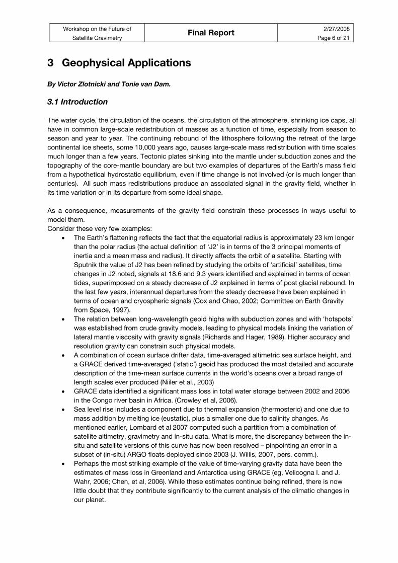
Table 3-1, from Rummel (2005) summarizes the GOCE requirements, which are still the most useful
targets for the time-averaged gravity field retrieval.
Table 3-1: Static gravity field, scientific requirements in preparation for GOCE, from: Rummel (2005).
Static gravity field, scientific requirements in reparation for GOCE
Application Accuracy Spatial resolution
Geoid
[cm]
Gravity
[mGal]
Half wavelength
D [km]
Solid Earth Lithosphere/upper mantle density 1-2 100
Continental lithosphere Sedimentary 1-2 50-100
Basins rifts 1-2 20-100
Tectonic motions 1-2 100-500
Seismic hazards 1 100
Ocean lithosphere/asthenosphere 0.5 100-200
Oceanography Short scale 1-2 100
0.2 200
Basin scale ~0.1 1000
Ice sheets Rock basement 1-5 50-100
Ice vertical movements 2 100-1000
Geodesy Levelling by GPS 1 100-1000
Unified height system 1 100-20000
INS ~1-5 100-1000
Orbits ~1-3 100-1000
Sea level
change
Many of the above applications, with
their specific requirements, are relevant
to studies of sea level change.
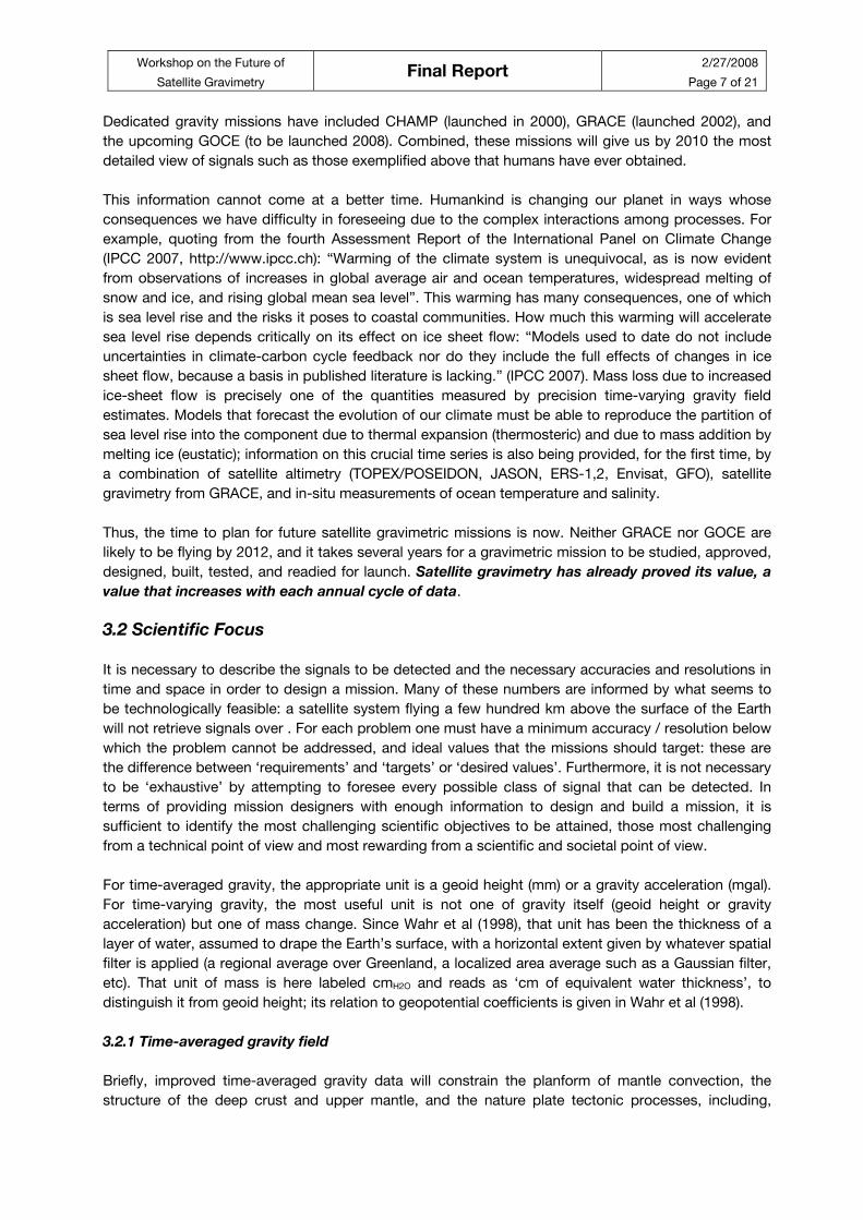
3.2.2 Time varying gravity field
Improved measurements of the time-varying field help determine seasonal, interannual and long-term
trends in ice sheet masses, hydrologic basins, ocean current transports, and changes in overall ocean
mass. Such changes are better expressed in terms of the changes in mass that cause the change in
gravity. The mass change is then expressed thickness of a thin layer of water draped over the surface
of the Earth, a thickness allowed to vary with position.
The following table gives needed accuracies in terms of rates of change in mass, either averaged over
1 year or over 1 month. The averaging radii assume a lower threshold of 300 km: many signals of
interest with shorter scales exist, but they are better measured with non-global observations. Values in
the form 0.5 (0.1) indicate a minimum useful accuracy, and a desired or target accuracy.
Workshop on the Future of
Satellite Gravimetry Final Report
2/27/2008
Page 9 of 21
Table 3-2: Accuracy requirements.
Application mmH2O
/mon mmH2O
/yr smoothing
radius (km)
≥ 300
Timescales and Notes
Hydrologic basin total water
change
10 20 (10) 400 days to decades
Glacier mass loss 2 (1) 300 seasonal, interannual
Ice sheet mass loss 20 (5) 1,000
Oceanic gyres spinup or down 4 (1) 700 interannual
Global Sea level rise: thermosteric
/ eustatic
1 (0.3) 5,000 seasonal, interannual
Glacial Isostatic Adjustment 0.5 (0.1) 1,000 5-10 years
3.2.3 Complementary Data, Separability, Aliasing, Modeling
These topics deserve an entirely separate section and will be addressed later. However, it is important
to note here that gravity is a powerful integrator: it ‘senses’ the combined changes due to many
effects, and it helps eliminate unphysical estimates or models of the processes involved. As GRACE
and CHAMP have shown, time changes in the gravity field with time scales shorter than the monthly or
longer averaging estimate, alias into longer period components. All these issues indicate the need for
(a) additional data types to help separate the various contributions to the gravity signal; (b) accurate
models of the shorter time scales of the gravity field; (c) improved Earth models to take advantage of
the new gravity data.
Examples of (a) include: radar altimetry to measure the slope of sea surface with respect to the
horizontal provided by a gravity mission or the time variations in both; laser altimetry to measure ice
sheet changes. Examples of (b) include the European Center Medium Range Weather Forecast’s
model of the global atmosphere and models of ocean and hydrologic changes accurate over at least
short time scales (eg, Dobslaw and Thomas, 2005; Rodell et al., 2004). Examples of (c), models
capable of assimilating the data from these gravity missions together with other data, include Rodell et
al (2004), Kim et al (2004), Stammer et al 2002, etc.
REFERENCES
Chen, J.L.; C.R.Wilson, D.D. Blankenship, B.D. Tapley, 2006: Antarctic mass rates from GRACE .
Geophys Res. Lett 33 - L11502.
Committee on Earth Gravity from Space, 1997: Satellite Gravity and the Geosphere. U.S. National
Academy Press, Washington, DC.
Cox C.M, and B.F.Chao, Detection of a Large-Scale Mass Redistribution in the Terrestrial System
Since 1998. Science 297, 831 (2002).
Crowley, JW, J.X. Mitrovica, R.C. Bailey, M.E. Tamisiea, J.L. Davis, JL , 2006: Land water storage
within the Congo Basin inferred from GRACE satellite gravity data). Geophys Res. Lett 33 - L19402.
Workshop on the Future of
Satellite Gravimetry Final Report
2/27/2008
Page 10 of 21
Dobslaw, H. and M. Thomas. Atmospheric induced oceanic tides from ECMWF forecasts. Geophys.
Res. Lett. 32, L10615, doi:10.1029/2005GL022990 (2005).
Kim, S.-B., T. Lee, and I. Fukumori (2004), The 1997–1999 abrupt change of the upper ocean
temperature in the north central Pacific, Geophys. Res. Lett., 31, L22304, doi:10.1029/2004GL021142.
Lombard, A; D. Garcia; G. Ramillien, A. Cazenave, R.Biancale, J.M. Lemoine, F. Flechtner, R. Schmidt,
M. Ishii, 2007: Estimation of steric sea level variations from combined GRACE and Jason-1 data. Earth
and Planet. Sci. Lett. 254 194 – 202.
Niiler, P. P., N. A. Maximenko, and J. C. McWilliams, Dynamically balanced absolute sea level of the
global ocean derived from near-surface velocity observations, Geophys. Res. Lett., 30(22), 2164,
doi:10.1029/2003GL018628, 2003.
Richards, M.A., Hager, B.H., 1989. Effects of lateral viscosity variations on long-wavelength geoid
anomalies and topography. J. Geophys. Res. 94, 10299-10313.
Rodell, M. et al. The Global Land Data Assimilation System. Bull. Am. Meteorol. Soc. 85, 381–-394
(2004).
Rummel, R, 2005: Geoid and Gravity in Earth Sciences, An Overview. Earth, Moon and Planets, 94:3-
11, DOI 10.1007/s11038-005-3755-8.
Stammer, D., C. Wunsch, I. Fukumori, and J. C. Marshall (2002), State estimation improves prospects
for ocean research, Eos Trans. AGU, 83, 289, 294– 295.
Velicogna I. and J. Wahr, 2006: Acceleration of Greenland ice mass loss in spring 2004. Nature 443
329 – 331.
Workshop on the Future of
Satellite Gravimetry Final Report
2/27/2008
Page 11 of 21
4 Separability and de-aliasing
By Pieter Visser and Erricos Pavlis.
4.1 Introduction
It was concluded that clear definitions are required for separability and (de-)aliasing. The following
definitions were discussed:
1. Aliasing: mapping of signal from higher frequencies onto lower frequencies due to under-
sampling;
2. Distortion (striations, stripes): geographic systematic effects resulting from the propagation of –
errors in the observations due to – the sampling configuration (non-isotropy, (near-) polar orbit,
resonances, inhomogeneous ground-track pattern, etc.);
3. Separation: unraveling into its individual contributions the superposition of all possible gravity
effects that the measurement system intrinsically measures.
In fact, a distinction has to be made between separability, coarse and fine spatial aliasing, and
distortion. Based on GRACE results, an example of coarse spatial aliasing is the relatively low-
precision C20 time series, an example of fine spatial aliasing are the gravity field maps displaying
localized excursions, and an example of distortions are the “striations” (or trackiness) in the gravity
solutions. Apart from the fact that these errors appear to be related to processing methodologies as
well, in the case of GRACE the distortions can be caused by any systematic error that manifests itself
predominantly at the resonances (e.g. affecting spherical harmonic order 15 coefficients) and the group
of spherical harmonic coefficients with n ≈ m and n rather high.
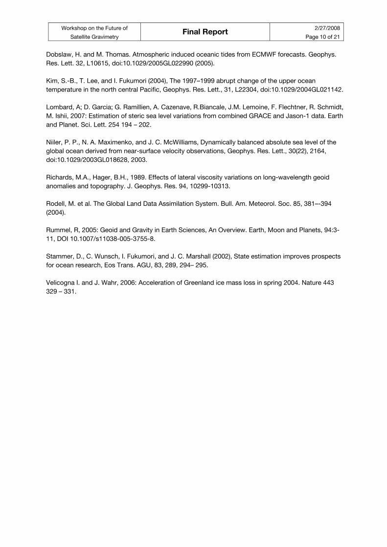
Figure 4-1: Error on gravity solution. Courtesy: M. Watkins, 2007.
Workshop on the Future of
Satellite Gravimetry Final Report
2/27/2008
Page 12 of 21
In principle, instruments on board of gravity-mapping satellites observe the integrated effect of the
total gravity field (static and temporally varying), which is composed of many sources (pseudo-static
gravity field, solid Earth and ocean tides, atmospheric, hydrologic, polar ice mass changes, “non-tidal”
ocean mass transfer, etc.). Recent experiences with GRACE demonstrate a well-known theoretical
principle, that is, the accuracy of derived gravity field products is not only limited by the precision of
the satellite observing system, but also – or especially – by the ability to separate the different
contributors. In general, this separation is attempted by reducing the signal size of the observations by
so-called background or de-aliasing models typically for taking into account atmospheric and ocean
tidal mass redistributions. In recent years, such models have been improved significantly, but their
accuracy still seems to be insufficient to fully exploit the information content of the observations. It is
expected that this become the fundamental limitation for more precise, second generation space-
borne gravity observing systems that are currently being proposed and investigated, despite the
parallel improvements of these background and de-aliasing models by better data from other remote
sensing techniques. For example, when nm-precision low-low SST would be possible in low Earth
orbits (altitude 250 km) the ocean tide aliasing errors will be three orders of magnitude larger than
gravity recovery error caused by observation noise, cf. Figure 4-1.
Fortunately, part of the ocean tide signal is separable due to the fact that they are coherent signals at
well-known frequencies. Other parts, e.g. ocean tides in coastal waters, are highly non-linear and
difficult to model. There are other signals though which produce gravitational signals (temporarily
varying), which are very difficult to separate from pure gravitational change, since the physics and the
mechanism behind them are still not well understood (e.g. soil moisture, atmospheric water, etc.).
The question of how to separate the different components of the gravity field is related to how the
satellite observing system samples the gravity field in space (1) and time (2). In addition, it is always
required to assess whether use can be made of complementary sensor systems (3) and
complementary terrestrial, airborne and other satellite data (4), and – as already mentioned above –
background models.
4.2 Sampling in space
The achievable spatial resolution depends strongly on the geographical coverage of each space-borne
observing system. Results based on GRACE show for example that the quality of monthly solutions is
not homogeneous because of changing – and sometimes unfavourable – ground track patterns. It
might be argued that a more stringent (repeat) orbit control would lead to better performance. An
important issue concerns the observing technique itself, for example one-dimensional (“one-arm” low-
low satellite-to-satellite tracking (SST)) vs. multi-dimensional (“three-arm” gradiometry or special
satellite formations) observations. The question is whether multi-dimensional observing techniques will
reduce for example distortions. In addition, the differences in how aliasing affects observations that
require orbit integration (e.g. SST) versus “in situ” observations (e.g. gradiometry) should be studied in
depth.
4.3 Sampling in time
Just like with other Earth observing satellites, it is obvious that for gravity mapping satellites a trade-off
has to be made between temporal and spatial resolution. It was noted that current space-borne
observing systems are sensitive to temporal gravity changes with periods as small as 12 hours (e.g.
background models seem to reduce the signal level of GRACE observations at these time scales).
Temporal resolution at such level can not be achieved globally by a single gravity mission. Simulation
studies have been carried out to assess the performance of proposed future missions such as, for
example, two GRACE-type missions flying simultaneously, one in a non-repeat orbit and one with a
Workshop on the Future of
Satellite Gravimetry Final Report
2/27/2008
Page 13 of 21
very short repeat period. Results are so far inconclusive and more investigations are required before
concrete conclusions can be drawn.
4.4 Complementary sensor systems
Strong synergies can be identified between satellite gravity missions and other satellite missions. For
example, altimeter satellites have provided the information for high-precision ocean tide and ocean
current models. However, there is still room for improvement, and ocean tide models in particular still
require improvement for use as background models of gravity reductions. Recently, GNSS radio
occultation observations (limb sounding) provide valuable information on mass changes in the
atmosphere. Synergies can, or have been, identified with missions such as ICESAT, CRYOSAT and
SMOS missions.
4.5 Complementary terrestrial, airborne and satellite data
It has been noted that certain parts of the gravity field are, or can be, better observed with terrestrial
systems. For example, core motion and seismic events are already being accurately observed better
by superconducting gravimeters. In addition, an enormous amount of terrestrial and airborne gravity
data sets have been collected that can be used in support of the space-based gravimetric data in
terms of calibration, validation and regional densification. An open question is what kind of other
satellite missions (existing, as well as those envisioned in the near future) might support, complement,
and/or enhance the products of future gravity mapping missions.
4.6 Models
It has been extensively discussed that the quality of background models (ocean tides, atmosphere,
hydrology, etc.) is crucial for taking full advantage of space-borne gravity field observing systems, and
in fact these might be limiting factors. Different philosophies might be pursued: further improvement on
the basis of other data (existing and future), co-estimation (e.g. tidal coefficients), and/or the
combination of the two. For GRACE-type missions, simulations indicate that in general the influence of
various geophysical phenomena on the observations was underestimated (which can again be
considered as a strength and weakness). To take advantage of the high sensitivity of such satellite
gravimetry to phenomena that manifest themselves as gravity changes, further investigations are
required in the near future.
4.7 Key issues
In summary, the following issues have been identified during the workshop as key issues for further
discussion:
• Proper definition of separability, aliasing, distortion
• Sampling in space:
- Orbit design/control: repeat, non-repeat
- Observation technique: “one-arm” vs. “multi-dimensional arm”, “integrated” vs. “in-
situ”, satellite formations
• Sampling in time:
- Observing systems are sensitive to high-frequency temporal variations (<12 hr):
simultaneous missions, formations
• Complementary sensor systems:
- Synergy with other satellites data: altimetry, GNSS radio occultation, ocean
temperature etc.
• Complementary terrestrial, airborne and satellite data:
Workshop on the Future of
Satellite Gravimetry Final Report
2/27/2008
Page 14 of 21
- Gravity contributors already being observed
- Supporting data sets: calibration, validation, regional enhancement, higher frequency
gravitational signal modelling (above degree ~250)
• Models:
- Quality of background models: achievable improvement and limitations
- Modelling and/or co-estimation (e.g. ocean tides)
- Which gravity sources are significant and need to be taken into account?
4.8 Recommendations
In summary, the following issues have been identified during the workshop as main recommendations:
Short term:
• Additional studies:
- Simulations of different processing strategies for GRACE data, e.g. co-estimation of
more temporal gravity sources such as ocean tides
- Further assessment of synergies with other sensors/satellite missions
Medium term:
• Requirement for continued observations by gravity missions such as GRACE in order to allow
the retrieval and study of more temporal gravity sources
Long term:
• Mission scenarios for enhanced temporal and spatial sampling of the gravity field
Workshop on the Future of
Satellite Gravimetry Final Report
2/27/2008
Page 15 of 21
5 Future Mission Concepts
By Jürgen Kusche and Roland Pail.
5.1 Introduction
The participants of the workshop acknowledge the great scientific advancements that has been
achieved through current exploitation of the GRACE data Further improvements are anticipated from
reprocessing GRACE data in the future when improved models and procedures for de-aliasing, signal
separation and data analysis are available. Also GOCE will lead to greatly improved models of the
Earth’s mean gravitational field with medium to high resolution in the near future.
However, limitations of the current mission GRACE and also of the upcoming mission GOCE exist.
They are due to lifetime, temporal and spectral resolution, the “aliasing” problem, the problem of
separability of sources, and in the case of SST of the error anisotropy of the recovered fields.
Regarding the workshop theme “Future Mission Concepts”, the rationale for three development
phases of future missions have been identified:
• On the short time scale, it would be desirable to have a continuation of the current observation
series of temporal gravity changes with GRACE, thus avoiding a gap after the GRACE lifetime
expires. The only realistic option to be considered is a near-rebuild of the GRACE spacecraft
and mission concept. A possible improvement of the orbital characteristics should be
investigated.
• On the medium time scale, the workshop participants expressed the expectation that new
mission concepts will overcome the limitations of the current mission concepts. Several
candidate mission concepts (including but not limited to single or multiple pairs of GRACE-
type formations, equipped with microwave or laser inter-satellite link, single or multiple pairs of
pendulum or cartwheel formation, GRACE follow-on missions equipped with an across-track
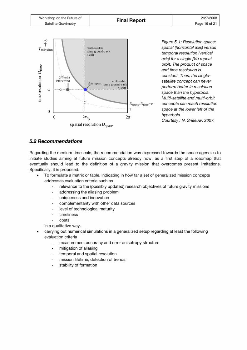
gradiometer) have been discussed (cf. Figure 5-1). It is felt that already now, in parallel with
efforts towards a GRACE continuation mission, the community should continue investigations
aiming at improved sensor systems and mission concepts.
• On the longer time scales, it appears that “new” technologies such as atom interferometry or
ultra-precise clocks, which are really new in the field of gravity field research, may become part
of future mission concepts. It became obvious from the workshop that the space gravimetry
community should monitor closely the technology developments in these fields. It is
recommended that the links to the instrument development in the field of fundamental physics
be strengthened.
Workshop on the Future of
Satellite Gravimetry Final Report
2/27/2008
Page 16 of 21
Courtesy : N. Sneeuw, 2007.
Figure 5-1: Resolution space:
spatial (horizontal axis) versus
temporal resolution (vertical
axis) for a single β/α repeat
orbit. The product of space
and time resolution is
constant. Thus, the single-
satellite concept can never
perform better in resolution
space than the hyperbola.
Multi-satellite and multi-orbit
concepts can reach resolution
space at the lower left of the
hyperbola. 2π/β
α
00
2π
∞↑
Tmission multi-satellitesame ground-trackt-shift
multi-orbit same ground-track
λ-shiftβ/α repeat
2nd orbitinterleaved
spatial resolution Dspace
time
reso
lutio
n D
time
Dspace×Dtime=c?
5.2 Recommendations
Regarding the medium timescale, the recommendation was expressed towards the space agencies to
initiate studies aiming at future mission concepts already now, as a first step of a roadmap that
eventually should lead to the definition of a gravity mission that overcomes present limitations.
Specifically, it is proposed:
• To formulate a matrix or table, indicating in how far a set of generalized mission concepts
addresses evaluation criteria such as
- relevance to the (possibly updated) research objectives of future gravity missions
- addressing the aliasing problem
- uniqueness and innovation
- complementarity with other data sources
- level of technological maturity
- timeliness
- costs
in a qualitative way.
• carrying out numerical simulations in a generalized setup regarding at least the following
evaluation criteria
- measurement accuracy and error anisotropy structure
- mitigation of aliasing
- temporal and spatial resolution
- mission lifetime, detection of trends
- stability of formation
Workshop on the Future of
Satellite Gravimetry Final Report
2/27/2008
Page 17 of 21
6 Candidate Technology
By Sean Bruinsma and Jürgen Müller.
(with remarks by Peter Bender, Pierre Touboul and Pierluigi Silvestrin)
This section gives an overview of existing (i.e. flight qualified or proven) and candidate technology with
respect to future Earth gravity field mapping missions. The overview is not restricted to the gravity
sensor per se, but also considers supporting technology that is imperative to the optimal operation and
usage of such a device.
Table 6-1 presents the gravity sensors and their present status of development, using the NASA and
ESA terminology ‘Technology Readiness Level’ (TRL).
Table 6-1: Gravity Sensors and Their Status of Development.
Status Expected qualification time*
Microwave interferometer Flight proven (TRL9) -
Inter-spacecraft
Laser interferometer:
Master-slave (2 lasers)
Master+retro-reflector(1 laser)
Qualified prototype (TRL6)
Breadboard (TRL4)
1-2 years
2-4 years
Gradiometer:
Electro-static
LTP Optical test mass readout
Quantum
Cryogenic
Flight qualified (TRL8)
Launch in 2010 (TRL7)
Breadboard (TRL3)
Breadboard (TRL3)
-
1 year
15 years
undefined (unfit for mission)
Drag-free low-low SST:
LTP Gravity Reference Sensor
One-axis Ion Thrusters
5-DoF FEEP Thrusters
Launch in 2009 (TRL7)
Flight Proven (TRL 9)
Launch in 2009 (TRL 5)
1 year
-
3 years
Optical clock Qualified prototype (TRL6) 15 years
* This is the estimated time necessary for the technology to attain the required accuracy for a gravity
monitoring mission.
The K-band microwave ranging system is used in the GRACE mission. The precision of the range-rate
measurements is 0.1μm/s. This instrument is sufficiently precise for a GRACE follow-on mission that
primarily serves continuation of the currently established time series. Only if the level of aliasing and
distortions can be reduced substantially full advantage can be taken from the second generation
technology concepts discussed in the following.
The laser interferometer, using the master-slave concept, has a (demonstrated) precision of 1 nm/s
and the potential to measure spacecraft relative attitudes via beam alignment with 100 nrad/Hz1/2
noise. It requires low-power lasers (10-30 mW), which are already flight qualified, with a very high level
of frequency stabilization (not space qualified yet, but under development for the LISA mission).
The single laser and retro-reflector concept, compared to that using two lasers, has the disadvantage
of requiring a larger optical power for a given operating distance, though ≈ 100mW are sufficient for an
inter-satellite distance of 10 km. The short intersatellite distance may prohibit monitoring of the very
long wavelength temporal variations. On the other hand it is simple (just a single laser, single

Workshop on the Future of
Satellite Gravimetry Final Report
2/27/2008
Page 18 of 21
interferometer and phase meters), robust (the co-alignment of the retro-reflected beam is automatically
ensured by the retro-reflector and does not need an active pointing system on the second satellite),
and reliable (no simultaneous operation of two lasers, two interferometers and phase meters).
The gradiometer for the GOCE satellite uses six 3-axis electro-static accelerometers, the sensitive axes
of which have a sensitivity of 2x10-12 ms-2Hz-1/2 (compared to 10-10 ms-2Hz-1/2 for the GRACE
instruments) in a given measurement bandwidth. The capacitive readout has a noise level of about 6
pm/Hz1/2. In this kind of instrument, test masses of the order of 0.07-0.32 kg are actively maintained in
the center of the instrument cage through electro-static compensation. The precision in the
measurement bandwidth of the GOCE gradiometer is a few 10-12 s-2. The limit of resolution of the
GOCE accelerometer (alone) is mainly due to the range of the digital conversion of the instrument
analog output, which have to include as a minimum the DC gradient and its weak fluctuations.
Improvement by a factor ten requires the availability of better electrical components, which seems
unlikely in the near future. A factor 2 could be obtained by optimized operational conditions minimizing
the margin in the maximum sustainable acceleration (the very high resolution of 10-15 ms-2 required for
the microscope mission is obtained after averaging over a long period of time). In addition, the attitude
control, the thermal control and the stiffness of the material used to construct and mount the
instrument are extremely demanding, but they must be in step with enhanced instrument sensitivity.
Technology developed for LISA Pathfinder (launch in 2010) includes a drag-free system with inertial
sensors around the 10-14 m/s2 level – however designed for a very low perturbation orbit environment –
and a local interferometric test mass readout with 10 pm/Hz1/2 noise. Both of these instrument noise
levels are about a factor of 100 lower than would be needed for a drag-free two spacecraft mission.
This is because of the perhaps 50 km baseline between the two satellites. One main advantage of
drag-free operation is being able to fly a two spacecraft mission at a lower altitude, as for
gradiometers. The other is the removal of the scale factor calibration and stability requirements
associated with accelerometers. A problem may be the associated shorter mission life time.
A quantum interferometer gravity gradiometer uses atomic particles, which are cooled to a few μK by
laser, as free fall test masses. Its building blocks are atom-interferometer accelerometers. The
projected achievable precision is comparable to that of the GOCE gradiometer, but the measurement
bandwidth of such an instrument (GOCE: 5mHz to 0.1 Hz) is not yet known.
The cryogenic gradiometer has been added for completeness, but in fact is not adapted for missions
exceeding 1-2 years due to the too large volume of liquid helium necessary to keep the instrument
cooled.
In a wider sense also comparison of high precision clocks is related to space gravimetry. The optical
clock technology offers the possibility to determine the difference in gravitational potential between
clocks at different locations and therefore of establishing a unified global height datum. Such a system
is required for several geodetic applications such as the global height synchronization of tide gauges
for global sea level monitoring. This approach has the advantage of being independent of the satellite
acceleration. However, a height change of about 1 mm at the Earth’s surface necessitates a clock
accuracy of 10-19. Presently, 10-17 accuracy is reached after several hours. Thus in the foreseeable
future, this techniques cannot be applied to in-situ gravitational potential difference measurement
along orbits. A second complication of using clocks in orbit is the required altitude accuracy, namely 1
cm and 30 cm for LEO and geostationary orbits, respectively. Even for high precision height
determination with ground based clocks, time synchronization by “orbiting clocks” has to reach a level
of precision compatible with the above quoted numbers.
Workshop on the Future of
Satellite Gravimetry Final Report
2/27/2008
Page 19 of 21
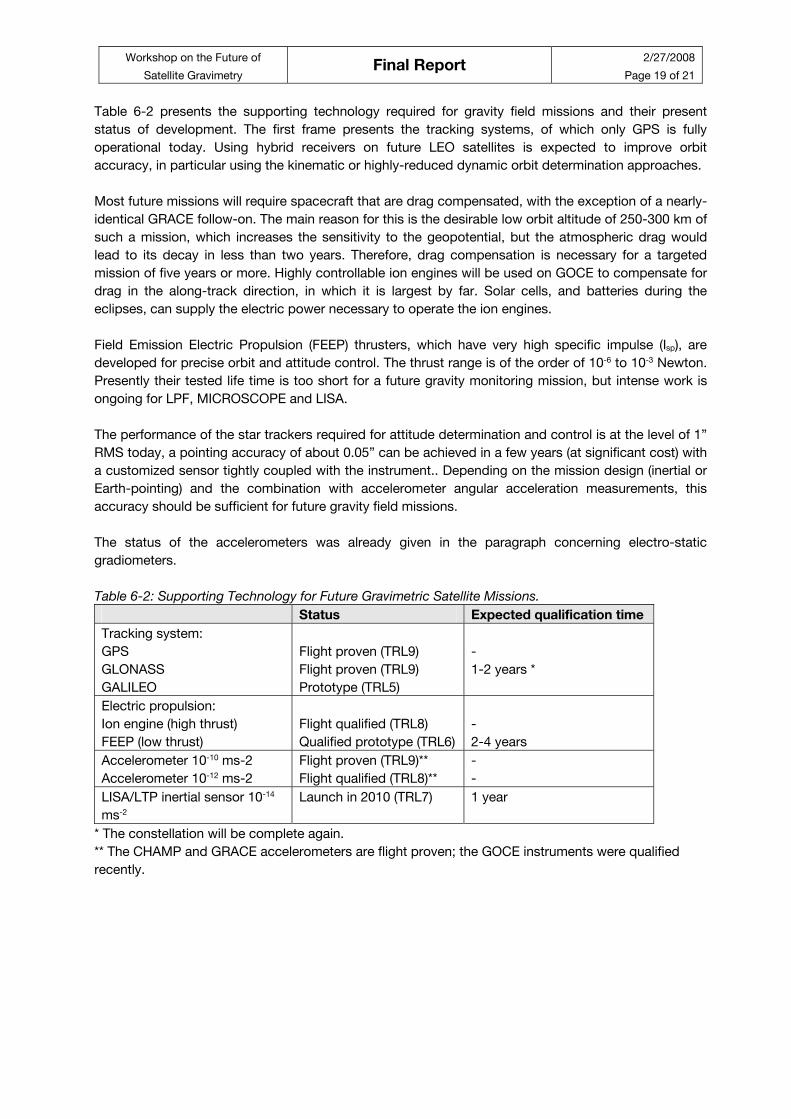
Table 6-2 presents the supporting technology required for gravity field missions and their present
status of development. The first frame presents the tracking systems, of which only GPS is fully
operational today. Using hybrid receivers on future LEO satellites is expected to improve orbit
accuracy, in particular using the kinematic or highly-reduced dynamic orbit determination approaches.
Most future missions will require spacecraft that are drag compensated, with the exception of a nearly-
identical GRACE follow-on. The main reason for this is the desirable low orbit altitude of 250-300 km of
such a mission, which increases the sensitivity to the geopotential, but the atmospheric drag would
lead to its decay in less than two years. Therefore, drag compensation is necessary for a targeted
mission of five years or more. Highly controllable ion engines will be used on GOCE to compensate for
drag in the along-track direction, in which it is largest by far. Solar cells, and batteries during the
eclipses, can supply the electric power necessary to operate the ion engines.
Field Emission Electric Propulsion (FEEP) thrusters, which have very high specific impulse (Isp), are
developed for precise orbit and attitude control. The thrust range is of the order of 10-6 to 10-3 Newton.
Presently their tested life time is too short for a future gravity monitoring mission, but intense work is
ongoing for LPF, MICROSCOPE and LISA.
The performance of the star trackers required for attitude determination and control is at the level of 1”
RMS today, a pointing accuracy of about 0.05” can be achieved in a few years (at significant cost) with
a customized sensor tightly coupled with the instrument.. Depending on the mission design (inertial or
Earth-pointing) and the combination with accelerometer angular acceleration measurements, this
accuracy should be sufficient for future gravity field missions.
The status of the accelerometers was already given in the paragraph concerning electro-static
gradiometers.
Table 6-2: Supporting Technology for Future Gravimetric Satellite Missions.
Status Expected qualification time
Tracking system:
GPS
GLONASS
GALILEO
Flight proven (TRL9)
Flight proven (TRL9)
Prototype (TRL5)
-
1-2 years *
Electric propulsion:
Ion engine (high thrust)
FEEP (low thrust)
Flight qualified (TRL8)
Qualified prototype (TRL6)
-
2-4 years
Accelerometer 10-10 ms-2
Accelerometer 10-12 ms-2
Flight proven (TRL9)**
Flight qualified (TRL8)**
-
-
LISA/LTP inertial sensor 10-14
ms-2
Launch in 2010 (TRL7) 1 year
* The constellation will be complete again.
** The CHAMP and GRACE accelerometers are flight proven; the GOCE instruments were qualified
recently.
Workshop on the Future of
Satellite Gravimetry Final Report
2/27/2008
Page 20 of 21
7 Appendix 1: List of Participants
Name email country
Miguel Aguirre [email protected] ESA
Georges Balmino [email protected] France
Peter Bender [email protected] US
Srinivas Bettadpur [email protected] US
Ben Braam [email protected] Netherlands
Sean Bruinsma [email protected] France
Stefano Cesare [email protected] Italy
Tonie van Dam [email protected] Luxembourg
Karsten Danzmann [email protected] Germany
Mark Drinkwater [email protected] ESA
Rune Floberghagen [email protected] ESA
Thomas Gruber [email protected] Germany
Roger Haagmans [email protected] ESA
Gerhard Heinzel [email protected] Germany
Christian Jentsch [email protected] Germany
Ulrich Johann [email protected] Germany
Michael Kern [email protected] ESA
Volker Klein [email protected] Germany
Radboud Koop [email protected] Netherlands
Jürgen Kusche [email protected] Germany
Bruno Leone [email protected] ESA
Torsten Mayer-Guerr [email protected] Germany
Federica Migliaccio [email protected] Italy
Jürgen Müller [email protected] Germany
Eamonn Murphy [email protected] ESA
Danilo Muzi [email protected] ESA
Steve Nerem [email protected] US
Roland Pail [email protected] Austria
Erricos Pavlis [email protected] US
Ernst Rasel [email protected] Germany
Markus Rothacher [email protected] Germany
Reiner Rummel [email protected] Germany
Fernando Sansò [email protected] Italy
Stephan Schiller [email protected] Germany
Ejo Schrama [email protected] Netherlands
Avri Selig [email protected] Netherlands
C.K. Shum [email protected] US
Pierluigi Silvestrin [email protected] ESA
Nico Sneeuw [email protected] Germany
Pierre Touboul [email protected] France
Bert Vermeersen [email protected] Netherlands
Pieter Visser [email protected] Netherlands
Michael Watkins [email protected] US
Remco Wiegerink [email protected] Netherlands
Ulrich Wittrock [email protected] Germany
Victor Zlotnicki [email protected] US
Workshop on the Future of
Satellite Gravimetry Final Report
2/27/2008
Page 21 of 21
8 Appendix 2: Abbreviations and Acronyms
CHAMP Challenging Mini-satellite Payload for Geophysical Research and Applications
DoF Degree of Freedom
FEEP Field Emission Electric Propulsion
GFO Geosat Follow-on
GNSS Global Navigation Satellite System
GOCE Gravity Field and Steady-State Ocean Circulation Explorer
GPS Global Positioning System
GRACE Gravity Recovery and Climate Experiment
ICESAT Ice, Cloud, and land Elevation Satellite
INS Inertial navigation System
IPCC Intergovernmental Panel on Climate Change
LDI Laser Doppler Interferometry
LEO Low Earth Orbit
LISA Laser Interferometer Space Antenna
LPF LISA Pathfinder
LTP LISA Technology Package
SMOS Soil Moisture and Ocean Salinity mission
SST Satellite-to-Satellite Tracking
TBD To Be Determined/Decided
TRL Technology Readiness Level