Embed Size (px)
Citation preview
127
THE FOSSE WAY AT BATH
INTRODUCTION
The route and nature of the main Roman roadsaround Bath (the Roman Aquae Sulis) have been amatter of interest and speculation since antiquariansfirst paid attention to the problem (Collinson 1791,99–102; Scarth 1864, 107–8), and it has long beenrecognised that the Fosse Way and the London toSea Mills (the Roman Abonae) roads met and crossedat or near Bath. While existing routes, old boundariesand surviving antiquities such as aggers, haveallowed a topographical consensus to grow up onthe general and indeed detailed routes of these roadsas they approach Bath, the dissected and deeplandscape in its nearer vicinity has defeated generalistfield archaeological approaches (Codrington 1919;Margary 1973). Recent excavations, both onestargeted and those more incidental to this problem,have provided evidence for arguments that result ina much clearer understanding of it, and indeed, somefairly convincing solutions. In addition, they haveadded value to antiquarian excavations which havebeen hard to understand on their own.
Important and fruitful reviews of the localevidence have been put together by Keevil (1989)and Bird (1991), both showing an awareness of thecomplexity of the problems and the fact that they donot have a simple solution. Keevil concentrated onthe Fosse Way itself and specifically its route southof Bath. Bird’s article was more a consideration ofthe possibilities, important in opening out thediscussion. The issues were these: what was theroute, or routes, that the Fosse Way took from itsknown position at Cleveland Place on the modernLondon Road north of the town and river, to Odd
Down on the heights south of the Avon? how andwhere did it cross the river? where did it partcompany with the Sea Mills road? and where didthe latter run between that point and Swineford?
This article will take up these issues but also addin new data on the nature of the Fosse Way south ofBath. It will also discuss the line of the Fosse Waynorthwards from its junction with the London roadat Batheaston and a few comments will also beoffered on the route of the Sea Mills road west of asecond junction west of the town in the RoyalCrescent area.
The term ‘Fosse Way’ is of course a post-Romanconstruct both archaeologically and historically, butit is also the result of a recognition, dating to themedieval period, that the long-distance route mustbe seen as having a unity of surveying and planningeven if it was not built as one project. Although laidout in the early post-conquest period on a Provincewide scale, its continuing use for the rest of theRoman period would have been predominantly on alocal scale. If this localised use also meant localmaintenance then local variations may have occurredover the Roman period. This would be relevant tothe route south of Bath, as various routes have beenproposed in the past which need not be exclusiveand could be local branches and variations.
During the late 1980s and through the 1990s BathArchaeological Trust carried out a series ofexcavations which either targeted Roman roadsaround Bath or incidentally produced evidence forthem. The preparation of reports for publication ledto an increased interest in the overall problem, andit was clear that the value of the reports would begreatly enhanced by publishing a general report on
THE FOSSE WAY AND OTHER ROMAN ROADS AROUNDBATH: EXCAVATIONS AND INTERPRETATIONS SINCE 1997
PETER DAVENPORT
127
SOMERSET ARCHAEOLOGY AND NATURAL HISTORY, 2007
128
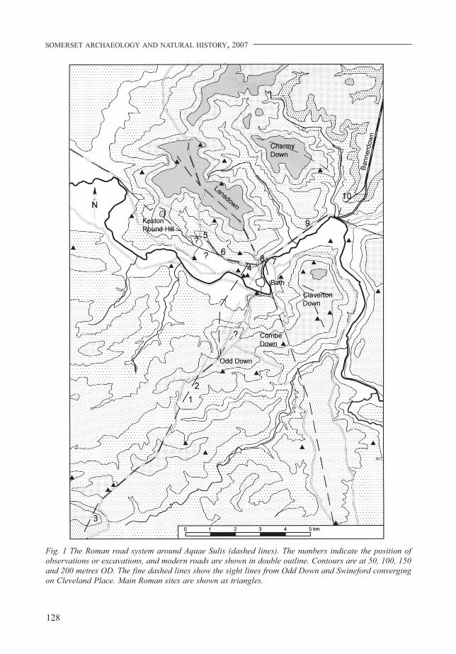
Fig. 1 The Roman road system around Aquae Sulis (dashed lines). The numbers indicate the position ofobservations or excavations, and modern roads are shown in double outline. Contours are at 50, 100, 150and 200 metres OD. The fine dashed lines show the sight lines from Odd Down and Swineford convergingon Cleveland Place. Main Roman sites are shown as triangles.
129
THE FOSSE WAY AT BATH
the road findings together with an overview to try toanswer some of these concerns. Excavations alongWalcot Street/London Street provided data on theRoman road at this point. Excavations around theRoyal Crescent provided information on the line ofthe Fosse Way, its putative junction with the SeaMills road and the crossing point of the River Avon;and observations along Weston Road offeredinformation on the line, or a line, of the road to SeaMills. Two research excavations across the FosseWay south of Bath, at Combe Hay and at Clandown,clarified the form of the road there and threw lighton earlier excavations. Observations of road anddrainage works, further map study andconsiderations of the route through Batheaston havealso led to further comments.
Two of the excavations across the Fosse Way,the research work at Clandown and Combe Hay, arepublished here. A report on work at Crescent Lanein Bath has been completed as an assessment for theclients (Lewcun 2003) and the evidence in it for theroads is also presented here. Pending publication infull elsewhere, the information from other sites hasbeen extracted and presented here. The archives ofall the sites discussed here are held at the RomanBaths Museum, Bath.
THE FOSSE WAY EXCAVATIONS SOUTH OFBATH
In July 1997, for National Archaeology Day, the BathArchaeological Trust mounted a short researchexcavation across the Fosse Way where it forms theboundary of Combe Hay with Englishcombe andDunkerton parishes (Fig. 1, 1 and 2). This involvedcutting two trenches, one to the south across theDunkerton boundary where a visible agger is raisedabove a flat plateau, and the other to the north acrossthe Englishcombe boundary where the agger was
more like a lynchet on the hill slope. The followingyear a trench was dug at Clandown, also as a NationalArchaeology Day project (Fig. 1, 3). This wasadjacent to a trench cut in 1881 by McMurtrie (1903)and was intended to answer questions raised by hiswork.
The 1997 excavations at Combe Hay
Two 1m wide trenches were dug: Trench 1 c. 150msouth of Crossways Farm at ST72046022, andTrench 2 just south of Fosse Cottage, several hundredmetres further north, at ST 72286065 (Fig. 1, 1 and2). Neither provided a complete section across theroad. The continued use of the tarmac road alongthe top of the agger at Trench 1 meant that only itseastern side was excavated. Trench 2 was excavatedinto the western side of the agger to allow continuedaccess to walkers, the road here being a bridleway.A small sondage was opened on the east of the agger,however. The line had served as the main road fromBath to Radstock and beyond until the creation ofthe turnpike further west in the late 18th century.
TRENCH 1
Before excavation the agger was c. 15m wide at thebase and c. 1.1m above the field on the west and c.2m above that on the east. The trench was placedimmediately south of the tarmac track occupying thewestern half of the flat top of the agger, and extended9m eastwards to take in the eastern base of the agger(Fig. 2).
Excavation stopped at the top of what wasbelieved to be the lowest of a series of hard-packedlayers of limestone rubble set in a pale reddish brownFuller’s Earth matrix (layer 113). The latter acted asa cement fining, producing a hard, smooth surface.It sloped away to the east and is most reasonablyinterpreted as being the cambered surface of the road.
Fig. 2 Trench 1 cut in 1997 across the Fosse Way at Combe Hay, nr. Bath
SOMERSET ARCHAEOLOGY AND NATURAL HISTORY, 2007
130
The highest point in the west end of the trench isprobably the top of the camber and the approximatecentre of the road in which case the metalled surfaceis, therefore, 9–10m wide. Its thickness was untestedbut was probably more than 0.2m at the edge, judgingby the drop to the subsoil exposed to its east. It wasedged by a clear kerb of roughly shaped limestoneblocks (114).
At the west end of the trench and therefore aboutin the centre of the road line, were five layers ofgravel and silt, similarly of Fuller’s Earth andlimestone gravel (Fig. 2, layers 107–110, 112). Thesewere clearly later metalling and make-up. The lowestof these extended only 2m from the end of the trenchand could not have represented a surface greater than5m wide at most. The layers above were the samewidth but increasingly domed, producing a steepcamber. The surfaces were hard and hard-wearing
No dating evidence was found in these layersbut they are likely to be Roman. Layer 113 is theearliest, broadest and best laid of these surfaces andprobably represents the first road. Strictly, howeverit is undated. There was little obvious damage in thelower surface, except for a shallow area of missingtop metalling, with sharp, 0.02–0.03m deep sides,as if it had been dug away, or possibly dislodged byfrost. The other metalling layers seem more likely,then, to represent not a replacement for the broadone but a raising of the camber in the centre, probablyin stages.
The layer immediately above these road surfaces,106, was a silt, heavily reworked by rabbits but likelyto have been a road silt. Layer 105 is interesting asit was a very gravelly silt and may have been theremains of a washed-out, much mixed and erodedpost-Roman surface. It was, however, very disturbedby animal burrowing and contained 19th-centuryfinds. It was cut by the terrace for a now collapseddrystone wall, 102, probably of 18th to early 19th-
century date. All the layers above this were of 20th-century date, some associated with the laying of thetarmac surface.
Excavation beyond the edge of the lowest roadsurface was limited but showed no sign of a ditch. Ashallow depression at the east edge of the trenchmight represent the beginning of a ditch but was aslikely to have been the edge of ploughing cuttinginto the subsoil (Fig. 2, 116).
The excavation was surprising in showing howlittle of the visible agger was of ancient, presumablyRoman, date, and, indeed, just how recent it was.The original structure, while substantial and wellbuilt, and raised a maximum 1m above thesurrounding land only in its latest form, was hardlythe massive symbol of dominance that has sometimesbeen claimed.
TRENCH 2
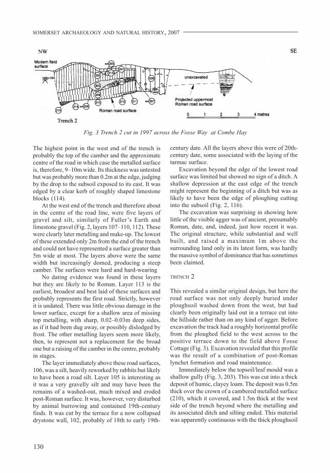
This revealed a similar original design, but here theroad surface was not only deeply buried underploughsoil washed down from the west, but hadclearly been originally laid out in a terrace cut intothe hillside rather than on any kind of agger. Beforeexcavation the track had a roughly horizontal profilefrom the ploughed field to the west across to thepositive terrace down to the field above FosseCottage (Fig. 3). Excavation revealed that this profilewas the result of a combination of post-Romanlynchet formation and road maintenance.
Immediately below the topsoil/leaf mould was ashallow gully (Fig. 3, 203). This was cut into a thickdeposit of humic, clayey loam. The deposit was 0.5mthick over the crown of a cambered metalled surface(210), which it covered, and 1.5m thick at the westside of the trench beyond where the metalling andits associated ditch and silting ended. This materialwas apparently continuous with the thick ploughsoil
Fig. 3 Trench 2 cut in 1997 across the Fosse Way at Combe Hay
131
THE FOSSE WAY AT BATH
in the adjacent field on the north-west and hadformed over a period.
The metalled surface was of laminar limestoneset in a matrix of Fuller’s Earth and was c. 0.2mthick. It was well laid and very hard. Judging fromthe camber and its position on the road line it wasprobably about 8 or 9m wide, but only just over 2mwas exposed of its western edge. The centre wasremoved by a 1970s gas main trench that had beencut down the length of the road line. The surfacehad been laid in a hollow cleared in the underlyingsilts (209), which were basically an earlier phase ofthe ploughsoil wash 202. At the west edge of thecobbling the side of the hollow seemed to have beenutilised as a drainage gully which had filled withsilts off the road (205) as is suggested by the section(Fig. 3). The surface was not dissimilar to the lowestsurface in Trench 1, but was dated to the 18th centuryfrom clay tobacco pipe fragments. It was the onlysurviving dated evidence of road maintenance afterthe Roman period.
The soils underlying this surface were 0.6–0.7mthick loamy silts, and covered another well laidcambered surface of small limestone cobbles set ina hard, Fuller’s Earth matrix. As in Trench 1 therewas a kerb along the edge of the metalling. Beyondthe kerb the surface continued but sloped away moresteeply as if forming the side slope of a low agger,similar to Trench 1. The slight hollow this formedin the end of the trench was filled with road silts,215. The thickness of this surface was notinvestigated in this trench but again, as in Trench 1,it had received resurfacings of small rubble andFuller’s Earth (Fig. 3, layers 211, 212). It seemedprobable that this was the earliest road surface butthe point could not be proved. A small test pit wasthen dug to the east and a series of surfaces werefound as expected which were similar to those inTrench 1 (Fig. 3). This showed that the highest pointof the road was at or near the test pit. If this were thecentre – and this need not have been the case – itwould indicate a road as much as 16m wide.
Given its position across a slight slope, it is likelythat the road was slightly higher than the adjacentland surface and thus more noticeable, but likeTrench 1, there was no sign here of a substantialagger construction. No dating evidence wasrecovered, but again, it seems likely that thesesurfaces are of Roman date.
The visible shape of the road as seen in thelandscape now is entirely due to the post-Romandeposition of ploughsoil washed down from the hillabove, presumably retained by the boundary along
its eastern edge and forming a post-Roman lynchet.At some point in the 18th century the road wasresurfaced, but already a great depth of soil hadaccumulated. Soil movement continued so that thepresumed Roman surface is now as much as 2mbelow the present ground level.
No finds were made in the lower surfaces in eithertrench so the date of this construction is not fixed,or indeed whether it is of Roman date. However,while it seems unlikely that it could be allocated toany other period, further work to date these structureswould be highly desirable – silt dating by OpticallyStimulated Luminescence might be a possibility.
The 1998 excavations at Clandown
At Clandown the modern turnpike again deviatesfrom the line of the Roman road and takes a broadcurve to the east to reduce the road gradient. Thishas left the Roman line visible as a raised bankforming a field boundary and farm track south ofthe village of Clandown. The area chosen forexcavation is on a short plateau, between ClandownBottom and Welton Hollow, forming a horizontalbreak in the slope down to the valley bottom of theRiver Somer (ST68155533; Fig. 1, 3).
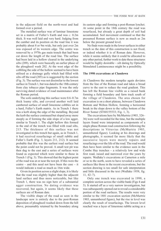
The excavations here by McMurtrie (1903, 326–36) were well recorded for the time, but the multiplelayers found were interpreted as components of asingle phase Roman road construction following thedescriptions in Vitruvius (McMurtrie 1903,unnumbered figure). Looking at his drawings andphotographs, it seemed far more likely that thesuccessive layers were merely repairs andresurfacings over the life of the road. The road wouldthen have been similar to the evidence seen in theCombe Hay trenches – a relatively low and widefirst road, raised and narrowed over the years byrepairs. Wedlake’s excavations at Camerton a mileor so to the north, seem to have revealed a series ofsurfaces like those in the recent excavations, but thesection drawing is too small for safe interpretationand little discussed in the text (Wedlake 1958, fig.11, 42–7).
Only one trench was excavated in 1998, acomplete section across the visible bank (Figs 4 and5). It started off as a very narrow investigation, butwas subsequently opened out to reveal a considerableportion of the road surfaces. The results were verysimilar to the 1881 excavation section (McMurtrie1903, unnumbered figure), but the rise in level wasclearly the result of resurfacings. The lowest levelreached was a layer of limestone rubble acting as a
SOMERSET ARCHAEOLOGY AND NATURAL HISTORY, 2007
132
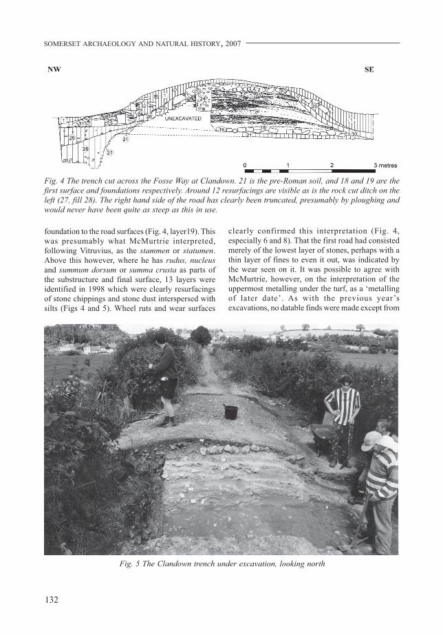
foundation to the road surfaces (Fig. 4, layer19). Thiswas presumably what McMurtrie interpreted,following Vitruvius, as the stammen or statumen.Above this however, where he has rudus, nucleusand summum dorsum or summa crusta as parts ofthe substructure and final surface, 13 layers wereidentified in 1998 which were clearly resurfacingsof stone chippings and stone dust interspersed withsilts (Figs 4 and 5). Wheel ruts and wear surfaces
clearly confirmed this interpretation (Fig. 4,especially 6 and 8). That the first road had consistedmerely of the lowest layer of stones, perhaps with athin layer of fines to even it out, was indicated bythe wear seen on it. It was possible to agree withMcMurtrie, however, on the interpretation of theuppermost metalling under the turf, as a ‘metallingof later date’. As with the previous year’sexcavations, no datable finds were made except from
Fig. 4 The trench cut across the Fosse Way at Clandown. 21 is the pre-Roman soil, and 18 and 19 are thefirst surface and foundations respectively. Around 12 resurfacings are visible as is the rock cut ditch on theleft (27, fill 28). The right hand side of the road has clearly been truncated, presumably by ploughing andwould never have been quite as steep as this in use.
Fig. 5 The Clandown trench under excavation, looking north
133
THE FOSSE WAY AT BATH
the recent metalling, which proved to be of 18th-century date or later.
No preparation of the ground surface seems tohave been made before the laying of the foundationstones, other than perhaps turf stripping, but evenso a buried soil existed under the foundation layer(21). A rock-cut feature was found on the west sideof the road, very close to the edge of the metallinglayers. Lack of space precluded full excavation, butit was at least 0.8m deep and more than 1.25m wide.It may have been a later quarry, as it was very closeto the road edge for a ditch – especially given thedistance of the Camerton lateral ditches from the road(Wedlake 1958, fig. 11, pl. xi). An eastern ditchremains unproven.
The agger at Clandown is now quite certainlymerely the result of repairs over time (and someshaping by plough erosion of the sides), not adeliberate construction. In this it follows the resultsfrom Combe Hay, but at Clandown, despite the lackof secure dating evidence, mostly, it seems, of Romandate. At both sites there is evidence of an 18th-century paving, which perhaps reflects the increasedconcern over the state of major through roads whichled to the eventual creation of the turnpike on a newroute. An instructive comparison would be with thevery similar but slightly longer sequences of roadconstruction and repair revealed along the ErmineStreet, north of Cirencester. There, similar impressiveaggers were merely the result of a long process of
repair and maintenance, also topped off by a (albeitbetter preserved) post-Roman, indeed post-medieval,set of surfaces (Mudd and Mortimer 1999, 261–81,figs 5.2, 5.3).
EXCAVATIONS ON THE WEST SIDE OF BATH
Other excavations on the line of the Fosse Way werecarried out in 2002 on the west side of Bath, northof the river. These were funded first by FutureHeritage, as part of an evaluation of a developmentsite and, a few months later, by Time Team (VideotextProductions) for a television programme. Again thesewere aimed at clarifying 19th-century excavations.Rather than investigating the structure of the road,however, these excavations confirmed the line of theroad north of the river (Fig. 1, 4).
The Royal Crescent area, 2002
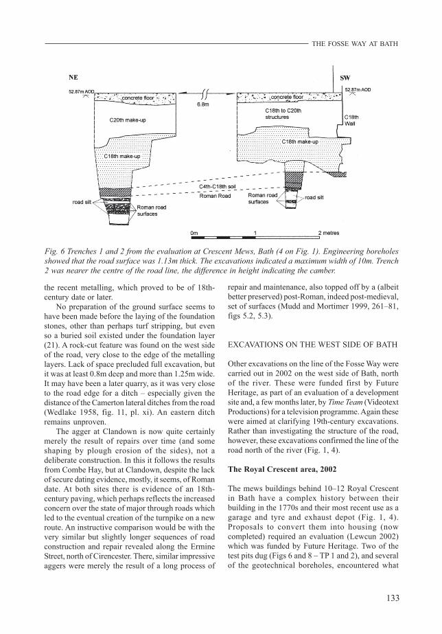
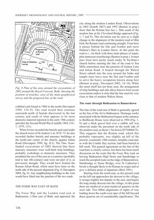
The mews buildings behind 10–12 Royal Crescentin Bath have a complex history between theirbuilding in the 1770s and their most recent use as agarage and tyre and exhaust depot (Fig. 1, 4).Proposals to convert them into housing (nowcompleted) required an evaluation (Lewcun 2002)which was funded by Future Heritage. Two of thetest pits dug (Figs 6 and 8 – TP 1 and 2), and severalof the geotechnical boreholes, encountered what
Fig. 6 Trenches 1 and 2 from the evaluation at Crescent Mews, Bath (4 on Fig. 1). Engineering boreholesshowed that the road surface was 1.13m thick. The excavations indicated a maximum width of 10m. Trench2 was nearer the centre of the road line, the difference in height indicating the camber.
SOMERSET ARCHAEOLOGY AND NATURAL HISTORY, 2007
134
were best interpreted as Roman road surfacings andsilts of a road aligned approximately south-south-west by north-north-east. In total they were 0.86mthick and extended over a width of about 8 or 9m.The test pits seemed to fall on the western camberof the road. Silts and ruts were visible in the layersand up to five resurfacings were identified. The roadwas more easily identifiable as such because it is onthe line of the road discovered by Irvine in 1870 ‘...running diagonally north-east and south-west ...’when the foundations for the tower of St Andrew’schurch were being dug (Davenport 1999, 129). Thecamber and wheel rut noted in the northern test pitand the construction material thus confirmed theearlier interpretation as a road. It is clearlysubstantially built and of the same broad scale asthe roads investigated at Combe Hay and Clandown.
On the eastern side of the road observed in 1870,a few metres north of these observations, lay a denseconcentration of human remains of Roman date.From the description given by Irvine, these seem tohave been a mix of inhumations and crematedremains. A Roman wall was also found here. Noremains or other structures were found in the 2002observations in Crescent Lane, apart from a possiblerobber trench seen in a builder’s test pit nearby.
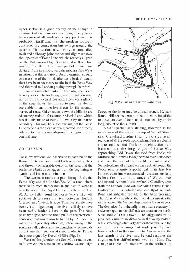
Two further trenches were dug south of the RoyalCrescent as part of a Time Team programme mountedin September of 2002 (Fig. 1, 4). These weredesigned to confirm the line of the road towards theRiver Avon. This line, predicted by the CrescentMews trenches and Keevil’s line south of the river,had also been picked up by a geophysical surveycarried out for the Time Team programme (Davenport2004). Both trenches revealed substantial gravelsurfaces and road silts, but neither were investigatedto a greater depth. However a machine sondage inone of the trenches (TH 4) showed that the roadgravels were at least 0.5m thick with largethicknesses of silt washed off the road. Unlike the1997 and 1998 excavations the road material herewas terrace gravel, excavated locally. Each trenchalso contained an inhumation burial alongside andparallel to the road line, set in a grave cut into theroad silts. Unlike the burials recorded by Irvine, theywere only on the western side. Both were male, withno grave goods except for hobnails. One, with coffinnails indicating a timber coffin was of a middle-agedmale, the other was a younger male with noindication of a coffin. They are seemingly of laterRoman date but were not independently dated.
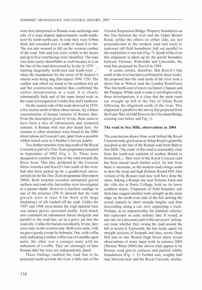
These findings enabled the road line to beprojected south towards the river, a little east of the
Victoria Suspension Bridge. Property boundaries onthis line between the river and the Upper BristolRoad, unlike the others on either side, are notperpendicular to the modern road and seem torepresent old field boundaries laid out parallel tothe road before it was lost (Fig. 7). South of the riverthis alignment is taken up by the parish boundarybetween Twerton, Widcombe and Lyncombe, theroad line proposed by Keevil in 1989.
It seems certain, therefore, that Keevil’s linesouth of the river has been confirmed by these works.He proposed that the road north of the river took adirect line to Walcot (and the London Road/FosseWay line north-east of town) via Queen’s Square andthe Paragon. While such a route is not disproved bythese investigations, it is clear that the main routeran straight up hill to the line of Julian Roadfollowing the alignment south of the river. Thisalignment is parallel to the survey line projected fromthe Fosse Way on Odd Down to the Cleveland Bridgecrossing (see below and Fig. 1).
The road to Sea Mills, observations in 2004
The conclusions drawn from work behind the RoyalCrescent make good sense as Julian Road is generallyaccepted as the line of the Roman road from Bath toSea Mills. The route of this road is reasonably clearfrom the south-east outskirts of modern Bristol toSwineford, c. 6km west of the Royal Crescent (andhas been traced much further west). Its line fromthere is uncertain, as the modern road swings southto skirt the steep and high Kelston Round Hill. Oneversion of the Roman road may well have done thesame, linking a Roman site near Kelston Farm andthe villa site at Partis College, both on its lowersouthern slopes. Fragments of field boundary andfarm lane suggest another route straight up the steepridge on the north-west side of the hill skirting theactual summit in short straight lengths and thendescending along a col, now supporting a track.Perhaps, in its impracticality for wheeled vehicles,this represents an early military line. It would, atany rate, be a necessary part of the surveyors’ setting-out route whether they swung the road around thehill or across it. Eastwards, the line leads, again viastraight sections of footpath and lane, across DeanHill and on into Weston High Street where recentobservations of water main work in summer 2004(Wessex Water 2004) has shown what appear to beRoman road gravel surfaces and packed rubblefoundations (Fig. 1, 5). Further east, roughly halfway between here and the Royal Crescent, similar,
135
THE FOSSE WAY AT BATH
probably Roman, road surfaces and foundations werealso observed in 2004 at Weston Lane in further watermain works (Fig. 1, 6; Wessex Water 2004). Thesurfaces in Weston High Street may be a later localdiversion or branch from a more logical direct routefrom Weston Lane to Penn Hill (the foot of KelstonRound Hill) across Combe Park (the present RoyalUnited Hospital). However, there is no evidence forthis route as yet.
Further east than this the road itself has not beenseen. Excavation behind the Crescent in 1986–87
(Davenport 1999, 127ff), and as part of the TimeTeam excavations in 2002, bracketed the possibleroute and indicated that the Roman road had to runpretty much under the current Julian Road at thispoint, although it was not seen. If this is so, then thejunction between it and the newly discovered roadrunning under the Crescent must be just north of thesite of the demolished tower of St Andrew’s Church,whose construction led to the discoveries here inthe first place. This gives a context for the burialsfound east and south of the road junction and the
Fig. 7 Aerial photo of the Royal Crescent and the crossing of the Avon. The solid line shows the parishboundary south of the river, and the dashed line is the line projected from the various Crescent excavationsto meet it, via the property boundaries by the river mentioned in the text.
SOMERSET ARCHAEOLOGY AND NATURAL HISTORY, 2007
136
cobbled yard found in 1986 to the north (Davenport1999, 134–9). The road would then continueeastwards north of burials discovered in the lastcentury and south of what appears to be moredomestic material reported in the early 19th centuryand after the Second World War (Cunliffe 1969, 216–7; 1979, 131).
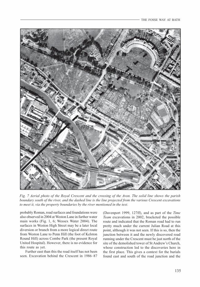
When Irvine recorded the burials and road underthe church tower of St Andrew’s in 1870–73, he alsorecorded further burials and masonry buildings atthe north-east corner of the church, against JulianRoad (Davenport 1999, fig. II.3). The Time Team-funded excavations of 2002 showed that thesemasonry structures were well-built strip buildings,probably workshops or domestic structures. Theypostdated the use of the area as a cemetery (probablymid to late 4th-century) and were not part of it, aspreviously thought. They would have fronted theRoman Julian Road, which must have been on thenorth side of the present alignment (Fig. 8; Davenport2004, fig. 6). Any neighbouring buildings to the westwould have fitted into the junction of the two roads.
THE FOSSE WAY EAST OF BATH
The Fosse Way and the London road join atBatheaston, 3.5km east of Bath, and approach the
city along the modern London Road. Observationsin 1865 (Scarth 1867) and 1992 (Beaton in prep.)show that the Roman line lies c. 50m south of themodern line at the Cleveland Bridge approach (Fig.1, 7 and 8). This deviation can be seen as a slightchange in the alignment of the modern road at MileEnd, the Roman road continuing straight. From hereit passes behind the Hat and Feather pub (nowHudson’s Bar) in London Street. At this point theroad is c. 1m thick with three main phases of repair,plus numerous resurfacings (Beaton in prep.). It mustpass from here pretty much under St Swithun’schurch before meeting the line of the road to SeaMills somewhere near the junction of Guinea Laneand Julian Road. A branch through the WalcotStreet suburb into the area around the baths andtemple must leave near the Hat and Feather pubto serve the heavy occupation known along here(Beaton in prep.; Davenport 2002, 14–16). Whilethe street itself has not been seen, the arrangementof strip buildings and side alleys known from recentexcavations makes it clear that the line must be veryclose to that of modern Walcot Street.
The route through Batheaston to Bannerdown
The line of the road east of Bath is generally agreedas the line of the A4 to Batheaston. Drainage worksassociated with the Batheaston bypass at the entranceto Bailbrook House were observed in 1994 (Fig. 1,9) and a thick gravel bed over a rubble raft wasobserved under the pavement on the north side ofthe modern road, at about 1.5m down (ST76806675).This suggests that the Roman road, which thisprobably represents, was slightly up hill of thepresent, essentially 18th-century, turnpike road and,as with the Combe Hay section, had been buried inhill wash. The general agreement on the line of theroad here is clearly correct, but there has been muchdiscussion on the route that the Fosse Way took onleaving Batheaston High Street and Stambridge toreach the accepted route on the ridge of Bannerdown.Stambridge or Stone Bridge, over St Catherine’sbrook is thought likely to be Roman in origin and sogive a definite point of departure (Bird 1991).
Starting from the north-east, as the present roadon the hill top approaches the descent to the village,it swings slightly but sharply to the east, and beginsthe long steady descent into the village. At this pointthere are medieval or post-medieval quarries on thewest side. Two 600m alignments of rights of wayleading down the south-west spur of the hill beyondthese quarries are of considerable significance. The
Fig. 8 Plan of the area around the excavations of2002 around the Royal Crescent, Bath, showing theposition of trenches, area of the main geophysicalsurvey and the proposed line of the road
137
THE FOSSE WAY AT BATH
upper section is aligned exactly on the change inalignment of the main road – although the quarrieshave removed all evidence of any junction. It isprobably significant that the modern footpathcontinues the connection but swings around thequarries. This section, now mostly an unmetalledtrack and holloway, joins the second alignment, nowthe upper part of Fosse Lane, which is exactly alignedon the Batheaston High Street/London Road linerunning into Bath. The lower part of Fosse Lanedeviates from this line toward the modern Five Waysjunction, but this is quite probably original, as onlyone crossing of the brook (the stone bridge) wouldthen have been necessary to take both the Fosse Wayand the road to London passing through Bathford.
The non-metalled parts of these alignments areheavily worn into holloways, and excavation maynot be fruitful, even if possible. However a glanceat the map shows that this route must be clearlypreferable to any other hypothesis for the original,surveyed route. Other routes down the hillside areof course possible – for example Morris Lane, whichhas the advantage of being followed by the parishboundary. This may be a later variant, but the FosseLane route has the clear air of a surveyed line directlyrelated to the known alignment, suggesting anoriginal line.
CONCLUSION
These excavations and observations have made theRoman route system around Bath reasonably clearand thrown considerable doubt on the idea that theroads were built up on aggers from the beginning assymbols of imperial domination.
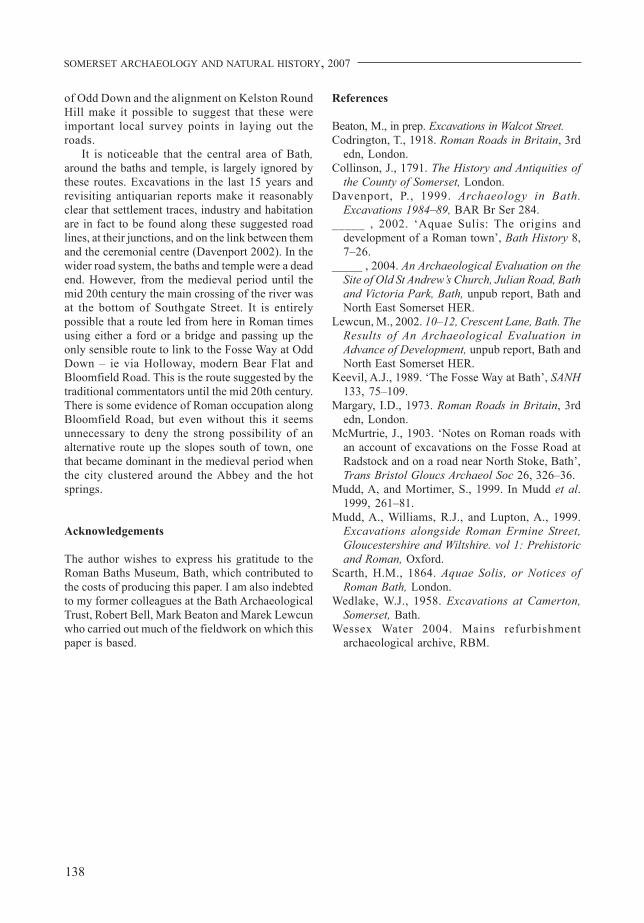
The two main roads that pass through Bath, theFosse Way and the London/Sea Mills road, sharetheir route from Batheaston in the east to what isnow the rear of the Royal Crescent in the west (Fig.9). At the latter point the Fosse Way strikes offsouthwards to cross the river between NorfolkCrescent and Victoria Bridge. This must surely havebeen via a bridge, though the river is likely to havebeen easily fordable here in the past. The roadpossibly negotiated the flood plain of the river on acauseway that would now be buried by 19th-centurymakeup and probably alluvium, before rising up thesouthern valley slope in a sweeping line which avoidsall but one short section of steep gradients. This isthe route argued by Keevil (1989) (Fig. 1).
West of this junction the Sea Mills road seemsto follow Weston Lane and may follow Weston High
Street, or the latter may be a local branch. KelstonRound Hill seems certain to be a focal point of theroad system even if the roads did not actually, or forlong, mount to the summit.
What is particularly striking, however, is theimportance of the area at the top of Walcot Street,near Cleveland Bridge (Fig. 1, 8). Significantsections of all the roads approaching Bath are clearlyaligned on this point. The long straight section fromBannerdown, the long length of Fosse Wayapproaching Odd Down, the road from Poole, viaMidford and Combe Down, the road over Lansdownand even the part of the Sea Mills road west ofSwineford, are all aligned on this spot. Although thePoole road is quite hypothetical in its last fewkilometres, its line was suggested by researchers longbefore the nodal importance of Walcot wasunderstood. A short-lived, probably Claudian, spurfrom the London Road was excavated at the Hat andFeather site in 1991 which aimed directly at the PooleRoad and indicated the site of the Avon crossing.The Fosse Way south of the river demonstrates theimportance of the Walcot alignment to the surveyors.The deviation from that alignment was necessary inorder to negotiate the difficult contours on the north-west side of Odd Down. The suggested routeprovides a minimum distance in the valley bottomwhile avoiding particularly difficult contours and themultiple river crossings that might possibly havebeen involved in the direct route. Nevertheless, thelast length to the river and beyond resumes thealignment but shifted north-west by 450m. Thechange of angle at Bannerdown, at the northern tip
Fig. 9 Roman roads in the Bath area
SOMERSET ARCHAEOLOGY AND NATURAL HISTORY, 2007
138
of Odd Down and the alignment on Kelston RoundHill make it possible to suggest that these wereimportant local survey points in laying out theroads.
It is noticeable that the central area of Bath,around the baths and temple, is largely ignored bythese routes. Excavations in the last 15 years andrevisiting antiquarian reports make it reasonablyclear that settlement traces, industry and habitationare in fact to be found along these suggested roadlines, at their junctions, and on the link between themand the ceremonial centre (Davenport 2002). In thewider road system, the baths and temple were a deadend. However, from the medieval period until themid 20th century the main crossing of the river wasat the bottom of Southgate Street. It is entirelypossible that a route led from here in Roman timesusing either a ford or a bridge and passing up theonly sensible route to link to the Fosse Way at OddDown – ie via Holloway, modern Bear Flat andBloomfield Road. This is the route suggested by thetraditional commentators until the mid 20th century.There is some evidence of Roman occupation alongBloomfield Road, but even without this it seemsunnecessary to deny the strong possibility of analternative route up the slopes south of town, onethat became dominant in the medieval period whenthe city clustered around the Abbey and the hotsprings.
Acknowledgements
The author wishes to express his gratitude to theRoman Baths Museum, Bath, which contributed tothe costs of producing this paper. I am also indebtedto my former colleagues at the Bath ArchaeologicalTrust, Robert Bell, Mark Beaton and Marek Lewcunwho carried out much of the fieldwork on which thispaper is based.
References
Beaton, M., in prep. Excavations in Walcot Street.Codrington, T., 1918. Roman Roads in Britain, 3rd
edn, London.Collinson, J., 1791. The History and Antiquities of
the County of Somerset, London.Davenport, P., 1999. Archaeology in Bath.
Excavations 1984–89, BAR Br Ser 284._____ , 2002. ‘Aquae Sulis: The origins and
development of a Roman town’, Bath History 8,7–26.
_____ , 2004. An Archaeological Evaluation on theSite of Old St Andrew’s Church, Julian Road, Bathand Victoria Park, Bath, unpub report, Bath andNorth East Somerset HER.
Lewcun, M., 2002. 10–12, Crescent Lane, Bath. TheResults of An Archaeological Evaluation inAdvance of Development, unpub report, Bath andNorth East Somerset HER.
Keevil, A.J., 1989. ‘The Fosse Way at Bath’, SANH133, 75–109.
Margary, I.D., 1973. Roman Roads in Britain, 3rdedn, London.
McMurtrie, J., 1903. ‘Notes on Roman roads withan account of excavations on the Fosse Road atRadstock and on a road near North Stoke, Bath’,Trans Bristol Gloucs Archaeol Soc 26, 326–36.
Mudd, A, and Mortimer, S., 1999. In Mudd et al.1999, 261–81.
Mudd, A., Williams, R.J., and Lupton, A., 1999.Excavations alongside Roman Ermine Street,Gloucestershire and Wiltshire. vol 1: Prehistoricand Roman, Oxford.
Scarth, H.M., 1864. Aquae Solis, or Notices ofRoman Bath, London.
Wedlake, W.J., 1958. Excavations at Camerton,Somerset, Bath.
Wessex Water 2004. Mains refurbishmentarchaeological archive, RBM.