Embed Size (px)
Citation preview
DMT 2010
The following was presented at DMT’10
(May 16-19, 2010).
The contents are provisional and will be
superseded by a paper in the
DMT’10 Proceedings.
See also earlier Proceedings (1997-2009)
http://ngmdb.usgs.gov/info/dmt/
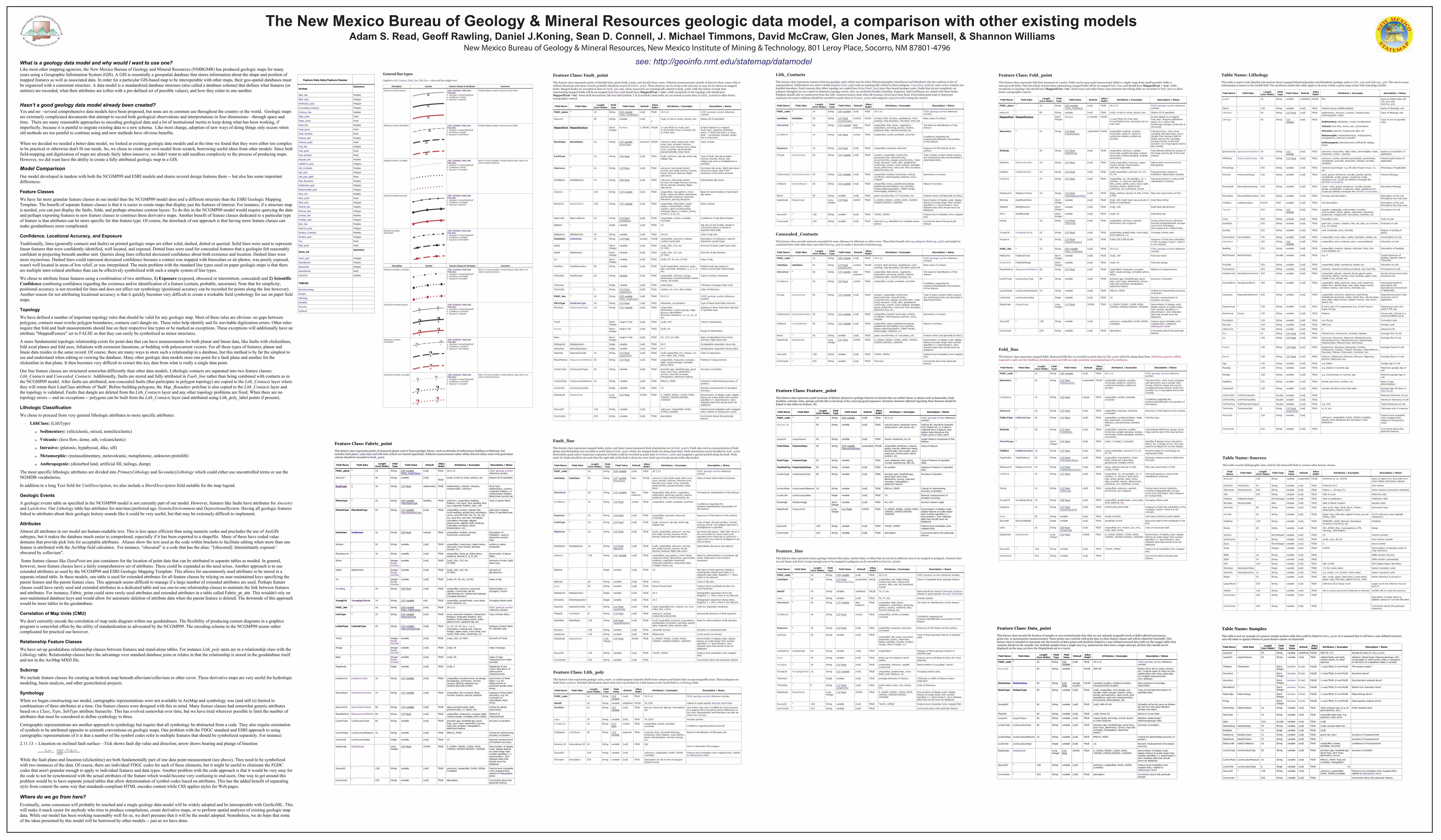
see: http://geoinfo.nmt.edu/statemap/datamodelWhat is a geology data model and why would I want to use one?Like most other mapping agencies, the New Mexico Bureau of Geology and Mineral Resources (NMBGMR) has produced geologic maps for many years using a Geographic Information System (GIS). A GIS is essentially a geospatial database that stores information about the shape and position of mapped features as well as associated data. In order for a particular GIS-based map to be interoperable with other maps, their geo-spatial databases must be organized with a consistent structure. A data model is a standardized database structure (also called a database schema) that defines what features (or entities) are recorded, what their attributes are (often with a pre-defined set of possible values), and how they relate to one another.
Hasn’t a good geology data model already been created?Yes and no—several comprehensive data models have been proposed, but none are in common use throughout the country or the world. Geologic maps are extremely complicated documents that attempt to record both geological observations and interpretations in four dimensions—through space and time. There are many reasonable approaches to encoding geological data and a lot of institutional inertia to keep doing what has been working, if imperfectly, because it is painful to migrate existing data to a new schema. Like most change, adoption of new ways of doing things only occurs when old methods are too painful to continue using and new methods have obvious benefits.
When we decided we needed a better data model, we looked at existing geologic data models and at the time we found that they were either too complex to be practical or otherwise don't fit our needs. So, we chose to create our own model from scratch, borrowing useful ideas from other models. Since both field-mapping and digitization of maps are already fairly labor-intensive, we didn't want to add needless complexity to the process of producing maps. However, we did want have the ability to create a fully attributed geologic map in a GIS.
Model ComparisonOur model developed in tandem with both the NCGMP09 and ESRI models and shares several design features them -- but also has some important differences:
Feature ClassesWe have far more granular feature classes in our model than the NCGMP09 model does and a different structure than the ESRI Geologic Mapping Template. The benefit of separate feature classes is that it is easier to create maps that display just the features of interest. For instance, if a structure map is needed, you can just display the faults, folds, and perhaps structure contour layers. To do this in the NCGMP09 model would require querying the data and perhaps exporting features to new feature classes to construct these derivative maps. Another benefit of feature classes dedicated to a particular type of feature is that attributes can be more specific for that feature type. Of course, the drawback of our approach is that having more feature classes can make geodatabases more complicated.
Confidence, Locational Accuracy, and ExposureTraditionally, lines (generally contacts and faults) on printed geologic maps are either solid, dashed, dotted or queried. Solid lines were used to represent linear features that were confidently identified, well located, and exposed. Dotted lines were used for concealed features that a geologist felt reasonably confident in projecting beneath another unit. Queries along lines reflected decreased confidence about both existence and location. Dashed lines were more mysterious. Dashed lines could represent decreased confidence because a contact was mapped with binoculars or air photos, was poorly exposed, wasn't well located in areas of low relief, or was interpolated. The main problem with the standard line types used on paper geologic maps is that there are multiple inter-related attributes than can be effectively symbolized with such a simple system of line types.
We chose to attribute linear features using a combination of two attributes, 1) Exposure (exposed, obscured or intermittent, concealed) and 2) Scientific Confidence combining confidence regarding the existence and/or identification of a feature (certain, probable, uncertain). Note that for simplicity, positional accuracy is not recorded for lines and does not affect our symbology (positional accuracy can be recorded for points along the line however). Another reason for not attributing locational accuracy is that it quickly becomes very difficult to create a workable field symbology for use on paper field maps.
TopologyWe have defined a number of important topology rules that should be valid for any geologic map. Most of these rules are obvious: no gaps between polygons, contacts must overlie polygon boundaries, contacts can't dangle etc. These rules help identify and fix inevitable digitization errors. Other rules require that fold and fault measurements should line on their respective line types or be marked as exceptions. These exceptions will additionally have an attribute "MappedFeature" set to FALSE so that they can easily be symbolized as minor structures.
A more fundamental topologic relationship exists for point data that can have measurements for both planar and linear data, like faults with slickenlines, fold axial planes and fold axes, foliations with extension lineations, or bedding with paleocurrent vectors. For all these types of features, planar and linear data resides in the same record. Of course, there are many ways to store such a relationship in a database, but this method is by far the simplest to see and understand when editing or viewing the database. Many other geologic data models store one point for a fault plane and another for the slickenline in that plane. It then becomes very difficult to extract this key data from what is really a single data point.
Our line feature classes are structured somewhat differently than other data models. Lithologic contacts are separated into two feature classes: Lith_Contacts and Concealed_Contacts. Additionally, faults are stored and fully attributed in Fault_line rather than being combined with contacts as in the NCGMP09 model. After faults are attributed, non-concealed faults (that participate in polygon topology) are copied to the Lith_Contacts layer where they will retain their LineClass attribute of 'fault'. Before building polygons, the Map_Boundary polyline is also copied to the Lith_Contacts layer and the topology is validated. Faults that dangle are deleted from the Lith_Contacts layer and any other topology problems are fixed. When there are no topology errors -- and no exceptions -- polygons can be built from the Lith_Contacts layer (and attributed using Lith_poly_label points if present).
Lithologic ClassificationWe chose to proceed from very general lithologic attributes to more specific attributes:
· LithClass: (LithType)
o Sedimentary: (siliciclastic, mixed, nonsiliciclastic)
o Volcanic: (lava flow, dome, ash, volcaniclastic)
o Intrusive: (plutonic, hypabyssal, dike, sill)
o Metamorphic: (metasedimentary, metavolcanic, metaplutonic, unknown protolith)
o Anthropogenic: (disturbed land, artificial fill, tailings, dump)
The most specific lithologic attributes are divided into PrimaryLithology and SecondaryLithology which could either use uncontrolled terms or use the NGMDB vocabularies.
In addition to a long Text field for UnitDescription, we also include a ShortDescription field suitable for the map legend.
Geologic EventsA geologic events table as specified in the NCGMP09 model is not currently part of our model. However, features like faults have attributes for Ancestry and LastActive. Our Lithology table has attributes for min/max/preferred age, GeneticEnvironment and DepositionalSystem. Having all geologic features linked to attributes about their geologic history sounds like it could be very useful, but that may be extremely difficult to implement.
AttributesAlmost all attributes in our model are human-readable text. This is less space efficient than using numeric codes and precludes the use of ArcGIS subtypes, but it makes the database much easier to comprehend, especially if it has been exported to a shapefile. Many of these have coded value domains that provide pick lists for acceptable attributes. Aliases show the text used as the code within brackets to facilitate editing when more than one feature is attributed with the ArcMap field calculator. For instance, “obscured” is a code that has the alias: “[obscured]: Intermittantly exposed / obscured by colluvium”.
Some feature classes like DataPoint are just containers for the location of point data that can be attributed in separate tables as needed. In general, however, most feature classes have a fairly comprehensive set of attributes. These could be expanded as the need arises. Another approach is to use extended attributes as used by the NCGMP09 and ESRI Geologic Mapping Template. This allows for uncommonly used attributes to be stored in a separate related table. In these models, one table is used for extended attributes for all feature classes by relying on user-maintained keys specifying the parent feature and the parent feature class. This approach seems difficult to manage if a large number of extended attributes are used. Perhaps feature classes could have rarely used and extended attributes in a dedicated table and use one-to-one relationship classes to maintain the link between features and attributes. For instance, Fabric_point could store rarely used attributes and extended attributes in a table called Fabric_pt_attr. This wouldn't rely on user-maintained database keys and would allow for automatic deletion of attribute data when the parent feature is deleted. The downside of this approach would be more tables in the geodatabase.
Correlation of Map Units (CMU)We don't currently encode the correlation of map units diagram within our geodatabases. The flexibility of producing custom diagrams in a graphics program is somewhat offset by the utility of standardization as advocated by the NCGMP09. The encoding scheme in the NCGMP09 seems rather complicated for practical use however.
Relationship Feature ClassesWe have set up geodatabase relationship classes between features and stand-alone tables. For instance Lith_poly units are in a relationship class with the Lithology table. Relationship classes have the advantage over standard database joins or relates in that the relationship is stored in the geodatabase itself and not in the ArcMap MXD file.
SubcropWe include feature classes for creating an bedrock map beneath alluvium/colluvium or other cover. These derivative maps are very useful for hydrologic modeling, basin analysis, and other geotechnical projects.
SymbologyWhen we began constructing our model, cartographic representations were not available in ArcMap and symbology was (and still is) limited to combinations of three attributes at a time. Our feature classes were designed with this in mind. Many feature classes had somewhat generic attributes based on a Class, Type, SubType attribute hierarchy. This has evolved somewhat over time, but we have tried wherever possible to limit the number of attributes that must be considered to define symbology to three.
Cartographic representations are another approach to symbology but require that all symbology be abstracted from a code. They also require orientation of symbols to be attributed opposite to azimuth conventions on geologic maps. One problem with the FDGC standard and ESRI approach to using cartographic representations of it is that a number of the symbol codes refer to multiple features that should be symbolized separately. For instance:
2.11.13 -- Lineation on inclined fault surface—Tick shows fault dip value and direction; arrow shows bearing and plunge of lineation
While the fault plane and lineation (slickenline) are both fundamentally part of one data point measurement (see above), They need to be symbolized with two instances of the data. Of course, there are individual FDGC codes for each of these elements, but it might be useful to eliminate the FGDC codes that aren't granular enough to apply to individual features and data types. Another problem with the code approach is that it would be very easy for the code to not be synchronized with the actual attributes of the feature which would become very confusing to end-users. One way to get around this problem would be to have separate joined tables that allow determination of symbol codes based on attributes. This has the added benefit of separating style from content the same way that standards-compliant HTML encodes content while CSS applies styles for Web pages.
Where do we go from here?Eventually, some consensus will probably be reached and a single geology data model will be widely adopted and be interoperable with GeoSciML. This will make it much easier for anybody who tries to produce compilations, create derivative maps, or to perform spatial analyses of existing geologic map data. While our model has been working reasonably well for us, we don't presume that it will be the model adopted. Nonetheless, we do hope that some of the ideas presented by this model will be borrowed by other models -- just as we have done.
revised: 12-Apr-2010
RAFT EOLOGIC ATA ODEL V
ONTACTS ITHOLOGIC
CONTACTS FAULTS FOLDS FEATURES MINING-MINERALIZATION-ALTERATION CONTOURS XSECTS & TRANSECTS CARTOGRAPHIC
LITHOLOGIC GEOMORPHIC SURFACES OVERLAYS ISOGRADS
Contents:
Lithologic contactsConcealed Lithologic contact
Lith_Contacts
This feature class represents contacts between geologic units which may be either lithostratigraphic (stratiform) and lithodemic (do not conform to law ofsuperposition). LithContacts are used to build polygons (Geo_poly) and are topologically related to these polygons. Concealed, surficial, and overlay contacts arehandled elsewhere. Fault contacts that affect topology are copied here (from Fault_line) since they bound geologic units. Faults that do not completely cutpolygons (dangles) are not copied to eliminate topology errors. Also, no attributes besides LineClass, Exposure, and Confidence are copied with these faults.Polygons should only be constructed from the Lith_Contacts feature class when all topology errors have been fixed. Particularly good and/or importantexposures of contact relations should be recorded as point data in Feature_point and assigned a special symbol along the contact.
Field Name Field Alias Length(text fields)
FieldType Field Value Default Allow
Nulls? setoN / noitpircseDselpmaxE / setubirttA
FGDC_code " 16 String CVD variable [null] TRUE 30.3.12 FGDC geologic symbol referencenumber.
LineClass LineClass 50 String CVD fixedContactClass
contact FALSE contact, fault, intrusive, gradational, masswasting, map-boundary, shoreline, intra-unit
Basic class of contact.
IDmethod " 50 String CVD variable fieldevidence
TRUE unspecified, field, photo, vegetation,subsurface, aeromag, gravity, seismic,analytical, lidar, remote sensing, etc.
The basis for identification of thisfeature.
Confidence " 16 String CVD fixed certain TRUE unspecified, certain, probable, uncertainConfidence regarding theexistence/identification and positionof this feature.
Exposure " 16 String CVD fixed [null] TRUE unspecified, exposed, obscured Exposure of this feature at thesurface.
CtType ContactType 50 String CVD variable [null] TRUE contact: unspecified, conformity,paraconformity, disconformity,nonconformity, angular unconformity,; fault:[null]; intrusive: [null], dike; gradational:conformity, extent; mass wasting: landslide,slump, debris flow; intra-unit: flow boundary,distinctive bed, etc.
Type of basic contact (fault contactsare null because they are described indetail elsewhere).
CtGeometry ContactGeometry 50 String CVD variable [null] TRUE unspecified, inclined, horizontal, vertical,curvilinear, intertonguing, buttress, wavy,irregular
Geometry of contact.
CtNature ContactNature 50 String CVD variable [null] TRUE unspecified, sharp, gradational-gradual,gradational-intercalated, soil, stylolites,drapes paleotopography, chilled margin,intermingled, indistinct, etc.
Nature of contact..
Name " 50 String variable [null] TRUE great unconformity, K-T boundary, etc Feature name (will generally be NULL)
DsplyScale DisplayScale LongInteger
CVD fixed 24000 TRUE 0, 24000, 50000, 12000, 6000, 100000,250000,500000, 1000000
Denominator of display scale: displayfeature at scales larger than numberspecified (=< denominator). Zeroindicates data that should never bedisplayed.
SourceID " deppam ohw( atadatem level erutaeF"a9991 ,htimS"EURT]llun[elbairavgnirtS821this)
Comments " 255 String variable [null] TRUE Free text e.g. identified from detailed stereophotos
Comments about this particularfeature.
Concealed_Contacts
This feature class records contacts concealed for some distance by alluvium or other cover. These lines bound subcrop polygons (Subcrop_poly) and might becombined later with other lines and with Subcrop_poly to make a derivative bedrock map.
Field Name Field Alias Length(text fields)
FieldType Field Value Default Allow
Nulls? setoN / noitpircseDselpmaxE / setubirttA
FGDC_code " 16 String CVD variable [null] TRUE 30.3.12 FGDC geologic symbol referencenumber.
LineClass LineClass 24 String CVD fixedContactClass
contact FALSE contact, fault intrusive, gradational, masswasting, map-boundary, shoreline, intra-unit
Basic class of contact.
IDmethod " 50 String CVD variable fieldevidence
TRUE unspecified, field, photo, vegetation,subsurface, aeromag, gravity, seismic,analytical, lidar, remote sensing, etc.
The basis for identification of thisfeature.
Confidence " 16 String CVD fixed certain TRUE unspecified, certain, probable, uncertainConfidence regarding theexistence/identification and positionof this feature.
CtType ContactType 50 String CVD variable [null] TRUE contact: unspecified, conformity,paraconformity, disconformity,nonconformity, angular unconformity,; fault:[null]; intrusive: [null], dike; gradational:conformity, extent; mass wasting: landslide,slump, debris flow; intra-unit: flow boundary,distinctive bed, etc.
Type of basic contact (fault contactsare null because they are described indetail elsewhere).
CtGeometry ContactGeometry 50 String CVD variable [null] TRUE unspecified, inclined, horizontal, vertical,curvilinear, intertonguing, buttress, wavy,irregular
Geometry of contact.
CtNature ContactNature 50 String CVD variable [null] TRUE unspecified, sharp, gradational-gradual,gradational-intercalated, soil, stylolites,drapes paleotopography, chilled margin,intermingled, indistinct, etc.
Nature of contact..
Name " 50 String variable [null] TRUE great unconformity, K-T boundary, etc Feature name (will generally be NULL)
DsplyScale DisplayScale LongInteger
CVD fixed 24000 TRUE 0, 24000, 50000, 12000, 6000, 100000,250000,500000, 1000000
Denominator of display scale: displayfeature at scales larger than numberspecified (=< denominator). Zeroindicates data that should never bedisplayed.
SourceID " deppam ohw( atadatem level erutaeF"a9991 ,htimS"EURT]llun[elbairavgnirtS821this)
ralucitrap siht tuoba stnemmoCtxet eerFEURT]llun[elbairavgnirtS552"stnemmoCfeature.
[return to top]
1 of 1 5/14/2010 6:52 PM
revised: 13-May-2010
RAFT EOLOGIC ATA ODEL V
APPED AULTS
CONTACTS FAULTS FOLDS FEATURES MINING-MINERALIZATION-ALTERATION CONTOURS XSECTS & TRANSECTS CARTOGRAPHIC
Fault_line
This feature class represents mapped faults, joints, and shear zones (measured fault orientations are in fault_point). Fault data such as measurements of faultplanes and slickenlines are recorded as point data in fault_point which, for mapped faults, lie along these lines. Fault annotation can be handled by fault_point.Particularly good and/or important exposures of faults could be recorded as point data in Feature_point and assigned a special symbol along the fault. Nodeorder for faults should be set such that the right side of the fault is down for every fault type (except purely strike-slip faults).
Field Name Field Alias Length(text fields)
FieldType Field Value Default Allow
Nulls? setoN / noitpircseDselpmaxE / setubirttA
FGDC_code " 16 String CVD variable [null] TRUE 30.3.12 FGDC geologic symbol referencenumber.
LineClass LineClass 50 String CVD variableStructClass
fault FALSE unknown, fault, fault-scarp, fault zone,joint, jointset, fracture, fracture zone,breccia zone, shear zone, mylonite,ultramylonite, pseudotachylite, shearband
Class of linear deformation structure.
IDmethod " 50 String CVD variable fieldevidence
TRUE unspecified, field, photo, vegetation,subsurface, aeromag, gravity, seismic,analytical, lidar, remote sensing, etc.
The basis for identification of this feature.
Confidence " 16 String CVD fixed certain TRUE unspecified, certain, probable, uncertainConfidence regarding theexistence/identification and position ofthis feature.
Exposure " 16 String CVD fixed [null] TRUE unspecified, exposed, obscured,concealed
Exposure of this feature at the surface.
FaultType " 16 String CVD fixed [null] TRUE [null], unknown, dip-slip, strike-slip,oblique-slip.
Type of fault. Dip-slip includes: normal,reverse, thrust. Use oblique-slip when aSubSlipSense is specified
SlipSense " 16 String CVD fixed [null] TRUE [null], unspecified, unknown, normal,low-angle normal, reverse, thrust,dextral, sinestral, Right-side down
Dominant slip sense; "right side" down isthe convention for every type (onlyspecified when FaultType is unknown) --node order may need to be flipped to setthis correctly.
SubSlipSns SubSlipSense 16 String CVD fixedSlipSense
[null] TRUE [null], unspecified, unknown, normal,low-angle normal, reverse, thrust,dextral, sinestral, Right-side down
Subordinate slip sense (see above)
SlipBasis " 128 String CVD variable [null] TRUE unspecified, map pattern, minor faults,observed offset, slickenlines, geomorphicevidence, vegetation lineament,kinematic indicators, subsurface data,multiple criteria, etc.
Basis for determination of dominant slipsense. Elaborate in comments ifnecessary.
ni sliateD .tnemges tluaf no etar pilS01EURT]llun[elbairavelgniS "etaRpilStopologically related point data or inseparate data table. Negative 1 = NULLwhich is not allowed.
.etar pils fo stinUry/mmEURT]llun[elbairavgnirtS02"stinUpilS
NAME " rof LLUN eb ylekil lliw( eman erutaeFtluaF siruciP-socePEURT]llun[elbairavgnirtS05most features)
.pid nwod noitarapes cihpargitartS3.43EURT]llun[elbairavelgniS noitarapeSpiDtarapeSpiDNegative 1 = NULL which is not allowed.
.ekirts gnola noitarapes cihpargitartS7.42EURT]llun[elbairavelgniS noitarapeSekirtSpeSekirtSNegative 1 = NULL which is not allowed.
SepUnits SeparationUnits 16 String CVD fixedLengthUnits
[null] TRUE [null] unspecified, km, meters, cm, mm,miles, feet, inches
Units for seperation attributes
FltDipDir FaultDipDir 8 String CVD fixed [null] TRUE unknown, vertical,N,NE,E,SE,S,SW,W,NW
General Dip direction of fault segment.
DipDirBsis DipDirBasis 128 String CVD fixedFaultDipDirBasis
[null] TRUE [null] unspecified, exposed, map pattern,stratigraphic constraint, well data, gravitydata, magnetic data, seismic data
Basis for determination of dip direction.
tluaf detavitcaer fo yrtsecnAesrever edimaraLEURT]llun[elbairavgnirtS821"yrtsecnA
tnemevom tnecer tsomenecotsielPEURT]llun[elbairavgnirtS821"evitcAtsaL
DsplyScale DisplayScale LongInteger
CVD fixed 24000 TRUE 0, 24000, 50000, 12000, 6000,100000, 250000,500000, 1000000
Denominator of display scale: displayfeature at scales larger than numberspecified (=< denominator). Zeroindicates data that should never bedisplayed.
SourceID " deppam ohw( atadatem level erutaeF"a9991 ,htimS"EURT]llun[elbairavgnirtS821this)
.erutaef ralucitrap siht tuoba stnemmoC EURT]llun[elbairavgnirtS552"stnemmoC
[return to top]
NMBGMR Draft Geologic Map Data Model: Mapped Faults http://geoinfo.nmt.edu/statemap/datamodel/lines/faults/home.html
revised: 13-May-2010
RAFT EOLOGIC ATA ODEL V
ITHOLOGIC NITS
LITHOLOGIC GEOMORPHIC LANDFORMS OVERLAYS MINING-MINERALIZATION-ALTERATION METAMORPHIC CARTOGRAPHIC
Contents:
Geologic units (lithologic)Polygon labels (lithologic)
Subcrop units (lithologic)
Feature Class: Lith_poly
This feature class represents geologic units, water, or anthropogenic deposits (built from contacts and faults) that occupy mappable areas. These polygons arebuilt from contacts. Detailed information about each unit is provided via a link based on the GeoID field to a lithology table.
Field Name Field Alias Length(text fields)
FieldType
FieldValue Default Allow
Nulls? setoN / noitpircseDselpmaxE / setubirttA
FGDC_code " 16 String CVDvariable
[null] TRUE 30.3.12 FGDC geologic symbol reference number.
GeoID cificeps-dauq ot detaleraTQ ,bTESLAFdenifednuelbairavgnirtS61" lithologic detail table
Modified " 24 String CVDvariable
[null] TRUE breccia, fractured, altered, mineralized,etc
Use where map unit is modified by some processto a degree that it should be shown differently onthe map. Mineralization and Alteration can also beshown as overlays.
LABEL seireuq sedulcni?aTQ ,bTEURT]llun[elbairavgnirtS61"
Confidence " 16 String CVDfixed
certain TRUE unspecified, certain, probable,uncertain confidence regarding feature level ID
LthIDbasis LithIDbasis 50 String CVDvariable
exposed TRUE exposed, float, dominant lithology,projected, strat-relation, map-relation,photo interpretation, remote sensing,etc.
Basis for identification of lithologic unit.
General_ID Generalized_ID 16 String variable [null] TRUE QsfHow to Generalize this polygon.
SourceID " 128 String variable [null] unknown; unspecified; Smith, 2006b[variable]
Feature level metadata (who mapped this); relatedto bibliographic detail
Descriptn Description 255 String variable [null] TRUE Description of unit in area of polygon(feature level)
Feature Class: Lith_poly_label
This point feature class is used as an aid in building polygons when digitizing and represents the geologic unit that a polygon that contains the point should beattributed with. This feature class is similar to the labels in an ArcInfo coverage. A topology rule requires that a Lith_poly polygon contain a Lith_poly_labelpoint. When polygons are built from their bounding lines, the GeoID of the point can be used to attribute the newly created polygon feature and to retainattributes when polygon topology needs to be rebuilt.
Field Name Field Alias Length(text fields)
FieldType
FieldValue Default Allow
Nulls? setoN / noitpircseDselpmaxE / setubirttA
FGDC_code " 16 String CVDvariable
[null] TRUE 30.3.12 FGDC geologic symbol reference number.
GeoID cificeps-dauq ot detaleraTQ ,bTESLAFdenifednuelbairavgnirtS61" lithologic detail table
Modified " 24 String CVDvariable
[null] TRUE breccia, fractured, altered, mineralized,etc
Use where map unit is modified by some processto a degree that it should be shown differently onthe map. Mineralization and Alteration can also beshown as overlays.
LABEL seireuq sedulcni?aTQ ,bTEURT]llun[elbairavgnirtS61"
Confidence " 16 String CVDfixed
certain TRUE unspecified, certain, probable,uncertain confidence regarding feature level ID
N h.cigolohtil/snogylop/ledomatad/pametats/ude.tmn.ofnioeg//:ptthstinU cigolohtiL - snogyloP :ledoM ataD paM cigoloeG tfarD RMGBM tml
revised: 13-May-2010
RAFT EOLOGIC ATA ODEL V
ITHOLOGIC NIT ETAIL
LITH UNIT-DETAIL GEOMORPHIC SURFACES GEOCHRON DETAIL IMAGES SAMPLE DATA BIBLIOGRAPHIC SOURCE DATA
Table Name: Lithology
This table is used to link detailed information about mapped lithostratigraphic and lithodemic geologic units to Lith_poly and Subcrop_poly. The one-to-manyrelationship is based on the GeolID field. The attributes within this table apply to all areas within a given map extent with matching GeoIDs.
Field Name Field Alias Length(text fields)
FieldType Field Value Default Allow
Nulls? Attributes / Examples Description / Notes
GeoID " htiw pihsnoitaler fo sisabmPIESLAFdenifednuelbairavgnirtS61Lith_poly andSubcrop_poly
.tinu cigolohtil fo emaNdetaitnereffidnu puorG aredaMEURT]llun[elbairavgnirtS821"emaN
LithClass gnirtS05" CVD fixed [null] TRUE sedimentary, intrusive, volcanic, metamorphic,anthropogenic, water
Class of lithologic unit
LithType gnirtS05" CVDvariable
[null] TRUESedimentary: siliciclastic, mixed, nonsiliciclastic
Volcanic: lava flow, dome, ash, volcaniclastic
Intrusive: plutonic, hypabyssal, dike, sill
Metamorphic: metasedimentary, metavolcanic,metaplutonic, unknown protolith
Anthropogenic: disturbed land, artificial fill, tailings,dump
Type of unit of specifiedclass
IgneousCmp IgneousComposition 50 String CVDvariable
[null] TRUE unknown, leucocratic, silicic, felsic, intermediate, mafic,ultramafic, [other - specify]
Igneous composition (ifapplicable)
MMfacies MetamorphicFacies 50 String CVD fixed [null] TRUE unknown, zeolite, prehnite-pumpellyite, greenschist,amphibolite, granulite, blueschist, eclogite, hornfels,sanidinite
Metatmorphic facies (ifapplicable)
EURT]llun[elbairavgnirtS552"ygolareniM mineral assemblage: e.g. Bt+Qtz+Kspar+musc; Cc;etc.
Mineralogy (if applicable)
PrimLith PrimaryLithology 128 String variable [null] TRUE sand, gravel, limestone, rhyolite, granite, diorite,amphibolite, schist, gneiss, mudstone, shale,sandstone etc. Could use defined ontologies likeNGMDB vocabularies.
Primary lithology
SecondLith SecondaryLithology 128 String variable [null] TRUE minor- sand, gravel, limestone, rhyolite, granite,diorite, amphibolite, mudstone, shale, sandstone etc.Could use defined ontologies like NGMDB vocabularies.
Secondary lithology
tinu eht fo noitpircseD.noitpircsed tinu esicnoCEURT]llun[elbairavgnirtS552noitpircseDtinUtrohScseDtrohSthroughout the map area.
tinu eht fo noitpircseDnoitpircsed tinUEURT]llun[elbairavTXET53556noitpircseDtinUcseDtinUthroughout the map area.
Texture gnirtS552" CVDvariable
[null] TRUE angular, subangular, subrounded, rounded,well-rounded, clastic, glassy, ahphanitic, phaneritic,porphyritic, megacrystic, brecciated, mylonitic, etc.
Provenance of unit
.tinu fo roloCroloc )?(llesnuMEURT]llun[elbairavgnirtS552"roloC
:ciremun ro[ ,yalc ,tlis ,enif ,muidem ,esraoc :ezis niargEURT]llun[elbairavgnirtS552"eziSniarGe.g. 1m clasts]
Grainsize of unit.
fo gnitros fo eergeDladomib ,roop ,etaredom ,llewEURT]llun[elbairavgnirtS552"gnitroSgrains.
Cemntation Cementation 255 String variable [null] TRUE unspecified, none, silica, calcite, hematite, zeolite, etc. Cementation of unit.
Induration gnirtS552" CVDvariable
[null] TRUE unspecified, well, moderate, poor, unconsolidated Induration of unit.
,niht ,kciht ,ralucitnel ,ralubat ,evissam ,deificepsnuEURT]llun[elbairavgnirtS552"gniddeBcross bedded, etc.
Description of bedding
fo ssenkciht lacipyT4 .g.eEURT]llun[elbairavelbuoD ssenkcihTdeBssenkhTdeBbedding. Specify units inThickUnits
.tinu fo noitarudnI.cte ,tlasab ,enotsdnas ,etilep ,deificepsnuEURT]llun[elbairavgnirtS552"htilotorP
.tinu fo ecnanevorPstM nauJ naS ,ylrehtuos,ylrehtron,ylretsae ,ylretsewEURT]llun[elbairavgnirtS552"ecnanevorP
GenEnvrnmt GeneticEnvironment 255 String variable [null] TRUE unspecified, alluvial, colluvial, fluvial, glacial eolian,lacustrine, deltaic, marine, mass wasting, upper crust,middle crust, mantle, etc.
Genetic Environment thatproduced unit.
GenLndform GeneticLandform 255 String variable [null] TRUE unspecified, delta, point bar, dune, reef, piedmont,debris flow, alluvial slope, reef, delta, deep-marine,shallow-marine, near-shore, intertidal, etc.
Interpreted landformassociated withdepositional environment(if applicable).
DepoSyst DepositionalSystem 255 String variable [null] TRUE unspecified, unknown, piedmont, axial-fluvial,transitional, lacustrine, eolian, debris flow, alluvial slope,reef, delta, deep-marine, shallow-marine, near shore,beach, etc.
Depositional system thatproduced unit (ifapplicable).
noynaC dnarG .g.e( puorgrepus a fo trap si tinu fIEURT]llun[elbairavgnirtS821"puorGrepuSSuper Group)
Supergroup rank (notused in NM yet)
a si 'puorG'( knar puorGaredaMEURT]llun[elbairavgnirtS821puorGpuorGoeGreserved DBMS word)
knar noitamroFsoyoM soLEURT]llun[elbairavgnirtS821"noitamroF
knar rebmeMwoC dliWEURT]llun[elbairavgnirtS821"rebmeM
DI emosohtiLAEURT]llun[elbairavgnirtS821"emosohtiL
Eon gnirtS42" CVD fixed [null] TRUE Phanerozoic, Proterozoic, Archean, Hadean Geologic Eon of unit
Era gnirtS821" CVD fixed [null] TRUE Cenozoic, Mesozoic, Paleozoic, Neoproterozoic,Mesoproterozoic, Paleoproterozoic, Neoarchean,Mesoarchean, Paleoarchean, Eoarchean
Geologic Era of unit
Period gnirtS821" CVD fixed [null] TRUE Quaternary, Neogene, Paleogene, Tertairy,Cretaceous, Jurassic, Triassic, Permian, Carboniferous,Devonian, Silurian, Ordovician, Cambrian, etc.
Geologic Period of unit
Epoch gnirtS821" CVD fixed [null] TRUE Holocen, Pleistocene, Pliocene, Miocene, Oligocene,Eocene, Paleocene, etc.
Geologic Epoch of unit
tinu fo egA cigloeGnaiblA .g.eEURT]llun[elbairavgnirtS821"egA
fo egA cigloeg mumixaMega ciremun ro naitpA .g.eEURT]llun[elbairavgnirtS821"egAxaMunit
fo egA cigloeg muminiMega ciremun ro nainamoneC .g.eEURT]llun[elbairavgnirtS821"egAniMunit
ega fo sisaBcte ,noitisop ,norhcoeg ,slissofEURT]llun[elbairavgnirtS552"sisaBegAdetermination.
IsoDateID " ot sknil( DI etad cipotosIatad etad tseb ot knil/ofni elpmasEURT]llun[elbairavgnirtS821Date Detail)
tinu fo ssenkciht muminiM EURT]llun[elbairavelbuoD niMssenkcihTtinUniMkchTtnU
tinu fo ssenkciht mumixaM EURT]llun[elbairavelbuoD xaMssenkcihTtinUxaMkchTtnU
tinu fo ssenkciht lacipyT543 .g.eEURT]llun[elbairavelbuoD lacipyTssenkcihTtinUpyTkchTtnU
ThickUnits ThicknessUnits 8 String CVD fixedLengthUnits
.erusaem fo tinu ssenkcihT.cte ,tf ,mEURT]llun[
SourceID ]llun[elbairavgnirtS821"unknown; unspecified; Smith, 2006b [variable].Specify when attributes like description needattribution.
Feature level metadata(who mapped this);related to bibliographicdetail
siht tuoba stnemmoC EURT]llun[elbairavgnirtS552"stnemmoCparticular feature.
[return to top]
NMBGMR Draft Geologic Map Data Model: Lithologic Unit Detail http://geoinfo.nmt.edu/statemap/datamodel/related_tables/lith-detail.html
1 of 1 5/14/2010 7:01 PM
revised: 13-May-2010
RAFT EOLOGIC ATA ODEL V
IBLIOGRAPHIC ATA
LITH UNIT-DETAIL GEOMORPHIC SURFACES GEOCHRON DETAIL IMAGES SAMPLE DATA BIBLIOGRAPHIC SOURCE DATA
Table Name: Sources
This table records bibliographic data cited by the SourceID field in various other feature classes.
FieldName Field Alias Length
(text fields) Field Type FieldValue Default Allow
Nulls? Attributes / Examples Description / Notes
SourceID morf DIecruoS morf etaler fo sisabb3002 ,.la .te hsotnIcMESLAFdeificepsnuelbairavgnirtS821"other tables and feature classes
rohtuA tsriF.C.W hsotnIcMEURT]llun[elbairavgnirtS05rohtuAtsriFhtuAtsriF
)detimiled nolocimes( srohtuA rehtO.J.D ,gninoK ,.L ,sretePEURT]llun[elbairavgnirtS552srohtuArehtOhtuArehtO
eltit ecnerefeRkrow fo eltiTEURT]llun[elbairavgnirtS552"eltiT
etad noitacilbuPnoitacilbup fo etadEURT]llun[elbairavregetnItrohS etaDnoitacilbuPetaDbuP
etad noisiveRnoisiver tsetal fo etadEURT]llun[elbairavetad etaDnoisiveRetaDveR
DocType " 50 String variable [null] TRUE new work, Map, Serial, Book, Thesis /Dissertation, Report, other
Document type
Format " 50 String variable [null] TRUE paper map, GIS-data, digital-format, journal-article, other
Formt reference was originallyreleased in.
Publisher " 128 String variable [null] TRUE NMBGMR, USGS, Elsevier, GeologicalSocienty of America, etc.
Publisher
Series " 50 String variable [null] TRUE GM, OFGM, Misc. Investigations, OFR,Geology, GSA Bulletin,
Series
rebmun emuloV22EURT]llun[elbairavregetnItrohS "emuloV
rebmun emulov-buVcte ,III ,c,b,a ,]llun[EURT]llun[elbairavgnirtS8"emuloVbuS
rebmun eussI2EURT]llun[elbairavregetnItrohS "eussI
fo elacs etulosba fo rotanimoneD00042EURT]llun[elbairavregetnI "elacSmap reference.
)skoob( rebmun NBSI EURT]llun[elbairavgnirtS61"NBSI
)slacidoirep( rebmun NSSI EURT]llun[elbairavgnirtS61"NSSI
)reifitnedI tcejbO latigiD( IODIOD fo LRUEURT]llun[elbairavgnirtS821"IOD
eulav noituloser retsaR)atad retsar rof( 51EURT]llun[elbairavelgniS eulaVnoituloseReulaVseR
ResUnits ResolutionUnits 16 String variable [null] TRUE e.g. meter, cm, foot(for raster data) Raster resolution units
Media " 24 String variable [null] TRUE film, mylar, paper, field sheet, scribe sheet,paper map, GIS-data, digital-format, other
Media reference is stored on
eb yam ecerefer eht krow regraLkrow regral fo DI ecnereferEURT]llun[elbairavgnirtS552"kroWregraLpart of
Hotlink " 128 String variable [null] TRUE link to source document (internet or intranet) Hotlink URL to external resource.
Conversion " 255 String variable [null] TRUE Description of steps taken todigitally capture or convert this data.
ralucitrap siht tuoba stnemmoC EURT]llun[elbairavgnirtS552"stnemmoCreference.
[return to top]
NMBGMR Draft Geologic Map Data Model: Bibliographic Data http://geoinfo.nmt.edu/statemap/datamodel/related_tables/biblio-data.html
revised: 13-May-2010
RAFT EOLOGIC ATA ODEL V
APPED OLDS
CONTACTS FAULTS FOLDS FEATURES MINING-MINERALIZATION-ALTERATION CONTOURS XSECTS & TRANSECTS CARTOGRAPHIC
Fold_line
This feature class represents mapped folds. Measured fold data is recorded as point data in fold_point which lie along these lines. Definition queries will berequired to split out the FoldClass attributes since ArcGIS can only symbolize on permutations of 3 attributes.
Field Name Field Alias Length(text fields)
FieldType Field Value Default Allow
Nulls? Attributes / Examples Description / Notes
FGDC_code " 16 String CVD variable [null] TRUE 30.3.12 FGDC geologic symbol referencenumber.
Geometry " 24 String CVD fixedFoldGeometry
unspecified FALSE unspecified, anticline, syncline,monocline, antiform, synform,synformal anticline, antiformalsyncline
Fold geometry; (this mixes youngingwith geometry, but is simpler thanhaving a field for shape and one foryounging because having "synformalsyncline" on a map legend seems likeoverkill).
Confidence " 16 String CVD fixed certain TRUE unspecified, certain, probable,uncertain Confidence regarding the
existence/identification and position ofthis feature.
Exposure " 16 String CVD fixed [null] TRUE unspecified, exposed, obscured,concealed
Exposure of this feature at the surface.
FoldLnType FoldLineType 50 String CVD fixed [null] TRUE unspecified, syncline/anticline: hingeline, axial trace; monoclines:inflection, synclinal bend, anticlinalbend
Fold line type.
Attitude " 20 String CVD fixedFoldAttitude
[null] TRUE unspecified, unknown, upright-horizontal, upright-plunging, inclined-horizontal, inclined-plunging, reclined,recumbent,
Fold attitude defined by plunge of thehinge and the dip of the axial surface.
ShowPlunge " shortinteger
CVD fixed [null] TRUE [null], 1 [single], 2 [double] Specifies if plunge arrows should bedrawn, for 1 (single arrow), line mayneed to be flipped for correct display.
FoldGen FoldGeneration 16 String CVD fixed [null] TRUE [null] unspecified, unknown, F1, F2,F3, F4
Would be basis for symbology forsuperposed folds
TypeEvidnc TypeEvidence 20 String CVD fixedFoldTypeEvidence
[null] TRUE unspecified, map pattern, minorfolds, observed, subsurface,geophysical, multiple criteria
Geologic evidence used to determinefold type.
MapAsymm MapAsymmetry 16 String CVD fixedFoldMapAsymmetry
[null] TRUE hinge, sinistral, dextral, M-fold,Z-fold, S-fold
Map view asymmetry of fold
FoldStyle " 24 String CVD fixed [null] TRUE unspecified, 1A, 1B (parallel), 1C, 2(similar), 3; chevron, fault-bend,kink, acute, gentle, open, close,tight, isoclinal, obtuse, disharmonic,cylindrical, non-cylindrical, conical
Fold style based on various foldclassification schemes.
Facing " 16 String CVD fixedFoldFacing
[null] TRUE unspecified, unknown, upward,downward, see-vergence
Facing where known (directiontowards stratigraphically youngerrocks from fold hinge). See-vergencefor inclined folds.
YoungCrit YoungingCriteria 16 String CVD fixed [null] TRUE unspecified, graded beds, cross beds,strat relations, etc.
Younging criteria used.
Vergence " 16 String CVD fixedOctantDirections
[null] TRUE N,NE,E,SE,S,SW,W,NW Vergence of fold (the orientation of theyounging "vector" when it is notvertical).
NAME " )selbat tniop ot deknil( eman dloFenilcnyS odnoHEURT]llun[elbairavgnirtS05
eht fo edutilpma eht fo feiler larutcurtSdlof fo edutilpmaEURT]llun[elbairavelgniS feileRlarutcurtSflRtcurtSfold.
Units " 16 String CVD fixedLengthUnits
[null] TRUE unspecified, km, meters, cm, mm,miles, feet, inches
Units of structural relief.
DsplyScale DisplayScale LongInteger
CVD fixed 24000 TRUE 0, 24000, 50000, 12000, 6000,100000, 250000,500000, 1000000
Denominator of display scale: displayfeature at scales larger than numberspecified (=< denominator). Zeroindicates data that should never bedisplayed.
SourceID " deppam ohw( atadatem level erutaeF"a9991 ,htimS"EURT]llun[elbairavgnirtS821this)
ralucitrap siht tuoba stnemmoC EURT]llun[elbairavgnirtS552"stnemmoCfeature.
[return to top]
NMBGMR Draft Geologic Map Data Model: Mapped Folds http://geoinfo.nmt.edu/statemap/datamodel/lines/folds/home.html
revised: 13-May-2010
RAFT EOLOGIC ATA ODEL V
APPED INEAR EATURES
CONTACTS FAULTS FOLDS FEATURES MINING-MINERALIZATION-ALTERATION CONTOURS XSECTS & TRANSECTS CARTOGRAPHIC
Feature_line
This feature class represents linear geologic features like ashes, marker beds, or dikes that do not have sufficient area to be mapped as polygons. Features thatare not linear and don't occupy enough area to be mapped as polygons can be recorded as Feature_points.
Field Name Field Alias Length(text fields)
FieldType Field Value Default Allow
Nulls? Attributes / Examples Description / Notes
FGDC_code " 16 String CVD variable [null] TRUE 30.3.12 FGDC geologic symbol reference number.
LineClass " 50 String CVD fixedFeatureLineClass
unspecified FALSE unspecified, ash, lapilli, tephra,marker-bed, flow, [intra-unit]contact, dike, vein, sill, lineament,margin
Class of mappable linear geologic feature.
GeoID rof desu sa DIoeG emaScte ,iT ,bTESLAFdenifednuelbairavgnirtS61" lithologic polygons.related to quad-specific lithologic detail table
LABEL seireuq sedulcni.cte ,?iT ,bTEURT]llun[elbairavgnirtS61"
IDmethod " 50 String CVD variable fieldevidence
TRUE unspecified, field, photo,vegetation, subsurface, aeromag,gravity, seismic, analytical, lidar,remote sensing, etc.
The basis for identification of this feature.
Confidence " 16 String CVD fixed certain TRUE unspecified, certain, probable,uncertain Confidence regarding the
existence/identification and position of thisfeature.
Exposure " 16 String CVD fixed [null] TRUE unspecified, exposed, obscured,concealed
Exposure of this feature at the surface.
LineType " 50 String variable [null] TRUEunspecified, fall, surge, reworked,pegmatite, quartz, carbonate,basalt, andesite, rhyolite, [crater]margin, [flow] margin, etc.
Type of linear geologic feature of specifedclass.
fo erutaef cigoloeg raenil fo epytbuS? ,deificepsnuEURT]llun[elbairavgnirtS05epyTbuSeniLpyTbuSeniLspecifed type.
NAME " 50 String variable [null] TRUE White ash #4 (linked to pointtables)
Feature name (will likely be NULL for mostfeatures)
Younging " 16 String CVD fixed [null] TRUE unspecified, unknown, upright,overturned
Determination of younging "vector'.
YoungCrit YoungingCriteria 16 String CVD variable [null] TRUE unspecified, graded beds, crossbeds, strat relations, etc.
Younging criteria used.
Thickness " Single variable [null] TRUE average thickness of feature Thickness or width of feature whereimportant.
ThickUnits " 8 String CVD fixedLengthUnits
[null] TRUE [null] meters, feet, mm, inches,etc.
Units of thickness.
DsplyScale DisplayScale LongInteger
CVD fixed 24000 TRUE 0, 24000, 50000, 12000, 6000,100000, 250000,500000,1000000
Denominator of display scale: displayfeature at scales larger than numberspecified (=< denominator). Zero indicatesdata that should never be displayed.
SourceID " )siht deppam ohw( atadatem level erutaeF"a9991 ,htimS"EURT]llun[elbairavgnirtS821
.erutaef ralucitrap siht tuoba stnemmoC EURT]llun[elbairavgnirtS552"stnemmoC
[return to top]
NMBGMR Draft Geologic Map Data Model: Mapped Linear Features http://geoinfo.nmt.edu/statemap/datamodel/lines/features/home.html
revised: 13-May-2010
RAFT EOLOGIC ATA ODEL V
OLD ATA
PLANAR & LINEAR FABRICS FAULT DATA FOLD DATA FEATURES SAMPLE DATA WELLS MINE DATA TICS
Contents:
Fold data (fold_point)Fold Symbols (Fold_Symbols)
Feature Class: Fold_point
This feature class represents fold data measured at a point. Folds can be map-scale (macroscopic folds) or might range from small parasitic folds oroutcrop-scale folds. Only the subset of point data representing mapped folds will lie on mapped fold_lines and should have MappedFeat = 'yes', whileexceptions to topology rule should have MappedFeat ='no'. Axial traces and other linear map elements describing folds are recorded in Fold_lines to allowbetter cartographic control.
Field Name Field Alias Length(text fields)
FieldType Field Value Default Allow
Nulls? Attributes / Examples Description / Notes
FGDC_plane " 16 String CVD variableFGDC_FoldPlanar
[null] TRUE 30.3.12 FGDC geologic symbol referencenumber.
StationID " 50 String variable [null] TRUE [null], to link to notes, photos, etc. Station ID (if specified)
MappedFeat MappedFeature ShortInteger
boolean 0 (FALSE) FALSE1=yes/TRUE (on Fold_line)0=no/FALSE (minor structure not onFold_line)
Is fold related to a mappedFold_line?: Requires definintionquery: for a minor foldsymbology changes (strike line isremoved).
Geometry " 24 String CVD fixedFoldGeometry
unspecified FALSE unspecified, anticline, syncline,monocline, antiform, synform,synformal anticline, antiformalsyncline
Fold geometry; (this mixesyounging with geometry, but issimpler than having a field forshape and one for youngingbecause having "synformalsyncline" on a map legend seemslike overkill).
Attitude " 20 String CVD fixedFoldAttitude
[null] TRUE unspecified, unknown, upright-horizontal, upright-plunging, inclined-horizontal, inclined-plunging, reclined,recumbent,
Fold attitude defined by plunge ofthe hinge and the dip of the axialsurface.
DefmEnv DeformationEnv 16 String CVD fixed [null] TRUE [null] unspecified, unknown, upper-crustal, ductile, rheomorphic,soft-sed, migmatitic
Deformation environment forfold genesis.
FoldGen FoldGeneration 16 String CVD fixed [null] TRUE [null] unspecified, unknown, F1, F2,F3, F4
Fold generation based onfold/fabric relationships (ductile)
FoldStyle gnirtS42" CVD fixed [null] TRUE unspecified, 1A, 1B (parallel), 1C, 2(similar), 3; chevron, fault-bend,kink, acute, gentle, open, close, tight,isoclinal, obtuse, disharmonic,cylindrical, non-cylindrical, conical
Fold style based on various foldclassification schemes.
MapAsymm MapAsymmetry 16 String CVD fixedFoldMapAsymmetry
[null] TRUE hinge, sinistral, dextral, M-fold, Z-fold,S-fold
Map view asymmetry of fold
APstrike AxialPlaneStrike ShortInteger
variable [null] TRUE [null], 256 (right hand rule azimuth ofstrike of axial plane)
Axial Plane Strike
APdipDir APdipDirection ShortInteger
noitcerid pid enalP laixA661 ,]llun[EURT]llun[elbairav
APDIP AxialPlaneDip ShortInteger
pid enalP laixA54 ,]llun[EURT]llun[elbairav
gnirtS61"gnicaF CVD fixedFoldFacing
[null] TRUE unspecified, unknown, upward,downward, see-vergence
Facing where known (directiontowards stratigraphically youngerrocks from fold hinge).See-vergence for inclined folds.
YoungCrit YoungingCriteria 16 String CVD fixed [null] TRUE unspecified, graded beds, cross beds,strat relations, etc.
Younging criteria used.
gnirtS61"ecnegreV CVD fixedOctantDirections
[null] TRUE N,NE,E,SE,S,SW,W,NW Vergence of fold (the orientationof the younging "vector" when itis not vertical).
FGDC_line " 16 String CVD variableFGDC_FoldLinear
[null] TRUE 30.3.12 FGDC geologic symbol referencenumber.
FldAxisTrd FoldAxisTrend ShortInteger
.dnert sixa dloF661 ,]llun[EURT]llun[elbairav
FLDAXISPLG FoldAxisPlunge ShortInteger
.egnulp sixa dloF54 ,]llun[EURT]llun[elbairav
MeasMethod MeasurementMethod 50 String CVD fixed [null] TRUE unspecified, measured, compasssight, visual average, compiled, photointerp
Method of measurement.
LocAccType LocAccuracyType 50 String variable [null] TRUE precision gps, handheld gps, goodtopo, poor topo, planimetric, survey,map and compass, triangulation,distinctive feature
Accuracy of position.
ycarucca gninimireted rof airetirCPODP ,)m(EPEEURT]llun[elbairavgnirtS61erusaeMycaruccAcoLsaeMccAcoLof position.
fo tnemerusaem ciremuN51EURT]llun[elbairavelgniS eulaVycaruccAcoLlaVccAcoLlocataion accuracy
DsplyScale DisplayScale LongInteger
CVD fixed 24000 TRUE 0, 24000, 50000, 12000, 6000,100000, 250000,500000, 1000000
Denominator of display scale:display feature at scales largerthan number specified (=<denominator). Zero indicatesdata that should never bedisplayed.
SourceID b6002 ,htimS ;deificepsnu ;nwonknu ]llun[elbairavgnirtS821"[variable]
Feature level metadata (whomapped this); related tobibliographic detail
ralucitrap siht tuoba stnemmoCnoitpircsedEURT]llun[elbairavgnirtS552"stnemmoCfeature.
Feature Class: Fold_Symbol
Fold annotation at a particular geographic location (does not include leaders, labels, etc). This feature class will be used for precise placement of fold annotationthat doesn't have numeric attitude data on fold_lines that has geologic meaning with respect to position. Annotation groups are preferable for fold names orother annotation where position doesn't convey specific geologic meaning.
Field Name Field Alias Length(text fields)
FieldType Field Value Default Allow
Nulls? Attributes / Examples Description / Notes
FGDC_code " 16 String CVD variableFGDC_FoldPlanar
[null] TRUE 30.3.12 FGDC geologic symbol reference number.
SymblClass SymbolClass 24 String CVD fixedFoldSymbolClass
? TRUE [null], fold, text, query Class of symbol. "Fold" will require attributesfor Geometry and Attitude.
Geometry " 24 String CVD fixedFoldGeometry
unspecified FALSE unspecified, anticline, syncline,monocline, antiform, synform,synformal anticline, antiformalsyncline
Fold geometry; (this mixes younging withgeometry, but is simpler than having a fieldfor shape and one for younging becausehaving "synformal syncline" on a map legendseems like overkill).
Attitude " 20 String CVD fixedFoldAttitude
[null] TRUE unspecified, unknown, upright-horizontal, upright-plunging,inclined-horizontal, inclined-plunging, reclined, recumbent,
Fold attitude defined by plunge of the hingeand the dip of the axial surface.
Queried " ShortInteger
binary no FALSE 1=yes/TRUE, 0=no/FALSE used to add a query to a symbol.
RotaAngle RotationAngle ShortInteger
.elgna noitator lobmyS872 ,54EURT]llun[elbairav
SymbolText " 50 String variable [null] TRUE annotation text (history, note,etc)
Use when you need a text comment along afold (set SymbolClass to 'note')
DsplyScale DisplayScale LongInteger
CVD fixed 24000 TRUE 0, 24000, 50000, 12000, 6000,100000, 250000,500000,1000000
Denominator of display scale: display featureat scales larger than number specified (=<denominator). Zero indicates data that shouldnever be displayed.
.erutaef ralucitrap siht tuoba stnemmoCnoitpircsedEURT]llun[elbairavgnirtS552"stnemmoC
[return to top]
NMBGMR Draft Geologic Map Data Model: Points - Fold Data http://geoinfo.nmt.edu/statemap/datamodel/points/fold-data.html
1 of 1 5/14/2010 7:15 PM
revised: 14-May-2010
RAFT
EOLOGIC ATA
ODEL V
EODATABASE
BJECTS
DISCUSSION GEODATABASE OBJECTS RELATIONSHIP CLASSES
Contents:
Feature Data Sets & Feature ClassesTables
This is an alphabetical list of all the feature classes and tables in themodel (click on the name for more detail).
Feature Data Sets/Feature Classes
GeologyGeometry
Alter_line Polyline
Alter_poly Polygon
Attribution_poly Polygon
Concealed_Contacts Polyline
Contour_line Polyline
Data_point Point
Fabric_point Point
Fault_line Polyline
Fault_point Point
Fault_Symbol Point
Feature_line Polyline
Feature_point Point
Fold_line Polyline
Fold_point Point
Fold_Symbol Point
Isograd_line Polyline
Landform_poly Polygon
Lith_Contacts Polyline
Lith_poly Polygon
Lith_poly_label Point
Map_Boundary Polyline
MapExtent_poly Polygon
Metamorphic_poly Polygon
Mine_line Polyline
Mine_point Point
Mine_poly Polygon
Mineral_line Polyline
Mineral_poly Polygon
Overlay_line Polyline
Overlay_poly Polygon
Sect_line Polyline
Subcrop_poly Polygon
Surface_Contacts Polyline
Surface_poly Polygon
Tics Point
Well_point Point
Xsect_AAGeometry
Xsect_poly Polygon
XsectBound Polyline
XsectLines Polyline
XsectSymbl Point
XsectTics Polyline
TABLES
Geochronology
Images
Lithology
Samples
Sources
Surfaces
NMBGMR Draft Geologic Map Data Model: http://geoinfo.nmt.edu/statemap/datamodel/objects.html
1 of 2 5/15/2010 11:47 AM
revised: 13-May-2010
RAFT EOLOGIC ATA ODEL V
AMPLE ATA
LITH UNIT-DETAIL GEOMORPHIC SURFACES GEOCHRON DETAIL IMAGES SAMPLE DATA BIBLIOGRAPHIC SOURCE DATA
Table Name: Samples
This table is just an example of a generic sample analysis table that could be linked to Data_point. It is assumed that it will have a user defined structureand will relate to spatial entities in point feature classes via StationID.
Field Name Field Alias Length(text fields)
FieldType
FieldValue Default Allow
Nulls? Attributes / Examples Description / Notes
SampleID " 50 String variable undefined FALSE ASR 09-123 Sample ID (links to Data_point)
LargerFtr LargerFeature 50 String variable [null] TRUE related faults, ash beds,marker layers, or otherfeatures
plaintext related larger features/geologic units(could apply to other points, lines, or polygons,so the form of a database relate in unclear)
ThinSect ThinSection ShortInteger
boolean 0 (no) FALSE 1=yes/TRUE, 0=no/FALSE Thin section made ?
Geochron " ShortInteger
boolean 0 (no) FALSE 1=yes/TRUE, 0=no/FALSE Geochron done?
Geochem " ShortInteger
boolean 0 (no) FALSE 1=yes/TRUE, 0=no/FALSE Geochemistry analysis done?
WholeRock " ShortInteger
boolean 0 (no) FALSE 1=yes/TRUE, 0=no/FALSE Whole rock chemsitry done?
Paleontlgy Paleontology ShortInteger
boolean 0 (no) FALSE 1=yes/TRUE, 0=no/FALSE Paleontology done?
Pmag " ShortInteger
boolean 0 (no) FALSE 1=yes/TRUE, 0=no/FALSE Palemagnetic analysis done?
OtherAnlys OtherAnalysis 16 String variable [null] TRUE other analysis type (e.g. airpermeametry, etc.)
Other analysis done
DataType " 16 String variable [null] TRUE extensible data type: e.g.grainsize, clast count
Data " 10.6 Double variable [null] TRUE [null]
DataSubtyp DataSubtype 16 String variable [null] TRUE [null], sample depth etc.
SubData " 12 Single variable [null] TRUE [null]
DataAccur DataAccuracy 12 String variable [null] TRUE good, fair, poor accuracy of measurement
DataPrecis DataPrecision 12 String variable [null] TRUE ? precision of measurement
DataConfid DataConfidence 16 String variable [null] TRUE unspecified, certain,probable, uncertain
confidence of measurement
LocAccType LocAccuracyType 50 String variable [null] TRUE precision gps, handheld gps,good topo, poor topo,planimetric, survey
accuracy of position
LocAccMeas LocAccuracyMeasure 16 String variable [null] TRUE EPE(m), PDOP, Map andcompass, triangulation
LocAccVal LocAccuracyValue 8 Single variable [null] TRUE 15
SourceID " 128 String variable [null] unknown; unspecified;Smith, 2006b [variable]
Feature level metadata (who mapped this);related to bibliographic detail
Comments " 255 String variable [null] TRUE Comments about this particular feature.
[return to top]
NMBGMR Draft Geologic Map Data Model: Sample Data http://geoinfo.nmt.edu/statemap/datamodel/related_tables/sample-data.html
1 of 1 5/15/2010 10:37 AM
revised: 12-Apr-2010
RAFT EOLOGIC ATA ODEL V
AMPLE ATA
PLANAR & LINEAR FABRICS FAULT DATA FOLD DATA FEATURES SAMPLE DATA WELLS MINE DATA TICS
Feature Class: Data_point
This feature class records the location of samples or non-oriented point data that are not uniquely mappable (such as field collected provenance,grain-size, or permeametry measurements). These points may coincide with point data in other feature classes and will be related by StationID. Thisfeature class is intended to represent just the location of data points and should be linked to a user-defined external data table (or the images table) thatcontains details on the samples. For multiple samples from a single area (e.g. paleocurrent data from a single outcrop), all data that should not bedisplayed on the map can have the DisplayScale set to 0 (zero).
Field Name Field Alias Length(text fields)
FieldType
FieldValue Default Allow
Nulls? Attributes / Examples Description / Notes
FGDC_code " 16 String CVDvariable
[null] TRUE 30.3.12 FGDC geologic symbol referencenumber.
STATIONID " 50 String variable FALSE ASR-99 Station ID to link to notes, photos,etc. Could be basis of many-to-onerelationships with other point datafor multiple measurements(non-attitude)
StatnClass StationClass 50 String CVDfixed
samplelocation
FALSE [sample] location, [station] location,[measurement] location
Main purpose of recordinginformation
StatnType StationType 50 String variable [null] TRUE [null], unspecified, rock sample, soilsample, water sample, sketch, notes,soil pit, permeametry, clast count, jointpopulations, grain size measurements,provenance, photographs, etc.
Type of recorded information ofspecified class.
SampleID " 50 String variable [null] TRUE [null], ARR-05-99 Probably will be the same as StationID, but non-null value indicatessample was taken.
PhotoID " 50 String variable [null] TRUE [null], frame 25 linked to image table
LargerFtr LargerFeature 50 String variable [null] TRUE related faults, ash beds, marker layers,or other features
Plaintext related largerfeatures/geologic units.
LocAccType LocAccuracyType 50 String variable [null] TRUE precision gps, handheld gps, good topo,poor topo, planimetric, survey, map andcompass, triangulation, distinctivefeature
Accuracy of position.
LocAccMeas LocAccuracyMeasure 16 String variable [null] TRUE EPE(m), PDOP Criteria for deterimining accuracy ofposition.
LocAccVal LocAccuracyValue Single variable [null] TRUE 15 Numeric measurement of locataionaccuracy
DsplyScale DisplayScale LongInteger
CVDfixed
24000 TRUE 0, 24000, 50000, 12000, 6000,100000, 250000,500000, 1000000
Denominator of display scale:display feature at scales larger thannumber specified (=< denominator).Zero indicates data that shouldnever be displayed.
SourceID " 128 String variable [null] unknown; unspecified; Smith, 2006b[variable]
Feature level metadata (whomapped this); related tobibliographic detail
Comments " 255 String variable [null] TRUE description Comments about this particularsample.
[return to top]
NMBGMR Draft Geologic Map Data Model: Points - Sample Data http://geoinfo.nmt.edu/statemap/datamodel/points/sample-data.html
1 of 1 5/15/2010 10:31 AM
revised: 13-May-2010
RAFT EOLOGIC ATA ODEL V
EOLOGIC EATURES
PLANAR & LINEAR FABRICS FAULT DATA FOLD DATA FEATURES SAMPLE DATA WELLS MINE DATA TICS
Feature Class: Feature_point
This feature class represents point locations of distinct physical or geologic features of interest that are neither linear or planar such as fumaroles, fossillocalities, volcanic vents, springs and the like or locations of key outcrops/good exposures. Extensive datasets collected regarding these features should belinked to this table via Feature_ID.
Field Name Field Alias Length(text fields)
FieldType Field Value Default Allow
Nulls? Attributes / Examples Description / Notes
FGDC_code " 16 String CVD variable [null] TRUE 30.3.12 FGDC geologic symbol referencenumber.
FEATURE_ID " 50 String variable [null] TRUE outcrop name, landmark name,spring name, vent name, etc.
Feature ID; should be separatefrom Station ID, i.e. if data iscollected from a feature, thatstation data should go intoFabric_point or Data_point
LargerFtr LargerFeature 50 String variable [null] TRUE Jemez Lineament, Xs, Pa Larger feature composed of thisfeature.
FeatrClass FeatureClass 50 String CVD variableFeaturePointClass
unspecified FALSE unspecified, landmark, volcanic,spring, breccia, distinctive clasts,fossil locality, key locality, goodexposure, control point, photolocation, etc
Class of feature.
FeatrType FeatureType 50 String variable TRUE vent, pedernal chert, springmound, autobreccia, cliff, etc
Type of feature of specifiedclass.
FeatSubTyp FeatureSubType 50 String variable [null] TRUE as needed Subtype of feature of specifiedtype.
LocAccType LocAccuracyType 50 String variable [null] TRUE precision gps, handheld gps,good topo, poor topo,planimetric, survey, map andcompass, triangulation,distinctive feature
Accuracy of position.
LocAccMeas LocAccuracyMeasure 16 String variable [null] TRUE EPE(m), PDOP Criteria for deteriminingaccuracy of position.
LocAccVal LocAccuracyValue Single variable [null] TRUE 15 Numeric measurement oflocataion accuracy
RotaAngle RotationAngle ShortInteger
variable [null] TRUE 45, 278 Symbol rotation angle
DsplyScale DisplayScale LongInteger
CVD fixed 24000 TRUE 0, 24000, 50000, 12000, 6000,100000, 250000,500000,1000000
Denominator of display scale:display feature at scales largerthan number specified (=<denominator). Zero indicatesdata that should never bedisplayed.
SourceID " 128 String variable [null] TRUE "Smith, 1999a" Feature level metadata (whomapped this)
Comments " 255 String variable [null] TRUE description Comments about this particularfeature.
[return to top]
NMBGMR Draft Geologic Map Data Model: Points - Geologic Features http://geoinfo.nmt.edu/statemap/datamodel/points/features.html
1 of 1 5/15/2010 11:59 AM
Feature Class: Fault_point
This feature class represents points of detailed data about faults, joints, and ductile shear zones. Foliation measurements outside of discrete shear zones with orwithout lineations and shear criteria probably should be stored in Fabric_point. These features can be of any scale and may or may not be shown as mappedfaults. Mapped faults are recorded as lines in Fault_line and, where measured, are topologically related to fault_point. Only the subset of point datarepresenting mapped faults will lie on mapped fault lines and should have MappedFeat = 'yes', while exceptions to the topology rule should haveMappedFeat ='no'. Some fault decorations, like bar-ball symbols, U & D symbols, fault teeth, etc are stored as point data in Fault_Symbol to allow bettercartographic control.
Field Name Field Alias Length(text fields)
FieldType Field Value Default Allow
Nulls? Attributes / Examples Description / Notes
FGDC_plane " 16 String CVD variableFGDC_FaultPlanar
[null] TRUE 30.3.12 FGDC geologic symbol referencenumber.
StationID " 50 String variable [null]y
[null], to link to notes, photos, etc. Station ID (if specified)
MappedFeat MappedFeature ShortInteger
boolean 1 (TRUE) FALSE 1=yes/TRUE (on Fault_line)0=no/FALSE (minor structure noton Fault_line)
Is fault related to a mappedFault_line?: Requires definintionquery: if TRUE then this is a minorfault -- symbology changes (strikeline is removed).
StrctClass StructClass 16 String CVD variableStructClass
unknown FALSE unknown, fault, fault-scarp, faultzone, joint, jointset, fracture,fracture zone, breccia zone, shearzone, mylonite, ultramylonite,pseudotachylite, shear band
Class of fault.
FaultType " 16 String CVD fixed [null] TRUE [null], unknown, dip-slip, strike-slip,oblique-slip.
Type of fault. Dip-slip includes:normal, reverse, thrust. Useoblique-slip when a SubSlipSense isspecified
SlipSense " 16 String CVD fixed [null] TRUE unknown, [all except joints]:normal, low-angle normal, reverse,thrust, dextral, sinestral, Right-side-down.
Dominant slip sense. Right-side-downmeans the down-side is 90°clockwise of the strike azimuth.
SubSlipSns SubSlipSense 16 String CVD fixed [null] TRUE unknown, [all except joints]:normal, low-angle normal, reverse,thrust, dextral, sinestral, Right-side-down.
Subordinate slip sense.
SlipBasis gnirtS821" CVD variable [null] TRUE unspecified, map pattern, minorfaults, observed offset, slickenlines,geomorphic evidence, kinematicindicators, piercing line/point
Basis for determination of dominantslip sense.
ShearCrit ShearCriteria 128 String CVD variable [null] TRUE unspecified, slickenlines, riedelshears, mineral fibers, offsetmarker, sigma porphyroclast,imbricate clasts, s-c fabric, [joint]:mode-[1,2,3], etc.
Shear criteria.
SlipConfid SlipConfidence 20 String CVD fixedConfidence
[null] TRUE unspecified, certain, probable,uncertain
Confidence of slip determination
ni sliated ,ytilacol siht ta etar pilS01EURT]llun[elbairavelgniS "etaRpilScomments below or linked toseparate data table
etar pils fo stinUry/mmEURT]llun[elbairavgnirtS61stinUetaRpilSnUetaRpilS
Inclnation Inclination 16 String CVD fixed inclined FALSE unspecified, unknown, inclined,vertical, horizontal
Description of inclination; used todetermine symbol type.
trohS "ekirtSInteger
variable [null] TRUE [null], 256, 123, etc.(0-360)
Azimuth of strike (right hand rule).
DipDir DipDirection ShortInteger
variable [null] TRUE [null], 166, 123, etc.(0-360)
Azimuth of dip-direction.
DIP trohS "Integer
variable [null] TRUE [null], 45, 56, etc, (0-90) Value of dip.
FaultGen FaultGeneration 50 String variable [null] TRUE [null] unspecified, unknown, early,late, Laramide, Neogene, 1, 2, 3, 4,etc.
Relative fault age based onmeso/macroscopic relationships
FltSurface FaultSurface 20 String variable [null] TRUE unspecified, unknown, gouge,slickensides, pseudotachylite, hacklemarks, rib marks
Type of surface measured.
.enoz tluaf /eguog fo ssenkcihT]ssenkciht[EURT]llun[elbairavelgniS "ssenkcihT
gnirtS8"stinUkcihT CVD fixedLengthUnits
[null] TRUE meters, cm, mm, feet, inches Units of thickness.
FGDC_line " 16 String CVD variableFGDC_FaultLinear
[null] TRUE 30.3.12 FGDC geologic symbol referencenumber.
FltLnType FaultLineType 16 String CVD fixed [null] TRUE slickenline, ext-lineation Type of linear fault fabric element.
FltLnSub FaultLineSubType 16 String CVD variable [null] TRUE unspecified,Slickenlines: scratch-gouge, ridge-groove, slickenfibersExtension lineations: L1, L2, L3, L4etc.
Subtype of linear fault fabric elementof specified type.
trohS "dnerTInteger
.senilnekcils fo dnerT543 ,]llun[EURT]llun[063-0 egnar
PLUNGE trohS "Integer
range 0-90 [null] TRUE [null], 45Plunge of slickenlines.
trohS "ekaRInteger
ekirts morf senilnekcils fo ekaR)081-0( ;321 ,54EURT]llun[081-0 egnarazimuth (right-hand rule).
.pid nwod noitarapes cihpargitartS3.43EURT]llun[elbairavelgniS noitarapeSpiDtarapeSpiD
.ekirts gnola noitarapes cihpargitartS7.42EURT]llun[elbairavelgniS noitarapeSekirtSpeSekirtS
SepUnits SeparationUnits 16 String CVD fixedLengthUnits
[null] TRUE [null] unspecified, km, meters, cm,mm, miles, feet, inches
Units of separation.
MeasMethod MeasurementMethod 50 String CVD fixed [null] TRUE unspecified, measured, compasssight, visual average, compiled,photo interp
Method of measurement.
LocAccType LocAccuracyType 50 String variable [null] TRUE precision gps, handheld gps, goodtopo, poor topo, planimetric,survey, map and compass,triangulation, distinctive feature
Accuracy of position.
fo ycarucca gninimireted rof airetirCPODP ,)m(EPEEURT]llun[elbairavgnirtS61erusaeMycaruccAcoLsaeMccAcoLposition.
noiatacol fo tnemerusaem ciremuN51EURT]llun[elbairavelgniS eulaVycaruccAcoLlaVccAcoLaccuracy
DsplyScale DisplayScale LongInteger
CVD fixed 24000 TRUE 0, 24000, 50000, 12000, 6000,100000, 250000,500000,1000000
Denominator of display scale: displayfeature at scales larger than numberspecified (=< denominator). Zeroindicates data that should never bedisplayed.
SourceID ,htimS ;deificepsnu ;nwonknu ]llun[elbairavgnirtS821"2006b [variable]
Feature level metadata (who mappedthis); related to bibliographic detail
ralucitrap siht tuoba stnemmoCnoitpircsedEURT]llun[elbairavgnirtS552"stnemmoCfeature.revised: 13-May-2010
RAFT EOLOGIC ATA ODEL V
LANAR INEAR ABRICS
PLANAR & LINEAR FABRICS FAULT DATA FOLD DATA FEATURES SAMPLE DATA WELLS MINE DATA TICS
Feature Class: Fabric_point
This feature class represents points of measured planar and/or linear geologic fabrics, such as attitudes of sedimentary bedding or foliations, butexcludes fault plane / joint data and fold data (which are treated separately). Foliation measurements taken within discrete shear zones with good shearcriteria should be recorded in Fault_point.
Field Name Field Alias Length(text fields)
FieldType Field Value Default Allow
Nulls? Attributes / Examples Description / Notes
FGDC_plane " 16 String CVD variableFGDC_FabricPlanar
[null] TRUE 30.3.12 FGDC geologic symbolreference number.
StationID " 50 String variable [null]TRUE
[null], to link to notes, photos, etc. Station ID (if specified)
RockType " 16 String CVD fixed sedimentary TRUE sedimentary, volcanic, intrusive,metamorphic, unknown
Rock type:sedimentary, volcanic,magmatic foliation, ormetamorphic foliationdetermines symbol set
PlaneType " 25 String CVD variableFabricPlaneType
bedding TRUE unknown, unspecified, bedding,foliation, volc-layer, flow banding, flowtop, magmatic foliation, dike, vein
Type of planar fabric.
PlnSubType PlaneSubType 25 String CVD variableFabricPlaneSubType
[null] TRUE unspecified, contact, tabular bed,cross-bedding, graded bed, lamination,varve, unconformity, S0, S1, S2, S3,S4,, lava flow, ash bed, crenulated,crenulation cleavage, alignedphenocrysts, aligned mafic enclaves,[vein/dike rocktype], photointerpretation, etc.
Sub-type of planarfabric of specified type.
Inclnation Inclination 16 String CVD fixed inclined TRUE unspecified, inclined, vertical,horizontal, overturned
Description ofinclination; used todetermine symboltype.
Surface " 50 String variable [null] TRUE unspecified, mudcracks, ripple marks,salt casts, trace fossils, geologiccontact, etc.
surface or planeproperties
PlaneAsymm " 16 String variable [null] TRUE unspecified, fining-up, fining-down,sinsistral, dextral, S, Z, M, etc
Asymmetry of planarfabric.
Strike " IntegerRangeDomain
variable [null] TRUE [null], 256, 123, etc.(0-360)
Azimuth of strike (righthand rule).
DipDir DipDirection IntegerRangeDomain
variable [null] TRUE [null], 166, 123, etc.(0-360)
Azimuth ofdip-direction.
DIP " IntegerRangeDomain
variable [null] TRUE [null], 45, 56, etc, (0-90) Value of dip.
Younging " 16 String CVD fixed [null] TRUE unspecified, unknown, assumed,upright, overturned, dip-dir(dip-direction for vertical bed indicatesyounging direction)
Determination ofyounging "vector'.
YoungCrit YoungingCriteria 16 String CVD variable null] TRUE unspecified, graded beds, cross beds,strat relations, etc.
Younging criteria used.
FGDC_line " 16 String CVD variableFGDC_FabricLinear
[null] TRUE 30.3.12 FGDC geologic symbolreference number.
LineType " 25 String CVD variableFabricLineType
[null] TRUE none, extension lineation, intersectionlineation, magmatic lineation, flowlineation, fluvial paleocurrent, eolianpaleocurrent, apparent dip, etc.
Type of linear fabric.
LnSubType LineSubType 25 String CVD variableFabricLineSubType
[null] TRUE L1, L2, L3, L4, L0-1 , L1-2 ,imbrication, channel axis, channelmargin, ripple crests, cross beds, toolmarks, flute casts, streaming, etc.
Subtype of linear fabricfor specifed type.
Trend " IntegerRangeDomain
variable [null] TRUE [null], 166; (0-360) Azimuth of Trend.
Plunge " IntegerRangeDomain
variable [null] TRUE [null], 45 Value of plunge.
Rake " IntegerRangeDomain
variable [null] TRUE [null], 45 Value of rakemeasured from strikeazimuth.
Magnitude " Single variable [null] TRUE [null], 5 Magnitude of anyvector data like # ofpaleocurrentmeasurements
LineAsymm LineAsymmetry 16 String CVD variable [null] TRUE unspecified, towards trend, up-plunge,downplunge, symmetric, normal,reverse, dextral, sinestral, top-[N,NE,E,SE,S,SW,W,NW]
Asymmetry of linearfabric; e.g. forPaleocurrents ordominant ductile shearsense.
SubLnAsym SubLineAsymmetry 16 String CVD variable [null] TRUE unspecified, tilt-corrected, tilted,normal, reverse, dextral, sinestral
Subtype of linear fabricasymetry; e.g. tiltcorrection orsubordinate shearsense.
AsymmCrit AsymmetryCriteria 50 String CVD variable [null] TRUE sigma porphyroclast, deltaporphyroclast, s-c fabric, etc.
Critera for planarasymmetry.
MeasMethod MeasurementMethod 50 String CVD fixed [null] TRUE unspecified, measured, compass sight,visual average, compiled, photo interp
Method ofmeasurement.
LocAccType LocAccuracyType 50 String variable [null] TRUE precision gps, handheld gps, goodtopo, poor topo, planimetric, survey,map and compass, triangulation,distinctive feature
Accuracy of position.
LocAccMeas LocAccuracyMeasure 16 String variable [null] TRUE EPE(m), PDOP Criteria for deteriminingaccuracy of position.
LocAccVal LocAccuracyValue Single variable [null] TRUE 15 Numeric measurementof locataion accuracy.
DsplyScale DisplayScale LongInteger
CVD fixed 24000 TRUE 0, 24000, 50000, 12000, 6000,100000, 250000,500000, 1000000
Denominator of displayscale: display featureat scales larger thannumber specified (=<denominator). Zeroindicates data thatshould never bedisplayed.
SourceID " 128 String variable [null] TRUE unknown; unspecified; Smith, 2006b[variable]
Feature level metadata(who mapped this);related to bibliographicdetail.
Comments " 255 String variable [null] TRUE description Comments about thisparticular feature.
[return to top]
NMBGMR Draft Geologic Map Data Model: Points - Planar & Linear Fabrics http://geoinfo.nmt.edu/statemap/datamodel/points/fabric-data.html
1 of 1 5/15/2010 12:03 PM
Adam S. Read, Geoff Rawling, Daniel J.Koning, Sean D. Connell, J. Michael Timmons, David McCraw, Glen Jones, Mark Mansell, & Shannon WilliamsNew Mexico Bureau of Geology & Mineral Resources, New Mexico Institute of Mining & Technology, 801 Leroy Place, Socorro, NM 87801-4796
The New Mexico Bureau of Geology & Mineral Resources geologic data model, a comparison with other existing models
General line types
(Applies to Lith_Contacts, Fault_line, Fold_line -- colors and line-weights vary)
tnemmoCsetubirttA & sessalC erutaeFlobmySnoitpircseD
[desopxe,niatrec-]epytenil[ Lith_Contacts, Fault_line,Fold_line]
LineClass="contact/fault/fold"Confidence="certain"Exposure="exposed"
triangle indicates superior exposure (point data)
[tnattimretni ,niatrec-]epytenil[ Lith_Contacts, Fault_line,Fold_line]
LineClass="contact/fault/fold"Confidence="certain"Exposure="intermittant"
triangle indicates superior exposure (point data)
[delaecnoc ,niatrec-]epytenil[ Lith_Contacts, Fault_line,Fold_line]
LineClass="contact/fault/fold"Confidence="certain"Exposure="concealed"
Note: For the Concealed_Contacts feature class, there is noneed to specify Exposure.
[desopxe,elbaborp-]epytenil[ Lith_Contacts, Fault_line,Fold_line]
LineClass="contact/fault/fold"Confidence="probable"Exposure="exposed"
[linetype]-probable,intermittant
[Lith_Contacts, Fault_line,Fold_line]
LineClass="contact/fault/fold"Confidence="probable"Exposure="intermittant"
1 of 2 5/14/2010 6:16 P
tnemmoCsetubirttA & sessalC erutaeFlobmySnoitpircseD
[delaecnoc ,elbaborp-]epytenil[ Lith_Contacts, Fault_line,Fold_line]
LineClass="contact/fault/fold"Confidence="probable"Exposure="concealed"
Note: For the Concealed_Contacts feature class, there is noneed to specify Exposure.
[desopxe,niatrecnu-]epytenil[ Lith_Contacts, Fault_line,Fold_line]
LineClass="contact/fault/fold"Confidence="uncertain"Exposure="exposed"
[linetype]-uncertain,intermittant
[Lith_Contacts, Fault_line,Fold_line]
LineClass="contact/fault/fold"Confidence="uncertain"Exposure="intermittant"
[delaecnoc ,niatrecnu-]epytenil[ Lith_Contacts, Fault_line,Fold_line]
LineClass="contact/fault/fold"Confidence="uncertain"Exposure="concealed"
Note: For the Concealed_Contacts feature class, there is noneed to specify Exposure.
N h/senil/ygolobmys/ledomatad/pametats/ude.tmn.ofnioeg//:ptthsepyT eniL lareneG - ygolobmyS :ledoM ataD paM cigoloeG tfarD RMGBM