Embed Size (px)
Citation preview

The flooding ofthe Yser plain
Guido Demerre & Johan Termote
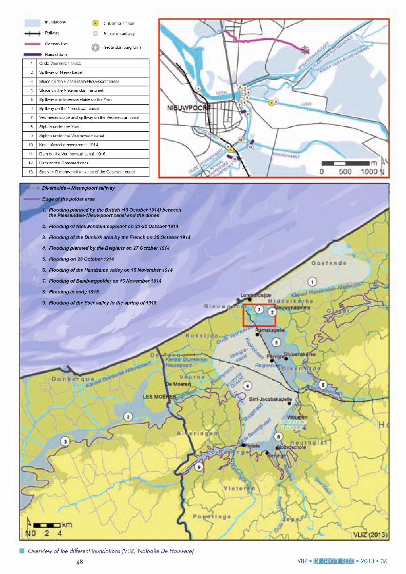
Nieuwpoort viewed from the east. Aeria l photograph made by a German scout on 19 August 1917. (Bundesarchiv, Koblenzj1 Sluice at Nieuwendamme creek through which the inundation o f Nieuwendamme polder took
place in the night o f 21 to 22 October 19142 Oude Veurnesas sluice, through which the first inundation attempt was made in the night o f 26
to 2 7 October 19143 Spillway o f the Noordvaart canal, through which the flooding was carried out on 29 October
1914
The northwesternmost part of Belgium played an important part in the First World War, as it was there, on the plains of the river Yser, that the advance of the German Fourth Army came to a halt. This was thanks to a tried and tested method: flooding or inundation. The flat Flemish polders, situated below sea level at high tide, were ideally suited for such a scheme. It was sufficient to manipulate the Ganzepoot sluice complex at Nieuwpoort, which controlled the inflow of seawater and the drainage ofthe polders in the hinterland.In those dramatic days of October 1914 the flooding of the Yser valley did not go smoothly at all, however. But after the war, these early setbacks were soon forgotten and the actual events were embellished. This inspired many romanticised patriotic stories, reinforced by all sorts of vanity documents written by those involved. What follows is an as objective as possible representation of the facts.
Water as a means of defence
Inundation is a means of defence that has been used frequently in the Low Countries at least since the end of the 16th century.It has primarily been used to defend ports, as was the case during the Siege of Ostend (1600-1604). The city of Nieuwpoort has also regularly adopted these tactics throughout history. The floodgates around the city were opened several times to flood the area during the French-Spanish wars in the second half ofthe 17th century. The last flooding took place in 1813-1814 when French troops defended the city. So the military commanders were sufficiently familiar with flooding as a means to halt the German advance at the onset of the First World War. The British and French high command were also aware ofthe possibilities. British engineers had helped to fortify the city of Nieuwpoort w ithin the scope ofthe completion ofthe Wellington Barrier between 1815 and 1830. This fortification was equipped with a system of floodgates. In addition, French military engineer Vauban had drawn up detailed inundation plans for the port of Dunkirk in 1694.The floodgates of this fortification were still operational at the outbreak of the First
World War, which was no longer the case for Nieuwpoort. With the exception ofthe sluice at Nieuwendamme creek, the fortifications around the city had been systematically demolished from 1853 onwards.
Of great importance was the fact that the drainage system ofthe Yser basin had been completely altered between 1861 and 1880, so shortly before the First World War. This large-scale project was aimed at improving drainage as well as navigation. The Lovaart canal was widened, deepened and embanked, a sluice gate and spillway were constructed at the confluence of this canal with the Yser river near the hamlet of Fintele, and siphons were constructed under the Lovaart canal for drainage (see map). The project was completed with the construction of several sluices and spillways at Nieuwpoort. The Veurnesas sluice on the new Veurnevaart canal as well as the sluices and spillways on the Noordvaart canal (1875) and the leper- vaart canal (or the canalised Yser river) were
given a makeover. Flowever, this system was not perfect: priority had been given to navigation instead of drainage. Nevertheless, the system was flexible enough to allow the navigable waterways to be used for drainage in case of abundant rainfall. All these hydraulic works were to play a crucial part in the war and helped facilitate the continued flooding ofthe Yser valley.
VLIZ IDE GROTE REDEI 2 0 1 3 • 36 47
MityWPûûl
V o I h
J-a -Il J 1 -1 r *ï f c r f lk # 'Ba
lita -I! mc-wirf
i -■!. .ic c tii.jp « !t
VLIZ ■ DE GROTE REDE 2 0 1 3 • 3 6
1. Oude Veurnesas sluice
2. Spillway of Nieuw Bedelf
3. Sluice on the Plassendale-Nieuwpoort canal
4. Sluice on the Nieuwendamme creek
5. Spillway and lepersas sluice on the Yser
6. Spillway on the Noordvaart canal
7. Veurnesas sluice and spillway on the Veurnevaart canal
8. Siphon under the Yser
9. Siphon under the Veurnevaart canal
Kool hofvaart embankment. 1914
Dam on the Veurnevaart canai. 1916
12. Dam on the Oostvaart canal
Sas van Dierendonck or sluice of the Oostvaart canal
Inundations Culvert or siphon
Railway Sluice or spillway
German line■ : ; G rote Bam b u rg f a rm
Raised dam
Overview o f the different inundations (VLIZ, Nathalie De Hauwere)
48
—1 Diksmuide - Nieuwpoort railway
• Edge ofthe polder area
1. Flooding planned by the British (10 October 1914) between the Plassendale-Nieuwpoort canal and the dunes
2. Flooding of Nieuwendammepolder on 21-22 October 1914
3. Flooding of the Dunkirk area by the French on 25 October 1914
4. Flooding planned by the Belgians on 27 October 1914
5. Flooding on 28 October 1914
6. Flooding of the Handzame valley on 15 November 1914
7. Flooding of Bamburgpolder on 16 November 1914
8. Flooding in early 1915
9. Flooding of the Yser valley in the spring of 1918
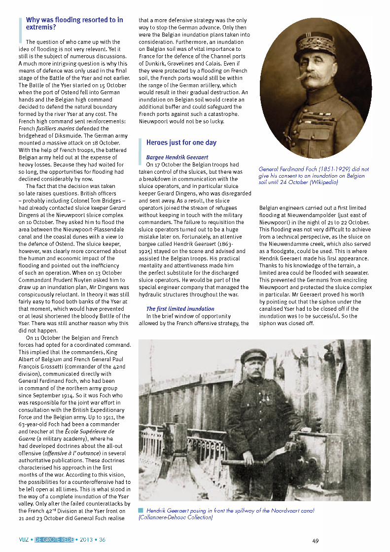
Why was flooding resorted to in extremis?
The question of who came up with the idea of flooding is not very relevant. Yet it still is the subject of numerous discussions.A much more intriguing question is why this means of defence was only used in the final stage ofthe Battle ofthe Yser and not earlier. The Battle of the Yser started on 15 October when the port of Ostend fell into German hands and the Belgian high command decided to defend the natural boundary formed by the river Yser at any cost. The French high command sent reinforcements: French fusiliers marins defended the bridgehead of Diksmuide. The German army mounted a massive attack on 18 October.With the help of French troops, the battered Belgian army held out at the expense of heavy losses. Because they had waited for so long, the opportunities for flooding had declined considerably by now.
The fact that the decision was taken so late raises questions. British officers - probably including Colonel Tom Bridges - had already contacted sluice keeper Gerard Dingens at the Nieuwpoort sluice complex on 10 October. They asked him to flood the area between the Nieuwpoort-Plassendale canal and the coastal dunes with a view to the defence of Ostend. The sluice keeper, however, was clearly more concerned about the human and economic impact ofthe flooding and pointed out the inefficiency of such an operation. When on 13 October Commandant Prudent Nuyten asked him to draw up an inundation plan, Mr Dingens was conspicuously reluctant. In theory it was still fairly easy to flood both banks of the Yser at that moment, which would have prevented or at least shortened the bloody Battle ofthe Yser. There was still another reason why this did not happen.
On 11 October the Belgian and French forces had opted for a coordinated command. This implied that the commanders, King Albert of Belgium and French General Paul François Grossetti (commander ofthe 42nd division), communicated directly with General Ferdinand Foch, who had been in command ofthe northern army group since September 1914. So it was Foch who was responsible for the joint war effort in consultation with the British Expeditionary Force and the Belgian army. Up to 1911, the 63-year-old Foch had been a commander and teacher at the École Supérieure de Guerre (a military academy), where he had developed doctrines about the all-out offensive (offensive à l ’ outrance) in several authoritative publications. These doctrines characterised his approach in the first months of the war. According to this vision, the possibilities for a counteroffensive had to be left open at all times. This is what stood in the way of a complete inundation o fthe Yser valley. Only after the failed counterattacks by the French 42nd Division at the Yser front on 21 and 23 October did General Foch realise
that a more defensive strategy was the only way to stop the German advance. Only then were the Belgian inundation plans taken into consideration. Furthermore, an inundation on Belgian soil was of vital importance to France for the defence ofthe Channel ports of Dunkirk, Gravelines and Calais. Even if they were protected by a flooding on French soil, the French ports would still be within the range ofthe German artillery, which would result in their gradual destruction. An inundation on Belgian soil would create an additional buffer and could safeguard the French ports against such a catastrophe. Nieuwpoort would not be so lucky.
Heroes just for one day
Bargee Hendrik GeeraertOn 17 October the Belgian troops had
taken control ofthe sluices, but there was a breakdown in communication with the sluice operators, and in particular sluice keeper Gerard Dingens, who was disregarded and sent away. As a result, the sluice operators joined the stream of refugees without keeping in touch with the military commanders. The failure to requisition the sluice operators turned out to be a huge mistake later on. Fortunately, an attentive bargee called Hendrik Geeraert (1863- 1925) stayed on the scene and advised and assisted the Belgian troops. His practical mentality and attentiveness made him the perfect substitute for the discharged sluice operators. Fie would be part o fthe special engineer company that managed the hydraulic structures throughout the war.
The first limited inundationIn the brief window of opportunity
allowed by the French offensive strategy, the
General Ferdinand Foch (1851-1929} d id not give his consent to an inundation on Belgian soil until 24 October (W ikipedia}
Belgian engineers carried out a first limited flooding at Nieuwendampolder (just east of Nieuwpoort) in the night of 21 to 22 October. This flooding was not very difficult to achieve from a technical perspective, as the sluice on the Nieuwendamme creek, which also served as a floodgate, could be used. This is where Hendrik Geeraert made his first appearance. Thanks to his knowledge ofthe terrain, a limited area could be flooded with seawater. This prevented the Germans from encircling Nieuwpoort and protected the sluice complex in particular. Mr Geeraert proved his worth by pointing out that the siphon under the canalised Yser had to be closed off if the inundation was to be successful. So the siphon was closed off.
Fiendrik Geeraert posing in front the spillway o f the Noordvaart canal (Callanaere-Dehouc Collection}
VLIZ IDE GROTE REDEI 2 0 1 3 • 36 49
A complete inundationwith the help o f Karel CoggeThe necessity of a complete inundation
became clear a few days later. The German advance proved to be unstoppable. Two German battalions were already on the left bank ofthe Yser on 24 October. Sunday 25 October was a crucial day. What was left ofthe Belgian army retreated behind the embankment of the railway between Nieuwpoort and Diksmuide in the morning.In an attempt to gain an insight into the hydrology, the potential consequences of the flooding initiated by the French and the practical execution of a complete inundation of part of the Yser plain, the Belgian Fleadquarters (established in Veurne) tried to contact specialists. But the engineers of Noordwatering Polder turned out to have fled the town. Eventually, Captain-commandant Prudent Nuyten enlisted the help of Karel Cogge (1855-1922) at the advice of mayor Raphael De Spot and justice ofthe peace Feys. Mr Cogge was a supervisor at a public body in charge of protection against flooding, was very familiar with the area’s hydrology and was able to answer Captain- commandant Nuyten’s specific questions. Contrary to many other members ofthe staff, Captain-commandant Nuyten was also able to communicate with Mr Cogge as he spoke the West Flemish dialect. On the basis of this information, a concrete plan was eventually drawn up which started from the new Belgian line of defence at that moment: the embankment ofthe railway between Nieuwpoort and Diksmuide. Time was running out: the French high command had already initiated its own inundation plan of flooding the area ofthe Colme river
Karel Cogge (Kristof Jacobs, Nieuwpoort Sector 1917j
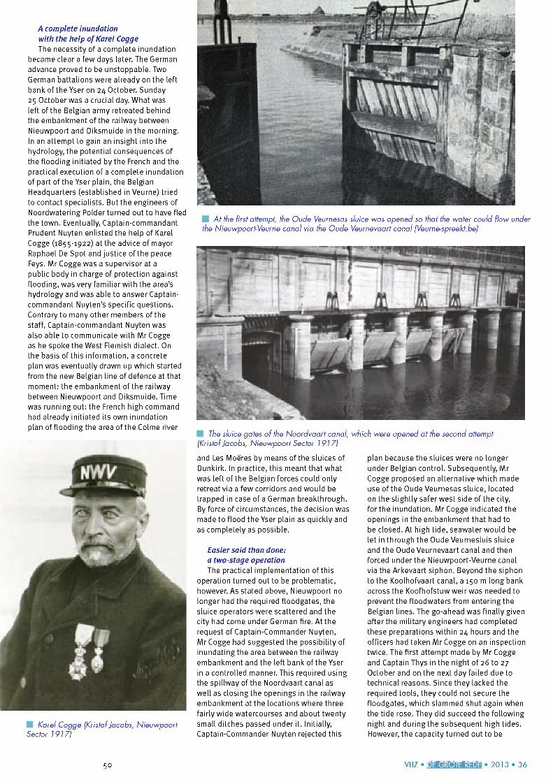
A t the first attempt, the Oude Veurnesas sluice was opened so that the water could flow under the Nieuwpoort-Veurne canal via the Oude Veurnevaart canal (Veurne-spreekt.bej
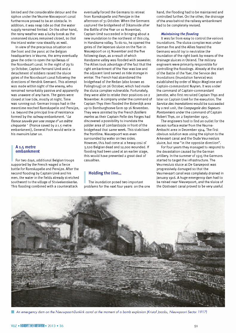
The sluice gates o f the Noordvaart canal, which were opened at the second attempt (Kristof Jacobs, Nieuwpoort Sector 1917J
and Les Moëres by means of the sluices of Dunkirk. In practice, this meant that what was left o fthe Belgian forces could only retreat via a few corridors and would be trapped in case of a German breakthrough. By force of circumstances, the decision was made to flood the Yser plain as quickly and as completely as possible.
Easier said than done:a two-stage operationThe practical implementation of this
operation turned out to be problematic, however. As stated above, Nieuwpoort no longer had the required floodgates, the sluice operators were scattered and the city had come under German fire. At the request of Captain-Commander Nuyten,Mr Cogge had suggested the possibility of inundating the area between the railway embankment and the left bank of the Yser in a controlled manner. This required using the spillway of the Noordvaart canal as well as closing the openings in the railway embankment at the locations where three fairly wide watercourses and about twenty small ditches passed under it. Initially, Captain-Commander Nuyten rejected this
plan because the sluices were no longer under Belgian control. Subsequently, Mr Cogge proposed an alternative which made use ofthe Oude Veurnesas sluice, located on the slightly safer west side of the city, for the inundation. Mr Cogge indicated the openings in the embankment that had to be closed. At high tide, seawater would be let in through the Oude Veurnesluis sluice and the Oude Veurnevaart canal and then forced under the Nieuwpoort-Veurne canal via the Arkevaart siphon. Beyond the siphon to the Koolhofvaart canal, a 150 m long bank across the Koofhofstuw weir was needed to prevent the floodwaters from entering the Belgian lines. The go-ahead was finally given after the military engineers had completed these preparations within 24 hours and the officers had taken Mr Cogge on an inspection twice. The first attempt made by Mr Cogge and Captain Thys in the night of 26 to 27 October and on the next day failed due to technical reasons. Since they lacked the required tools, they could not secure the floodgates, which slammed shut again when the tide rose. They did succeed the following night and duringthe subsequent high tides. Flowever, the capacity turned out to be
50 VLIZ IDE GROTE REDE] 2 0 1 3 • 3 6
limited and the considerable detour and the siphon under the Veurne-Nieuwpoort canal furthermore proved to be an obstacle. In addition, it was neap tide so that the water supply remained limited. On the other hand, the rainy weather was a lucky break as the unmanned sluices remained closed, so that the inland water rose steadily as well.
In view of the precarious situation on the front and the panic at the Belgian headquarters in Veurne, the army eventually gave the order to open the spillways of the Noordvaart canal. In the night of 29 to 30 October, Captain Fernand Umé and a detachment of soldiers raised the sluice gates of the Noordvaart canal following the directions of Hendrik Geeraert. This attempt was made within sight of the enemy, who remained remarkably passive and apparently was unaware of any harm. The gates were closed at low tide, mostly at night. Time was running out: German troops had in the meantime reached Ramskapelle and Pervijze, i.e. beyond the principal line of resistance formed by the railway embankment. ‘ La France sauvée par une rampe d ’ un mètre cinquante ’ (France saved by a 1.5 metre embankment), General Foch would write in his memoirs later on.
A 1.5 metre embankment
For two days, additional Belgian troops supported by the French waged a fierce battle for Ramskapelle and Pervijze. After the second flooding by Captain Umé and his men, the water in the fields already stretched southward to the village of Stuivekenskerke. This flooding combined with a counterattack
eventually forced the Germans to retreat from Ramskapelle and Pervijze in the afternoon of 31 October. When the Germans captured the bridgehead of Diksmuide after the Battle of the Yser on 10 November,Captain Umé succeeded in bringing about a new inundation to the northeast of this city, in Flandzame valley. To do so, he opened the gates of the lepersas sluice on the Yser in Nieuwpoort on 15 November and the five following days, as a result of which Flandzame valley was flooded with seawater. The Allies took advantage of the fact that the right embankment of the Yser was low and the adjacent land served as tide storage in winter. The French had abandoned the bridgehead ofthe Redan (also known as Palingbrug) on 26 October, which had made the sluice complex vulnerable. Fortunately, they were able to retake their positions on 2 November. A company under the command of Captain Thys then flooded the Boterdijk area up to Bamburghoeve farm op 16 November. They were assisted by the French fusiliers marins as their Captain Pelle des Forges had discovered a possibility to inundate the polder area of Lombardsijde in front ofthe bridgehead that same week. This stabilised the frontline. Nieuwpoort was even surrounded by water on two sides.Flowever, this had come at a heavy cost of 3,500 Belgian dead and 12,000 wounded. If flooding had been used at an earlier stage, this would have prevented a great deal of casualties.
Holding the line...
The inundation posed two important problems for the next four years: on the one
hand, the flooding had to be maintained and controlled further. On the other, the drainage ofthe area behind the railway embankment had to be completely revised.
Maintaining the floodingIt was far from easy to control the various
inundations. The sluice complex was under German fire and the Allies feared the Germans would try to neutralise the inundation of the right bank by means of the drainage sluices in Ostend. The military engineers were primarily responsible for controlling the floodings. Already at the start ofthe Battle ofthe Yser, the Service des Inondations (Inundation Service) was established by order of Major Maglinse and Captain-commandant Nuyten. It was under the command of Captain-commandant Jamotte, who first recruited Captain Thys and later on Captain Umé for the execution. The Service des Inondations would be succeeded by a real unit, the Compagnie des Sapeurs- Pontonniers under the command of Captain Robert Thys, on 2 September 1915.
The engineers had to find an outlet for the excess surface water from the Veurne- Ambacht area in December 1914. The first obvious solution was using the siphon to the Arkevaart canal and the Oude Veurnesluis sluice, but now “ in the opposite direction” .
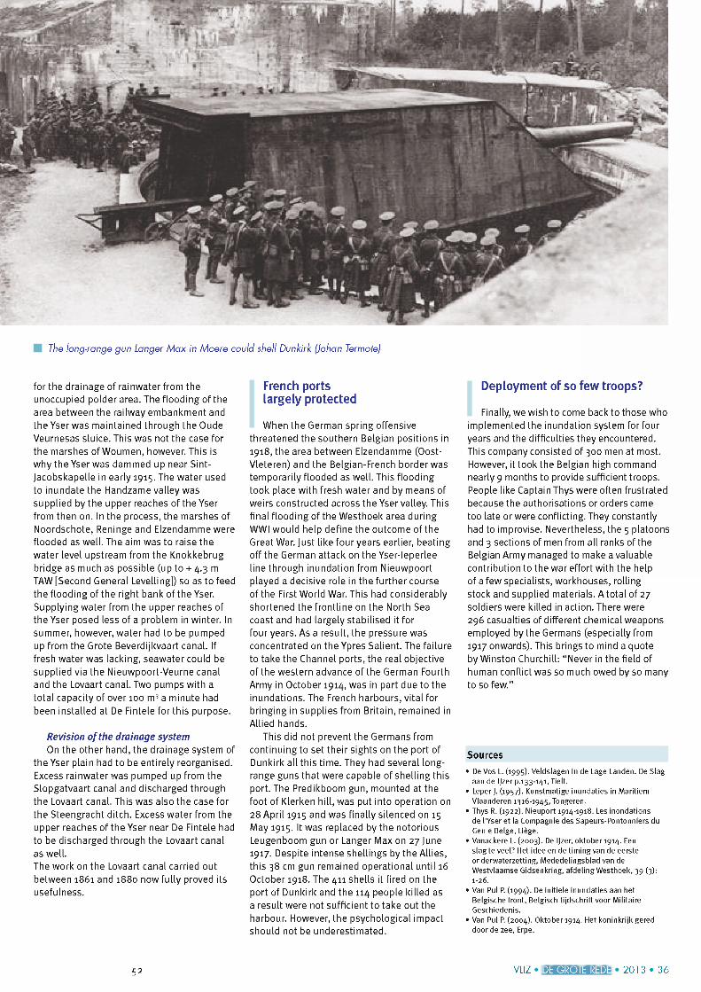
For four years they managed to respond to the devastation caused by the German artillery. In the summer of 1915 the Germans started to target the infrastructure. The Veurnesluis sluice at De Ganzepoot was progressively damaged so that the Veurnevaart canal was completely drained in January 1916. A huge emergency dam had to be raised near Nieuwpoort, and the sluice of the Oostvaart canal proved to be very useful
An emergency dam on the Nieuwpoort-Dunkirk canal at the moment o f a bomb explosion (Kristof Jacobs, Nieuwpoort Sector 1917J
V I 17 » I r i M t a a i J t H l M » 2 0 1 3 » 3 6 51DE GROTE REDE
The long-range gun Langer M ax in Moere could shell Dunkirk (Johan Termote)
for the drainage of rainwater from the unoccupied polder area. The flooding ofthe area between the railway embankment and the Yser was maintained through the Oude Veurnesas sluice. This was not the case for the marshes of Woumen, however. This is why the Yser was dammed up near Sint- Jacobskapelle in early 1915. The water used to inundate the Handzame valley was supplied by the upper reaches of the Yser from then on. In the process, the marshes of Noordschote, Reninge and Elzendamme were flooded as well. The aim was to raise the water level upstream from the Knokkebrug bridge as much as possible (up to + 4.3 m TAW [Second General Levelling]) so as to feed the flooding ofthe right bank ofthe Yser. Supplying water from the upper reaches of the Yser posed less of a problem in winter. In summer, however, water had to be pumped up from the Grote Beverdijkvaart canal. If fresh water was lacking, seawater could be supplied via the Nieuwpoort-Veurne canal and the Lovaart canal. Two pumps with a total capacity of over 100 m3 a minute had been installed at De Fintele for this purpose.
Revision ofthe drainage systemOn the other hand, the drainage system of
the Yser plain had to be entirely reorganised. Excess rainwater was pumped up from the Slopgatvaart canal and discharged through the Lovaart canal. This was also the case for the Steengracht ditch. Excess water from the upper reaches of the Yser near De Fintele had to be discharged through the Lovaart canal as well.The work on the Lovaart canal carried out between 1861 and 1880 now fully proved its usefulness.
French ports largely protected
When the German spring offensive threatened the southern Belgian positions in 1918, the area between Elzendamme (Oost- Vleteren) and the Belgian-French border was temporarily flooded as well. This flooding took place with fresh water and by means of weirs constructed across the Yser valley. This final flooding ofthe Westhoek area during WWI would help define the outcome of the Great War. Just like four years earlier, beating off the German attack on the Yser-leperlee line through inundation from Nieuwpoort played a decisive role in the further course of the First World War. This had considerably shortened the frontline on the North Sea coast and had largely stabilised it for four years. As a result, the pressure was concentrated on the Ypres Salient. The failure to take the Channel ports, the real objective ofthe western advance ofthe German Fourth Army in October 1914, was in part due to the inundations. The French harbours, vital for bringing in supplies from Britain, remained in Allied hands.
This did not prevent the Germans from continuing to set their sights on the port of Dunkirk all this time. They had several long- range guns that were capable of shelling this port. The Predikboom gun, mounted at the foot of Klerken hill, was put into operation on 28 April 1915 and was finally silenced on 15 May 1915. It was replaced by the notorious Leugenboom gun or Langer Max on 27 June 1917. Despite intense shellings by the Allies, this 38 cm gun remained operational until 16 October 1918. The 411 shells it fired on the port of Dunkirk and the 114 people killed as a result were not sufficient to take out the harbour. However, the psychological impact should not be underestimated.
Deployment of so few troops?
Finally, we wish to come back to those who implemented the inundation system for four years and the difficulties they encountered. This company consisted of 300 men at most. However, it took the Belgian high command nearly 9 months to provide sufficient troops. People like Captain Thys were often frustrated because the authorisations or orders came too late or were conflicting. They constantly had to improvise. Nevertheless, the 5 platoons and 3 sections of men from all ranks ofthe Belgian Army managed to make a valuable contribution to the war effort with the help of a few specialists, workhouses, rolling stock and supplied materials. A total of 27 soldiers were killed in action. There were 296 casualties of different chemical weapons employed by the Germans (especially from 1917 onwards). This brings to mind a quote by Winston Churchill: “ Never in the field of human conflict was so much owed by so many to so few.”
Sources
• De Vos L. (1995). Veldslagen in de Lage Landen. De Slag aan de IJzer p.133-141, Tielt.
• Leper J. (1957). Kunstmatige inundaties in Maritiem Vlaanderen 1316-1945, Tongeren.
• Thys R. (1922). Nieuport 1914-1918. Les inondations de l’Yser et la Compagnie des Sapeurs-Pontonniers du Genie Belge, Liège.
• Vanackere L. (2003). De Ijzer, oktober 1914. Een slag te veel? Het idee en de timing van de eerste onderwaterzetting, Mededelingsblad van de Westvlaamse Gidsenkring, afdeling Westhoek, 39 (3): 1-26.
• Van Pul P. (1994). De initiele inundaties aan het Belgische front, Belgisch tijdschrift voor Militaire Geschiedenis.
• Van Pul P. (2004). Oktober 1914. Het koninkrijk gered door de zee, Erpe.
52 VLIZ IDE GROTE REDEI 2 0 1 3 • 3 6