Embed Size (px)
Citation preview
Ground School 2011 Created by Steve Reisser
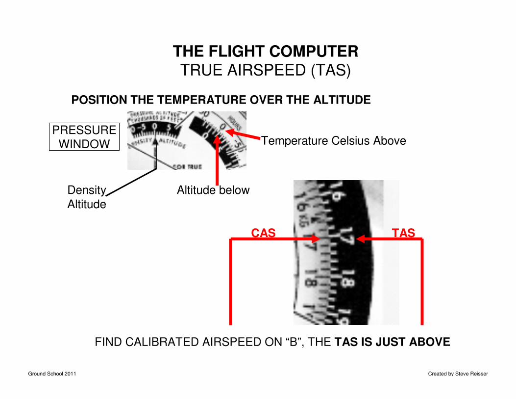
THE FLIGHT COMPUTERTRUE AIRSPEED (TAS)
POSITION THE TEMPERATURE OVER THE ALTITUDE
Temperature Celsius Above PRESSURE
WINDOW
Altitude below
FIND CALIBRATED AIRSPEED ON “B”, THE TAS IS JUST ABOVE
CAS TAS
Density
Altitude
Ground School 2011 Created by Steve Reisser
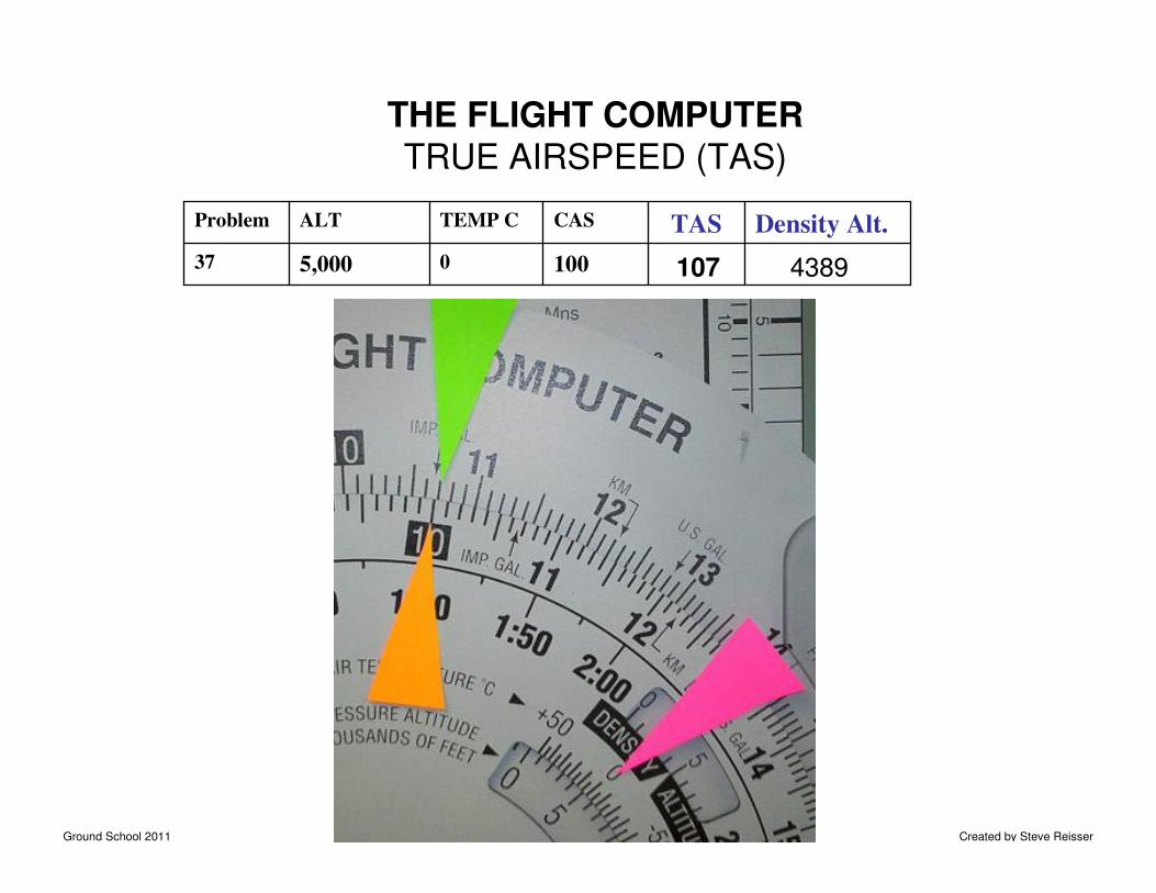
THE FLIGHT COMPUTERTRUE AIRSPEED (TAS)
10005,00037
Density Alt.TASCASTEMP CALTProblem
107 4389
Ground School 2011 Created by Steve Reisser
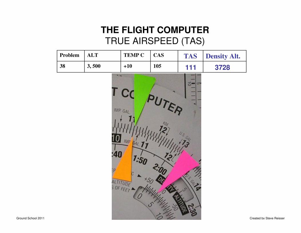
105+103, 50038
Density Alt.TASCASTEMP CALTProblem
THE FLIGHT COMPUTERTRUE AIRSPEED (TAS)
3728111
Ground School 2011 Created by Steve Reisser
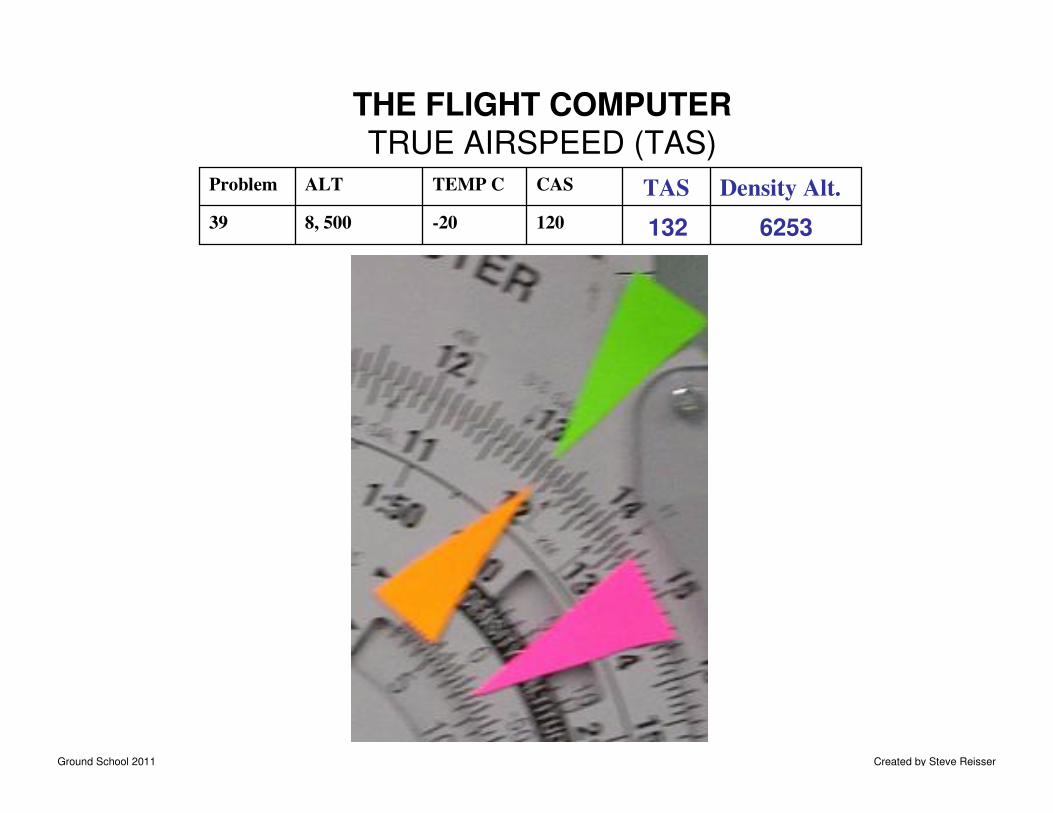
120-208, 50039
Density Alt.TASCASTEMP CALTProblem
THE FLIGHT COMPUTERTRUE AIRSPEED (TAS)
132 6253
Ground School 2011 Created by Steve Reisser
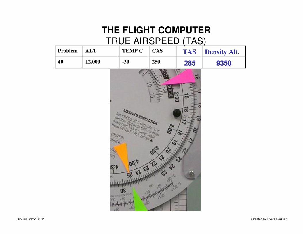
THE FLIGHT COMPUTERTRUE AIRSPEED (TAS)
250-3012,00040
Density Alt.TASCASTEMP CALTProblem
285 9350
Ground School 2011 Created by Steve Reisser
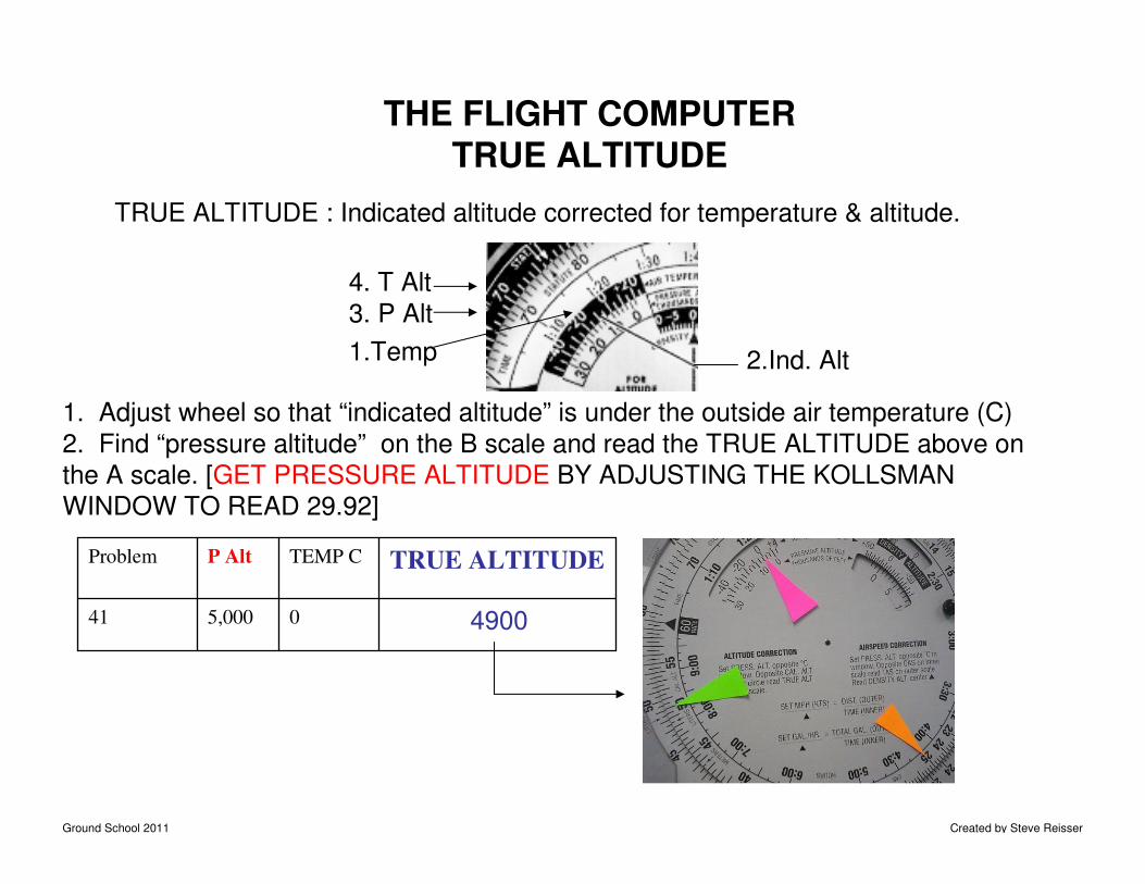
TRUE ALTITUDE : Indicated altitude corrected for temperature & altitude.
THE FLIGHT COMPUTERTRUE ALTITUDE
1. Adjust wheel so that “indicated altitude” is under the outside air temperature (C)
2. Find “pressure altitude” on the B scale and read the TRUE ALTITUDE above on
the A scale. [GET PRESSURE ALTITUDE BY ADJUSTING THE KOLLSMAN
WINDOW TO READ 29.92]
05,00041
TRUE ALTITUDETEMP CP AltProblem
4900
2.Ind. Alt1.Temp
4. T Alt
3. P Alt
Ground School 2011 Created by Steve Reisser
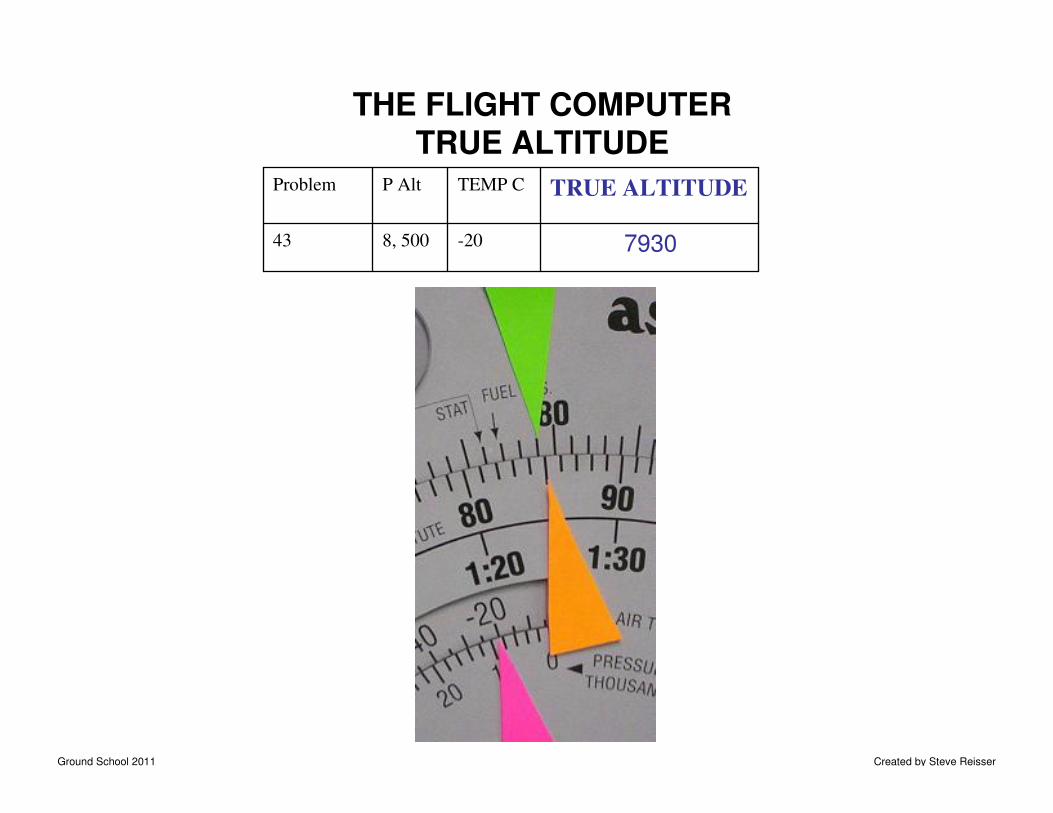
THE FLIGHT COMPUTERTRUE ALTITUDE
-208, 50043
TRUE ALTITUDETEMP CP AltProblem
7930
Ground School 2011 Created by Steve Reisser
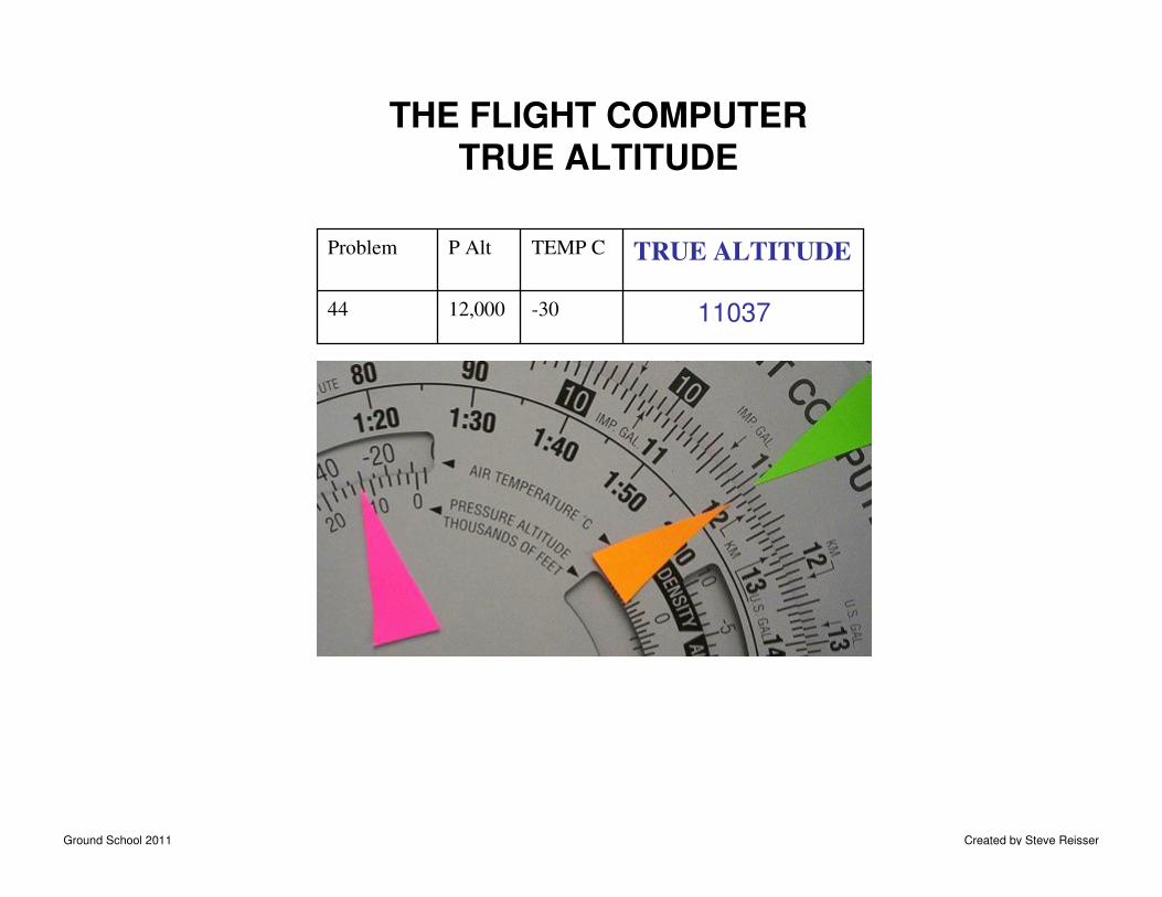
THE FLIGHT COMPUTERTRUE ALTITUDE
-3012,00044
TRUE ALTITUDETEMP CP AltProblem
11037
Ground School 2011 Created by Steve Reisser
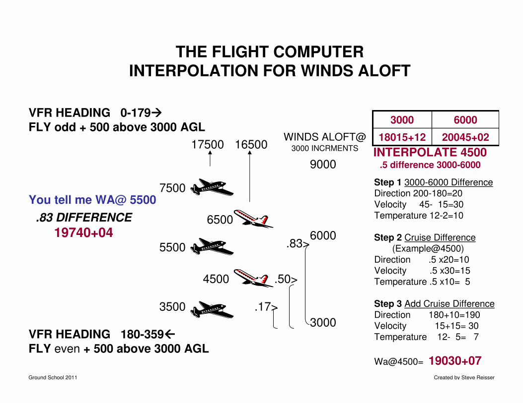
THE FLIGHT COMPUTERINTERPOLATION FOR WINDS ALOFT
VFR HEADING 0-179����
FLY odd + 500 above 3000 AGL
VFR HEADING 180-359
FLY even + 500 above 3000 AGL
3500
5500
7500
17500 16500
6500
4500
WINDS ALOFT@3000 INCRMENTS
3000
6000
9000
.17>
.50>
.83>
20045+0218015+12
60003000
Step 1 3000-6000 DifferenceDirection 200-180=20Velocity 45- 15=30Temperature 12-2=10
Step 2 Cruise Difference(Example@4500)
Direction .5 x20=10Velocity .5 x30=15Temperature .5 x10= 5
Step 3 Add Cruise DifferenceDirection 180+10=190Velocity 15+15= 30Temperature 12- 5= 7
Wa@4500= 19030+07
INTERPOLATE 4500.5 difference 3000-6000
You tell me WA@ 5500
.83 DIFFERENCE
19740+04
Ground School 2011 Created by Steve Reisser
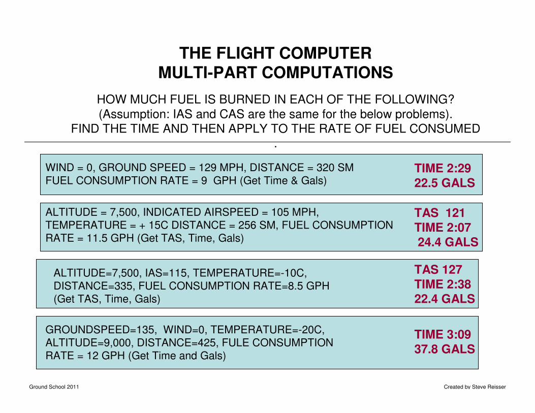
THE FLIGHT COMPUTERMULTI-PART COMPUTATIONS
HOW MUCH FUEL IS BURNED IN EACH OF THE FOLLOWING?
(Assumption: IAS and CAS are the same for the below problems).
FIND THE TIME AND THEN APPLY TO THE RATE OF FUEL CONSUMED
.
WIND = 0, GROUND SPEED = 129 MPH, DISTANCE = 320 SM
FUEL CONSUMPTION RATE = 9 GPH (Get Time & Gals)TIME 2:29
22.5 GALS
ALTITUDE = 7,500, INDICATED AIRSPEED = 105 MPH,
TEMPERATURE = + 15C DISTANCE = 256 SM, FUEL CONSUMPTION
RATE = 11.5 GPH (Get TAS, Time, Gals)
TAS 121
TIME 2:0724.4 GALS
ALTITUDE=7,500, IAS=115, TEMPERATURE=-10C,
DISTANCE=335, FUEL CONSUMPTION RATE=8.5 GPH
(Get TAS, Time, Gals)
TAS 127
TIME 2:3822.4 GALS
GROUNDSPEED=135, WIND=0, TEMPERATURE=-20C,
ALTITUDE=9,000, DISTANCE=425, FULE CONSUMPTION
RATE = 12 GPH (Get Time and Gals)
TIME 3:09
37.8 GALS
Ground School 2011 Created by Steve Reisser
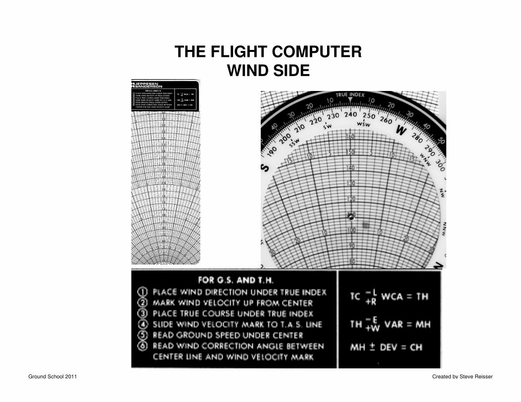
THE FLIGHT COMPUTERWIND SIDE
Ground School 2011 Created by Steve Reisser
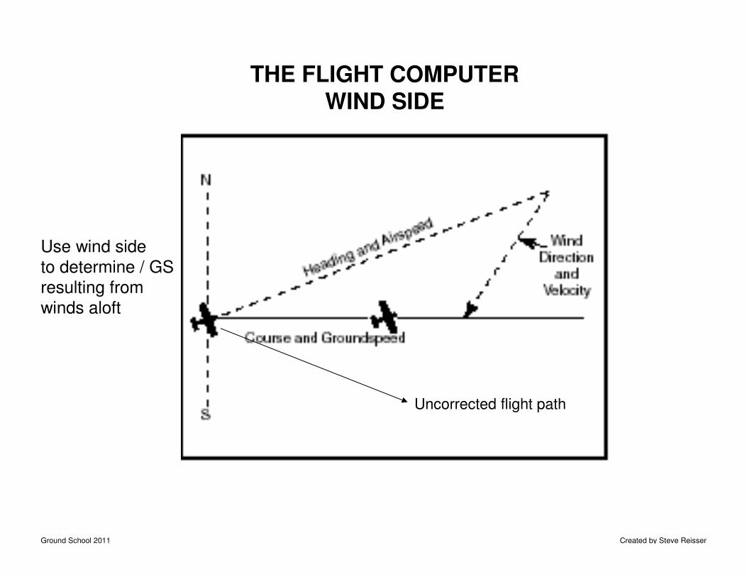
THE FLIGHT COMPUTERWIND SIDE
Use wind side
to determine / GS
resulting from
winds aloft
Uncorrected flight path
Ground School 2011 Created by Steve Reisser
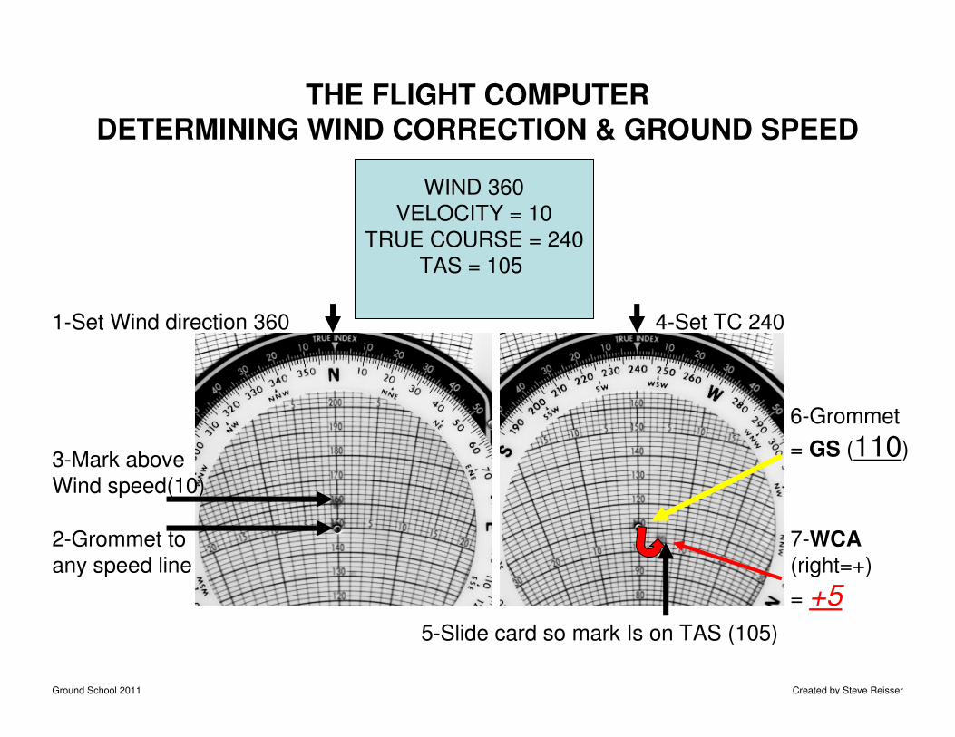
1-Set Wind direction 360
2-Grommet to
any speed line
3-Mark above
Wind speed(10)
4-Set TC 240
5-Slide card so mark Is on TAS (105)
6-Grommet
= GS (110)
7-WCA
(right=+)
= +5
THE FLIGHT COMPUTERDETERMINING WIND CORRECTION & GROUND SPEED
WIND 360
VELOCITY = 10
TRUE COURSE = 240
TAS = 105
Ground School 2011 Created by Steve Reisser
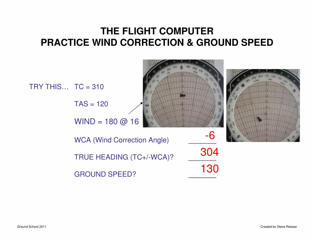
THE FLIGHT COMPUTERPRACTICE WIND CORRECTION & GROUND SPEED
TC = 310
TAS = 120
WIND = 180 @ 16
WCA (Wind Correction Angle) _______
TRUE HEADING (TC+/-WCA)? _______
GROUND SPEED? _______
-6
304
130
TRY THIS…
Ground School 2011 Created by Steve Reisser
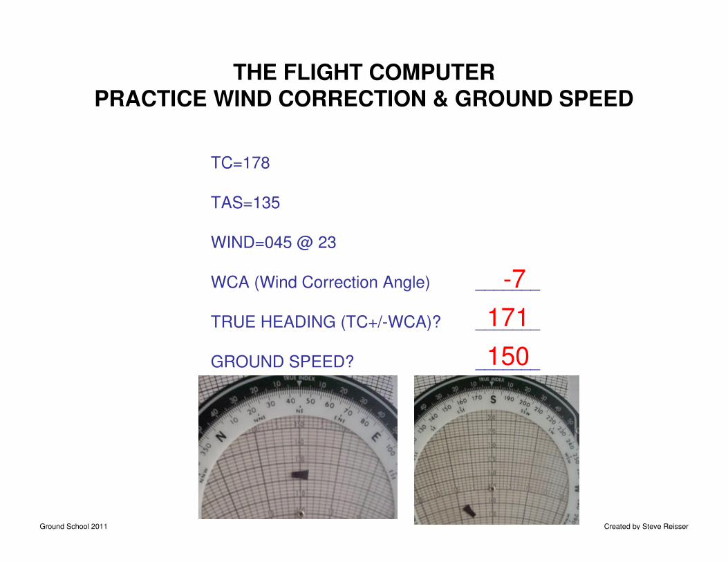
THE FLIGHT COMPUTERPRACTICE WIND CORRECTION & GROUND SPEED
TC=178
TAS=135
WIND=045 @ 23
WCA (Wind Correction Angle) _______
TRUE HEADING (TC+/-WCA)? _______
GROUND SPEED? _______
-7
171
150
Ground School 2011 Created by Steve Reisser
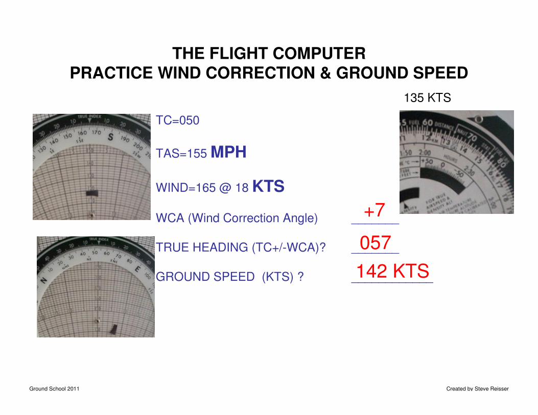
THE FLIGHT COMPUTERPRACTICE WIND CORRECTION & GROUND SPEED
TC=050
TAS=155 MPH
WIND=165 @ 18 KTS
WCA (Wind Correction Angle) _______
TRUE HEADING (TC+/-WCA)? _______
GROUND SPEED (KTS) ? ____________
+7
057
142 KTS
135 KTS
Ground School 2011 Created by Steve Reisser
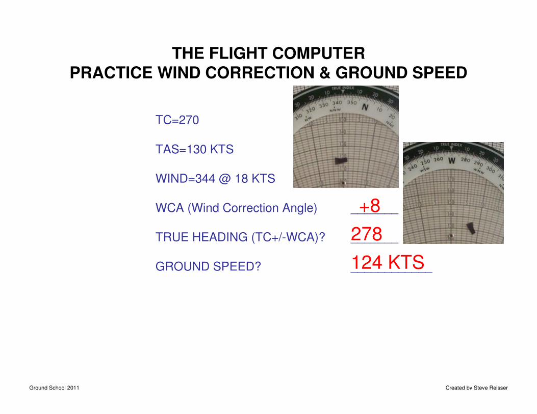
THE FLIGHT COMPUTERPRACTICE WIND CORRECTION & GROUND SPEED
TC=270
TAS=130 KTS
WIND=344 @ 18 KTS
WCA (Wind Correction Angle) _______
TRUE HEADING (TC+/-WCA)? _______
GROUND SPEED? ____________
+8
278
124 KTS
Ground School 2011 Created by Steve Reisser
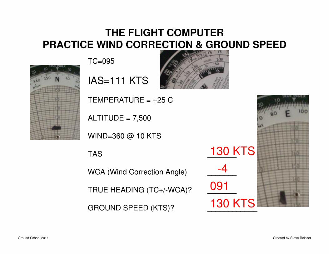
THE FLIGHT COMPUTERPRACTICE WIND CORRECTION & GROUND SPEED
TC=095
IAS=111 KTS
TEMPERATURE = +25 C
ALTITUDE = 7,500
WIND=360 @ 10 KTS
TAS _______
WCA (Wind Correction Angle) _______
TRUE HEADING (TC+/-WCA)? _______
GROUND SPEED (KTS)? ____________
130 KTS
-4
091
130 KTS
Ground School 2011 Created by Steve Reisser
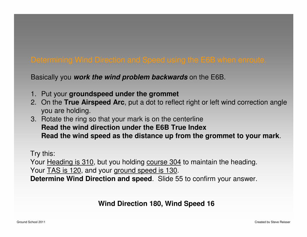
Determining Wind Direction and Speed using the E6B when enroute.
Basically you work the wind problem backwards on the E6B.
1. Put your groundspeed under the grommet2. On the True Airspeed Arc, put a dot to reflect right or left wind correction angle
you are holding.
3. Rotate the ring so that your mark is on the centerline
Read the wind direction under the E6B True IndexRead the wind speed as the distance up from the grommet to your mark.
Try this:
Your Heading is 310, but you holding course 304 to maintain the heading.
Your TAS is 120, and your ground speed is 130.
Determine Wind Direction and speed. Slide 55 to confirm your answer.
Wind Direction 180, Wind Speed 16
Ground School 2011 Created by Steve Reisser
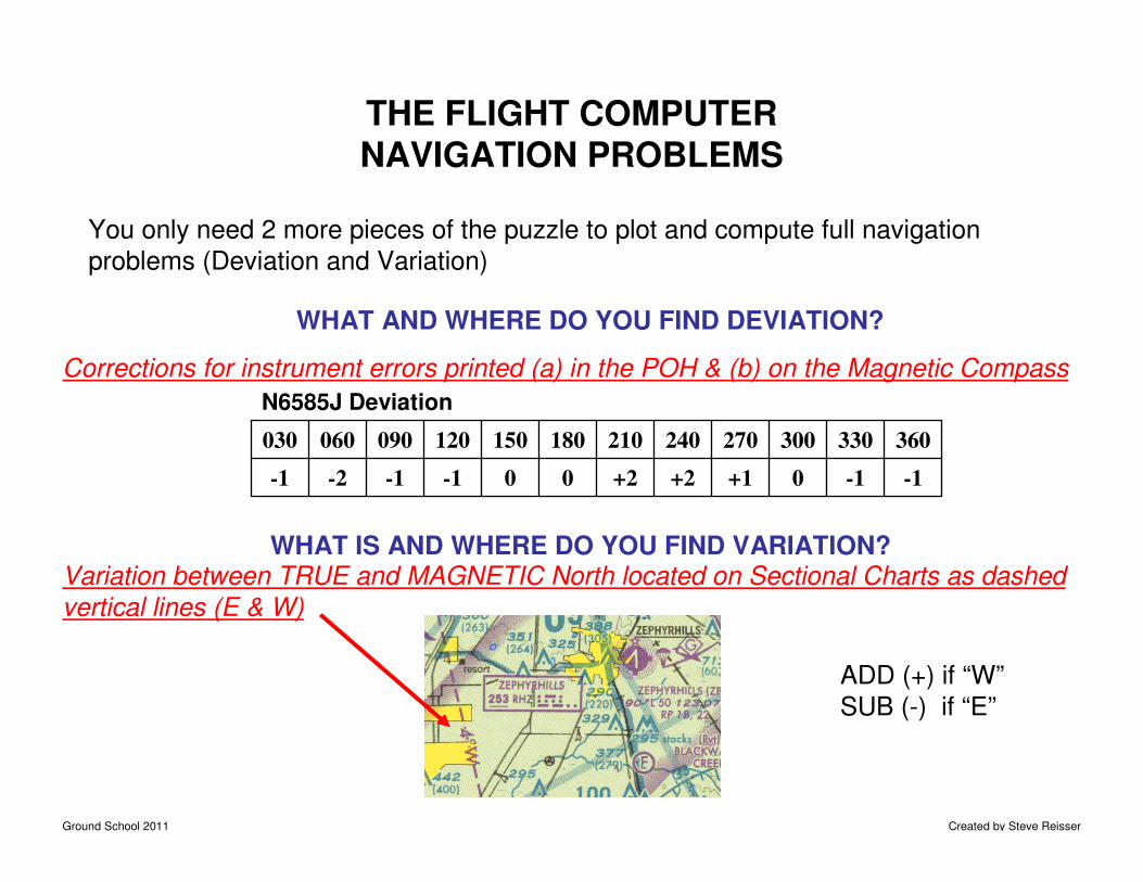
THE FLIGHT COMPUTERNAVIGATION PROBLEMS
You only need 2 more pieces of the puzzle to plot and compute full navigation
problems (Deviation and Variation)
WHAT AND WHERE DO YOU FIND DEVIATION?
N6585J Deviation
-1-10+1+2+200-1-1-2-1
360330300270240210180150120090060030
WHAT IS AND WHERE DO YOU FIND VARIATION?Variation between TRUE and MAGNETIC North located on Sectional Charts as dashed
vertical lines (E & W)
Corrections for instrument errors printed (a) in the POH & (b) on the Magnetic Compass
ADD (+) if “W”
SUB (-) if “E”
Ground School 2011 Created by Steve Reisser
THE FLIGHT COMPUTER NAVIGATION PROBLEMS
PUTTING IT ALL TOGETHER…. IT’S ON YOUR E6B
� TAS, you must know the Winds Aloft , outside air temperature and velocity at altitude
�WCA is the offset to the TC due to the winds aloft
�GS is the correction of TAS for the winds aloft
�TH is the TC correction of WCA (TH = TC +/- WCA)
�MH is the TH correction of Variation (MH = TH +/- VAR)
�CH is the MH correction of Deviation (CH = MH +/- DEV)
Ground School 2011 Created by Steve Reisser
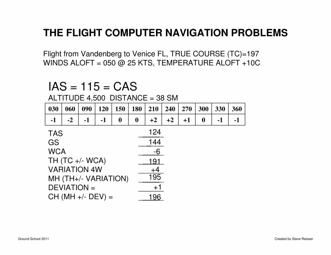
THE FLIGHT COMPUTER NAVIGATION PROBLEMS
Flight from Vandenberg to Venice FL, TRUE COURSE (TC)=197
WINDS ALOFT = 050 @ 25 KTS, TEMPERATURE ALOFT +10C
IAS = 115 = CASALTITUDE 4,500 DISTANCE = 38 SM
TAS ______
GS ______
WCA ______
TH (TC +/- WCA) ______
VARIATION 4W ______
MH (TH+/- VARIATION) ______
DEVIATION = ______
CH (MH +/- DEV) = ______
-1-10+1+2+200-1-1-2-1
360330300270240210180150120090060030
124
-6
144
191+4
195
+1
196
Ground School 2011 Created by Steve Reisser
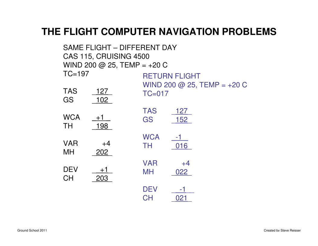
THE FLIGHT COMPUTER NAVIGATION PROBLEMS
SAME FLIGHT – DIFFERENT DAY
CAS 115, CRUISING 4500
WIND 200 @ 25, TEMP = +20 C
TC=197
TAS _127_
GS _102_
WCA _+1 _
TH _198_
VAR +4
MH _202_
DEV _ +1_
CH _203_
RETURN FLIGHT
WIND 200 @ 25, TEMP = +20 C
TC=017
TAS _127_
GS _152_
WCA _-1 _
TH _016_
VAR +4
MH _022_
DEV _ -1__
CH _021_
Ground School 2011 Created by Steve Reisser
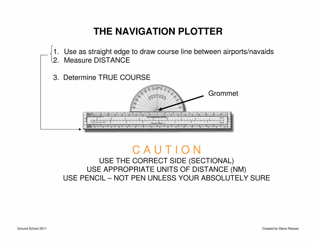
THE NAVIGATION PLOTTER
1. Use as straight edge to draw course line between airports/navaids
2. Measure DISTANCE
3. Determine TRUE COURSE
C A U T I O NUSE THE CORRECT SIDE (SECTIONAL)
USE APPROPRIATE UNITS OF DISTANCE (NM)
USE PENCIL – NOT PEN UNLESS YOUR ABSOLUTELY SURE
Grommet
Ground School 2011 Created by Steve Reisser
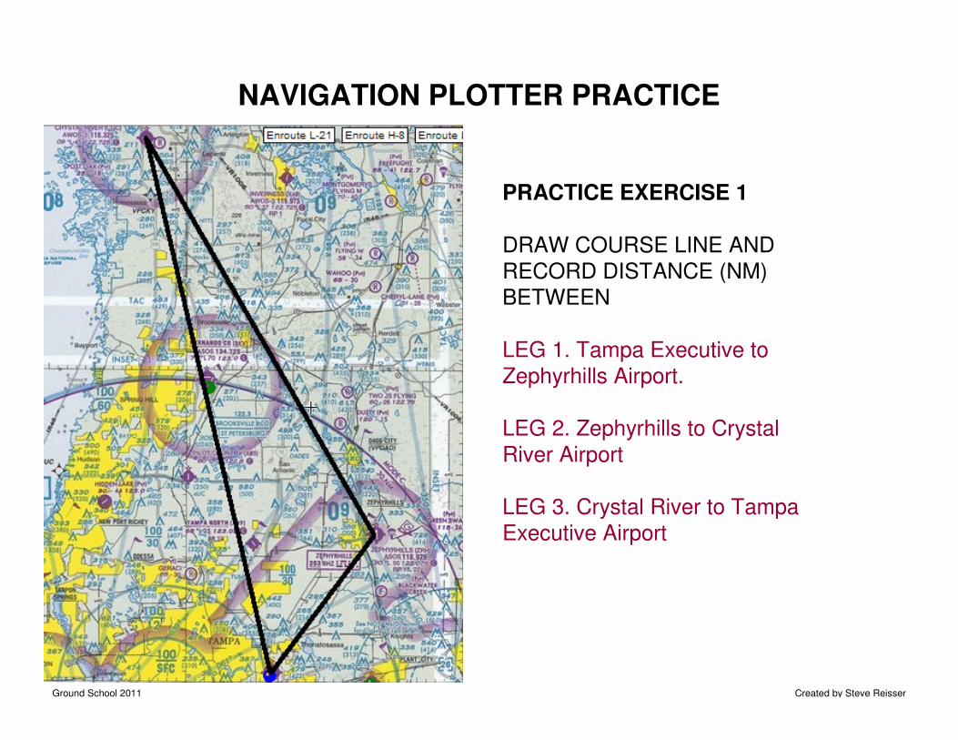
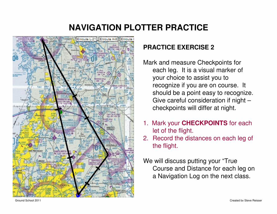
NAVIGATION PLOTTER PRACTICE
PRACTICE EXERCISE 1
DRAW COURSE LINE AND
RECORD DISTANCE (NM)
BETWEEN
LEG 1. Tampa Executive to
Zephyrhills Airport.
LEG 2. Zephyrhills to Crystal
River Airport
LEG 3. Crystal River to Tampa
Executive Airport
Ground School 2011 Created by Steve Reisser
PRACTICE EXERCISE 2
Mark and measure Checkpoints for
each leg. It is a visual marker of
your choice to assist you to
recognize if you are on course. It
should be a point easy to recognize.
Give careful consideration if night –
checkpoints will differ at night.
1. Mark your CHECKPOINTS for each
let of the flight.
2. Record the distances on each leg of
the flight.
We will discuss putting your “True
Course and Distance for each leg on
a Navigation Log on the next class.
NAVIGATION PLOTTER PRACTICE
Ground School 2011 Created by Steve Reisser
Next Session – Cross Country Planning & Navigation
• Study for exam on use of E6B and PN-1.
• Read Chapters 9,Section A and 5, Section A.
BRING A SECTION CHART, E6B, AND PN-1 TO
THE NEXT CLASS. Also, in the “Jewel” folder
for the “Cross Country-COMM” Section 05, Print
2 “NAVLOGPlan.pdf sheets for our exercises in
class.
“That’s All Folks”