Embed Size (px)
Citation preview
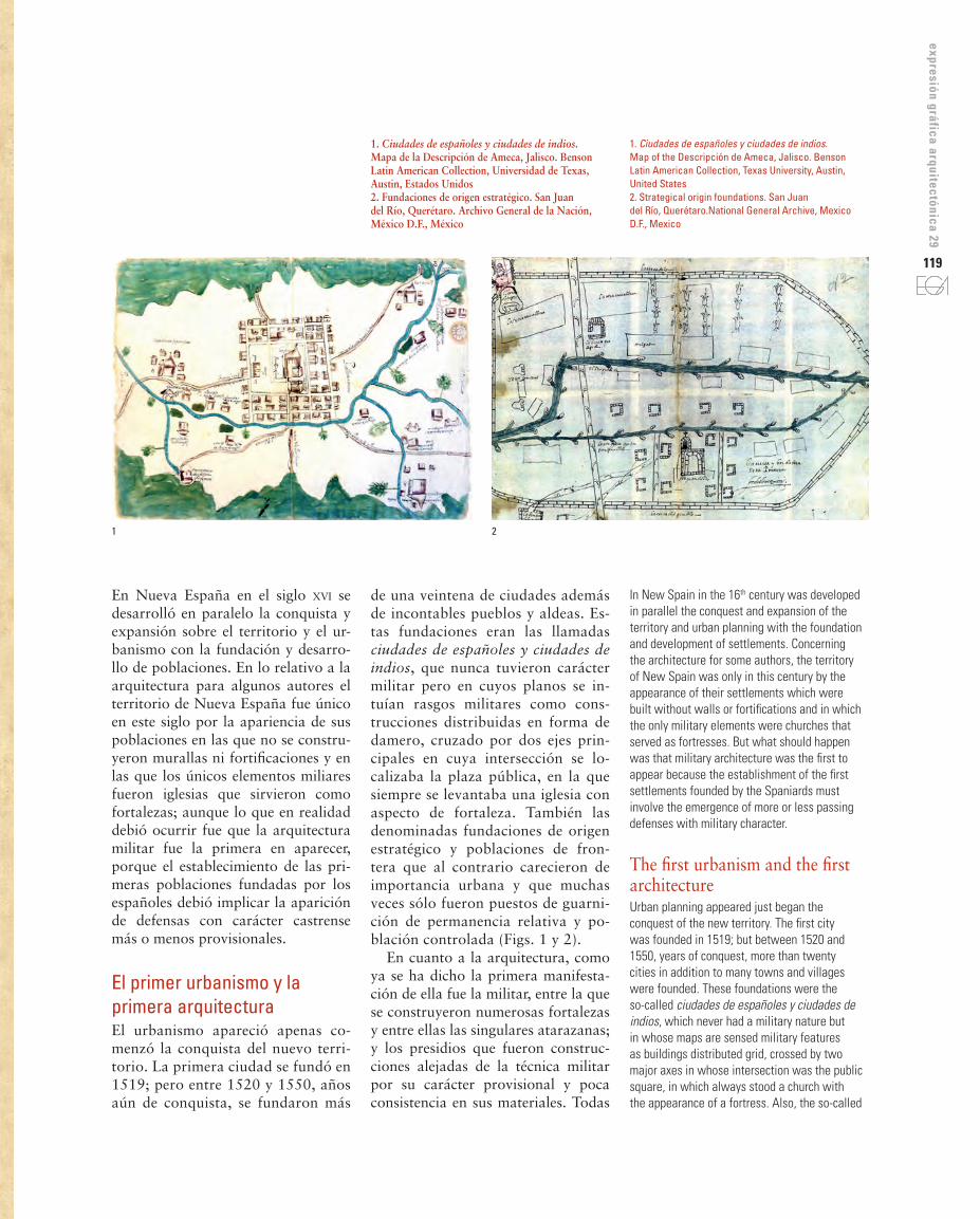
118 DIBUJOS DE LA PRIMERA ARQUITECTURA DE NUEVA ESPAÑA: ALGUNOS MAPAS, PLANOS Y PROYECTOS DE ARQUITECTURA DEL SIGLO XVI
THE FIRST NEW SPAIN ARCHITECTURE DRAWINGS: SOME MAPS, PLANS, AND PROJECTS OF ARCHITECTURE OF THE 16TH CENTURY
Pilar Moya Olmedo
doi: 10.4995/ega.2017.1281
Los dibujos de la arquitectura que ya no existe surgen como fieles cronistas de la historia para que esta sea recuperada.El estudio de la historia del territorio a través de su arquitectura y sus dibujos es posible ya que estos surgen como consecuencia del conocimiento y posesión del mismo. Hablar de la arquitectura de Nueva España en el siglo xvi es hablar de una arquitectura de conquista; de la arquitectura de las ciudades que construyeron los españoles, pero sobre todo de la arquitectura militar que fue la que apareció desde el comienzo mismo de la conquista.
PALABRAS CLAVE: NUEVA ESPAÑA SIGLO XVI. URBANISMO. ARQUITECTURA MILITAR. DIBUJOS DE CIUDADES Y ARQUITECTURA
Drawings of buildings that no longer exist arise as faithful chroniclers of history to be recovered.The study of the history of the territory through its architecture and its drawings is possible since they appear as a result of the knowledge and possession of the same. Talk about the architecture of New Spain in the 16th century is talking about an architecture of conquest; the architecture of the Spanish cities, but above all of the military architecture which was the one that appeared from the beginning of the conquest.
Keywords: New spaiN 16th ceNtury. military architecture. urbaNism. aNd drawiNgs of cities aNd architecture
119
expresión gráfica arquitectónica 29
En Nueva España en el siglo xvi se desarrolló en paralelo la conquista y expansión sobre el territorio y el ur-banismo con la fundación y desarro-llo de poblaciones. En lo relativo a la arquitectura para algunos autores el territorio de Nueva España fue único en este siglo por la apariencia de sus poblaciones en las que no se constru-yeron murallas ni fortificaciones y en las que los únicos elementos miliares fueron iglesias que sirvieron como fortalezas; aunque lo que en realidad debió ocurrir fue que la arquitectura militar fue la primera en aparecer, porque el establecimiento de las pri-meras poblaciones fundadas por los españoles debió implicar la aparición de defensas con carácter castrense más o menos provisionales.
El primer urbanismo y la primera arquitecturaEl urbanismo apareció apenas co-menzó la conquista del nuevo terri-torio. La primera ciudad se fundó en 1519; pero entre 1520 y 1550, años aún de conquista, se fundaron más
de una veintena de ciudades además de incontables pueblos y aldeas. Es-tas fundaciones eran las llamadas ciudades de españoles y ciudades de indios, que nunca tuvieron carácter militar pero en cuyos planos se in-tuían rasgos militares como cons-trucciones distribuidas en forma de damero, cruzado por dos ejes prin-cipales en cuya intersección se lo-calizaba la plaza pública, en la que siempre se levantaba una iglesia con aspecto de fortaleza. También las denominadas fundaciones de origen estratégico y poblaciones de fron-tera que al contrario carecieron de importancia urbana y que muchas veces sólo fueron puestos de guarni-ción de permanencia relativa y po-blación controlada (Figs. 1 y 2).
En cuanto a la arquitectura, como ya se ha dicho la primera manifesta-ción de ella fue la militar, entre la que se construyeron numerosas fortalezas y entre ellas las singulares atarazanas; y los presidios que fueron construc-ciones alejadas de la técnica militar por su carácter provisional y poca consistencia en sus materiales. Todas
In New Spain in the 16th century was developed in parallel the conquest and expansion of the territory and urban planning with the foundation and development of settlements. Concerning the architecture for some authors, the territory of New Spain was only in this century by the appearance of their settlements which were built without walls or fortifications and in which the only military elements were churches that served as fortresses. But what should happen was that military architecture was the first to appear because the establishment of the first settlements founded by the Spaniards must involve the emergence of more or less passing defenses with military character.
The first urbanism and the first architectureUrban planning appeared just began the conquest of the new territory. The first city was founded in 1519; but between 1520 and 1550, years of conquest, more than twenty cities in addition to many towns and villages were founded. These foundations were the so-called ciudades de españoles y ciudades de indios, which never had a military nature but in whose maps are sensed military features as buildings distributed grid, crossed by two major axes in whose intersection was the public square, in which always stood a church with the appearance of a fortress. Also, the so-called
1 2
1. Ciudades de españoles y ciudades de indios. Mapa de la Descripción de Ameca, Jalisco. Benson Latin American Collection, Universidad de Texas, Austin, Estados Unidos2. Fundaciones de origen estratégico. San Juan del Río, Querétaro. Archivo General de la Nación, México D.F., México
1. Ciudades de españoles y ciudades de indios. Map of the Descripción de Ameca, Jalisco. Benson Latin American Collection, Texas University, Austin, United States2. Strategical origin foundations. San Juan del Río, Querétaro.National General Archive, Mexico D.F., Mexico
120
3. Congregation Jail. Map of the description of Yuririapundaro, Guanajuato. Archivo General de Indias, Seville, Spain4. ‘Cortés Map’ (detail). Library of Congress, Washington, D.C., United States. http://www.loc.gov/exhibits/exploring-the-early-americas/ExplorationsandEncounters/CortesandtheAztecs/Assets/object60_t_725.Jpeg5. ‘Uppsala Map’ (detail). Carolina Rediviva Library, Uppsala University, Sweden. http://art.alvin-portal.org/alvin/view.jsf?file=4289
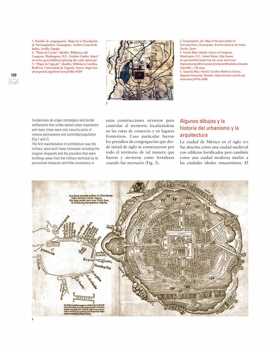
3. Presidio de congregación. Mapa de la Descripción de Yuririapúndaro, Guanajuato. Archivo General de Indias, Sevilla, España4. “Plano de Cortés” (detalle). Biblioteca del Congreso, Washington, D.C., Estados Unidos. http://www.loc.gov/exhibits/exploring-the-early-americas/5. “Mapa de Uppsala” (detalle). Biblioteca Carolina Rediviva, Universidad de Uppsala, Suecia. http://art.alvin-portal.org/alvin/view.jsf?file=4289
fundaciones de origen estratégico and border settlements that unlike lacked urban importance and many times were only security posts of relative permanence and controlled population (Fig.1 and 2).The first manifestation of architecture was the military, were built many fortresses including the singular shipyards and the presidios that were buildings away from the military-technical by its provisional character and little consistency in
Algunos dibujos y la historia del urbanismo y la arquitecturaLa ciudad de México en el siglo xvi fue descrita como una ciudad medieval con edificios fortificados pero también como una ciudad moderna similar a las ciudades ideales renacentistas. El
estas construcciones sirvieron para controlar el territorio localizándose en las rutas de comercio y en lugares fronterizos. Caso particular fueron los presidios de congregación que des-de mitad de siglo se construyeron por todo el territorio de tal manera que fueron y sirvieron como fortalezas cuando fue necesario (Fig. 3).
3
4

121
expresión gráfica arquitectónica 29
5
primer dibujo conocido de la ciudad es el llamado “Plano de Cortés” en el cual se mezclan elementos urbanos con la simbología indígena y que fue publica-do en Núremberg en 1524 en un libro que contenía la traducción latina de la segunda y tercera Cartas de Relación que Cortés envió al emperador Carlos V. Aunque son varias las hipótesis so-bre su origen, la más acertada parece ser que fue un diseño originalmente in-dígena con añadidos españoles después idealizado para su publicación, Mundy (1998) sostiene que es un mapa reela-borado por europeos pero con indicios que permiten vincularlo a los tlacuilos escribas mesoamericanos. El plano, al que no se le puede conceder intención
topográfica, es importante porque per-mite hacer una reconstrucción hipoté-tica de cómo era la ciudad de México-Tenochtitlán antes de su transforma-ción tras la conquista (Fig. 4).
En el “Mapa de Uppsala” se repiten elementos urbanos del dibujo anterior que muestran el proceso de urbaniza-ción que transformó la ciudad, pero en él ya aparece otra arquitectura. Atribuido históricamente a Alonso de Santa Cruz, más bien parece ser obra también de los tlacuilos del Colegio de Santa Cruz Tlatecolco. Los elementos urbanos representados hacen pensar que fue realizado hacia 1540 lo que se confirma porque no refleja la ciu-dad descrita por Cervantes de Salazar
their materials. All these constructions, located in trade routes and border places, were used to control the territory. Particular cases were presidios de congregación since half of century were built throughout the territory in such way were and served as fortresses when was necessary (Fig. 3).
Some drawings and the history of urbanism and architectureThe city of México in the 16th century was described as a medieval city with fortified buildings but also as a modern city similar to the Renaissance ideal cities. The first known drawing of the city is the so-called ‘Cortés Map’ in which are mixed urban elements with indigenous symbols. It was published in Nuremberg in 1524, in a book containing the Latin translation of the second and third letters which Cortés sent the
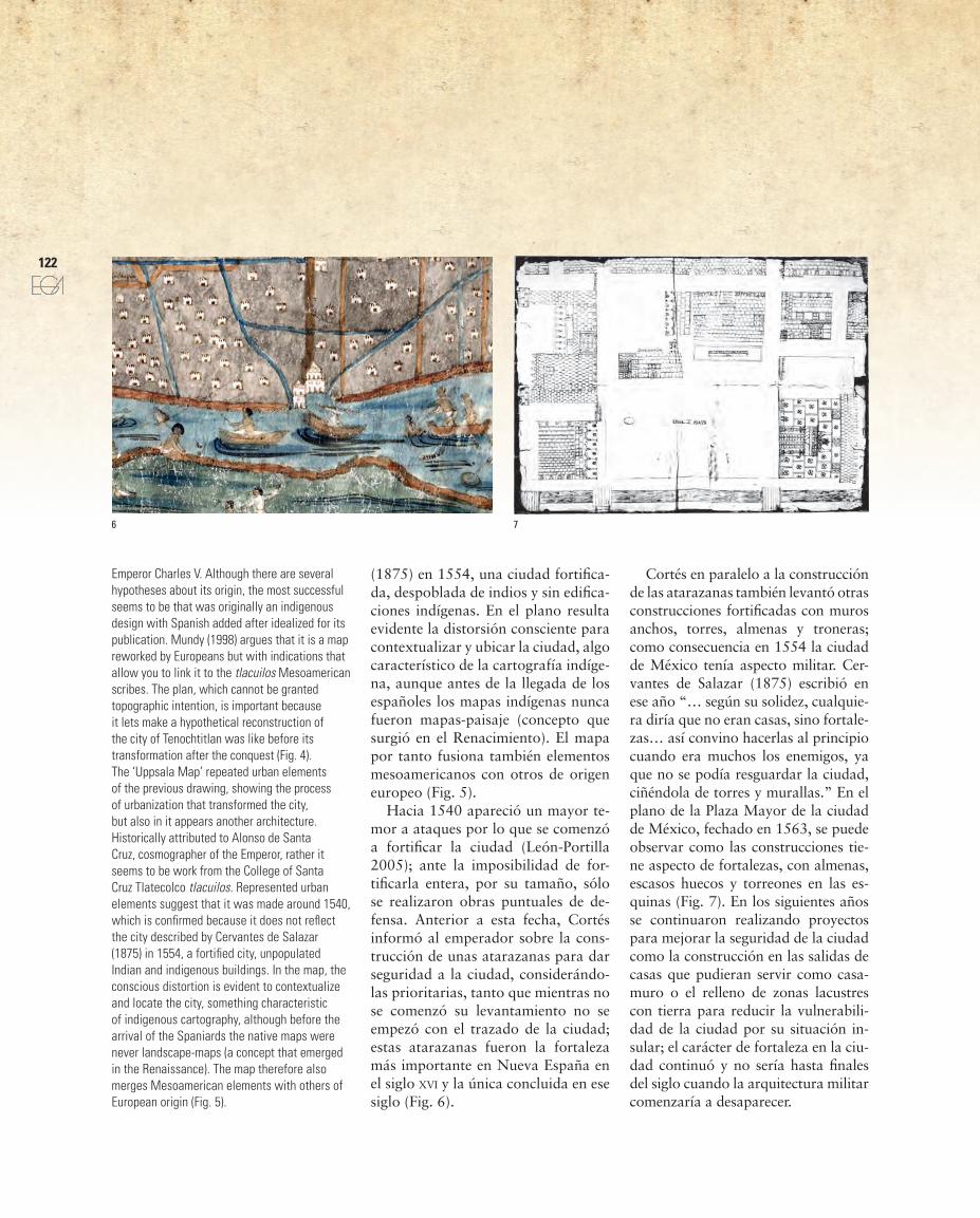
Emperor Charles V. Although there are several hypotheses about its origin, the most successful seems to be that was originally an indigenous design with Spanish added after idealized for its publication. Mundy (1998) argues that it is a map reworked by Europeans but with indications that allow you to link it to the tlacuilos Mesoamerican scribes. The plan, which cannot be granted topographic intention, is important because it lets make a hypothetical reconstruction of the city of Tenochtitlan was like before its transformation after the conquest (Fig. 4).The ‘Uppsala Map’ repeated urban elements of the previous drawing, showing the process of urbanization that transformed the city, but also in it appears another architecture. Historically attributed to Alonso de Santa Cruz, cosmographer of the Emperor, rather it seems to be work from the College of Santa Cruz Tlatecolco tlacuilos. Represented urban elements suggest that it was made around 1540, which is confirmed because it does not reflect the city described by Cervantes de Salazar (1875) in 1554, a fortified city, unpopulated Indian and indigenous buildings. In the map, the conscious distortion is evident to contextualize and locate the city, something characteristic of indigenous cartography, although before the arrival of the Spaniards the native maps were never landscape-maps (a concept that emerged in the Renaissance). The map therefore also merges Mesoamerican elements with others of European origin (Fig. 5).
6 7
(1875) en 1554, una ciudad fortifica-da, despoblada de indios y sin edifica-ciones indígenas. En el plano resulta evidente la distorsión consciente para contextualizar y ubicar la ciudad, algo característico de la cartografía indíge-na, aunque antes de la llegada de los españoles los mapas indígenas nunca fueron mapas-paisaje (concepto que surgió en el Renacimiento). El mapa por tanto fusiona también elementos mesoamericanos con otros de origen europeo (Fig. 5).
Hacia 1540 apareció un mayor te-mor a ataques por lo que se comenzó a fortificar la ciudad (León-Portilla 2005); ante la imposibilidad de for-tificarla entera, por su tamaño, sólo se realizaron obras puntuales de de-fensa. Anterior a esta fecha, Cortés informó al emperador sobre la cons-trucción de unas atarazanas para dar seguridad a la ciudad, considerándo-las prioritarias, tanto que mientras no se comenzó su levantamiento no se empezó con el trazado de la ciudad; estas atarazanas fueron la fortaleza más importante en Nueva España en el siglo xvi y la única concluida en ese siglo (Fig. 6).
Cortés en paralelo a la construcción de las atarazanas también levantó otras construcciones fortificadas con muros anchos, torres, almenas y troneras; como consecuencia en 1554 la ciudad de México tenía aspecto militar. Cer-vantes de Salazar (1875) escribió en ese año “… según su solidez, cualquie-ra diría que no eran casas, sino fortale-zas… así convino hacerlas al principio cuando era muchos los enemigos, ya que no se podía resguardar la ciudad, ciñéndola de torres y murallas.” En el plano de la Plaza Mayor de la ciudad de México, fechado en 1563, se puede observar como las construcciones tie-ne aspecto de fortalezas, con almenas, escasos huecos y torreones en las es-quinas (Fig. 7). En los siguientes años se continuaron realizando proyectos para mejorar la seguridad de la ciudad como la construcción en las salidas de casas que pudieran servir como casa-muro o el relleno de zonas lacustres con tierra para reducir la vulnerabili-dad de la ciudad por su situación in-sular; el carácter de fortaleza en la ciu-dad continuó y no sería hasta finales del siglo cuando la arquitectura militar comenzaría a desaparecer.
122
6. Shipyards of the city of México. ‘Uppsala Map’ (detail). Carolina Rediviva Library, Uppsala University, Sweden7. Map of the Plaza Mayor of the city of México 1562-1566. Ángulo Iñiguez, D. 1933-1939. Planos de monumentos arquitectónicos de América y Filipinas existentes en el Archivo de Indias, por Diego Angulo Íñiguez. Seville: Laboratorio de arte, lam.2.A8. Map of the Descripción de la (Antigua) Vera Cruz, Veracruz. Benson Latin American Collection, Texas University, Austin, United States9. View of the port and fortress of San Juan de Ulúa, Veracruz. Vellerino de Villalobos, B. ca.1592. Salamanca University Library, Spain
6. Atarazanas de ciudad de México. “Mapa de Uppsala” (detalle). Biblioteca Carolina Rediviva, Universidad de Uppsala, Suecia7. Plano de la Plaza Mayor de la ciudad de México 1562-1566. Angulo Iñiguez, D. 1933-1939. Planos de monumentos arquitectónicos de América y Filipinas existentes en el Archivo de Indias, por Diego Angulo Íñiguez. Sevilla: Laboratorio de arte, lam.2.A. ExplorationsandEncounters/CortesandtheAztecs/Assets/object60_t_725.Jpeg8. Mapa de la Descripción de la (Antigua) Vera Cruz, Veracruz. Benson Latin American Collection, Universidad de Texas, Austin, Estados Unidos9. Vista del puerto y fortaleza de San Juan de Ulúa, Veracruz. Vellerino de Villalobos, B. ca.1592. Biblioteca de la Universidad de Salamanca, España
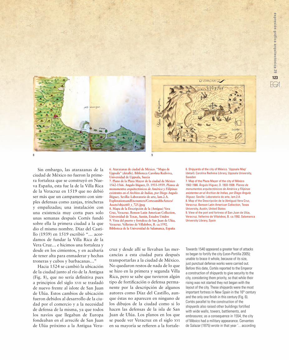
Sin embargo, las atarazanas de la ciudad de México no fueron la prime-ra fortaleza que se construyó en Nue-va España, esta fue la de la Villa Rica de la Veracruz en 1519 que no debió ser más que un campamento con sim-ples defensas como zanjas, trincheras y empalizadas; una instalación con una existencia muy corta pues solo unas semanas después Cortés fundó sobre ella la primera ciudad a la que dio el mismo nombre. Díaz del Casti-llo (1939) en 1519 escribió “… acor-damos de fundar la Villa Rica de la Vera Cruz… e hicimos una fortaleza y desde en los cimientos, y en acabaría de tener alta para enmaderar y hechas troneras y cubos y barbacanas…”
Hacia 1524 se cambió la ubicación de la ciudad junto al río de la Antigua (Fig. 8), que no sería definitiva pues a principios del siglo xvii se trasladó de nuevo frente al islote de San Juan de Ulúa. Estos cambios de ubicación fueron debidos al desarrollo de la ciu-dad por el comercio y a la necesidad de defensa de la misma, ya que todos los navíos que llegaban de Europa fondeaban en el arrecife de San Juan de Ulúa próximo a la Antigua Vera-
cruz y desde allí se llevaban las mer-cancías a esta ciudad para después transportarlas a la ciudad de México. No quedaron restos de nada de lo que se hizo en la primera y segunda Villa Rica, pero se sabe que tuvieron algún tipo de fortificación o defensa perma-nente por la descripción de algunos autores como Díaz del Castillo, aun-que éstas no aparecen en ninguno de los dibujos de la ciudad como si lo hacen las defensas de la isla de San Juan de Ulúa. Los planos en los que se puede ver Veracruz en el siglo xvi en su mayoría se refieren a la fortale-
8 9
Towards 1540 appeared a greater fear of attacks so began to fortify the city (Leon-Portilla 2005); unable to brace it whole, because of its size, just punctual defense works were carried out. Before this date, Cortés reported to the Emperor a construction of shipyards to give security to the city, considering them priority, so that while their rising was not started they not began with the layout of the city. These shipyards were the most important fortress in New Spain in the 16th century and the only one finish in this century (Fig. 6).Cortés parallel to the construction of the shipyards also raised other buildings fortified with wide walls, towers, battlements, and embrasures; as a consequence in 1554, the city of México had a military appearance. Cervantes de Salazar (1875) wrote in that year ‘... according
123
expresión gráfica arquitectónica 29

124
11
10
za de Ulúa, ambas ciudad y fortaleza siempre estuvieron unidas.
Aunque hay algún plano anterior mostrando el cambio de situación de la ciudad y el desarrollo de la fortifi-cación propuestos, la vista del puerto y la fortaleza de San Juan de Ulúa de Vellerino de Villalobos hacia 1592, muestra aun la ciudad de Veracruz todavía junto al río de la Antigua y aparece también dibujadas las Ventas de Buitrón lugar donde Antonelli, in-geniero de Felipe II, recomendó que fuera trasladada la ciudad porque la seguridad y defensa de la misma se podría articular fácil y conjuntamente con la fortaleza de Ulúa (Fig. 9). Exis-te una vista panorámica atribuida a Boot, ingeniero y cosmógrafo flamen-co, fechada en 1615 en el estudio de Paso y Troncoso que Toussaint (1947) recoge, en la que aparece la ciudad re-cién fundada con la fortaleza de San Juan de Ulúa al fondo (Fig. 10).
Desconocemos las defensas que tuvo la isla de Ulúa durante la con-quista, pero en el gobierno del pri-mer virrey tenía una torre con muros de mampostería para la defensa del puerto. Debido a la importancia que fue adquiriendo Veracruz, se hicieron propuestas para mejorar su seguridad y con ello la del puerto y las naves. Esto implicó, en la isla de Ulúa, la construcción de una Casa de contra-tación como casa-fuerte que sirviera para la defensa del puerto y que al es-tar levantada sobre el arrecife dejaba libre el canal y la entrada al puerto. El proyecto resultante fue, con la cons-trucción de otra torre al este, un frente con forma de fortificación constituido por un muro entre dos baluartes.
En 1590, el virrey solicitó la inter-vención de un ingeniero militar para el estudio de las costas americanas y para trazar las fortalezas que conside-rara necesarias. Fue Antonelli el que
125
expresión gráfica arquitectónica 29
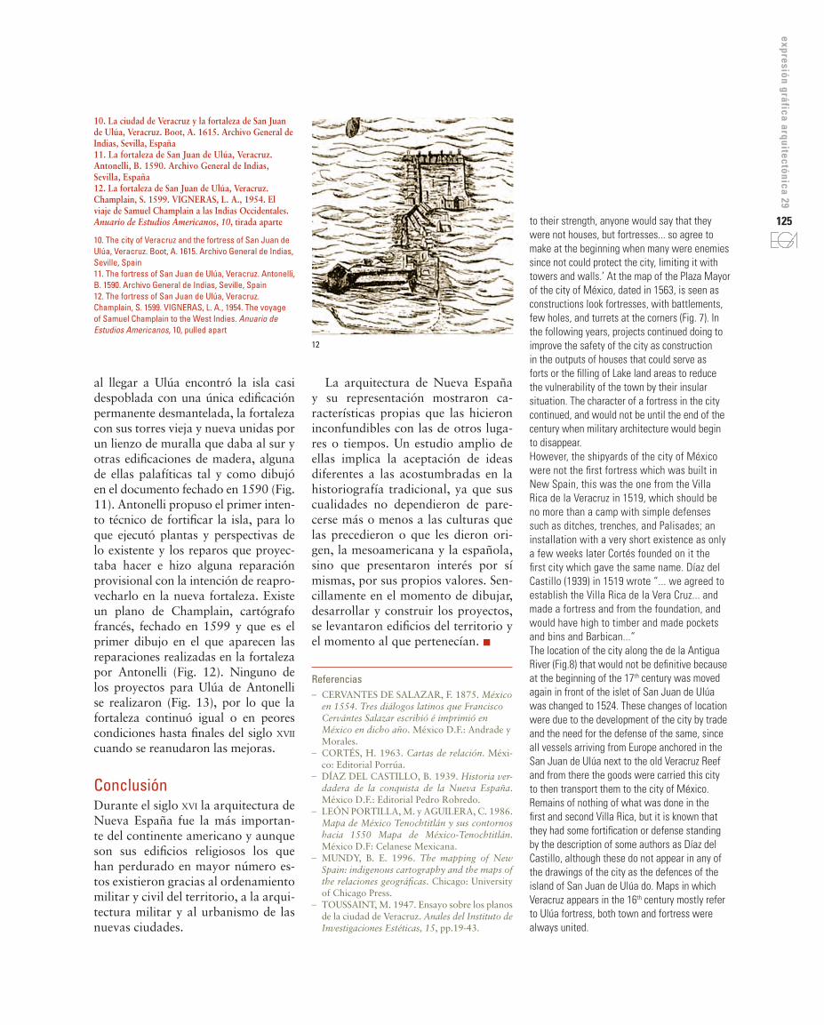
10. La ciudad de Veracruz y la fortaleza de San Juan de Ulúa, Veracruz. Boot, A. 1615. Archivo General de Indias, Sevilla, España11. La fortaleza de San Juan de Ulúa, Veracruz. Antonelli, B. 1590. Archivo General de Indias, Sevilla, España12. La fortaleza de San Juan de Ulúa, Veracruz. Champlain, S. 1599. VIGNERAS, L. A., 1954. El viaje de Samuel Champlain a las Indias Occidentales. Anuario de Estudios Americanos, 10, tirada aparte
10. The city of Veracruz and the fortress of San Juan de Ulúa, Veracruz. Boot, A. 1615. Archivo General de Indias, Seville, Spain11. The fortress of San Juan de Ulúa, Veracruz. Antonelli, B. 1590. Archivo General de Indias, Seville, Spain12. The fortress of San Juan de Ulúa, Veracruz. Champlain, S. 1599. VIGNERAS, L. A., 1954. The voyage of Samuel Champlain to the West Indies. Anuario de Estudios Americanos, 10, pulled apart
to their strength, anyone would say that they were not houses, but fortresses... so agree to make at the beginning when many were enemies since not could protect the city, limiting it with towers and walls.’ At the map of the Plaza Mayor of the city of México, dated in 1563, is seen as constructions look fortresses, with battlements, few holes, and turrets at the corners (Fig. 7). In the following years, projects continued doing to improve the safety of the city as construction in the outputs of houses that could serve as forts or the filling of Lake land areas to reduce the vulnerability of the town by their insular situation. The character of a fortress in the city continued, and would not be until the end of the century when military architecture would begin to disappear.However, the shipyards of the city of México were not the first fortress which was built in New Spain, this was the one from the Villa Rica de la Veracruz in 1519, which should be no more than a camp with simple defenses such as ditches, trenches, and Palisades; an installation with a very short existence as only a few weeks later Cortés founded on it the first city which gave the same name. Díaz del Castillo (1939) in 1519 wrote “... we agreed to establish the Villa Rica de la Vera Cruz... and made a fortress and from the foundation, and would have high to timber and made pockets and bins and Barbican...”The location of the city along the de la Antigua River (Fig.8) that would not be definitive because at the beginning of the 17th century was moved again in front of the islet of San Juan de Ulúa was changed to 1524. These changes of location were due to the development of the city by trade and the need for the defense of the same, since all vessels arriving from Europe anchored in the San Juan de Ulúa next to the old Veracruz Reef and from there the goods were carried this city to then transport them to the city of México. Remains of nothing of what was done in the first and second Villa Rica, but it is known that they had some fortification or defense standing by the description of some authors as Díaz del Castillo, although these do not appear in any of the drawings of the city as the defences of the island of San Juan de Ulúa do. Maps in which Veracruz appears in the 16th century mostly refer to Ulúa fortress, both town and fortress were always united.
La arquitectura de Nueva España y su representación mostraron ca-racterísticas propias que las hicieron inconfundibles con las de otros luga-res o tiempos. Un estudio amplio de ellas implica la aceptación de ideas diferentes a las acostumbradas en la historiografía tradicional, ya que sus cualidades no dependieron de pare-cerse más o menos a las culturas que las precedieron o que les dieron ori-gen, la mesoamericana y la española, sino que presentaron interés por sí mismas, por sus propios valores. Sen-cillamente en el momento de dibujar, desarrollar y construir los proyectos, se levantaron edificios del territorio y el momento al que pertenecían. n
Referencias– CERVANTES DE SALAzAR, F. 1875. México
en 1554. Tres diálogos latinos que Francisco Cervántes Salazar escribió é imprimió en México en dicho año. México D.F.: Andrade y Morales.
– CoRTéS, H. 1963. Cartas de relación. Méxi-co: Editorial Porrúa.
– DíAz DEL CASTILLo, B. 1939. Historia ver-dadera de la conquista de la Nueva España. México D.F.: Editorial Pedro Robredo.
– LEóN PoRTILLA, M. y AgUILERA, C. 1986. Mapa de México Tenochtitlán y sus contornos hacia 1550 Mapa de México-Tenochtitlán. México D.F: Celanese Mexicana.
– MUNDy, B. E. 1996. The mapping of New Spain: indigenous cartography and the maps of the relaciones geográficas. Chicago: University of Chicago Press.
– ToUSSAINT, M. 1947. Ensayo sobre los planos de la ciudad de Veracruz. Anales del Instituto de Investigaciones Estéticas, 15, pp.19-43.
al llegar a Ulúa encontró la isla casi despoblada con una única edificación permanente desmantelada, la fortaleza con sus torres vieja y nueva unidas por un lienzo de muralla que daba al sur y otras edificaciones de madera, alguna de ellas palafíticas tal y como dibujó en el documento fechado en 1590 (Fig. 11). Antonelli propuso el primer inten-to técnico de fortificar la isla, para lo que ejecutó plantas y perspectivas de lo existente y los reparos que proyec-taba hacer e hizo alguna reparación provisional con la intención de reapro-vecharlo en la nueva fortaleza. Existe un plano de Champlain, cartógrafo francés, fechado en 1599 y que es el primer dibujo en el que aparecen las reparaciones realizadas en la fortaleza por Antonelli (Fig. 12). Ninguno de los proyectos para Ulúa de Antonelli se realizaron (Fig. 13), por lo que la fortaleza continuó igual o en peores condiciones hasta finales del siglo xvii cuando se reanudaron las mejoras.
ConclusiónDurante el siglo xvi la arquitectura de Nueva España fue la más importan-te del continente americano y aunque son sus edificios religiosos los que han perdurado en mayor número es-tos existieron gracias al ordenamiento militar y civil del territorio, a la arqui-tectura militar y al urbanismo de las nuevas ciudades.
12
Although there are some previous maps which show the change in status of the city and the development of the proposed fortification, the view of the port and the fortress of San Juan de Ulúa of Vellerino de Villalobos to 1592 shows the city of Veracruz still along the de la Antigua River; also appears drawn the Ventas de Buitrón place where Antonelli, the engineer of Felipe II, recommended that the city was moved because the security and defense of it could articulate easily in conjunction with the Ulúa fortress (Fig. 9). There is a panoramic view attributed to Boot, engineer and Flemish cosmographer, dated 1615 in the study of Paso and Troncoso that Toussaint (1947) collects, in which appears the city recently founded and the fortress of San Juan de Ulúa at the bottom (Fig. 10).We don’t know the defenses that had the Ulúa Island during the conquest, but in the Government of the first Viceroy had a tower with masonry walls for the defense of the port. Due to the importance that was acquiring Veracruz, proposals were made to improve its safety and the port and the ships security. This improvement involves, in the Ulúa Island, the construction of a House of recruitment as a fort that served as a defense of the port and that being raised on the reef so left free the channel and the entrance to the port. The resulting project was, with the construction of another tower to the East, a front shaped fortification made up of a wall between two bastions.In 1590, the Viceroy requested the intervention of a military engineer for the study of the American coasts and to build the defenses that consider necessary. It was Antonelli which when getting to Ulúa found the nearly uninhabited island with a unique building permanent dismantled the fortress with their old and new towers joined by a canvas of wall that gave to the South and other buildings of wood, as he draws in the document dated 1590 (Fig. 11). Antonelli which proposed the first attempt to fortify the island executed maps, and prospects of the existing and the objections that planned to make and made some temporary repairs with the intent to take advantage of it in the new fortress. There is a map of Champlain, a French cartographer,
13
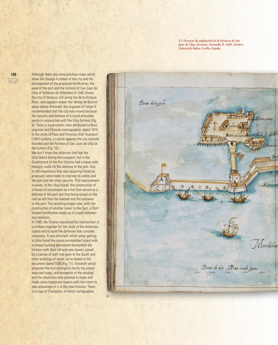
13. Proyecto de ampliación de la fortaleza de San Juan de Ulúa, Veracruz. Antonelli, B. 1608. Archivo General de Indias, Sevilla, España
126
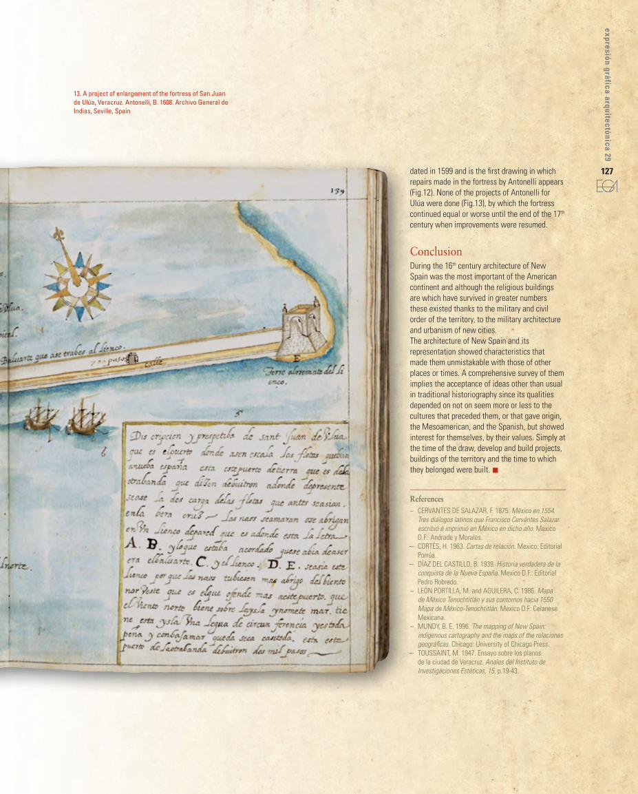
dated in 1599 and is the first drawing in which repairs made in the fortress by Antonelli appears (Fig.12). None of the projects of Antonelli for Ulúa were done (Fig.13), by which the fortress continued equal or worse until the end of the 17th century when improvements were resumed.
ConclusionDuring the 16th century architecture of New Spain was the most important of the American continent and although the religious buildings are which have survived in greater numbers these existed thanks to the military and civil order of the territory, to the military architecture and urbanism of new cities.The architecture of New Spain and its representation showed characteristics that made them unmistakable with those of other places or times. A comprehensive survey of them implies the acceptance of ideas other than usual in traditional historiography since its qualities depended on not on seem more or less to the cultures that preceded them, or that gave origin, the Mesoamerican, and the Spanish, but showed interest for themselves, by their values. Simply at the time of the draw, develop and build projects, buildings of the territory and the time to which they belonged were built. n
References– CERVANTES DE SALAzAR, F. 1875. México en 1554.
Tres diálogos latinos que Francisco Cervántes Salazar escribió é imprimió en México en dicho año. Mexico D.F.: Andrade y Morales.
– CoRTéS, H. 1963. Cartas de relación. Mexico: Editorial Porrúa.
– DíAz DEL CASTILLo, B. 1939. Historia verdadera de la conquista de la Nueva España. Mexico D.F.: Editorial Pedro Robredo.
– LEóN PoRTILLA, M. and AGUILERA, C. 1986. Mapa de México Tenochtitlán y sus contornos hacia 1550 Mapa de México-Tenochtitlán. Mexico D.F: Celanese Mexicana.
– MUNDy, B. E. 1996. The mapping of New Spain: indigenous cartography and the maps of the relaciones geográficas. Chicago: University of Chicago Press.
– ToUSSAINT, M. 1947. Ensayo sobre los planos de la ciudad de Veracruz. Anales del Instituto de Investigaciones Estéticas, 15, p.19-43.
–
–
–
–
–
–
13. A project of enlargement of the fortress of San Juan de Ulúa, Veracruz. Antonelli, B. 1608. Archivo General de Indias, Seville, Spain
127
expresión gráfica arquitectónica 29