Embed Size (px)
Citation preview
Navigation solutions powered by Europe
Ugo CelestinoEuropean Commission
Damascus, 8 April 2010
The EU GNSS Programmes: EGNOS, GALILEOStatus & International Cooperation
2
Navigation solutions powered by EuropeContent
• EU GNSS Programmes- Galileo- EGNOS
• International Cooperation
3
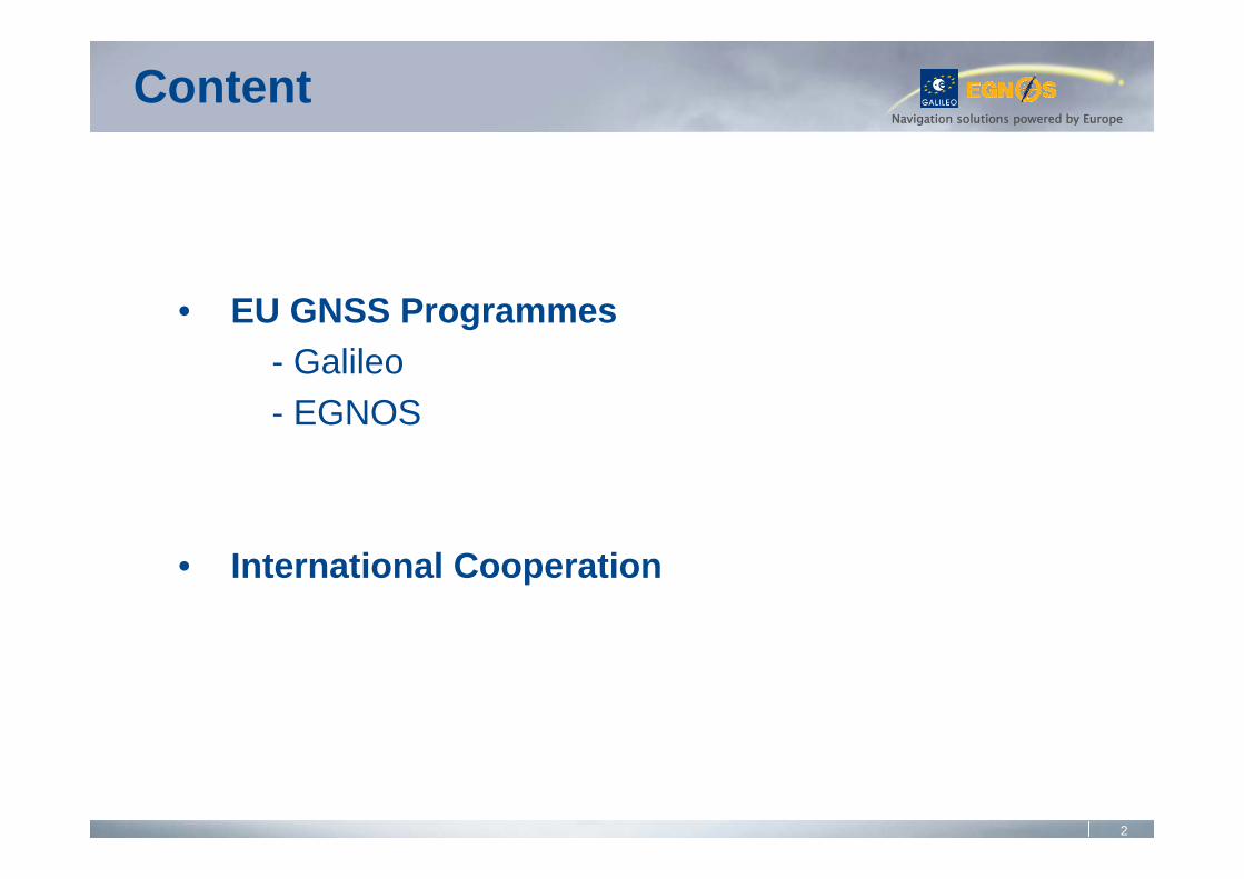
Navigation solutions powered by EuropeIntroduction
• Galileo• An autonomous infrastructure• Global coverage• Global Space and Ground elements• Services similar to GPS, plus innovative ones
• EGNOS• Simply improves GPS performances• Coverage: European landmasses• Limited Space and Ground elements• Mainly for aviation users (« Safety-of-Life »)
4
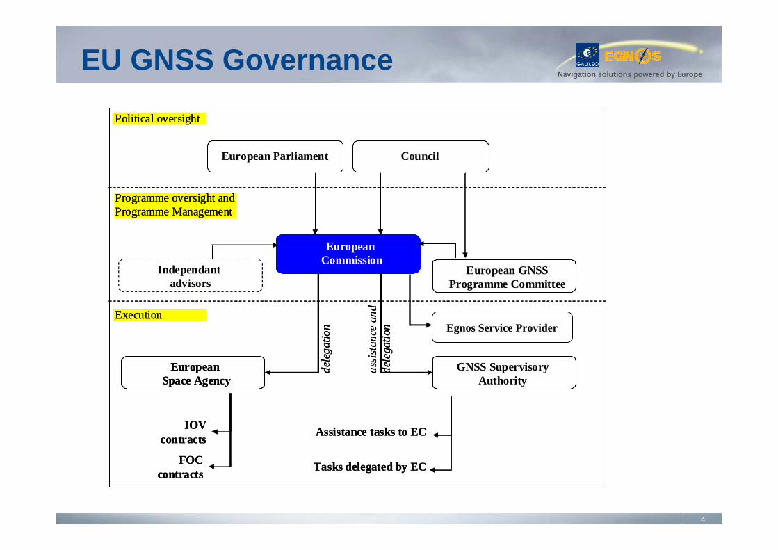
Navigation solutions powered by EuropeEU GNSS Governance
Council
European Commission
Independantadvisors
European Space Agency
IOVcontracts
FOCcontracts
GNSS Supervisory Authority
Political oversight
Programme oversight and Programme Management
Executionde
lega
tion
assi
stanc
e an
dde
lega
tion
European GNSS Programme Committee
European Parliament
Assistance tasks to EC
Tasks delegated by EC
Market preparation
ResearchAccreditation
Others
Egnos Service Provider
5
Navigation solutions powered by Europe
Navigation solutions powered by Europe
GALILEO
6
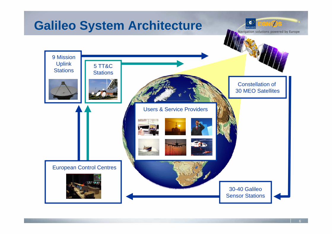
Navigation solutions powered by Europe
5 TT&CStations
9 MissionUplink
Stations
European Control Centres
30-40 GalileoSensor Stations
Constellation of 30 MEO Satellites
Users & Service Providers
Galileo System Architecture
7
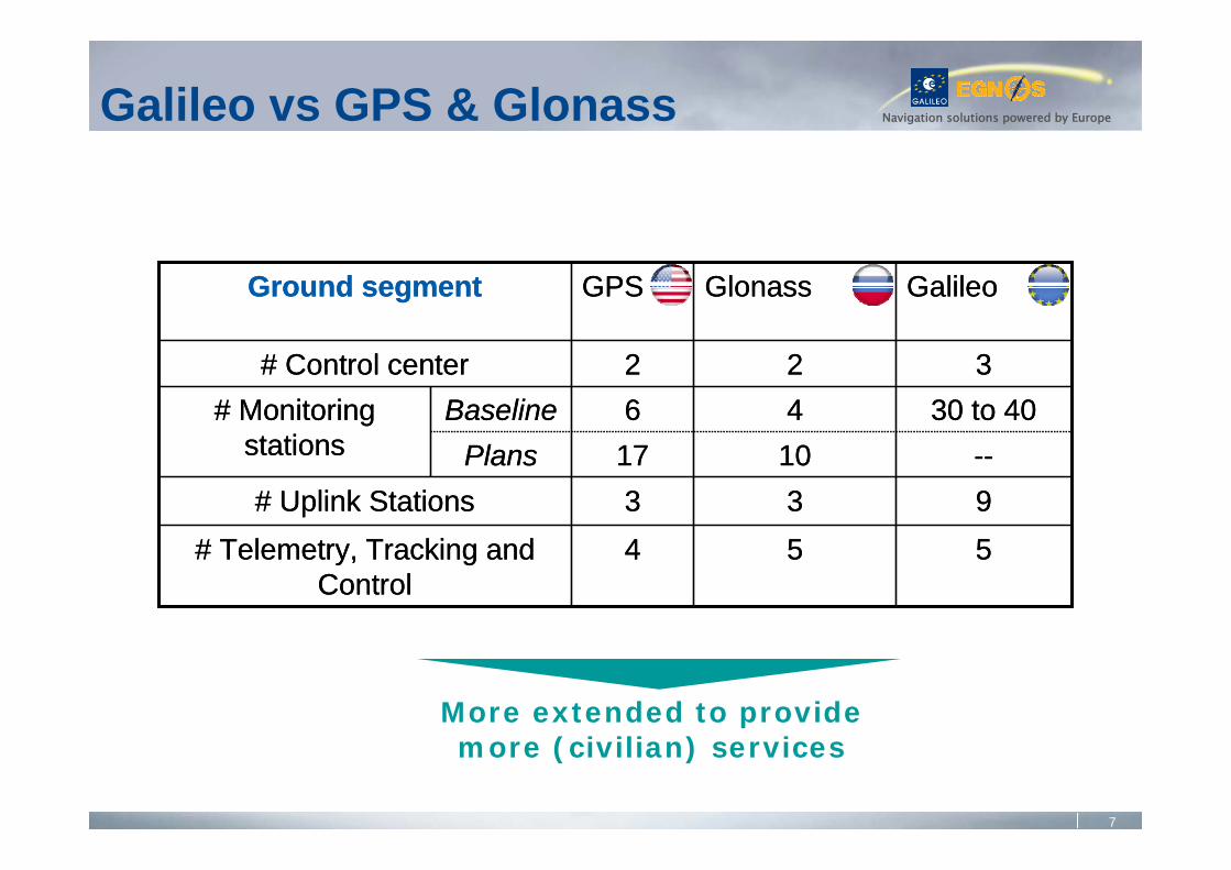
Navigation solutions powered by EuropeGalileo vs GPS & Glonass
554# Telemetry, Tracking and Control
933# Uplink Stations--1017Plans
30 to 4046Baseline# Monitoring stations
322# Control center
GalileoGlonassGPSGround segment
554# Telemetry, Tracking and Control
933# Uplink Stations--1017Plans
30 to 4046Baseline# Monitoring stations
322# Control center
GalileoGlonassGPSGround segment
More extended to provide more (civilian) services
8
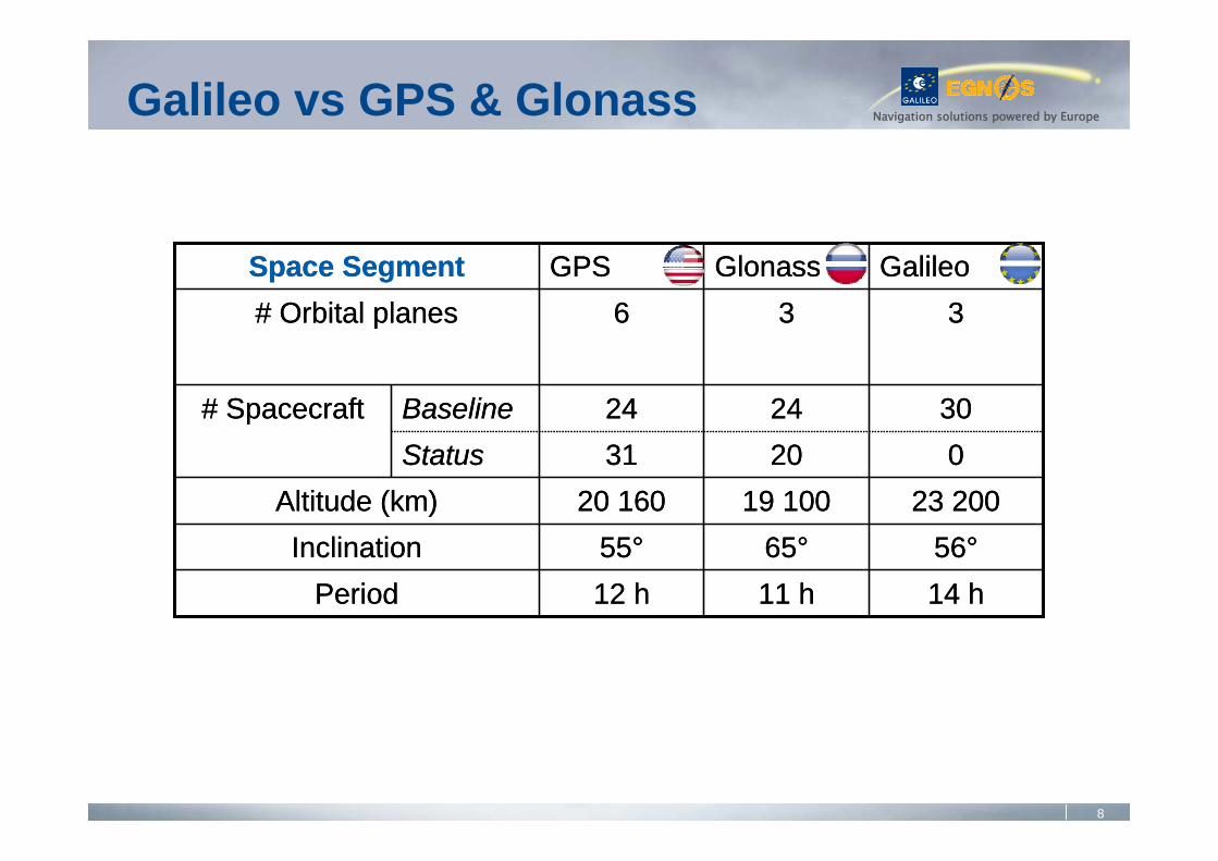
Navigation solutions powered by EuropeGalileo vs GPS & Glonass
14 h11 h12 hPeriod56°65°55°Inclination
23 20019 10020 160Altitude (km)02031Status
302424Baseline# Spacecraft
336# Orbital planesGalileoGlonassGPSSpace Segment
14 h11 h12 hPeriod56°65°55°Inclination
23 20019 10020 160Altitude (km)02031Status
302424Baseline# Spacecraft
336# Orbital planesGalileoGlonassGPSSpace Segment
9
Navigation solutions powered by Europe
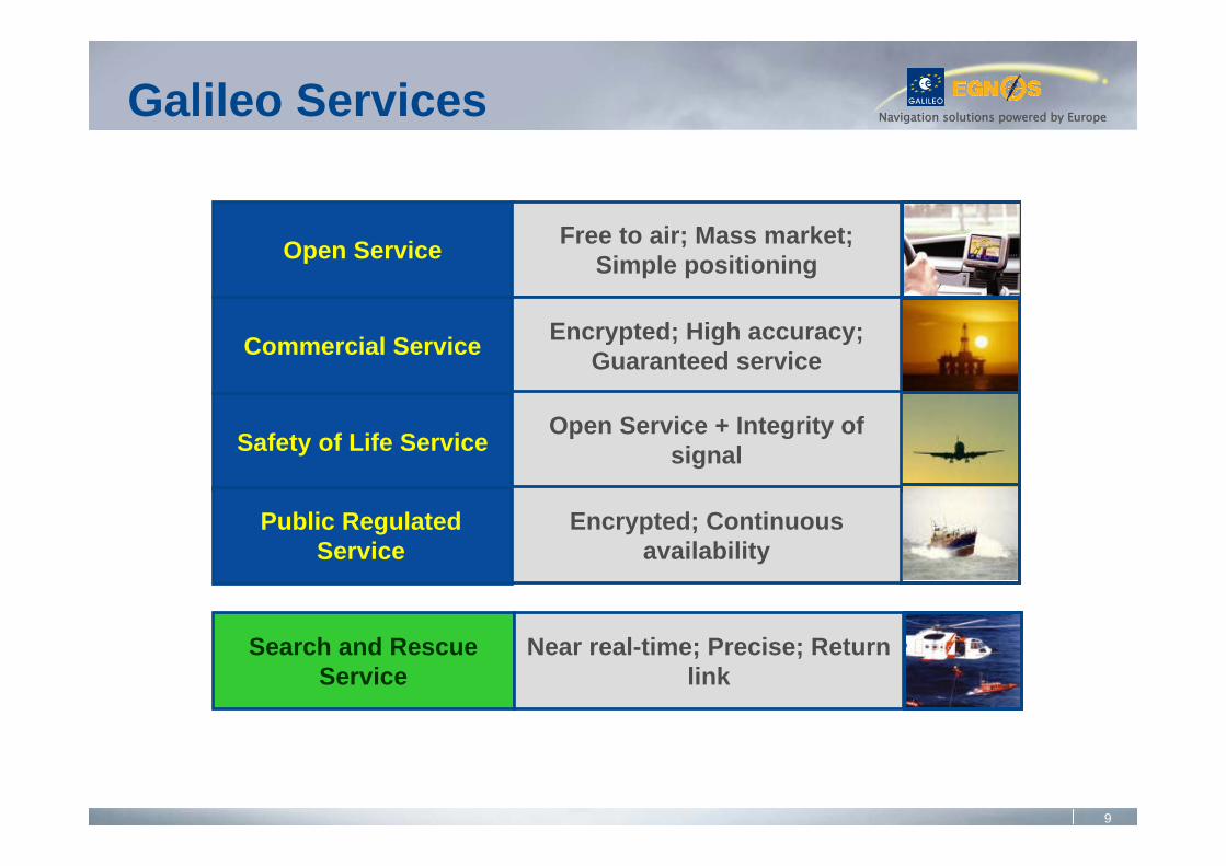
Open Service
Commercial Service
Safety of Life Service
Search and Rescue Service
Free to air; Mass market; Simple positioning
Encrypted; High accuracy; Guaranteed service
Open Service + Integrity of signal
Encrypted; Continuous availability
Near real-time; Precise; Return link
Public RegulatedService
Galileo Services
10
Navigation solutions powered by Europe
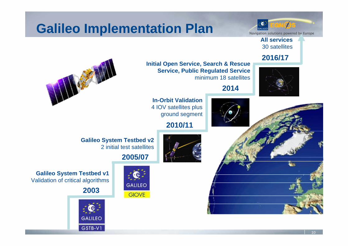
Galileo System Testbed v1Validation of critical algorithms
Galileo System Testbed v22 initial test satellites
In-Orbit Validation4 IOV satellites plus
ground segment
Initial Open Service, Search & Rescue Service, Public Regulated Service
minimum 18 satellites
2003
2005/07
2010/11
2014
Galileo Implementation PlanAll services30 satellites
2016/17
11
Navigation solutions powered by Europe
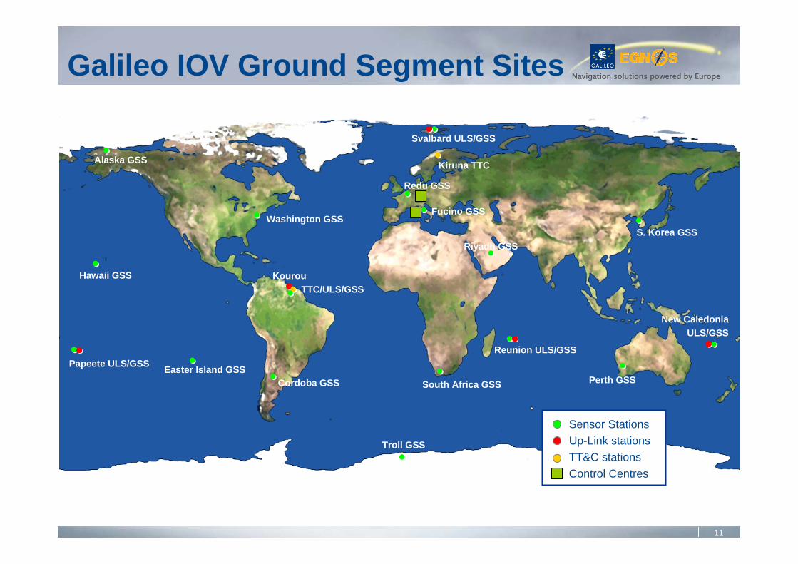
Cordoba GSS
Troll GSS
Alaska GSS
Hawaii GSS
Papeete ULS/GSS Easter Island GSS
Washington GSS
Svalbard ULS/GSS
Kiruna TTC
Redu GSS
Fucino GSS
Riyadh GSS
Reunion ULS/GSS
South Africa GSS
KourouTTC/ULS/GSS
Perth GSS
New Caledonia ULS/GSS
S. Korea GSS
Sensor StationsUp-Link stationsTT&C stationsControl Centres
Galileo IOV Ground Segment Sites

12
Navigation solutions powered by Europe
30-4020Sensor Stations
52TT&C Stations
95Mission Uplink Stations
31Control Centres
27(+3)4Satellites
FOC PhaseIOV PhaseComponent
IOV (In Orbit Validation), FOC (Full Operational Capability)
Galileo IOV vs FOC
2011 2016/17
13
Navigation solutions powered by Europe
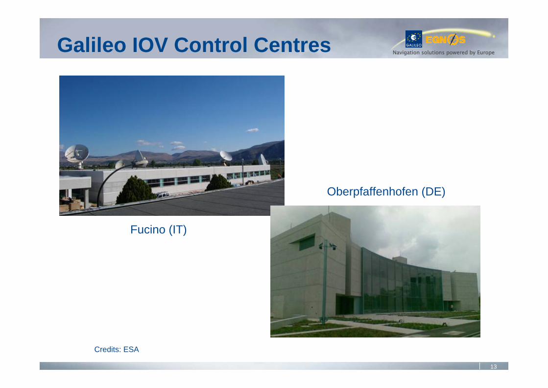
Fucino (IT)
Oberpfaffenhofen (DE)
Credits: ESA
Galileo IOV Control Centres
14
Navigation solutions powered by Europe
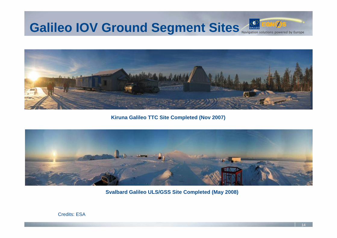
Kiruna Galileo TTC Site Completed (Nov 2007)
Svalbard Galileo ULS/GSS Site Completed (May 2008)
Credits: ESA
Galileo IOV Ground Segment Sites
15
Navigation solutions powered by Europe
• Infrastructure procurement divided in 6 workpackages
• Tender launched on July 1, 2008• Candidates have been shortlisted (see table)• WP1, WP4 and WP5 : contracts were signed on
January 26, 2010• WP2, WP3 and WP6 : competitive dialogue is under
way; award decisions in 2010
Galileo FOC Procurement
16
Navigation solutions powered by Europe
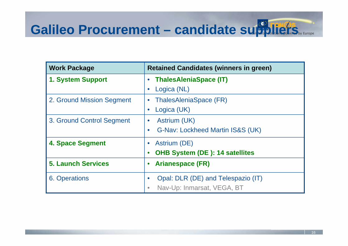
• Astrium (UK) • G-Nav: Lockheed Martin IS&S (UK)
3. Ground Control Segment
• Arianespace (FR)5. Launch Services
• Opal: DLR (DE) and Telespazio (IT)• Nav-Up: Inmarsat, VEGA, BT
6. Operations
• Astrium (DE) • OHB System (DE ): 14 satellites
4. Space Segment
• ThalesAleniaSpace (FR) • Logica (UK)
2. Ground Mission Segment
• ThalesAleniaSpace (IT) • Logica (NL)
1. System Support
Retained Candidates (winners in green)Work Package
Galileo Procurement – candidate suppliers
17
Navigation solutions powered by Europe
• 2009IOV : ground infrastructure deploymentsFOC : first procurement contracts awarded (system support services, first 14 satellites, launchers)
• 2010IOV : first two operational satellites to be launched in Dec 2010FOC : remaining procurements contracts to be awarded in 2010
• 2011IOV : third and fourth satellites to be launched in 2011FOC : ground infrastructure deployments
• 2012 onwardsProgressive FOC deployment with step-wise service introduction as of 2014 (Open Service, Search And Rescue Service, Public Regulated Service)
Galileo Programme Status
18
Navigation solutions powered by EuropeGalileo Challenges
• Finalise contracts for 3 workpackages• Mission• Control• Operations
• Decide on launcher options• Ensure security accreditation of ground stations• Complete budget for FOC• Decision PRS access rules• Launch 2 « IOV » satellites around 2010 year end
19
Navigation solutions powered by Europe
‘It’s there, use it’
EGNOS
20
Navigation solutions powered by Europe
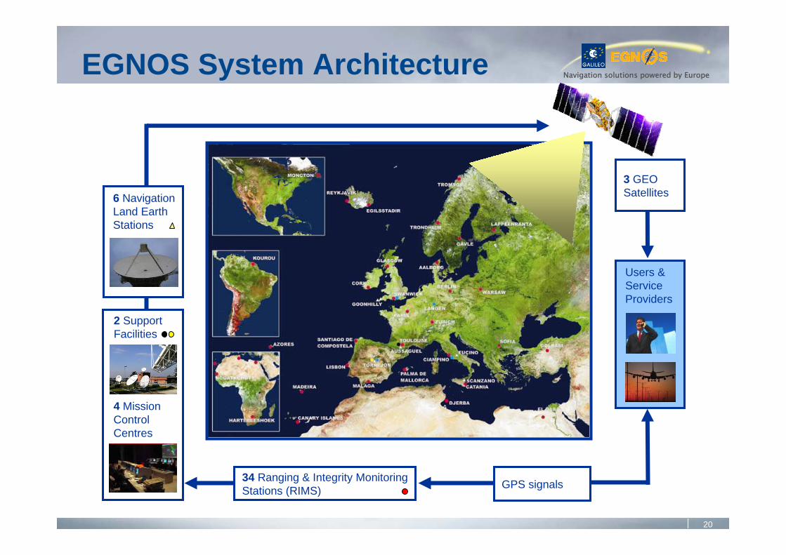
Users &ServiceProviders
3 GEOSatellites
2 Support Facilities
6 NavigationLand EarthStations
4 MissionControlCentres
EGNOS System Architecture
34 Ranging & Integrity MonitoringStations (RIMS) GPS signals
21
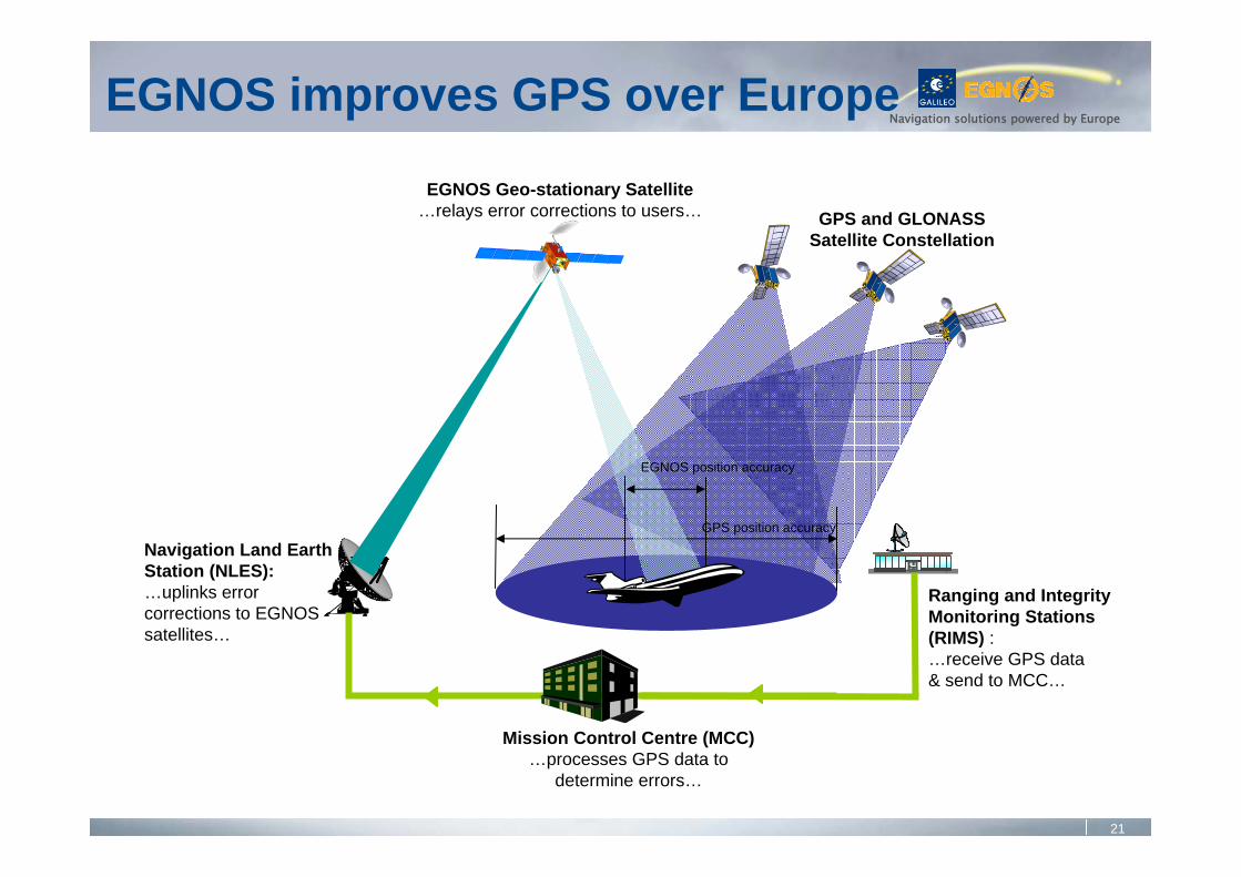
Navigation solutions powered by EuropeEGNOS improves GPS over Europe
GPS and GLONASS Satellite Constellation
GPS position accuracy
Navigation Land Earth Station (NLES):…uplinks error corrections to EGNOS satellites…
EGNOS Geo-stationary Satellite…relays error corrections to users…
EGNOS position accuracy
Ranging and Integrity Monitoring Stations (RIMS) : …receive GPS data & send to MCC…
Mission Control Centre (MCC)…processes GPS data to
determine errors…
22
Navigation solutions powered by Europe
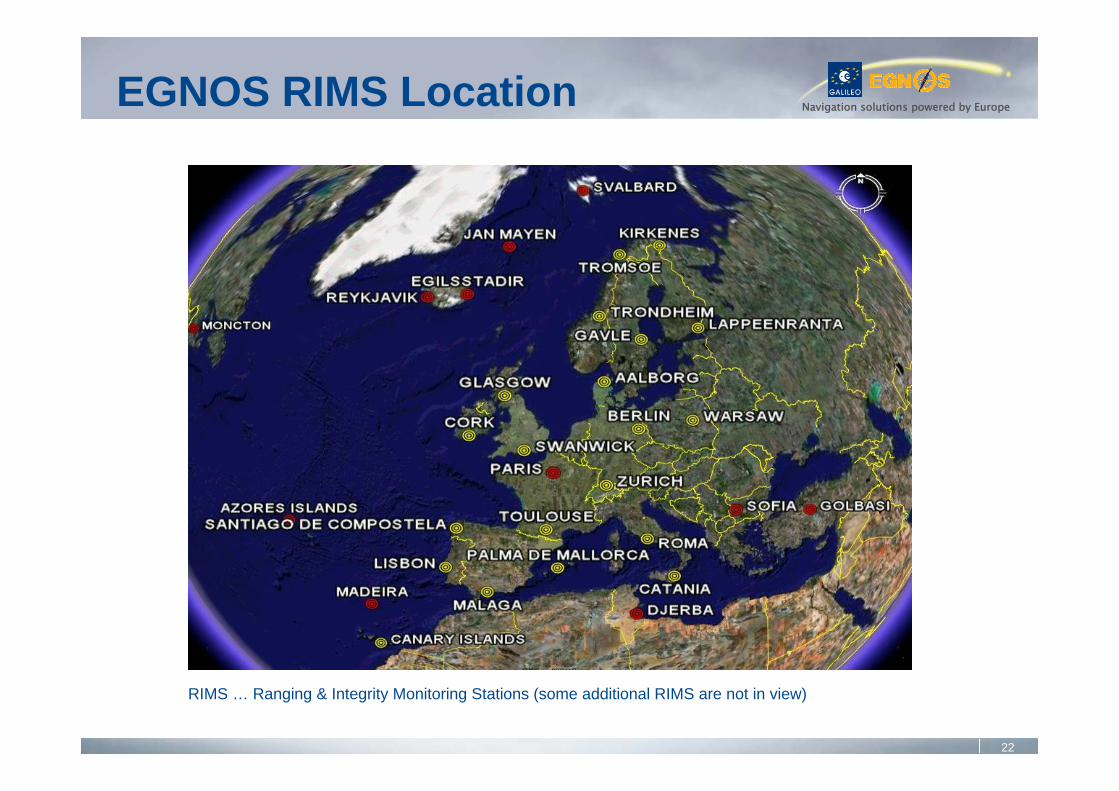
EGNOS Satellite Footprints
RIMS … Ranging & Integrity Monitoring Stations (some additional RIMS are not in view)
EGNOS RIMS Location
23
Navigation solutions powered by Europe
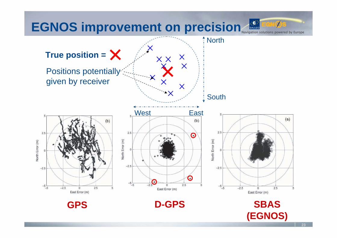
GPS D-GPS SBAS(EGNOS)
EGNOS improvement on precision
West
South
North
East
True position =
Positions potentiallygiven by receiver
24
Navigation solutions powered by Europe
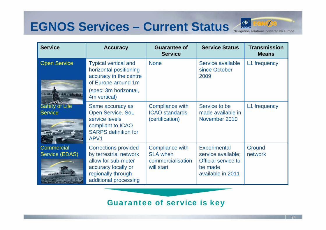
Compliance with SLA when commercialisation will start
Compliance with ICAO standards (certification)
None
Guarantee of Service
Ground network
L1 frequency
L1 frequency
Transmission Means
Corrections provided by terrestrial network allow for sub-meter accuracy locally or regionally through additional processing
Same accuracy as Open Service. SoL service levels compliant to ICAO SARPS definition for APV1
Typical vertical and horizontal positioning accuracy in the centre of Europe around 1m(spec: 3m horizontal, 4m vertical)
Accuracy
Experimental service available; Official service to be made available in 2011
Service to be made available in November 2010
Service available since October 2009
Service Status
Commercial Service (EDAS)
Safety of Life Service
Open Service
Service
EGNOS Services – Current Status
Guarantee of service is key
25
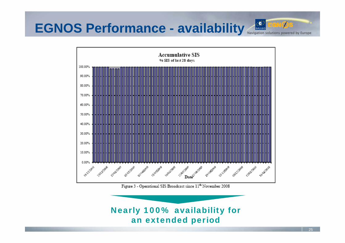
Navigation solutions powered by EuropeEGNOS Performance - availability
Nearly 100% availability for an extended period
26
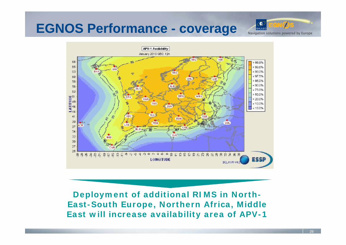
Navigation solutions powered by EuropeEGNOS Performance - coverage
Deployment of additional RIMS in North-East-South Europe, Northern Africa, Middle East will increase availability area of APV-1
27
Navigation solutions powered by Europe
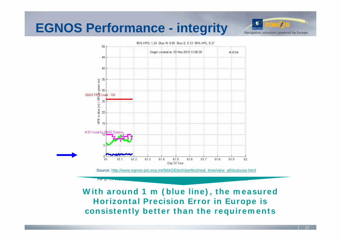
HPE … Horizontal Precision Error, HPL … Horizontal Protection Level
Source: http://www.egnos-pro.esa.int/IMAGEtech/perfect/real_time/view_all/toulouse.html
EGNOS Performance - integrity
With around 1 m (blue line), the measured Horizontal Precision Error in Europe is
consistently better than the requirements
28
Navigation solutions powered by Europe
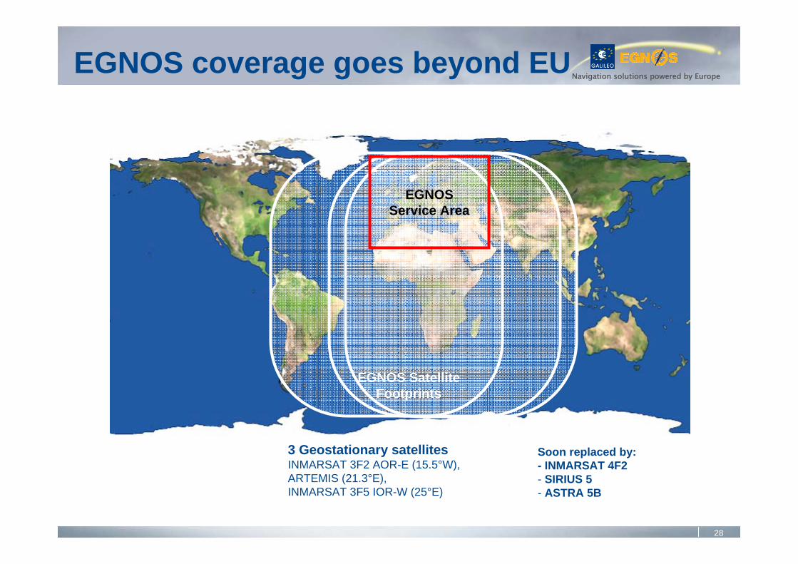
EGNOSService Area
EGNOS SatelliteFootprints
Soon replaced by:- INMARSAT 4F2- SIRIUS 5- ASTRA 5B
3 Geostationary satellitesINMARSAT 3F2 AOR-E (15.5°W), ARTEMIS (21.3°E), INMARSAT 3F5 IOR-W (25°E)
EGNOS coverage goes beyond EU
29
Navigation solutions powered by Europe
• 2009:Assets were transferred to the European Union on April 1, 2009Open Service declaration took place on Oct 1, 2009Long-term operator contract was signed on Oct 1, 2009Procurement to replace the transponder on Artemis is finalized (Astra Sirius 5 to be launched in Nov 2011)Procurement to replace the transponder on Inmarsat 4F2 is ongoing (Astra 5B to be launched in June 2013)Free testing of Commercial Service by Industry & AcademiaGeographical extension to Africa under study
• 2010:Safety-of-Life Service declaration planned for November 1, after certificationCommercial Service declaration planned for 2011
EGNOS Programme status
30
Navigation solutions powered by Europe
• Before EGNOS can be used for safety critical operations, it should be demonstrated that it is designed and operated in a safe manner
• Certification requirements baseline: Single European Sky Regulatory package:
Interoperability Regulation (EC No 552/2004)Service Provision Regulation (EC No 550/2004) –Provision of air navigation services in the Single European SkyCommission Regulation (EC No 2096/2005) –ANSP certification process Safety Oversight Regulation (EC No1315/2007)
EGNOS Certification
31
Navigation solutions powered by Europe
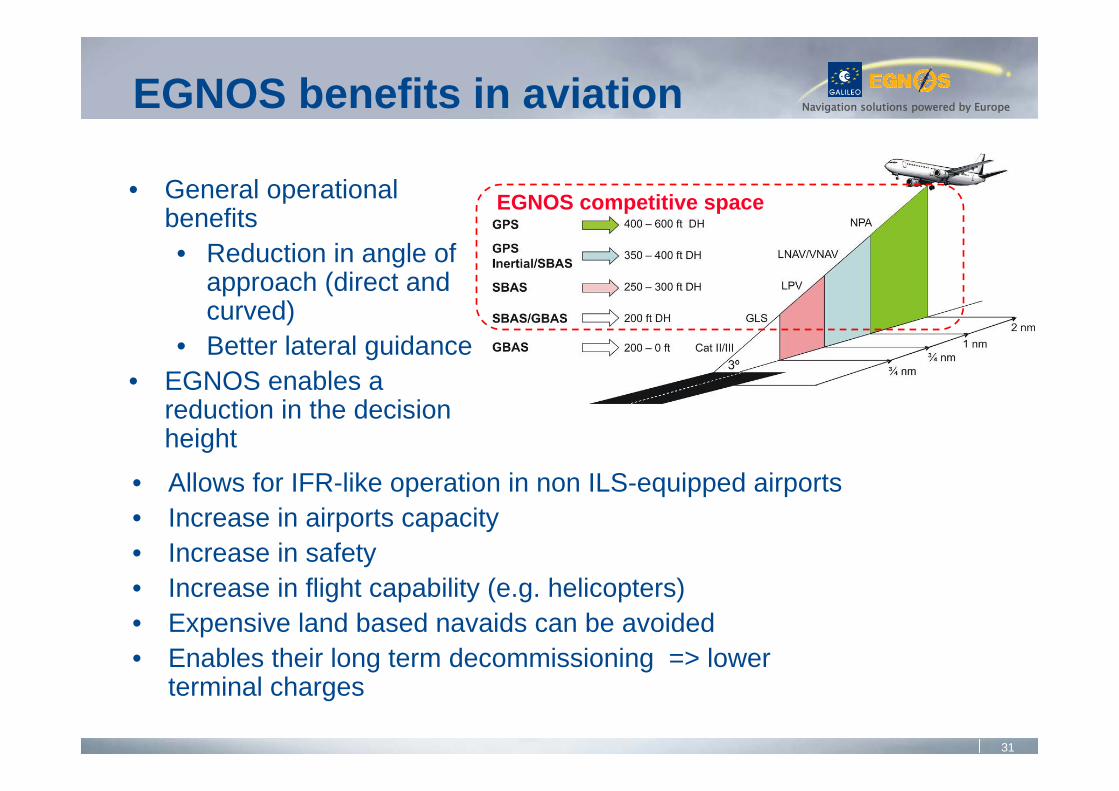
• Allows for IFR-like operation in non ILS-equipped airports • Increase in airports capacity• Increase in safety• Increase in flight capability (e.g. helicopters)• Expensive land based navaids can be avoided• Enables their long term decommissioning => lower
terminal charges
• General operational benefits• Reduction in angle of
approach (direct and curved)
• Better lateral guidance• EGNOS enables a
reduction in the decision height
EGNOS benefits in aviation
EGNOS competitive space
32
Navigation solutions powered by EuropeEGNOS Challenges
• Ensure certification of operator for SoL• Complete ECAC coverage• Remove obsolescences• Manage the assets
• Frequency Evolution• Evolution of Standards
• Augmentation of new GNSS
• LPV200 service level
• Maintain EGNOS over the long term
• Capture economic opportunities downstream, in aviation and beyond
33
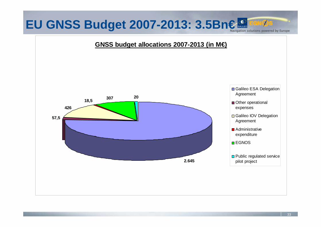
Navigation solutions powered by EuropeEU GNSS Budget 2007-2013: 3.5Bn€
GNSS budget allocations 2007-2013 (in M€)
57,5
42618,5 307 20
2.645
Galileo ESA DelegationAgreement
Other operationalexpenses
Galileo IOV DelegationAgreement
Administrativeexpenditure
EGNOS
Public regulated servicepilot project
34
Navigation solutions powered by Europe
International Cooperation
35
Navigation solutions powered by EuropeCooperation: diverse intensity and scope
General
Country orRegionspecific
• Agreements with:Norway, Switzerland, USA, South Korea, Ukraine, Morocco, other ad hoc for Galileo GS, other underdiscussion
• Galileo/EGNOS applications development
• R & D
• Multilateral:Founding member of UN International Committee on GNSS & Providers Forum, candidate to host ICG in 2010
• Regional training centers: Asia, Africa, Latin America
• EGNOS modular extension
• Compatibility• Interoperability
• Standardisation• Trade matters
36
Navigation solutions powered by Europe
• Ensure compatibility at a minimum: ability of space-based PNT services to be used separately or together without interfering with each individual service or signal, and without adversely affecting national security
Radio frequency compatibility (ITU provides a framework)Spectral separation between PRS and other signals
• Compatibility is a MUSTOnce Compatibility has been achieved, interoperability can be addressed
EU Objectives in Bi/Multi-lateral Coordination
37
Navigation solutions powered by Europe
• Galileo encourages interoperability between Galileo open signals (OS, SoL and CS) and other space-based PNT signals when desirable for the benefits of users
Focus on E1 CBOC (MBOC), AltBOC E5 (which includes E5a & E5b) and E6 CS signalsCommon maximum power level is a necessary aspect of Interoperability (and compatibility)Highest minimum power level is a desired aspect as well
EU Objectives in Bi/Multi-lateral Coordination
38
Navigation solutions powered by Europe
• Definition of interoperability?• Technical: same center frequency, same modulation,
commonly agreed maximum power level, geodetic reference frames realization and system time reference
• Non-technical: transparency and availability of open information on signals (e.g. SIS ICD), availability of open information on performance standards and actual performance
• ICG (International Committee GNSS) should work on the definition of consolidated “boundary conditions” to achieve interoperability
Outstanding Issues on Interoperability
39
Navigation solutions powered by Europe
• 2004 Agreement: plenary session held in October 2008 Radio-frequency compatibility and interoperability: commonMBOC civil signal on GPS L1C – Galileo E1 open serviceTrade and civil applicationsDesign and development of the next generationSecurity and International aspects
EU – US Agreement
40
Navigation solutions powered by Europe
• 2003 Agreement: regular steering Committee meetingsRun by MOST and European CommissionBeidou/Compass was not involved until recently
• Technical Working Group regular meetings to addressthe compatibility and interoperability between Galileo and Compass
• Industrial Working Group regular meetings to addressindustrial cooperation
China – EU Agreement
41
Navigation solutions powered by Europe
• Regular meetings to address the compatibility and interoperability of IRNSS and GAGAN with Galileo and EGNOS
India – EU Draft Agreement
42
Navigation solutions powered by Europe
• Under the hospices of the EU RF Space Dialogue• Regular meetings to address the compatibility and
interoperability of GLONASS and SDCM with Galileo and EGNOS
• Draft Agreement under discussion
Russian Federation – EU Discussions
43
Navigation solutions powered by Europe
• Regular meetings to address the compatibility and interoperabilityof QZSS with Galileo
Good prospect for an E6 CS / QZSS Lex interoperable signal• Draft Agreement under consideration
Japan – EU Discussions
44
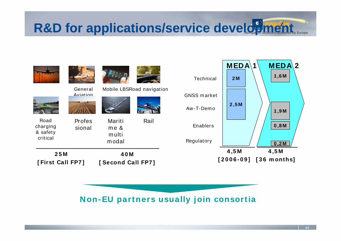
Navigation solutions powered by EuropeR&D for applications/service development
GNSS market
Technical
Aw-T-Demo
Enablers
Regulatory
MEDA 1
4,5M[2006-09]
2M
2,5M
MEDA 2
4,5M[36 months]
1,6M
0,2M
0,8M
1,9M
GeneralAviation
Mobile LBSRoad navigation
Road charging & safety critical
Maritime & multi modal
RailProfessional
Non-EU partners usually join consortia
25M[First Call FP7]
40M[ Second Call FP7]

45
Navigation solutions powered by Europe
EGNOSService Area
EGNOS SatelliteFootprints
Potential EGNOS extensions
Depending on the extension area, technical implementationmay vary from:
Homogeneous extension with deployment of additional RIMSRegional infrastructure including additional processing capabilities
S. Africa
Arabic peninsula
W. Africa
Northern-East Europe
MEDA Extension
To be further evaluated

46
Navigation solutions powered by Europe
EGNOS enters its operational phase• EGNOS Open Service since Oct 2009• EGNOS Safety-of Life-Service in 2010
Galileo is progressing, at the crossing between the development (IOV) and deployment (FOC) phases
• GIOVE-A, GIOVE-B missions on-going• FOC procurement on-going• First two operational satellites in 2010• OS, S&R Service, PRS as of 2014
International cooperation is importantGALILEO:
- Secure ground infrastructure- Compatibility as a minimum, interoperability desired- Enable new services provision, free trade and fair
access to markets worldwideEGNOS:
- Leverage EU investment to service other areas- Applications development on common standards
Conclusions

Navigation solutions powered by Europe
Thank you for your attentionFurther information:
http://www.satellite-navigation.eu/
Input and questions are [email protected]