Embed Size (px)
Citation preview
THE EFFECTS OF IMPROVEMENT PLANS ON URBAN TRANSFORMATION PROCESS IN ILLEGAL BUILT UP/SQUATTER AREAS
IN TURKEY: İZMİR AND ANKARA CASES
A Thesis Submitted to the Graduate School of Engineering and Sciences of
İzmir Institute of Technology in Partial Fulfillment of the Requirements for the Degree of
DOCTOR OF PHILOSOPHY
in City and Regional Planning
by Yakup EGERCIOĞLU
January 2008 İZMİR
We approve the thesis of Yakup EGERCİOĞLU _________________________________ Assoc. Prof. Dr. Semahat ÖZDEMİR Supervisor _________________________________ Assist. Prof. Dr. Erkal SERİM Committee Member _________________________________ Prof. Dr. Cemal ARKON Committee Member _________________________________ Prof. Dr. Hülya KOÇ Committee Member _________________________________ Prof. Dr. Emel GÖKSU Committee Member ________________ Date _________________________________ _____________________ Assoc. Prof. Dr. Semahat ÖZDEMİR Prof. Dr. Hasan BÖKE Head of the City and Regional Planning Dean of the Graduate School of Department Engineering and Sciences

ACKNOWLEDGMENTS
Several people have contributed to the completion of this thesis. First and
foremost, I would like to express my deep gratitude to my supervisor, Assoc. Prof. Dr.
Semahat Özdemir. Her constructive comments at all stages provided me with invaluable
guidance by which this thesis could be formulated and completed.
Also I would like to thank the thesis committee members; Assist Prof. Dr. Erkal
Serim, Prof. Dr. Cemal Arkon, Prof. Dr. Hülya Koç and Prof. Dr. Emel Göksu for their
attendance tp my thesis defence seminar and for their valuable contributions to this
study.
Special thanks to my wife Sevinç Egercioğlu for her supports and contributions
during the preparation of this thesis.
Finally, I would like to thank my mother, my father, my sister and my brother
for their help and support.

iv
ABSTRACT
THE EFFECTS OF IMPROVEMENT PLANS ON URBAN TRANSFORMATION PROCESS IN ILLEGAL BUILT UP/SQUATTER
AREAS IN TURKEY: İZMİR AND ANKARA CASES
Today, urbanization problems which have been experienced in the past fifty
years in our country have also brought about other deep-rooted problems in other
sectors. The migration which started in the 1950s is the major cause of all urban
problems. The social and economic problems that arose after migration, later manifested
themselves in the physical space; and after the emergence of the first squatter houses a
process that later turned into a practice of continuous illegal building construction was
to begin. Urban problems have turned into an impasse due to the uncontrolled
development and cities spreading hastily towards their peripheries, the changing social
structure of cities after migratory waves, continuously mounting spatial problems, lack
of policies, an even policies promoting these developments. However, it is stressed by
the State Statistics Institute that the speed of population increase will go down
significantly in next decades. The decrease in population rate and the focusing of
government policies on the transformation of squatter areas give hints for the fact that
urban transformation will always be on the agenda in the following years.
In this sense, within the scope of this thesis study, especially the transformation
processes which formed in the squatter/illegally constructed areas of the post 1980s in
Turkey were investigated in detail. In order to present an objective picture of the
transformation processes in those areas, two different samples which experienced the
same transformation process in the post 1980 period were selected because different
transformation processes emerged in different squatter areas where the same
improvement plan was applied. Along with this, as two different work areas, the
improvement plans which were applied in the squatter/illegally constructed areas in
Ankara-Çankaya and Izmir-Konak municipalities were investigated, and the
transformation processes were analyzed and the two different processes were reflected.
At the basis of this study lies the need for investigating the urban transformation
processes in squatter and illegally constructed areas, which seems especially to be a
problem of big towns and metropolitan cities, and also the thought of identifying the
problem objectively. This study aims at identifying urban renewal form and how the
v
transformation process has developed, and under what sort of conditions within the
present settlement of the Turkish cities, in other words in squatter or illegally-
constructed areas in recent years. In this study, in order to find out under what
conditions and in which organizational structure market-based urban transformation
processes were realized by individuals and in the leadership of constructors, the
squatter/illegally constructed areas in Ankara-Çankaya and İzmir-Konak municipalities,
where improvement plans were applied, were comparatively investigated.
Key Words: Urban Transformation Processes, Squatter Areas, Improvement Plans,
Redevelopment, Holistic Planning, Partnerships, Participations.
vi
ÖZET
TÜRKİYE’DE KAÇAK YAPILAŞMIŞ / GECEKONDULAŞMIŞ
ALANLARDA ISLAH İMAR PLANLARININ KENTSEL DÖNÜŞÜM
SÜREÇLERİNE ETKİLERİ : İZMİR VE ANKARA ÖRNEĞİ.
Ülkemizin son elli yıldır yaşamakta olduğu kentleşme sorunları bugün pek çok
sektörde yaşanan ve giderek yoğunlaşan problemler zincirini de beraberinde
getirmektedir. 1950’lerle birlikte başlayan göç, tüm kentsel sorunların temelinde yatan
nedendir. Göçle birlikte ortaya çıkan ekonomik ve sosyal sorunlar, fizik mekana da
yansımış ve ilk gecekonduların ardından, zaman içinde yasadışı yapılanmaya dönen bir
süreç başlamıştır. Önceleri kontrolsüz gelişen ve hızla büyüyen kentler, göçle gelen
sosyal yapı ve bir o kadar da mekan sorunları artan nüfus, politikasızlık ve adeta bu
çarpık yapıya prim veren politikalar ve süreçle birlikte, kentsel sorunlar içinden
çıkılmaz bir hal almıştır. Ancak önümüzdeki 10 yıllarda nüfus artış hızının önemli
oranlarda azalacağı Devlet Istatistik Enstitüsü tarafından belirtilmektedir. Nüfus artış
hızının azalması ve hükümet politikalarının da, gecekondu alanlarının dönüşümü
üzerine odaklanması, gelecek yıllarda kentsel dönüşümün ön plana çıkacağının
ipuçlarını vermektedir.
Bu anlamda, tez çalışması kapsamında Türkiye’de, özellikle 1980 sonrası
dönemde geckondulaşmış/kaçak yapılaşmış alanlarda oluşan dönüşüm süreçleri detaylı
bir şekilde incelenmiştir. Bu alanlardaki dönüşüm süreçlerini somut bir şekilde ortaya
koyabilmek için, 1980 sonrası dönemdeki, aynı dönüşüm süreçlerini yaşamış olan iki
farklı örnek seçilmiştir. Çünkü aynı ıslah imar planı uygulanmış olan farklı gecekondu
bölgelerinde farklı dönüşüm süreçleri ortaya çıkmıştır. Buna göre, farklı iki çalışma
alanı olarak Ankara-Çankaya Belediyesi ve İzmir-Konak Belediyesi’ndeki
gecekondulaşmış/kaçak yapılaşmış alanlarında gerçekleştirilen ıslah imar planları
incelenmiş ve dönüşüm süreçleri analiz edilerek, oluşmuş olan farklı dönüşüm süreçleri
ortaya konulmuştur.
Çalışmanın temelinde, daha çok büyük şehirlerin ve metropollerin bir sorunu
olarak karşımıza çıkan gecekondu ve kaçak yapılaşmış alanlardaki kentsel dönüşüm
süreçlerinin incelenmesi ve somut olarak ortaya konulması düşüncesi yatmaktadır. Türk
kentlerinin yerleşik dokusu içerisinde yani gecekondu/kaçak yapılaşmış alanlarında son

vii
yıllarda yaşanmakta olan ve bu çalışmanın ana konusu olan bir kentsel dönüşüm
türünün ne ve değişim sürecinin nasıl ve ne tür koşullar altında oluştuğunun
irdelenmesine yöneliktir. Bu çalışmada, piyasa temelli gerçekleşen kentsel dönüşüm
süreçlerinin, bireylerin kendi başlarına veya bir müteahhit öncülüğünde hangi koşullar
ve organizasyonel yapı içinde gerçekleştiğini öğrenebilmek için, Ankara-Çankaya ve
İzmir-Konak Belediyeleri ıslah imar planı uygulanmış olan gecekondulaşmış/kaçak
yapılaşmış alanlar, -iki farklı kentteki örneklerle karşılaştırılmalı olarak detaylı bir
şekilde incelenmiştir.
Anahtar Kelimeler: Kentsel Dönüşüm Süreçleri, Gecekondu Alanları, Islah İmar
Planları, Yıkıp-yeniden Yapma, Bütüncül Planlama, Ortaklıklar.
viii
TABLE OF CONTENTS
LIST OF FIGURES..........................................................................................................iv CHAPTER 1. INTRODUCTION ..................................................................................... 1 1.1. Purpose, Methodology and Research Process of the Study.................... 4 1.2. Methodology of the Study ...................................................................... 8 1.3. Limitations of the Study ....................................................................... 10 1.4. Selection of Case Area.......................................................................... 11 1.5. Fundamental Acceptances of the Study................................................ 12 CHAPTER 2. DEFINITIONS AND CONCEPTS FOR URBAN TRANSFORMATION
................................................................................................................ 15 2.1. Urban Transformation in the Literature................................................ 15 2.2. The Meaning and Scope of Urban Transformation .............................. 20
2.2.1. The Purpose of Urban Transformation ........................................... 22 2.2.2. Changing Policies on Urban Transformation and Ways of
Interference .................................................................................... 23 2.2.3. Types of Urban Renewal ................................................................ 26
2.2.3.1. Urban Redevelopment ........................................................... 26 2.2.3.2. Urban Rehabilitation.............................................................. 27 2.2.3.3. Urban Regeneration ............................................................... 27
2.3. Partnerships in Urban Transformation Process .................................... 29 2.4. Urban Transformation Processes .......................................................... 33
2.4.1. Urban Transformation Processes in Europe ................................... 33 2.4.2. Urban Transformation Processes in USA....................................... 35 2.4.3. Urban Transformation Processes in Under-Developed and
Developing Countries ................................................................... 36 CHAPTER 3. APPROACHES AND PRACTICES OF URBAN TRANSFORMATION
– SELECTED DIFFERENT SAMPLES IN THE WORLD .................. 39 3.1. Urban Transformation Approaches ...................................................... 39
3.1.1. The Main Actors in Urban Transformation Process....................... 42 3.1.2. Co-ordination in Urban Transformation Process............................ 43 3.1.3. Problems in Urban Transformation Process ................................... 44 3.1.4. General Principles and Suggestions for the Implementation of
Urban Transformation.................................................................... 46 3.2. The Practices of Urban Transformation................................................ 49
3.2.1. The Practice of Urban Transformation in Seoul, Korea ................. 49 3.2.1.1. Hapdong Residential Transformation Project........................ 50 3.2.1.2. Framework of the Hapdong Redevelopment Project............. 52 3.2.1.3. Evaluations of the Hapdong Redevelopment Project ............ 54
3.2.2. The Practice of Urban Transformation in Beijing, China............... 56 3.2.2.1. Ju-er Hutong Residential Transformation Project ................. 57 3.2.2.2. Framework of the Ju-er Hutong Redevelopment Project ...... 58 3.2.2.3. Evaluations of the Ju-er Hutong Redevelopment Project ...... 59
3.2.3. The Practice of Urban Transformation in Singapore...................... 62
ix
3.2.3.1. Singapore River Transformation Project ............................... 63 3.2.3.2. Framework of the Singapore River Transformation Project . 65 3.2.3.3. Evaluations of the Singapore River Transformation Project . 66
3.2.4. The Practice of Urban Transformation in Mumbai, India .............. 68 3.2.4.1. Dharavi Slum Redevelopment Project in Mumbai ................ 69 3.2.4.2. Framework of the Dharavi Slum Redevelopment Project ..... 71 3.2.4.3. Evaluations of the Dharavi Slum Redevelopment Project..... 73
3.2.5. The Practice of Urban Transformation in Rie de Janeiro, Brazil ... 75 3.2.5.1. Fernao Cardim Slum Redevelopment Project ....................... 76 3.2.5.2. Framework of the Fernao Cardim Slum Redevelopment
Project ................................................................................... 78 3.2.5.3. Evaluations of the Fernao Cardim Slum Redevelopment
Project ................................................................................... 79 3.2.6. The Practice of Urban Transformation in Amsterdam, Netherlands
....................................................................................................... 81 3.2.6.1. Bijlmermeer Residential Transformation Project .................. 81 3.2.6.2. Framework of the Bijlmermeer Redevelopment Project ....... 84 3.2.6.3. Evaluations of the Bijlmermeer Redevelopment Project....... 86
3.2.7. Comparison of Project Models of Urban Transformation in Different Countries ........................................................................ 89
CHAPTER 4. TURKISH URBAN TRANSFORMATION APPROACHES................ 93 4.1. Historical Perspective on Urban Transformation in Turkey................. 93
4.1.1. 1950-1980: Rapid Urbanization and from Squatter Areas to Apartment Buildings...................................................................... 98
4.1.2. 1980–2000: Certificated and Illegal Construction within the City100 4.1.3. Post 2000 Period: Urban Transformation is Becoming Legalized104
4.2. Urban Transformation in Turkey and the West and an Assessment of the Future ........................................................................................... 106
4.2.1. Implementation of Urban Renewal in European Union and Turkey.......................................................................................... 108
4.3. Urban Transformation oriented Planning and Implementation Approach in Turkey ........................................................................... 110
4.3.1. Needs and Capacity Development……………………………….114 4.3.1.1. The Experiences of Turkey in Urban Transformation……..115 4.3.2. The Experiences of Turkey in Urban Transformation.................. 118 4.3.3. Main Issues in the Organization of Transformation/regeneration 123
CHAPTER 5. EFFECTS OF IMPROVEMENT PLANS ON TRANSFORMATION
PROCESS IN IZMIR-KONAK AND ANKARA-ÇANKAYA MUNICIPALITY.................................................................................. 125
5.1. Purpose of the Study .......................................................................... 125 5.1.1. Methodology of Study ................................................................. 127
5.2. The Process of Urban Transformation in Konak Municipality ......... 127 5.2.1. Muammer Akar District – 1......................................................... 129 5.2.2. Muammer Akar District – 2......................................................... 136 5.2.3. Esentepe District .......................................................................... 140 5.2.4. Yeşilyurt - 1 District .................................................................... 150 5.2.5. Yeşilyurt - 2 District .................................................................... 157 5.2.6. Yeşilyurt - 3 District .................................................................... 164
x
5.2.7. Günaltay District.......................................................................... 171 5.3. The Process of Urban Transformation in Çankaya Municipality ...... 182
5.3.1. Hilal District ................................................................................ 185 5.3.2. Yıldızevler District ...................................................................... 192 5.3.3. Mühye-Çukurca District .............................................................. 198 5.3.4. Kırkkonaklar District ................................................................... 206 5.3.5. Yukarı Dikmen District ............................................................... 210 5.3.6. Mürsel Uluç District .................................................................... 214 5.3.7. Sancak District ............................................................................. 223 5.3.8. Boztepe District ........................................................................... 230
5.4. Evaluation of Urban Transformation Processes in Konak and Çankaya Municipality........................................................................ 237
5.4.1. Single-Plot Based Transformation in Konak and Çankaya Municipality................................................................................. 238
5.4.2. Empty-Plot Based Transformation in Konak and Çankaya Municipality................................................................................. 240
5.4.3. Co-operative Based Transformation in Konak and Çankaya Municipality................................................................................. 241
5.4.4. Buildings that are not Transformed in Konak and Çankaya Municipality................................................................................. 243
CHAPTER 6. CONCLUSION .................................................................................... 244 6.1. Suggestions ........................................................................................ 255 REFERENCES………………………………………………………………………..261
xi
LIST OF FIGURES
Figure Page
Figure 2. 1. Concepts and Processes related to Urban Transformation.......................... 16 Figure 3. 1. Types of Residential Transformation in Seoul ........................................... 50 Figure 3. 2. Hapdong Project-Residential Rebuilding Sites . ......................................... 51 Figure 3. 3. Hapdong Project before Clearence.............................................................. 51 Figure 3. 4. Hapdong Project after Completion.............................................................. 51 Figure 3. 5. Pre-Development Residential Area ............................................................ 53 Figure 3. 6. Post-Development Residential Area .......................................................... 53 Figure 3. 7. Clearence of Project Area.......................... ..................................................54 Figure 3. 8. Hapdong Apartment District. ...................................................................... 54 Figure 3. 9. The Pre-renewal Condition in Ju-er ................ ............................................57 Figure 3. 10. Ju-er Hutong: the Pre-renewal................................................................... 57 Figure 3. 11. The Plan of the Ju-er Hutong Project .......... .............................................59 Figure 3. 12. A Bird-eye View of the Project ................................................................. 59 Figure 3. 13. The Singapore River Project before the Clean-up .................................... 63 Figure 3. 14. The three Sub-zones along the Singapore ......... ........................................64 Figure 3. 15. Detail Map of Redevelopment Project Area ............................................. 64 Figure 3. 16. Boat Quay: 1982................ ........................................................................64 Figure 3. 17. Boat Quay: Civil and Commercial Uses ................................................... 64 Figure 3. 18. China Street back in 1986 ............ .............................................................66 Figure 3. 19. China Street after Redevelopment............................................................. 66 Figure 3. 20. Map of Mumbai Showing Dharavi ........................................................... 70 Figure 3. 21. Survey Layout of Dharavi Slum................ ................................................70 Figure 3. 22. A View from Dharavi Slum ...................................................................... 70 Figure 3. 23. Floor Plan of Dharavi Project, 1996.............. ............................................73 Figure 3. 24. A Photograph of the Dharavi..................................................................... 73 Figure 3. 25. Fernao Cardim Settlement....... ..................................................................76 Figure 3. 26. A View from Fernao Cardim-1969 ........................................................... 76 Figure 3. 27. The Favela Bairro Programme in Action. River Channel Improvement in
Fernao Cardim . ......................................................................................... 77 Figure 3. 28. Favela and High Rise in Fernao Cardim. ..... ……………………………78 Figure 3. 29. Residential Units in Project. ...................................................................... 78 Figure 3. 30. Buildings in Bijlmermeer Project Area . ................................................... 82 Figure 3. 31. The high-rise Wave in the Netherlands: Dwellings in High-Rise as a
Percentage of all Flats ............................................................................... 83 Figure 3. 32. 31 Blocks Laid out in a Honeycomb................. …………………………84 Figure 3. 33. 10 Storey High Rise .................................................................................. 84 Figure 3. 34. Before Renewal Plan - 1992. ............... ………………………………….85 Figure 3. 35. After Physical Renewal -2010................................................................... 85 Figure 3. 36. Removal of high rises. ...... ………………………………………………86 Figure 3. 37. Half of the 13,000 Dwellings are Demolished .......................................... 86 Figure 3. 38.Renewal: Storerooms Transformed........ …………………………………87 Figure 3. 39.New Houses and Gardens under the Flat ................................................... 87 Figure 4. 1. Location of Valleys in Ankara. ................................................................. 119
xii
Figure 4. 2. Squatter Areas in Dikmen Valley……………………………………….. 120 Figure 4. 3. Dikmen Valley Urban Renewal Project-2006........................................... 120 Figure 4. 4. Squatters in the Portakal Çiçeği Valley before the Project…………….. . 121 Figure 4. 5. Vacant lands: According to Project Proposed by Portaş. .......................... 121 Figure 4. 6. Aerial Photo from Valley. ……………………………………… ........ 122 Figure 4. 7. Portakal Çiçeği Valley Urban Renewal Project-2006. ............................ 1222 Figure 5. 1. Improvement Plans in Izmir-Konak Municipality. ................................... 128 Figure 5. 2. Urban Transformation in Muammer Akar-1 District. ............................... 129 Figure 5. 3. Single Plot Based Redevelopment Process: Muammer Akar-1 District. .. 130 Figure 5. 4. Single Plot Based Redevelopment in 41997 B.Block and 30 Plot……….130 Figure 5. 5. Building Transformation in in Muammer Akar-1 District. ....................... 130 Figure 5. 6. Vacant Plot Based Development Process: Muammer Akar-1 District...... 131 Figure 5. 7. Vacant Plot Based Development in 42014 B.Block and 10 Plot…….…..132 Figure 5. 8. Vacant-Plot Based Development in Muammer Akar-1 District ............... 132 Figure 5. 9. Co-operative Based Redevelopment Process: Muammer Akar-1 District.132 Figure 5. 10. Co-operative Based Redevelopment ... …………………………………133 Figure 5. 11. Contract Rate in Muammer ..................................................................... 133 Figure 5. 12. Add-on Floors: Muammer Akar-1 District. ............................................ 133 Figure 5. 13. Unaltered Buildings: Muammer Akar-1 District..................................... 136 Figure 5. 14. Urban Transformation in Muammer Akar-2 District. ............................. 136 Figure 5. 15. Single Plot Based Redevelopment Process: Muammer Akar-2 District. 137 Figure 5. 16. Single Plot Based Redevelopment in 42057 B.Block and 5 Plot. ........... 137 Figure 5. 17. Vacant Plot Based Development Process: Muammer Akar-2 District.... 138 Figure 5. 18. Vacant Plot Based Development in 42040 B.Block and 6 Plot. ............. 138 Figure 5. 19. Add-on Floors: Muammer Akar-2 District. ............................................ 139 Figure 5. 20. Unaltered Buildings: Muammer Akar-2 District..................................... 139 Figure 5. 21. Urban Transformation in Esentepe District............................................. 142 Figure 5. 22. Single Plot Based Redevelopment Process: Esentepe District................ 143 Figure 5. 23. Single Plot Based Redevelopment in 31462 B.Block and 11 Plot .......... 140 Figure 5. 24. Building Transformation in Esentepe District......................................... 143 Figure 5. 25. Vacant Plot Based Development Process: Esentepe District. ................. 144 Figure 5. 26. Vacant Plot Based Transformation in 31507 B.Block and 10 Plot……..143 Figure 5. 27. Vacant-Plot Transformation in Esentepe District ................................... 145 Figure 5. 28. Co-operative Based Redevelopment Process: Esentepe District. ........... 146 Figure 5. 29. Co-operative Based Redevelopment in 42415 B.Block and 48 Plot…...144 Figure 5. 30. Contract Rate in Esentepe ....................................................................... 146 Figure 5. 31. Add-on Floors: Esentepe District. ........................................................... 147 Figure 5. 32. Unaltered Buildings: Esentepe District. .................................................. 150 Figure 5. 33. Urban Transformation in Yeşilyurt - 1 District....................................... 150 Figure 5. 34. Single Plot Based Urban Transformation: Yesilyurt-1 District. ............. 151 Figure 5. 35. Single Plot Based Redevelopment in 43347 B.Block and 3 Plot ............ 147 Figure 5. 36. Building Transformation in Yeşilyurt-1 District..................................... 151 Figure 5. 37. Vacant Plot Based Development Process: Yesilyurt-1 District. ............. 152 Figure 5. 38. Vacant Plot Based Development in 31507 B.Block and 10 Plot...……..150 Figure 5. 39. Vacant-Plot Based Development in Yeşilyurt-1 District ........................ 152 Figure 5. 40. Co-operative Based Redevelopment Process: Yesilyurt-1 District......... 153 Figure 5. 41. Co-operative Based Redevelopment in 13644 B.Block and 1 Plot......... 151 Figure 5. 42. Contract Rate in Yeşilyurt-1.................................................................... 153 Figure 5. 43. Add-on Floors: Yesilyurt-1 District. ....................................................... 154 Figure 5. 44. Unaltered Buildings: Yesilyurt-1 District. .............................................. 157
xiii
Figure 5. 45. Urban Transformation in Yeşilyurt - 2 District....................................... 157 Figure 5. 46. Single Plot Based Redevelopment Process: Yesilyurt-2 District. ........... 158 Figure 5. 47. Single Plot Based Redevelopment in 42349 B.Block and 1 Plot……….153 Figure 5. 48. Building Transformation in Yeşilyurt-2 District..................................... 159 Figure 5. 49. Vacant Plot Based Development Process: Yeşilyurt-2 District. ............. 160 Figure 5. 50. Vacant Plot Based Development in 13443 B.Block and 1 Plot…...........155 Figure 5. 51. Vacant-Plot Development in Yeşilyurt-2 District ................................... 161 Figure 5. 52. Co-operative Based Redevelopment Process: Yesilyurt-2 District......... 161 Figure 5. 53. Co-operative Based Redevelopment in 42415 B.Block and 1 Plot......... 157 Figure 5. 54. Contract Rate in Yeşilyurt-2.................................................................... 162 Figure 5. 55. Add-on Floors: Yesilyurt-2 District. ....................................................... 162 Figure 5. 56. Unaltered Buildings: Yesilyurt-2 District. .............................................. 163 Figure 5. 57. Urban Transformation in Yeşilyurt - 3 District....................................... 166 Figure 5. 58. Single Plot Based Redevelopment Process: Yesilyurt-3 District. ........... 167 Figure 5. 59. Single Plot Based Redevelopment in 42072 B.Block and 1 Plot.............161 Figure 5. 60. Building Transformation in Yeşilyurt-3 District..................................... 167 Figure 5. 61. Vacant Plot Based Development Process: Yesilyurt-3 District. ............. 168 Figure 5. 62. Vacant Plot Based Development in 42073 B.Block and 5 Plot...............162 Figure 5. 63. Vacant-Plot Development in Yeşilyurt-3 District ................................... 169 Figure 5. 64. Single Plot Based Redevelopment Process: Yesilyurt-3 District. ........... 169 Figure 5. 65. Unaltered Buildings: Yesilyurt-3 District. .............................................. 170 Figure 5. 66. Urban Transformation in Günaltay District. ........................................... 173 Figure 5. 67. Single Plot Based Redevelopment Process: Günaltay District. .............. 174 Figure 5. 68. Single Plot Based Redevelopment in 33672 B.Block and 3 Plot.............167 Figure 5. 69. Building Transformation in Günaltay District ........................................ 174 Figure 5. 70. Vacant Plot Based Development Process: Gunaltay District. ................. 175 Figure 5. 71. Vacant Plot Based Development in 33803 B.Block and 9 Plot…...........168 Figure 5. 72. Vacant-Plot Transformation in Günaltay District ................................... 178 Figure 5. 73. Co-operative Based Redevelopment Process: Günaltay District. ........... 178 Figure 5. 74. Co-operative Based Redevelopment in 34075 B.Block and 6 Plot......... 169 Figure 5. 75. Contract Rate in Günaltay ....................................................................... 179 Figure 5. 76. Add-on Floors Development Process: Günaltay District. ....................... 179 Figure 5. 77. Unaltered Buildings: Günaltay District. .................................................. 181 Figure 5. 78. Improvement Plans in Ankara-Çankaya Municipality ............................ 184 Figure 5. 79. Urban Transformation in Hilal District. .................................................. 185 Figure 5. 80. Single Plot Based Redevelopment Process: Hilal District. ..................... 186 Figure 5. 81. Single Plot Based Redevelopment in 27712 B.Block and 5 Plot.............174 Figure 5. 82. Building Transformation in Hilal District ............................................... 186 Figure 5. 83. Vacant Plot Based Development Process: Hilal District......................... 187 Figure 5. 84. Vacant Plot Based Development in 27713 B.Block and 1 Plot…...........178 Figure 5. 85. Vacant-Plot Based Development in Hilal District .................................. 187 Figure 5. 86. Co-operative Based Redevelopment Process: Hilal District. .................. 188 Figure 5. 87. Co-operative Based Redevelopment in 27714 B.Block and 1 Plot......... 179 Figure 5. 88. Contract Rate in Hilal District................................................................. 188 Figure 5. 89. Add-on Floors Development Process: Hilal District ………………….189 Figure 5. 90. Unaltered Buildings: Hilal District.......................................................... 192 Figure 5. 91. Urban Transformation in Yıldızevler District. ........................................ 192 Figure 5. 92. Single Plot Based Redevelopment Process: Yıldızevler District. ........... 193 Figure 5. 93. Single Plot Based Redevelopment in 26730 B.Block and 9 Plot.............185 Figure 5. 94. Building Transformation in Yıldızevler District ..................................... 193
xiv
Figure 5. 95. Vacant Plot Based Development Process: Yıldızevler District............... 194 Figure 5. 96. Vacant Plot Based Development in 26727 B.Block and 1Plot................186 Figure 5. 97. Vacant-Plot Development in Yıldızevler District ................................... 194 Figure 5. 98. Co-operative Based Redevelopment Process: Yıldızevler District. ........ 195 Figure 5. 99. Co-operative Based Redevelopment in 27714 B.Block and 1 Plot......... 187 Figure 5. 100. Contract Rate in Yıldızevler District..................................................... 195 Figure 5. 101. Unaltered Buildings: Yıldızevler District.............................................. 198 Figure 5. 102. Urban Transformation in Mühye-Çukurca District............................... 198 Figure 5. 103. Single Plot Based Redevelopment Process: Muhye-Çukurca District. . 199 Figure 5. 104. Single Plot Based Redevelopment in 26189 B.Block and 11 Plot.........190 Figure 5. 105. Building Transformation in Mühye-Çukurca District........................... 199 Figure 5. 106. Vacant Plot Based Development Process: Mühye-Çukurca District. ... 200 Figure 5. 107. Vacant Plot Based Development in 26113 B.Block and 4 Plot.............192 Figure 5. 108. Vacant-Plot Based Development in Mühye-Çukurca District .............. 201 Figure 5. 109. Co-operative Based Redevelopment Process: Mühye-Çukurca District.
.............................................................................................................................. 202 Figure 5. 110. Co-operative Based Redevelopment in 9857 B.Block and 1 Plot......... 193 Figure 5. 111. Contract Rate in Muhye-Çukurca District............................................. 202 Figure 5. 112. Unaltered Buildings: Mühye-Çukurca District. .................................... 205 Figure 5. 113. Urban Transformation in Kırkkonaklar District.................................... 205 Figure 5. 114. Single Plot Based Redevelopment Process: Kırkkonaklar District....... 206 Figure 5. 115. Single Plot Based Redevelopment in 27401B.Block and 4 Plot............195 Figure 5. 116. Building Transformation in Kırkkonaklar District .............................. 206 Figure 5. 117. Vacant Plot Based Development Process: Kırkkonaklar District. ........ 196 Figure 5. 118. Vacant Plot Based Development in 26317 B.Block and 1 Plot.............197 Figure 5. 119. Vacant-Plot Based Development in Kırkkonaklar District ................... 198 Figure 5. 120. Unaltered Buildings: Kırkkonaklar District. ......................................... 199 Figure 5. 121. Urban Transformation in Yukarı Dikmen District. ............................... 199 Figure 5. 122. Single Plot Based Redevelopment Process: Yukarı Dikmen District. .. 199 Figure 5. 123. Single Plot Based Redevelopment in 27661 B.Block and 6 Plot...........200 Figure 5. 124. Building Transformation in Yukarı Dikmen District ............................ 211 Figure 5. 125. Vacant Plot Based Development Process: Yukarı Dikmen District...... 212 Figure 5. 126. Vacant Plot Based Development in 27660 B.Block and 3 Plot.............202 Figure 5. 127. Vacant-Plot Based Development in Yukarı Dikmen District ............... 213 Figure 5. 128. Unaltered Buildings: Yukarı Dikmen District....................................... 213 Figure 5. 129. Urban Transformation in Mürsel Uluç District. .................................... 216 Figure 5. 130. Single Plot Based Redevelopment Process: Mürsel Uluç District. ....... 217 Figure 5. 131. Single-Plot Based Redevelopment in 27660 B.Block and 3 Plot..........205 Figure 5. 132. Building Transformation in Mürsel-Uluç District................................. 217 Figure 5. 133. Vacant Plot Based Development Process: Mürsel Uluç District. ......... 218 Figure 5. 134. Vacant Plot Based Development in 26317 B.Block and 1 Plot.............206 Figure 5. 135. Vacant-Plot Based Development in Mürsel-Uluç District .................... 219 Figure 5. 136. Co-operative Based Redevelopment Process: Mürsel Uluç District..... 219 Figure 5. 137. Co-operative Based Redevelopment in 27081 B.Block and 13 Plot..... 207 Figure 5. 138. Contract Rate in Mursel-Uluç District .................................................. 220 Figure 5. 139. Unaltered Buildings: Mürsel Uluç District. .......................................... 220 Figure 5. 140. Urban Transformation in Sancak District. ............................................ 223 Figure 5. 141. Single Plot Based Redevelopment Process: Sancak District................. 224 Figure 5. 142. Single-Plot Based Redevelopment in 25343 B.Block and 4 Plot.......... 210 Figure 5. 143. Building Transformation in Sancak District ......................................... 224
xv
Figure 5. 144. Vacant Plot Based Development Process: Sancak District. .................. 225 Figure 5. 145. Vacant Plot Based Development in 25339 B.Block and 5 Plot.............211 Figure 5. 146. Vacant-Plot Based Development in Sancak District ............................. 226 Figure 5. 147. Co-operative Based Redevelopment Process: Sancak District. ............ 226 Figure 5. 148. Co-operative Based Redevelopment in 25319 B.Block and 1 Plot....... 213 Figure 5. 149. Contract Rate in Sancak District ........................................................... 227 Figure 5. 150. Unaltered Buildings: Sancak District. ................................................... 230 Figure 5. 151. Urban Transformation in Boztepe District. ........................................... 230 Figure 5. 152. Single Plot Based Redevelopment Process: Boztepe District. .............. 231 Figure 5. 153. Single-Plot Based Redevelopment in 26528 B.Block and 15 Plot........ 217 Figure 5. 154. Building Transformation in Boztepe District ........................................ 231 Figure 5. 155. Vacant Plot Based Development Process: Boztepe District. ................ 232 Figure 5. 156. Vacant Plot Based Development in 26530 B.Block and 26 Plot...........218 Figure 5. 157. Vacant-Plot Based Development in Boztepe District .......................... 232 Figure 5. 158. Co-operative Based Redevelopment Process: Boztepe District............ 233 Figure 5. 159. Co-operative Based Redevelopment in 25319 B.Block and 1 Plot....... 219 Figure 5. 160. Contract Rate in Sancak District ........................................................... 233 Figure 5. 161. Add-on Floors Development: Boztepe District..................................... 234 Figure 5. 162. Unaltered Buildings: Boztepe District. ................................................. 237 Figure 5. 163. Urban Transformation in Konak and Çankaya Municipality. ............... 238 Figure 5. 164. Building Transformation in Konak Municipality............... …………...222 Figure 5. 165. Building Transformation in Çankaya Municipality .............................. 239 Figure 5. 166. Single-Plot Based Redevelopment Process in Konak and Çankaya
Municipality.......................................................................................... 239 Figure 5. 167. Vacant-Plot Based Development in Konak Municipality......................224 Figure 5. 168. Vacant-Plot Based Development in Çankaya Municipality.................. 240 Figure 5. 169. Vacant-Plot Based Development Process in Konak and Çankaya
Municipality.......................................................................................... 241 Figure 5. 170. Contract Rate in Konak Municipality. . ...... ..........................................226 Figure 5. 171. Contract Rate in Çankaya...................................................................... 242 Figure 5. 172. Co-operative Based Redevelopment Process in Konak and Çankaya
Municipality.......................................................................................... 242 Figure 5. 173. Unaltered Buildings: Konak and Çankaya Municipality. ..................... 244 Figure 5. 174. Contract Rate in Sancak District………………………………………227 Figure 5. 175. Urban Transformation Process Çankaya Municipality-Sancak……….228 Figure 5. 176. Çankaya Municipality Construction Certificate Archive-Sancak……..229 Figure 5. 177. Unaltered Buildings: Sancak District………………………………….230 Figure 5. 178. Urban Transformation in Boztepe District…………………………….230 Figure 5. 179. Single Plot Based Redevelopment Process: Boztepe District…………231 Figure 5. 180. Single-Plot Based Redevelopment in 26528 B.Block and 15 Plot……231 Figure 5. 181. Building Transformation in Boztepe District………………………….231 Figure 5. 182. Vacant Plot Based Development Process: Boztepe District…………..232 Figure 5. 183. Vacant Plot Based Development in 26530 B.Block and 26 Plot……...232 Figure 5. 184. Vacant Plot Development in Boztepe District………………………...232 Figure 5. 185. Co-operative Based Redevelopment Process: Boztepe District……….233 Figure 5. 186. Co-operative Based Redevelopment in 25319 B.Block and 1 Plot…...233 Figure 5. 187. Contract Rate in Sancak District………………………………………233 Figure 5. 188. Add-on Floors Development: Boztepe District……………………….234 Figure 5. 189. Urban Transformation Process Çankaya Municipality-Boztepe……...235 Figure 5. 190. Çankaya Municipality Construction Certificate Archive-Boztepe……236
xvi
Figure 5. 191. Unaltered Buildings: Boztepe District………………………………...237 Figure 5. 192. Urban Transformation in Konak and Çankaya Municipality………….238 Figure 5. 193. Buildings Transformation in Konak Municipality…………………….239 Figure 5. 194. Building Transformation in Çankaya Municipality…………………...239 Figure 5. 195. Single-Plot Based Redevelopment Process in Konak and Çankaya…..239 Figure 5. 196. Vacant-Plot Development in Konak Municipality…………………….240 Figure 5. 197. Vacant-Plot Development in Çankaya Municipality………………….240 Figure 5. 198. Vacant-Plot Based Development Process in Konak and Çankaya….…241 Figure 5. 199. Contract Rate in Konak Municipality…………………………………242 Figure 5. 200. Contract Rate in Çankaya Municipality……………………………….242 Figure 5. 201. Co-operative Based Redevelopment Process in Konak and Çankaya...242 Figure 5. 202. Unaltered Buildings: Konak and Çankaya Municipality……………...244
xvii
LIST OF TABLES
Table Page
Table 2. 1. Development Process of Urban Transformation Practices . ......................... 26 Table 2. 2. Conditions for Different forms of Partnership ............................................. 32 Table 2. 3. Squatter Population in 2001 ......................................................................... 37 Table 3. 1. Housing Transformation Project .................................................................. 50 Table 3. 2. General Information of Hapdong Project . ................................................... 52 Table 3. 3. Housing Type Before Transformation ......................................................... 53 Table 3. 4. Evaluations of Hapdong Residential Transformation Project. ..................... 56 Table 3. 5. Data on Ju-er Hutong Project . ..................................................................... 58 Table 3. 6. ODHR Plan . ................................................................................................. 59 Table 3. 7. Ju-er Hutong Project before and after 1992 ................................................. 60 Table 3. 8. Ju-er Hutong Projects . ................................................................................. 61 Table 3. 9. Evaluations of Ju-er Hutong Residential Transformation Project. ............... 62 Table 3. 10. Evaluations of Singapore River Transformation Project............................ 68 Table 3. 11. Slum Rehabilitation Scheme Projects in Mumbai . .................................... 69 Table 3. 12. Additional Units at the Dharavi Project ..................................................... 71 Table 3. 13. Unit Statement at the Dharavi Project . ...................................................... 72 Table 3. 14. Evaluations of Dharavi Slum Redevelopment Project. .............................. 74 Table 3. 15. Favelo Bairro Project Preparation Stages . ................................................. 78 Table 3. 16. Organisation Structure of Favela Bairro Projects . ..................................... 79 Table 3. 17. Evaluations of Fernao Cardim Slum Redevelopment Project. ................... 81 Table 3. 18. Physical Renewal in Bijlmermeer . ............................................................ 85 Table 3. 19. Evaluations of Bijlmermeer Residential Transformation Project.............. 89 Table 3. 20. Evaluation of Kore Hapdong, Çin Ju-er Hutong, Singapur River, Hindistan
Dharavi, Brezilya Fernao Cardim and Hollanda Bijlmermeer Transformation project. ............................................................................. 92
Table 4. 1. Transformation and Historical Characteristics of Variables of Change....... 93 Table 4. 2. Identification of the Needs in an Urban Transformation Area……………114 Table 4. 3. Urban Transformation Planning in an Urban Transformation Area……...116 Table 5. 1. Evaluation of construction-certificate archieve in Muammer Akar-1 District:
(Single Plot Based) .................................................................................... 130 Table 5. 2. Evaluation of construction-certificate archieve in Muammer Akar-1 District:
(Vacant-Plot Based). .................................................................................. 131 Table 5. 3. Evaluation of construction-certificate archieve in Muammer Akar-1 District:
(Co-operative Based) ................................................................................. 132 Table 5. 4. Evaluation of construction-certificate archieve in Muammer Akar-1 District
(Add-on Floors) .......................................................................................... 133 Table 5. 5. Evaluation of construction-certificate archieve in Muammer Akar-2 District:
(Single Plot Based) .................................................................................... 137 Table 5. 6. Evaluation of construction-certificate archieve in Muammer Akar-2 District:
(Vacant-Plot Based). .................................................................................. 138 Table 5. 7. Evaluation of construction-certificate archieve in Muammer Akar-2 District:
(Add-on Floors) .......................................................................................... 139 Table 5. 8. Evaluation of construction-certificate archieve in Esentepe District:
(Single Plot Based) .................................................................................... 143

xviii
Table 5. 9. Evaluation of construction-certificate archieve in Esentepe District: (Vacant-Plot Based)................................................................................... 145
Table 5. 10. Evaluation of Construction-Certificate Archieve in Esentepe District: (Co-operative Based) .............................................................................. 146
Table 5. 11. Evaluation of Construction-Certificate Archieve in Esentepe District: (Add-on Floors) ....................................................................................... 147
Table 5. 12. Evaluation of construction-certificate archieve in Yesilyurt-1 District: (Single Plot Based) ................................................................................. 151
Table 5. 13. Evaluation of construction-certificate archieve in Yesilyurt-1 District: (Vacant-Plot Based)................................................................................ 152
Table 5. 14. Evaluation of construction-certificate archieve in Yesilyurt-1 District: (Co-operative Based) .............................................................................. 153
Table 5. 15. Evaluation of construction-certificate archieve in Yesilyurt-1 District: (Add-on Floors) ....................................................................................... 154
Table 5. 16. Evaluation of construction-certificate archieve in Yesilyurt-2 District: (Single Plot Based) ................................................................................. 158
Table 5. 17. Evaluation of construction-certificate archieve in Yesilyurt-2 District: (Vacant-Plot Based)................................................................................ 160
Table 5. 18. Evaluation of construction-certificate archieve in Yesilyurt-2 District: (Co-operative Based) .............................................................................. 161
Table 5. 19. Evaluation of construction-certificate archieve in Yeşilyurt-2 District: (Add-on Floors) ....................................................................................... 163
Table 5. 20. Evaluation of construction-certificate archieve in Yeşilyurt-3 District: (Single Plot Based) . ............................................................................... 167
Table 5. 21. Evaluation of construction-certificate archieve in Yesilyurt-3 District: (Vacant-Plot Based)................................................................................ 168
Table 5. 22. Evaluation of construction-certificate archieve in Yesilyurt-3 District: (Add-on Floors) ....................................................................................... 170
Table 5. 23. Evaluation of construction-certificate archieve in Gunaltay District: (Single Plot Based) ................................................................................. 174
Table 5. 24. Evaluation of construction-certificate archieve in Gunaltay District: (Vacant-Plot Based)................................................................................ 177
Table 5. 25. Evaluation of construction-certificate archieve in Günaltay District: (Co-operative Based) .............................................................................. 178
Table 5. 26. Evaluation of construction-certificate archieve in Gunaltay District: (Add-on Floors) ....................................................................................... 180
Table 5. 27. Evaluation of construction-certificate archieve in Hilal District: (Single Plot Based) ................................................................................. 186
Table 5. 28. Evaluation of construction-certificate archieve in Hilal District: (Vacant-Plot Based)................................................................................ 187
Table 5. 29. Evaluation of construction-certificate archieve in Hilal District: (Co-operative Based) .............................................................................. 188
Table 5. 30. Evaluation of construction-certificate archieve in Hilal District: (Add-on Floors) ....................................................................................... 189
Table 5. 31. Evaluation of construction-certificate archieve in Yıldızevler District: (Single Plot Based) ................................................................................. 193
Table 5. 32. Evaluation of construction-certificate archieve in Yıldızevler District: (Vacant-Plot Based)................................................................................ 194
Table 5. 33. Evaluation of construction-certificate archieve in Yıldızevler District: (Co-operative Based) .............................................................................. 195
xix
Table 5. 34. Evaluation of construction-certificate archieve in Muhye-Çukurca District: (Single Plot Based) ................................................................................. 199
Table 5. 35. Evaluation of construction-certificate archieve in Mühye-Çukurca District: (Vacant-Plot Based)................................................................................ 201
Table 5. 36. Evaluation of construction-certificate archieve in Mühye Çukurca District: (Co-operative Based) .............................................................................. 202
Table 5. 37. Evaluation of construction-certificate archieve in Kırkkonaklar District: (Vacant-Plot Based)................................................................................ 207
Table 5. 38. Evaluation of construction-certificate archieve in Yukarı Dikmen District: (Single Plot Based) ................................................................................. 211
Table 5. 39. Evaluation of construction-certificate archieve in Yukarı Dikmen District: (Vacant-Plot Based)................................................................................ 212
Table 5. 40. Evaluation of construction-certificate archieve in Mürsel Uluç District: (Single Plot Based) ................................................................................. 217
Table 5. 41. Evaluation of construction-certificate archieve in Mürsel Uluç District: (Vacant-Plot Based)................................................................................ 218
Table 5. 42. Evaluation of construction-certificate archieve in Mürsel Uluç District: (Co-operative Based) .............................................................................. 219
Table 5. 43. Evaluation of construction-certificate archieve in Sancak District: (Single Plot Based) ................................................................................. 224
Table 5. 44. Evaluation of construction-certificate archieve in Sancak District: (Vacant-Plot Based)................................................................................ 225
Table 5. 45. Evaluation of construction-certificate archieve in Sancak District: (Co-operative Based) .............................................................................. 226
Table 5. 46. Evaluation of construction-certificate archieve in Sancak District: (Add-on Floors) ....................................................................................... 227
Table 5. 47. Evaluation of construction-certificate archieve in Boztepe District: (Single Plot Based) ................................................................................. 231
Table 5. 48. Evaluation of construction-certificate archieve in Boztepe District: (Vacant-Plot Based)................................................................................ 232
Table 5. 49. Evaluation of construction-certificate archieve in Boztepe District: (Co-operative Based) .............................................................................. 233
Table 5. 50. Evaluation of construction-certificate archieve in Boztepe District: (Add-on Floors) ..................................................................................... 2344
Table 6. 1. Identification of the Needs in an Urban Transformation Area and Increasing the Capacity ................................................................................................ 114
Table 6. 2. Urban Transformation Planning in an Urban Transformation Area........... 116
1
CHAPTER 1
INTRODUCTION
In the 1950s, Turkey has met the fact of mass migration from rural to urban
areas. The national population was 19 million in the year 1945, and the population
living in the cities was 25% of the total. In ten years time, the urban population ratio
increased to 32 %. In 1980, this ratio reached to 44%, and in 2000, to 65%. The socalled
quick process was not only the change at the spatial organization of population. It
occurred as a series of important changes in economic, political, social and cultural
levels. The government could not produce adequate shelter to the new ‘urban
population’ and migrated groups built their own dwellings creating a special and
original form of housing-“gecekondus”. In the 1950s, the government began to see the
large amount of population living in the gecekondus as potential votes. With the Law of
Gecekondu (no.775), these areas gained infrastructure, new roads and streets, and
almost a new view of low-middle-class-residential character. After the 1960s,
gecekondu, which had started as individual solutions to the housing need of urban poor,
grew in number and changed character. Since the public land stock was already eroded
during the 1960s, it became impossible for poor individuals to invade public land and
build their own gecekondu. Some of the newcomers had to become tenants of the
gecekondu owners who had already constructed their second/third gecekondu in order
to get rental income.
Between 1983 and 1988, a series of amnesty laws has been put into force. The
main aim of those laws was to legalize the existing stock and solve the ownership
problem of gecekondu districts. To fulfill this aim, treasury land was transferred to
municipalities, implementation was entrusted to them in order to provide housing for
low income groups. Development and upgrading laws provided the necessary condition
for the transformation into proper apartment housing stock. This transformation had to
be rapid and at a mass scale. Apartment housing, in Turkey, has always been seen as the
opposite of gecekondu. According to the modernist elite, the gecekondu symbolizes the
informal part of Turkish urban society, while the apartment housing was used as the
symbol of formal and ‘modern society’. After the legalization, the transformation from
2
gecekondus to planned apartment areas started with market dynamics and development
plans. Rising land and real estate rents served to owners of gecekondus as an award
with the impetus of market dynamics. Gecekondu population was encouraged by the
authorities to unite their parcels so that to be legalized and let multistory buildings be
constructed financed by promised credits.
In Turkey, the process of urban transformation continues under more complex
conditions in comparison with many other countries. It would be right to search for the
reason of this in the socio-cultural, economic and legal-government identities of our
country. Especially the process of immigration to cities that broke out in 1950s is the
main reason underlying the urban problems. It is unfortunate that Turkey has not been
able to pursue a planned demographic policy and urban development. It has not been
possible to form a policy of urban development neither with five-year development
plans nor with regional and city plans. The laws and governmental system have
influenced this negative process and resulted in the rise of urban problems. Lack of
control, which is one of the fundamentals of governmental systems and the construction
exemptions that have passed in the parliament have had the primary roles in legalization
process of illegal constructions in our country.
When urban development, which is mostly unplanned, disorganised and
operating mainly outside a scientific basis and planning, was combined with urban
decline processes, new problem areas have emerged. Urban decline in big cities and
metropolitan areas does not only have economic or spatial impacts, but also have social
consequences. The population which immigrates to a big city tends to choose not only
the squatter areas, but they also settle down in the areas which have begun to
deteriorate. Low rents and cheap houses for sale in such areas seem to affect people’s
preference of place for settling down. However, the socio-cultural and economic
qualities of this new population cause as a result, they face the danger of urban decline
in time. Moving the new economic centers to the other parts of a big metropolitan area
draws the new investments to these new areas, and, in the end, speeds up the process of
urban decline.
Urban transformation in such areas are not only a important issues of our
country but it is also on the whole world’s agenda. The efforts for searching solutions,
in which international organizations, academic circles, governments and local
municipalities, private sector and public sector are involved, also bring conceptual
definitions with them. As urban transformation requires different applications in
3
different countries, cities, and regions, it also gains various meanings. However, in
general, this concept can be defined as regaining the urban areas - through certain social
and economic programs - which have lost their qualities in time and declined with
respect to their physical and environmental characteristics and faced social and
economical isolation (Hague 2004).
The efforts of urban transformation were speeded up in the western world after
the Second World War. In the light of the policies of social welfare which were put in
effect in the post-war period in Europe, governments and local governments took on
new responsibilities in the construction of the cities which had been destroyed during
the war. The rehabilitation of the destructed cities and the regeneration programs for the
decayed areas were also subsidized by the governments within the same framework.
Whereas urban transformation activities in Europe are applied in decayed areas which
have lost their economic value, the transformation of the squatter areas forms the most
important part of the urban transformation applications in our country. After 1980s, the
transformation of urban areas consists of projects aiming at redevelopment within urban
settlement area for the purposes of preservation and rehabilitation within the framework
of a program, and covers the problem areas which need to be reorganized.
The starting point of this thesis study involves presenting objectively urban
transformation process that formed in squatter/illegally constructed areas where an
improvement plan was applied after 1980 in Turkey. The urban transformation
processes realized all over Turkey resulted in transformation of buildings by individuals
or in the leadership of constructors in line with construction rights. This study aims to
investigate under what conditions transformation process was realized in Turkey, the
reasons which led to transformation, and the organizational structure of it in a detailed
way, focusing on the samples carried out in two different cities. Another purpose of the
study is to show the formation of organizational and financial structures of the
transformation processes which have formed in our cities so far and finally to
understand the effect of improvement plans’ decisions on this process. At the end of this
transformation, with respect to holistic planning and urban transformation, it is essential
to determine what kind of approach should be developed with the help of the
organizational and financial structures of the investigated foreign samples.
“Improvement plan” is a plan prepared in 1/1000 scale and defined with the
Act numbered 2981/3290 relating to the regulations to be applied to buildings which
were constructed illegally to the Act of Squatters. According to the law, improvement
4
plan was defined as a reconstruction plan aimed to bring structures, which were formed
irregular and reliable condition (Keleş 2004).
Today in Turkey, one of the most fundamental reasons of the problems of urban
transformation in such areas are that holistic planning approaches cannot be developed.
The urban transformation projects which were applied in our cities are projects aiming
to transform the neighborhoods mainly plot by plot. On the other hand, in areas where
transformation projects will be applied, a holistic planning approach needs to be
developed which assesses the social, spatial, and economic data together with the
development dynamics of a region, and which interferes with a city with more dynamic
tools.
Another factor that has been influential in bringing the concept of “urban
transformation” to the agenda in our country is the phenomenon of earthquake.
Especially the Marmara Earthquake in 1999 made many people understand the degree
of seriousness of the quake factor in big cities. This condition depicted the drawbacks of
unhealthy constructions strikingly; and in this way, the importance of urban
transformation has always been kept on the agenda. Although urban renewal is not a
new concept for our country, the principles of renewal have not been discussed fully yet
and there has been no compromise on this issue. It is also observed that there have been
no sanctions from the perspective of law and government. Hence, this study looks at the
present condition of urban renewal in our country. In this respect, in one hand, the
government structure of our country and the present laws are reviewed; on the other
hand, the planning dimension of renewal in our country is focused on. It appears that, in
this way, a set of suggestions which are specific to our country will be developed.
1.1. Purpose, Methodology and Research Process of the Study
This research study aims to investigate the changing process which is observed
in recent years in squatter areas in all big metropolitan cities in Turkey where an
improvement plan has been applied. This so-called phenomenon is a kind of urban
renewal which is specific to our country and to those in similar conditions. In other
words, the urban renewal style of our cities displays significant differences from the
earlier and recent urban renewal processes which industrialized western countries have
undergone with respect to both formation reasons and planning and application.
5
It is a known fact that the need for urban renewal in the U.S.A and the western
European countries, such as England, Germany and France was an outcome of the
obligation of reconsidering and redesigning the unhealthy, declined and old urban
settlements which had been primarily caused by the industrial revolution and later on by
1st and 2nd World Wars. All the efforts to this purpose led to planned and collective
urban renewal samples in those countries as a result of a specific evolution process.
There seems to be an unquestionable necessity for urban transformation in the
cities in our country. In the cities like Istanbul, Ankara, and Izmir, which hold the
biggest populations, the regions that really necessitate renewal are getting more and
more declined. It is observed that –in the transformation process of the squatter areas
where an improvement plan has been applied- available buildings are knocked down
one by one and then reconstructed. Which significant factors play important roles in
these transformations and changes in both single-plot transformation works and large-
scale urban transformation projects? What sort of transformation is being realized, in
which parts of the cities, and under which conditions? This study focuses on the causes
and effects of the urban renewal form which is specific to our country as stated above.
At the basis of this study lies the need for investigating the urban
transformation processes in squatter and illegally constructed areas, which seems
especially to be a problem of big towns and metropolitan cities, and also the thought of
identifying the transformation process objectively. This study aims at identifying urban
renewal form and how the transformation process has developed, and under what
sort of conditions within the present settlement of the Turkish cities, in other words in
squatter or illegally-constructed areas in recent years? In this research study, the
transformation process experienced in the squatter and illegally-constructed areas in our
two big metropolitan cities –Ankara and Izmir, in both of which improvement plans
have been applied, will be investigated, and besides, the effects of physical plans in this
process will be identified, and then a set of suggestions will be developed in order to
create a healthier process.
The purpose of the study – in line with the urban transformation samples
realized in similar areas in the world – is to develop outcomes that will enhance the
urban transformation process which overlaps with the process of planning, the legal-
managerial opportunities in squatter and illegally-constructed areas in Turkey, its
conditions and applicability. To this end, the urban transformation applications, which
were realized and thought to have been successful or failed in various countries, cities
6
and in similar settlements, were taken as a guide; and all the principles and
organizations which enabled these applications to succeed or vice versa, will be
investigated.
Questions Relating to the Purpose And Origins of the Research
At the basis of this research study lies the fact that there is no well-established
urban renewal policy in our country, and that this brings about many problems from a
managerial viewpoint as well as legal, socio-cultural and economic reasons. For this
reason, the capacities and places of local municipalities with respect to urban
transformation will be investigated within the scope of Ankara-Çankaya and Izmir-
Konak Municipalities. The questions selected for this research are:
1. What are the reasons which necessitate urban transformation in the urban
space? In what way is the allocation of the urban transformation processes -
carried out in the squatter areas where an improvement plan was applied –
being realized in the urban space? For example, what sort of urban
transformation activities are being realized in squatter areas? What is the
organizational structure of urban transformation processes and what are the
conditions for project formation?
2. An examination of urban transformation in squatter/illegally constructed
areas where an improvement plan was applied.
A. Urban transformation projects (large-scale urban transformation
projects realized in squatter areas by demolishing / reconstruction).
B. Single - plot based redevelopment process by demolishing /
reconstruction (construct – sale).
C. Vacant - plot based development process. Urban transformation done
in vacant plot on the basis of single plot.
D. Co-operative based redevelopment process. Urban transformation
formed with the leadership of a constructor under the protection of co-
operative using a number of plots and development plan.
E. Add-on Floors.
F. Unaltered Buildings. Buildings that are not transformed.
3. How is the distribution of plots according to the roads, ownership and other
factors of the urban transformation processes in the squatter areas where an
7
improvement plan was applied? This condition is of importance with respect
to the number of floors and height a building because such features as
conditions of development, road width, the number of floors and the
location of the region constitute the most important factors in the realization
of urban transformation processes. At this point, the data to be obtained are:
♦ Location of the plot,
♦ Accessibility of the plot,
♦ Condition of ownership,
♦ Front of the plot and its depth,
♦ and the number of floors.
4. In general, the following sub-titles are the most important factors that form
the urban transformation. There are many urban problems in
squatter/illegally constructed areas which will be transformed. In which part
of the squatter areas are transformed regions located within the city? What
are the general transformation potentials of such regions where there are
urban problems and which require urban transformation?
♦ Lack of identity,
♦ Lack of economic vitality,
♦ Unqualified physical environment,
♦ Unhealthy construction,
♦ and urban environmental problems.
5. What is the point of view of the local municipalities to squatter areas where
urban transformation is being carried out?
♦ Is it an application of a classic development plan?
♦ Does it aim to increase the number of new spaces for facilities?
♦ Does it aim to construct modern roads?
♦ Is it an application to solve the problems of infrastructure?
♦ What are the experiences of the municipalities with regard to
urban transformation?
♦ Are there any staff employed in the body of the municipalities
who are expert in urban transformation?
8
1.2. Methodology of the Study
In order to enrich the study, master’s and doctoral studies which were carried on
about the subject were also used at various stages of the study. Scientific articles
published in Turkey and out of Turkey were identified through a library search, studied
and their contents and important sections were reflected. The references were classified
according to this study’s sections and the subjects of the sources. Especially in the
preparation of the conceptual –theoretical sections, internal and external literature was
required for reference. The articles which were taken from Turkish and foreign
publications and daily newspapers also contributed a lot to the study. It is to be noted
that public sources also had a great role in making the subject more concrete. To this
end, all the publications of the Ministry of Culture and Tourism, the Ministry of Public
Works and Housing and the other ministries, the publications of chambers and official
newspapers were used.
In addition, the projects of Ankara-Çankaya and İzmir-Konak municipalities that
relate to urban transformation were also investigated. Also, the files in construction-
certificate archives for the buildings constructed in areas whose transformation was
realized were investigated, and we tried to gather detailed data on the organization of
the transformation, the owners, and agreement conditions. This case study was carried
out in two parts: The first part covered the identification of the boundaries of the
improvement plans made after 1980 in Izmir-Konak and Ankara-Çankaya
municipalities. Also, within this study, the improvement plans realized between 1986-
1987, and the base maps prepared between 2003-2004 were obtained. In order to
identify the transformation in squatter areas, improvement plans and base maps were
compared; and besides, the transformed buildings were identified using the satellite-
views taken between 1989 and 2005. In the second part of the study, an investigation of
building certificate archives was carried out for the transformed buildings with sampling
rate of %5. In April 2006, the files of 292 buildings were investigated in Konak
Municipality building certificate archives for about a month; and similarly, during
September in 2006, the files of 191 buildings were investigated in Çankaya building
certificate archives. From these files, the owners of the buildings, the names of the firms
that constructed the buildings, if built by a constructor, the number of flats the land
owner had gotten and the number of flats the constructor owned and the certificate dates
of the buildings were all obtained from the archive files. With the help of these data, the

9
kind of transformation that the buildings had undergone and the contract rate between
the land owners and the constructing firms were also obtained.
This thesis study was designed in six chapters:
First of all, the introduction presents the purpose of the study, its scope and
limitations, and the methodology.
The second chapter deals with urban transformation at theoretical and
conceptual basis. In this sense, the phenomenon of urban transformation is discussed
within the dimension of its principles, and the principles are identified. In this way, the
related concepts are given in detail. The origins of the concept of urban
transformation in different societies according to economic structures and cultural
profiles have been studied in detail. In this sense, various transformation samples from
Europe, America, and Asia have been studied in order to gain a better insight into the
subject. This chapter draws a profile of the process extending from renewal to
regeneration, redevelopment and rehabilitation.
The third chapter, in which the strategic dimension of urban transformation is
dealt with, focuses on planning, approaches in urban transformation, its principles,
strategy development, and legal, governmental and organizational models. This
chapter also looks at the planning principles and approaches agreed upon within the
transformation applications which were realized in specially-qualified regions and they
are presented with samples.
The fourth chapter discusses the place and role of urban transformation in our
country. Within the scope of this chapter, the evolution of planning that our country has
undergone, the chaos experienced in planning, the contradictions and disputes, the
problems and drawbacks that the legal system brought, the bottlenecks caused by the
governmental structure, and the illegal construction processes caused by the
disfunctional control mechanism have all been investigated; and besides, the
applications carried out on the transformation of disorganized urban profiles and
decayed areas through improvement were also reflected. Also, Turkey’s vision and
capacities of urban transformation in European Union process were compared with the
approaches envisaged by the Union; and the position of our country has been identified.
Following these identifications, in the fifth chapter, the level of the urban
transformation in squatter and illegally-constructed areas where an improvement plan
10
has been applied within the boundaries of Izmir–Konak and Ankara-Çankaya
municipalities was investigated; and in this way, the approaches and capacities of urban
transformation were explained at the level of local governments in our country. Within
the scope of this chapter, we identified the buildings in the squatter areas whose
transformations were completed. Regarding the buildings which were transformed, we
tried to investigate in which part of the squatter areas they were located. We also
investigated which buildings were transformed by demolishing, which ones from
empty-plot, which ones by cooperatives, and which ones remained the same. As a result
of this investigation, we identified which buildings were constructed in the leadership of
a constructor with a contract with the land owner and which buildings were constructed
by the building owner by getting another extra floor constructed. As a result, the urban
transformation processes which developed in different directions in the squatter areas in
İzmir-Konak and Ankara-Çankaya Municipalities, where improvement plans were
applied after 1980, and the reasons behind them were investigated comparatively.
Differences in improvement plans of two municipalities and their effects on mentioned
transformation process are also presented in this chapter.
The sixth chapter presents an evaluation of the previous chapters, the results,
and the implications, and lays the principles of urban transformation which are specific
to our country in the light of the general principles. In this sense, this chapter identifies
the strategic approach that our country is to own and the place and role of urban
transformation in the planning process within the framework of legal and governmental
model. Within the scope of this chapter, necessary requirements for the introduction of
an urban transformation approach - that can adapt to the conditions in our country and
that are supported by the laws covering an effective governmental dimension – are
assessed and suggestions are presented.
1.3. Limitations of the Study
Space Limitations: The space limitation relating to our case study has been
determined to be Turkey. Two big metropols of our country were selected as the sample
area in order to obtain the data relating to the case study, and the place of the
municipalities in these metropols has been identified with respect to transformation.
Limitations of the Subject: This study was outlined with the limitations put by
the aimed target and the fundamental acceptances. In this sense, the socio-economic,
11
cultural and physical and spatial dimensions of the concept of urban transformation
have been dealt within the scope of the subject; and besides, the governmental and legal
dimensions of urban transformation as well as its relation to planning and strategic
approach were also discussed.
Limitations of the Methodology: The methodology of the study includes a
literature review of studies carried out in Turkey and abroad, a review of the doctoral
and master’s studies related to the subject, and an evaluation of the reports, documents
and data obtained from related institutions and organizations, national and international
contracts and reports. In addition, the boundaries of the squatter and illegally-
constructed areas, where an improvement plan was applied within Izmir-Konak and
Ankara-Çankaya municipalities, were identified. Also, the construction-certificate
archives of the two municipalities were searched, and the transformation process of
previously determined buildings were investigated in detail. The buildings which were
investigated in the archives were taken into consideration within a 5% sampling rate (1
building in 20).
Limitation of Time: The limitation of time covers the time period from 1980s
on including the transformation process within squatter and illegally-constructed areas.
This study has been planned in a way so as to gain an insight into the past period and
question the present situation so that it could be a preparation for the future.
1.4. Selection of Case Area
The selection of the sample area for this study was done based on observations,
and preliminary research on the subject. The phenomenon being investigated is in fact
observed in all big metropolitan cities of Turkey and even in middle-sized towns. In
this sense, this research could also be done in any of such cities as Istanbul, Izmir,
Ankara, or Bursa and so on. However, it is inevitable to carry out this research in
Ankara and Izmir owing to such limitations as human power, time, and so on.
After determining Ankara and Izmir as the main locations of the research, the
problem was to determine which regions of Ankara and Izmir would be selected
because the kind of urban transformation dealt with in this study is commonly observed
in many regions of these two cities (for example, exterior municipalities of Izmir, such
as Karşıyaka, Bornova, Buca, Konak, and Çiğli). Therefore, for the reliability of the
research, as a result of the sample area selection for the reasons of that the history of the

12
region is known and that all the information regarding the transformation phases that it
has undergone so far are available made us select Izmir - Konak and Ankara - Çankaya
Municipalities which are central municipalities, where improvement plans were applied
in their squatter areas.
Furthermore, as urban transformation emerges in different ways in different
cities, two different sample areas were selected so as to reflect the transformation
process in a more sound way. Naturally, the central towns of Konak and Çankaya were
especially chosen for this study as they stand for their metropolitan areas the best. In
addition, the fact that urban transformation was felt a lot physically and that no analysis
was involved in this detail was another important factor. Finally, the institutional
facilities, obtaining the plans and necessary satellite photographs in both municipalities
and the permission given by both municipal authorities to work in building-certificate
archives were also other important factors.
1.5. Fundamental Acceptances of the Study
In the after period of 1980s, a detailed study carried out in squatter areas, which
is similar to our study, had been done by Tansı Şenyapılı. That study discussed the
transformation of the old squatter areas and the phenomenon of apartment buildings in
those areas (Şenyapılı 1996). This study by Şenyapılı offers suggestions in a general
framework. It was carried out in 1992 in Ankara, Gaziantep, Istanbul, and Izmir in 62
districts with a participation of 2800 person, and covered owners of houses in squatter
areas, renters, owners of apartments built in squatter areas and constructors and seller
groups in the same areas. The selection of the streets and the houses where the survey
was carried was determined by Konda. The point we contributed to in this survey was
the data gathered on the construction of apartments in squatter areas from 1980s to the
present time, which was an easily observable process. This process seems to be realized
with the financial and organizational capacity of the population living in the squatter
areas. According to Tansı Şenyapılı (Şenyapılı 1996), this issue is not a matter
squatters, but it is a result of the transformation in the low-income housing stock. It is
not a question of people immigrating from the rural areas and building houses on other
people’s lands illegally and without any permission either. However, available squatter
stock transforms and accommodates people coming from the rural. This transformation
13
happens in the form of “apartments”. In short, the problem of “gecekondu” is over, and
the new term for it is “transformation”.
Another detailed study includes Istanbul Area Development and Transformation
Researches, which were started by Istanbul Greater Municipality in collaboration with
the university in 2004 after the Marmara Earthquake which struck the region in 1999, as
a separate study. This so-called study focused on the identification of the planning
approaches, means of application, and governmental processes within the framework of
transformation of physical, social, and economic structures in Istanbul. For this study,
four different universities developed suggestions in relation to transformation in
squatter areas in Avcılar, Fikirtepe, Bayrampaşa, and Gülsuyu. This study also discusses
the necessary steps to be taken related to Istanbul – oriented vision, strategy, and urban
transformation.
Of the research studies done abroad on urban transformation, six different
research studies were investigated. The urban transformation projects realized in
Hapdong-Korea, Ju-er Hutong-China, Singapore River, Dharavi-India, Fernao Cardim-
Brasil and Bijlmermeer-Holland were investigated in detail based on the criteria of
definition and evaluation. The reason why these samples were selected is that they
contain similar or very close characteristics to the transformation conditions
experienced in Turkey. In general, as the squatter areas, slum areas and the housing
regions are transformation projects, these research studies were included in this study as
well.
This study primarily presumes that urban decays, social transformations,
economic, cultural and physical changes are caused by the changing social expectations
which vary depending on time and space. This forms the source of the necessity for
urban transformation. Considering the investigated samples, the elimination of urban
decay lying at the base of the need for urban transformation is accepted to be an
obligation for regaining a city’s life-style and unique buildings.
♦ This thesis study is based on the fundamental assumption that our country is
undergoing a process of rapid and severe urban decline, and that this process has
socio-economic, cultural, and physical and spatial dimensions.
♦ One of the most important assumptions of the study is that the decays observed
in our country are hard to be eliminated with available laws. Whereas each
developed country has a definite urban transformation law, the concept of urban
transformation is not touched upon at all in the laws in our country.

14
♦ The duties and authorities of municipalities with respect to urban transformation
are not quite clear though they are the most effective local government units.
This is not mentioned in the laws at all.
♦ It is possible to say that urban transformation dynamics have much larger and
more complicated dimensions especially in big metropolitan cities in our
country. Rapid urbanization development and modernization’s unbearable
pressure leads to a series of problems and a chaos, in its real sense, in our big
cities. Under the pressure of the society’s rapidly changing social structure and
the tendency of cities in turning to metropols by changing rapidly, urban
transformation seems to be one of the phenomena that needs to be handled and
investigated with care.
♦ There are still many things to do in our country with respect to planning and it
seems remain far behind the urban developments, which results in illegal
constructions in our cities. Such a tendency of constructions forms in time the
basis of the declined areas. The most striking side of this condition was
experienced in the earthquake in Marmara Region in 1999. The earthquakes we
experienced and the ones that might possibly strike the region in the future make
us feel deeply the necessity for urban transformation and its importance as well.
15
CHAPTER 2
DEFINITIONS AND CONCEPTS FOR URBAN
TRANSFORMATION
2.1. Urban Transformation in the Literature
Urban areas are the outcomes of complex and dynamic systems. They do not
only change as a result of many physical, economic, social and environmental factors,
but they are also the prime generators of many such changes. Urban areas are therefore
transformed through several sources of influence. The transformation however can be
toward either positive or negative. As an urban policy strategy, urban transformation
deals with the negative aspects of urban change.
The literature of urban transformation, consisting of wide and rich issues and
activities, includes many definitions of the term with emphasises on different aspects of
urban transformation. Reviewing many of these definitions, the term can be defined as
‘a comprehensive and integrated vision and action which leads to the resolution of
urban problems and which seeks to bring about a lasting improvement in the economic,
physical, social and environmental condition of an area that has been subject to change’.
Urban transformation interventions may vary according to the problems of localities.
Some may aim to revitalise a declining activity, or a social function; to encourage social
integration in the areas suffering from social exclusion; and/or to return the
environmental and ecological deprivation back to a balanced level, while others may
aim to regularize squatter areas and illegal urban developments, and to redevelop urban
areas where standards of quality of life are highly low compared to other parts of the
city. Therefore, urban transformation interventions need to have a deep and multifaceted
understanding of the processes and sources of urban problems, and they should be the
outcome of an agreement on what one is trying to achieve and how (Lichfield 1992).
Urban transformation, as an urban policy strategy, serves for five major
purposes which are:
1. to establish the direct relationship between ‘urban physical conditions’ and
‘social deprivation’;
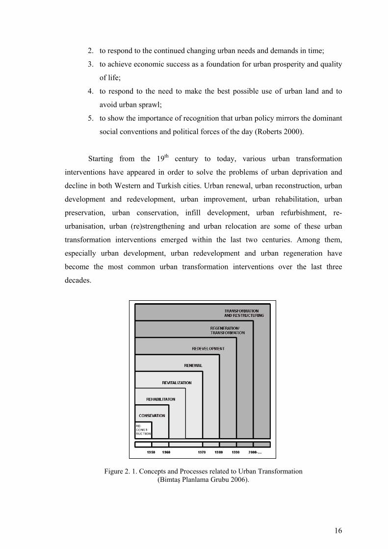
16
2. to respond to the continued changing urban needs and demands in time;
3. to achieve economic success as a foundation for urban prosperity and quality
of life;
4. to respond to the need to make the best possible use of urban land and to
avoid urban sprawl;
5. to show the importance of recognition that urban policy mirrors the dominant
social conventions and political forces of the day (Roberts 2000).
Starting from the 19th century to today, various urban transformation
interventions have appeared in order to solve the problems of urban deprivation and
decline in both Western and Turkish cities. Urban renewal, urban reconstruction, urban
development and redevelopment, urban improvement, urban rehabilitation, urban
preservation, urban conservation, infill development, urban refurbishment, re-
urbanisation, urban (re)strengthening and urban relocation are some of these urban
transformation interventions emerged within the last two centuries. Among them,
especially urban development, urban redevelopment and urban regeneration have
become the most common urban transformation interventions over the last three
decades.
Figure 2. 1. Concepts and Processes related to Urban Transformation (Bimtaş Planlama Grubu 2006).
17
Coupled with the privatization policies, a number of urban transformation
projects have been launched in both European and North American cities throughout the
1980s in order to develop or redevelop especially old industrial and harbour areas,
declining and deteriorated parts of cities. These projects were generally planned as
‘flagship projects’, and used as the catalysts for economic and physical regeneration.
Canary Wharf in London, Albert Docks in Liverpool, Symphony Hall in Birmingham,
Waterstad and The Cultural Triangle in Rotterdam, Battery Park City and South Street
Seaport in New York can be given as the examples of these projects. Most of flagship
schemes were developed on public-private partnerships. The central government
agencies, such as urban development corporations, mostly took the leadership of these
projects. A significant characteristic of these development and redevelopment projects
is that major infrastructural services and land development were provided by the central
government funding in order to attract private sector investments to such project areas.
In this sense, there is a wide recognition that the urban transformation schemes of the
1980s and early 1990s mostly served for the benefit of private investors and developers.
Another common opinion about such projects is that they were significantly used as the
crucial means of city-imaging and city-marketing programs. These projects were
developed and redeveloped declining and deteriorated parts of cities by using chic
architecture, stylish and elegant materials, the replicas of world-famous artefacts,
creating well-designed and attractive public spaces and constructing the buildings with
prestigious leisure and cultural activities, such as symphony halls, music halls,
convention centres, art galleries. Some of the prominent projects, such as Canary
Wharf, were designed by name ‘architects’ with various architectural styles. In this way,
the economic and symbolic functions of urban space were over-emphasised in order to
attract not only national and international investment, but also visitors and tourists
(Bimtaş Planlama Grubu 2006).
Starting from the 1990s, urban regeneration has been used more and more
common as an urban transformation intervention. These projects have generally been
established on partnerships, which principally include public, private, voluntary, and
community sectors. Most of regeneration projects have been led by competitive,
cooperative and entrepreneurial local authorities, and central government agencies set
up at the regional-level (such as regional development agencies, urban regeneration
agencies), or quangos. (Quangos are organizations that operate independently but with
support from the government) (Oxford Advanced Learner’s Dictionary 1995). Private

18
consultancies (eg. urban regeneration companies) have become to play more and more
active roles in the design, plan and organisation processes of these schemes in some
countries, such as in the UK. In such projects, the public sector has started to encourage
the private-sector stakeholders to take part in the provision of major infrastructural and
land development services. The emphasis on public interest is significant in these
projects where an integrated approach to economic, physical, social and environmental
regeneration seeks to be achieved. Besides, urban sustainability is an inevitable policy
for the recent urban regeneration projects. Finally, the promotion of existent cultural
and historical values and assets of cities has become a remarkable feature of these
projects in relation to city-imaging and city-marketing campaigns (Bailey and
Robertson 1999).
Urban regeneration projects show variety in terms of their targets and
regeneration approaches. There are various projects developed for economic, physical
and environmental regeneration, such as Albert Dock Project in Liverpool, a project
which aimed to transform the old docks into a marina, business park, and housing,
commercial and leisure centre of the city. Some projects target social regeneration. In
such projects, urban regeneration strategies mainly aim to improve economic and social
welfare of communities living in declining and run-down areas, by particularly creating
new job opportunities, providing education and training programmes, improving the
quality of labour forces. In this sense, Lowell in Massachusetts, and Cruddas Park in
Newcastle upon Tyne are good examples. Some urban regeneration projects are used as
catalysts for city-imaging and city-marketing programs in order to attract inward
investment, tourists and visitors to declining areas. The Quayside Project in Newcastle
upon Tyne, which has been led by the partnership of both Newcastle and Gateshead
local authorities, includes a number of schemes, such as Baltic Flour (an art gallery),
The Sage (a music hall), Blinking Eye (a pedestrian bridge over the Tyne River), which
play significant roles in order to build a new image for the Quayside and therefore for
both Newcastle and Gateshead. Another type of regeneration projects are based on
mega-event organisations. In this sense, Barcelona is one of the leading cities in
Europe. There are also culture-led regeneration projects. Gugghenheim Museum in
Bilbao, Waterfront Hall in Belfast, and Tate Galery in Liverpool are such schemes
seeking to vitalise the city’s economy through the development of cultural activities.
Finally, there are conservation-led regeneration projects. Edinburgh City has been
successfully implemented a number of such schemes (Ball and Maginn 2005).

19
When the best practices of the recent urban transformation projects in European
Union countries are examined, it is possible to identify 8 common key features. First of
all, these projects are based on strategic planning approach. That is to say, they
consist of strategies guided by a vision and modified according to changing economic,
social, physical and environmental conditions.
Second, the recent urban transformation projects acquire multi-actor and multi-
sector approach. They are based on partnerships embarrassing not only public and
private sectors, but also voluntary groups and the communities or groups related to
urban transformation projects areas. For this reason, another remarkable feature of the
best practices is the holistic planning approaches. They are developed through
participatory processes where all the stakeholders are involved in the planning and
development of the projects. Participatory platforms, such as residents fora, business
fora, and panels, are developed in order to sustain the involvement of all stakeholders
and give them a right to say about how the projects need to be planned, developed and
implemented. Participatory platforms are also used for community empowerment and
capacity-building. Additionally, in such projects, a new group of professionals, called
‘community workers’, play significant roles. Community workers are involved in the
urban transformation projects from their launches, to the determination of problems and
needs of the communities in the project areas, the finding the solutions to the problems
and implementation of proposals through collaborative and participatory processes.
They therefore seek to sustain the long-term support of communities to the projects.
Fourth, the best practice projects are based on a comprehensive and integrated
development model. They generally deal with the problems with various aspects, such
as economic, physical, social, and environmental aspects, and their proposals are to be
developed by integrating these aspects of the project areas. Legal, organisational,
institutional and financial dimensions, and monitoring and evaluation of these projects
are also designed and identified before they start.
Fifth, the best practices are local-based projects. In other words, there is no
‘prototype model’ which offers a successful urban transformation for a declining or
deteriorated area. Every single locality has its own decline conditions, problems and
needs which have to be examined and solutions are to be proposed accordingly.
Sixth, these urban transformation schemes are open to considerable changes in
the institutional structures over time. They are also open to new institutional
developments. Here, it is important to emphasise that, in the EU countries, urban
20
transformation projects are generally supported by central-government policies and
programs beside the local authorities’ projects and plans. For example, in the UK, all
the strategies, legal acts and regulations, and programs related to urban transformation
are led by the central governments. The central governments in the UK also provide
guidelines for the local authorities to follow in urban transformation projects. One of the
primary changes in this country can be seen at the institutional level. Urban
development corporations, urban regeneration agencies and urban regeneration
companies are the new agencies set up subsequently and played the leading roles in the
urban transformation schemes since the early 1980s.
Finally the best practice projects successfully mobilise collective efforts and
provide the basis for the negotiation of appropriate solutions. For this reason, it is
crucial to develop urban transformation projects through holistic methods and
processes. It is widely recognised that the long-term success and sustainability of such
projects can be only attained by mobilising collective efforts (Cameron and Smith
2005).
2.2. The Meaning and Scope of Urban Transformation
Our cities today are experiencing an urban decline as a result of such causes as
overpopulation, economic conditions, lack of social consciousness and wrong selection
of a place. As in many places in the world, this decay is felt deeply in our country and
observed not only in under-developed countries suffering urbanization problems but
also in developed countries experiencing rapid renewal processes since 19th century.
The experience of decay due to various factors has led the responsible authorities in
such cities to the search for solutions to eliminate this decay. The concept of urban
transformation has been put forward as a consequence of this search and as a solution.
One of the most important factors that shows whether a settlement requires an
urban transformation or not is the dimension of lack of urbanization. Hence,
identifying these conditions is of prime importance. If lack of urbanization is at a high
level, then this condition is taken for granted as an important factor indicating the
presence of necessity for urban renewal. Lack of urbanization; every physical and
economic decay which draws attention in a settlement does not mean that there is a lack
of urbanization there. In their definition of this term, Brown and Madge simply regard
21
lack of urbanization as unsatisfactory and undesirable conditions on economic,
sentimental, physical and behavioral grounds where a social agreement is at a low level.
(Brown and Madge 1982). On the other hand, Towsend defines lack of urbanization as
the observable disadvantage of an individual, a family or a group compared to a local
society or a larger community or nation (Townsend 1987).
It seems to be hard to find the right definition that will explain urban
transformation in full due to the complexity of the problems involved in the process.
There seem to be some differences in the use of the term resulting from perceiving the
phenomenon of urban transformation differently. At the 1st International Seminar on
Urban transformation held in Den Hang in August, 1958, the experts agreed on the fact
that the fundamental purpose of urban transformation is to change the urban
environment on purpose through a planned interference and an injection of regeneration
in order to address to the needs of urban life and work of available areas at present and
in the future.
When the meaning of the phenomenon of urban transformation is examined, it is
possible to find various definitions that refer to ‘transformation’. According to one
definition, transformation is “ a process which provides redevelopment or change of old
urban settlements in line with today’s social and economic conditions” (Atalık et.al.
1985).
In other words, urban transformation is defined as “re-planning the present cities
and centers and applying this in order to redesign and suit them to today’s
requirements” (Hasol 1998). Also, in another definition, urban transformation is
expressed as “bringing a whole city or a part of it –by means of public investment or
help- to the level of today’s changing conditions for the purpose of clearance of poor
neighborhoods, for improving and protecting the buildings and providing better housing
and public buildings” (Keleş 2004), and with this definition, the important role of the
government in renewal applications is also emphasized.
In general, urban transformation has been defined as “comprehensive vision
and action” which tries to solve urban problems and provide for permanent solutions
regarding the economical, physical, social and environmental conditions of a district
undergoing specific changes (Thomas 2003). This definition has been linked to three
fundamental issues. In this context, urban transformation:
1. Is intended to change the nature of a place and in the process to involve the
resident community and other actors with a stake in its future.
22
2. Embraces multiple objectives and activities and activities that across the main
functional responsibilities of government, depending on the area’s particular
problems and potential.
3. Usually involves some form of partnership working among different
stakeholders, although the specific institutional form of partnership can vary
(Thomas 2003).
The above mentioned three issues in fact determine the three key concepts for
urban transformation:
♦ Participation,
♦ Roles and responsibilities of the public sector,
♦ Partnertships (roles and responsibilities of the stakeholders)
As can be seen, the essence of the concept of urban transformation, covers a
dynamism expressed with the concepts like change, transformation, regeneration, and
vitality. This dynamism is the basic factor in giving its real characteristic back to the
city, which was destroyed in time by natural and artificial factors. With this definition
in mind, it is possible to define urban transformation –in its general sense- as the action
of transformation, improvement, regeneration and sometimes redesign of a city’s
infrastructure which has decayed in time and waits for reuse as a consequence of the
potential rise in its land value in line with today’s socio-economic and physical
conditions in a strategic approach formed by the social and economic programs.
2.2.1. The Purpose of Urban Transformation
The purpose of urban transformation is regeneration of the sections of a city
which are important for the city, where these processes are already being experienced,
but which are old, decayed and destructed due to various reasons. This process is also
related to the economic inputs that use of available resources will bring about – as well
as the obligation of preserving and continuing a city’s cultural heritance and identity.
When the applications of urban transformation in Europe and the U.S.A. are examined,
it can be seen that they took place more in city centers, in decayed or abandoned depot
and industrial regions or at seaside constructions like shipyard, port and dock. In short,
fundamental purposes of urban transformation are:
23
♦ To redesign the decayed areas of a city in a well-planned way with satisfactory
transportation, infrastructure and social facilities in order to minimize the
problems of social deterioration and avoid the problems of urban decay in the
long-term.
As can be seen, all kinds of planned interferences done to avoid problems
resulting from environmental and structural differences arising in a city are in general
called as “urban renewal”. The interferences regarding the solution of these problems
are applied within the range of the whole city, neighborhood, streets, place of a
structure, plot scale.
♦ At the 1st International Urban Renewal Seminar held in August, 1958, there
types of interferences of urban renewal had been determined:
1. Redevelopment that includes demolishing and reconstruction,
2. Rehabilitation or improvement of an original building,
3. Preservation of historical monuments which are generally away from
housing areas.
However, in urban renewal works that took place later on, preservation was
regarded as a form of rehabilitation. In this sense, the types of interferences were
defined as rehabilitation, redevelopment and a combination of both. On the other
hand, urban renewal projects were pointed out in three ways:
Firstly, as the clearance of the slums or decayed areas, and preparation of the
land for redevelopment in line with planned uses;
Secondly, rehabilitation and preservation of buildings and improvement of
social facilities in coordination with the local government;
Thirdly, as a combination of the first two. Both approaches cover keeping the
original population on the land in their place and re-housing them in a different part of a
city.
2.2.2. Changing Policies on Urban Transformation and Ways of
Interference
Urban transformation policies and ways of interference applied since 19th
century onwards have always shown variance. From mid 1800 to 1945, the most
important form of interference against physical and social decay in cities was urban

24
renewal. In the after period of industrial revolution, the environmental pollution which
increased in industrial cities, disorganized construction of industrial regions, crowded
and low-standard housing areas led to the emergence of unhealthy cities (LeGates and
Stout 2003).
After the Second World War, urban transformation has also been effective in the
process of reconstruction of cities. In the post-war period, gross destructions in the
European cities placed the subject of widespread reconstruction of cities on the agenda.
The urban policies of 1940s and 50s envisaged the replacement of the old urban areas
by the new ones, and reconstruction of cities through elimination of physical problems
taken over from the past. For instance, in the USA, the US Housing Act (1949) made it
possible for urban renewal to get institutionalized (LeGates and Stout 2003). As a result
of the plans prepared for internal urban areas, the priority was given to slum clearance,
and as part of this process, vast destructions were done; and they were replaced by
multi-storey housing blocks in those regions (Noon, et. al., 2000).
1960s were the years when urban improvement and urban renewal projects
were given priority. In that period, the European countries abandoned general urban
improvement and renewal policies, and made a transition to area-focused programs
based on social problems (Couch 2003). Whereas urban decay was seen as a disorder by
mid 1970s, it was explained by structural and economic causes by the end of 1970s
(Balchin 1995). It was especially observed that the actors who started and carried out
the transformation projects covering urban centers and their surroundings showed
variance (Roberts 2000). 1980s, as happened in many fields, was the period during
which significant changes were realized in urban transformation. During that period, the
idea of urban transformation under the leadership of the central government was
completely abandoned; and the importance of partnership in urban transformation was
stressed, and in addition, the role of the private sector was brought up. The importance
given to urban redevelopment policy is another striking characteristic of urban
transformation projects.
1990s witnessed urban regeneration, known as the most important form of
interference in urban transformation. One of the leading characteristics of that period
was that the existence of urban transformation process which involved many partners,
new problems, and interferences was accepted. As well as the private sector, the
importance of the participation of various walks from the society into urban
transformation process was emphasized; and new legal regulations were introduced.
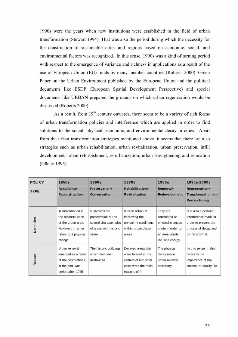
25
1990s were the years when new institutions were established in the field of urban
transformation (Stewart 1994). That was also the period during which the necessity for
the construction of sustainable cities and regions based on economic, social, and
environmental factors was recognized. In this sense, 1990s was a kind of turning period
with respect to the emergence of variance and richness in applications as a result of the
use of European Union (EU) funds by many member countries (Roberts 2000). Green
Paper on the Urban Environment published by the European Union and the political
documents like ESDP (European Spatial Development Perspective) and special
documents like URBAN prepared the grounds on which urban regeneration would be
discussed (Roberts 2000).
As a result, from 19th century onwards, there seem to be a variety of rich forms
of urban transformation policies and interference which are applied in order to find
solutions to the social, physical, economic, and environmental decay in cities. Apart
from the urban transformation strategies mentioned above, it seems that there are also
strategies such as urban rehabilitation, urban revitalization, urban preservation, infill
development, urban refurbishment, re-urbanization, urban strengthening and relocation
(Günay 1995).
POLICY
TYPE
1950s
Rebuilding+
Reconstruction
1960s
Preservation+
Conversation
1970s
Rehabilitation+
Revitalization
1980s
Renewal+
Redevelopment
1990s-2000s
Regeneration+
Transformation and
Restructuring
Def
init
ion
Transformation is
the reconstruction
of the urban area.
However, it rather
refers to a physical
change.
It involves the
preservation of the
special characteristics
of areas with historic
value.
It is an action of
improving the
unhealthy conditions
within urban decay
areas.
They are
considered as
physical changes
made in order to
an area vitality,
life, and energy.
It is also a detailed
interference made in
order to prevent the
process of decay and
to transform it.
Rea
son
Urban renewal
emerged as a result
of the destructions
in the post-war
period after 1945
The historic buildings
which had been
destructed
Decayed areas that
were formed in the
centers of industrial
cities were the main
reasons of it
The physical
decay made
urban renewal
necessary
In this sense, it also
refers to the
importance of the
concept of quality life.

26
Akt
ors
Local and national
government,
entrepreneurs in
private sectors
Private sector, public
sector and judicial
individuals
Search for a balance
between private
sector and public
sector
The increased role
of the private
sector and the
decreased
influence of local
governments
Cooperation under the
pressure of the
environment
Leve
l of
App
licat
ion
Emphasis on Local
and plot scale
Urban-scale
preservation policies
Emergence of
regional level in
actions
Emergence of
regional local
levels at first, and
then the local
level
Redefinition of
strategic perspective
Econ
omic
Lev
el
Public investments
in which private
sector is involved
Investments of
central and local
governments and
investments of public
sector
The growing interest
of the private sector
since 1960s
The limitation of
sources in public
sector and the
increase in
investment by the
private sector
A more balanced
distribution among
public sector, private
sector, and funds
Soci
al L
evel
Living standards
and exchange of
accommodation
Preservation of the
unique features of
the historic buildings
Development of
social environment
and wealth
Participative
planning and
allocation of
larger authorities
Importance of
society’s role
Impa
cts
on P
hys
ical
Spac
e
Replacing the areas
in the centre and
suburbs
Preservation of
historic buildings and
development of
culture tourism
Continuation of the
renewal and
rehabilitation of
available areas in
parallel to 1960s
Detailed renewal
of old settlements
Related groups
undertakes a more
effective role in
physical space than in
1980s
Envi
ron
men
tal
App
roac
h
Landscape
Arrangements and
greening
Regeneration of the
physical surroundings
Selective
improvements
Enabling the
environmental
development
through new
ideas
A more detailed view
for environmental
sustainability
Table 2. 1. Development process of Urban Transformation Practices (Roberts and Skyes 2000).
2.2.3. Types of Urban Renewal
2.2.3.1. Urban Redevelopment
Urban Redevelopment is clearance of the available buildings and reuse of the
cleared area for the application of new projects. This approach is admitted when
buildings are seriously damaged and have no value to be preserved or when the

27
arrangements of buildings are not able to provide the necessary conditions for living. In
such cases, demolishing all the buildings in a whole area or part of it and reconstructing
them are generally thought to be the only way of solution in order to provide comfort
and security for the future inhabitants. The clearance of a land by demolishing
according to a plan is called “land clearance”. Redevelopment is a method which clears
away the decayed areas of a city, and the problem areas which are impossible to be
changed socially are eliminated through this method. The term “Slum Clearance” is
used for policies that aim at moving a part of lower-income group or all of it off a
particular region. Also, this approach contains heavy social and environmental costs.
Demolishing the architectural structure is probably the most serious outcome of the
approach of redevelopment. Even though people are re-housed in the same area after
the reconstruction of an area, the transformation of a neighborhood inevitably has an
impact on the social structure.
2.2.3.2. Urban Rehabilitation
Urban Rehabilitation is a process of making a whole settlement or a part of it –
which cannot be used or function properly again- worthy again and giving it better
qualities if it has developed based on a plan, but became worn out, old-fashioned,
heavily populated as a result of additions. Rehabilitation can be defined as the opposite
of “redevelopment” and “preservation”, when used together. This term covers
preservation and restoration of the natural and human structure environment of the
neighborhoods. Rehabilitation is generally applied in areas where buildings are
structurally in good condition and in areas where they have decayed due to lack of care.
It makes use of the advantage of available housing stock as a valuable source, and adapt
old buildings to present daily life and approximate them to acceptable standards by
providing modern facilities.
2.2.3.3. Urban Regeneration
The definition of the concept of urban regeneration in Turkish is ‘bringing
vitality’. Regeneration is an approach which aims at improving a city or a part of it with
respect to its space, its economy and social structure, and its sustainability through
28
preservation. Urban regeneration originated as a consequence of the economic changes
during the last two decades and the changes in the types of social space, as a reflection
of the relationship between space and economy. Urban regeneration is a set of
integrated and detailed actions aiming at making the urban areas, which are in the
process of physical and social decay, worth living and lively by means of re-activating
the dynamics owned by a local economy and enabling the city to gain them back. Urban
regeneration aims at providing the following four criteria:
1. To stop the physical decay in cities and keep the historical structure
2. To reactivate the economic life
3. To enhance the quality of urban life and reactivate the dynamics that depend
on culture
4. To motivate participation at every level.
On the other hand, the impacts of urban renewal upon population develop in two
different ways: Gentrification and incumbent upgrading.
Gentrification: Regeneration through gentrification policy is based on the
principle of placing the middle and high-level classes in the center of a city as an
outcome of improvement in buildings and environment and forcing the previous
inhabitants to move out of this area. This policy is based on the assumption that middle
and high class society who were placed in city centers and areas with historic identity
would enable the area to develop physically and gain a new identity. The concept of
gentrification is related to the concept of regeneration and the invasion of the city center
by the middle and high classes. The reinvasion of cities is regarded as the concept
explaining the process that the lower class society who were placed in city centers are
replaced by the higher class.
Incumbent upgrading: By means of the process of obligatory improvement,
city inhabitants remain in their places and spend their time, money, and energy
redesigning their houses and social environment.
♦ In developing countries, improvement generally refers to an approach which
develops an area, in which the original population is located, further with or
without government support.
♦ This approach also prevents a possible decay caused by the lack of investment
and environmental interest by acting as an active power in the process of
housing.

29
♦ It also requires a high level of social organization and responsibility as well as a
general reorganization of houses.
2.3. Partnerships in Urban Transformation Process
The main actors of the transformation process consist of the public sector, local
community, voluntary institutions, private sector and other related groups. However,
depending on characteristics and goals of transportation and the scale in question, the
matter of who the partners and what the characteristics of partnership are, in other
words, the balance of power may change. Therefore, this delicate balance as an
extremely important factor in delivering the targets of transformation is shaped
according to the purpose and context of transformation and other subjective conditions.
The most critical point to be dwelled upon here concerns the adverse outcomes of any
direct transfer of a transformation on experience as if the case presents a generally
accepted prescription to be “copied and pasted” under particularly the circumstances
where there can emerge, even within the same country, different models of
transformation and types of partnership (Thornley 2005).
In those transformation projects which have been implemented, the most
funamental problems stem from insufficiency in determination of the goals such that
they could not be defined explicitly and clearly enough; lack of coordination between
the local and central governments; inability to build any connections between physical,
economical and social regeneration; disregard of the fact that the area in question for
neighbourhood regeneration projects is actually a piece of the whole city; and
negligence of probable problems pertaining to involvement of resident community
within the process. In order to succeed in transformation despite all these problems, a
range of mixed initiatives shall be offered as integrated with general policies of
economy, welfare, unemployment, education, training and health, all guided by the
central government (Andersen 2004).
An inevitable factor within the transformation process pertains to “partnership”.
The Western experiences have indicated that cooperation between different institutions
and public bodies is ineluctable with respect to a search for an organization in optimal
structure and operations on the one hand, and to “governance” on the other. Assembling
the private and public sectors, and additionally a multiple set of actors together, this
30
approach has also defined a series of dynamics in parallel. In consequence, various
control mechanisms and related legislation could be fostered. As they undertake an
extremely crucial role in terms of providing for sustainability of the process in context
of different fields of expertise and roles, partnerships also function as the most
important factor in “enabling” this effective process, having such goals and strategies
that are evident in all stages. Distant from any excessive bureaucracy, this structure has
at the same time aided in public control over and limitations to those activities with
emphasis entirely on dynamics of market mechanisms (Hastings 1996).
In European Union, the last two decades have witnessed a rise in studies dealing
with problems of urban areas, and this in turn has implied a variety of policies and
initiatives. While the main focus of the agenda was previously on problem areas of
those cities in economic decline, parallel to emergence of “urban social exclusion”,
“urban tension” and similar problems experienced even in flourishing cities, it has
become increasingly apparent during the 1990s that social problems are not simply
restricted to economically declining cities such that “excluded spaces” appear to
develop in and around many urban areas. Therefore, at all levels of governance within
the European Union, there has been a growing recognition that the problem of urban
social exclusion needs to be addressed in an integrated manner. However, much of the
impetus for developing national, regional and local responses to urban problems will
depend upon the extent to which they feature on the relevant national, regional and local
policy agendas. This depends on what the problem-focus of urban policy is and how
these problems are explained, what the aim of urban policy is, how it is achieved and
which resources are to be used to reach this aim, how policy will be guided and
managed, whether there exists any adequate legislative base, what the measures for
monitoring are, who will be benefiting from this process and what the weight given to
social equality is, all as difficult questions awaiting an answer (Atkinson 2004).
Today, partnerships of urban transformation are mostly multi-sectoral in UK.
Due to relative newness of the experiences that attempt to combine the public, private,
voluntary and community sectors, partnerships are seen very much as a “learning
process”, because all the participants have to learn how to work together and set aside
their individual interests and develop a notion of the “common good”. The general
characteristics of the above-mentioned area-based multi-sectoral partnerships and
contradictory processes within these partnerships can be identified as follows.

31
1. Synergy – of bringing together organizations and people for combining their
resources to get added value, and achieve more than what they can do by
themselves alone.
2. Transformation – by coming together into a new corporate entity (a
transformation partnership) all of the those involved pool their collective
interests and identities to create a new and cohesive body with an identity and a
set of shared common interests.
3. Budget enhancement – in some cases this is the primary motive for creating a
partnership. In England access to transformation funding is usually conditional
on creating a partnership involving the community.
4. Such partnerships can sometimes be seen as a method of avoiding the failures
of 1980s style market-led physical transformation.
5. They can represent a method of reducing private sector risk and thereby
facilitating investment.
6. A method of making transformation more relevant to the needs of marginalised/
excluded groups.
7. A method of insertion/integration acting to create social solidarity and cohesion,
of countering social exclusion.
8. A way of helping create a culture of self-help within marginalised communities.
9. They can be seen as a method of managing the community (Atkinson 2004).
For success in partnerships, community engagement as well as partnerships
between public and private sectors should be set out carefully. Consideration of the
conditions of success and failures of public-private paernerships in UK avail for
following remarks to be made (McCarthy 2006). Implementation of a successful public-
private partnership is contingent on harmonious execution of different procedures in
between a variety of sensitive balances. At this point, the “balance of power” should be
established properly in partnerships; for instance, despite its positive contributions, the
“leading capacity” may also have the implication where one partner tends to impose his
own model, possibly leading to such problems as “lack of accountability” followed by
“lack of committment”. Lack of openness between partners, which may result in raised
expectations that cannot be fullfilled, lack of a clear basis of agreements on which the
partnership can be built and such situations where the risks are perceived to be too high,
all are the reasons for failure of partnerships that are expected to transform a specific
area. It is emphasized that serious problems had to be encountered in public-private
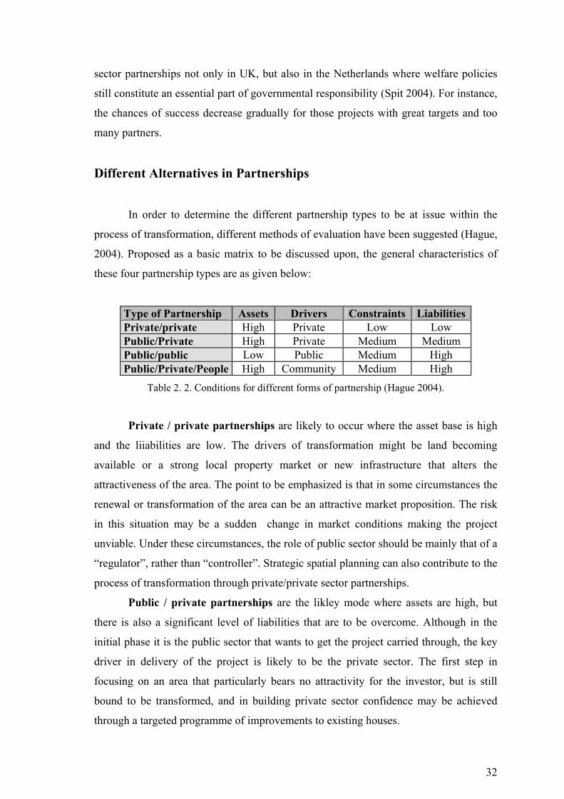
32
sector partnerships not only in UK, but also in the Netherlands where welfare policies
still constitute an essential part of governmental responsibility (Spit 2004). For instance,
the chances of success decrease gradually for those projects with great targets and too
many partners.
Different Alternatives in Partnerships
In order to determine the different partnership types to be at issue within the
process of transformation, different methods of evaluation have been suggested (Hague,
2004). Proposed as a basic matrix to be discussed upon, the general characteristics of
these four partnership types are as given below:
Type of Partnership Assets Drivers Constraints Liabilities Private/private High Private Low Low Public/Private High Private Medium Medium Public/public Low Public Medium High Public/Private/People High Community Medium High
Table 2. 2. Conditions for different forms of partnership (Hague 2004).
Private / private partnerships are likely to occur where the asset base is high
and the liiabilities are low. The drivers of transformation might be land becoming
available or a strong local property market or new infrastructure that alters the
attractiveness of the area. The point to be emphasized is that in some circumstances the
renewal or transformation of the area can be an attractive market proposition. The risk
in this situation may be a sudden change in market conditions making the project
unviable. Under these circumstances, the role of public sector should be mainly that of a
“regulator”, rather than “controller”. Strategic spatial planning can also contribute to the
process of transformation through private/private sector partnerships.
Public / private partnerships are the likley mode where assets are high, but
there is also a significant level of liabilities that are to be overcome. Although in the
initial phase it is the public sector that wants to get the project carried through, the key
driver in delivery of the project is likely to be the private sector. The first step in
focusing on an area that particularly bears no attractivity for the investor, but is still
bound to be transformed, and in building private sector confidence may be achieved
through a targeted programme of improvements to existing houses.
33
Public / public partnerships are likely to constitute the mode when assets are
low and liabilities are high. In these circumstances the private sector is unlikely to be
attracted into partnership. The public sector is the actual owner of the proporties and so
may have a special interest in reviving the value of its assets. Liabilities are likely to
include costs of maintenance and repair, allowances for rent, or similar expenses
concerning the area. The public sector is the main dirver, though there are likely to be
constraints of finance and on the capacity to deliver improvements. Transformation of
publicly –owned areas is often for transformation of particularly –for our country-
squatter settlements and other illegal areas, creation of public areas and delivery of
housing policies as based on national development plans.
Public / private / community partnerships are likely to be found when assets
are high and so are liabilities, and the drivers of change include groups in the
community. Typical constraints are likely to be in funding, with the risk that a sequence
of small budget initiatives creates a sense of “fatigue” as key activities get worn down
chasing new grants. Being inter-personal and negotiative take place among those skills
required for this type of partnership (Hague 2004).
2.4. Urban Transformation Processes
It appears quite clear that problems of urban decline differ from country to
country, as do the conditions for solving them. In every country, urban problems appear
in a specific geographical, economic and political context, and the possible instruments
for solving the problems are often linked to the present national structure of public
administration and policies. General housing policies and the character of housing
markets are of special importance. Finally, divergent political priorities and objectives
for urban renewal have lead to quite different policies in practice.
2.4.1. Urban Transformation Processes in Europe
Most governments in Europe have found it necessary to subsidise and regulate
the processes of urban renewal and housing rehabilitation and many countries have
implemented special renewal programmes for deprived urban neighbourhoods.
However, in a comparative study on housing renewal in Europe it was concluded that
34
public policies for housing rehabilitation and urban renewal in European countries
appeared to be very different (Andersen 2004). Every country has its own way of
understanding this policy area and the kinds of problems it concerns. In the USA
policies have, moreover, also been different from European approaches.
Conditions in the American housing market differ fundamentally from those in
most West European countries. European cities have had a lower risk of urban decline
and severe slums, welfare systems are better, and housing allowances are larger,
meaning that more people can afford well-maintained dwellings. The extensive public
involvement in housing in Western Europe since World War II, supplemented by
special large-scale urban renewal programmes, means that Europe has not experienced
the same serious decay in, and virtual breakdown of, large urban areas. Europe has,
however, seen some problems of decay in old housing and in some of the large social
housing estates built in the 1960s and 1970s. And there is no doubt that the general
forces of decay which can be observed in the unregulated American housing market
also exist in Western Europe – they have been restrained only by extensive public
involvement in the housing market (Dean and Hastings 2000).
The general economic and legal conditions concerning private maintenance and
improvement of dwellings in these countries have also been of decisive importance. The
fundamental economic conditions are not the same in different tenures and they vary
from country to country. Therefore differences in the composition of the housing market
in the countries and the public regulation of tenures also play important roles (Andersen
1999). The problems of with social housing is vary. In most of the countries, a
combination of building problems and social problems, caused by a high concentration
of residents with low incomes, has resulted in problems in high-rise estates from the
1960s and 1970s. The conditions for housing rehabilitation in owner occupied housing
have formerly been quite good. However, in areas with declining demand, firinge areas
or with a high concentration of low-income residents, some deterioration has also been
observed. Urban problems have been given different national priorities depending partly
on the composition of the housing stock. For example, some countries, Denmark,
France and the UK have a much larger proportion of old dwellings built before 1945.
France and the UK in particular have an old housing stock, while the dwellings in
Sweden, Norway and the Netherlands are relatively new. All the countries countries
have experienced these kinds of problems, but they seem to be have been most serious
35
in France, the Netherlands and Great Britain, where high proportions of immigrants
reside (Andersen 2004).
The direct observably severe problems found in the worst European areas of
deprivation and decay involve (Taylor, 1998);
♦ Physical decay because of shoddy construction work, rapid attrition and
dereliction and increasing volumes of litter and rubbish in open spaces.
♦ Low demand, abandonment of dwellings.
♦ Visible anti-social behaviour: crime, rioting, vandalism, drugs, alcoholics,
increased noise.
♦ Deteriorated housing service and management.
♦ Visible signs of negative changes and unstable conditions.
The direct consequence of the emergence of these problems has been a
deterioration of the environment and housing quality for people living on the estates
(Burrows and Rhodes 1998). An indirect effect is that these areas gain bad reputations,
places where people stay only when they have no alternative. For those who have to live
in these areas, this can mean an attack on their identity and a reduction in their self-
esteem. As Taylor (Taylor 1998) puts it: “For many residents on estates, community is
the site of fear and blame rather than choice and pride”.
2.4.2. Urban Transformation Processes in USA
Urban declined areas with the worst problems are to be found in the central parts
of some US cities, just outside the central business district. To a large degree, the
problems of decay in the American housing stock are concentrated in certain urban
areas. Despite years of economic growth and several urban renewal programmes, urban
decay has spread in major cities. Some neighbourhoods exhibit ongoing decay;
buildings are deteriorating and many dwellings are being abandoned (Adams 2005).
The extent of these processes can be explained partly by the special conditions
prevailing in the housing market in American cities. In both Western Europe and the
USA, a dramatic change has occurred in the economic conditions of cities since the
1950’s. That change was caused by two trends. The first is the decrease in industrial
activity, with increasing unemployment among blue-collar workers. The second is the
departure of middle-class residents moving to suburbs. These two trends were stronger

36
in the USA than in most West European cities. In Europe, moreover, a great deal of new
social housing has been built in the suburbs for people with low incomes. In the USA,
these groups have been left behind in the older parts of the American cities (Adams
1996).
American experience shows that the extent of both urban decay and renewal has
varied greatly over time and from city to city (Raggeett 1986). It might be expected that
factors such as average househols income, distribution of income, and the extent and
scope of urban renewal programmes has been of decisive importance. However,
American census data suggests there is a wide range of poor-quality housing and
decline among cities and neigbourhoods with similar income distributions. Decay has
been spreading even while real incomes rise, subsidy programmes expand and
substandard housing is eliminated (Gittell 1992).
The United States has a much less regulated market. Therefore, it is possible to
observe processes of decay and renewal that are less affected by rent control or other
kinds of public interventions used in European countries. Extensive research has been
done in the housing market in the US, and on processes of decay and renewal in cities.
American research therefore allows us to discuss the possibility that general market
failure exists and promotes slums and decay. Many American social scientists have
pointed to a process, by which well-to-do residents in a neighbourhood are replaced by
low-income households as the primary cause of urban decay (Litchfield 1992). This
process has been called downward “succession”. This process has resulted in that
people left in some central city areas are less able to pay for good housing quality,
which results in decreasing investments both in maintenance and improvement of the
housing stock.
While many neighbourhoods in American cities are declining, there have also
been examples, since the 1970s, of neighbourhoods where decay has stopped and after
few years, new investments have begun to flow into the areas. This process has been
named “gentrification”, the opposite of succession, because households with higher
incomes move into the neighbourhood and replace the existing residents who have
lower incomes. (Nelson 1988).
2.4.3. Urban Transformation Processes in Under-Developed and
Developing Countries
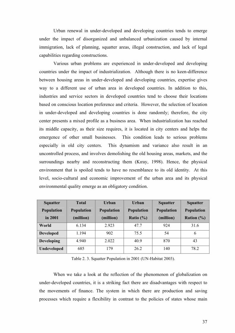
37
Urban renewal in under-developed and developing countries tends to emerge
under the impact of disorganized and unbalanced urbanization caused by internal
immigration, lack of planning, squatter areas, illegal construction, and lack of legal
capabilities regarding constructions.
Various urban problems are experienced in under-developed and developing
countries under the impact of industrialization. Although there is no keen-difference
between housing areas in under-developed and developing countries, expertise gives
way to a different use of urban area in developed countries. In addition to this,
industries and service sectors in developed countries tend to choose their locations
based on conscious location preference and criteria. However, the selection of location
in under-developed and developing countries is done randomly; therefore, the city
center presents a mixed profile as a business area. When industrialization has reached
its middle capacity, as their size requires, it is located in city centers and helps the
emergence of other small businesses. This condition leads to serious problems
especially in old city centers. This dynamism and variance also result in an
uncontrolled process, and involves demolishing the old housing areas, markets, and the
surroundings nearby and reconstructing them (Kıray, 1998). Hence, the physical
environment that is spoiled tends to have no resemblance to its old identity. At this
level, socio-cultural and economic improvement of the urban area and its physical
environmental quality emerge as an obligatory condition.
Squatter
Population
in 2001
Total
Population
(million)
Urban
Population
(million)
Urban
Population
Ratio (%)
Squatter
Population
(million)
Squatter
Population
Ration (%)
World 6.134 2.923 47.7 924 31.6
Developed 1.194 902 75.5 54 6
Developing 4.940 2.022 40.9 870 43
Undeveloped 685 179 26.2 140 78.2
Table 2. 3. Squatter Population in 2001 (UN-Habitat 2003).
When we take a look at the reflection of the phenomenon of globalization on
under-developed countries, it is a striking fact there are disadvantages with respect to
the movements of finance. The system in which there are production and saving
processes which require a flexibility in contrast to the policies of states whose main
38
policy is not to let the finance go out of the country and to control finance movements
seems to be unsatisfactory in preventing the financial depressions in under-developed
countries (Eraydın 2006). Financial depressions are usually followed by a series of
socio-cultural and urban problems. Big cities, in one hand, struggle with the problems
caused by urbanization without reaching that quality, and on the other hand, with the
density of finance in certain areas, social disputes, discrepancies between the social
classes are all reflected to the physical locations and show their effects. The huge
discrepancies connected with finance movements in the physical location, varying plot
values, and the social classes which move their location make an invitation to urban
renewal.
Another characteristic of urban transformation stems from the fact that it is
multi-dimensional. Urban transformation has social, economic, legal-governmental,
planning, and design dimensions. Transformation is phenomenon which can be filled
by overlapping its dimensions. The private sector, civil society
organizations/institutions, universities, and the whole local population must have
daresay at certain levels together with he local governments/municipalities in
overlapping the dimensions. It is this kind of approach that will enable the
transformation application to reach success.
39
CHAPTER 3
APPROACHES AND PRACTICES OF URBAN
TRANSFORMATION – SELECTED DIFFERENT
SAMPLES IN THE WORLD
The phenomenon of urban transformation which has been studied with its
conceptual dimension in the previous chapters will be dealt with in this chapter with
samples focusing on application and with a different view. Within this chapter, as well
as various kinds of urban transformation approaches, the subject will be investigated
and the scope of it will be widened considering the planning dimension of urban
transformation, the management of the transformed area, its organization structures,
participation of people, and the public support that will be given to the transforming
area in the scope of private and public investments.
3.1. Urban Transformation Approaches
Urban transformation requires a strategic approach. The functions expected from
a renewal area in the future are to be determined in line with the strategies to be
developed for a particular area. The transformation strategies which are developed
independently from the other strategies related to an area will lead to a failure for the
local governments and their partners who collaborate with them in renewal applications.
The transformation strategies that are not supported by such strategies and have no
application in practice cannot be expected to be successful. New Jersey and London
can be shown as good examples for this. Urban settlements can be resembled to
organisms which continue to exist by changing and transforming as required by their
nature. However, it does not seem possible for various branches of science to monitor,
guide, and limit this change and transformation and then to realize it in a collaborative
relation that they will organize at the local and central levels. The characteristics and
needs of every urban sub-region determine the method to be used. On the basis of the
idea of evaluating each city’s present construction potential, specific identity, and
population, such methods help us to gain back the cities successfully which are
40
undergoing a period of decline. The most important step in creating sustainable cities,
which is often stressed in the process of accession to European Union, can be taken by
gaining back the decayed regions of available urban areas. In this step, the main purpose
is to overcome lack of urbanization and to provide the city dwellers with better, more
quality and healthier environment to live in; and in order to do this, using the available
stock in hand is of prime importance. In this process, planning seems to be an important
task. It would be possible to keep urban transformations and renewal under control only
through realizing them in a planned way. In this respect, the most important thing is to
determine primarily the principles and policies of urban transformation and renewal.
The principles and policies determined at local and central levels differ from each other
in certain points. Under these policies there must be other policies and principles
relating to the areas which have special importance with respect to their different
qualities and functions.
Urban transformation strategies must be perceived together with the whole
urban area and designed with high level decisions; and therefore they must offer the
opportunity to form integrated renewal policy parameters. When we approach this issue
by giving examples from European countries, it is then possible to talk about three basic
strategies (Andersen 2004).
1. Approaches of General Housing Transformation
The first is called an approach for general housing transformation. Countries
such as Austria, Denmark and Sweeden have followed this approach. Typically,
housing rehabilitation programmes in this countries are very general. Nearly all
dwellings are covered by a few general programmes and very few means test are
required. Few centrally fixed rules exist about which housing should be renewed and
how it should be accomplished. In Denmark and Austria, this is mainly left in the hands
of local government –in Sweeden, in the hands of property owners. Austria and
Denmark, renewal area has played an important role and these programmes have taken
the form of direct intervention. Significantly, the approaches chosen by these three
countries agree well with their general housing policies. In all three countries, housing
is largely seen as a public good and the state is extensively involved in housing. In all
three countries, the subsidy levels have been quite high (Andersen and Leather 1999).
41
2. Approaches of Strong Central Priorities
The second main approach is an approach of strong central priorities. Especially
the UK and France have followed this approach, but we have also placed Norway and
the Netherlands in this group, even though these countries share some similarities with
the first group. All these countries have developed complex systems with many
different programmes directed towards selected parts of the housing stock. Local
governments are involved in programmes for urban restructuring or area renewal in all
the countries, but their influence is – except in Norway – restricted by detailed rules
fixed by the state. The dominant form is indirect intervention, even in area renewal
schemes. Tenant influence has been less important than in the first group of countries,
but has attracted some attention in the UK and Norway. The Netherlands has previously
emphasized residents’ rights to stay in their dwellings, but this has been less important
in recent years. Another problem in these countries has been that low-income groups
have often been expelled from renewed housing as a consequence of a low level of
subsidies (Andersen and Leather 1999).
3. Approaches of Limited Public Involvement
The third main approach is an approach of limited public involvement.
Especially in Switzerland, but also in Germany, the programmes devised have been
quite limited. Indirect intervention is the rule, except for the German urban renewal
programme, which is aimed more at urban restructuring that at housing rehabilitation.
Local authorities have a great deal of influence. Germany is the only country to give
special tax subsidies supporting all investments in housing and reducing the need for
indirect regulation. Tenants have no special rights and the amount of direct subsidies is
small. In both countries, traditionally the state has a more reduced role than in the other
comparison countries, and a more liberal housing policy is implemented than in the
other comparison countries, and a more liberal housing policy is implemented than in
most countries. It is, however, important to notice that the general conditions for
housing investments in both countries have been very favourable because interest rates
have been low. This has made it easier for market forces to work and has reduced the

42
need for public housing support. As a result, housing rehabilitation problems have also
been reduced and most of the older stock has been renewed without subsidies.
The different approaches applied by the countries all have advantages and
drawbacks. The approach of general housing renewal is very cautious when residents
are financially secure and have considerable influence. Moreover, the approach facilities
a coherent renewal in selected urban areas to solve connected social, economic and
physical problems. The negative consequences of the approach are that high subsidies
are needed with a smaller number of private investments. With limited public budgets,
this means that it takes a long time to implement renewal of the neediest part of the
housing stock and some of these countries are therefore still in considerable need of
renewal. The approach of central priorities results in more efficient use of subsidies
where only the neediest are supported and more private capital is involved. The price is
that it is much more difficult to coherently renew selected urban areas and therefore
stop self-reinforcing slum processes in vulnerable neighbourhoods. Moreover, tenants
are often financially insecure. This problem is even more pronounced in the strategy for
limited public involvement, which has generally resulted in high rents in Germany and
Switzerland (Andersen and Leather 1999).
3.1.1. The Main Actors in Urban Transformation Process
In many cases there will be a combination of public, private, community and
voluntary sector participation, but the relative importance of these partners and the way
they are co-ordinated will vary according to the situation. Transformation initiatives
with a strong social dimension are likely to feature extensive community participation.
This is to ensure that they are relevant to local needs and that there is a degree of local
“ownership” of the strategy and resulting activities. Members of the local community
may be intimately involved in making decisions about the strategy and in implementing
it. In general terms, community members can bring legitimacy, credibility, local know-
ledge and ownership of transformation programmes, which helps them to “stick”.
Almost all transformation initiatives have strong public sector involvement and
many are led by particular public agencies. Depending on the objectives being pursued,
they may include local authorities, economic development agencies, regional health and
police authorities, government employment agencies, universities and representatives of
43
regional and national government. They clearly have very substantial powers and
resources to bring to bear, and the legitimacy of democratic control, although they are
not always very popular with local communities. Transformation programmes with
prominent physical and economic objectives are most likely to feature private sector
involvement. Different kinds of businesses have different interests, objectives and
experience. Initiatives may include property owners and developers, calfirms, major
employers and potential inward investors. Experience suggests that it is generally
difficult to involve the private sector unless there is clear self-interest.
3.1.2. Co-ordination in Urban Transformation Process
Coordination is a major objective of transformation process. This is partly
because of the multiple objectives of many initiatives, but also because delivering any
single one of them also generally requires more than one organisation to be involved.
Promoting economic development may, for example, require at least the involvement of
the local business community, the local planning authority, providers of business
services and institutional investors. Coordination tends to take different forms for
different purposes. The largest and most complex tend to be comprehensive area-wide
partnerships that include representatives from the public, private, community and
voluntary sectors and that cover a particular neighbourhood or district. Because of their
diversity, they tend to be voluntary arrangements that operate by consensus and moral
persuasion, rather than tightly controlled hierarchical institutions. There may be a
written agreement signed by all the partners at the outset that commits them to a broad
set of objectives, but this is rarely formalised (Thomas 2003).
This partnerships tend to have a lifespan of 5 – 10 years. This is long enough to
begin to address significant structural issues but not indefinite because of the substantial
economic and political costs to key public organisations of targeting activities on a
particular area at the expense of other areas. Their success depends crucially on the
support they can mobilise from the various partners and the ability of individual
representatives to wield influence within their own organisations. At worst they remain
essentially talking-shops that deliver very little of substance. At best they can draw
together and concentrate very substantial resources from a group of powerful
organisations onto the target area, with significant effects.
44
“Doing deals” is key feature of urban transformation in practice. There are all
sorts of negotiations involved, depending on the issue and activity. This is particularly
important where property development is concerned, since there are very substantial
financial resources at stake and considerable opportunities for creativity and cross-
subsidising other activities. Financial engineering is an important skill for
transformation practitioners. This refers to the ability to negotiate effectively, but also to
“leverage” funding streams from different sources and to package them together in
useful ways. These may include local and national government, the European
Commission, thenational lottery and charitable funds (Turok 2004).
Following the announcement of an area as the urban transformation area, a
vision of the place which will determine its future function and identity must be formed
by considering that area’s physical, socio-economic and local conditions. The method of
application to be selected has to be of a kind that will help to reach the targets
anticipated by this vision.
It does not seem possible to realize change and transformation by means of a
single method. Based on the fact that a city’s present housing potential and original
identity must be evaluated together with its living population, the characteristics and
needs of every urban sub-region do help in gaining back the cities which are undergoing
a process of decline.
Behind each successful renewal model, which is often observed in European
countries and the U.S.A., there seem to be a strong government, effective
entrepreneurship of the local governments, a rational program that offers guidance on
the method to be followed, a plan with definite targets, a strong and effective finance
mechanism, and a conscious mass of people. With reference to the issues discussed so
far and by getting lessons out of them, the central and local governments in our country,
which are organized and gain effectiveness in the course of time, must accept that
discipline in planning is a means in the direction of development of unique principles
and policies for urban settlements.
3.1.3. Problems in Urban Transformation Process
There are so many points that could be made in the process of urban
transformation. However, it should also be borne in mind that transformation policies
45
are often trying to solve some of the most difficult social and economic problems of the
country, so it is hardly surprising if they are not always very successful.
Lack of clarity of purpose: One of the common mistakes has been to set out
with objectives that are too broad and ill defined. Area-based policies cannot
realistically tackle all the problems of society. Vagueness of purpose has caused inflated
expectations on the part of some partners, especially the community, resulting in
frustration and conflict. In addition, too many objectives have meant that it is difficult to
set priorities and focus on feasible targets.
Excessive control from the centre: Governments have often been too
prescriptive about transformation programmes and not allowed “local solutions to
emerge for local problems”. There has been little local analysis of the problem and its
causes, and insufficient recognition that flexible resources are required for innovation
and creativity. Governments have set too many targets, limited local discretion and
caused friction among local partners. They have put undue pressure on local
partnerships to deliver tangible outputs, without allowing partnerships to develop at
their own pace. This has sometimes undermined the building of shared understanding
and mutual trust among partners. In addition, they have sometimes forced partnerships
together, which have then failed to cohere.
Lack of co-ordination: A related concern has been a lack of horizontal and
vertical co-ordination across departments of central and local government. Many local
initiatives have been left isolated from mainstream functional programmes and services.
The temptation has been to pursue separate short-life initiatives rather than a long-term
perspective driven by changes in mainstream services with greater local co-ordination
and increased community involvement. Piecemeal projects and marginal resources
result in the tangible achievements being very modest. Strategic leadership and capacity
to make difficult decisions has often been weak.
One-dimensional initiatives: Where the problems being addressed are multi-
faceted, the policy response needs to be commensurate. Too often in the past policies
have been too circumscribed – property-led transformation, limited social programmes,
business development or community transformation. The connections between physical,
economic and social transformation have often been neglected historically.
Treating neighbourhoods in isolation: Too often neighbourhoods have been
considered in isolation of their wider urban context. There has been insufficient
understanding of the function played by the area in the wider housing and labour
46
market, and of the relationship with surrounding area. Artificial boundaries have been
erected around priority areas and issues of displacement and leakage have been
neglected (Turok 2004).
3.1.4. General Principles and Suggestions for the Implementation of
Urban Transformation
The reasons for urban transformation can be summarized under three titles:
Obligatory Transformation involves changing the level of life quality in
abandoned or neglected areas. (London Docklands)
Opportunist Transformation involves transformation by means of preparing
big projects covering suitable large areas by public and private sector investors.
(Barcelona, Athens)
Protectionist Urban Transformation is realized in areas where social and
economic tissue has worn out. (Istanbul, Halep, Iskenderiye)
In coherence with the comprehensive approach in urban regeneration planning,
that emphasises partnerships, participatory principles, and transformation process
design, the implementation practice must not ignore certain principles and findings.
These principles include such components as comprehensiveness, area/site specificity,
governance, partnership, tenure and equal enabling.
In practice urban regeneration/transformation rests on a tripod consisting of
individuals, place and employment (Turok, 2004). In order to have a long term
sustainable development of an area, a balanced approach among the three components is
required. Within this context, the capabilities, capacities, potentials and the expectations
of individuals must be determined and they should be empowered to be able to reach
their expected level of welfare and benefit from it. Next, local employment possibilities
and income generating environments must be supported. Also, attempts must be made
to attract the investor firms and individuals to the area. Some of the general principles in
the context of this trinity, regarding the process, comprehensiveness, organization, local
capacity use and increase, and tenure relations are the following (Bimtaş 2006):
The process:
1. The objectives and the priorities of transformation must be determined clearly
and openly. These must be shared with stakeholders. Continuous evaluation
47
and follow-up must allow transparency and enable the reformulation of
decisions.
2. Strategies directed to a specific area to be transformed and strategies that apply
to the city in general must be in coherence with each other. Otherwise,
activities and services might concentrate in certain areas and influence the land
and rental market causing unequal access to housing. Working in coordination
might solve such problems.
3. Transformation activities may require phasing depending on the conditions of
individuals, place and employment. According to the specific characteristics of
the area, the conditions for negotiation, the infrastructure of participation,
increasing the capacity of individuals (enabling) and a model implementation
improving the image of the area may be required.
Comprehensiveness
1. All three dimensions of the urban transformation (physical, social and
economic) must be incorporated into the implementation process. When
dealing with multi-dimensional problems, one dimensional interventions
remain ineffective (e.g. retail centred projects, restricted social programmes,
partial infrastructure projects of development plans).
2. The implementation strategy must encompass social and economic activities,
regulations related to finance, ownership and institutions, visions on urban life
and policies, and about the prospective role the area will play within the urban
settlement.
3. An urban transformation of high quality requires a good “urban design”.
Organization:
1. New types of organizations (e.g., mass housing administrative board,
neighbourhood renewal unit, neighbourhood disaster management) that
provide for the administration and sustainability of the settlement area may be
necessary. It is of great importance that the community appropriates the
transformation processes.
2. Collaboration between the public, the private organizations and the NGOs can
take different forms, in reference to the values and possibilities, the driving
forces and the restrictions present at the site of transformation.
48
3. Horizontal as well as vertical coordination between central and local
authorities is of vital importance for the projects. Long term coordination
instead of a short term perspective for coordination should be of preference.
Utilization and Improvement of Local Capacities:
1. Priority must be given to activities utilizing the potentials of the inhabitants
and the local companies in upgrading the physical stock of the area. And if
necessary others living outside or visitors must be attracted to the site.
2. Especially in the housing projects planned for the low income communities,
the transformation must begin with the people participating and contributing to
the process.
3. Strategic leadership and empowerment programmes should be developed for
the units of management and coordination and the implementing groups.
Ownership and Tenure types:
1. Transformation projects have to envisage strategies for different typs of tenure
or ownership patterns existing in the area. Special consideration in legal terms
is required if the percentage of tenants living in the area is greater then the
owner-occupants living in the site (Bimtaş 2006).
In conclusion, given that urban transformation includes “a comprehensive vision
and activity seeking sustainable solutions to economic, social and environmental
problems of a changing region and providing solutions to urban problems”, regeneration
can be defined as regenerating and restructuring existing values present in the area.
Thus, before taking action,
1. the values and potentials present in the project area must be determined and
analysed;
2. the dynamics of change and its driving forces designated;
3. responsibilities of those active in the realization of transformation determined,
and the responsibilities as well as limitations defined.
There seem to be a strong government, a local municipality which has an
effective and entrepreneur soul, a rational program which offers guidance with regards
to method to be pursued, a plan with definite targets, a strong and effective finance
mechanism and conscious people behind the successful renewal models realized in
European countries and the U.S.A. The central and local governments, which were
institutionalized in our country by getting lessons out of these organizations, have to
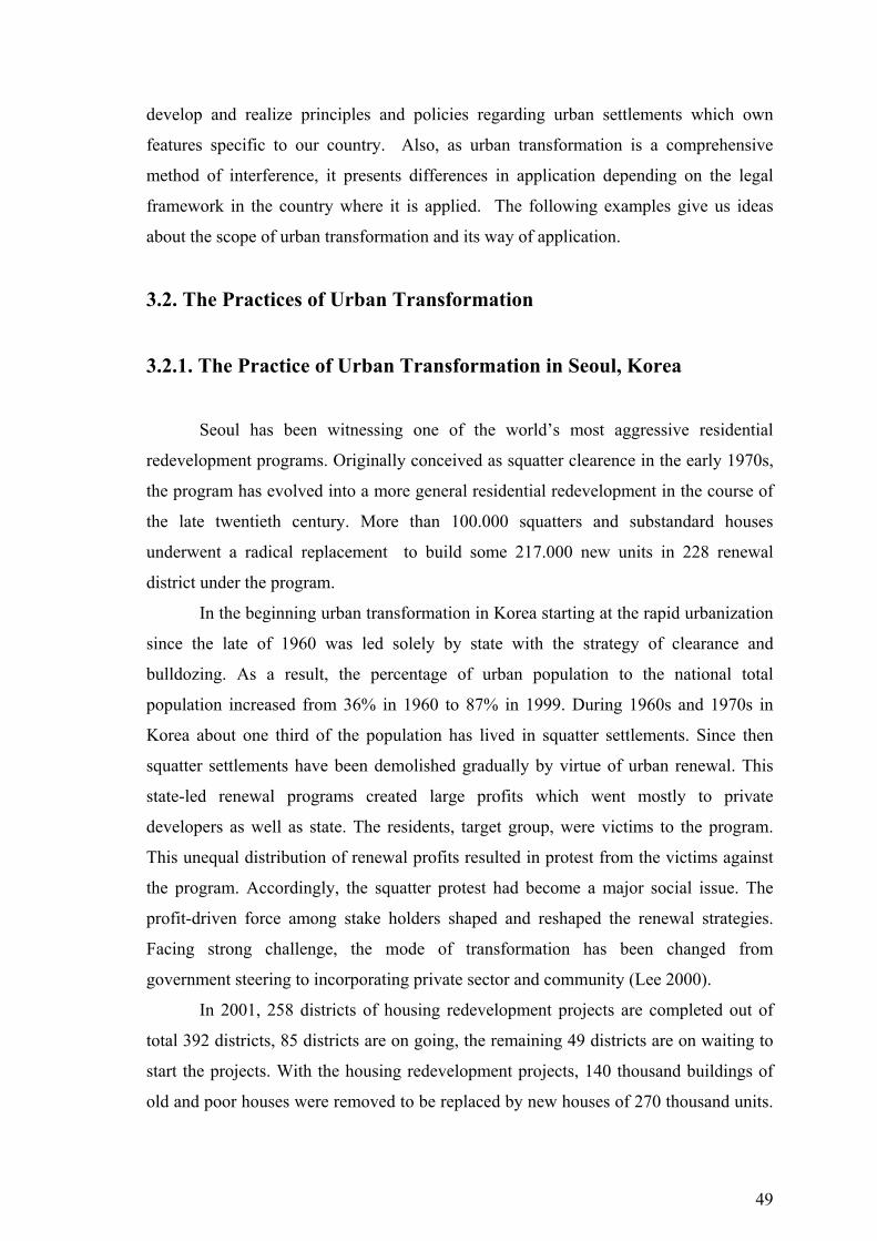
49
develop and realize principles and policies regarding urban settlements which own
features specific to our country. Also, as urban transformation is a comprehensive
method of interference, it presents differences in application depending on the legal
framework in the country where it is applied. The following examples give us ideas
about the scope of urban transformation and its way of application.
3.2. The Practices of Urban Transformation
3.2.1. The Practice of Urban Transformation in Seoul, Korea
Seoul has been witnessing one of the world’s most aggressive residential
redevelopment programs. Originally conceived as squatter clearence in the early 1970s,
the program has evolved into a more general residential redevelopment in the course of
the late twentieth century. More than 100.000 squatters and substandard houses
underwent a radical replacement to build some 217.000 new units in 228 renewal
district under the program.
In the beginning urban transformation in Korea starting at the rapid urbanization
since the late of 1960 was led solely by state with the strategy of clearance and
bulldozing. As a result, the percentage of urban population to the national total
population increased from 36% in 1960 to 87% in 1999. During 1960s and 1970s in
Korea about one third of the population has lived in squatter settlements. Since then
squatter settlements have been demolished gradually by virtue of urban renewal. This
state-led renewal programs created large profits which went mostly to private
developers as well as state. The residents, target group, were victims to the program.
This unequal distribution of renewal profits resulted in protest from the victims against
the program. Accordingly, the squatter protest had become a major social issue. The
profit-driven force among stake holders shaped and reshaped the renewal strategies.
Facing strong challenge, the mode of transformation has been changed from
government steering to incorporating private sector and community (Lee 2000).
In 2001, 258 districts of housing redevelopment projects are completed out of
total 392 districts, 85 districts are on going, the remaining 49 districts are on waiting to
start the projects. With the housing redevelopment projects, 140 thousand buildings of
old and poor houses were removed to be replaced by new houses of 270 thousand units.
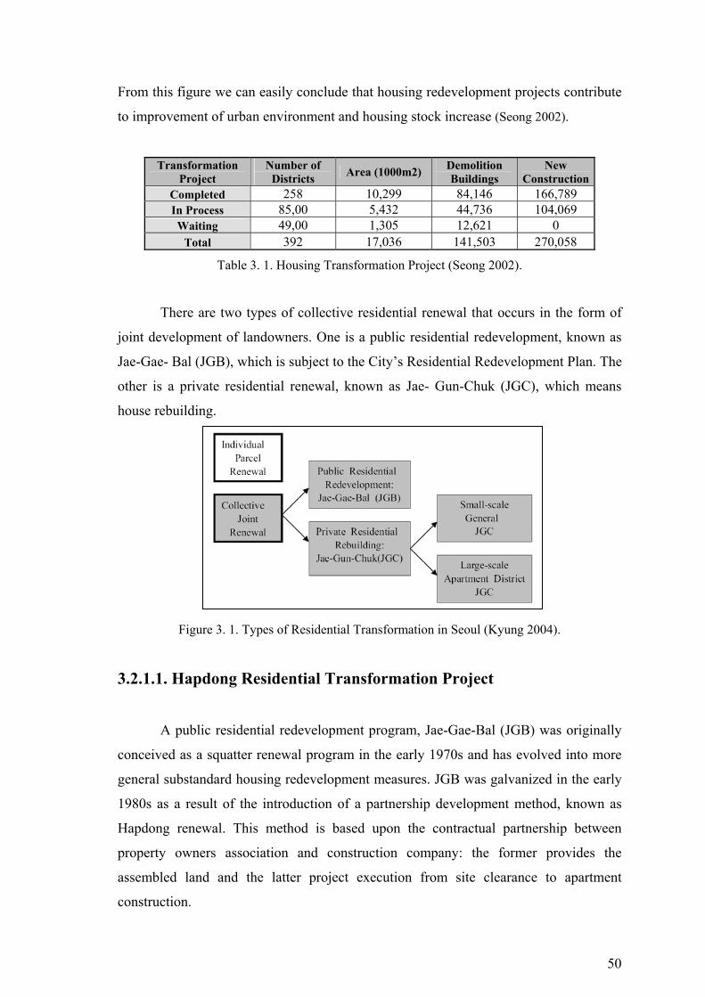
50
From this figure we can easily conclude that housing redevelopment projects contribute
to improvement of urban environment and housing stock increase (Seong 2002).
Transformation Project
Number of Districts Area (1000m2) Demolition
Buildings New
ConstructionCompleted 258 10,299 84,146 166,789 In Process 85,00 5,432 44,736 104,069 Waiting 49,00 1,305 12,621 0
Total 392 17,036 141,503 270,058
Table 3. 1. Housing Transformation Project (Seong 2002).
There are two types of collective residential renewal that occurs in the form of
joint development of landowners. One is a public residential redevelopment, known as
Jae-Gae- Bal (JGB), which is subject to the City’s Residential Redevelopment Plan. The
other is a private residential renewal, known as Jae- Gun-Chuk (JGC), which means
house rebuilding.
Figure 3. 1. Types of Residential Transformation in Seoul (Kyung 2004).
3.2.1.1. Hapdong Residential Transformation Project
A public residential redevelopment program, Jae-Gae-Bal (JGB) was originally
conceived as a squatter renewal program in the early 1970s and has evolved into more
general substandard housing redevelopment measures. JGB was galvanized in the early
1980s as a result of the introduction of a partnership development method, known as
Hapdong renewal. This method is based upon the contractual partnership between
property owners association and construction company: the former provides the
assembled land and the latter project execution from site clearance to apartment
construction.

51
Figure 3. 2. Hapdong Project-Residential Rebuilding Sites (Kwang 2000).
In 1993, the city devised the innovative Hapdong redevelopment scheme, which
it hoped would solve the chronic problem of project financing in residential
redevelopment. In Hapdong redevelopment, the residents provide land and a
construction company, in theory, takes charge of the development costs. The
combination of the residents and a construction company followed from earlier
redevelopment projects. However, the key difference in Hapdong redevelopment is its
independent financing scheme. The city government provides no public assistance.
Nonetheless, residents are not obliged to pay for the initial project costs and the
construction company is assured a reasonable profit. In Korea, new housing is sold
before construction. This special housing market condition made the Hapdong
redevelopment scheme workable because the city allows extra housing construction for
sale. The revenue from the sale of the additional housing units makes the project
feasible (Chang and Jong 2003).
Figure 3. 3. Hapdong Project before clearence Figure 3. 4. Hapdong Project after completion (Chang and Jong 2003). (Chang and Jong 2003).
52
3.2.1.2. Framework of the Hapdong Redevelopment Project
The Hapdong redevelopment approach can be characterised as follows: an
association of owners, rather than the city government, becomes the implementer of the
redevelopment project; the owners’ association selects a construction company that will
proceed with the redevelopment project; and the city government allows high-density
development to ensure reasonable profits for all participants (Koh and Yoon 2002).
Name of District Hapdong Existing Housing Stock 2368 Project Area (ha) 150.562 Development Density (unit/ha) 160 Ratio of Public Owning Land (%) 95.4 Expected Project Period(months) 84 Height (m) 67 Existing Households 2.337 Building Site Ratio (%) 326 Tenants Ratio (%) 49.4 Time of Completion (year) 12,14
Table 3. 2. General Information of Hapdong Project (Koh and Yoon 2002).
Hapdong redevelopment proceeds in the following way. The city government
designates residential redevelopment districts by a field survey of blighted and sub-
standard housing areas. After that, the owners in a redevelopment site democratically
organise an owners’ association for redevelopment and select a construction company
as a partner. The construction company prepares a project plan focusing on site and
architectural schemes, and the city government reviews the proposed plan. If the plan is
accepted, the city government issues implementation permission for the project. After
the implementation permission is issued, the owners decide whether to participate in the
project by applying for new housing units or to leave the project by applying for
compensation for their properties. After this new housing application period, the
construction company arranges loans to the new housing applicants for the costs of
moving to temporary residences. Immediately after the evacuation, the construction
company starts redevelopment (Koh and Yoon 2002).
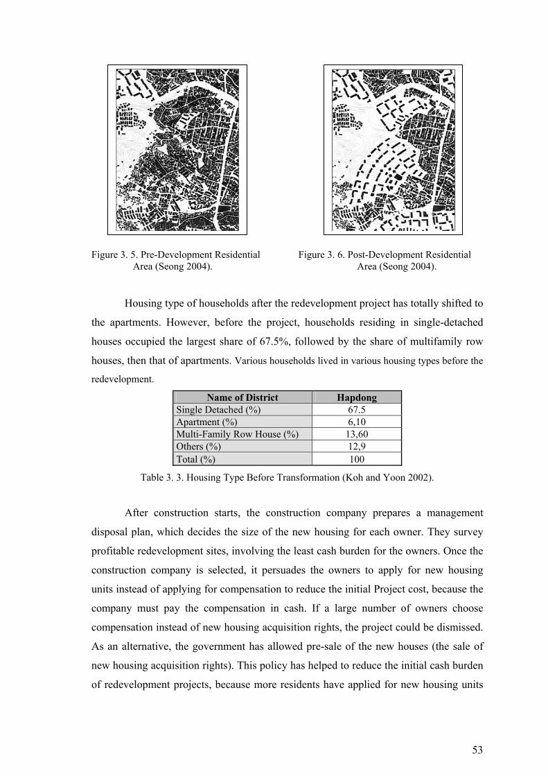
53
Figure 3. 5. Pre-Development Residential Figure 3. 6. Post-Development Residential
Area (Seong 2004). Area (Seong 2004).
Housing type of households after the redevelopment project has totally shifted to
the apartments. However, before the project, households residing in single-detached
houses occupied the largest share of 67.5%, followed by the share of multifamily row
houses, then that of apartments. Various households lived in various housing types before the
redevelopment.
Name of District Hapdong Single Detached (%) 67.5 Apartment (%) 6,10 Multi-Family Row House (%) 13,60 Others (%) 12,9 Total (%) 100
Table 3. 3. Housing Type Before Transformation (Koh and Yoon 2002).
After construction starts, the construction company prepares a management
disposal plan, which decides the size of the new housing for each owner. They survey
profitable redevelopment sites, involving the least cash burden for the owners. Once the
construction company is selected, it persuades the owners to apply for new housing
units instead of applying for compensation to reduce the initial Project cost, because the
company must pay the compensation in cash. If a large number of owners choose
compensation instead of new housing acquisition rights, the project could be dismissed.
As an alternative, the government has allowed pre-sale of the new houses (the sale of
new housing acquisition rights). This policy has helped to reduce the initial cash burden
of redevelopment projects, because more residents have applied for new housing units
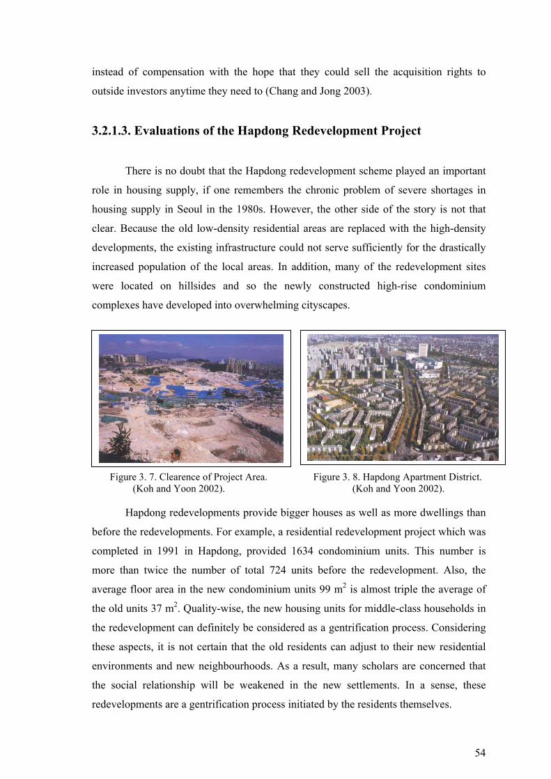
54
instead of compensation with the hope that they could sell the acquisition rights to
outside investors anytime they need to (Chang and Jong 2003).
3.2.1.3. Evaluations of the Hapdong Redevelopment Project
There is no doubt that the Hapdong redevelopment scheme played an important
role in housing supply, if one remembers the chronic problem of severe shortages in
housing supply in Seoul in the 1980s. However, the other side of the story is not that
clear. Because the old low-density residential areas are replaced with the high-density
developments, the existing infrastructure could not serve sufficiently for the drastically
increased population of the local areas. In addition, many of the redevelopment sites
were located on hillsides and so the newly constructed high-rise condominium
complexes have developed into overwhelming cityscapes.
Figure 3. 7. Clearence of Project Area. Figure 3. 8. Hapdong Apartment District. (Koh and Yoon 2002). (Koh and Yoon 2002).
Hapdong redevelopments provide bigger houses as well as more dwellings than
before the redevelopments. For example, a residential redevelopment project which was
completed in 1991 in Hapdong, provided 1634 condominium units. This number is
more than twice the number of total 724 units before the redevelopment. Also, the
average floor area in the new condominium units 99 m2 is almost triple the average of
the old units 37 m2. Quality-wise, the new housing units for middle-class households in
the redevelopment can definitely be considered as a gentrification process. Considering
these aspects, it is not certain that the old residents can adjust to their new residential
environments and new neighbourhoods. As a result, many scholars are concerned that
the social relationship will be weakened in the new settlements. In a sense, these
redevelopments are a gentrification process initiated by the residents themselves.

55
Hapdong redevelopment has enabled the redevelopment of sub-standard housing
areas through the market system without public assistance and at an accelerated pace.
However, there are controversial issues. The re-entering rate of the original residents is
extremely low and there is a considerable amount of development profits from the
projects being passed to outside investors rather than to the old residents in the
redevelopment sites. Although the new type of residential redevelopment scheme has
changed the old equity competition of urban renewal into a revenue-sharing game in the
market system, low-income households in the Hapdong redevelopment process remain
disadvantaged, because of their financial vulnerability (Chang and Jong 2003).
Here, it is necessary to rethink the old ideas of rehousing residents through
residential redevelopment. As soon as the market-driven approach is introduced, the
goal might become unreachable. A redevelopment project becomes a resident-initiated
gentrification process that makes the residents seek a larger share of windfall gains
rather than a new house in a nicely rearranged residential setting that retains the old
community spirit. With these unavoidable changes in residents’ behaviours, the public
goal of residential redevelopment may need to be revised to provide residents with more
money rather than a new house. This change may not be a bad alternative. In this
respect, Hapdong redevelopment is functioning as a kind of income subsidy programme
for the low-income households in the redevelopment areas. However, their shares are
smaller than anticipated.
Hapdong Resiential Transformation Project
Exist/ Non-Exist Statement
Integration with City Plan Exist
Southeast region in Seoul, squatter clearance is the main strategy in master plan for transforming new residential areas.
Rehabilitation Strategy Compatibility Non-Exist
After, Hapdong redevelopment project starts, old low-density residential are replaced with the high-density developments.
Urban Development Strategy
Compatibility Exist
♦ To transform squatter areas on southeast region.
♦ To increase housing stock in city.
Developer Impact on Economic Structure Non-Exist
There is no economic development impact on urban scale, but in Hapdong Redevelopment, the residents and construction company are increased profit.
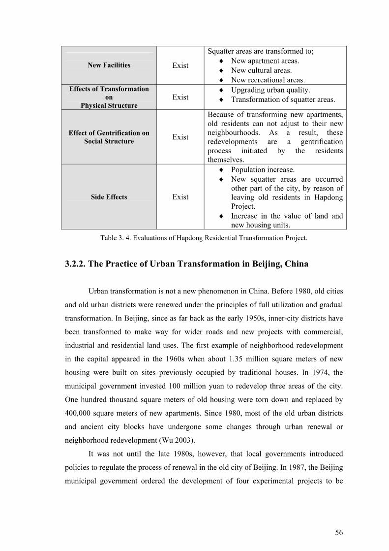
56
New Facilities
Exist
Squatter areas are transformed to; ♦ New apartment areas. ♦ New cultural areas. ♦ New recreational areas.
Effects of Transformation on
Physical Structure Exist
♦ Upgrading urban quality. ♦ Transformation of squatter areas.
Effect of Gentrification on Social Structure Exist
Because of transforming new apartments, old residents can not adjust to their new neighbourhoods. As a result, these redevelopments are a gentrification process initiated by the residents themselves.
Side Effects Exist
♦ Population increase. ♦ New squatter areas are occurred
other part of the city, by reason of leaving old residents in Hapdong Project.
♦ Increase in the value of land and new housing units.
Table 3. 4. Evaluations of Hapdong Residential Transformation Project.
3.2.2. The Practice of Urban Transformation in Beijing, China
Urban transformation is not a new phenomenon in China. Before 1980, old cities
and old urban districts were renewed under the principles of full utilization and gradual
transformation. In Beijing, since as far back as the early 1950s, inner-city districts have
been transformed to make way for wider roads and new projects with commercial,
industrial and residential land uses. The first example of neighborhood redevelopment
in the capital appeared in the 1960s when about 1.35 million square meters of new
housing were built on sites previously occupied by traditional houses. In 1974, the
municipal government invested 100 million yuan to redevelop three areas of the city.
One hundred thousand square meters of old housing were torn down and replaced by
400,000 square meters of new apartments. Since 1980, most of the old urban districts
and ancient city blocks have undergone some changes through urban renewal or
neighborhood redevelopment (Wu 2003).
It was not until the late 1980s, however, that local governments introduced
policies to regulate the process of renewal in the old city of Beijing. In 1987, the Beijing
municipal government ordered the development of four experimental projects to be

57
implemented on the sites with the worst living standards within the four inner-city
districts. Three of those four projects were implemented and completed by 1990.
In 1990, the People's Municipal Government of Beijing commissioned the
Beijing City Planning Institute to draw up a master plan for the four central city
districts, in order to accelerate their renewal. What is known as the Old and Dilapidated
Housing Renewal Program was then initiated. As many as thirty-seven regeneration
projects were started in the old city districts through this program in 1990. Only eight of
them have so far been completed and inhabited (Wu and He 2004).
3.2.2.1. Ju-er Hutong Residential Transformation Project
In 1987, the Beijing Housing Reform Office launched a pilot program to test
various approaches to rehabilitating dilapidated inner-city housing. With limited
funding from the municipal government (Yn10 million), each of the four districts that
comprise the Old City was expected to nominate a site for renewal and develop its own
way to finance the project. The East District government selected the Ju-er Hutong
neighborhood (Li 2003).
The Ju-er Hutong project, a government pilot program to rehabilitate dilapidated
housing in inner-city Beijing, was tought as a successful model of housing design by
academia and authorities alike. However, it was suspended after its second phase; its
surprising fate begs the question of how and why this award-winning, government
model of housing renewal was abandoned and not replicated elsewhere in Beijing.
Figure 3. 9. The pre-renewal condition in Ju-er Figure 3. 10. Ju-er Hutong: the pre-renewal Hutong(surrounded by high-rise building)(Wu 2003). Siteplan (Wu 2003).
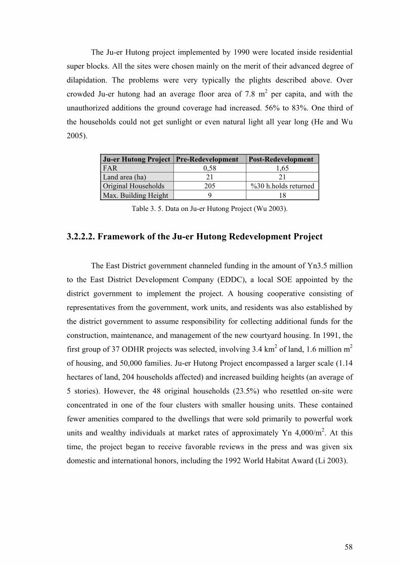
58
The Ju-er Hutong project implemented by 1990 were located inside residential
super blocks. All the sites were chosen mainly on the merit of their advanced degree of
dilapidation. The problems were very typically the plights described above. Over
crowded Ju-er hutong had an average floor area of 7.8 m2 per capita, and with the
unauthorized additions the ground coverage had increased. 56% to 83%. One third of
the households could not get sunlight or even natural light all year long (He and Wu
2005).
Ju-er Hutong Project Pre-Redevelopment Post-Redevelopment FAR 0,58 1,65 Land area (ha) 21 21 Original Households 205 %30 h.holds returned Max. Building Height 9 18
Table 3. 5. Data on Ju-er Hutong Project (Wu 2003).
3.2.2.2. Framework of the Ju-er Hutong Redevelopment Project
The East District government channeled funding in the amount of Yn3.5 million
to the East District Development Company (EDDC), a local SOE appointed by the
district government to implement the project. A housing cooperative consisting of
representatives from the government, work units, and residents was also established by
the district government to assume responsibility for collecting additional funds for the
construction, maintenance, and management of the new courtyard housing. In 1991, the
first group of 37 ODHR projects was selected, involving 3.4 km2 of land, 1.6 million m2
of housing, and 50,000 families. Ju-er Hutong Project encompassed a larger scale (1.14
hectares of land, 204 households affected) and increased building heights (an average of
5 stories). However, the 48 original households (23.5%) who resettled on-site were
concentrated in one of the four clusters with smaller housing units. These contained
fewer amenities compared to the dwellings that were sold primarily to powerful work
units and wealthy individuals at market rates of approximately Yn 4,000/m2. At this
time, the project began to receive favorable reviews in the press and was given six
domestic and international honors, including the 1992 World Habitat Award (Li 2003).
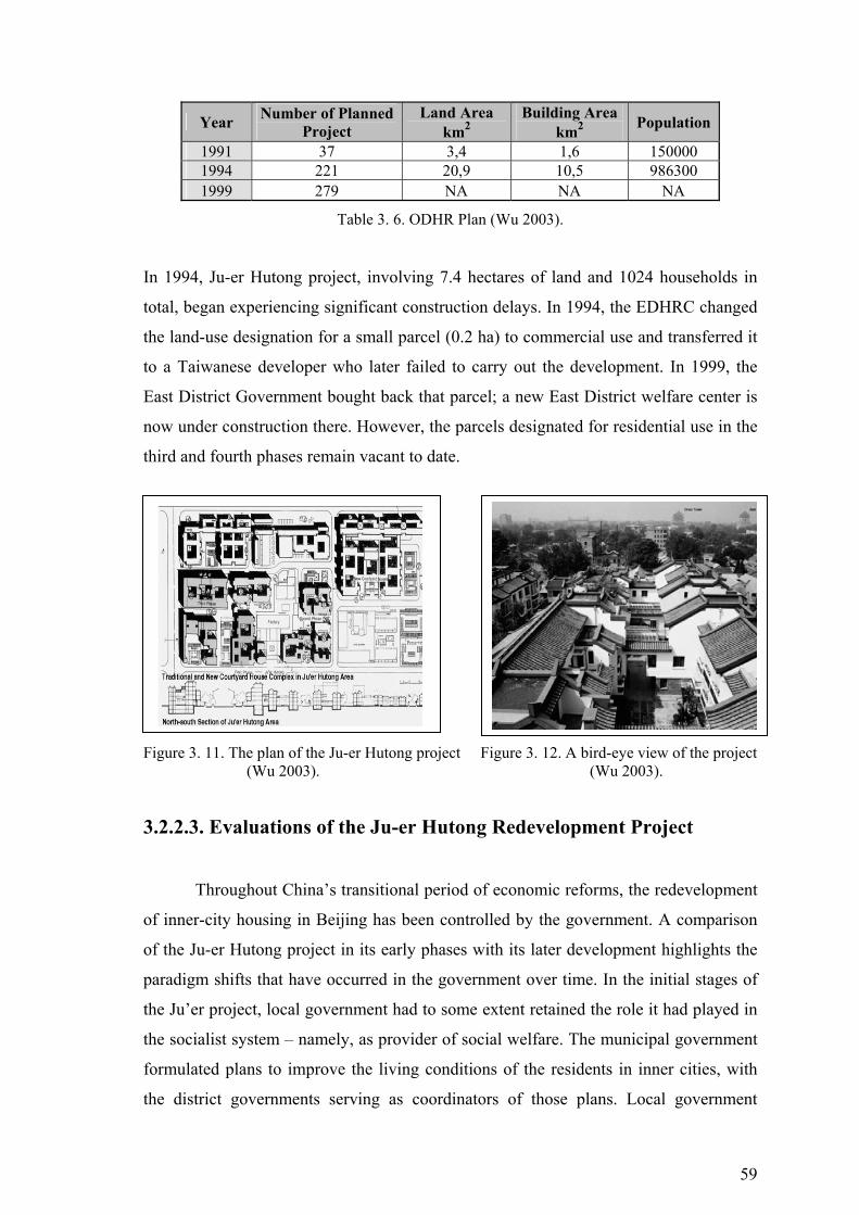
59
Year Number of Planned Project
Land Area km2
Building Area km2 Population
1991 37 3,4 1,6 150000 1994 221 20,9 10,5 986300 1999 279 NA NA NA
Table 3. 6. ODHR Plan (Wu 2003).
In 1994, Ju-er Hutong project, involving 7.4 hectares of land and 1024 households in
total, began experiencing significant construction delays. In 1994, the EDHRC changed
the land-use designation for a small parcel (0.2 ha) to commercial use and transferred it
to a Taiwanese developer who later failed to carry out the development. In 1999, the
East District Government bought back that parcel; a new East District welfare center is
now under construction there. However, the parcels designated for residential use in the
third and fourth phases remain vacant to date.
Figure 3. 11. The plan of the Ju-er Hutong project Figure 3. 12. A bird-eye view of the project (Wu 2003). (Wu 2003).
3.2.2.3. Evaluations of the Ju-er Hutong Redevelopment Project
Throughout China’s transitional period of economic reforms, the redevelopment
of inner-city housing in Beijing has been controlled by the government. A comparison
of the Ju-er Hutong project in its early phases with its later development highlights the
paradigm shifts that have occurred in the government over time. In the initial stages of
the Ju’er project, local government had to some extent retained the role it had played in
the socialist system – namely, as provider of social welfare. The municipal government
formulated plans to improve the living conditions of the residents in inner cities, with
the district governments serving as coordinators of those plans. Local government

60
provided land and initial funding, while adopting preferential policies to benefit local
SOEs in ODHR projects. However, local government also acted as a gatekeeper to
protect construction companies against financial losses and to guarantee the provision of
basic housing needs for households impacted by redevelopment (Fang and Zhang
2003).
Period Features of ODHR Behaviors Ju-er Hutong Project Small-scale Provided Land, transition
Before 1992 experiments housing and initial funds Ju-er Hutong Project Large-scale Provided Land, guaranteed
After 1992 redevelopment basic housing needs of affected households
Table 3. 7. Ju-er Hutong Project before and after 1992 (Wu 2003).
When the Ju-er Hutong project was ready to be scaled up in 1992, Beijing’s
booming real-estate market triggered a transformation of the ODHR program. From a
non-profit housing rehabilitation effort, it evolved into a for-profit urban redevelopment
program. With devolution of state power over land leasing and land use, local
governments tried to increase their revenues by promoting market-driven
redevelopment.
The relaxation of these policies left an opening for developers to engage in
nonresidential projects and seek to maximize their profits under the auspices of the
ODHR. In fact, local governments even encouraged, if not forced, residents to relocate
to low-quality housing on the outskirts of the city in order to free up land for the real-
estate market. Despite the resulting negative social and environmental impacts of this
transition, local government adopted a laissez faire attitude and turned into an operator
of the growth machine. When the Ju-er Hutong project was initiated, the EDDC (East
District Development Company) was a lower branch of the local government. Its major
function was to implement the government’s construction plans. After a project’s
completion, EDDC passed the buildings on to the corresponding government branches
for allocation and management (Zhang and Fang 2003).
Exempted from land-use tax and infrastructure fees, and subsidized by the
government and work units, Phase I of the Ju-er project covered its development cost.
Even the developer acknowledged the project’s considerable profitability in the second
phase. During the third and fourth phases, as the government’s subsidies were phased
out, the EDDC took over the leading role in the Ju-er Hutong project. Most importantly,
instead of the low-rise new courtyard housing project, the EDDC and other SOEs began
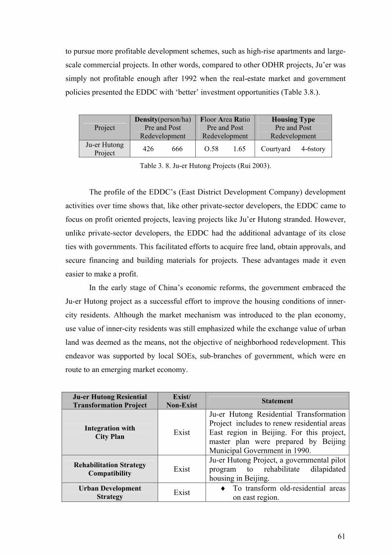
61
to pursue more profitable development schemes, such as high-rise apartments and large-
scale commercial projects. In other words, compared to other ODHR projects, Ju’er was
simply not profitable enough after 1992 when the real-estate market and government
policies presented the EDDC with ‘better’ investment opportunities (Table 3.8.).
Project Density(person/ha)
Pre and Post Redevelopment
Floor Area Ratio Pre and Post
Redevelopment
Housing Type Pre and Post
Redevelopment Ju-er Hutong
Project 426 666 O.58 1.65 Courtyard 4-6story
Table 3. 8. Ju-er Hutong Projects (Rui 2003).
The profile of the EDDC’s (East District Development Company) development
activities over time shows that, like other private-sector developers, the EDDC came to
focus on profit oriented projects, leaving projects like Ju’er Hutong stranded. However,
unlike private-sector developers, the EDDC had the additional advantage of its close
ties with governments. This facilitated efforts to acquire free land, obtain approvals, and
secure financing and building materials for projects. These advantages made it even
easier to make a profit.
In the early stage of China’s economic reforms, the government embraced the
Ju-er Hutong project as a successful effort to improve the housing conditions of inner-
city residents. Although the market mechanism was introduced to the plan economy,
use value of inner-city residents was still emphasized while the exchange value of urban
land was deemed as the means, not the objective of neighborhood redevelopment. This
endeavor was supported by local SOEs, sub-branches of government, which were en
route to an emerging market economy.
Ju-er Hutong Resiential Transformation Project
Exist/ Non-Exist Statement
Integration with City Plan Exist
Ju-er Hutong Residential Transformation Project includes to renew residential areas East region in Beijing. For this project, master plan were prepared by Beijing Municipal Government in 1990.
Rehabilitation Strategy Compatibility Exist
Ju-er Hutong Project, a governmental pilot program to rehabilitate dilapidated housing in Beijing.
Urban Development Strategy Exist ♦ To transform old-residential areas
on east region.

62
Compatibility ♦ To rehabilitate housing stock in city.
Developer Impact on Economic Structure Non-Exist
There is no economic development impact on urban scale, but in Project, the residents and construction company are increased profit.
New Facilities
Exist
Old-residential areas are transformed to; ♦ New housing areas. ♦ New recreational areas.
Effects of Transformation on
Physical Structure Exist
♦ Upgrading urban quality. ♦ Transformation of residential
areas.
Effect of Gentrification on Social Structure Non-Exist
Because of transforming old residents to new residents, there is no gentrification process in Ju-er Hutong Residential Project. Old residents stayed in Project area. This project was tought as a successful model of housing design by academia.
Side Effects Exist
♦ Population increase. ♦ To improve living condition. ♦ Increase in the value of land and
new housing units. Table 3. 9. Evaluations of Ju-er Hutong Residential Transformation Project.
3.2.3. The Practice of Urban Transformation in Singapore
As with parallel approaches elsewhere, the Singapore government introduced a
new planning incentive in the early 1990s that relied primarily on private investment to
stimulate urban redevelopment in central-city locations. Despite institutional differences
between Singapore and other western cities, two common features of their recent urban
policy initiatives towards inner city redevelopment have been an emphasis on the
private sector and an unprecedented faith in the efficiency of the market (Lum 2004).
In particular, private sector participation in the urban renewal of Singapore has
been largely passive. Under the Government Land Sales (GLS) program that began in
1967, sub-optimally used land parcels were acquired and assembled by the state for
comprehensive redevelopment. This changed with the release of the first of 55 DGPs
(Development Guide Plan) in 1994. Singapore is currently divided into 55 planning
areas. For privately owned sites in many of the centrally located areas, the DGPs
relaxed extent development controls on building density in terms of the allowable plot

63
ratio or floor area ratio (FAR). The land-use planning density bonus gave rise to
attractive land value enhancement possibilities that triggered a string of what have been
called en bloc or collective sales. In such a sale, owners of fragmented interests in land
responded to the DGP inducement of private gains by banding together to sell their
combined sites for redevelopment collectively (Savage and Kong 2003).
3.2.3.1. Singapore River Transformation Project
Figure 3. 13. The Singapore River Project before the clean-up (Lum 2004).
The Singapore River has since undergone rapid transformation in the past 25
years, with old buildings restored and new developments springing up by the river
banks alongside the heritage buildings. By 1970s, the river had become one large
dumping ground for the street hawkers and squatter settlements that had settled around
its shores. Thus, in 1977, the government embarked on the mammoth task of cleaning
up the river. Ten years later, marine life started to thrive in this river. With the river
cleaned up, the next stage is to redevelop the area around the river. The Urban
Redevelopment Authority (URA) undertook the planning of the Singapore River. It was
envisioned that the river could be transformed into a waterway providing waterfront
housing, entertainment and dining facilities to all Singaporeans. It will be a river
sparkling with life and exuberance for all to enjoy (Leitmann 2000).
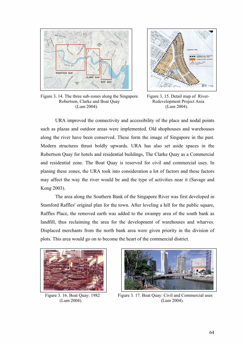
64
Figure 3. 14. The three sub-zones along the Singapore Figure 3. 15. Detail map of River-
Robertson, Clarke and Boat Quay Redevelopment Project Area (Lum 2004). (Lum 2004).
URA improved the connectivity and accessibility of the place and nodal points
such as plazas and outdoor areas were implemented. Old shophouses and warehouses
along the river have been conserved. These form the image of Singapore in the past.
Modern structures thrust boldly upwards. URA has also set aside spaces in the
Robertson Quay for hotels and residential buildings, The Clarke Quay as a Commercial
and residential zone. The Boat Quay is reserved for civil and commercial uses. In
planing these zones, the URA took into consideration a lot of factors and these factors
may affect the way the river would be and the type of activities near it (Savage and
Kong 2003).
The area along the Southern Bank of the Singapore River was first developed in
Stamford Raffles' original plan for the town. After leveling a hill for the public square,
Raffles Place, the removed earth was added to the swampy area of the south bank as
landfill, thus reclaiming the area for the development of warehouses and wharves.
Displaced merchants from the north bank area were given priority in the division of
plots. This area would go on to become the heart of the commercial district.
Figure 3. 16. Boat Quay: 1982 Figure 3. 17. Boat Quay: Civil and Commercial uses (Lum 2004). (Lum 2004).

65
3.2.3.2. Framework of the Singapore River Transformation Project
In 1983 as part of the government's efforts to clean up the river, the remaining
shipping industry's lighters were moved to a new site off Pasir Panjang. The presence of
the industry had already begun to dwindle with the introduction of the more efficient
and safe mechanized container port at Tanjong Pagar. Thus, from 1983 to about 1990
the Boat Quay was empty and unused. Once the area was designated a conservation area
in 1989, redevelopment began and by 1993 every shophouse was under reconstruction.
The redevelopment area is a triangular piece of land surrounded by the Singapore River
to the east, South Bridge Road to the west and North Canal Road to the south. The quay
is about 110 shophouses long. In total the conservation area includes about 200 two or
three story shophouses of the "Early, Transitional and Art Deco Styles." The majority of
the buildings were built in the 1920's and 1930's with extensive renovations after WWII.
Shipping offices, supply shops and warehouses were housed in these buildings. The
area was typically covered with items such as shipping crates, stacks of rubber and rice
sacks that had been unloaded from the brightly colored tongkangs (Malay for barge or
lighter) (Savage and Kong 2003).
The shophouse is a traditional architectural form in Singapore, and a building
type indigenous to South East Asia, with its origins in the Chinese provinces and
influenced by European colonial architecture. Typically they were used for businesses
at the ground level and had living spaces on the upper floors. Spatially they are narrow,
small and terraced, having exposed timber structure and staircases and a masonry party
wall. Being only 6 meters wide, the resultant depth of the building's interior was opened
up by internal open-air courtyards. The distinctive five foot covered walkways that line
the quay and form a continuous path along it are actually a remnant from Raffles'
original plan's concern for public spaces and pedestrians. As well as providing shelter
from bad weather, these spaces, which were required on all houses on both sides of the
street, were also used by minor random tradesmen such as fortune-tellers, barbers,
medicine men, and traveling foodsellers (Leitmann 2000).
China Square is one of the earliest urbanised areas in Singapore, dating back to
The Raffles Town Plan in 1822. It was the site where early immigrants first landed and
settled down along the shoreline of Telok Ayer Street. With the settlement of the
Chinese south of the Singapore River, it was part of the Chinese enclave (home to the
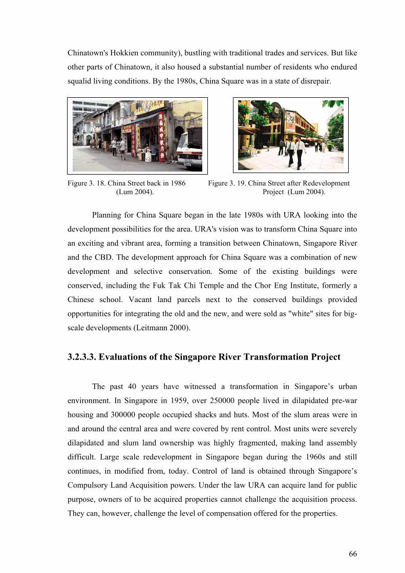
66
Chinatown's Hokkien community), bustling with traditional trades and services. But like
other parts of Chinatown, it also housed a substantial number of residents who endured
squalid living conditions. By the 1980s, China Square was in a state of disrepair.
Figure 3. 18. China Street back in 1986 Figure 3. 19. China Street after Redevelopment (Lum 2004). Project (Lum 2004).
Planning for China Square began in the late 1980s with URA looking into the
development possibilities for the area. URA's vision was to transform China Square into
an exciting and vibrant area, forming a transition between Chinatown, Singapore River
and the CBD. The development approach for China Square was a combination of new
development and selective conservation. Some of the existing buildings were
conserved, including the Fuk Tak Chi Temple and the Chor Eng Institute, formerly a
Chinese school. Vacant land parcels next to the conserved buildings provided
opportunities for integrating the old and the new, and were sold as "white" sites for big-
scale developments (Leitmann 2000).
3.2.3.3. Evaluations of the Singapore River Transformation Project
The past 40 years have witnessed a transformation in Singapore’s urban
environment. In Singapore in 1959, over 250000 people lived in dilapidated pre-war
housing and 300000 people occupied shacks and huts. Most of the slum areas were in
and around the central area and were covered by rent control. Most units were severely
dilapidated and slum land ownership was highly fragmented, making land assembly
difficult. Large scale redevelopment in Singapore began during the 1960s and still
continues, in modified from, today. Control of land is obtained through Singapore’s
Compulsory Land Acquisition powers. Under the law URA can acquire land for public
purpose, owners of to be acquired properties cannot challenge the acquisition process.
They can, however, challenge the level of compensation offered for the properties.
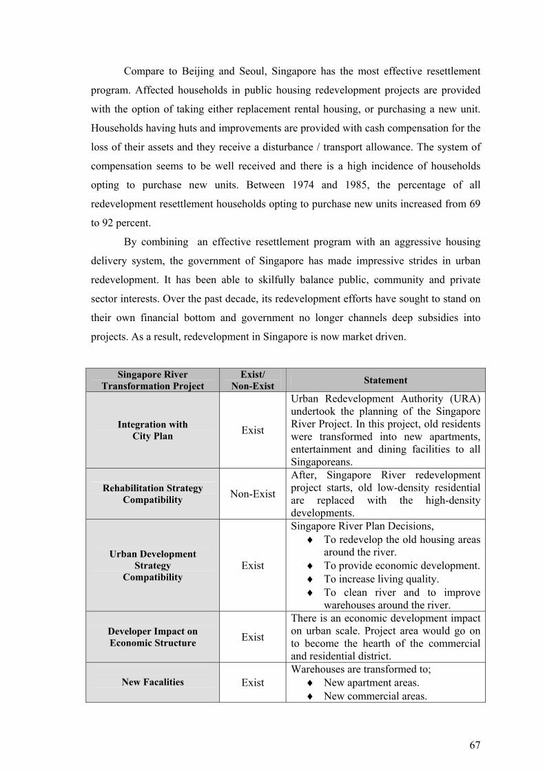
67
Compare to Beijing and Seoul, Singapore has the most effective resettlement
program. Affected households in public housing redevelopment projects are provided
with the option of taking either replacement rental housing, or purchasing a new unit.
Households having huts and improvements are provided with cash compensation for the
loss of their assets and they receive a disturbance / transport allowance. The system of
compensation seems to be well received and there is a high incidence of households
opting to purchase new units. Between 1974 and 1985, the percentage of all
redevelopment resettlement households opting to purchase new units increased from 69
to 92 percent.
By combining an effective resettlement program with an aggressive housing
delivery system, the government of Singapore has made impressive strides in urban
redevelopment. It has been able to skilfully balance public, community and private
sector interests. Over the past decade, its redevelopment efforts have sought to stand on
their own financial bottom and government no longer channels deep subsidies into
projects. As a result, redevelopment in Singapore is now market driven.
Singapore River Transformation Project
Exist/ Non-Exist Statement
Integration with City Plan Exist
Urban Redevelopment Authority (URA) undertook the planning of the Singapore River Project. In this project, old residents were transformed into new apartments, entertainment and dining facilities to all Singaporeans.
Rehabilitation Strategy Compatibility Non-Exist
After, Singapore River redevelopment project starts, old low-density residential are replaced with the high-density developments.
Urban Development Strategy
Compatibility Exist
Singapore River Plan Decisions, ♦ To redevelop the old housing areas
around the river. ♦ To provide economic development. ♦ To increase living quality. ♦ To clean river and to improve
warehouses around the river.
Developer Impact on Economic Structure Exist
There is an economic development impact on urban scale. Project area would go on to become the hearth of the commercial and residential district.
New Facalities
Exist
Warehouses are transformed to; ♦ New apartment areas. ♦ New commercial areas.
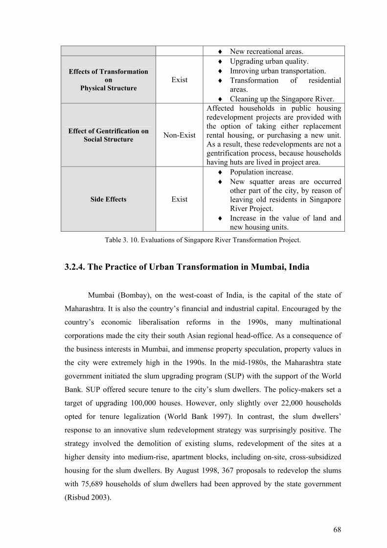
68
♦ New recreational areas.
Effects of Transformation on
Physical Structure Exist
♦ Upgrading urban quality. ♦ Imroving urban transportation. ♦ Transformation of residential
areas. ♦ Cleaning up the Singapore River.
Effect of Gentrification on Social Structure Non-Exist
Affected households in public housing redevelopment projects are provided with the option of taking either replacement rental housing, or purchasing a new unit. As a result, these redevelopments are not a gentrification process, because households having huts are lived in project area.
Side Effects Exist
♦ Population increase. ♦ New squatter areas are occurred
other part of the city, by reason of leaving old residents in Singapore River Project.
♦ Increase in the value of land and new housing units.
Table 3. 10. Evaluations of Singapore River Transformation Project.
3.2.4. The Practice of Urban Transformation in Mumbai, India
Mumbai (Bombay), on the west-coast of India, is the capital of the state of
Maharashtra. It is also the country’s financial and industrial capital. Encouraged by the
country’s economic liberalisation reforms in the 1990s, many multinational
corporations made the city their south Asian regional head-office. As a consequence of
the business interests in Mumbai, and immense property speculation, property values in
the city were extremely high in the 1990s. In the mid-1980s, the Maharashtra state
government initiated the slum upgrading program (SUP) with the support of the World
Bank. SUP offered secure tenure to the city’s slum dwellers. The policy-makers set a
target of upgrading 100,000 houses. However, only slightly over 22,000 households
opted for tenure legalization (World Bank 1997). In contrast, the slum dwellers’
response to an innovative slum redevelopment strategy was surprisingly positive. The
strategy involved the demolition of existing slums, redevelopment of the sites at a
higher density into medium-rise, apartment blocks, including on-site, cross-subsidized
housing for the slum dwellers. By August 1998, 367 proposals to redevelop the slums
with 75,689 households of slum dwellers had been approved by the state government
(Risbud 2003).
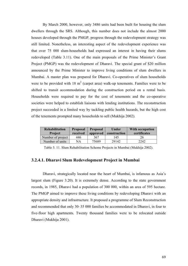
69
By March 2000, however, only 3486 units had been built for housing the slum
dwellers through the SRS. Although, this number does not include the almost 2000
houses developed through the PMGP, progress through the redevelopment strategy was
still limited. Nonetheless, an interesting aspect of the redevelopment experience was
that over 75 000 slum-households had expressed an interest in having their slums
redeveloped (Table 3.11). One of the main proposals of the Prime Minister’s Grant
Project (PMGP) was the redevelopment of Dharavi. The special grant of $20 million
announced by the Prime Minister to improve living conditions of slum dwellers in
Mumbai. A master plan was prepared for Dharavi. Co-operatives of slum households
were to be provided with 18 m2 (carpet area) walk-up tenements. Families were to be
shifted to transit accommodation during the construction period on a rental basis.
Households were required to pay for the cost of tenements and the co-operative
societies were helped to establish liaisons with lending institutions. The reconstruction
project succeeded in a limited way by tackling public health hazards, but the high cost
of the tenements prompted many households to sell (Mukhija 2002).
Rehabilitation Project
Proposal received
Proposal approved
Under construction
With occupation certificates
Number of project 446 367 145 26 Number of units NA 75689 29142 2242
Table 3. 11. Slum Rehabilitation Scheme Projects in Mumbai (Mukhija 2002).
3.2.4.1. Dharavi Slum Redevelopment Project in Mumbai
Dharavi, strategically located near the heart of Mumbai, is infamous as Asia’s
largest slum (Figure 3.20). It is extremely dense. According to the state government
records, in 1985, Dharavi had a population of 300 000, within an area of 595 hectare.
The PMGP aimed to improve these living conditions by redeveloping Dharavi with an
appropriate density and infrastructure. It proposed a programme of Slum Reconstruction
and recommended that only 30–35 000 families be accommodated in Dharavi, in four to
five-floor high apartments. Twenty thousand families were to be relocated outside
Dharavi (Mukhija 2001).
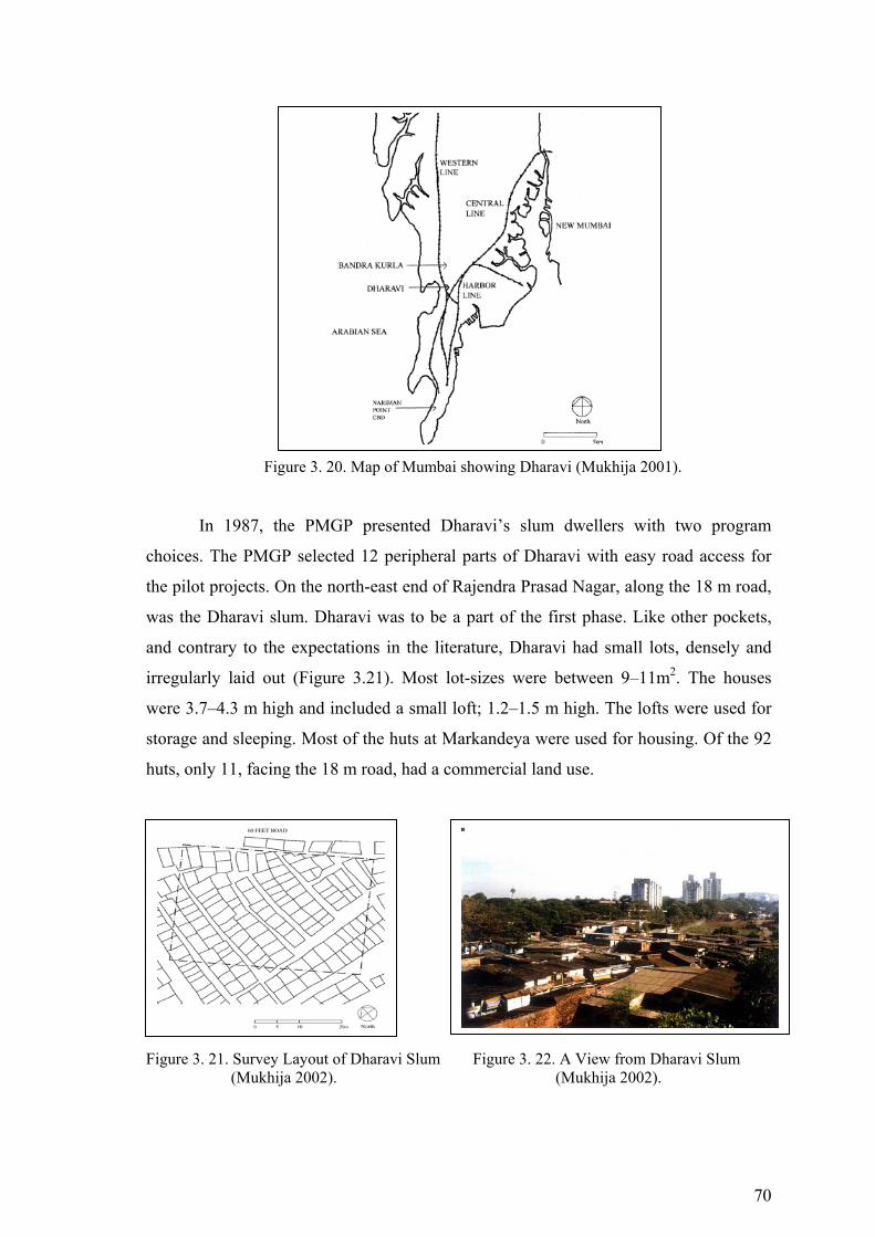
70
Figure 3. 20. Map of Mumbai showing Dharavi (Mukhija 2001).
In 1987, the PMGP presented Dharavi’s slum dwellers with two program
choices. The PMGP selected 12 peripheral parts of Dharavi with easy road access for
the pilot projects. On the north-east end of Rajendra Prasad Nagar, along the 18 m road,
was the Dharavi slum. Dharavi was to be a part of the first phase. Like other pockets,
and contrary to the expectations in the literature, Dharavi had small lots, densely and
irregularly laid out (Figure 3.21). Most lot-sizes were between 9–11m2. The houses
were 3.7–4.3 m high and included a small loft; 1.2–1.5 m high. The lofts were used for
storage and sleeping. Most of the huts at Markandeya were used for housing. Of the 92
huts, only 11, facing the 18 m road, had a commercial land use.
Figure 3. 21. Survey Layout of Dharavi Slum Figure 3. 22. A View from Dharavi Slum (Mukhija 2002). (Mukhija 2002).
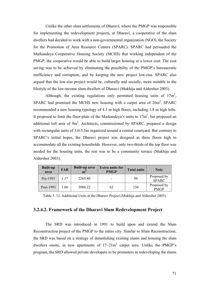
71
Unlike the other slum settlements of Dharavi, where the PMGP was responsible
for implementing the redevelopment projects, at Dharavi, a cooperative of the slum
dwellers had decided to work with a non-governmental organization (NGO), the Society
for the Promotion of Area Resource Centers (SPARC). SPARC had persuaded the
Markandeya Cooperative Housing Society (MCHS) that working independent of the
PMGP, the cooperative would be able to build larger housing at a lower cost. The cost
saving was to be achieved by eliminating the possibility of the PMGP’s bureaucratic
inefficiency and corruption, and by keeping the new project low-rise. SPARC also
argued that the low-rise project would be, culturally and socially, more suitable to the
lifestyle of the low-income slum dwellers of Dharavi (Mukhija and Aldershot 2003).
Although, the existing regulations only permitted housing units of 17m2,
SPARC had promised the MCHS new housing with a carpet area of 26m2. SPARC
recommended a new housing typology of 4.3 m high floors, including 1.8 m high lofts.
It proposed to limit the floor-plate of the Markandeya’s units to 17m2, but proposed an
additional loft area of 9m2. Architects, commissioned by SPARC, prepared a design
with rectangular units of 3.0-5.5m organized around a central courtyard. But contrary to
SPARC’s initial hopes, the Dharavi project was designed as three floors high to
accommodate all the existing households. However, only two-thirds of the top floor was
needed for the housing units, the rest was to be a community terrace (Mukhija and
Aldershot 2003).
Built-up area FAR Built-up area
m2 Extra units for
PMGP Total units Note
Pre-1991 1.17 2265.80 - 94 Proposed by SPARC
Post-1991 1.60 3086.22 62 156 Proposed by PMGP
Table 3. 12. Additional Units at the Dharavi Project (Mukhija and Aldershot 2003).
3.2.4.2. Framework of the Dharavi Slum Redevelopment Project
The SRD was introduced in 1991 to build upon and extend the Slum
Reconstruction project of the PMGP to the entire city. Similar to Slum Reconstruction,
the SRD was based on a strategy of demolishing existing slums and housing the slum
dwellers onsite, in new apartments of 17–21m2 carpet area. Unlike the PMGP’s
program, the SRD allowed private developers to be promoters in redeveloping the slums
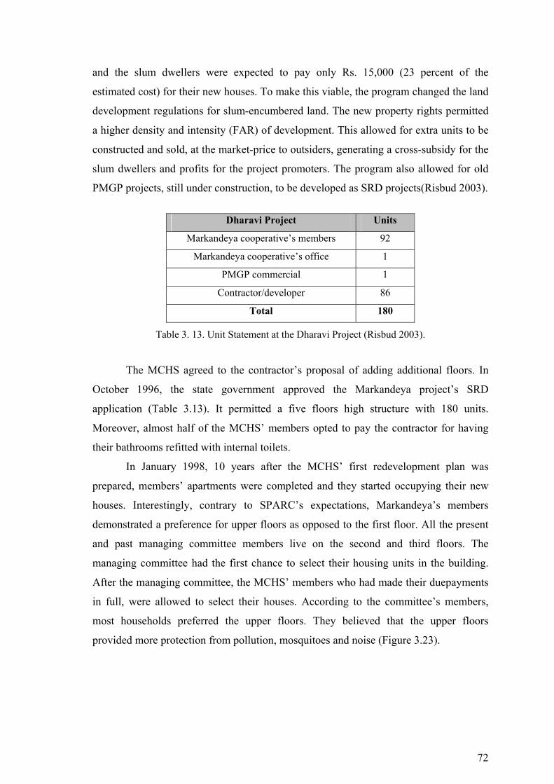
72
and the slum dwellers were expected to pay only Rs. 15,000 (23 percent of the
estimated cost) for their new houses. To make this viable, the program changed the land
development regulations for slum-encumbered land. The new property rights permitted
a higher density and intensity (FAR) of development. This allowed for extra units to be
constructed and sold, at the market-price to outsiders, generating a cross-subsidy for the
slum dwellers and profits for the project promoters. The program also allowed for old
PMGP projects, still under construction, to be developed as SRD projects(Risbud 2003).
Dharavi Project Units
Markandeya cooperative’s members 92
Markandeya cooperative’s office 1
PMGP commercial 1
Contractor/developer 86
Total 180
Table 3. 13. Unit Statement at the Dharavi Project (Risbud 2003).
The MCHS agreed to the contractor’s proposal of adding additional floors. In
October 1996, the state government approved the Markandeya project’s SRD
application (Table 3.13). It permitted a five floors high structure with 180 units.
Moreover, almost half of the MCHS’ members opted to pay the contractor for having
their bathrooms refitted with internal toilets.
In January 1998, 10 years after the MCHS’ first redevelopment plan was
prepared, members’ apartments were completed and they started occupying their new
houses. Interestingly, contrary to SPARC’s expectations, Markandeya’s members
demonstrated a preference for upper floors as opposed to the first floor. All the present
and past managing committee members live on the second and third floors. The
managing committee had the first chance to select their housing units in the building.
After the managing committee, the MCHS’ members who had made their duepayments
in full, were allowed to select their houses. According to the committee’s members,
most households preferred the upper floors. They believed that the upper floors
provided more protection from pollution, mosquitoes and noise (Figure 3.23).
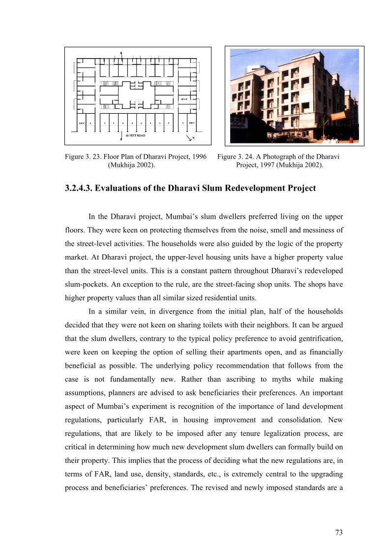
73
Figure 3. 23. Floor Plan of Dharavi Project, 1996 Figure 3. 24. A Photograph of the Dharavi (Mukhija 2002). Project, 1997 (Mukhija 2002).
3.2.4.3. Evaluations of the Dharavi Slum Redevelopment Project
In the Dharavi project, Mumbai’s slum dwellers preferred living on the upper
floors. They were keen on protecting themselves from the noise, smell and messiness of
the street-level activities. The households were also guided by the logic of the property
market. At Dharavi project, the upper-level housing units have a higher property value
than the street-level units. This is a constant pattern throughout Dharavi’s redeveloped
slum-pockets. An exception to the rule, are the street-facing shop units. The shops have
higher property values than all similar sized residential units.
In a similar vein, in divergence from the initial plan, half of the households
decided that they were not keen on sharing toilets with their neighbors. It can be argued
that the slum dwellers, contrary to the typical policy preference to avoid gentrification,
were keen on keeping the option of selling their apartments open, and as financially
beneficial as possible. The underlying policy recommendation that follows from the
case is not fundamentally new. Rather than ascribing to myths while making
assumptions, planners are advised to ask beneficiaries their preferences. An important
aspect of Mumbai’s experiment is recognition of the importance of land development
regulations, particularly FAR, in housing improvement and consolidation. New
regulations, that are likely to be imposed after any tenure legalization process, are
critical in determining how much new development slum dwellers can formally build on
their property. This implies that the process of deciding what the new regulations are, in
terms of FAR, land use, density, standards, etc., is extremely central to the upgrading
process and beneficiaries’ preferences. The revised and newly imposed standards are a
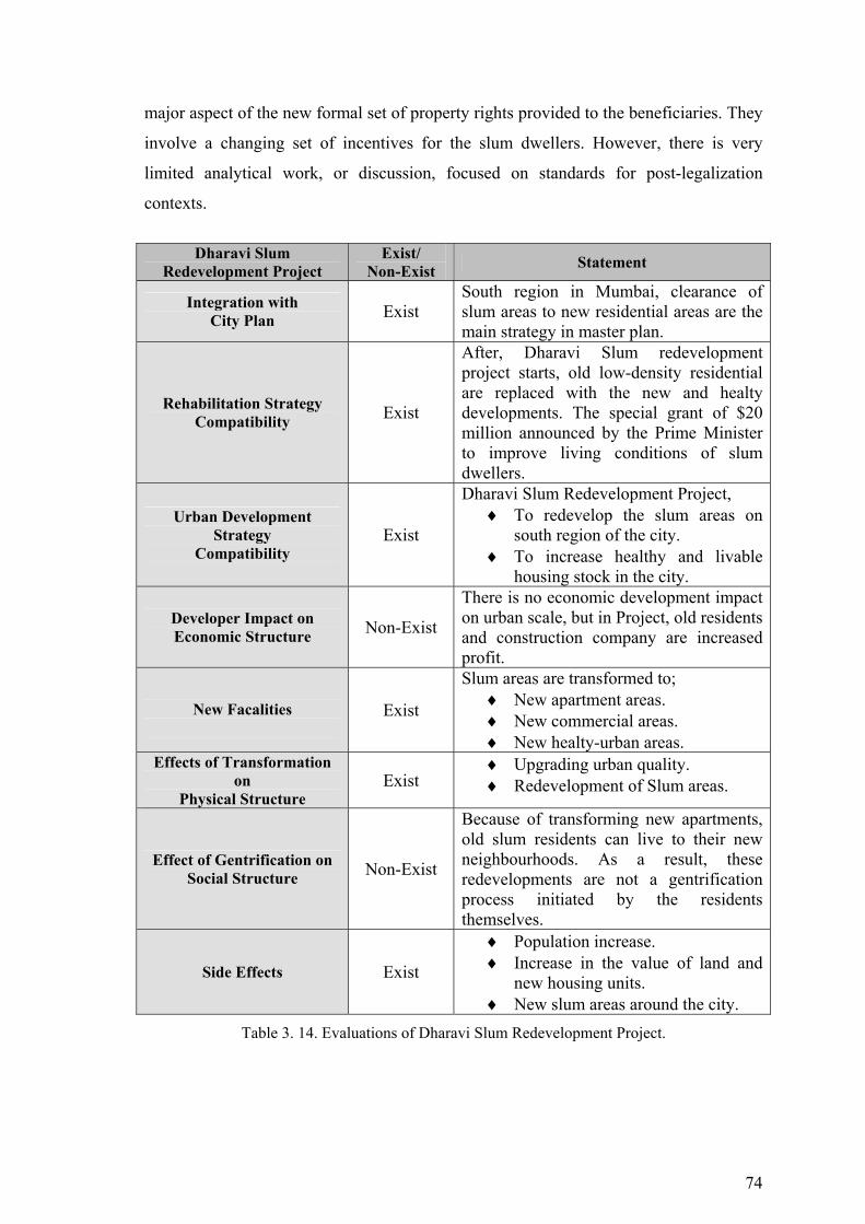
74
major aspect of the new formal set of property rights provided to the beneficiaries. They
involve a changing set of incentives for the slum dwellers. However, there is very
limited analytical work, or discussion, focused on standards for post-legalization
contexts.
Dharavi Slum
Redevelopment Project Exist/
Non-Exist Statement
Integration with City Plan Exist
South region in Mumbai, clearance of slum areas to new residential areas are the main strategy in master plan.
Rehabilitation Strategy Compatibility Exist
After, Dharavi Slum redevelopment project starts, old low-density residential are replaced with the new and healty developments. The special grant of $20 million announced by the Prime Minister to improve living conditions of slum dwellers.
Urban Development Strategy
Compatibility Exist
Dharavi Slum Redevelopment Project, ♦ To redevelop the slum areas on
south region of the city. ♦ To increase healthy and livable
housing stock in the city.
Developer Impact on Economic Structure Non-Exist
There is no economic development impact on urban scale, but in Project, old residents and construction company are increased profit.
New Facalities
Exist
Slum areas are transformed to; ♦ New apartment areas. ♦ New commercial areas. ♦ New healty-urban areas.
Effects of Transformation on
Physical Structure Exist
♦ Upgrading urban quality. ♦ Redevelopment of Slum areas.
Effect of Gentrification on Social Structure Non-Exist
Because of transforming new apartments, old slum residents can live to their new neighbourhoods. As a result, these redevelopments are not a gentrification process initiated by the residents themselves.
Side Effects Exist
♦ Population increase. ♦ Increase in the value of land and
new housing units. ♦ New slum areas around the city.
Table 3. 14. Evaluations of Dharavi Slum Redevelopment Project.
75
3.2.5. The Practice of Urban Transformation in Rie de Janeiro, Brazil
The municipality of Rio de Janeiro is the center of Brazil's second largest
metropolitan region. Like most Brazilian metropolises, the municipality is subject to the
consequences of the phenomena of ‘peripherization’ and informal urban expansion. As
a result of demographic pressure, aggravated by growing urban poverty and the absence
of suitable alternatives for settlements and housing poor families, the city has a long
history of illegal occupations of public and private land and thus the multiplication and
expansion of informal settlements. Most of Rio's slums are on steep hillsides and
subject to collapse, falling stones or rocks, and landslides. The others are in flood-prone
areas. According to recent data, more than one million are living in slums in Rio. The
Favela -Bairro program was conceived as an urban policy intervention rather than just a
public initiative to help solve the slum problem in the city of Rio de Janeiro. In this
respect it featured two basic principles: a) upgrading as the main public policy for
slums; b) housing as an urban issue, and so situated in a broader context. Note that the
Favela-Bairro program is an integral part of a larger program known as PROAP-RIO,
which involves upgrading of slums and informal and irregular subdivisions (Hunter
2004).
The Favela -Bairro program covers 158 slums and benefits 130,000 families or
500,000 people. This amounts to slightly less than half the number of residents in
informal areas of the city. The initial portion of the program was known as the Low-
income Settlements Urbanization Program (local acronym PROAP I) and covered 90
slums classed as medium scale, i.e. from 500 to 2,500 households. Launched by the
Municipal Housing Department (SMH) in 1994, Favela Bairro can be described as a
programme of “… physical and social transformation” for Rio’s favelas. As revealed in
the previous section of this report, the SMH also operates a number of other housing
programmes designed to address a range of low-income groups, and these programmes
often complement Favela Bairro projects. However, the essential components of Favela
Bairro are:
♦ the installation and upgrading of basic infrastructure such as water, sewerage
and drainage systems;
♦ the opening and paving of roads and walkways;
♦ the elimination of strategic areas of geological instability or natural risk;

76
♦ the construction of new housing for essential resettlement;
♦ the commencement of land tenure regularisation processes;
♦ the construction and reform of buildings and their use through the
implementation of social projects such as nursery schools, community centres
(CEMASIs), and income generation and training projects (Nobre 2004).
3.2.5.1. Fernao Cardim Slum Redevelopment Project
Fernao Cardim is a squatter settlement located in the neighbourhood of Inhauma
in the north of Rio de Janeiro. It has a population of 3,183 residents or 875 households,
and occupies an area of 45 hectares. The settlement was established in 1951 when the
area was still rural in character, and over the years the Residents’ Association of the
community undertook basic upgrading work with support from various government and
non-government foundations and agencies, private companies, the Catholic Church, the
SMDS (through the Projeto Mutirao), and the state government.
Figure 3. 25. Fernao Cardim settlement Figure 3. 26. A view from Fernao Cardim-1969 with 3183 residents in Rio (Hare 2002). (Hare 2002).
When the Favela Bairro programme was first presented to the community in
1995, 95 per cent of houses in Fernao Cardim were made from brick, and 5 per cent
from wood. Most of the latter were located along the banks of the Faria Timbó river that
would flood on a regular basis. Land in the settlement was under municipal ownership
with a small part being privately owned, and the surrounding neighbourhood was and is
characterised by commercial and industrial enterprises, and there is also a hospital
nearby (Fiori and Riley 2000).

77
Fernao Cardim was one of the first projects to be finished, and the only
settlement to date to have its land tenure fully regularised. The project was designed by
architects from the firm Planejamento Arquitetônico e Ambiental (PAA), with the
development of the project plans costing Rs 120,4458, and the upgrading work itself
costing Rs 5,334,9819. The project included: improved access (through opening new
roads and widening existing lanes); the channelling of the river (with non- Favela Bairro
funds) and upgrading of surrounding area; a new block of 22 flats for those needing to
be resettled; the reform of the community square and football pitch; the building of a
new sports area; installation of leisure equipment; the construction of a nursery school
and sewing co-operative; installation of sewerage, water and drainage systems, rubbish
collection and public lighting; the planting of trees and installation of street furniture;
building of kiosks and a POUSO; the implementation of various IT and training
courses; and the installation of public telephones. The Residents’ Association has also
been successful in working with the near-by shopping mall, thereby accessing resources
for reform of the Association building and the opening of a health clinic on the
premises, and from a nearby supermarket and McDonald’s they receive donations of
food. Finally the Association has also acquired the financial backing of the British
Consulate in Rio for purchase of sewing equipment for the co-operative.
Figure 3. 27. The Favela Bairro Programme in action. River channel improvement in Fernao Cardim (Hare 2002).
It was acknowledged that one area of the settlement, that located on private land,
had benefited less from Favela Bairro than the rest of the community, this also being the
area where the cancelled community centre was due to be built. In addition, it was
reported that house prices have risen considerably since Favela Bairro was completed,
with average house prices reported to be around Rs 25,00010, though it was observed
that very few people had left the settlement. Many people were also said to be

78
undertaking construction work to improve their homes further. In general, those
interviewed in Fernao Cardim expressed their satisfaction with the results of Favela
Bairro, describing the settlement as being more integrated with the surrounding
neighbourhood (Russel 2004).
Figure 3. 28. Favela and high rise in Fernao Cardim. Figure 3. 29. Residential units in Project. (Hare 2002). (Hare 2002). 3.2.5.2. Framework of the Fernao Cardim Slum Redevelopment
Project
Favela Bairro aims to upgrade all of Rio’s medium-sized favelas by 2004, and in
conjunction with the programmes Bairro, the aim of the SMH is to transform all of the
city’s favelas. The programme builds upon the existing infrastructure and housing assets
that favelas in Rio have accrued over decades of self-help construction by residents and
during previous government initiatives. The development of a Favela Bairro upgrading
project follows a number of stages (Xavier and Magalhaes 2003).
Table 3. 15. Favelo Bairro Project Preparation Stages (Hare 2002).
Stage 1: the diagnostic study :During the diagnostic study the architectural
practice establishes in detail the needs, character and situation of the community.
Stage 2: the intervention plan: At this stage the extent of the intervention is
also identified, with focal points within a settlement being selected as the locations for
the most significant upgrading activities (road building/widening, opening of public
squares, construction of community buildings and housing units for resettlement).
Stage 1 Diagnostic
study
Stage 2 Intervention
plan
Stage 3 Pre-project
Stage 4 Executive
project
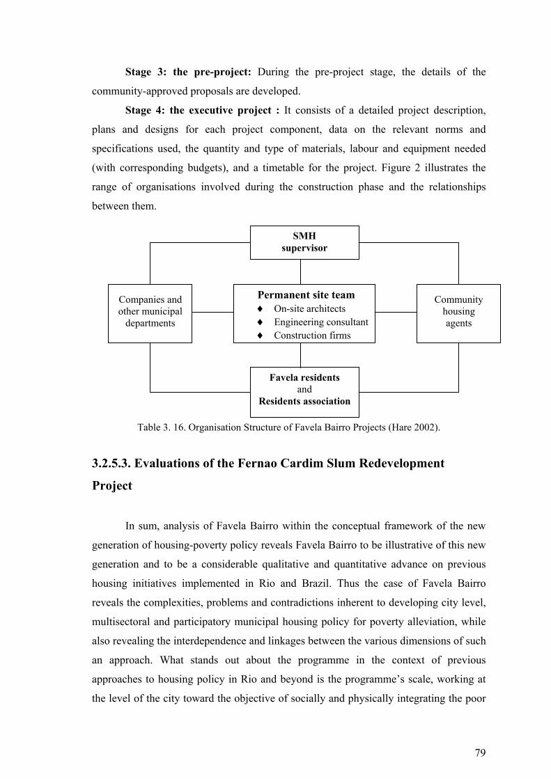
79
Stage 3: the pre-project: During the pre-project stage, the details of the
community-approved proposals are developed.
Stage 4: the executive project : It consists of a detailed project description,
plans and designs for each project component, data on the relevant norms and
specifications used, the quantity and type of materials, labour and equipment needed
(with corresponding budgets), and a timetable for the project. Figure 2 illustrates the
range of organisations involved during the construction phase and the relationships
between them.
Table 3. 16. Organisation Structure of Favela Bairro Projects (Hare 2002).
3.2.5.3. Evaluations of the Fernao Cardim Slum Redevelopment
Project
In sum, analysis of Favela Bairro within the conceptual framework of the new
generation of housing-poverty policy reveals Favela Bairro to be illustrative of this new
generation and to be a considerable qualitative and quantitative advance on previous
housing initiatives implemented in Rio and Brazil. Thus the case of Favela Bairro
reveals the complexities, problems and contradictions inherent to developing city level,
multisectoral and participatory municipal housing policy for poverty alleviation, while
also revealing the interdependence and linkages between the various dimensions of such
an approach. What stands out about the programme in the context of previous
approaches to housing policy in Rio and beyond is the programme’s scale, working at
the level of the city toward the objective of socially and physically integrating the poor
Permanent site team ♦ On-site architects ♦ Engineering consultant ♦ Construction firms
Companies and other municipal
departments
Community housing agents
SMH supervisor
Favela residents and
Residents association
80
areas of the city with the wealthier. In addition, the quantity of financial resources being
invested as subsidies through Favela Bairro is another characteristic previously unseen
in Rio. The programme also demonstrates a very strong multisectoral approach at the
project level, and is especially interesting in the emphasis it places on architecture and
public space as mechanisms to bring about social and physical integration, with
integration of the informal and the formal at the city level being its most ambitious
objective. Thus it can be concluded that Favela Bairro does constitute a new approach to
poverty alleviation in Rio, and although the programme’s considerable resources are not
targeted at the most vulnerable, they instead focus upon the collective needs of a
sizeable proportion of Rio’s population. In addition, Favela Bairro applies a broad and
multidimensional understanding of poverty, which is addressed at the city scale through
a multisectoral approach.
Fernao Cardim Slum Redevelopment Project
Exist/ Non-Exist Statement
Integration with City Plan Exist
Fernao Cardim is a slum redevelopment project located on the north of Rio de Janerio.Fernao Cardim redevelopment project aims to upgrade Rio’s medium sized favelas by 2004, with the programs Favela Bairro. Integration of favelas into urban fabric, The Importance of City Cooperation.
Rehabilitation Strategy Compatibility Exist
This project included: improved access (new roads), the channelling of the river, rehabilitation and redevelopment of surrounding area, (22 flats to be resettled).
Urban Development Strategy
Compatibility Exist
Fernao Cardim Slum Redevelopment Project,
♦ To redevelop the slum areas on north region of the city.
♦ To increase healthy and livable housing stock in the city.
Developer Impact on Economic Structure Non-Exist
There is no economic development impact on urban scale, but in Project, old residents and construction company are increased profit.
New Facalities
Exist
Slum areas are transformed to; ♦ New apartment areas. ♦ New commercial areas. ♦ New recreational areas.
Effects of Transformation on Exist ♦ Upgrading urban quality.
♦ Redevelopment of Slum areas.

81
Physical Structure ♦ Upgrading of infrastructure such as water, sewerage and drainage systems
Effect of Gentrification on Social Structure Non-Exist
Fernao Cardim was one of the first projects to be finished, and the only settlement to date to have its land tenure fully regularised. As a result, these rehabilitations and redevelopments are not a gentrification process initiated by the residents themselves.
Side Effects Exist
♦ Population increase. ♦ This transformation projects
involve upgrading of slums and informal and irregular subdivisions.
♦ Increase in the value of land and new housing units.
Table 3. 17. Evaluations of Fernao Cardim Slum Redevelopment Project.
3.2.6. The Practice of Urban Transformation in Amsterdam,
Netherlands
The present urban renewal policy in the Netherlands was shaped during the
1990s. Urban renewal nowadays is both more complicated and more integral than the
relatively easygoing urban renewal of the period 1975–1995. Moreover, instead of old
neighbourhoods, renewal now mainly concerns post-war areas, often the large-scale
housing estates. Most renewal plans are made in the Netherlands for low-rise flat areas
dating from the 1950s and 1960s, high-rise areas mainly from the period 1965–1974,
and areas with austere and simple single-family houses in rows (Helleman and
Wassenberg 2004).
3.2.6.1. Bijlmermeer Residential Transformation Project
At the end of 1966 the construction of Bijlmermeer started. A city in which
living, working, traffic and recreation would each be giving its own place. The first
residents of this south-eastern part of Amsterdam came in 1968. Almost 40 years later,
it is clear that Amsterdam Southeast has developed entirely different from what was
expected. Amsterdam Southeast has a population of over 86.000 with more than 130
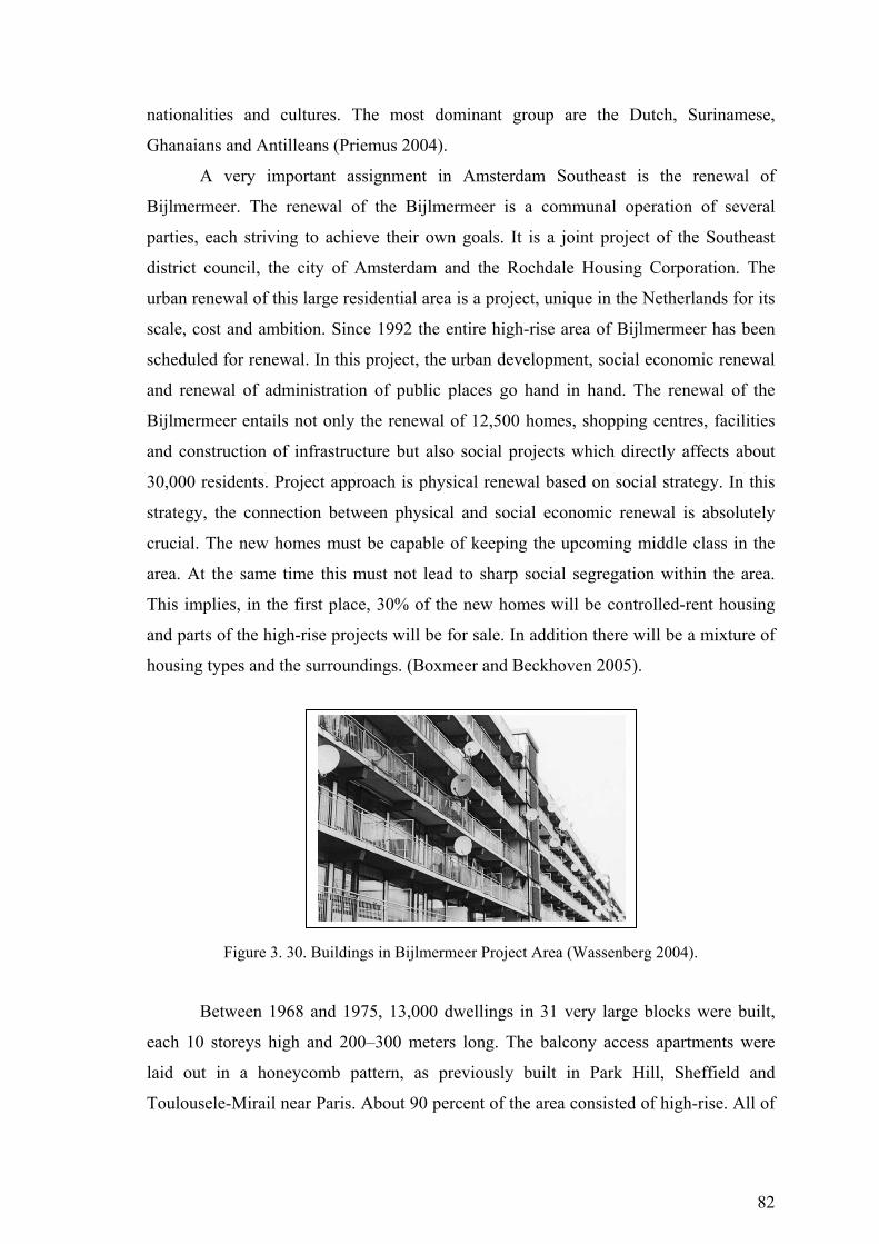
82
nationalities and cultures. The most dominant group are the Dutch, Surinamese,
Ghanaians and Antilleans (Priemus 2004).
A very important assignment in Amsterdam Southeast is the renewal of
Bijlmermeer. The renewal of the Bijlmermeer is a communal operation of several
parties, each striving to achieve their own goals. It is a joint project of the Southeast
district council, the city of Amsterdam and the Rochdale Housing Corporation. The
urban renewal of this large residential area is a project, unique in the Netherlands for its
scale, cost and ambition. Since 1992 the entire high-rise area of Bijlmermeer has been
scheduled for renewal. In this project, the urban development, social economic renewal
and renewal of administration of public places go hand in hand. The renewal of the
Bijlmermeer entails not only the renewal of 12,500 homes, shopping centres, facilities
and construction of infrastructure but also social projects which directly affects about
30,000 residents. Project approach is physical renewal based on social strategy. In this
strategy, the connection between physical and social economic renewal is absolutely
crucial. The new homes must be capable of keeping the upcoming middle class in the
area. At the same time this must not lead to sharp social segregation within the area.
This implies, in the first place, 30% of the new homes will be controlled-rent housing
and parts of the high-rise projects will be for sale. In addition there will be a mixture of
housing types and the surroundings. (Boxmeer and Beckhoven 2005).
Figure 3. 30. Buildings in Bijlmermeer Project Area (Wassenberg 2004).
Between 1968 and 1975, 13,000 dwellings in 31 very large blocks were built,
each 10 storeys high and 200–300 meters long. The balcony access apartments were
laid out in a honeycomb pattern, as previously built in Park Hill, Sheffield and
Toulousele-Mirail near Paris. About 90 percent of the area consisted of high-rise. All of
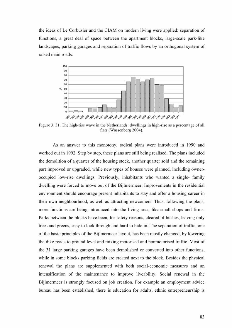
83
the ideas of Le Corbusier and the CIAM on modern living were applied: separation of
functions, a great deal of space between the apartment blocks, large-scale park-like
landscapes, parking garages and separation of traffic flows by an orthogonal system of
raised main roads.
Figure 3. 31. The high-rise wave in the Netherlands: dwellings in high-rise as a percentage of all
flats (Wassenberg 2004).
As an answer to this monotony, radical plans were introduced in 1990 and
worked out in 1992. Step by step, these plans are still being realised. The plans included
the demolition of a quarter of the housing stock, another quarter sold and the remaining
part improved or upgraded, while new types of houses were planned, including owner-
occupied low-rise dwellings. Previously, inhabitants who wanted a single- family
dwelling were forced to move out of the Bijlmermeer. Improvements in the residential
environment should encourage present inhabitants to stay and offer a housing career in
their own neighbourhood, as well as attracting newcomers. Thus, following the plans,
more functions are being introduced into the living area, like small shops and firms.
Parks between the blocks have been, for safety reasons, cleared of bushes, leaving only
trees and greens, easy to look through and hard to hide in. The separation of traffic, one
of the basic principles of the Bijlmermeer layout, has been mostly changed, by lowering
the dike roads to ground level and mixing motorised and nonmotorised traffic. Most of
the 31 large parking garages have been demolished or converted into other functions,
while in some blocks parking fields are created next to the block. Besides the physical
renewal the plans are supplemented with both social-economic measures and an
intensification of the maintenance to improve liveability. Social renewal in the
Bijlmermeer is strongly focused on job creation. For example an employment advice
bureau has been established, there is education for adults, ethnic entrepreneurship is
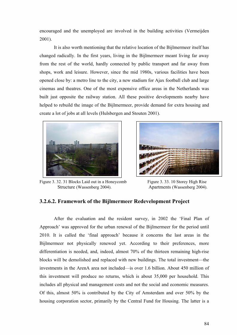
84
encouraged and the unemployed are involved in the building activities (Vermeijden
2001).
It is also worth mentioning that the relative location of the Bijlmermeer itself has
changed radically. In the first years, living in the Bijlmermeer meant living far away
from the rest of the world, hardly connected by public transport and far away from
shops, work and leisure. However, since the mid 1980s, various facilities have been
opened close by: a metro line to the city, a new stadium for Ajax football club and large
cinemas and theatres. One of the most expensive office areas in the Netherlands was
built just opposite the railway station. All these positive developments nearby have
helped to rebuild the image of the Bijlmermeer, provide demand for extra housing and
create a lot of jobs at all levels (Hulsbergen and Stouten 2001).
Figure 3. 32. 31 Blocks Laid out in a Honeycomb Figure 3. 33. 10 Storey High Rise
Structure (Wassenberg 2004). Apartments (Wassenberg 2004).
3.2.6.2. Framework of the Bijlmermeer Redevelopment Project
After the evaluation and the resident survey, in 2002 the ‘Final Plan of
Approach’ was approved for the urban renewal of the Bijlmermeer for the period until
2010. It is called the ‘final approach’ because it concerns the last areas in the
Bijlmermeer not physically renewed yet. According to their preferences, more
differentiation is needed, and, indeed, almost 70% of the thirteen remaining high-rise
blocks will be demolished and replaced with new buildings. The total investment—the
investments in the ArenA area not included—is over 1.6 billion. About 450 million of
this investment will produce no returns, which is about 35,000 per household. This
includes all physical and management costs and not the social and economic measures.
Of this, almost 50% is contributed by the City of Amsterdam and over 50% by the
housing corporation sector, primarily by the Central Fund for Housing. The latter is a
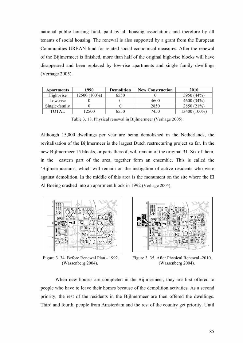
85
national public housing fund, paid by all housing associations and therefore by all
tenants of social housing. The renewal is also supported by a grant from the European
Communities URBAN fund for related social-economical measures. After the renewal
of the Bijlmermeer is finished, more than half of the original high-rise blocks will have
disappeared and been replaced by low-rise apartments and single family dwellings
(Verhage 2005).
Apartments 1990 Demolition New Construction 2010 Hight-rise 12500 (100%) 6550 0 5950 (44%) Low-rise 0 0 4600 4600 (34%)
Single-family 0 0 2850 2850 (21%) TOTAL 12500 6550 7450 13400 (100%)
Table 3. 18. Physical renewal in Bijlmermeer (Verhage 2005).
Although 15,000 dwellings per year are being demolished in the Netherlands, the
revitalisation of the Bijlmermeer is the largest Dutch restructuring project so far. In the
new Bijlmermeer 15 blocks, or parts thereof, will remain of the original 31. Six of them,
in the eastern part of the area, together form an ensemble. This is called the
‘Bijlmermuseum’, which will remain on the instigation of active residents who were
against demolition. In the middle of this area is the monument on the site where the El
Al Boeing crashed into an apartment block in 1992 (Verhage 2005).
Figure 3. 34. Before Renewal Plan - 1992. Figure 3. 35. After Physical Renewal -2010. (Wassenberg 2004). (Wassenberg 2004).
When new houses are completed in the Bijlmermeer, they are first offered to
people who have to leave their homes because of the demolition activities. As a second
priority, the rest of the residents in the Bijlmermeer are then offered the dwellings.
Third and fourth, people from Amsterdam and the rest of the country get priority. Until
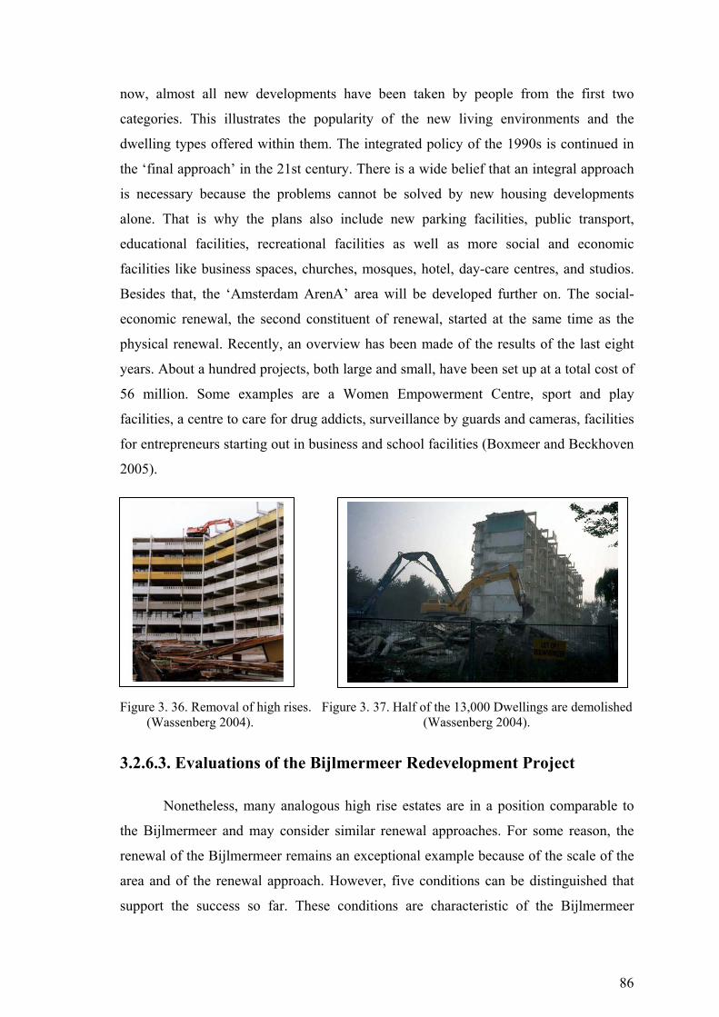
86
now, almost all new developments have been taken by people from the first two
categories. This illustrates the popularity of the new living environments and the
dwelling types offered within them. The integrated policy of the 1990s is continued in
the ‘final approach’ in the 21st century. There is a wide belief that an integral approach
is necessary because the problems cannot be solved by new housing developments
alone. That is why the plans also include new parking facilities, public transport,
educational facilities, recreational facilities as well as more social and economic
facilities like business spaces, churches, mosques, hotel, day-care centres, and studios.
Besides that, the ‘Amsterdam ArenA’ area will be developed further on. The social-
economic renewal, the second constituent of renewal, started at the same time as the
physical renewal. Recently, an overview has been made of the results of the last eight
years. About a hundred projects, both large and small, have been set up at a total cost of
56 million. Some examples are a Women Empowerment Centre, sport and play
facilities, a centre to care for drug addicts, surveillance by guards and cameras, facilities
for entrepreneurs starting out in business and school facilities (Boxmeer and Beckhoven
2005).
Figure 3. 36. Removal of high rises. Figure 3. 37. Half of the 13,000 Dwellings are demolished (Wassenberg 2004). (Wassenberg 2004).
3.2.6.3. Evaluations of the Bijlmermeer Redevelopment Project
Nonetheless, many analogous high rise estates are in a position comparable to
the Bijlmermeer and may consider similar renewal approaches. For some reason, the
renewal of the Bijlmermeer remains an exceptional example because of the scale of the
area and of the renewal approach. However, five conditions can be distinguished that
support the success so far. These conditions are characteristic of the Bijlmermeer
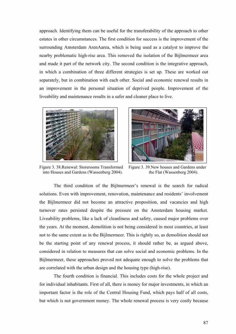
87
approach. Identifying them can be useful for the transferability of the approach to other
estates in other circumstances. The first condition for success is the improvement of the
surrounding Amsterdam ArenAarea, which is being used as a catalyst to improve the
nearby problematic high-rise area. This removed the isolation of the Bijlmermeer area
and made it part of the network city. The second condition is the integrative approach,
in which a combination of three different strategies is set up. These are worked out
separately, but in combination with each other. Social and economic renewal results in
an improvement in the personal situation of deprived people. Improvement of the
liveability and maintenance results in a safer and cleaner place to live.
Figure 3. 38.Renewal: Storerooms Transformed Figure 3. 39.New houses and Gardens under into Houses and Gardens (Wassenberg 2004). the Flat (Wassenberg 2004).
The third condition of the Bijlmermeer’s renewal is the search for radical
solutions. Even with improvement, renovation, maintenance and residents’ involvement
the Bijlmermeer did not become an attractive proposition, and vacancies and high
turnover rates persisted despite the pressure on the Amsterdam housing market.
Liveability problems, like a lack of cleanliness and safety, caused major problems over
the years. At the moment, demolition is not being considered in most countries, at least
not to the same extent as in the Bijlmermeer. This is rightly so, as demolition should not
be the starting point of any renewal process, it should rather be, as argued above,
considered in relation to measures that can solve social and economic problems. In the
Bijlmermeer, these approaches proved not adequate enough to solve the problems that
are correlated with the urban design and the housing type (high-rise).
The fourth condition is financial. This includes costs for the whole project and
for individual inhabitants. First of all, there is money for major investments, in which an
important factor is the role of the Central Housing Fund, which pays half of all costs,
but which is not government money. The whole renewal process is very costly because
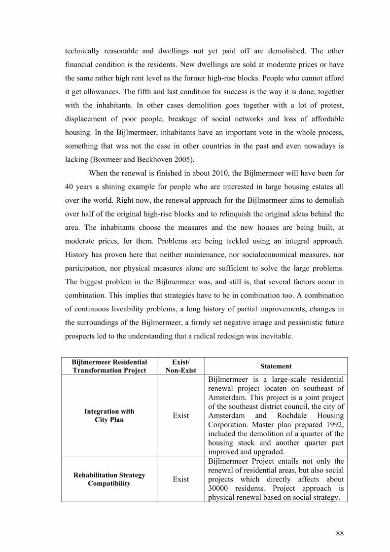
88
technically reasonable and dwellings not yet paid off are demolished. The other
financial condition is the residents. New dwellings are sold at moderate prices or have
the same rather high rent level as the former high-rise blocks. People who cannot afford
it get allowances. The fifth and last condition for success is the way it is done, together
with the inhabitants. In other cases demolition goes together with a lot of protest,
displacement of poor people, breakage of social networks and loss of affordable
housing. In the Bijlmermeer, inhabitants have an important vote in the whole process,
something that was not the case in other countries in the past and even nowadays is
lacking (Boxmeer and Beckhoven 2005).
When the renewal is finished in about 2010, the Bijlmermeer will have been for
40 years a shining example for people who are interested in large housing estates all
over the world. Right now, the renewal approach for the Bijlmermeer aims to demolish
over half of the original high-rise blocks and to relinquish the original ideas behind the
area. The inhabitants choose the measures and the new houses are being built, at
moderate prices, for them. Problems are being tackled using an integral approach.
History has proven here that neither maintenance, nor socialeconomical measures, nor
participation, nor physical measures alone are sufficient to solve the large problems.
The biggest problem in the Bijlmermeer was, and still is, that several factors occur in
combination. This implies that strategies have to be in combination too. A combination
of continuous liveability problems, a long history of partial improvements, changes in
the surroundings of the Bijlmermeer, a firmly set negative image and pessimistic future
prospects led to the understanding that a radical redesign was inevitable.
Bijlmermeer Residential Transformation Project
Exist/ Non-Exist Statement
Integration with City Plan Exist
Bijlmermeer is a large-scale residential renewal project locaten on southeast of Amsterdam. This project is a joint project of the southeast district council, the city of Amsterdam and Rochdale Housing Corporation. Master plan prepared 1992, included the demolition of a quarter of the housing stock and another quarter part improved and upgraded.
Rehabilitation Strategy Compatibility Exist
Bijlmermeer Project entails not only the renewal of residential areas, but also social projects which directly affects about 30000 residents. Project approach is physical renewal based on social strategy.
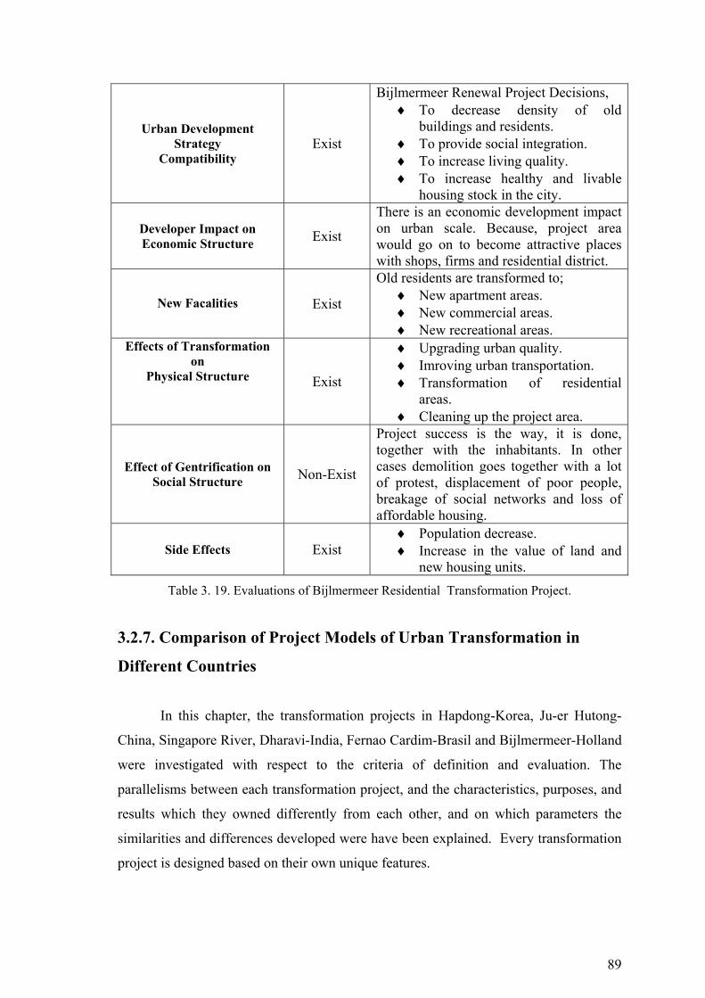
89
Urban Development Strategy
Compatibility Exist
Bijlmermeer Renewal Project Decisions, ♦ To decrease density of old
buildings and residents. ♦ To provide social integration. ♦ To increase living quality. ♦ To increase healthy and livable
housing stock in the city.
Developer Impact on Economic Structure Exist
There is an economic development impact on urban scale. Because, project area would go on to become attractive places with shops, firms and residential district.
New Facalities
Exist
Old residents are transformed to; ♦ New apartment areas. ♦ New commercial areas. ♦ New recreational areas.
Effects of Transformation on
Physical Structure Exist
♦ Upgrading urban quality. ♦ Imroving urban transportation. ♦ Transformation of residential
areas. ♦ Cleaning up the project area.
Effect of Gentrification on Social Structure Non-Exist
Project success is the way, it is done, together with the inhabitants. In other cases demolition goes together with a lot of protest, displacement of poor people, breakage of social networks and loss of affordable housing.
Side Effects Exist ♦ Population decrease. ♦ Increase in the value of land and
new housing units. Table 3. 19. Evaluations of Bijlmermeer Residential Transformation Project.
3.2.7. Comparison of Project Models of Urban Transformation in
Different Countries
In this chapter, the transformation projects in Hapdong-Korea, Ju-er Hutong-
China, Singapore River, Dharavi-India, Fernao Cardim-Brasil and Bijlmermeer-Holland
were investigated with respect to the criteria of definition and evaluation. The
parallelisms between each transformation project, and the characteristics, purposes, and
results which they owned differently from each other, and on which parameters the
similarities and differences developed were have been explained. Every transformation
project is designed based on their own unique features.
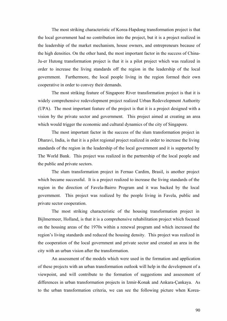
90
The most striking characteristic of Korea-Hapdong transformation project is that
the local government had no contribution into the project, but it is a project realized in
the leadership of the market mechanism, house owners, and entrepreneurs because of
the high densities. On the other hand, the most important factor in the success of China-
Ju-er Hutong transformation project is that it is a pilot project which was realized in
order to increase the living standards off the region in the leadership of the local
government. Furthermore, the local people living in the region formed their own
cooperative in order to convey their demands.
The most striking feature of Singapore River transformation project is that it is
widely comprehensive redevelopment project realized Urban Redevelopment Authority
(UPA). The most important feature of the project is that it is a project designed with a
vision by the private sector and government. This project aimed at creating an area
which would trigger the economic and cultural dynamics of the city of Singapore.
The most important factor in the success of the slum transformation project in
Dharavi, India, is that it is a pilot regional project realized in order to increase the living
standards of the region in the leadership of the local government and it is supported by
The World Bank. This project was realized in the partnership of the local people and
the public and private sectors.
The slum transformation project in Fernao Cardim, Brasil, is another project
which became successful. It is a project realized to increase the living standards of the
region in the direction of Favela-Bairro Program and it was backed by the local
government. This project was realized by the people living in Favela, public and
private sector cooperation.
The most striking characteristic of the housing transformation project in
Bijlmermeer, Holland, is that it is a comprehensive rehabilitation project which focused
on the housing areas of the 1970s within a renewal program and which increased the
region’s living standards and reduced the housing density. This project was realized in
the cooperation of the local government and private sector and created an area in the
city with an urban vision after the transformation.
An assessment of the models which were used in the formation and application
of these projects with an urban transformation outlook will help in the development of a
viewpoint, and will contribute to the formation of suggestions and assessment of
differences in urban transformation projects in Izmir-Konak and Ankara-Çankaya. As
to the urban transformation criteria, we can see the following picture when Korea-

91
Hapdong, China-Ju-er Hutong, Singapore River, India-Dharavi, Brasil-Fernao Cardim,
and Holland-Bijlmermeer transformation projects are assessed.
Criterions To Provide Residential Transformation of the
Project Area
To Increase Urban Living Quality
To Provide Public Participant
Hapdong Residential
Transformation Project
Hapdong transformation scheme, old low-density squatter areas are replaced with the high-density apartments. And this Project has enabled the redevelopment of sub-standard housing areas through the market system without public assistance.
Upgrading urban quality. Creating new cultural activity areas. Creating open and covered public spaces for Hapdong residents.
Residents provide land and a construction company, the key difference is in Hapdong Project is its independent financing scheme. The revenue from the sale of the additional housing units makes the Project feasible.
Ju-er Hutong Residential
Transformation Project
Ju-er Hutong Project, a governmental pilot program to rehabilitate dilapidated housing in Beijing, was tauted as a successful model of housing design by academia and authorities alike.
Upgrading urban quality. Creating new cultural activity areas. Ju-er Hutong Project as a successful effort to improve the housing conditions.
In 1987, the Beijing Housing Reform launched a pilot program for Ju-er Hutong Project, with limited funding from the municipal govern- ment (Yn10milion).
Singapore River Transformation
Project
Urban Redevelopment Authority (URA) undertook the planning of the Singapore River. It was envisioned that the river could be transformed into apartments, entertainment and recreational areas.
Upgrading urban quality. URA improved the connectivity and accessibility of the place and nodal points such as plazas and outdoor areas were implemented.
Households having huts and improvements are provided with cash compensation for the loss of their assets and they receive a disturbance and transport allowance.
Dharavi Slum Transformation
Project
Prime Minister’s Grant Project (PMGP) aimed to improve these living conditions by redeveloping Dharavi with an appropriate density and infrastructure.
Upgrading urban quality. Creating new street- facing shop units.
Maharashtra State government initiated the slum upgrading program (SUP) with the support of the Worldbank.
Fernao Cardim Slum
Transformation Project
In 1994, Municipal Housing Department (SMH), prepared a program of phsical and social transformation of Rio’s favelas.
Upgrading urban quality. Upgrading of basic infrastructure such as water, sewerage and drainage systems.
Residents Association of the community undertook basic upgrading work with support from various governmental and non- governmental foundations.
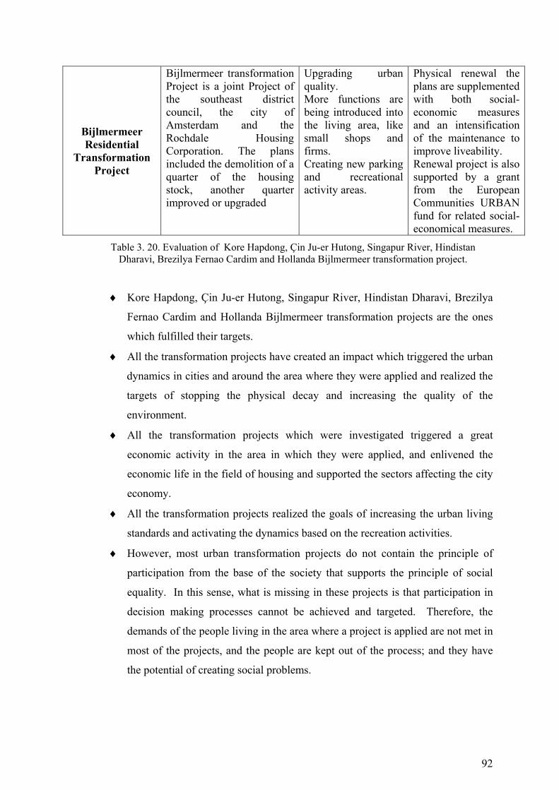
92
Bijlmermeer Residential
Transformation Project
Bijlmermeer transformation Project is a joint Project of the southeast district council, the city of Amsterdam and the Rochdale Housing Corporation. The plans included the demolition of a quarter of the housing stock, another quarter improved or upgraded
Upgrading urban quality. More functions are being introduced into the living area, like small shops and firms. Creating new parking and recreational activity areas.
Physical renewal the plans are supplemented with both social-economic measures and an intensification of the maintenance to improve liveability. Renewal project is also supported by a grant from the European Communities URBAN fund for related social-economical measures.
Table 3. 20. Evaluation of Kore Hapdong, Çin Ju-er Hutong, Singapur River, Hindistan Dharavi, Brezilya Fernao Cardim and Hollanda Bijlmermeer transformation project.
♦ Kore Hapdong, Çin Ju-er Hutong, Singapur River, Hindistan Dharavi, Brezilya
Fernao Cardim and Hollanda Bijlmermeer transformation projects are the ones
which fulfilled their targets.
♦ All the transformation projects have created an impact which triggered the urban
dynamics in cities and around the area where they were applied and realized the
targets of stopping the physical decay and increasing the quality of the
environment.
♦ All the transformation projects which were investigated triggered a great
economic activity in the area in which they were applied, and enlivened the
economic life in the field of housing and supported the sectors affecting the city
economy.
♦ All the transformation projects realized the goals of increasing the urban living
standards and activating the dynamics based on the recreation activities.
♦ However, most urban transformation projects do not contain the principle of
participation from the base of the society that supports the principle of social
equality. In this sense, what is missing in these projects is that participation in
decision making processes cannot be achieved and targeted. Therefore, the
demands of the people living in the area where a project is applied are not met in
most of the projects, and the people are kept out of the process; and they have
the potential of creating social problems.
93
CHAPTER 4
TURKISH URBAN TRANSFORMATION APPROACHES
In Turkey, urban transformation is a result of changes taking place not only in
the physical structure but also in the social and economic structure of the society as
well. In this section, an analysis of the last fifty years of urban transformation within its
contextual framework, emphasizing the socio-economic dynamics and the changes
concerning the approach and methods of implementation has been presented. The
indicators that have an impact on change or transformation have been defined as,
contextual elements (economic policies, demographic change), socio-economic
structure (types of housing supply, work–labour relationship), organisation /
implementation structure (distribution of authority, planning implementations, political
and legal regulations) and the physical morphology/structure (urban form, industry,
housing, transportation and the city center). Based on this historical analysis some
principles have been developed regarding a future approach to urban transformation and
a method of participatory planning for urban regeneration suggested.
4.1. Historical Perspective on Urban Transformation in Turkey
Early examples of urban transformation in Turkey had appeared in the squatter
settlements which emerged in the second half of the 20th Century. Urban transformation
in Turkish metropolitan cities differentiates into three periods since the 1950s. The
first period covers/encompass the years between 1950 - 1980. This is the period when
policies of economic growth and industrialization were supported and diffused in the
country. Economic growth and industrialization motivated the rapid growth of urban
centres and the development of squatter areas in large cities. A major urban
transformation in this period is caused first by the invasion of vacant land at the
periphery of cities by squatter housing. The second period, from 1980 to 2000 is when
the large urban settlements/metropolitan cities in Turkey are transformed under the
impact of liberalisation and globalization of the country’s economy. In this period two
important developments in the urban space attracts attention. These include, on the one
94
hand, increase in the construction of authorised as well as unauthorised of residential
areas; on the other hand, the decentralization of residential areas. Urban transformation
within this period can be observed in the inner city residential and industrial areas, the
CBD and in the coastal areas. The last period, beginning with the year 2000, when
privatization of public institutions has gained speed, is when for the first time
“transformation/regeneration” strategies for larger urban areas are adopted by the local
authorities and implemented in collaboration with the private sector (Bayraktar 2006).
In order to understand and analyse the dynamics of urban transformation in
Turkish metropolitan cities at the present, a historical review of the processes dominant
in each period is undertaken. Each period is analysed, within the framework of
structural, contextual, socio-economic dynamics and the implementational approaches
prevalent at the time. Within the structural and contextual framework the Turkish
economic policies and the demographic changes are scrutinized; within the socio-
economic framework modes of urban housing supply, the characteristics and structure
of employment/labour/manpower as they relate to the living environment is analysed.
Under the implementational approaches, the distribution of power among central and
local administration, planning implementations and the legal framework is discussed.
Finally, the stated contextual changes in terms of socio-economic changes and the
changes in the implementational approaches are interpreted from the point of view of
the impact they had on the urban macro-form, on housing areas, on industrial sites, the
transportation network and the inner-city areas.
The spatial structure of cities in Turkey, unlike cities in the western countries
(e.g., UK, France, and USA) has evolved with different social dynamics and processes.
In the Western countries, the urban space is formed by the intervention methods,
institutions and social dynamics peculiar to that society. In Turkey, often the
intervention methods utilised in the west have been adopted or followed closely by the
planning authorities, in order to find a solution to the prevailing urban problems. Yet,
due to the structural/institutional differences between the societies and the different
dynamics of change operating, the western methods of intervention have remained
insufficient in transforming the urban space socially and economically and spatial
transformation was conceived only in terms of a “physical” transformation.
Due to the changing contextual characteristics and dynamics, the Turkish
metropolitan cities went through over a period of fifty years (1950- 2000). It is evident
from the analysis that the urban transformation as experienced in Turkey is not directly

95
related to plans and programmes implemented nor to the political intervention methods
utilized, but rather a result of an interaction between the market conditions operating,
the “spontaneous” social solutions brought people and the central and local
administration. The objective of this historical analysis is also to determine the role of
national and international of the external factors in the process of urban transformation
and planning practice (Yörükan 2006).
At the end of this fifty years the urban transformation realized in Turkey is a
physical as well as a social and economic transformation. The urban transformation in
Turkey has been at a much higher rate than the ones in western countries. The
institutions and legal/legislative measures controlling this change and the planning
approaches adopted have often remained behind this rapid transformation. The leading
actors in developing urban transformation strategies were the market forces and later the
private bodies and institutions. The plans and strategies developed however, have
mostly followed the implementations instead of leading them.
Post 1980 planning and supervisions practices in Turkey as well as at the
international and global arena, began to lose their centralized “top down” approach and
efforts towards a re-institutionalization of urban planning began, which aimed to
integrate the people into the planning process. Within this framework and within the
context of democratization concepts valued and accentuated such as ‘sustainability’,
‘multi-dimensionality’, ‘equal accessibility’, ‘participation’ and ‘collaboration’ got
accepted as unavoidable/inevitable principles in determining the principles of social
transformation and the planning strategies.
Urban transformation in Turkey and the parallel legislations to the
implementations demonstrate the fact that, urban transformation has been defined
mainly as ‘urban renewal’, but the process has differentiated and gained new
dimensions to it over time. While in the first period, the intervening practice has been
mostly tearing down and rebuilding, in time the practice of upgrading the infrastructure
while preserving the existing physical tissue developed. Later, another practice has been
added to preservation and upgrading: preservation of the existing space through social
and economic regeneration. Other, renewal interventions are those that foresee physical,
social and economic developments. The historic urban areas are developed while
preserving the existing historic, cultural and environmental values in situ (Şenyapılı
1996).
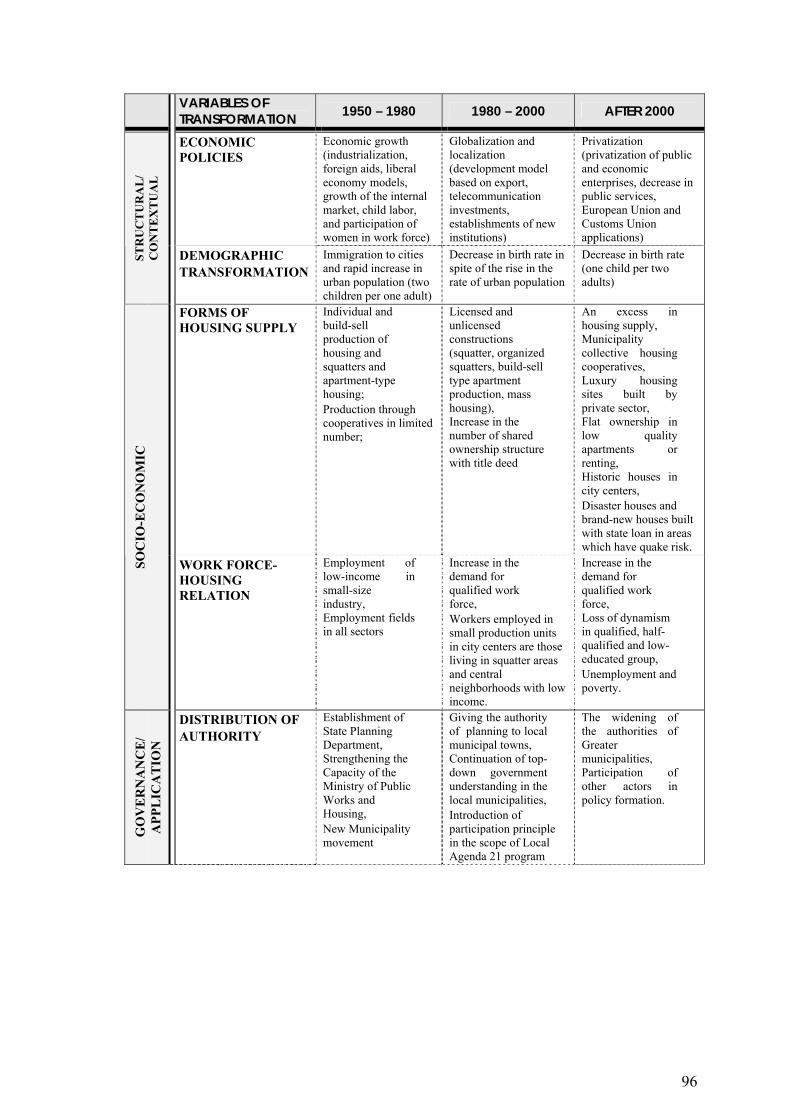
96
VARIABLES OF TRANSFORMATION 1950 – 1980 1980 – 2000 AFTER 2000
ECONOMIC POLICIES
Economic growth (industrialization, foreign aids, liberal economy models, growth of the internal market, child labor, and participation of women in work force)
Globalization and localization (development model based on export, telecommunication investments, establishments of new institutions)
Privatization (privatization of public and economic enterprises, decrease in public services, European Union and Customs Union applications)
STR
UC
TU
RA
L/
CO
NT
EX
TU
AL
DEMOGRAPHIC TRANSFORMATION
Immigration to cities and rapid increase in urban population (two children per one adult)
Decrease in birth rate in spite of the rise in the rate of urban population
Decrease in birth rate (one child per two adults)
FORMS OF HOUSING SUPPLY
Individual and build-sell production of housing and squatters and apartment-type housing; Production through cooperatives in limited number;
Licensed and unlicensed constructions (squatter, organized squatters, build-sell type apartment production, mass housing), Increase in the number of shared ownership structure with title deed
An excess in housing supply, Municipality collective housing cooperatives, Luxury housing sites built by private sector, Flat ownership in low quality apartments or renting, Historic houses in city centers, Disaster houses and brand-new houses built with state loan in areas which have quake risk.
SOC
IO-E
CO
NO
MIC
WORK FORCE-HOUSING RELATION
Employment of low-income in small-size industry, Employment fields in all sectors
Increase in the demand for qualified work force, Workers employed in small production units in city centers are those living in squatter areas and central neighborhoods with low income.
Increase in the demand for qualified work force, Loss of dynamism in qualified, half-qualified and low-educated group, Unemployment and poverty.
GO
VE
RN
AN
CE
/ A
PPL
ICA
TIO
N
DISTRIBUTION OF AUTHORITY
Establishment of State Planning Department, Strengthening the Capacity of the Ministry of Public Works and Housing, New Municipality movement
Giving the authority of planning to local municipal towns, Continuation of top-down government understanding in the local municipalities, Introduction of participation principle in the scope of Local Agenda 21 program
The widening of the authorities of Greater municipalities, Participation of other actors in policy formation.

97
VARIABLES OF TRANSFORMATION 1950 – 1980 1980 – 2000 AFTER 2000
PLANNING APPLICATIONS
Central planned development model, Comprehensive planning approach.
Master plans that suggest macroform, guiding urban development and centralizing the development and application plans, Applications of transformation projects in settled locations (renewal, rehabilitation improvement).
Strategic planning, Transformation strategies in he leadership of municipality in general, Participative application with the initiation of other actors.
POLICIES AND LEGAL ARRANGEMENTS
The Act of Municipality numbered 327 (1963), The Act of Squatters numbered 775 (1966), The Act of Land Office numbered 1164 (1969), The Act of Improvement numbered 6785 (1972), The Act of Flat Ownership (1965).
The Act of Greater Municipality numbered 3030 (1984), The Act of Mass Housing numbered 2985 (1984), The Act of Improvement numbered 3194 (1985), The Act of Exemption numbered 2805 (1983), The Act of Exemption numbered 2981 (1984), The Act of Preservation of Cultural and Natural Assets numbered 2863 (1983), The Act of Environment numbered 2872 (1983), The Act of Bosphorous numbered 2960 (1983), The Act of Natural Parks numbered 2873 (1983).
The Act of Greater Municipality numbered 5216 (2004), The Act of Urban Transformation (2005).
URBAN MACROFORM
Constructing on empty lands in cities: formation of “huge industrial city”.
Centralisation (increase in the number of central business districts); Spread towards the outer parts of the center along the main transport lines and ring roads.
Growth of metropolitan city in huge pieces, Transformation of inner city areas.
Industry Density of small-size producers in city center, Increase in the number of small-size industrial sites outside the city.
Flexible production in the center and organized industry which is centralized outside the city, Opening of industry to international markets.
Development of construction industry and continuation of relation with the international market, Relation of new technologies with industrial production.
PHY
SIC
AL
Housing Developments of squatters and apartments.
Houses located in the old city centers (renters with low income), Changing and transforming squatter areas, Legalization of illegally-constructed houses, Permitted and illegal housing areas in the inner city.
Squatters, decayed areas, unhealthy apartments (low income), Improved apartment areas (middle income), Sub-cities, sites, preserved historical housing areas (high and middle income).

98
VARIABLES OF TRANSFORMATION 1950 – 1980 1980 – 2000 AFTER 2000
Transportation Transition from Transport of railway to automobile transformation.
Increase in the number of car ownership.
Start of big collective transport-metro projects.
Center Development of small-size production activities in city centers by damaging its surrounding, Increase in wholesale and retail trade, Development of new business centers.
Small-size production units existing in city centers and historical cities and the increase in their number, Partial preservation and strengthening of historical buildings, Continuation of development of business centers by transforming in the growth areas of cities.
Easy access and formation of new finance centers under the effect of new communication technologies, High density in existing trade centers, Increase in the number of shopping centers and their location at city entrances and junctions, Location of tourism-based businesses in historical centers.
Tablo 4. 1. Transformation and Historical Characteristics of Variables of Change (Bimtaş 2006).
4.1.1. 1950-1980: Rapid Urbanization and from Squatter Areas to
Apartment Buildings
While the policy of economic growth and industrialization was giving birth to a
phenomenon of an industrial city between 1950 and 1980, it also brought about
immigration from the rural to the urban and a rapid urbanization. Because of the lack of
infra-structure in cities, the only solution for the people who immigrated from the rural
to build their own houses was to build squatters on state and private lands at the edge of
the cities. This resulted in the conversion of the rural area surrounding the city into an
urban area. This period gave birth to the construction of apartment buildings within the
city centers as well in the squatter areas built on state and private lands at the urban
fringe after the start of immigration to urban areas. Urbanization and the population
which immigrated, in one hand, created new employment areas and forms in
metropolitan cities between 1950s and 1980s, and on the other hand, developed new
forms of housing supply. The squatters, detached houses, and multi-storey apartments
produced by build-and-sell type of entrepreneurs, total housing production supported by
co-operatives, chamber unions and banks are examples of this kind of housing.
In this period, the application of the planning activities in our country was
supported under the authority of central governments. The State Planning Institution
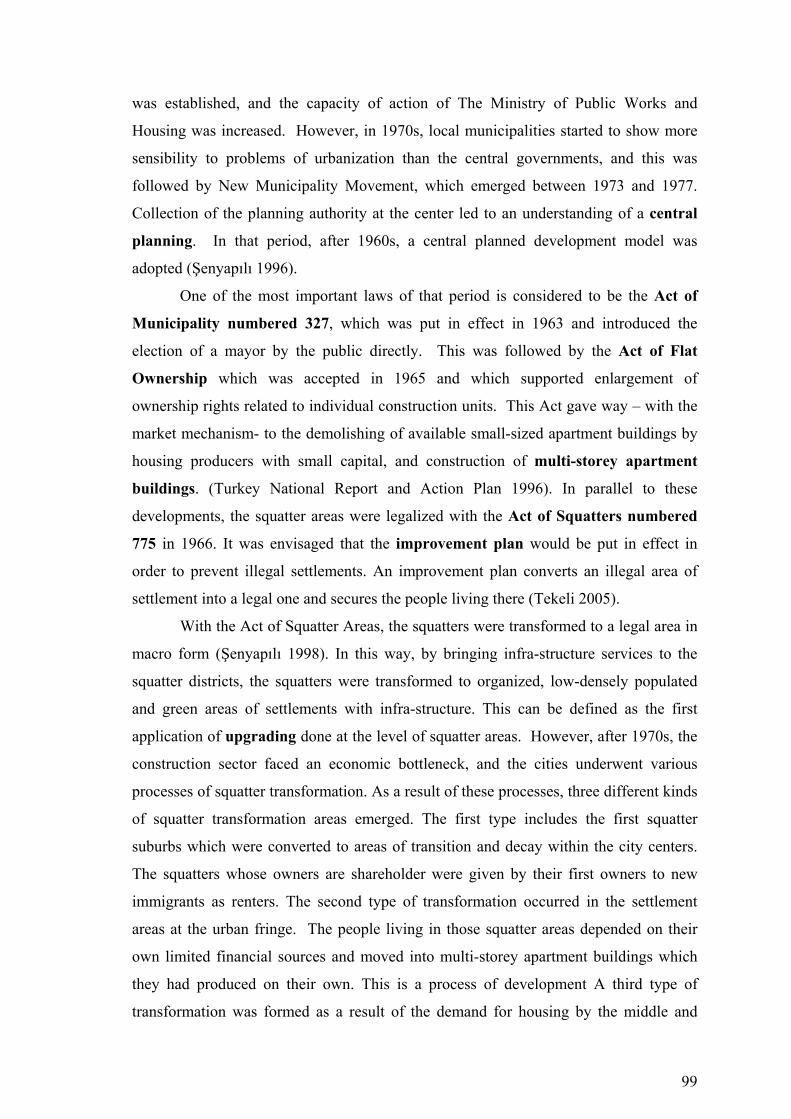
99
was established, and the capacity of action of The Ministry of Public Works and
Housing was increased. However, in 1970s, local municipalities started to show more
sensibility to problems of urbanization than the central governments, and this was
followed by New Municipality Movement, which emerged between 1973 and 1977.
Collection of the planning authority at the center led to an understanding of a central
planning. In that period, after 1960s, a central planned development model was
adopted (Şenyapılı 1996).
One of the most important laws of that period is considered to be the Act of
Municipality numbered 327, which was put in effect in 1963 and introduced the
election of a mayor by the public directly. This was followed by the Act of Flat
Ownership which was accepted in 1965 and which supported enlargement of
ownership rights related to individual construction units. This Act gave way – with the
market mechanism- to the demolishing of available small-sized apartment buildings by
housing producers with small capital, and construction of multi-storey apartment
buildings. (Turkey National Report and Action Plan 1996). In parallel to these
developments, the squatter areas were legalized with the Act of Squatters numbered
775 in 1966. It was envisaged that the improvement plan would be put in effect in
order to prevent illegal settlements. An improvement plan converts an illegal area of
settlement into a legal one and secures the people living there (Tekeli 2005).
With the Act of Squatter Areas, the squatters were transformed to a legal area in
macro form (Şenyapılı 1998). In this way, by bringing infra-structure services to the
squatter districts, the squatters were transformed to organized, low-densely populated
and green areas of settlements with infra-structure. This can be defined as the first
application of upgrading done at the level of squatter areas. However, after 1970s, the
construction sector faced an economic bottleneck, and the cities underwent various
processes of squatter transformation. As a result of these processes, three different kinds
of squatter transformation areas emerged. The first type includes the first squatter
suburbs which were converted to areas of transition and decay within the city centers.
The squatters whose owners are shareholder were given by their first owners to new
immigrants as renters. The second type of transformation occurred in the settlement
areas at the urban fringe. The people living in those squatter areas depended on their
own limited financial sources and moved into multi-storey apartment buildings which
they had produced on their own. This is a process of development A third type of
transformation was formed as a result of the demand for housing by the middle and
100
upper level groups at the edge of the growing cities as well as replacement of available
squatter areas through payment and moving them to other parts of the city and
development of these areas of settlement by big construction companies. This kind of
squatter transformation process can be defined as urban renewal realized by the private
sector (Şenyapılı 1998).
4.1.2. 1980–2000: Certificated and Illegal Construction within the City
The legalization of the squatter areas before 1980s and its becoming a means of
trade paved the way to the organized production of squatters in this period. This was
the period during which the ownership of houses showed a rise both through individual
investments and through illegal organizations. This also led to both certificated and not
certificated constructions in various places. Constructions without permit started to be
seen not only in squatter areas but also in the regions within the city center where
apartments were common. In this period, the production of housing by means of build-
and-sell system became very common. The conversion of squatters into four or five-
storey apartments also led to a spread in the structure of shared title deed (hisseli tapu)
and ownership.
On the other hand, in metropolitan cities in 1980s various collective housing
applications became very common (Turkey National Report and Action Plan, 1996).
The first of these is organizations in the form of co-operatives and co-operative higher
unions. The second one is the housing production by TOKI (The Administration of
Collective Housing) by using the housing funds. The third one is collective housing
areas formed by the cooperation of local municipalities and TOKI. The fourth one is
collective housing project realized by big private entrepreneurs and Turkish Emlak
Bank. Whereas the first three of the housing applications aimed at supplying housing to
low and middle-income groups, the fourth one focused on high income groups (Tekeli
1999).
After 1980, three important legal arrangements were introduced which
determined the processes of urban transformation. The first one was Metropolitan
Municipality Act numbered 3030 which was accepted in 1984, and the second one
was the Act of Development numbered 3194, which was put in effect a year after.
Within the Acts of Municipality and Development, the authorities were taken over by
101
municipalities, and the sources channeled to them were increased. As a result of this,
almost in all big cities, a widespread planning and development works were started.
However, the local government approach was not consistent with the principle of
government depending on the base of the nation. Within the scope of these
applications, there appeared various plans - from the restoration of historical city tissue
to the transformation of squatter areas into healthy urban areas (Şahin 2003). In spite of
the fact that the authority of planning was given to the local municipalities in towns,
top-down understanding of government continued within itself. The third regulation
which influenced urban transformation is to do with expropriation applications (Özden
2002).
After 1980, in addition to these three regulations, some other laws and
regulations that influenced the transformation in special fields, such as housing,
squatters and environment, were put in effect. The most important of these with respect
to transformation was the Act of Mass Housing numbered 2985, which passed in
1984. With this Act, a fund and a central public institution were established in order to
provide sources for housing supply; and as a result, collective housing supply form was
set up in a central organization, which envisaged the realization of collective housing
projects in order to meet the need for housing, transforming the squatter areas within the
scope of an action plan, and rehabilitation of historical housing stock.
Apart from the law related to collective housing supply, five other related laws
were accepted between 1983 and 1988 as a solution to constructions which have no
permit (Şenyapılı 1998). The first Act of Exemption of that period, was the act
numbered 2805, which was enacted in 1983. This law envisaged legalizing not only the
squatters but also any sort of illegal development. However, it did not have the chance
of application (Şenyapılı 2004). The second Act of Exemption of the period was the
Act of Construction Exemption numbered 2981, which was passed in 1984 and
introduced giving a title deed allocation certificate to squatters and making a
redevelopment plan. The squatters which had been built and had invaded the state land
before 1981 were taken into the scope of the Act. The third Act of Construction
Exemption was the one numbered 3290 and passed in 1986. In comparison to the
previous one, its scope had been developed more and comprised all the illegally-
constructed buildings which were being used for housing and non-housing purposes.
All the buildings which had been built by the end of 1986 were considered within the
scope of the Act. The right of constructing four-storey apartment buildings in squatter
102
areas was also given (h=12,50) and they were opened to the market by improvement
plans. In 1987, the Act numbered 3366 widened the area of improvement plan. The
empty areas which were exposed to the danger of becoming squatter were given the
permission of planning. This Act also comprised the illegally constructed buildings
belonging to the army and changed them to places that own a development plan. In this
way, direct sale of squatter lands with building permit was made possible. Finally, in
1988, all the limitations which were brought with the first Act of Squatter Areas
numbered 775 and the Act numbered 3194 were changed, and as a result, all the illegal
constructions were included in the scope of the exemption, and the transformation was
left to the market conditions. This group of laws aimed at solving the ownership
problems in squatter areas and transforming the squatter stock into legal housing stock
in the form of apartment buildings. The transformation was realized by legalizing
illegally constructed buildings, making them development areas based on a plan,
increasing the number of floors, widening the scope of transformation in a way so as to
cover the areas out of the housing area, and finally by opening the empty lands to
construction.
In this period, it is possible to classify both the transformations which emerged
as a result of experience in individual interference and the transformations which were
formed an important authority’s decision in three general categories according to the
form of interference. 1. Redevelopment, 2. Improvement, 3. Preservation.
The first category - as a radical one - includes the transformation which
demolishes the old buildings and then rebuilds them. This can be called as urban
redevelopment (Tekeli 2003). Golden Horn (Haliç) Environment Development Plan
in Istanbul can be given as an example project for urban renewal. This is the most
radical form of transformation. This kind of transformation can be seen as a solution
to increase the living quality and profitability by giving a region - whose value and
quality decreased and which is risky for settlement - new development rights.
The second category includes transformation interferences which focus on
the improvement of available physical, social, and economic quality instead of
knocking down the old buildings and renewing them. Of the types of transformation
interferences which aim at preserving the available structure, upgrading, urban
regeneration and improvement planning are the most striking ones (Tekeli 2005).
Upgrading can be defined as converting an area whose infra-structure is
unsatisfactory into a satisfactory one with limited investments. Urban regeneration

103
can be defined as regeneration of an area with respect to the social and economic
activities as well as the areas physical rehabilitation and legalization.
Improvement, if an area is not legalized for development, refers to providing
security to dwellers by giving them the right of construction in a participative
process and by legalizing it. During the period after 1980, based on the Act
numbered 2981, the improvement plans which brought density to an area of
settlement in the pioneer of local municipalities were commonly used (Şenyapılı
2004). The plans aimed at transforming the squatter areas to organized apartment
type housing stock (Şenyapılı 1998). The local municipalities took on the participant
role with the private sector and tried to apply improvement plans in squatter areas
located in specific topographic regions near the city centers.
The redevelopment projects, such as Dikmen Valley Squatter Transformation
Project and Portakal Çiçeği Valley Project in Ankara introduced for the first time the
approach of participation by local right owners in the process of decision making in
planning and application (Göksu 2003). The interferences in these projects were made
in the direction of preferences and expectations of the people undergoing a process of
planning and application. In order to realize the projects, agreement of owning a house
that will be built within the project in exchange for a squatter owner’s land and a model
based on the principles of creating sources through other trade investments were formed
instead of using the method of expropriation. For the realization of Dikmen Valley
transformation project, a project development company was established in the
leadership of the Municipality of Ankara, in which municipal towns were partners, and
the owners of squatters established a cooperative in the neighborhood leg of the project
(Göksu 2003). The decision making process was realized by the participation of
mayors, company executives, managers of cooperatives, and neighborhoods chiefs. In
addition, an office was opened in neighborhoods for consultancy and discussions with
land owners. In this way, squatter owners found the opportunity of getting continual
feedback and suggestion at the stages of both design and application.
The third type of transformation interference is the preservation of a historic
area and realization of institutionalization by giving an area a new function or by
changing the society which lives in it. This transformation is realized in two ways:
Firstly, a historic place can be given a new function. Opening food and souvenir shops
within The Castle of Ankara can be a good example for this kind of transformation.
The other way of preserving a historic area is to change the society living there. This

104
goes beyond the physical preservation and brings economical living conditions with it.
The transformation of Cihangir, Istanbul into a housing area accommodated by upper
level and newly-married young people can be an example for this type of
transformation.
4.1.3. Post 2000 Period: Urban Transformation is Becoming Legalized
The 2000s were the years when the applications within the scope of European
Union got denser, and public and economic institutions were privatized in great
numbers rapidly. In that period, the public services decreased in number in parallel to
privatization. As a result of the negative trend in social and economic balance coupled
with globalization, and as there was a need for effective and efficient use of resources
and human power, the main focuses in many cities were associated with each other and
a regional network was formed, which led to a “region-city” concept. This concept
helped the emergence of a regional government understanding in which a number of
centers were effective and in which the local partners took an active role in the process
of decision making in the cities (Yörükan 2006).
In recent years in Turkey, the region-city area management gained more
importance under the impact of rapid growth in big metropols. The Act of Greater
Municipality numbered 5216, which was put in effect in 2004, has supported this.
This Act defined all the metropolitan municipalities within the radius of 30-50
kilometer, whose center is the city government. This Act also widened the duties
and fields of authority of metropolitan municipalities in a way to comprise
authorities, such as making strategic plans, putting annual targets, making
investment programs, budgets, and environmental plans, approval of application
plans, changes, approval of improvement plans as they are or with changes. The
authorities of the metropolitan municipalities were increased regarding transportation
and infra-structure plans as well. In contrast, the authorities of small municipalities
were limited in the boundaries of metropolitan municipalities.
The purpose of the Act of urban Transformation and Development dated January
27th, 2004 was defined as “to form healthy and secure areas for living which are
sensitive to disasters and convenient to urban standards; to fulfill improvement,
change, and renewal; to open new areas for settlement and development; to produce
105
reasonable buildings and lands for construction; and to identify application methods
and principles based on social participation in all areas of settlement in the direction of
sustainable development” (The Ministry of Construction and Housing 2004). However,
as urban transformation was not detailed enough, and, as the civil society institutions
were not invited to participate in the running of the applications, and, as it criticized and
found unsatisfactory with respect to the provision of co-operation with experts in the
process of inspection (National Assembly Internal Affairs Commission 2005), that Act
was legalized in a way to comprise the historic building stock.
In this period, the metropolitan cities have grown by transforming in big pieces
in contrast to the previous periods (Tekeli 2005). New transport lines, infra-structure
investments, the processes of market and planning in the direction of national and
international demands coupled with globalization have all shaped the metropolitan
cities. While the fordist production form which developed out of cities was improving
its own employment and housing environment, internal city-flexible small-sized
production types got their support from the housing projects and the labor force
surrounding them got denser.
The decade beginning in 2000 is the period when construction industry has
developed and the construction companies were opened to the international market. In
addition, new technologies were associated with industrial production. It is observed
that the living areas were formed in three types according to the income groups.
Whereas the low income group was getting dense in squatter areas and unhealthy
apartments, the middle-income group improved the housing stock of 1960-70s in
apartment buildings within the city and continued their life-style. With the increase in
the number of cars in metropolitan areas, high and low income groups tend to leave the
city centers; and as a result of this, sub-cities and sites are becoming more common.
Bahçekent and Kemer County in Istanbul are example developments for this. Also, this
income group tends to purchase the historic and old houses in the city centers and
restore them, which is called as “gentrification”. Cihangir and Kuzguncuk in Istanbul
can be shown as two samples for this kind of development.
In this period, it is observed that new finance centers are being established along
the surrounding roads for easy access. İkitelli in Istanbul is a good example for such a
trade and media center development. Furthermore, a transformation to an area of high
buildings in the old trade center of the city is still going on. On the other hand, the

106
historic centers – as in İstiklal Street and the historic peninsula – are transforming into
areas where tourism-based offices and services are becoming dense.
4.2. Urban Transformation in Turkey and the West and an Assessment
of the Future
The phenomenon of urban transformation emerged for the first time in western
cities with the interferences directed at the regeneration of areas suffering from social
and economic decay. In general, the projects which would contribute to the economic
development of the city in empty industrial areas and housing areas were applied in
cities which lost its population, or where low-income groups were living under bad
economic and physical conditions and social support was not available.
The methods of interference in cities in the West were developed according to
the structure of the institutions in those societies and social dynamics. In contrast, the
area structures of the Turkish cities were shaped with different processes and social
dynamics. The transformation the urban housing areas comprised interferences directed
at squatter areas where low income groups generally lived. In order to find solutions to
problems, the methods of interference used in the West were investigated. However,
because of the differences in Turkish society’s structure and dynamics, the western
interference methods could not meet the needs of social and economic dimension of the
local municipalities. Area transformation was perceived as physical transformation and
it was applied only with this dimension. Therefore, the physical transformation could
create a social transformation. For example, even though the informal relations became
formal in the transformation process of the squatter areas, a very low level of living
quality was the outcome of in the physical environment. In this sense, it was seen to be
essential that we develop transformation models which suit Turkey’s economic, social,
environmental, governmental/legal structure, and which special to the area being
transformed (Güvenç 2004).
In the section above, we have tried to summarize through which dynamics of the
metropols specifically transformed for the period of 1950 to 2000 and onwards as well
as the characteristics of these dynamics, in order to develop a vision for urban
transformation applications; to determine the methods of application and to suggest
structural changes. As can be seen from this picture, generally, the urban transformation
107
experience in Turkey depends on the market conditions, the society’s spontaneous
solutions, and the interaction between the central and local governments rather than the
direct result of plans, programs and the political interferences. The reason behind
making an analysis of the past is to determine the national and international role of
external effects in the process and practice of urban transformation.
The urban transformation realized in Turkey in this 50-year period is not only a
result of transformation of the physical structure, but also a result of social and
economic development. It is also important to point out that the cities in Turkey have
transformed much more rapidly than the Western cities. Public and legal arrangements
that control this transformation and the planning approaches have mostly remained
behind the transformation. However, the plans and strategies mostly tended to follow
the applications instead of preceding them.
After 1980, on the international and global relations platform, planning
practices in Turkey began to lose their top-down centralized characteristic, it became
essential to work on the necessity of reorganization of a city planning that does not
ignore the society. In this framework, it was accepted that the terms such as
sustainability as a rising value of democratic movement, multi-dimensionalism, equal
access to opportunities, participation and partnership are inevitable in identifying the
principles of social transformation and determining the planning strategies (Un-Habitat
2003).
When we have a look at the formation of transformation in Turkey and the legal
arrangements in parallel, it can be observed that urban transformation is defined as
“renewal”, but it changes within itself in time and gains new dimensions. While
transformation interferences were applied by tearing down the old buildings and
rebuilding them during the early periods, it was observed that the practice of
rehabilitating the physical characteristics by bringing infra-structure and preserving the
available structure was introduced later on. Later, this was supported by the
regeneration of social and economic structure. Other renewal interferences, on the other
hand, are development interferences envisaging physical, social, and economic
transformation. In this period, it was seen that the settlements where there are historic,
cultural, and environmental values were transformed through preservation and
development.
108
4.2.1. Implementation of Urban Renewal in European Union and
Turkey
In European countries, owing to the rich urban architecture, the renewal actions
cannot be considered separately from urban preservation. It is quite important for
European cities to preserve the cultural inheritance. The integrated preservation soul
which was accepted by the European Council and included Granada Agreement sees the
history and renewal as an essential element of the development policies (European
Foundation for the Improvement of Living and Working Conditions 1998). The
measures regarding urban renewal takes place together with the phenomenon of
preservation within European Union Regional Policy. Especially, the measures directed
at the improvement of the image of the environment and housing regions which were
envisaged for providing economic development and redevelopment of the regions
which cannot be used any longer because of these so-called measures and applications,
such as the rehabilitation of city centers and the neglected neighborhoods, give us clues
about the Union’s approach to renewal.
When the urbanization policies of Turkey are investigated within the process of
European Union, it is observed that – although there is a parallelism to the Union on a
theoretical basis on certain issues – Turkey seems to be continuing its activities on quite
different paths with respect to the application dimension. The policies which were
formed nearly 30 years ago have not become effective enough yet. It would be wrong to
search for its reason in only legal difficulties and economic bottlenecks. It is also
necessary to search for such values at the root of the problem as management,
inspection, culture, manner, experience, aesthetics, feelings of moral and relation, which
are more effective in the solving the problem.
With the European Union Agreement signed in Maastrich on 7th February, 1992,
the function of local and central governments in the integration Europe gained more
importance. The Committee of Regions, in one hand, gives its opinions regarding urban
renewal, and, on the other hand, focuses on the responsibilities that local municipalities
have to undertake. According to the Committee, cities have different approaches of
regeneration, which tend to range from urban renewal and fight with poverty to social
renewal and encouragement of the local economy. A great many cities in Europe are
face to face with the need of eliminating the harm caused by an economic development

109
model which failed to take the environmental influences into consideration. The
renewal of city centers and buildings, and development and improvement of the infra-
structure encouraged many cities to recheck their urban policies. It is reported that The
Committee of Regions agrees with the commission on the importance of employment
creation, potential of urban renewal policies (The Committee of Regions 1999).
Local municipalities have serious responsibilities in regard to the elimination of
social problems within the urban renewal area. Especially, social isolation and its results
are confusing and difficult problems for the local municipalities. Local municipalities
have responsibilities within the framework of providing social support; supplying
housing and urban renewal; improving the areas of poverty and forming society-based
educational and instructional projects (The Committee of Regions 1998). Actually,
when we had a look at the progress reports in which The Commission of European
Union evaluated the developments in Turkey, especially the ones in 2000 Progress
Report, it seems that the Turkish Laws are very different from the Laws of the Union in
regard to standards, methods, and inspections. Existence of social policies on urban
renewal and functioning social programs are the factors that lead renewal to success.
When this reality is taken into consideration, it is clearly seen that there is a great need
for new methods and standards regarding the social dimension of renewal in our
country. It was also reported in the same report that there is a need for administrative
reform at every level in order to bring the Turkish Law closer to the European Union
Law, and that new reforms, such as regional development and state support, need to be
formed. This general recommendation is expected to force our country to undergo a
new structural organization in urban renewal in a very short time. Therefore, it is
essential to take the initial steps on this issue.
4.3. Urban Transformation oriented Planning and Implementation
Approach in Turkey
Today all types of transformation co-exist in Turkey. However, within the
framework of the new planning and intervention approach, an emphasis of local
characteristics of the area and the participation of all related actors and collaboration
with stakeholders in the process of transformation are underlined in the West as well as
in Turkey. Taking the local characteristics and the participation of related actors as the
110
basis of all activities brings about the necessity for an analysis of each urban
transformation project individually/separately. This approach rejects a top-down
intervention without sufficient information about the contextual characteristics of the
site in question. Therefore in this section, instead of stating what the necessary steps are
in each type of transformation, it is argued that the emphasis must be on what should
not be forgotten in light of the areas’ past experience and theoretical discussions of the
transformation phenomenon in view.
Urban transformation is defined as, (Turok 2004) “Accordingly urban
transformation has three distinct characteristics. First, it aims to change the nature of a
place and to include the stakeholders having a right to decide on the future of the area
into the process. Second, it includes a multitude objectives and activities that crossect
with the basic responsibilities of the state in relation to the specific problems and
potentials of th region. Third, even though the process related institutional
bodies/structures show a variety, it is necessary to form co-operations/collaborations
among different interest groups.”
During the last fifty years in Turkey, solutions to urban problems have been
sought at the physical dimension, thus, no sustainable solutions to problems at the
social, economic and environmental dimensions could be produced. New approaches
and tools of implementation are necessary if urban transformation is expected to bring
also change in the social dimension. In this context, determining the transformation
areas at the urban scale is of priority. Therefore, the production of reliable information
on selected areas is of utmost importance (Guvenç 2004).
The historical development of urban regeneration in the West as well as in
Turkey points to a more comprehensive transformation than the transformation of the
physical environment. Also, the main themes of the UN Habitat programmes, to which
Turkey is committed with international contracts as well, encompasses accessibility of
shelter for all, sustainable human settlements and good governance. Accordingly, a
more comprehensive approach to urban regeneration/transformation is needed, which
requires a participatory process design, a transformation model based on local
cooperation and implementation.
When we have a look at the lessons gotten out of the development and
applications in Turkey, it can be said that so-called definition of urban transformation
can also be considered in connection with Turkey. According to this, when dealing with
the phenomenon of urban transformation, it is essential to take into consideration the
111
need for a holistic approach, design of participatory process, the transformation
approach based on local partnership, and physical interference and application.
1. Holistic Approach
When wee have a look at the historical development and formation of urban
transformation in cities in the West and Turkey, it is clearly seen that urban
transformation is more detailed than the transformation of available physical
environment into another physical one. Also, the fundamental themes of Habitat
programs of the United Nations, on which Turkey agrees based on international
agreements, envisage sufficient shelter for everyone, sustainable human settlements and
good urban management (Hague 2004). Therefore, transformation of urban environment
is to be considered along with a holistic approach as well as with social and economic
development and environmental protection.
Besides the change of physical environment in urban transformation areas,
creation of various economic sectors and employment, there seems to be a need for the
development of social life, increasing the living-standard and collective activities and
the space that will make them possible (Balamir 2005). Holistic approach looks at the
phenomenon of transformation from a wider perspective of social and environmental
scope rather than as partial interferences such as forming squares, restoring a building’s
outer space or exchanging ownership. Transformation covers exchange in many areas of
life such as work and employment; and this is a new process of social change which
contains higher levels of organizational structures.
Social and economic policies which vary depending on the features and needs of
an area can be applied in transformation areas. Some of these policies may include the
following: First, organization of the local people in the transformation area in the
direction of identification of needs and handling them, formation of collective action
plans and direct participation of people in the realization of change in their life should
be made possible. Secondly, training programs in which local people can elicit
decisions for action on such subjects as social organizations, economic development,
health and/or natural risk must be realized. Thirdly, creation of new employment areas
for both genders and for all people who can work must be encouraged. In order to
increase the quality of unqualified work force, short and long-term courses and schools
should be opened (Noon 2000). Fourthly, micro-finance aid packages should be
provided to people who can attempt to open small-size businesses (Balamir, 2004).
Fifthly, opportunities of training, seminars and workshops for workers and producers on
112
the subjects of building strong constructions in areas with disaster risk, construction
materials, and constructing buildings resistant enough to quakes ought to be organized.
As the sixth, training programs in which representatives of municipalities and local
administrations could be given knowledge and skills in relation to the management of
urban transformation processes.
2. Local Partnerships, Participation and Collaboration
A good urban management may create difference in urban transformation
processes. To that end, it is essential that governments understand the market and
public. Although houses are supplied less commonly by governments compared with
the past, this is to do with the direct supply of the services of central government.
Governments may obtain finance for housing development. A bureaucratic process is
experienced for reaching the finance provided to the private firms and individuals
through incentives in order to have reliability in public expenses. In contrast to this, the
companies which do not have any purpose of profit could be important partners for the
public sector (Hague, 2004).
Urban transformation projects must be handled in an integrated and coordinated
approach. An urban transformation project must be planned within a program from such
perspectives as legal, institutional, financial as well as physical, economic, and social
ones (Noon 2000). Partnerships can get various forms. However, what is important is
the need for being able to work in harmony and interact bilaterally. At times, public
sector may require working with the public sector at various levels. Besides, public
sector may work in a partnership with the private sector and local people. The need for
integration of urban transformation policies in Western Europe into more
comprehensive strategies that were developed for city-region, nation, and Europe
dimension have gained more importance (Atkinson, 2004). One of the primary reasons
of this is the establishment of multi-sector partnerships (public, private, local people) as
a means of reaching the targets.
The participation of local people is important with respect to the prevention of
loss of time, effort, and financial support resulting from changes in decisions made
against the related groups of a city, democratization of decision making processes,
guarantees received about the application of decisions and the support it gives to social
education. I urban transformation our age, as happens in the West, also in Turkey, it is
necessary that the public have an important role in decision making processes.
Primarily, a participative urban transformation process envisages the participation of all
113
related groups in a city into the decision-making process. In this way, a decision that is
likely to be made against a related group is prevented; as a result, time, effort, and
financial sources are not wasted (Balamir, 2005). It is inevitable to experience a tiring
process extending as far as reacting to that decision, stopping and/or changing the
decision if a decision is made against a related group. In addition, making decision on
the issues relating to the city with those interest groups is an approach which makes the
decision making process democratic. Participative planning processes envisage the
formation of open dialog atmosphere and equal turn-taking in such cases for everyone.
This is an important means in democratization at the social level.
Also, the participation of the directors of interest groups, in other words, of
practitioners, into the decision making process makes it easy for them to take on
responsibilities in the application of decisions. It is difficult to expect another actor to
apply a decision that the public have made based on their own realities, understanding
and knowledge; and similarly, it will be easy to apply these decisions together with the
person who will apply them. When the local public has participated in the
transformation process, it is always likely that they will adopt and apply the decisions.
Finally, participative processes present very strong learning opportunities. People with
various interests, skills, and knowledge can come together and form common views
based on collective discussions and opinion exchange. In this process, an individual
both adds to his/her knowledge and experiences a social learning process.
3. Definition of Participative Urban Transformation Planning Process
An urban transformation process to be applied in a neighborhood is a process
that is to be handled together with capacity development and participative action survey.
There may be a need for a capacity increase directed at social organization or local
structural characteristics before the transformation process. In this sense, the process of
transformation process must be shaped in two main frameworks. The first one is needs
analysis and increasing the capacity. This study aims to identify the local needs of the
right owners in urban transformation area and applying the education packages directed
at those needs. The second covers developing the transformation plan within the process
together with the right owners within an area.
4.3.1. Needs Analysis and Capacity Development

114
Planning and application process of identification of the needs of an urban
transformation area and increasing the capacity based on those needs may involve three
stages (Table 4.2). The first stage is the investigation of available studies and projects
and identification of interest groups. The second stage is the analysis of the interest
groups and identification of local needs. At this level, firstly, independent group works
can be carried out in order to prevent as much as possible the effect of each interest
group on the process. Later, a collective meeting can be held in order to assess the
outputs of group works and prioritize the needs. The third stage involves the design
training programs based on the needs and can be applied to different interest groups in
parallel. Of these training packages, the training package on participative urban
transformation strategic planning can be planned as follows. Participative urban
transformation process brings about a different organization and understanding. It is
necessary that related group representatives enable all the interests of members to have
a role in the decision making process, to discuss collectively, and develop them on
decision making actively. Therefore, the related group representatives can be guided to
a sample study in which they can identify and discuss the problems they experience, and
overcome the problems in participative methods and design means of applications.
FIRST STAGE (1.Month)
SECOND STAGE (2-3.Month)
THIRD STAGE (4-6.Month)
GETTING to KNOW the REGION
IDENTIFICATION of NEEDS and GETTING to
KNOW the REGION TRAINING
ANALYSIS of the NEEDS and INVESTIGATION of REPORTS IDENTIFICATION Of RELATED REGION’S MAP IDENTIFICATION Of LOCAL PRIOR NEEDS
Evaluation Analysis of and the Interest Prioritization Group Meeting
Urban Problem Application Transformation Identification Design Process/ Group Participation and Planning Workshop Partnerships Kick-off Meeting Participation Process Holistic Evaluation of Performance Planning Partnerships Approach Co-ordination COMMUNICATION MEETINGS
COMMUNICATION WITH CLAIM OWNERS AND FEEDBACK MEETINGS (PARTICIPATION, IDENTIFICATION OF NEEDS, TRAINING PROGRAMS)
Iden
tific
atio
n of
the
Nee
ds in
an
Urb
an T
rans
form
atio
n A
rea
PROJECT TEAM MEETINGS (CENTRAL TEAM AND LOCAL REPRESENTATIVES)
Table 4.2. Identification of the Needs in an Urban Transformation Area and Increasing the Capacity (adapted from Bimtaş 2006).
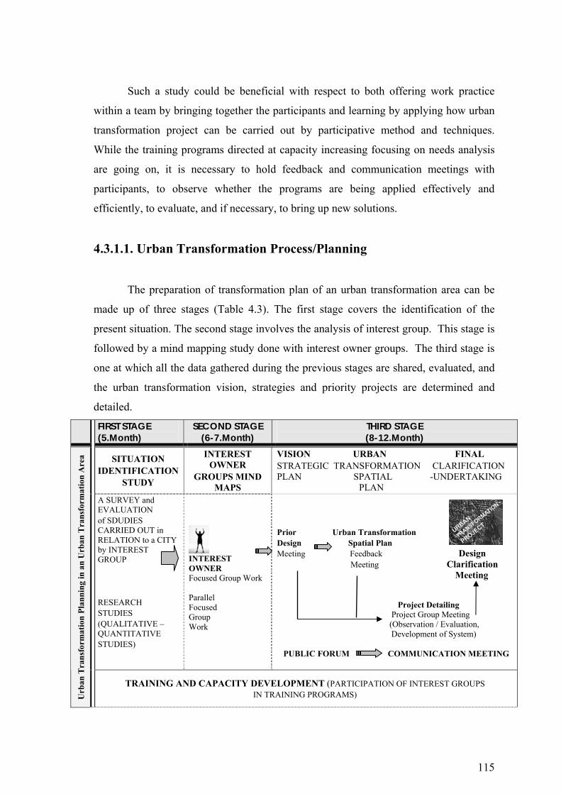
115
Such a study could be beneficial with respect to both offering work practice
within a team by bringing together the participants and learning by applying how urban
transformation project can be carried out by participative method and techniques.
While the training programs directed at capacity increasing focusing on needs analysis
are going on, it is necessary to hold feedback and communication meetings with
participants, to observe whether the programs are being applied effectively and
efficiently, to evaluate, and if necessary, to bring up new solutions.
4.3.1.1. Urban Transformation Process/Planning
The preparation of transformation plan of an urban transformation area can be
made up of three stages (Table 4.3). The first stage covers the identification of the
present situation. The second stage involves the analysis of interest group. This stage is
followed by a mind mapping study done with interest owner groups. The third stage is
one at which all the data gathered during the previous stages are shared, evaluated, and
the urban transformation vision, strategies and priority projects are determined and
detailed.
FIRST STAGE (5.Month)
SECOND STAGE (6-7.Month)
THIRD STAGE (8-12.Month)
SITUATION IDENTIFICATION
STUDY
INTEREST OWNER
GROUPS MIND MAPS
VISION URBAN FINAL STRATEGIC TRANSFORMATION CLARIFICATION PLAN SPATIAL -UNDERTAKING PLAN
A SURVEY and EVALUATION of SDUDIES CARRIED OUT in RELATION to a CITY by INTEREST GROUP RESEARCH STUDIES (QUALITATIVE – QUANTITATIVE STUDIES)
INTEREST OWNER Focused Group Work
Parallel Focused Group Work
Prior Urban Transformation Design Spatial Plan Meeting Feedback Design Meeting Clarification Meeting
Project Detailing Project Group Meeting (Observation / Evaluation,
Development of System) PUBLIC FORUM COMMUNICATION MEETING
Urb
an T
rans
form
atio
n Pl
anni
ng in
an
Urb
an T
rans
form
atio
n A
rea
TRAINING AND CAPACITY DEVELOPMENT (PARTICIPATION OF INTEREST GROUPS IN TRAINING PROGRAMS)
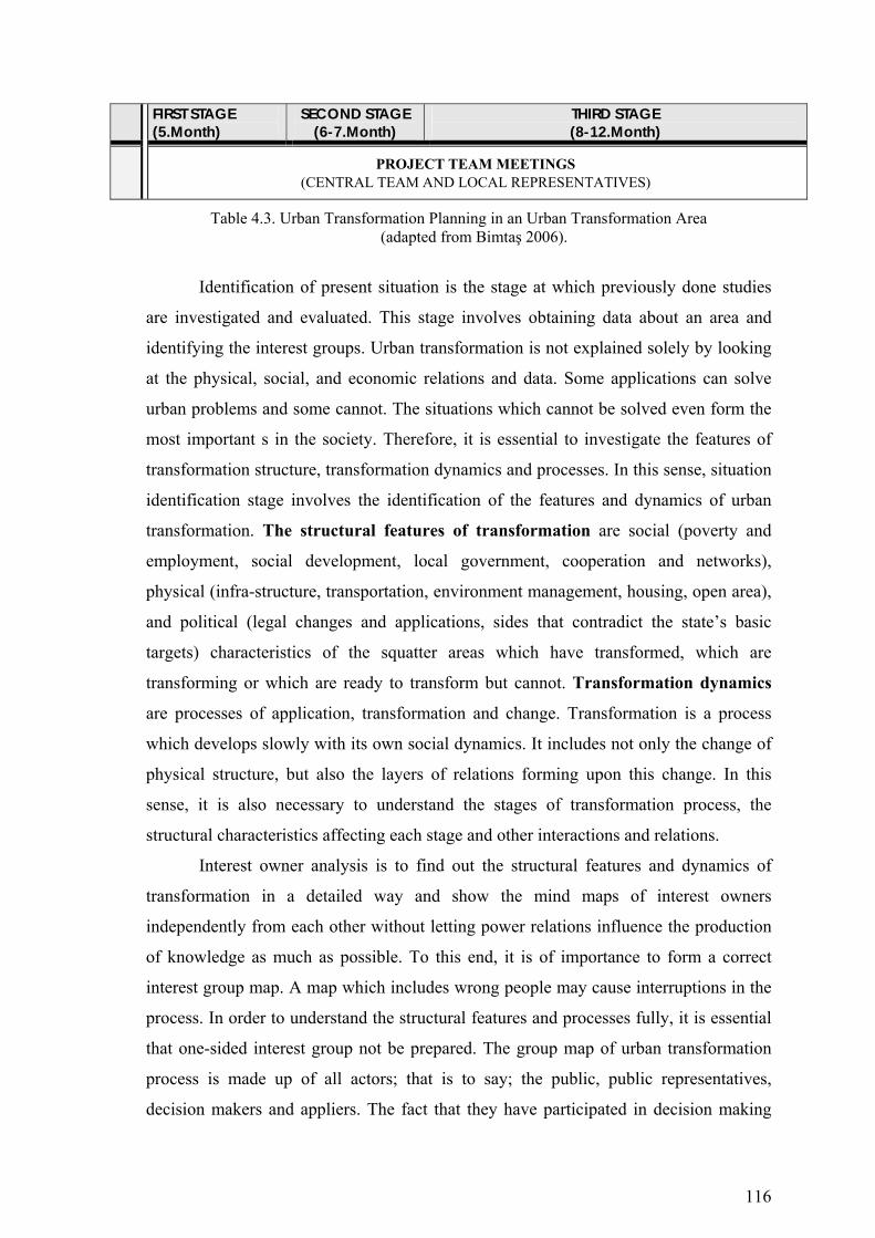
116
FIRST STAGE (5.Month)
SECOND STAGE (6-7.Month)
THIRD STAGE (8-12.Month)
PROJECT TEAM MEETINGS (CENTRAL TEAM AND LOCAL REPRESENTATIVES)
Table 4.3. Urban Transformation Planning in an Urban Transformation Area (adapted from Bimtaş 2006).
Identification of present situation is the stage at which previously done studies
are investigated and evaluated. This stage involves obtaining data about an area and
identifying the interest groups. Urban transformation is not explained solely by looking
at the physical, social, and economic relations and data. Some applications can solve
urban problems and some cannot. The situations which cannot be solved even form the
most important s in the society. Therefore, it is essential to investigate the features of
transformation structure, transformation dynamics and processes. In this sense, situation
identification stage involves the identification of the features and dynamics of urban
transformation. The structural features of transformation are social (poverty and
employment, social development, local government, cooperation and networks),
physical (infra-structure, transportation, environment management, housing, open area),
and political (legal changes and applications, sides that contradict the state’s basic
targets) characteristics of the squatter areas which have transformed, which are
transforming or which are ready to transform but cannot. Transformation dynamics
are processes of application, transformation and change. Transformation is a process
which develops slowly with its own social dynamics. It includes not only the change of
physical structure, but also the layers of relations forming upon this change. In this
sense, it is also necessary to understand the stages of transformation process, the
structural characteristics affecting each stage and other interactions and relations.
Interest owner analysis is to find out the structural features and dynamics of
transformation in a detailed way and show the mind maps of interest owners
independently from each other without letting power relations influence the production
of knowledge as much as possible. To this end, it is of importance to form a correct
interest group map. A map which includes wrong people may cause interruptions in the
process. In order to understand the structural features and processes fully, it is essential
that one-sided interest group not be prepared. The group map of urban transformation
process is made up of all actors; that is to say; the public, public representatives,
decision makers and appliers. The fact that they have participated in decision making

117
and application stages also makes them actors who claim a right in the formation of
future plans.
Interest group map is made up, in general, of local government, firms or
companies, the real owners of lands (prior to transformation), the individual who bought
the land and settled down, constructors, lawyers, planners, local tradesmen, and other
groups scattered in the city whom the public have with. However, the interest group
map for each working area may vary, expand, or get smaller. When all these are taken
into consideration, it is necessary to come together and talk with the key individuals
who have participated and taken role in decision making, planning and application
stages in order to shape a large interest group map; and then hold detailed discussions
and carry out focused group workshops with them. In parallel, the focused group
workshops are applied in order to identify the process and expectations relating to the
area of transformation. Such a study both puts the viewpoints of interest owner groups
and enables them to make evaluations and suggestions independently from each other
and far from the impact of groups’ power relations.
The data obtained from mind map workshops carried out individually or group-
based are evaluated in a preliminary design meeting which all interest group
representatives can join, and based on them, urban transformation strategies and policies
can be developed. Spatial planning is also carried out together with the produced
strategies and policies. Besides, the social projects which have priority with respect to
social and economic empowering are detailed by project groups and action plans are
prepared. At this stage, an observation and evaluation system is also developed as a part
of transformation action plan design. Finally, all the physical, social, or management
projects which are detailed get their final shape in a meeting in which interest group
representatives participate. In addition to the urban transformation design and planning
works, the process of communication and feedback should be carried out
simultaneously and continually both among the project group members and with the
general public. During the process of communication and feedback, various
communication mechanisms such as e-mail, meeting, interview and presentation can be
used. Besides, some training programs which were started in the process of capacity
development can be carried out simultaneously in parallel to the planning process.
In conclusion, given that urban transformation includes “a comprehensive
vision and activity seeking sustainable solutions to economic, social and environmental
problems of a changing region and providing solutions to urban problems”,

118
transformation can be defined as regenerating and restructuring existing values present
in the area. Thus, before taking action, 1. The values and potentials present in the
project area must be determined and analysed; 2. The dynamics of change and its
driving forces designated; 3. Responsibilities of those active in the realization of
transformation determined, and the responsibilities as well as limitations defined.
4.3.2. The Experiences of Turkey in Urban Transformation
From the past up to now, Turkey carries a characteristic of a country which has
been a stage of highly rapid socio-economic, cultural and space transformations. These
transformations are reflected to the urban spaces under the influence of political
conditions. Therefore, it is not easy to carry out the transformation process in our cities
which are full of rich cultural heritage but which suffer from the pressure of illegal and
unhealthy constructions. In spite of this, the concept of transformation and the
phenomenon of urban renewal have started to be discussed as a result of the earthquake
factor. It is also to be stressed that there are not many big-sized and multi-dimensional
urban renewal experiences in our country. On the other hand, the private sector has not
had any serious interest in urban renewal so far either. The private sector owns the
viewpoint of reaching the maximum profit in the shortest time. They are not much
interested in long-term interests and projects.
Dikmen Valley Urban Transformation Project
Dikmen Valley Project is one of the multi dimensional urban transformation
projects and is an important component of the Ankara metropolitan area cultural and
recreational system. A study for the project has started by October 1989, and is still
continuing. This project is the biggest squatter settlement renewal project. In this valley
there were 2000 squatter dwellings and approximately 10000 people had lived. The
major objectives of the project are defined as;
• To create cultural, recreational, commercial and social center which will serve the
whole city and become a well planned contemporary urban part of the city,
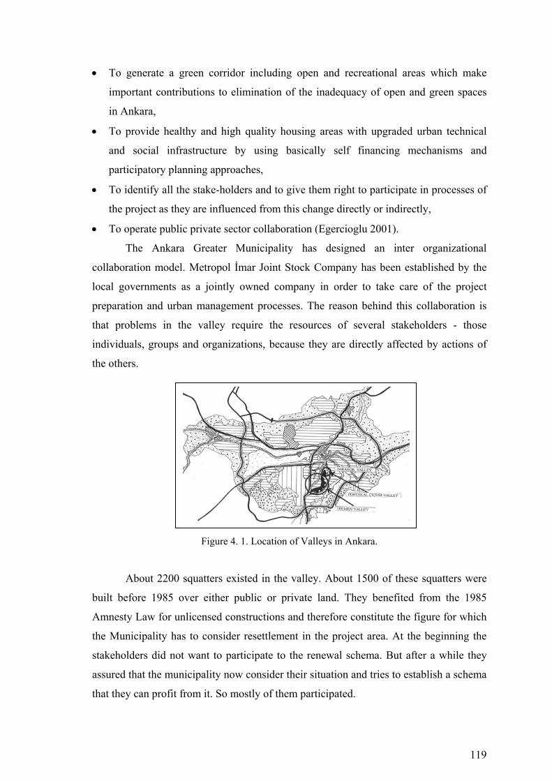
119
• To generate a green corridor including open and recreational areas which make
important contributions to elimination of the inadequacy of open and green spaces
in Ankara,
• To provide healthy and high quality housing areas with upgraded urban technical
and social infrastructure by using basically self financing mechanisms and
participatory planning approaches,
• To identify all the stake-holders and to give them right to participate in processes of
the project as they are influenced from this change directly or indirectly,
• To operate public private sector collaboration (Egercioglu 2001).
The Ankara Greater Municipality has designed an inter organizational
collaboration model. Metropol İmar Joint Stock Company has been established by the
local governments as a jointly owned company in order to take care of the project
preparation and urban management processes. The reason behind this collaboration is
that problems in the valley require the resources of several stakeholders - those
individuals, groups and organizations, because they are directly affected by actions of
the others.
Figure 4. 1. Location of Valleys in Ankara.
About 2200 squatters existed in the valley. About 1500 of these squatters were
built before 1985 over either public or private land. They benefited from the 1985
Amnesty Law for unlicensed constructions and therefore constitute the figure for which
the Municipality has to consider resettlement in the project area. At the beginning the
stakeholders did not want to participate to the renewal schema. But after a while they
assured that the municipality now consider their situation and tries to establish a schema
that they can profit from it. So mostly of them participated.

120
Figure 4. 2. Squatter Areas in Dikmen Figure 4. 3. Dikmen Valley Urban Valley Project-1991. Renewal Project – 2006.
For the people who constructed their squatters before 1985 legally deserved a
housing unit and they joined the schema. But the organization did not ignore the tenants
and the people who built their squatters after 1985 and municipality prepared a plot with
infrastructure in another part of Ankara for those people to build their own dwellings.
Despite many significant goals, objectives, and positive instruments of the project
preparation and urban management aspects, today the continuing process is quite
different from planned and desired process. The most important indicator is the high
rise and high density residential uses and the increased supply of luxury housing for
speculative purposes (Egercioglu 2001).
Portakal Çiçeği Valley Urban Transformation Project
Portakal Çiçeği Valley is an area approximately 11 hectares, situated in the
proximity of high income residential areas, modern shopping centers and embassy
buildings in Ankara. The valley is at the southern and highest point of Ankara. After
1950s by the rapid urbanization, many squatter housings appeared in the valley. In
1970s the number of squatter settlements reached to a maximum number. Then with the
increasing land values and by the high income families, who started to settle down
around the valley. It caused squatter settlement reduction. In 1985, all construction
rights were cancelled and the whole valley was designated as green area.
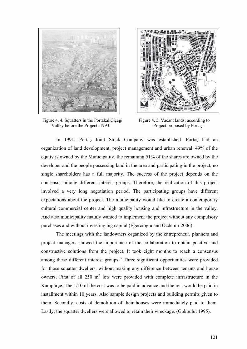
121
Figure 4. 4. Squatters in the Portakal Çiçeği Figure 4. 5. Vacant lands: according to Valley before the Project.-1993. Project proposed by Portaş.
In 1991, Portaş Joint Stock Company was established. Portaş had an
organization of land development, project management and urban renewal. 49% of the
equity is owned by the Municipality, the remaining 51% of the shares are owned by the
developer and the people possessing land in the area and participating in the project, no
single shareholders has a full majority. The success of the project depends on the
consensus among different interest groups. Therefore, the realization of this project
involved a very long negotiation period. The participating groups have different
expectations about the project. The municipality would like to create a contemporary
cultural commercial center and high quality housing and infrastructure in the valley.
And also municipality mainly wanted to implement the project without any compulsory
purchases and without investing big capital (Egercioglu and Özdemir 2006).
The meetings with the landowners organized by the entrepreneur, planners and
project managers showed the importance of the collaboration to obtain positive and
constructive solutions from the project. It took eight months to reach a consensus
among these different interest groups. “Three significant opportunities were provided
for those squatter dwellers, without making any difference between tenants and house
owners. First of all 250 m2 lots were provided with complete infrastructure in the
Karapürçe. The 1/10 of the cost was to be paid in advance and the rest would be paid in
installment within 10 years. Also sample design projects and building permits given to
them. Secondly, costs of demolition of their houses were immediately paid to them.
Lastly, the squatter dwellers were allowed to retain their wreckage. (Gökbulut 1995).
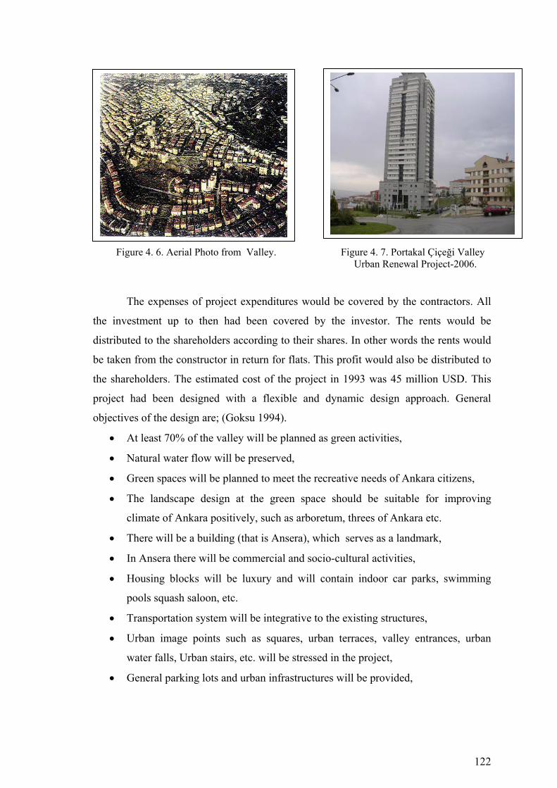
122
Figure 4. 6. Aerial Photo from Valley. Figure 4. 7. Portakal Çiçeği Valley Urban Renewal Project-2006.
The expenses of project expenditures would be covered by the contractors. All
the investment up to then had been covered by the investor. The rents would be
distributed to the shareholders according to their shares. In other words the rents would
be taken from the constructor in return for flats. This profit would also be distributed to
the shareholders. The estimated cost of the project in 1993 was 45 million USD. This
project had been designed with a flexible and dynamic design approach. General
objectives of the design are; (Goksu 1994).
• At least 70% of the valley will be planned as green activities,
• Natural water flow will be preserved,
• Green spaces will be planned to meet the recreative needs of Ankara citizens,
• The landscape design at the green space should be suitable for improving
climate of Ankara positively, such as arboretum, threes of Ankara etc.
• There will be a building (that is Ansera), which serves as a landmark,
• In Ansera there will be commercial and socio-cultural activities,
• Housing blocks will be luxury and will contain indoor car parks, swimming
pools squash saloon, etc.
• Transportation system will be integrative to the existing structures,
• Urban image points such as squares, urban terraces, valley entrances, urban
water falls, Urban stairs, etc. will be stressed in the project,
• General parking lots and urban infrastructures will be provided,
123
• Project will not only consider the project area, it will also tries to consider its
surrounding.
4.3.3. Main Issues in the Organization of Transformation/regeneration
Transformation/regeneration of a settlement may be carried out as a special
project, or conditions for the transformation/regeneration can be created (such as plans
and land subdivisions are prepared and approved) so that investors may transform
structures in time under market conditions. There are many examples of each of these
approached in Turkish cities; Dikmen Valley and Portakal Çiçeği redevelopment
projects in Ankara are the examples of first one, replacement of gecekondu buildings by
apartments in accordance to Improvement Development and Subdivision Plans are the
examples of second one. In recent years, laws have been enacted to enable
municipalities to undertake transformation/regeneration projects of the first kind. For
example, Article 73 of the Municipalities Act, numbered 5393, under the title of Urban
Transformation/regeneration and Development Areas says:
“ A municipality can implement urban transformation and development projects
to rebuild and restore the obsolescent parts of the city in accordance to its development
potential; that include dwelling areas, industry and commercial areas, technology parks
and social services, to take preventing measures against the earthquake risk or to protect
the historical and cultural pattern of the city.
An area can be declared as urban transformation and development area on the
basis of the majority vote of the municipal council.
To announce a place as an urban transformation and development area; it has to
be within the boundaries of a municipality or its adjacent area, and to be at least fifty
thousand meter square.
Agreements with the property owners are needed for the clearance or
expropriation of their properties….”
A similar approach is adopted in the Act numbered 5366 on the Preservation and
Renovation of the Historically Significant Structures. Municipal council’s decision on
the designation of a settlement as a “regeneration area” has to be approved by the
Council of Ministers.
124
To sum up, whether the transformation/regeneration will be a special Project or
will be defined as the activities to be implemented in time in accordance with a prepared
plan and defined principals under market conditions is the fundamental matter which
has to be decided at the first step.
The second important issue is which institutions or organizations will prepare
the transformation/regeneration project/process and be in charge of its implementation,
and the roles of other stakeholders, including civil society organizations.
The third issue in the realization of transformation/regeneration projects is the
forms of provision that is chosen and the types (and size) of construction firms that will
undertake the projects. These issues affect the ways in which
transformation/regeneration is undertaken.
125
CHAPTER 5
EFFECTS OF IMPROVEMENT PLANS ON URBAN
TRANSFORMATION PROCESS IN IZMIR-KONAK AND
ANKARA-ÇANKAYA MUNICIPALITY
5.1. Purpose of the Study
At the basis of this study lies the need for investigating the urban
transformation processes in squatter and illegally constructed areas, which seems
especially to be a problem of big towns and metropolitan cities, and also the thought of
identifying the problem objectively. This study aims at identifying urban renewal
form and how the transformation process has developed, and under what sort of
conditions within the present settlement of the Turkish cities, in other words in squatter
or illegally-constructed areas in recent years? In this research study, the transformation
process experienced in the squatter and illegally-constructed areas in our two big
metropolitan cities –Ankara and Izmir, in both of which improvement plans have been
applied, will be investigated, and besides, the problems in this process will be identified,
and then a set of suggestions will be developed in order to create a healthier process.
At the basis of this research study lies the fact that there is no well-established
urban renewal policy in our country, and that this brings about many problems from a
managerial viewpoint as well as legal, socio-cultural and economic reasons. For this
reason, the capacities and places of local municipalities with respect to urban
transformation will be investigated within the scope of Ankara-Çankaya and Izmir-
Konak Municipalities. In this sense, the following questions will be investigated in this
research study:
♦ What is the objective place of Ankara-Çankaya and Izmir-Konak
Municipalities in relation to urban transformation? What are the urban
transformation approaches and opportunities for local municipalities in our
country? Also, what are the urban transformation processes and approaches in
squatter areas where improvement plans were realized during the period after
1980?

126
♦ What are the reasons which necessitate urban transformation in the urban space?
In what way is the allocation of the urban transformation processes -carried out
in the squatter areas where an improvement plan was applied – being realized in
the urban space? For example, what sort of urban transformation activities are
being realized in squatter areas? What is the organizational structure of urban
transformation processes and what are the conditions for project formation?
♦ An examination of urban transformation in squatter/illegally constructed areas
where an improvement plan was applied?
A. Urban transformation projects (large-scale urban transformation
projects realized in squatter areas by demolishing / reconstruction)
B. Single-plot based urban redevelopment process by demolishing /
reconstruction (construct – sale)
C. Vacant-plot based urban development process. Urban transformation
done in vacant space on the basis of single plot.
D. Co-operative based urban redevelopment process. Urban
transformation formed with the leadership of a constructor under the
protection of co-operative using a number of plots and development
plan
E. Add-on Floors in squatter/illegal housing areas.
F. Unaltered buildings. Buildings that are not transformed.
♦ The distribution of plots according to the roads, ownership and other factors
of the urban transformation done in the squatter areas where an improvement
plan was applied. This condition is of importance with respect to the number of
floors and height a building because such features as conditions of development,
road width, the number of floors and the location of the region constitute the
most important factors in the realization of urban transformation processes. At
this point, the data to be obtained are:
♦ Location of the plot,
♦ Transport to the plot,
♦ Condition of ownership,
♦ Front of the plot and its depth,
♦ and the number of floors.
127
♦ What is the point of view of the local municipalities to squatter areas where
urban transformation is being carried out?
♦ Is it an application of a classic development plan?
♦ Does it aim to increase the number of new spaces for facilities?
♦ Does it aim to construct modern roads?
♦ Is it an application to solve the problems of infrastructure?
♦ What are the experiences of the municipalities with regard to
urban transformation?
♦ Are there any staff employed in the body of the municipalities
who are expert in urban transformation?
5.1.1. Methodology of Study
In the case study, the boundaries of the squatter and illegally-constructed areas,
where an improvement plan was applied within Izmir-Konak and Ankara-Çankaya
municipalities, were identified. Also, the construction-certificate archives of the two
municipalities were searched, and the transformation periods of previously determined
buildings were investigated in detail. The buildings which were investigated in the
archives were taken into consideration within a 5% sample (1 building in 20). The
results of available transformation processes have been useful in forming the
suggestions that take place in the model.
5.2. The Process of Urban Transformation in Konak Municipality
Of the nine municipial towns which are connected to the Major Municipality of
Izmir, Konak - as the central town of Izmir - owns the largest population. In 2000, the
population of the town was 781.073, and it was the area of settlement where the squatter
areas were observed to be at the highest level with respect to the area they covered
before 1980’s. One-third of the improvement plans (1.053ha.) which were prepared and
authorized for 3.214 hectare-land between 1985 and 1998 within the boundaries of
Izmir Municipality based on the laws of exemption are within the boundaries of the
town of Konak Municipality.
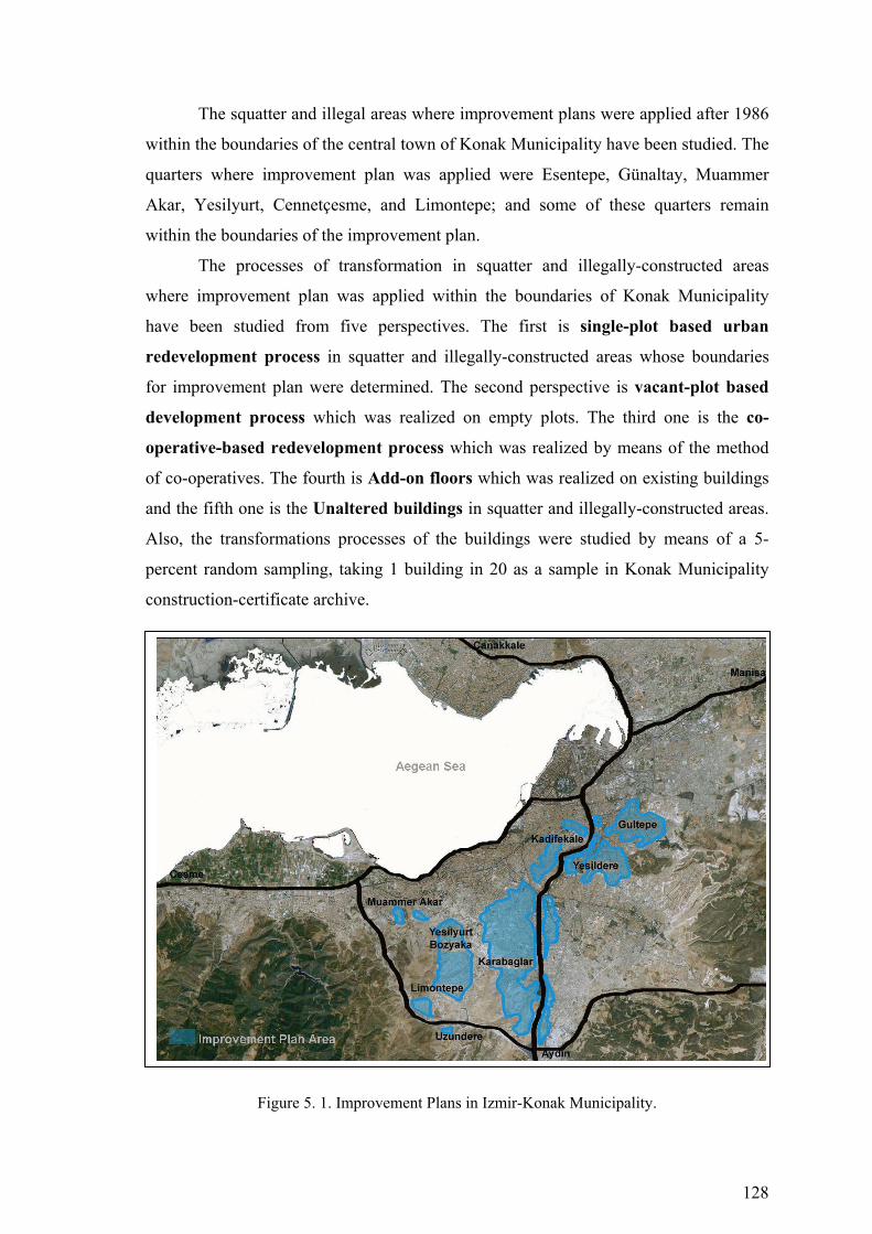
128
The squatter and illegal areas where improvement plans were applied after 1986
within the boundaries of the central town of Konak Municipality have been studied. The
quarters where improvement plan was applied were Esentepe, Günaltay, Muammer
Akar, Yesilyurt, Cennetçesme, and Limontepe; and some of these quarters remain
within the boundaries of the improvement plan.
The processes of transformation in squatter and illegally-constructed areas
where improvement plan was applied within the boundaries of Konak Municipality
have been studied from five perspectives. The first is single-plot based urban
redevelopment process in squatter and illegally-constructed areas whose boundaries
for improvement plan were determined. The second perspective is vacant-plot based
development process which was realized on empty plots. The third one is the co-
operative-based redevelopment process which was realized by means of the method
of co-operatives. The fourth is Add-on floors which was realized on existing buildings
and the fifth one is the Unaltered buildings in squatter and illegally-constructed areas.
Also, the transformations processes of the buildings were studied by means of a 5-
percent random sampling, taking 1 building in 20 as a sample in Konak Municipality
construction-certificate archive.
Figure 5. 1. Improvement Plans in Izmir-Konak Municipality.
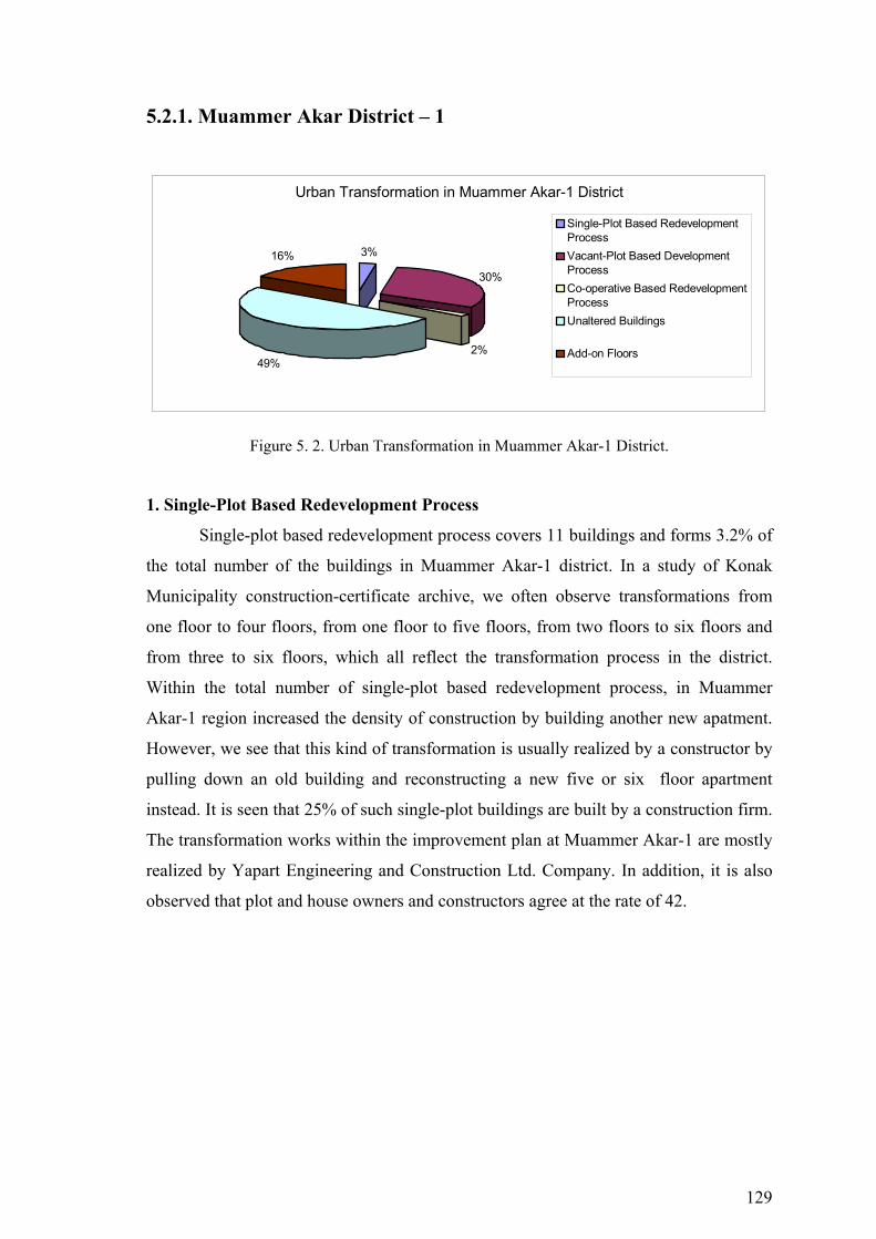
129
5.2.1. Muammer Akar District – 1
Urban Transformation in Muammer Akar-1 District
3%
30%
2%49%
16%
Single-Plot Based RedevelopmentProcessVacant-Plot Based DevelopmentProcessCo-operative Based RedevelopmentProcessUnaltered Buildings
Add-on Floors
Figure 5. 2. Urban Transformation in Muammer Akar-1 District.
1. Single-Plot Based Redevelopment Process
Single-plot based redevelopment process covers 11 buildings and forms 3.2% of
the total number of the buildings in Muammer Akar-1 district. In a study of Konak
Municipality construction-certificate archive, we often observe transformations from
one floor to four floors, from one floor to five floors, from two floors to six floors and
from three to six floors, which all reflect the transformation process in the district.
Within the total number of single-plot based redevelopment process, in Muammer
Akar-1 region increased the density of construction by building another new apatment.
However, we see that this kind of transformation is usually realized by a constructor by
pulling down an old building and reconstructing a new five or six floor apartment
instead. It is seen that 25% of such single-plot buildings are built by a construction firm.
The transformation works within the improvement plan at Muammer Akar-1 are mostly
realized by Yapart Engineering and Construction Ltd. Company. In addition, it is also
observed that plot and house owners and constructors agree at the rate of 42.
130
Single Plot Based Redevelopment ProcessMuammer Akar 1 District
11
3 3
1 1 1
00,5
11,5
22,5
33,5
1-4 fl.
1-5 fl.
2-6 fl.
3-5 fl.
3-6 fl.
4-5 fl.
4-6 fl.
Number of Floor
Build
ing
Figure 5. 3. Single Plot Based Redevelopment Process: Muammer Akar-1 District.
B. Block-
Plot Construction
Firm Plot/Building Ownership
Building Permit
Building Transformation
Contract Rate
B. Permit Date
1 41997-30 Y. Const. Co. Osman D. 4 fl. 2 fl. - 6 fl. 42% 14.11.1997 2 42004-11 - Ahmet K. 4 fl. 1 fl. - 5 fl. - 05.08.1995
Table 5. 1. Evaluation of construction-certificate archieve in Muammer Akar-1 District: (Single Plot Based).
Figure 5. 4. Single Plot Based Redevelopment Figure 5. 5. Building Transformation in in 41997 B.Block and 30 Plot. Muammer Akar-1 District.
2. Vacant-Plot Based Development Process
In vacant-plot based development process, Muammer Akar-1 forms 30.1% of
the total construction with 127 buildings. In a study of construction-certificate archive,
it is seen that individuals tend to settle down in Muammer Akar-1 region by building
their houses on their own. The transformation is realized from a vacant plot to one, two,
three and four floors. In this way, the rate of the settlers in this region forms 84.2%
Building Transformation(Single Plot+Add on Floors)
in Muammer Akar-1 District
86%
14%
Increased the density of construction by buildinganother floor on their own
Transformed the building by a constructor
131
within vacant-plot based transformation. We also see that 15.8% of the rest of the
buildings are transformed from vacant plot to five or six-floor apartments in the
leadership of constructors. Of the buildings transformed from a vacant plot, it is seen
that 66.7% of them were renewed by a construction firm. In fact, this rate shows a
transformation organization. We often see that land owners and constructors make an
agreement on the basis of a flat under the present conditions, and in this way, vacant
plots are transformed to apartments. It seems that the transformation works in
Muammer Akar-1 are often realized by Aksoy Engineering and Construction Ltd
Company and Dalyan Engineering and Construction Ltd. Company within the limits of
improvement plan. It is also observed that plot owners and constructors tend to agree on
the rate of 40%.
Vacant Plot Based Development ProcessMuammer Akar-1 District
3027
40
1810
20
10
20
30
40
50
1fl.
2fl.
3 fl.
4 fl.
5 fl.
6 fl.
Number of Floor
Bui
ldin
g
Figure 5. 6. Vacant Plot Based Development Process: Muammer Akar-1 District.
B.Block-Plot
Construction Firm
Plot/Building Ownership
Building Permit
Building Transformation
Contract Rate
B. Permit Date
1 42014-10 A. Const.Co. Behri A. 4 fl. Plot - 5 fl. 40% 15.12.1992 2 41992-1 - Emine S. 4 fl. Plot - 2 fl. - 24.02.1998 3 42004-8 - Fehmi P. 4 fl. Plot -2 fl. - 22.02.1993 4 42015-24 - Muzaffer S. 4 fl. Plot - 4 fl. - 12.03.1994 5 6304-24 - Mehmet K. 4 fl. Plot - 2 fl. - unlicenced 6 41990-14 D. Const.Co. Yılmaz K. 4 fl. Plot - 5 fl. - 25.11.1996
Table 5. 2. Evaluation of construction-certificate archieve in Muammer Akar-1 District: (Vacant-Plot Based).
132
Figure 5. 7. Vacant Plot Based Development Figure 5. 8. Vacant-Plot Based Development in 42014 B.Block and 10 Plot. in Muammer Akar-1 District.
3. Co-operative Based Redevelopment Process
In co-operative based redevelopment process, Muammer Akar-1 region forms
2.1% of the total construction with 9 buildings. In a study of construction-certificate
archive, this kind of transformation seems to be realized in the leadership of a co-
operative on a vacant land to build five or six-floor apartments. Co-operative based
redevelopment process includes land owners, constructors, and co-operative members.
Co-operative based transformation works at Muammer Akar-1 region are mostly
realized by Süreç Engineering and Construction Ltd Company within the limits of the
improvement plan. It seems that land owners and constructors agree on the rate of 38%.
Co-operative Based RedevelopmentMuammer Akar-1 District
12
6
01234567
5 fl.
6 fl.
7 fl.
Number of Floor
Bui
ldin
g
Figure 5. 9. Co-operative Based Redevelopment Process: Muammer Akar-1 District.
B.Block-Plot
Construction Firm
Plot/Building Ownership
Building Permit
Building Transformation
Contract Rate
B. Permit Date
1 42415-6 S. Const.Co. Y. Koop. 6 fl. 1 fl. -7 fl. 38% 16.03.1998 Table 5. 3. Evaluation of construction-certificate archieve in Muammer Akar-1 District:
(Co-operative Based).
Vacant-Plot Based Development in Muammer Akar-1 District
84%
16%
Increased the density of construction by buildinganother floor on their own
Transformed the vacant plot by a constructor

133
Figure 5. 10. Co-operative Based Redevelopment Figure 5. 11. Contract Rate in Muammer in 42415 B.Block and 48 Plot. Akar-1 District.
4. Add-On Floors
Add-on Floors cover 65 buildings and forms 15.7% of the total number of the
buildings in Muammer Akar-1 district. In a study of Konak Municipality construction-
certificate archive, we often observe transformations from one floor to three floors,
from one floor to four floors, from two floors to three and four floors and from three to
four floors, which all reflect the increase in present density. Within the total number of
add-on floors process, in Muammer Akar-1 region increased the density of construction
by building another floor on their own.
Add-on FloorsMuammer Akar 1 District
6
18
12 1210
7
0
5
10
15
20
1-2 fl.
1-3 fl.
1-4 fl.
2-3 fl.
2-4 fl.
3-4 fl.
Number of Floor
Build
ing
Figure 5. 12. Add-on Floors: Muammer Akar-1 District.
B. Block-
Plot Construction
Firm Plot/Building Ownership
Building Permit
Building Transformation
Contract Rate
B. Permit Date
1 42014-16 - Hasan Ö. 4 fl. 1 fl. - 2 fl. - 01.11.1998 2 6303-1 - Vehbi A. 4 fl. 1 fl. - 3 fl. - 16.03.2001
Table 5. 4. Evaluation of construction-certificate archieve in Muammer Akar-1 District: (Add-on Floors)
Contract Rate in Muammer Akar-1 District
38%
62%
Construction Firm Plot/Building Ow nership

134
Figure 5. 13. Urban Transformation Process (1986-2005) Konak Municipality- Muammer Akar-1 District

135
Figure 5. 14. Buildings that are Investigated in Konak Municipality Construction Certificate Archive-Muammer Akar-1 District
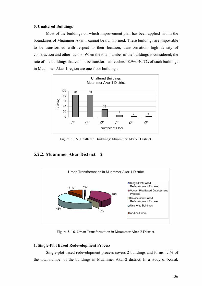
136
5. Unaltered Buildings
Most of the buildings on which improvement plan has been applied within the
boundaries of Muammer Akar-1 cannot be transformed. These buildings are impossible
to be transformed with respect to their location, transformation, high density of
construction and other factors. When the total number of the buildings is considered, the
rate of the buildings that cannot be transformed reaches 48.9%. 40.7% of such buildings
in Muammer Akar-1 region are one-floor buildings.
Unaltered BuildingsMuammer Akar-1 District
28
84 83
72 2
0
20
40
60
80
100
1 fl.
2 fl.
3 fl.
4 fl.
5 fl.
6 fl.
Number of Floor
Build
ing
Figure 5. 15. Unaltered Buildings: Muammer Akar-1 District.
5.2.2. Muammer Akar District – 2
Urban Transformation in Muammer Akar-1 District
1%
40%
0%48%
11%
Single-Plot BasedRedevelopment ProcessVacant-Plot Based DevelopmentProcessCo-operative BasedRedevelopment ProcessUnaltered Buildings
Add-on Floors
Figure 5. 16. Urban Transformation in Muammer Akar-2 District.
1. Single-Plot Based Redevelopment Process
Single-plot based redevelopment process covers 2 buildings and forms 1.1% of
the total number of the buildings in Muammer Akar-2 district. In a study of Konak
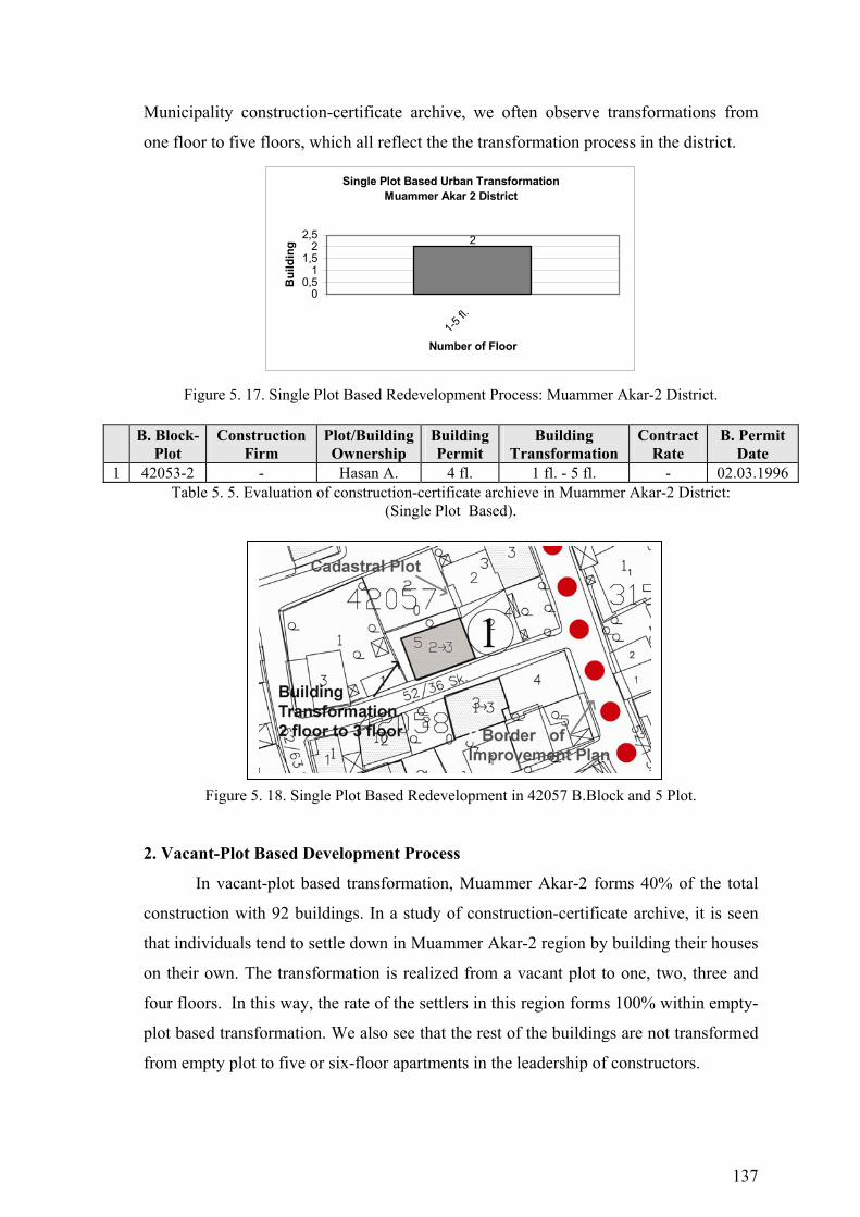
137
Municipality construction-certificate archive, we often observe transformations from
one floor to five floors, which all reflect the the transformation process in the district.
Single Plot Based Urban TransformationMuammer Akar 2 District
2
00,5
11,5
22,5
1-5 fl.
Number of Floor
Bui
ldin
g
Figure 5. 17. Single Plot Based Redevelopment Process: Muammer Akar-2 District.
Table 5. 5. Evaluation of construction-certificate archieve in Muammer Akar-2 District: (Single Plot Based).
Figure 5. 18. Single Plot Based Redevelopment in 42057 B.Block and 5 Plot.
2. Vacant-Plot Based Development Process
In vacant-plot based transformation, Muammer Akar-2 forms 40% of the total
construction with 92 buildings. In a study of construction-certificate archive, it is seen
that individuals tend to settle down in Muammer Akar-2 region by building their houses
on their own. The transformation is realized from a vacant plot to one, two, three and
four floors. In this way, the rate of the settlers in this region forms 100% within empty-
plot based transformation. We also see that the rest of the buildings are not transformed
from empty plot to five or six-floor apartments in the leadership of constructors.
B. Block-Plot
Construction Firm
Plot/Building Ownership
Building Permit
Building Transformation
Contract Rate
B. Permit Date
1 42053-2 - Hasan A. 4 fl. 1 fl. - 5 fl. - 02.03.1996
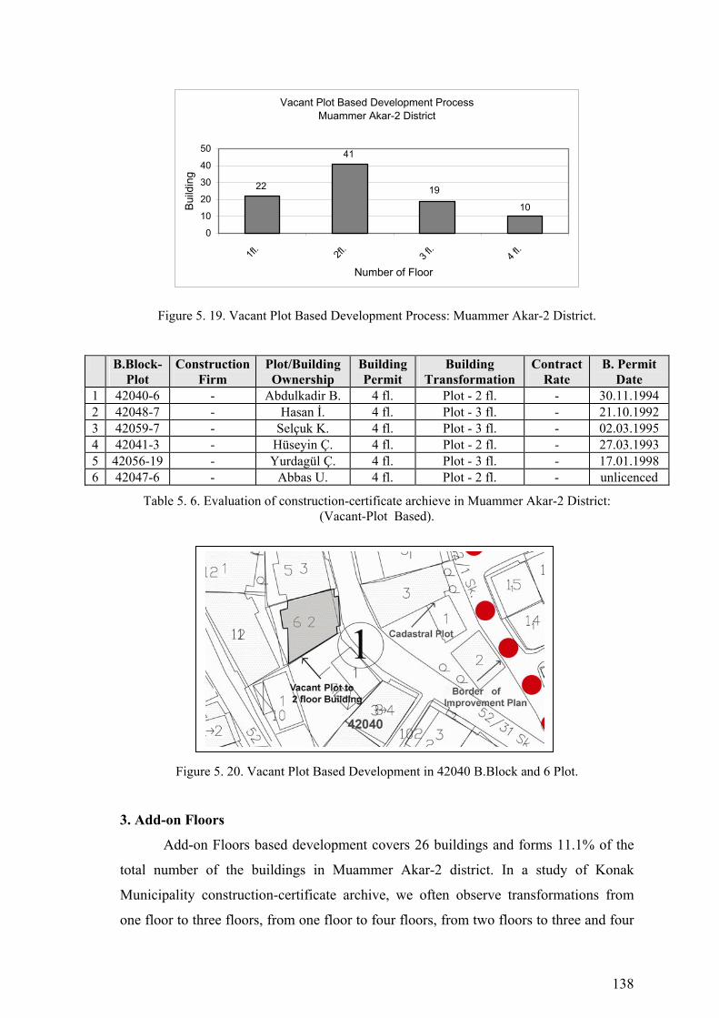
138
Vacant Plot Based Development ProcessMuammer Akar-2 District
10
41
22 19
0
10
20
30
40
50
1fl.
2fl.
3 fl.
4 fl.
Number of Floor
Build
ing
Figure 5. 19. Vacant Plot Based Development Process: Muammer Akar-2 District.
B.Block-Plot
Construction Firm
Plot/Building Ownership
Building Permit
Building Transformation
Contract Rate
B. Permit Date
1 42040-6 - Abdulkadir B. 4 fl. Plot - 2 fl. - 30.11.1994 2 42048-7 - Hasan İ. 4 fl. Plot - 3 fl. - 21.10.1992 3 42059-7 - Selçuk K. 4 fl. Plot - 3 fl. - 02.03.1995 4 42041-3 - Hüseyin Ç. 4 fl. Plot - 2 fl. - 27.03.1993 5 42056-19 - Yurdagül Ç. 4 fl. Plot - 3 fl. - 17.01.1998 6 42047-6 - Abbas U. 4 fl. Plot - 2 fl. - unlicenced
Table 5. 6. Evaluation of construction-certificate archieve in Muammer Akar-2 District: (Vacant-Plot Based).
Figure 5. 20. Vacant Plot Based Development in 42040 B.Block and 6 Plot.
3. Add-on Floors
Add-on Floors based development covers 26 buildings and forms 11.1% of the
total number of the buildings in Muammer Akar-2 district. In a study of Konak
Municipality construction-certificate archive, we often observe transformations from
one floor to three floors, from one floor to four floors, from two floors to three and four
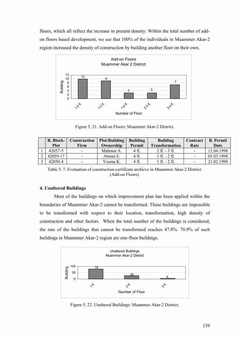
139
floors, which all reflect the increase in present density. Within the total number of add-
on floors based development, we see that 100% of the individuals in Muammer Akar-2
region increased the density of construction by building another floor on their own.
Add-on FloorsMuammer Akar 2 District
3
10 9
3
7
02468
1012
1-2 fl.
1-3 fl.
1-4 fl.
2-3 fl.
3-4 fl.
Number of Floor
Build
ing
Figure 5. 21. Add-on Floors: Muammer Akar-2 District.
B. Block-Plot
Construction Firm
Plot/Building Ownership
Building Permit
Building Transformation
Contract Rate
B. Permit Date
1 42057-5 - Mahmut A. 4 fl. 2 fl. - 3 fl. - 12.04.1998 2 42059-17 - Ahmet E. 4 fl. 1 fl. - 2 fl. - 05.03.1998 3 42050-4 - Yosma K. 4 fl. 1 fl. - 2 fl. - 21.02.1998
Table 5. 7. Evaluation of construction-certificate archieve in Muammer Akar-2 District: (Add-on Floors).
4. Unaltered Buildings
Most of the buildings on which improvement plan has been applied within the
boundaries of Muammer Akar-2 cannot be transformed. These buildings are impossible
to be transformed with respect to their location, transformation, high density of
construction and other factors. When the total number of the buildings is considered,
the rate of the buildings that cannot be transformed reaches 47.8%. 70.9% of such
buildings in Muammer Akar-2 region are one-floor buildings.
Unaltered BuildingsMuammer Akar-2 District
6
78
260
50
100
1 fl.
2 fl.
3 fl.
Number of Floor
Build
ing
Figure 5. 22. Unaltered Buildings: Muammer Akar-2 District.

140
Figure 5. 23. Urban Transformation Process (1986-2005) Konak Municipality Muammer Akar 2 District
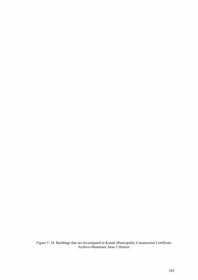
141
Figure 5. 24. Buildings that are Investigated in Konak Municipality Construction Certificate Archive-Muammer Akar-2 District
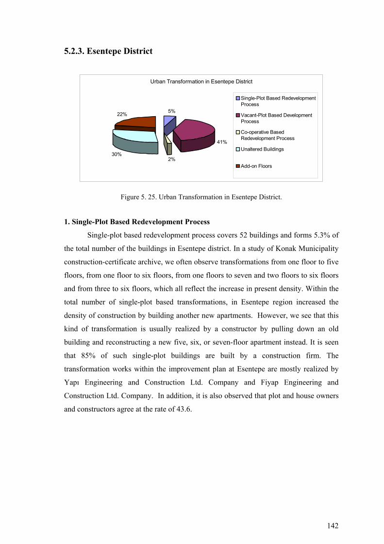
142
5.2.3. Esentepe District
Urban Transformation in Esentepe District
5%
41%
2%30%
22%
Single-Plot Based RedevelopmentProcess
Vacant-Plot Based DevelopmentProcess
Co-operative BasedRedevelopment Process
Unaltered Buildings
Add-on Floors
Figure 5. 25. Urban Transformation in Esentepe District.
1. Single-Plot Based Redevelopment Process
Single-plot based redevelopment process covers 52 buildings and forms 5.3% of
the total number of the buildings in Esentepe district. In a study of Konak Municipality
construction-certificate archive, we often observe transformations from one floor to five
floors, from one floor to six floors, from one floors to seven and two floors to six floors
and from three to six floors, which all reflect the increase in present density. Within the
total number of single-plot based transformations, in Esentepe region increased the
density of construction by building another new apartments. However, we see that this
kind of transformation is usually realized by a constructor by pulling down an old
building and reconstructing a new five, six, or seven-floor apartment instead. It is seen
that 85% of such single-plot buildings are built by a construction firm. The
transformation works within the improvement plan at Esentepe are mostly realized by
Yapı Engineering and Construction Ltd. Company and Fiyap Engineering and
Construction Ltd. Company. In addition, it is also observed that plot and house owners
and constructors agree at the rate of 43.6.
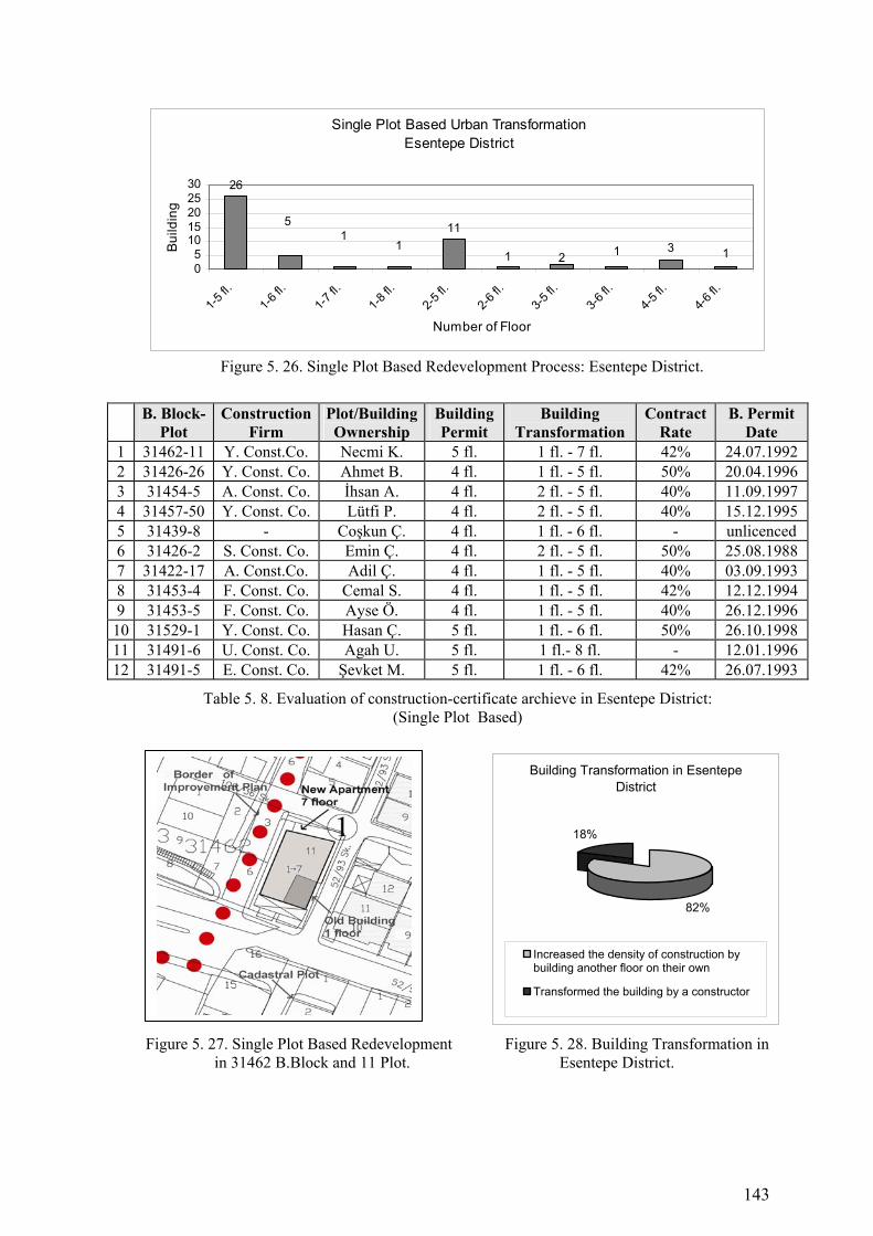
143
Single Plot Based Urban TransformationEsentepe District
1
26
5
111
1 2 1 3 105
1015202530
1-5 fl.
1-6 fl.
1-7 fl.
1-8 fl.
2-5 fl.
2-6 fl.
3-5 fl.
3-6 fl.
4-5 fl.
4-6 fl.
Number of Floor
Bui
ldin
g
Figure 5. 26. Single Plot Based Redevelopment Process: Esentepe District.
B. Block-
Plot Construction
Firm Plot/Building Ownership
Building Permit
Building Transformation
Contract Rate
B. Permit Date
1 31462-11 Y. Const.Co. Necmi K. 5 fl. 1 fl. - 7 fl. 42% 24.07.1992 2 31426-26 Y. Const. Co. Ahmet B. 4 fl. 1 fl. - 5 fl. 50% 20.04.1996 3 31454-5 A. Const. Co. İhsan A. 4 fl. 2 fl. - 5 fl. 40% 11.09.1997 4 31457-50 Y. Const. Co. Lütfi P. 4 fl. 2 fl. - 5 fl. 40% 15.12.1995 5 31439-8 - Coşkun Ç. 4 fl. 1 fl. - 6 fl. - unlicenced 6 31426-2 S. Const. Co. Emin Ç. 4 fl. 2 fl. - 5 fl. 50% 25.08.1988 7 31422-17 A. Const.Co. Adil Ç. 4 fl. 1 fl. - 5 fl. 40% 03.09.1993 8 31453-4 F. Const. Co. Cemal S. 4 fl. 1 fl. - 5 fl. 42% 12.12.1994 9 31453-5 F. Const. Co. Ayse Ö. 4 fl. 1 fl. - 5 fl. 40% 26.12.1996
10 31529-1 Y. Const. Co. Hasan Ç. 5 fl. 1 fl. - 6 fl. 50% 26.10.1998 11 31491-6 U. Const. Co. Agah U. 5 fl. 1 fl.- 8 fl. - 12.01.1996 12 31491-5 E. Const. Co. Şevket M. 5 fl. 1 fl. - 6 fl. 42% 26.07.1993
Table 5. 8. Evaluation of construction-certificate archieve in Esentepe District: (Single Plot Based)
Figure 5. 27. Single Plot Based Redevelopment Figure 5. 28. Building Transformation in in 31462 B.Block and 11 Plot. Esentepe District.
Building Transformation in Esentepe District
82%
18%
Increased the density of construction bybuilding another floor on their own
Transformed the building by a constructor

144
2. Vacant-Plot Based Development Process
In vacant-plot based development process, Esentepe forms 41.4% of the total
construction with 463 buildings. In a study of construction-certificate archive, it is seen
that individuals tend to settle down in Esentepe region by building their houses on their
own. The transformation is realized from a vacant plot to one, two, three and four
floors. In this way, the rate of the settlers in this region forms 71.8% within vacant-plot
based transformation. We also see that 28.2% of the rest of the buildings are
transformed from vacant plot to five or six-floor apartments in the leadership of
constructors. Of the buildings transformed from a vacant plot, it is seen that 27.2% of
them were renewed by a construction firm. In fact, this rate shows a transformation
organization. We often see that land owners and constructors make an agreement on the
basis of a flat under the present conditions, and in this way, vacant plots are transformed
to apartments. It seems that the transformation works in Esentepe are often realized by
Konum Engineering and Construction Ltd Company and Ertem Engineering and
Construction Ltd. Company within the limits of improvement plan. It is also observed
that plot owners and constructors tend to agree on the rate of 41%.
Vacant Plot Based Development ProcessEsentepe District
7650
74
133108
193
020406080
100120140
1fl.
2fl.
3 fl.
4 fl.
5 fl.
6 fl.
7 fl.
Number of Floor
Build
ing
Figure 5. 29. Vacant Plot Based Development Process: Esentepe District.
B.Block-Plot
Construction Firm
Plot/Building Ownership
BuildingPermit
Building Transformation
Contract Rate
B. Permit Date
1 31507-10 Y. Const. Co. Yusuf A. 5 fl. Plot - 6 fl. 42% 07.05.1996 2 31519-13 - Veli D. 5 fl. Plot - 7 fl. - unlicenced 3 31546-30 K. Const. Co. Süleyma K. 4 fl. Plot - 4 fl. - 21.03.2006 4 31546-10 E. Const. Co. Fevzi Ö. 4 fl. Plot - 5 fl. - 08.03.2000 5 31508-5 - Mehmet Ö. 4 fl. Plot - 5 fl. - 08.04.1998 6 34508-5 - Ali T. 4 fl. Plot - 4 fl. - 07.05.1997 7 31528-2 - Yusuf K. 4 fl. Plot - 4 fl. - 02.11.1998 8 34535-1 - Arif A. 3 fl. Plot - 2 fl. - unlicenced 9 34536-10 E. Const. Co. Fethi B. 4 fl. Plot - 4 fl. - 07.05.1999
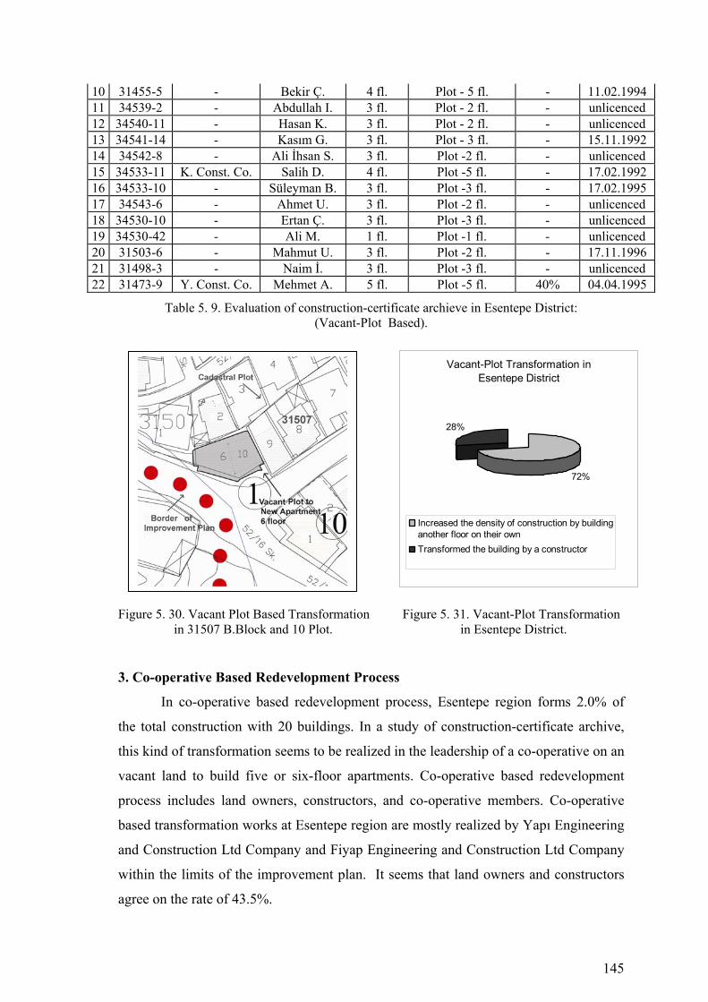
145
10 31455-5 - Bekir Ç. 4 fl. Plot - 5 fl. - 11.02.1994 11 34539-2 - Abdullah I. 3 fl. Plot - 2 fl. - unlicenced 12 34540-11 - Hasan K. 3 fl. Plot - 2 fl. - unlicenced 13 34541-14 - Kasım G. 3 fl. Plot - 3 fl. - 15.11.1992 14 34542-8 - Ali İhsan S. 3 fl. Plot -2 fl. - unlicenced 15 34533-11 K. Const. Co. Salih D. 4 fl. Plot -5 fl. - 17.02.1992 16 34533-10 - Süleyman B. 3 fl. Plot -3 fl. - 17.02.1995 17 34543-6 - Ahmet U. 3 fl. Plot -2 fl. - unlicenced 18 34530-10 - Ertan Ç. 3 fl. Plot -3 fl. - unlicenced 19 34530-42 - Ali M. 1 fl. Plot -1 fl. - unlicenced 20 31503-6 - Mahmut U. 3 fl. Plot -2 fl. - 17.11.1996 21 31498-3 - Naim İ. 3 fl. Plot -3 fl. - unlicenced 22 31473-9 Y. Const. Co. Mehmet A. 5 fl. Plot -5 fl. 40% 04.04.1995
Table 5. 9. Evaluation of construction-certificate archieve in Esentepe District: (Vacant-Plot Based).
Figure 5. 30. Vacant Plot Based Transformation Figure 5. 31. Vacant-Plot Transformation in 31507 B.Block and 10 Plot. in Esentepe District.
3. Co-operative Based Redevelopment Process
In co-operative based redevelopment process, Esentepe region forms 2.0% of
the total construction with 20 buildings. In a study of construction-certificate archive,
this kind of transformation seems to be realized in the leadership of a co-operative on an
vacant land to build five or six-floor apartments. Co-operative based redevelopment
process includes land owners, constructors, and co-operative members. Co-operative
based transformation works at Esentepe region are mostly realized by Yapı Engineering
and Construction Ltd Company and Fiyap Engineering and Construction Ltd Company
within the limits of the improvement plan. It seems that land owners and constructors
agree on the rate of 43.5%.
Vacant-Plot Transformation in Esentepe District
72%
28%
Increased the density of construction by buildinganother floor on their own Transformed the building by a constructor
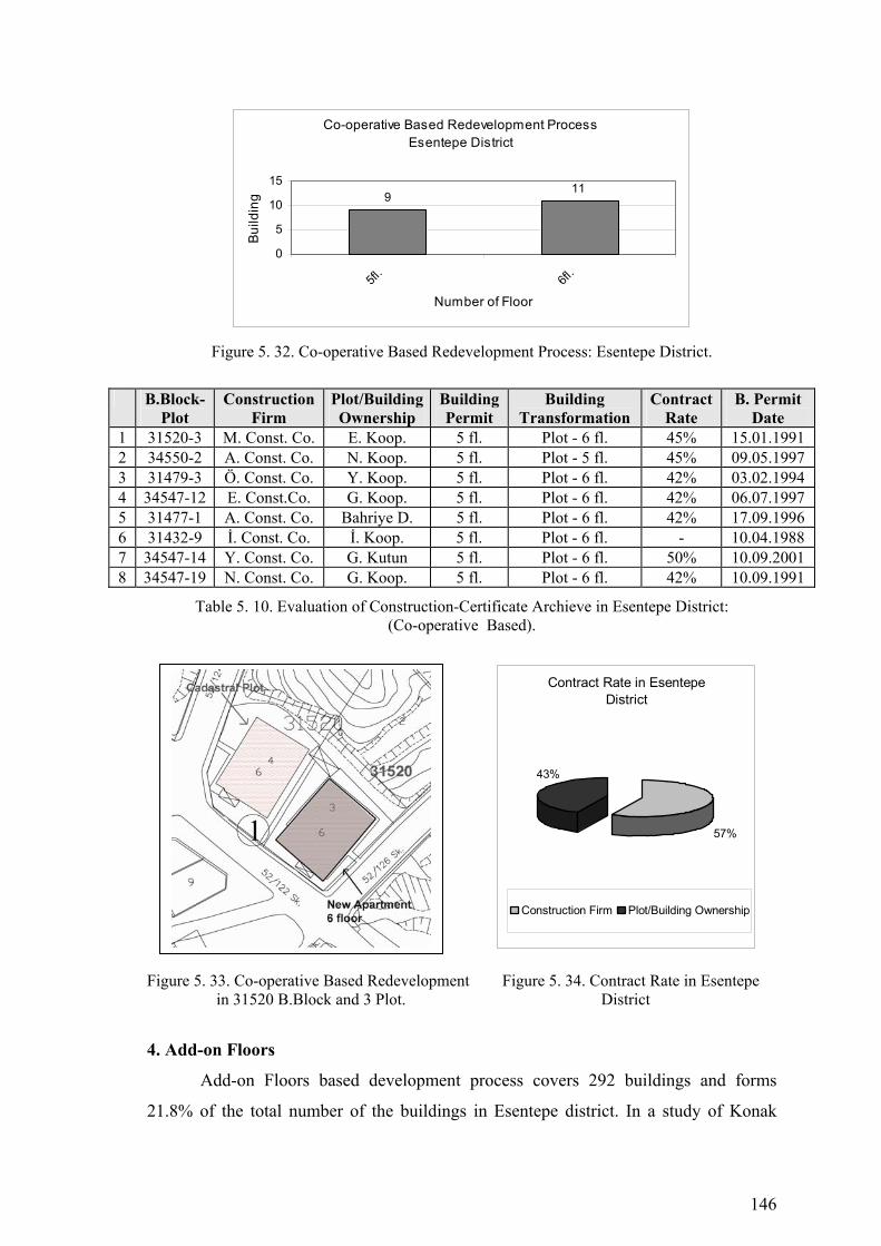
146
Co-operative Based Redevelopment ProcessEsentepe District
911
0
5
10
15
5fl.
6fl.
Number of Floor
Build
ing
Figure 5. 32. Co-operative Based Redevelopment Process: Esentepe District.
B.Block-
Plot Construction
Firm Plot/Building Ownership
BuildingPermit
Building Transformation
Contract Rate
B. Permit Date
1 31520-3 M. Const. Co. E. Koop. 5 fl. Plot - 6 fl. 45% 15.01.1991 2 34550-2 A. Const. Co. N. Koop. 5 fl. Plot - 5 fl. 45% 09.05.1997 3 31479-3 Ö. Const. Co. Y. Koop. 5 fl. Plot - 6 fl. 42% 03.02.1994 4 34547-12 E. Const.Co. G. Koop. 5 fl. Plot - 6 fl. 42% 06.07.1997 5 31477-1 A. Const. Co. Bahriye D. 5 fl. Plot - 6 fl. 42% 17.09.1996 6 31432-9 İ. Const. Co. İ. Koop. 5 fl. Plot - 6 fl. - 10.04.1988 7 34547-14 Y. Const. Co. G. Kutun 5 fl. Plot - 6 fl. 50% 10.09.2001 8 34547-19 N. Const. Co. G. Koop. 5 fl. Plot - 6 fl. 42% 10.09.1991
Table 5. 10. Evaluation of Construction-Certificate Archieve in Esentepe District: (Co-operative Based).
Figure 5. 33. Co-operative Based Redevelopment Figure 5. 34. Contract Rate in Esentepe in 31520 B.Block and 3 Plot. District
4. Add-on Floors
Add-on Floors based development process covers 292 buildings and forms
21.8% of the total number of the buildings in Esentepe district. In a study of Konak
Contract Rate in Esentepe District
57%
43%
Construction Firm Plot/Building Ownership

147
Municipality construction-certificate archive, we often observe transformations from
one floor to three floors, from one floor to four floors, from two floors to three and four
floors and from three to four floors, which all reflect the increase in present density.
Within the total number of add-on floors based transformations, in Esentepe region
increased the density of construction by building another floor on their own.
Add-on Floors Esentepe District
44
7562
2326
10
01020304050607080
1-2 fl.
1-3 fl.
1-4 fl.
2-3 fl.
2-4 fl.
3-4 fl.
Number of Floor
Bui
ldin
g
Figure 5. 35. Add-on Floors: Esentepe District.
B. Block-
Plot Construction
Firm Plot/Building Ownership
Building Permit
Building Transformation
Contract Rate
B. Permit Date
1 31461-5 - Ferit Y. 4 fl. 1 fl. - 2 fl. - unlicenced 2 31427-18 - Ali C. 4 fl. 1 fl. - 3 fl. - 10.03.1995 3 31453-7 - Hilmi D. 4 fl. 2 fl. - 4 fl. - 15.03.1991 4 31456-1 - Kerim B. 4 fl. 1 fl. - 4 fl. - 12.10.1993 5 31432-2 - Cihat K. 4 fl. 2 fl. - 3 fl. - unlicenced 6 31420-6 - Erhan F. 4 fl. 3 fl. - 4 fl. - 15.06.1986 7 34531-11 - Hüseyin T. 3 fl. 1 fl. - 3 fl. - 02.03.1996
Table 5. 11. Evaluation of Construction-Certificate Archieve in Esentepe District: (Add-on Floors).
5. Unaltered Buildings
Most of the buildings on which improvement plan has been applied within the
boundaries of Esentepe cannot be transformed. These buildings are impossible to be
transformed with respect to their location, transformation, high density of construction
and other factors. When the total number of the buildings is considered, the rate of the
buildings that cannot be transformed reaches 29.5%. 71.4% of such buildings in
Esentepe region are one-floor buildings.

148
Figure 5. 36. Urban Transformation Process (1986-2005) Konak Municipality Esentepe District

149
Figure 5. 37. Buildings that are Investigated in Konak Municipality Construction Certificate Archive-Esentepe District

150
Unaltered BuildingsEsentepe District
20
23465
4 20
50100150200250
1 fl.
2 fl.
3 fl.
4 fl.
5 fl.
Number of Floor
Build
ing
Figure 5. 38. Unaltered Buildings: Esentepe District.
5.2.4. Yeşilyurt - 1 District
Urban Transformation in Yesilyurt-1 District
6%
41%
6%
33%
14%
Single-Plot BasedRedevelopment Process
Vacant-Plot BasedDevelopment Process
Co-operative BasedRedevelopment Process
Unaltered Buildings
Add-on Floors
Figure 5. 39. Urban Transformation in Yeşilyurt - 1 District.
1. Single-Plot Based Redevelopment Process
Single-plot based redevelopment process covers 8 buildings and forms 6.2% of
the total number of the buildings in Yesilyurt-1 district. In a study of Konak
Municipality construction-certificate archive, we often observe transformations from
one floor to five floors, from two floors to five floors, from two floors to six and and
from four to six floors, which all reflect the redevelopment process in the district.
Within the total number of single-plot based redevelopment, in Yesilyurt-1 region
increased the density of construction by building new apartment. However, we see that
this kind of transformation is usually realized by a constructor by pulling down an old
building and reconstructing a new five floor apartment instead. The transformation

151
works within the improvement plan at Yesilyurt-1 are mostly realized by Gülbahar
Engineering and Construction Ltd. Company.
Single Plot Based Urban TransformationYeşilyurt-1 District
1
2 2 2
1
00,5
11,5
22,5
1-5 fl.
2-5 fl.
2-6 fl.
4-5 fl.
4-6 fl.
Number of Floor
Build
ing
Figure 5. 40. Single Plot Based Urban Transformation: Yesilyurt-1 District.
B.Block-Plot
Construction Firm
Plot/Building Ownership
Building Permit
Building Transformation
Contract Rate
B. Permit Date
1 43347-3 G. Const. Co. Hüseyin G. 4 fl. 2 fl. - 6 fl. - 28.12.20042 43344-2 - Ishak A. 4 fl. 2 fl. - 5 fl. - 09.09.2005
Table 5. 12. Evaluation of construction-certificate archieve in Yesilyurt-1 District: (Single Plot Based).
Figure 5. 41. Single Plot Based Redevelopment Figure 5. 42. Building Transformation in in 43347 B.Block and 3 Plot. Yeşilyurt-1 District.
2. Vacant-Plot Based Development Process
In vacant-plot based development process, Yesilyurt-1 forms 40.8% of the total
construction with 51 buildings. In a study of construction-certificate archive, it is seen
that individuals tend to settle down in Yesilyurt-1 region by building their houses on
their own. The transformation is realized from an empty plot to one, two, three and four
floors. In this way, the rate of the settlers in this region forms 88.2% within vacant-plot
based development. We also see that 17.8% of the rest of the buildings are transformed
Building Transformation in Yeşilyurt-1 District
81%
19%
Increased the density of construction bybuilding another floor on their own
Transformed the building by a constructor
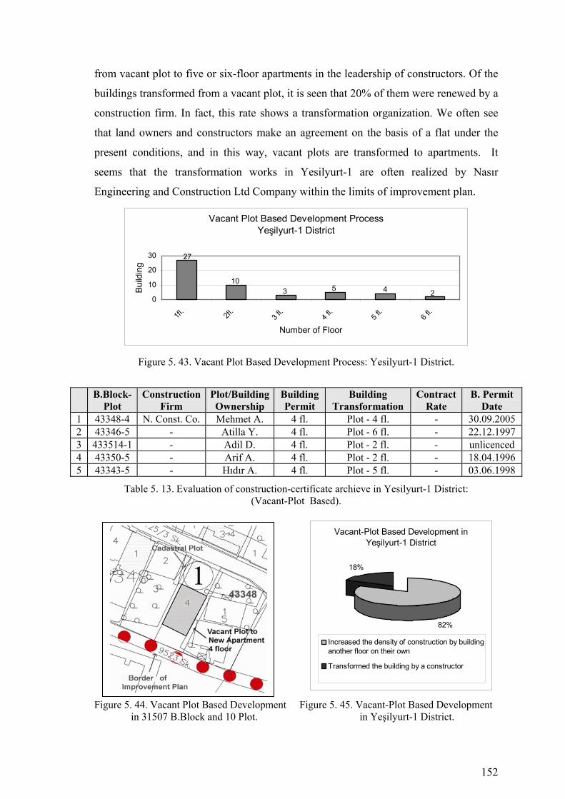
152
from vacant plot to five or six-floor apartments in the leadership of constructors. Of the
buildings transformed from a vacant plot, it is seen that 20% of them were renewed by a
construction firm. In fact, this rate shows a transformation organization. We often see
that land owners and constructors make an agreement on the basis of a flat under the
present conditions, and in this way, vacant plots are transformed to apartments. It
seems that the transformation works in Yesilyurt-1 are often realized by Nasır
Engineering and Construction Ltd Company within the limits of improvement plan.
Vacant Plot Based Development ProcessYeşilyurt-1 District
3
27
105 4 2
0
10
20
30
1fl.
2fl.
3 fl.
4 fl.
5 fl.
6 fl.
Number of Floor
Build
ing
Figure 5. 43. Vacant Plot Based Development Process: Yesilyurt-1 District.
B.Block-Plot
Construction Firm
Plot/Building Ownership
Building Permit
Building Transformation
Contract Rate
B. Permit Date
1 43348-4 N. Const. Co. Mehmet A. 4 fl. Plot - 4 fl. - 30.09.2005 2 43346-5 - Atilla Y. 4 fl. Plot - 6 fl. - 22.12.1997 3 433514-1 - Adil D. 4 fl. Plot - 2 fl. - unlicenced 4 43350-5 - Arif A. 4 fl. Plot - 2 fl. - 18.04.1996 5 43343-5 - Hıdır A. 4 fl. Plot - 5 fl. - 03.06.1998
Table 5. 13. Evaluation of construction-certificate archieve in Yesilyurt-1 District: (Vacant-Plot Based).
Figure 5. 44. Vacant Plot Based Development Figure 5. 45. Vacant-Plot Based Development in 31507 B.Block and 10 Plot. in Yeşilyurt-1 District.
Vacant-Plot Based Development in Yeşilyurt-1 District
82%
18%
Increased the density of construction by buildinganother floor on their own
Transformed the building by a constructor
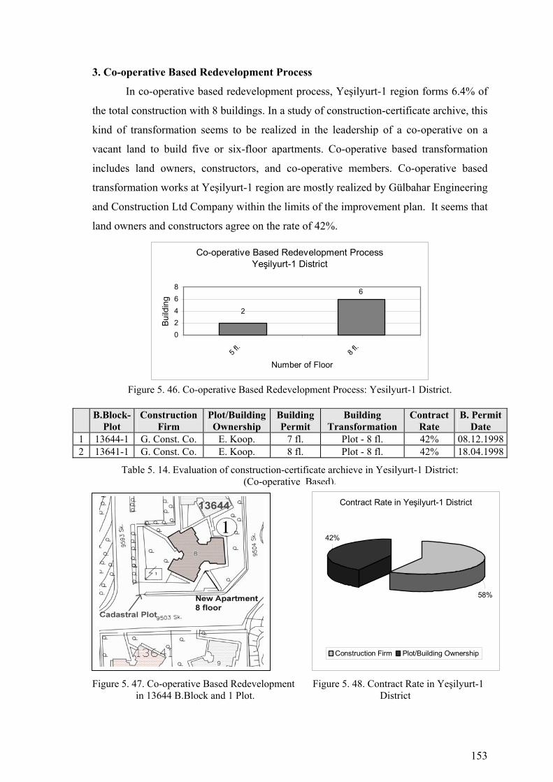
153
3. Co-operative Based Redevelopment Process
In co-operative based redevelopment process, Yeşilyurt-1 region forms 6.4% of
the total construction with 8 buildings. In a study of construction-certificate archive, this
kind of transformation seems to be realized in the leadership of a co-operative on a
vacant land to build five or six-floor apartments. Co-operative based transformation
includes land owners, constructors, and co-operative members. Co-operative based
transformation works at Yeşilyurt-1 region are mostly realized by Gülbahar Engineering
and Construction Ltd Company within the limits of the improvement plan. It seems that
land owners and constructors agree on the rate of 42%.
Co-operative Based Redevelopment ProcessYeşilyurt-1 District
2
6
02468
5 fl.
8 fl.
Number of Floor
Build
ing
Figure 5. 46. Co-operative Based Redevelopment Process: Yesilyurt-1 District.
B.Block-
Plot Construction
Firm Plot/Building Ownership
Building Permit
Building Transformation
Contract Rate
B. Permit Date
1 13644-1 G. Const. Co. E. Koop. 7 fl. Plot - 8 fl. 42% 08.12.19982 13641-1 G. Const. Co. E. Koop. 8 fl. Plot - 8 fl. 42% 18.04.1998
Table 5. 14. Evaluation of construction-certificate archieve in Yesilyurt-1 District: (Co-operative Based).
Figure 5. 47. Co-operative Based Redevelopment Figure 5. 48. Contract Rate in Yeşilyurt-1 in 13644 B.Block and 1 Plot. District
Contract Rate in Yeşilyurt-1 District
58%
42%
Construction Firm Plot/Building Ownership
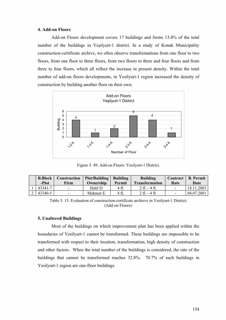
154
4. Add-on Floors
Add-on Floors development covers 17 buildings and forms 13.8% of the total
number of the buildings in Yeşilyurt-1 district. In a study of Konak Municipality
construction-certificate archive, we often observe transformations from one floor to two
floors, from one floor to three floors, from two floors to three and four floors and from
three to four floors, which all reflect the increase in present density. Within the total
number of add-on floors developments, in Yesilyurt-1 region increased the density of
construction by building another floor on their own.
Add-on FloorsYeşilyurt-1 District
2
4
1
54
1
0123456
1-2 fl.
1-3 fl.
1-4 fl.
2-3 fl.
2-4 fl.
3-4 fl.
Number of Floor
Build
ing
Figure 5. 49. Add-on Floors: Yesilyurt-1 District.
B.Block-Plot
Construction Firm
Plot/Building Ownership
Building Permit
Building Transformation
Contract Rate
B. Permit Date
1 43341-7 - Halil D. 4 fl. 2 fl. - 4 fl. - 18.11.20032 43340-5 - Mahmut E. 4 fl. 2 fl. - 4 fl. - 04.07.2001
Table 5. 15. Evaluation of construction-certificate archieve in Yesilyurt-1 District: (Add-on Floors).
5. Unaltered Buildings
Most of the buildings on which improvement plan has been applied within the
boundaries of Yesilyurt-1 cannot be transformed. These buildings are impossible to be
transformed with respect to their location, transformation, high density of construction
and other factors. When the total number of the buildings is considered, the rate of the
buildings that cannot be transformed reaches 32.8%. 70.7% of such buildings in
Yesilyurt-1 region are one-floor buildings.

155
Figure 5. 50. Urban Transformation Process (1986-2005) Konak Municipality Yeşilyurt 1 District

156
Figure 5. 51. Buildings that are Investigated in Konak Municipality Construction Certificate Archive-Yeşilyurt 1 District
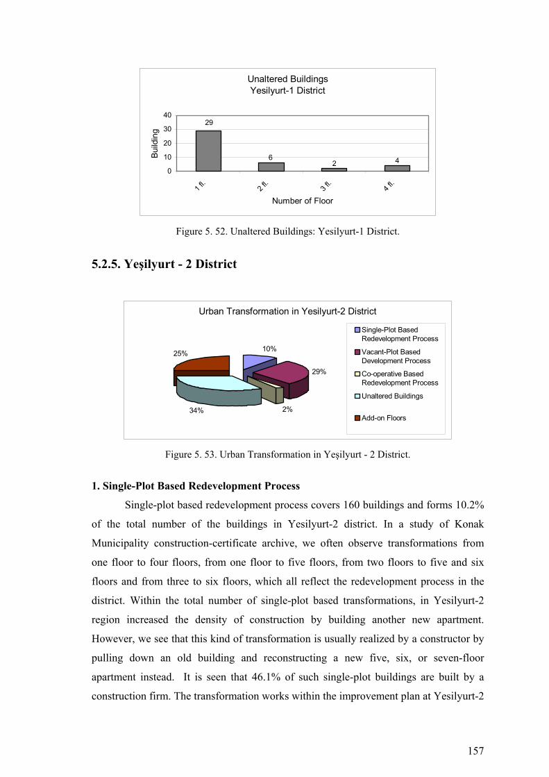
157
Unaltered BuildingsYesilyurt-1 District
2
29
6 40
10
20
30
40
1 fl.
2 fl.
3 fl.
4 fl.
Number of Floor
Build
ing
Figure 5. 52. Unaltered Buildings: Yesilyurt-1 District.
5.2.5. Yeşilyurt - 2 District
Urban Transformation in Yesilyurt-2 District
10%
29%
2%34%
25%
Single-Plot BasedRedevelopment Process
Vacant-Plot BasedDevelopment Process
Co-operative BasedRedevelopment Process
Unaltered Buildings
Add-on Floors
Figure 5. 53. Urban Transformation in Yeşilyurt - 2 District.
1. Single-Plot Based Redevelopment Process
Single-plot based redevelopment process covers 160 buildings and forms 10.2%
of the total number of the buildings in Yesilyurt-2 district. In a study of Konak
Municipality construction-certificate archive, we often observe transformations from
one floor to four floors, from one floor to five floors, from two floors to five and six
floors and from three to six floors, which all reflect the redevelopment process in the
district. Within the total number of single-plot based transformations, in Yesilyurt-2
region increased the density of construction by building another new apartment.
However, we see that this kind of transformation is usually realized by a constructor by
pulling down an old building and reconstructing a new five, six, or seven-floor
apartment instead. It is seen that 46.1% of such single-plot buildings are built by a
construction firm. The transformation works within the improvement plan at Yesilyurt-2
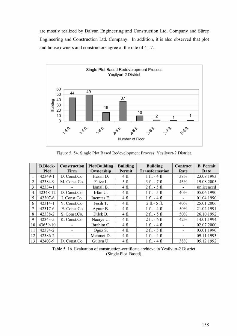
158
are mostly realized by Dalyan Engineering and Construction Ltd. Company and Süreç
Engineering and Construction Ltd. Company. In addition, it is also observed that plot
and house owners and constructors agree at the rate of 41.7.
Single Plot Based Redevelopment ProcessYeşilyurt 2 District
16
44 4937
102 1 1
0102030405060
1-4 fl.
1-5 fl.
1-6 fl.
2-5 fl.
2-6 fl.
3-6 fl.
3-7 fl.
5-6 fl.
Number of Floor
Build
ing
Figure 5. 54. Single Plot Based Redevelopment Process: Yesilyurt-2 District.
B.Block-Plot
Construction Firm
Plot/Building Ownership
Building Permit
Building Transformation
Contract Rate
B. Permit Date
1 42349-1 D. Const.Co. Hasan D. 4 fl. 1 fl. - 4 fl. 38% 23.08.1993 2 42384-9 M. Const.Co. Faize I. 5 fl. 3 fl. - 7 fl. 43% 19.08.2005 3 42334-1 - Ismail B. 4 fl. 2 fl. - 5 fl. - unlicenced 4 42348-12 D. Const.Co. Irfan U. 4 fl. 1 fl. - 5 fl. 40% 05.06.1990 5 42307-6 I. Const.Co. Inemtas E. 4 fl. 1 fl. - 4 fl. - 01.04.1990 6 42314-1 Y. Const.Co. Fesih T. 4 fl. 2 fl.- 5 fl. 40% 25.01.2006 7 42317-6 E. Const.Co Aynur B. 4 fl. 1 fl. - 4 fl. 50% 21.02.1991 8 42338-2 S. Const.Co. Dilek B. 4 fl. 2 fl. - 5 fl. 50% 26.10.1992 9 42343-5 K. Const.Co. Naciye U. 4 fl. 2 fl. - 6 fl. 42% 14.01.1994
10 43659-10 - Ibrahim C. 4 fl. 1 fl. - 4 fl. - 02.07.2000 11 42374-2 - Oguz S. 4 fl. 2 fl. - 5 fl. - 03.01.1990 12 42386-2 - Mehmet D. 4 fl. 1 fl. - 4 fl. - 09.11.1993 13 42403-9 D. Const.Co. Gülten U. 4 fl. 1 fl. - 4 fl. 38% 05.12.1992
Table 5. 16. Evaluation of construction-certificate archieve in Yesilyurt-2 District: (Single Plot Based).
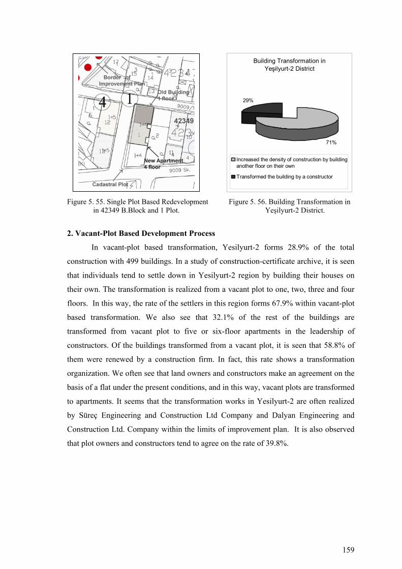
159
Figure 5. 55. Single Plot Based Redevelopment Figure 5. 56. Building Transformation in in 42349 B.Block and 1 Plot. Yeşilyurt-2 District.
2. Vacant-Plot Based Development Process
In vacant-plot based transformation, Yesilyurt-2 forms 28.9% of the total
construction with 499 buildings. In a study of construction-certificate archive, it is seen
that individuals tend to settle down in Yesilyurt-2 region by building their houses on
their own. The transformation is realized from a vacant plot to one, two, three and four
floors. In this way, the rate of the settlers in this region forms 67.9% within vacant-plot
based transformation. We also see that 32.1% of the rest of the buildings are
transformed from vacant plot to five or six-floor apartments in the leadership of
constructors. Of the buildings transformed from a vacant plot, it is seen that 58.8% of
them were renewed by a construction firm. In fact, this rate shows a transformation
organization. We often see that land owners and constructors make an agreement on the
basis of a flat under the present conditions, and in this way, vacant plots are transformed
to apartments. It seems that the transformation works in Yesilyurt-2 are often realized
by Süreç Engineering and Construction Ltd Company and Dalyan Engineering and
Construction Ltd. Company within the limits of improvement plan. It is also observed
that plot owners and constructors tend to agree on the rate of 39.8%.
Building Transformation in Yeşilyurt-2 District
29%
71%
Increased the density of construction by buildinganother floor on their own
Transformed the building by a constructor

160
Vacant Plot Based Development ProcessYeşilyurt-2 District
84
41
72
142
102
3916 3
0
50
100
150
1fl.
2fl.
3 fl.
4 fl.
5 fl.
6 fl.
7 fl.
8 fl.
Number of Floor
Build
ing
Figure 5. 57. Vacant Plot Based Development Process: Yeşilyurt-2 District.
B.Block-Plot
Construction Firm
Plot/Building Ownership
Building Permit
Building Transformation
Contract Rate
B. Permit Date
1 42349-10 D. Const.Co. Kevser S. 4 fl. Plot - 5 fl. 40% 11.04.1995 2 42436-9 E. Const.Co. Necdet Ç. 4 fl. Plot - 5 fl. 40% 25.11.1995 3 13443-1 M. Const.Co. Ak-iş K. 5 fl. Plot - 5 fl. 40% 07.06.1999 4 43342-1 S. Const.Co. Ahmet K. 5 fl. Plot - 5 fl. 40% 18.02.2005 5 42437-8 - Abdullah T. 4 fl. Plot - 5 fl. - unlicenced 6 42383-9 K. Const.Co. Abdullah T. 4 fl. Plot - 2 fl. - 29.06.2000 7 42395-5 - Seyfettin E. 4 fl. Plot - 5 fl. - unlicenced 8 42393-9 - Zihni G. 4 fl. Plot - 4 fl. - 27.03.1991 9 13564-11 - Yahya K. 4 fl. Plot - 4 fl. 42% 17.04.1992
10 42362-1 G. Const.Co Yaşar K. 4 fl. Plot - 4 fl. 38% 18.01.1995 11 42399-23 Y. Const.Co. Fesih T. 4 fl. Plot - 4 fl. 38% 25.01.1996 12 42372-24 Ş. Const.Co. Dilek B. 5 fl. Plot - 5 fl. 35% 26.10.1992 13 42356-8 K. Const.Co Naciye U. 5 fl. Plot - 5 fl. 40% 02.11.1994 14 42339-1 - Mehmet D. 5 fl. Plot - 5 fl. - 04.02.1992 15 42332-20 - Ruhide G. 5 fl. Plot - 5 fl. - 10.04.1995 16 42341-1 S. Const.Co. Hüseyin S. 5 fl. Plot - 4 fl. 42% 11.04.1995 17 42297-15 - Hasan K. 5 fl. Plot - 4 fl. - 18.08.1998 18 42299-10 - Saziye Ö. 4 fl. Plot - 3 fl. - 12.01.1990 19 42315-2 - Ertem G. 4 fl. Plot - 1 fl. - unlicenced 20 42318-2 G. Const.Co Niyazi Ç. 4 fl. Plot - 4 fl. - 23.03.2002 21 42459-9 - Hamdi B. 4 fl. Plot - 6 fl. - 17.11.1991 22 42335-16 A. Const.Co. Durmuş H. 6 fl. Plot - 7 fl. 43% 02.12.1995 23 42441-11 - Ahmet C. 4 fl. Plot - 3 fl. - unlicenced 24 42391-8 - Ahmet G. 4 fl. Plot - 4 fl. - 10.04.1997 25 42378-4 - Mustafa G. 4 fl. Plot - 4 fl. - 02.05.1998
Table 5. 17. Evaluation of construction-certificate archieve in Yesilyurt-2 District: (Vacant-Plot Based).
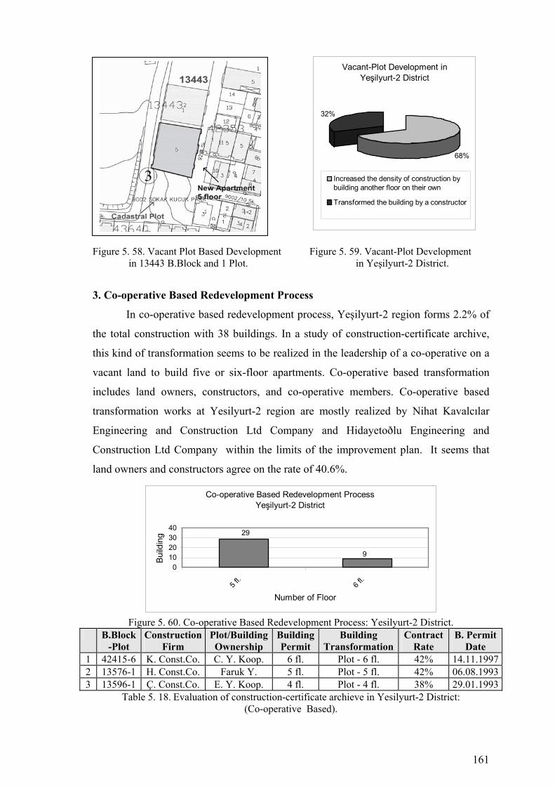
161
Figure 5. 58. Vacant Plot Based Development Figure 5. 59. Vacant-Plot Development in 13443 B.Block and 1 Plot. in Yeşilyurt-2 District.
3. Co-operative Based Redevelopment Process
In co-operative based redevelopment process, Yeşilyurt-2 region forms 2.2% of
the total construction with 38 buildings. In a study of construction-certificate archive,
this kind of transformation seems to be realized in the leadership of a co-operative on a
vacant land to build five or six-floor apartments. Co-operative based transformation
includes land owners, constructors, and co-operative members. Co-operative based
transformation works at Yesilyurt-2 region are mostly realized by Nihat Kavalcılar
Engineering and Construction Ltd Company and Hidayetoðlu Engineering and
Construction Ltd Company within the limits of the improvement plan. It seems that
land owners and constructors agree on the rate of 40.6%.
Co-operative Based Redevelopment ProcessYeşilyurt-2 District
29
9
010203040
5 fl.
6 fl.
Number of Floor
Build
ing
Figure 5. 60. Co-operative Based Redevelopment Process: Yesilyurt-2 District.
B.Block-Plot
Construction Firm
Plot/Building Ownership
BuildingPermit
Building Transformation
Contract Rate
B. Permit Date
1 42415-6 K. Const.Co. C. Y. Koop. 6 fl. Plot - 6 fl. 42% 14.11.19972 13576-1 H. Const.Co. Faruk Y. 5 fl. Plot - 5 fl. 42% 06.08.19933 13596-1 Ç. Const.Co. E. Y. Koop. 4 fl. Plot - 4 fl. 38% 29.01.1993
Table 5. 18. Evaluation of construction-certificate archieve in Yesilyurt-2 District: (Co-operative Based).
Vacant-Plot Development in Yeşilyurt-2 District
68%
32%
Increased the density of construction bybuilding another floor on their own
Transformed the building by a constructor
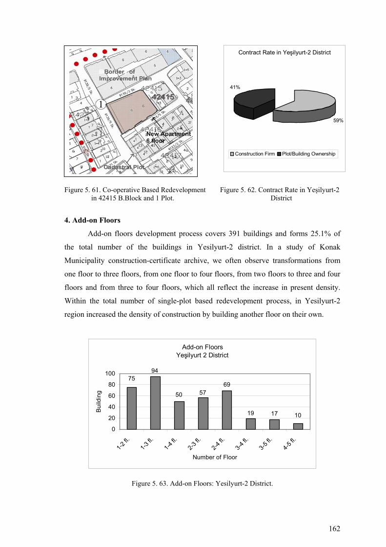
162
Figure 5. 61. Co-operative Based Redevelopment Figure 5. 62. Contract Rate in Yeşilyurt-2 in 42415 B.Block and 1 Plot. District
4. Add-on Floors
Add-on floors development process covers 391 buildings and forms 25.1% of
the total number of the buildings in Yesilyurt-2 district. In a study of Konak
Municipality construction-certificate archive, we often observe transformations from
one floor to three floors, from one floor to four floors, from two floors to three and four
floors and from three to four floors, which all reflect the increase in present density.
Within the total number of single-plot based redevelopment process, in Yesilyurt-2
region increased the density of construction by building another floor on their own.
Add-on FloorsYeşilyurt 2 District
50
7594
5769
19 17 10
0
20
40
60
80
100
1-2 fl.
1-3 fl.
1-4 fl.
2-3 fl.
2-4 fl.
3-4 fl.
3-5 fl.
4-5 fl.
Number of Floor
Bui
ldin
g
Figure 5. 63. Add-on Floors: Yesilyurt-2 District.
Contract Rate in Yeşilyurt-2 District
59%
41%
Construction Firm Plot/Building Ownership
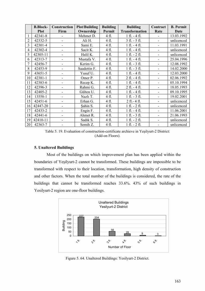
163
B.Block-Plot
Construction Firm
Plot/Building Ownership
Building Permit
Building Transformation
Contract Rate
B. Permit Date
1 42341-8 - Mehmet D. 4 fl. 1 fl. - 4 fl. - 13.03.1992 2 42332-5 - Ali H. 4 fl. 3 fl. - 5 fl. - unlicenced 3 42301-4 - Sami E. 4 fl. 1 fl. - 4 fl. - 11.03.1991 4 42302-4 - Sacit K. 4 fl. 1 fl. - 4 fl. - unlicenced 5 42305-11 - Halil K. 4 fl. 1 fl. - 2 fl. - unlicenced 6 42313-7 - Mustafa V. 4 fl. 1 fl. - 4 fl. - 25.04.1996 7 42456-7 - Kerim G. 4 fl. 1 fl. - 3 fl. - 12.08.1992 8 42453-9 - Saadettin F. 4 fl. 1 fl. - 3 fl. - 14.02.2000 9 43651-5 - Yusuf U. 4 fl. 1 fl. - 4 fl. - 12.03.2000
10 42381-1 - Omer P. 4 fl. 2 fl. - 4 fl. - 02.06.1992 11 42383-6 - Recep K. 4 fl. 1 fl. - 4 fl. - 05.10.1994 12 42396-3 - Rahmi G. 4 fl. 2 fl. - 4 fl. - 18.05.1993 13 42405-2 - Gülten U. 4 fl. 1 fl. - 4 fl. - 09.10.1995 14 13558-1 - Nazlı T. 4 fl. 1 fl. - 3 fl. - 19.02.2001 15 42451-6 - Erhan G. 4 fl. 2 fl.- 4 fl. - unlicenced 16 42447-20 - Şahin S. 4 fl. 1 fl. - 2 fl. - unlicenced 17 42433-2 - Engin F. 4 fl. 1 fl. - 4 fl. - 11.06.2001 18 42441-6 - Ahmet R. 4 fl. 1 fl. - 3 fl. - 21.06.1993 19 42410-11 - Sadık S. 4 fl. 1 fl. - 2 fl. - unlicenced 20 42363-7 - Semih Z. 4 fl. 1 fl. - 2 fl. - unlicenced
Table 5. 19. Evaluation of construction-certificate archieve in Yeşilyurt-2 District: (Add-on Floors).
5. Unaltered Buildings
Most of the buildings on which improvement plan has been applied within the
boundaries of Yeşilyurt-2 cannot be transformed. These buildings are impossible to be
transformed with respect to their location, transformation, high density of construction
and other factors. When the total number of the buildings is considered, the rate of the
buildings that cannot be transformed reaches 33.6%. 43% of such buildings in
Yesilyurt-2 region are one-floor buildings.
Unaltered BuildingsYesilyurt-2 District
56
227 204
28 9 3050
100150200250
1 fl.
2 fl.
3 fl.
4 fl.
5 fl.
6 fl.
Number of Floor
Build
ing
Figure 5. 64. Unaltered Buildings: Yesilyurt-2 District.

164
Figure 5. 65. Urban Transformation Process (1986-2005) Konak Municipality-Yeşilyurt 2 District

165
Figure 5. 66. Buildings that are Investigated in Konak Municipality Construction Certificate Archive-Yeşilyurt-2 District
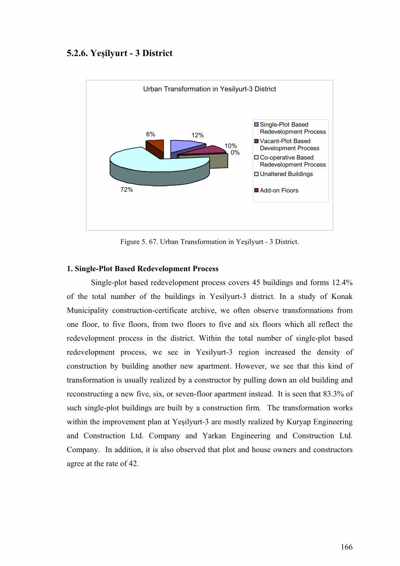
166
5.2.6. Yeşilyurt - 3 District
Urban Transformation in Yesilyurt-3 District
12%
10%0%
72%
6%Single-Plot BasedRedevelopment ProcessVacant-Plot BasedDevelopment ProcessCo-operative BasedRedevelopment ProcessUnaltered Buildings
Add-on Floors
Figure 5. 67. Urban Transformation in Yeşilyurt - 3 District.
1. Single-Plot Based Redevelopment Process
Single-plot based redevelopment process covers 45 buildings and forms 12.4%
of the total number of the buildings in Yesilyurt-3 district. In a study of Konak
Municipality construction-certificate archive, we often observe transformations from
one floor, to five floors, from two floors to five and six floors which all reflect the
redevelopment process in the district. Within the total number of single-plot based
redevelopment process, we see in Yesilyurt-3 region increased the density of
construction by building another new apartment. However, we see that this kind of
transformation is usually realized by a constructor by pulling down an old building and
reconstructing a new five, six, or seven-floor apartment instead. It is seen that 83.3% of
such single-plot buildings are built by a construction firm. The transformation works
within the improvement plan at Yeşilyurt-3 are mostly realized by Kuryap Engineering
and Construction Ltd. Company and Yarkan Engineering and Construction Ltd.
Company. In addition, it is also observed that plot and house owners and constructors
agree at the rate of 42.

167
Single Plot Based Redevelopment ProcessYeşilyurt 3 District
5
86
1
57
56
2
02468
10
1-5 fl.
1-6 fl.
1-7 fl.
1-8 fl.
2-5 fl.
2-6 fl.
2-7 fl.
2-8 fl.
3-5 fl.
Number of Floor
Build
ing
Figure 5. 68. Single Plot Based Redevelopment Process: Yesilyurt-3 District.
B.Block-Plot
Construction Firm
Plot/Building Ownership
Building Permit
Building Transformation
Contract Rate
B. Permit Date
1 42072-26 K. Const.Co. Erdogan Ç. 4 fl. 1 fl. - 5 fl. 40% 17.08.1996 2 42071-5 K. Const.Co. Saniye Ö. 4 fl. 2 fl. - 6 fl. 42% 17.04.1990 3 42075-11 - Hasan K. 6 fl. 1 fl. - 7 fl. - 11.09.1997 4 42078-11 G. Const.Co. O. Osman S. 6 fl. 2 fl.- 7 fl. 43% 16.12.1997 5 42078-10 Y. Const.Co. O. Osman S. 6 fl. 1 fl. - 7 fl. 43% 07.02.1992
Table 5. 20. Evaluation of construction-certificate archieve in Yeşilyurt-3 District: (Single Plot Based).
Figure 5. 69. Single Plot Based Redevelopment Figure 5. 70. Building Transformation in in 42072 B.Block and 1 Plot. Yeşilyurt-3 District.
Building Transformation in Yeş ilyurt-3 District
31%
69%
Increased the density of construction by buildinganother f loor on their ow n
Transformed the building by a constructor
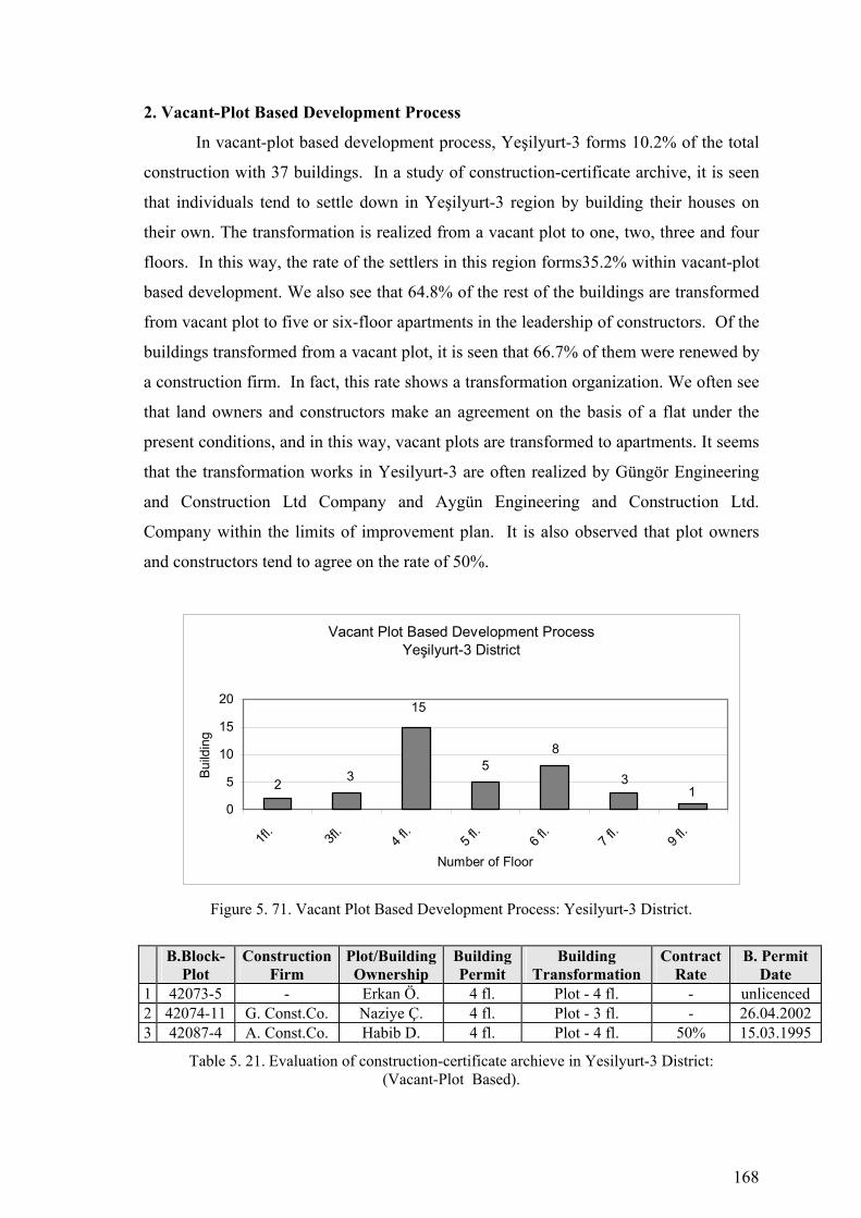
168
2. Vacant-Plot Based Development Process
In vacant-plot based development process, Yeşilyurt-3 forms 10.2% of the total
construction with 37 buildings. In a study of construction-certificate archive, it is seen
that individuals tend to settle down in Yeşilyurt-3 region by building their houses on
their own. The transformation is realized from a vacant plot to one, two, three and four
floors. In this way, the rate of the settlers in this region forms35.2% within vacant-plot
based development. We also see that 64.8% of the rest of the buildings are transformed
from vacant plot to five or six-floor apartments in the leadership of constructors. Of the
buildings transformed from a vacant plot, it is seen that 66.7% of them were renewed by
a construction firm. In fact, this rate shows a transformation organization. We often see
that land owners and constructors make an agreement on the basis of a flat under the
present conditions, and in this way, vacant plots are transformed to apartments. It seems
that the transformation works in Yesilyurt-3 are often realized by Güngör Engineering
and Construction Ltd Company and Aygün Engineering and Construction Ltd.
Company within the limits of improvement plan. It is also observed that plot owners
and constructors tend to agree on the rate of 50%.
Vacant Plot Based Development ProcessYeşilyurt-3 District
15
2 35
8
31
0
5
10
15
20
1fl.
3fl.
4 fl.
5 fl.
6 fl.
7 fl.
9 fl.
Number of Floor
Build
ing
Figure 5. 71. Vacant Plot Based Development Process: Yesilyurt-3 District.
B.Block-Plot
Construction Firm
Plot/Building Ownership
Building Permit
Building Transformation
Contract Rate
B. Permit Date
1 42073-5 - Erkan Ö. 4 fl. Plot - 4 fl. - unlicenced 2 42074-11 G. Const.Co. Naziye Ç. 4 fl. Plot - 3 fl. - 26.04.2002 3 42087-4 A. Const.Co. Habib D. 4 fl. Plot - 4 fl. 50% 15.03.1995
Table 5. 21. Evaluation of construction-certificate archieve in Yesilyurt-3 District: (Vacant-Plot Based).
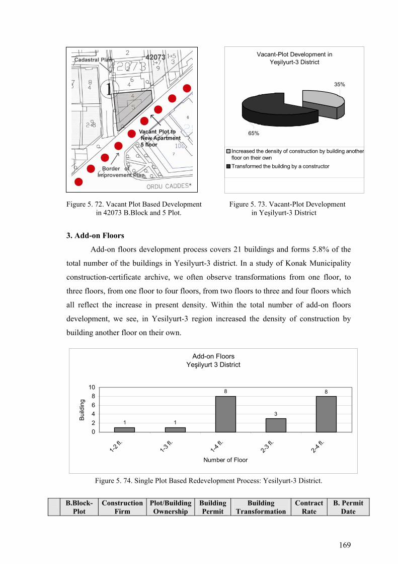
169
Figure 5. 72. Vacant Plot Based Development Figure 5. 73. Vacant-Plot Development in 42073 B.Block and 5 Plot. in Yeşilyurt-3 District
3. Add-on Floors
Add-on floors development process covers 21 buildings and forms 5.8% of the
total number of the buildings in Yesilyurt-3 district. In a study of Konak Municipality
construction-certificate archive, we often observe transformations from one floor, to
three floors, from one floor to four floors, from two floors to three and four floors which
all reflect the increase in present density. Within the total number of add-on floors
development, we see, in Yesilyurt-3 region increased the density of construction by
building another floor on their own.
Add-on Floors Yeşilyurt 3 District
8
1 13
8
02468
10
1-2 fl.
1-3 fl.
1-4 fl.
2-3 fl.
2-4 fl.
Number of Floor
Build
ing
Figure 5. 74. Single Plot Based Redevelopment Process: Yesilyurt-3 District.
B.Block-
Plot Construction
Firm Plot/Building Ownership
Building Permit
Building Transformation
Contract Rate
B. Permit Date
Vacant-Plot Development in Yeşilyurt-3 District
65%
35%
Increased the density of construction by building anotherfloor on their ownTransformed the building by a constructor
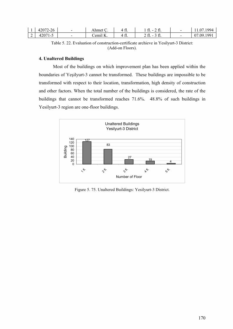
170
1 42072-26 - Ahmet Ç. 4 fl. 1 fl. - 2 fl. - 11.07.1994 2 42071-5 - Cemil K. 4 fl. 2 fl. - 3 fl. - 07.09.1991
Table 5. 22. Evaluation of construction-certificate archieve in Yesilyurt-3 District: (Add-on Floors).
4. Unaltered Buildings
Most of the buildings on which improvement plan has been applied within the
boundaries of Yeşilyurt-3 cannot be transformed. These buildings are impossible to be
transformed with respect to their location, transformation, high density of construction
and other factors. When the total number of the buildings is considered, the rate of the
buildings that cannot be transformed reaches 71.6%. 48.8% of such buildings in
Yesilyurt-3 region are one-floor buildings.
Unaltered BuildingsYesilyurt-3 District
27
12783
19 40
20406080
100120140
1 fl.
2 fl.
3 fl.
4 fl.
5 fl.
Number of Floor
Build
ing
Figure 5. 75. Unaltered Buildings: Yesilyurt-3 District.

171
Figure 5. 76. Urban Transformation Process (1986-2005) Konak Municipality-Yeşilyurt 3 District

172
Figure 5. 77. Buildings that are Investigated in Konak Municipality Construction Certificate Archive-Yeşilyurt-3 District
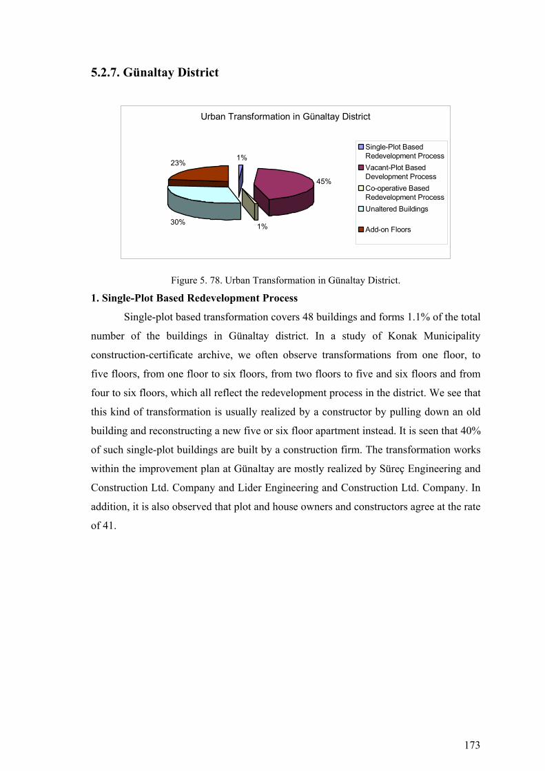
173
5.2.7. Günaltay District
Urban Transformation in Günaltay District
1%
45%
1%30%
23%
Single-Plot BasedRedevelopment ProcessVacant-Plot BasedDevelopment ProcessCo-operative BasedRedevelopment ProcessUnaltered Buildings
Add-on Floors
Figure 5. 78. Urban Transformation in Günaltay District.
1. Single-Plot Based Redevelopment Process
Single-plot based transformation covers 48 buildings and forms 1.1% of the total
number of the buildings in Günaltay district. In a study of Konak Municipality
construction-certificate archive, we often observe transformations from one floor, to
five floors, from one floor to six floors, from two floors to five and six floors and from
four to six floors, which all reflect the redevelopment process in the district. We see that
this kind of transformation is usually realized by a constructor by pulling down an old
building and reconstructing a new five or six floor apartment instead. It is seen that 40%
of such single-plot buildings are built by a construction firm. The transformation works
within the improvement plan at Günaltay are mostly realized by Süreç Engineering and
Construction Ltd. Company and Lider Engineering and Construction Ltd. Company. In
addition, it is also observed that plot and house owners and constructors agree at the rate
of 41.
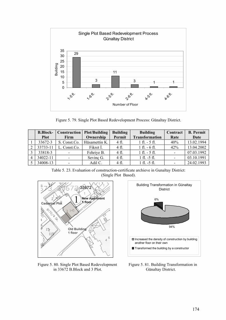
174
Single Plot Based Redevelopment ProcessGünaltay District
11
29
3 3 1 105
101520253035
1-5 fl.
1-6 fl.
2-5 fl.
2-6 fl.
4-5 fl.
4-6 fl.
Number of Floor
Bui
ldin
g
Figure 5. 79. Single Plot Based Redevelopment Process: Günaltay District.
B.Block-Plot
Construction Firm
Plot/Building Ownership
Building Permit
Building Transformation
Contract Rate
B. Permit Date
1 33672-3 S. Const.Co. Hüsamettin K. 4 fl. 1 fl. - 5 fl. 40% 13.02.1994 2 33733-11 L. Const.Co. Fikret İ. 4 fl. 1 fl. - 6 fl. 42% 13.04.2002 3 33818-3 - Fehriye B. 4 fl. 1 fl. - 5 fl. - 07.03.1992 4 34022-11 - Sevinç G. 4 fl. 1 fl. -5 fl. - 03.10.1991 5 34008-13 - Adil C. 4 fl. 1 fl. -5 fl. - 24.02.1993
Table 5. 23. Evaluation of construction-certificate archieve in Gunaltay District: (Single Plot Based).
Figure 5. 80. Single Plot Based Redevelopment Figure 5. 81. Building Transformation in in 33672 B.Block and 3 Plot. Günaltay District.
Building Transformation in Günaltay District
94%
6%
Increased the density of construction by buildinganother floor on their own
Transformed the building by a constructor

175
2. Vacant-Plot Based Development Process
In vacant-plot based transformation, Gunaltay forms 44.8% of the total
construction with 1941 buildings. In a study of construction-certificate archive, it is
seen that individuals tend to settle down in Günaltay region by building their houses on
their own. The transformation is realized from a vacant plot to one, two, three and four
floors. In this way, the rate of the settlers in this region forms 93% within vacant-plot
based transformation. We also see that 7% of the rest of the buildings are transformed
from vacant plot to five or six-floor apartments in the leadership of constructors. Of the
buildings transformed from a vacant plot, it is seen that 36.3% of them were renewed by
a construction firm. In fact, this rate shows a transformation organization. We often see
that land owners and constructors make an agreement on the basis of a flat under the
present conditions, and in this way, vacant plots are transformed to apartments. It seems
that the transformation works in Günaltay are often realized by Mimta Engineering and
Construction Ltd Company and Süreç Engineering and Construction Ltd. Company
within the limits of improvement plan. It is also observed that plot owners and
constructors tend to agree on the rate of 41.4%.
Vacant Plot Based Development ProcessGünaltay District
580
376
628
24096
16 50
100200300400500600700
1fl.
2fl.
3 fl.
4 fl.
5 fl.
6 fl.
7 fl.
Number of Floor
Build
ing
Figure 5. 82. Vacant Plot Based Development Process: Gunaltay District.
B.Block-Plot
Construction Firm
Plot/Building Ownership
Building Permit
Building Transformation
Contract Rate
B. Permit Date
1 338036 S.Const. Mustafa Y. 4 fl. Plot - 6 fl. 42% 10.05.19992 33801-10 - Necmettin Ç. 4 fl. Plot - 4 fl. 38% 13.03.19943 33787-11 M.Const. Alaattin S. 5 fl. Plot - 6 fl. 44% 05.12.19954 33780-3 - Ali G. 5 fl. Plot - 3 fl. - 14.12.19975 43654-7 N.Const. Hüseyin Y. 4 fl. Plot - 5 fl. 40% 13.09.19916 3425-752 - Yüksel S. 4 fl. Plot - 4 fl. - 19.03.20017 33670-7 - Secaattin A. 4 fl. Plot - 6 fl. - 22.11.19928 34057-12 S.Const. İrfan K. 4 fl. Plot - 7 fl. 43% 23.08.1994
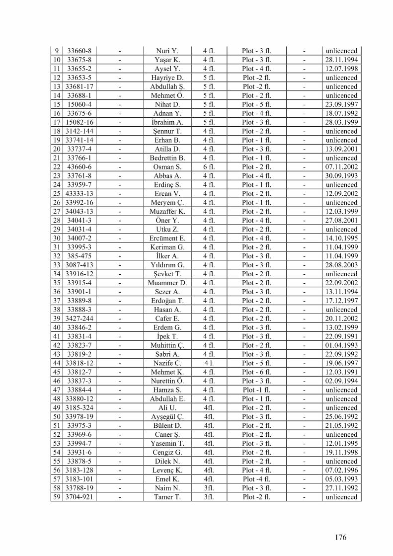
176
9 33660-8 - Nuri Y. 4 fl. Plot - 3 fl. - unlicenced10 33675-8 - Yaşar K. 4 fl. Plot - 3 fl. - 28.11.199411 33655-2 - Aysel Y. 4 fl. Plot - 4 fl. - 12.07.199812 33653-5 - Hayriye D. 5 fl. Plot -2 fl. - unlicenced13 33681-17 - Abdullah Ş. 5 fl. Plot -2 fl. - unlicenced14 33688-1 - Mehmet Ö. 5 fl. Plot - 2 fl. - unlicenced15 15060-4 - Nihat D. 5 fl. Plot - 5 fl. - 23.09.199716 33675-6 - Adnan Y. 5 fl. Plot - 4 fl. - 18.07.199217 15082-16 - İbrahim A. 5 fl. Plot - 3 fl. - 28.03.199918 3142-144 - Şennur T. 4 fl. Plot - 2 fl. - unlicenced19 33741-14 - Erhan B. 4 fl. Plot - 1 fl. - unlicenced20 33737-4 - Atilla D. 4 fl. Plot - 3 fl. - 13.09.200121 33766-1 - Bedrettin B. 4 fl. Plot - 1 fl. - unlicenced22 43660-6 - Osman S. 6 fl. Plot - 2 fl. - 07.11.200223 33761-8 - Abbas A. 4 fl. Plot - 4 fl. - 30.09.199324 33959-7 - Erdinç S. 4 fl. Plot - 1 fl. - unlicenced25 43333-13 - Ercan V. 4 fl. Plot - 2 fl. - 12.09.200226 33992-16 - Meryem Ç. 4 fl. Plot - 1 fl. - unlicenced27 34043-13 - Muzaffer K. 4 fl. Plot - 2 fl. - 12.03.199928 34041-3 - Öner Y. 4 fl. Plot - 4 fl. - 27.08.200129 34031-4 - Utku Z. 4 fl. Plot - 2 fl. - unlicenced30 34007-2 - Ercüment E. 4 fl. Plot - 4 fl. - 14.10.199531 33995-3 - Keriman G. 4 fl. Plot - 2 fl. - 11.04.199932 385-475 - İlker A. 4 fl. Plot - 3 fl. - 11.04.199933 3087-413 - Yıldırım G. 4 fl. Plot - 3 fl. - 28.08.200334 33916-12 - Şevket T. 4 fl. Plot - 2 fl. - unlicenced35 33915-4 - Muammer D. 4 fl. Plot - 2 fl. - 22.09.200236 33901-1 - Sezer A. 4 fl. Plot - 3 fl. - 13.11.199437 33889-8 - Erdoğan T. 4 fl. Plot - 2 fl. - 17.12.199738 33888-3 - Hasan A. 4 fl. Plot - 2 fl. - unlicenced39 3427-244 - Cafer E. 4 fl. Plot - 2 fl. - 20.11.200240 33846-2 - Erdem G. 4 fl. Plot - 3 fl. - 13.02.199941 33831-4 - İpek T. 4 fl. Plot - 3 fl. - 22.09.199142 33823-7 - Muhittin Ç. 4 fl. Plot - 2 fl. - 01.04.199343 33819-2 - Sabri A. 4 fl. Plot - 3 fl. - 22.09.199244 33818-12 - Nazife C. 4 l. Plot - 5 fl. - 19.06.199745 33812-7 - Mehmet K. 4 fl. Plot - 6 fl. - 12.03.199146 33837-3 - Nurettin Ö. 4 fl. Plot - 3 fl. - 02.09.199447 33884-4 - Hamza S. 4 fl. Plot -1 fl. - unlicenced48 33880-12 - Abdullah E. 4 fl. Plot - 1 fl. - unlicenced49 3185-324 - Ali U. 4fl. Plot - 2 fl. - unlicenced50 33978-19 - Ayşegül Ç. 4fl. Plot - 3 fl. - 25.06.199251 33975-3 - Bülent D. 4fl. Plot - 2 fl. - 21.05.199252 33969-6 - Caner Ş. 4fl. Plot - 2 fl. - unlicenced53 33994-7 - Yasemin T. 4fl. Plot - 3 fl. - 12.01.199554 33931-6 - Cengiz G. 4fl. Plot - 2 fl. - 19.11.199855 33878-5 - Dilek N. 4fl. Plot - 2 fl. - unlicenced56 3183-128 - Levenç K. 4fl. Plot - 4 fl. - 07.02.199657 3183-101 - Emel K. 4fl. Plot -4 fl. - 05.03.199358 33788-19 - Naim N. 3fl. Plot - 3 fl. - 27.11.199259 3704-921 - Tamer T. 3fl. Plot -2 fl. - unlicenced
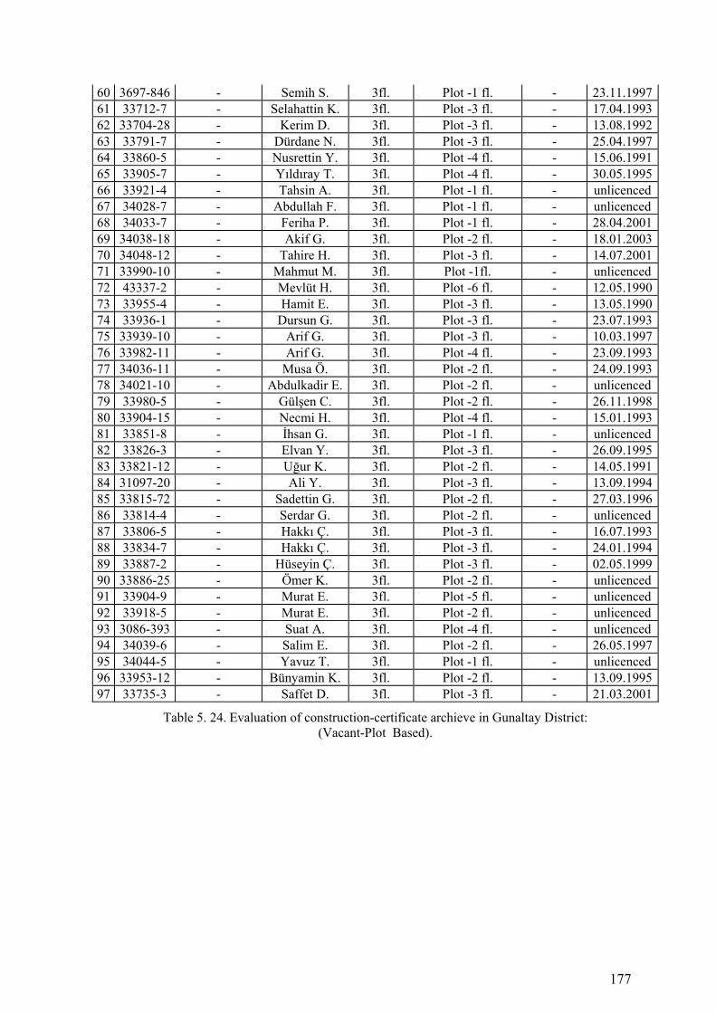
177
60 3697-846 - Semih S. 3fl. Plot -1 fl. - 23.11.199761 33712-7 - Selahattin K. 3fl. Plot -3 fl. - 17.04.199362 33704-28 - Kerim D. 3fl. Plot -3 fl. - 13.08.199263 33791-7 - Dürdane N. 3fl. Plot -3 fl. - 25.04.199764 33860-5 - Nusrettin Y. 3fl. Plot -4 fl. - 15.06.199165 33905-7 - Yıldıray T. 3fl. Plot -4 fl. - 30.05.199566 33921-4 - Tahsin A. 3fl. Plot -1 fl. - unlicenced67 34028-7 - Abdullah F. 3fl. Plot -1 fl. - unlicenced68 34033-7 - Feriha P. 3fl. Plot -1 fl. - 28.04.200169 34038-18 - Akif G. 3fl. Plot -2 fl. - 18.01.200370 34048-12 - Tahire H. 3fl. Plot -3 fl. - 14.07.200171 33990-10 - Mahmut M. 3fl. Plot -1fl. - unlicenced72 43337-2 - Mevlüt H. 3fl. Plot -6 fl. - 12.05.199073 33955-4 - Hamit E. 3fl. Plot -3 fl. - 13.05.199074 33936-1 - Dursun G. 3fl. Plot -3 fl. - 23.07.199375 33939-10 - Arif G. 3fl. Plot -3 fl. - 10.03.199776 33982-11 - Arif G. 3fl. Plot -4 fl. - 23.09.199377 34036-11 - Musa Ö. 3fl. Plot -2 fl. - 24.09.199378 34021-10 - Abdulkadir E. 3fl. Plot -2 fl. - unlicenced79 33980-5 - Gülşen C. 3fl. Plot -2 fl. - 26.11.199880 33904-15 - Necmi H. 3fl. Plot -4 fl. - 15.01.199381 33851-8 - İhsan G. 3fl. Plot -1 fl. - unlicenced82 33826-3 - Elvan Y. 3fl. Plot -3 fl. - 26.09.199583 33821-12 - Uğur K. 3fl. Plot -2 fl. - 14.05.199184 31097-20 - Ali Y. 3fl. Plot -3 fl. - 13.09.199485 33815-72 - Sadettin G. 3fl. Plot -2 fl. - 27.03.199686 33814-4 - Serdar G. 3fl. Plot -2 fl. - unlicenced87 33806-5 - Hakkı Ç. 3fl. Plot -3 fl. - 16.07.199388 33834-7 - Hakkı Ç. 3fl. Plot -3 fl. - 24.01.199489 33887-2 - Hüseyin Ç. 3fl. Plot -3 fl. - 02.05.199990 33886-25 - Ömer K. 3fl. Plot -2 fl. - unlicenced91 33904-9 - Murat E. 3fl. Plot -5 fl. - unlicenced92 33918-5 - Murat E. 3fl. Plot -2 fl. - unlicenced93 3086-393 - Suat A. 3fl. Plot -4 fl. - unlicenced94 34039-6 - Salim E. 3fl. Plot -2 fl. - 26.05.199795 34044-5 - Yavuz T. 3fl. Plot -1 fl. - unlicenced96 33953-12 - Bünyamin K. 3fl. Plot -2 fl. - 13.09.199597 33735-3 - Saffet D. 3fl. Plot -3 fl. - 21.03.2001
Table 5. 24. Evaluation of construction-certificate archieve in Gunaltay District: (Vacant-Plot Based).
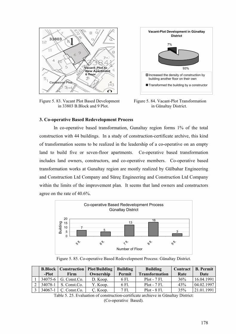
178
Figure 5. 83. Vacant Plot Based Development Figure 5. 84. Vacant-Plot Transformation in 33803 B.Block and 9 Plot. in Günaltay District.
3. Co-operative Based Redevelopment Process
In co-operative based transformation, Gunaltay region forms 1% of the total
construction with 44 buildings. In a study of construction-certificate archive, this kind
of transformation seems to be realized in the leadership of a co-operative on an empty
land to build five or seven-floor apartments. Co-operative based transformation
includes land owners, constructors, and co-operative members. Co-operative based
transformation works at Gunaltay region are mostly realized by Gülbahar Engineering
and Construction Ltd Company and Süreç Engineering and Construction Ltd Company
within the limits of the improvement plan. It seems that land owners and constructors
agree on the rate of 40.6%.
Co-operative Based Redevelopment ProcessGünaltay District
137
5
16
305
101520
5 fl.
6 fl.
7 fl.
8 fl.
9 fl.
Number of Floor
Bui
ldin
g
Figure 5. 85. Co-operative Based Redevelopment Process: Günaltay District.
B.Block
-Plot Construction
Firm Plot/Building Ownership
Building Permit
Building Transformation
Contract Rate
B. Permit Date
1 34075-6 G. Const.Co. D. Koop. 6 Fl. Plot - 7 Fl. 36% 16.04.19912 34078-1 S. Const.Co. Y. Koop. 6 Fl. Plot - 7 Fl. 43% 04.02.19973 34067-1 Ç. Const.Co. Ç. Koop. 7 Fl. Plot - 8 Fl. 35% 21.01.1991
Table 5. 25. Evaluation of construction-certificate archieve in Günaltay District: (Co-operative Based).
Vacant-Plot Development in Günaltay District
93%
7%
Increased the density of construction bybuilding another floor on their own
Transformed the building by a constructor
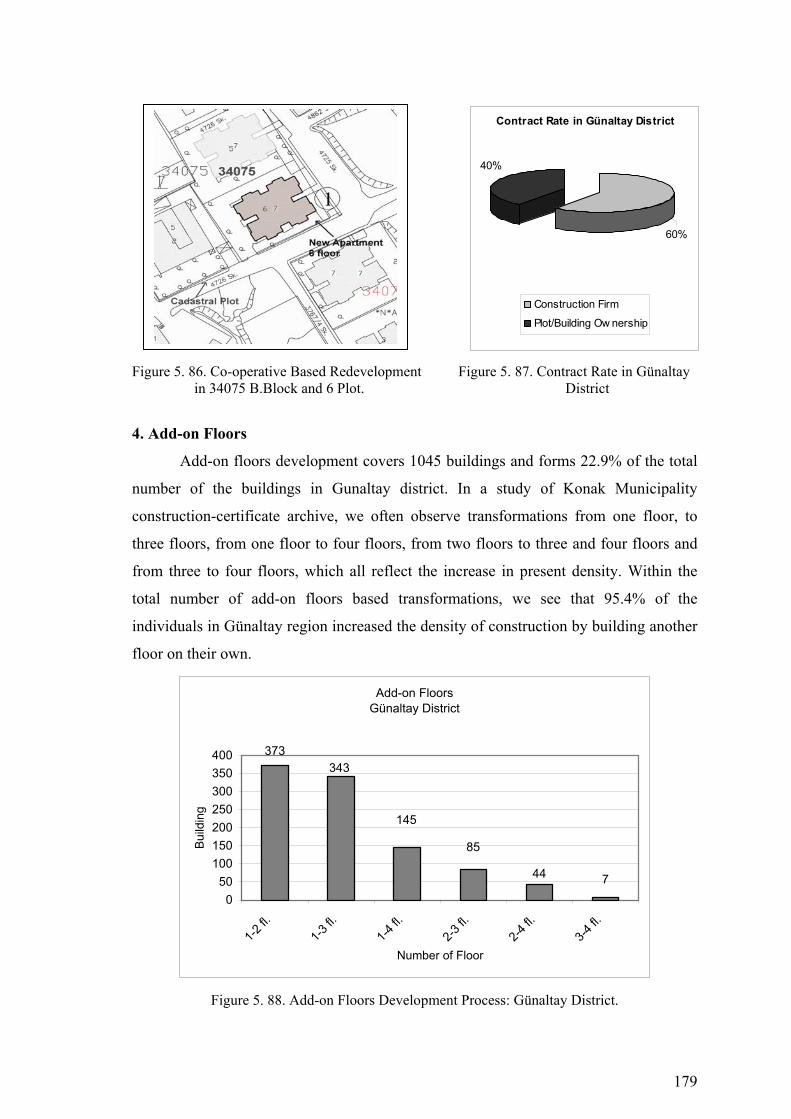
179
Figure 5. 86. Co-operative Based Redevelopment Figure 5. 87. Contract Rate in Günaltay in 34075 B.Block and 6 Plot. District
4. Add-on Floors
Add-on floors development covers 1045 buildings and forms 22.9% of the total
number of the buildings in Gunaltay district. In a study of Konak Municipality
construction-certificate archive, we often observe transformations from one floor, to
three floors, from one floor to four floors, from two floors to three and four floors and
from three to four floors, which all reflect the increase in present density. Within the
total number of add-on floors based transformations, we see that 95.4% of the
individuals in Günaltay region increased the density of construction by building another
floor on their own.
Add-on FloorsGünaltay District
145
373343
85
44 70
50100150200250300350400
1-2 fl.
1-3 fl.
1-4 fl.
2-3 fl.
2-4 fl.
3-4 fl.
Number of Floor
Build
ing
Figure 5. 88. Add-on Floors Development Process: Günaltay District.
Contract Rate in Günaltay District
60%
40%
Construction Firm
Plot/Building Ow nership

180
B.Block-Plot
Construction Firm
Plot/Building Ownership
Building Permit
Building Transformation
Contract Rate
B. Permit Date
1 33784-11 - Fevzi Ö. 4 fl. 1 fl. - 4 fl. - unlicenced 2 33788-2 - Mehmet Ç. 4 fl. 2 fl. - 4 fl. - 01.04.1993 3 33800-6 - Erhan Ç. 4 fl. 1 fl. - 4 fl. - 15.11.1997 4 33802-8 - Ahmet E. 4 fl. 1 fl. - 3 fl. - Ruhsatsız 5 33841-4 - Harun G. 4 fl. 1 fl. - 3 fl. - unlicenced 6 33838-14 - Orhan Ö. 4 fl. 2 fl. - 4 fl. - 11.03.1999 7 33837-7 - İbrahim A. 4 fl. 1 fl. - 3 fl. - 19.07.2002 8 33836-6 - Bülent Ö. 4 fl. 2 fl. - 4 fl. - 03.05.2000 9 33829-8 - Emre A. 4 fl. 1 fl. - 4 fl. - 13.11.1996
10 33830-3 - Hasan B. 4 fl. 1 fl. - 4 fl. - 19.09.1999 11 33845-11 - Gülhan B. 4 fl. 1 fl. - 2 fl. - unlicenced 12 33847-2 - Saadet K. 4 fl. 1 fl. - 3 fl. - 13.11.1993 13 33848-9 - Kemalettin Ö. 4 fl. 1 fl. - 3 fl. - 14.05.1995 14 33849-17 - Sevgi A. 4 fl. 1 fl. - 3 fl. - 09.11.1993 15 33844-8 - Sacide E. 4 fl. 1 fl. - 3 fl. - 22.03.1995 16 33862-6 - Davud D. 4 fl. 1 fl. - 3 fl. - 13.02.1991 17 33854-2 - Hüseyin E. 4 fl. 1 fl. - 3 fl. - 29.03.1991 18 33853-2 - Metin E. 4 fl. 1 fl. - 3 fl. - unlicenced 19 33789-13 - Nasıf Y. 4 fl. 1 fl. - 4 fl. - 22.03.1992 20 33783-15 - A. Hasan Y. 4 fl. 1 fl. - 3 fl. - unlicenced 21 33778-6 - Ali B. 4 fl. 2 fl. - 4 fl. - 22.03.1992 22 13550-4 - Hakan D. 4 fl. 2 fl. - 4 fl. - 15.01.1999 23 33772-3 - Sabri B. 4 fl. 1 fl. - 3 fl. - unlicenced 24 34053-10 - Hamza B. 4 fl. 1 fl. - 3 fl. - 26.07.1998 25 14094-17 - Erdem G. 4 fl. 1 fl. - 3 fl. - 12.04.1998 26 33669-17 - Cahit D. 4 fl. 1 fl. - 3 fl. - unlicenced 27 33668-14 - Remzi G. 4 fl. 1 fl. - 5 fl. - unlicenced 28 43633-6 - İhsan S. 4 fl. 1 fl. - 5 fl. - 20.12.1997 29 33656-6 - İsmail Ş. 4 fl. 1 fl. - 3 fl. - 10.01.1990 30 33679-17 - Nuriye K. 4 fl. 1 fl. - 3 fl. - 11.02.1992 31 34053-17 - Mahmut K. 4 fl. 1 fl. - 3 fl. - unlicenced 32 33694-6 - Mustafa K. 4 fl. 1 fl. - 3 fl. - 12.04.1994 33 33739-5 - Rasim S. 4 fl. 1 fl. - 2 fl. - unlicenced 34 33747-4 - Cafer Y. 4 fl. 1 fl. - 2 fl. - 11.02.1998 35 33755-11 - Mehmet U. 4 fl. 2 fl. - 4 fl. - 21.12.1998 36 33719-5 - Mazhar S. 4 fl. 1 fl. - 3 fl. - 01.05.2001 37 33960-11 - Yaşar Y. 4 fl. 1 fl. - 2 fl. - unlicenced 38 43333-11 - Metin Y. 4 fl. 1 fl. - 2 fl. - unlicenced 39 43332-9 - Arif H. 4 fl. 1 fl. - 3 fl. - 11.04.2004 40 43329-1 - Cemal K. 4 fl. 1 fl. - 2 fl. - unlicenced 41 34044-10 - Sadık A. 4 fl. 1 fl. - 3 fl. - 23.07.1993 42 34046-12 - Mehmet G. 4 fl. 1 fl. -4 fl. - 12.01.1995 43 34032-9 - Hasan K. 4 fl. 1 fl. -4 fl. - 24.07.1994 44 34027-7 - Hüseyin Ö. 4 fl. 1 fl. -2 fl. - unlicenced 45 33918-8 - Serkan A. 4 fl. 1 fl. -3 fl. - 19.05.1998 46 33905-3 - Özlem G. 4 fl. 1 fl. -3 fl. - unlicenced 47 33899-4 - Kemal K. 4 fl. 1 fl. -2 fl. - unlicenced
Table 5. 26. Evaluation of construction-certificate archieve in Gunaltay District: (Single Plot Based).
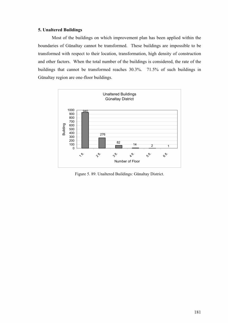
181
5. Unaltered Buildings
Most of the buildings on which improvement plan has been applied within the
boundaries of Günaltay cannot be transformed. These buildings are impossible to be
transformed with respect to their location, transformation, high density of construction
and other factors. When the total number of the buildings is considered, the rate of the
buildings that cannot be transformed reaches 30.3%. 71.5% of such buildings in
Günaltay region are one-floor buildings.
Unaltered BuildingsGünaltay District
82
940
276
14 2 10100200300400500600700800900
1000
1 fl.
2 fl.
3 fl.
4 fl.
5 fl.
6 fl.
Number of Floor
Build
ing
Figure 5. 89. Unaltered Buildings: Günaltay District.

182
Figure 5. 90. Urban Transformation Process (1986-2005) Konak Municipality-Günaltay District

183
Figure 5. 91. Buildings that are Investigated in Konak Municipality Construction Certificate Archive-Günaltay District
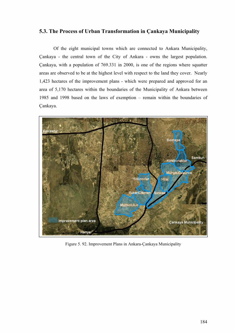
184
5.3. The Process of Urban Transformation in Çankaya Municipality
Of the eight municipal towns which are connected to Ankara Municipality,
Çankaya - the central town of the City of Ankara - owns the largest population.
Çankaya, with a population of 769.331 in 2000, is one of the regions where squatter
areas are observed to be at the highest level with respect to the land they cover. Nearly
1,423 hectares of the improvement plans - which were prepared and approved for an
area of 5,170 hectares within the boundaries of the Municipality of Ankara between
1985 and 1998 based on the laws of exemption – remain within the boundaries of
Çankaya.
Figure 5. 92. Improvement Plans in Ankara-Çankaya Municipality

185
5.3.1. Hilal District
Urban Transformation in Hilal District
43%
19%
6%
28%
4% Single-Plot BasedRedevelopment ProcessVacant-Plot BasedDevelopment ProcessCo-operative BasedRedevelopment ProcessUnaltered Buildings
Add-on Floors
Figure 5. 93. Urban Transformation in Hilal District.
1. Single-Plot Based Urban Redevelopment
Single-plot based transformation covers 83 buildings and forms 43.1% of the
total number of the buildings in Hilal district. In a study of Çankaya Municipality
construction-certificate archive, we often observe transformations from one floor to five
floors, from one floor to seven floors, from two floors to five and seven floors, which all
reflect the redevelopment process in Hilal district. Within the total number of single-
plot based transformations, we see in Hilal region increased the density of construction
by demolishing an old buildings. We see that this kind of transformation is usually
realized by a constructor by pulling down an old building and reconstructing a new five
or seven floor apartment instead. It is seen that 60% of such single-plot buildings are
built by a construction firm. The transformation works within the improvement plan at
Hilal are mostly realized by Karabey, Cansın and Ceykent Engineering and
Construction Ltd. Company. In addition, it is also observed that plot and house owners
and constructors agree at the rate of 40.
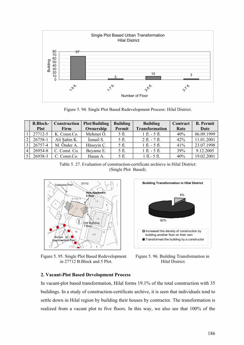
186
Single Plot Based Urban Transformation Hilal District
67
310 3
01020304050607080
1-5 fl.
1-7 fl.
2-5 fl.
2-7 fl.
Number of Floor
Build
ing
Figure 5. 94. Single Plot Based Redevelopment Process: Hilal District.
B.Block-Plot
Construction Firm
Plot/Building Ownership
Building Permit
Building Transformation
Contract Rate
B. Permit Date
1 27712-5 K. Const.Co. Mehmet Ö. 5 fl. 1 fl. - 5 fl. 40% 06.09.1999 2 26758-1 Ali Şahin K. İsmail S. 5 fl. 2 fl. - 7 fl. 42% 11.01.2001 3 26757-4 M. Önder A. Hüseyin Ç. 5 fl. 1 fl. - 5 fl. 41% 23.07.1998 4 26954-8 C. Const. Co. Beyame E. 5 fl. 1 fl. - 5 fl. 39% 9.12.2005 5 26938-3 C. Const.Co. Hasan A. 5 fl. 1 fl.- 5 fl. 40% 19.02.2001
Table 5. 27. Evaluation of construction-certificate archieve in Hilal District: (Single Plot Based).
Figure 5. 95. Single Plot Based Redevelopment Figure 5. 96. Building Transformation in in 27712 B.Block and 5 Plot. Hilal District.
2. Vacant-Plot Based Development Process
In vacant-plot based transformation, Hilal forms 19.1% of the total construction with 35
buildings. In a study of construction-certificate archive, it is seen that individuals tend to
settle down in Hilal region by building their houses by contractor. The transformation is
realized from a vacant plot to five floors. In this way, we also see that 100% of the
Building Transformation in Hilal District
8%
92%
Increased the density of construction bybuilding another floor on their ownTransformed the building by a constructor
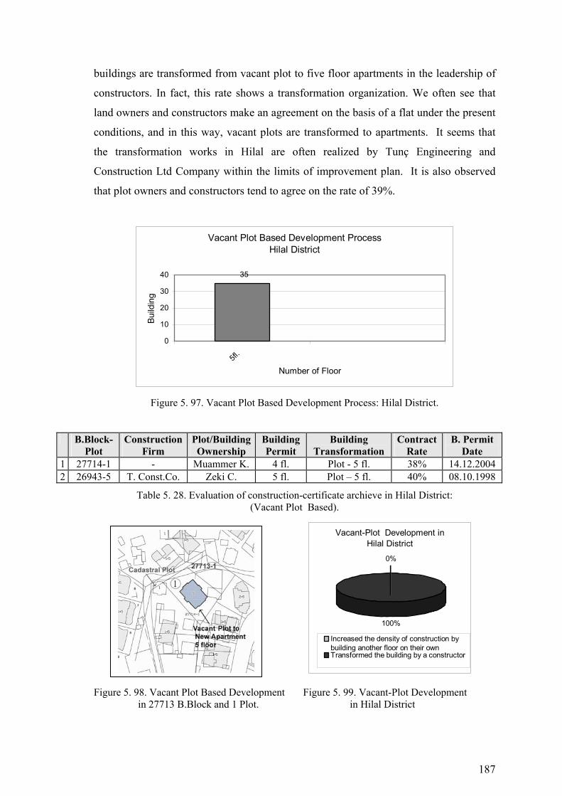
187
buildings are transformed from vacant plot to five floor apartments in the leadership of
constructors. In fact, this rate shows a transformation organization. We often see that
land owners and constructors make an agreement on the basis of a flat under the present
conditions, and in this way, vacant plots are transformed to apartments. It seems that
the transformation works in Hilal are often realized by Tunç Engineering and
Construction Ltd Company within the limits of improvement plan. It is also observed
that plot owners and constructors tend to agree on the rate of 39%.
Vacant Plot Based Development ProcessHilal District
35
0
10
20
30
40
5fl.
Number of Floor
Build
ing
Figure 5. 97. Vacant Plot Based Development Process: Hilal District.
B.Block-Plot
Construction Firm
Plot/Building Ownership
Building Permit
Building Transformation
Contract Rate
B. Permit Date
1 27714-1 - Muammer K. 4 fl. Plot - 5 fl. 38% 14.12.2004 2 26943-5 T. Const.Co. Zeki C. 5 fl. Plot – 5 fl. 40% 08.10.1998
Table 5. 28. Evaluation of construction-certificate archieve in Hilal District: (Vacant Plot Based).
Figure 5. 98. Vacant Plot Based Development Figure 5. 99. Vacant-Plot Development in 27713 B.Block and 1 Plot. in Hilal District
Vacant-Plot Development in Hilal District
0%
100%
Increased the density of construction bybuilding another floor on their ownTransformed the building by a constructor
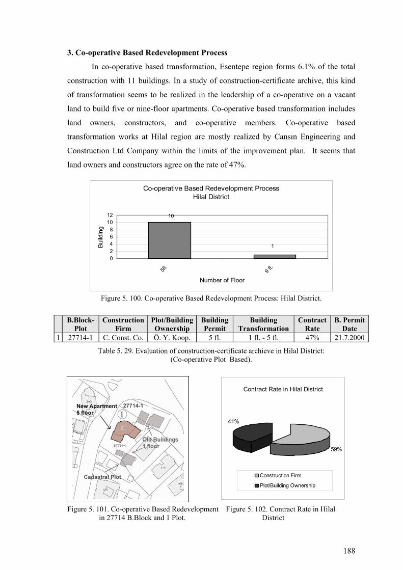
188
3. Co-operative Based Redevelopment Process
In co-operative based transformation, Esentepe region forms 6.1% of the total
construction with 11 buildings. In a study of construction-certificate archive, this kind
of transformation seems to be realized in the leadership of a co-operative on a vacant
land to build five or nine-floor apartments. Co-operative based transformation includes
land owners, constructors, and co-operative members. Co-operative based
transformation works at Hilal region are mostly realized by Cansın Engineering and
Construction Ltd Company within the limits of the improvement plan. It seems that
land owners and constructors agree on the rate of 47%.
Co-operative Based Redevelopment ProcessHilal District
1
10
02468
1012
5fl.
9 fl.
Number of Floor
Build
ing
Figure 5. 100. Co-operative Based Redevelopment Process: Hilal District.
B.Block-
Plot Construction
Firm Plot/Building Ownership
Building Permit
Building Transformation
Contract Rate
B. Permit Date
1 27714-1 C. Const. Co. Ö. Y. Koop. 5 fl. 1 fl. - 5 fl. 47% 21.7.2000
Table 5. 29. Evaluation of construction-certificate archieve in Hilal District: (Co-operative Plot Based).
Figure 5. 101. Co-operative Based Redevelopment Figure 5. 102. Contract Rate in Hilal in 27714 B.Block and 1 Plot. District
Contract Rate in Hilal District
59%
41%
Construction Firm
Plot/Building Ownership
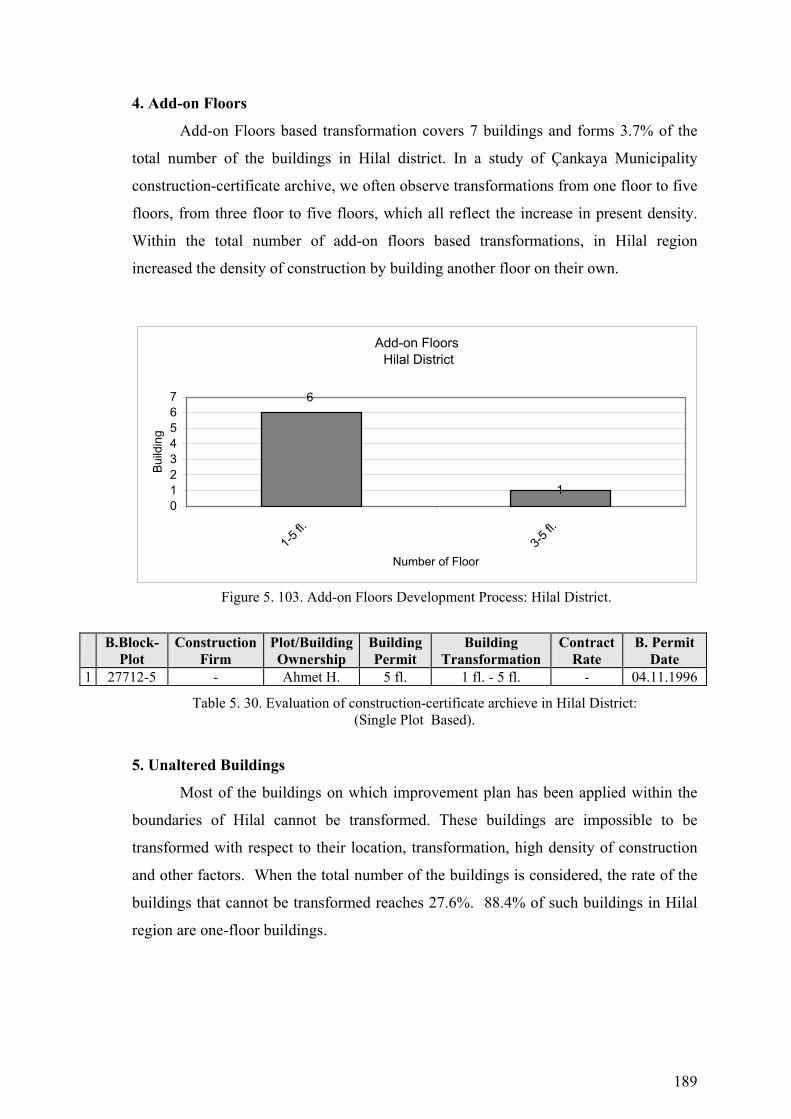
189
4. Add-on Floors
Add-on Floors based transformation covers 7 buildings and forms 3.7% of the
total number of the buildings in Hilal district. In a study of Çankaya Municipality
construction-certificate archive, we often observe transformations from one floor to five
floors, from three floor to five floors, which all reflect the increase in present density.
Within the total number of add-on floors based transformations, in Hilal region
increased the density of construction by building another floor on their own.
Add-on Floors Hilal District
6
101234567
1-5 fl.
3-5 fl.
Number of Floor
Build
ing
Figure 5. 103. Add-on Floors Development Process: Hilal District.
B.Block-Plot
Construction Firm
Plot/Building Ownership
Building Permit
Building Transformation
Contract Rate
B. Permit Date
1 27712-5 - Ahmet H. 5 fl. 1 fl. - 5 fl. - 04.11.1996
Table 5. 30. Evaluation of construction-certificate archieve in Hilal District: (Single Plot Based).
5. Unaltered Buildings
Most of the buildings on which improvement plan has been applied within the
boundaries of Hilal cannot be transformed. These buildings are impossible to be
transformed with respect to their location, transformation, high density of construction
and other factors. When the total number of the buildings is considered, the rate of the
buildings that cannot be transformed reaches 27.6%. 88.4% of such buildings in Hilal
region are one-floor buildings.

190
Figure 5. 104. Urban Transformation Process (1985-2005) Çankaya Municipality-Hilal District

191
Figure 5. 105. Buildings that are Investigated in Çankaya Municipality Construction Certificate
Archive-Hilal District
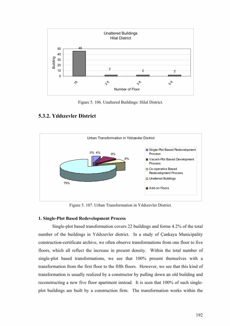
192
Unaltered BuildingsHilal District
2
46
2 20
10
2030
40
50
1fl.
2 fl.
3 fl.
5 fl.
Number of Floor
Build
ing
Figure 5. 106. Unaltered Buildings: Hilal District.
5.3.2. Yıldızevler District
Urban Transformation in Yıldızevler District
4% 9%8%
79%
0%Single-Plot Based RedevelopmentProcess
Vacant-Plot Based DevelopmentProcess
Co-operative BasedRedevelopment Process
Unaltered Buildings
Add-on Floors
Figure 5. 107. Urban Transformation in Yıldızevler District.
1. Single-Plot Based Redevelopment Process
Single-plot based transformation covers 22 buildings and forms 4.2% of the total
number of the buildings in Yıldızevler district. In a study of Çankaya Municipality
construction-certificate archive, we often observe transformations from one floor to five
floors, which all reflect the increase in present density. Within the total number of
single-plot based transformations, we see that 100% present themselves with a
transformation from the first floor to the fifth floors. However, we see that this kind of
transformation is usually realized by a constructor by pulling down an old building and
reconstructing a new five floor apartment instead. It is seen that 100% of such single-
plot buildings are built by a construction firm. The transformation works within the
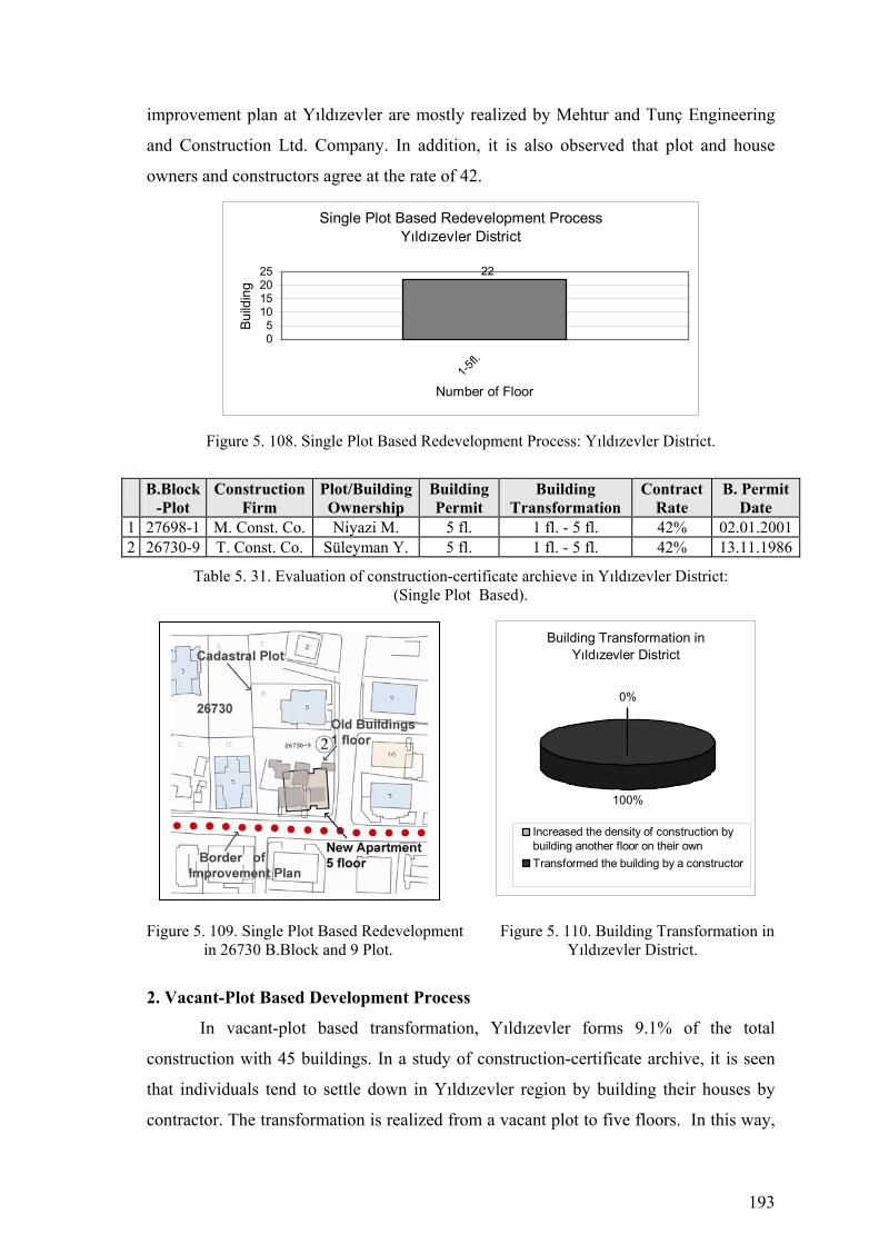
193
improvement plan at Yıldızevler are mostly realized by Mehtur and Tunç Engineering
and Construction Ltd. Company. In addition, it is also observed that plot and house
owners and constructors agree at the rate of 42.
Single Plot Based Redevelopment ProcessYıldızevler District
22
05
10152025
1-5fl.
Number of Floor
Build
ing
Figure 5. 108. Single Plot Based Redevelopment Process: Yıldızevler District.
B.Block-Plot
Construction Firm
Plot/Building Ownership
Building Permit
Building Transformation
Contract Rate
B. Permit Date
1 27698-1 M. Const. Co. Niyazi M. 5 fl. 1 fl. - 5 fl. 42% 02.01.20012 26730-9 T. Const. Co. Süleyman Y. 5 fl. 1 fl. - 5 fl. 42% 13.11.1986
Table 5. 31. Evaluation of construction-certificate archieve in Yıldızevler District: (Single Plot Based).
Figure 5. 109. Single Plot Based Redevelopment Figure 5. 110. Building Transformation in in 26730 B.Block and 9 Plot. Yıldızevler District.
2. Vacant-Plot Based Development Process
In vacant-plot based transformation, Yıldızevler forms 9.1% of the total
construction with 45 buildings. In a study of construction-certificate archive, it is seen
that individuals tend to settle down in Yıldızevler region by building their houses by
contractor. The transformation is realized from a vacant plot to five floors. In this way,
Building Transformation in Yıldızevler District
0%
100%
Increased the density of construction bybuilding another floor on their ownTransformed the building by a constructor
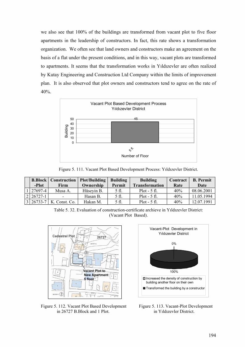
194
we also see that 100% of the buildings are transformed from vacant plot to five floor
apartments in the leadership of constructors. In fact, this rate shows a transformation
organization. We often see that land owners and constructors make an agreement on the
basis of a flat under the present conditions, and in this way, vacant plots are transformed
to apartments. It seems that the transformation works in Yıldızevler are often realized
by Kutay Engineering and Construction Ltd Company within the limits of improvement
plan. It is also observed that plot owners and constructors tend to agree on the rate of
40%.
Vacant Plot Based Development ProcessYıldızevler District
45
01020304050
5 fl.
Number of Floor
Build
ing
Figure 5. 111. Vacant Plot Based Development Process: Yıldızevler District.
B.Block
-Plot Construction
Firm Plot/Building Ownership
Building Permit
Building Transformation
Contract Rate
B. Permit Date
1 27697-4 Musa A. Hüseyin B. 5 fl. Plot - 5 fl. 40% 08.06.2001 2 26727-1 - Hasan B. 5 fl. Plot - 5 fl. 40% 11.05.1994 3 26733-7 K. Const. Co. Hakan M. 5 fl. Plot - 5 fl. 40% 12.07.1991
Table 5. 32. Evaluation of construction-certificate archieve in Yıldızevler District: (Vacant Plot Based).
Figure 5. 112. Vacant Plot Based Development Figure 5. 113. Vacant-Plot Development in 26727 B.Block and 1 Plot. in Yıldızevler District.
Vacant-Plot Development in Yıldızevler District
0%
100%
Increased the density of construction bybuilding another floor on their own
Transformed the building by a constructor

195
3. Co-operative Based Redevelopment Process
In co-operative based transformation, Yıldızevler region forms 8.1% of the total
construction with 39 buildings. In a study of construction-certificate archive, this kind
of transformation seems to be realized in the leadership of a co-operative on an empty
land to build five, seven or nine-floor apartments. Co-operative based transformation
includes land owners, constructors, and co-operative members. Co-operative based
transformation works at Yıldızevler region are mostly realized by Intur, MESA and
Evren Engineering and Construction Ltd Company within the limits of the improvement
plan. It seems that land owners and constructors agree on the rate of 42%.
Co-operative Based Redevelopment ProcessYıldızevler District
25
32
010203040
5 fl.
7 fl.
9 fl.
Number of Floor
Build
ing
Figure 5. 114. Co-operative Based Redevelopment Process: Yıldızevler District.
B.Block-Plot
Construction Firm
Plot/Building Ownership
Building Permit
Building Transformation
Contract Rate
B. Permit Date
1 7753-6 I. Const.Co. G.Y. Koop. 9 Fl. Plot - 9 Fl. - 08.11.1988 2 34550-2 M. Const.Co. Ç. Y. Koop. 9 Fl. Plot - 9 Fl. - 12.10.1987 3 28042-1 E. Const.Co. K. Y. Koop. 9 Fl. Plot - 9 Fl. 42% 12.07.1991
Table 5. 33. Evaluation of construction-certificate archieve in Yıldızevler District: (Co-operative Plot Based).
Figure 5. 115. Co-operative Based Redevelopment Figure 5. 116.Contract Rate in Yıldızevler in 27714 B.Block and 1 Plot. District.
Contract Rate in Yıldızevler District
59%
41%
Construction Firm
Plot/Building Ownership

196
Figure 5. 117. Urban Transformation Process (1985-2005) Çankaya Municipality-Yıldızevler District

197
Figure 5.118. Buildings that are Investigated in Çankaya Municipality Construction Certificate
Archive-Yıldızevler District
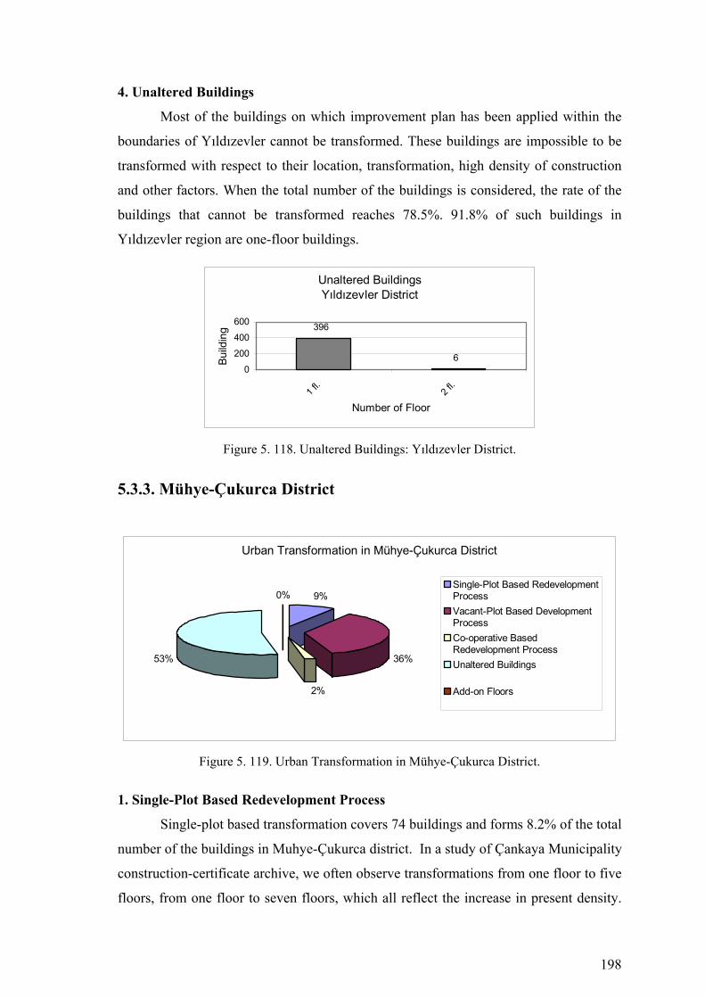
198
4. Unaltered Buildings
Most of the buildings on which improvement plan has been applied within the
boundaries of Yıldızevler cannot be transformed. These buildings are impossible to be
transformed with respect to their location, transformation, high density of construction
and other factors. When the total number of the buildings is considered, the rate of the
buildings that cannot be transformed reaches 78.5%. 91.8% of such buildings in
Yıldızevler region are one-floor buildings.
Unaltered BuildingsYıldızevler District
6
396
0
200
400
600
1 fl.
2 fl.
Number of Floor
Build
ing
Figure 5. 118. Unaltered Buildings: Yıldızevler District.
5.3.3. Mühye-Çukurca District
Urban Transformation in Mühye-Çukurca District
9%
36%
2%
53%
0%Single-Plot Based RedevelopmentProcessVacant-Plot Based DevelopmentProcessCo-operative BasedRedevelopment ProcessUnaltered Buildings
Add-on Floors
Figure 5. 119. Urban Transformation in Mühye-Çukurca District.
1. Single-Plot Based Redevelopment Process
Single-plot based transformation covers 74 buildings and forms 8.2% of the total
number of the buildings in Muhye-Çukurca district. In a study of Çankaya Municipality
construction-certificate archive, we often observe transformations from one floor to five
floors, from one floor to seven floors, which all reflect the increase in present density.
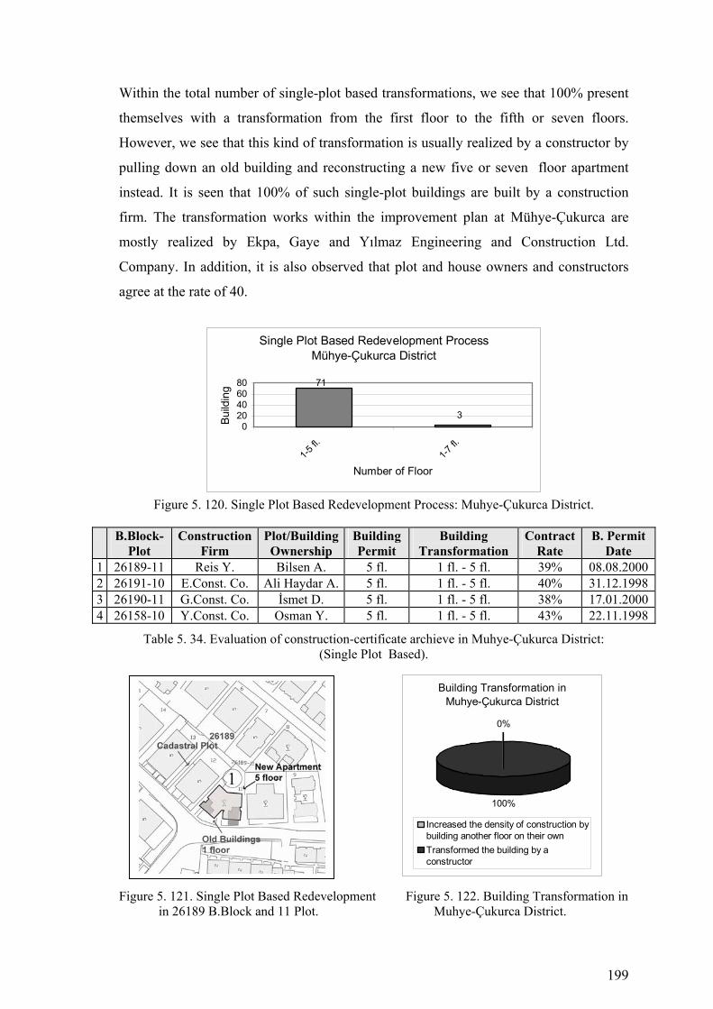
199
Within the total number of single-plot based transformations, we see that 100% present
themselves with a transformation from the first floor to the fifth or seven floors.
However, we see that this kind of transformation is usually realized by a constructor by
pulling down an old building and reconstructing a new five or seven floor apartment
instead. It is seen that 100% of such single-plot buildings are built by a construction
firm. The transformation works within the improvement plan at Mühye-Çukurca are
mostly realized by Ekpa, Gaye and Yılmaz Engineering and Construction Ltd.
Company. In addition, it is also observed that plot and house owners and constructors
agree at the rate of 40.
Single Plot Based Redevelopment ProcessMühye-Çukurca District
3
71
020406080
1-5 fl.
1-7 fl.
Number of Floor
Build
ing
Figure 5. 120. Single Plot Based Redevelopment Process: Muhye-Çukurca District.
B.Block-
Plot Construction
Firm Plot/Building Ownership
Building Permit
Building Transformation
Contract Rate
B. Permit Date
1 26189-11 Reis Y. Bilsen A. 5 fl. 1 fl. - 5 fl. 39% 08.08.2000 2 26191-10 E.Const. Co. Ali Haydar A. 5 fl. 1 fl. - 5 fl. 40% 31.12.1998 3 26190-11 G.Const. Co. İsmet D. 5 fl. 1 fl. - 5 fl. 38% 17.01.2000 4 26158-10 Y.Const. Co. Osman Y. 5 fl. 1 fl. - 5 fl. 43% 22.11.1998
Table 5. 34. Evaluation of construction-certificate archieve in Muhye-Çukurca District: (Single Plot Based).
Figure 5. 121. Single Plot Based Redevelopment Figure 5. 122. Building Transformation in in 26189 B.Block and 11 Plot. Muhye-Çukurca District.
Building Transformation in Muhye-Çukurca District
0%
100%
Increased the density of construction bybuilding another floor on their ownTransformed the building by aconstructor
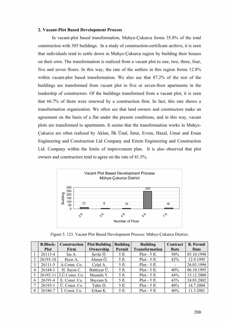
200
2. Vacant-Plot Based Development Process
In vacant-plot based transformation, Muhye-Çukurca forms 35.8% of the total
construction with 305 buildings. In a study of construction-certificate archive, it is seen
that individuals tend to settle down in Muhye-Çukurca region by building their houses
on their own. The transformation is realized from a vacant plot to one, two, three, four,
five and seven floors. In this way, the rate of the settlers in this region forms 12.8%
within vacant-plot based transformation. We also see that 87.2% of the rest of the
buildings are transformed from vacant plot to five or seven-floor apartments in the
leadership of constructors. Of the buildings transformed from a vacant plot, it is seen
that 66.7% of them were renewed by a construction firm. In fact, this rate shows a
transformation organization. We often see that land owners and constructors make an
agreement on the basis of a flat under the present conditions, and in this way, vacant
plots are transformed to apartments. It seems that the transformation works in Muhye-
Çukurca are often realized by Aklan, İlk Ünal, İntur, Evren, Hazal, Umut and Ersan
Engineering and Construction Ltd Company and Ertem Engineering and Construction
Ltd. Company within the limits of improvement plan. It is also observed that plot
owners and constructors tend to agree on the rate of 41.5%.
Vacant Plot Based Development ProcessMühye-Çukurca District
821 10
250
160
50100150200250300
2 fl.
3 fl.
4 fl.
5 fl.
7 fl.
Number of Floor
Build
ing
Figure 5. 123. Vacant Plot Based Development Process: Mühye-Çukurca District.
B.Block-
Plot Construction
Firm Plot/Building Ownership
BuildingPermit
Building Transformation
Contract Rate
B. Permit Date
1 26113-4 İsa A. Şevki Ö. 5 fl. Plot - 5 fl. 50% 05.10.19982 26193-10 Hızır A. Ahmet Ö. 5 fl. Plot - 5 fl. 42% 12.9.1995 3 26111-5 A.Const. Co. Celal A. 5 fl. Plot - 5 fl. - 26.03.19964 26184-1 H. Sayın C. Bahtiyar Ü. 5 fl. Plot - 5 fl. 40% 06.10.19955 26192-11 İ.Ü.Const. Co. Mustafa Y. 5 fl. Plot - 5 fl. 44% 15.12.20006 26191-4 E. Const. Co. Bayram Ş. 5 fl. Plot - 5 fl. 43% 24.03.20027 26193-1 Ü. Const. Co. Tahir D. 5 fl. Plot - 5 fl. 40% 14.7.2004 8 26186-7 İ. Const. Co. Erkan K. 5 fl. Plot - 5 fl. 40% 11.3.2001

201
9 26107-1 E. Const. Co. Serdar Ü. 5 fl. Plot - 5 fl. 40% 25.07.199810 26183-11 - Burhan Y. 5 fl. Plot - 5 fl. 40% 30.05.199511 26180-10 H. Const. Co. Ali Haydar Y. 5 fl. Plot - 5 fl. 40% 12.7.2001 12 26177-18 U. Const. Co. Hakan E. 5 fl. Plot - 5 fl. 38% 7.8.2005 13 26117-3 - Ahmet U. 4 fl. Plot - 3 fl. - 4.5.2001 14 26119-5 E. Const. Co. Ömer K. 5 fl. Plot -5 fl. 40% 24.8.2003 15 26148-2 İ. Const. Co. İhsan A. 7 fl. Plot -7 fl. 43% 13.03.1997
Table 5. 35. Evaluation of construction-certificate archieve in Mühye-Çukurca District: (Vacant Plot Based).
Figure 5. 124. Vacant Plot Based Development Figure 5. 125. Vacant-Plot Development in 26113 B.Block and 4 Plot. in Muhye-Çukurca District
3. Co-operative Based Redevelopment Process
In co-operative based transformation, Muhye-Çukurca region forms 2.3% of the
total construction with 17 buildings. In a study of construction-certificate archive, this
kind of transformation seems to be realized in the leadership of a co-operative on a
vacant land to build five, seven or nine-floor apartments. Co-operative based
transformation includes land owners, constructors, and co-operative members. Co-
operative based transformation works at Muhye-Çukurca region are mostly realized by
Sever Engineering and Construction Ltd Company within the limits of the improvement
plan.
Vacant-Plot Development in Muhye-Çukurca District
13%
87%
Increased the density of constructionby building another floor on their own
Transformed the building by aconstructor
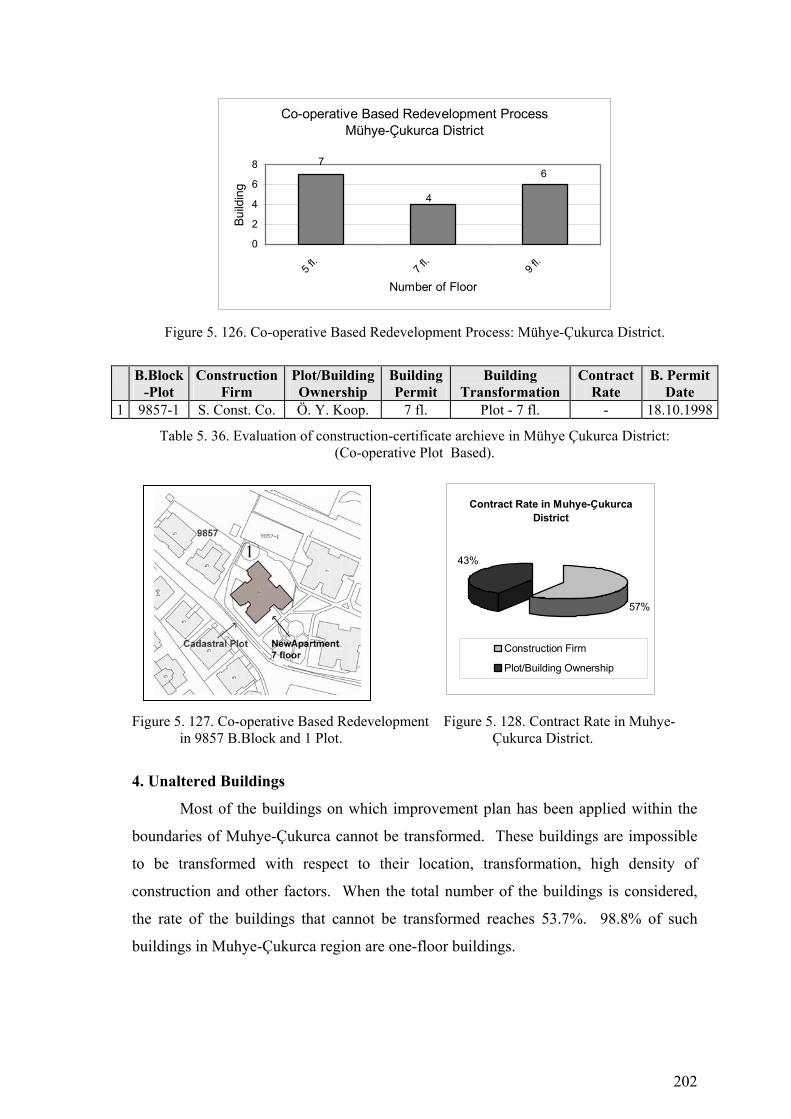
202
Co-operative Based Redevelopment ProcessMühye-Çukurca District
4
76
0
2
4
6
8
5 fl.
7 fl.
9 fl.
Number of Floor
Build
ing
Figure 5. 126. Co-operative Based Redevelopment Process: Mühye-Çukurca District.
B.Block-Plot
Construction Firm
Plot/Building Ownership
BuildingPermit
Building Transformation
Contract Rate
B. Permit Date
1 9857-1 S. Const. Co. Ö. Y. Koop. 7 fl. Plot - 7 fl. - 18.10.1998
Table 5. 36. Evaluation of construction-certificate archieve in Mühye Çukurca District: (Co-operative Plot Based).
Figure 5. 127. Co-operative Based Redevelopment Figure 5. 128. Contract Rate in Muhye- in 9857 B.Block and 1 Plot. Çukurca District.
4. Unaltered Buildings
Most of the buildings on which improvement plan has been applied within the
boundaries of Muhye-Çukurca cannot be transformed. These buildings are impossible
to be transformed with respect to their location, transformation, high density of
construction and other factors. When the total number of the buildings is considered,
the rate of the buildings that cannot be transformed reaches 53.7%. 98.8% of such
buildings in Muhye-Çukurca region are one-floor buildings.
Contract Rate in Muhye-Çukurca District
57%
43%
Construction Firm
Plot/Building Ownership

203
Figure 5. 129. Urban Transformation Process (1985-2005) Çankaya Municipality-Mühye Çukurca District

204
Figure 5. 130. Buildings that are Investigated in Çankaya Municipality Construction Certificate Archive-MühyeÇukurca District

205
Unaltered BuildingsMühye-Çukurca District
3
444
2
0100200300400500
1 fl.
2 fl.
3 fl.
Number of Floor
Build
ing
Figure 5. 131. Unaltered Buildings: Mühye-Çukurca District.
5.3.4. Kırkkonaklar District
Urban Transformation in Kırkkonaklar District
11%
19%
0%70%
0% Single-Plot BasedRedevelopment ProcessVacant-Plot BasedDevelopment ProcessCo-operative BasedRedevelopment ProcessUnaltered Buildings
Add-on Floors
Figure 5. 132. Urban Transformation in Kırkkonaklar District.
1. Single-Plot Based Redevelopment Process
Single-plot based transformation covers 70 buildings and forms 11.2% of the
total number of the buildings in Kırkkonaklar district. In a study of Çankaya
Municipality construction-certificate archive, we often observe transformations from
one floor to five floors, from two floor to five floors, which all reflect the increase in
present density. Within the total number of single-plot based transformations, we see
that 100% present themselves with a transformation from the first floor to the fifth.
However, we see that this kind of transformation is usually realized by a constructor by
pulling down an old building and reconstructing a new five or seven floor apartment
instead. It is seen that 100% of such single-plot buildings are built by a construction
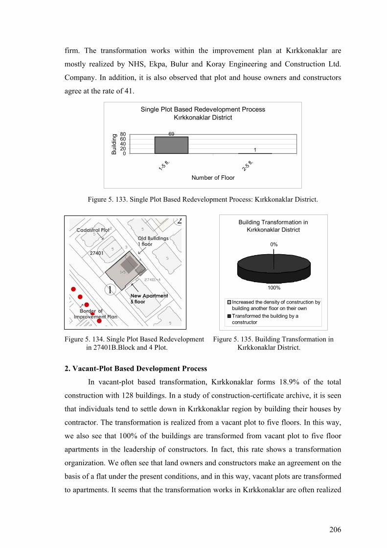
206
firm. The transformation works within the improvement plan at Kırkkonaklar are
mostly realized by NHS, Ekpa, Bulur and Koray Engineering and Construction Ltd.
Company. In addition, it is also observed that plot and house owners and constructors
agree at the rate of 41.
Single Plot Based Redevelopment ProcessKırkkonaklar District
69
10
20406080
1-5 fl.
2-5 fl.
Number of Floor
Build
ing
Figure 5. 133. Single Plot Based Redevelopment Process: Kırkkonaklar District.
Figure 5. 134. Single Plot Based Redevelopment Figure 5. 135. Building Transformation in in 27401B.Block and 4 Plot. Kırkkonaklar District.
2. Vacant-Plot Based Development Process
In vacant-plot based transformation, Kırkkonaklar forms 18.9% of the total
construction with 128 buildings. In a study of construction-certificate archive, it is seen
that individuals tend to settle down in Kırkkonaklar region by building their houses by
contractor. The transformation is realized from a vacant plot to five floors. In this way,
we also see that 100% of the buildings are transformed from vacant plot to five floor
apartments in the leadership of constructors. In fact, this rate shows a transformation
organization. We often see that land owners and constructors make an agreement on the
basis of a flat under the present conditions, and in this way, vacant plots are transformed
to apartments. It seems that the transformation works in Kırkkonaklar are often realized
Building Transformation in Kırkkonaklar District
0%
100%
Increased the density of construction bybuilding another floor on their ownTransformed the building by aconstructor

207
by Koray Gür, İsa Acar, Sezer, Bahar, Ertürk, Cansu Engineering and Construction Ltd
Company within the limits of improvement plan. It is also observed that plot owners
and constructors tend to agree on the rate of 42%.
Figure 5. 136. Vacant Plot Based Development Process: Kırkkonaklar District.
B.Block
-Plot Construction
Firm Plot/Building Ownership
Building Permit
Building Transformation
Contract Rate
B. Permit Date
1 26317-1 K. G. Const.Co. D. Ahmet E. 5 fl. Plot - 5 fl. 42% 27.2.1997 2 26318-5 İ. A. Const.Co. İsa A. 5 fl. Plot - 5 fl. - 31.12.2003 3 26358-6 S. Const.Co. Sabri İ. 5 fl. Plot - 5 fl. 42% 13.07.2003 4 27395-6 B. Const.Co. Bülent İ. 5 fl. Plot - 5 fl. 42% 16.11.1998 5 27405-2 E. Const.Co. Ali Yunus B. 5 fl. Plot - 5 fl. 40% 21.6.1998 6 27408-5 C. Const.Co. Rahmi U. 5 fl. Plot - 5 fl. 42% 17.01.1999
Table 5. 37. Evaluation of construction-certificate archieve in Kırkkonaklar District: (Vacant Plot Based).
Figure 5. 137. Vacant Plot Based Development Figure 5. 138. Vacant-Plot Development in 26317 B.Block and 1 Plot. in Kırkkonaklar District.
Vacant-Plot Development in Kırkkonaklar District
13%
87%
Increased the density of constructionby building another floor on their own
Transformed the building by aconstructor
Vacant Plot Based Development ProcessKırkkonaklar District
128
0
50
100
150
5 fl.
Number of Floor
Build
ing

208
Figure 5. 139. Urban Transformation Process (1985-2005) Çankaya Municipality-Kırkkonaklar District

209
Figure 5. 140. Buildings that are Investigated in Çankaya Municipality Construction Certificate Archive-Kırkkonaklar District

210
3. Unaltered Buildings
Most of the buildings on which improvement plan has been applied within the
boundaries of Kırkkonaklar cannot be transformed. These buildings are impossible to
be transformed with respect to their location, transformation, high density of
construction and other factors. When the total number of the buildings is considered,
the rate of the buildings that cannot be transformed reaches 69.9%. 94.5% of such
buildings in Kırkkonaklar region are one-floor buildings.
Unaltered BuildingsKırkkonaklar District
641
34 30
200400600800
1 fl.
2 fl.
5 fl.
Number of Floor
Build
ing
Figure 5. 141. Unaltered Buildings: Kırkkonaklar District.
5.3.5. Yukarı Dikmen District
Urban Transformation in Yukarı Dikmen District
11%5%0%
84%
0%Single-Plot BasedRedevelopment ProcessVacant-Plot BasedDevelopment ProcessCo-operative BasedRedevelopment ProcessUnaltered Buildings
Add-on Floors
Figure 5. 142. Urban Transformation in Yukarı Dikmen District.
1. Single-Plot Based Redevelopment Process
Single-plot based transformation covers 37 buildings and forms 11.3% of the
total number of the buildings in Yukarı Dikmen district. In a study of Çankaya
Municipality construction-certificate archive, we often observe transformations from
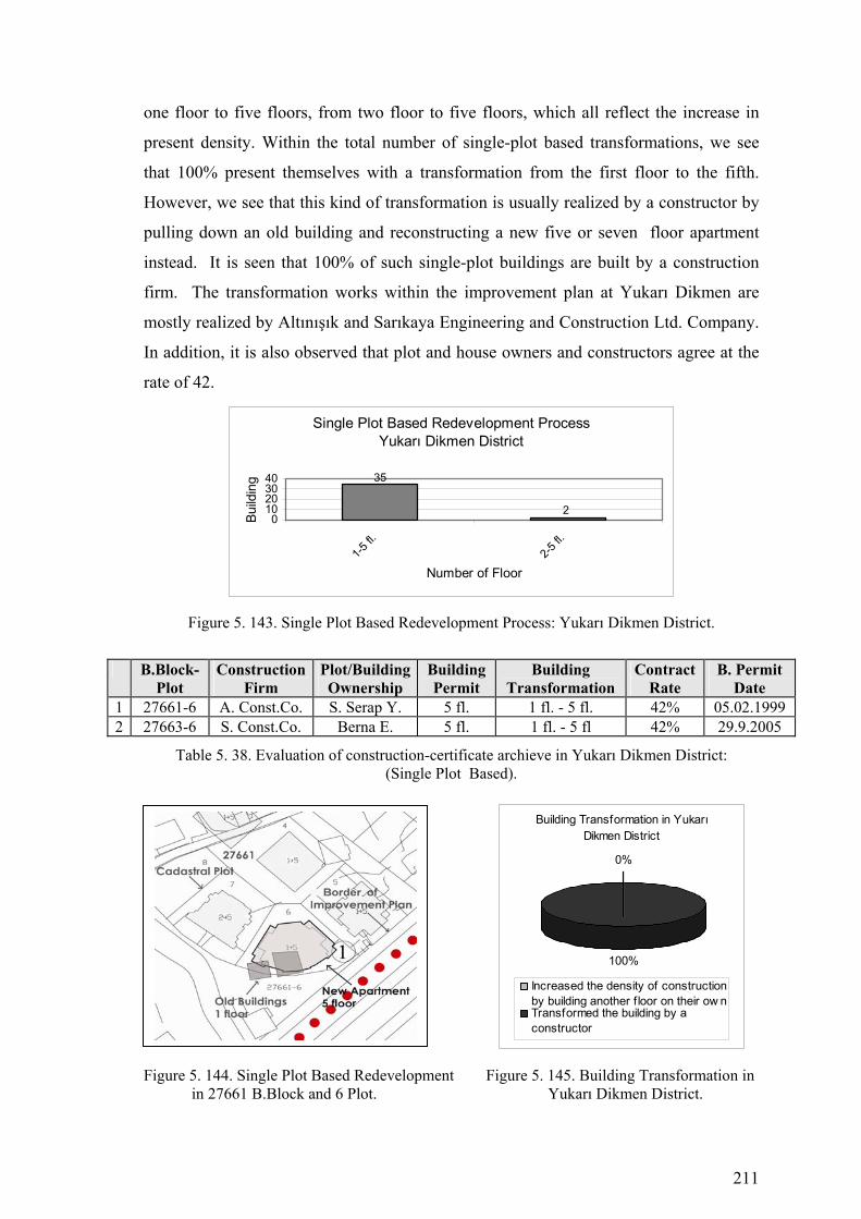
211
one floor to five floors, from two floor to five floors, which all reflect the increase in
present density. Within the total number of single-plot based transformations, we see
that 100% present themselves with a transformation from the first floor to the fifth.
However, we see that this kind of transformation is usually realized by a constructor by
pulling down an old building and reconstructing a new five or seven floor apartment
instead. It is seen that 100% of such single-plot buildings are built by a construction
firm. The transformation works within the improvement plan at Yukarı Dikmen are
mostly realized by Altınışık and Sarıkaya Engineering and Construction Ltd. Company.
In addition, it is also observed that plot and house owners and constructors agree at the
rate of 42.
Single Plot Based Redevelopment ProcessYukarı Dikmen District
35
20
10203040
1-5 fl.
2-5 fl.
Number of Floor
Build
ing
Figure 5. 143. Single Plot Based Redevelopment Process: Yukarı Dikmen District.
B.Block-Plot
Construction Firm
Plot/Building Ownership
Building Permit
Building Transformation
Contract Rate
B. Permit Date
1 27661-6 A. Const.Co. S. Serap Y. 5 fl. 1 fl. - 5 fl. 42% 05.02.1999 2 27663-6 S. Const.Co. Berna E. 5 fl. 1 fl. - 5 fl 42% 29.9.2005
Table 5. 38. Evaluation of construction-certificate archieve in Yukarı Dikmen District: (Single Plot Based).
Figure 5. 144. Single Plot Based Redevelopment Figure 5. 145. Building Transformation in in 27661 B.Block and 6 Plot. Yukarı Dikmen District.
Building Transformation in Yukarı Dikmen District
0%
100%
Increased the density of constructionby building another f loor on their ow nTransformed the building by aconstructor

212
2. Vacant-Plot Based Development Process
In vacant-plot based transformation, Yukarı Dikmen forms 4.9% of the total
construction with 17 buildings. In a study of construction-certificate archive, it is seen
that individuals tend to settle down in Kırkkonaklar region by building their houses by
contractor. The transformation is realized from a vacant plot to five floors. In this way,
we also see that 100% of the buildings are transformed from vacant plot to five floor
apartments in the leadership of constructors. In fact, this rate shows a transformation
organization. We often see that land owners and constructors make an agreement on the
basis of a flat under the present conditions, and in this way, vacant plots are transformed
to apartments. It seems that the transformation works in Yukarı Dikmen are often
realized by Alçın Engineering and Construction Ltd Company within the limits of
improvement plan. It is also observed that plot owners and constructors tend to agree
on the rate of 50%.
Vacant Plot Based Development ProcessYukarı Dikmen District
17
0
5
10
15
20
5 fl.
Number of Floor
Build
ing
Figure 5. 146. Vacant Plot Based Development Process: Yukarı Dikmen District.
B.Block-Plot
Construction Firm
Plot/Building Ownership
Building Permit
Building Transformation
Contract Rate
B. Permit Date
1 27660-3 A. Const. Co. Sezer A. 5 fl. Plot - 5 fl. 50% 4.6.2005
Table 5. 39. Evaluation of construction-certificate archieve in Yukarı Dikmen District: (Vacant Plot Based).

213
Figure 5. 147. Vacant Plot Based Development Figure 5. 148. Vacant-Plot Development in 27660 B.Block and 3 Plot. in Yukarı Dikmen District.
3. Unaltered Buildings
Most of the buildings on which improvement plan has been applied within the
boundaries of Yukarı Dikmen cannot be transformed. These buildings are impossible to
be transformed with respect to their location, transformation, high density of
construction and other factors. When the total number of the buildings is considered, the
rate of the buildings that cannot be transformed reaches 83.8%. 93.2% of such buildings
in Yukarı Dikmen region are one-floor buildings.
Unaltered BuildingsYukarı Dikmen District
259
1711
050
100150200250300
1 fl.
2 fl.
3 fl.
4 fl.
Number of Floor
Build
ing
Figure 5. 149. Unaltered Buildings: Yukarı Dikmen District.
Empty-Plot Transformation in Yukarı Dikmen District
0%
100%
Increased the density of construction bybuilding another floor on their ownTransformed the building by aconstructor

214
Figure 5. 150. Urban Transformation Process (1985-2005) Çankaya Municipality-Yukarı Dikmen District

215
Figure 5. 151. Buildings that are Investigated in Çankaya Municipality Construction Certificate Archive-Yukarı Dikmen District
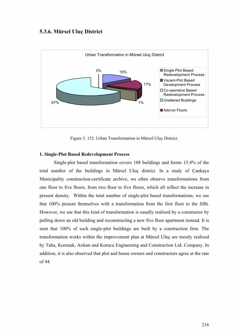
216
5.3.6. Mürsel Uluç District
Urban Transformation in Mürsel Uluç District
15%
17%
1%67%
0% Single-Plot BasedRedevelopment ProcessVacant-Plot BasedDevelopment ProcessCo-operative BasedRedevelopment ProcessUnaltered Buildings
Add-on Floors
Figure 5. 152. Urban Transformation in Mürsel Uluç District.
1. Single-Plot Based Redevelopment Process
Single-plot based transformation covers 108 buildings and forms 15.4% of the
total number of the buildings in Mürsel Uluç district. In a study of Çankaya
Municipality construction-certificate archive, we often observe transformations from
one floor to five floors, from two floor to five floors, which all reflect the increase in
present density. Within the total number of single-plot based transformations, we see
that 100% present themselves with a transformation from the first floor to the fifth.
However, we see that this kind of transformation is usually realized by a constructor by
pulling down an old building and reconstructing a new five floor apartment instead. It is
seen that 100% of such single-plot buildings are built by a construction firm. The
transformation works within the improvement plan at Mürsel Uluç are mostly realized
by Taha, Korunak, Arıkan and Korucu Engineering and Construction Ltd. Company. In
addition, it is also observed that plot and house owners and constructors agree at the rate
of 44.
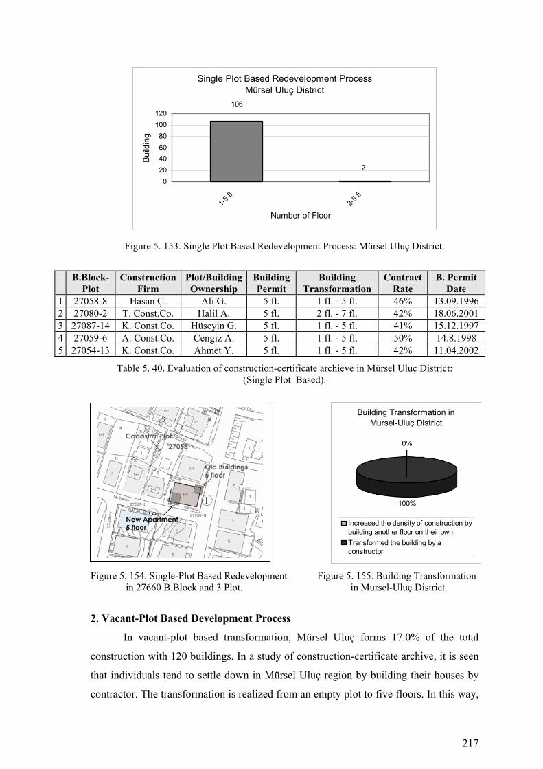
217
Single Plot Based Redevelopment ProcessMürsel Uluç District
106
2
020406080
100120
1-5 fl.
2-5 fl.
Number of Floor
Build
ing
Figure 5. 153. Single Plot Based Redevelopment Process: Mürsel Uluç District.
B.Block-Plot
Construction Firm
Plot/Building Ownership
Building Permit
Building Transformation
Contract Rate
B. Permit Date
1 27058-8 Hasan Ç. Ali G. 5 fl. 1 fl. - 5 fl. 46% 13.09.1996 2 27080-2 T. Const.Co. Halil A. 5 fl. 2 fl. - 7 fl. 42% 18.06.2001 3 27087-14 K. Const.Co. Hüseyin G. 5 fl. 1 fl. - 5 fl. 41% 15.12.1997 4 27059-6 A. Const.Co. Cengiz A. 5 fl. 1 fl. - 5 fl. 50% 14.8.1998 5 27054-13 K. Const.Co. Ahmet Y. 5 fl. 1 fl. - 5 fl. 42% 11.04.2002
Table 5. 40. Evaluation of construction-certificate archieve in Mürsel Uluç District: (Single Plot Based).
Figure 5. 154. Single-Plot Based Redevelopment Figure 5. 155. Building Transformation in 27660 B.Block and 3 Plot. in Mursel-Uluç District.
2. Vacant-Plot Based Development Process
In vacant-plot based transformation, Mürsel Uluç forms 17.0% of the total
construction with 120 buildings. In a study of construction-certificate archive, it is seen
that individuals tend to settle down in Mürsel Uluç region by building their houses by
contractor. The transformation is realized from an empty plot to five floors. In this way,
Building Transformation in Mursel-Uluç District
0%
100%
Increased the density of construction bybuilding another floor on their ownTransformed the building by aconstructor
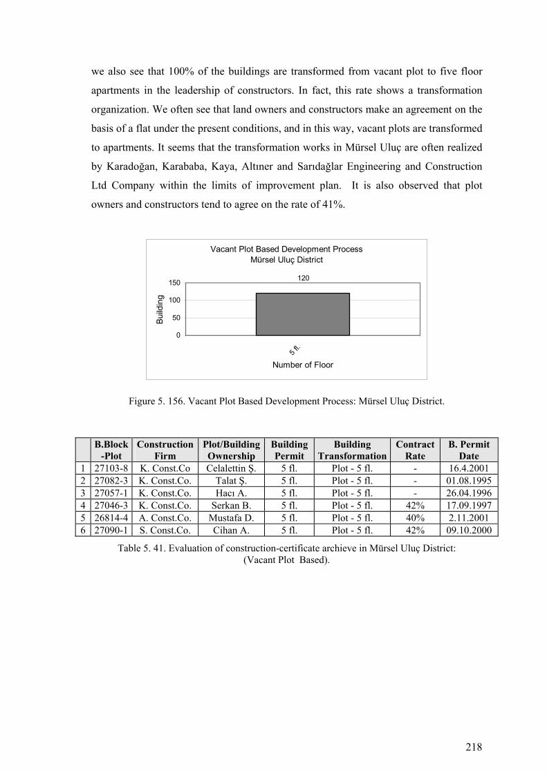
218
we also see that 100% of the buildings are transformed from vacant plot to five floor
apartments in the leadership of constructors. In fact, this rate shows a transformation
organization. We often see that land owners and constructors make an agreement on the
basis of a flat under the present conditions, and in this way, vacant plots are transformed
to apartments. It seems that the transformation works in Mürsel Uluç are often realized
by Karadoğan, Karababa, Kaya, Altıner and Sarıdağlar Engineering and Construction
Ltd Company within the limits of improvement plan. It is also observed that plot
owners and constructors tend to agree on the rate of 41%.
Vacant Plot Based Development ProcessMürsel Uluç District
120
0
50
100
150
5 fl.
Number of Floor
Build
ing
Figure 5. 156. Vacant Plot Based Development Process: Mürsel Uluç District.
B.Block-Plot
Construction Firm
Plot/Building Ownership
Building Permit
Building Transformation
Contract Rate
B. Permit Date
1 27103-8 K. Const.Co Celalettin Ş. 5 fl. Plot - 5 fl. - 16.4.2001 2 27082-3 K. Const.Co. Talat Ş. 5 fl. Plot - 5 fl. - 01.08.1995 3 27057-1 K. Const.Co. Hacı A. 5 fl. Plot - 5 fl. - 26.04.1996 4 27046-3 K. Const.Co. Serkan B. 5 fl. Plot - 5 fl. 42% 17.09.1997 5 26814-4 A. Const.Co. Mustafa D. 5 fl. Plot - 5 fl. 40% 2.11.2001 6 27090-1 S. Const.Co. Cihan A. 5 fl. Plot - 5 fl. 42% 09.10.2000
Table 5. 41. Evaluation of construction-certificate archieve in Mürsel Uluç District: (Vacant Plot Based).

219
Figure 5. 157. Vacant Plot Based Development Figure 5. 158. Vacant-Plot Development in 27103 B.Block and 8 Plot. in Mursel-Uluç District.
3. Co-operative Based Redevelopment Process
In co-operative based transformation, Mürsel Uluç region forms 1.0% of the
total construction with 10 buildings. In a study of construction-certificate archive, this
kind of transformation seems to be realized in the leadership of a co-operative on an
empty land to build five, seven or nine-floor apartments. Co-operative based
transformation includes land owners, constructors, and co-operative members. Co-
operative based transformation works at Mürsel Uluç region are mostly realized by
Menekşe Engineering and Construction Ltd Company within the limits of the
improvement plan.
Co-operative Based Redevelopment ProcessMürsel Uluç District
10
0
5
10
15
9 fl.
Number of Floor
Build
ing
Figure 5. 159. Co-operative Based Redevelopment Process: Mürsel Uluç District.
B.Block-
Plot Construction
Firm Plot/Building Ownership
BuildingPermit
Building Transformation
Contract Rate
B. Permit Date
1 27081-13 M. Cons.Co. Y.Y.Koop. 9 fl. 1 fl.- 9 fl. - 21.12.2000 Table 5. 42. Evaluation of construction-certificate archieve in Mürsel Uluç District:
(Co-operative Based).
Vacant-Plot Development in Mursel-Uluç District
0%
100%
Increased the density of construction bybuilding another floor on their ownTransformed the building by aconstructor
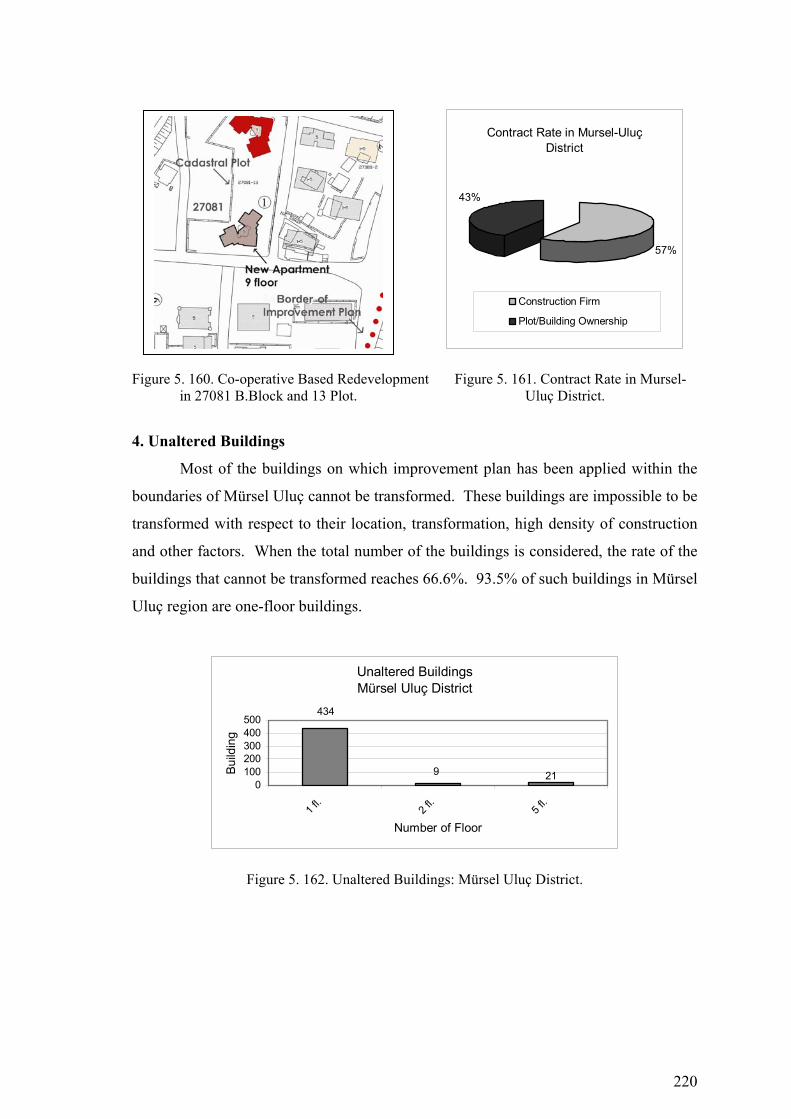
220
Figure 5. 160. Co-operative Based Redevelopment Figure 5. 161. Contract Rate in Mursel- in 27081 B.Block and 13 Plot. Uluç District.
4. Unaltered Buildings
Most of the buildings on which improvement plan has been applied within the
boundaries of Mürsel Uluç cannot be transformed. These buildings are impossible to be
transformed with respect to their location, transformation, high density of construction
and other factors. When the total number of the buildings is considered, the rate of the
buildings that cannot be transformed reaches 66.6%. 93.5% of such buildings in Mürsel
Uluç region are one-floor buildings.
Unaltered BuildingsMürsel Uluç District
434
9 210
100200300400500
1 fl.
2 fl.
5 fl.
Number of Floor
Build
ing
Figure 5. 162. Unaltered Buildings: Mürsel Uluç District.
Contract Rate in Mursel-Uluç District
57%
43%
Construction Firm
Plot/Building Ownership

221
Figure 5. 163. Urban Transformation Process (1985-2005) Çankaya Municipality-Mürsel Uluç District

222
Figure 5. 164. Buildings that are Investigated in Çankaya Municipality Construction Certificate Archive-MürselUluç District
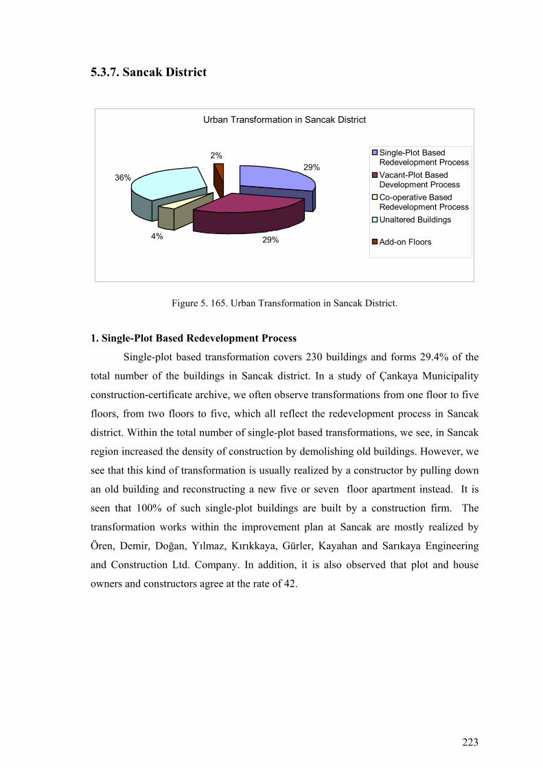
223
5.3.7. Sancak District
Urban Transformation in Sancak District
29%
29%4%
36%
2% Single-Plot BasedRedevelopment ProcessVacant-Plot BasedDevelopment ProcessCo-operative BasedRedevelopment ProcessUnaltered Buildings
Add-on Floors
Figure 5. 165. Urban Transformation in Sancak District.
1. Single-Plot Based Redevelopment Process
Single-plot based transformation covers 230 buildings and forms 29.4% of the
total number of the buildings in Sancak district. In a study of Çankaya Municipality
construction-certificate archive, we often observe transformations from one floor to five
floors, from two floors to five, which all reflect the redevelopment process in Sancak
district. Within the total number of single-plot based transformations, we see, in Sancak
region increased the density of construction by demolishing old buildings. However, we
see that this kind of transformation is usually realized by a constructor by pulling down
an old building and reconstructing a new five or seven floor apartment instead. It is
seen that 100% of such single-plot buildings are built by a construction firm. The
transformation works within the improvement plan at Sancak are mostly realized by
Ören, Demir, Doğan, Yılmaz, Kırıkkaya, Gürler, Kayahan and Sarıkaya Engineering
and Construction Ltd. Company. In addition, it is also observed that plot and house
owners and constructors agree at the rate of 42.

224
Single Plot Based Redevelopment ProcessSancak District
209
21
050
100150200250
1-5 fl.
2-5 fl.
Number of Floor
Build
ing
Figure 5. 166. Single Plot Based Redevelopment Process: Sancak District.
B.Block-Plot
Construction Firm
Plot/Building Ownership
Building Permit
Building Transformation
Contract Rate
B. Permit Date
1 25343-4 Ö.Const. Co. Özcan D. 5 fl. 1 fl. - 5 fl. 42% 11.05.19952 25341-5 D. Const. Co. İrfan K. 5 fl. 1 fl. - 5 fl. 42% 23.10.19923 25318-2 D. Const. Co. İbrahim A. 5 fl. 1 fl. - 5 fl. 42% 21.08.19974 25332-5 - Özcan S. 5 fl. 1 fl. - 5 fl. 42% 22.09.19985 25318-2 Y. Const. Co. Şeref B. 5 fl. 2 fl. - 5 fl. 43% 12.05.19986 25309-6 K. Const. Nisa S. 5 fl. 2 fl. - 5 fl. 42% 16.2.2001 7 25320-1 G. Const. Co. Ramazan Y. 5 fl. 1 fl. - 5 fl. 40% 19.12.20048 25322-1 K. Const. Cihan A. 5 fl. 1 fl. - 5 fl. 43% 9.10.2002 9 25356-1 D. Const.Co. Erhan Ç. 5 fl. 1 fl. - 5 fl. 42% 19.11.2001
10 25356-2 D. Const.Co. Mehmet Ç. 5 fl. 1 fl. - 5 fl. 42% 4.07.2002 11 25331-2 S. Const.Co Yeliz T. 5 fl. 1 fl. - 5 fl. 42% 24.03.200112 25344-5 K. Const.Co. Ahmet S. 5 fl. 1 fl. - 5 fl. 43% 28.7.1995
Table 5. 43. Evaluation of construction-certificate archieve in Sancak District: (Single Plot Based).
Figure 5. 167. Single-Plot Based Redevelopment Figure 5. 168. Building Transformation in 25343 B.Block and 4 Plot. in Sancak District.
Building Transformation in Sancak District
8%
92%
Increased the density of construction bybuilding another floor on their ownTransformed the building by aconstructor
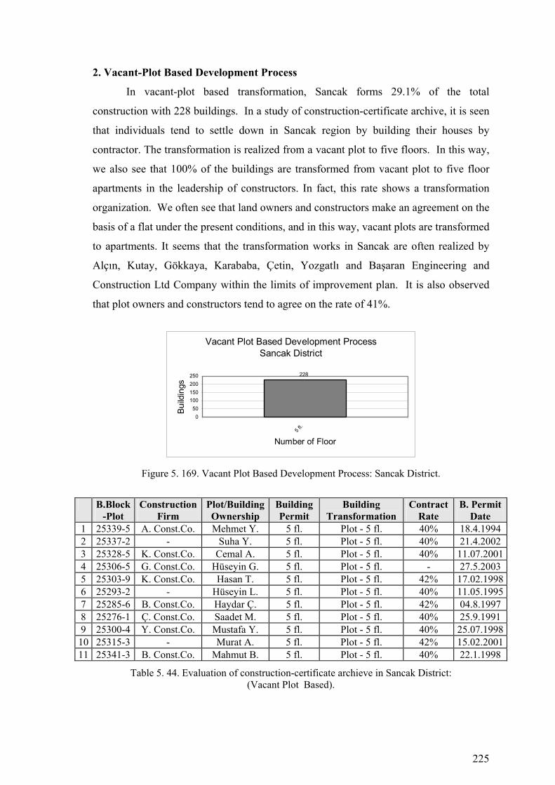
225
2. Vacant-Plot Based Development Process
In vacant-plot based transformation, Sancak forms 29.1% of the total
construction with 228 buildings. In a study of construction-certificate archive, it is seen
that individuals tend to settle down in Sancak region by building their houses by
contractor. The transformation is realized from a vacant plot to five floors. In this way,
we also see that 100% of the buildings are transformed from vacant plot to five floor
apartments in the leadership of constructors. In fact, this rate shows a transformation
organization. We often see that land owners and constructors make an agreement on the
basis of a flat under the present conditions, and in this way, vacant plots are transformed
to apartments. It seems that the transformation works in Sancak are often realized by
Alçın, Kutay, Gökkaya, Karababa, Çetin, Yozgatlı and Başaran Engineering and
Construction Ltd Company within the limits of improvement plan. It is also observed
that plot owners and constructors tend to agree on the rate of 41%.
Vacant Plot Based Development ProcessSancak District
228
050
100150200250
5 fl.
Number of Floor
Build
ings
Figure 5. 169. Vacant Plot Based Development Process: Sancak District.
B.Block
-Plot Construction
Firm Plot/Building Ownership
Building Permit
Building Transformation
Contract Rate
B. Permit Date
1 25339-5 A. Const.Co. Mehmet Y. 5 fl. Plot - 5 fl. 40% 18.4.1994 2 25337-2 - Suha Y. 5 fl. Plot - 5 fl. 40% 21.4.2002 3 25328-5 K. Const.Co. Cemal A. 5 fl. Plot - 5 fl. 40% 11.07.20014 25306-5 G. Const.Co. Hüseyin G. 5 fl. Plot - 5 fl. - 27.5.2003 5 25303-9 K. Const.Co. Hasan T. 5 fl. Plot - 5 fl. 42% 17.02.19986 25293-2 - Hüseyin L. 5 fl. Plot - 5 fl. 40% 11.05.19957 25285-6 B. Const.Co. Haydar Ç. 5 fl. Plot - 5 fl. 42% 04.8.1997 8 25276-1 Ç. Const.Co. Saadet M. 5 fl. Plot - 5 fl. 40% 25.9.1991 9 25300-4 Y. Const.Co. Mustafa Y. 5 fl. Plot - 5 fl. 40% 25.07.1998
10 25315-3 - Murat A. 5 fl. Plot - 5 fl. 42% 15.02.200111 25341-3 B. Const.Co. Mahmut B. 5 fl. Plot - 5 fl. 40% 22.1.1998
Table 5. 44. Evaluation of construction-certificate archieve in Sancak District: (Vacant Plot Based).

226
Figure 5. 170. Vacant Plot Based Development Figure 5. 171. Vacant-Plot Development in 25339 B.Block and 5 Plot. in Sancak District.
3. Co-operative Based Redevelopment Process
In co-operative based transformation, Sancak region forms 3.9% of the total
construction with 34 buildings. In a study of construction-certificate archive, this kind
of transformation seems to be realized in the leadership of a co-operative on a vacant
land to build five, nine or nine-twelve floor apartments. Co-operative based
transformation includes land owners, constructors, and co-operative members. Co-
operative based transformation works at Sancak region are mostly realized by
Sarıdağlar and MESA Engineering and Construction Ltd Company within the limits of
the improvement plan.
Co-operative Based Redevelopment ProcessSancak District
9
57
13
05
1015
2 fl.
5 fl.
9 fl.
12 fl.
Number of Floor
Build
ings
Figure 5. 172. Co-operative Based Redevelopment Process: Sancak District.
B.Block
-Plot Construction
Firm Plot/Building Ownership
Building Permit
Building Transformation
Contract Rate
B. Permit Date
1 25319-1 S. Const.Co. Ç.Y. Koop. 9 fl. 1 fl. - 9 fl. - 8.11.1991 2 28407-7 M. Const.Co. B. K. Koop. 12 fl. Plot - 12 fl. - 26.06.2002
Table 5. 45. Evaluation of construction-certificate archieve in Sancak District: (Co-operative Based).
Vacant-Plot Development in Sancak District
0%
100%
Increased the density of construction bybuilding another floor on their ownTransformed the building by aconstructor

227
Figure 5. 173. Co-operative Based Redevelopment Figure 5. 174. Contract Rate in Sancak in 25319 B.Block and 1 Plot. District. 4. Add-on Floors
Add-on floors based development covers 15 buildings and forms 1.9% of the
total number of the buildings in Sancak district. In a study of Çankaya Municipality
construction-certificate archive, we often observe transformations from one floor to five
floors, from two floors to five and from three to five floors, which all reflect the
increase in present density. Within the total number of add-on floors based
transformations, we see, in Sancak region increased the density of construction by
building another floor on their own.
B.Block
-Plot Construction
Firm Plot/Building Ownership
Building Permit
Building Transformation
Contract Rate
B. Permit Date
1 25318-2 - Nihat B. 5 fl. 2 fl. - 5 fl. - 11.07.19942 25309-6 - Kerim T. 5 fl. 2 fl. - 5 fl. - 26.6.2001
Table 5. 46. Evaluation of construction-certificate archieve in Sancak District: (Add-on Floors).
5. Unaltered Buildings
Most of the buildings on which improvement plan has been applied within the
boundaries of Sancak cannot be transformed. These buildings are impossible to be
transformed with respect to their location, transformation, high density of construction
and other factors. When the total number of the buildings is considered, the rate of the
buildings that cannot be transformed reaches 36.2%. 88% of such buildings in Sancak
region are one-floor buildings.
Contract Rate in Sancak District
59%
41%
Construction Firm
Plot/Building Ownership

228
Figure 5. 175. Urban Transformation Process (1985-2005) Çankaya Municipality-Sancak District

229
Figure 5. 176. Buildings that are Investigated in Çankaya Municipality Construction Certificate Archive-Sancak District
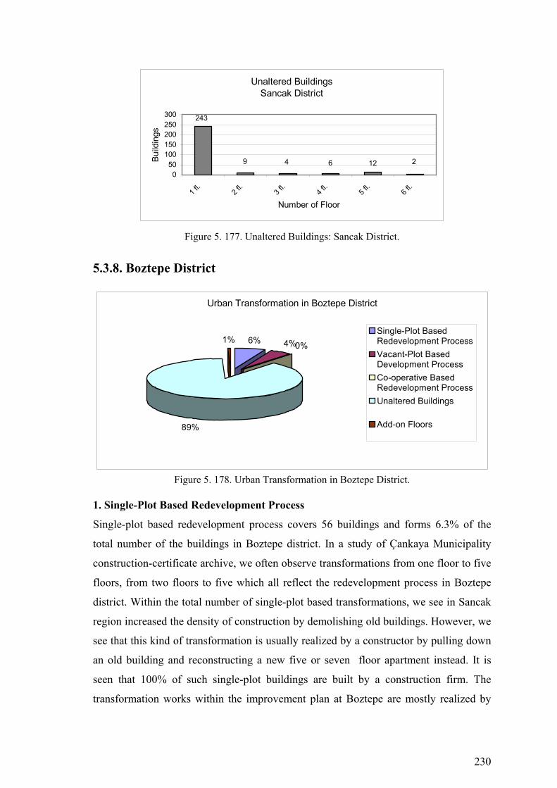
230
Unaltered BuildingsSancak District
212
243
9 64
050
100150200250300
1 fl.
2 fl.
3 fl.
4 fl.
5 fl.
6 fl.
Number of Floor
Build
ings
Figure 5. 177. Unaltered Buildings: Sancak District.
5.3.8. Boztepe District
Urban Transformation in Boztepe District
6% 4%0%
89%
1%Single-Plot BasedRedevelopment ProcessVacant-Plot BasedDevelopment ProcessCo-operative BasedRedevelopment ProcessUnaltered Buildings
Add-on Floors
Figure 5. 178. Urban Transformation in Boztepe District. 1. Single-Plot Based Redevelopment Process
Single-plot based redevelopment process covers 56 buildings and forms 6.3% of the
total number of the buildings in Boztepe district. In a study of Çankaya Municipality
construction-certificate archive, we often observe transformations from one floor to five
floors, from two floors to five which all reflect the redevelopment process in Boztepe
district. Within the total number of single-plot based transformations, we see in Sancak
region increased the density of construction by demolishing old buildings. However, we
see that this kind of transformation is usually realized by a constructor by pulling down
an old building and reconstructing a new five or seven floor apartment instead. It is
seen that 100% of such single-plot buildings are built by a construction firm. The
transformation works within the improvement plan at Boztepe are mostly realized by
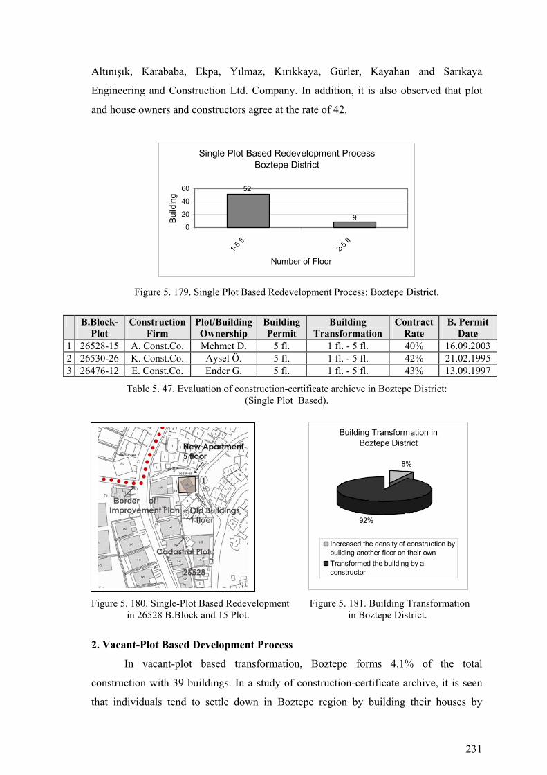
231
Altınışık, Karababa, Ekpa, Yılmaz, Kırıkkaya, Gürler, Kayahan and Sarıkaya
Engineering and Construction Ltd. Company. In addition, it is also observed that plot
and house owners and constructors agree at the rate of 42.
Single Plot Based Redevelopment ProcessBoztepe District
9
52
0
20
40
60
1-5 fl.
2-5 fl.
Number of Floor
Build
ing
Figure 5. 179. Single Plot Based Redevelopment Process: Boztepe District.
B.Block-Plot
Construction Firm
Plot/Building Ownership
Building Permit
Building Transformation
Contract Rate
B. Permit Date
1 26528-15 A. Const.Co. Mehmet D. 5 fl. 1 fl. - 5 fl. 40% 16.09.2003 2 26530-26 K. Const.Co. Aysel Ö. 5 fl. 1 fl. - 5 fl. 42% 21.02.1995 3 26476-12 E. Const.Co. Ender G. 5 fl. 1 fl. - 5 fl. 43% 13.09.1997
Table 5. 47. Evaluation of construction-certificate archieve in Boztepe District: (Single Plot Based).
Figure 5. 180. Single-Plot Based Redevelopment Figure 5. 181. Building Transformation in 26528 B.Block and 15 Plot. in Boztepe District.
2. Vacant-Plot Based Development Process
In vacant-plot based transformation, Boztepe forms 4.1% of the total
construction with 39 buildings. In a study of construction-certificate archive, it is seen
that individuals tend to settle down in Boztepe region by building their houses by
Building Transformation in Boztepe District
8%
92%
Increased the density of construction bybuilding another floor on their ownTransformed the building by aconstructor
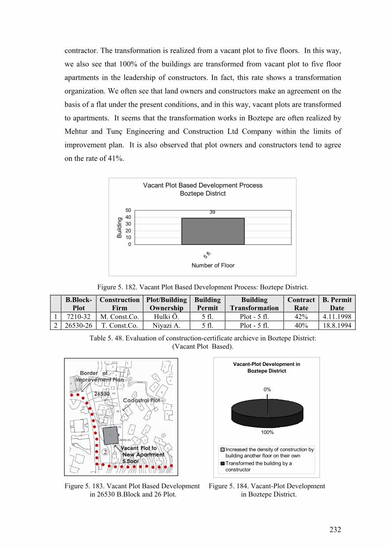
232
contractor. The transformation is realized from a vacant plot to five floors. In this way,
we also see that 100% of the buildings are transformed from vacant plot to five floor
apartments in the leadership of constructors. In fact, this rate shows a transformation
organization. We often see that land owners and constructors make an agreement on the
basis of a flat under the present conditions, and in this way, vacant plots are transformed
to apartments. It seems that the transformation works in Boztepe are often realized by
Mehtur and Tunç Engineering and Construction Ltd Company within the limits of
improvement plan. It is also observed that plot owners and constructors tend to agree
on the rate of 41%.
Vacant Plot Based Development ProcessBoztepe District
39
01020304050
5 fl.
Number of Floor
Build
ing
Figure 5. 182. Vacant Plot Based Development Process: Boztepe District.
B.Block-Plot
Construction Firm
Plot/Building Ownership
Building Permit
Building Transformation
Contract Rate
B. Permit Date
1 7210-32 M. Const.Co. Hulki Ö. 5 fl. Plot - 5 fl. 42% 4.11.1998 2 26530-26 T. Const.Co. Niyazi A. 5 fl. Plot - 5 fl. 40% 18.8.1994
Table 5. 48. Evaluation of construction-certificate archieve in Boztepe District: (Vacant Plot Based).
Figure 5. 183. Vacant Plot Based Development Figure 5. 184. Vacant-Plot Development in 26530 B.Block and 26 Plot. in Boztepe District.
Vacant-Plot Development in Boztepe District
0%
100%
Increased the density of construction bybuilding another floor on their ownTransformed the building by aconstructor

233
3. Co-operative Based Redevelopment Process
In co-operative based transformation, Boztepe region forms 0.1% of the total
construction with 1 building. In a study of construction-certificate archive, this kind of
transformation seems to be realized in the leadership of a co-operative on an empty land
to build ten floor apartments. Co-operative based transformation includes land owners,
constructors, and co-operative members. Co-operative based transformation works at
Boztepe region are mostly realized by Cansın Engineering and Construction Ltd
Company within the limits of the improvement plan.
Co-operative Based Redevelopment ProcessBoztepe District
1
0
0,5
1
1,5
10 fl.
Number of Floor
Build
ing
Figure 5. 185. Co-operative Based Redevelopment Process: Boztepe District.
B.Block-Plot
Construction Firm
Plot/Building Ownership
Building Permit
Building Transformation
Contract Rate
B. Permit Date
1 7212-38 C.Const.Co. G. Y. Koop. 9 fl. 1 fl. - 9 fl. - 8.11.1991
Table 5. 49. Evaluation of construction-certificate archieve in Boztepe District: (Co-operative Based).
Figure 5. 186. Co-operative Based Redevelopment Figure 5. 187. Contract Rate in Sancak in 25319 B.Block and 1 Plot. District.
Contract Rate in Boztepe District
59%
41%
Construction Firm
Plot/Building Ownership
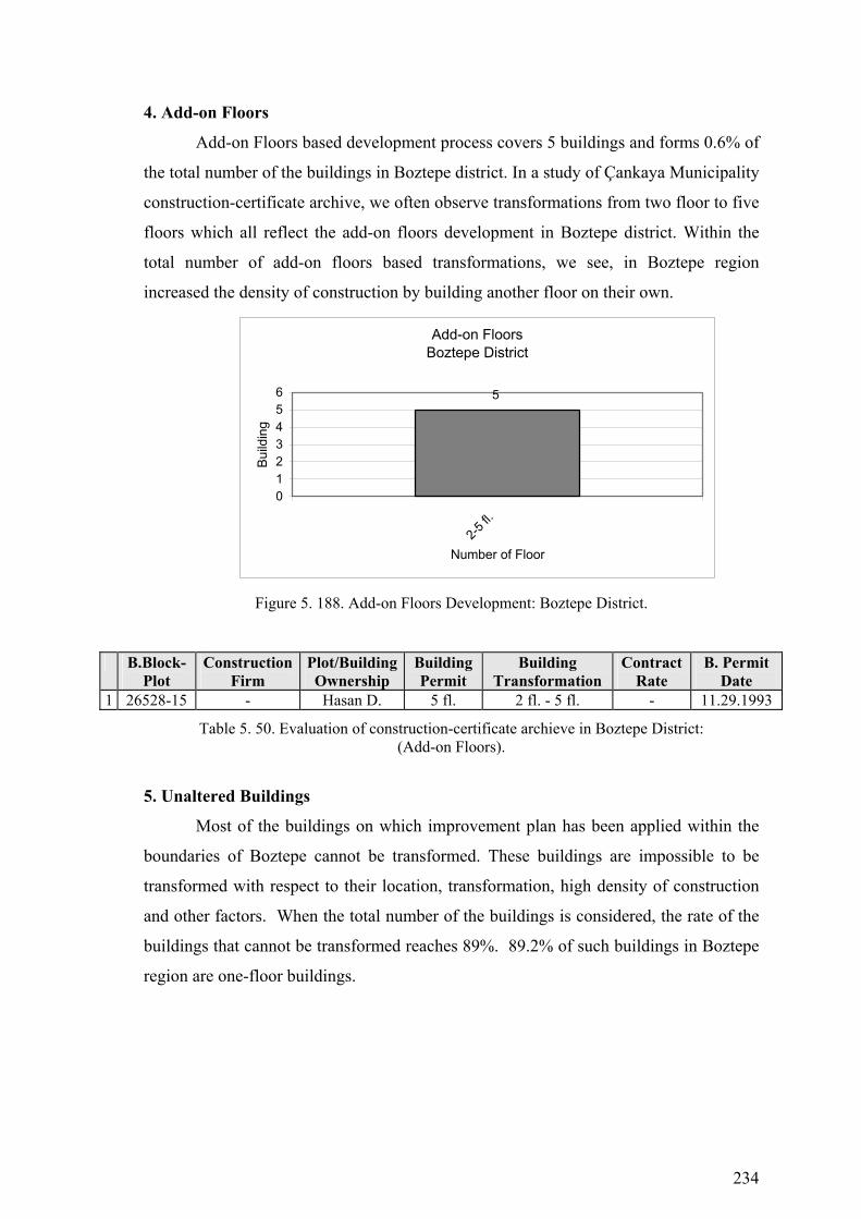
234
4. Add-on Floors
Add-on Floors based development process covers 5 buildings and forms 0.6% of
the total number of the buildings in Boztepe district. In a study of Çankaya Municipality
construction-certificate archive, we often observe transformations from two floor to five
floors which all reflect the add-on floors development in Boztepe district. Within the
total number of add-on floors based transformations, we see, in Boztepe region
increased the density of construction by building another floor on their own.
Add-on FloorsBoztepe District
5
0123456
2-5 fl.
Number of Floor
Build
ing
Figure 5. 188. Add-on Floors Development: Boztepe District.
B.Block-Plot
Construction Firm
Plot/Building Ownership
Building Permit
Building Transformation
Contract Rate
B. Permit Date
1 26528-15 - Hasan D. 5 fl. 2 fl. - 5 fl. - 11.29.1993
Table 5. 50. Evaluation of construction-certificate archieve in Boztepe District: (Add-on Floors).
5. Unaltered Buildings
Most of the buildings on which improvement plan has been applied within the
boundaries of Boztepe cannot be transformed. These buildings are impossible to be
transformed with respect to their location, transformation, high density of construction
and other factors. When the total number of the buildings is considered, the rate of the
buildings that cannot be transformed reaches 89%. 89.2% of such buildings in Boztepe
region are one-floor buildings.

235
Figure 5. 189. Urban Transformation Process (1985-2005) Çankaya Municipality Boztepe District

236
Figure 5. 190. Buildings that are Investigated in Çankaya Municipality Construction Certificate Archive-Boztepe District
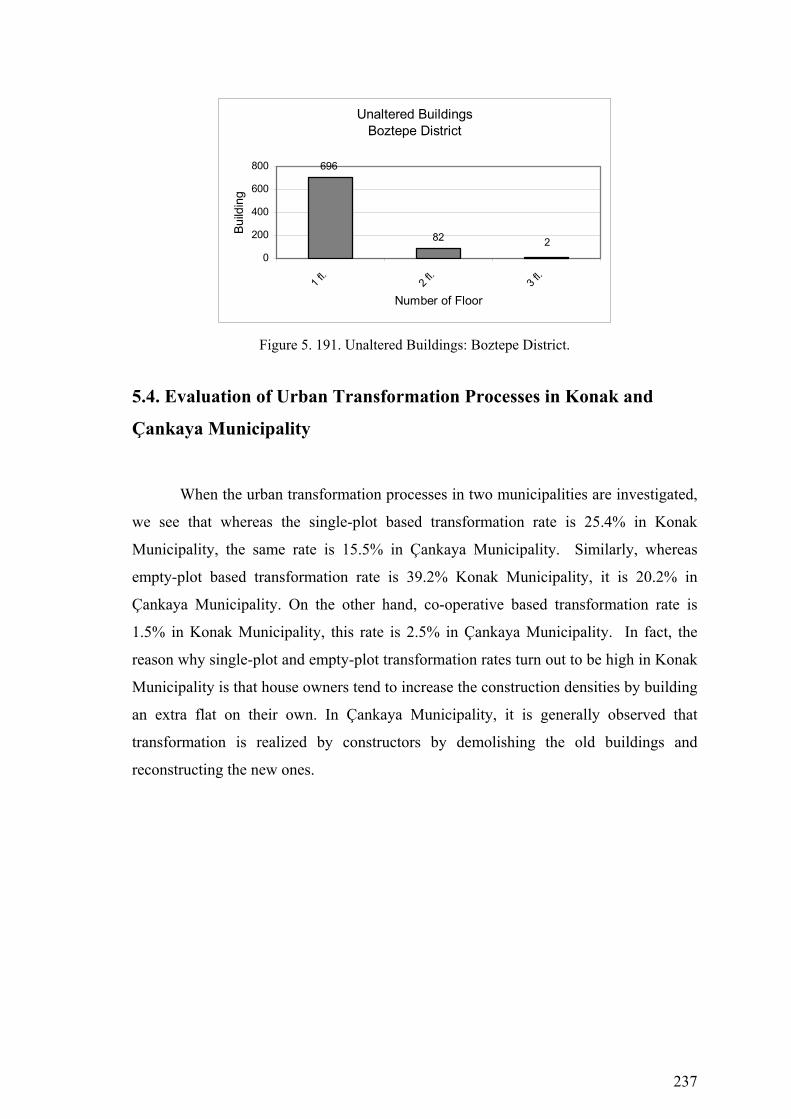
237
Unaltered BuildingsBoztepe District
82
696
20
200
400
600
800
1 fl.
2 fl.
3 fl.
Number of Floor
Build
ing
Figure 5. 191. Unaltered Buildings: Boztepe District.
5.4. Evaluation of Urban Transformation Processes in Konak and
Çankaya Municipality
When the urban transformation processes in two municipalities are investigated,
we see that whereas the single-plot based transformation rate is 25.4% in Konak
Municipality, the same rate is 15.5% in Çankaya Municipality. Similarly, whereas
empty-plot based transformation rate is 39.2% Konak Municipality, it is 20.2% in
Çankaya Municipality. On the other hand, co-operative based transformation rate is
1.5% in Konak Municipality, this rate is 2.5% in Çankaya Municipality. In fact, the
reason why single-plot and empty-plot transformation rates turn out to be high in Konak
Municipality is that house owners tend to increase the construction densities by building
an extra flat on their own. In Çankaya Municipality, it is generally observed that
transformation is realized by constructors by demolishing the old buildings and
reconstructing the new ones.

238
Urban Transformation in Konak and Çankaya Municipality
2083
3210
119703 917
112
2784 2803
0500
100015002000250030003500
Single-Plot BasedRedevelopment
Process
Vacant-PlotBased
DevelopmentProcess
Co-operativeBased
RedevelopmentProcess
UnalteredBuildings
Add-on Floors
Bui
ldin
g
Konak Municipality Çankaya Municipality
Figure 5. 192. Urban Transformation in Konak and Çankaya Municipality.
5.4.1. Single-Plot Based Redevelopment Process in Konak and
Çankaya Municipality
We get interesting results when we have a look at single-plot based
transformation from the point of both municipalities. When we investigate the buildings
which have transformed since 1986 onwards within the boundaries of Konak
Municipality where an improvement plan has been applied, we see that the house
owners increased the construction densities by building an extra on their own in 86.7
percent of the total buildings. On the other hand, only the remaining 13.3% of the
buildings are seen to be transformed in the pioneer of constructors by knocking down
the old buildings and rebuilding in order to construct 5, 6, or 7-storey apartments in an
organized way. However, within the boundaries of Çankaya Municipality, we see that
this turns out to occur just in the opposite way. It is seen that 96 percent of the
buildings which transformed in single-plot had been transformed into 5 or 7 storey
apartments in an organized way (entrepreneurs - plot/building owner) in the leadership
of a constructor by knocking down the old one or two-storey buildings. In contrast to
Konak Municipality, it is observed that only a 4 percent of the building owners tend to
build an extra flat. As a result, whereas single-plot based transformation rate of old
buildings into apartments occurs at a low rate within the boundaries of Konak
Municipality, there seems to be a very fast transformation in Çankaya Municipality and

239
this clearly proves that the buildings that fall into this group (single-plot transformation)
within the boundaries of Çankaya Municipality, where an improvement plan has been
applied in squatter/illegally constructed areas, realized this transformation process in
high rates by co-operating with other squatters in the leadership of constructors.
Naturally, the low rate of squatters and illegally-constructed areas within Çankaya
Municipality and that most of them were one-storey and were built as shelter are other
factors in this high rate of transformation.
Figure 5. 193. Building Transformation in Konak Figure 5. 194. Building Transformation in Municipality. Çankaya Municipality.
Single-Plot Based Redevelopment Process in Konak and Çankaya Municipality
522
303
30
349
5 651 26 3 21
119
668 23
556
6 349
3
646
0
100
200
300
400
500
600
700
1-2 fl.
1-3 fl.
1-4 fl.
1-5 fl.
1-6 fl.
1-7 fl.
2-3 fl.
2-5 fl.
2-6 fl.
2-7 fl.
2-8 fl.
3-4 fl.
3-5 fl.
3-6 fl.
4-5 fl.
Build
ing
Konak Municipality Çankaya Municipality
Figure 5. 195. Single-Plot Based Redevelopment Process in Konak and Çankaya Municipality.
Building Transformation in Konak Municipality
87%
13%
Increased the density of construction by buildinganother floor on their own
Transformed the building by a construction
Building Transformation in Çankaya Municipality
4%
96%
Increased the density of construction bybuilding another floor on their own
Transformed the building by a construction

240
5.4.2. Vacant-Plot Based Development Process in Konak and Çankaya
Municipality
Also, in empty-plot transformation, similar to single-plot based transformation
within the boundaries of Konak Municipality, we see that land owners tend to build
their own building on the same plot to be one, two, three, or four-storey buildings.
Within the boundaries of the improvement plan of Konak Municipality, whereas the rate
of buildings constructed on empty-plot by land owners turns out to be 85.5%, the
remaining 14.5% was transformed into apartments in the partnership of building owners
and constructors. However, within the boundaries of Çankaya Municipality, it is
observed that only 4.3% of the land owners constructed their buildings on empty plot on
their own. The remaining 95.7% was transformed into apartments in an organized way
in the partnership of land owners and constructors. It is seen that a very high rate of
transformation from empty plot into apartments has been realized as part of empty-plot
based transformation within the boundaries of Çankaya Municipality. Although the
empty plots have similar characteristics in both municipalities, it is seen that the type of
transformation is different, and that we observe a more individual type of
transformation within the boundaries of Konak Municipality which produces its own
solution.
Figure 5.157. Empty-Plot Transformation Figure 5.158. Empty-Plot Transformation in Konak Municipality. in Çankaya Municipality.
Figure 5. 196. Vacant-Plot Development in Figure 5. 197. Vacant-Plot Development in Konak Municipality. Çankaya Municipality.
Vacant-Plot Development in Konak Municipality
85%
15%
Increased the density of construction by building anotherfloor on their own
Transformed the building by a construction
Vacant-Plot Development in Çankaya Municipality
4%
96%
Increased the density of construction by buildinganother floor on their own
Transformed the building by a construction
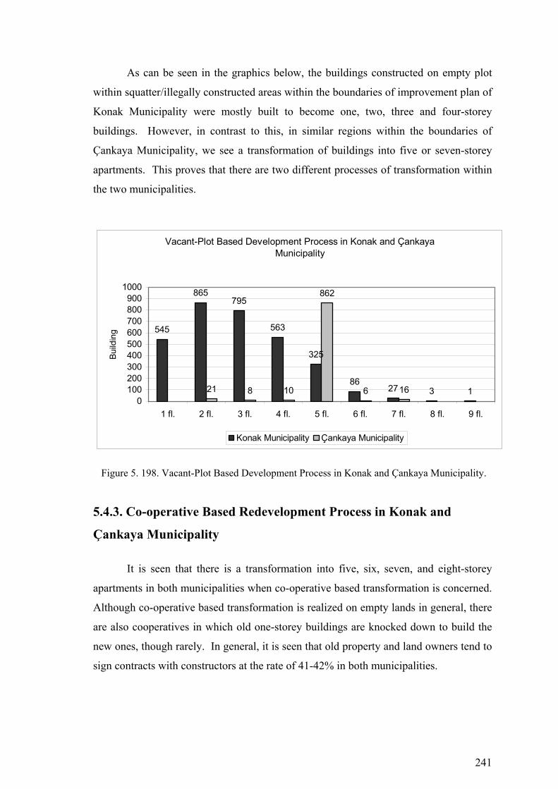
241
As can be seen in the graphics below, the buildings constructed on empty plot
within squatter/illegally constructed areas within the boundaries of improvement plan of
Konak Municipality were mostly built to become one, two, three and four-storey
buildings. However, in contrast to this, in similar regions within the boundaries of
Çankaya Municipality, we see a transformation of buildings into five or seven-storey
apartments. This proves that there are two different processes of transformation within
the two municipalities.
Vacant-Plot Based Development Process in Konak and Çankaya Municipality
545
865795
563
325
8627 3 121 8 10
862
6 160
100200300400500600700800900
1000
1 fl. 2 fl. 3 fl. 4 fl. 5 fl. 6 fl. 7 fl. 8 fl. 9 fl.
Build
ing
Konak Municipality Çankaya Municipality
Figure 5. 198. Vacant-Plot Based Development Process in Konak and Çankaya Municipality.
5.4.3. Co-operative Based Redevelopment Process in Konak and
Çankaya Municipality
It is seen that there is a transformation into five, six, seven, and eight-storey
apartments in both municipalities when co-operative based transformation is concerned.
Although co-operative based transformation is realized on empty lands in general, there
are also cooperatives in which old one-storey buildings are knocked down to build the
new ones, though rarely. In general, it is seen that old property and land owners tend to
sign contracts with constructors at the rate of 41-42% in both municipalities.
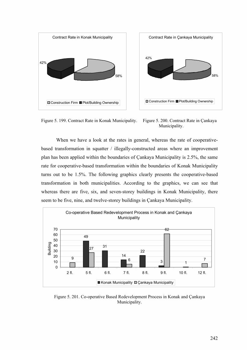
242
Figure 5. 199. Contract Rate in Konak Municipality. Figure 5. 200. Contract Rate in Çankaya Municipality.
When we have a look at the rates in general, whereas the rate of cooperative-
based transformation in squatter / illegally-constructed areas where an improvement
plan has been applied within the boundaries of Çankaya Municipality is 2.5%, the same
rate for cooperative-based transformation within the boundaries of Konak Municipality
turns out to be 1.5%. The following graphics clearly presents the cooperative-based
transformation in both municipalities. According to the graphics, we can see that
whereas there are five, six, and seven-storey buildings in Konak Municipality, there
seem to be five, nine, and twelve-storey buildings in Çankaya Municipality.
Co-operative Based Redevelopment Process in Konak and Çankaya Municipality
49
31
1422
39
27
6
62
17
010203040506070
2 fl. 5 fl. 6 fl. 7 fl. 8 fl. 9 fl. 10 fl. 12 fl.
Build
ing
Konak Municipality Çankaya Municipality
Figure 5. 201. Co-operative Based Redevelopment Process in Konak and Çankaya Municipality.
Contract Rate in Konak Municipality
58%
42%
Construction Firm Plot/Building Ownership
Contract Rate in Çankaya Municipality
58%
42%
Construction Firm Plot/Building Ownership
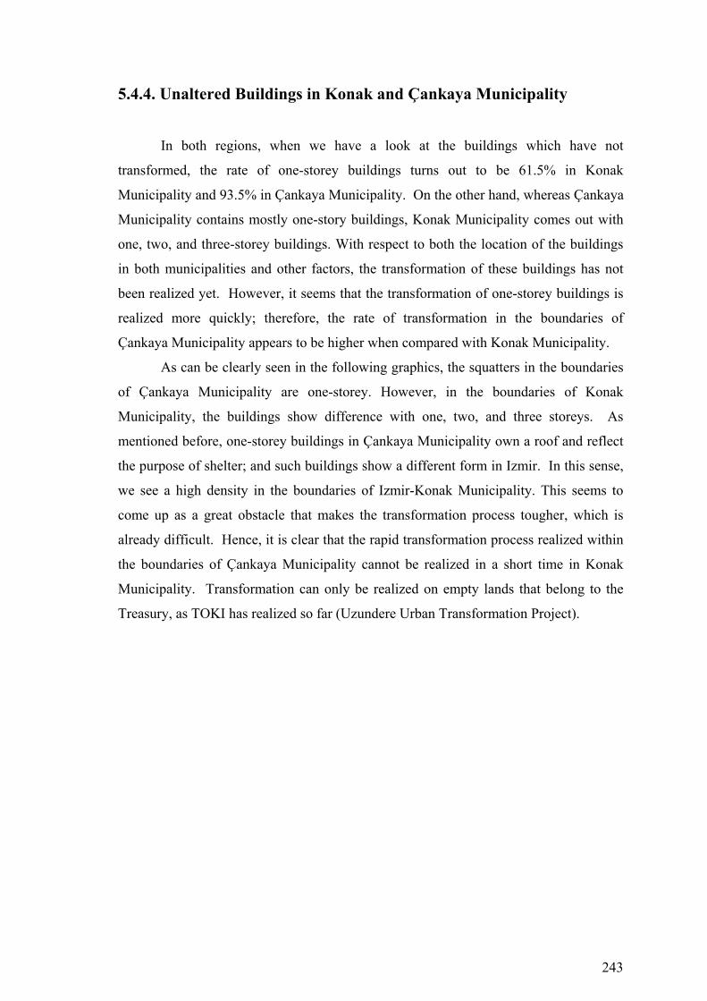
243
5.4.4. Unaltered Buildings in Konak and Çankaya Municipality
In both regions, when we have a look at the buildings which have not
transformed, the rate of one-storey buildings turns out to be 61.5% in Konak
Municipality and 93.5% in Çankaya Municipality. On the other hand, whereas Çankaya
Municipality contains mostly one-story buildings, Konak Municipality comes out with
one, two, and three-storey buildings. With respect to both the location of the buildings
in both municipalities and other factors, the transformation of these buildings has not
been realized yet. However, it seems that the transformation of one-storey buildings is
realized more quickly; therefore, the rate of transformation in the boundaries of
Çankaya Municipality appears to be higher when compared with Konak Municipality.
As can be clearly seen in the following graphics, the squatters in the boundaries
of Çankaya Municipality are one-storey. However, in the boundaries of Konak
Municipality, the buildings show difference with one, two, and three storeys. As
mentioned before, one-storey buildings in Çankaya Municipality own a roof and reflect
the purpose of shelter; and such buildings show a different form in Izmir. In this sense,
we see a high density in the boundaries of Izmir-Konak Municipality. This seems to
come up as a great obstacle that makes the transformation process tougher, which is
already difficult. Hence, it is clear that the rapid transformation process realized within
the boundaries of Çankaya Municipality cannot be realized in a short time in Konak
Municipality. Transformation can only be realized on empty lands that belong to the
Treasury, as TOKI has realized so far (Uzundere Urban Transformation Project).
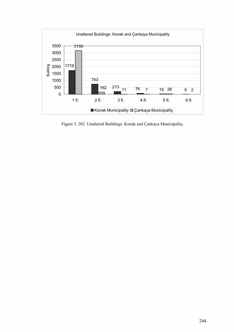
244
Unaltered Buildings: Konak and Çankaya Municipality
743
6
3159
11 7 38 2
1719
213 76 191620
500100015002000250030003500
1 fl. 2 fl. 3 fl. 4 fl. 5 fl. 6 fl.
Build
ing
Konak Municipality Çankaya Municipality
Figure 5. 202. Unaltered Buildings: Konak and Çankaya Municipality.
245
CHAPTER 6
CONCLUSION
Within the content of last chapter, urban transformation will be reviewed and
reevaluated with its conceptual, theoretical, and application dimensions. Within the
chapter, the research carried out by Izmir-Konak and Ankara-Çankaya Municipalities
that improvement plans which were applied in the squatter/illegally constructed areas
will also be evaluated briefly, and it is aimed that these evaluations will lay the basis for
suggestions.
As a summary of various definitions presented in the chapter, it is possible to
define urban transformation as “comprehensive vision and action” which tries to solve
urban problems and provide for permanent solutions regarding the economical,
physical, social and environmental conditions of a district undergoing specific changes
(Thomas 2003). The general aim of urban transformation, its goals and principles have
been identified. Urban transformation, as a multi-dimensional phenomenon, has been
dealt with within its social, economic, legal-governmental, planning and design
dimensions. Concerning the multi-dimensional dynamics of transformation systematic,
urban transformation approaches of various countries were referred to, and the
investigation done gives important hints with respect to the development of a rational
urban transformation systematic.
The place of Turkey with respect to urban transformation has been identified in
the direction of available capacities and facilities of the local municipalities; and in this
respect, present laws and institutions were investigated and their applicability to urban
renewal was investigated. Among the reasons why local municipalities and their units
are unable to carry out their tasks effectively are inconsistencies in the division of tasks,
lack of income, problems faced, incapability of staff, and failure in communication with
banks.
In conclusion, within the boundaries of Izmir-Konak and Ankara-Çankaya
Municipalities, the urban transformation capacity and facilities in squatter and illegally-
constructed areas where improvement plan has been applied were investigated in detail.
This study basically focused on the assumption that there was not a settled urban

246
transformation policy in our country, and that this had some important governmental
reasons as well as legal, socio-cultural, and economic reasons. Therefore, this study
aims to review the urban transformation that emerged within the scope of two
municipalities, their capacities and infra-structures with respect to their urban
transformation processes, and the physical change that formed.
The Results Obtained within the Boundaries of Izmir-Konak and Ankara-
Çankaya Municipalities:
♦ It appears that in the areas where an improvement plan was applied for
transformation within the boundaries of both municipalities, there are a great
many such problems as loss of identity, lack of economic vitality, lack of quality
in physical surroundings, unhealthy constructions, and environmental problems,
which all dominate the city life.
♦ The local municipal units perceive urban transformation as can be realized by
classic development plan with limited scope. According to them, transformation
is an application that can be explained or directed by increasing the number of
areas of facilities, by constructing modern roads, and by shaping the problems of
infra-structure.
♦ It seems that local municipal units have no experience in creating financial
sources in urban transformation; and they cannot show any efforts in search of
ways to overcome the problem of lack of sources which they point to as the
main reason for failure in transformation application.
♦ One of the biggest lacks in urban transformation is that local municipalities do
not employ a satisfactory number of experts for urban transformation.
♦ Rearrangement of urban transformation by law is an approach that is accepted
almost by all local municipal units. It is necessary that this problem be made
clear enough with respect to authority, and that the lines of authority of related
institutions must be drawn.
♦ It was found that both municipalities tend to see urban transformation as a
development application. Whereas single-plot transformation rate in Çankaya
Municipality is 96%, empty-plot transformation rate is 95.7%, and cooperative-
based transformation is 10%. Within the boundaries of Konak Municipality, the

247
same rates are 13.3%, 14.5% and 9% respectively. These percentages give us
information about urban transformation rates in both municipalities.
The discussion within this thesis study gathers on two lines: First, the structure
based on the physical point of view in which there is the present planning system of
Turkey, and how the problems stemming from this can be overcome. Second, how can
the transformation which is realized on its own in cities in spite of the static institutional
structure of the present planning system in Turkey be transformed into an organizational
structure?
As a result of the investigations carried out within country and abroad as well as
the conceptual discussions throughout the study in order to find the answers to these
questions;
• In the West, for the solution of the cities’ space, economic and social problems,
the urban transformation approach that has been invoked as a holistic and
sustainable planning approach and the conceptual emptiness within the planning
system in Turkey;
• Based on the samples investigated and as a result of the analysis made on urban
transformation processes which developed in different directions, it is
recognized that the addition of the required transformation projects into the
planning system as dynamic, revolutionary and creative means and gaining an
institutional place for itself are essential.
As for the case study we have done, the transformation which was realized
concretely in similar places, both because of the structure of ownership, the number of
building owners, the number of the flat of existing building, the size of the cadastral
plot, and the physical reasons (the location of the plot and accessibility), and as a result
of the improvement plans’ decisions applied by the municipalities, various urban
transformation processes have emerged. When we have a look at the total
transformation of buildings, the rate of transformation in the areas in Konak
Municipality, where an improvement plan was applied, is 66.1%, and we see that only
38.2% of the buildings in Çankaya Municipality was transformed. We also see that the
buildings within the boundaries of Konak Municipality underwent a more dynamic
transformation in number. However, when we look at the kind of transformation, we
can see that within the boundaries of Konak Municipality the buildings were
constructed within the determined plot from 1 or 2 floor to 3, 4, and even 5th floors, and
in this way, they increased the density and paved the way to the emergence of buildings
248
which are impossible to be transformed again. When we have a look at urban
transformation elaborately, we can see that this phenomenon developed in a different
way. Each neighborhood within the municipal boundaries was investigated in four
different ways. First of all, when we have a look at single-plot-based transformation
from 1986, when improvement plans were first applied, we see that the transformation
rate in Konak Municipality was 25.4% whereas it turned out to be 15.1% in Çankaya
Municipality. However, although there was a higher rate of transformation in Konak
Municipality, 13.3% of the buildings were constructed in the leadership of a constructor
by demolishing old buildings to rebuild the new ones. We see that the remaining - that
is 86.7% - increased their density by building a top flat on their own.
The transformation realized in Çankaya Municipality is different. 96% of the
buildings transformed in single-plot were rebuilt in the leadership of a constructor by
demolishing old buildings to rebuild the new ones. This seems to be a matter of
organization and it is a transformation carried out by a cooperation of entrepreneur and
plot owner. As a result, when we have investigated the single-plot-based transformation,
we see that whereas the buildings within the boundaries of Konak Municipality increase
their density, within the boundaries of Çankaya Municipality, however, there seems to
be a very rapid transformation process realized within the boundaries of Çankaya
Municipality within the market conditions.
At the second stage, vacant plot-based transformation was investigated
comparatively in these two municipalities. Whereas vacant plot-based transformation
rate within the boundaries of Konak Municipality turned out to be 39.2%, the same rate
was 20.2% in Çankaya Municipality. It appears that the process in vacant-plot-based
transformation is experienced similarly in single-plot-based transformation as well. In
vacant plot-based transformation within the boundaries of Konak Municipality, 85.5%
of the buildings were constructed to be one, two, three and four floors by the land
owners on the plots which they owned or bought. The remaining 14.5% was
transformed from vacant plot into five or six-floor apartments by the plot owners and in
the leadership of constructors. However, within the boundaries of Çankaya
Municipality, only 4% of the building owners got their buildings constructed on their
own plots and transformed their evacant plots to one or two-floor houses. The
remaining 95.7 % transformed their vacant plots to five, 6, or seven-floor apartments in
the leadership of constructors in an organized way. It seems that within the boundaries
of Çankaya Municipality, vacant plots are transformed to apartments at a high rate.
249
There are very different transformation processes between the two municipalities with
respect to the buildings that fall in this category.
At the third stage, as for the cooperative-based transformation, the
transformation in the two municipalities was investigated comparatively. The rate of
cooperative-based transformation in Konak Municipality is 1.5% whereas it is 2.5% in
Çankaya Municipality. In this type of transformation, the buildings were generally
transformed from empty plot to five, six, seven, or eight-floor apartments, or if there
were buildings on the plot, buildings were transformed by demolishing them and
rebuilding the new ones. The plot and building owners in Konak Municipality seem to
agree with constructors at the rate of 41%, whereas the same rate turns out to be 42% in
Çankaya Municipality.
At the fourth stage, unaltered buildings, the buildings which did not undergo any
transformation were also investigated comparatively. Of such buildings, the rate of one-
floor buildings within the boundaries of Konak Municipality was 61.5%, whereas the
same rate turned out to be 93.5% within the boundaries of Çankaya Municipality. In
Konak Municipality, mostly one, two, and three-floor buildings are seen, whereas in
Çankaya Municipality generally one-floor buildings are more common. However, these
buildings have not been able to transform in both municipalities, but the fact that the
buildings in Çankaya Municipality are generally one-floor buildings is another factor
which influences the realization of transformation at a higher rate compared to Konak
Municipality.
When we have a look at the transformation rates at neighborhood level in areas
where an improvement plan has been applied within the boundaries of Konak
Municipality, the neighborhood where the lowest rate of transformation was achieved
turned out to be Günaltay. On the other hand, the rate of transformation in Esentepe and
Yeşilyurt were much higher when compared to the other neighborhoods. The reason of
this is that the location of these neighborhoods is closer to the transportation areas and
the city center. Similarly, when we have a look at some neighborhoods in Çankaya
Municipality, we see that there has been a rapid and comprehensive transformation
process in the neighborhoods such as Hilal, Yıldızevler, Mühye-Çukurca, Kırkkonaklar,
Yukarı Dikmen, Mürsel-Ulus, Sancak, and Boztepe.
We see that – with the improvement plans prepared within the scope of Act
2981 which was put in effect for squatter/illegally constructed areas in 1980s – our
cities underwent a very serious operation. When this Act was passed, the populations of
250
Ankara and Izmir were less than one-third of today’s, and they used to maintain their
potentials. With the improvement plans prepared, the legalization of the existing illegal
buildings was attempted as the people living in metropolitan areas wouldn’t be thought
of residing under illegal conditions. The phenomenon that was experienced during that
period was that the ownership divisions of buildings in many metropolitan areas were
all legalized. The Greater Municipality of İzmir prepared plots small in size and in a
way to cover each building in squatter areas. However, The Greater Municipality of
Ankara did not legalize the divisions of plots in this way. The municipality did not give
the building owners their title deeds for each squatter. Naturally, the fact that the plots
were designed in bigger size in a way to cover more than one building is the greatest
reason in such a variation of transformation processes today. As a result, it appears that
the present density of urban transformation in squatter areas increased in each plot
within the boundaries of Konak Municipality; and therefore, it was realized under much
more difficult conditions than in Çankaya Municipality.
In the transformation process in gecekondu areas of Çankaya Municipality and
Konak Municipality, that improvement plans which were applied in the
squatter/illegally constructed areas, there are two important turning points. First is the
transformation process from rural settlement to urban gecekondu area in the 1960s and
1970s. Second is the transformation process from gecekondu areas to legal (apartment)
urban residential area, after the legitimization of the area in 1986. Today, by the
application of the improvement plan, two contrasting urban patterns co-exist in the
squatter areas. There is an ongoing replacement process of the unauthorized settlement
by the newly built environment. The new physical environment represents the new face
of gecekondu areas of Çankaya and Konak Municipality with its at least 4-storey
housing blocks. Yet, this physical change has also resulted in an urban transformation
process that is analyzed through the case study.
Following the several amnesty laws, the population living in gecekondus started
to expect maximum benefit and rent from their gecekondu. With the amnesty laws
(no.2981) for gecekondu areas, ‘Improvement and Development Plans’ have been
prepared for gecekondu areas. At the end of the 1980s the urban transformation process
and its positive aspects was introduced. In this process, the related area is handled with
a holistic approach instead of plot scale. On the contrary, in the improvement plan,
gecekondu plots are reorganized according to the improvement plan in market
251
conditions. These plans provide new plot pattern for the construction of apartment
blocks, in which gecekondu owners become a shareholder.
According to the improvement plans the location of gecekondu plots are
important for the transformation. Three different types of transformation processes can
be defined. The first one is the transformation of the best located and properly sized
areas having maximum rent. These areas have been developed by big construction
firms. The second is the transformation of the areas near to important transportation axis
and/or in the periphery of prestigious residential areas, which are mostly built by small-
scale firms or build-and-sell constructors. The last section is those areas located in the
periphery and near to industrial sites, where urban transformation could not be realized.
The population of these peripheral gecekondus’ refused the other solutions as they
expected to get higher rents. By time, these types of areas get older and become the
squatter areas of the city.
All these laws and transformation processes encouraged further gecekondu
construction. Authorities have failed to control land speculation, and could not produce
adequate housing for low income. Transforming urban land into commercial
commodity, rents given to a group of individual and developers, unhealthy urbanization,
degradation of urban environment through increased densities and deterioration of
urban spatial standards are paid today by the whole urban population.
After the planning process, the existing gecekondu areas have been transformed
into the prestige residential area of squatter areas of Çankaya Municipality. In the first
half of 1980s, with the amnesty laws, illegal houses were legitimized and an
improvement plan was prepared for Çankaya (1/1000 scale) and approved in 1984 to
transform the gecekondus. In this plan minimum plot areas was bigger than the
gecekondu areas of Konak Municipality, and minimum distance between houses and
road was 5 meters and minimum distance among houses was 5 meters. In this plan four-
storey houses were planned. And the gecekondu areas of Çankaya Municipality is
located on the south of Ankara. The neighborhood is very near to the junction of
important highways as at the north there is the Eskişehir Highway, which is the main
west axis in Ankara, and at the east, there is the Konya Highway.
Çankaya and Konak Municipality eventually shows three different urban
settlement characters; a residential district, a continuing construction site, and a
transformation area. Since the 1960s, it become a gecekondu area. After 1984, when the
improvement plans have been prepared for the neighborhood, and put into force, the
252
spatial and social face of the area started to change. Today, gecekondu areas of Çankaya
Municipality reflects a new scene of Turkey from an urban transformation experience
with ‘luxurious’ multi-storey apartment buildings, where high-income inhabitants are
accommodated, together with one storey gecekondus that is subject to transformation
and replacement by new blocks in a short time. Few gecekondu buildings in the old
parts of Çankaya Municipality still exist.
The size of plots in squatter areas of Çankaya Municipality is greater than
squatter areas of Konak Municipality. High buildings and high population density,
determined in the planning process, has made the transformation of this area easier due
to the high urban land values at this gecekondu areas of Çankaya Municipality.
Therefore, every gecekondu owner has expected to exchange their lands with flat of
apartments. Today, as the result of the ongoing transformation, the old one storey
gecekondus and highrise ‘modern’ buildings are together in the area.
When improvement plans and urban transformation projects are compared,
urban transformation projects usually provide higher quality urban environment and
more fair distribution of urban annuity among stakeholders. The transformation
experience of Çankaya and Konak Municipality shows that the improvement plan
process does not answer the needs of the city and the area. The comparison of the
improvement plan and the transformation project shows that, transformation project
practice is more adequate for gecekondu areas that have high urban rent values and are
subject to transformation. Hence, it is possible to argue that transformation projects
should be preferred instead of improvement plans to overcome the problems. For this, a
new legislation is required, in which rights of stakeholders, role and responsibilities of
authorities in preparation and implementation processes are defined. However, only the
preference of a transformation project does not solve the isolation of gecekondu areas of
Çankaya and Konak Municipality from the rest of the city.
In the transformation process of squatter areas of Çankaya and Konak
Municipality, there is no urban identity due to the absence of a comprehensive planning
process. There is need for a holistic and comprehensive approach to establish the
relation between the neighbourhood and city so that transportation, social and cultural
facilities, infrastructure and other urban investments are realized within maser plans.
The transformation process ended in an isolated residential areas in Çankaya and
Konak Municipality that transfers its character to the plots. In the light of the
‘improvement plan’, architects have built their stereo-type apartments in their plots,
253
without projecting any common language in the neighborhood. It is possible to argue
that this neighborhood represents the problems of planning approaches and procedures
in Turkey. The transformation of the gecekondu areas ended with spatial transformation
form which has no concept, just for the market demand implementation and their
probable results were not considered. In fact, the types of implementation in the world
examples, their organizational and financial solutions were not queried. The
improvement plans plays a dominant role at determining the environmental quality and
identity of the area leaving to the developers and land owners. To realize an urban area
with identity, high environmental quality, and adequate social facilities, there is need to
involve both planners, architects and residents to the transformation process. Especially
in transformation projects planners should determine urban design criteria for the
neighbourhoods that gives identity to the area. This also limits the developers
inappropriate, problematic applications in single plots.
Improvements plans that give significant role to the developers cause such social
exclusions due to the legislative limits and procedures of the improvement plans, as
discussed above. Increasing the participatory planning processes, involving the
stakeholders to the process, and not leaving the plan to the manipulation of urban rents
can prevent the social exclusion, and increase integration of existing and new coming
residents. For this, in addition to comprehensive-holistic planning and participatory
practices, there is need for intervention to plot scale applications of the developers and
architects to direct and establish an urban design language in the area.
The conceptual framework of this thesis study was built up with urban
transformation approach and development of transformation projects in the West and
the discussions related to institutional structure and practices. Samples of transformation
projects applied abroad: Hapdong-Korea, Ju-er Hutong-China, Singapore River,
Dharavi-India, Fernao Cardim-Brasil and Bijlmermeer-Holland projects also
contributed to the study with institutional organizations which they introduced into the
formation of this conceptual framework, finance and participation models. These
projects are sample projects in which urban transformation was realized along with
national policies and in which central and local governments acted together. The
organization structures which are formed top-down in decision-making processes
include parallel actions of institutions around common targets. The projects were
formed in the direction of holistic approaches which are in harmony with upper
planning decisions and the city’s vision. This holistic approach enabled the effective

254
actors of the state and private sectors in various projects to act in harmony within the
balance of common interests. However, the projects can be criticized in that they do not
have a local-based participation and include some effects which could create social
problems. In this framework, when compared, the examples which were applied in
Turkey include negative characteristics with respect to their effects on a whole city and
their independent formation from upper-planning decisions. The projects, depending on
the criterion of ownership, are applications which were realized within the scope of
transformation of state lands instead of identifying the lands with priority for
transformation. They also contain structures that provide local participation.
In spite of the planning approaches which show great conceptual variances in
the West and Turkey, the transformation projects seem to gain importance as a means of
re-organize of spaces in Turkish cities as well as in western cities. In particular, in
metropolitan areas, since the end of 1990s, transformation projects have become
important, and in this way, transformation of housing areas has found its place on the
agenda. In order to obtain transformation projects for these areas, competitions were
organized; however, these projects and competitions were mostly organized under the
title of urban design projects and contained approaches which have the aim of designing
solely the physical space and giving it a new function. They failed to develop an
approach that deals with the social, physical, and economic dimensions of urban
transformation altogether.
The applications such as the development of squatter areas which take place
within the understanding of planning in Turkey can be used as samples in the scope of
urban transformation. However, these limited applications of Turkey’s experience have
not been assessed as a means in urban transformation and have remained away from
bringing in a revolutionary approach to the planning system. In order to fill in the
institutional and conceptual gap within the planning system as part of the decision and
application processes of transformation projects developed by means of urban
transformation, new structures that cover social equality principle and that is directed at
the creation of widespread sustainable sources must be considered.
One of the fundamental problems in the design and application of transformation
projects in Turkey seems to come out at the breaking point between the state policies
and local applications. This problem is two-fold and is born at the national level because
of the lack of the holistic and sustainable planning policies, and it is born at the local
level with partial applications as a result of the physical planning approach with limited

255
scope. Three problem areas which need to be overcome in developing an urban
transformation aproaches for Turkey can be expressed as follows:
• lack of a holistic approach in planning system.
• lack of collaboration between institutions.
• problems experienced at every level of participation in planning and
application processes.
As a result, it is clear that the approach offered in the scope of this study must
include three focuses made up with “a holistic planning approach”, “collaboration”,
and “participation”. It is necessary that these three problem areas are dealt with at the
international, national, and local levels. It was found that the investigated foreign
samples had developed a holistic approach in order to solve the social, economic and
space problems in urban areas. The transformation project followed in these samples is
seen to be a bunch of policies that formed in a system going down from an international
scale to local scale. This thesis study presents suggestions for every level in order to
overcome the problem areas in the conceptual approach.
6.2. Suggestions
Transformation of any area only in physical means does not define the process
of transformation. Beyond this, transformation should be depicted as an activity where
all interest groups participate, the process is planned and not only top-to-down, but also
down-to-top steps are organized and where these are all supported by upper-level state
policies. For these reason, transformation processes shall definitely be defined in
parallel to policies of the central government and national policies. Unless these policies
are fostered, it is not possible for planning activity and the central and local
governments that adopt an incremental approach to bring any radical solution to the
very comprehensive range of problems such as transformation of housing areas. In
Urban transformation processes, within the range of works from stakeholders analysis
to designation of vision, from analysis of existing circumstances to that of problems and
targets, from determination of sectoral strategies to development of action plans,
coordination-monitoring-evaluation and management processes, a holistic approach is
must. These projects should:
256
1. Include studies of transformation management, change in circumstances
from crisis to gains, and target-based project planning.
2. Aim at promoting local development, initiatives of the local government,
economic development model and the competitive power; initiate
metropolitan development and reflect the scope of the targets in this respect.
3. Target at enabling the local community come to an agreement concerning
the future of the area-therefore their own future-, and with an intention as
such, its scope shall involve the ways of convincing and encouraging the
local community.
4. Ensure and sustain public and private sector co-operation.
5. Envisage improvement of the circumstances for national and international
co-operation and investments.
6. Be open to new searches and frameworks with the adoption of a competitive,
but also realistic manners and identity.
Taking the departure point from the fact that urbanization and provision of
housing have been left to its own dynamics since the 1950s in Turkey, and considering
that is no longer possible for the very same dynamics to take hold of future attempts,
every action targeted at overcoming the challenges points to the significance of
developing an effective “urban policy”, which focuses on the identified partnerships,
empowerment of and direct engagement with the local community, the roles and
responsibilities of the public sector in the process. It is only under these circumstances
that a process of transformation can be at issue. On the other hand, it remains to be a
narrow undertaking where urban transformation is depicted and identified as some
“amnesty”. Bearing in mind the specific circumstances of the country, the policies and
processes pursued so far and sensitivity of the public opinion, the main point to be made
here corresponds to the necessity of acting carefully in order to prevent the adopted
approach of the process from turning out to become a tool in gaining unjust rent.
For all these reasons, it remains worth underlining once again the need for
setting up the transformation process within the framework of a sound urban policy and
planning. In order to approach urban transformation from a integrated perspective, the
inter-related approaches and action plans should be prepared in complementary scales,
like the national, urban and the neihgbourhood. From the private sector viewpoint, the
appealing aspects of urban transformation projects are their commercial dimension.
Those projects which have a market dimension and encounter the expectations of the

257
project stakeholders are to be successful. The private sector may contribute to urban
transformation projects in terms of concept development and project planning,
financement and delivery and management projects. In this sense, for the delivery of
urban transformation projects;
♦ Legislative framework should be constituted.
♦ The economic circumstances should be available.
♦ Bureaucratic procedures should not be excessive.
♦ Planning and project designing studies should be held.
♦ Public support for urban infrastructure should be provided.
♦ Co-operation between parties should be promoted.
♦ There sholud be work held for sociological adjustment.
♦ A symbol transformation project should be accomplished.
In addition, there is need for; fromation of those circumstances that will attract
foreign funds for finance of projects.
New agenda and processes imply a series of innovative action. The first and
perhaps the most important one of these will be share of created value instead of the
right for land development. The second one, on the other hand, pertains to the approach
of man-based project development rather than based on real estate. The third is the
tendency where it will be the project-led institutional investments, rathet than individual
investments on specific plots within a build-sell, sell-build framework, that is to be
favoured the most. The fourth tendency will involve focusing on a project-led multi-
agency partnership and cooperation structure, instead of public or private sector-based
project development that accounts to single-agency structure. As for the last action, it
involves elaborate consideration of the social and economic development of the sites
surrounding the project area instead of focusing merely on the lands within the project
area boundries upon which the investment is to be made. Urban transformation
implementations, the below issues appear to be significant:
♦ Ensuring formation and encouragement of partnerships and with an aim
as such, there may also be tax incitements and specific means to
encourage project partners.
♦ A flexible and participatory planning understanding where project
partners as well as the affected groups are to be involved.
♦ The share to be distributed over the project value.

258
♦ Urban transformation fund and the ways of its use.
♦ A relative legislative base provided in order to ensure assembly and
transfer of land development rights.
In urban transformation, the primary method for implementation necessitates
fundamental steps of the work programme to be taken by the municipality at issue
taking active part in formation of a relevant project in the given context, the low income
residents to be moved to housing estates constructed by those firms/investors which
have developed their projects through competitive bidding, and the vacated areas to then
be utilized for new projects. The already vacant lands and those lands which are owned
particularly by the local government are of crucial potential here. Two method can be
launched at this point: Revenue Share Method and the Flat for Land Method. It is
possible to regard plots as the resources of finance in order to carry on the construction
works for superstructures as well as infrastructure of the building lots in an urban
transformation project. At this point, the remarks of ex-users or ex-residents of the
vacated properties shall not be directed to the public body for probable resistances to be
avoided. In the line with the plan that will be approved, the Municipality is to make a
short list of the private and expert developer companies, which will also be
acknowledged by academicians, planners, banks and then the contract is to be finally
signed with the developer. In the contract, the developer should give commitment in
terms of the life of project, the minimum amount of selling price, from which the share
of land is to be given to the municipality. The bank, which is to provide for the letter of
guarantee and give house-buyers appropriate credits, shall also be involved in this
commitment.
259
REFERENCES Adams, D., 1994. Urban Planning and the Development Process, (UCL Press, London). Adams, D., 1996. “The Use of Compulsory Purchase under Planning Legislation”, Journal of Planning and Environmental Law. Vol. 2, pp. 275-285. Adams, D., 2005. Planning, Public and Property Markets, (Blackwell Publishing, UK). Adams, D., Baum, A. and MacGregor B., 1998, “The availability of Land for inner City Development: A Case Study of Inner Manchester”, Urban Studies. Vol. 25, p. 62. Adams, D., Baum, A. and MacGregor, B., 1997. “The Influence of Valuation Practices upon the Price of Vacant inner City Land”, Land Development Studies. No. 2, pp. 157-173. Adair, A. and Hutchison, N., 2000. “The Valuation of Urban Regeneration Land”, Environment and Planning. Vol. 33, pp. 447-453. Akdeniz, H. 2001. İmar Planlarının Uygulamasında Arazi ve Arsa Düzenlemesi, (Teknik Yayınevi, Ankara), p. 161. Akkoyunlu, V., 1999. The Role of Land Readjustment in Urban Design. Unpublished Master Thesis, METU, Department of City Planning, Ankara. Andersen, H., 2004. “Residents’ Understanding of Deprived Urban Neighbourhoods and its Signifiance for Plans to Move”, Proceedings of the ENHR Conference, Cambridge, UK, (2-6 July 2004). Andersen, H. and Leather, P., 1999. Housing Renewal in Europe, (Policy Press, Bristol). Arkon, C., 2006. Şehir Planlama / Tasarım Sözlüğü, (Meta Basım Matbaacılık, İzmir). Arslan, S., 1995. “The Problem of Limiting Urban Land Ownership Rights and Evaluation the Decision’s of Constitutional Court on Replotting”, Unpublished Master Thesis, Middle East Technical University, Ankara. Atalık, G., et.al., 1985. Şehircilik, (İTÜ Mimarlık Fakültesi Yayını, İstanbul), p. 277. Atkinson, R., 2004. “The Evidence on the Impact of Gentrification: New Lessons for the Urban Renaissance?”, European Journal of Housing Policy. Vol. 4, No. 1, p. 107. Bailey, N. and Robertson, D. 1999. “Reforming Flat Ownership and Management: Consensus and Disagreement between the Key Actors in England and Wales”, Report to the Joseph Rowntree Foundation, UK. Balamir, M., 2005. “Aspects of Urban Regeneration in Turkey: The Zeytinburnu Project”. Proceedings of the International Symposium on Urban Regeneration UK-Turkey Symposium, Istanbul, (6 July 2005), p. 8.
260
Balchin, P., 1995. Housing Policy: An Introduction, (Routledge, London). Ball, M., 1998. “Institutions in British Property Research: A Review”, Urban Studies, No. 35, pp. 1501-1517. Ball, M. and Maginn, P., 2005. “Urban Change and Conflict: Evaluating the Role of Partnerships in Urban Regeneration in the UK”, Housing Studies. Vol. 2, No. 1, p. 9-28. Bayraktar, E., 2006. Gecekondu ve Kentsel Yenileme, (Ekonomik Araştırmalar Merkezi Yayınları, Ankara), p. 229. Bimtaş Planlama Grubu, 2006. “İstanbul Mekansal Gelişme ve Dönüşüm Araştırmaları Sempozyumu”, İstanbul, (23-24 Kasım 2006). Boxmeer, B. and Beckhoven, E., 2005. “Public-Private Partnership in Urban Regeneration: A Comparison of Dutch and Spanish PPPs”, European Journal of Housing Policy. Vol. 5, No. 1, p.16. Bridnley, T., Rydin, Y. and Stoker, G., 1996. Remaking Planing, The Politics of Urban Change, (Roudledge, London), p. 169. Brown, M. and Madge, N., 1982. Despite the Welfare State: A Report on the SSRC/ DHSS Programme into Transmitted Deprivation, (Maldon, ESS, UK), p. 257. Burrows, R. and Rhodes, D., 1998. Unpopular Places? Area Disadvantage and the Geography of Misery in England, (The Policy Press, Bristol). Cameron, S., 1992. “Housing, Gentrification and Urban Regeneration Policies”, Urban Studies. Vol. 29, No. 1, pp. 3-14. Cameron, S. and Smith, G., 2005. “Building Citizens Participatory Planning Practice and a Transformative Politics of Difference”, Urban Policy and Research. Vol. 23, No. 1, pp. 25-40. Chang, L. and Jong, H., 2003. “A Revenue-Sharing Model of Residential Redevelopment Projects: The Case of the Hapdong Redevelopment Scheme in Seoul, Korea”, Urban Studies. Vol. 40, No. 11, p. 2223. Collins, C., 1986. “Large Scale Urban Renewal: a Developers Viewpoint”, Journal of Housing and the Built Environment, Vol. 12, No. 4, pp. 208-217. Couch, C., 2003. Urban Regeneration in Europe, (Blackwell Science, Oxford), p. 200. Çamur, T., 1996. “Imar Islah Planlarının Ankara Kent Makroformu Üzerindeki Yoğunluk Etkileri”, Planlama. Vol. 1, No. 4, p. 11. Danielson, M. and Keleş, R., 1985. The Politics of Rapid Urbanisation, Government and Growth in Modern Turkey, (Holmes and Meier Publishers, New York), p. 147. Davoudi, S., 1995. “City Challenge: The Three-Way Partnership”, Planning Practice and Research, Vol. 10, No. 3, pp. 333-344.
261
Dean, J. and Hastings, A., 2000. Challenging Images: Housing Estates, Stigma and Regeneration, (The Policy Pres, Bristol). Dowall, D., 1994. “Urban Residential Development in the People’s Republic of China”, Urban Studies, Vol. 31, No. 9, pp. 1497-1516. Egercioğlu, Y., 2001. “Changing Dynamics of Urban Renewal: Uzunudere(Izmir) Urban Renewal Project”, Unpublished Master Thesis, Izmir Institute of Technology, Izmir. Advisor: Assist. Prof. Dr. Erkal Serim. Egercioğlu, Y. and Özdemir, S., 2006. “The Effects of Property Relations on Urban Renewal Projects”, Proceedings of the 46th International Congress of the European Regional Science Association, Volos, Greece, (30 August - 3 September 2006), Vol. 1, pp. 350-374. Egercioğlu, Y. and Özdemir, S., 2007. “Changing Dynamics of Urban Transformation Process in Turkey: Izmir and Ankara Cases”, Proceedings of the 47th International Congress of the European Regional Science Association, Paris, France, (29 August - 2 September 2007), Vol. 1, pp. 254-256. Eraydın, A., 2006. Değişen Mekansal Süreçlere İlişkin Tartışma ve Araştırmalara Toplu Bakış: 1923-2003, (Dost Kitabevi Yayınları, Ankara). Erden, D., 2003. “Kentsel Yenilemede Bir Araç Olarak Dönüşüm Projeleri”, Yayımlanmamış Doktora Tezi, Mimar Sinan Üniversitesi, İstanbul. European Foundation for the Improvement of Living and Working Conditions, 1998. Changes for Urban Governance in the European Union, Ireland. Fainstein, S., 1994. The City Builders, Property, Politics and Planning in London, (Blackwell Press, Oxford, UK), p. 178. Fang, K. and Zhang Y., “Plan and Market Mismatch: Urban Redevelopment in Beijing during a period of Transition”, Asia Pacific Viewpoint. Vol. 44, No. 2, p. 149. Fiori, J. and Riley, L., 2000. Urban Poverty Alleviation Through Environmental Upgrading in Rio de Janeiro: Favela Bairro, (University College, London), p.92. Friedrichs, J., 1987. “Urban Renewal Policies and Back to the City Migration”, Journal of the American Planning Association, Vol. 53, pp. 70-79. Giddens, A., 1994. “Elements of the Theory of Structuration” in The Polity Reader in Social Theory, edited by Giddens, A., Held, D., Hubert, D., Seymour, D. and Thompson J., (Polity Press, Cambridge), pp. 56-71. Gittell, R., 1992. Renewing Cities, (Princeton University Press, Princeton, New Jersey), p. 56. Gökbulut, Ö., 1995. “Urban Renewal: An Urban Dimension in Process of Change within the Context of Globalization: Case Study Ankara: Portakal Çiçeği Urban
262
Renewal Project”, Unpublished Master Thesis, Middle East Technical University, Ankara. Gökbulut, Ö., 1996. “Kentsel Yenilemenin Değişen Anlam ve Boyutları”, Planlama, Vol. 1, No. 4, pp. 34-38. Göksu, F., 1994. Portakal Çiçeği Vadisi Kentsel Gelişme Projesi, (Prepared by Portaş Joint Stock Company, Ankara), p. 57. Göksu, F., 2003. “Kentsel Dönüşüm Projelerinde Yenilikçi Yaklaşımlar”, Kentsel Dönüşüm Sempozyumu, YTÜ, İstanbul, (11-13 Haziran 2003), pp. 270-280. Gülöksüz, E. 1998. “The Role of Landowner Behavior in the Growth Pattern of Cities”, Unpublished Ph.D. Thesis, Middle East Technical University, Ankara. Günay, B., 1991. “Regeneration and Adaptation of Urban Space in Response to the Dynamics of redevelopment Specific to the Mediterranean Countries, Case Study Ankara”, UN Economic Commission For Europe, 16th Session, Ankara. Günay, B., 1995. “The Role of Property Relations in the Evolution of Urban Space and Urban Design Approaches”, Unpublished Ph.D. Thesis, Middle East Technical University, Ankara. Güvenç, M., 2004. “Turkey’s demography and economic geography”, SudostEuropa Mitteilungen. Vol. 6, No. 44, pp. 30-43. Hague, C., 2004. “Tackling Housing Regeneration and Housing Renewal”, Proceedings of the International Urban Regeneration Symposium, İstanbul, (27-30 November 2004), Vol. 1, pp. 235-245. Hare, G., 2003. “The Favelas of Rio de Janeiro: A Temporal and Spatial Analysis”, GeoJournal. Vol. 56, p. 225. (Kluwer Academic Publishers, the Netherlands). Harvey, D., 1993. “From Space to Place and Back Again: Reflections on the Condition of Post Modernity”, in Mapping the Futures: Local Cultures, Global Change, edited by Bird, J., Curtis, T., Robertson, G. and Tickner, L., (Routledge, London), p. 118. Hasol, D., 1998. Ansiklopedik Mimarlık Sözlüğü, (YEM Yayınları, İstanbul). Hastings, A., 1996. “Unravelling the Process of Partnership in Urban Regeneration Policy”, Urban Studies. Vol. 33, No. 2, pp. 253-268. Healey, P., 1991. “Urban Regeneration and the Development Industry”, Regional Studies. Vol. 25, No. 2, pp. 97-110. Healey, P. and Barrett, S., 1990. “Structure and Agency in Land and Property Development Processes: Some Ideas for Research”, Urban Studies. No. 27, pp. 89 - 104. Helleman, G. and Wassenberg, F., 2004. “The Renewal of what was Tomorrow’s Idealistic City. Amsterdam’s Bijlmermeer High-Rise”, Cities. Vol. 21, No. 1, p.15.

263
Hooper, A. J., 1992. “The construction of theory: a comment”, Journal of Property Research. Vol. 9, pp. 45 - 48. Hulsbergen, E. and Stouten, P., 2001. “Urban Renewal and Regeneration in the Netherlands”, City. Vol. 5, No. 3, p.327. Hunter, T., 2004. “Slum Upgrading: Improving Quality of Life While Building a Neighbourhood”, Unpublished Master Thesis, University of Victoria, Sao Paulo. Info Defense, 1993. The Booklet of La Defense, (Ars Medias, Paris). Judd, D. and Parkinson, M., 1990. “Leadership and Urban Regeneration; Cities in North America and Europe”, Urban Affairs Annual Reviews. Vol. 37, p. 170. Keleş, R., 2004. Kentleşme Politikası, (İmge Kitabevi, Ankara). Kıray, M., 1998. Kentleşme Yazıları, (Bağlam Yayınları, İstanbul). Koebel, T., 1996. Urban Redevelopment, and the Future of the American City, (Center for Housing Research Virginia Polytechnic Institute and State University), pp. 187-196. Koh, C. and Yoon, J., 2002. Urban Squatter Policies: The Case of Korea and UK, (Research Institute for Human Settlements, Korea), pp. 76-95. Kovancı, P., 1996. “Urban Regeneration Issues and Policies as Complementary and Multi Aspect Planning Tools”, Unpublished Master Thesis, Middle East Technical University, Ankara. Kwang, J., 2000. “Residential Redevelopment in Seoul: Public Substandard Housing Renewal Program”, Journal of Housing and the Built Environment. Vol. 24, No. 4, p. 191. Kyung, S., 2004. “Community Involvement in Urban Policy”, Proceedings of the Sixth International Symposium on ENHR Conference, Cambridge, UK, (2-6 July 2004). Lawless, P., 1994. “Partnership in urban regeneration in the UK: The Sheffield Central Area Study”, Urban Studies. Vol. 31, No. 8, p. 22. Lee, J., 2000. “The Practice of Urban Renewal in Seoul Korea: Mode, Govarnance and Sustainability”, Proceedings of the Second International Critical Geography Conference, Taegu, Korea, (9-13 August 2000), Vol. 2, pp. 385-399. LeGates, R. and Stout, F., 2003. The City Reader, (Taylor and Francis, Bristol). Leitmann, J., 2000. “Integrating the Environment in Urban Development: Singapore as a Model of Good Practice”, (The McGraw-Hill Companies, Washington DC), p. 23. Li, M., 2003. “Urban Regeneration Through Public Space: A Case Study in Squares in Dalian, China”, Unpublished Master Thesis, University of Waterloo, Ontario, Canada.
264
Litchfield, D., 1984. “Alternative Strategies for Redistribution in Urban Renewal”, Habitat International, Vol: 8, No: ¾, pp: 103-115. Litchfield, D., 1992. “Urban Regeneration for the 1990s”, London Planning Advisory Committe, p. 137. Loftman, P. and Nevin, B., 1995. “Prestige projects and urban regeneration in the 1980s and 1990s”, Planning Practice and Research, Vol. 10 No. 3, pp. 299-316. Lum, S., 2004. “Market-Led Policy Measures for Urban Redevelopment in Singapore”, Land-use Policy. Vol. 21, p. 19. McCarthy, J., 2006. Partnership, Collaborative Planning and Urban Regeneration, (Ashgate, Aldershot). Mukhija, V., 2002. “An Analytical Framework for Urban Upgrading: Property Rights, Property Values and Physical Attributes”, Habitat International. Vol. 26, p. 553. Mukhija, V., 2001. “Enabling Slum Redevelopment in Mumbai: Policy Paradox in Practice”, Housing Studies. Vol. 16, No. 6, p. 791. Mukhija, V. and Aldershot, A., 2003. “Squatters as Developers? Slum Redevelopment in Mumbai”, Habitat International. Vol. 15, p. 189. Nelson, K., 1988. Gentrification and Distressed Cities: An Assessment of Trends in Intrametropolitan Migration, (The University of Wisconsin Press). Nobre, E., 2004. “Towards a Beter Approach to Urban Regeneration: Defining Strategies for Intervention in the Central Area of Sao Paulo”, Unpublished Master Thesis, Oxford Brookes University, Oxford, UK. Noon, D., et. al., 2000. “Economic Regeneration and Funding”, in Urban Regeneration- A Handbook, edited by P. Roberts and H. Sykes (Sage Publications, London). Osborne, T., 1986. “Swansea: a Multi Zonal Revitalization Project”, Built Environment, vol: 12, No. 3, pp. 128-137. Özbay, A., 1992. “Dikmen Vadisi ve Kültür Köprüsü Üzerine”, Yapı Dergisi, Vol. 126, pp. 68-76. Özbay, A., 1993. “Portakal Çiçeği Vadisi , Yapı Dergisi, Vol. 136, p. 21. Özdemir, S., 1997. Kamu Arazilerinin Özelleştirilmesi ve Planlamaya Etkileri, (IYTE, Şehir ve Bölge Planlama Bölümü, Izmir), (Yayınlanmamış Araştırma Projesi). Özdemir, S., 1995. “Kamu Arazilerinin Özelleştirilmesi Sürecinde İzmir’in Payına Düşenler, Planlama”, TMMOB Şehir Plancıları Odası Yayını. Vol. 12, No. 2, pp. 9-13. Özdemir, S., et. al., 2002. İmar Afları Sonrasında İzmir’de Gecekondulaşma: Sosyo-Ekonomik, Mekansal Bir Çözümleme, (IYTE, Şehir ve Bölge Planlama Bölümü, Izmir), (Yayınlanmamış Araştırma Projesi).
265
Özden, P., 2002. “Yasal ve Yönetsel Çerçevesiyle Şehir Yenileme Planlaması ve Uygulaması: Türkiye Örneği”, Yayımlanmamış Doktora Tezi, İTÜ, İstanbul. Pamir, D. and İlter, M., 1992. “Dikmen Köprüsü”, Yapı Dergisi. No. 126, pp. 60-67. Priemus, H., 2004. “The Path to Successful Urban Renewal: Current Policy Debates in the Netherlands”, Journal of Housing and the Built Environment. Vol. 19, p. 199. Raggett, B., 1986. “Post-War Urban Renewal: Past and Present Partnership Schemes”, Journal of Housing and the Built Environment. Vol. 12, No. 4, pp. 189-197. Risbud, N., 2003. Urban Slums Reports: The Case of Mumbai, India, (School of Planning and Architecture, New Delhi), p. 17. Roberts, P., 2000. “The Evolution, Definition and Purpose of Urban Regeneration”, in Urban Regeneration, edited by P. Roberts and H. Skyes (Thousand Oaks- Sage Publications, New Delhi), pp. 9-36. Roberts, P. and Skyes, H., 2000. Urban Regeneration – A Handbook, (Sage Publication London). Rui, L., 2003. “Urban Renewal at Neighborhood Level: A Case Study of Huangjadun Neighborhood in Wuhan City”, Unpublished Master Thesis, International Institute for Geo-Information Science, the Netherlands. Russel, S., 2004. “Two Quarters in Rio de Janeiro”, Focus. Vol. 1, p. 72. Savage, V. and Kong, L., 2003. Urban Constraints, Political Imperatives: Environmental Design in Singapore, (National University of Singapore), p. 32. Seong, K., 2002. “Developing a Community-Based Approach to Urban Redevelopment”, GeoJournal. Vol. 53, p. 39. Seong, K., 2004. “Housing Renewal and Neighbourhood Change as a Gentrification Process in Seoul”, Cities. Vol. 20, No. 20, p. 30. Serim, E., 1979. “Yıkıp Yapım Satım” Olgusu ve Kentsel Yenileme”, Yayımlanmamış Doktora Tezi, Ege Üniversitesi Güzel Sanatlar Fakültesi, İzmir. Sever, M., 1994. “Efficient Ownership Patterns: Three Examples”, Unpublished Master Thesis, Bilkent University, Department of Social Sciences, Ankara. Smith, G. and Lichfield, D. 1986. “Large Scale Private Developments: the Role of the Development Planner”, Journal of Housing and the Built Environment. Vol. 12, No. 4, pp. 198-207. Spit, T., 2004. “Tackling Housing Regeneration and Housing Renewal”, Proceedings of the International Urban Regeneration Symposium, İstanbul, (27-30 November 2004), Vol. 1, pp. 219-235.
266
Stewart, M., 1994. “Between Whiteall and Townhall: The Realignment of Urban Regeneration Policy in England”, Policy and Politics. Vol.22, No. 2, p. 17. Şahin, Z., 2003. “İmar planı değişiklikleri ve imar hakları aracılığıyla yanıltıcı (pseudo) kentsel dönüşüm senaryoları: Ankara Altındağ İlçesi örneği”, Kentsel Dönüşüm Sempozyumu, YTÜ, İstanbul, (11-13 Haziran 2003), pp. 89-101. Şenyapılı, T., 1996. “Yeni Sorunlar/Eski Çözümler (Kentsel Mekanda bir Gecekondu Yolculuğu)”, in Tarihten Günümüze ve Anadolu’da Konut ve Yerleşme, HABITAT II, (Tarih Vakfı Yayınları), pp. 345-354. Şenyapılı, T., 1998. “Cumhuriyet’in 75. Yılı Gecekondunun Ellinci Yılı”, in 75 Yılda Değişen Kent ve Mimarlık, (Tarih Vakfı Yayınları). Şenyapılı, T., 2004. “Baraka”dan Gecekonduya, Ankara’da Kentsel Mekanın Dönüşümü 1923-1960, (İletişim Yayınları, İstanbul), p. 173. Taşan, T., 1996. “Islah Imar Planları ile Kentsel Arsa Rantlarının Yeniden Dağıtılması Kentte Refah Aktarımları Yaratmış Olabilir mi? Ankara Örneğinde bir Analiz Çalışması”, Planlama. Vol. 1, No. 4, p. 17. Taylor, D., 1998. “Combating the Social Exclusion of Housing Estates, Housing Studies. Vol. 13, No. 6, pp. 819-832. Tekeli, İ., 1999. “Türkiye’de Cumhuriyet döneminde kentsel gelişme ve kent planlaması”, in 75 yılda Köylerden Şehirlere, (Tarih Vakfı Yayınları). Tekeli, İ., 2003. “Kentleri dönüşüm mekanı olarak düşünmek”, Kentsel Dönüşüm Sempozyumu, YTÜ, İstanbul, (11-13 Haziran 2003), p. 2. Tekeli, İ., 2005. “Türkiye’de Kent Planlaması Düşüncesinin Gelişimi”, 15. Yunus Aran Konferansı, Vol. 1, p. 24. The Committe of the Regions, 1998. Opinion of the Committee of the Regions on the Communication from the Commission on Environment and Urban Areas, Brussels, (14 December 1998). The Committee of the Regions, 1999. Opinion of the Committee of the Regions on Towards an Urban Agenda in the European Union, Brussels, (6 October 1999). Thomas, H., 2003. “Regeneration Minorities and Networks”, in Knights and Castles: Minorities and Urban Regeneration, edited by L. Piccolo and H. Thomas (Ashgate, Aldershot). Thornley, A., 2005. Planning World Cities, Urban Governance and Policy Dilemmas (Planning, Environment, Cities), (Palgrave Macmillan, Hampshire), p. 308. Townsend, P., 1987. “Deprivation”, Journal of Social Policy. Vol. 16, pp. 125-146.

267
Turok, I., 2004. “Tackling Housing Regeneration and Housing Renewal”, Proceedings of the International Urban Regeneration Symposium, İstanbul, (27-30 November 2004), Vol. 1, pp. 55-84. Un-Habitat, 2003. The Challenge of Slums, Global Report on Human Settlements, (Eartscan Publications, New York). Verhage, R., 2005. “Towards a Territorialized Approach to Urban Renewal”, International Planning Studies. Vol. 10, No.2, p. 129. Vermeijden, B., 2001. “Dutch Urban Renewal, Transformation of the Policy Discourse 1960-2000”, Journal of Housing and the Built Environment. Vol. 16, p. 203. Wassenberg, F., 2004. “Renewing Stigmatised Estates in the Netherlands: A Framwork for Image Renewal Strategies”, Journal of Housing and the Built Environment. Vol. 19, p. 271. Wu, F., 2004. “Residential Relocation under Market-Oriented Redevelopment: the Process and Outcomes in Urban China”, Geoforum. Vol. 35, p. 453. Wu, F. and He, S., 2004. “Changes in Traditional Urban Areas and Impacts of Urban Redevelopment”, Royal Dutch Geographical Society. Vol. 96, No. 1, p. 75. Xavier, H. and Magalhaes, F., 2003. “The Case of Rie de Janeiro”, (IBAM, Rio de Janeiro, RJ), p. 27. Yetişkul, E., 1999. “The Effects of Land Ownership on Urban Transformation Processes A Case Study: Öveçler (Ankara), Unpublished Master Thesis, Middle East Technical University, Ankara. Yörükan, T., 2006. Şehir Yenilemesi Sırasında İş Birliği, (Nobel Yayın Dağıtım, Ankara), p. 183. Zhang, Y. and Fang K., 2003. “Politics of Housing Redevelopment in China: The Rise and Fall of the Ju-er Hutong Project in iner-city Beijing”, Journal of Housing and the Built Environment. Vol.18, p. 75.

268
VITA
Yakup Egercioğlu was born in İzmir on December 15, 1975. He received his
B.C.P. degree in the Department of City and Regional Planning from the Dokuz Eylül
University in June 1997. He received his Master of Urban Design degree in the
Department of City and Regional Planning from the Izmir Institute of Technology in
September 2001, writing a thesis on “Changing Dynamics of Urban Renewal: Uzundere
(İzmir) Urban Renewal Project”. Between 1998-2007 he worked as research and
teaching assistant in the Izmir Institute of Technology, Department of City and Regional
Planning. His research interest include Urban Renewal, Residential Transformation,
Gentrification, Urban Governance, Property Relations and Urban Regeneration.