Embed Size (px)
Citation preview
The East Lakeshore
Trail System Mapbook
Construction of the East Lakeshore Trail is a joint venture between the
Watershed Association of the Tellico Reservoir (WATeR) and the Tennessee
Valley Authority (TVA).
Created by Ryan Janikula, Loudon County ECD GIS Department
!
!
!
!
!
!
!
!
!
!
!
!
!
!
!
!
!
!
!
!
!
!
!
!!
!
!
!
!
!
!
!
!
!
!
!
!
!
!
!!!
!
!
!!
!!
!
!
!
!
!
!
!
!
!
!
!!
!
!
!
!
!
!
!
!!
!
!
!
!
!
!
!!
!
!
!
!
!
!
!
! !
!
!
!
!
!!
!
!!
!
!
!
!
!
!
!
!
!
!
!
!
!
!
!
!
!
!
!
!
!
!
!
!
!
!
!
!
!
!
!
!
!
!
!
!
!
!
!
! !
!
!
!!
!
!
!
!
!
!
!
!
!
!! !
!!!
!
!
!
!
!
!
!!
!
!
!
!!
!
!
!
Produced by Ryan JanikulaLoudon Co E911 Mapping and AddressingJune 2008
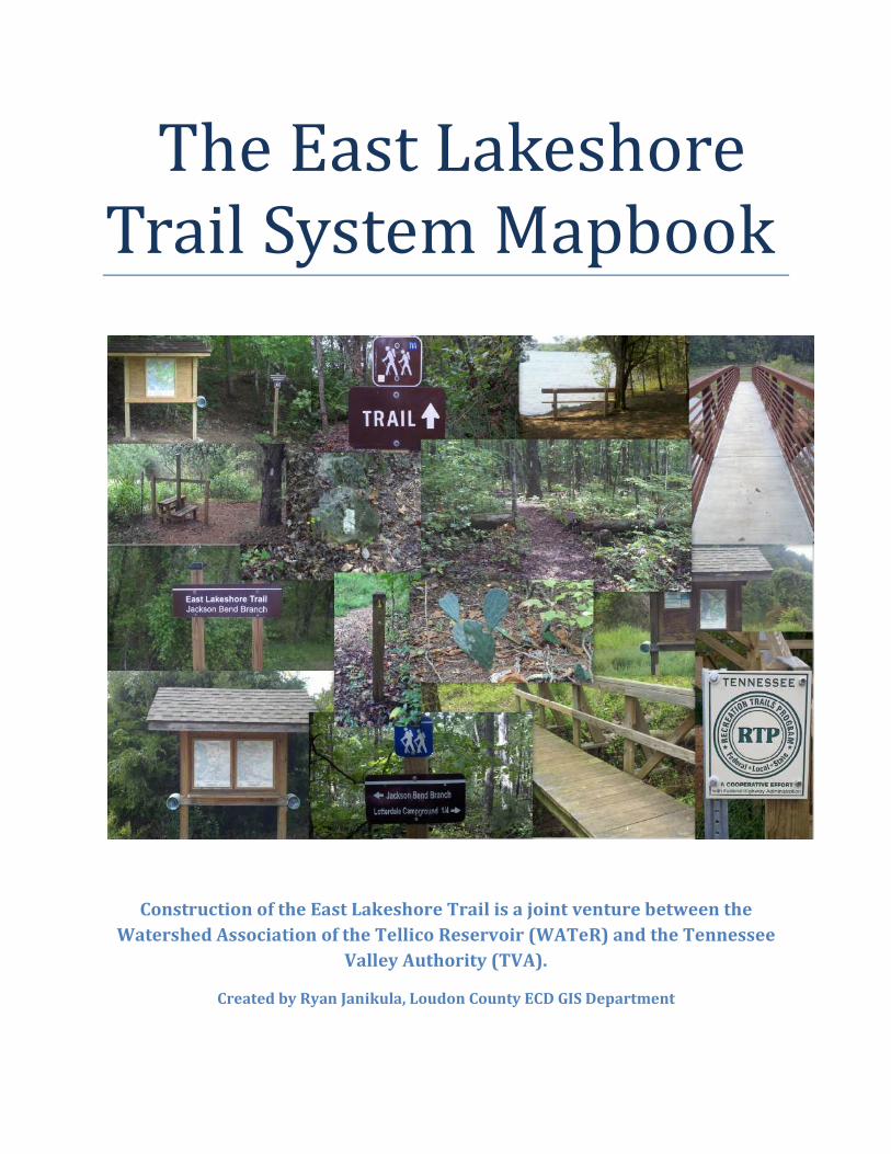
Legend
TRAILS
Trail_Name! ! DAVIS FERRY BRANCH
! ! GLENDALE BRANCH
! ! GLENDALE SHORT CUT
! ! COYTEE LOOP
! ! SINKING CREEK BRANCH
! ! LOTTERDALE BRANCH
! ! JACKSON BEND BRANCH
! ! LOTTERDALE CAMPGROUND CONNECTOR
tu95
tu321
tu444To Maryville
·
East Lakeshore Trail System
GLENDALE TRAIL HEAD
COYTEE TRAILHEAD
SINKING CREEK
TRAILHEAD
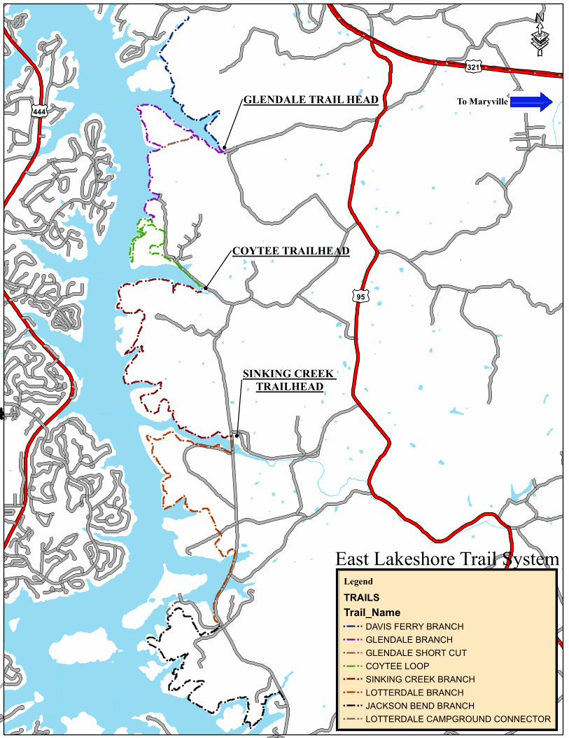
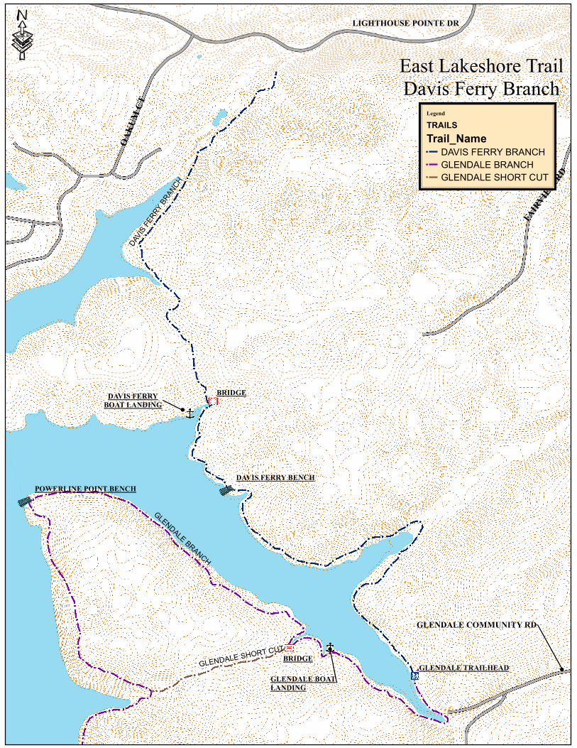
Trail Descriptions Davis Ferry Branch
The Davis Ferry Branch extends north from the Glendale Trailhead two (2) miles to the current north terminus of the
East lakeshore Trail at the Rarity Pointe Golf Course.
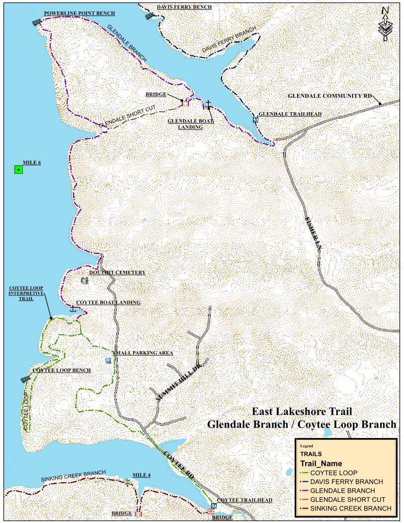
Glendale Branch
The Glendale Branch extends south from the Glendale Trailhead to an intersection with the Coytee Loop interpretive
trail. This trail is 3.0 miles via Power Point and 2.2 miles via the Shortcut. From the Glendale Trailhead to Power Point is
1.2 miles. The Powerline Point Loop interpretive trail is 2.2 miles and goes from the trailhead to Powerline Point and
returns via the Glendale Shortcut trail. A trail guide for this loop is available in printable form on the website
tellicowater.org or copies are available for checkout from the Tellico Village Library.
Glendale Shortcut Trail
The Glendale Shortcut allows hikers to walk a 2.2 mile loop around Powerline Point and return to the Glendale
Trailhead.
Coytee Loop Branch
The Coytee Loop Branch extends north from the Coytee Trailhead 2.4 miles and includes a 1.6–mile self guided
interpretive loop trail. It incorporates eight learning sites marked by lettered posts along the trail. There is a bench about
half way around the loop looking out over scenic Tellico Lake. A trail guide for this interpretive trail is available in
printable form at tellicowater.org or copies are available for checkout from the Tellico Village Library.
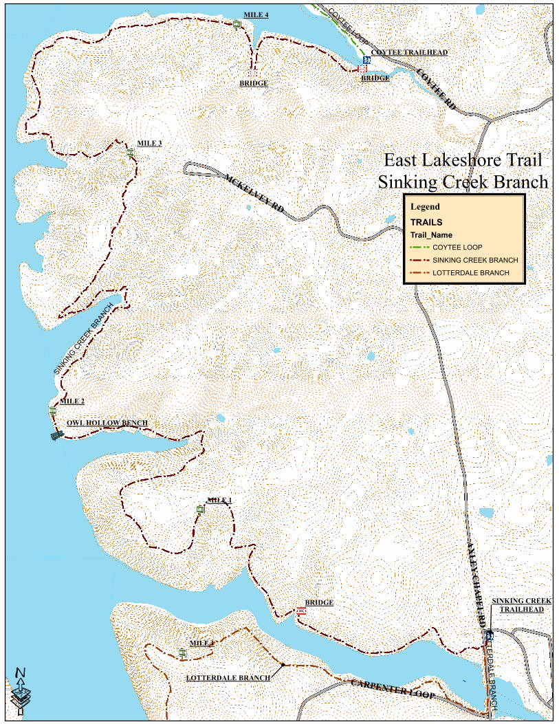
Sinking Creek Branch
The Sinking Creek Branch extends south from Coytee Trailhead 4.5 miles to Sinking Creek Trailhead. It features several
bridges including an 85-foot steel and concrete bridge erected by TVA in 2011, and elevated 15-feet above Coytee Cove
adjacent to Coytee Trailhead.
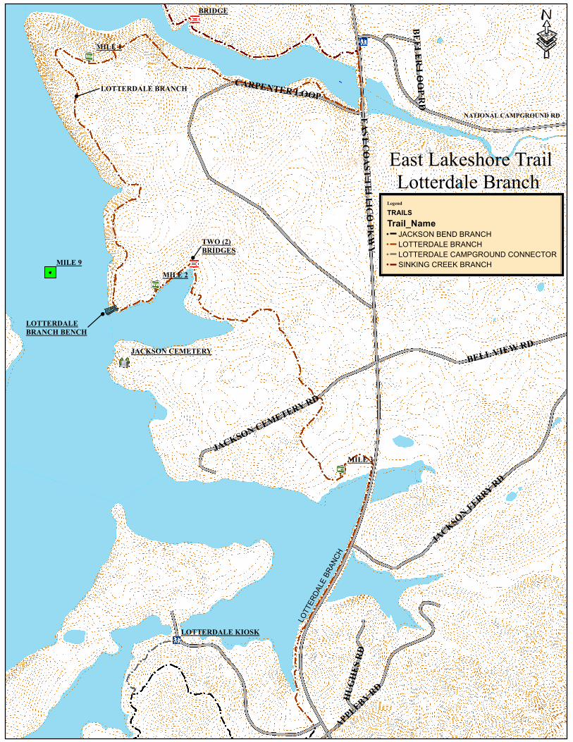
Lotterdale Branch
The Lotterdale Branch extends south from the Sinking Creek Trailhead 3.8 miles to the entrance road into Lotterdale
Campground. Parts of the trail traverse along East Coast Tellico Parkway separated by guardrail.
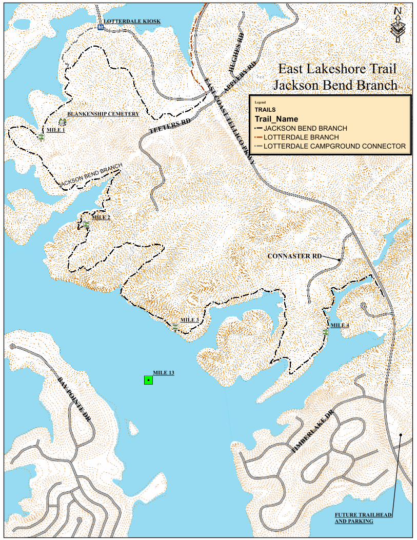
Jackson Bend Branch
The Jackson Bend Branch extends south from the Lotterdale Campground entrance road five (5) miles to the Peterson
Rd Trailhead. The last ½ mile of trail on the south end is under construction to be completed December, 2011. The
trailhead is expected to be built in early 2012. This branch showcases a variety of landscapes and scenic views and
includes an elevation gain of more than 100 feet. A ¼ mile connecting trail to a map kiosk at the campground entrance
provides ready access to the East Lakeshore Trail for campers.
Points of Interest for the East Lakeshore
Trail
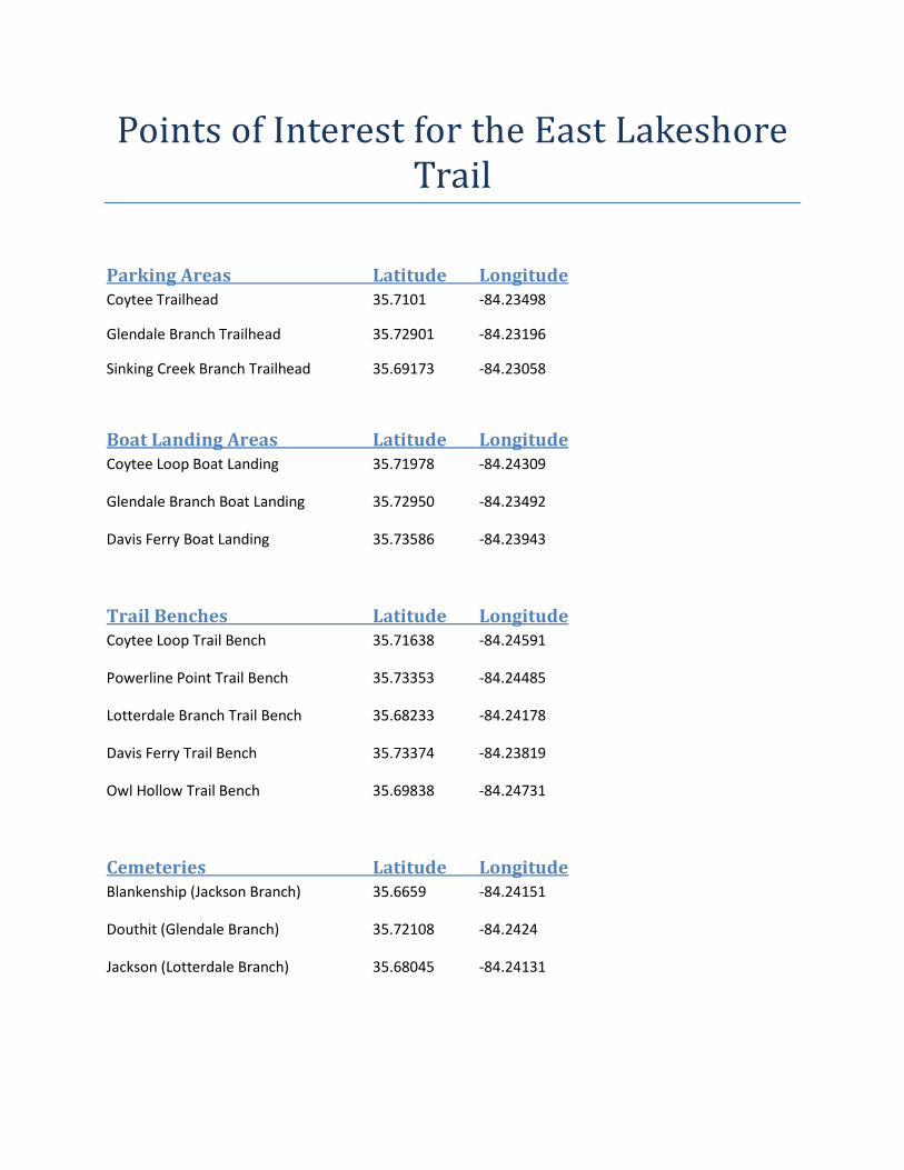
Parking Areas Latitude Longitude
Coytee Trailhead 35.7101 -84.23498
Glendale Branch Trailhead 35.72901 -84.23196
Sinking Creek Branch Trailhead 35.69173 -84.23058
Boat Landing Areas Latitude Longitude
Coytee Loop Boat Landing 35.71978 -84.24309
Glendale Branch Boat Landing 35.72950 -84.23492
Davis Ferry Boat Landing 35.73586 -84.23943
Trail Benches Latitude Longitude
Coytee Loop Trail Bench 35.71638 -84.24591
Powerline Point Trail Bench 35.73353 -84.24485
Lotterdale Branch Trail Bench 35.68233 -84.24178
Davis Ferry Trail Bench 35.73374 -84.23819
Owl Hollow Trail Bench 35.69838 -84.24731
Cemeteries Latitude Longitude
Blankenship (Jackson Branch) 35.6659 -84.24151
Douthit (Glendale Branch) 35.72108 -84.2424
Jackson (Lotterdale Branch) 35.68045 -84.24131
BRIDGE
DAVIS FERRY BENCH
GLENDALE TRAILHEAD
POWERLINE POINT BENCH
OAKUM CT
FAIRVIEW RD
DA
VIS
FE
RR
Y B
RA
NC
H
GLEN
DALE BR
AN
CH
GLENDALE SHORT CUT
Produced by Ryan JanikulaLoudon Co E911 Mapping and AddressingJune 2008
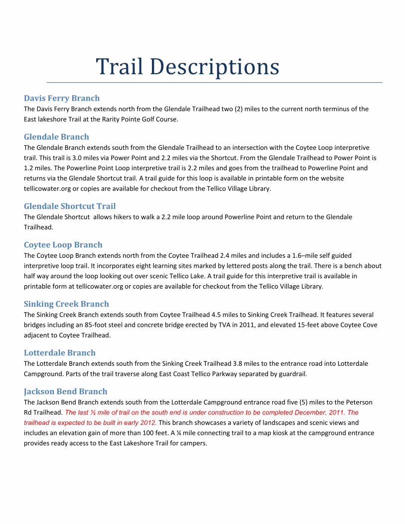
Legend
TRAILS
Trail_Name! DAVIS FERRY BRANCH! GLENDALE BRANCH! GLENDALE SHORT CUT
·East Lakeshore Trail
Davis Ferry Branch
DAVIS FERRY
BOAT LANDING
BRIDGE
GLENDALE BOAT
LANDING
GLENDALE COMMUNITY RD
LIGHTHOUSE POINTE DR
MILE 6
MILE 4
DOUTHIT CEMETERY
COYTEE TRAILHEAD
COYTEE LOOP BENCH
DAVIS FERRY BENCH
SMALL PARKING AREA
GLENDALE TRAILHEAD
COYTEE BOAT LANDING
POWERLINE POINT BENCH
COYTEE R
D
FIS
HER L
N
SUM
MIT
HIL
L DR
COYTEE LOOP
GLEN
DALE
BRANCH
SINKING CREEK
BRANCH
DAVIS
FERR
Y BRA
NCH
GLEND
ALE SH
ORT C
UT
Produced by Ryan JanikulaLoudon Co E911 Mapping and AddressingJune 2008
Legend
TRAILS
Trail_Name! COYTEE LOOP! DAVIS FERRY BRANCH! GLENDALE BRANCH! GLENDALE SHORT CUT! SINKING CREEK BRANCH
·
East Lakeshore Trail
Glendale Branch / Coytee Loop Branch
BRIDGE
GLENDALE BOAT
LANDING
COYTEE LOOP
INTERPRETIVE
TRAIL
BRIDGEBRIDGE
GLENDALE COMMUNITY RD
MILE 1
BRIDGE
MILE 1
MILE 2
MILE 3
MILE 4
OWL HOLLOW BENCH
COYTEE TRAILHEAD
AXLEY CHAPEL RD
COYTEE RD
MCKELVEY RD
CARPENTER LOOP
SIN
KIN
G C
RE
EK
BR
AN
CH
LO
TT
ER
DA
LE
BR
AN
CH
CO
YTEE LO
OP
Produced by Ryan JanikulaLoudon Co E911 Mapping and AddressingJune 2008
Legend
TRAILS
Trail_Name
! ! COYTEE LOOP
! ! SINKING CREEK BRANCH
! ! LOTTERDALE BRANCH
·
East Lakeshore Trail
Sinking Creek Branch
BRIDGEBRIDGE
SINKING CREEK
TRAILHEAD
LOTTERDALE BRANCH
MILE 3
MILE 2
MILE 1
MILE 9
BRIDGE
JACKSON CEMETERY
LOTTERDALE KIOSK
EAST COAST TELLIC
O PKWY
APPLEBY RD
BELL VI
EW RD
JACKSON FERRY RD
CARPENTER LOOP
JACK
SON C
EMET
ERY R
D
HUGHES RD
BEELER LOOP RD
LOTTERDALE BRANCH
Produced by Ryan JanikulaLoudon Co E911 Mapping and AddressingJune 2008
Legend
TRAILS
Trail_Name! JACKSON BEND BRANCH! LOTTERDALE BRANCH! LOTTERDALE CAMPGROUND CONNECTOR! SINKING CREEK BRANCH
·
East Lakeshore Trail
Lotterdale Branch
LOTTERDALE
BRANCH BENCH
TWO (2)
BRIDGES
NATIONAL CAMPGROUND RD
LOTTERDALE BRANCH
MILE 4MILE 3
MILE 2
MILE 1
MILE 13
LOTTERDALE KIOSK
BLANKENSHIP CEMETERY
EAST COAST TELLICO PKWY
TEETER
S RD
APPLEBY RD
TIMBERLAKE DR
BAY POINTE DR
HUGHES RD
JACKSO
N BEND
BRANC
H
Produced by Ryan JanikulaLoudon Co E911 Mapping and AddressingJune 2008
Legend
TRAILS
Trail_Name! JACKSON BEND BRANCH! LOTTERDALE BRANCH! LOTTERDALE CAMPGROUND CONNECTOR
·East Lakeshore Trail
Jackson Bend Branch
CONNASTER RD
FUTURE TRAILHEAD
AND PARKING