Embed Size (px)
Citation preview
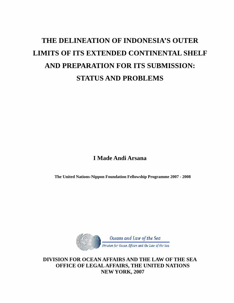
THE DELINEATION OF INDONESIA’S OUTER
LIMITS OF ITS EXTENDED CONTINENTAL SHELF
AND PREPARATION FOR ITS SUBMISSION:
STATUS AND PROBLEMS
I Made Andi Arsana
The United Nations-Nippon Foundation Fellowship Programme 2007 - 2008
DIVISION FOR OCEAN AFFAIRS AND THE LAW OF THE SEA
OFFICE OF LEGAL AFFAIRS, THE UNITED NATIONS NEW YORK, 2007
- - i
DISCLAIMER
The views expressed herein are those of the author and do not necessarily reflect the views of
Government of Indonesia, the United Nations, the Nippon Foundation of Japan, or the
Australian National Centre for Ocean Resources and Security (ANCORS) of the University of
Wollongong, or those of Gadjah Mada University.
©2007 I Made Andi Arsana. All rights reserved.
- - ii
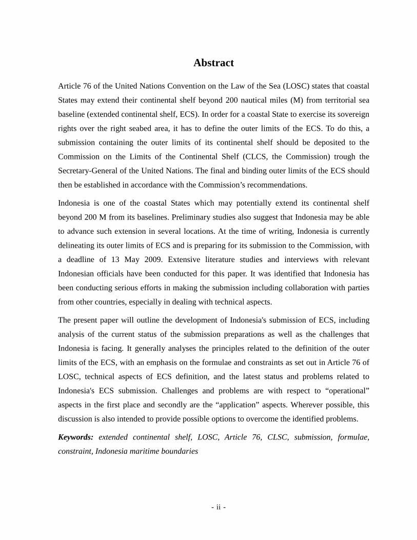
Abstract
Article 76 of the United Nations Convention on the Law of the Sea (LOSC) states that coastal
States may extend their continental shelf beyond 200 nautical miles (M) from territorial sea
baseline (extended continental shelf, ECS). In order for a coastal State to exercise its sovereign
rights over the right seabed area, it has to define the outer limits of the ECS. To do this, a
submission containing the outer limits of its continental shelf should be deposited to the
Commission on the Limits of the Continental Shelf (CLCS, the Commission) trough the
Secretary-General of the United Nations. The final and binding outer limits of the ECS should
then be established in accordance with the Commission’s recommendations.
Indonesia is one of the coastal States which may potentially extend its continental shelf
beyond 200 M from its baselines. Preliminary studies also suggest that Indonesia may be able
to advance such extension in several locations. At the time of writing, Indonesia is currently
delineating its outer limits of ECS and is preparing for its submission to the Commission, with
a deadline of 13 May 2009. Extensive literature studies and interviews with relevant
Indonesian officials have been conducted for this paper. It was identified that Indonesia has
been conducting serious efforts in making the submission including collaboration with parties
from other countries, especially in dealing with technical aspects.
The present paper will outline the development of Indonesia's submission of ECS, including
analysis of the current status of the submission preparations as well as the challenges that
Indonesia is facing. It generally analyses the principles related to the definition of the outer
limits of the ECS, with an emphasis on the formulae and constraints as set out in Article 76 of
LOSC, technical aspects of ECS definition, and the latest status and problems related to
Indonesia's ECS submission. Challenges and problems are with respect to “operational”
aspects in the first place and secondly are the “application” aspects. Wherever possible, this
discussion is also intended to provide possible options to overcome the identified problems.
Keywords: extended continental shelf, LOSC, Article 76, CLSC, submission, formulae,
constraint, Indonesia maritime boundaries
- - iii
Summary
WORKING TITLE:
The Delineation of Indonesia’s Outer Limits of its Extended Continental Shelf and Preparation
For its Submission: Status and Problems
SUPERVISORS:
Dr. Clive Schofield
Dr. Francois Bailet
- - iv
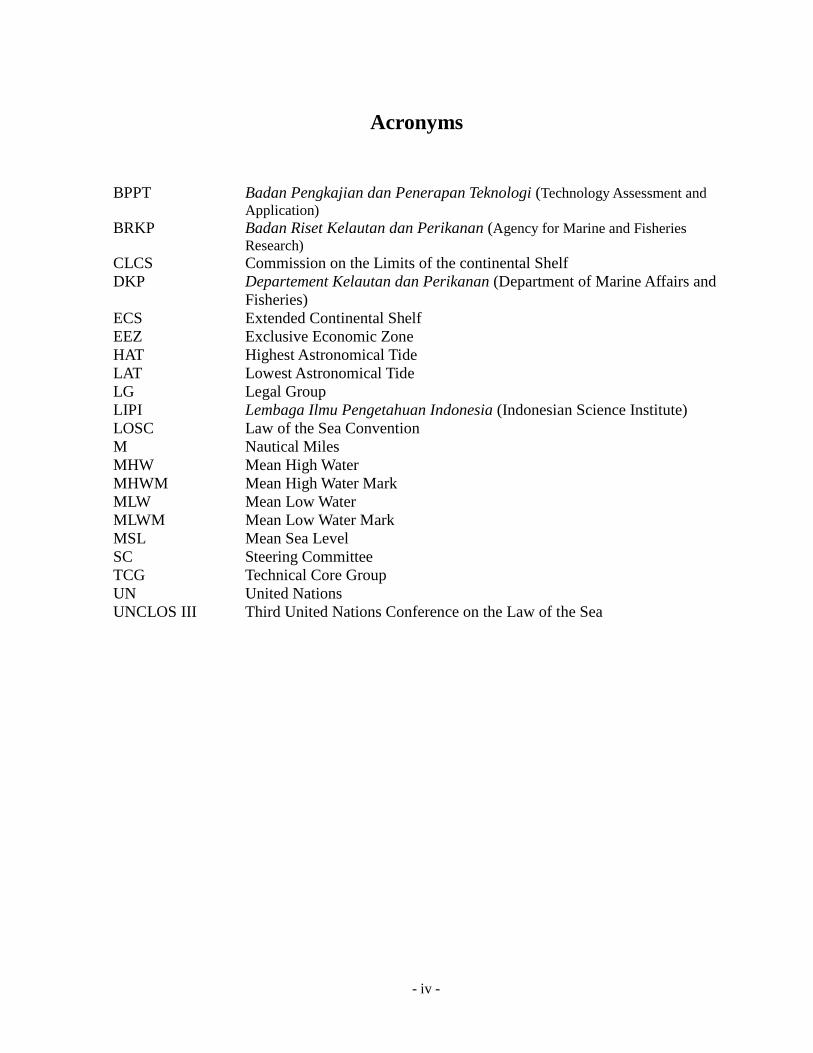
Acronyms
BPPT Badan Pengkajian dan Penerapan Teknologi (Technology Assessment and Application)
BRKP Badan Riset Kelautan dan Perikanan (Agency for Marine and Fisheries Research)
CLCS Commission on the Limits of the continental Shelf DKP Departement Kelautan dan Perikanan (Department of Marine Affairs and
Fisheries) ECS Extended Continental Shelf EEZ Exclusive Economic Zone HAT Highest Astronomical Tide LAT Lowest Astronomical Tide LG Legal Group LIPI Lembaga Ilmu Pengetahuan Indonesia (Indonesian Science Institute) LOSC Law of the Sea Convention M Nautical Miles MHW Mean High Water MHWM Mean High Water Mark MLW Mean Low Water MLWM Mean Low Water Mark MSL Mean Sea Level SC Steering Committee TCG Technical Core Group UN United Nations UNCLOS III Third United Nations Conference on the Law of the Sea
- - v
Dedication
For Asti, Lita and Indonesia
- - vi
Acknowledgements
It has been a great opportunity for me for being awarded the United Nations – Nippon
Foundation of Japan Fellowship. I would like to convey my sincere gratitude to the Division
for Ocean Affairs and Law of the Sea (DOALOS), Office of Legal Affairs, United Nations and
The Nippon Foundation of Japan for this opportunity. I thank Dr. Francois Bailet (Program
Adviser), Mr. Václav Mikulka (Director of DOALOS) and all DOALOS staff members for
their support and warm welcome here in the office. I also appreciate my all UN-Nippon 2007-
2008 fellows (Sampan, Ritche, Uirá , Rodrigue, Christophe, Mohamed, Tatiana, Robert, and
Tricia) for our warm friendship and mutual collaboration.
This fellowship has given me opportunities to work with many great people during my
research. I thank Dr. Clive Schofield for being such a good supervisor for me. I also thank
Prof. Martin Tsamenyi and Myree Mitchell from the Australian National Centre for Ocean
Resources and Security (ANCORS), University of Wollongong for their assistance during my
first-phase placement. To all friends in the University of Wollongong (Mbak Martha, Mas
Zain, Mas Kresno, Hendi, Michael, Jane, Amy, Dorina, Georgia, Daisuke, Marry-And and
Lowell), I do acknowledge your supports. Good friendship has made me able to survive the
challenging journey.
This research would have not been finished without technical supports from staff members of
the Indonesian National Coordinating Agencies for Surveys and Mapping (Bakosurtanal).
Therefore I would like to thank Dr. Sobar Sutisna, Ms. Tripatmasari, Dr. Khafid and all other
staff members of the Center for Boundary Mapping of Bakosurtanal. For technical and
administrative supports, I also thank Subaryono, PhD, Mr. Sumaryo and all of my fellow
lecturers in the Department of Geodetic and Geomatic Engineering of Gadjah Mada
University, Indonesia.
This fellowship is also a journey, where family plays an important role. Without support from
my wife, Asti, and our daughter, Lita, I would not have been able to accomplish this. I dedicate
this work to their supports, prayers and even sacrifices. Similarly, I also thank Meme’, Bapak,
Ibu, Mbok Iluh and her family and Komang Upik for their endless courage and love.
- - vii
To my parents in law, Mas Wawan, Mas Ari, Mbak Komang and their respective family, I
thank them for kindly taking over many of my family obligations during my absence in
Indonesia. Their supports are undisputable so I can achieve this far. I am indebted to them all.
During my placement in New South Wales, Australia, many friends helped me enjoy my
lonely life being far from family. To Ode, Putu Eri, Nina, Bli Sutil, Wulan, Nio, and Bli Sujata,
I sincerely express my gratitude for being good friends to me. Similarly, I thank Ibu Endang,
Bapak Madjid and their family for being good host for me during my stay in New York. Their
kindness has made my life comfortable.
Finally, I acknowledge everybody whose name cannot be mentioned one by one in this
acknowledgement page. However, their supports never lose their meaning.
- - viii
Table of Contents
Abstract....................................................................................................................................... ii
Summary....................................................................................................................................iii
Acronyms .................................................................................................................................. iv
Dedication................................................................................................................................... v
Acknowledgements ...................................................................................................................vi
Table of Contents.....................................................................................................................viii
List of Figures............................................................................................................................xi
List of Tables ............................................................................................................................xii
List of Appendices...................................................................................................................xiii
Chapter 1 Introduction .......................................................................................................... 1
1.1 Background and Context............................................................................................ 1
1.2 Scope and Objectives................................................................................................. 5
1.3 Approach.................................................................................................................... 5
1.4 Overview of Report.................................................................................................... 5
Chapter 2 The Continental Shelf........................................................................................... 7
2.1 Definitions.................................................................................................................. 7
2.1.1 Historical Perspectives .......................................................................................... 7
2.1.2 Scientific Perspectives......................................................................................... 11
2.1.2.1 Geology ...................................................................................................................12
2.1.2.2 Geomorphology.......................................................................................................14
2.1.3 Legal Perspectives............................................................................................... 14
2.1.3.1 Baselines..................................................................................................................17
2.1.3.2 Foot of Slope ...........................................................................................................18
2.1.3.3 Formulae..................................................................................................................18
2.1.3.4 Constraints...............................................................................................................23
2.1.3.5 The Outer Limits of ECS.........................................................................................26
2.1.3.6 Relevant Scientific Methodologies..........................................................................27
2.1.4 Uncertainties........................................................................................................ 40
2.2 Concluding Remarks................................................................................................ 42
- - ix
Chapter 3 The Commission on the Limits of the Continental Shelf ................................... 43
3.1.1 Membership......................................................................................................... 43
3.1.2 Roles and Functions ............................................................................................ 45
3.1.3 Procedures for Submission.................................................................................. 49
3.2 Benefits of the Delineation of ECS.......................................................................... 52
3.2.1 Declaration of Sovereign Rights ......................................................................... 53
3.2.2 Economic Benefits .............................................................................................. 54
3.3 Concluding Remarks................................................................................................ 57
Chapter 4 The Indonesian Case........................................................................................... 59
4.1 Defining the Potential Outer Limits of the ECS ...................................................... 59
4.1.1 Delineation of the Outer Limits of the ECS and Preparation for Submission .... 60
4.1.1.1 Institutions involved in the delineation and its submission.....................................61
4.1.1.2 The roles of External Bodies and Consultants ........................................................63
4.1.2 Results of Work and Latest Developments .........................................................65
4.1.2.1 Global Study by the USGS......................................................................................65
4.1.2.2 Preliminary Study by Indonesian Experts ...............................................................66
4.1.2.3 Technical Data Acquisition and Processing ............................................................68
4.1.2.4 Legal Preparations...................................................................................................70
4.1.3 Potential Boundary Disputes and Resolutions .................................................... 71
4.2 Towards a Submission for the Commission............................................................. 73
4.2.1 Challenges and Solutions .................................................................................... 74
4.2.1.1 Technical Challenges...............................................................................................74
4.2.1.2 Institutional Challenges...........................................................................................75
4.2.1.3 Financial Challenges ...............................................................................................76
4.2.1.4 Political Challenges.................................................................................................79
4.2.2 Status of the Submission ..................................................................................... 79
4.3 Concluding Remarks................................................................................................ 80
Chapter 5 Concluding Remarks .......................................................................................... 81
5.1 Review of Findings .................................................................................................. 81
5.1.1 Results from Existing Researches ....................................................................... 81
5.1.2 Progress Regarding the Delineation and Submission ......................................... 82
5.1.3 Challenges and Solutions .................................................................................... 82
- - x
5.2 Research Limitation and Obstacles.......................................................................... 84
5.2.1 Access to Data and Information .......................................................................... 84
5.2.2 Access to Government Officials.......................................................................... 84
5.3 Conclusions.............................................................................................................. 85
5.4 Recommendations.................................................................................................... 86
5.5 Directions for Future Research ................................................................................ 86
Appendices ............................................................................................................................... 88
- - xi
List of Figures
Figure 1. 1 Indonesian Archipelago and its neighboring States ................................................................3
Figure 2. 1 Continental shelf in a geological perspective .......................................................................13
Figure 2. 2 Seabed profile and the definition of outer limits of the continental shelf .............................16
Figure 2. 3 Type of Baselines..................................................................................................................17
Figure 2. 4 Foot of the continental slope.................................................................................................19
Figure 2. 5 Sediment thickness ...............................................................................................................20
Figure 2. 6 Gardiner line .........................................................................................................................21
Figure 2. 7 Hedberg Line ........................................................................................................................22
Figure 2. 8 Provisional line by combining Gardiner and Hedberg Lines................................................23
Figure 2. 9 The 350 M lines cutting the provisional outer limits of the continental shelf ......................24
Figure 2. 10 Outer Limits of the continental Shelf..................................................................................25
Figure 2. 11 Earth’s surface, Geoid, Ellipsoid, and Ocean......................................................................28
Figure 2. 12 Comparison between geodesic and loxodrome (NYC - Geneva) .......................................31
Figure 2. 13 Insular features and the vertical datum ...............................................................................34
Figure 2. 14 Singlebeam echosounder ....................................................................................................35
Figure 2. 15 Multibeam Echosounder .....................................................................................................36
Figure 4. 1 Potential ECS claim of Indonesia proposed by Sutisna et al. (2005)....................................68
Figure 4. 2 New survey route for the area to the west of Sumatera ........................................................69
Figure 4. 3 Existing maritime boundary agreements between Indonesia and Australia..........................72
- - xii
List of Tables
Table 1. 1 List of ECS submitters as per December 2007.........................................................................4
Table 2. 1 Potential uncertainties in determining the outer limit of the juridical continental shelf.........41
- - xiii
List of Appendices
Appendix 1 Flow chart of the Procedures Concerning a Submission Made to the Commission............88
Appendix 2 List of Candidates for CLCS members elected in 2007 ......................................................91
Appendix 3 List of CLCS members for the term of 2005-2012 .............................................................92
Appendix 4 Global study by USGS ........................................................................................................94
Appendix 5 Indonesian map: Agreed and Pending Maritime Boundaries with Neighboring States.......95
Appendix 6 List of Agreed Maritime Boundaries and Related Materials between Indonesia and
Neighboring States ..................................................................................................................................96
- - 1
Chapter 1 Introduction
The United Nations Convention on the Law of the Sea, or, in short, the Law of the Sea
Convention (hereinafter referred to as LOSC), indicates that a coastal State may extend their
continental shelf beyond 200 nautical miles (M) from its baselines (hereinafter referred to as
Extended Continental Shelf, ECS). Coastal States, pursuant to Article 76 of the LOSC, need to
delineate the outer limit ECS and make a submission the Commission on the Limits of the
Continental Shelf (CLCS, hereinafter referred to as the Commission)1 through the Secretary-
General of the United Nations. The submission should contain list of coordinates describing
the outer limit of its continental shelf, accompanied with supporting data and documents.
In this regard, Indonesia is one of the coastal States which may potentially extend its
continental shelf beyond 200 M. It has also been identified by previous studies that Indonesia,
technically, may extend its continental shelf in several locations. This paper is aimed at
assisting in the development of Indonesia's submission of the outer limits of its ECS. The
paper will analyze the current status of the submission as well as the problems Indonesia is
facing. While giving significant emphasis to technical aspects, this paper will discuss legal
issues associated with Indonesia's ECS submission to the Commission.
1.1 Background and Context
LOSC indicates that a coastal State can exercise sovereign rights over the continental shelf
appertaining to it without requiring an express or formal claim.2 Continental shelf, as defined
in Article 76 of the LOSC, comprises the seabed and subsoil that are natural prolongation of a
coastal State beyond its territorial sea, up to the outer edge of the continental margin. In cases
where the said continental margin does not reach the distance of 200 M from baseline,
continental shelf can be measured up to 200 M form its baselines. While, no formal claim to
continental shelf is required, it does not automatically mean every coastal State is entitled to a
200 M continental shelf. Meanwhile, unlike the continental shelf, a coastal State can only
1 The use of term "the Commission" has been adopted by document CLCS/40, Rules of Procedure of the Commission on the Limits of the Continental Shelf. However the use of term “CLCS” is unavoidable, for example in referring to specific documents such as CLCS/XX or other specific terms. 2 Article 77, LOSC states "The rights of the coastal State over the continental shelf do not depend on occupation, effective or notional, or on any express proclamation".
- - 2
exercise its rights over the exclusive economic zone (EEZ) when it is formally delimited, even
though its breadth is also 200 M from the territorial sea baselines. In other words, continental
shelf is not a maritime jurisdiction that a coastal State has to actively claim, unlike other
maritime jurisdictions such as territorial sea, contiguous zone, and EEZ. However, Article 76
(4(a)) of the LOSC also stipulates that a coastal State has to define the outer edge of its
continental margin in case the margin extends beyond a distance of 200 M from its baseline.3
The outer limits of the continental shelf must be submitted to the Commission for
recommendation through Secretary-General of the United Nations.4 The submission by a
coastal State should also include charts and relevant information, including geodetic data,
which permanently describe the outer limits of its continental shelf as stated in Article 76 (9).
This indicates that the submission of ECS by a coastal State will involve both technical and
non-technical aspects. For technical aspects, required data should be taken by sophisticated
field surveys, which require systematic planning, rigorous calculation and careful attention to
geodetic, geomorphological and geophysical aspects.5 Meanwhile, for non-technical aspects,
legal and political considerations will also be of significance.
Different information has been obtained concerning the number of coastal States with potential
ECS. An analysis states that in the course of the third United Nations Conference on Law of
the Sea (UNCLOS III), over 30 States were identified as potentially being able to extend their
continental shelf beyond 200 M.6 Meanwhile, the former Chairman of the Commission asserts
that there are 59 States that may potentially make their ECS submission to the Commission.7
However, without conducting at a minimum a desktop study for each potential State, it
3 Article 76 (4)(a) states "for the purpose if this Convention, the coastal State shall establish the outer edge of the continental margin wherever the martin extends beyond 2000 nautical mils from which the breadth of the territorial sea is measured …". 4 Article 76 (8) states: “Information on the limits of the continental shelf beyond 200 nautical miles from the baselines from which the breadth of the territorial sea is measured shall be submitted by the coastal State to the Commission on the Limits of the Continental Shelf set up under Annex II on the basis of equitable geographical representation.” See: Chapter 2 for more detailed information concerning the role and function of the Commission. 5 See: Persand (2005), A Practical Overview of Article 76 of the United Nations Convention on the Law of the Sea, Report of the UN-Nippon Fellowship. 6 Egede, E. (2004) “The Outer Limits of the Continental Shelf: African States and the Law of the Sea Convention 1982”, pp. 175 Ocean Development & International Law, 35.2: p. 157-178. 7 Croker P. F. (2007), CLCS: Further update on the work of the Commission, pp.15-15 in The Establishment of the Outer Limits of the Continental Shelf beyond 200 Nautical Miles – Its International Circumstances, and Its Scientific and Technical Aspects-, Ocean Policy Resource Foundation, p. 223.
- - 3
remains difficult to know precisely how many States may have a legitimate ECS.
Notwithstanding the number of potential States with an ECS, Indonesia is viewed as one of
them. Considering the geographic configuration and position of the Indonesian Archipelago,
this possibility does make sense. To the west of Sumatra, for example, Indonesia may assess
the possibility of extending its continental shelf. Considering that there is no other State
located within a distance of 200-400 M. Therefore, no overlapping claims need to be
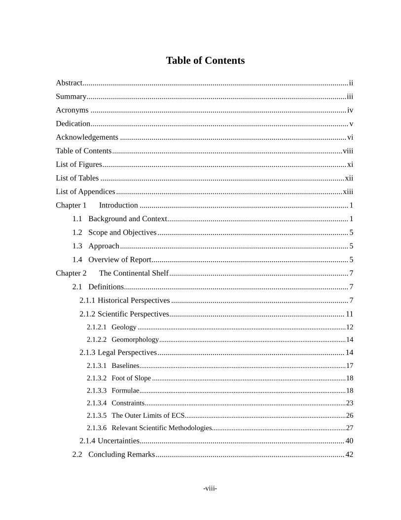
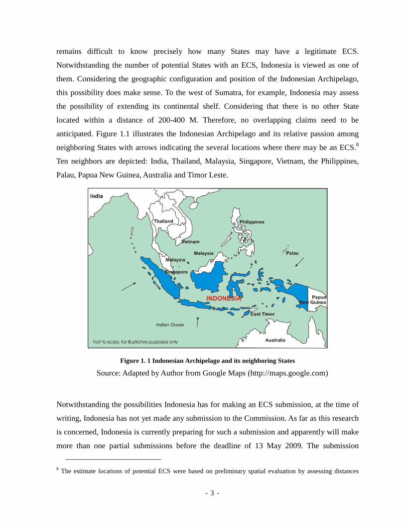
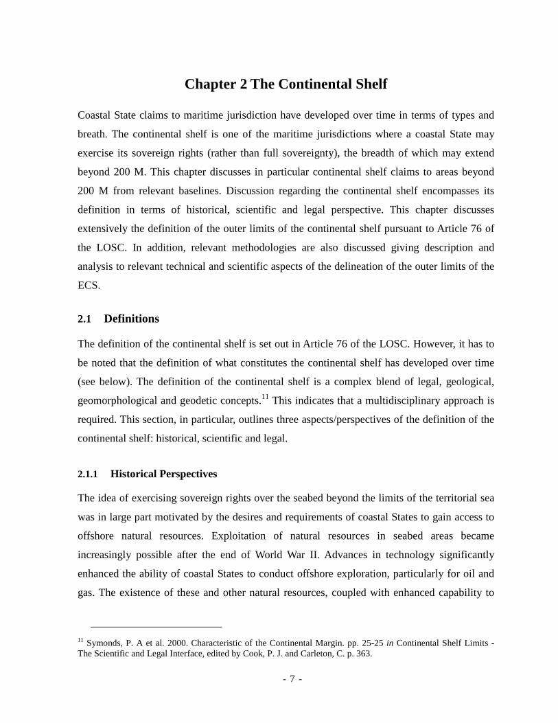
anticipated. Figure 1.1 illustrates the Indonesian Archipelago and its relative passion among
neighboring States with arrows indicating the several locations where there may be an ECS.8
Ten neighbors are depicted: India, Thailand, Malaysia, Singapore, Vietnam, the Philippines,
Palau, Papua New Guinea, Australia and Timor Leste.
Figure 1. 1 Indonesian Archipelago and its neighboring States
Source: Adapted by Author from Google Maps (http://maps.google.com)
Notwithstanding the possibilities Indonesia has for making an ECS submission, at the time of
writing, Indonesia has not yet made any submission to the Commission. As far as this research
is concerned, Indonesia is currently preparing for such a submission and apparently will make
more than one partial submissions before the deadline of 13 May 2009. The submission
8 The estimate locations of potential ECS were based on preliminary spatial evaluation by assessing distances
- - 4
deadline for a coastal State, pursuant to Annex II of the LOSC, is ten years after the
ratification of the LOSC by the coastal State. However, based on the latest developments, the
deadline was revised for the States that ratified the LOSC before 1999. The 2001 meeting of
the States Parties to the Convention decided that the commencement of the ten-year period
would be 13 May 1999, as this was the date on which the Commission adopted the Technical
and Scientific Guidelines (the Guidelines).9
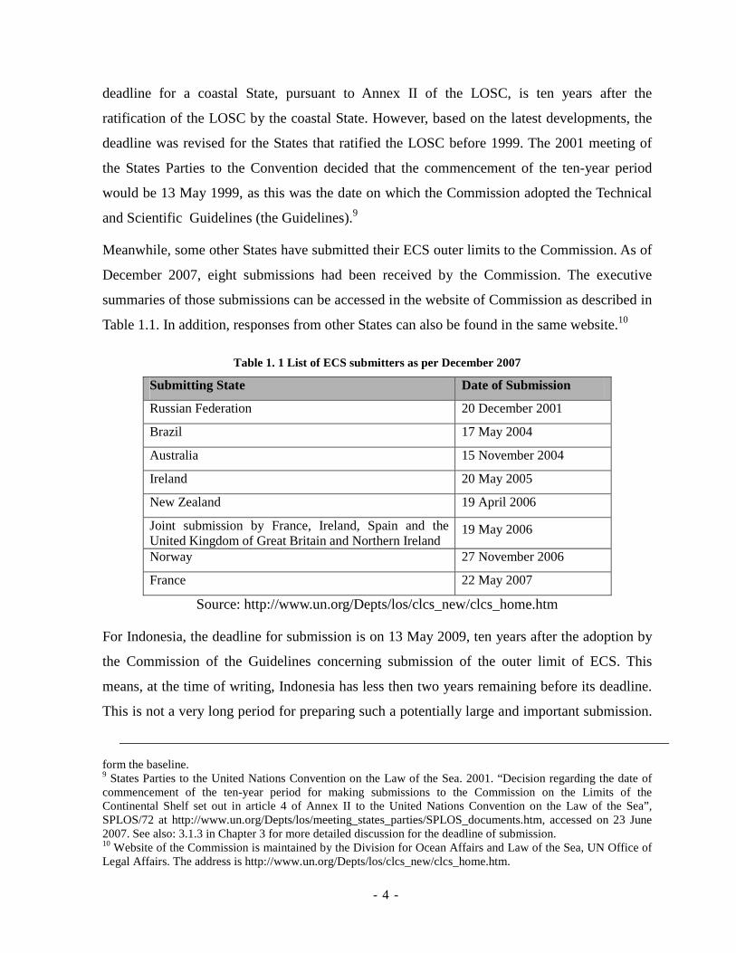
Meanwhile, some other States have submitted their ECS outer limits to the Commission. As of
December 2007, eight submissions had been received by the Commission. The executive
summaries of those submissions can be accessed in the website of Commission as described in
Table 1.1. In addition, responses from other States can also be found in the same website.10
Table 1. 1 List of ECS submitters as per December 2007
Submitting State Date of Submission
Russian Federation 20 December 2001
Brazil 17 May 2004
Australia 15 November 2004
Ireland 20 May 2005
New Zealand 19 April 2006
Joint submission by France, Ireland, Spain and the United Kingdom of Great Britain and Northern Ireland
19 May 2006
Norway 27 November 2006
France 22 May 2007
Source: http://www.un.org/Depts/los/clcs_new/clcs_home.htm
For Indonesia, the deadline for submission is on 13 May 2009, ten years after the adoption by
the Commission of the Guidelines concerning submission of the outer limit of ECS. This
means, at the time of writing, Indonesia has less then two years remaining before its deadline.
This is not a very long period for preparing such a potentially large and important submission.
form the baseline. 9 States Parties to the United Nations Convention on the Law of the Sea. 2001. “Decision regarding the date of commencement of the ten-year period for making submissions to the Commission on the Limits of the Continental Shelf set out in article 4 of Annex II to the United Nations Convention on the Law of the Sea”, SPLOS/72 at http://www.un.org/Depts/los/meeting_states_parties/SPLOS_documents.htm, accessed on 23 June 2007. See also: 3.1.3 in Chapter 3 for more detailed discussion for the deadline of submission. 10 Website of the Commission is maintained by the Division for Ocean Affairs and Law of the Sea, UN Office of Legal Affairs. The address is http://www.un.org/Depts/los/clcs_new/clcs_home.htm.
- - 5
This paper, which is being written during the preparation of the submission, will provide an
assessment of the current state of the development of Indonesia's ECS submission. This will
also critically analyze problems Indonesia is facing during the preparation and subsequently
offer potential solutions.
1.2 Scope and Objectives
The scope of this research is the development of Indonesia's ECS submission with particular
attention to its current status and problems encountered in its preparation. It has to be stated
clearly that this research is based on literature review and desktop analysis. No field
work/survey was done for this research in relation to geodetic data acquisition for the purpose
of the submission. Particular attention has been devoted to technical aspects of these issues,
while at the same time this paper addresses legal and other non-technical matters to support
the discussion.
The objective of this research is to provide an assessment and constructive critique as to the
latest status and problems of Indonesia's ECS submission. Wherever possible, this is also
intended to provide possible recourses for identified problems to be, if possible, considered by
the Indonesian submission team.
1.3 Approach
For the purpose of this research, extensive literature review has been undertaken as well as
interviews with authorities of the Indonesian Government who are directly-involved in the
ECS submission. Drawing on the literature review, this report addresses principles of the
continental shelf and the delineation of its outer limits which include historical and scientific
perspectives. Meanwhile, a detailed examination of the process of the Indonesian preparation
for ECS submission provides this report with the latest development of the process. Some
challenges have also been identified as well as alternatives for their resolution.
1.4 Overview of Report
This report consists of four chapters, each of which covers a different topic. Chapter 1, the
present chapter, provides an introduction and brief background to this current research.
Chapter 2 follows with an overview of the continental which discusses the scientific and legal
- - 6
definition of the continental shelf including its historical perspective and recent development.
This chapter focuses on the procedures of the delineation of the outer limits of the ECS. The
roles of the Commission are described in Chapter 3 including its recent members and the
Guidelines the Commission has produced for guiding coastal States in preparing their
submission.
Chapter 4 can be considered as the focus of this report as it encompasses on the case of
Indonesia. This includes preliminary studies concerning potential ECS limits, technical data,
recent work progress, developments on the road to submission and its latest status, and
problems concerning the submission and their potential solutions. The last chapter, Chapter 5,
concludes the report with a summary of findings and recommendations. Future work that is
required to be accomplished is also addressed in this chapter.
- - 7
Chapter 2 The Continental Shelf
Coastal State claims to maritime jurisdiction have developed over time in terms of types and
breath. The continental shelf is one of the maritime jurisdictions where a coastal State may
exercise its sovereign rights (rather than full sovereignty), the breadth of which may extend
beyond 200 M. This chapter discusses in particular continental shelf claims to areas beyond
200 M from relevant baselines. Discussion regarding the continental shelf encompasses its
definition in terms of historical, scientific and legal perspective. This chapter discusses
extensively the definition of the outer limits of the continental shelf pursuant to Article 76 of
the LOSC. In addition, relevant methodologies are also discussed giving description and
analysis to relevant technical and scientific aspects of the delineation of the outer limits of the
ECS.
2.1 Definitions
The definition of the continental shelf is set out in Article 76 of the LOSC. However, it has to
be noted that the definition of what constitutes the continental shelf has developed over time
(see below). The definition of the continental shelf is a complex blend of legal, geological,
geomorphological and geodetic concepts.11 This indicates that a multidisciplinary approach is
required. This section, in particular, outlines three aspects/perspectives of the definition of the
continental shelf: historical, scientific and legal.
2.1.1 Historical Perspectives
The idea of exercising sovereign rights over the seabed beyond the limits of the territorial sea
was in large part motivated by the desires and requirements of coastal States to gain access to
offshore natural resources. Exploitation of natural resources in seabed areas became
increasingly possible after the end of World War II. Advances in technology significantly
enhanced the ability of coastal States to conduct offshore exploration, particularly for oil and
gas. The existence of these and other natural resources, coupled with enhanced capability to
11 Symonds, P. A et al. 2000. Characteristic of the Continental Margin. pp. 25-25 in Continental Shelf Limits - The Scientific and Legal Interface, edited by Cook, P. J. and Carleton, C. p. 363.
- - 8
develop them, therefore dramatically increased the importance of the legal status of the
continental shelf.12
A proclamation by the American President Harry S. Truman, which became known simply as
“the Truman Proclamation”, can be considered as one of the key catalysts of the birth of the
continental shelf concept. This declaration had a significant influence on the development of
the continental shelf jurisdiction, as it was the first formal document asserting a claim beyond
the territorial sea.13 The Truman Proclamation was proposed on 28 September 1945 to allow
claims over parts of the adjacent continental shelf.14 It states that:
[…] having concern for the urgency of conserving and prudently utilizing its natural resources, the Government of the United States regards the natural resources of the subsoil and sea-bed of the continental shelf beneath the high seas but contiguous to the coasts of the United States as appertaining to the United States, subject to its jurisdiction and control.
The Truman Proclamation was a response in part to pressure from domestic oil interests,
unilaterally extending United States jurisdiction over all natural resources on that nation's
continental shelf - oil, gas, minerals, etc. The proclamation was considered as the first major
challenge to the freedom-of-the-seas doctrine.15 On the other hand, the Truman Proclamation
also reflected a growing “creeping coastal State jurisdiction” as coastal States increasingly
advanced claims offshore in that era.
According to the historical perspective of the LOSC published in the website of the Division
of Ocean Affairs and the Law of the Sea (DOALOS) of the United Nations, the proclamation
by the United States was then readily followed by other States. In October 1946, Argentina
claimed its continental shelf and the water column superjacent to the sea bed. Similarly, Chile
and Peru (1947), and Ecuador (1950), asserted sovereign rights over a 200 M zone which
encompassed both seabed and the water column.16 The intention of the assertion was to limit
12 Churchill, R. and Lowe, A. 1999. The Law of the Sea, pp. 142-142, Manchester University Press, p. 494. 13 Nandan, S. N. 1987. The Exclusive Economic Zone: A Historical Perspective in Essays in memory of Jean Carroz, Rome, at http://www.fao.org/docrep/s5280T/s5280t0p.htm, accessed on 20 June 2007. 14 See also: Truman Proclamation: Presidential Proclamation No. 2667 on 28 September 1945 regarding the Policy of the United States with Respect to the Natural Resources of the Subsoil and Sea Bed of the Continental Shelf at: http://www.oceanlaw.net/texts/truman1.htm, accessed on 4 May 2007. 15 See also: The United Nations Convention on the Law of the Sea (A historical perspective) at: http://www.un.org/Depts/los/convention_agreements/convention_historical_perspective.htm#Historical%20Perspective, accessed on 4 May 2007. 16 Ibid.
- - 9
the access of distant-water fishing fleets and to control the depletion of fish stocks in their
adjacent seas. In other words, the motivation was not strictly continental shelf-related. From a
different perspective, what these three South American Countries did might be viewed
deviating from the original principle of the continental shelf because they claimed full
sovereignty over continental shelf, while they do not seem to physically have real continental
shelves. These claims provoked resistance by other States and are considered as the starting
points of the development in the law of the sea, particularly the EEZ and the continental shelf
concepts.17 These phenomena reveal that the reasons of the continental shelf claim in its early
development were either to secure resources and prevent others from exploiting them, or
expanding opportunities to explore and exploit more resources.
In addition, the advancement in technology enables coastal States to have greater control over
the shelf resources beyond territorial sea.18 The invention of sophisticated vessels, submarine
vessels, drilling equipment and positioning technology such as Global Positioning Systems19
provide significant progress in terms of seabed resource exploration and exploitation. With the
help of these technology and equipments people can reach deeper to the seabed and farther
beyond the territorial sea.
The unilateral and sporadic claims described above, to an extent, stimulated conflict and
disputes among neighboring States, but, at the same time, were also viewed as playing
important roles in the birth of the continental shelf concept. In order to accommodate claims
by coastal States as well as to prevent excessive claims over large maritime areas, a clear
concept and law concerning the continental shelf was inevitably required.
The first effort towards the codification of international law concerning the continental shelf
was made in the first UN Conference on the Law of the Sea held in Geneva in 1958. One of
the four conventions produced by the Conference is the Convention on the Continental Shelf
(hereinafter referred to as the 1958 Convention).20 In the Manual on Technical Aspects of the
17 Heidar, T, H. 2004. Legal Aspects of the continental Shelf Limits, pp. 20-21 in Legal and Scientific Aspects if Continental Shelf Limits, p. 467, edited by Nordquist M. H., More, J. H., and Heidar, T. H., Martinus Nijhoff Publishers, The Netherlands. 18 See also: The United Nations Convention on the Law of the Sea (A historical perspective), op cit. 19 GPS is a satellite-based positioning system, by which a position on earth can be precisely determined and exp pressed in a coordinate with specific references. See also: http://www.navcen.uscg.gov/gps/. 20 The Convention is also called the Geneva Convention on the Continental Shelf, 1958 or in short, the 1958 Convention. The other three conventions are Convention on the Territorial Sea and the Contiguous Zone, 1958;
- - 10
United Nations Conventions on the Law of the Sea (TALOS)21, it is stated that the 1958
Convention has been very successful with 53 States ratifying.22 Through the 1958 Convention,
States were able to explore and exploit the non living resources of their sea beds from the early
1960s with confidence. However, the 1958 Convention definition of the continental shelf also
suffered from uncertainty in terms of the definition of outer limits. It is worth noting that the
wording of the 1958 Convention stated that the term "continental shelf" is used to refer “the
seabed and subsoil of the submarine areas adjacent to the coast but outside the area of the
territorial sea, to a depth of 200 meters (m) or, beyond that limit, to where the depth of the
superjacent waters admits of the exploitation of the natural resources of the said areas; or to
the seabed and subsoil of similar submarine areas adjacent to the coasts of islands.”23
One critical issue concerning the definition of the continental shelf is the criteria of
“exploitability”. This consequently made the definition unsettled as along the advancement of
science and technology concerning the seabed exploration and exploitation the definition of
the continental shelf would keep extending. The definition was thus effectively open-ended.24
In addition, the 1958 Convention generally states that coastal States have sovereignty over the
seabed and its resources, but not over the water and airspace above the seabed. Similarly, the
LOSC also stipulates that “The rights of the coastal State over the continental shelf do not
affect the legal status of the superjacent waters or of the air space above those waters.”25
In a historical perspective, the North Sea Continental Shelf Cases concerning the delimitation
of the continental shelf of the North Sea between Denmark and the Federal Republic of
Germany, and between the Netherlands and the Federal Republic of Germany, the
International Court of Justice decided to give significance to the principle of natural
prolongation.26 This was one of the cases considered as a retreat from the implementation of
Convention on the High Seas, 1958; and Convention on Fishing and Conservation of the Living Resources of the High Seas, 1958. 21 TALOS is published by the International Hydrographic Bureau and was prepared by three international organizations: International Association of Geodesy (IAG), International Hydrographic Organization (IHO), and International Oceanographic Commission (IOC). These three organizations are grouped in a board called Advisory Board on Law of the Sea (ABLOS). TALOS is available for download through IHO: www.iho.int. 22 International Hydrographic Bureau, 2006. Manual on Technical Aspects of the United Nations Conventions on the Law of the Sea, Monaco. Chapter 1- 4. 23 Article 1, 1958 Convention. 24 International Hydrographic Bureau, 2006. Chapter 1 (4-5). 25 Article 78 (1), LOSC. 26 North Sea Continental Shelf, Judgment, I.C.J. Reports 1969, p.3.
- - 11
equidistance lines for maritime boundary delimitation. This decision was to have a big
influence on the development of the continental shelf issue in the United Nation Conference
on the Law of the Sea III.27 The consideration to geomorphology of the seabed in delimiting
the outer limits of the continental shelf as described in Article 76 of the LOSC, for example,
indicates this. The Convention stipulates that the breadth of the continental shelf is not based
on a distance measured from the baselines. Instead, it is based on the topography of the
seabed. Even though the distance criteria is also involved, for example in defining the Hedberg
line which is a line with a distance of 60 M from the foot of the continental slope, topography
of the seabed plays significant role. This is because the foot of the continental slope is defined
in respect to the topography of the seabed.28
In 1982, the United Nations Conference on the Law of the Sea III finally reached conclusion
by establishing the LOSC. Most of the provisions contained in the 1958 Convention were
adopted by the LOSC with regards to the definition of the outer limits of the continental shelf.
However, there were other significant developments.29 There was a consciousness at that
Conference concerning the need to establish clear rules to define the outer limits of the
continental shelf. As mentioned previously, if the provisions of the 1958 Convention regarding
this matter were to be maintained, the development of new technology would undoubtedly
push the outer limits of the continental shelf farther offshore. This means that the 1958
Convention does not provide fixed definition of the outer limits the continental shelf.30
Therefore, the success of the III in defining the procedure for the delineation of the outer limits
of the continental shelf is viewed a remarkable achievement in the development of the law of
the sea. The provisions governing the definition of the outer limits of the continental shelf will
be further discussed in the next section of this chapter.
2.1.2 Scientific Perspectives
The continental shelf can be viewed from a scientific perspective, notably through disciplines
27 Heidar, T, H, op cit. pp. 22-22 . 28 See: 2.1.3.2 for more details concerning foot of the continental slope. 29 Smith, R. W. and Taft. R. 2000. Legal Aspects of the Continental Shelf. pp. 17-17 in Continental Shelf Limits - The Scientific and Legal Interface, edited by Cook, P. J. and Carleton, C. p. 363. 30 Article 1 of the 1958 Convention states that continental shelf refers to "the seabed and subsoil of the submarine areas adjacent to the coast but outside the area of the territorial sea, to a depth of 200 meters or, beyond that limit, to where the depth of the superjacent waters admits of the exploitation of the natural resources of the said areas".
- - 12
such as geology and geomorphology. Scientific perspectives are important in this context as
the definition of the continental shelf includes scientific principles, especially concerning the
ECS. This report also includes geological and geomorphological perspectives as described in
the following subsections.
2.1.2.1 Geology
The continental shelf was originally recognized as a geologic term.31 Therefore, the early
definition of the continental shelf refers to a geological perspective, not to a legal perspective
as will mostly be discussed in this report. One definition by the United States Geological
Survey (USGS) states that "continental shelf is the shallow, gradually sloping seabed around a
continental margin, not usually deeper than 200 m and formed by submergence of part of a
continent."32 The term "gradually sloping" in this definition, is in line with the term natural
prolongation used in Article 76 of LOSC. The continental shelf should be the natural
prolongation of landmass of a coastal State.
With regard to natural prolongation, it can be viewed as both a geomorphological and a
geological based concept.33 With reference to the Article 76 of LOSC, it can be inferred that
the natural prolongation also deals with geological properties. This is evident by the mention
for consideration of geological concepts such as "subsoil and submarine areas, the submerged
prolongation of landmass, the continental margin and the natural components of the
continental margin."34 In addition that such properties may also include geologically-related
characteristics such as crustal type, structure and composition; element of common geological
history or origin that were caused by geological process/events. Such geological properties can
possibly be used as the identification of coastal States' natural prolongation
In a geological perspective, the seabed has to have similar geological properties compared to
its landmass in order for the seabed to be considered as part of the continental shelf of the
31 Djunarsjah, E. and Dewantara, T. 2002. The Establishment of the Indonesian Continental Shelf, Proceeding of the Annual Scientific Forum of the Indonesian Surveyor Association, Yogyakarta, Indonesia. 32 See: Status and Trends of the Nation's Biological Resources – Glossary at: http://www.nwrc.usgs.gov/sandt/Glossary.pdf, accessed on 6 June 2007. See also: http://biology.usgs.gov/s%2Bt/SNT/noframe/zy198#C, accessed on 6 June 2007. 33 Gudlaugsson, S. T. 2004. Natural Prolongation and the Concept of the Continental Margin for the Purposes of Article 76, pp. 307-309 in Legal and Scientific Aspects if Continental Shelf Limits, p. 467, edited by Nordquist M. H., More, J. H., and Heidar, T. H., Martinus Nijhoff Publishers, The Netherlands.
- - 13
landmass. This characteristic deals with structure and composition of the materials that form
the seabed. In a geological perspective, the continental margin is not viewed as only a margin
consisting of shelf, slope, and rise.35 The complexities of its definition deal with structure
beneath the margin. Therefore, it is unsurprising that geological data and information are
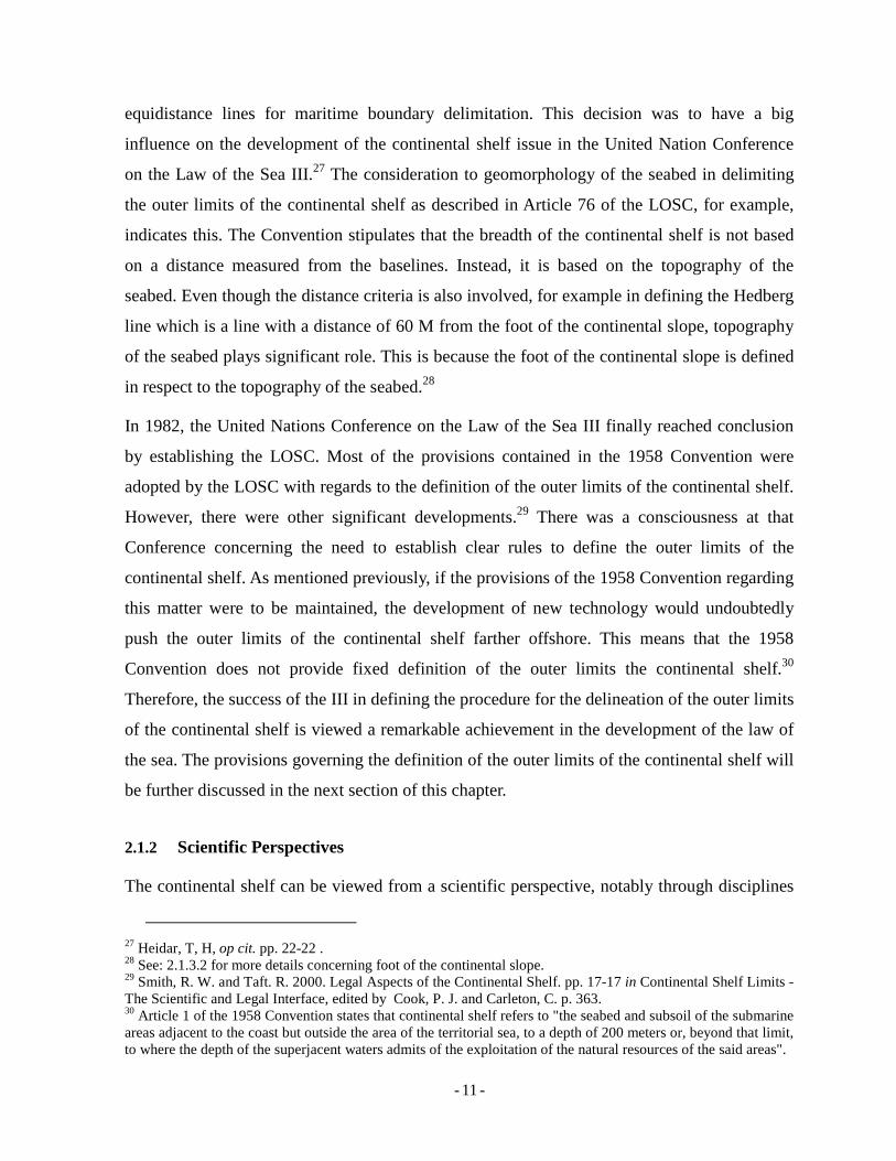
essential for a coastal States in the establishment of the outer limits of its ECS. Figure 2.1
illustrates the continental shelf in a geological perspective.
Figure 2. 1 Continental shelf in a geological perspective
Source: Adapted from Symonds, P. A., et al. (2000).36
Notwithstanding the arguments demonstrating the importance of geological properties in
determining the outer limits of the continental shelf, there are arguments against a
geologically-based concept of natural prolongation. These arguments propose that
geologically-based interpretations are commonly in conflict with geomorphologically based
concepts.37 In this context, geological approaches in defining the continental shelf should not
be viewed as more important that geomorphological perspective. Therefore geological
34 Ibid. pp. 71-71. 35 Symonds, P. A et al, op cit. pp. 28-28. 36 Ibid. 37 Gudlaugsson S. T., op cit. pp. 73-73.
- - 14
approaches cannot be used to override the implementation of geomorphologically based
concepts in defining the outer limit of the continental shelf. The geomorphological concept of
the continental shelf is further discussed in the following section.
2.1.2.2 Geomorphology
The geomorphological perspective is one of the aspects of natural prolongation, as previously
mentioned. In this regard, the entitlement to the continental shelf relates to the topography of
the seabed. This has nothing to do with the physical component/structure of the seabed but
instead its relief/shape of its surface.
In a geomorphological perspective, the continental shelf is viewed as simpler than under a
geological perspective.38 This concept emphasizes more on the topography of the seabed and
not the structure and composition of materials forming the seabed. The continental margin is
defined merely by the margin consisting of simple shelf, slope and rise without considering the
structure lying beneath. This view is, to an extent, similar to what was proposed other author
saying that the outer edge of the continental margin is the best definition of the continental
shelf,39 even though, to certain extents this is somewhat different from the usual definition of
geomorphic definition of the continental margin as consisting of the shelf, slope, and rise.40
The use of the term “base of the continental slope” or foot of slope, proposed by Hedberg in
his paper in 1976 finally becomes an important part in Article 76 of the LOCS.41 This is to
define on the basis of the formula called the Hedberg Line, a line delineating distance of 60 M
from the foot of the continental slope.42
2.1.3 Legal Perspectives
Legal definition of the continental shelf is dealt with in Article 76 of LOSC. The focus of the
continental shelf discussion in this report will be that of legal perspective, which in this case is
governed by Article 76 of LOSC. It is generally accepted that the real achievement in Article
38 Symonds, P. A. et al, op cit. pp. 28-28. 39 Hedberg, H. D. 1976. Relation of Political Boundaries on the Ocean Floor to the Continental Margin. Virginia Journal of International Law, 17 (1) pp. 57-75. 40 Symonds, P. A et al, op cit. pp. 29-29. 41 Hedberg, H. D., op cit. pp. 57-75. 42 See: 2.3.1 for more details.
- - 15
76 of LOSC is not the complexity of procedures in defining the outer limits of the continental
shelf, but the fact that the definition of the outer limit of the continental shelf has been
specifically formulated.43 Legal definition of the continental shelf, mainly, refers to the
definition or the outer limits of the continental shelf. However, the outer limit is achieved by
reference to geological and geomorphological criteria. Therefore, the discussion on the legal
perspective will consequently deal with geological and geomorphological aspects. This section
encompasses the definition of the continental shelf according to Article 76 of LOSC that
covers formulae and constraints in defining the outer limits of the continental shelf.
Article 76 of LOSC consists of ten paragraphs dealing with the definition of the legal
continental shelf and the procedures by which its outer limits may be delineated. The
definition of the continental shelf can be taken from Article 76 (1), which states that:
The continental shelf of a coastal State comprises the seabed and subsoil of the submarine
areas that extend beyond its territorial sea throughout the natural prolongation of its land
territory to the outer edge of the continental margin, or to a distance of 200 nautical miles from
the baselines from which the breadth of the territorial sea is measured where the outer edge of
the continental margin does not extend up to that distance.
The above paragraph tells us that the continental shelf covers the seabed area beyond coastal
States' territorial sea (beyond 12 M from the baselines) up to the edge of its continental
margin. The other important point in this context is that the continental shelf should be the
natural prolongation of landmass of the coastal State. In case the continental margin does not
reach a distance of 200 M, then the coastal State is entitled to a 200-M continental shelf
measured from its baselines.
In addition, paragraph 3 of Article 76 states that:
The continental margin comprises the submerged prolongation of the land mass of the coastal State, and consists of the seabed and subsoil of the shelf, the slope and the rise. It does not include the deep ocean floor with its oceanic ridges or the subsoil thereof.
43 McDorman, T. L., 2002. The Role of the Commission on the Limits of the Continental Shelf: A Technical Body in a Political World, The International Journal of Marine and Coastal Law Vol. 17 No. 3, Kluwer Law International, pp. 301-324.
- - 16
Paragraph 3 confirms parts of the seabed that form the continental margin. It tells us the
geomorphological structure of the continental shelf, as well as the fact that the continental
shelf excludes ocean floor with its oceanic ridges or subsoil thereof.
It is worth emphasizing that a coastal State’s continental shelf may extend up to a distance of
200 M from its baselines provided that there is no overlapping claim with its neighbors.44 In
addition, Article 77(3) states that “the rights of the coastal State over the continental shelf do
not depend on occupation, effective or notional, or on any express proclamation”. However,
coastal States need to delineate the outer limits of their continental shelf beyond 200 M, the
definition of which is governed by paragraphs 4, 5 and 6 of Article 76.
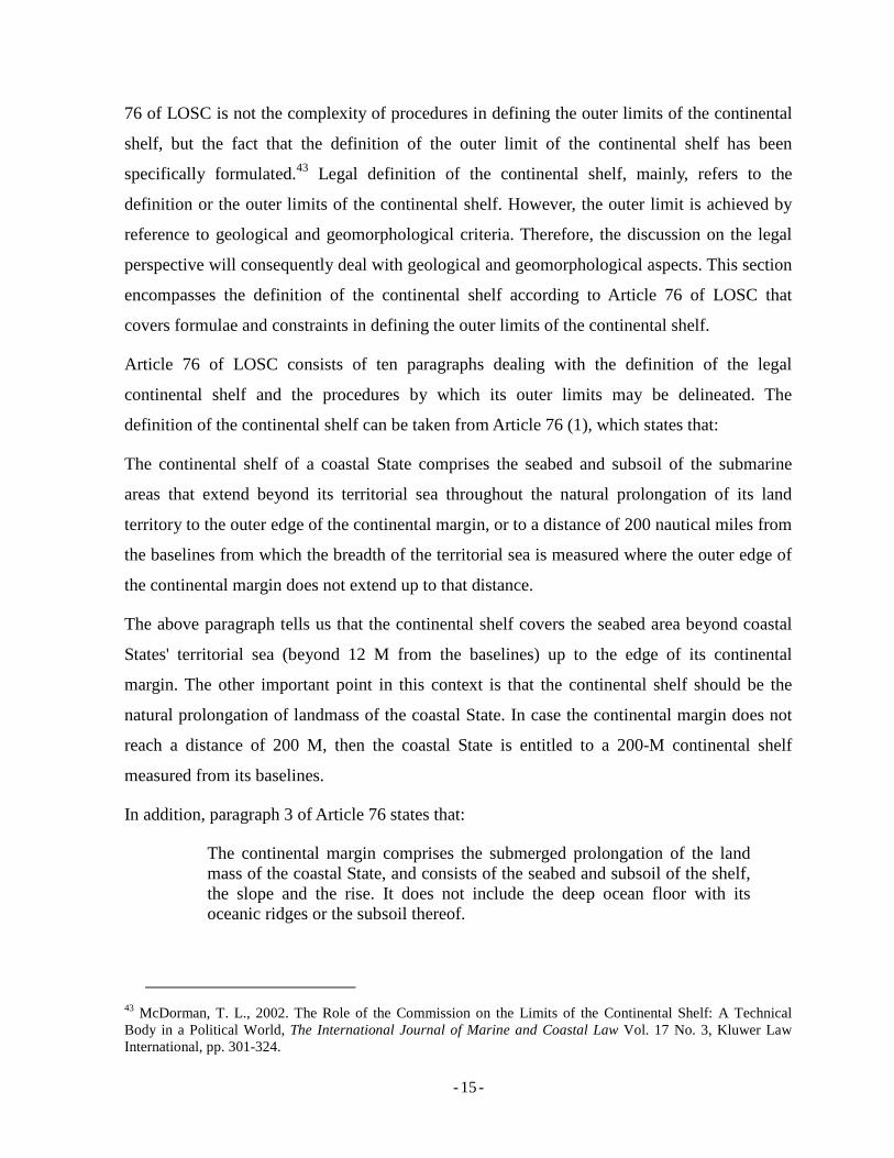
The following subsections of this paper discuss several important points concerning the
definition of the outer limits of the continental shelf: baselines, foot of slope, formulae lines
(Gardiner and Hedberg Lines), and constraints (350 M line and 2500 isobath + 100 M). The
definition of the outer limits of the continental shelf by employing the above formulae and
constraints is illustrated in a 3D perspective in Figure 2.2. More detailed explanations
concerning each formulae and constraint are provided in relevant subsections.
Figure 2. 2 Seabed profile and the definition of outer limits of the continental shelf
Source: Adapted from International Hydrographic Bureau, (2006).45
44 Article 76, LOSC. 45 International Hydrographic Bureau, op cit. cover page.
- - 17
2.1.3.1 Baselines
Baselines represent the starting point from which the territorial sea and other maritime
jurisdictions – contiguous zone, EEZ continental shelf, – are measured. There are commonly
three types of baselines: normal46, straight47, and archipelagic baselines.48 However there are
also other types of baselines such as for the mouth if a river49 and bay closing line.50 Figure
2.3 illustrates three different kinds of baselines that can be used by coastal States. Baselines
are important as they are the starting point for delineating the outer limits of the continental
shelf as it is clearly important to determine the 200 M limit. Furthermore, one of the constraint
lines is based on the distance of 350 M from baselines.51
The definition of baselines is strongly related to hydrographic methodologies as it deals with
the definition of the low-water lines. There are several types of low-water lines that can be
used in defining baselines and which are not explicitly specified by the LOSC.52
Figure 2. 3 Type of Baselines
Source: Adapted from Arsana, I M. A. (2007).53
46 Article 5, LOSC. 47 Article 7, LOSC. 48 Article 47, LOSC. 49 Article 9, LOSC. 50 Article 10, LOSC. 51 See: 2.1.3.4 for further details. 52 See: 2.1.3.6.2 for Hydrographic Methodologies. 53 Arsana, I M. 2007. International Maritime Boundaries – A Technical and Legal Perspective, pp. 21-21 (in Bahasa Indonesia), Gadjah Mada University Press, p. 204.
- - 18
2.1.3.2 Foot of Slope
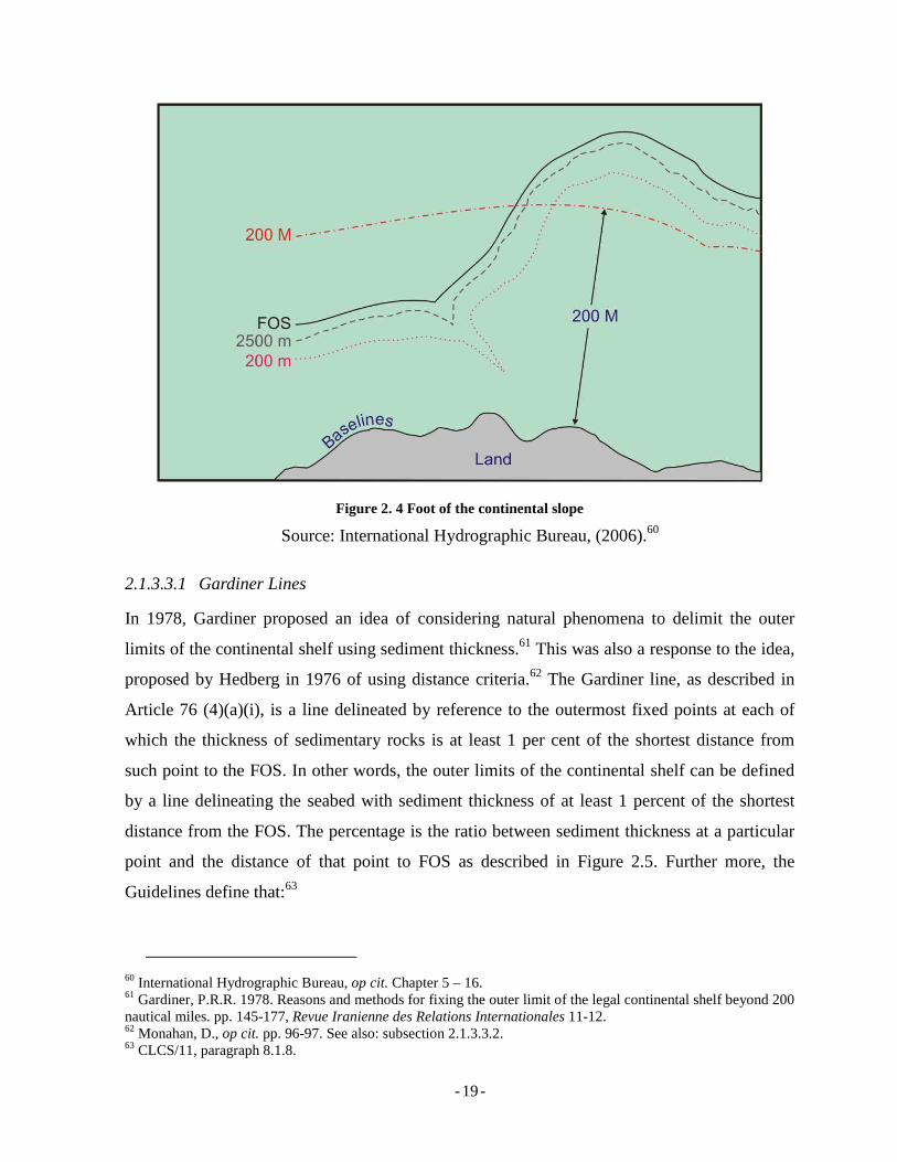
The foot of slope (FOS) has to be defined prior to the definition of the outer limits of the
continental shelf. FOS is the point of maximum change in gradient of the continental's base as
described in Figure 2.4.54 FOS is important to be identified as it is used as the reference in
defining Gardiner and Hedberg lines.55
The Guidelines states that bathymetric and geological data provide the evidence to be used in
geomorphological analysis to identify the foot of the continental slope.56 This indicates the
definition of FOS involves hydrographic methodologies, especially bathymetric survey to
define depth of ocean floor measured from chart datum (vertical reference). Meanwhile,
geological data obtained using geological methodologies,57 is required in case the base cannot
be determined using bathymetric data.58 This undoubtedly requires carrying out complicated
survey activities involving advanced technological survey equipment.59 Figure 2.4 illustrates
the line delineating the foot of the continental slope.
2.1.3.3 Formulae
The outer limits of the continental shelf are defined by either one or both of the formulae of
the Gardiner and Hedberg Lines. In a historical perspective, Hedberg Lines was introduced
first (in 1976) and Gardiner line came later (1978). However, the order is not relevant as these
two criteria are not interdependent, but will be discussed in the sequence they appear in Article
76 of the LOSC: Gardiner Line first, followed by Hedberg Line.
54 Article 76(4)(b), LOSC. 55 See: 2.1.3.3 for more details about formulae in defining the outer limits of the continental shelf. 56 Commission on the Limits of the Continental Shelf. 2007. “Scientific and Technical Guidelines of the Commission on the Limits of the Continental Shelf”, CLCS/11, hereafter CLCS/11. Paragraph 5.2.1. Available at http://www.un.org/Depts/los/clcs_new/commission_documents.htm, accessed on 3 July 2007. 57 See: 2.1.3.6.3 for more details in geological methodologies. 58 Monahan, D. 2004. Determination of the Foot of the Continental Slope as the Point of Maximum Change in Gradient at its Base. pp. 301-301, in Legal and Scientific Aspects if Continental Shelf Limits, p. 467, edited by Nordquist M. H., More, J. H., and Heidar, T. H., Martinus Nijhoff Publishers, The Netherlands. 59 See: 2.1.3.6.2 of Hydrographic Methodologies for more details.
- - 19
Figure 2. 4 Foot of the continental slope
Source: International Hydrographic Bureau, (2006).60
2.1.3.3.1 Gardiner Lines
In 1978, Gardiner proposed an idea of considering natural phenomena to delimit the outer
limits of the continental shelf using sediment thickness.61 This was also a response to the idea,
proposed by Hedberg in 1976 of using distance criteria.62 The Gardiner line, as described in
Article 76 (4)(a)(i), is a line delineated by reference to the outermost fixed points at each of
which the thickness of sedimentary rocks is at least 1 per cent of the shortest distance from
such point to the FOS. In other words, the outer limits of the continental shelf can be defined
by a line delineating the seabed with sediment thickness of at least 1 percent of the shortest
distance from the FOS. The percentage is the ratio between sediment thickness at a particular
point and the distance of that point to FOS as described in Figure 2.5. Further more, the
Guidelines define that:63
60 International Hydrographic Bureau, op cit. Chapter 5 – 16. 61 Gardiner, P.R.R. 1978. Reasons and methods for fixing the outer limit of the legal continental shelf beyond 200 nautical miles. pp. 145-177, Revue Iranienne des Relations Internationales 11-12. 62 Monahan, D., op cit. pp. 96-97. See also: subsection 2.1.3.3.2. 63 CLCS/11, paragraph 8.1.8.
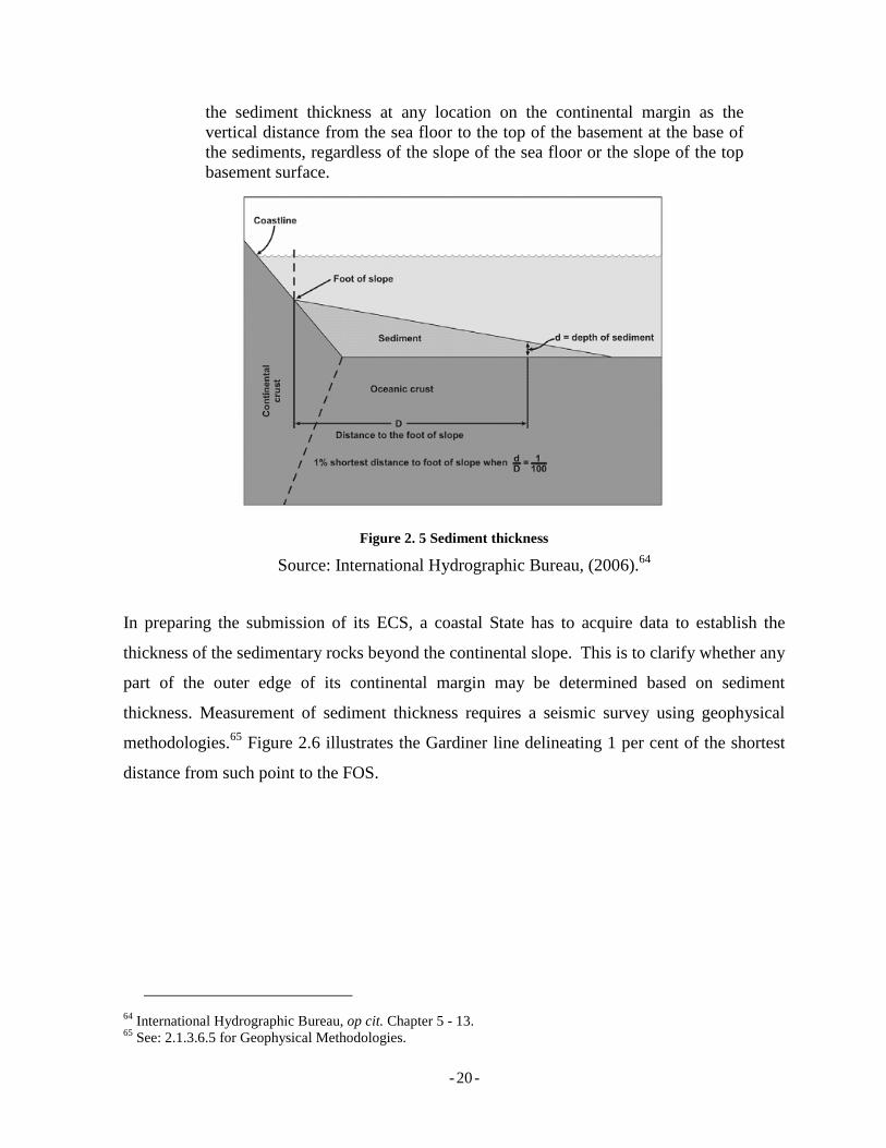
- - 20
the sediment thickness at any location on the continental margin as the vertical distance from the sea floor to the top of the basement at the base of the sediments, regardless of the slope of the sea floor or the slope of the top basement surface.
Figure 2. 5 Sediment thickness
Source: International Hydrographic Bureau, (2006).64
In preparing the submission of its ECS, a coastal State has to acquire data to establish the
thickness of the sedimentary rocks beyond the continental slope. This is to clarify whether any
part of the outer edge of its continental margin may be determined based on sediment
thickness. Measurement of sediment thickness requires a seismic survey using geophysical
methodologies.65 Figure 2.6 illustrates the Gardiner line delineating 1 per cent of the shortest
distance from such point to the FOS.
64 International Hydrographic Bureau, op cit. Chapter 5 - 13. 65 See: 2.1.3.6.5 for Geophysical Methodologies.
- - 21
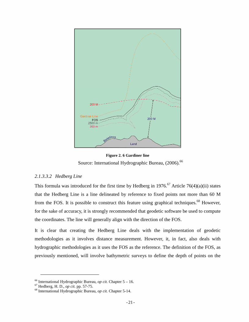
Figure 2. 6 Gardiner line
Source: International Hydrographic Bureau, (2006).66
2.1.3.3.2 Hedberg Line
This formula was introduced for the first time by Hedberg in 1976.67 Article 76(4)(a)(ii) states
that the Hedberg Line is a line delineated by reference to fixed points not more than 60 M
from the FOS. It is possible to construct this feature using graphical techniques.68 However,
for the sake of accuracy, it is strongly recommended that geodetic software be used to compute
the coordinates. The line will generally align with the direction of the FOS.
It is clear that creating the Hedberg Line deals with the implementation of geodetic
methodologies as it involves distance measurement. However, it, in fact, also deals with
hydrographic methodologies as it uses the FOS as the reference. The definition of the FOS, as
previously mentioned, will involve bathymetric surveys to define the depth of points on the
66 International Hydrographic Bureau, op cit. Chapter 5 – 16. 67 Hedberg, H. D., op cit. pp. 57-75. 68 International Hydrographic Bureau, op cit. Chapter 5-14.
- - 22
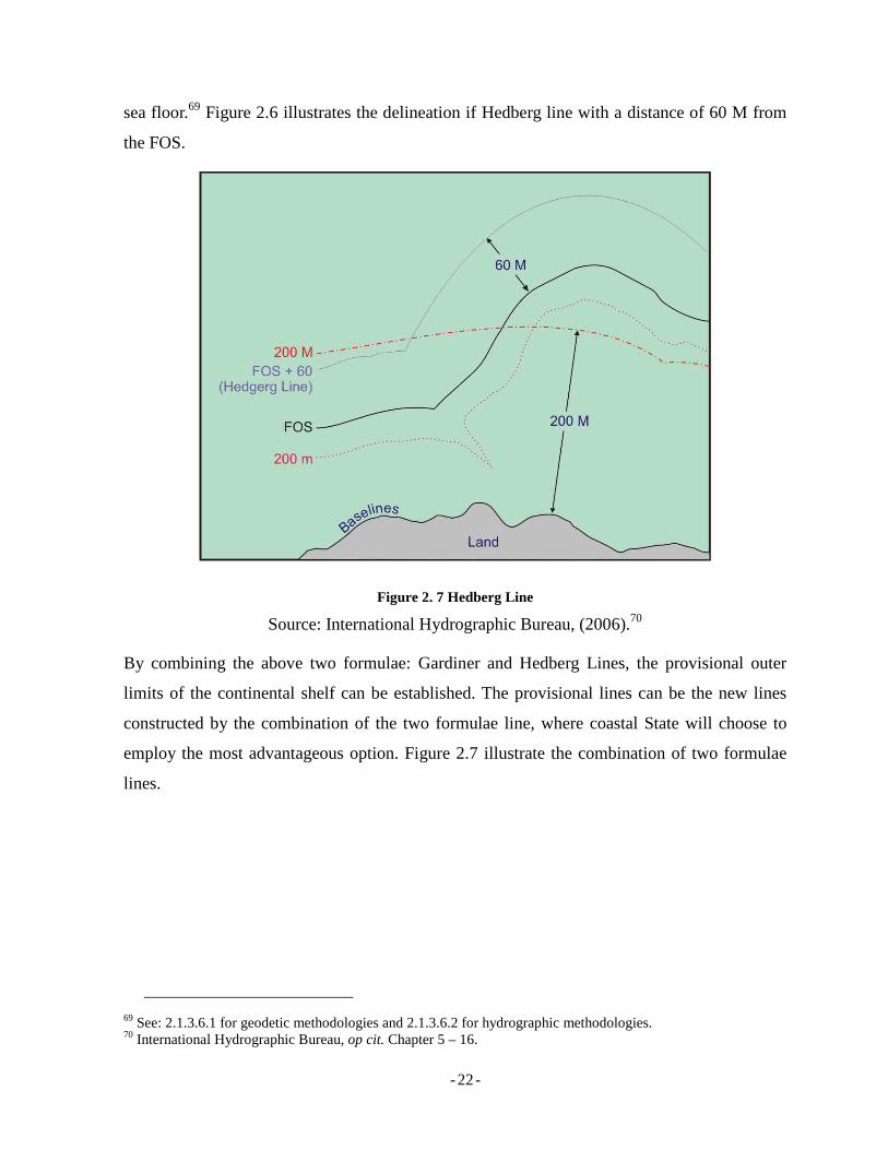
sea floor.69 Figure 2.6 illustrates the delineation if Hedberg line with a distance of 60 M from
the FOS.
Figure 2. 7 Hedberg Line
Source: International Hydrographic Bureau, (2006).70
By combining the above two formulae: Gardiner and Hedberg Lines, the provisional outer
limits of the continental shelf can be established. The provisional lines can be the new lines
constructed by the combination of the two formulae line, where coastal State will choose to
employ the most advantageous option. Figure 2.7 illustrate the combination of two formulae
lines.
69 See: 2.1.3.6.1 for geodetic methodologies and 2.1.3.6.2 for hydrographic methodologies. 70 International Hydrographic Bureau, op cit. Chapter 5 – 16.
- - 23
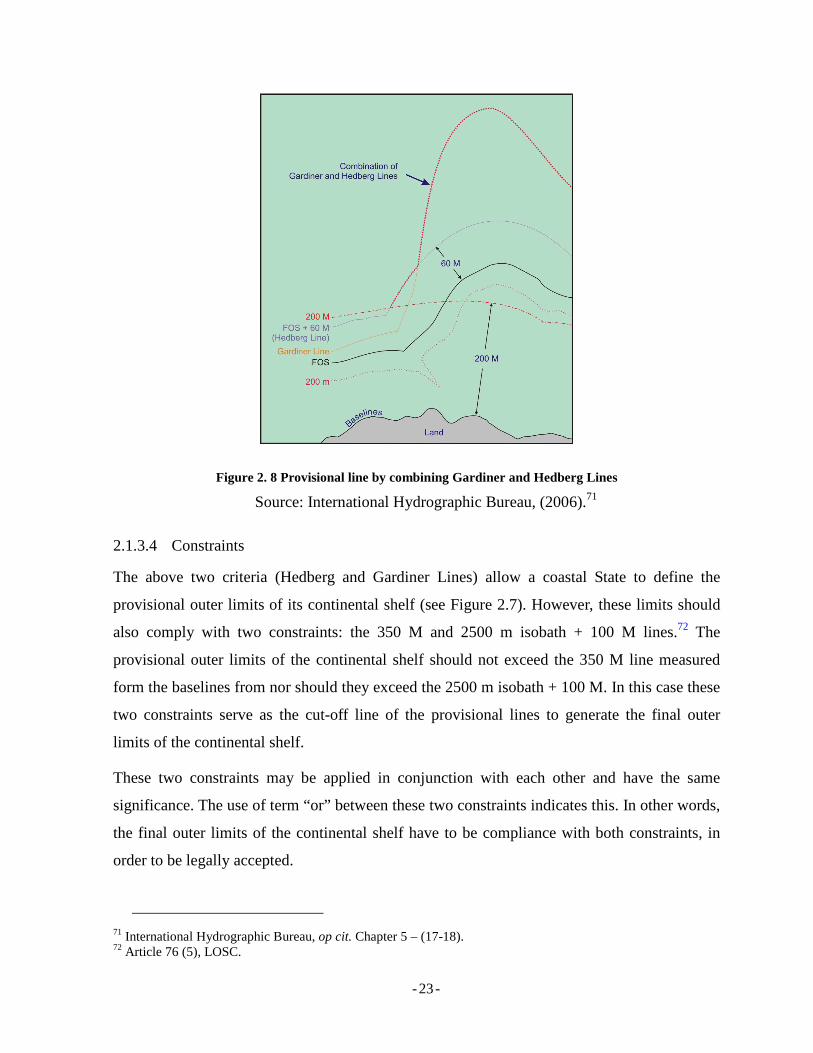
Figure 2. 8 Provisional line by combining Gardiner and Hedberg Lines
Source: International Hydrographic Bureau, (2006).71
2.1.3.4 Constraints
The above two criteria (Hedberg and Gardiner Lines) allow a coastal State to define the
provisional outer limits of its continental shelf (see Figure 2.7). However, these limits should
also comply with two constraints: the 350 M and 2500 m isobath + 100 M lines.72 The
provisional outer limits of the continental shelf should not exceed the 350 M line measured
form the baselines from nor should they exceed the 2500 m isobath + 100 M. In this case these
two constraints serve as the cut-off line of the provisional lines to generate the final outer
limits of the continental shelf.
These two constraints may be applied in conjunction with each other and have the same
significance. The use of term “or” between these two constraints indicates this. In other words,
the final outer limits of the continental shelf have to be compliance with both constraints, in
order to be legally accepted.
71 International Hydrographic Bureau, op cit. Chapter 5 – (17-18). 72 Article 76 (5), LOSC.
- - 24
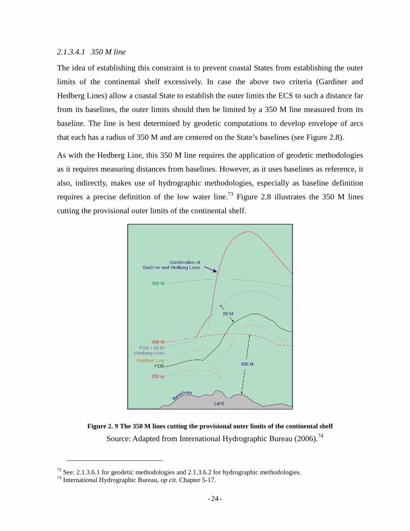
2.1.3.4.1 350 M line
The idea of establishing this constraint is to prevent coastal States from establishing the outer
limits of the continental shelf excessively. In case the above two criteria (Gardiner and
Hedberg Lines) allow a coastal State to establish the outer limits the ECS to such a distance far
from its baselines, the outer limits should then be limited by a 350 M line measured from its
baseline. The line is best determined by geodetic computations to develop envelope of arcs
that each has a radius of 350 M and are centered on the State’s baselines (see Figure 2.8).
As with the Hedberg Line, this 350 M line requires the application of geodetic methodologies
as it requires measuring distances from baselines. However, as it uses baselines as reference, it
also, indirectly, makes use of hydrographic methodologies, especially as baseline definition
requires a precise definition of the low water line.73 Figure 2.8 illustrates the 350 M lines
cutting the provisional outer limits of the continental shelf.
Figure 2. 9 The 350 M lines cutting the provisional outer limits of the continental shelf
Source: Adapted from International Hydrographic Bureau (2006).74
73 See: 2.1.3.6.1 for geodetic methodologies and 2.1.3.6.2 for hydrographic methodologies. 74 International Hydrographic Bureau, op cit. Chapter 5-17.
- - 25
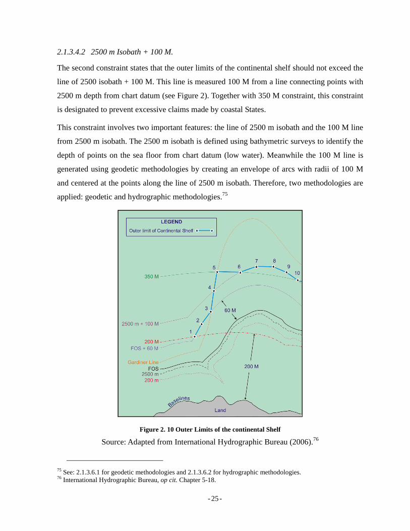
2.1.3.4.2 2500 m Isobath + 100 M.
The second constraint states that the outer limits of the continental shelf should not exceed the
line of 2500 isobath + 100 M. This line is measured 100 M from a line connecting points with
2500 m depth from chart datum (see Figure 2). Together with 350 M constraint, this constraint
is designated to prevent excessive claims made by coastal States.
This constraint involves two important features: the line of 2500 m isobath and the 100 M line
from 2500 m isobath. The 2500 m isobath is defined using bathymetric surveys to identify the
depth of points on the sea floor from chart datum (low water). Meanwhile the 100 M line is
generated using geodetic methodologies by creating an envelope of arcs with radii of 100 M
and centered at the points along the line of 2500 m isobath. Therefore, two methodologies are
applied: geodetic and hydrographic methodologies.75
Figure 2. 10 Outer Limits of the continental Shelf
Source: Adapted from International Hydrographic Bureau (2006).76
75 See: 2.1.3.6.1 for geodetic methodologies and 2.1.3.6.2 for hydrographic methodologies. 76 International Hydrographic Bureau, op cit. Chapter 5-18.
- - 26
By employing formulae and constrains, the outer limits of the continental shelf can be
determined as described in Figure 2.9. It can be identified that two lines were drawn based on
sediment thickness and 60 M from FOS criteria forming the provisional outer limit of a coastal
State’s continental shelf. The limit may be the combination of the two lines where it is possible
to choose the most advantageous outer limits formed by the two. However, a coastal State still
need to consider other two constraints as previously explained. The outer limits formed by
those two criteria (Gardiner and Hedberg lines) should not go beyond 350 M from baseline or
the 2500 isobath + 100 NM line. In Figure 2.3, it is outlined how the two constraints work in
combination to define the outer limits of the continental shelf. The segment formed by points
5 and 6 is the result of the 350 M line, while segments formed by points 6, 7, 8, 9 and 10 is the
result of the 2500 isobath + 100 M line. This option is more advantageous compared to an
alternative using only the 350 M line constraint.
2.1.3.5 The Outer Limits of ECS
Article 76(7) of the LOSC prescribes that:
The coastal State shall delineate the outer limits of its continental shelf, where that shelf extends beyond 200 M from the baselines from which the breadth of the territorial sea is measured, by straight lines not exceeding 60 M in length, connecting fixed points, defined by coordinates of latitude and longitude.
Two important points to note from this paragraph are the requirements of maximum length of
straight line segments depicting the outer limits of the continental shelf, and the need to
express the fixed points constructing the outer limit in coordinates of latitude and longitude.
With regard to straight line segment, it is worth noting that either geodesic or loxodrome types
of lines can be used as determined in the Guidelines.77 Meanwhile, the coordinates of fixed
points describing the outer limits should also be expressed in specific geodetic reference
system.78
77 CLCS/11 paragraph 3.3.8. 78 See: 2.1.3.6.1 for more detailed explanation concerning geodetic reference system.
- - 27
2.1.3.6 Relevant Scientific Methodologies
Defining the outer limits of the ECS is certainly a complex task. Not only does it inevitably
require considerable time to complete, but also many different disciplines of sciences. This
section provides an overview of the relevant scientific methodologies involved in the
definition of the outer limits of the ECS including geodetic, hydrographic, geomorphological,
geological, and geophysical methodologies.
2.1.3.6.1 Geodetic methodologies
Geodetic methodologies are referred to in Chapter 3 of the Guidelines of the Commission.
Geodesy deals with the measurement and the representation of the shape and dimensions of
the earth including its gravity in three-dimensional and time-dependent space.79 Simply
speaking, geodetic methodologies, in this context, primarily deal with distance measurements.
Such measurements are, in particular, relevant to the generation of the 350 M line and the
2500 isobath + 100 M constraint lines,80 the measurement of the breadth of maritime
jurisdiction - territorial sea, and 2500 isobath + 100 M constraint line,81 the generation of the
350 M constraint line82 and the delineation of the outer limits of the continental shelf.83 Three
major issues of geodetic methodologies discussed here are: horizontal datum; units, geodetic
reference system and coordinate transformation; and distance determination. These three
issues are important as they have a strong correlation to the definition of position and distance
measurements, which are relevant to the activities mentioned previously.
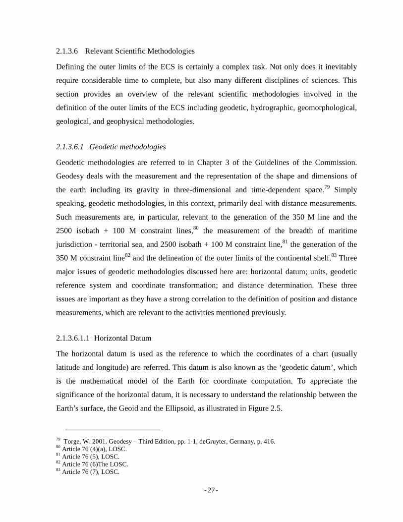
2.1.3.6.1.1 Horizontal Datum
The horizontal datum is used as the reference to which the coordinates of a chart (usually
latitude and longitude) are referred. This datum is also known as the ‘geodetic datum’, which
is the mathematical model of the Earth for coordinate computation. To appreciate the
significance of the horizontal datum, it is necessary to understand the relationship between the
Earth’s surface, the Geoid and the Ellipsoid, as illustrated in Figure 2.5.
79 Torge, W. 2001. Geodesy – Third Edition, pp. 1-1, deGruyter, Germany, p. 416. 80 Article 76 (4)(a), LOSC. 81 Article 76 (5), LOSC. 82 Article 76 (6)The LOSC. 83 Article 76 (7), LOSC.
- - 28
Figure 2. 11 Earth’s surface, Geoid, Ellipsoid, and Ocean
Source: adapted from International Hydrographic Bureau (2006).84
The feature labeled “Earth surface” is the physical surface of the Earth. As this surface is
irregular, it is impossible to use it as a computation reference, since it does not have a simple
mathematical expression. The Geoid is a physical model of the Earth that equates to
approximately the mean sea level of the oceans. It is influenced by the combined effects of the
Earth’s mass attraction and the centrifugal force of the Earth’s rotation. Yet the Geoid is not
perfectly mathematically shaped and under these influences, it undulates in height up to 100
m, compared to the ellipsoid.85 The ellipsoid itself is a mathematical model of the Earth. It is
defined by the appropriate selection of values for the semi-major and semi-minor axis of a
biaxial Ellipsoid and the location of its centre of mass. It can be said that the Ellipsoid replaces
the Geoid in order to have a ‘best-fit,’ comparatively simple, mathematical model surface. All
horizontal coordinates need to be referenced on the Ellipsoid to be meaningful. The one most
commonly used at present is the Ellipsoid, which underpins the World Geodetic System 1984
84 International Hydrographic Bureau, op cit. Chapter 2 (6-7). 85 Carleton, C. and Schofield, C. H. 2001. Development in the Technical Determination of Maritime Space: Charts, Datum, Baselines and Maritime Zones, Maritime Briefing, pp. 5-5, Vol. 3 No. 3, International Boundary Research Unit, Durham, United Kingdom.
- - 29
(WGS 84).86 The reason for this datum gaining popularity is because it is used in the GPS, a
satellite-based positioning and navigation system, which is nowadays used worldwide. The
applications of GPS encompass the wide range of activities including, but not limited to,
surveying, structure deformation, transportation, navigation, etc.
However, different countries may have dissimilar and often regional ellipsoids underpinning
their horizontal datum, which best fit their own regions. The difference between one ellipsoid
and another can be defined by its center's position related to the centre of mass of the Earth
(whether geocentric or not), and the lengths of the semi-major and semi-minor axes. The
uncertainty arising from the difference in coordinates of points constructing the outer limits of
the ECS, due to uncertainty of geodetic datum used, may weaken an ECS submission.
Therefore, it is important for a submitting State to specify the geodetic datum it uses in
defining the outer limits of its ECS.
Regardless of the coordinates being clearly stated in a treaty or agreement, they will not have
accurate and unambiguous spatial meaning until the geodetic datum is explicitly defined and
the existing coordinates are referred to that geodetic datum. This is because the same
coordinates, but referred to different datum, will change physical location on the Earth.87
Similarly, different coordinates expressed in varying datum may represent the same location in
the real world.
2.1.3.6.1.2 Units, Geodetic Reference System and Coordinate Transformation
The Guidelines states that two units are used in the relation to defining the outer limits of the
ECS, i.e. meters (m) and nautical miles (M). In this regard, 1 M equals 1,852 m as adopted by
IHO in 1926 and is recognized as international M.88
With regard to the positioning of points describing the outer limits of the ECS, all points have
to be expressed in geodetic coordinates with specific geodetic reference system. The
coordinates should preferably be expressed in either the International Terrestrial Reference
Frame of 1994 (ITRF94) produced by the International Earth Rotation Service (hereafter:
86 Ibid. pp. 6-6. 87 Abidin, H. Z. et al. (2005). Geodetic Datum of Indonesian Maritime Boundaries: Status and Problems. pp. 293-293. Marine Geodesy, Vol. 28 No. 4, p.291-304. 88 CLCS/11 paragraph 3.2.1.

- - 30
IERS), as recommended by the International Union of Geodesy and Geophysics (IUGG), or
the World Geodetic System of 1984 (WGS84; G873 or G1150), as recommended by the IHO.
However, the Commission does recognize that each coastal State may adopt different geodetic
reference system than that adopted by the Commission. Therefore, expression of coordinates
in other reference frames should be accepted.89 In this case, the coastal State should also
provide its transformation parameters with respect to one of the International Terrestrial
Reference Systems (ITRS) adopted by the Commission and the methodology used in their
determination.90; 91
2.1.3.6.1.3 Distance Determination
The main concern regarding distance determination is the use of geodesic versus loxodrome or
rhumb lines to represent straight lines. From a geodetic perspective, a straight line connecting
to points can be depicted using either geodesic or loxodrome lines. A geodesic curve is defined
as the unique line having the shortest possible distance between any two points on the space
over which it is measured.92 When projected onto a map, being a flat surface, the geodetic line
can never be depicted as a straight line, except for the case of meridians.
The second alternative for representing a straight line is using a loxodrome. Loxodrome is the
line with constant azimuth at each intersection with parallel lines. Loxodrome is the
appropriate line to use in navigational charts. The line would appear as a straight line on a
Mercator Chart but it does not, in fact, represent the shortest distance between two points.
In most cases, geodesic and loxodrome lines do not coincide with each other. They only
coincide in the North-South direction when they go along meridian lines. A comparison
between geodesic and loxodrome lines between a point in New York City and a point in
Geneva, for example, shows a significant difference as shown in Figure 2.11 below.
89 CLCS/11 paragraph 3.2.8. 90 Ibid. 91 Detailed explanation of the coordinate transformations and their mathematical formula are provided in the "Training Manual for delineation of the outer limits of the continental shelf beyond 200 nautical miles and for preparation of submissions to the Commission on the Limits of the Continental Shelf", Module II-(9-15) published by United Nations in 2006. 92 United Nations, 2006. Training Manual for delineation of the outer limits of the continental shelf beyond 200 nautical miles and for preparation of submissions to the Commission on the Limits of the Continental Shelf, DOALOS, New York.
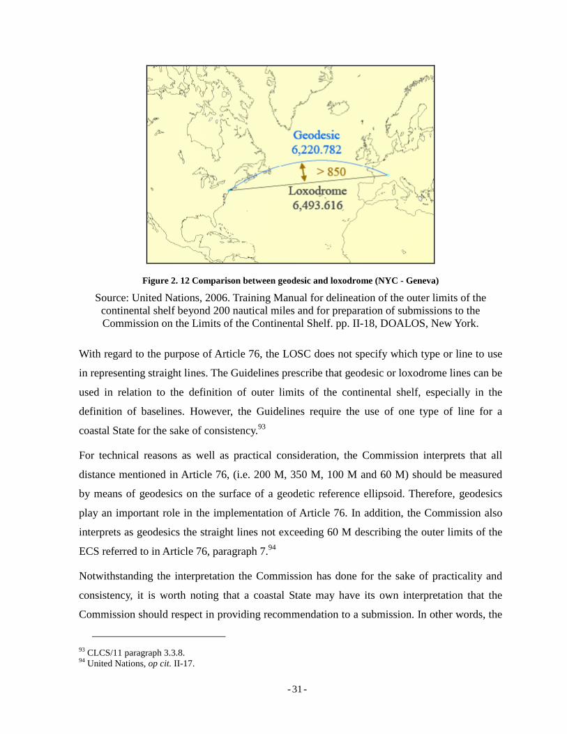
- - 31
Figure 2. 12 Comparison between geodesic and loxodrome (NYC - Geneva)
Source: United Nations, 2006. Training Manual for delineation of the outer limits of the continental shelf beyond 200 nautical miles and for preparation of submissions to the Commission on the Limits of the Continental Shelf. pp. II-18, DOALOS, New York.
With regard to the purpose of Article 76, the LOSC does not specify which type or line to use
in representing straight lines. The Guidelines prescribe that geodesic or loxodrome lines can be
used in relation to the definition of outer limits of the continental shelf, especially in the
definition of baselines. However, the Guidelines require the use of one type of line for a
coastal State for the sake of consistency.93
For technical reasons as well as practical consideration, the Commission interprets that all
distance mentioned in Article 76, (i.e. 200 M, 350 M, 100 M and 60 M) should be measured
by means of geodesics on the surface of a geodetic reference ellipsoid. Therefore, geodesics
play an important role in the implementation of Article 76. In addition, the Commission also
interprets as geodesics the straight lines not exceeding 60 M describing the outer limits of the
ECS referred to in Article 76, paragraph 7.94
Notwithstanding the interpretation the Commission has done for the sake of practicality and
consistency, it is worth noting that a coastal State may have its own interpretation that the
Commission should respect in providing recommendation to a submission. In other words, the
93 CLCS/11 paragraph 3.3.8. 94 United Nations, op cit. II-17.
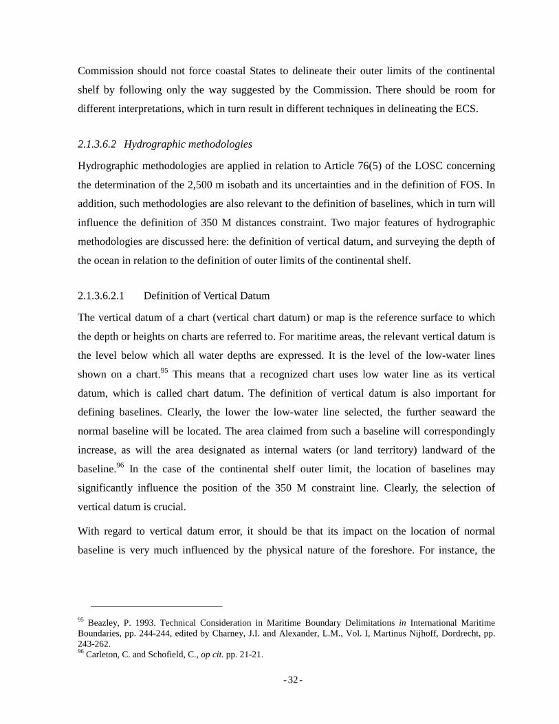
- - 32
Commission should not force coastal States to delineate their outer limits of the continental
shelf by following only the way suggested by the Commission. There should be room for
different interpretations, which in turn result in different techniques in delineating the ECS.
2.1.3.6.2 Hydrographic methodologies
Hydrographic methodologies are applied in relation to Article 76(5) of the LOSC concerning
the determination of the 2,500 m isobath and its uncertainties and in the definition of FOS. In
addition, such methodologies are also relevant to the definition of baselines, which in turn will
influence the definition of 350 M distances constraint. Two major features of hydrographic
methodologies are discussed here: the definition of vertical datum, and surveying the depth of
the ocean in relation to the definition of outer limits of the continental shelf.
2.1.3.6.2.1 Definition of Vertical Datum
The vertical datum of a chart (vertical chart datum) or map is the reference surface to which
the depth or heights on charts are referred to. For maritime areas, the relevant vertical datum is
the level below which all water depths are expressed. It is the level of the low-water lines
shown on a chart.95 This means that a recognized chart uses low water line as its vertical
datum, which is called chart datum. The definition of vertical datum is also important for
defining baselines. Clearly, the lower the low-water line selected, the further seaward the
normal baseline will be located. The area claimed from such a baseline will correspondingly
increase, as will the area designated as internal waters (or land territory) landward of the
baseline.96 In the case of the continental shelf outer limit, the location of baselines may
significantly influence the position of the 350 M constraint line. Clearly, the selection of
vertical datum is crucial.
With regard to vertical datum error, it should be that its impact on the location of normal
baseline is very much influenced by the physical nature of the foreshore. For instance, the
95 Beazley, P. 1993. Technical Consideration in Maritime Boundary Delimitations in International Maritime Boundaries, pp. 244-244, edited by Charney, J.I. and Alexander, L.M., Vol. I, Martinus Nijhoff, Dordrecht, pp. 243-262. 96 Carleton, C. and Schofield, C., op cit. pp. 21-21.
- - 33
higher the gradient97 of the foreshore, the less the impact would be. For areas where foreshore
gradient is 0.5 per cent, an error of just 0.5 m in vertical datum definition causes a 100 m error
in the location of the normal baseline. However, with sections of coastline characterized by a
steep foreshore (e.g. 50 or 100 per cent), the same vertical datum error may result in a
positional error of only 1 or 2 m.98
It has to be noted that each coastal State usually implements it own local vertical datum for its
national charts. Consequently, in the case of boundary delineation, the use of local datum may
cause problem as this may involve with other State’s entitlement, especially when overlapping
maritime jurisdictions exist. In this case, the use of global vertical datum is necessary.
Therefore, a systematic procedure to transform a local datum into a global one is required.
Having established this, a coastal State may keep using its local vertical datum but is required
to establish a procedure (mathematical formula) to transform it into a global vertical datum.99
Notwithstanding scientific and technical arguments proposed by scientist through their studies,
it is worth emphasizing that the choice of the vertical datum remains up to the coastal State.
Article 5 of the LOSC also refers to the term “low-water line”, but unfortunately neither the
1958 Convention nor the LOSC specify the vertical datum for depicting the low-water line on
charts used for the determination of normal baselines. Consequently, various datums have been
used by different States, providing a range of low-water lines and thus offering scope for
dispute. The variation in the use of low-water line is made possible by the difference in sea
tidal observation method, the accuracy of the observation and also the duration of observation.
Figure 2.4 illustrates some possibilities for vertical datums.
97 Gradient is the ratio between the height and the distance of two specific points/locations. The higher the gradient, the steeper the surface is. 98 Leahy, F.J., Murphy, B.A., Collier, P.A., and Mitchell, D.J. 2001. Uncertainty Issues in the Geodetic Delimitation of Maritime Boundaries, Accuracies and Uncertainties in Maritime Boundaries and Outer Limits. pp. 4-4, 2001 ABLOS Conference International Hydrographic Bureau, Monaco. 99 A study conducted by Vaníček in 1994 examined the concepts of global and local vertical datum and their roles in maritime boundary delimitation. He concluded that it was necessary to formulate sound transformation equations between the local vertical datum (sea level) and the geocentric reference ellipsoid (global vertical datum). This would make possible the use of heights determined by one of the space techniques in maritime boundary delimitations, and it would unify the height systems used on dry land with those used in bathymetric charting.
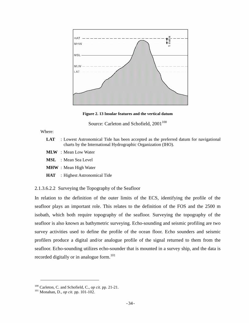
- - 34
Figure 2. 13 Insular features and the vertical datum
Source: Carleton and Schofield, 2001100
Where:
LAT : Lowest Astronomical Tide has been accepted as the preferred datum for navigational charts by the International Hydrographic Organization (IHO).
MLW : Mean Low Water
MSL : Mean Sea Level
MHW : Mean High Water
HAT : Highest Astronomical Tide
2.1.3.6.2.2 Surveying the Topography of the Seafloor
In relation to the definition of the outer limits of the ECS, identifying the profile of the
seafloor plays an important role. This relates to the definition of the FOS and the 2500 m
isobath, which both require topography of the seafloor. Surveying the topography of the
seafloor is also known as bathymetric surveying. Echo-sounding and seismic profiling are two
survey activities used to define the profile of the ocean floor. Echo sounders and seismic
profilers produce a digital and/or analogue profile of the signal returned to them from the
seafloor. Echo-sounding utilizes echo-sounder that is mounted in a survey ship, and the data is
recorded digitally or in analogue form.101
100 Carleton, C. and Schofield, C., op cit. pp. 21-21. 101 Monahan, D., op cit. pp. 101-102.
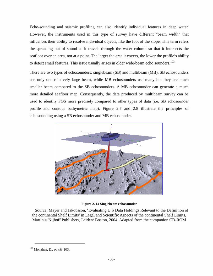
- - 35
Echo-sounding and seismic profiling can also identify individual features in deep water.
However, the instruments used in this type of survey have different "beam width" that
influences their ability to resolve individual objects, like the foot of the slope. This term refers
the spreading out of sound as it travels through the water column so that it intersects the
seafloor over an area, not at a point. The larger the area it covers, the lower the profile’s ability
to detect small features. This issue usually arises in older wide-beam echo sounders.102
There are two types of echosounders: singlebeam (SB) and multibeam (MB). SB echosounders
use only one relatively large beam, while MB echosounders use many but they are much
smaller beam compared to the SB echosounders. A MB echosounder can generate a much
more detailed seafloor map. Consequently, the data produced by multibeam survey can be
used to identity FOS more precisely compared to other types of data (i.e. SB echosounder
profile and contour bathymetric map). Figure 2.7 and 2.8 illustrate the principles of
echosounding using a SB echosounder and MB echosounder.
Figure 2. 14 Singlebeam echosounder
Source: Mayer and Jakobsson, ‘Evaluating U.S Data Holdings Relevant to the Definition of the continental Shelf Limits’ in Legal and Scientific Aspects of the continental Shelf Limits, Martinus Nijhoff Publishers, Leiden/ Boston, 2004. Adapted from the companion CD-ROM
102 Monahan, D., op cit. 103.
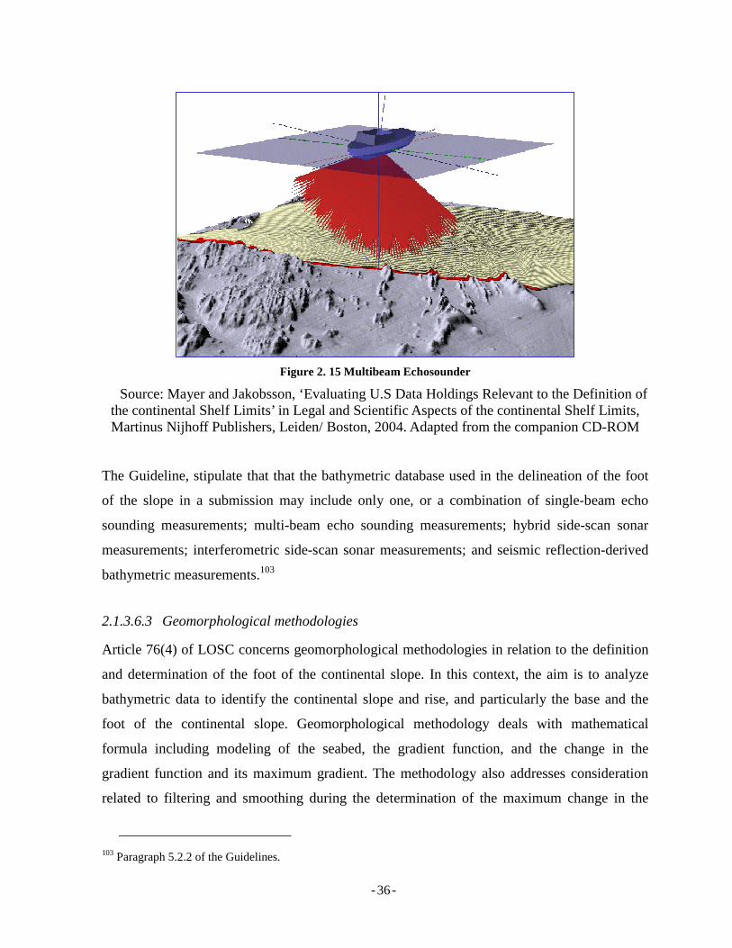
- - 36
Figure 2. 15 Multibeam Echosounder
Source: Mayer and Jakobsson, ‘Evaluating U.S Data Holdings Relevant to the Definition of the continental Shelf Limits’ in Legal and Scientific Aspects of the continental Shelf Limits, Martinus Nijhoff Publishers, Leiden/ Boston, 2004. Adapted from the companion CD-ROM
The Guideline, stipulate that that the bathymetric database used in the delineation of the foot
of the slope in a submission may include only one, or a combination of single-beam echo
sounding measurements; multi-beam echo sounding measurements; hybrid side-scan sonar
measurements; interferometric side-scan sonar measurements; and seismic reflection-derived
bathymetric measurements.103
2.1.3.6.3 Geomorphological methodologies
Article 76(4) of LOSC concerns geomorphological methodologies in relation to the definition
and determination of the foot of the continental slope. In this context, the aim is to analyze
bathymetric data to identify the continental slope and rise, and particularly the base and the
foot of the continental slope. Geomorphological methodology deals with mathematical
formula including modeling of the seabed, the gradient function, and the change in the
gradient function and its maximum gradient. The methodology also addresses consideration
related to filtering and smoothing during the determination of the maximum change in the
103 Paragraph 5.2.2 of the Guidelines.
- - 37
gradient at the base of the continental slope. Smoothing and filtering are the important
processes in dealing with data. Different techniques in filtering and smoothing may result in
different interpretations of the same data, which in turn, may result in different understanding
in relation to the determination of the FOS.
Geomorphological methodologies involve complicated and high-level mathematical equations
and formulae which are not detailed here. This requires good scientific understanding from
experts in relevant disciplines.104
There is also a requirement for a submission to be accompanied with scientific and technical
data.105 In addition, it should not be submitted only with data but also with explanation
concerning the approach to the methodologies in obtaining and processing the data, as well as
the weakness it may have. Further more, the identification of the continental slope, most of the
time, is not straight forward. For seabed with a highly complex topography, the options for the
location of the FOS are usually not obvious and even ambiguous. In this case, the definition of
the FOS requires sophisticated mathematical treatment and three-dimensional modeling of the
seabed, the gradient function, and the change in the gradient function and its maximum.
Data obtained from field survey is expected to be the close representation of the real condition
of the seabed. However, being discreet data, they can never precisely represent the real world.
The limited numbers of survey points acquired during the survey is one of the reasons the data
cannot represent the real topography of the seabed. In order for the data to be able to depict the
surface of the seabed as close as possible, modeling and filtering are required. The choice of
models and filtering methods will define how accurate and precise the data can represent
topography of the seabed. Therefore, that three-dimensional filtering and smoothing may play
significant roles during the determination of the maximum change in the gradient at the base
of the continental slope.106
104 Detailed explanation of the formula can be found in Module IV of the Training Manual for delineation of the outer limits of the continental shelf beyond 200 nautical miles and for preparation of submissions to the Commission on the Limits of the Continental Shelf, published by United Nations in 2006. 105 Commission on the Limits of the Continental Shelf. 2007. “Rules of Procedure of the Commission on the Limits of the Continental Shelf”, (CLCS/40). Hereafter CLCS/40. Rule 45. Available at http://www.un.org/Depts/los/clcs_new/commission_documents.htm, accessed on 3 July 2007. 106 See: Module IV of the Training Manual for delineation of the outer limits of the continental shelf beyond 200 nautical miles and for preparation of submissions to the Commission on the Limits of the Continental Shelf, published by United Nations in 2006.
- - 38
2.1.3.6.4 Geological methodologies
Geological aspects are concerned of Article 76(4)(a) of the LOSC regarding continental
margin, paragraph 4(b) regarding the evidence to the contrary concerning the determination of
foot of slope, and paragraph 6 regarding submarine ridges, and other natural components of
the continental margin such as plateux, rises, caps, banks and spurs.
As previously mentioned, in exploring scientific perspectives of the continental shelf,
geomorphology is the dominant consideration in determining the outer limits of the ECS.
However, it was also noted that geological aspects play an important role, especially when the
determination using purely geomorphological methodologies is unsatisfactorily. In addition,
Article 76 does not offer a comprehensive, general definition of the foot of the continental
slope as such. Paragraph 4(b), for example, only refers the foot of slope “as the point of
maximum change in the gradient at its [the slope’s] base”. This is a mathematically based
prescription of how the FOS is to be determined in the context of UNCLOS. However, the
same paragraph also states that this method applies “in the absence of evidence to the
contrary”, which implies there are a variety of alternative ways to determine the foot of the
continental slope. Different alternatives may be applicable when there is evidence to show that
the FOS is not at the point of maximum change but elsewhere. In such cases, it is common to
speak of “the foot of the slope determined by means of evidence to the contrary”. To an extent,
this also indicates that the wording of Article 76(4) (b) of the LOSC can be interpreted in some
different ways.
Geologic methodology deals with the way to determine the FOS by considering the geological
structure of the seabed. This considers, for example, that oceans and continents, as well as the
continental margins, have different structures and are formed by plate tectonic processes,
which in this case is a geological process. In addition, there are two main types of the
continental margins: the passive, or divergent, continental margin and the active, or
convergent, continental margin. Both of the major types may merge laterally into a third type,
the sheared or transformed continental margin. Consequently, the characteristics of the
margins, including the nature of the continent-ocean boundary, are determined by the tectonic
and magmatic processes acting under the formation of the individual margin. The natural
variations in continental margins are also reflected in variations in their continental slopes.
- - 39
Thus, geologic methodologies related to understanding the nature of the seabed in a geologic
perspective and are essential in defining the outer limits of the ECS.
2.1.3.6.5 Geophysical Methodologies
One of the formulae to define the outer limits of the continental shelf is sedimentary rock
thickness. Article 76 4(a) (i) states that the limit should be defined by a line delineated by
reference to the outermost fixed points at each of which the thickness of sedimentary rocks is
at least 1 per cent of the shortest distance from such point to the FOS. Geophysical
methodologies are applied in determining the thickness of sedimentary rock at particular
points on the seabed.
Geophysical methodologies concern the data suitable for mapping and documenting the limits
of the ECS, as well as data and procedures for depth conversion and sediment thickness
estimation.107 In addition, it governs how to estimate the uncertainties involved in the
determination of sediment thickness. Furthermore, geophysical data are required in the
desktop studies prior to submission, as well as in the detailed determination and
documentation of the sediment thickness pursuant the LOSC and other relevant provisions.
In most cases, only the 2-dmension multi-channel seismic reflection data is suitable data for
the purpose of determining sediment thickness. The process involves seismic data acquisition
at certain locations that are selected carefully, dedicated data processing, geological
interpretation, and depth conversion of the seismic profiles. Sediment thickness is determined
primarily by geological interpretation and the depth conversion procedures. In addition, the
geological interpretation is also important in gaining an in-depth understanding of the
sedimentology of the area since this may be critical for the selection of the final outer limit
points.108
It is understandable that determining the thickness of the sediment is complicated. In order to
determine sediment thickness, the base for the reference for thickness measurement needs to
be determined. The base of the sediment is the top of the basement from which the thickness
of the sediment is measured. Basically, measuring the thickness means calculating distance
107 United Nations, 2006, op cit. Module IV (1-1). 108 Ibid.
- - 40
from the base to the top of the sediment. Mathematically, distance is calculated using velocity
(speed) and travel time, where distance equals velocity times travel time. In this case, the
velocity concerned is that of the seismic wave released from certain equipment and is reflected
by the top of the basement. The wave travels two ways from the equipment to the top of
basement and then return to the point where it comes from.
The definition of the base of the sediments and the quality of the velocity model are the two
most critical factors in calculating the sediment thickness. The velocity model is used to
represent the speed of the seismic wave in different media (i.e. water and sedimentary rock) in
relation to the derivation of distance (depth) in m from two-way travel time. The availability of
adequate data and the implementation of relevant methods will significantly influence the
results in determining sediment thickness. Therefore geophysical methodologies play
important roles in delineating the outer limits of the ECS.
2.1.4 Uncertainties
As previously noted, the definition of the outer limits of the ECS governed in the LOSC is one
of the main achievements of UNCLOS III in 1982. Nonetheless, the procedures to delineate
the outer limits of ECS described in Article 76 are prone to uncertainties. These uncertainties
can be contributed to by the availability of data and the methods to interpret the existing data.
There are several sources of uncertainties in defining outer limits of the continental shelf, as
summarized in Table 2.1.
It should be anticipated that the errors can also be caused by a combination of error sources
listed in Table 2.1, so that "contributions to the overall error budget will vary according to the
nature of the operation, to the ease of deriving the parameter in question, and to the technique
that is employed."109 These uncertainties will, in turn, cause problems in defining the final
outer limits of the ECS. These issues of uncertainness have to be considered by coastal States
in preparing their submission. Similarly, this has also to be taken into account by the
Commission in assessing submissions and in providing recommendations regarding these
submissions. To an extent, these uncertainties can also be sources of problems for the
Commission in assessing and making recommendation.
109 Ibid.
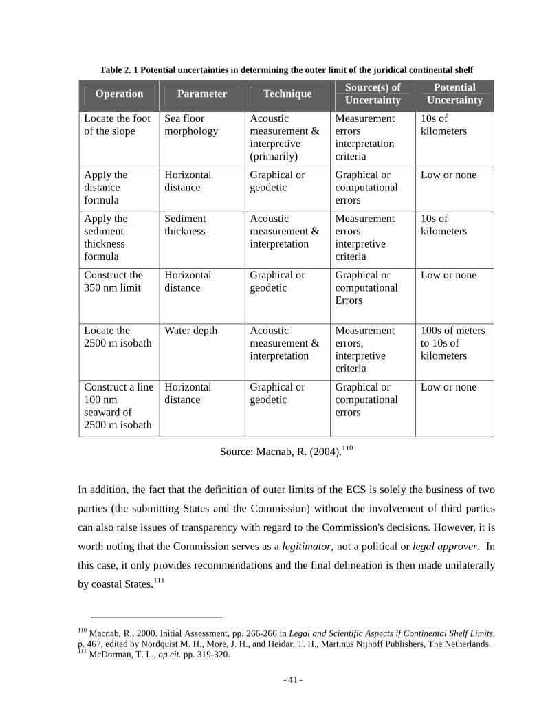
- - 41
Table 2. 1 Potential uncertainties in determining the outer limit of the juridical continental shelf
Operation Parameter Technique Source(s) of Uncertainty
Potential Uncertainty
Locate the foot of the slope
Sea floor morphology
Acoustic measurement & interpretive (primarily)
Measurement errors interpretation criteria
10s of kilometers
Apply the distance formula
Horizontal distance
Graphical or geodetic
Graphical or computational errors
Low or none
Apply the sediment thickness formula
Sediment thickness
Acoustic measurement & interpretation
Measurement errors interpretive criteria
10s of kilometers
Construct the 350 nm limit
Horizontal distance
Graphical or geodetic
Graphical or computational Errors
Low or none
Locate the 2500 m isobath
Water depth Acoustic measurement & interpretation
Measurement errors, interpretive criteria
100s of meters to 10s of kilometers
Construct a line 100 nm seaward of 2500 m isobath
Horizontal distance
Graphical or geodetic
Graphical or computational errors
Low or none
Source: Macnab, R. (2004).110
In addition, the fact that the definition of outer limits of the ECS is solely the business of two
parties (the submitting States and the Commission) without the involvement of third parties
can also raise issues of transparency with regard to the Commission's decisions. However, it is
worth noting that the Commission serves as a legitimator, not a political or legal approver. In
this case, it only provides recommendations and the final delineation is then made unilaterally
by coastal States.111
110 Macnab, R., 2000. Initial Assessment, pp. 266-266 in Legal and Scientific Aspects if Continental Shelf Limits, p. 467, edited by Nordquist M. H., More, J. H., and Heidar, T. H., Martinus Nijhoff Publishers, The Netherlands. 111 McDorman, T. L., op cit. pp. 319-320.
- - 42
2.2 Concluding Remarks
The definition of the continental shelf and the procedures for delineating the ECS have been
discussed in Chapter 2. Extensive description and analysis have been provided concerning the
delineation of the ECS pursuant to Article 76 on the LOSC with emphasis on formulae and
constraints. Scientific and technical methodologies have also been outlined providing insight
concerning technical implementation of the LOSC provisions concerning continental shelf
delineation by coastal States.
Pursuant to Article 76 (8), coastal States should make a submission to the Commission, which
contains information regarding the outer limits of their ECS. With recommendation provided
by the Commission, coastal States then establish their final and binding outer limits of the
ECS. Detailed explanation on the Commission and its work will be expanded in Chapter 3.
- - 43
Chapter 3 The Commission on the Limits of the Continental Shelf
The Commission on the Limits of the Continental Shelf (the Commission) was established in
accordance with Article 2 of Annex II to the LOSC. The Commission, which has been
described as "a technical body in a political world",112 was established to facilitate the
implementation of Article 76 of the LOSC, particularly those related to the definition of the
outer limits of the continental shelf beyond 200 M measured from coastal States' baseline. This
section discusses three main topics in relation to the Commission, namely the membership,
role and functions, and the procedure which a coastal States should follow in making an ECS
submission to the Commission.
3.1.1 Membership
Membership of the Commission is governed by Article 2 of Annex II to the LOSC. The article
states that:
[…] the Commission shall consist of twenty-one members who shall be experts in the field of geology, geophysics or hydrography, elected by States Parties to the Convention from among their nationals, having due regard to the need to ensure equitable geographical representation, who shall serve in their personal capacities.
There are at least four important points to note from Article 2 of Annex II to the LOSC
concerning the membership of the Commission, namely the expertise; the procedure for
elections; the equitability of geographical representation; and that the members serve in their
personal capacities. With regard to expertise, it is clear that a candidate should have expertise
in geology, geophysics or hydrography. Considering the Commission’s tasks which are related
to earth measurement and observation, expertise should also include other geosciences
disciplines such as geodesy and geography.
In addition, the provision confirms that members of the Commission should be elected from
and by State parties to the LOSC that represent equitable geographical representation. This
means that the members should be elected from all representing regions of State parties to the
LOSC. In addition, paragraph 3 of the same article specifies that no less than three members
112 McDorman, T. L., op cit. pp. 301-324.
- - 44
shall be elected from each geographical region. The regions referred to in this provision are
Africa, Asia, Eastern Europe, Latin America and Caribbean, and Western Europe and Others.
With regard to the proportion ratio, the existing provision was questioned in the 2007 Meeting
of States Parties to the LOSC. During the meeting, some delegations from Asia and Africa
viewed that the geographical distribution of seats for the Commission should be changed due
to the increase in the numbers of State Parties. A decision has been made concerning the new
allocations of seats for members of the Commission where Africa and Asia will be given six
and five seats in a rotation manner. In the next election (2012), Asia will be given six seats,
while Africa will occupy five seats. In the following election, Africa will have six allocations
of seats while Asia will be given five seats.113
At the time of writing, the Commission has conducted three membership elections, namely in
1997, 2002 and 2007 for a term of five years for each period. On 23 April 2002, the Twelfth
Meeting of States Parties to the LOSC elected 21 members of the Commission, commencing
from 16 June 2002.114 These 21 members came from five regions as follows:
1. Four members from the African States Group;
2. Six members from the Asian States Group;
3. Three members from the Eastern European States Group;
4. Four members from the Latin American and Caribbean States Group; and
5. Four members from the Western European and Other States Group.
The third election for the new members of the Commission was held in its nineteenth session
on 14 June 2007, during the seventeenth Meeting of States Parties to the Convention.115 In
preparation for the 2007 election, State parties to the LOSC were invited to submit candidates
during the period of 15 December 2006 to 14 March 2007. By the deadline, twenty-six
candidates were presented by State parties.116
113 States Parties to the United Nations Convention on the Law of the Sea. 2007. “Decision on the allocation of seats on the Commission and the Tribunal”, SPLOS/163, Annex I, at http://www.un.org/Depts/los/meeting_states_parties/SPLOS_documents.htm, accessed on 10 November 2007. 114 See also: http://www.un.org/Depts/los/clcs_new/commission_2002elections.htm. 115 See also: Press Release of CLCS No. 1882 at http://www.un.org/News/Press/docs/2007/sea1882.doc.htm. 116 See: Appendix 2, as listed in the document of SPLOS/150, at http://www.un.org/Depts/los/meeting_States_parties/ SPLOS_documents.htm, accessed on 8 June 2007.
- - 45
The third election of the new CLCS member was concluded on 15 June 2007 and twenty one
new members have been elected for a five-year term among the 26 nominated candidates.
These new members and their nationalities are listed in Appendix 3.
With regard to privileges and immunities of the members of the Commission, it is confirmed
that their status is the same as that of experts on mission in accordance with one of the basic
legal instruments of the United Nations.117
3.1.2 Roles and Functions
The legal basis of the establishment of the Commission can be found in Article 76(8) of the
LOSC. The article clearly states that the Commission is the technical body to whom the outer
limits of the ECS shall be submitted. It is also confirmed that the Commission shall provide
recommendations to coastal States concerning the establishment of the outer limits of their
continental shelf. In addition, Article 76(8) asserts that limits of the continental shelf
established by a coastal State on the basis of recommendations provided by the Commission
shall be final and binding.
In case such recommendations are ignored, disagreements between coastal States and the
Commission exist. This issue is not stipulated in the Convention, nor in the rules of procedure
of the Commission. Referring to the provision in Article 77 of the LOSC, the sovereign rights
over the continental shelf does not depend on active claims. Coastal States can always exercise
their sovereign rights over the continental shelf, even though there is disagreement with the
Commission. The only issue is that there will be no certainty concerning the breadth/extent of
the jurisdiction until the outer limits of the ECS are set. In case coastal States insist to establish
the outer limits of the ECS without complying with the Commission’s recommendations,
protest or disagreements may also arise from neighboring States. It then becomes a bilateral
issue/dispute between sovereign States, a situation in which the Commission does not have
competence.
117 This is stated by the Legal Counsel through a letter addressed to the Commission on the Limits of the Continental Shelf (CLCS/5), which states that "by established precedent in respect of similar treaty organs, the members of the Commission on the Limits of the Continental Shelf can be considered to be experts on mission
- - 46
Pursuant to Article 76, the establishment of CLSC is governed by Annex II to the LOSC. The
roles and functions of the Commission are found in Article 3(1) of the Annex, which states
that:
The functions of the Commission shall be:
(a) to consider the data and other material submitted by coastal States concerning the outer limits of the continental shelf in areas where those limits extend beyond 200 nautical miles, and to make recommendations in accordance with article 76 and the Statement of Understanding adopted on 29 August 1980 by the Third United Nations Conference on the Law of the Sea;
(b) to provide scientific and technical advice, if requested by the coastal State concerned during the preparation of the data referred to in subparagraph (a).
Article 3(1) of Annex II to the LOSC stipulates that the Commission is responsible for
considering submission made by coastal States, making recommendation concerning the
submission and providing scientific and technical advice, if requested by the coastal States
concerned during the preparation of a submission.
It has to be noted that delineating the outer limits of the ECS should be done unilaterally by
coastal States. This indicates that the Commission does not serve as a judge or a court that will
delineate the outer limits of the ECS for a coastal State. It only provides recommendations and
it is then the obligation of the coastal States to conduct the delineation.
With regard to the roles and functions of the Commission, there are apparently some potential
problems to anticipate. One critical point concerns the fact that the submission made by a
coastal State to the Commission will be responded to by the Commission through
recommendations. In case the Commission recommends the coastal State to amend its
submission, then the coastal State will need to resubmit its submission. This may result in a
"ping-pong" situation with no certainty concerning the end-point of the process. This
perspective is understandable as there is no provision concerning the time-frame of
covered by Article VI of the General Convention on the Privileges and Immunities of the United Nations. See: CLCS/5 at http://www.un.org/Depts/los/clcs_new/commission_documents.htm.
- - 47
recommendation and revision process.118 Therefore, clear and specific rules regarding this
might need to be established.
Similarly, this “ping-pong” situation was also admitted by the chairman of the Commission for
the period of 2002-2007 (re-elected in 2004). This can be inferred from the process concerning
submission and recommendation with regard to the Russian Federation's submission. Russia
made its submission in 2001 and it was considered by the Commission for the first time during
its 10th session in March 2002. Recommendations by the Commission were provided to the
Russian Federation Government which responded with several technical questions and
requests for confirmation. It was admitted that the questions were too technical and have to be
responded by subcommission dealing with Russia's submission.119 This, to an extent, also
causes delay and lengthens the "ping-pong" process.
To overcome this situation, submitting States need to agree with the Commission regarding the
procedures on how to address the potential “ping-pong” situation. Considering that the
Commission is not the judge for the submission, it may be viewed as a partner with whom a
coastal State will collaborate in delineating the outer limits of its ECS. In this regard, coastal
States should be able to establish a productive and mutual communication with the
Commission so that the best approach can be taken towards a successful submission of the
outer limits of the ESC.
Pursuant to Article 3 of Annex II to the LOSC, the Commission can also provide technical
assistance to a coastal State that will submit the outer limits of its ECS. Notwithstanding the
availability of assistance, it is interesting to note that as of April 2007, no State has officially
requested technical assistance to the Commission.120 Given the above, the Commission has
also underlined its willingness to assist States in that regard and encouraged them to make an
official request for such assistance, if required.121
118 McDorman, T. L., 2002., op cit. pp. 306-306. 119 Croker, P. F. 2004. The Commission on the Limits of the Continental Shelf: Progress to Date and Future Challenges. pp. 217-218 in Legal and Scientific Aspects if Continental Shelf Limits, p. 467, edited by Nordquist M. H., More, J. H., and Heidar, T. H., Martinus Nijhoff Publishers, The Netherlands. 120 This information was stated by the Chairman of the Scientific and Technical Advice Committee (2002-2007), Mr. Phillips Symonds, in the document of work progress of the nineteenth session of the Commission (CLCS/54). 121 CLCS/54, op cit.
- - 48
There are some terms by which other people and institutions see the role of the
Commission.122 Those terms include "a technical body in a political world", "the canary in the
mine shaft", "the policemen who oversee the application of Article 76", "a watchdog to
prevent excessive coastal State claims" and some other terms. The other thing is that some
opine that "when the Commission has done its work, the fact relevant to the outer continental
shelf will be drawn as clearly as a coastline on a nautical chart".
The above views might not precisely describe the roles of the Commission but does, at least,
indicate that the roles seen by State Parties to the LOSC might not be uniform and specific. It
can be observed that some may see the Commission as the judge that decides whether a
coastal State can delineate its outer limits of ECS or not. In regard to this opinion, the
Commission may be viewed as an institution sitting on the other side of the fence instead of a
partner, which is actually not the case.
Notwithstanding different interpretations regarding the roles and functions of the Commission,
it has continued its work and shows significant progress.123 As of December 2007, eight
submissions have been received by the Commission. The submissions are from Russia; Brazil;
Australia; Ireland; New Zealand; joint submission made by France, Ireland, Spain and the
United Kingdom of Great Britain and Northern Ireland; Norway; and France.124 The
Commission has provided recommendations to the submission of Russia and Brazil,125 and are
currently considering four submissions (Australia; New Zealand; joint submission by France,
Ireland, Spain and the UK of Great Britain; and Norway). However, the Commission has not
yet considered the submission of France that was made in May 2007.126
122 Croker, P. F., op cit. pp. 221-221. 123 Commission on the Limits of the Continental Shelf. 2007. “Statement by the Chairman of the Commission on the Limits of the Continental Shelf on the progress of work in the Commission, CLCS/56. Hereafter CLCS/56. Available at http://www.un.org/Depts/los/clcs_new/commission_documents.htm, accessed on 3 November 2007. 124 See also: the website of the Commission at http://www.un.org/Depts/los/clcs_new/clcs_home.htm accessed on 3 November 2007. 125 Commission on the Limits of the Continental Shelf, “Statement by the Chairman of the Commission on the Limits of the Continental Shelf on the progress of work in the Commission, CLCS/54, (2007) Hereafter CLCS/54. Available at http://www.un.org/Depts/los/clcs_new/commission_documents.htm, accessed on 16 July 2007. 126 CLCS/56, op cit. pp. 1-1.
- - 49
3.1.3 Procedures for Submission
The procedures for submission of the outer limit of the ECS are outlined, in general, in Article
76(8) and (9) of the LOSC. As previously mentioned, the outer limits should be submitted to
the Commission (paragraph 8). It is then the role of the Commission to make
recommendations to the submitting coastal State with regard to the submission. Paragraph 9
adds that the submission shall be accompanied with charts and relevant information, including
geodetic data, permanently describing the outer limits of its continental shelf that shall be
deposited with the Secretary-General of the United Nations and The Secretary-General shall
give due publicity thereto.
With regard to the deadline for submissions, Article 4 of Annex II to the LOSC stipulates that
the submission by a coastal State shall be made "as soon as possible but in any case within 10
years of the entry into force of the LOSC for that State". However, it is worth noting that the
Guidelines were just adopted on 13 May 1999, which means that coastal States only had
detailed guidance for delineating the outer limits of their ECS since that time. It should be
unfair for coastal States that have ratified the LOSC a long time before that adoption of the
Guidelines if the ten-year period is calculated from the time the LOSC entered into force in
those coastal States. Therefore, the Meeting of the States Parties decided that in the case of a
State Party for which the Convention entered into force before 13 May 1999, the ten-year time
period should be commenced on 13 May 1999.127 In this case, the deadline for those said
States will be on 13 May 2009. This deadline is also applicable to Indonesia, which ratified the
LOSC in 1985.
Detailed procedures for submission are covered in the CLCS document: “Rules of Procedure
of the Commission on the Limits of the Continental Shelf” (CLCS/40, the Rules).128 This
document covers the procedures for submission by coastal States in its Part XI (Submission by
a coastal State), which contains ten rules (Rules 45-54). A flowchart for this procedure is also
contained in CLCS/40, and is provided for information in Appendix 1 of the present paper.
127 SPLOS/72, op cit. 128 Commission on the Limits of the Continental Shelf. 2007. “Rules of Procedure of the Commission on the Limits of the Continental Shelf”, (CLCS/40). Hereafter CLCS/40. Available at http://www.un.org/Depts/los/clcs_new/commission_documents.htm, accessed on 3 July 2007.
- - 50
Rule 45 outlines the deadline for submission for coastal States intending to submit their outer
limits of the ECS.129 As previously mentioned, the deadline is 13 May 2009. However, there is
misunderstanding concerning the deadline for ECS submission among Government officials
and experts in Indonesia. Some opine that the deadline is 16 November 2009 for Indonesia,
simply a five-year extension after 16 November 2004, and ten years after the entry into force
of the LOSC.130 This misunderstanding should be revised otherwise Indonesia may
miscalculate the time for preparation and submission. Similar misunderstandings also may
occur in other coastal States. This should be well understood by coastal States, otherwise
submission might not able to be made on time.
The other important matter in Rule 45 is that coastal States also have to indicate in their
submission the name[s] of the Commission member[s] who provided technical assistance in
preparing the submission. This information may be used by the Commission while composing
the subcommission that will examine a particular submission. This is essential to prevent a
subcommission from considering a submission subjectively. A member, who provided
technical assistance to a State, should not be the member of the subcommission that will
consider that submission.
Rule 46 concerns “submissions in case of a dispute between States with opposite or adjacent
coasts or in other cases of unresolved land or maritime disputes”.131 In case there is a dispute
between two or more neighboring States, either adjacent or opposite, the submission can still
be made. This should be pursuant to the Annex I to the Rules, which states that the submission
and consideration by the Commission of that submission should not prejudice the maritime
boundary delimitation between the neighboring States. However, the Commission is not in a
position to delimit maritime boundaries of the submitting States. In addition, a joint
submission is also one of the solutions in case there is unsettled land or maritime boundaries
among neighboring Coastal States.
129 CLCS/40, op cit. pp. 15-16. 130 Personal opinion was published by Mr. Suhana, a researcher in the Department of Marine Affairs and Fisheries of Indonesia, in http://ocean.iuplog.com/default.asp?item=186387. Through personal communications wit some Indonesian law of the sea experts in Indonesia, the author has also established that there exists some confusion with respect to the issue of deadlines. 131 CLCS/40, op cit. pp. 16-16.
- - 51
On 19 May 2006 the Commission has received one joint submission made by France, Ireland,
Spain and the United Kingdom of Great Britain.132 A subcommission is currently considering
the submission and expects to have the recommendations prepared for the Commission at the
twenty-first session on 17 March to 18 April 2008.133
Rule 47 states that a submission should be delivered in a specific format and language. The
format of submission is governed by the provisions of Annex II of CLCS/40, and states that
the Commission requires 22 copies of the executive summary, 8 copies of the main analytical
and descriptive part, and 2 copies of the part containing all data referred to in the analytical
and descriptive part. A submission can also be provided in an unaltered electronic form along
with the hardcopy versions. However, “in case of discrepancies between the electronic and
hard copy of the submission, the latter will be deemed the primary source.”134 The language of
the submission should be made in the Commission’s official language.135 If it is other than
English, then the Secretariat should translate it into English.
Once a submission is received, the Secretary-General should record it,136 notify the submitting
State upon receipt of the submission,137 and inform the Commission and all State Parties
through the appropriate channel.138 The executive summary of a submission will be made
available on the Commission’s official website so that all other State Parties can make their
analysis and response. Their response will also be published on the same website.
Rule 51 concerns the recommendations by the Commission concerning submissions by coastal
States. For this purpose, the Commission will form a subcommission to consider a specific
submission, unless otherwise provided. The consideration made by a subcommission should
then be submitted to the chair of the Commission in a written format. In considering a
132 See also: Commission on the Limits of the Continental Shelf (CLCS) Outer limits of the continental shelf beyond 200 nautical miles from the baselines: Submissions to the Commission: Joint submission by France, Ireland, Spain and the United Kingdom of Great Britain and Northern Ireland at http://www.un.org/Depts/los/clcs_new/submissions_files/submission_frgbires.htm, accessed on 24 April 2007. 133 CLCS/56, op cit. 6-7. See also: Llewellyn, H. 2007. The Commission on the Limits of the Continental Shelf: Joint Submission by France, Ireland, Spain, and the United Kingdom, pp. 677-693, International Comparative Law Quarterly, Vol. 56, July. 134 See: Annex III (I)(1)(2) of CLCS/40. 135 According to CLCS/40 Rule 19 official languages of the Commission are Arabic, Chinese, English, French, Russian and Spanish. 136 CLCS/40 Rule 48. 137 CLCS/40 Rule 49. 138 CLCS/40 Rule 50.
- - 52
submission, the Commission should invite the submitting State to attend the particular session,
in which a specific submission will be considered by subcommission. The invitation has to be
made at least sixty days before the opening date of the session.139
Upon receiving a recommendation by a subcommission, the Commission should decide
whether to accept it or ask the subcommission for amendment. Once the recommendation is
accepted, the “Chairperson of the Commission shall transmit to the Secretariat two copies of
the recommendations, one to be submitted to the coastal State, and one to remain in the
custody of the Secretary-General.”140 The coastal State then decides whether to accept the
recommendations or not. In case the recommendations are not accepted by the coastal State, a
revised submission should be made in reasonable time.141 The establishment of the outer limits
of the ECS based on the recommendations of the Commission is final and binding.142
The final outer limits of the ECS should be deposited by coastal States to the UN Secretary-
General in the form of charts and relevant geodetic coordinates. In case there are maritime
boundary delimitations with neighboring States, the coordinates and charts of these
delimitations should also be deposited.143 After this, the Secretary-General shall give due
publicity also to the recommendations of the Commission which in the view of the
Commission are related to those limits.144
3.2 Benefits of the Delineation of ECS
In a national forum conducted in Yogyakarta, Indonesia concerning the intention of Indonesia
to delineate the outer limits of its ECS and followed by a submission to the Commission, a
critical question was addressed to the forum by some participants: what benefit will Indonesia
obtain from delineating its outer limits of the continental shelf and submitting it to the
Commission? If Indonesia manages to complete its delineation, submit it with convincing data
and argumentation and the submission is recommended by the Commission, will the benefit
139 CLCS/40 Rule 52. 140 CLCS/40 Rule 53 paragraph 3. 141 Ibid. paragraph 4. 142 Ibid. paragraph 5. 143 Ibid. paragraph 6. See also: Elferink, A. G. O. 2004. Submission of Coastal States to the CLCS in Case of Unresolved Land and Maritime Disputes, pp. 263-285 in Legal and Scientific Aspects if Continental Shelf Limits, p. 467, edited by Nordquist M. H., More, J. H., and Heidar, T. H., Martinus Nijhoff Publishers, The Netherlands.
- - 53
Indonesia gains be worth the expensive cost of delineation and preparing the submission?
These may be a typical question considered by a coastal State, particularly a developing one.
This section outlines certain benefits of delineating the outer limits of the ECS and its
submission to the Commission, namely: declaration of sovereign rights and economic benefit.
3.2.1 Declaration of Sovereign Rights
Coastal States exercise sovereign rights on the continental shelf where the States secure rights
to explore and exploit natural resource therein.145 Submitting the outer limits of the ECS
means the confirmation of coastal States' sovereign rights over a definitive (certain) extent of
seabed area. It is true that coastal States are sovereign over continental shelf even they do not
do anything but the delineation will help them determine the limits to what extent they may
exercise the sovereign rights. In the age where coastal States are given rights to extend their
continental shelf beyond 200 M, certain and definitive claims are required, otherwise other
States may delineate overlapping areas as long as they can prove that the seabed is part of their
continental shelf (meeting the test of appurtenance).
By delineating and submitting the outer limits of the ECS, a coastal State will gain
acknowledgment of its sovereign rights over a certain area of the seabed from international
community, provided that the submission is in no conflict with others and is recommended by
the Commission. This, in return, may prevent other States from claiming maritime areas in
question and also ovoid unnecessary dispute over certain maritime areas. In addition, the
submission will therefore enable the coastal State to exercise its continental shelf rights with
significantly greater certainty in the future.
By securing acknowledgement from the international community concerning the ECS, a
coastal State will be able to explore and exploit natural resources in and on the seabed without
causing disputes with other States. It serves as a political guarantee for peaceful seabed
resource utilization, which is very important when it concerns the provisions of exploration
concession to a multinational company, for example. Without certainty concerning the limits
of maritime jurisdiction, especially the extent to which an exploration can be conducted, no
company will take a risk of investing their capital. This, in return, can result in a negative
144 CLCS/40 Rule 54.
- - 54
impact on the national economy. On the other hand, by not delineating the ECS, a coastal State
my save significantly in terms of cost for delineation. However, at the same time it loses the
chance to extend the area over which it can exercise sovereign rights, and potentially exploit
mineral resources.
3.2.2 Economic Benefits
Another critical question about delineating the outer limits of the continental shelf is how it
will be valuable to coastal States economically. Economic benefit is the matter that coastal
States will usually consider before delineating the outer limits of ECS and making their
submissions to the Commission. This is usually challenged by the parliament of a coastal State
before the decision to lodge submission is made. Therefore, the delineation and submission
team of a coastal State has to be able to prove that the delineation and the submission are
economically worth it.
In case a coastal State is entitled to ECS, it will definitely secure additional seabed area
compared to that it originally secures by the only 200 M of the continental shelf entitlement.
Considering the potential economic implication of this extension, it may be considered to be
an outstanding investment. A coastal State secures “sovereign rights for the purpose of
exploring” the continental shelf and “exploiting its natural resources”.146 It is defined that the
natural resources of the continental shelf consists of the
[…] mineral and other non-living resources of the sea-bed and subsoil together with living organisms belonging to sedentary species147, that is to say, organisms which, at the harvestable stage, either are immobile on or under the sea-bed or are unable to move except in constant physical contact with the seabed or subsoil.148
This also includes organisms such as sponges and molluscs.
Relatively little is known about the resources of the continental shelf beyond the EEZ, but they
may include mineral and petroleum resources, and possibly yet-to-be-discovered marine
145 Article 77 (1), of the LOCS. 146 Article 77 (1), LOSC. 147 Sedentary species is also governed in Article 68, LOSC. 148 Article 77 (4), LOSC.
- - 55
species and microorganisms that could have potentially valuable applications in a number of
sectors including medicine.
Bioprospecting describes activities including the discovery and utilization of new biological
seabed resources for new applications. There is no single universally adopted definition of
bioprospecting, but generally it may be defined as “the entire research and development
process from sample extraction by publicly funded scientific and academic research
institutions, through to full scale commercialization and marketing by commercial interests
such as biotechnology companies.”149 One of the latest publications concerning bioprospecting
is published by the United Nations University (UNU) in relation to the Eighth Meeting of the
United Nations Informal Consultative Process on Oceans and the Law of the Sea.150 It has
been found that diverse ranges have been discovered with regards to deep sea biological
communities. This discovery, including hydrothermal vents, methane seeps and deep sea
sediments in the extreme environments has provided indication that organisms present in these
communities have unique properties to be explored further for the development of science and
technology.
Given the above, it is not surprising the global trends of bioprospecting are increasing and
include sectors such as biotechnology, waste, agriculture, and the pharmaceutical and
cosmetics industry. All these sectors are increasingly using biotechnology to develop new
products.151
The main reason behind efforts to define and delineate the outer limits of the ECS is
hydrocarbon resources in the seabed and water above it.152 Nowadays, the development of
deep seabed oil and gas exploration is expanding rapidly. Even though oil and gas exploitation
of the deep seabed started in the late 1970s, dramatic advances have been achieved during the
2000s as exemplified by the resource exploration in the Gulf of Mexico by the US, especially
149 Ibid. pp. 7-7. 150 United Nations, 2007. An Update on Marine Genetic Resources: Scientific Research, Commercial Uses and a Database on Marine Bioprospecting - United Nations Informal Consultative Process on Oceans and the Law of the Sea Eight Meeting, New York, 25-29 June 2007. 151 Arico, S. and Salpin, C. 2005. UNU-IAS Report - Bioprospecting of Genetic Resources in the Deep Seabed: Scientific, Legal and Policy Aspects, pp.25-25, United Nations University. 152 Kelly, P. L. 2004. Deepwater Oil Resources: The Expanding Frontier, pp. 413-419, in Legal and Scientific Aspects if Continental Shelf Limits, p. 467, edited by Nordquist M. H., More, J. H., and Heidar, T. H., Martinus Nijhoff Publishers, The Netherlands.
- - 56
in terms of the depth of drilling achieved. In 2001 a deepwater drilling record of 2,964 m was
set.153 As drilling becomes possible at deeper and deeper depths, with the advancement of
technology, is more productive exploration/exploitation of the seabed will become possible.
For example both in the Brazilian and US waters, oil production already takes place at a
depths greater than 2000 m.154
The advances in the application of geophysical exploration and computer technologies have
significantly enhance the success of deep seabed exploration and exploitation.155 It is now
possible to visualize 3D and even 4D data and combine them with other sources of satellite
data for better interpretation and information extraction. In addition, deeper and deeper
well/boreholes are now coming to reality for exploration due to the advances in technology.
Along with that, production platforms also come with significant innovations. The
development and advancement of oil exploration can also be seen in the Northeast Atlantic.
Oil explorations in several areas have been conducted by leading oil companies in the world
indicating the potential of seabed resources.156 Some gas and oil fields were discovered, for
example the Ormen Lange gas field in Norway deepwater, which was planned to come into
production in 2007; the Corrib gas field in offshore Ireland in 1996, which has been explored
by Shell Company; and some other gas and oil fields.157
Hydrocarbons might be the main economically high-value resource but non-hydrocarbon
resources are also significant with respect to the continental shelf. There are at least seven non-
hydrocarbon resources that have economic value to exploit in the continental shelf, including
placer deposits, phosphorite, evaporates, polymetallic, sulphides, gas hydrates, and manganese
nodules.158 Each resource has its own characteristics and economic value as well as places and
process of formation. Notwithstanding the high value of the non-hydrocarbon resources, the
exploitation of those resources has not yet been cost-effective for reasons such as high
153 Ibid. pp. 414-414. 154 Parson, Lindsay. 2004. Non-Hydrocarbon Resources. pp. 424-424, in Legal and Scientific Aspects if Continental Shelf Limits, p. 467, edited by Nordquist M. H., More, J. H., and Heidar, T. H., Martinus Nijhoff Publishers, The Netherlands. 155 Kelly, P. L., op cit. pp. 415-416. 156 Allinson, G. J., .2004. The Developments in Oil Exploration in the Northeast Atlantic, pp. 421-422, in Legal and Scientific Aspects if Continental Shelf Limits, p. 467, edited by Nordquist M. H., More, J. H., and Heidar, T. H., Martinus Nijhoff Publishers, The Netherlands. 157 Ibid. pp. 421-422. 158 Parson, L., op cit. pp. 425-429.
- - 57
investment requirement and technology development. However, there is confidence among
experts that this situation will definitely change so that the resources will become recoverable
resources in the future.159 Some experts also predict that seafloor polymetallic massive
sulphide mining, which is considered as an international mining industry, is about to follow
the success of the off-shore oil industry that started nearly 40 years ago.160
Notwithstanding potential economic resources that are exploitable from the continental shelf,
some opinions say that delineating the outer limits of the ECS is not worth the trouble.161 For
these commentators, the cost of the carrying out the preparations, including the field surveys
and document preparations, is too high compared to the benefits a coastal State may gain. For
a developing country like Indonesia, for instance, it would be wiser, they say, to spend the
money on other sectors that are more important, such as healthcare and education.
This argument may appear valid at first sight. It is true that a coastal State should not
carelessly lavish money on something that has no benefit. Furthermore, it is clear that the
benefits of an ECS delineation and submission will not be felt straight away. It is not
something that can be judged beneficial instantly. Rather, this is an investment for the
future.162 As previously highlighted, the cost of the delineation of the ECS for Indonesia may
equal the tuition fees of hundreds of students studying in universities. Therefore the benefits
may be viewed as incomparable with the associated cost, at least when only considering
instant benefits. However, the benefits may far outweigh the costs of the project when it is
viewed through a long term perspective. The potential seabed resources, the issue of maritime
security and sovereign rights, are just a few long term benefits.
3.3 Concluding Remarks
Several important issues concerning the Commission have been presented in Chapter 3,
including the compassion of the Commission, its roles and functions, and the procedure for a
159 Ibid. pp. 429. 160 Herzig, P. M., Seafloor Massive Sulfide Deposits and Hydrothermal Systems. pp. 446, in Legal and Scientific Aspects if Continental Shelf Limits, p. 467, edited by Nordquist M. H., More, J. H., and Heidar, T. H., Martinus Nijhoff Publishers, The Netherlands. 161 Discussion in an international workshop on legal and technical aspects of maritime boundary delimitation held by the Department of Geodetic Engineering, Gadjah Mada University in Yogyakarta on 4 May 2005. 162 Arsana, I M. A. and Putri N. M. K. 2006. Indonesia has much to gain from extension of continental shelf , The Jakarta Post, 11 December 2006, Jakarta, Indonesia.
- - 58
coastal State to submit the outer limits of its ECS. Critiques concerning the roles of the
Commission coupled with how the Commission is viewed by other parties have also been
outlined. Chapter 3 has also described the benefits of delineating the outer limits of the ECS
for coastal States and the importance of submitting it to the Commission. The following
chapter will focus on the case of Indonesia in delineating the outer limits of its ECS and
preparation of its submission to the Commission. This will include the latest development of
the delineation as well as problems arisen during the preparation for its submission to the
Commission.
- - 59
Chapter 4 The Indonesian Case
While there is some debate over precisely which coastal States may be able to delineate the
ECS, Indonesia has been consistently viewed as one of the States with the opportunity to
delineate its ECS and submit it to the Commission. As an archipelagic State, which ratified the
LOSC in 1985, Indonesia has been bound by the LOSC for more than two decades163.
Pursuant to Article 76 of the Convention, Indonesia is currently delineating its ECS and
preparing submissions to the Commission. As previously mentioned, Indonesia will be one of
the States with the earliest deadline for a submission, which is 13 May 1999.164
This chapter outlines the delineation of the outer limits of the ECS ant the preparation for
submission to the Commission in the case of Indonesia. This encompasses the definition of
potential the ECS outer limits and toward the requirements to fulfill for the preparation of the
submission to the Commission.
4.1 Defining the Potential Outer Limits of the ECS
Prior to discussing the potential outer limits of ECS for Indonesia, it is necessary to briefly
recall the history of Indonesia's maritime jurisdictions. Indonesia’s first claim to maritime
jurisdiction dated from the 1950s when its sovereignty over the whole maritime area in the
entire Indonesian Archipelago was declared on 13 December 1957 through the Djuanda
Declaration.165 The declaration served to assert the Indonesian view that its land territory and
maritime area are one united entity where Indonesia exercises full sovereignty.166 In this early
stage, Indonesia was focused on winning international recognition for its status as an
archipelagic State. This became the starting point of Indonesia's claims over other maritime
jurisdictional zones including the territorial sea, the contiguous zone, the EEZ and the
continental shelf.
163 Indonesia ratified the LOSC on 31 December 1985 through the Law no. 17/1985. The Indonesian version of this law can be downloaded from http://www.menlh.go.id/i/art/pdf_1038295269.pdf, accessed on 12 October 2007. 164 See: section 3.1.3 regarding the deadline for a submission. SPLOS/72, op cit. 165 The Djuanda Declaration is proposed by Mr. Djuanda Kartawidjaja, the eleventh Prime Minister of Indonesia. He was also the latest prime minister on Indonesia.
- - 60
Indonesia ratified the 1958 Convention in 1973 as well as declared the Indonesia’s continental
shelf.167 The law no 1/1973 officially declares Indonesia's sovereign rights over its continental
shelf in accordance with the provisions of the 1958 Convention. With the entry into force of
the LOSC in 1982, the archipelagic State regime was officially recognized by the international
community. The provisions concerning archipelagic States are included in the 1982
Convention, which for Indonesia is a significant development. Pursuant to the LOSC, an
archipelagic State like Indonesia may claim several maritime jurisdictions such as archipelagic
waters,168 territorial sea,169 EEZ,170 and continental shelf.171 The breadth of each maritime
jurisdiction is measured from baselines. In addition, Indonesia is also possible to delineate its
ECS, the continental shelf beyond 200 M from its baseline from which the territorial sea is
measured.
Indonesia is a party to the LOSC, thus it is bound by its provisions. As a State party to the
LOSC, it is required to submit the outer limit of its ECS to the United Nations Secretary
General. A submission for consideration and recommendation needs to be submitted to the
Commission no later than 13 May 2009.172 The delineation of the outer limits of its ECS and
the preparation for the submission are currently being conducted, including technical and non-
technical activities. The present section outlines the delineation of the outer limits of the ECS
and preparation for submission, result of works and latest development; and also potential
boundary disputes and their possible resolutions.
4.1.1 Delineation of the Outer Limits of the ECS and Preparation for Submission
Since 2001, Indonesian scientists have been assessing the extent of the outer limits of
Indonesia’s ECS. Along with that studies have also been conducted in relation to the intention
to submit the outer limits of the ECS to the Commission. These works started two years after
166 The declaration was also known as the seed of Wawasan Nusantara. See also: the Doctrine of "Wawasan Nusantara" in Rudiyanto, A. 2002. A critical appraisal of marine and coastal policy in Indonesia including comparative issues and lesson learnt from Australia, PhD Thesis, University of Wollongong, Australia. 167 See: Law No 1/1973 concerning the Indonesian Continental Shelf. The document is available online from http://birohukumsiskum.sumutprov.go.id/myadmin/undang/1%20Tahun%201973.pdf, accessed 20 August 2007. 168 Article 49, LOSC. 169 Part II, LOSC. 170 Part V, LOSC. 171 Part VI, LOSC. 172 SPLOS/72, op cit.
- - 61
the adoption by the Commission of the Guidelines. Given the complexity of the task, it seems
that Indonesia’s early start was reasonable. In other words, the delineation and preparation
have been started eight years before the submission deadline. However, this early start does
not guarantee that Indonesia will be able to submit its extension without problems. In addition,
experiences from other States show that it may take up to ten years to prepare a submission.
For example, Australia with reasonably adequate resources and capacity, took around ten years
to present its submission to the United Nations in 2004.
The time needed for delineation and preparing a submission also depends on the way the
project is handled. Project management, in general, will influence the length of the project to
be undertaken before a submission can be made. This should include policy from the
Government, arrangements concerning team collaboration and also resource and capacity
availability.
As an archipelagic State that is a party to the LOSC, Indonesia may extend its continental shelf
beyond 200 M, provided requirements pursuant to Article 76 of the LOSC can be fulfilled. For
this purpose, Indonesia should delineate its ECS and then submit it to the Commission.
Therefore, the initial preparation would include the assessment of the possibility that Indonesia
can meet the requirements under Article 76 of the LOSC: test or appurtenance.173 If so, the
question would be "where are the locations?" This subsection outlines two main issues: the
institutions and the roles of external bodies and consultancies.
4.1.1.1 Institutions involved in the delineation and its submission
One of the first steps in the delineation of the outer limits of ECS and its submission includes
ensuring the administrative arrangements have been put in place. This has led to the
establishment of institutions that are assigned to handle the tasks related to Indonesia's ECS
delineation and submission to the Commission. With regard to this, the Indonesian
Government has formed both technical and non-technical bodies, which are to work in
coordination for the delineation and preparation of the submission. Three organizations were
established, namely the Technical Core Group (TCG), the National Steering Committee (NSC)
173 See: Article 76 (4), LOSC and Chapter 2 for the procedures to delineate the ECS. See also: CLCS/40 and Chapter 3 for the procedures of making a submission to the Commission.
- - 62
and the Legal Group (LG).174 In its early development, the team was established by the
mandate from the Minister of Energy and Mineral Resources (MEMR). The TSG’s main tasks
is to provide and collect supporting scientific data sets such as geodetic positioning, sea level,
bathymetric, seismic, gravity and magnetic data through field surveys and other sources.175
The data sets are than processed, assembled, analyzed and visualized on maps in order to
provide the technical documentation of the submission.
The TCG consists of several scientists in various scientific disciplines. This group has been
working since 2001 assessing the potentials for ECS submission for Indonesia. The members
of TCG come from several institutions including the National Coordinating Agency for
Surveys and Mapping (Badan Koordinasi Survey dan Pemetaan Nasional, hereinafter
Bakosurtanal), the Hydro-Oceanographic Department on the Indonesian Navy (Jawatan
Hidro-Oseanografi, hereinafter Janhidros), the National Agency for Technology Assessment
and Application (Badan Pengkajian dan Penerapan Technology, BPPT), the Department of
Ocean Affairs and Fisheries (Departmen Kelautan dan Perikanan, DKP), the Indonesian
Institute of Sciences (Lembaga Ilmu Pengetahuan Indonesia, LIPI), Marine Geology
Indonesia (Pusat Penelitian dan Pengembangan Geologi Kelautan, P3GL), and several
universities.
It is worth noting that the submission is treated as a project by the Indonesian Government,
and is handled by tailor-made bodies (committees, i.e. the institutions outlined above) assigned
to this specific task. However, people involved in the teams are apparently affiliated with
particular institutions, meaning that they are not exclusively assigned to the above outlined
bodies (i.e. TCG, NSC, and LG). Thus, the team members are required to keep doing their jobs
within their institutions, as well as working with the ECS submission. In a technical
perspective, the preparation is coordinated by the Bakosurtanal.
The NSC is another component of the Indonesian team for ECS submission. This committee is
aimed at providing advice and general direction in preparing the submission to the
174 Interview with Dr. Sobar Sutisna, Dr. Khafid and Ms. Tripatmasari of Bakosurtanal who are involved in the delineation of the Indonesia’s outer limits of the ECS and the preparation for its submission via email on 18 August 2007. 175 Ibid. Ideally, the document concerning the mandate of each group in the team should be obtained for this research purposes. However, due to issue of confidentiality, the efforts to secure the document were not
- - 63
Commission.176 The third component of the team is the LG, which is composed of relevant
authorities from the Indonesian Department of Foreign Affairs (DFA). In general, the LG is
responsible for the whole project. Therefore, it serves as the coordinator for the whole project
that will produce the final submission document for submission to the Commission. The LG
will compile the results of the technical assessment produced by TCG with the legal materials
and prepare a single complete submission package.
4.1.1.2 The roles of External Bodies and Consultants
In order to delimit the outer limits of ECS and prepare for its submission to the Commission,
Indonesia requires doing scientific studies, technical activities and legal preparation.
Indonesia, as much as possible, utilizes its national resources to accomplish the task. However,
due to certain limitations, collaboration with external bodies is required. The collaboration
concerns, mainly, the technical aspects, especially those regarding data acquisition and
processing. The collaboration is necessary because of a lack of technical equipment currently
possessed by Indonesia to conduct field surveys and to process the data required to delimit the
outer limits of the ECS. To conduct bathymetric and seismic surveys, for example, a
sophisticated survey vessel will be required. Since Indonesia’s survey vessel is inadequate, it
needs to hire a survey vessel form another State.
Apart from technical equipment, human resources will also be a concern. The use of survey
vessels from another State requires people with specific skills. Therefore, Indonesia will also
need assistance in terms of operating the equipment, as well in processing the data into useful
information for the delineation of the ECS. In addition, collaboration with other States and
consultants should also be treated as an opportunity for knowledge and technology transfer for
Indonesian.177
successful. Thus, conducting interviews with individual directly involved with the team was undertaken as alternative to obtaining necessary information. 176 Unfortunately, efforts to obtain additional information concerning NSC have not been successful. The roles of the NSC can not clearly be seen, especially in the technical preparation. 177 One professional consultant that assists Indonesia in preparing its submission is German Sonne - BGR Ship of Germany. Another consultancy was provided by a Norwegian private consultant, which assisted Indonesian team in conducting studies related to the ECS submission. This collaboration also includes data processing and Indonesian human resource training in Norway.
- - 64
As previously highlighted, the cooperation between the Indonesian team and these
professional consultants includes mostly technical data acquisition through field surveys.
However, the collaboration with is treated as a professional collaboration between the
Government of Indonesia and the private consultant, and not an inter-Governmental
collaboration.178 Therefore it should not be viewed that Indonesia as a State is assisted by, for
example, Norway or Germany, as States. Consequently, there is no political intention involved
in the collaboration. There is no political obligation for Indonesia as a consequence of the
collaboration. In addition, the submitted material and other supporting documents should all
be under the control of the Indonesian team. The issue of confidentiality concerning data and
analysis should be carefully considered. The Indonesian team and the consultants should agree
upon the mechanism to treat the data and results of the analysis or studies confidentially.
As previously outlined, it is possible for a coastal State to ask for technical assistance from the
Commission with regard to the preparation of its submission. Indonesia, as in the case with
other coastal States, has not shown its intention to take advantage of the of the Commission’s
expertise on this matter. No official request has been submitted by Indonesia to ask the
Commission's members involvement in preparing its submission. One reason for this is that
asking the Commission’s assistance may cause significant delay in the project as it would
require certain administrative procedures on the Indonesian side which is lengthy to
undertake.179
Engaging collaboration with external bodies usually sparks pros and cons. Considering that
there is a lack of technical equipment in Indonesia, the collaboration seems to be inevitable.
Collaboration seems to be an affordable solution as it is not economical for Indonesia to
purchase those equipments. In terms of expert availability, Indonesia certainly has adequate
resources in Government institutions and universities. Viewing this phenomenon, it might
seem that collaboration is not required. However, without adequate technical equipment, this
expertise will not be in a position to make substantial contributions.
178 Personal communication with Dr. Sobar Sutisna, the Head of Center for Boundary Mapping, Bakosurtanal on 18 August 2007. 179 Personal communication with Dr. Khafid of Bakosurtanal on 18 August 2007. He is an expert member of the Indonesian TCG representing the Bakosurtanal.
- - 65
Notwithstanding, the inevitability of collaboration, the important issue to be taken into account
is the cost of collaboration. The operation of a German survey ship for field survey (German
Sonne - BGR Ship), for instance, may cost USD 50,000 per day.180 Meanwhile, survey for an
area such as the south of Nusa Tenggara took nearly three weeks to complete and requires at
least 7 days for mobilization and demobilization. This means that the whole survey activity
may take four weeks to complete, which costs approximately USD 1,400,000. By way of
comparison, this sum can be used to pay tuition fees for approximately 600 students studying
engineering in good universities in Indonesia.181 Considering that access to good education is
one of the current problems for Indonesian citizens, this amount of money might be seen as
“too much”, and thus may spark controversy and resistance in regard to spending it on the
distant continental shelf.
4.1.2 Results of Work and Latest Developments
Indonesia has been working on the delineation of the outer limits of its ECS since 2001.
Subsequently, the preparation toward a submission to the Commission has also been carried
out since then. The delineation and preparation for submission started with preliminary
technical research conducted by the Bakosurtanal of Indonesia. Not only research conducted
by Indonesian experts that was considered, researches carried out by external parties are also
part of the consideration.
With regard to the preparation for submission, technical and non-technical work has also been
carried out in accordance with the Guidelines provided by the Commission. These following
sections outline four activities related to the Indonesia’s potential ECS including the global
study conducted by the USGS, studies conducted by Indonesian experts, field survey and data
processing, and legal preparation toward finalizing the submission.
4.1.2.1 Global Study by the USGS
One useful starting point for analysis of the potential ECS is publicly available data. To assess
the potential of an ECS by coastal States, the United States Geological Survey (USGS) has
180 Ibid. 181 The data is based on the tuition fees in Gadjah Mada University for the Department of Geodetic and Geomatic Engineering in 2007 with an average 5-year study period.
- - 66
conducted a global study. This is referred to as a global study as it covers the maritime’s areas
of the whole world and uses global data (from public domain sources). In addition, the results
of this study are also made available for public. This can be considered as a rough study with
very general results. In addition it has no particular emphasis on the Indonesian maritime area
(ECS) as it covers the whole world. However, it is still worth considering as it may be treated
as a starting point for Indonesia.
The result of the USGS global study shows that several locations adjacent to Indonesia have
potential for ECS, including the area to the west of Sumatera Island; and south of Bali,
Lombok and Sumba Islands. The shaded areas in the map depicted in Appendix 4 (taken from
the United States Geological Survey)182 indicate area with ECS potential, while the single
continuous lines represent the 200 M lines measured from the baselines of each coastal State.
The USGS underlines that this global study is by no means final and binding, and is only
intended to provide initial information for coastal States intending to delineate the outer limits
of their ECS and prepare for submission to the Commission.183 More detailed and
comprehensive studies are undoubtedly required before conducting the delineation and
preparing for submission. In other words, this global study should only be treated as a
reference but useful starting point nonetheless.
4.1.2.2 Preliminary Study by Indonesian Experts
For the purpose of delineating the outer limits of Indonesia’s ECS and its submission to the
Commission, Indonesian experts had already been conducted research as to analyze the
possibility for Indonesia to extend its continental shelf beyond 200 M. For example, a study
was conducted by Indonesian scientists in Bakosurtanal, published in 2005, concerning the
potential Indonesian ECS. The study assessed the locations of potential ECS and determined
the outer limits of each possibility.184 It utilized available data and software using relevant
method to conduct the assessment.185
182 Taken from http://geology.usgs.gov/connections/mms/landscapes/law_of_sea.htm, accessed on 7 July 2007. 183 Ibid. 184 Sutisna, S., Tripatmasari, and Khafid. 2005. Indonesian Searching for Its Continental Shelf Outer Limits. Proceeding of the 2005 ABLOS Tutorials & Conference "Marine Scientific Research and the Law of the Sea: the Balance between Coastal State and International Rights" 10-12 October. International Hydrographic Bureau,
- - 67
It was also inferred that the use of relevant software as an assisting tool for the above
mentioned study significantly eases the assessment process as it is equipped with the
Guidelines of the Commission. The study also used several types of data for the research
including:
• Indonesian Government Regulation (PP) No.38/2002 establishing the Indonesian baselines; • World Vector Shoreline (WVS), a digital chart of 1: 250,000 scale from the US National
Imagery and Mapping Agency (NIMA); • Bathymetric data derived from Digital Marine Resource Mapping (DMRM) Project 1996-1999,
which was obtained using SIMRAD EM12D Multibeam Echosounder;186; 187 • Global Bathymetric Data: ETOPO 2: A gridded database of bathymetry and land topography
covering the entire surface of the earth, which was supplied for free by CARIS; and • Sediment thickness data from the Indonesian National Centre for Geophysical Data.
The results of this study show that Indonesia may potentially extend its continental shelf
beyond 200 M to the west of Sumatra, south of Sumba Island and north of Papua, as shown in
Figure 4.1. In the figure, the position of the FOS, Gardiner lines, and Hedberg lines are clearly
depicted in three different locations. However, this preliminary study is only intended to
confirm the possibility of the presence on an ECS. The next step would be to conduct further
studies and the delineation itself.
Monaco. pp. 2-5, accessed from http://www.gmat.unsw.edu.au/ablos/ABLOS05Folder/SutisnaPaper.pdf on 26 December 2005. 185 This study used CARIS LOTS™ to simulate and assess the possibility for Indonesia to submit it’s a claim to ECS and model potential outer limits. The feature of CARIS LOTS™ used in this research is Article 76: United Nations Convention (UNCLOS), one of the main features of the software. 186 During the DMRM project 1996-1999, a bathymetric survey has been carried out using SIMRAD EM12D Multibeam Echosounder. The spatial distance between the line tracks are about 100 km and cover minimal 200 nm seaward from the baseline. The aim of this survey is to determine the limits of the Exclusive Economic Zone (EEZ) and to provide reconnaissance surveys for the continental shelf study. 187 Sutisna, S., Tripatmasari., and Khafid, op cit. pp. 3-3.
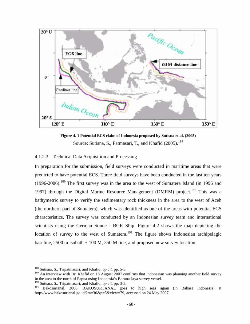
- - 68
Figure 4. 1 Potential ECS claim of Indonesia proposed by Sutisna et al. (2005)
Source: Sutisna, S., Patmasari, T., and Khafid (2005).188
4.1.2.3 Technical Data Acquisition and Processing
In preparation for the submission, field surveys were conducted in maritime areas that were
predicted to have potential ECS. Three field surveys have been conducted in the last ten years
(1996-2006).189 The first survey was in the area to the west of Sumatera Island (in 1996 and
1997) through the Digital Marine Resource Management (DMRM) project.190 This was a
bathymetric survey to verify the sedimentary rock thickness in the area to the west of Aceh
(the northern part of Sumatera), which was identified as one of the areas with potential ECS
characteristics. The survey was conducted by an Indonesian survey team and international
scientists using the German Sonne - BGR Ship. Figure 4.2 shows the map depicting the
location of survey to the west of Sumatera.191 The figure shows Indonesian archipelagic
baseline, 2500 m isobath + 100 M, 350 M line, and proposed new survey location.
188 Sutisna, S., Tripatmasari, and Khafid, op cit. pp. 5-5. 189 An interview with Dr. Khafid on 18 August 2007 confirms that Indonesian was planning another field survey in the area to the north of Papua using Indonesia’s Baruna Jaya survey vessel. 190 Sutisna, S., Tripatmasari, and Khafid, op cit. pp. 3-3. 191 Bakosurtanal. 2006. BAKOSURTANAL goes to high seas again (in Bahasa Indonesia) at http://www.bakosurtanal.go.id/?m=30&p=5&view=79, accessed on 24 May 2007.
0°
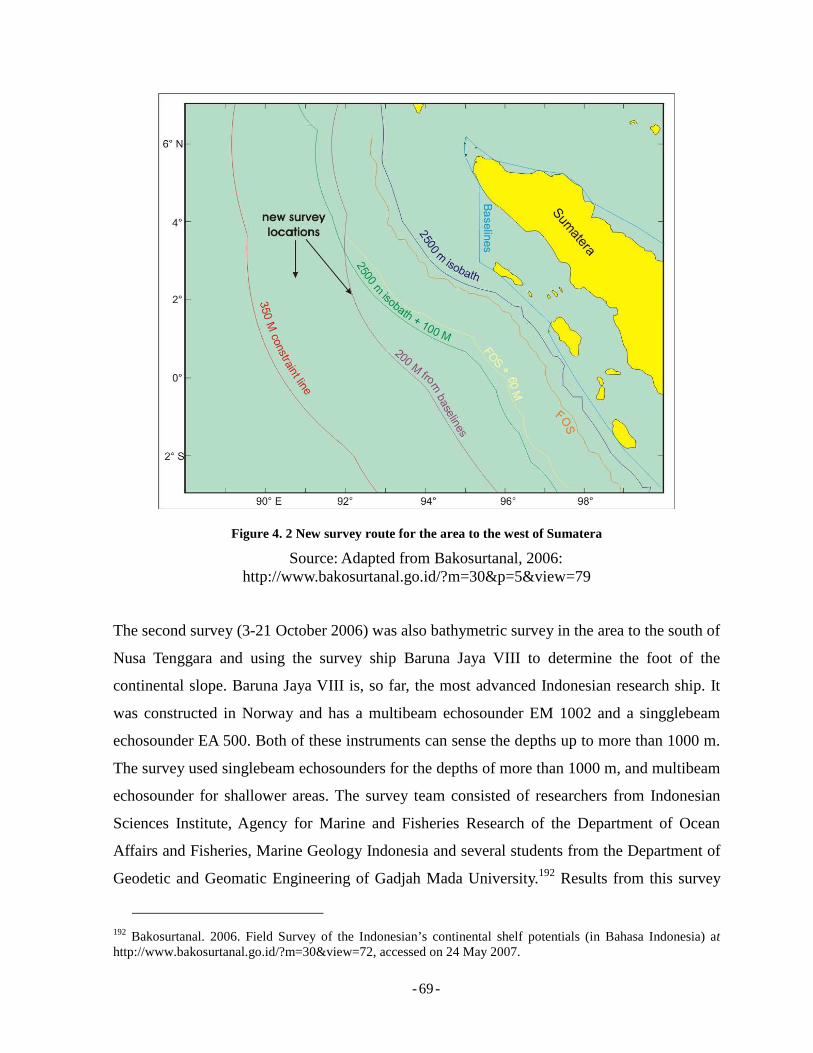
- - 69
Figure 4. 2 New survey route for the area to the west of Sumatera
Source: Adapted from Bakosurtanal, 2006: http://www.bakosurtanal.go.id/?m=30&p=5&view=79
The second survey (3-21 October 2006) was also bathymetric survey in the area to the south of
Nusa Tenggara and using the survey ship Baruna Jaya VIII to determine the foot of the
continental slope. Baruna Jaya VIII is, so far, the most advanced Indonesian research ship. It
was constructed in Norway and has a multibeam echosounder EM 1002 and a singglebeam
echosounder EA 500. Both of these instruments can sense the depths up to more than 1000 m.
The survey used singlebeam echosounders for the depths of more than 1000 m, and multibeam
echosounder for shallower areas. The survey team consisted of researchers from Indonesian
Sciences Institute, Agency for Marine and Fisheries Research of the Department of Ocean
Affairs and Fisheries, Marine Geology Indonesia and several students from the Department of
Geodetic and Geomatic Engineering of Gadjah Mada University.192 Results from this survey
192 Bakosurtanal. 2006. Field Survey of the Indonesian’s continental shelf potentials (in Bahasa Indonesia) at http://www.bakosurtanal.go.id/?m=30&view=72, accessed on 24 May 2007.
- - 70
will also be used in negotiating the pending continental shelf boundaries with Australia to the
south of Nusa Tenggara, which on the Indonesian map currently appears as a dashed line,
indicating that no agreement has been reached yet for that segment.193
The latest survey was conducted on 11 October-11 November 2006 again using the German
Sonne – BGR Ship. This was a seismic survey to obtain data and verify the thickness of
sedimentary rock in the seabed area to the south of Nusa Tenggara. Team of the third survey
was composed of Bakosurtanal, Marine Geology Indonesia, Indonesian Science Institute, and
the Agency for Marine and Fisheries Research. At the time of writing, the results of the survey
are not yet available to public as TCG is processing the data in order to assess the presence of
ECS characteristics in the area to the south of Nusa Tenggara.
In conclusion concerning data, Indonesia has adequate data required to delineate the outer
limits of its ECS, especially for the area to the west of Sumatera. However, more data is
required for other locations. In addition, as confirmed by the authority in the Bakosurtanal,
ideally, Indonesia needs more data for better result. However, due to limitation is budget, the
existing data can be viewed adequate for delineation and submission.
4.1.2.4 Legal Preparations
Legal preparations are an important part of the whole process of preparing a submission to the
Commission. In the Indonesian case, legal preparations are being conducted by the Committee
on the Legal Group lead by the Ministry of Foreign Affairs. Legal preparations relate to
ensuring that the submission is pursuant to Article 76 of the LOSC and all its supporting
documents including those specified in Annex II to the LOCS, and the Rules of Procedure of
the Commission.
Workshops and information dissemination have been carried out in relation to the legal
preparations in order to produce official documents for the submission. At the time of writing,
a full first draft submission document has been prepared and is currently under discussion for
improvement.194
193 Ibid. 194 Personal communication with Ms. Tripatmasari, a Division Head for Maritime Boundary Issues in the Center for Boundary Mapping, Bakosurtanal on 18 August 2007.
- - 71
4.1.3 Potential Boundary Disputes and Resolutions
Potential boundary disputes concerning the delineation of Indonesia’s ECS will not become
wholly clear until official submissions are made. However, a certain insight may be gained in
this regard from the geographical position of the Indonesian Archipelago and the relationships
Indonesia has with its ten neighboring States as illustrated in Appendix 5, taken from
Bakosurtanal. Those ten States are (from the northwest in clockwise order) India, Thailand,
Malaysia, Singapore, Vietnam, Philippines, Palau, Papuan New Guinea, Australia and Timor
Leste.
Indonesia has signed several maritime boundary agreements with its neighbors but there are
several boundary locations which remain unresolved.195 In certain locations, the agreed
boundary lines should serve as the cut-off lines of the outer limits of Indonesia’s continental
shelf, while pending maritime agreements must be reached in the other areas the outer limits
of the ECS can be established. In addition, an agreement concerning delimitation of maritime
boundary has to be concluded between neighboring States in case the delimitation
encompasses the area where the ECS is to be settled. For example, Indonesia is likely to claim
ECS to the south of Sumba and Bali.196 Therefore, this claim should consider the existing
agreement between Indonesia and Australia made in 1971, 1972 and 1997, even though
Indonesia has not yet ratified the 1997 agreement. To some extents, this may constrain or
curtail the delineation of Indonesia’s ECS. In its ECS submission for the Commission, this
issue has to be clearly addressed ensuring that Indonesia’s outer limits of its ECS do not go
beyond the existing boundaries with Australia. Figure 4.3 illustrate existing maritime boundary
agreements between Indonesia and Australia.
195 See: Appendix 6 for list of maritime boundary agreements between Indonesia and its neighbors. 196 Bakosurtanal. 2006., op cit.
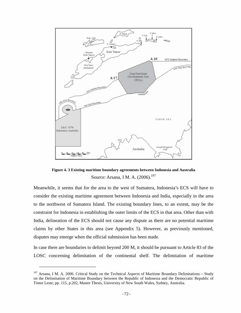
- - 72
Figure 4. 3 Existing maritime boundary agreements between Indonesia and Australia
Source: Arsana, I M. A. (2006).197
Meanwhile, it seems that for the area to the west of Sumatera, Indonesia’s ECS will have to
consider the existing maritime agreement between Indonesia and India, especially in the area
to the northwest of Sumatera Island. The existing boundary lines, to an extent, may be the
constraint for Indonesia in establishing the outer limits of the ECS in that area. Other than with
India, delineation of the ECS should not cause any dispute as there are no potential maritime
claims by other States in this area (see Appendix 5). However, as previously mentioned,
disputes may emerge when the official submission has been made.
In case there are boundaries to delimit beyond 200 M, it should be pursuant to Article 83 of the
LOSC concerning delimitation of the continental shelf. The delimitation of maritime
197 Arsana, I M. A. 2006. Critical Study on the Technical Aspects of Maritime Boundary Delimitations – Study on the Delimitation of Maritime Boundary between the Republic of Indonesia and the Democratic Republic of Timor Leste, pp. 115, p.202, Master Thesis, University of New South Wales, Sydney, Australia.
- - 73
boundaries beyond 200 M is solely the responsibility of the concerned States and it should be
in accordance with the LOSC and its corresponding annexes. It is worth noting that it is not
the responsibility of the Commission to recommend or settle any maritime boundaries between
any concerned States.198 In case there is potency of dispute in relation to ECS submission,
coastal States in question should firstly resolve their conflict before making the submission.
In certain cases, such as the ECS in the Arctic region, five States (Russia, Norway, Denmark,
Canada, the US) are viewed as being entitled to an ECS. Russia submitted its first submission
to the Commission in 2001199 and is currently preparing a resubmission. Other polar States
have also showed their intention to do the same. This, to an extent, can be viewed as a
competition among polar States to secure their rights over the seabed of the Arctic, which
consequently may spark disputes. Considering this, those five polar States may make a
coordinated or even a joint submission to the Commission.200 If a submission made by one
State is protested by another State, the Commission will not make any recommendation with
respect to the disputed area and leave it until a multilateral agreement is achieved among the
States in question.201 Pursuant to Article 76 (10) the LOSC’s provisions concerning the
delineations of the outer limits of the continental shelf are “without prejudice to the question
of delimitation of the continental shelf between States with opposite or adjacent coasts”.
So far, there has been no indication that Indonesia intends to make a joint submission with
other States. However, this may be seen as an option considering that there are some pending
maritime boundary agreements with neighboring States such as Australia and East Timor, in
potential ECS regions.
4.2 Towards a Submission for the Commission
Defining the outer limits of the ECS was one of the concerns addressed in the Two-year
Performance Report of the Government of SBY-JK (Susilo Bambang Yudoyono - Jusuf
198 See also: Carleton, C. M, (2000) Delimitation Issues, in Continental Shelf Limits The Scientific and Legal Interface, edited by Peter J. Cook and Chris M. Carlton, Oxford University Press, p. 312. 199 See also: the website of the Commission at http://www.un.org/Depts/los/clcs_new/clcs_home.htm accessed on 3 July 2007. 200 Macnab, R. 2004. The Outer Limit of the continental Shelf in Arctic Ocean. pp. 307-309, in Legal and Scientific Aspects if Continental Shelf Limits, p. 467, edited by Nordquist M. H., More, J. H., and Heidar, T. H., Martinus Nijhoff Publishers, The Netherlands. 201 Annex I to CLCS/40.
- - 74
Kalla).202 This is viewed by the Government as one of the important agendas in establishing
and maintaining national security and stability, and thus, Indonesia is currently conducting
serious preparations toward delineating its ECS and preparing the its submission for the
Commission.
4.2.1 Challenges and Solutions
Delineating the outer limits of the ECS and preparing a submission for the Commission is by
no means an easy task. Many challenges exist, including technical, institutional, financial, and
political matters.
4.2.1.1 Technical Challenges
Conducting field surveys is clearly the most challenging technical issue. It is understood that
the Indonesian team confronted some technical difficulties including the availability of a
capable survey ship and other technical equipment for field data acquisition. Indonesia, in this
regard, has a survey ship called Baruna Jaya VIII with which field survey can be carried out.203
In the case of Indonesia faces technical difficulties and requires more technical support,
assistances have been obtained from other States and institutions. Such assistance has included
collaboration with external parties such as German Sonne - BGR and also Norway, which have
the required technical capabilities. However, the collaboration does not deal only with
equipment but also human resources. Collaboration with other parties often includes the use of
external human resources for reasons of capabilities and familiarity in operation of the
equipment. In this case, Indonesia may also take the opportunity to benefit from knowledge
and technology transfer. Improvement in Indonesian human resources is one of the advantages
of international collaboration. In addition, cost remains one of the most significant issues
which may constrain the ECS project in Indonesia. As outlined previously, the high costs are
associated with data collection and processing.204
202 This report is a report of the President of the Republic Indonesia concerning the performance of the Government in the first two year the administration. It is an accountability report addressed to the House of Representatives. See: Chapter 2 of the Two-year Performance Report of the Government of SBY-JK. 2006. 203 See: 4.1.2.3. 204 See: 4.1.1.2.
- - 75
With regard to collaboration with other States and institutions, confidentiality issues need to be
carefully taken into account. The involvement of foreign parties may, unintentionally, cause
“leaks” of important data and valuable information that should be treated as confidential. Prior
to collaboration, agreements should be drafted to address this issue. This has been confirmed
by Bakosurtanal of Indonesian that the confidentiality issue was taken info account
seriously.205
4.2.1.2 Institutional Challenges
The availability of capable human resources is a concern in relation to the delineation of the of
outer limits of the ECS. Even though Indonesia has many excellent scientists, notably in
Bakosurtanal, Indonesian Institute of Sciences, Marine Geology Institute, Agency for
Technology Assessment and Application, Department of Foreign Affairs and several
universities, it seems that the coordination of people from different institutions can be difficult
to at times.
The establishment of the team to delineate the outer limits of the ECS and prepare for a
submission was initially a decision of the Indonesian Ministry of Energy and Mineral
Resources. To an extent, this may be viewed inadequate considering that the delineation and
submission deal with interdepartmental issues. Ideally, the decision should have come from the
President of the Republic of Indonesia, as only the president has the authority over all relevant
departments. This might also be one of the sources of reluctance in carrying out collaboration
among the relevant institutions.
The issue concerning mandate by which the Indonesian team works on the delineation and
preparation for the submission is reasonably complicated. While the decision by a Minister of
Energy and Mineral Resources206 was viewed inadequate, later on the decision was expired
and then replaced a new one issued by the Head of Bakosurtanal.207 It is worth noting that
Bakosurtanal is a hierarchically lower institution compared to the Ministry of Energy and
Mineral Resources. Bakosurtanal structurally is under the Ministry of Research and
Technology. Therefore, the issuance of new mandate by the head of Bakosurtanal was actually
205 Personal communication with Dr. Sobar Sutisna, op cit. 206 Communication has been made with staff members of Bakosurtanal concerning this mandate. However, due to confidentiality issues, the efforts to secure the document were not successful.
- - 76
degradation in term of hierarchy, which to some extents worsened the situation for an inter-
institutional collaboration.208
This was also highlighted by a staff member of Bakosurtanal in his presentation in Yogyakarta
on 4 May 2005 concerning the fact that it was difficult to mobilize the team for
collaboration.209 The fact that the delineation of the outer limits of ECS and preparation of the
submission is an inter-disciplinary project requires effective communication and collaboration
among experts from different fields and institutions. This may be the source of difficulties.
To overcome this problem, Indonesia may look at the possibility of establishing a dedicated
team to do the delineation and prepare the submission. However, such a decision should come
from the President as the highest authority, and so that all departments will have a stronger
willingness to collaborate.
4.2.1.3 Financial Challenges
From a financial perspective, two challenges must be faced: the cost of accomplishing the
delineation and preparation for its submission and the question concerning economic benefits
in return. It is true that conducting field surveys for the purpose of data collection is,
undoubtedly, expensive. Rudolf W. Matindas, the head of Bakosurtanal, in his statement in
Kompas said that the budget required for surveys and mapping is approximately 17 to 20
billion rupiah (or about USD 1.8 to 2.2 million).210
Understanding that Indonesia is a developing country and is currently facing many other
important challenges and demands on the national budget, it might be true that the cost for
carrying out the preparations, including the field surveys and document preparations, is high.
In a national forum held in Yogyakarta on 4 May 2005,211 an opinion raised that for a
developing country like Indonesia, it would be wiser to spend the money on other sectors that
207 Ibid. 208 Ibid. 209 Personal Communication with Dr. Khafid, op cit. 210 See also: Survey of Continental shelf awaits budget arrangement (in Bahasa Indonesia) at http://www.kompas.com/kompas-cetak/0411/04/utama/1365772.htm, accessed on 8 August 2007. 211 An international workshop on legal and technical aspects of maritime boundary delimitation was held by the Department of Geodetic Engineering, Gadjah Mada University in Yogyakarta on 4 May 2005.
- - 77
are more important, such as healthcare and education.212 This argument may appear valid at
first sight. It is true that a coastal State should not carelessly lavish money on something that
has no benefit. However, the benefits of an ECS are unlikely to be felt straight away, is not
something that can be judged beneficial instantly. Rather, an ECS is an investment for the
future.213
It was confirmed by a staff member of Bakosurtanal that size of the budget is a serious issue in
the delineation of the outer limits of the ECS and preparation for its submission.214 The Head
of the Center for Boundary Mapping of Bakosurtanal admitted that the technical survey cost a
lot of money and was provided by Bakosurtanal, National Agency for Technology Assessment
and Application, Department of Ocean Affairs and Fisheries, Indonesian Institute of Sciences,
Department of Energy and Mineral Resources.215 This was not considered as an efficient
arrangement as funds are spread out in different institutions are difficult to access for
bureaucratic reasons. In general, it was concluded that the budget for the delineation of the
outer limits of the ECS and preparation for its submission is inadequate especially to conduct
subsequent field surveys.216
To deal with the budget issue, the Indonesia team needs to make priority and attempts to
decrease the utilization of external resources including collaboration with other
States/institutions that may be highly-expensive. One of the recourses is to conduct surveys
using Indonesia’s own survey vessel. However, another issue to consider is whether such
survey will be able to acquire data which is detailed enough and is able to convince the
Commission. For this, TCG will need to make detailed and comprehensive considerations.
Obtaining funding assistance from external parties is also an option. There are several options
for this including the World Bank, Trust Fund of DOALOS, and funding from oil
212 The Author together with prominent Indonesian experts from Bakosurtanal, Department of Home Affairs, Department of Foreign Affairs, and universities participated in the above workshop. Participants discussed the development of the project of delineation of the outer limits of the ECS and the preparation for its submission to the Commission. 213 Arsana, I M. A. and Putri, . M. K., op cit. 214 Personal communication with Dr. Khafid, op cit. 215 Personal communication with Dr. Sobar Sutisna, op cit. 216 Personal communication with Dr. Khafid, op cit.
- - 78
companies.217 For the first option, the World Bank, the possibility is there because in several
occasions it has informally expressed interest in the project regarding continental shelf
delimitation. Meanwhile, funding from trust fund managed by DOALOS can also be obtained.
United Nations, through its resolution 55/7 established a trust fund to assist coastal States by
providing technical and administrative training, technical and scientific advice, as well as
personnel. The trust fund is also allocated to help developing States and small island
developing States to conduct desktop studies to prepare their submission to the Commission.
In particular, the assistance may be obtained for the purposes of training, desktop studies for
initial assessment, planning for data acquisition, preparation for final submission, and
consultancy assistance related to the above matters.218
It is worth noting that the trust fund cannot be allocated for data acquisition and functions.
When the trust fund was established in 2000,219 the utilization of the trust fund was only on the
basis of reimbursement. This means that coastal States intending to utilize this available
funding should cover all expenses up front and then request reimbursement by providing all
required documents and evidence to DOALOS. This may cause complicated process and
procedures, which may causes reluctance of coastal States to make use of the option. This
complication might be viewed as a disadvantage that needs improvement. A new payment
procedure established by DOALOS is grant mechanism. This procedure “will enable the
United Nations to provide assistance to States from this Trust Fund without Governments first
having to make financial outlays and then being reimbursed by the United Nations.”220
Securing funding from oil companies can also be opted for but only with careful arrangement
as there are usually related business and economic considerations such as oil field concession.
A coastal State should take this into account and avoid being trapped in a situation where an
oil company can influence the State in deciding on oil concession due to the company’s
funding assistance.
217 Parson, L. 2007. Ideas to Support Coastal States with Problems in Article 76 Case Preparation – ‘Helping to Fix it”, pp. 66-67 in The Establishment of the Outer Limits of the Continental Shelf beyond 200 Nautical Miles – Its International Circumstances, and Its Scientific and Technical Aspects-, Ocean Policy Resource Foundation. 218 Golitsyn, V. 2007. Support for Developing States, pp.148-149 in The Establishment of the Outer Limits of the Continental Shelf beyond 200 Nautical Miles – Its International Circumstances, and Its Scientific and Technical Aspects-, Ocean Policy Resource Foundation, p. 223. 219 See: http://www.un.org/Depts/los/clcs_new/trust_fund_article76.htm. 220 See: http://www.un.org/Depts/los/clcs_new/note_on_grants.pdf.
- - 79
In general, there is no ‘free lunch’. Therefore coastal States, including Indonesia, need to make
careful considerations before accepting funding assistance from external parties. It must be
confirmed that such agreement will not be harmful to the national interests.
4.2.1.4 Political Challenges
Notwithstanding the importance of the technical and legal aspects of the delineation and the
submission of ECS, there are also, inevitably, political dimensions to the issue. In particular,
difficulties may be encountered in convincing members of the House of Representative
(Dewan Perwakilan Rakyat, DPR) of the importance of the ECS to Indonesia’s national
interests, particularly given the other issues. This might be the issue as there are many other
agendas that need to be put in the top priority. However, this should have also been considered
by the Indonesian Team as one of the importance challenges.
Another issue is the political will from the Government. As previously explained, the transfer
of mandate from the Minister of Energy and Mineral Resources to the Head of Bakosurtanal
may also be viewed as an indication of a decline in political will. In the situation, where
financial support is limited and political will is inadequate, the submission team may face a
difficult situation. Limited financial support will clearly lead to difficulties in the conduct of
field surveys for the acquisition of adequate data and its processing. In addition, the lack of
political will can also weaken the willingness and commitment of team members to
collaborate, especially because the mandate was issued by a hierarchically-low institution.
Thus, there is a need to build political understanding that delineating the outer limits of ECS
and submitting it to the Commission concern the long term socio-economic well being of the
State. Therefore, support needs to be provided now even though a delineated ECS will not
provide instant results for current economic life.
4.2.2 Status of the Submission
At the time of writing, Indonesia has not yet submitted the outer limits of its ECS to the
Commission. However, it is anticipated that this will take place in the relatively near future. In
this context, it is possible that Indonesia will opt for a partial submission for several locations.
The latest information confirms that Indonesia is planning to make its submission in December
- - 80
2007 for the area to the northwest of Sumatera.221 The precise locations for all possible
submission have not yet been officially confirmed but some of them seem to have particular
attention. With regards to technical aspects, the TCG, with Bakosurtanal as one the main
participants, has been conducting technical preparations and assessments and has produced
submission drafts. Being drafts, the documents are available for internal use only and have not
yet been released for public consumption.
4.3 Concluding Remarks
Chapter 4 has outlined the latest developments with respect to the delineation of Indonesia’s
outer limits of its ECS. It has been confirmed that Indonesia has conducted field surveys for
data acquisition as well as processed data for delineation purposes. It was indicated that
Indonesia may have more than one location where an ECS may present namely in the west of
Sumatera, to the South Nusa Tenggara, and to the north of Papua. At the time of writing,
Indonesia has not yet made its initial submission to the Commission, but is currently seriously
undertaking preparations.
Several issues and challenges faced by the Indonesian team have also been addressed in this
chapter as well as proposals for addressing this. It has to be noted that delineating the outer
limits of the ECS is by no means an easy task, so the Indonesian team has to be prepared for
the possible challenges and obstacles. Delineating the ECS and submitting it to the
Commission should be viewed as an investment for the benefit of the State in the future.
221 Personal communication with Ms. Tripatmasari of Bakosurtanal on 10 October 2007 via email.
- - 81
Chapter 5 Concluding Remarks
5.1 Review of Findings
This section reviews the findings that have been discussed and analyzed in previous chapters.
The following subsections briefly summarize the findings regarding result from existing
researches; progress regarding the delimitation of Indonesia’s outer limits of ECS and
preparation for its submission; and challenges faced by Indonesia as well as suggestions to
overcome the challenges.
5.1.1 Results from Existing Researches
Extensive studies on existing research regarding the delineation of the outer limits of the ECS
in general and particularly concerning Indonesia has been conducted for this paper. With
regards to general delineation of the continental shelf, many works have been published. Of
note are for example the works edited by Peter J. Cook and Chris M, Carleton, Continental
Shelf Limits – The Scientific and Legal Interface (2000); and Legal and Scientific Aspects of
the continental Shelf Limits edited by Myron H. Nordquist, John Norton Moore and Tomas H.
Heidar (2004). These two works provide comprehensive background and outline the
fundamental principles of ECS delineation and its submission to the Commission, as well as
provide case studies from several coastal States. In addition, these books also provide the
development of ECS submission by coastal States and how the Commission handles those
submissions.
Other research concerning the ECS has been conducted by Indonesian experts and officials,
especially those regarding technical aspects of Indonesia’s ECS delineation. Studies conducted
by Sutisna et al. and published in 2005, for example provide background on the Indonesian
case as well as the possibility of the ECS submission made by Indonesia. The research
published by Indonesian experts was mainly based on desktop studies and conclude that three
locations are possible for ECS claim submission. Notwithstanding the accuracy of the
research, they contain no official statement confirming the locations of potential ECS and
when the submission is going to be made. However, they do provide good insight on the topic
and thus serve as valuable references for the present paper.
- - 82
5.1.2 Progress Regarding the Delineation and Submission
At the time of writing, Indonesia has undertaken a project to delineate the outer limits of its
ECS and is currently preparing its submission. However, no submission has been made to the
Commission. Intensive and serious preparation has been made through collaboration among
several relevant institutions including the National Coordinating Agency for Surveys and
Mapping, Hydro-Oceanographic Department on the Indonesian Navy, National Agency for
Technology Assessment and Application, Department of Ocean Affairs and Fisheries,
Indonesian Institute of Sciences, Marine Geology Indonesia, and several universities.
Collaboration, especially concerning technical aspects, has also been carried out with relevant
third parties including those from other States such as Germany and Norway.
A draft submission has been produced by the submission team. The latest information obtained
from officials in the Bakosurtanal confirmed that the submission is going to be made in
December 2007. However, the precise date of the submission has not been released. It seems
that the team still needs to finalize the document and make a proper compilation for legal and
technical materials.
Meanwhile, it was confirmed by the Head of the Center for Boundary Mapping of
Bakosurtanal that Indonesia is preparing partial submissions for at least three locations: to the
northwest of Sumatera, to the south of Sumba Island and to the north of Papua. In mid August
2007, Bakosurtanal was planning a field survey for the location to the north of Papua. The
survey was going to use Indonesia’s own survey ship, Baruna Jaya VIII, the most advanced
Indonesia’s survey ship for these purposes. It has to be admitted that the specifications of the
ship are inadequate to obtain the desired data. However, according to staff members of
Bakosurtanal, the budget was an issue to be taken into account. At the time of writing, no
additional information has been released by the Bakosurtanal regarding the survey.
Indonesia is currently preparing at least three submissions for the Commission, the first of
which is expected to be made by December 2007.
5.1.3 Challenges and Solutions
In conducting the delineation and preparing the submission of the ECS, the Indonesian team
must overcome some challenges. These challenges include technical, institutional, financial,
- - 83
and political. With regard to technical challenges, the availability of technical instruments is
the main concern. These are required in conducting field surveys and data processing. As
indicated by officials in Bakosurtanal, the most advanced survey ship Indonesia currently has
is inadequate for obtaining data at the required level of accuracy. This issue has been
overcome through collaboration has been done with foreign consultants from Germany and
Norway.
Delineation of the outer limits of the ECS and preparing a submission are the concerns of
several institutions. For the Indonesian case, inter-institutional collaboration is a challenge. As
an inter-departmental project, the delineation and submission involves many people from
different ministries and institutions. The key of mutual and sustainable collaboration is the
clearness of assignment. For this purpose, there must be an adequate mandate issued by a
relevant party to establish and describe the duty and responsibility of the teams. Ideally, for an
inter-departmental project, the mandate should be issued by the President. In fact such a
document does not exist. One mandate issued by the Indonesian Ministry of Energy and
Mineral Resources was then replaced by a new one issued by the Head of Bakosurtanal. In this
case, there was a degradation in terms of hierarchy. This consequently was a disadvantage to
the collaboration as there a is lack of authority associated with the mandate. The impact of this
has not yet been accurately measured, but it surely causes challenges for inter-institutional
collaboration.
Another important issue is the financial challenge. Considering that the ECS project is a
complex, detailed and time-consuming process, it surely requires a reasonably large amount of
money. For Indonesia, it might not be easy to secure that budget as the State has several other
problems that require dedicated budget. Natural disasters that are currently frequent in
Indonesia play significant influence in the Government budget scheme. It may be seen as an
acceptable policy if the Government identifies the ECS project as a top priority. However,
delineating the outer limits of the ECS and submitting these limits to the Commission should
also be seen as an important investment for the future.
Last, but not least, are the political challenges. This issue concerns the support that the House
of Representatives will provide with regard to the ECS project. It might not be easy to
convince the members of the House the submission is important. The fact that Indonesia is
- - 84
currently facing many other problems may cause reluctance in the House to support the
project. Therefore, the submission team needs to work hard and use a good strategy to
convince the House. Issues related to national sovereignty, including those concerning
boundary-related disputes may be good examples to draw House’s attention to the importance
of the delineation and submission.
5.2 Research Limitation and Obstacles
A lot of efforts have been put in this research to produce accurate and precise results as far as
possible. However, some limitations and obstacles faced during the research may be
considered, to a degree, as weaknesses. Among these limitations, the lack of availability and
access to data and access to the Indonesian Government officials are two issues described
below.
5.2.1 Access to Data and Information
It has been made clear that this research analyzes the recent developments with respect to the
delimitations of the Indonesia’s outer limits of its ECS and the preparation of its submission.
Therefore, no technical data has been analyzed. Being outside of the submission team, the
researcher has no official access to the available technical data. This, to an extent, caused
difficulties in performing evaluation and analysis of the latest status of the delineation and the
submission Indonesia is about to make.
The other issue is one of confidentiality. It is worth noting that, all data and analysis are treated
as confidential by the Indonesian Government and the United Nations. Therefore, there is no
official access to the data by parties outside the team. Furthermore, no publication can be
made with regard to the available data before the submission is made. In addition, even after
the submission, only the executive summary of the submission can be accessed through the
Commission’s website. This, to some extent, is also a challenge for researchers. Consequently,
this paper does not address technical analysis, for example, the evaluation of the accuracy in
the determination of the outer limits of the continental shelf in particular areas of Indonesia.
5.2.2 Access to Government Officials
Considering that this research was conducted in Australia and the United States of America,
- - 85
telecommunication is the only option for accessing Indonesian Government officials. Two
issues arose during research: the limited number of people dealing with the ECS project that
are known by the researcher, and the issue of telecommunications. The first issue is partly due
to the fact that there was no official announcement concerning the composition of the
submission team. Efforts to find such information in newspapers, internet, and other public
media for example, were not successful. Therefore, only few people can be contacted for
information regarding recent developments and information. With regard to
telecommunication, it was not easy, to some extent, to contact certain Government officials
through email, being the most affordable mode of international communication. While some
officials would be willing to answer email and provide information, others did not reply to
emails for unknown reasons. Another issue concerning telecommunications is the inefficiency
and ineffectiveness of discussing certain issues through telecommunication, such as emails.
Several Government officials tended not to write much in emails, and therefore the
communication did not cover a wide range of issues and could not provide information in
details (lack of depth).
5.3 Conclusions
The LOSC provides provisions concerning the entitlement of coastal States to maritime
jurisdictions including the territorial sea, the contiguous zone, the exclusive economic zone,
and the continental shelf. Every maritime jurisdiction has its own breadth criteria and legal
properties.
Article 76 of the LOSC provides that the continental shelf comprises the seabed and subsoil
that are natural prolongations of a coastal State beyond its territorial sea, up to the outer edge
of the continental margin. In cases where the said continental margin does not reach a distance
of 200 M from the baselines, the continental shelf can be measured up to 200 M form its
baselines. In addition, the coastal States can extend their continental shelf beyond 200 M,
which is also known as extended continental shelf (ECS). For this purpose, coastal States
should delineate the outer limits of the ECS and make a submission to the Commission
through the UN Secretary General. Article 76 of the LOSC provides detailed procedures to
delineate and submit the outer limits of the continental shelf.
Indonesia, at the time of writing, has been conducting the delineation of its ECS and is
- - 86
preparing for partial submissions to the Commission. It is currently conducting comprehensive
preparations including technical and legal aspects. The delineation and preparation for the
submission involve technical and legal teams, who work in collaboration with several
Indonesian institutions and with foreign consultants. The first submission is expected to be
made by the end of 2007. In conducting preparations Indonesian team faces challenges
including technical, institutional, financial and political challenges to overcome.
5.4 Recommendations
This paper does not represent the views of the Indonesian Government, nor those of the
Division for Ocean Affairs and Law of the Sea (DOALOS) of those of the University of
Wollongong. Therefore, this is not an official statement of progress concerning Indonesia’s
ECS submission. However, the paper has been built through critical analysis with emphasis on
technical and legal aspects, by which it should be able to closely represent the current situation
concerning the delineation of the Indonesia’s outer limits of its ECS and the preparation for its
submission to the Commission.
Considering that Indonesia has not yet finished the delineation project and the preparations for
the submission, many things need to be done. It must have been anticipated by the team that
further assessments will also be necessary for all possible maritime areas. Stronger
collaboration could be undertaken with more academia from several universities in Indonesia
with relevant expertise. With regard to assistance for the preparation of the submission, the
Indonesian team may consider requesting technical assistance from the Commission.
However, some relevant issues should be addressed such as financial matters and issues of
confidentiality. In addition, for the purpose of delimitation and submission in the future,
Indonesia can also obtain financial assistance provided by several institutions including the
trust fund for the purpose of facilitating the preparation of submissions to the Commission on
the Limits of the Continental Shelf for developing States, in particular the least developed
countries and small island developing States managed by DOALOS.
5.5 Directions for Future Research
This current research focuses on the delineation of the outer limits of Indonesia’s extended
continental shelf and the preparation for its submission to the Commission. It shows that there
- - 87
are several things to be done prior to making a submission. It is understood that the ECS
delimitation and submission involve complicated technical processes as well as sophisticated
legal matters. In addition, it also requires consideration of political, social and economic
issues. Notwithstanding the difficulties and complications, defining the limit of Indonesia’s
maritime jurisdiction and securing recognition from other States is not the end of story. Further
actions are required. Therefore, future research also needs to focus on these areas.
As an archipelagic State, Indonesia has ten potential boundaries with its neighbors. Some of
these are already well-established. Several others remain either undelimited or only partially
delimited. While there is scope for further research on Indonesia’s outstanding maritime
boundaries, it is essential to remember that the establishment of boundaries is not the end point
of this process. Maintenance and management are the next important tasks to be undertaken.
Future work also includes the integration of the existing boundaries and limits into an
information system. This information (regarding limits of maritime jurisdictions, maritime
boundaries, the importance of boundaries and their impact on society) should then be made
available to the public. This is especially critical for those people living in border areas, who
will need to be both better educated and thus more aware of the actual consequences of
boundary delimitation. Furthermore, the limits of maritime jurisdiction are important for those
whose daily activities concern these limits, such as fishermen. This is also important for other
economic activity such as seabed resource exploration and exploitation.
Finally, by signing the LOSC, a State is obliged to respect and follow the rules related to
oceans’ management. This, therefore, requires a State to prepare its national systems, including
the legal processes, ensuring that law enforcement in these matters is conducted properly and
appropriately.
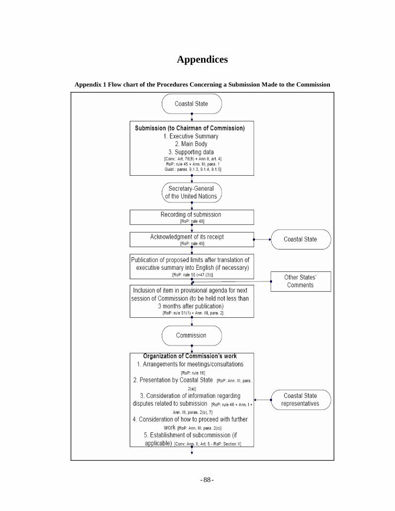
- - 88
Appendices
Appendix 1 Flow chart of the Procedures Concerning a Submission Made to the Commission
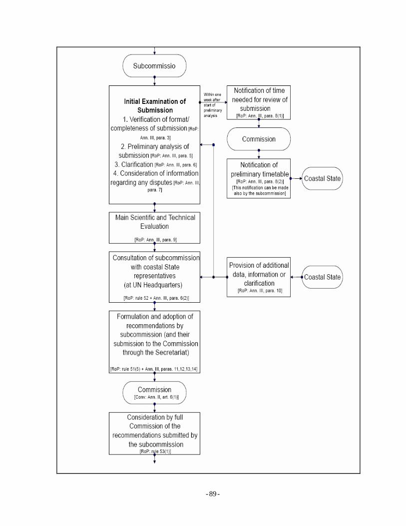
- - 89
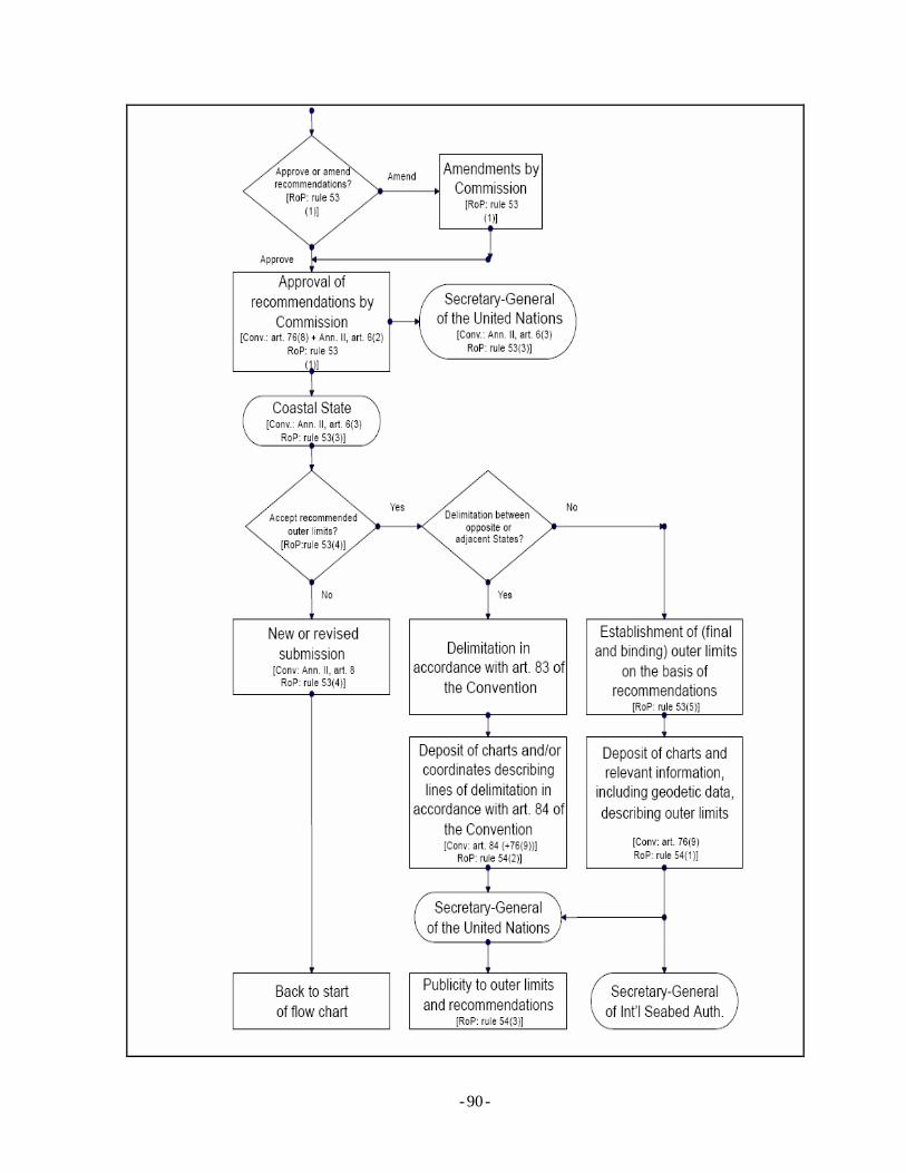
- - 90
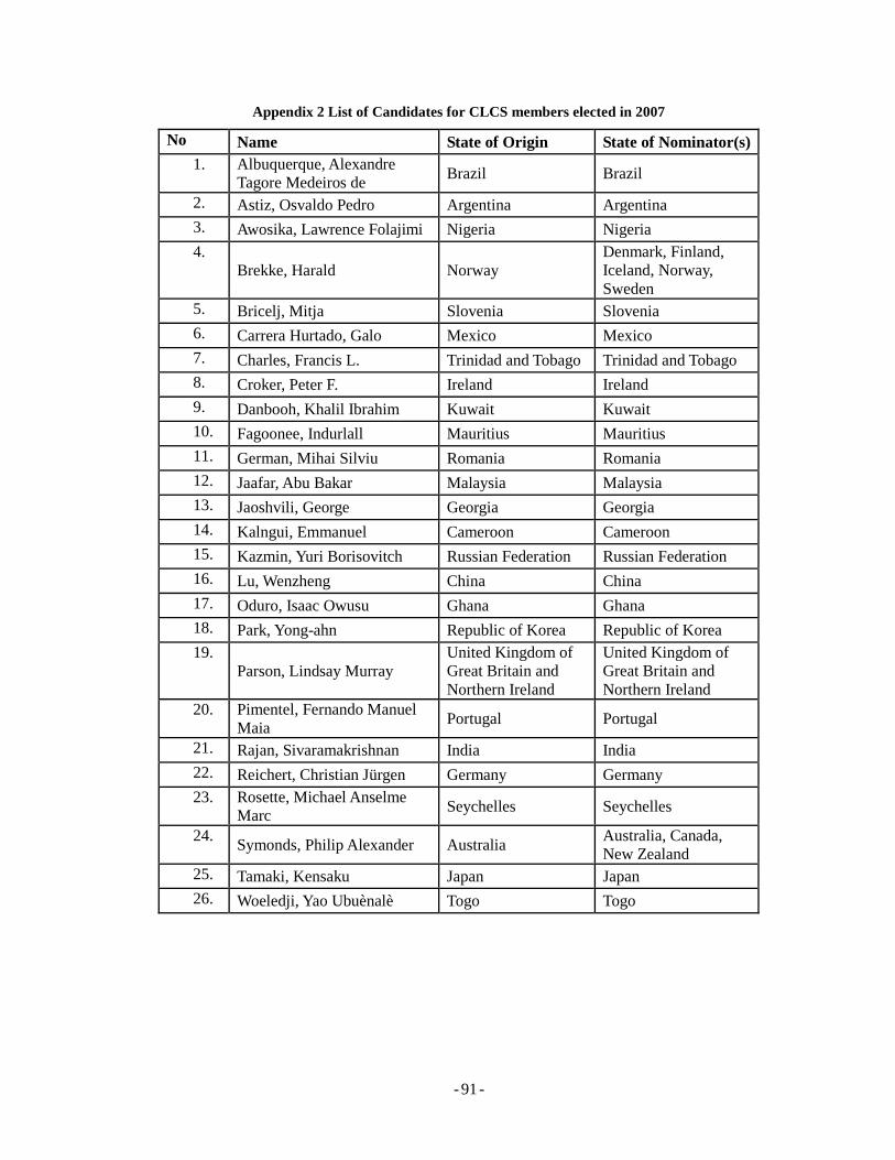
- - 91
Appendix 2 List of Candidates for CLCS members elected in 2007
No Name State of Origin State of Nominator(s) 1. Albuquerque, Alexandre
Tagore Medeiros de Brazil Brazil
2. Astiz, Osvaldo Pedro Argentina Argentina 3. Awosika, Lawrence Folajimi Nigeria Nigeria 4.
Brekke, Harald Norway Denmark, Finland, Iceland, Norway, Sweden
5. Bricelj, Mitja Slovenia Slovenia 6. Carrera Hurtado, Galo Mexico Mexico 7. Charles, Francis L. Trinidad and Tobago Trinidad and Tobago 8. Croker, Peter F. Ireland Ireland 9. Danbooh, Khalil Ibrahim Kuwait Kuwait 10. Fagoonee, Indurlall Mauritius Mauritius 11. German, Mihai Silviu Romania Romania 12. Jaafar, Abu Bakar Malaysia Malaysia 13. Jaoshvili, George Georgia Georgia 14. Kalngui, Emmanuel Cameroon Cameroon 15. Kazmin, Yuri Borisovitch Russian Federation Russian Federation 16. Lu, Wenzheng China China 17. Oduro, Isaac Owusu Ghana Ghana 18. Park, Yong-ahn Republic of Korea Republic of Korea 19.
Parson, Lindsay Murray United Kingdom of Great Britain and Northern Ireland
United Kingdom of Great Britain and Northern Ireland
20. Pimentel, Fernando Manuel Maia Portugal Portugal
21. Rajan, Sivaramakrishnan India India 22. Reichert, Christian Jürgen Germany Germany 23. Rosette, Michael Anselme
Marc Seychelles Seychelles
24. Symonds, Philip Alexander Australia
Australia, Canada, New Zealand
25. Tamaki, Kensaku Japan Japan 26. Woeledji, Yao Ubuènalè Togo Togo
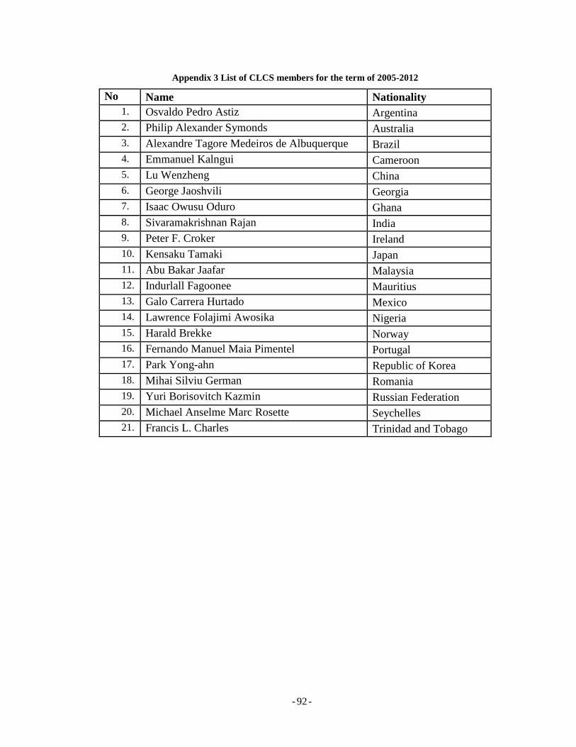
- - 92
Appendix 3 List of CLCS members for the term of 2005-2012
No Name Nationality 1. Osvaldo Pedro Astiz Argentina 2. Philip Alexander Symonds Australia 3. Alexandre Tagore Medeiros de Albuquerque Brazil 4. Emmanuel Kalngui Cameroon 5. Lu Wenzheng China 6. George Jaoshvili Georgia 7. Isaac Owusu Oduro Ghana 8. Sivaramakrishnan Rajan India 9. Peter F. Croker Ireland 10. Kensaku Tamaki Japan 11. Abu Bakar Jaafar Malaysia 12. Indurlall Fagoonee Mauritius 13. Galo Carrera Hurtado Mexico 14. Lawrence Folajimi Awosika Nigeria 15. Harald Brekke Norway 16. Fernando Manuel Maia Pimentel Portugal 17. Park Yong-ahn Republic of Korea 18. Mihai Silviu German Romania 19. Yuri Borisovitch Kazmin Russian Federation 20. Michael Anselme Marc Rosette Seychelles 21. Francis L. Charles Trinidad and Tobago
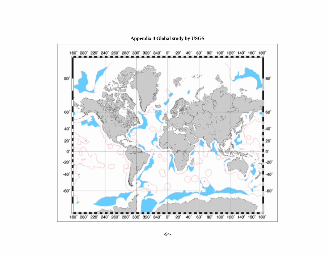
- - 94
Appendix 4 Global study by USGS
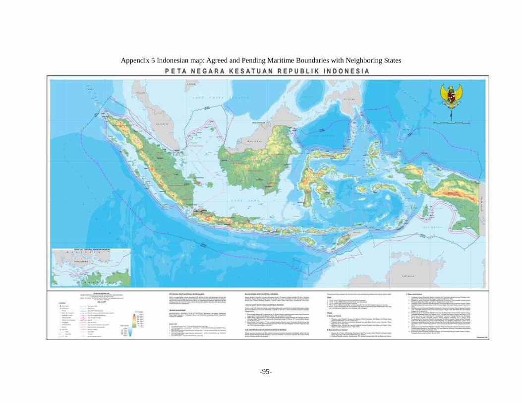
- - 95
Appendix 5 Indonesian map: Agreed and Pending Maritime Boundaries with Neighboring States
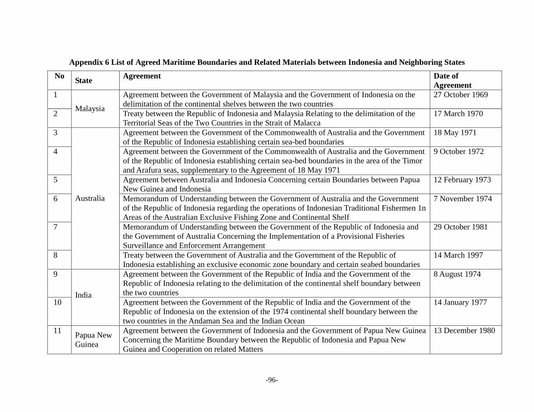
- - 96
Appendix 6 List of Agreed Maritime Boundaries and Related Materials between Indonesia and Neighboring States
No State Agreement Date of Agreement
1 Agreement between the Government of Malaysia and the Government of Indonesia on the delimitation of the continental shelves between the two countries
27 October 1969
2 Malaysia
Treaty between the Republic of Indonesia and Malaysia Relating to the delimitation of the Territorial Seas of the Two Countries in the Strait of Malacca
17 March 1970
3 Agreement between the Government of the Commonwealth of Australia and the Government of the Republic of Indonesia establishing certain sea-bed boundaries
18 May 1971
4 Agreement between the Government of the Commonwealth of Australia and the Government of the Republic of Indonesia establishing certain sea-bed boundaries in the area of the Timor and Arafura seas, supplementary to the Agreement of 18 May 1971
9 October 1972
5 Agreement between Australia and Indonesia Concerning certain Boundaries between Papua New Guinea and Indonesia
12 February 1973
6 Memorandum of Understanding between the Government of Australia and the Government of the Republic of Indonesia regarding the operations of Indonesian Traditional Fishermen 1n Areas of the Australian Exclusive Fishing Zone and Continental Shelf
7 November 1974
7 Memorandum of Understanding between the Government of the Republic of Indonesia and the Government of Australia Concerning the Implementation of a Provisional Fisheries Surveillance and Enforcement Arrangement
29 October 1981
8
Australia
Treaty between the Government of Australia and the Government of the Republic of Indonesia establishing an exclusive economic zone boundary and certain seabed boundaries
14 March 1997
9 Agreement between the Government of the Republic of India and the Government of the Republic of Indonesia relating to the delimitation of the continental shelf boundary between the two countries
8 August 1974
10 India
Agreement between the Government of the Republic of India and the Government of the Republic of Indonesia on the extension of the 1974 continental shelf boundary between the two countries in the Andaman Sea and the Indian Ocean
14 January 1977
11 Papua New Guinea
Agreement between the Government of Indonesia and the Government of Papua New Guinea Concerning the Maritime Boundary between the Republic of Indonesia and Papua New Guinea and Cooperation on related Matters
13 December 1980
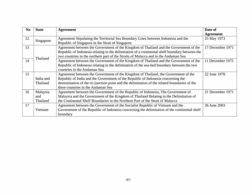
- - 97
No State Agreement Date of Agreement
12 Singapore
Agreement Stipulating the Territorial Sea Boundary Lines between Indonesia and the Republic of Singapore in the Strait of Singapore
25 May 1973
13 Agreement between the Government of the Kingdom of Thailand and the Government of the Republic of Indonesia relating to the delimitation of a continental shelf boundary between the two countries in the northern part of the Straits of Malacca and in the Andaman Sea
17 December 1971
14 Thailand
Agreement between the Government of the Kingdom of Thailand and the Government of the Republic of Indonesia relating to the delimitation of the sea-bed boundary between the two countries in the Andaman Sea
11 December 1975
15 India and Thailand
Agreement between the Government of the Kingdom of Thailand, the Government of the Republic of India and the Government of the Republic of Indonesia concerning the determination of the tri-junction point and the delimitation of the related boundaries of the three countries in the Andaman Sea
22 June 1978
16 Malaysia and Thailand
Agreement between the Government of the Republic of Indonesia, The Government of Malaysia and the Government of the Kingdom of Thailand Relating to the Delimitation of the Continental Shelf Boundaries in the Northern Part of the Strait of Malacca
21 December 1971
17 Vietnam
Agreement between the Government of the Socialist Republic of Vietnam and the Government of the Republic of Indonesia concerning the delimitation of the continental shelf boundary
26 June 2003