Embed Size (px)
Citation preview
You-Are-Here Maps in Emergencies –
The Danger of Getting Lost
Alexander Klippel1, Christian Freksa2, Stephan Winter3
1Cooperative Research Centre for Spatial Information, Department of Geomatics, University of Melbourne, Australia
2Transregional Collaborative Research Center SFB/TR 8 Spatial Cognition Universität Bremen, Germany
3Department of Geomatics, University of Melbourne, Australia
Abstract. This article evaluates criteria for the design of so-called You-Are-Here
(YAH) maps, i.e. maps that explicitly indicate the position of the map reader.
Established design criteria (Levine, 1982, O'Neill, 1999) are rendered more precise
and applied in an exemplary assessment of three YAH maps as they can be found in
public buildings as part of a general emergency scheme. The clarification of the YAH
map terminology is necessary to allow for assessing the quality of existing YAH maps
and consolidates the basis of rule-based generation of location-aware information
services. Possibilities for further empirical evaluation of YAH maps are discussed and
the role of location-aware technology is considered for smart mobile systems and
smart environments.
INTRODUCTION Information about one's location is essential for numerous daily tasks such as
planning a route to take and finding a desired destination. For modern information
systems it is necessary to provide information about ones location in a cognitive
ergonomic format using cognitively relevant features of the environment rather than
numerical coordinates. While humans are not aware of the complexity of cognitive
processes involved in the task of locating oneself in familiar environments (Gärling et
al., 1983, Baskaya et al., 2004, Golledge, 1999), the scrutinies of determining where
am I reveal themselves in unfamiliar or partially familiar environments.
Therefore, in cases of emergencies, understanding of provided spatial
information is crucial, for example for leaving a building if it is on fire; the means are
manifold: green exit signs mark emergency exits, fire wardens are trained to guide
people, and dwellers of public buildings undergo instructions to the safety regulations
relevant for their workplace. Most of the signage and the safety instructions are
designated by official authorities.
In addition to the signs and the training, maps—mostly annotated floor
plans—are placed at various locations in public buildings. Sometimes these maps are
equipped with so-called You-Are-Here (YAH) symbols that should help the user to
locate and orient herself. These maps are therefore referred to as YAH maps. They
allow a user to update, for example, her knowledge about exit possibilities and
existing fire fighting equipment in preparation for a potential emergency, whenever
she passes a YAH map. Yet, apparently no clear principles for the design of these
maps and for their proper placement have been applied to take into account the results
from pertinent research about the usefulness and usability of these maps. Basic and
well established principles of map design and spatial cognition (Levine, 1982, Levine
et al., 1984, Liben and Downs, 1993) are continuously neglected in the design and
placement of YAH maps, world-wide. This is not only a matter of theoretical interest
but can be dangerous for people in buildings in case of an emergency.
A different explanation for the design mistakes in emergency YAH maps is
that the responsible authorities are aware of the problems but proper plans are not
implemented due to cost efficiency considerations. With current information
technology and the omnipresence of map-like representation along with the
inexpensive production of maps, the missing element is a formal specification of the
design criteria for these YAH maps that allows for rule-based generation.
This article extends a perspective offered by early cognitive science research (e.g.,
Levine, 1982, Levine et al., 1984, O'Neill, 1999) by integrating new findings and
establishing a consistent terminological framework for the evaluation and design of
YAH maps. The results are applied to evaluate YAH maps and discussed with respect
to technological developments and further empirical evaluation.
PRINCIPLES OF GOOD MAP DESIGN AND DESIGN CRITERIA FOR YAH MAPS
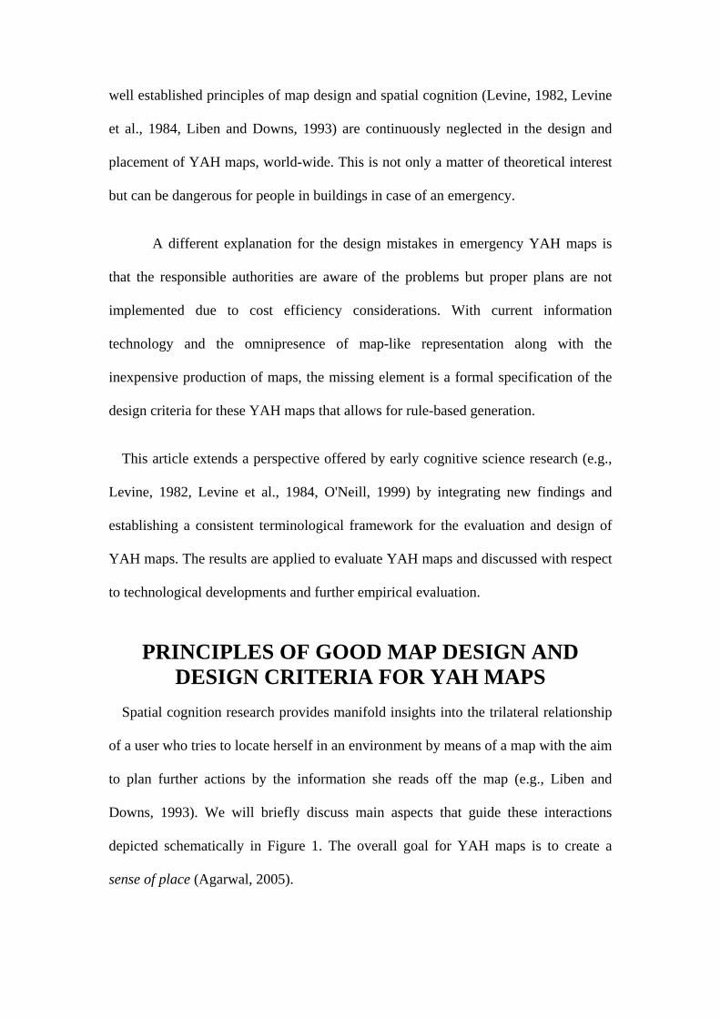
Spatial cognition research provides manifold insights into the trilateral relationship
of a user who tries to locate herself in an environment by means of a map with the aim
to plan further actions by the information she reads off the map (e.g., Liben and
Downs, 1993). We will briefly discuss main aspects that guide these interactions
depicted schematically in Figure 1. The overall goal for YAH maps is to create a
sense of place (Agarwal, 2005).
World Map
Way-finder
3
12
4
Figure 1. The trilateral relationship between wayfinder, world, and map.
A first step to establish a sense of place is to read off information from a map
(relation 1 Figure 1). Literature on map design and visual graphic communication
provides us with a rich knowledge base for formulating general and effective design
criteria (e.g., Tufte, 1990, Tufte, 1997, Kosslyn, 1989, Keates, 1996, Lloyd, 2000).
Interesting for the present study are those relevant for so called task-specific maps
(e.g., Freksa, 1999, Muehrke and Muehrke, 1986, Tversky, 2000) as we focus on
maps used in an emergency scheme. These criteria comprise:
• Completeness: All the information that is necessary to fulfil a given task, for
example route information to leave a building, needs to be represented in the
map. Different levels of the representation are pertinent: The representational
characteristics of the graphic medium make the explicit representation of some
information superfluous contributing to the advantageous use of map-like
representations (cf., Larkin and Simon, 1987).
• Perceptibility / syntactic clarity / visual clutter: All the relevant graphic
features for a given task—once they are represented in the map—need to be
easily perceptible and identifiable (readable). The biggest threat to easy
perception is visual clutter (e.g., Phillips and Noyes, 1982). The negative
effects have been known and behaviourally validated in early research
(Dobson, 1980).
• Semantic clarity: All the symbols and map features need to be easily imbued
with meaning. In the optimal case, this should be accomplished within the map
itself, i.e. the symbols used should be self-explanatory. If this cannot be
achieved, a proper legend is required. Three sub-aspects can be differentiated.
o Ambiguity: The information for solving the tasks should be displayed
in a non-ambiguous way.
o Consistency: All objects of the same kind should be in the map, if one
is depicted.
o Signage: Iconic signs should be used to make a legend obsolete.
• Pragmatics: We consider two aspects:
o Convenience: A good design should take into account how, when, and
where the information is used.
o Contact and date information. A map should provide information on
its creation date and its creator.
For the special case of YAH maps—indicating a user's current position within an
environment—the literature provides additional design criteria. Levine (1982)
identified design and positioning guidelines for YAH maps to enhance their suitability
for aiding wayfinding processes. These criteria have been extended and
experimentally evaluated by several authors (e.g., O'Neill, 1999, Warren and Scott,
1993, Warren et al., 1992, Lloyd, 2000, Levine et al., 1982, Montello, 2005). YAH
map design principles (relation 2-4 Figure 1)—additionally to the general map design
aspects—can be summarized as follows:
• General (global) placement: The evaluation of environmental characteristics
based on their complexity and their structural characteristics has gained
considerable attention in recent years (Hillier and Iida, 2005, O'Neill, 1999,
O'Neill, 1991b, Levine et al., 1984, Bafna, 2003). Together with agent
simulations (Raubal, 2001, Frank, 2000) the identification of critical points for
finding one's way and for reorientation in an environment is a task that is close
to being automated. A distinction has to be made between indoor and outdoor
environments (e.g., Gartner et al., 2004). While placement evaluations for two
dimensional outdoor environments have progressed well (e.g., Richter and
Klippel, 2002), the intricacies of the third dimension in indoor environments
require further studies (Hölscher et al., in prep, Moeser, 1988, Fontaine and
Denis, 1999).
• Local placement: Once the general placement for a YAH map has been
chosen, attention has to be paid to the local placement, for example, where at
an intersection or in a building the YAH map should be installed (Levine et
al., 1984, Best, 1970). One important aspect of the local placement of YAH
maps is the use of asymmetries to facilitate locating the map within the
environment. An asymmetrical part of an environment is easily identified on
the map as its layout combined with the YAH symbol (see below) shown on
the map provides many cues for its location. Therefore, the location of the map
in the environment becomes non-ambiguous.
• Correspondence: YAH maps should allow for easily establishing a
correspondence between the represented information and the information that
is immediately perceptible (see Figure 1). Self-localization, i.e. the
understanding of where one is, is a prerequisite to use the map for planning
where to go and which route to take (Liben and Downs, 1993). While locating
oneself should be guided by a YAH symbol (see below), several aspects
contribute to whether or not the orientation within an environment can be
accomplished easily. We discuss here alignment, architectural cues, and the
YAH symbol.
o Alignment: The YAH map and the environment should be aligned. If
a map is aligned with the environment the top of the map corresponds
to the relation ‘in front of’ of the user viewing the map. Hence, the
different reference systems involved can be easily matched: the
absolute reference system of the map, the relative reference system of
the user, and the intrinsic reference system of the YAH symbol
representing the intrinsic characteristics of the user (eg., Levine, 1982,
Levinson, 2003). The relations LEFT and RIGHT are the same in the
looked at map and in the viewed environment fostering the
establishment of a correspondence (e.g., Shepard and Hurwitz, 1984,
Warren and Scott, 1993). Apart from the YAH symbol, alignment is
the most important criterion for the design of good YAH maps: People
usually expect YAH maps to be aligned and they use them accordingly
(Shepard and Hurwitz, 1984). Thus, non-aligned YAH maps
significantly complicate the wayfinding process.
o Architectural cues: YAH maps should be designed such that
architectural cues and natural landmarks are included and that the
shape of the route drawn in the YAH map relates to the actual shape of
the route the user has to take in the environment, i.e. the behavioural
pattern depicted corresponds to the behavioural pattern to be carried
out (Klippel, 2003, Montello, 2005). As these are important cues in
people’s wayfinding behaviour (Golledge, 1999, Golledge and
Stimson, 1997) this eases map use and reinforces learning and
remembering the environment’s layout. In the case of emergency YAH
maps, the shape of the environment is mostly provided with high
precision and is rectangular in most cases as these maps are mostly
architectural floor plans. There are, however, exceptions in the
regularity, which should be pointed out if available.
o YAH symbol: The YAH symbol fulfils two tasks: First, it locates the
user within an environment; second, it should indicate the user's
orientation with respect to her immediate surroundings. If a YAH
symbol complies with both tasks it is referred to as a complex YAH
symbol (Levine, 1982). The double function can be achieved by
combining a dot with an arrow or by a triangular shaped symbol
designs. Complex YAH symbols significantly ease orientation at
current locations and allow determining the route to the destination as,
again, relating map features to features in the environment is
facilitated; alignment of the map and the orientation of the complex
YAH symbol should correspond to each other.
• Alignment of text in the map: The text in a map should be generally readable
without requiring to turn one's head.
• Redundancy: Redundancy is a concept that is quantitatively not well defined
and can have positive as well as negative impacts. Combining the principles
mentioned above may allow for easier self-localization, orientation and
determination of the route to the destination, i.e. to exit the building (see also
Hirtle, 2000). On the other hand, increasing redundancy may lead to worse
performance if, for example, the visual or cognitive complexity inhibits the
extraction of information from a map (O'Neill, 1991a).
ASSESSING YAH MAPS Given the criteria for the design of good maps and the specific criteria of YAH
maps defined in the previous section, we evaluate exemplarily three YAH-Maps
found at the University of Melbourne. The maps were chosen to exhibit how different
environmental characteristics interact with the representational characteristics of
maps, especially when these maps are of the same type, i.e. annotated floor plans.
This choice allows us to work out the importance of location-aware information on
the basis of maps of the same type. How these results can be applied to a wider range
of YAH maps is discussed in Section 5.
Additionally to the criteria of good map design and those established for YAH-
Maps we discuss important aspects for YAH maps in emergencies: emergency exits
behind secured doors, ambiguous information at decision points, and temporarily
unstable information.
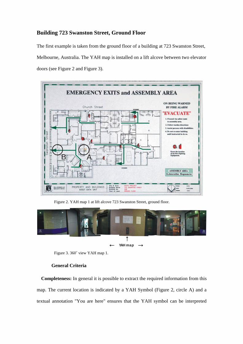
Building 723 Swanston Street, Ground Floor
The first example is taken from the ground floor of a building at 723 Swanston Street,
Melbourne, Australia. The YAH map is installed on a lift alcove between two elevator
doors (see Figure 2 and Figure 3).
AB
Figure 2. YAH map 1 at lift alcove 723 Swanston Street, ground floor.
YAH map Figure 3. 360˚ view YAH map 1.
General Criteria
Completeness: In general it is possible to extract the required information from this
map. The current location is indicated by a YAH Symbol (Figure 2, circle A) and a
textual annotation "You are here" ensures that the YAH symbol can be interpreted
correctly; the main entrance/exit door to Swanston Street (Figure 2, circle B) is
contained in the map although not explicitly marked. The route, or better several
routes are indicated but not marked from the current position.
Perceptibility / syntactic clarity / visual clutter: The relevant features are the
current location and the next exit. The exit to take is not explicitly marked, i.e., the
user has to figure out the closest exit herself. The YAH symbol is barely visible
(Figure 2, circle A). The map is a floor plan annotated for the case of emergencies.
Accordingly, the amount of visual clutter is high. Several objects are superfluous, for
example, movable objects, like under desk containers; several of these objects have
changed position or are no longer existing. Other information, like exit possibilities
behind closed doors in other parts of the building, is not important for someone who is
using the map at this position. Hence, some of the clutter could be avoided by
omission and/or using iconic symbols.
Semantic clarity: The YAH symbol is annotated with text. The green lines can be
recognised as possible escape routes, although that is not made explicit. There are,
however, many signs/features in the map that are not readily recognisable by lay
persons and are architectural specifications. For instance, the location of the restrooms
could be used as a valuable landmark but instead has to be inferred from the toilet-
shaped symbols instead of using a standardized sign.
Ambiguity: The exit routes from the current position are marked very prominently
in the map, whereas the main exit to Swanston Street (Figure 2, circle B) is not
marked explicitly—other than by the general green arrows. The inexperienced lay
user of this map might infer that all exit routes are suited equally well. Most of the
exits, however, are secured by hierarchical entrance rights which bear the possibilities
to seriously trap users.
Consistency: The green exit signs are prominent markers within the building.
Around the YAH map location several of them are installed. Their display in the map,
however, is missing. That no exit signs are displayed on the exit Swanston Street is
regarded critical and inconsistent.
YAH Map Criteria
General placement: The placement is close to an important, highly frequented
location, i.e. the elevator. Additionally the map is opposite the entrance/exit of one of
the bigger units on this floor.
Local placement / asymmetry: The asymmetry in this case is the symmetry, i.e.
the location between two elevator doors. As this map is not intended as a map for
visitors to find their destination but for people who want to leave the building or fight
a fire, a placement opposite the elevator doors as suggested by Levine (1982) does not
seem appropriate here.
Correspondence: As the green exit signs are prominent landmarks in the building
environment, they could be used in the map to enhance the mapping, i.e. to establish
the trilateral relationship between user-map-environment (see Figure 1).
Alignment: The map is misaligned with respect to the user's perspective. To be
correctly aligned the map needs to be rotated 90 degrees clockwise. The alignment
would ease orientation and would reduce the necessity for mental or head rotation.
Architectural cues: It could be better stressed that the map location is directly
between the two elevator doors. Instead, the YAH symbol (i.e. the red star in Figure 2,
circle A) is slightly misplaced.
YAH symbol: The YAH symbol is just a star providing position information but no
orientation.
Redundancy: Not used.
General Evaluation
This map reveals several general issues that are neglected in the design of maps and
YAH maps: Starting with the problem of visual clutter, the reuse of a map that is
designed for a different purpose, and neglecting specific design criteria for the
establishment of a sense of place. This map bears little usefulness in cases of
emergencies.
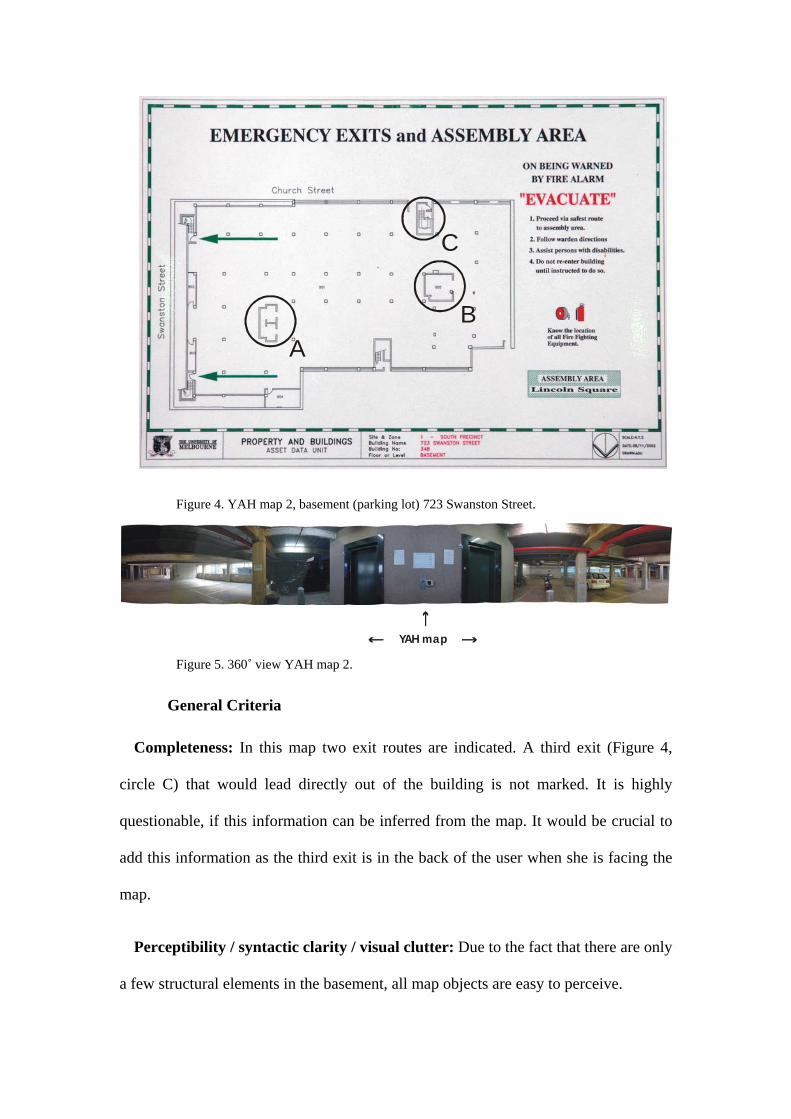
Basement 723 Swanston Street
The second example is taken from the basement in the same building (Figure 3 and
Figure 4). While the design scheme of the map is the same as in YAH map example 1,
the environment is quite different.
AB
C
Figure 4. YAH map 2, basement (parking lot) 723 Swanston Street.
YAH map Figure 5. 360˚ view YAH map 2.
General Criteria
Completeness: In this map two exit routes are indicated. A third exit (Figure 4,
circle C) that would lead directly out of the building is not marked. It is highly
questionable, if this information can be inferred from the map. It would be crucial to
add this information as the third exit is in the back of the user when she is facing the
map.
Perceptibility / syntactic clarity / visual clutter: Due to the fact that there are only
a few structural elements in the basement, all map objects are easy to perceive.
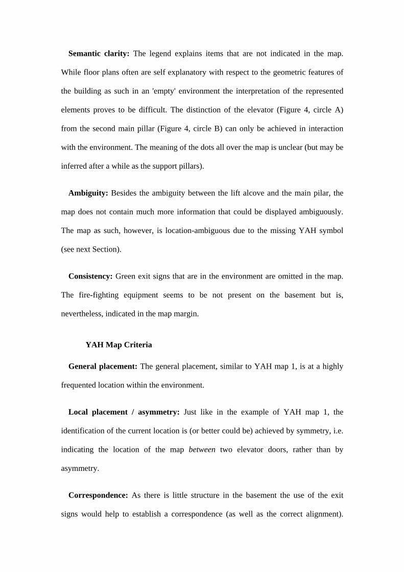
Semantic clarity: The legend explains items that are not indicated in the map.
While floor plans often are self explanatory with respect to the geometric features of
the building as such in an 'empty' environment the interpretation of the represented
elements proves to be difficult. The distinction of the elevator (Figure 4, circle A)
from the second main pillar (Figure 4, circle B) can only be achieved in interaction
with the environment. The meaning of the dots all over the map is unclear (but may be
inferred after a while as the support pillars).
Ambiguity: Besides the ambiguity between the lift alcove and the main pilar, the
map does not contain much more information that could be displayed ambiguously.
The map as such, however, is location-ambiguous due to the missing YAH symbol
(see next Section).
Consistency: Green exit signs that are in the environment are omitted in the map.
The fire-fighting equipment seems to be not present on the basement but is,
nevertheless, indicated in the map margin.
YAH Map Criteria
General placement: The general placement, similar to YAH map 1, is at a highly
frequented location within the environment.
Local placement / asymmetry: Just like in the example of YAH map 1, the
identification of the current location is (or better could be) achieved by symmetry, i.e.
indicating the location of the map between two elevator doors, rather than by
asymmetry.
Correspondence: As there is little structure in the basement the use of the exit
signs would help to establish a correspondence (as well as the correct alignment).
There are no identical labels that can be found in the map as well as in the
environment.
Alignment: The map is misaligned. To be correctly aligned the map needs to be
rotated 90 degrees clockwise.
Architectural cues: There are some architectural cues in the environment that
could potentially help establish a correspondence, for example, a fence right of the lift
alcove. These elements are not depicted.
YAH symbol: The YAH symbol has been omitted. Especially in an environment as
unstructured and information empty, i.e. no knowledge is in the environment (Raubal
and Worboys, 1999), establishing a correspondence is thereby inhibited.
Redundancy: Not used.
General Evaluation
This map is a good example of how the violation of correspondence requirements—
misalignment, missing YAH symbol, missing architectural clues—in environments
that do not naturally provide structure leads to an increased cognitive effort to
establish the trilateral user-map-environment relationship. This failure makes the map
barely usable, although the global location is suitable.
Geomatics Building 2nd Floor
YAH map 3 was found on the second floor of the Geomatics building.
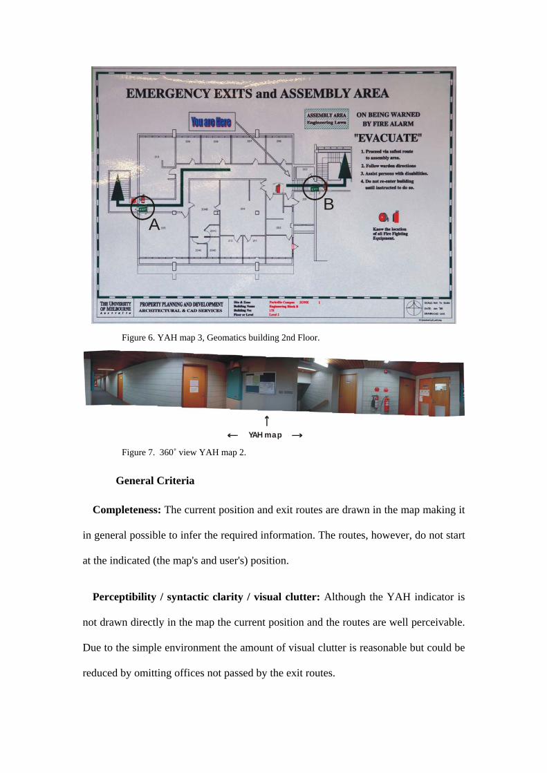
AB
Figure 6. YAH map 3, Geomatics building 2nd Floor.
YAH map Figure 7. 360˚ view YAH map 2.
General Criteria
Completeness: The current position and exit routes are drawn in the map making it
in general possible to infer the required information. The routes, however, do not start
at the indicated (the map's and user's) position.
Perceptibility / syntactic clarity / visual clutter: Although the YAH indicator is
not drawn directly in the map the current position and the routes are well perceivable.
Due to the simple environment the amount of visual clutter is reasonable but could be
reduced by omitting offices not passed by the exit routes.
Semantic Clarity: The YAH indicator is textual; the semantics of arrows should be
clear. The green lines with arrow ends denote the exit routes. The symbols for the fire
fighting equipment and the exit signs have been added subsequently. The symbols
differ in the map but no legend is provided that would explain these differences, i.e.
indicating the existence of different fire fighting equipment for different kinds of fires.
Ambiguity: The green exit signs (Figure 6, circle A and B) are arbitrarily placed in
the map as an in-map legend for the green lines. Their position does not correspond to
the green exit signs found in the environment.
Consistency: While room 203 is labelled with a number in the map, the actual door
sign shows the function (women's restroom). There is also an additional fire
extinguisher at the exit indicated by circle A in Figure 6.
YAH Map Criteria
General placement: The map is located at a wall that basically everyone who is
leaving this part of the building regularly has to pass.
Local placement / asymmetry: The asymmetry of this place (stairs on the very left
side) could be used to establish further correspondence if the map would have been
aligned correctly.
Alignment: The map is misaligned and needs to be rotated 90 counter clockwise to
fit the reference system of user-map-environment.
Correspondence: The green exit signs could be used as extra features to help
establishing a correspondence.
Architectural cues: The stairs right to the YAH map provide a good feature of
asymmetry.
YAH symbol: It is rather a YAH indicator lacking the inherent user reference
systems that a complex YAH symbol could supply.
Redundancy: Not given.
General Remarks
The mentioning of the assembly area is at a different position than in the other
maps. The symbols for the fire fighting equipment differ in the map but no legend is
provided to explain the different types. The date on the map is 1998 which might
explain why the symbols are added subsequently and why the indication of additional
fire fighting equipment is missing.
A strange mismatch is induced in that the arrow indicating the exit route conveys
the correct movement pattern but only as it incorporates one further decision point
that is located in the staircase. This, again, indicates the influence of the proper
depiction not only of the environment but also of the actions that have to be
performed therein.
RESULTS AND DISCUSSION The analysis of the map examples shows that the design and placement of YAH
maps has not been guided by established principles of YAH map design and their
placement (see Section 0). While we chose three map examples of the same design
style to highlight how different environments effect the legibility of maps, the
problems identified are omnipresent. Without having a systematic survey but many
other examples at hand, this situation is symptomatic for most YAH maps (e.g.,
search in Google’s images for "emergency map"). One of the biggest problems
identified is the difficulty of establishing a correspondence between the user, the map,
and the environment (see Figure 1), i.e. the trilateral user-map-environment
relationship necessary for updating one's cognitive map (Golledge, 1999). For a
successful orientation and the planning of appropriate next steps in an emergency,
accounting for this relationship is a necessity. The best researched—and probably
most pertinent—criterion for YAH maps, their alignment with the environment, is
violated in all discussed examples. All maps require the user to perform a mental
rotation of 90 degrees clockwise to establish a correct forward-up relationship. While
this might be feasible for locating oneself, the cognitive load increases if routes have
to be planned on this basis. The discussed examples make it obvious that the success
of the rotation task is strongly dependent on the structural cues provided in the
immediate surroundings of the map placement. Additionally, none of the maps
provides a complex YAH symbol that indicates the user's current orientation.
Supplementary features in the environment that could be used to establish the
correspondence more easily are often neglected. In our example, the prominent green
exit signs would allow to relate information represented in the map to information
present in the environment.
For the analysed cases, the global placement at highly frequented locations was a
sensible choice. The criteria for placing YAH maps can be evaluated using
approaches from different disciplines. For outdoor environments several factors can
be combined to identify critical decision points for wayfinding in a closed
environment (Richter and Klippel, 2002). To our knowledge, for indoor environments
no such assessment has been done for the placement of YAH maps.
The asymmetry criterion for the placement of YAH maps introduced by Levine
(Levine, 1982) can be extended by a symmetry criterion. Given the correct application
of other YAH map design criteria, a symmetrical placement within an environment
can be used to quickly identify one's position as well as the original asymmetry
criterion.
If maps are drawn in a precise way like the floor plans in our example, i.e. they are
spatially veridical, users expect them to be correct and complete (Habel, 2003).
Missing features, like the fence in the basement in YAH map example 3, make these
maps confusing, as they are not sketch maps, which might allow for the depiction of
partial spatial knowledge.
These results reveal the necessity to advise proper and clear guidelines for those
who are responsible for providing map-based orientation beyond the ones that can be
already found in the literature (O'Neill, 1999, Levine, 1982). The examples in this
paper show that the maps provided need improvement to fulfil the criteria of good
map design and the special requirements for YAH Maps (in emergencies). A common
terminology as proposed in this paper that guides the evaluation and the design is a
first step.
IDENTIFICATION OF FUTURE RESEARCH DIRECTIONS
Requirements and Implementations of a (Semi) Automatic Interactive Systems for YAH Map Design and Placement
A system that semiautomatically creates location-aware YAH maps requires the
specification of several design factors. For solidly installed YAH maps the first step is
the identification of a suitable location within an environment. This location is
influenced by global and afterwards local properties of an environment. Several
approaches for specifying these placement criteria and for outdoor environments
evaluations have taken place (O'Neill, 1991b, Richter and Klippel, 2002). For the case
of emergency YAH maps local criteria are more crucial (as it is better to have an
additional map than being one short) that allow for creating a sense of place usable in
emergency situations. The legibility of an environment has been characterised in
environmental cognition and architectural literature (Weisman, 1987, Lynch, 1960).
Yet, as it is a sensible approach to guide architectural design decision at least partially
by aspects of spatial cognition, the problem remains pertinent for existing buildings;
suitable YAH maps have to be advised for existing structures. A deeper understanding
of aspects of spatial cognition is therefore desirable, especially in complex indoor
structures (O'Neill, 1992, Hölscher et al., in prep).
Dynamically created emergency YAH maps pose additional challenges. It is useful
to distinguish here between different visualization technologies of dynamically
created emergency maps. Using immersive visualization technologies (Cartwright et
al., 1999) emergency maps would be designed for a specific location, while their
content changes according to the actual emergency situation. For example, if the next
emergency exit is blocked by a fire, a dynamically created map could show the route
to the next free exit (Graf and Winter, 2003, Pu and Zlatanova, 2005). Dynamically
created maps for presentation on mobile devices have to deal additionally with the
variable (and changing) position and orientation of the map reader. In this case, map
design needs knowledge about the spatial environment, the emergency situation, the
individual user, and her position, orientation and speed (Kealy et al., submitted).
Another constraint is the small screen of current mobile devices. However, the map
will be not only adaptive to the situation, but also to the user. For example, two
mobile users coming along the same place in an evacuation situation can get different
advice according to their individual abilities and mobility. In both cases, the content
will be drastically reduced, since the situation requires quick action. Sense of
direction will be more relevant then sense of place.
The design of such maps can follow an approach taken in the project Spatial
Structures in Aspect Maps (Berendt et al., 1998). Based on the distinction of
knowledge into different aspects, precedence relations have to be established on
which criteria are ranked higher than others. This holds for the objects represented in
the map as well as for the specific criteria for YAH maps. Instead of using existing
maps we suggest to pursue an approach known from sketch maps where the
representation are constructed based on conceptual units (Klippel et al., 2005). To this
end, we aim to fulfil communicative maxims (Grice, 1989) and especially avoid
visual clutter.
The combination of two-dimensional and three-dimensional information, i.e. maps
that are annotated with three-dimensional models of salient objects does show a lot of
promise in increasing the efficiency of maps for orientation (Rakkalainen and Vainio,
2001). The technical capabilities of extracting, for example, map icons have advanced
(DeCarlo et al., 2003) and in combination with availability of three-dimensional city
models, the seamless integration of different information sources with exploiting the
information best suited to a given task will be feasible.
Possibilities for Evaluation
We rendered the terminology associated with YAH maps more precise to allow for
an easy evaluation of existing maps (Section 0). A further assessment should be based
on established methodologies from cognitive science and related fields of research.
Possibilities that we are currently exploring comprise the following:
Eye movement studies: Eye movement studies are becoming more and more
popular as the technical (and economic) aspects of these systems are well advanced
(Hayhoe and Ballard, 2005). Several studies in visual communication and related
fields have shown the value of this methodology.
Virtual environments: Virtual environments allow for the manipulation of specific
environmental characteristics. This procedure is necessary to establish a base line of
human behaviour and human response to different environmental settings (Vinson,
1999).
Agent simulations: Great progress has been made in agent simulations within the
last couple of years (Raubal, 2001, Frank, 2000). As agent models become more and
more sophisticated these simulations can save valuable time and money for the
assessment of necessary security provisions.
Behavioural studies: The analysis of wayfinding behaviour in complex building
with several parts and several levels is part of current research programs (Hölscher et
al., in prep). Interestingly, these studies show that maps seem to have no or a negative
effect on the performance of wayfinders. In our opinion this is not because of the
general inapplicability of maps as they have proven beneficial influence on spatial
problem solving, but is a further indicator of still to many maps that need
improvement.
CONCLUSIONS In this article we have shown how different approaches of spatial sciences can
benefit from each other: On the one hand, the general aspect of mapping and data
provision, on the other hand, spatial cognition research. Spatial cognition research
offers many insights into processes how humans perceive, store, transform, and
employ spatial information. Although there exist many accounts on how cartographic
and cognitive research can be fruitfully combined from a more cartographic
perspective (e.g., MacEachren, 1995), a closer relationship shows beneficial promises,
and close collaborations are necessary to conduct research in so called research cycles
in which behavioural findings are iteratively integrated in information systems.
Users should get an enhanced (integrated) sense of the one place that they are at
(rather than several ways of seeing a place that burden their mental capacities). This
can only be achieved if perceptual and cognitive aspects of the processing of spatial
information are combined. The developed terminology is a synthesis from the
literature and our own work in spatial cognition. It allows to improve YAH maps in
two ways: First, it is a means to evaluate existing YAH maps; second, it is an
extended guideline for designing and placing YAH maps. Additionally, the identified
categories are the basis for a system that will autonomously create maps for specific
locations. With the shift from solidly installed YAH maps to mobile systems or
automatically updated ones and the development of smart environments additional
possibilities for providing route information emerge.
ACKNOWLEDGEMENTS This work has been supported by the Cooperative Research Centre for Spatial
Information, whose activities are funded by the Australian Commonwealth's
Cooperative Research Centres Programme and the German Science Foundation
(DFG), SFB/TR 8 Spatial Cognition. The authors would like to thank the participants
of the Advanced Topics of GIS lecture and three anonymous reviewers for valuable
comments.
REFERENCES Agarwal, P 2005, 'Operationalising 'sense of place' as a cognitive operator for
semantics in place-based ontologies', in AG Cohn & DM Mark (eds), Spatial
Information Theory. International Conference, COSIT 2005, Ellicottville, NY,
USA, September 14-18, 2005, Proceedings, Springer, Berlin.
Bafna, S 2003, 'Space Syntax. A brief introductions to its logic and analytical
techniques', Environment and Behavior, vol. 35, no. 1, pp. 17-29.
Baskaya, A, Wilson, C & Özcan, Y 2004, 'Wayfinding in an unfamiliar environment.
Different spatial settings of two polyclinics', Environment and Behavior, vol.
36, no. 6, pp. 839-67.
Berendt, B, Barkowsky, T, Freksa, C & Kelter, S 1998, 'Spatial representation with
aspect maps', in C Freksa, C Habel & KF Wender (eds), Spatial Cognition. An
interdisciplinary approach to representing and processing spatial knowledge,
Springer, Berlin, pp. 313-36.
Best, GA 1970, 'Direction-finding in large buildings', in D Canter (ed.), Architectural
Psychology, RIBA, London, pp. 72-91.
Cartwright, W, Peterson, MP & Gartner, G (eds) 1999, Multimedia Cartography,
Springer, New York.
DeCarlo, D, Finkelstein, A, Rusinkiewicz, S & Santella, A 2003, 'Suggestive contours
for conveying shape', in SIGGRAPH 2003, pp. 848-55.
Dobson, MW 1980, 'The influence of the amount of graphic information on visual
matching', The Cartographic Journal, vol. 17, no. 1, pp. 26-32.
Fontaine, S & Denis, M 1999, 'The production of route instructions in underground
and urban environments.' in C Freksa & DM Mark (eds), Spatial information
theory. Cognitive and computational foundations of geographic information
science, Springer, Berlin, pp. 83-94.
Frank, AU 2000, 'Spatial communication with maps: Defining the correctness of maps
using a multi-agent simulation', in C Freksa, W Brauer, C Habel & KF
Wender (eds), Spatial cognition II: Integrating abstract theories, empirical
studies, formal methods, and practical applications, Springer, Berlin.
Freksa, C 1999, 'Spatial aspects of task-specific wayfinding maps.' in JS Gero & B
Tversky (eds), Visual and Spatial Reasoning in Design., Key Centre of Design
Computing and Cognition, University of Sydney, pp. 15-32.
Gärling, T, Lindberg, E & Mäntylä, G 1983, 'Orientation in buildings: Effects of
familiarity, visual access, and orientation aids', Journal of Applied Psychology,
vol. 68, no. 1, pp. 177-86.
Gartner, G, Frank, AU & Retscher, G 2004, 'Pedestrian navigation system for mixed
indoor/outdoor environments', in G Gartner (ed.), Location based services &
telecartography. Proceedings of the Symposium 2004, Vienna University of
Technology, Vienna, pp. 161-7.
Golledge, RG & Stimson, RJ 1997, Spatial Behavior. A Geographic Perspective., The
Guilford Press, New York.
Golledge, RG (ed.) 1999, Wayfinding behavior. Cognitive mapping and other spatial
processes, Johns Hopkins University Press, Baltimore.
Graf, M & Winter, S 2003, 'Netzwerk-Voronoi-Diagramme', Österreichische
Zeitschrift für Vermessung und Geoinformation, vol. 91, no. 3, pp. 166-74.
Grice, HP 1989, Studies in the way of words, Harvard University Press, Cambridge,
MA.
Habel, C 2003, 'Representational commitment in maps', in M Duckham, MF
Goodchild & M Worboys (eds), Roundations of Geographic Information
Science, Taylor & Francis, London, pp. 69-93.
Hayhoe, M & Ballard, D 2005, 'Eye movements in natural behavior', Trends in
Cognitive Sciences, vol. 9, no. 4.
Hillier, B & Iida, S 2005, 'Network and psychological effects in urban movement', in
AG Cohn & DM Mark (eds), Spatial Information Theory. International
Conference, COSIT 2005, Ellicottville, NY, USA, September 14-18, 2005,
Proceedings, Springer, Berlin, pp. 475-90.
Hirtle, SC 2000, 'The use of maps, images and "gestures" for navigation', in C Freksa,
W Brauer, C Habel & KF Wender (eds), Spatial cognition II -- Integrating
abstract theories, empirical studies, formal methods, and practical
applications, Springer, Berlin, pp. 31-40.
Hölscher, C, Meilinger, T, Vrachliotis, G & Brösamle, M 2005, 'Maps, room numbers
and wayfinding strategies - Investigations in a vertically complex building',
Poster Presented at Spatial Information Theory. International Conference,
COSIT 2005, Ellicottville, NY, USA, September 14-18, 2005,.
Kealy, A, Retscher, G & Winter, S submitted, 'Approaches to Developing the Next
Generation of Mobile Mapping Systems', Mobile Information Systems.
Keates, JS 1996, Understanding Maps, 2nd edn, Longman, Edinburgh.
Klippel, A 2003, Wayfinding Choremes. Conceptualizing Wayfinding and Route
Direction Elements., Universität Bremen, Bremen.
Klippel, A, Lee, PU, Fabrikant, SI, Montello, DR & Bateman, J 2005, 'The cognitive
conceptual approach as a leitmotif for map design', in Reasoning with Mental
and External Diagrams: Computational Modeling and Spatial Assistance.
Papers from the AAAI 2005 Spring Symposium. March 21-23, Stanford,
California., AAAI Press, Menlo Park, CA, pp. 90-5.
Kosslyn, SM 1989, 'Understanding charts and graphs', Applied Cognitive Psychology,
vol. 3, pp. 185-225.
Larkin, JH & Simon, HA 1987, 'Why a diagram is (sometimes) worth ten thousand
words', Cognitive Science, vol. 82, no. 4, pp. 207-25.
Levine, M 1982, 'You-Are-Here maps. Psychological considerations', Environment
and Behavior, vol. 14, pp. 221-37.
Levine, M, Jankovic, IN & Palij, M 1982, 'Principles of spatial problem solving',
Journal of Experimental Psychology: General, vol. 111, no. 2, pp. 157-75.
Levine, M, Marchon, I & Hanley, G 1984, 'The placement and misplacement of You-
Are-Here-Maps.' Environment and Behavior, vol. 16, no. 2, pp. 139-57.
Levinson, SC 2003, Space in Language and Cognition, Cambridge University Press,
Cambridge.
Liben, LS & Downs, RM 1993, 'Understanding person-space-map relations:
Cartographic and developmental perspective', Developmental Psychology, vol.
29, no. 4, pp. 739-52.
Lloyd, R 2000, 'Understanding and learning maps', in R Kitchin & S Freundschuh
(eds), Cognitive Mapping: Past, present, and future, Routledge, London, pp.
84-107.
Lynch, K 1960, The image of the city., MIT Press, Cambridge, MA.
MacEachren, AM 1995, How Maps Work. Representation, Visualization, and Design,
The Guilford Press, New York.
Moeser, SD 1988, 'Cognitive mapping in a complex building', Environment and
Behavior, vol. 20, no. 1, pp. 21-49.
Montello, DR 2005, 'Navigation', in A Miyake & P Shah (eds), Cambridge Handbook
of Visuospatial Thinking, Cambridge University Press, Cambridge, pp. 257-94.
Muehrke, PC & Muehrke, JO 1986, Map use: reading, analysis, and interpretation,
JP Publications, Madison, WI.
O'Neill, MJ 1991a, 'Effects of signage and floor plan configuration on wayfinding
accuracy', Environment and Behavior, vol. 23, no. 5, pp. 553-74.
---- 1991b, 'Evaluation of a conceptual model for architectural legibility', Environment
and Behavior, vol. 23, no. 3, pp. 259-84.
---- 1992, 'Effects of familiarity and plan complexity on wayfinding in simulated
buildings', Journal of Environmental Psychology, vol. 12, pp. 319-27.
---- 1999, 'Theory and research in design of 'You-Are-Here' maps', in JG Zwaga, T
Boersema & HCM Hoonhout (eds), Visual information for everyday use -
design and research perspectives, Taylor & Francis, London.
Phillips, RJ & Noyes, E 1982, 'An investigation of visual clutter in the topographic
base of a geological map', Cartographic Journal, vol. 19, no. 2, pp. 122-32.
Pu, S & Zlatanova, S 2005, 'Evacuation Route Calculation of Inner Buildings', in P
van Oosterom, S Zlatanova & EM Fendel (eds), Geo-information in Disaster
Management, Springer, Heidelberg, pp. 1143-61.
Rakkalainen, T & Vainio, T 2001, 'A 3D city info for mobile users', Computers &
Graphics, vol. 25, no. 4, pp. 619-25.
Raubal, M 2001, 'Ontology and epistemology for agent-based wayfinding simulation',
International Journal of Geographical Information Science, vol. 15, no. 7, pp.
653-65.
Raubal, M & Worboys, M 1999, 'A formal model of the process of wayfinding in
built environments', in C Freksa & DM Mark (eds), Spatial information
theory. Cognitive and computational foundations of geographic information
science., Springer, Berlin, pp. 381-99.
Richter, K-F & Klippel, A 2002, 'You-are-here-maps: Wayfinding support as location
based service.' in J Möltgen & A Wytzisk (eds), GI-Technologien für Verkehr
und Logistik. Beiträge zu den Münsteraner GI-Tagen 20./21. Juni 2002.,
IfGIprints, 13: Muenster, pp. 357-64.
Shepard, RN & Hurwitz, S 1984, 'Upward direction, mental rotation, and
discrimination of left and right turns in maps', Cognition, vol. 18, pp. 161-93.
Tufte, E 1990, Envisioning information, Graphics Press, Connecticut.
---- 1997, Visual explanations: Images and quantities, evidence and narratives,
Graphics Press, Connecticut.
Tversky, B 2000, 'What maps reveal about spatial thinking', Developmental Science,
vol. 3, no. 3, pp. 281-2.
Vinson, NG 1999, 'Design guidelines for landmarks to support navigation in virtual
environments', in CHI 99.
Warren, DH & Scott, TE 1993, 'Map alignment in traveling multisegment routes',
Environment and Behavior, vol. 25, pp. 643-66.
Warren, DH, Scott, TE & Medley, C 1992, 'Finding locations in the environment: The
map as mediator.' Perception, vol. 21, no. 5, pp. 671-89.
Weisman, GD 1987, 'Improving way-finding and architectural legibility in housing
for the elderly', in V Regnier & J Pynoos (eds), Housing the aged: Design
directives and policy considerations, Elsevier, New York.


![Sensors 2012 sensors - MSE - MyWebPages · 2015. 9. 2. · Kinect have attracted the attention of researchers from other fields [3–11] including mapping and 3D modeling [12–15]](https://img.pdfslide.us/doc/110x75/5fbcd3db5f08e177897b5418/sensors-2012-sensors-mse-mywebpages-2015-9-2-kinect-have-attracted-the.jpg)