Embed Size (px)
Citation preview
THE CORPORATION OF THE CITY OF LONDON
Guidelines for Management Zones & Trails in Environmentally Significant Areas May 2016
The Corporation of the City of London Guidelines for Management Zones & Trails in Environmentally Significant Areas May 2016
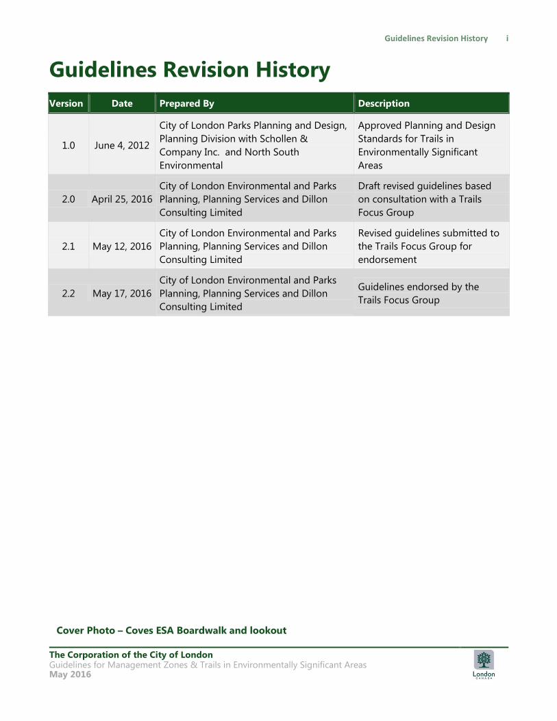
Guidelines Revision History
Version Date Prepared By Description
1.0 June 4, 2012
City of London Parks Planning and Design,
Planning Division with Schollen &
Company Inc. and North South
Environmental
Approved Planning and Design
Standards for Trails in
Environmentally Significant
Areas
2.0 April 25, 2016
City of London Environmental and Parks
Planning, Planning Services and Dillon
Consulting Limited
Draft revised guidelines based
on consultation with a Trails
Focus Group
2.1 May 12, 2016
City of London Environmental and Parks
Planning, Planning Services and Dillon
Consulting Limited
Revised guidelines submitted to
the Trails Focus Group for
endorsement
2.2 May 17, 2016
City of London Environmental and Parks
Planning, Planning Services and Dillon
Consulting Limited
Guidelines endorsed by the
Trails Focus Group
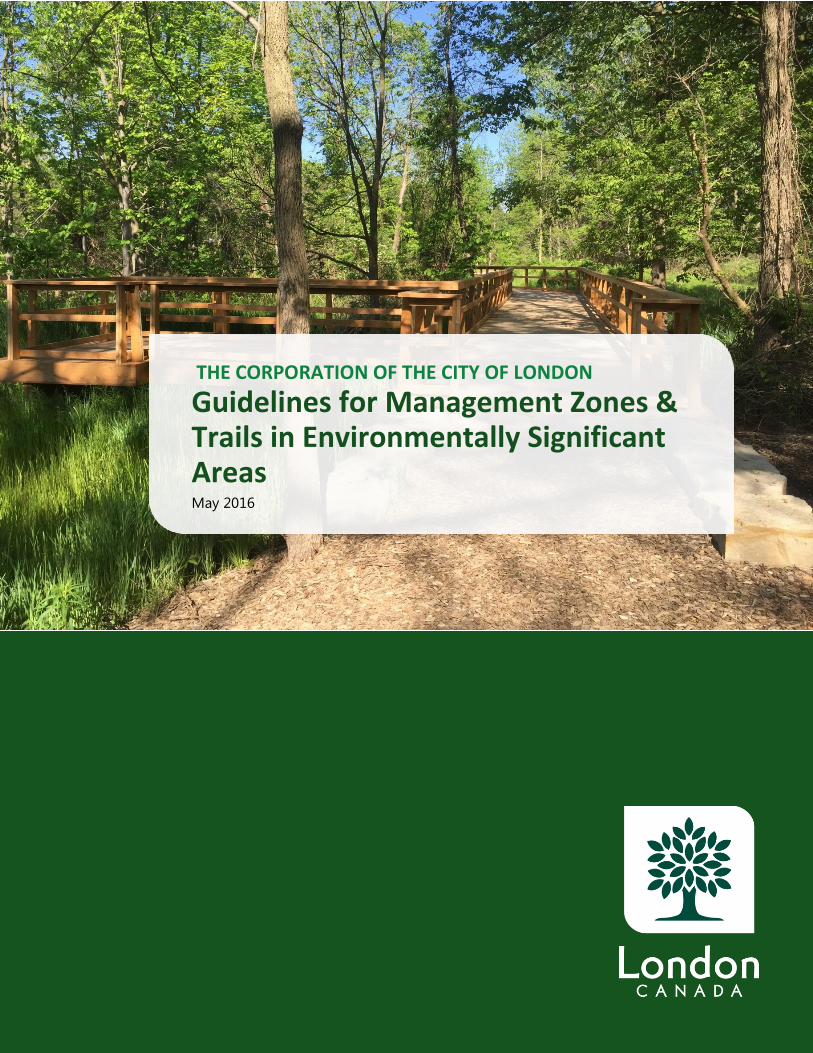
Cover Photo – Coves ESA Boardwalk and lookout
The Corporation of the City of London Guidelines for Management Zones & Trails in Environmentally Significant Areas May 2016
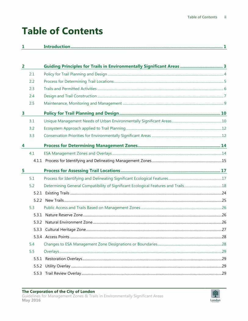
Table of Contents
1 Introduction ............................................................................................................................. 1
2 Guiding Principles for Trails in Environmentally Significant Areas ................................... 3
2.1 Policy for Trail Planning and Design .................................................................................................................................... 4
2.2 Process for Determining Trail Locations ............................................................................................................................. 5
2.3 Trails and Permitted Activities ................................................................................................................................................ 6
2.4 Design and Trail Construction ................................................................................................................................................ 7
2.5 Maintenance, Monitoring and Management ................................................................................................................... 9
3 Policy for Trail Planning and Design ................................................................................... 10
3.1 Unique Management Needs of Urban Environmentally Significant Areas ......................................................... 10
3.2 Ecosystem Approach applied to Trail Planning ............................................................................................................. 12
3.3 Conservation Priorities for Environmentally Significant Areas ................................................................................ 12
4 Process for Determining Management Zones .................................................................... 14
4.1 ESA Management Zones and Overlays ............................................................................................................................. 14
4.1.1 Process for Identifying and Delineating Management Zones ................................................................................ 15
5 Process for Assessing Trail Locations .................................................................................. 17
5.1 Process for Identifying and Delineating Significant Ecological Features ............................................................. 17
5.2 Determining General Compatibility of Significant Ecological Features and Trails........................................... 18
5.2.1 Existing Trails ............................................................................................................................................................................. 24
5.2.2 New Trails .................................................................................................................................................................................... 25
5.3 Public Access and Trails Based on Management Zones ............................................................................................ 26
5.3.1 Nature Reserve Zone .............................................................................................................................................................. 26
5.3.2 Natural Environment Zone ................................................................................................................................................... 26
5.3.3 Cultural Heritage Zone........................................................................................................................................................... 27
5.3.4 Access Points ............................................................................................................................................................................. 28
5.4 Changes to ESA Management Zone Designations or Boundaries ......................................................................... 28
5.5 Overlays ......................................................................................................................................................................................... 29
5.5.1 Restoration Overlays ............................................................................................................................................................... 29
5.5.2 Utility Overlay ............................................................................................................................................................................ 29
5.5.3 Trail Review Overlay ................................................................................................................................................................ 29
The Corporation of the City of London Guidelines for Management Zones & Trails in Environmentally Significant Areas May 2016
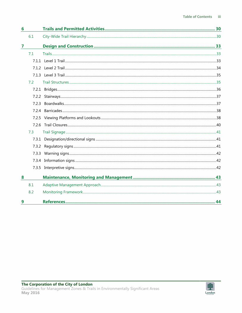
6 Trails and Permitted Activities ............................................................................................. 30
6.1 City-Wide Trail Hierarchy ........................................................................................................................................................ 30
7 Design and Construction ...................................................................................................... 33
7.1 Trails ................................................................................................................................................................................................ 33
7.1.1 Level 1 Trail ................................................................................................................................................................................. 33
7.1.2 Level 2 Trail ................................................................................................................................................................................. 34
7.1.3 Level 3 Trail ................................................................................................................................................................................. 35
7.2 Trail Structures ............................................................................................................................................................................ 35
7.2.1 Bridges .......................................................................................................................................................................................... 36
7.2.2 Stairways ...................................................................................................................................................................................... 37
7.2.3 Boardwalks .................................................................................................................................................................................. 37
7.2.4 Barricades .................................................................................................................................................................................... 38
7.2.5 Viewing Platforms and Lookouts ....................................................................................................................................... 38
7.2.6 Trail Closures .............................................................................................................................................................................. 40
7.3 Trail Signage ................................................................................................................................................................................ 41
7.3.1 Designation/directional signs ............................................................................................................................................. 41
7.3.2 Regulatory signs ....................................................................................................................................................................... 41
7.3.3 Warning signs ............................................................................................................................................................................ 42
7.3.4 Information signs ..................................................................................................................................................................... 42
7.3.5 Interpretive signs ...................................................................................................................................................................... 42
8 Maintenance, Monitoring and Management ..................................................................... 43
8.1 Adaptive Management Approach ....................................................................................................................................... 43
8.2 Monitoring Framework ............................................................................................................................................................ 43
9 References .............................................................................................................................. 44
The Corporation of the City of London Guidelines for Management Zones & Trails in Environmentally Significant Areas May 2016
Flowcharts
Chart 1: Identify and Delineate Management Zones ............................................................................... 16
Chart 2: Review of Significant Ecological Features and Trail Recommendation for Existing Trails
..................................................................................................................................................................... 24
Chart 3: Review of Significant Ecological Features and Trail Recommendations for New Trails25
Tables
Table 1: Significant Ecological Features and General Compatibility with Trails ............................. 20
Table 2: Summary of Management Zones, Overlays and Trail Hierarchy for ESAs ...................... 31
Appendices
A Glossary
The Corporation of the City of London Guidelines for Management Zones & Trails in Environmentally Significant Areas May 2016
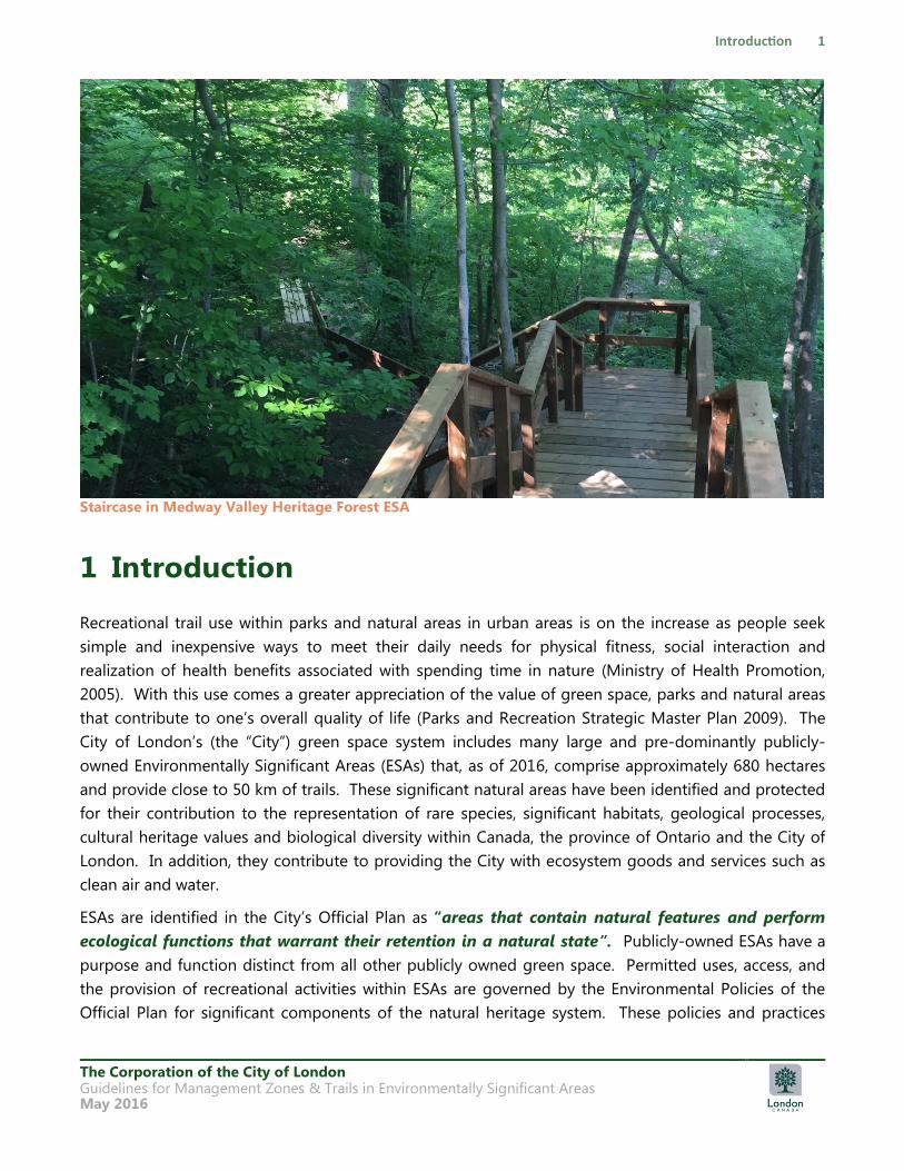
Staircase in Medway Valley Heritage Forest ESA
1 Introduction
Recreational trail use within parks and natural areas in urban areas is on the increase as people seek
simple and inexpensive ways to meet their daily needs for physical fitness, social interaction and
realization of health benefits associated with spending time in nature (Ministry of Health Promotion,
2005). With this use comes a greater appreciation of the value of green space, parks and natural areas
that contribute to one‟s overall quality of life (Parks and Recreation Strategic Master Plan 2009). The
City of London‟s (the “City”) green space system includes many large and pre-dominantly publicly-
owned Environmentally Significant Areas (ESAs) that, as of 2016, comprise approximately 680 hectares
and provide close to 50 km of trails. These significant natural areas have been identified and protected
for their contribution to the representation of rare species, significant habitats, geological processes,
cultural heritage values and biological diversity within Canada, the province of Ontario and the City of
London. In addition, they contribute to providing the City with ecosystem goods and services such as
clean air and water.
ESAs are identified in the City‟s Official Plan as “areas that contain natural features and perform
ecological functions that warrant their retention in a natural state”. Publicly-owned ESAs have a
purpose and function distinct from all other publicly owned green space. Permitted uses, access, and
the provision of recreational activities within ESAs are governed by the Environmental Policies of the
Official Plan for significant components of the natural heritage system. These policies and practices
The Corporation of the City of London Guidelines for Management Zones & Trails in Environmentally Significant Areas May 2016
must be consistent with the Provincial Policy Statement (PPS) issued under authority of Section 3 of the
Planning Act. The PPS is to be read in its entirety and all of the relevant policies must be considered
together.
Meeting the requirements of the Official Plan is the main reason why guidelines for management zones
and trails within ESAs must be based first on ecological protection through avoidance of impacts, and
secondly, the application of appropriate mitigation where necessary to avoid degradation of natural
features or loss of ecological functions.
The intent of this document is to establish the policy, process, and practice that must be followed when
establishing management zones and reviewing the appropriateness of existing trails or planning new
trails in ESAs, including:
• Establishing management zones based on Ecological Land Classification (Lee et al. 1998).
• Establishing and implementing a trail hierarchy according to management zones.
• Identifying areas for review where significant ecological features may occur in association with the
trail system.
• Responding to unacceptable change through appropriate mitigation and adaptive management to
alter practices, as required. This document is aligned with the City of London Official Plan and
guidelines developed by the Ontario Ministry of Natural Resources and Forestry (MNR 1992; MNR
2009; MNR 2014) and Parks Canada (Parks Canada 2008; Parks Canada 2012) to manage protected
natural areas. It is consistent with and generally exceeds the requirements for protected natural
areas managed by the Government of Ontario and the Government of Canada (Dillon 2016).
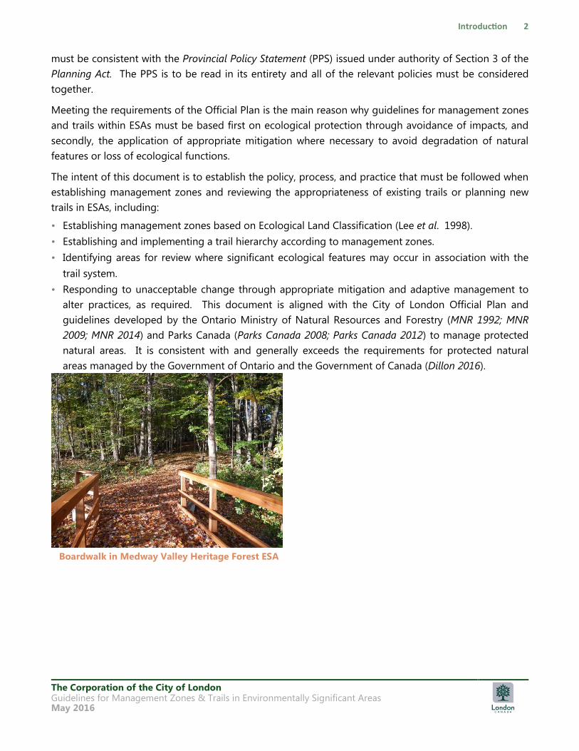
Boardwalk in Medway Valley Heritage Forest ESA
The Corporation of the City of London Guidelines for Management Zones & Trails in Environmentally Significant Areas May 2016
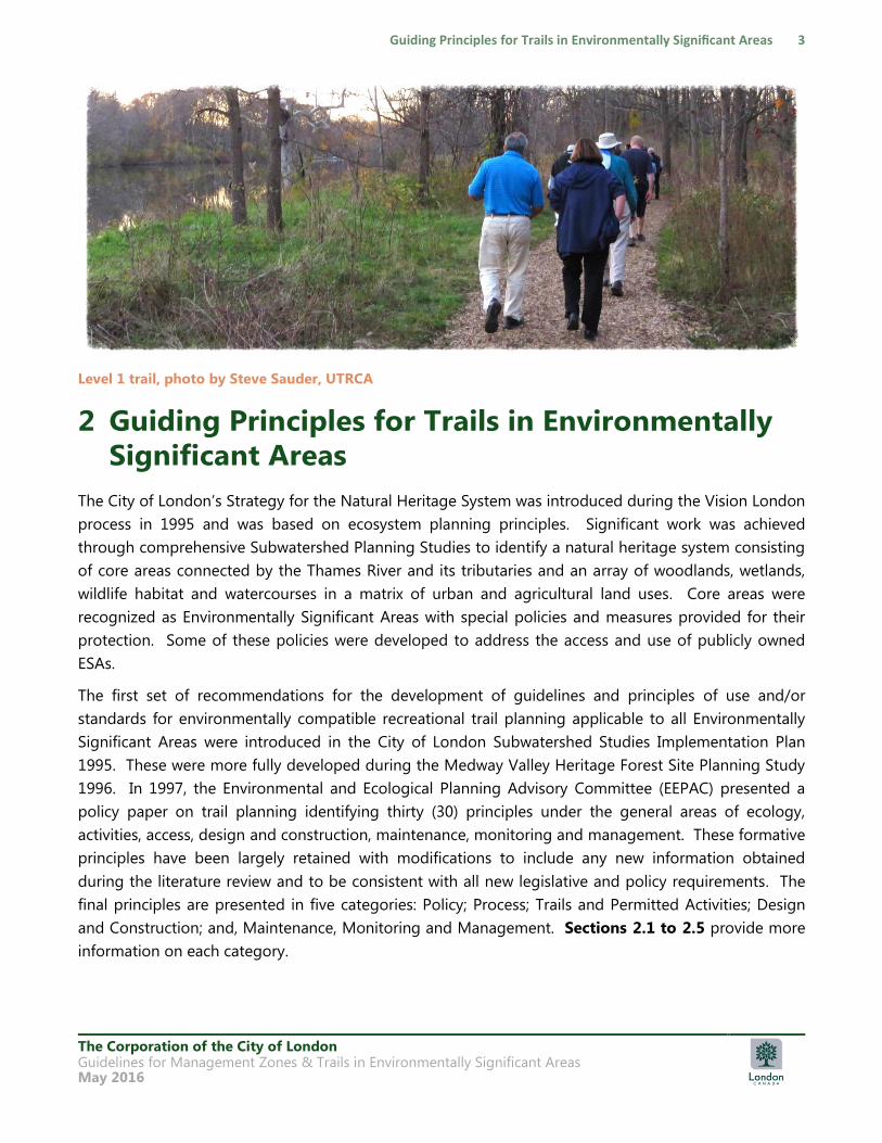
Level 1 trail, photo by Steve Sauder, UTRCA
2 Guiding Principles for Trails in Environmentally
Significant Areas
The City of London‟s Strategy for the Natural Heritage System was introduced during the Vision London
process in 1995 and was based on ecosystem planning principles. Significant work was achieved
through comprehensive Subwatershed Planning Studies to identify a natural heritage system consisting
of core areas connected by the Thames River and its tributaries and an array of woodlands, wetlands,
wildlife habitat and watercourses in a matrix of urban and agricultural land uses. Core areas were
recognized as Environmentally Significant Areas with special policies and measures provided for their
protection. Some of these policies were developed to address the access and use of publicly owned
ESAs.
The first set of recommendations for the development of guidelines and principles of use and/or
standards for environmentally compatible recreational trail planning applicable to all Environmentally
Significant Areas were introduced in the City of London Subwatershed Studies Implementation Plan
1995. These were more fully developed during the Medway Valley Heritage Forest Site Planning Study
1996. In 1997, the Environmental and Ecological Planning Advisory Committee (EEPAC) presented a
policy paper on trail planning identifying thirty (30) principles under the general areas of ecology,
activities, access, design and construction, maintenance, monitoring and management. These formative
principles have been largely retained with modifications to include any new information obtained
during the literature review and to be consistent with all new legislative and policy requirements. The
final principles are presented in five categories: Policy; Process; Trails and Permitted Activities; Design
and Construction; and, Maintenance, Monitoring and Management. Sections 2.1 to 2.5 provide more
information on each category.

The Corporation of the City of London Guidelines for Management Zones & Trails in Environmentally Significant Areas May 2016
The basic principle for trail planning and design is to protect the natural features and ecological
functions for which the ESA has been identified. The ecological integrity and ecosystem health of the
ESA shall have priority in any trail use or design-related decisions. This also provides an opportunity to
promote and engage a natural resource stewardship ethic among users. A stewardship ethic refers to
the thoughtful care of ecological systems to preserve or enhance their natural qualities and recognizes
that the values and goals of all users of natural areas are more similar than they are different. The vast
majority of people value natural areas for their natural scenery and respite from the built form and do
not enter a natural area with the intention of causing harm. A properly designed trail system is required
to meet the needs of a wide mix of trail users in an urban setting.
Trail planning and design must address physical sustainability (trails that will retain their form over years
of use and natural forces acting on them), ecological sustainability (managing the impacts of trail
location and use to ensure no loss of ecological features and functions), and stewardship (fostering of
individual and collective responsibility for protection of natural areas).
In London, the majority of trail planning and management efforts are focused on addressing existing
use patterns on unplanned trails in existing well-used ESAs. As the City grows and new ESA lands are
acquired, we may have the opportunity to plan and design new trails to protect ESAs and accommodate
users.
2.1 Policy for Trail Planning and Design
• Natural features and ecological functions for which the ESA has been identified shall be protected.
• The ecological integrity and ecosystem health of the ESA shall have priority in any use or design-
related decision.
• A properly designed and implemented trail system appropriate to specific management zones and
reflecting sensitivity of the natural features will be implemented to achieve the primary objective of
protection and the secondary objective of providing suitable recreational and educational
opportunities.
• The community will be engaged in natural areas protection and the trail planning process to build
awareness, foster education, and encourage participation in order to increase the capacity for
creating a conservation culture that promotes natural areas as a common good and conservation as
a collective responsibility.
• Enjoyable, safe, accessible trails for recreation appropriate in an ESA and learning environment will be
permitted in accordance with recognized accessibility legislation (such as the Accessibility for
Ontarians with Disabilities Act, 2005 (AODA), best practices and the above principles.
The Corporation of the City of London Guidelines for Management Zones & Trails in Environmentally Significant Areas May 2016
2.2 Process for Determining Trail Locations
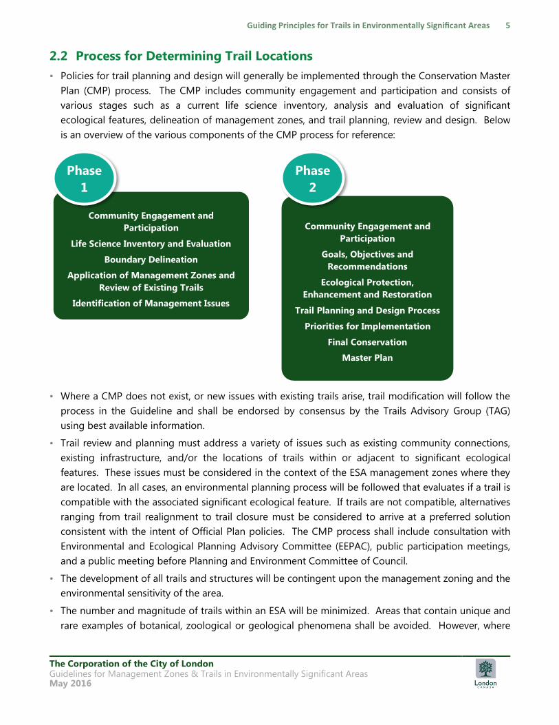
• Policies for trail planning and design will generally be implemented through the Conservation Master
Plan (CMP) process. The CMP includes community engagement and participation and consists of
various stages such as a current life science inventory, analysis and evaluation of significant
ecological features, delineation of management zones, and trail planning, review and design. Below
is an overview of the various components of the CMP process for reference:
• Where a CMP does not exist, or new issues with existing trails arise, trail modification will follow the
process in the Guideline and shall be endorsed by consensus by the Trails Advisory Group (TAG)
using best available information.
• Trail review and planning must address a variety of issues such as existing community connections,
existing infrastructure, and/or the locations of trails within or adjacent to significant ecological
features. These issues must be considered in the context of the ESA management zones where they
are located. In all cases, an environmental planning process will be followed that evaluates if a trail is
compatible with the associated significant ecological feature. If trails are not compatible, alternatives
ranging from trail realignment to trail closure must be considered to arrive at a preferred solution
consistent with the intent of Official Plan policies. The CMP process shall include consultation with
Environmental and Ecological Planning Advisory Committee (EEPAC), public participation meetings,
and a public meeting before Planning and Environment Committee of Council.
• The development of all trails and structures will be contingent upon the management zoning and the
environmental sensitivity of the area.
• The number and magnitude of trails within an ESA will be minimized. Areas that contain unique and
rare examples of botanical, zoological or geological phenomena shall be avoided. However, where
Community Engagement and
Participation
Life Science Inventory and Evaluation
Boundary Delineation
Application of Management Zones and
Review of Existing Trails
Identification of Management Issues
Phase
1
Community Engagement and
Participation
Goals, Objectives and
Recommendations
Ecological Protection,
Enhancement and Restoration
Trail Planning and Design Process
Priorities for Implementation
Final Conservation
Master Plan
Phase
2
The Corporation of the City of London Guidelines for Management Zones & Trails in Environmentally Significant Areas May 2016
appropriate and following the process outlined in this document, trails should be carefully sited to
allow opportunities for enhanced user experience, education and accessibility. This process includes
avoiding negative impacts on significant ecological features and the ecological integrity of the ESA.
• For the creation of new trails that do not comply with this Guideline, such as those requested by the
community and/or directed by Council (ex. the bicycle trail from Commissioners Road to Parliament
Crescent in the Westminster Ponds ESA), the process shall include consultation with Environmental
and Ecological Planning Advisory Committee (EEPAC), public participation meetings, the Trails
Advisory Group (TAG) and a public meeting before the Planning and Environment Committee of
Council.
• Some existing trail routes may be permanently closed and rehabilitated in conjunction with Council
approval of a CMP. Access points will be limited and controlled to minimize disturbance.
2.3 Trails and Permitted Activities
• The primary reason for trails in ESAs is to provide appropriate recreation and promote ecological
education.
• Permitted uses shall be generally restricted to low intensity, nature-based recreation, such as walking,
wildlife and nature observation, with scientific study encouraged but subject to authorized permit
from the City.
• Trails to permit access for persons with disabilities, consistent with these guiding principles and
AODA requirements, will be provided where this can be achieved while protecting the ecological
integrity and ecosystem health of the ESA.
• Activities will only be permitted when they are able to occur without negatively impacting significant
ecological features and require minimal management.
• Adequate signage is required at all access points to identify the area as an ESA and to inform users of
their responsibilities, code of conduct and of restrictions of use. Appropriate trail markers are also
recommended throughout the ESA to further inform users.
• Off-trail use will be restricted through signage and barriers, augmented by education.
• Users have a responsibility to follow codes of conduct; trail etiquette practices to minimize user
conflicts, adherence to the Parks & Recreation Area By-law and permitted activities (e.g. dogs on
leash) as developed by the City of London and reinforced by informational signage. Ecologically
oriented education to develop an understanding of the natural environment for a wide variety of
users shall be encouraged through interpretive programs, signage, and the City‟s Adopt an ESA
program.
The Corporation of the City of London Guidelines for Management Zones & Trails in Environmentally Significant Areas May 2016
2.4 Design and Trail Construction
• Restoration and/or trail solutions shall rely on ecologically appropriate approaches to trail design to
achieve maximum protection with a minimum of maintenance.
• The majority of trails will be natural surface hiking trails, augmented by the least intrusive measures
(physical or management) to protect local conditions along a trail route. The trail surface and
structures used may consist of woodchips, compacted granular materials, rock vortex weirs, culverts,
boardwalks, staircases, and bridges (where/as required). Firm and stable surfaces may be permitted
within specified zones to accommodate persons with disabilities or to best protect the natural
features from heavy use.
• The size and number of necessary structures shall be minimized.
• The feasibility, appropriateness and cost of all structures will be based on an evaluation of site
specific conditions of the trail in the context of providing the best level of protection for the overall
ESA. The need for structures will be identified in the Conservation Master Plan or by the Trails
Advisory Group.
• Structures required to maintain a safe trail and mitigate trail impacts on permitted trails will be
subject to review by the ESA managers and professional staff. Proposals to locate and install larger
structures such as observation platforms, bridges or other structures as overviewed in Section 7.2,
where the primary purpose of such structure is to optimize the enjoyment and educational value of
the ESA for permitted uses, will be reviewed through the process in Section 2.2.
• The location of trails adjacent to watercourses and/or steep slopes shall be minimized and subject to
the determination of a suitable buffer (setback) required to control compaction, sedimentation and
erosion and to enhance aquatic habitat. Through the process in Section 2.2, a suitable buffer
distance should be provided based on the ecological features and functions. Consideration should
be given to the stable top of bank, the type of soils in the area, ease of access to the aquatic feature
and features that may be more sensitive to disturbances. Where appropriate, viewing areas may be
provided and/or short trail segments designed to allow users access to the water‟s edge.
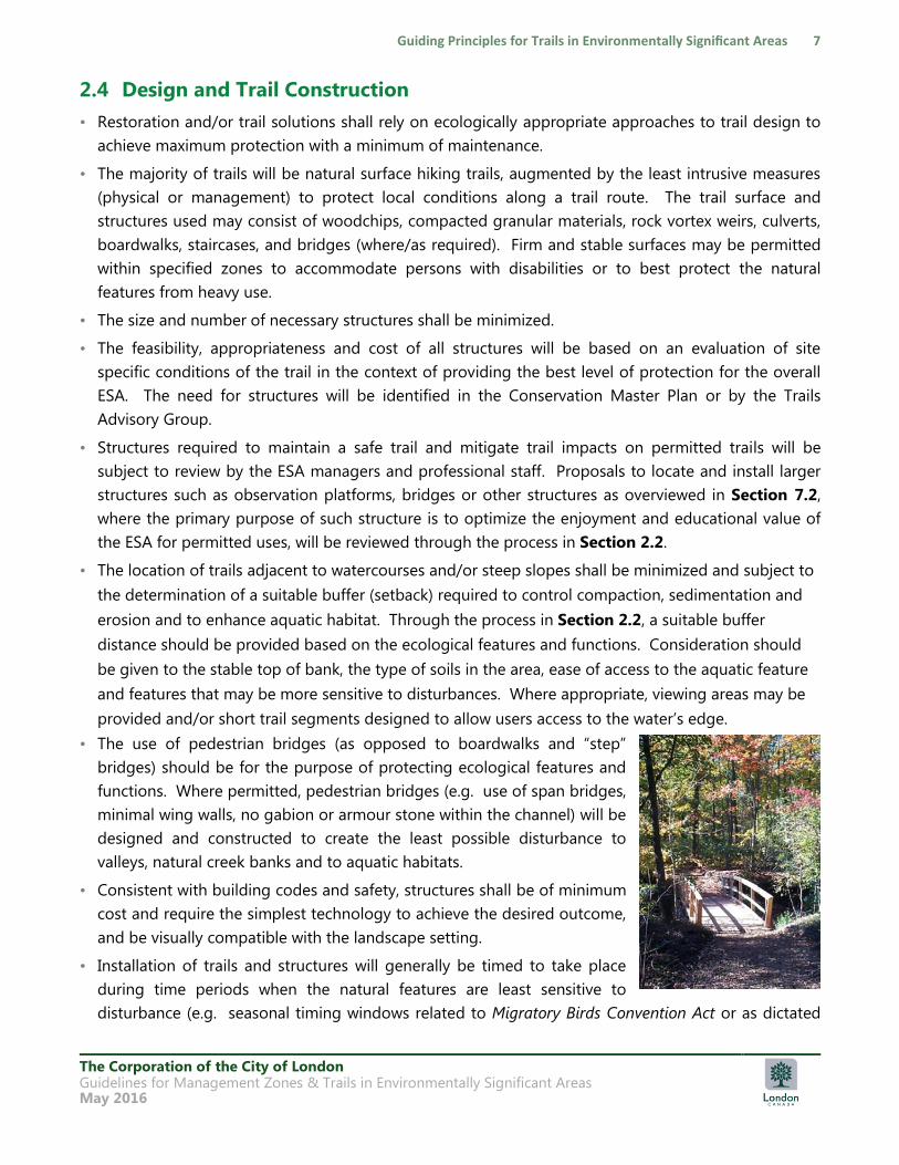
• The use of pedestrian bridges (as opposed to boardwalks and “step”
bridges) should be for the purpose of protecting ecological features and
functions. Where permitted, pedestrian bridges (e.g. use of span bridges,
minimal wing walls, no gabion or armour stone within the channel) will be
designed and constructed to create the least possible disturbance to
valleys, natural creek banks and to aquatic habitats.
• Consistent with building codes and safety, structures shall be of minimum
cost and require the simplest technology to achieve the desired outcome,
and be visually compatible with the landscape setting.
• Installation of trails and structures will generally be timed to take place
during time periods when the natural features are least sensitive to
disturbance (e.g. seasonal timing windows related to Migratory Birds Convention Act or as dictated
The Corporation of the City of London Guidelines for Management Zones & Trails in Environmentally Significant Areas May 2016
by aquatic and terrestrial habitat sensitivities) and restoration should follow immediately using native
species adapted to local conditions.
• Trail construction must be in compliance with the Ontario Endangered Species Act, 2007, Ontario
Regulation 179/06 (Section 28 of the Conservation Authorities Act to implement and enforce the
Development, Interference with Wetlands and Alterations to Shorelines and Watercourses
Regulation), and may be subject to archaeological heritage investigations in areas identified as
having archeological potential.
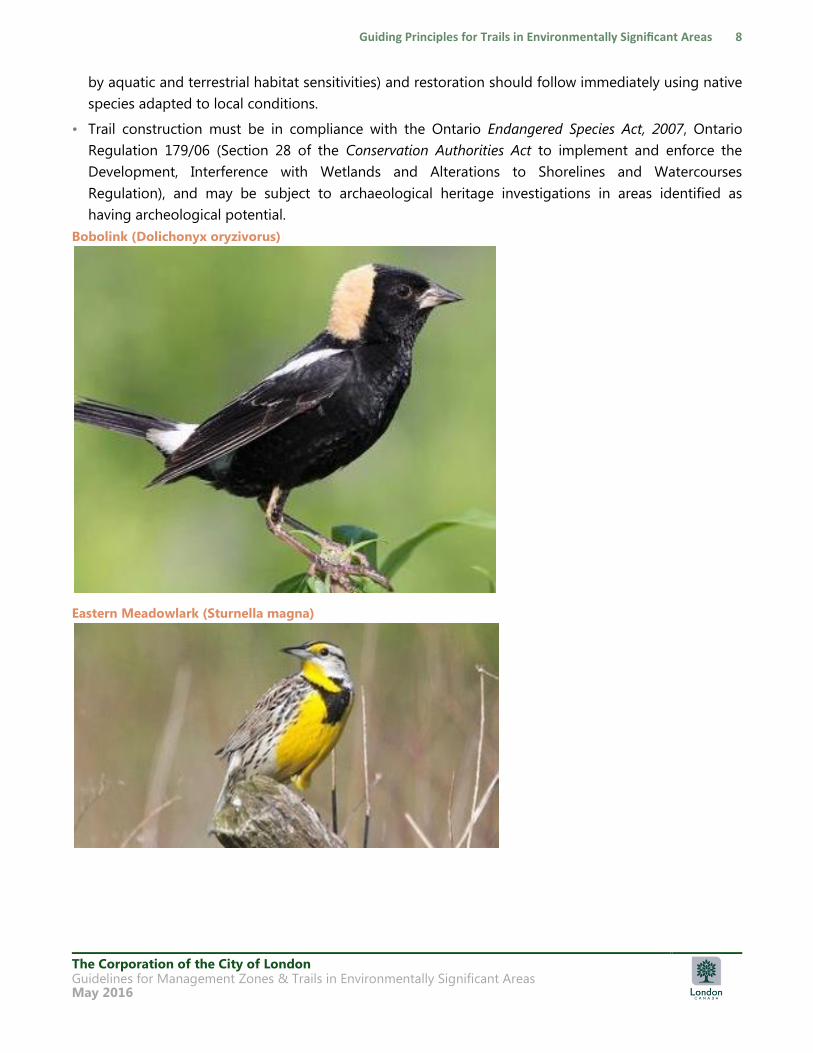
Bobolink (Dolichonyx oryzivorus)
Eastern Meadowlark (Sturnella magna)
The Corporation of the City of London Guidelines for Management Zones & Trails in Environmentally Significant Areas May 2016
2.5 Maintenance, Monitoring and Management
• Trails must be regularly monitored through both informal visual monitoring and more formal
technical investigations, to detect environmental damage or user interference inconsistent with the
purpose of an ESA. If this is detected, the trail must be closed and rehabilitated, relocated, or
upgraded, and rules enforced.
• Areas deemed acceptable for trails shall be monitored to ensure trail route boundaries are
appropriately followed and that the intensity and type of use does not result in negative impacts to
the overall area where the route is located.
• A monitoring program will be developed during the Conservation Master Plan process for each ESA
and implemented to provide the necessary feedback for gauging the effectiveness of management
interventions in keeping conditions within acceptable limits. Monitoring periods will vary from
annually to every 3-5 years, based on the intensity of trail use and sensitivity and vulnerability of the
trail to impacts.
• For ESAs without a current CMP, monitoring will occur as part of the general ESA management
activities and through observation reports provided by the public. This is typically done by the
UTRCA on behalf of the City and through observation reports from the public which may trigger
further review by a consultant, the UTRCA and/or TAG for example. At least twice annually, signs and
structures are inspected and at least quarterly trails are reviewed.
• Trails in ESAs are routinely monitored.
• All structures will be regularly monitored by qualified staff and or consultants and repairs made as
required, ensuring user safety.
• Restoration measures will be monitored and managed annually for the first 2-3 years to ensure
successful establishment of desirable species, with the intent that a minimum of maintenance will be
required in the long-term.
The City will retain management responsibility in ongoing consultation with the public whereby the
community, user groups and Adopt an ESA members shall share in the responsibility of trail
management through proper use of trails. These groups may assist in, providing additional monitoring
of trails, advising and educating other trail users regarding codes of use where possible and safe to do
so. Observation reports can be provided to the City for follow-up.
The Corporation of the City of London Guidelines for Management Zones & Trails in Environmentally Significant Areas May 2016
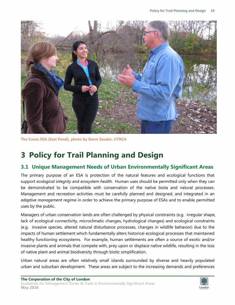
The Coves ESA (East Pond), photo by Steve Sauder, UTRCA
3 Policy for Trail Planning and Design
3.1 Unique Management Needs of Urban Environmentally Significant Areas
The primary purpose of an ESA is protection of the natural features and ecological functions that
support ecological integrity and ecosystem health. Human uses should be permitted only when they can
be demonstrated to be compatible with conservation of the native biota and natural processes.
Management and recreation activities must be carefully planned and designed, and integrated in an
adaptive management regime in order to achieve the primary purpose of ESAs and to enable permitted
uses by the public.
Managers of urban conservation lands are often challenged by physical constraints (e.g. irregular shape,
lack of ecological connectivity, microclimatic changes, hydrological changes) and ecological constraints
(e.g. invasive species, altered natural disturbance processes, changes in wildlife behavior) due to the
impacts of human settlement which fundamentally alters historical ecological processes that maintained
healthy functioning ecosystems. For example, human settlements are often a source of exotic and/or
invasive plants and animals that compete with, prey upon or displace native wildlife, resulting in the loss
of native plant and animal biodiversity through biotic simplification.
Urban natural areas are often relatively small islands surrounded by diverse and heavily populated
urban and suburban development. These areas are subject to the increasing demands and preferences
The Corporation of the City of London Guidelines for Management Zones & Trails in Environmentally Significant Areas May 2016
for recreation use, and the impacts of heavy and often incompatible uses, including encroachment, trail
widening and erosion, ad hoc trail creation, dogs off leash, biking, vandalism and campfire party
activities after dark. The very nature of urban natural areas assures often vigorous public involvement
with an often crowded and conflicting roster of neighbours, recreationists, and environmentalists.
The key responsibility of urban conservation land managers is to find the best way to protect and
restore, as much as possible, a healthy functioning ecological community in the face of fundamentally
altered ecology of the urban environment and public pressure for access (Davis 2010).
The development of CMPs must outline realistic strategies, achievable objectives, and actionable items
to manage the multitude of disturbances that threaten a natural area, and to identify key indicators that
can be monitored to detect change over time, in order to maintain and protect irreplaceable natural
habitat values, including earth and life science interests, and sensitive cultural and archaeological
resources.
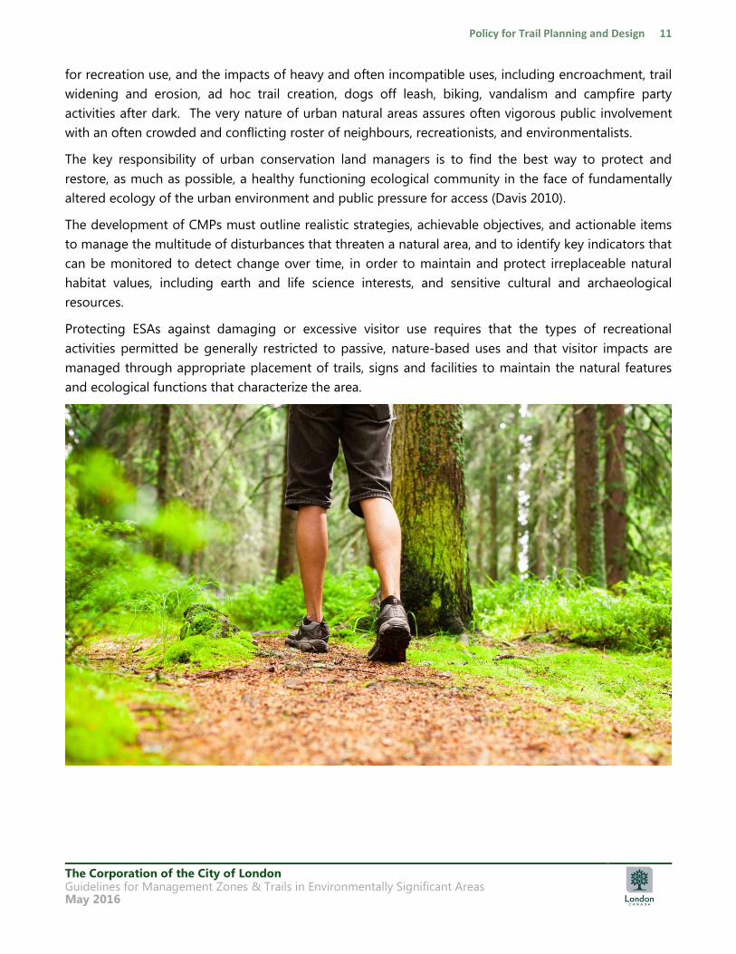
Protecting ESAs against damaging or excessive visitor use requires that the types of recreational
activities permitted be generally restricted to passive, nature-based uses and that visitor impacts are
managed through appropriate placement of trails, signs and facilities to maintain the natural features
and ecological functions that characterize the area.
The Corporation of the City of London Guidelines for Management Zones & Trails in Environmentally Significant Areas May 2016
3.2 Ecosystem Approach applied to Trail Planning
In the City of London‟s natural areas, the footprint of trails may date back to early settlers.
Archaeological evidence and the location of potential areas of human occupation are most frequently
associated with sites along the Thames River Valley and its major tributaries (Wilson and Horne 1995).
Within ESAs, years of use have created trail networks that may not be based on an ecosystem approach
that is reflective of current policies, guidelines or best management practices. With the increase of
public access and diverse user groups, many of these historic trails are now showing signs of overuse.
Trails located on fall lines or on steep slopes are more susceptible to erosion, while trails crossing wet
areas lead to trail widening and soil compaction. Many trails are too close to watercourses. These are
key management issues to be addressed as CMPs are prepared or updated.
The City of London Official Plan promotes an ecosystem approach to environmental planning. This
approach, when applied to trail planning, must recognize the dynamic nature of ecosystems and the
potential for ecosystems to change over time following a trajectory determined in large part by natural
and human-induced stresses that are placed on the system. The introduction of new trails of any type
into a natural area where none previously existed must be recognized as a new stress on the ecosystem
that will result in some unavoidable ecological effects associated with a semi-permanent to permanent
trail facility and the presence of trail users. A trail system that is well planned and designed sustainably
can mitigate disturbances to the environment by avoiding the most sensitive portions of natural areas,
utilizing sustainable construction techniques and by providing users a defined path with education
opportunities and varied user experiences. In this way, new trails should not result in any permanent
loss of natural features or ecological functions.
Research on natural area trail impacts has demonstrated that a properly managed trail system will limit
the areal extent and severity of recreation impacts by concentrating traffic on resistant trail surfaces and
through the use of appropriate structures such as bridges, fences, and boardwalks (Leung & Marion
2000). Depending on the type of trail system developed, the visitor experience may vary from one that
is primitive and intimate with nature to one that is more developed and separate from nature (Stankey
and Schreyer 1987; Hendee and Dawson 2002; Lynn and Brown 2003). Within ESAs, it is the intent to
continue to create trail systems that protect key ecological features and functions while permitting
passive nature-based recreation appropriate to the natural setting.
3.3 Conservation Priorities for Environmentally Significant Areas
ESAs are recognized and designated as fully protected natural areas. In the hierarchy of the Natural
Heritage System, ESAs are considered the largest, highest quality, core areas within the City. They
represent areas that may have unusual geological processes, contribute important hydrological
functions related to wetlands and watercourses, contain high quality vegetation communities, rare and
uncommon vegetation communities and species, including Species at Risk, are of sufficiently large size
to support critical wildlife habitat and linkage functions, and represent important areas of biodiversity.
The Corporation of the City of London Guidelines for Management Zones & Trails in Environmentally Significant Areas May 2016
Protection of important ecological areas, including the physical and ecological features and functions
that sustain these areas, is therefore the primary management goal of ESAs.
In the City of London, the management of publicly owned ESAs is typically addressed through the
preparation and implementation of CMP recommendations consistent with the Official Plan. Trail
planning is one of the matters addressed through a CMP process.
The vast majority of documents that were reviewed for policies and best practices on natural area
protection, management and the provision of public access and sustainable recreation, where the
protection of the natural area is paramount, present an approach that must attempt to weigh the value
and benefits of the human experience and balance this against the negative impacts on the ecosystem.
London‟s Official Plan recognizes the need to provide public access to publicly owned ESAs, but limits
permitted uses.
Public access to identified ESAs within public ownership will be controlled
so that such access will not be detrimental to the significant features of the property.
(Official Plan 15.4.1.4)
As such, this and other Official Plan policies identify protection as a first priority, which places ESAs in a
unique and separate classification from all other publicly owned parks and natural areas. The policies
do not require or state that a balance must be achieved between protection and access. The Official
Plan recognizes that in trail planning decisions, greater weight must be given to the avoidance and
minimization of negative impacts through mitigation for the protection of the ecological features and
functions for which an ESA has been identified.

The Corporation of the City of London Guidelines for Management Zones & Trails in Environmentally Significant Areas May 2016
4 Process for Determining Management Zones
4.1 ESA Management Zones and Overlays
The management objective for ESAs is to preserve and protect the ecological features and functions for
which the area has been identified. This is primarily achieved through implementation of the habitat
protection, restoration, and stewardship recommendations identified in the CMPs that provide direction
on the management of these areas.
A management strategy often employed in national and provincial parks planning allocates
management zones to various areas of the park. This has proven to be an effective protection strategy
for managing the potential impacts of users, types of uses, and visitor expectations.
While it must be understood that an ESA is an integrated ecological unit in which all of the parts
contribute to its ecological significance as a dynamic system, it is also important to recognize that an
ESA may contain areas that have higher relative degrees of sensitivity and different ecological features
and functions that warrant additional protection. These highly sensitive areas must be identified and
reviewed for compatibility with trail use and/or creation.
Ecological data collected as part of the CMP process is to be used to map the ESA into a management
zones. For each management zone, permitted uses are identified and allowable trail types, surfaces and
uses are determined. In cases where there are existing trails, the identification of management zones
and sensitive significant ecological features assists in making decisions regarding priorities for trail
management, including closures, rerouting or relocation of trails, and/or where alternate trail design
strategies may be required.
In keeping with the concept of the ESA as an integrated dynamic system, all zones must be managed to
maintain, enhance and/or restore the ecological features and functions of the ESA, in the context of the
overall protection and enhancement of the ESA and consistent with the City‟s Official Plan and the CMP
The Corporation of the City of London Guidelines for Management Zones & Trails in Environmentally Significant Areas May 2016
for the ESA (if one exists). Implementation of management zoning should result in the protection of the
more sensitive ecological features by directing access and use to the areas that have been identified as
having lower sensitivity to trails and are able to support more accessible trails. Any decision to close
existing trails must be accompanied by clear communication of the rationale, preferably through
communication, consultation, education and signage. Alternative route locations must also be clearly
marked (Marion 2008). In some cases, trail rotation based on seasonal sensitivities to the natural
environment may also be an option and must also rely on signage and barriers. There are three
management zones that may be identified within an ESA (see Section 5.3 for more information):
• Nature Reserve Zone: These areas require a higher level of protection to preserve the ecological
integrity of the ESA and represent natural vegetation communities. This zone is delineated using
Ecological Land Classification (Lee et al., 1998) to identify vegetation communities that are the result
of natural processes. The majority of an ESA is anticipated to be identified as a Nature Reserve Zone.
• Natural Environment Zone: Areas of cultural vegetation communities that result from, or are
maintained by existing or previous cultural or anthropocentric-based disturbances. These areas often
contain a large proportion of non-native species. These communities include plantations, cultural
meadows, cultural thickets, cultural woodlands, and cultural savannahs, as well as manicured areas
such as mowed lawn or hedgerows.
• Cultural Heritage Zone: These areas include identified cultural and archaeological features located
within an ESA, but are distinct from the natural area (e.g. Park Farm at Meadowlily Woods ESA)
and/or are large enough to warrant a separate zone.
In addition, there are “overlay” zones that are be applied to the underlying management zones if
applicable. These include:
• Restoration Overlay: This overlay highlights areas within the ESA that require active ecological
restoration or special management to restore or improve ecological conditions.
• Utility Overlay: This overlay is introduced where an existing condition such as a utility site or
corridor (e.g. hydro transmission lines, gas or water pipeline, railroad lines, sanitary sewer) or other
servicing infrastructure or facilities (e.g., sanitary sewer pumping station or stormwater management
facility), is present within the ESA and preclude restoration to the original ecological condition.
• Trail Review Overlay: This overlay is to be used as part of trail planning and review. The overlay is
to be applied to areas where existing trails are located within a significant ecological feature and
further review is required to determine the appropriate resolution if the existing trail is determined to
be incompatible with a certain species and/or habitat.
For a more complete description of each overlay, please refer to Section 5.5.
4.1.1 Process for Identifying and Delineating Management Zones
Nature Reserve and Natural Environment Zones are to be mapped following the completion of field
studies to delineate the boundaries of vegetation communities. As outlined in the City‟s most recent
The Corporation of the City of London Guidelines for Management Zones & Trails in Environmentally Significant Areas May 2016
Data Collection Standards for Ecological Inventory, a vegetation community survey should be based on
the Ecological Land Classification for Southern Ontario – First Approximation and its Application (Lee et
al., 1998). Those communities/ecosites identified under the community series of plantation (CUP),
cultural meadow (CUM), cultural thicket (CUT), cultural savannah (CUS) and cultural woodland (CUW), as
well as manicured areas such as mowed lawn or hedgerows, are to be zoned as Natural Environment.
All other natural communities/ecosites are to be zoned as Nature Reserve. This process is overviewed
in Chart 1.
Chart 1: Identify and Delineate Management Zones
1 = Vegetation community designated as “cultural” under Ecological Land Classification for Southern Ontario – First Approximation
and Its Application (Lee et al., 1998); include the ecosites and vegetation communities listed under the community series of
Plantation (CUP), Cultural Meadow (CUM), Cultural Thicket (CUT), Cultural Savannah (CUS), and Cultural Woodland (CUW).
Cultural vegetation communities would also include manicured areas such as mowed lawn or hedgerows.
MAP VEGETATION COMMUNITIES AND /OR
ECOSITES
AS PER PROVINCIAL STANDARDS
Natural vegetation
community and/or
ecosite
Nature Reserve
Zone
May include Access
Points, Restoration
and/or Utility Overlays
Cultural1 vegetation
community
and/or ecosite
Natural Environment
Zone
May include Access
Points, Restoration
and/or Utility Overlays
Cultural
heritage
feature
Cultural Heritage
Zone
May include Access
Points, Restoration
and/or Utility Overlays
The Corporation of the City of London Guidelines for Management Zones & Trails in Environmentally Significant Areas May 2016
Coves ESA (East Pond) boardwalk and look out. Photo by Steve Sauder, UTRCA
5 Process for Assessing Trail Locations
Following the identification and delineation of management zones to guide the types of trails and use
permitted in each zone, existing trails and proposed trails within an ESA will require review for
compatibility with the surrounding significant ecological features. Following the completion of the life
science inventory of the ESA, significant ecological features are required to be identified and evaluated.
These significant ecological features are mapped as part of the life science inventory and evaluation
phase of the CMP for the ESA. To supplement the guidance provided in the City‟s most recent version
of the Environmental Management Guidelines, we have included additional notes for delineating
significant ecological features in ESAs in Section 5.1.
5.1 Process for Identifying and Delineating Significant Ecological Features
As part of the Conservation Master Plan process and overall management of ESAs, significant ecological
features are to be identified and delineated based on provincially accepted standards. Where wildlife
habitat has been identified and evaluated as significant using the most recent version of the MNRF‟s
Significant Wildlife Habitat Ecoregion 7E Criteria Schedule, these are to be mapped to identify their
location(s) in an ESA. For provincially listed Species at Risk (as per Ontario Regulation 230/08 – the
Species at Risk in Ontario List), habitat for each species listed as Threatened or Endangered is to be
mapped based on the following (in order of priority):
The Corporation of the City of London Guidelines for Management Zones & Trails in Environmentally Significant Areas May 2016
1. The regulated habitat description defined in Ontario Regulation 242/08 under the Ontario
Endangered Species Act, 2007; or,
2. The general habitat description issued by the MNRF. This includes the delineation of a species‟
habitat into habitat categories; or,
3. The type of habitat known to support the species and as described according to an accepted
Government of Canada or Government of Ontario reference source. This may be delineated
based on a vegetation community/ecosite identified during the vegetation community survey.
It should be noted that some wildlife and/or Species at Risk/rare species habitat may not be mapped
for public viewing to protect features with increased sensitivity consistent with the data sensitivity
requirements of Ontario‟s Natural Heritage Information Centre.
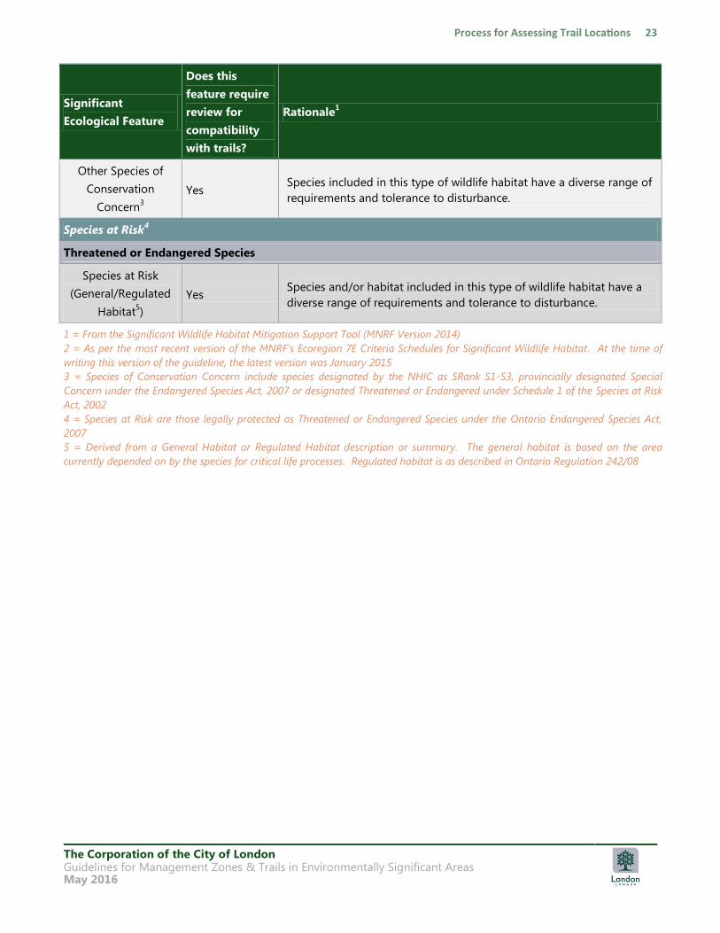
5.2 Determining General Compatibility of Significant Ecological Features and Trails
Using Table 1 as a guide, there are significant ecological features that may occur within a City ESA that
should be reviewed to determine compatibility with new or existing trails within or adjacent to them.
The question asked for each significant ecological feature in Table 1 is:
“Is there potential for the trail or its use to impact or eliminate
the significant ecological feature and/or its ecological function?”
For the question above, it is important to also consider the following:
Would a trail designed to be compatible with the underlying landform and/or significant
ecological feature(s) harm the feature or its ecological function?
Would responsible trail use harm the feature or its function?
The majority of the review to date involves existing trails that have been formed in the green space area
prior to its designation as an ESA or prior to coming into City ownership. However, Table 1 is also to
be used when considering the location for a new trail in an ESA.
Significant ecological features that are generally compatible with trails and/or trail use are identified
with a “No” in Table 1. This means that these types of wildlife habitat in Ecoregion 7E have been pre-
determined as either not applicable to the City of London or generally compatible with trails. However,
all trails in an ESA are subject to review to ensure they are designed appropriately (eg. trail surface,
width, elevation, etc.) and are able to withstand use by the public (see Section 2.5 and Section 8 for
more information on trail management and monitoring). Rerouting or relocation of existing trails, as
well as creation of new trails in an ESA is subject to ground-level micro-siting through the process
described in Section 2.2.
Significant ecological features that may be more susceptible to impacts caused by trails and/or trail use
are indicated with a “Yes” in Table 1. For each of these features, rationale is to be provided during the
The Corporation of the City of London Guidelines for Management Zones & Trails in Environmentally Significant Areas May 2016
review of a trail as to why the trail and/or trail use is compatible with the specific circumstance
presented.
Included in Table 1 is a brief rationale to provide context to the “Yes/No” answer to the question “Does
this feature require review for compatibility with trails?”
For Species at Risk listed as Threatened or Endangered under the Ontario Endangered Species Act, 2007,
habitat related to these species shall be considered individually and not included as part of an
applicable wildlife habitat. This is further reinforced by the MNRF as Species at Risk are not included as
indicator wildlife species in their Significant Wildlife Habitat Ecoregion 7E Criteria Schedule (2015). For
example, if Eastern Spiny Softshell turtles (Apalone spinifera spinifera) were identified within an ESA, this
Species at Risk would require further review to determine if trails and/or trail use is compatible with its
general habitat. If turtle wintering areas or turtle nesting areas have also been identified in the ESA and
are being reviewed for their compatibility with trails, these types of wildlife habitat would not include
Spiny Softshell turtles as an indicator species as they would be reviewed separately. Where Species of
Conservation Concern are included as indicator species in the Significant Wildlife Habitat Ecoregion 7E
Criteria Schedule (2015), these species are to be assessed individually based on their unique habitat
needs and a review completed to determine if that habitat is compatible with trails.
For species and features that are considered to be regionally rare in the City of London, consideration
should be given to these during the ground-level micro-siting of a trail. These species and features
have not been included in Table 1 as they are not subject to the periodic reviews for status updates by
any one government agency or group. Regionally rare species and features would be identified and
mapped as part of the CMP process and consideration provided when reviewing and locating trails in
an ESA.
The Corporation of the City of London Guidelines for Management Zones & Trails in Environmentally Significant Areas May 2016
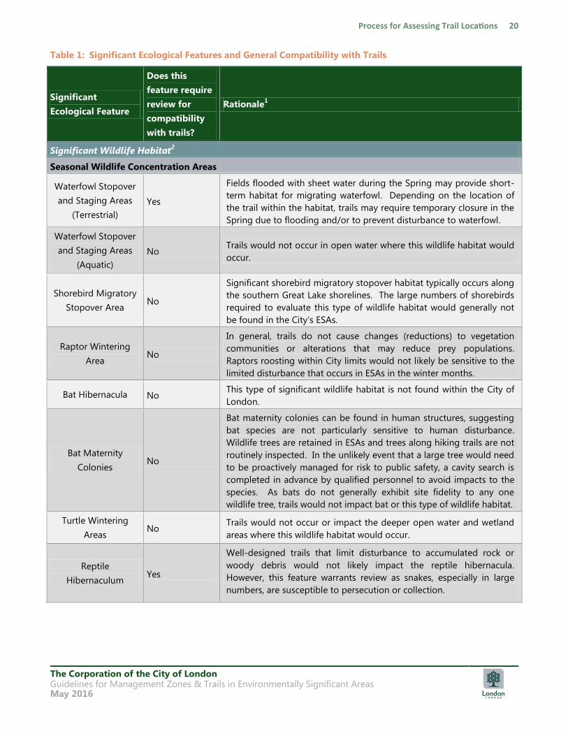
Table 1: Significant Ecological Features and General Compatibility with Trails
Significant
Ecological Feature
Does this
feature require
review for
compatibility
with trails?
Rationale1
Significant Wildlife Habitat2
Seasonal Wildlife Concentration Areas
Waterfowl Stopover
and Staging Areas
(Terrestrial)
Yes
Fields flooded with sheet water during the Spring may provide short-
term habitat for migrating waterfowl. Depending on the location of
the trail within the habitat, trails may require temporary closure in the
Spring due to flooding and/or to prevent disturbance to waterfowl.
Waterfowl Stopover
and Staging Areas
(Aquatic)
No Trails would not occur in open water where this wildlife habitat would
occur.
Shorebird Migratory
Stopover Area No
Significant shorebird migratory stopover habitat typically occurs along
the southern Great Lake shorelines. The large numbers of shorebirds
required to evaluate this type of wildlife habitat would generally not
be found in the City‟s ESAs.
Raptor Wintering
Area No
In general, trails do not cause changes (reductions) to vegetation
communities or alterations that may reduce prey populations.
Raptors roosting within City limits would not likely be sensitive to the
limited disturbance that occurs in ESAs in the winter months.
Bat Hibernacula No This type of significant wildlife habitat is not found within the City of
London.
Bat Maternity
Colonies No
Bat maternity colonies can be found in human structures, suggesting
bat species are not particularly sensitive to human disturbance.
Wildlife trees are retained in ESAs and trees along hiking trails are not
routinely inspected. In the unlikely event that a large tree would need
to be proactively managed for risk to public safety, a cavity search is
completed in advance by qualified personnel to avoid impacts to the
species. As bats do not generally exhibit site fidelity to any one
wildlife tree, trails would not impact bat or this type of wildlife habitat.
Turtle Wintering
Areas No
Trails would not occur or impact the deeper open water and wetland
areas where this wildlife habitat would occur.
Reptile
Hibernaculum Yes
Well-designed trails that limit disturbance to accumulated rock or
woody debris would not likely impact the reptile hibernacula.
However, this feature warrants review as snakes, especially in large
numbers, are susceptible to persecution or collection.
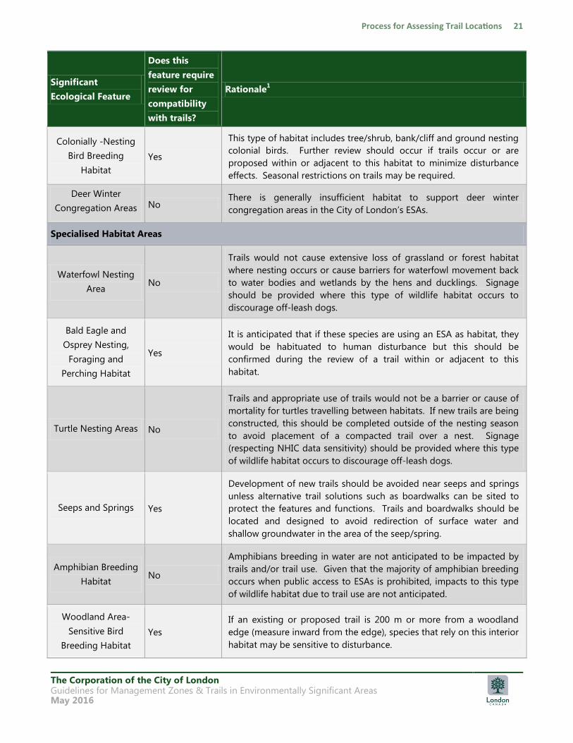
The Corporation of the City of London Guidelines for Management Zones & Trails in Environmentally Significant Areas May 2016
Significant
Ecological Feature
Does this
feature require
review for
compatibility
with trails?
Rationale1
Colonially -Nesting
Bird Breeding
Habitat
Yes
This type of habitat includes tree/shrub, bank/cliff and ground nesting
colonial birds. Further review should occur if trails occur or are
proposed within or adjacent to this habitat to minimize disturbance
effects. Seasonal restrictions on trails may be required.
Deer Winter
Congregation Areas No There is generally insufficient habitat to support deer winter
congregation areas in the City of London‟s ESAs.
Specialised Habitat Areas
Waterfowl Nesting
Area No
Trails would not cause extensive loss of grassland or forest habitat
where nesting occurs or cause barriers for waterfowl movement back
to water bodies and wetlands by the hens and ducklings. Signage
should be provided where this type of wildlife habitat occurs to
discourage off-leash dogs.
Bald Eagle and
Osprey Nesting,
Foraging and
Perching Habitat
Yes
It is anticipated that if these species are using an ESA as habitat, they
would be habituated to human disturbance but this should be
confirmed during the review of a trail within or adjacent to this
habitat.
Turtle Nesting Areas No
Trails and appropriate use of trails would not be a barrier or cause of
mortality for turtles travelling between habitats. If new trails are being
constructed, this should be completed outside of the nesting season
to avoid placement of a compacted trail over a nest. Signage
(respecting NHIC data sensitivity) should be provided where this type
of wildlife habitat occurs to discourage off-leash dogs.
Seeps and Springs Yes
Development of new trails should be avoided near seeps and springs
unless alternative trail solutions such as boardwalks can be sited to
protect the features and functions. Trails and boardwalks should be
located and designed to avoid redirection of surface water and
shallow groundwater in the area of the seep/spring.
Amphibian Breeding
Habitat No
Amphibians breeding in water are not anticipated to be impacted by
trails and/or trail use. Given that the majority of amphibian breeding
occurs when public access to ESAs is prohibited, impacts to this type
of wildlife habitat due to trail use are not anticipated.
Woodland Area-
Sensitive Bird
Breeding Habitat
Yes
If an existing or proposed trail is 200 m or more from a woodland
edge (measure inward from the edge), species that rely on this interior
habitat may be sensitive to disturbance.

The Corporation of the City of London Guidelines for Management Zones & Trails in Environmentally Significant Areas May 2016
Significant
Ecological Feature
Does this
feature require
review for
compatibility
with trails?
Rationale1
Woodland Raptor
Nesting Habitat Yes
Woodland raptors vary in their tolerance of human activities. Review
should be based on the species observed.
Animal Movement Corridors and Linkages
Amphibian
Movement
Corridors
No
Trails are not a barrier to connectivity for amphibian species. Most
non-salamander species‟ movement between amphibian habitats is
typically random dispersal rather than following a distinct corridor.
For salamander species that depend on micro-climate conditions, the
supply of downed woody debris, forest floor structure and tree cover
should be maintained in the ESA through appropriate trail design.
Rare Vegetation Communities
Cliffs and Talus
Slopes, Sand Barrens,
Alvars, Old Growth
Forests, Savannahs
and Tallgrass Prairies
No
These types of rare vegetation are generally not found in the City of
London. Further, a well-designed trail would not significantly impact
these communities or threaten their continued persistence in the ESA.
Other Rare
Vegetation
Communities
(Provincially Rare S1
to S3 Communities)
No
A well-designed trail would not impact these communities or threaten
their continued persistence in the ESA. Specific rare species within
these communities are reviewed as part of Habitat for Species of
Conservation Concern.
Habitat for Species of Conservation Concern
Shrub/Early
Successional Bird
Breeding Habitat
No Trails located in or adjacent to this habitat would not result in habitat
loss.
Marsh Bird Breeding
Habitat Yes
Though trails in marsh habitats will be limited due to the requirement
for boardwalks, the diverse assemblage of species that use this habitat
have specific habitat requirements that should be considered.
Open Country Bird
Breeding Habitat Yes
Species that depend on this type of habitat may have specific habitat
requirements. Species that rely on this interior grassland habitat may
be more sensitive to disturbance.
Terrestrial Crayfish Yes
If evidence of terrestrial crayfish is found, the use of the habitat by the
species should be reviewed as colonies can be as small as a few
square meters, making trail placement or use of boardwalks important
to avoid impacting the habitat.
The Corporation of the City of London Guidelines for Management Zones & Trails in Environmentally Significant Areas May 2016
Significant
Ecological Feature
Does this
feature require
review for
compatibility
with trails?
Rationale1
Other Species of
Conservation
Concern3
Yes Species included in this type of wildlife habitat have a diverse range of
requirements and tolerance to disturbance.
Species at Risk4
Threatened or Endangered Species
Species at Risk
(General/Regulated
Habitat5)
Yes Species and/or habitat included in this type of wildlife habitat have a
diverse range of requirements and tolerance to disturbance.
1 = From the Significant Wildlife Habitat Mitigation Support Tool (MNRF Version 2014)
2 = As per the most recent version of the MNRF‟s Ecoregion 7E Criteria Schedules for Significant Wildlife Habitat. At the time of
writing this version of the guideline, the latest version was January 2015
3 = Species of Conservation Concern include species designated by the NHIC as SRank S1-S3, provincially designated Special
Concern under the Endangered Species Act, 2007 or designated Threatened or Endangered under Schedule 1 of the Species at Risk
Act, 2002
4 = Species at Risk are those legally protected as Threatened or Endangered Species under the Ontario Endangered Species Act,
2007
5 = Derived from a General Habitat or Regulated Habitat description or summary. The general habitat is based on the area
currently depended on by the species for critical life processes. Regulated habitat is as described in Ontario Regulation 242/08
The Corporation of the City of London Guidelines for Management Zones & Trails in Environmentally Significant Areas May 2016
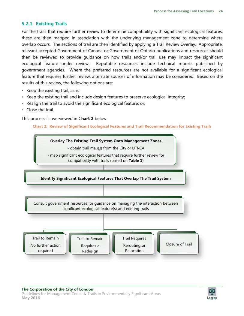
5.2.1 Existing Trails
For the trails that require further review to determine compatibility with significant ecological features,
these are then mapped in association with the underlying management zone to determine where
overlap occurs. The sections of trail are then identified by applying a Trail Review Overlay. Appropriate,
relevant accepted Government of Canada or Government of Ontario publications and resources should
then be reviewed to provide guidance on how trails and/or trail use may impact the significant
ecological feature under review. Reputable resources include technical reports published by
government agencies. Where the preferred resources are not available for a significant ecological
feature that requires further review, alternate sources of information may be considered. Based on the
results of this review, the following options are:
• Keep the existing trail, as is;
• Keep the existing trail and include design features to preserve ecological integrity;
• Realign the trail to avoid the significant ecological feature; or,
• Close the trail.
This process is overviewed in Chart 2 below.
Chart 2: Review of Significant Ecological Features and Trail Recommendation for Existing Trails
Overlay The Existing Trail System Onto Management Zones
- obtain trail map(s) from the City or UTRCA
- map significant ecological features that require further review for
compatibility with trails (based on Table 1)
Identify Significant Ecological Features That Overlap The Trail System
Consult government resources for guidance on managing the interaction between
significant ecological feature(s) and existing trails
Trail to Remain
No further action
required
Trail to Remain
Requires a
Redesign
Trail Requires
Rerouting or
Relocation
Closure of Trail
The Corporation of the City of London Guidelines for Management Zones & Trails in Environmentally Significant Areas May 2016
As noted in Section 5.2, rerouting or relocation of existing trails, as well as the redesign of a trail in an
ESA is subject to ground-level micro-siting through the process described in Section 2.2.
Natural features or land ownership issues may not permit a continuous, connected trail through an ESA,
particularly where trails were not planned as part of a CMP. Connectivity of the Thames Valley Trail
(TVT) should continue to be maintained in City owned ESAs, subject to the process in Section 2.2. The
TVT is about 110 km long and follows the Thames River for most of its route. The TVT travels through
the City of London over multi-use pathways, private lands such as the University of Western Ontario
(UWO), and in City owned natural areas including Killaly Meadows, Kains Woods and Warbler Woods
ESAs. London‟s Mayor officially opened the City section of the trail on June 16, 1973 at Gibbons Park.
The TVT also travels through the Fanshawe Conservation Area and Komoka Provincial Park. The TVT
links to a broad network of footpaths in Southwestern Ontario (TVTA 2008).
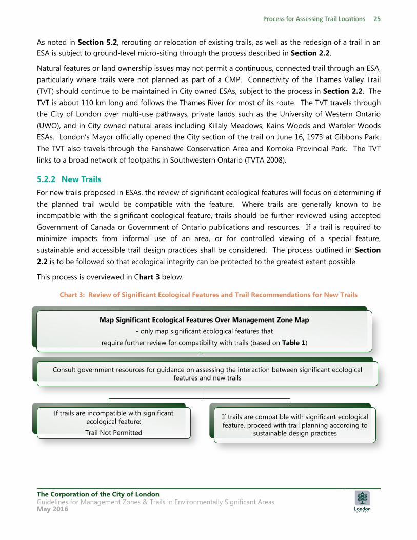
5.2.2 New Trails
For new trails proposed in ESAs, the review of significant ecological features will focus on determining if
the planned trail would be compatible with the feature. Where trails are generally known to be
incompatible with the significant ecological feature, trails should be further reviewed using accepted
Government of Canada or Government of Ontario publications and resources. If a trail is required to
minimize impacts from informal use of an area, or for controlled viewing of a special feature,
sustainable and accessible trail design practices shall be considered. The process outlined in Section
2.2 is to be followed so that ecological integrity can be protected to the greatest extent possible.
This process is overviewed in Chart 3 below.
Chart 3: Review of Significant Ecological Features and Trail Recommendations for New Trails
Map Significant Ecological Features Over Management Zone Map
- only map significant ecological features that
require further review for compatibility with trails (based on Table 1)
Consult government resources for guidance on assessing the interaction between significant ecological
features and new trails
If trails are incompatible with significant
ecological feature:
Trail Not Permitted
If trails are compatible with significant ecological
feature, proceed with trail planning according to
sustainable design practices
The Corporation of the City of London Guidelines for Management Zones & Trails in Environmentally Significant Areas May 2016
As noted in Section 5.2, the siting of trails in ESAs is subject to ground-level micro-siting through the
process in Section 2.2.
5.3 Public Access and Trails Based on Management Zones
The following sections provide a description of each management zone and recommendations for
public access and trails for ESAs based on the identified management zone. Information about what
types of trail is permitted in each management zone is provided in Section 6.0.
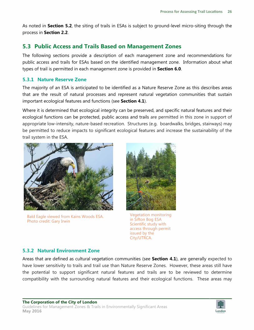
5.3.1 Nature Reserve Zone
The majority of an ESA is anticipated to be identified as a Nature Reserve Zone as this describes areas
that are the result of natural processes and represent natural vegetation communities that sustain
important ecological features and functions (see Section 4.1).
Where it is determined that ecological integrity can be preserved, and specific natural features and their
ecological functions can be protected, public access and trails are permitted in this zone in support of
appropriate low-intensity, nature-based recreation. Structures (e.g. boardwalks, bridges, stairways) may
be permitted to reduce impacts to significant ecological features and increase the sustainability of the
trail system in the ESA.
5.3.2 Natural Environment Zone
Areas that are defined as cultural vegetation communities (see Section 4.1), are generally expected to
have lower sensitivity to trails and trail use than Nature Reserve Zones. However, these areas still have
the potential to support significant natural features and trails are to be reviewed to determine
compatibility with the surrounding natural features and their ecological functions. These areas may
Bald Eagle viewed from Kains Woods ESA. Photo credit: Gary Irwin
Vegetation monitoring in Sifton Bog ESA Scientific study with access through permit issued by the City/UTRCA.
The Corporation of the City of London Guidelines for Management Zones & Trails in Environmentally Significant Areas May 2016
provide an opportunity for accessible trails that permit use by persons with mobility disabilities,
especially when directly adjacent to an Access Point.
Trails may be located in Natural Environment Zones where it can be demonstrated that the trail will not
result in negative impact to the adjacent ecological features and functions of the ESA. Temporary
facilities for research, education and management may be permitted in less sensitive supporting areas
to allow human activities designed to improve values such as biodiversity, wildlife habitat and aesthetics.
These will be considered on a case-by-case basis.
5.3.3 Cultural Heritage Zone
The protection of cultural heritage landscapes within natural settings is important to safeguard the
human-nature interaction. These may include farm complexes which contain important cultural
heritage landscapes (e.g. Park Farm at Meadowlily Woods ESA), historically significant buildings or
structures, archaeological sites, mill sites, aboriginal sites, views and vistas. As outlined in Section 4.1,
Cultural Heritage Zone applies where a cultural heritage feature is located inside an ESA, but is distinct
from the natural area and/or large enough to warrant a separate zone. Small, isolated cultural heritage
features would be recognized and managed within other zones.
Trails are permitted in Cultural Heritage Zones where it can be demonstrated that the trail will not result
in negative impact to the ecological features and functions of the ESA and/or cultural heritage resource.
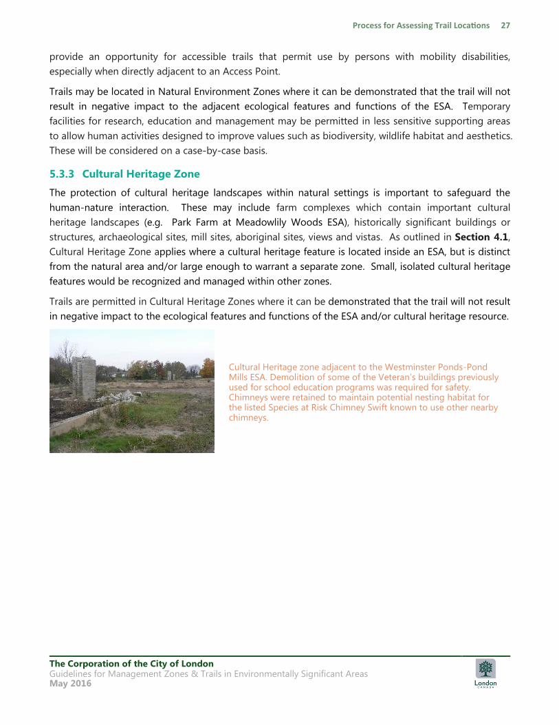
Cultural Heritage zone adjacent to the Westminster Ponds-Pond Mills ESA. Demolition of some of the Veteran‟s buildings previously used for school education programs was required for safety. Chimneys were retained to maintain potential nesting habitat for the listed Species at Risk Chimney Swift known to use other nearby chimneys.
The Corporation of the City of London Guidelines for Management Zones & Trails in Environmentally Significant Areas May 2016
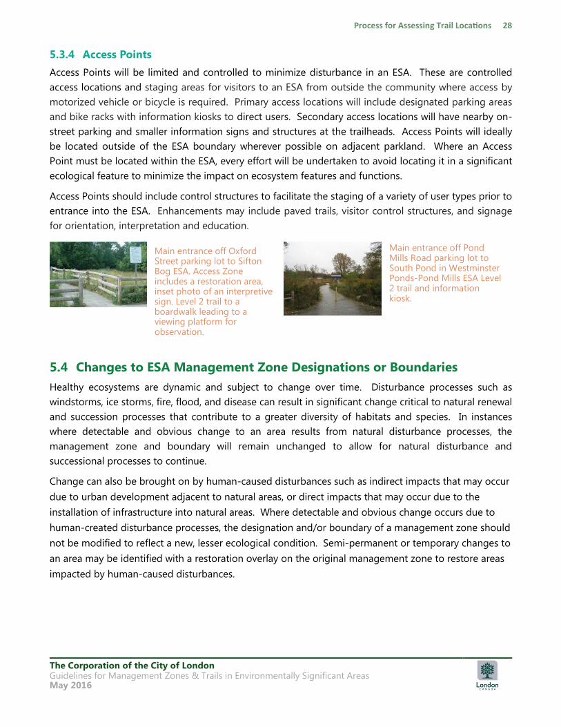
5.3.4 Access Points
Access Points will be limited and controlled to minimize disturbance in an ESA. These are controlled
access locations and staging areas for visitors to an ESA from outside the community where access by
motorized vehicle or bicycle is required. Primary access locations will include designated parking areas
and bike racks with information kiosks to direct users. Secondary access locations will have nearby on-
street parking and smaller information signs and structures at the trailheads. Access Points will ideally
be located outside of the ESA boundary wherever possible on adjacent parkland. Where an Access
Point must be located within the ESA, every effort will be undertaken to avoid locating it in a significant
ecological feature to minimize the impact on ecosystem features and functions.
Access Points should include control structures to facilitate the staging of a variety of user types prior to
entrance into the ESA. Enhancements may include paved trails, visitor control structures, and signage
for orientation, interpretation and education.
5.4 Changes to ESA Management Zone Designations or Boundaries
Healthy ecosystems are dynamic and subject to change over time. Disturbance processes such as
windstorms, ice storms, fire, flood, and disease can result in significant change critical to natural renewal
and succession processes that contribute to a greater diversity of habitats and species. In instances
where detectable and obvious change to an area results from natural disturbance processes, the
management zone and boundary will remain unchanged to allow for natural disturbance and
successional processes to continue.
Change can also be brought on by human-caused disturbances such as indirect impacts that may occur
due to urban development adjacent to natural areas, or direct impacts that may occur due to the
installation of infrastructure into natural areas. Where detectable and obvious change occurs due to
human-created disturbance processes, the designation and/or boundary of a management zone should
not be modified to reflect a new, lesser ecological condition. Semi-permanent or temporary changes to
an area may be identified with a restoration overlay on the original management zone to restore areas
impacted by human-caused disturbances.
Main entrance off Pond Mills Road parking lot to South Pond in Westminster Ponds-Pond Mills ESA Level 2 trail and information kiosk.
Main entrance off Oxford Street parking lot to Sifton Bog ESA. Access Zone includes a restoration area, inset photo of an interpretive sign. Level 2 trail to a boardwalk leading to a viewing platform for observation.
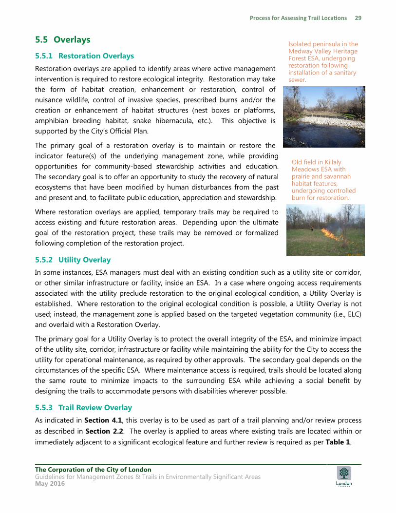
The Corporation of the City of London Guidelines for Management Zones & Trails in Environmentally Significant Areas May 2016
5.5 Overlays
5.5.1 Restoration Overlays
Restoration overlays are applied to identify areas where active management
intervention is required to restore ecological integrity. Restoration may take
the form of habitat creation, enhancement or restoration, control of
nuisance wildlife, control of invasive species, prescribed burns and/or the
creation or enhancement of habitat structures (nest boxes or platforms,
amphibian breeding habitat, snake hibernacula, etc.). This objective is
supported by the City‟s Official Plan.
The primary goal of a restoration overlay is to maintain or restore the
indicator feature(s) of the underlying management zone, while providing
opportunities for community-based stewardship activities and education.
The secondary goal is to offer an opportunity to study the recovery of natural
ecosystems that have been modified by human disturbances from the past
and present and, to facilitate public education, appreciation and stewardship.
Where restoration overlays are applied, temporary trails may be required to
access existing and future restoration areas. Depending upon the ultimate
goal of the restoration project, these trails may be removed or formalized
following completion of the restoration project.
5.5.2 Utility Overlay
In some instances, ESA managers must deal with an existing condition such as a utility site or corridor,
or other similar infrastructure or facility, inside an ESA. In a case where ongoing access requirements
associated with the utility preclude restoration to the original ecological condition, a Utility Overlay is
established. Where restoration to the original ecological condition is possible, a Utility Overlay is not
used; instead, the management zone is applied based on the targeted vegetation community (i.e., ELC)
and overlaid with a Restoration Overlay.
The primary goal for a Utility Overlay is to protect the overall integrity of the ESA, and minimize impact
of the utility site, corridor, infrastructure or facility while maintaining the ability for the City to access the
utility for operational maintenance, as required by other approvals. The secondary goal depends on the
circumstances of the specific ESA. Where maintenance access is required, trails should be located along
the same route to minimize impacts to the surrounding ESA while achieving a social benefit by
designing the trails to accommodate persons with disabilities wherever possible.
5.5.3 Trail Review Overlay
As indicated in Section 4.1, this overlay is to be used as part of a trail planning and/or review process
as described in Section 2.2. The overlay is applied to areas where existing trails are located within or
immediately adjacent to a significant ecological feature and further review is required as per Table 1.
Isolated peninsula in the Medway Valley Heritage Forest ESA, undergoing restoration following installation of a sanitary sewer.
Old field in Killaly Meadows ESA with prairie and savannah habitat features, undergoing controlled burn for restoration.
The Corporation of the City of London Guidelines for Management Zones & Trails in Environmentally Significant Areas May 2016
6 Trails and Permitted Activities
The use of trails for permitted activities should follow the four standards for ESAs in the City:
1. To promote protection of the natural heritage system through proper management zoning and
trail design
2. To generally locate trails and ancillary trail facilities/amenities outside of significant ecological
features
3. To restrict trail uses to low-impact nature-based activities
4. To create a safe, enjoyable and accessible trail system for public use, education and overall
nature appreciation
6.1 City-Wide Trail Hierarchy
There are three tiers, or levels of trails and pathways that may be applied to publicly-owned natural
and built form areas across the City. Generally, Level 1 and Level 2 trails are the standard approach
within publicly owned ESAs. This guideline document addresses the planning and design of these trails
to permit appropriate access and use while protecting the features and functions of an ESA. The type of
trail is determined through the process identified in Section 2.2.
The types of trails, users and general trail characteristics permitted in ESAs are outlined in Table 2
based on each of the management zones described in the sections above. The various types of trails
and the types of activities permitted on them are further described in the subsections below. Specific
design and construction details are outlined in Section 7.
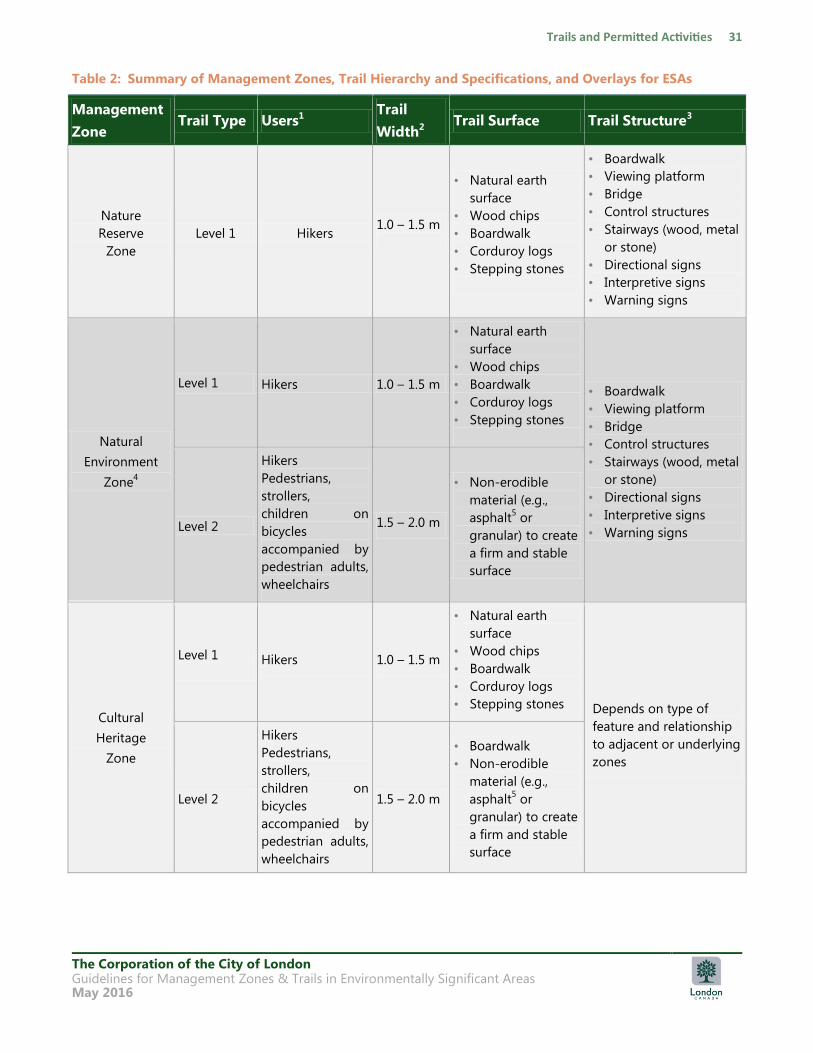
The Corporation of the City of London Guidelines for Management Zones & Trails in Environmentally Significant Areas May 2016
Table 2: Summary of Management Zones, Trail Hierarchy and Specifications, and Overlays for ESAs
Management
Zone Trail Type Users1
Trail
Width2 Trail Surface Trail Structure3
Nature
Reserve
Zone
Level 1 Hikers 1.0 – 1.5 m
• Natural earth
surface
• Wood chips
• Boardwalk
• Corduroy logs
• Stepping stones
• Boardwalk
• Viewing platform
• Bridge
• Control structures
• Stairways (wood, metal
or stone)
• Directional signs
• Interpretive signs
• Warning signs
Natural
Environment
Zone4
Level 1 Hikers 1.0 – 1.5 m
• Natural earth
surface
• Wood chips
• Boardwalk
• Corduroy logs
• Stepping stones
• Boardwalk
• Viewing platform
• Bridge
• Control structures
• Stairways (wood, metal
or stone)
• Directional signs
• Interpretive signs
• Warning signs Level 2
Hikers
Pedestrians,
strollers,
children on
bicycles
accompanied by
pedestrian adults,
wheelchairs
1.5 – 2.0 m
• Non-erodible
material (e.g.,
asphalt5 or
granular) to create
a firm and stable
surface
Cultural
Heritage
Zone
Level 1
Hikers 1.0 – 1.5 m
• Natural earth
surface
• Wood chips
• Boardwalk
• Corduroy logs
• Stepping stones Depends on type of
feature and relationship
to adjacent or underlying
zones
Level 2
Hikers
Pedestrians,
strollers,
children on
bicycles
accompanied by
pedestrian adults,
wheelchairs
1.5 – 2.0 m
• Boardwalk
• Non-erodible
material (e.g.,
asphalt5 or
granular) to create
a firm and stable
surface
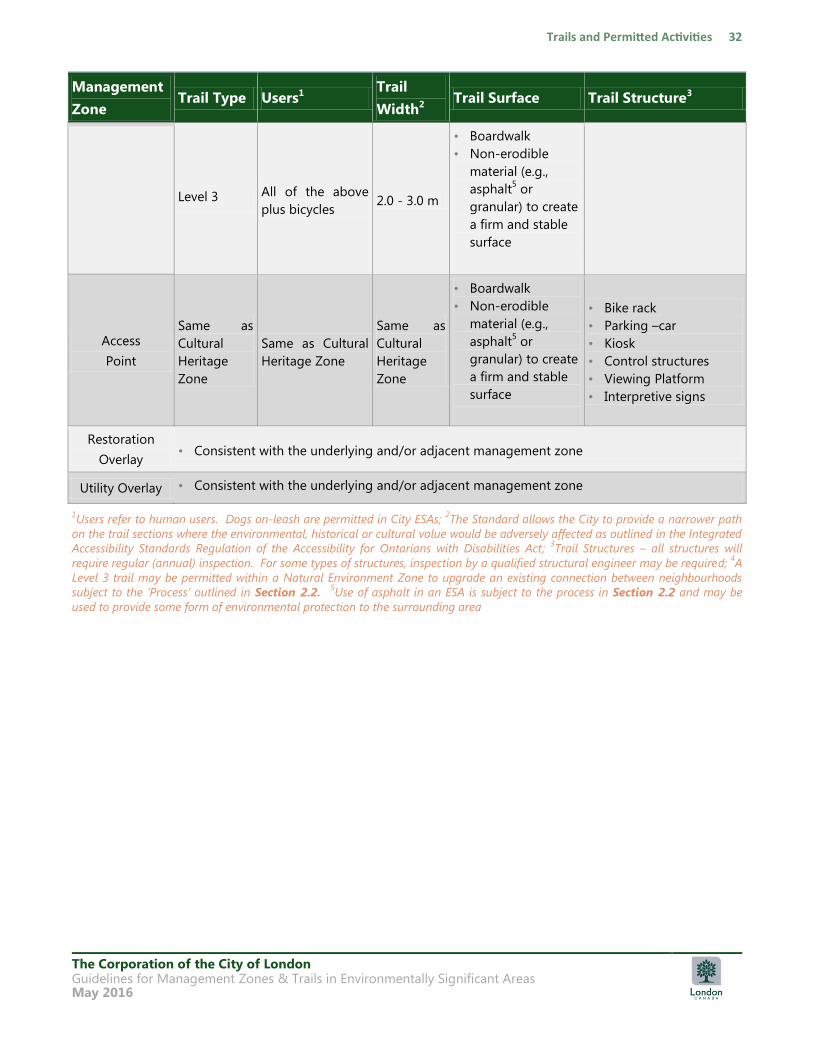
The Corporation of the City of London Guidelines for Management Zones & Trails in Environmentally Significant Areas May 2016
Management
Zone Trail Type Users1
Trail
Width2 Trail Surface Trail Structure3
Level 3 All of the above
plus bicycles 2.0 - 3.0 m
• Boardwalk
• Non-erodible
material (e.g.,
asphalt5 or
granular) to create
a firm and stable
surface
Access
Point
Same as
Cultural
Heritage
Zone
Same as Cultural
Heritage Zone
Same as
Cultural
Heritage
Zone
• Boardwalk
• Non-erodible
material (e.g.,
asphalt5 or
granular) to create
a firm and stable
surface
• Bike rack
• Parking –car
• Kiosk
• Control structures
• Viewing Platform
• Interpretive signs
Restoration
Overlay • Consistent with the underlying and/or adjacent management zone
Utility Overlay • Consistent with the underlying and/or adjacent management zone
1Users refer to human users. Dogs on-leash are permitted in City ESAs;
2The Standard allows the City to provide a narrower path
on the trail sections where the environmental, historical or cultural value would be adversely affected as outlined in the Integrated
Accessibility Standards Regulation of the Accessibility for Ontarians with Disabilities Act; 3Trail Structures – all structures will
require regular (annual) inspection. For some types of structures, inspection by a qualified structural engineer may be required; 4A
Level 3 trail may be permitted within a Natural Environment Zone to upgrade an existing connection between neighbourhoods
subject to the „Process‟ outlined in Section 2.2. 5Use of asphalt in an ESA is subject to the process in Section 2.2 and may be
used to provide some form of environmental protection to the surrounding area
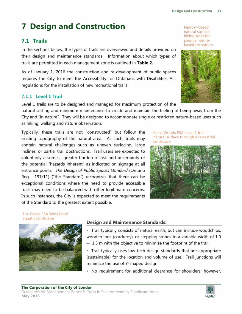
The Corporation of the City of London Guidelines for Management Zones & Trails in Environmentally Significant Areas May 2016
7 Design and Construction
7.1 Trails
In the sections below, the types of trails are overviewed and details provided on
their design and maintenance standards. Information about which types of
trails are permitted in each management zone is outlined in Table 2.
As of January 1, 2016 the construction and re-development of public spaces
requires the City to meet the Accessibility for Ontarians with Disabilities Act
regulations for the installation of new recreational trails.
7.1.1 Level 1 Trail
Level 1 trails are to be designed and managed for maximum protection of the
natural setting and minimum maintenance to create and maintain the feeling of being away from the
City and “in nature”. They will be designed to accommodate single or restricted nature-based uses such
as hiking, walking and nature observation.
Typically, these trails are not “constructed” but follow the
existing topography of the natural area. As such, trails may
contain natural challenges such as uneven surfacing, large
inclines, or partial trail obstructions. Trail users are expected to
voluntarily assume a greater burden of risk and uncertainty of
the potential “hazards inherent” as indicated on signage at all
entrance points. The Design of Public Spaces Standard (Ontario
Reg. 191/11) (“the Standard”) recognizes that there can be
exceptional conditions where the need to provide accessible
trails may need to be balanced with other legitimate concerns.
In such instances, the City is expected to meet the requirements
of the Standard to the greatest extent possible.
Design and Maintenance Standards:
• Trail typically consists of natural earth, but can include woodchips,
wooden logs (corduroy), or stepping stones to a variable width of 1.0
─ 1.5 m with the objective to minimize the footprint of the trail.
• Trail typically uses low-tech design standards that are appropriate
(sustainable) for the location and volume of use. Trail junctions will
minimize the use of Y-shaped design.
• No requirement for additional clearance for shoulders; however,
Kains Woods ESA Level 1 trail – natural surface through a terrestrial landscape
The Coves ESA West Pond aquatic landscape
Narrow-based, natural surface hiking trails for passive nature-based recreation
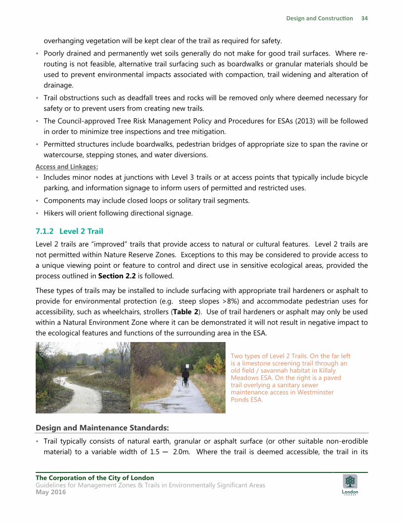
The Corporation of the City of London Guidelines for Management Zones & Trails in Environmentally Significant Areas May 2016
overhanging vegetation will be kept clear of the trail as required for safety.
• Poorly drained and permanently wet soils generally do not make for good trail surfaces. Where re-
routing is not feasible, alternative trail surfacing such as boardwalks or granular materials should be
used to prevent environmental impacts associated with compaction, trail widening and alteration of
drainage.
• Trail obstructions such as deadfall trees and rocks will be removed only where deemed necessary for
safety or to prevent users from creating new trails.
• The Council-approved Tree Risk Management Policy and Procedures for ESAs (2013) will be followed
in order to minimize tree inspections and tree mitigation.
• Permitted structures include boardwalks, pedestrian bridges of appropriate size to span the ravine or
watercourse, stepping stones, and water diversions.
Access and Linkages:
• Includes minor nodes at junctions with Level 3 trails or at access points that typically include bicycle
parking, and information signage to inform users of permitted and restricted uses.
• Components may include closed loops or solitary trail segments.
• Hikers will orient following directional signage.
7.1.2 Level 2 Trail
Level 2 trails are “improved” trails that provide access to natural or cultural features. Level 2 trails are
not permitted within Nature Reserve Zones. Exceptions to this may be considered to provide access to
a unique viewing point or feature to control and direct use in sensitive ecological areas, provided the
process outlined in Section 2.2 is followed.
These types of trails may be installed to include surfacing with appropriate trail hardeners or asphalt to
provide for environmental protection (e.g. steep slopes >8%) and accommodate pedestrian uses for
accessibility, such as wheelchairs, strollers (Table 2). Use of trail hardeners or asphalt may only be used
within a Natural Environment Zone where it can be demonstrated it will not result in negative impact to
the ecological features and functions of the surrounding area in the ESA.
Design and Maintenance Standards:
• Trail typically consists of natural earth, granular or asphalt surface (or other suitable non-erodible
material) to a variable width of 1.5 ─ 2.0m. Where the trail is deemed accessible, the trail in its
Two types of Level 2 Trails. On the far left is a limestone screening trail through an old field / savannah habitat in Killaly Meadows ESA. On the right is a paved trail overlying a sanitary sewer maintenance access in Westminster Ponds ESA.
The Corporation of the City of London Guidelines for Management Zones & Trails in Environmentally Significant Areas May 2016
entirety shall meet AODA recreational trail surface requirements for both firmness and stability. Trail
surface for access to special-feature areas may require the installation of structures such as
boardwalks or viewing platforms.
• Trail may consist of shorter closed loop trail segments that pass by features of interest.
• Trail obstructions such as deadfall trees and rocks will be removed for safety.
• The Council-approved Tree Risk Management Policy and Procedures for ESAs (2013) will be followed
in order to minimize tree inspections and tree mitigation.
Access and Linkages:
• May include a major kiosk at the main access entrance with interpretive signs to inform users of
permitted and restricted uses, to highlight the natural features of the ESA, and may provide bicycle
parking.
• May include minor nodes with bicycle parking at junctions with Level 3 trails where car parking and
other facilities are not provided.
• Typically will offer trailside amenities such as benches, viewing platforms, interpretive signs and other
signage at access points.
7.1.3 Level 3 Trail
These trails provide visitor access and are to be designed and implemented to protect environmental
features and to accommodate areas of increased visitor use. Level 3 trails and structural amenities may
require appropriate setbacks from adjacent natural features and functions. In exceptional situations, a
Level 3 trail may be permitted within a Natural Environment Zone to upgrade an existing connection
between neighbourhoods subject to the „Process‟ outlined in Section 2.2. Level 3 trails are not
permitted within Nature Reserve Zones.
7.2 Trail Structures
Where the health and sustainability of ESAs is threatened by high use, mitigation efforts often include
trail hardening, posting signs, installing stairs, boardwalks or bridges and erecting rail fencing or other
barricades to preclude off-trail hiking. Other measures include educational programs and visitation by
uniformed personnel, or limiting parking and other structures that encourage access. The following
section includes general guidelines for the design and location of various trail structures. Structures
and their location will be guided by the management plans within the CMP for the ESA.
Some built structures will be required for user passage over some of the physical trail barriers
throughout the City (rivers, streams, steep slopes, roads, railroads) and to protect sensitive areas from
user impacts. In ESAs, the use of trail structures will be minimized and used to either provide a higher
level of protection to a significant ecological feature from the permitted trail use or to increase user
safety and trail accessibility. In ESAs, structures will be permitted and built to accommodate the
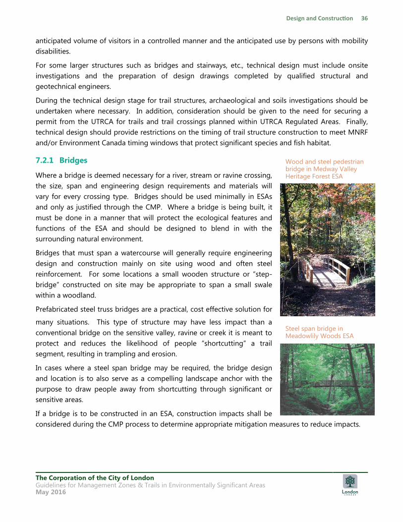
The Corporation of the City of London Guidelines for Management Zones & Trails in Environmentally Significant Areas May 2016
anticipated volume of visitors in a controlled manner and the anticipated use by persons with mobility
disabilities.
For some larger structures such as bridges and stairways, etc., technical design must include onsite
investigations and the preparation of design drawings completed by qualified structural and
geotechnical engineers.
During the technical design stage for trail structures, archaeological and soils investigations should be
undertaken where necessary. In addition, consideration should be given to the need for securing a
permit from the UTRCA for trails and trail crossings planned within UTRCA Regulated Areas. Finally,
technical design should provide restrictions on the timing of trail structure construction to meet MNRF
and/or Environment Canada timing windows that protect significant species and fish habitat.
7.2.1 Bridges
Where a bridge is deemed necessary for a river, stream or ravine crossing,
the size, span and engineering design requirements and materials will
vary for every crossing type. Bridges should be used minimally in ESAs
and only as justified through the CMP. Where a bridge is being built, it
must be done in a manner that will protect the ecological features and
functions of the ESA and should be designed to blend in with the
surrounding natural environment.
Bridges that must span a watercourse will generally require engineering
design and construction mainly on site using wood and often steel
reinforcement. For some locations a small wooden structure or “step-
bridge” constructed on site may be appropriate to span a small swale
within a woodland.
Prefabricated steel truss bridges are a practical, cost effective solution for
many situations. This type of structure may have less impact than a
conventional bridge on the sensitive valley, ravine or creek it is meant to
protect and reduces the likelihood of people “shortcutting” a trail
segment, resulting in trampling and erosion.
In cases where a steel span bridge may be required, the bridge design
and location is to also serve as a compelling landscape anchor with the
purpose to draw people away from shortcutting through significant or
sensitive areas.
If a bridge is to be constructed in an ESA, construction impacts shall be
considered during the CMP process to determine appropriate mitigation measures to reduce impacts.
Wood and steel pedestrian bridge in Medway Valley Heritage Forest ESA
Steel span bridge in Meadowlily Woods ESA
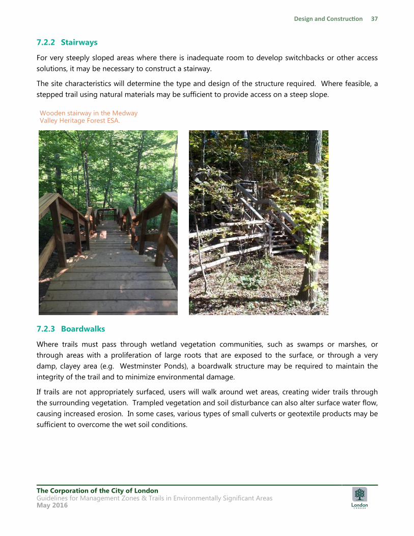
The Corporation of the City of London Guidelines for Management Zones & Trails in Environmentally Significant Areas May 2016
7.2.2 Stairways
For very steeply sloped areas where there is inadequate room to develop switchbacks or other access
solutions, it may be necessary to construct a stairway.
The site characteristics will determine the type and design of the structure required. Where feasible, a
stepped trail using natural materials may be sufficient to provide access on a steep slope.
7.2.3 Boardwalks
Where trails must pass through wetland vegetation communities, such as swamps or marshes, or
through areas with a proliferation of large roots that are exposed to the surface, or through a very
damp, clayey area (e.g. Westminster Ponds), a boardwalk structure may be required to maintain the
integrity of the trail and to minimize environmental damage.
If trails are not appropriately surfaced, users will walk around wet areas, creating wider trails through
the surrounding vegetation. Trampled vegetation and soil disturbance can also alter surface water flow,
causing increased erosion. In some cases, various types of small culverts or geotextile products may be
sufficient to overcome the wet soil conditions.
Wooden stairway in the Medway Valley Heritage Forest ESA.
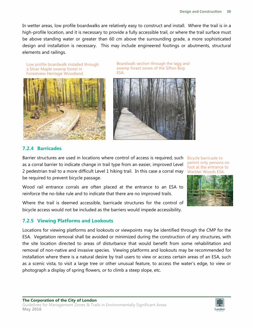
The Corporation of the City of London Guidelines for Management Zones & Trails in Environmentally Significant Areas May 2016
In wetter areas, low profile boardwalks are relatively easy to construct and install. Where the trail is in a
high-profile location, and it is necessary to provide a fully accessible trail, or where the trail surface must
be above standing water or greater than 60 cm above the surrounding grade, a more sophisticated
design and installation is necessary. This may include engineered footings or abutments, structural
elements and railings.
7.2.4 Barricades
Barrier structures are used in locations where control of access is required, such
as a corral barrier to indicate change in trail type from an easier, improved Level
2 pedestrian trail to a more difficult Level 1 hiking trail. In this case a corral may
be required to prevent bicycle passage.
Wood rail entrance corrals are often placed at the entrance to an ESA to
reinforce the no-bike rule and to indicate that there are no improved trails.
Where the trail is deemed accessible, barricade structures for the control of
bicycle access would not be included as the barriers would impede accessibility.
7.2.5 Viewing Platforms and Lookouts
Locations for viewing platforms and lookouts or viewpoints may be identified through the CMP for the
ESA. Vegetation removal shall be avoided or minimized during the construction of any structures, with
the site location directed to areas of disturbance that would benefit from some rehabilitation and
removal of non-native and invasive species. Viewing platforms and lookouts may be recommended for
installation where there is a natural desire by trail users to view or access certain areas of an ESA, such
as a scenic vista, to visit a large tree or other unusual feature, to access the water‟s edge, to view or
photograph a display of spring flowers, or to climb a steep slope, etc.
Boardwalk section through the lagg and swamp forest zones of the Sifton Bog ESA.
Low profile boardwalk installed through a Silver Maple swamp forest in Forestview Heritage Woodland.
Bicycle barricade to permit only persons on foot at the entrance to Warbler Woods ESA.
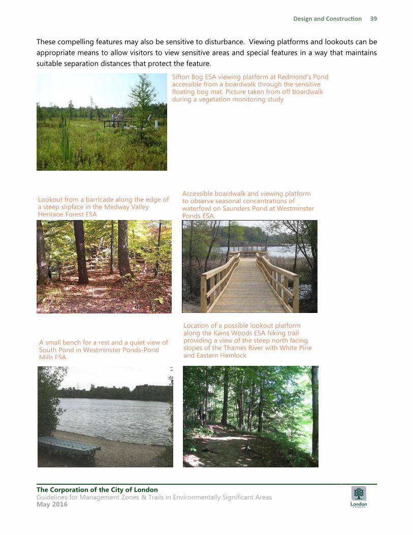
The Corporation of the City of London Guidelines for Management Zones & Trails in Environmentally Significant Areas May 2016
These compelling features may also be sensitive to disturbance. Viewing platforms and lookouts can be
appropriate means to allow visitors to view sensitive areas and special features in a way that maintains
suitable separation distances that protect the feature.
Sifton Bog ESA viewing platform at Redmond‟s Pond accessible from a boardwalk through the sensitive floating bog mat. Picture taken from off boardwalk during a vegetation monitoring study
Lookout from a barricade along the edge of a steep slipface in the Medway Valley Heritage Forest ESA
Accessible boardwalk and viewing platform to observe seasonal concentrations of waterfowl on Saunders Pond at Westminster Ponds ESA.
Location of a possible lookout platform along the Kains Woods ESA hiking trail providing a view of the steep north facing slopes of the Thames River with White Pine and Eastern Hemlock
A small bench for a rest and a quiet view of South Pond in Westminster Ponds-Pond Mills ESA
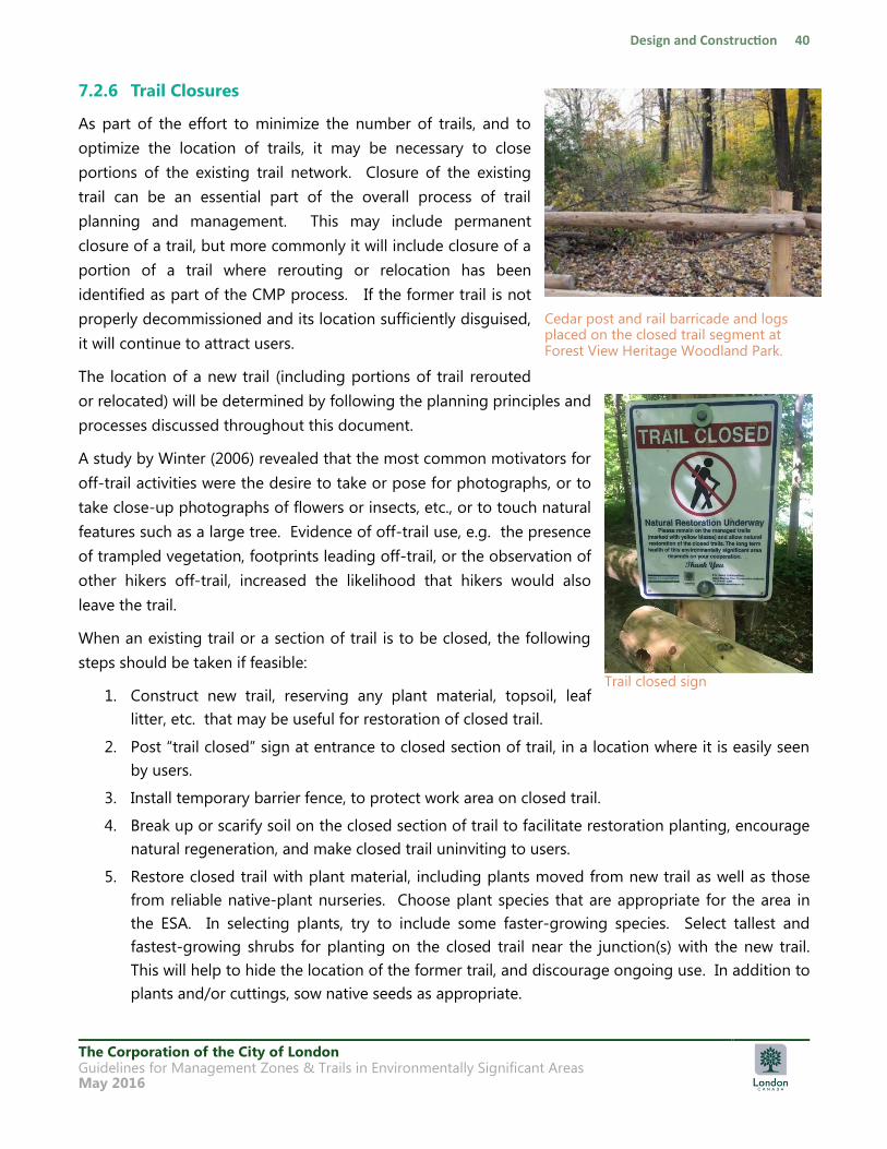
The Corporation of the City of London Guidelines for Management Zones & Trails in Environmentally Significant Areas May 2016
7.2.6 Trail Closures
As part of the effort to minimize the number of trails, and to
optimize the location of trails, it may be necessary to close
portions of the existing trail network. Closure of the existing
trail can be an essential part of the overall process of trail
planning and management. This may include permanent
closure of a trail, but more commonly it will include closure of a
portion of a trail where rerouting or relocation has been
identified as part of the CMP process. If the former trail is not
properly decommissioned and its location sufficiently disguised,
it will continue to attract users.
The location of a new trail (including portions of trail rerouted
or relocated) will be determined by following the planning principles and
processes discussed throughout this document.
A study by Winter (2006) revealed that the most common motivators for
off-trail activities were the desire to take or pose for photographs, or to
take close-up photographs of flowers or insects, etc., or to touch natural
features such as a large tree. Evidence of off-trail use, e.g. the presence
of trampled vegetation, footprints leading off-trail, or the observation of
other hikers off-trail, increased the likelihood that hikers would also
leave the trail.
When an existing trail or a section of trail is to be closed, the following
steps should be taken if feasible:
1. Construct new trail, reserving any plant material, topsoil, leaf
litter, etc. that may be useful for restoration of closed trail.
2. Post “trail closed” sign at entrance to closed section of trail, in a location where it is easily seen
by users.
3. Install temporary barrier fence, to protect work area on closed trail.
4. Break up or scarify soil on the closed section of trail to facilitate restoration planting, encourage
natural regeneration, and make closed trail uninviting to users.
5. Restore closed trail with plant material, including plants moved from new trail as well as those
from reliable native-plant nurseries. Choose plant species that are appropriate for the area in
the ESA. In selecting plants, try to include some faster-growing species. Select tallest and
fastest-growing shrubs for planting on the closed trail near the junction(s) with the new trail.
This will help to hide the location of the former trail, and discourage ongoing use. In addition to
plants and/or cuttings, sow native seeds as appropriate.
Cedar post and rail barricade and logs placed on the closed trail segment at Forest View Heritage Woodland Park.
Trail closed sign
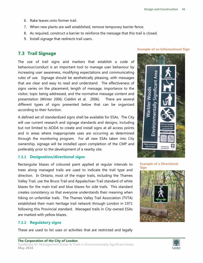
The Corporation of the City of London Guidelines for Management Zones & Trails in Environmentally Significant Areas May 2016
6. Rake leaves onto former trail.
7. When new plants are well established, remove temporary barrier fence.
8. As required, construct a barrier to reinforce the message that this trail is closed.
9. Install signage that redirects trail users.
7.3 Trail Signage
The use of trail signs and markers that establish a code of
behaviour/conduct is an important tool to manage user behaviour by
increasing user awareness, modifying expectations and communicating
rules of use. Signage should be aesthetically pleasing, with messages
that are clear and easy to read and understand. The effectiveness of
signs varies on the placement, length of message, importance to the
visitor, topic being addressed, and the normative message content and
presentation (Winter 2006; Cialdini et al. 2006). There are several
different types of signs presented below that can be organized
according to their function.
A defined set of standardized signs shall be available for ESAs. The City
will use current research and signage standards and designs, including
but not limited to AODA to create and install signs at all access points
and in areas where inappropriate uses are occurring as determined
through the monitoring program. For all new ESAs taken into City
ownership, signage will be installed upon completion of the CMP and
preferably prior to the development of a nearby site.
7.3.1 Designation/directional signs
Rectangular blazes of coloured paint applied at regular intervals to
trees along managed trails are used to indicate the trail type and
direction. In Ontario, most of the major trails, including the Thames
Valley Trail, use the Bruce Trail and Appalachian Trail standard of white
blazes for the main trail and blue blazes for side trails. This standard
creates consistency so that everyone understands their meaning when
hiking on unfamiliar trails. The Thames Valley Trail Association (TVTA)
established their main heritage trail network through London in 1971
following this Provincial standard. Managed trails in City-owned ESAs
are marked with yellow blazes.
7.3.2 Regulatory signs
These are used to list uses or activities that are restricted and legally
Example of a Directional Sign
Example of an Informational Sign
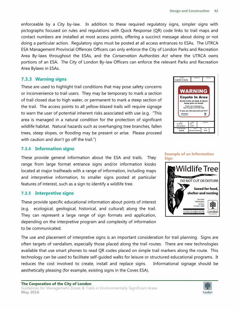
The Corporation of the City of London Guidelines for Management Zones & Trails in Environmentally Significant Areas May 2016
enforceable by a City by-law. In addition to these required regulatory signs, simpler signs with
pictographs focused on rules and regulations with Quick Response (QR) code links to trail maps and
contact numbers are installed at most access points, offering a succinct message about doing or not
doing a particular action. Regulatory signs must be posted at all access entrances to ESAs. The UTRCA
ESA Management Provincial Offences Officers can only enforce the City of London Parks and Recreation
Area By-laws throughout the ESAs, and the Conservation Authorities Act where the UTRCA owns
portions of an ESA. The City of London By-law Officers can enforce the relevant Parks and Recreation
Area Bylaws in ESAs.
7.3.3 Warning signs
These are used to highlight trail conditions that may pose safety concerns
or inconvenience to trail users. They may be temporary to mark a section
of trail closed due to high water, or permanent to mark a steep section of
the trail. The access points to all yellow-blazed trails will require signage
to warn the user of potential inherent risks associated with use (e.g. “This
area is managed in a natural condition for the protection of significant
wildlife habitat. Natural hazards such as overhanging tree branches, fallen
trees, steep slopes, or flooding may be present or arise. Please proceed
with caution and don‟t go off the trail.”)
7.3.4 Information signs
These provide general information about the ESA and trails. They
range from large format entrance signs and/or information kiosks
located at major trailheads with a range of information, including maps
and interpretive information, to smaller signs posted at particular
features of interest, such as a sign to identify a wildlife tree.
7.3.5 Interpretive signs
These provide specific educational information about points of interest
(e.g. ecological, geological, historical, and cultural) along the trail.
They can represent a large range of sign formats and application,
depending on the interpretive program and complexity of information
to be communicated.
The use and placement of interpretive signs is an important consideration for trail planning. Signs are
often targets of vandalism, especially those placed along the trail routes. There are new technologies
available that use smart phones to read QR codes placed on simple trail markers along the route. This
technology can be used to facilitate self-guided walks for leisure or structured educational programs. It
reduces the cost involved to create, install and replace signs. Informational signage should be
aesthetically pleasing (for example, existing signs in the Coves ESA).
Example of an Information Sign

The Corporation of the City of London Guidelines for Management Zones & Trails in Environmentally Significant Areas May 2016
8 Maintenance, Monitoring and Management
8.1 Adaptive Management Approach
Establishment of baseline conditions through a CMP process or other environmental planning process
is essential to implementing an adaptive management approach. Baseline data provides a benchmark
against which objectives related to ecosystem protection, environmental policies and management can
be measured to ensure activities are sustainable and effective. The key to effective adaptive
management is to implement rigorous monitoring and evaluation to ensure ecological objectives are
being maintained while achieving community and social objectives.
8.2 Monitoring Framework
Managing change in natural ecosystems involves evaluating trails and their use through a decision
framework such as the Limit of Acceptable Change (LAC) (Cole and Stankey 1998) or the Stress-
Response-Intervention-Outcome (SRIO) adaptive management framework (Bergsma and De Young
2007). This framework is used to guide decisions about the acceptability and management of impacts
and visitor use. Identification of an acceptable limit or targeted outcome establishes thresholds for
permitted uses (e.g. trails) such that recreation use does not compromise protection of the resource
beyond a minimally acceptable condition (Cole and Stankey 1998) that will contribute to ecosystem
decay.
Monitoring begins by understanding the current conditions of an area to establish a baseline.
Degraded areas will require management plans for restoration and trail system improvements that can
be monitored to track the success of management in achieving acceptable baseline conditions. The
baseline of healthy natural areas will be monitored to ensure use of the trail system does not result in
environmental impacts over time. The objective of monitoring is to provide a quantifiable assessment
of trail conditions and will typically include such measurements as trail width and depth, trail condition
class score, soil and vegetation plot data, and other environmental factors. Indicator variables are
regularly monitored and can be summarized to report on trail conditions and their impact on the
surrounding environment over time (Marion 2008). Monitoring frequency will vary based on the
intensity of trail use and sensitivity and vulnerability of the natural area to impacts. A well-designed
monitoring program will provide the necessary feedback for gauging the effectiveness of management
interventions in keeping conditions within acceptable limits and within the targeted outcome. A
documented failure of an intervention can be used to justify the use of a more obtrusive [intrusive] or
expensive intervention (Marion 2008), trail closure, or more innovative management. The CMP process
will establish the details and protocols for the monitoring framework and implementation approach to
be undertaken as part of required management activities within each publicly owned ESA. As outlined
in Section 2.5, for ESAs that do not have a current CMP, monitoring will occur as part of the general
ESA management activities.
The Corporation of the City of London Guidelines for Management Zones & Trails in Environmentally Significant Areas May 2016
9 References
Accessibility for Ontarians with Disabilities Act, 2005 (AODA).
Bergsma, Bonnie and William DeYoung. 2007. Paradox of the Natural in Urban Parks: A Case Study of
Sifton Bog, London Ontario. Presentation at the Parks Research Forum of Ontario.
Cialdini, R.B., Barrett, D.W., Bator, R., Demaine, L., Sagarin, B.J., Rhoads, K.L., Winter, P.L.. 2006.
Managing Social Norms for Persuasive Impact. Social Influence 1 (1): 3-15.
City of London Official Plan. 2007
City of London Parks and Recreation Area By-Law No. PR-2. 2005. Enacted May 2 2005.
City of London Bicycle Master Plan. 2005.
City of London. 2007. Facility Accessibility Design Standards, 108 pp.
City of London. 2007. Environmental Management Guidelines.
City of London Parks and Recreation Strategic Master Plan. 2009. Prepared by: Monteith Brown
Planning Consultants, Tucker-Reid & Associates, The JF Group. Final Report adopted by Municipal
Council November 23, 2009.
City of London Tree Risk Management Policy and Procedures for ESAs. 2013.
Cole, David N. and George H. Stankey. 1998. Historical Development of Limits of Acceptable Change:
conceptual clarifications and possible extensions. Proceedings – limits of acceptable change and
related planning processes: progress and future directions; 1997 May 20-22. Missoula,
MT,Gen.Tech.Rep. INT-GTR-371. USDA Forest Service.
Davis, Steven M.. 2010. The politics of Urban Natural Areas Management at the Local Level. A Case
Study. KY Journal of Equine, Agricultural and Natural Resource Law. Vol 2-2.
Dillon Consulting Limited. 2016. Trail Standards Review for Conformance to Provincial and Federal
Standards. Prepared for: The City of London.
Global Alliance on Accessible Technologies and Environments. 2014. The Illustrated Technical Guide to
the Accessibility Standards for the Design of Public Spaces.
Hendee, J.C. and Dawson C.P.. 2002. Wilderness visitor management: Stewardship for quality
experiences. In Wilderness Management: Stewardship and Protection of Resources and Values.
Golden, CO: Fulcrum.
The Corporation of the City of London Guidelines for Management Zones & Trails in Environmentally Significant Areas May 2016
Lee, H.T., W.D. Bakowsky, J. Riley, J. Bowles, M. Puddister, P. Uhlig and S. McMurray. 1998.
Ecological Land Classification for Southern Ontario: First Approximation and Its Application. Ontario
Ministry of Natural Resources, Southcentral Science Section, Science Development and Transfer
Branch. SCSS Field Guide FG-02.
Leung, Yu-Fai and Jeffrey L. Marion. 2000. Recreation Impacts and Management in Wilderness: A
State-of-Knowledge Review. USDA Forest Service Proceedings RMRS-P-15. Vol.5:23-48.
Lynn, N.A., and Robert D. Brown. 2003. Effects of recreational use impacts on hiking experiences in
natural areas. Landscape and Urban Planning. Vol.64: 77-87.
Marion, Jeff. 2008. Guidance for Managing Informal Trails. Presented at the American Trails 19th
National Trails Symposium, November 2008.
Ontario Ministry of Natural Resources. 1992. Ontario Provincial Parks: Planning and Management
Policies. 1992 Update. 125 pp.
Ontario Ministry of Natural Resources. 2000. Significant Wildlife Habitat Technical Guide. 151pp.
Ontario Ministry of Natural Resources. 2009. Ontario Protected Areas Planning Manual. Peterborough.
Queen‟s Printer for Ontario. 50 pp.
Ontario Ministry of Natural Resources. 2014. Guideline to Management Planning for Protected Areas in
the Context of Ecological Integrity. Peterborough. Queen‟s Printer for Ontario. 79 pp.
Ontario Ministry of Natural Resources. Version 2014. Significant Wildlife Habitat Mitigation Support
Tool. Peterborough. Queen‟s Printer for Ontario. 533 pp.
Ontario Ministry of Natural Resources and Forestry. 2015. Significant Wildlife Habitat Criteria
Schedules for Ecoregion 7E. 41 pp.
Ontario Regulation 413/12, Amending Ontario Regulation 191/11, Integrated Accessibility Standards
Parks Canada. 2008. Guide to Management Planning. 100 pp.
Parks Canada. 2012. Parks Canada Trail Guidelines: Trail Classification System User Guide (20 pp.) and
Trail Specifications (16 pp.)
Stankey, G.H. and Schreyer, R.. 1987. Attitudes towards wilderness and factors affecting visitor
behaviour: A state of knowledge review. In R.C. Lucas (ed.) Proceedings – National Wilderness
Research Conference. Issues, State of Knowledge, Future Directions (pp. 246-93). General Technical
Report INT-220. Ogden, UT: USDA Forest Service, Intermountain Research Station.
The Corporation of the City of London Guidelines for Management Zones & Trails in Environmentally Significant Areas May 2016
Trails for All Ontarians Collaborative. 2006. Ontario‟s Best Trails. Guidelines and Best Practices for the
Design, Construction and Maintenance of Sustainable Trails for All Ontarians.
Thames Valley Trail Association Inc. 2008. A Guide to Hiking the Thames Valley Trail, Third edition
Winter, Patricia. 2006. The Impact of Normative Message Types on Off-Trail Hiking. Journal of
Interpretation Research 11 (1): 35-52.
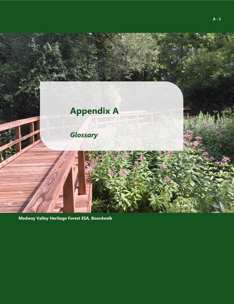
Appendix A
A - 1
A Glossary
Medway Valley Heritage Forest ESA, Boardwalk
The Corporation of the City of London Guidelines for Management Zones & Trails in Environmentally Significant Areas May 2016
Acronyms, Abbreviations, Definitions
– A –
Adaptive Management - is a structured, iterative process of optimal decision making in the face of
uncertainty regarding the effectiveness of our actions in achieving desired objectives – due to either gaps
in our understanding or changes in the ecosystems we are trying to manage. Adaptive management
provides a way to systematically reduce uncertainty over time via system monitoring and management
intervention (Holling 1978; Murray and Marmorek 2004).
Anthropogenic - of, relating to, or resulting from the influence of human beings on nature.
– B –
– C –
Cultural - as defined under Ecological Land Classification for Southern Ontario – First Approximation
and Its Application (Lee et al., 1998), vegetation community resulting from, or maintained by, cultural or
anthropogenic-based disturbances. Includes the ecosites and vegetation communities listed under the
community series of Plantation (CUP), Cultural Meadow (CUM), Cultural Thicket (CUT), Cultural Savannah
(CUS), and Cultural Woodland (CUW). Manicured areas, such as mowed lawn or hedgerows, are also
considered to be cultural.
– D–
– E–
Ecological Integrity - Ecological integrity refers to a condition in which biotic and abiotic components
of ecosystems and the composition and abundance of native species and biological communities are
characteristic of their natural regions and rates of change and ecosystem processes are unimpeded (note,
this definition has been taken from the Ontario Provincial Parks and Conservation Reserves Act, 2006)
The Corporation of the City of London Guidelines for Management Zones & Trails in Environmentally Significant Areas May 2016
Ecoregion - a relatively large unit of land or sea that contains a geographically distinct assemblage of
natural communities with boundaries that approximate the original extent of the natural environment
prior to major land use change
Ecosystem - defined as the community of living co-existing organisms (including humans) and the non-
living physical and chemical environment in which that community lives. There is a constant interaction
and interdependence among all components of the ecosystem resulting in a dynamic variability. This
variability means that ecosystems are constantly changing
Ecosystem Health - Ecosystem health refers to the biological condition of an ecosystem and may be
indicated by its ability to maintain natural diversity and primary productivity, perform ecosystem services
(such as nutrient cycling) and to rebound from stress. The field of ecosystem health often examines
relationships between ecosystem health and human health. Knowledge of the measures of ecosystem
health may help to diagnose causes of degradation and assist in aspects of ecosystem management.
Indicators of poor ecosystem health tend to be specific to the ecosystem, but symptoms of poor health
often include:
a) A loss of biodiversity accompanied by the proliferation of simpler life forms;
b) The loss of keystone species, leading to stresses on other species;
c) An increased rate of species mortality due to disease;
d) Changes in the historic patterns of species movement; and
e) The proliferation of non-native invasive species.
Environmentally Significant Areas (ESAs) - are identified in the City‟s Official Plan as areas that
contain natural features and perform ecological functions that warrant their retention in a natural state.
Publicly-owned ESAs have a purpose and function distinct from all other publicly owned green space.
Permitted uses, access, and the provision of recreational activities within ESAs are governed by the
Environmental Policies of the Official Plan for significant components of the natural heritage system.
The Corporation of the City of London Guidelines for Management Zones & Trails in Environmentally Significant Areas May 2016
– F –
– G –
General Habitat - an area on which a species depends, directly or indirectly, to carry out its life
processes. This includes places that are used by the species as dens, nests, hibernacula or other residences.
It doesn‟t include areas where the species once lived or where it may be reintroduced in the future. As
soon as a species is listed as Threatened or Endangered on Ontario Regulation 230/08 (the Species at Risk
in Ontario list) under the Ontario Endangered Species Act, 2007, that species‟ general habitat is legally
protected as well.
General Habitat Description - general habitat descriptions are technical, science-based documents that
provide greater clarity on the area of general habitat protected for a species. They have been developed
for some of the provincially listed Species at Risk that are most likely to be affected by human activity (see
also Habitat Categories).
Government Resources - technical reports published by government agencies.
Groundwater - water found in the tiny spaces between soil particles and in cracks in bedrock. Aquifers
are the underground areas of soil or rock where substantial quantities of groundwater can be found.
These are the source for water wells and springs. Groundwater discharges when it leaves the ground
wherever the water table meets the ground‟s surface. This discharge is essential for maintaining surface
waters (see Seeps and Springs).
– H –
Habitat Categories - when the Ministry of Natural Resources and Forestry issues a General Habitat
Description for a Species at Risk, the habitat is categorized to help identify areas within the species‟
habitat that may be able to tolerate more or fewer changes. Habitat is categorized by considering how a
species uses its habitat and taking into account any unique characteristics of that habitat. Habitat
categories can vary among species and generally help determine when an activity may damage or destroy
habitat and what conditions may be required for an authorization.
The Corporation of the City of London Guidelines for Management Zones & Trails in Environmentally Significant Areas May 2016
Category 1: These are areas of habitat where a species will probably be least tolerant to
changes (e.g., nesting and hibernation sites). Activities that could alter category 1 habitat areas
will likely damage and destroy them, so they usually require authorization to continue.
Category 2: These are areas of habitat where a species is believed to be moderately tolerant to
changes (e.g., areas used daily to find food). Relatively high-impact or large-scale activities that
could alter category 2 habitat areas could damage and destroy them, so they usually require
authorization to continue.
Category 3: These are areas of habitat where a species is believed to be the most tolerant to
changes (e.g., areas used occasionally to find food). Some high-impact or large-scale activities
that could alter category 3 habitat areas could damage and destroy them, so they usually
require authorization to continue.
High water mark - the highest that the water gets under normal conditions during the course of a year,
but not the highest it gets during extreme flooding. In the case of watercourse features, such a line would
be the line below which the vegetation and soil show the effects of submersion under water.
– I –
Interior Habitat - interior habitats are those that provide area-sensitive species a refuge from edge
effects. These habitats are typically measured from the edge of the feature (e.g. woodland or grassland)
in an inward direction. For area-sensitive species that use woodland areas as habitat, this area is typically
more than 200 m (inward) from the edge of the woodland. For clarity, this differs from woodland interior,
which is more than 100 m (inward) from the edge of the woodland.
The Corporation of the City of London Guidelines for Management Zones & Trails in Environmentally Significant Areas May 2016
– L –
Linkage/corridor - a linear area intended to provide connectivity (at the regional or site level)
supporting a complete range of community and ecosystem processes, enabling plants and smaller
animals to move between core areas and other larger areas of habitat over a period of generations. The
terms are used interchangeably for planning purposes but may need to be distinguished for ecological
or biological reasons (Adapted from the Natural Heritage Reference Manual 2011).
Limit of Acceptable Change (LAC) - is a framework to guide decisions about the compatibility,
acceptability and management of trail impacts and visitor use within designated management zones
based on an inventory and evaluation of existing (baseline) conditions. The evaluation of existing trail
conditions is generally based on objective and quantifiable measurements of abiotic (e.g. soils, slopes,
exposure, elevation, trail width and depth, trail condition class score), biotic (e.g. vegetation and wildlife)
and cultural elements (e.g. archaeological and cultural heritage features). Indicator variables are
identified for various trail segments that will be used to monitor and detect changes in trail conditions and
user impacts on the surrounding environment. Trail maintenance activities will focus on resolving impacts
through appropriate interventions. Any documented failure of an intervention over time may be used to
justify either increasing the level of intervention or a trail closure.
– N –
NHIC; Natural Heritage Information Centre - part of the MNRF that conducts research and surveys in
the field for priority species and areas across Ontario. The centre collects, reviews, manages and
distributes information for: species of conservation concern, rare and exemplary plant communities,
wildlife concentration areas, and natural areas.
– M–
MNRF; Ministry of Natural Resources and Forestry - a government ministry of the
province of Ontario that is responsible for Ontario‟s provincial parks, forests, fisheries, wildlife, mineral
aggregates and the Crown lands and waters. It should be noted that this ministry was previously referred
to as the Ministry of Natural Resources (MNR).

The Corporation of the City of London Guidelines for Management Zones & Trails in Environmentally Significant Areas May 2016
Micro-siting - this refers to reviewing the location for a trail through a site visit, which may include a
Conservation Master Plan Local Implementation Committee or the Trails Advisory Group (TAG). The
intention of micro-siting is to further ensure the avoidance of impacts to ecological features such as
regionally rare flora, and seasonal habitats such as vernal pools for example.
– P –
PPS; Provincial Policy Statement - The Provincial Policy Statement is issued under section 3 of
the Planning Act. The Provincial Policy Statement applies province-wide and should be read in its entirety.
Its policies set out the government‟s land use vision for how we settle our landscape, create our built
environment, and manage our land and resources over the long term to achieve livable and resilient
communities.
PSW; Provincially Significant Wetland - wetlands are ranked to determine whether they should
receive special protection as “provincially significant”. Significance is determined by the Ontario Wetland
Evaluation System. Completed wetland evaluations are submitted to the MNRF for approval prior to a
wetland being identified as a PSW.
– O –
OWES; Ontario Wetland Evaluation System - created to inform Ontario‟s land use planning process.
The Ministry of Natural Resources and Forestry evaluates wetlands to help municipalities, conservation
authorities and others with land use planning. The ministry provides manuals describing how wetlands
are to be delineated and evaluated and offers annual training for professionals wishing to become
qualified wetland evaluators.
The Corporation of the City of London Guidelines for Management Zones & Trails in Environmentally Significant Areas May 2016
– R–
Rare Vegetation Community - The MNRF defines rare vegetation communities as a type of wildlife
habitat. This includes vegetation communities with a sub-national (SRank) ranking of S1, S2 or S3 as
designated by the NHIC and/or listed in Appendix M of the Significant Wildlife Haibtat Technical Guide
(MNR 2000). This also includes cliffs and talus slopes, sand barrens, alvars, old growth forests, savannahs,
and tallgrass prairies. Many of these types of rare vegetation communities are not applicable to the City
of London.
Regulated Habitat - this habitat area is prescribed in Ontario Regulation 242/08 under the Ontario
Endangered Species Act, 2007 as the protected habitat for species listed as Threatened or Endangered in
Ontario. Once a habitat regulation has been defined for a listed species, this replaces the general habitat
protection.
Riparian Zone - areas where the terrestrial landscape transitions to the aquatic environment of a
flowing watercourse.
– S –
Seep - a moist or wet place where water, usually groundwater, reaches the earth's surface from an
underground aquifer.
Significant Wildlife Habitat - wildlife habitat is identified as “areas where plants, animals, and other
organisms live, and find adequate amounts of food, water, shelter, and space needed to sustain their
populations.” It is considered significant where it is ecologically important in terms of features, functions,
representation or amount, and contributing to the quality and diversity of an identifiable geographic area
or Natural Heritage System. The MNRF is the authoritative source for defining the types of wildlife habitat
relevant to the various ecoregions in Ontario.
Broadly defined, wildlife habitat includes seasonal concentration areas of animals, rare vegetation
communities, specialized habitat for wildlife, habitat for species of conservation concern, and animal
movement corridors. Criteria for determining significance have been developed by the MNRF for the
various ecoregions in Ontario. The City of London falls within ecoregion 7E.
The Corporation of the City of London Guidelines for Management Zones & Trails in Environmentally Significant Areas May 2016
Species at Risk - This includes Species at Risk that would be legally protected by provincial or federal
legislation. In Ontario, flora and/or fauna listed as Endangered or Threatened under the provincial
Endangered Species Act, 2007, as well as their habitat, are protected. Aquatic Species at Risk and
Migratory Birds listed on Schedule 1 of the federal Species at Risk Act, 2002 are also protected. Other
species listed on Schedule 1 of the federal Species at Risk Act, 2002 would not be protected on City-owned
lands as Species at Risk (see Species of Conservation Concern). The federal Species at Risk Act applies
mostly to federal lands.
Species of Conservation Concern - flora and/or fauna listed as Special Concern under the provincial
Endangered Species Act, 2007; Endangered or Threatened under Schedule 1 of the federal Species at Risk
Act, 2002; and species designated a SRank of S1, S2 or S3 by the NHIC.
Spring - a water resource formed when the side of a hill, a valley bottom or other excavation intersects a
flowing body of groundwater at or below the local water table, below which the subsurface material is
saturated with water. A spring is the result of an aquifer being filled to the point that the water overflows
onto the land surface.
SRank; Subnational Rank - the conservation status of a species or plant community within a particular
province, territory or state. NHIC assigns subnational ranks (SRanks) for species and plant communities in
Ontario using the best available information and considering factors such as abundance, distribution,
population trends and threats. Conservation status ranks do not have any legal standing in Ontario. They
are independent of status designated under Canada‟s Species at Risk Act and Ontario‟s Endangered
Species Act.
Sustainability – refers to the capacity to endure. A holistic concept that, for natural ecosystems, requires
all their components to be sustained, with human uses included only when they are compatible with
conservation of the native biota and natural processes (Noss 1995). Sustainable systems are maintained
without exhausting natural resources or losing ecological integrity. For humans, sustainability is the
potential for long-term maintenance of well-being, and includes environmental, economic, and social
components.
Sustainable Design Practices - those that can be maintained over the long-term from environmental,
economic and social perspectives. (Adapted from Trails for All Ontarians, 2006)
The Corporation of the City of London Guidelines for Management Zones & Trails in Environmentally Significant Areas May 2016
– T –
TAG; Trails Advisory Group - representing ESA user groups to comment on any trail related issues in
ESAs that were not addressed or contemplated in the most current Conservation Master Plans (CMP) or
where a current CMP does not exist. The detailed terms of reference for TAG is outlined under separate
cover as approved by Council.
– U –
Unevaluated Wetland - a wetland that has not been evaluated using the Ontario Wetland Evaluation
System.
Utility Corridor - generally a linear anthropogenic feature that contains infrastructure (e.g. hydro
transmission lines, gas or water pipeline, railroad lines, sanitary sewer)
– W –
Watercourse - An identifiable depression in the ground in which a flow of water occurs regularly or
continuously
Wildlife Habitat - see Significant Wildlife Habitat