Embed Size (px)
Citation preview
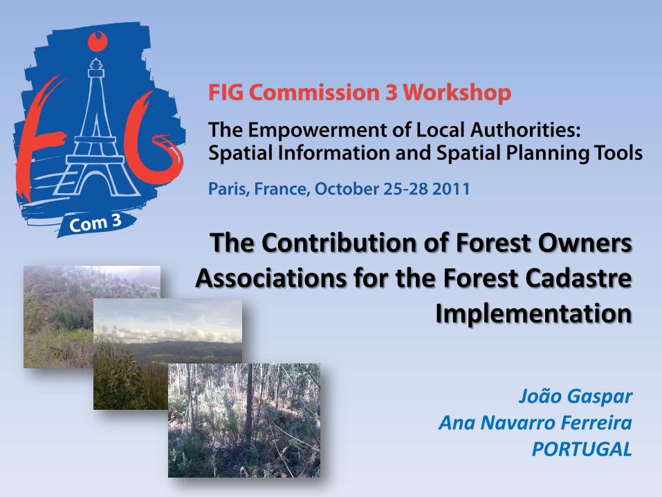
The Contribution of Forest Owners Associations for the Forest Cadastre
Implementation
João Gaspar Ana Navarro Ferreira
PORTUGAL
2
Motivation Lack of forestry cadastre;
Unify all FOAs databases with common attributes and share data to the Forest National Authority and to the SiNErGIC project;
Develop a freeware application to collect data for parcel characterization in the scope of the SiNErGIC project ;
Replace the traditional paper form used in the field and make the process of data collecting and processing easier;
Create solutions of cooperation between FOAs, private owners and Real Cadastre Entities.
3
Identified Problems FOAs perform forest perimeter surveys instead of parcel´s delimitation;
Lack of precision of some perimeter surveys;
FOAs databases with different attributes that disables interoperability among FOAs;
Data Protection Law demands that FOA can’t share information related to private owners without permission;
The FOAs demands financial compensations to share information;
In the scope of the SiNErGIC project, parcels are delimited and their ownership is confirmed, however parcel contents (such as types and number of species) are not considered;
Land fragmentation.

4
Main Goals Create a seamless database with common attributes to all the FOAs to store data to
be used for parcel characterization in the scope of the SiNErGIC project; Create an application that collect the attributes of the FOAs database, increasing the
data collecting rate to the FOAs database at the Office; Create partnerships and solutions among private owners, FOAs, Taxes Office and
National Forest Authority to share information.
5
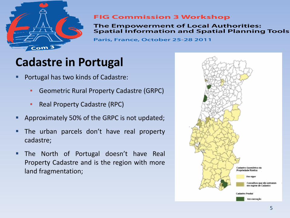
Portugal has two kinds of Cadastre:
• Geometric Rural Property Cadastre (GRPC)
• Real Property Cadastre (RPC)
Approximately 50% of the GRPC is not updated;
The urban parcels don’t have real property cadastre;
The North of Portugal doesn’t have Real Property Cadastre and is the region with more land fragmentation;
Cadastre in Portugal
6
SiNErGIC Project
Formally created by the Resolution of the Council of Ministers 45/2006, May 4th
Cadastral System approved by the Decree-law 224/ 2007, May 31st
Main goals:
• Ensure the unique identification of parcels; • Unify the existing land registry with the land registry that will be acquire; • Allow a uniform information and land registry content management; • Ensure compatibility among the information systems used by different entities
involved in the project; • Ensure that the description of the land register is supported by a graphic support; • Enable the widespread use of the system by the Public Administration; • Ensure access to the information by citizens and businesses.
7
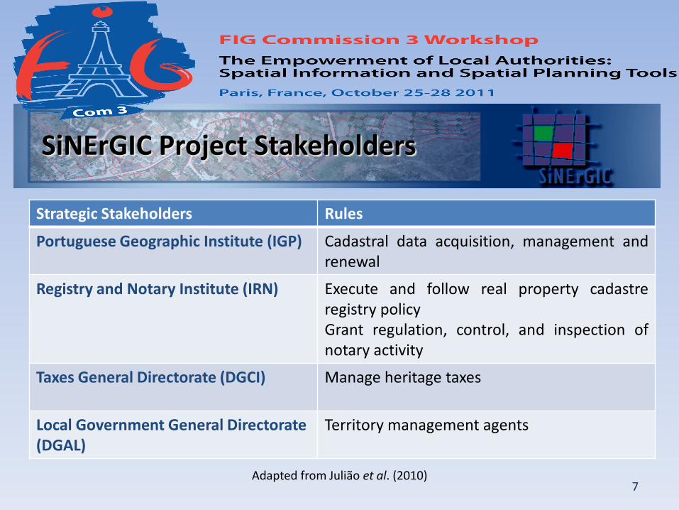
SiNErGIC Project Stakeholders
Strategic Stakeholders Rules
Portuguese Geographic Institute (IGP) Cadastral data acquisition, management and renewal
Registry and Notary Institute (IRN) Execute and follow real property cadastre registry policy Grant regulation, control, and inspection of notary activity
Taxes General Directorate (DGCI) Manage heritage taxes
Local Government General Directorate (DGAL)
Territory management agents
Adapted from Julião et al. (2010)
8
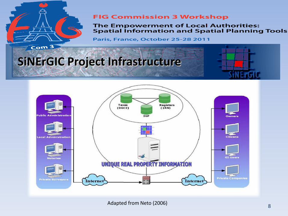
SiNErGIC Project Infrastructure
Adapted from Neto (2006)

9
Portuguese Forests
Adapted from AFN (2010)
Forest covers 38.8% of the national territory; The main economics species of Portuguese
forest are: • Maritime Pine (Pinus pinaster) • Eucalypt (Eucalyptus globulus) • Cork Oak (Quercus suber);
The main negative aspects of the Portuguese forest are:
• Land Fragmentation; • Rural exodus; • Owner absenteeism; • Forestry policies; • Forest wildfires; • Lack of forest cadastre.

10
Forest Owners Associations (FOAs) Appeared in the 90’s as an important
associative initiative among forest owners, mainly in the Northern and Central regions where small scale forestry is largely predominant;
The FOAs are Non-Government Organizations (NGOs) and their profits came essentially from the services provided to the associates;
FOAs contribute to the provision of several public goods;
Presently, there are 169 FOAs distributed in Portugal.
11
Forest Intervention Zones (FIZ) Approved by the Resolution of the Council of Ministers 178/ 2003, October 31st as
a measure of the Structural Reform of Forest sector;
Created by the Decree-law 127/2005, August 5th and revised by the Decree-law 15/2009, January 14th;
A FIZ is:
• A continuous delimited territorial area;
• Formed in their majority by forest areas;
• Submitted to a management and wildfire protection forest plans;
• Managed by a single entity (Ex.: FOAs, Municipalities).

12
FIZs objectives: Promote an active and permanent
management of forest areas; Protect the forest areas and rural areas
associated in an efficient way; Promote the rehabilitation of the forest
areas affected by wildfires; Reduce ignition conditions and the
propagation of wildfires; Allow coordination of the different
instruments that exist for land use management;
Contribute to reduce land fragmentation and create conditions of economic viability for the smaller parcels.
Adapted from AFN (2011)
13
Methods - Questionnaires To understand the kind of guidelines that FOAs follow to collect, process and store
information, a questionnaire was sent to all FOAs covering the following topics:
• Associate Information;
• Parcel characterization;
• GPS Equipment used (Precision);
• Data acquisition (Real Time or Post-Processing);
• The kind of software used in data process (Licensed and/or Open source);
• Cartographic support and their scale;
• Data storage;
• The kind of compensations needed to share the information to the SiNErGIC entities.
14
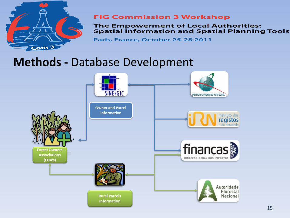
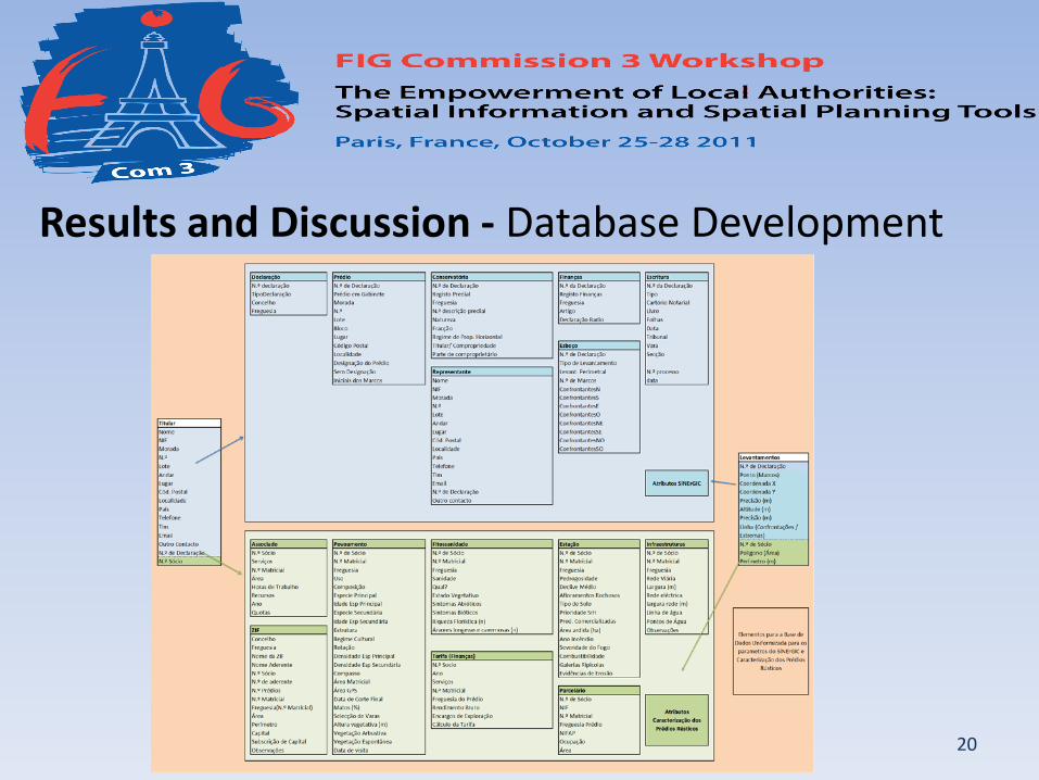
Methods - Database Development Realize the kind of information that FOAs store to share with other entities;
Harmonize all FOAs databases by creating a database with common attributes of land characterization for all FOAs and common attributes of the SiNErGIC project;
This database will store attributes (alphanumeric) and geographic information;
This database will promote partnerships between FOAs and the SiNErGIC entities.
15
Methods - Database Development
16
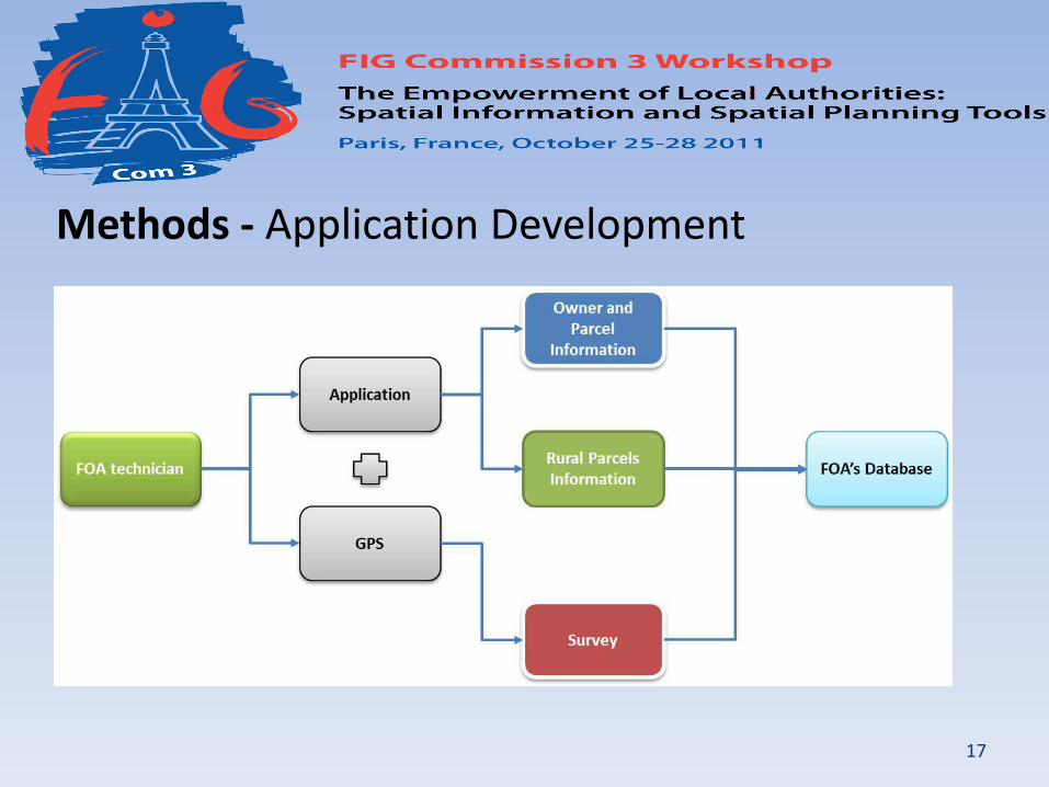
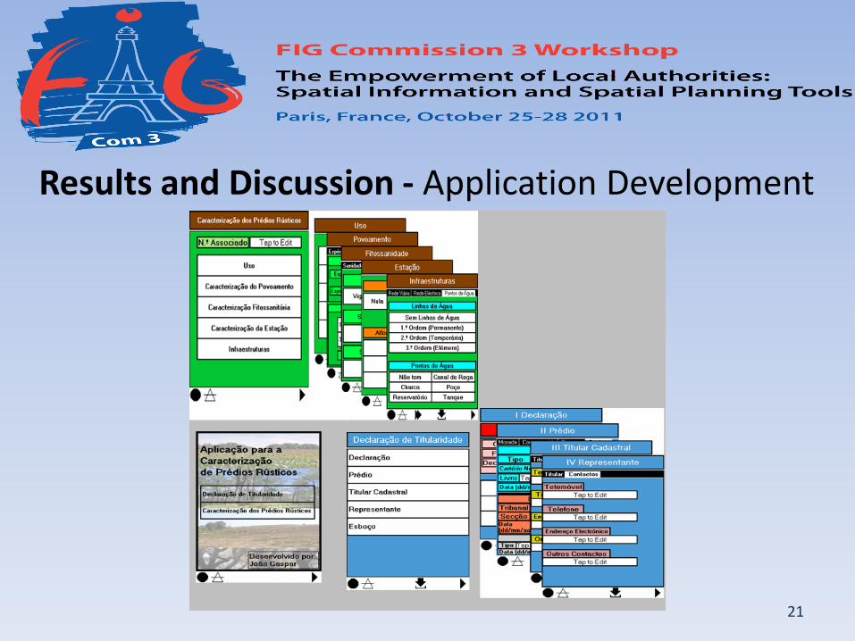
Methods - Application Development Create an application based on a freeware (CyberTracker) using the attributes
compiled by the FOAs questionnaire survey and also extending to the attributes of the SiNErGIC project;
Minimize the use of traditional paper forms during the field work;
Increase the speed of data collection;
Speed up the process of transferring data to databases of Forestry Associations;
Speed up the collection of information for the Forest cadastre (SiNErGIC).
17
Methods - Application Development

18
Results and Discussion - Questionnaires In a universe of 169 FOAs only 44 were received back; From 44, one was invalid, 2 were from National FOAs and 3 from FOAs that don´t use GPS; Therefore, only 38 questionnaires were considered valid:
• 92.7% use GPS for perimeter surveys and 7.3% use cadastral data; • 36.8% collect data only with GPS, 34.2% with GPS and paper form and 28.9% use GPS with
digital form; • the most used GIS software is ESRI ArcGIS (81.6%); • 89.5% use GPS receivers with internal antenna and 86.8% use GPS data post-processing; • 63.2% were aware of planimetric and altimetric accuracies; • 57.9% use aerial photos and topographic maps; • In terms of land use, all FOAs delimitate forestry, 30 delimitate Agriculture, 24 delimitate
community lands and only 8 FOAs consider urban delimitation; • Data is stored in a computer with a GIS database by 26.3%, of the FOAs and the same
amount was obtained for those that store data just in digital format in a computer.
19
Results and Discussion (2) - Questionnaires Ownership is proven based on the fiscal registry by 36.8% and based on the real property by
18.4% of the FOAs;
The most common attributes are: date, type of stand, land use, primary specie, primary specie age, secondary specie, secondary specie age, owner’s name, fiscal identification number, area, type of road, member’s number, stand rotation, compass, natural values, erosion evidences among others;
How FIZs are delimited: 13.2% consider only the perimeter delimitation of contiguous forest patches, 34.2% consider the perimeter delimitation of contiguous forest patches plus the parcel´s type and 7.9% consider the perimeter delimitation of contiguous forest patches plus parcel´s type and the exclusion of non-forest lands (however, only 55.3% of the FOAs stated that they manage one or more FIZs);
All FOAs are willing to contribute to the SiNErGIC project in exchange of training courses, cartographic data and payment of the services and more than half of the FOAs (60.5%) stated that are interested in using an application to turn data acquisition easier.
20
Results and Discussion - Database Development
21
Results and Discussion - Application Development

22
Conclusion and Future Actions In Portugal, forest is an important sector of exportation and is urgent to create
mechanisms to promote the forest management;
A significant threat is the lack of long term forest management planning and the absence of cadastre for about half of the country;
FOAs must be consider as a local agent of significant importance for the cadastre execution due to the closer relationship with the property owners;
The conceptual data model developed in this study includes attributes that might be useful to the DGCI, for the calculation of equitable taxes, and to the IRN, for the harmonization between the real property registry and the territory’s physical reality, allowing the security of tenure;
The development of a unique and seamless database, to be used by all the FOAs, is a crucial factor for the establishment of the national cadastral information system.
23
Conclusion and Future Actions (2) To accomplish a forest cadastre, not only the attributes common to all the stakeholder’s
databases should be harmonized, but also the parcel’s boundaries delimitation should be performed in agreement with the SiNErGIC technical specifications;
The freeware application, developed to be used by the FOA’s technicians when performing the cadastral surveys, has the capability of allowing the simultaneous acquisition of graphic and alphanumeric data. In such manner, those parcels can be included and/or updated in the real property cadastre;
The compensations to FOAs to share information might be training courses on the SiNErGIC technical specifications, base cartography to support the parcel’s delimitation and/or financial support;
It is relevant to define the data policy specifying the basic principles to be observed by individuals and institutions when generating, collecting, transforming, disseminating, and making use of data.
24
Thank you for your time.