Embed Size (px)
Citation preview
The state-of-the-practice of geotechnical engineering in Taiwan and Hong Kong 52
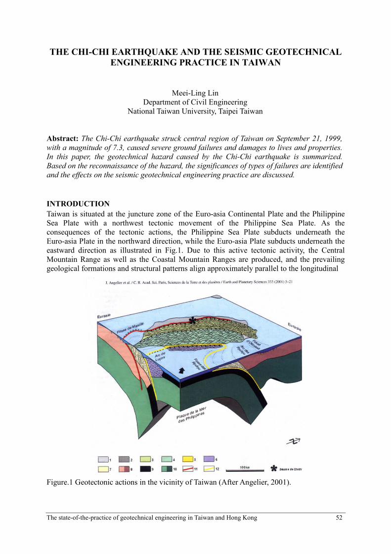
THE CHI-CHI EARTHQUAKE AND THE SEISMIC GEOTECHNICAL
ENGINEERING PRACTICE IN TAIWAN
Meei-Ling Lin
Department of Civil Engineering
National Taiwan University, Taipei Taiwan
Abstract: The Chi-Chi earthquake struck central region of Taiwan on September 21, 1999,
with a magnitude of 7.3, caused severe ground failures and damages to lives and properties.
In this paper, the geotechnical hazard caused by the Chi-Chi earthquake is summarized.
Based on the reconnaissance of the hazard, the significances of types of failures are identified
and the effects on the seismic geotechnical engineering practice are discussed.
INTRODUCTION
Taiwan is situated at the juncture zone of the Euro-asia Continental Plate and the Philippine
Sea Plate with a northwest tectonic movement of the Philippine Sea Plate. As the
consequences of the tectonic actions, the Philippine Sea Plate subducts underneath the
Euro-asia Plate in the northward direction, while the Euro-asia Plate subducts underneath the
eastward direction as illustrated in Fig.1. Due to this active tectonic activity, the Central
Mountain Range as well as the Coastal Mountain Ranges are produced, and the prevailing
geological formations and structural patterns align approximately parallel to the longitudinal
Figure.1 Geotectonic actions in the vicinity of Taiwan (After Angelier, 2001).
The state-of-the-practice of geotechnical engineering in Taiwan and Hong Kong 53
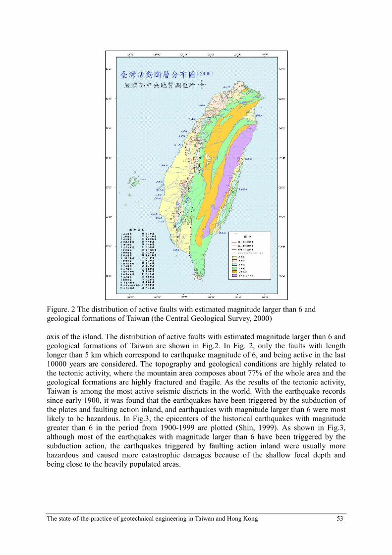
Figure. 2 The distribution of active faults with estimated magnitude larger than 6 and
geological formations of Taiwan (the Central Geological Survey, 2000)
axis of the island. The distribution of active faults with estimated magnitude larger than 6 and
geological formations of Taiwan are shown in Fig.2. In Fig. 2, only the faults with length
longer than 5 km which correspond to earthquake magnitude of 6, and being active in the last
10000 years are considered. The topography and geological conditions are highly related to
the tectonic activity, where the mountain area composes about 77% of the whole area and the
geological formations are highly fractured and fragile. As the results of the tectonic activity,
Taiwan is among the most active seismic districts in the world. With the earthquake records
since early 1900, it was found that the earthquakes have been triggered by the subduction of
the plates and faulting action inland, and earthquakes with magnitude larger than 6 were most
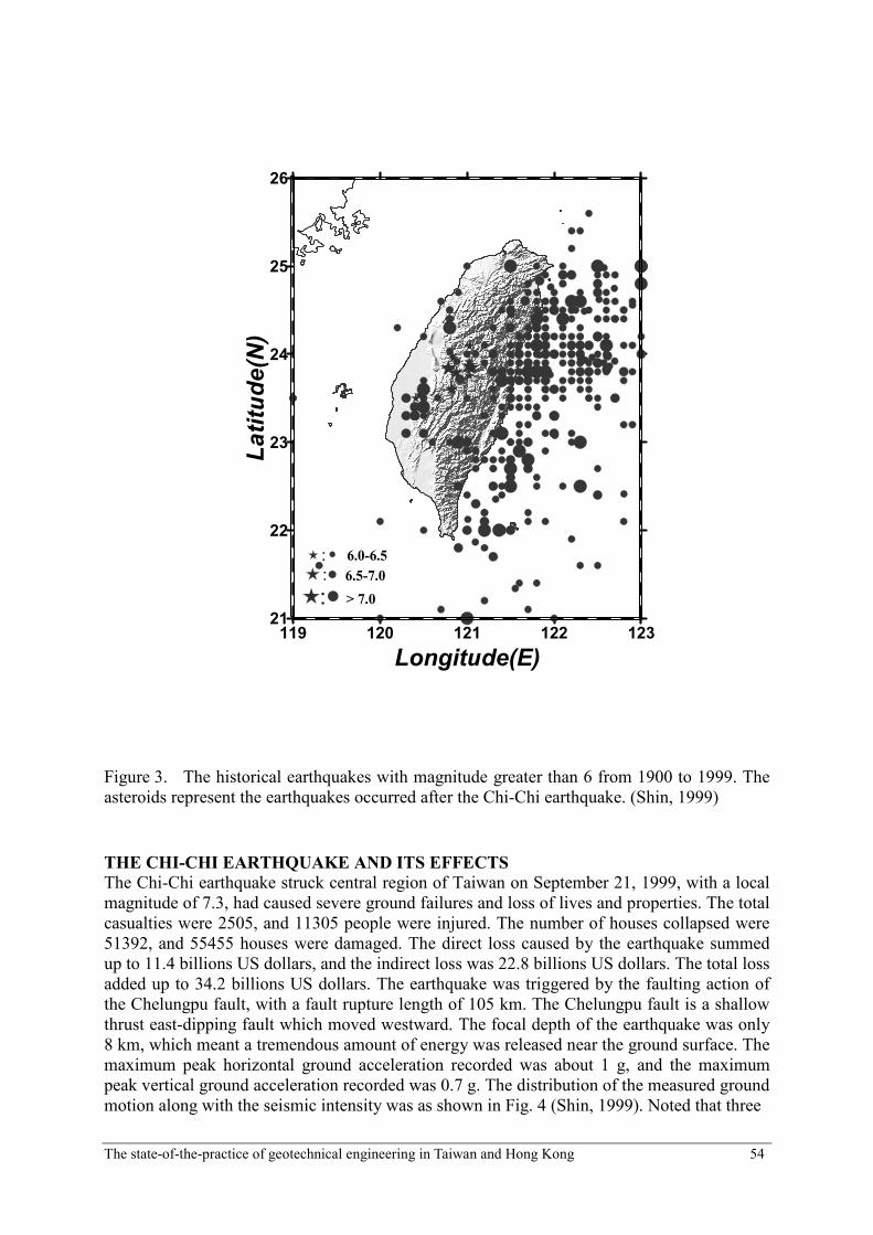
likely to be hazardous. In Fig.3, the epicenters of the historical earthquakes with magnitude
greater than 6 in the period from 1900-1999 are plotted (Shin, 1999). As shown in Fig.3,
although most of the earthquakes with magnitude larger than 6 have been triggered by the
subduction action, the earthquakes triggered by faulting action inland were usually more
hazardous and caused more catastrophic damages because of the shallow focal depth and
being close to the heavily populated areas.
The state-of-the-practice of geotechnical engineering in Taiwan and Hong Kong 54
119 120 121 122 123
Longitude(E)
21
22
23
24
25
26
Latitude(N)
6.0-6.5
6.5-7.0
> 7.0
:
:
:
Figure 3. The historical earthquakes with magnitude greater than 6 from 1900 to 1999. The
asteroids represent the earthquakes occurred after the Chi-Chi earthquake. (Shin, 1999)
THE CHI-CHI EARTHQUAKE AND ITS EFFECTS
The Chi-Chi earthquake struck central region of Taiwan on September 21, 1999, with a local
magnitude of 7.3, had caused severe ground failures and loss of lives and properties. The total
casualties were 2505, and 11305 people were injured. The number of houses collapsed were
51392, and 55455 houses were damaged. The direct loss caused by the earthquake summed
up to 11.4 billions US dollars, and the indirect loss was 22.8 billions US dollars. The total loss
added up to 34.2 billions US dollars. The earthquake was triggered by the faulting action of
the Chelungpu fault, with a fault rupture length of 105 km. The Chelungpu fault is a shallow
thrust east-dipping fault which moved westward. The focal depth of the earthquake was only
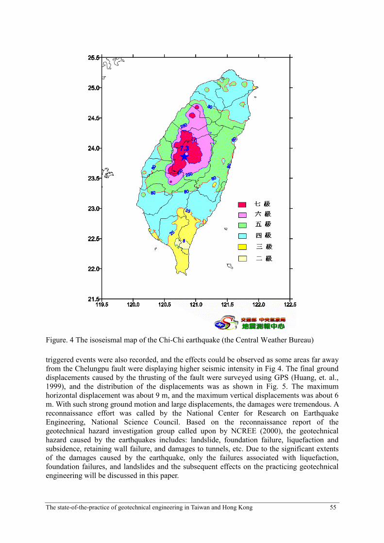
8 km, which meant a tremendous amount of energy was released near the ground surface. The
maximum peak horizontal ground acceleration recorded was about 1 g, and the maximum
peak vertical ground acceleration recorded was 0.7 g. The distribution of the measured ground
motion along with the seismic intensity was as shown in Fig. 4 (Shin, 1999). Noted that three
The state-of-the-practice of geotechnical engineering in Taiwan and Hong Kong 55
Figure. 4 The isoseismal map of the Chi-Chi earthquake (the Central Weather Bureau)
triggered events were also recorded, and the effects could be observed as some areas far away
from the Chelungpu fault were displaying higher seismic intensity in Fig 4. The final ground
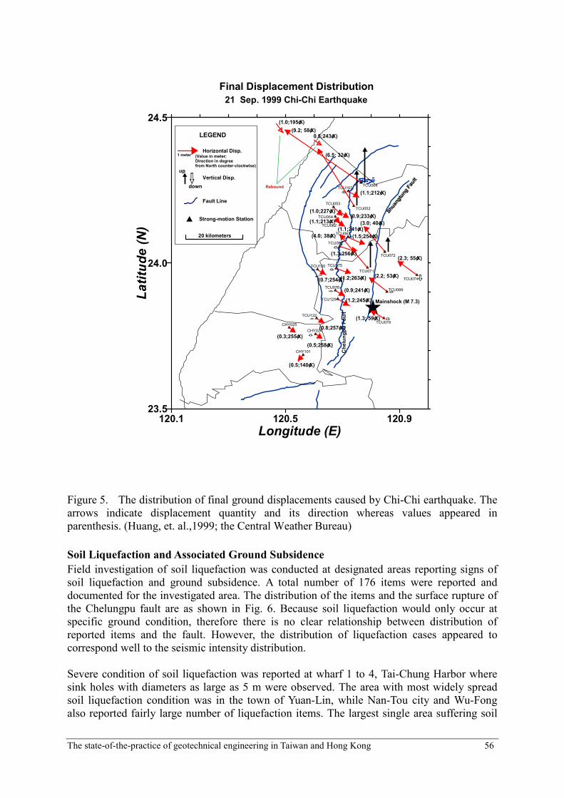
displacements caused by the thrusting of the fault were surveyed using GPS (Huang, et. al.,
1999), and the distribution of the displacements was as shown in Fig. 5. The maximum
horizontal displacement was about 9 m, and the maximum vertical displacements was about 6
m. With such strong ground motion and large displacements, the damages were tremendous. A
reconnaissance effort was called by the National Center for Research on Earthquake
Engineering, National Science Council. Based on the reconnaissance report of the
geotechnical hazard investigation group called upon by NCREE (2000), the geotechnical
hazard caused by the earthquakes includes: landslide, foundation failure, liquefaction and
subsidence, retaining wall failure, and damages to tunnels, etc. Due to the significant extents
of the damages caused by the earthquake, only the failures associated with liquefaction,
foundation failures, and landslides and the subsequent effects on the practicing geotechnical
engineering will be discussed in this paper.
The state-of-the-practice of geotechnical engineering in Taiwan and Hong Kong 56
120.1 120.5 120.9
Longitude (E)
23.5
24.0
24.5
Latitude (N)
Chelungpu Fault
Mainshock (M 7.3)
Final Displacement Distribution
TCU068
TCU052
TCU102
TCU053
TCU082
TCU054
TCU067
TCU065
TCU072
TCU071
TCU074
TCU089
TCU078
TCU075TCU120
TCU076
TCU129
TCU122
CHY024
CHY025
CHY101
21 Sep. 1999 Chi-Chi Earthquake
LEGEND
Horizontal Disp.
Fault Line
Strong-motion Station
1 meter
up
down
Vertical Disp.
20 kilometers
(Value in meter;Direction in degreefrom North counter-clockwise)
(9.2; 58¢X)
(6.5; 32¢X)
(1.1;212¢X)
(1.0;227¢X)(0.9;233¢X)
(1.1;213¢X)
(1.1;241¢X)
(1.5;254¢X)
(1.3;256¢X)
(4.0; 38¢X)
(3.0; 40¢X)
(2.3; 55¢X)
(2.2; 53¢X)
(1.3; 59¢X)
(1.2;263¢X)
(0.9;241¢X)
(1.2;245¢X)
(0.8;257¢X)
(0.5;258¢X)
(0.3;255¢X)
(0.5;140¢X)
(0.7;254¢X)
(1.0;195¢X)
0.5;243¢X)
Rebound
Figure 5. The distribution of final ground displacements caused by Chi-Chi earthquake. The
arrows indicate displacement quantity and its direction whereas values appeared in
parenthesis. (Huang, et. al.,1999; the Central Weather Bureau)
Soil Liquefaction and Associated Ground Subsidence
Field investigation of soil liquefaction was conducted at designated areas reporting signs of
soil liquefaction and ground subsidence. A total number of 176 items were reported and
documented for the investigated area. The distribution of the items and the surface rupture of
the Chelungpu fault are as shown in Fig. 6. Because soil liquefaction would only occur at
specific ground condition, therefore there is no clear relationship between distribution of
reported items and the fault. However, the distribution of liquefaction cases appeared to
correspond well to the seismic intensity distribution.
Severe condition of soil liquefaction was reported at wharf 1 to 4, Tai-Chung Harbor where
sink holes with diameters as large as 5 m were observed. The area with most widely spread
soil liquefaction condition was in the town of Yuan-Lin, while Nan-Tou city and Wu-Fong
also reported fairly large number of liquefaction items. The largest single area suffering soil

The state-of-the-practice of geotechnical engineering in Taiwan and Hong Kong 57
liquefaction was 4 hectare. Soil liquefaction could cause damages to all kinds of buildings and
infrastructures. Based on the data collected, statistical analyses were performed, and
distribution of damages to different types of structure was as shown in Fig.7.
#
#
##
#
#
#
#
#
#
###
######
#
####
##
#
##
####
#
#
#############################
###
###
###########
##
###
#
########## ####################
#
###
#
########
#
#
#
###
####
#
#
##
#
###########################
#
##
#
#
#
##
##########
#
#
#
#
Miao-Li
Tai-Chung
Nan-Tou
Chung-Hua
Yun-Lin
Jai-Yi
0 30 60Kilometers
N
EW
S Figure 6. The distribution of the soil liquefaction cases. (Lin, Liao, and Ueng, 1999)
道路(43件)
4%
橋樑(11件)
1%
堤防(25件)
2%
房屋(998件)
93%
Figure 7. The distribution of types of structures damaged by soil liquefaction
Embankment(25 cases) Road(43 cases)
Bridge(11 cases)
Building(998 cases)
The state-of-the-practice of geotechnical engineering in Taiwan and Hong Kong 58
In Fig. 7, the damages to buildings out number other types of structures, because buildings are
the most encountered structures in the areas. The damages to buildings could be divided into
three different types, i.e. subsidence, tilting and collapse. Typically soil liquefaction causes
the ground to loose bearing capacity, which induces subsidence and unequal settlement of the
building. Therefore, subsidence is the most encountered type of damage, while tilting due to
unequal settlement is the second most reported damage. Soil liquefaction seldom induces
collapse of building. In the areas surveyed, more than 200 buildings have undergone
subsidence of more than 0.5 m, and about 50 buildings have undergone lateral displacement
of more than 1 m.
Foundation Failures
Field investigation of foundation failure was conducted in 19 towns and cities where
population densities were higher. The reconnaissance subgroup for foundation failure has
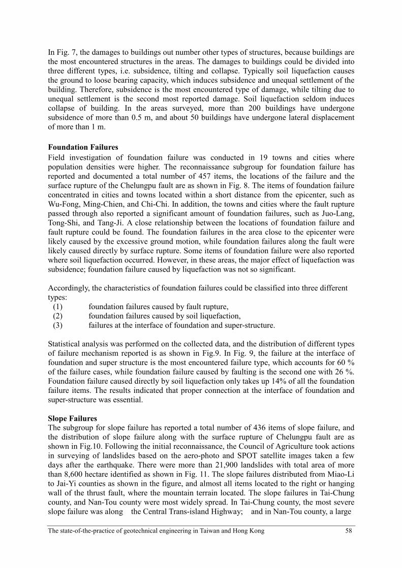
reported and documented a total number of 457 items, the locations of the failure and the
surface rupture of the Chelungpu fault are as shown in Fig. 8. The items of foundation failure
concentrated in cities and towns located within a short distance from the epicenter, such as
Wu-Fong, Ming-Chien, and Chi-Chi. In addition, the towns and cities where the fault rupture
passed through also reported a significant amount of foundation failures, such as Juo-Lang,
Tong-Shi, and Tang-Ji. A close relationship between the locations of foundation failure and
fault rupture could be found. The foundation failures in the area close to the epicenter were
likely caused by the excessive ground motion, while foundation failures along the fault were
likely caused directly by surface rupture. Some items of foundation failure were also reported
where soil liquefaction occurred. However, in these areas, the major effect of liquefaction was
subsidence; foundation failure caused by liquefaction was not so significant.
Accordingly, the characteristics of foundation failures could be classified into three different
types:
(1) foundation failures caused by fault rupture,
(2) foundation failures caused by soil liquefaction,
(3) failures at the interface of foundation and super-structure.
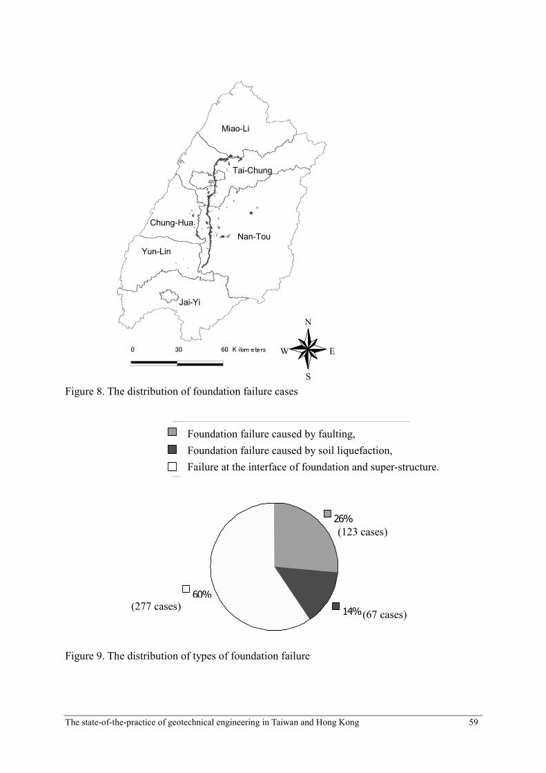
Statistical analysis was performed on the collected data, and the distribution of different types
of failure mechanism reported is as shown in Fig.9. In Fig. 9, the failure at the interface of
foundation and super structure is the most encountered failure type, which accounts for 60 %
of the failure cases, while foundation failure caused by faulting is the second one with 26 %.
Foundation failure caused directly by soil liquefaction only takes up 14% of all the foundation
failure items. The results indicated that proper connection at the interface of foundation and
super-structure was essential.
Slope Failures
The subgroup for slope failure has reported a total number of 436 items of slope failure, and
the distribution of slope failure along with the surface rupture of Chelungpu fault are as
shown in Fig.10. Following the initial reconnaissance, the Council of Agriculture took actions
in surveying of landslides based on the aero-photo and SPOT satellite images taken a few
days after the earthquake. There were more than 21,900 landslides with total area of more
than 8,600 hectare identified as shown in Fig. 11. The slope failures distributed from Miao-Li
to Jai-Yi counties as shown in the figure, and almost all items located to the right or hanging
wall of the thrust fault, where the mountain terrain located. The slope failures in Tai-Chung
county, and Nan-Tou county were most widely spread. In Tai-Chung county, the most severe
slope failure was along the Central Trans-island Highway; and in Nan-Tou county, a large
The state-of-the-practice of geotechnical engineering in Taiwan and Hong Kong 59
####
##
##
###########
#######
## #
#############
######
###
######
#
####
##### ############################## # #
###########
##
#
#
############ #
#
########### ####
##### #################################################
##
###
#
###################
###
###
#
##################
##
###### #
################ ############
### ##
###
##
#####
##
#####
#######
######################
#####
#
####
#####
########################
#######
########## ### #
################## #####
#######
#
##
##
####
#
#
#
##
##
###
#
#
#
#####
#
######
#
##
####
#
Miao-Li
Tai-Chung
Nan-Tou
Chung-Hua
Yun-Lin
Jai-Yi
0 30 60Kilometers
N
EW
S Figure 8. The distribution of foundation failure cases
26%
14%
60%
斷層引致基礎隆起破壞
土壤液化引致基礎破壞
非斷層區之基礎與上部結構界面破壞
(277件)(67件)
(123件)
Figure 9. The distribution of types of foundation failure
Foundation failure caused by faulting,
Foundation failure caused by soil liquefaction,
Failure at the interface of foundation and super-structure.
(123 cases)
(67 cases) (277 cases)
The state-of-the-practice of geotechnical engineering in Taiwan and Hong Kong 60
########## ## # ###########
#
#####
##
### #
###
# #
# ##
## ###
#
#
#
#
#
##
#
###### ##
#### ######
#
#
# #### ##
#
######
#
#
#
##
#
#
###
#
####
##
#
###
####### #
####
##
###
###
#
#
##
###
# ##
#
## ####
#######
####
##
#
#################
####
####
#
### ## ## ## ## #
##
##
### #
##
#
###
#
#
##
#####
#
#######
##
## ####
##
##
###
#
#
##
##
###
#
####
#
## #
#
#######
###############
##########
##
#
##
#
#
## #
######
######
####
####
### # ### # ##
#
#
######
####
#
##
###########
#
#
#
#
# #
##
#
#
#
#
#
#
#
######### ####
##
#####
#
####
######
###
#
###
#
##
#
Miao-Li
Tai-Chung
Nan-Tou
Chung-Hua
Yun-Lin
Jai-Yi
0 30 60Kilometers
N
EW
S
Figure 10. The distribution of the slope failure cases
Figure 11. Distribution of landslide caused by Chi-Chi earthquake based on SPOT
images.(Council of Agriculture, 2000)
The state-of-the-practice of geotechnical engineering in Taiwan and Hong Kong 61
scale slope failure of Juo-Juo peaks covered an area as large as 950 hectare, which was major
shallow sliding and spalling of gravelly material. In Juo-Feng-Err mountain area, a dip slope
sliding occurred with an area of 200 hectare, 29 people were buried. In Yun-Lin county, a
massive dip slope failure occurred in the Tsao-Ling area which covered an area of 400 hectare
and with an amount of 120 million cubic meter of deposit material. The large amount of
material deposited in the valley of Ching-Sui river, and a dammed-up lake was formed.
63%
22%
11%
4%
岩石滑移、岩屑崩滑
落石、翻轉型破壞
平面破壞、弧形破壞、楔型破壞
路基流失、潛移、重力拱曲、其他
Figure 12. The distribution of type of slope failure cases
2% 8%
24%
36%
30%
<30°
30-44°
45-59°
60-75°
>75°
Figure 13. The distribution of slope angle of slope failure cases
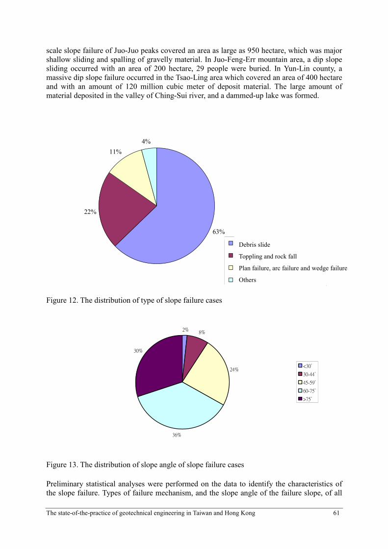
Preliminary statistical analyses were performed on the data to identify the characteristics of
the slope failure. Types of failure mechanism, and the slope angle of the failure slope, of all
Debris slide
Toppling and rock fall
Plan failure, arc failure and wedge failure
Others
The state-of-the-practice of geotechnical engineering in Taiwan and Hong Kong 62
items reported are as shown in Fig.12 and Fig.13. The distribution of the slope angle
compared relatively well with the distribution of the types of the slope failure, because
typically the debris slide and toppling/rock fall would occur at the slope with steep slope
angle. Due to the extensive slope failures caused by the earthquake, tremendous amount of
landslide materials deposited in the up-stream areas of watershed, and were prone to induce
the secondary hazard. Measures for the secondary hazard prevention and further hazard
reduction including the rating of landslide potential, field investigation and rating of possible
debris flows, and emergency remedial measures for slope stability were taken.
GROUND MOTION AND SEISMIC ZONATION
The ground motions are directly related to the seismic forces acting on structures, and hence
seismic zoning for ground motion addresses one of the most fundamental aspects of seismic
hazard. Zoning for ground motions is therefore an essential part for hazard reduction caused
by the earthquake. The seismic codes for building called for the exceeding probability of 10%
for 50 years, which corresponded to a return period of 475 years for the design earthquake.
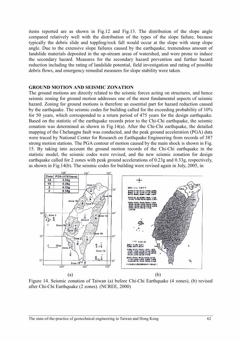
Based on the statistic of the earthquake records prior to the Chi-Chi earthquake, the seismic
zonation was determined as shown in Fig.14(a). After the Chi-Chi earthquake, the detailed
mapping of the Chelungpu fault was conducted, and the peak ground acceleration (PGA) data
were traced by National Center for Research on Earthquake Engineering from records of 387
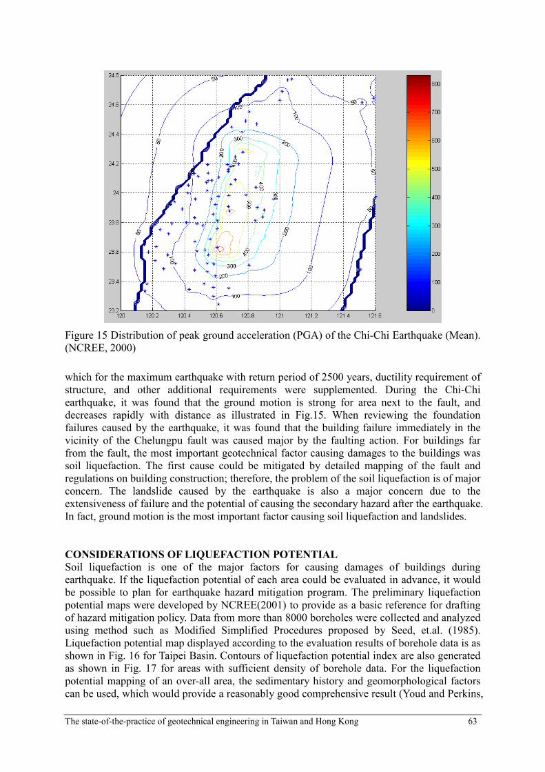
strong motion stations. The PGA contour of motion caused by the main shock is shown in Fig.
15. By taking into account the ground motion records of the Chi-Chi earthquake in the
statistic model, the seismic codes were revised, and the new seismic zonation for design
earthquake called for 2 zones with peak ground accelerations of 0.23g and 0.33g, respectively,
as shown in Fig.14(b). The seismic codes for building were revised again in July, 2005, in
(a) (b)
Figure 14. Seismic zonation of Taiwan (a) before Chi-Chi Earthquake (4 zones), (b) revised
after Chi-Chi Earthquake (2 zones). (NCREE, 2000)
The state-of-the-practice of geotechnical engineering in Taiwan and Hong Kong 63
Figure 15 Distribution of peak ground acceleration (PGA) of the Chi-Chi Earthquake (Mean).
(NCREE, 2000)
which for the maximum earthquake with return period of 2500 years, ductility requirement of
structure, and other additional requirements were supplemented. During the Chi-Chi
earthquake, it was found that the ground motion is strong for area next to the fault, and
decreases rapidly with distance as illustrated in Fig.15. When reviewing the foundation
failures caused by the earthquake, it was found that the building failure immediately in the
vicinity of the Chelungpu fault was caused major by the faulting action. For buildings far
from the fault, the most important geotechnical factor causing damages to the buildings was
soil liquefaction. The first cause could be mitigated by detailed mapping of the fault and
regulations on building construction; therefore, the problem of the soil liquefaction is of major
concern. The landslide caused by the earthquake is also a major concern due to the
extensiveness of failure and the potential of causing the secondary hazard after the earthquake.
In fact, ground motion is the most important factor causing soil liquefaction and landslides.
CONSIDERATIONS OF LIQUEFACTION POTENTIAL
Soil liquefaction is one of the major factors for causing damages of buildings during
earthquake. If the liquefaction potential of each area could be evaluated in advance, it would
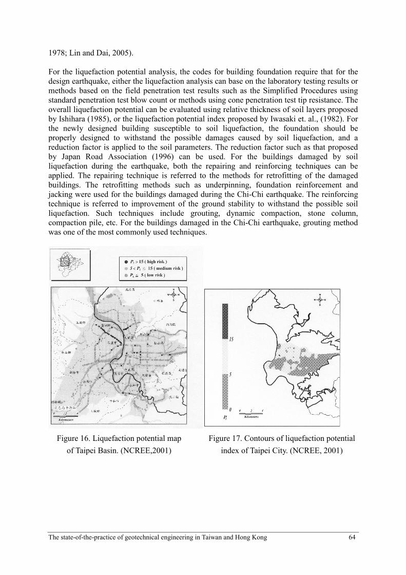
be possible to plan for earthquake hazard mitigation program. The preliminary liquefaction
potential maps were developed by NCREE(2001) to provide as a basic reference for drafting
of hazard mitigation policy. Data from more than 8000 boreholes were collected and analyzed
using method such as Modified Simplified Procedures proposed by Seed, et.al. (1985).
Liquefaction potential map displayed according to the evaluation results of borehole data is as
shown in Fig. 16 for Taipei Basin. Contours of liquefaction potential index are also generated
as shown in Fig. 17 for areas with sufficient density of borehole data. For the liquefaction
potential mapping of an over-all area, the sedimentary history and geomorphological factors
can be used, which would provide a reasonably good comprehensive result (Youd and Perkins,
The state-of-the-practice of geotechnical engineering in Taiwan and Hong Kong 64
1978; Lin and Dai, 2005).
For the liquefaction potential analysis, the codes for building foundation require that for the
design earthquake, either the liquefaction analysis can base on the laboratory testing results or
methods based on the field penetration test results such as the Simplified Procedures using
standard penetration test blow count or methods using cone penetration test tip resistance. The
overall liquefaction potential can be evaluated using relative thickness of soil layers proposed
by Ishihara (1985), or the liquefaction potential index proposed by Iwasaki et. al., (1982). For
the newly designed building susceptible to soil liquefaction, the foundation should be
properly designed to withstand the possible damages caused by soil liquefaction, and a
reduction factor is applied to the soil parameters. The reduction factor such as that proposed
by Japan Road Association (1996) can be used. For the buildings damaged by soil
liquefaction during the earthquake, both the repairing and reinforcing techniques can be
applied. The repairing technique is referred to the methods for retrofitting of the damaged
buildings. The retrofitting methods such as underpinning, foundation reinforcement and
jacking were used for the buildings damaged during the Chi-Chi earthquake. The reinforcing
technique is referred to improvement of the ground stability to withstand the possible soil
liquefaction. Such techniques include grouting, dynamic compaction, stone column,
compaction pile, etc. For the buildings damaged in the Chi-Chi earthquake, grouting method
was one of the most commonly used techniques.
Figure 16. Liquefaction potential map
of Taipei Basin. (NCREE,2001)
Figure 17. Contours of liquefaction potential
index of Taipei City. (NCREE, 2001)
The state-of-the-practice of geotechnical engineering in Taiwan and Hong Kong 65
SEISMIC SLOPE STABILITY
Due to the extensiveness of slope failure induced by the earthquake and the potential of
causing secondary hazard, the landslide caused by the earthquake is also a major concern.
Typically, analyses of dynamic slope stability are performed using three different methods:
the pseudo-static method, the Newmark’s method, and ground response analysis. The
pseudo-static method adopted the critical equilibrium concept to calculate the factor of safety
using a pseudo-static force acting on a slope under horizontal acceleration (Chen &
Snitbhan,1975; Seed, 1979). Newmark (1965) proposed a sliding block model to simulate
slope behavior under seismic forces, and calculate the block movement when acceleration
exceeded the critical acceleration of the slope. However, these two methods do not take into
account the dynamic slope behavior and soil amplification. With the help of numerical
methods, the ground response analysis using the finite element method and/or finite
difference method (Clough & Chopra, 1966) can take into account the dynamic ground
responses as well as the nonlinear behavior of soil, and the elastic-plastic constitutive laws
can be applied. For the earth dam, the shear beam method (Ambraseys & Sarma, 1967)
simplifies a 2-dimensional dam into a 1-dimensional analysis, and acceleration along the
height of dam can be obtained quickly.
Although it was suggested that the pseudo-static analysis might not be able to represent the
seismic slope behavior, and the safety factor might not be a good indication of seismic slope
stability (Seed, 1979), the method appeared to provide reasonable results for the dynamic
slope analysis if the failure surface was shallow and close to the toe of slope (Huang and Lin,
2003). For the Newmark’s method, the failure of the slope was assessed by the permanent
displacement of the sliding block. The threshold displacement of 5-10 cm was suggested by
Jibson (1993). Based on the analyses performed on the landslide cases induced by the Chi-Chi
earthquake, the displacement of 10 cm appeared to be a reasonable threshold value (Lin and
Kao, 2005) for causing failure of the slope.
0
20
40
60
80
100
120
140
160
180
150-250 250-350 350-450 450-550 550-650 650-750 750-
Mean PGA (gal)
Cas
e
Fig. 18 Distribution of the geometric mean PGA of the earthquake induced slope failures
The state-of-the-practice of geotechnical engineering in Taiwan and Hong Kong 66
0
50
100
150
200
250
0-100 100-200 200-300 300-400 400-500
Vertical PGA ( gal )
Case
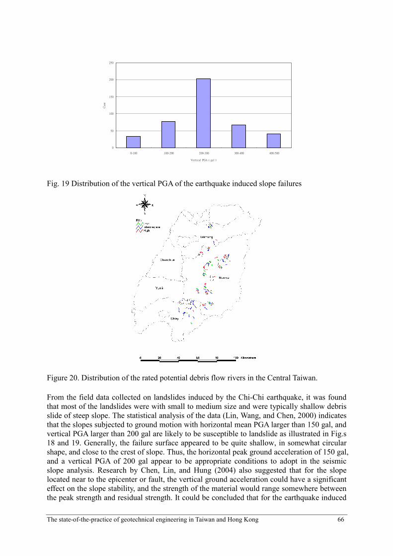
Fig. 19 Distribution of the vertical PGA of the earthquake induced slope failures
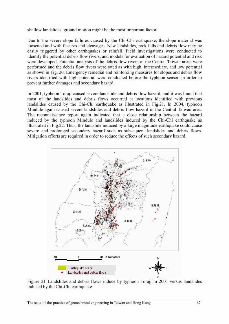
Figure 20. Distribution of the rated potential debris flow rivers in the Central Taiwan.
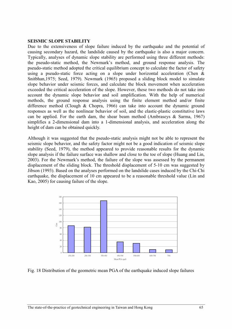
From the field data collected on landslides induced by the Chi-Chi earthquake, it was found
that most of the landslides were with small to medium size and were typically shallow debris
slide of steep slope. The statistical analysis of the data (Lin, Wang, and Chen, 2000) indicates
that the slopes subjected to ground motion with horizontal mean PGA larger than 150 gal, and
vertical PGA larger than 200 gal are likely to be susceptible to landslide as illustrated in Fig.s
18 and 19. Generally, the failure surface appeared to be quite shallow, in somewhat circular
shape, and close to the crest of slope. Thus, the horizontal peak ground acceleration of 150 gal,
and a vertical PGA of 200 gal appear to be appropriate conditions to adopt in the seismic
slope analysis. Research by Chen, Lin, and Hung (2004) also suggested that for the slope
located near to the epicenter or fault, the vertical ground acceleration could have a significant
effect on the slope stability, and the strength of the material would range somewhere between
the peak strength and residual strength. It could be concluded that for the earthquake induced
The state-of-the-practice of geotechnical engineering in Taiwan and Hong Kong 67
shallow landslides, ground motion might be the most important factor.
Due to the severe slope failures caused by the Chi-Chi earthquake, the slope material was
loosened and with fissures and cleavages. New landslides, rock falls and debris flow may be
easily triggered by other earthquakes or rainfall. Field investigations were conducted to
identify the potential debris flow rivers, and models for evaluation of hazard potential and risk
were developed. Potential analysis of the debris flow rivers of the Central Taiwan areas were
performed and the debris flow rivers were rated as with high, intermediate, and low potential
as shown in Fig. 20. Emergency remedial and reinforcing measures for slopes and debris flow
rivers identified with high potential were conducted before the typhoon season in order to
prevent further damages and secondary hazard.
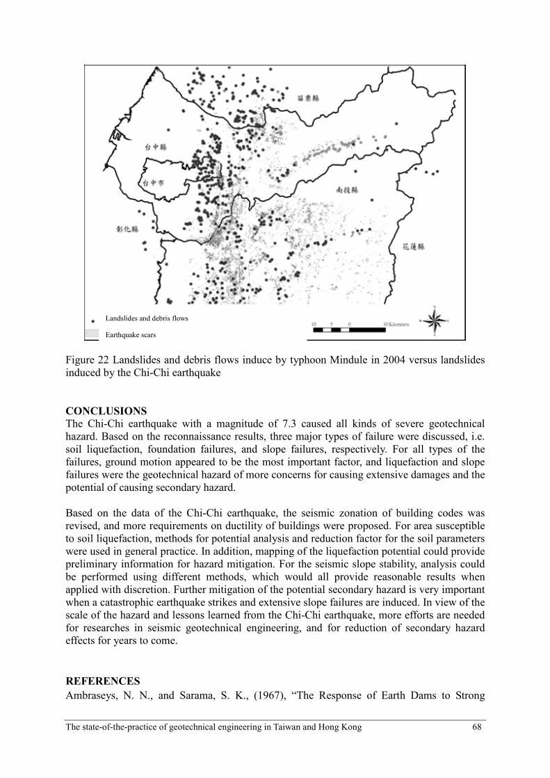
In 2001, typhoon Toraji caused severe landslide and debris flow hazard, and it was found that
most of the landslides and debris flows occurred at locations identified with previous
landslides caused by the Chi-Chi earthquake as illustrated in Fig.21. In 2004, typhoon
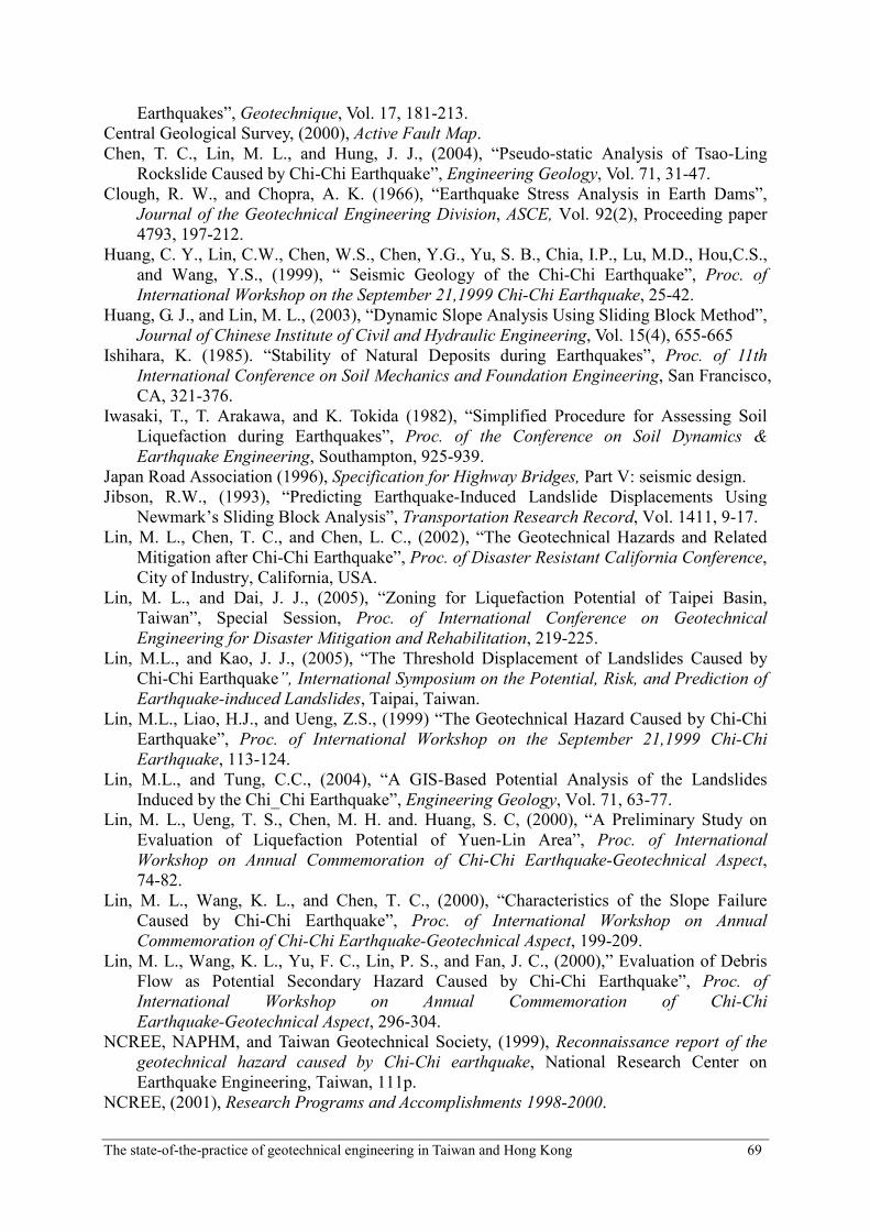
Mindule again caused severe landslides and debris flow hazard in the Central Taiwan area.
The reconnaissance report again indicated that a close relationship between the hazard
induced by the typhoon Mindule and landslides induced by the Chi-Chi earthquake as
illustrated in Fig.22. Thus, the landslide induced by a large magnitude earthquake could cause
severe and prolonged secondary hazard such as subsequent landslides and debris flows.
Mitigation efforts are required in order to reduce the effects of such secondary hazard.
Figure 21 Landslides and debris flows induce by typhoon Toraji in 2001 versus landslides
induced by the Chi-Chi earthquake
The state-of-the-practice of geotechnical engineering in Taiwan and Hong Kong 68
Figure 22 Landslides and debris flows induce by typhoon Mindule in 2004 versus landslides
induced by the Chi-Chi earthquake
CONCLUSIONS
The Chi-Chi earthquake with a magnitude of 7.3 caused all kinds of severe geotechnical
hazard. Based on the reconnaissance results, three major types of failure were discussed, i.e.
soil liquefaction, foundation failures, and slope failures, respectively. For all types of the
failures, ground motion appeared to be the most important factor, and liquefaction and slope
failures were the geotechnical hazard of more concerns for causing extensive damages and the
potential of causing secondary hazard.
Based on the data of the Chi-Chi earthquake, the seismic zonation of building codes was
revised, and more requirements on ductility of buildings were proposed. For area susceptible
to soil liquefaction, methods for potential analysis and reduction factor for the soil parameters
were used in general practice. In addition, mapping of the liquefaction potential could provide
preliminary information for hazard mitigation. For the seismic slope stability, analysis could
be performed using different methods, which would all provide reasonable results when
applied with discretion. Further mitigation of the potential secondary hazard is very important
when a catastrophic earthquake strikes and extensive slope failures are induced. In view of the
scale of the hazard and lessons learned from the Chi-Chi earthquake, more efforts are needed
for researches in seismic geotechnical engineering, and for reduction of secondary hazard
effects for years to come.
REFERENCES
Ambraseys, N. N., and Sarama, S. K., (1967), “The Response of Earth Dams to Strong
Landslides and debris flows
Earthquake scars
The state-of-the-practice of geotechnical engineering in Taiwan and Hong Kong 69
Earthquakes”, Geotechnique, Vol. 17, 181-213.
Central Geological Survey, (2000), Active Fault Map.
Chen, T. C., Lin, M. L., and Hung, J. J., (2004), “Pseudo-static Analysis of Tsao-Ling
Rockslide Caused by Chi-Chi Earthquake”, Engineering Geology, Vol. 71, 31-47.
Clough, R. W., and Chopra, A. K. (1966), “Earthquake Stress Analysis in Earth Dams”,
Journal of the Geotechnical Engineering Division, ASCE, Vol. 92(2), Proceeding paper
4793, 197-212.
Huang, C. Y., Lin, C.W., Chen, W.S., Chen, Y.G., Yu, S. B., Chia, I.P., Lu, M.D., Hou,C.S.,
and Wang, Y.S., (1999), “ Seismic Geology of the Chi-Chi Earthquake”, Proc. of
International Workshop on the September 21,1999 Chi-Chi Earthquake, 25-42.
Huang, G. J., and Lin, M. L., (2003), “Dynamic Slope Analysis Using Sliding Block Method”,
Journal of Chinese Institute of Civil and Hydraulic Engineering, Vol. 15(4), 655-665
Ishihara, K. (1985). “Stability of Natural Deposits during Earthquakes”, Proc. of 11th
International Conference on Soil Mechanics and Foundation Engineering, San Francisco,
CA, 321-376.
Iwasaki, T., T. Arakawa, and K. Tokida (1982), “Simplified Procedure for Assessing Soil
Liquefaction during Earthquakes”, Proc. of the Conference on Soil Dynamics &
Earthquake Engineering, Southampton, 925-939.
Japan Road Association (1996), Specification for Highway Bridges, Part V: seismic design.
Jibson, R.W., (1993), “Predicting Earthquake-Induced Landslide Displacements Using
Newmark’s Sliding Block Analysis”, Transportation Research Record, Vol. 1411, 9-17.
Lin, M. L., Chen, T. C., and Chen, L. C., (2002), “The Geotechnical Hazards and Related
Mitigation after Chi-Chi Earthquake”, Proc. of Disaster Resistant California Conference,
City of Industry, California, USA.
Lin, M. L., and Dai, J. J., (2005), “Zoning for Liquefaction Potential of Taipei Basin,
Taiwan”, Special Session, Proc. of International Conference on Geotechnical
Engineering for Disaster Mitigation and Rehabilitation, 219-225.
Lin, M.L., and Kao, J. J., (2005), “The Threshold Displacement of Landslides Caused by
Chi-Chi Earthquake”, International Symposium on the Potential, Risk, and Prediction of
Earthquake-induced Landslides, Taipai, Taiwan.
Lin, M.L., Liao, H.J., and Ueng, Z.S., (1999) “The Geotechnical Hazard Caused by Chi-Chi
Earthquake”, Proc. of International Workshop on the September 21,1999 Chi-Chi
Earthquake, 113-124.
Lin, M.L., and Tung, C.C., (2004), “A GIS-Based Potential Analysis of the Landslides
Induced by the Chi_Chi Earthquake”, Engineering Geology, Vol. 71, 63-77.
Lin, M. L., Ueng, T. S., Chen, M. H. and. Huang, S. C, (2000), “A Preliminary Study on
Evaluation of Liquefaction Potential of Yuen-Lin Area”, Proc. of International
Workshop on Annual Commemoration of Chi-Chi Earthquake-Geotechnical Aspect,
74-82.
Lin, M. L., Wang, K. L., and Chen, T. C., (2000), “Characteristics of the Slope Failure
Caused by Chi-Chi Earthquake”, Proc. of International Workshop on Annual
Commemoration of Chi-Chi Earthquake-Geotechnical Aspect, 199-209.
Lin, M. L., Wang, K. L., Yu, F. C., Lin, P. S., and Fan, J. C., (2000),” Evaluation of Debris
Flow as Potential Secondary Hazard Caused by Chi-Chi Earthquake”, Proc. of
International Workshop on Annual Commemoration of Chi-Chi
Earthquake-Geotechnical Aspect, 296-304.
NCREE, NAPHM, and Taiwan Geotechnical Society, (1999), Reconnaissance report of the
geotechnical hazard caused by Chi-Chi earthquake, National Research Center on
Earthquake Engineering, Taiwan, 111p.
NCREE, (2001), Research Programs and Accomplishments 1998-2000.
The state-of-the-practice of geotechnical engineering in Taiwan and Hong Kong 70
Newmark, N. M. (1965), “Effects of Earthquake on Dams and Embankments”, Géotechnique,
Vol. 15( 2), 139-160.
Seed, H. B. (1979), “Considerations in the earthquake-resistant design of earthquake and
rockfill dams”, Géotechnique, Vol. 29(3), 215-263.
Seed, H. B., and Idriss, I. M. (1982), Ground Motions and Soil Liquefaction during
Earthquakes, Earthquake Engineering Research Institute, Berkeley, California.
Seed, H.B., Tokimatsu, K., Harder, L.F., and Chung, R.M., (1985), “Influence of SPT
Procedures in Soil Liquefaction Resistance Evolution”, Report, Earthquake Research
Center, University of California, Berkeley, No. UBC/EERC-84/15.
Shin, T. C., (1999), “ Chi-Chi Earthquake-Seismology”, Proc. of International Workshop on
the September 21,1999 Chi-Chi Earthquake, 1-14. Youd, T. L. and D. M. Perkins, (1978), “Mapping Liquefaction-Induced Ground Failure
Potential,” Journal of the Geotechnical Engineering Division, ASCE, Vol. 104(4), 433-466.