Embed Size (px)
Citation preview
PAGE 1
WOODS HOLE, 26-28 MAY 1996
CONVENORS:Henry Dick (WHOI) & Catherine Mével (CNRS, Paris)
STEERING COMMITTEE:M. Cannat, M.F. Coffin, J.R. Delaney, R.S. Detrick, R.A. Duncan,J.L. Karsten, P.D. Kempton, E. Kikawa, J.N. Ludden, J.H. Natland,P. Pezard, R.C. Searle, D. Stakes, K. Tamaki, B. Taylor, R.A. Zierenberg
WORKSHOP SPONSORS:IAVCEI, InterRidge, ODP, JOI/USSSSP
OCEAN LITHOSPHERE
FINAL DRAFT
THE
&
INTO THE 21ST CENTURYSCIENTIFIC DRILLING
PAGE 2
This report is published by the JOI/U.S. Science Support Program withadditional help in distribution provided by InterRidge and RIDGE.
The Convenors would like to acknowledge the generous support of theJOI/U.S. Science Support Program, InterRidge, and RIDGE whogenerously provided direct financial support and assistance in runningthe conference.
We also wish to express our gratitude to Robert B. Kidd, JOIDESPlanning Committee Chair 1994-1995, whose dedication to the OceanDrilling Program and generous advice played a key role in the initia-tion and planning of this conference and workshop.
PAGE 3
EXECUTIVE SUMMARY
Introduction
The oceanic lithosphere is formed as a consequence of two major kinds of apparently unrelated pro-cesses: the result of ongoing shallow mantle up-welling driven by the motions of the earth’s plates atvarying rates beneath the oceans, and by the more intermittent process involved in the emplacement oflarge igneous provinces (LIPs) driven by deep mantle circulation. Over a hundred scientists met atWoods Hole on May 26-28, 1996 to discuss the formation of the ocean lithosphere and how it could beexplored through scientific drilling into the 21st century. This meeting was held in the context of theInterRidge and LIPs initiatives which directly address the two components controlling the formation ofthe lithosphere and whose prior planning forms the basis for this integrated workshop. This reportpresents an integrated drilling strategy in the framework of the present Ocean Drilling Program (1998-2003) and a future program involving deep-drilling capabilities for beyond 2003 without which thiscommunity believes it would be difficult to ever fully understand the evolution of the ocean crust andmantle over some two thirds of the earth.
General recommendations
The workshop participants recognize that scientific drilling in the oceans is required in order to mean-ingfully advance our knowledge of the oceanic lithosphere. It is the only way to directly constrainmodels based on indirect measurements, to provide the continuous sampling and stratigraphy requiredto know the structure and composition of the ocean crust, and to provide boreholes for in situ measure-ments and monitoring of active processes in this living earth.
A two phase strategy is recommended for a systematic focused program of ocean drilling to explore theocean lithosphere consistent with the ODP Long Range Plan:
Until 2003 (end of Phase II and Phase III of the current ODP): Drilling the ocean lithosphere should bepursued using the drilling capabilities of the JOIDES Resolution.
Beyond 2003 (Phase IV): the workshop strongly endorses a two-ship program, including the capacity fordeep-drilling (through the MOHO), and the capacity to drill shallower holes on a routine basis with asecond technologically less complex and less expensive ship.
MAJOR SCIENTIFIC OBJECTIVES
• To document the active magmatic, tectonic and hydrothermal processes and their temporal variabil-ity which control crustal formation at and near ocean ridges.
• Identify the mechanism of formation, timing of emplacement, genesis and environmental impact ofthe LIPs.
• Determine if sections of fossil ocean crust (ophiolites) exposed on-land in continental margins andisland arcs may have formed in the fore-arc environment, and therefore determine the extent towhich these sections can be used as analogues for the formation of the modern ocean crust.
• Obtain the needed reference sections of the ocean crust and mantle required to interpolate thecomposition and structure of the ocean crust across the global ocean basins from geophysical data.
PAGE 4
• Determine the processes and locus of formation of representative large ore bodies in the arc-environ-ment — the active analogs to most deposits of economic importance on-land.
• Document the extent of the deep crustal biosphere. Recent work has shown that the biosphereextends much deeper that previously envisioned, well into the crust of the earth, making it theprinciple unknown component of the Earth’s biomass.
PROPOSED STRATEGY
A) 1998-2003 (end of ODP Phase II, ODP Phase III)
During this phase, the drilling capabilities of the JOIDES Resolution should be fully utilized to:
• Drill an array of holes at center and distal ends of a representative spreading center to directlyconstrain variation in crustal architecture and composition at the slow-spreading Mid-Atlantic Ridge.
• Select a site and start the hole as soon as possible in fast-spread Pacific crust and drill into gabbroiccrust below the seismic layer 2-3 boundary, as the first stage in proceeding to deep-drilling to theMoho in ODP Phase IV.
• Use the strategy of offset drilling in tectonic windows to: (1) create a composite section of the lowercrust and shallow mantle at a fast spreading ridge (Hess Deep); and (2) explore the lateral variabilityof the shallow mantle in a peridotite belt flanking a slow-spreading ridge segment.
• Define the timing, petrology and geochemistry of four representative LIPs: the two Cretaceous giantLIPs (Kerguelen and Ontong Java), and two representative examples of older and younger LIP em-placement.
• Set up an observatory in conjunction with InterRidge for in situ monitoring of active processes bydrilling an array of CORKED holes at an axial site, and if zero age drilling is not available, on a ridgeflank.
• Drill an andesite-dacite hosted metalliferous deposit in an arc environment to provide an analog forlarge ore bodies.
• Drill the best possible modern fore-arc potential analog for ophiolites.• Evaluate the biomass in every new hole in the ocean crust to document the extent of the deep earth
biosphere
B) Post 2003 (Phase IV)
• There is a consensus that post 2003, the primary target should be to achieve total crustal penetrationand drill through MOHO in lithosphere generated at a fast-spreading ridge.
• In addition, the experiment initiated during Phase III to understand the three-dimensional character ofslow spread ocean lithosphere should be continued with two holes deepened, preferably to Moho, atthe center and the end of a Mid-Atlantic Ridge spreading segment.
• One deep hole and possibly two intermediate holes should be drilled in a LIP, to document thechrono- and lithostratigraphy and to address magma sources and genesis.
• Install seafloor observatories in different environments such as intraplate volcanoes or convergentmargin environment.
• Continue the Phase III programs that have not been completed.
PAGE 5
TECHNOLOGICAL REQUIREMENTS
The workshop participants stressed that with the capability of the JOIDES Resolution, drilling holes to 3-km during Phase III should be feasible with present technology. Necessary technological improvementsleading to improved penetration and recovery, particularly in young, fractured basalts — such ashammer-in casing and diamond-coring system — are needed in Phase III. Borehole instrumentation andlogging tools should be developed to fit in diamond-cored slim holes.
Many of the Phase IV objectives imply deep crustal penetration (>3-km) and require a ship with deep-drilling capabilities and well control. However, most of the workshop objectives are beyond the reach ofa 2500-m water depth conventional riser, and riserless drilling or a slim line riser should be explored fordrilling in waters up to 4000 m. In parallel, a ship with drilling capabilities similar to the present JOIDESResolution should be used to pursue scientific objectives that do not require deep-drilling.
A biology laboratory on the JOIDES Resolution should be developed as a matter of urgency along withtools to sample the biota in situ without contamination.
RECOMMENDATIONS FOR ODP PROGRAM PLANNING GROUPS
The workshop participants recommend formation of the following program planning groups (PPGs) inconcert with the noted global research initiatives:
• RIDGES PPG InterRidge, ION• LIPs PPG LIPs , ION• Borehole Instrumentation working group InterRidge, ION, Margins• Biology PPG InterRidge, Margins
The Workshop considered a convergent margins PPG, but felt that a formal recommendation for thisgroup should come from a broader community involved in arc-related research.
PAGE 6
1 - FOREWORD .............................................................................................. 7
2 - STEERING COMMITTEE REPORT ................................................................. 10
3 - TECHNOLOGICAL REQUIREMENTS ............................................................ 18
4 - WORKING GROUP REPORTS ..................................................................... 21
4.1 - FAST-SPREADING RIDGES ................................................................. 21
4.2 - SLOW-SPREADING RIDGES ............................................................... 36
4.3 - ACTIVE PROCESSES .......................................................................... 50
4.4 - LIPS .................................................................................................. 63
4.5 - ARC ENVIRONMENT ......................................................................... 76
5 - REFERENCES ............................................................................................. 86
6 - MEETING AGENDA ................................................................................... 88
7- ABSTRACTS OF POSTERS PRESENTED AT THE MEETING .............................. 90
8 - LIST OF ATTENDEES .................................................................................. 92
TABLE OF CONTENTS

PAGE 7
The ocean lithosphere &scientific drilling into the 21st century
In the last five decades the oceans have been a major focus of exploration and discovery. With theadvent of plate tectonic theory, large scale seafloor mapping, and systematic geophysical survey, therehas been the rapid development of new paradigms for the evolution of the oceanic lithosphere whichhave transformed geologic thinking and our concept of earth history. In recent years, earth scientistshave focused on testing these paradigms in the diverse tectonic environments found in the oceans,including fast- and slow-spreading ocean ridges, convergent margins and large oceanic igneous prov-inces. This has led to a growing appreciation of the limits of surface exploration and an increasedinterest in drilling, particularly deep-drilling, as the only way to directly test and provide ground truth forthe composition and evolution of oceanic crust and shallow mantle.
The last ten years have seen accelerated progress towards understanding the formation of ocean lithos-phere at ocean ridges, its evolution with time and fate at subduction zones. National and internationalprograms have been set up by the scientific community to better coordinate the sea efforts: InterRidgeand the different national programs (Ridge, Bridge, Dorsales, DRidge, Japan Ridge) have focused theirefforts on understanding mid-ocean ridges. LIPs is aimed at understanding the generation of largeigneous provinces and the evaluation of their impact on the biosphere and climate. The ION (Interna-tional Ocean Network) program objective is to complement the existing seismologic network on-land byseafloor/borehole observatories to increase the resolution of mantle seismic tomography. The margincommunity is also getting organized at the national as well as the international level. The focus of theseprograms has been geophysical mapping, observation of the seafloor, surficial sampling and remotesensing. However, as knowledge has increased, it has become clear that many of the key observationsrequired to document the structure and the composition of the ocean crust and shallow mantle, andidentify the processes of lithospheric accretion can only be made by direct sampling. Given that therequired observations are inherently stratigraphic, the only way this can be done is by ocean drilling.
Recent drilling in tectonically exposed lower crust and mantle sections in the Pacific, Atlantic andIndian oceans, for example, appears to confirm that crust formed at fast- and slow-spreading ridgesvaries dramatically in stratigraphy, structure and state of alteration. This apparently reflects very differentrates of magma supply and lithospheric thickness beneath the ridge system. Only small sections, repre-senting a fraction of the total crustal and shallow mantle stratigraphy in either environment, are pres-ently available for study. Thus, models for accretion at slow- and fast-spreading ridges, and the state ofthe crust formed in these environments, remain largely a matter of speculation.
The lynch pin for interpretation of the nature and volume of the ocean crust for several decades hasbeen the near layer cake seismic stratigraphy found throughout the ocean basins. This seismic stratigra-phy has been equated to fundamental litho-stratigraphic breaks found in ophiolites, and has been usedto extrapolate to the general crustal structure of the oceans. Until recently it was widely thought thatseismic layer 3 marked the transition from intrusive gabbroic crust, formed as the fossil remains ofmagma chambers, to sheeted dikes which formed the feeder system to the overlying carapace of eruptedbasaltic lava. This interpretation was challenged, however, when drilling at 504B passed through seismiclayer 3 without encountering gabbroic rocks. There, at least, seismic layer 3 coincides with an alterationfront in the dikes. It is not known if this is the case elsewhere or coincidental to the Hole 504B section.Now the equivalency between the Mohorovicic seismic discontinuity and the igneous crust-mantle
1 - FOREWARD
PAGE 8
boundary is in question. Recent tabulations have shown that serpentinized mantle is far more abundant,and gabbroic rocks far less common in tectonic sections in slow-spread ocean crust than should be thecase for a uniform 6-km crust. Some marine geologists now believe that the Moho may also be analteration front - at least at slow-spreading ridges. This leaves estimates of the total igneous flux frommantle to crust over the last 300 Ma completely uncertain. The only way these major questions can beresolved is through deep ocean drilling.
Recent work has also shown that the biosphere extends to much greater depths than scientists initiallythought (Parkes et al., 1994; Stetter, 1995) . As a consequence our present evaluation of the total earthbiomass is likely to be significantly underestimated. A better evaluation of the total biomass is critical forseveral reasons including: estimates of oceanic and atmospheric CO2 production, understanding thechemical environment of rocks and sediments and the chemical reactions occurring within them,understanding the food chain at the sediment-water, rock-water, and sediment-rock interfaces. There isalso the likely possibility of discovering major new life forms previously unknown to science, as hasalready happened at ridge hydrothermal vents (e.g. the hyperthermophilic archaea — a whole new classof organism (Stetter, 1995). Questions as to how these organisms survive and thrive in these complexand seemingly hostile environments have potentially important technological and industrial implica-tions. Evaluation of the biomass in the oceanic crust, however, requires a systematic approach to bothdrilling and on-site measurement of the organic content and properties of hard rock cores. Given therecent discoveries of diverse biotic communities living off heat from the earth’s interior at ocean ridges,axial hydrothermal vent regions are particularly important to explore at depth in assessing total oceaniccrust biomass.
Large igneous provinces (LIPs) are voluminous emplacements of mafic rock not clearly explained by theplate tectonics paradigm. LIPs provide the strongest evidence that at specific times in the past, energytransfer from the Earth’s interior to its surface has occurred in a manner substantially different frommodern processes. These provinces form the largest expressions of transient basaltic volcanism on Earth,and emplacement rates of the largest provinces may have exceeded the global integrated mid-oceanridge production rate over time periods of roughly a million years. Moreover, LIPs may have beenimportant contributors to crustal growth and continental stabilization throughout Earth history. Despitethis, the evolution of large oceanic LIPs is poorly know. Largely covered by sediment, their timing andrate of growth must remain largely a matter of speculation without a systematic program of oceandrilling.
Although the progress in understanding convergent margins over the last 50 years is impressive, firstorder problems remain that are relevant to lithospheric formation. In the context of the oceanic lithos-phere, of particular interest is the relationship between suprasubduction zone environments andophiolites. Ophiolites, representing fossil oceanic crust formed in a rifting environment, are used as themajor analog for the oceanic crust formed at ocean ridges. Yet many, if not most, ophiolites appear tohave notable differences to what has been sampled in situ in the oceans. Do these differences representa biased sample due to the limitations of surficial sampling, or do they reflect the differences betweenformation of ocean lithosphere above a subducting slab in a fore-arc or back-arc environment as manybelieve? What are the mantle dynamics associated with the transition from rifting to true ocean spread-ing in the back-arc environment? What processes operating in active convergent margins contribute to,or provide appropriate environments for, concentrating metals in massive sulfide deposits, particularly
PAGE 9
those which may be analogues for some of the larger, economically significant world-class precious andbase metal deposits? Only deep ocean drilling can provide unambiguous answers to these criticalquestions.
Another major issue is the understanding of active processes at mid-ocean ridges which lead to thegeneration of the ocean crust. To decipher the mechanisms of oceanic accretion, it is essential toaddress their temporal variability. This can be done only with long term observation and measurement.Ocean drilling provides boreholes for in situ monitoring in order to document temporal changes inspecific active processes. These are the necessary complement of the seafloor observatory that theInterRidge community wants to deploy on an active axial site.
Beyond the two COSOD meetings in 1981 and 1987, scientific planning of ocean lithosphere drillingup until now has largely been ad-hoc, based on proposals submitted by small groups of individuals withinput from smaller working groups and USSAC supported meetings in the US (Coffin and Eldholm,1990; Dick, 1989). There has been no formal integration with the various national ridge initiatives,though drilling is frequently mentioned in InterRidge and national ridge committee reports (Lin et al.,1994; Parsons et al., 1994). Thus, there has been no coordinated approach to planning utilization ofscientific drilling vessels to accomplish InterRidge or LIPs objectives. Until now this ad-hoc approachhas been sufficient due to the exploratory nature of ocean crust drilling. This exploratory phase is nowlargely over.
As stated in the ODP Long Range Plan (1996), the current phase of the Ocean Drilling Program (PhaseII) extends through 1998. During Phase III (1999-2003), the JOIDES Resolution will continue to be theprogram primary drilling platform, although the use of alternate platforms to achieve specific objectivesin particular environment, (i.e. shallow water, high latitudes, ...) will be considered. In 2003, the presentOcean Drilling Program will be over. Beyond 2003, ocean drilling will enter Phase IV. The scientificcommunity expects a step in technology, to have access to deep-drilling (beyond 3000-m) that will opena completely new range of scientific goals. There is a Japanese proposal for a greatly improved oceandrill ship with riser capability (OD21) to be run by an international consortium successor to the presentJOIDES structure. If the international scientific community wants this project - or an alternative one -tobecome a reality, it must begin the planning process and put serious scientific proposals for its use onthe table. This is necessary (1) to demonstrate major international support for such a deep-drillingcapability, (2) to guide the direction of the technological developments being planned so the future canmeet the needs for the lithosphere community, and (3) because it is none too early to start the planning,site identification, and site survey process for drilling in the year 2003. Preparation of current oceandrilling legs can take 4 to 5 years, and identifying sites for total crustal penetration and their completegeological and geophysical characterization is likely to take even longer.
Given these constraints, the 100 scientists assembled in Woods Hole discussed the scientific goals thatare listed in this report in the frame of a three phase approach. Phase II is almost over, since the planningis completed through 1998. It is imperative that there be a formal coordinated approach to identifyingdrilling strategies and targets to capitalize on the last 5 years of ODP, and to accomplish the highestscientific priorities during Phase III. Regarding Phase IV, this workshop represented the beginning of theplanning effort for the ocean lithosphere community. As a whole, this report signals community widesupport for Ocean Drilling Program through 2003 and for a new drilling program into the 21st century.
Henry JB Dick & Catherine Mével

PAGE 10
2 - STEERING COMMITTEE REPORT
Introduction
Over 100 scientists attended the jointly sponsored ODP-InterRidge-IAVCEI Workshop: The OceanLithosphere & Scientific Drilling into the 21st Century, from May 26 to 28th, 1996 in Woods HoleMassachusetts. They considered current and past progress in understanding the evolution of the oceanlithosphere, along with the present and future need for scientific drilling in the oceans. The meetingrepresented the culmination of a series of meetings and workshops on the study of the evolution of theocean lithosphere held over several years by both by InterRidge and the Commission on Large-VolumeBasaltic Provinces (LIPs) of the International Association of Volcanology and Chemistry of the Earth’sInterior (a member of the International Union of Geodesy and Geophysics). Thus, the recommendationspresented here represent the considerations of a far larger group of scientists than those attending thisone meeting.
The workshop participants emphasized that drilling is essential, in fact the only means, to providecontinuous sampling and directly determine the stratigraphy of the oceanic lithosphere. Drilling is theonly means by which geophysical interpretations can be ground-truthed, and to provide boreholes for insitu measurements and long term experiments in the ocean crust. It was recognized, however, that forthe foreseeable future, drilling has to be focused, and must address the most important questions.Moreover, drilling legs must be part of larger integrated studies, involving other types of experimentsorganized in the framework of major global initiatives such as InterRidge, LIPs, MARGINS or the IONprogram.
To discuss scientific problems and set up specific experiments, the workshop participants split into 5thematic working groups for detailed discussions and planning: 1) Fast-spreading Ridges; 2) Slow-spreading Ridges; 3) Active Ridge Processes; 4) Large Igneous Provinces; and 5) The Arc-Environment.While these groups fully covered the meeting mandate, it was felt that the inclusion of the arc-environ-ment in this meeting was not widely known, and as a result the attendance for this group was too smallto be representative of this scientific community. Thus, the steering committee feels that it can only pointout areas where the interests of this meeting coincides with those of the convergent margins community,and recommends a more general workshop on convergent margins be convened, which includes theseinterests.
The meeting considered that the existence of a significant biomass within subseafloor rocks is a verysignificant discovery and represents a most exciting opportunity for science, which should be pursuedwith the utmost vigor. It recommends the formation of an ODP Detailed Planning Group to prepare forinstallation of a micro biological laboratory on the JOIDES Resolution as a matter of urgency and tomake recommendations on the setting up of a Working Group on Biology. The meeting noted thatInterRidge already has its own Biology Working Group (Co-Chairs D. Desbruyères and L. Mullineaux)which would be well-placed to assist ODP.
PAGE 11
First-order scientific questions to be addressed
FAST-SPREADING RIDGES
Ocean crust generated at fast-spreading ridges covers over 50% of the surface of the planet. Althoughthere is little direct constraint on its stratigraphy, geophysical experiments indicate that it is relativelyhomogenous in terms of crustal thickness and architecture. Unlike slower spreading ridges, there is alsoevidence from seismic refraction and reflection for a melt lens situated below layer 2, presumably at thedike-gabbro transition, implying a near steady-state geotherm in the zone of primary accretion. This, andradically different seafloor topography suggests that crust formed at fast- and slow-spreading ridges havea fundamentally different architecture. However, because of the lack of direct sampling, little is knownof crustal accretion, dike injection, hydrothermal circulation, and lower crustal stratigraphy at fast-spreading ridges, or its relationship to seismic stratigraphy. The only means by which these fundamentalquestions can be directly addressed is by ocean drilling. This requires total penetration of the crust fromthe top of the extrusive basalt layer into the mantle in at least one location, as well as complementarydrilling in a tectonic windows to address the lateral variability of the crust and shallow mantle at keystratigraphic intervals on the ridge segment scale. This mandates selection of an optimal site for totalpenetration in the near future, and devoting a number of legs to the same location over a relatively shortperiod of time.
Because it is clear that reaching seismic layer 3 and ultimately the Moho will take years, and becausethe heterogeneity of the crust and shallow mantle on the local scale is unknown, the workshop partici-pants feel strongly that the strategy of offset-drilling in tectonic windows should be pursued at HessDeep, both to provide a partial composite section of fast-spread lower crust and upper mantle, and toexplore its lateral variability in the three-dimensional framework of ridge segmentation.
SLOW-SPREADING RIDGES
As opposed to fast-spreading ridges, no evidence for a steady-state melt lens or magma chamber hasbeen seismically determined at a slow-spreading ridge - except possibly beneath the Reykjanes Ridge,under the influence of the Icelandic hot spot (Sinha et al., 1997 ; Constable et al., in press). In addition,the igneous crust at slow spreading ridges has been determined by sampling and geophysical measure-ment to have highly variable thickness. Unlike the Pacific, the vertical stratigraphy of slow-spread lowercrust has been directly constrained by drilling during ODP Legs 118 and 153 in the Indian and Atlanticoceans. These legs show that crustal accretion at slow-ridges reflects ephemeral magmatism, and deepseated deformation, hydrothermal alteration and tectonically controlled melt migration throughout thezone of crustal accretion. This has produced a complex vertical igneous, metamorphic and tectonicstratigraphy reflecting periodic migration of the zone of brittle-ductile deformation through the section inthe absence of a steady-state geotherm.
Since Legs 118 and 153 recovered similar material, and as currently scheduled, Leg 176 will presumablyprovide a more fully representative section of the lower crust in one location, the workshop focused onhow to understand the processes which led to the vertical heterogeneity and how to explore its lateralvariability on the scale of a single ridge segment. The workshop proposes two drilling experiments onthe Mid-Atlantic Ridge to determine (A) the structure and composition of the crustal component of slow-spreading oceanic lithosphere and its evolution in time, and (B) the along-axis chemical, lithologic, and
PAGE 12
structural variations in the uppermost mantle at the ridge segment scale, and its relation to crustalaccretion. The drilling experiments will focus effort on crustal variation along a “normal” segment ofnorthern Mid-Atlantic Ridge and on an “end-member” area to the south, where partially serpentinizedperidotites crop out on the flank of the rift valley wall along the length of several spreading segments.These experiments will allow us to directly constrain the nature of the whole system of melt migration,mantle flow and crustal accretion at the critical ridge segment scale for slow-spreading ridges. They willdetermine the lithology of the geophysically defined crust, and will show the extent and nature of itsvariability along a spreading segment and how it evolves with age.
ACTIVE PROCESSES
Active processes, hydrothermal, magmatic and tectonic, occur in a variety of environments on theseafloor. A key parameter for understanding these processes is gaining insight into their temporal vari-ability. Monitoring of active processes requires seafloor observatories to which drilling will contribute byallowing borehole instrumentation and long term measurements. Among all the possible options, highestpriority is given to the ridge axis. This involves drilling and instrumenting 5 boreholes in conjunctionwith a ridge axis observatory experiment. The ideal configuration would consist of 4 holes to ~500-mdepth and 1 hole to ~2-km depth, distributed in an L-shaped array. All five holes would be logged,CORKed and instrumented in order to determine the physico-chemical state of the crust in the region ofan active volcano-hydrothermal system and to monitor fluid and geochemical evolution of the hydro-thermal system over decade time scales.
Since this experiment must rely on the further development of current technologies such as DCS and thehammer-in-casing, other critical environments should be also considered for Phase III drilling. Theseinclude the area of the experiment initiated on the flank of the Juan de Fuca Ridge (leg 168), as well asmid-plate volcano and convergent margin hydrothermal systems.
LARGE IGNEOUS PROVINCES
The Cretaceous period is marked by voluminous and episodic basaltic magmatic events that are notclearly associated with plate tectonic processes: approximately twenty oceanic plateaus, volcanicpassive margins, and continental flood basalts were emplaced during that period of time. Through oceandrilling, we seek to better understand the timing, genesis and environmental effect of voluminous maficmagmatism. For this, we must determine the chronology of individual LIP emplacements as well as thatof all LIPs during the entire Cretaceous period. Determination of source composition, melting regime,and melt migration is critical for understanding asthenospheric and lithospheric geodynamic processes.The tectonic setting and deformational history of LIP emplacement must be defined so that the interac-tion between LIPs and plate tectonics can be better understood. Finally, the impact of Cretaceous LIPemplacements on the biosphere, hydrosphere, and atmosphere is potentially highly significant andshould be fully investigated.
Two of these LIPs, Ontong Java and Kerguelen plateaus, are giants, each covering an area of ~2 x 10⁶-km2. To meet our scientific objectives, exploratory drilling and associated geophysical investigations ofthese two features are given the highest priority. In addition, other members of the Cretaceous LIPsfamily, both older and younger, must be surveyed and drilled to address key LIP issues. The necessity ofappropriate crustal and mantle geophysical surveys on Cretaceous LIPs must be emphasized; integrationof these geophysical data and drilling results is critical to addressing fundamental LIP science objectives.Eventually, at least one deep hole should be drilled in one of the LIPs.
PAGE 13
THE ARC ENVIRONMENT
Since the arc environment working group did not feel it could represent their entire community, theyfocused their discussions on two major problems associated with the oceanic lithosphere.
The first of these is testing the ophiolite model. Although ophiolites are often considered as ancientanalogs to oceanic crust, much evidence suggests that many actually formed in a supra-subduction zoneenvironment. Fore-arcs are the best candidates to explain most of the features observed in theseophiolites. Deepening a hole in a fore-arc to the plutonic section will provide a reference section to testthis model, and provide a means for evaluating the extent to which they can, or should, be used asdirect analogues for crustal formation at mid-ocean ridges.
Secondly, most of ore deposits of great economic importance were not formed in large ocean basins -but in oceanic crust in the arc-environment, formed in association with the rifting of continental ornewly formed arc crust. Drilling one of these deposits in situ (possibly Pacmanus in the western Pacific)will help understanding hydrothermal processes and the formation of large ore bodies.
Implementation
Implementation is discussed as a two stage approach: before and beyond 2003 (Table 1). Until 2003, theJOIDES Resolution will remain the primary drilling platform of ODP. Individual legs identified andproposed for the period 1998-2003 (end of Phase II, Phase III) in this scheme reflect the discussionswithin the 5 working groups. Each group focused on the minimum number of legs needed to meet theirhighest priorities. Although no general prioritization is made among these legs, four of the groupsidentified their highest priority and these were endorsed by the meeting-at-large. The arc-environmentgroup proposed two legs, which they did not prioritize, but were endorsed by the workshop at-large forfurther consideration by the active margins community. The total number of legs proposed probablyexceeds what can reasonably be expected within the 2003 time frame, but we are aware that thescheduling of a leg is dependent on a number of considerations, including logistical constraints andproposal readiness, and thus, some are unlikely to be drilled prior to 2003 for these reasons. Beyond2003, the future configuration of ocean drilling is still poorly constrained and so the report focuses onthe general directions which drilling should pursue.
BEFORE 2003: END OF PHASE II AND PHASE III OF THE OCEAN DRILLING PROGRAM
Phase II of the ODP Long Range Plan is almost at an end. Several of the currently scheduled legs willaddress this workshops objectives. Leg 176 will deepen Hole 735B near the SW Indian Ridge to close to2-km in slow-spread lower crust at the end of 1997, and Leg 183 has now been scheduled to drill thefirst leg of the proposed two-leg Kerguelen program in 1998. In addition, Leg 179 is scheduled to test thehammer-drill in casing system at Site 735.
During Phase III, we expect to continue using the JOIDES Resolution. After careful consideration of thelimited time available, experiments were designed which could best address the present gaps in ourknowledge of the ocean lithosphere.
PAGE 14
On mid-ocean ridges, the major gaps to fill include: A) The shallow and intermediate depth crustalstructure of fast-spread oceanic crust, about which almost nothing is known, and the completion of acomposite vertical section of tectonically exposed fast-spread lower crust and mantle at Hess Deepusing offset section drilling; and (B) The lateral heterogeneity of the crust and shallow mantle at slow-spreading ocean ridges (believed to be more extreme than in the Pacific).
ln order to reach intermediate crustal depths (~3-km) in old Pacific crust by the end of Phase III, anexploratory drilling leg should be devoted as soon as possible (1999) to locating a site for this deep hole.This site should then be re-occupied and a new hole, designed for deep penetration should be drilledthrough the dike-gabbro transition by the end of the Phase III (2-3 legs). An important objective of thishole is to extend ODP’s limited experience with deep crustal drilling and to locate the initial site fordrilling to the MOHO during Phase IV. If the initial attempt to locate a site for deep-drilling in the Pacificfails, given the difficulties already encountered in drilling Pacific crust, it is proposed that ODP andInterRidge fall back to Site 504 on intermediate-rate crust where the crustal structure is already wellcharacterized and we know good drilling conditions exist. In this option, ODP would abandon theexisting deep hole due to its distressed state, and redrill and case most of the Hole 504B section, coringahead from that point down to several hundred meters below the dike-gabbro transition. In addition, bythe end of the present circumnavigation of the Resolution from the Atlantic through the Pacific, thesecond Leg of Hess Deep drilling must be accomplished as well. Proposals for neither of these experi-ments, or the backup program at Site 504, presently exist beyond this report, and these must be put intothe ODP-review process as soon as possible for this to happen.
This report endorses and extends the two InterRidge experiments designed to address lateral crustal andmantle variability in the Atlantic. One is an array of shallow holes in crust at the center and the end of asingle spreading segment. The location of this experiment is still to be determined. Two of these shallowholes would be later selected, on the basis of drilling conditions and segment position, for deepeningduring a follow up leg later in the cycle before the ship leaves the Atlantic in the 2000-2001 timeperiod. The experiment to study shallow mantle flow, lateral mantle heterogeneity and melt-transport atthe rift segment scale requires a single leg to drill an array of ridge-parallel shallow holes in a belt ofpartially serpentinized peridotites situated along the rift valley wall at 15°N. Again, proposals for the twoAtlantic experiments do not presently exist in the ODP review system, and must be prepared soon, if thisprogram is to proceed.
The highest priority for LIPs in Phase III is to drill the Ontong Java plateau, which will complete theinitial exploration of the two giant Cretaceous large igneous provinces. In addition, given their inherentcomplexity, drilling significantly older and younger LIPs is needed in order to obtain a temporal perspec-tive on deep mantle circulation and the formation of large igneous provinces. At this time, proposals forOntong Java, Caribbean, Shatsky Rise, and a NW Australia LIP exist within ODP. Thus, this communityis well positioned to move ahead with its program, though ODP should formally identify a workinggroup or PPG to liaison with SCICOM. We note that such a group (commission) already exists under theIAVCEI umbrella and only needs to be partially co-opted by the ODP structure for this purpose.
The ridge axis seafloor observatory proposed by the workshop will involve drilling 500-m deep holes invery young near zero-age crust. Given past drilling experience, this requires the improvement of currentdrilling technologies for the JOIDES Resolution (hammer-drill, DCS), and thus, should be tentativelyplanned for in the latter half of Phase III. If the technology does not become available, then a program in

PAGE 15
less technologically challenging environments should be considered, such as continuing the ridge flankexperiment initiated on the Juan de Fuca. In addition, a second priority, to drill a convergent marginhydrothermal deposit with the existing Resolution technology does not need to wait for these improve-ments and can be done early in Phase III.
PHASE IV - POST 2003
Phase IV will require the use of another platform with deep-drilling capabilities. The first priority will beto achieve total crustal penetration through MOHO in fast-spread crust. At the MAR, the two intermedi-ate depth holes from Phase III should be deepened to achieve crustal penetration. One deep hole, andpossibly two intermediate holes should be drilled in a LIP. This deep-drilling will require large amountsof drilling time.
In the framework of a two ship program, the lithosphere community needs continued access to a shipwith drilling capabilities similar to the present JOIDES Resolution for many of the programs initiatedduring Phase III, and for new projects. Much of this is likely to focus on intraplate volcanoes, offsetdrilling in tectonic windows in various settings to explore the lateral heterogeneity of the ocean lithos-phere, and to fully investigate the arc environment. An important role of this ship will also includeservicing, extending and new construction of seafloor observatories, as well as deploying instruments forlong term observation.
TECHNOLOGICAL REQUIREMENTS
The workshop participants felt that the capability of the JOIDES Resolution, using present drillingtechnology, for drilling deeper holes (up to 3-km or more subseafloor) in oceanic crust has not been fullyexploited. Therefore, the lithospheric drilling objective defined for Phase II and III seem to be achievablewith the JOIDES Resolution.
However, during these two phases, it is essential to improve penetration and recovery. The hammer-drill-in-casing system is a great hope for starting holes on slopes in unstable young crust. The DCS isnecessary to drill holes to 500-m at ridge axis to monitor active processes. This will also require a newgeneration of borehole instrumentation and logging tools designed to measure the physical and chemi-cal properties (e.g. CORKs for slim holes produced by DCS).
There is very strong interest in the ocean lithosphere community for drilling a few very deep holes (up to6-km or more subseafloor). A ship equipped with a riser would be a great help for drilling deep holes.However, many the lithospheric drilling objectives are beyond the reach of a riser with a 2500-m waterdepth capability, which seems to be the limit, at this time, for a conventional riser. To meet the need ofthis community, the objective is to drill in 4000-m water depth. If a conventional riser cannot meet thisobjective, other directions should be explored, such as “riserless drilling” or slim line riser.
Exploring the deep biosphere is a common interest to all the thematic groups and is a very exciting andalmost entirely new field. However, there are still technological problems to solve to address this newquestion. In particular, tools to sample the biota without contamination need to be developed, and abiology laboratory needs to be designed and installed on the Resolution as soon as possible.
PAGE 16
RECOMMENDATIONS FOR PLANNING GROUPS
The conference heard that ODP is in the process of reorganizing itself, and would replace the scienceplanning aspects of the existing Planning Committee (PCOM) by a new Science Committee (SCICOM).This committee would consider proposals in accordance with the Long Range Plan objectives and mayalso seek advice directly from working groups set up for major ODP scientific themes. The Workshop,recognizing that all proposals will be graded for scientific merit by independent scientific review panels,and therefore must compete on merit, felt it obvious that working groups would be critical to insure thesustained focused and coordinated effort required to accomplish major multi-leg or long-term scientificprojects. As they saw it, such working groups would have the responsibility for soliciting, and possiblywriting, proposals, and forging them into practical drilling plans for presentation to SCICOM.
The conference recommended that ODP set up four working groups (PPGs as SCICOM has now desig-nated them) in its areas of interest, noting that only 2 of these solely represents the ocean lithospherecommunity, while the others overlap with a broader scientific community.
RIDGES PPG
Roger Searle as Chair of InterRidge was charged with presenting ODP PCOM with nominations for aRidges PPG, in consultation with the InterRidge Steering Committee. It is anticipated that the PPG willhave the responsibility for soliciting, and possibly writing, proposals, and forging them into a singlepractical drilling plan for presentation to SCICOM, to cover both fast- and slow-spreading (or ‘hot’ and‘cold’) ridges. A group of some 16-20 nominations should be put forward, representing people whowould take a vigorous interest in preparing and promoting the drilling plan. Nominees should includerepresentatives of the main projects conceived at this (Woods Hole) meeting, and two liaisons fromInterRidge. InterRidge should also reserve the right to add or replace members as appropriate in consul-tation with SCICOM. The nominations should include 3-4 potential candidates for chairing the group.
LARGE IGNEOUS PROVINCES PPG
Similarly, Mike Coffin as Chair of the IAVCEI LIPs committee was charged with presenting PCOM withnominations for a LIPs PPG.
ACTIVE PROCESSES PPG
There should be a PPG on Active Processes that would cover hydrothermal venting, cold seeps, bore-hole instrumentation and seafloor observatories. It is suggested that this group have joint membershipfrom the InterRidge, ION and MARGINS programs. The InterRidge Steering Committee is asked toconsider, together with ION and MARGINS, how best to set up this Group, and to make suitable recom-mendations to PCOM.
BIOLOGY PPG
The meeting considered that the existence of a significant biomass within subseafloor rocks is a verysignificant discovery, representing a most exciting opportunity for science, which should be pursuedwith the utmost vigor. It recommends the formation of an ODP Detailed Planning Group to prepare forinstallation of a micro biological laboratory on the JOIDES Resolution as a matter of urgency and to
PAGE 17
make recommendations on the setting up of a PPG on Biology. The meeting noted that InterRidgealready has its own Biology Working Group (Co-Chairs D. Desbruyères and L. Mullineaux) which wouldbe well-placed to assist ODP in setting up its own.
ACTIVE MARGINS
The workshop participants considered drilling in active margins in the context of the broader question ofthe evolution of ocean lithosphere, and not in the holistic sense of the back-arc - volcanic arc - fore arc -fore arc basin -accretionary wedge system overlying active subduction of oceanic crust. Accordingly, wehave endorsed specific drilling projects, but believe these should be considered in a broader context bya more representative body of scientists focused on the active margins environment. It is this latter groupfrom which any recommendations for active margins working groups should come.
Post-cruise science and site survey requirements
A concern of the workshop participants is the lack of post-cruise science support funds for oceandrilling. Given the total investment these cruises represent, available funding to study the cores and datain many partner countries are seriously inadequate. If the Ocean Drilling Program is to be successful inrealizing its ambitious goals, then this will only be realized if funds are adequate to support majorscientific studies of the material through to publication in peer-reviewed international journals for eachleg of ocean drilling. Under the present funding mechanisms, this is rarely the case in the US and inother partner countries. This, in good part, accounts for the lack of a commensurate community aware-ness of the success of the Ocean Drilling Program outside the drilling community itself and those whoread the ODP Proceedings Volumes. Moreover, given the geriatric nature of cores, which degraderapidly after they are collected, both through sampling and exposure to surface conditions, the inad-equacy of post-cruise funding represents a significant loss of the scientific opportunity afforded byscientific ocean drilling, since this research cannot be postponed indefinitely.
A second concern of the workshop is that with the change in the Ocean Drilling Program to morefocused long range planning with the formation of project specific working groups, a new approach tosite survey funding is required. In the current system, dedicated funds for routine site surveys of majordrilling targets are not available, either through Co-mingled funds or in most of the partner countries. Asa consequence, site surveys, which often represent routine data collection, are forced to competedirectly with cutting edge stand-alone scientific programs. In some cases, funding agencies have refusedto consider drilling and survey as an integrated scientific program, even where the drilling is scheduled.Thus, a survey proposal which represents a major part of a highly ranked first-order scientific program ofintegrated drilling and survey, may be down-graded to an unfundable ranking as a stand-alone-program.In other cases, sufficient funds are not available in a partner country to fully fund a single site survey,where such a program could be mounted if several countries were able to pool their resources. How-ever, this has proved difficult with the different funding mechanisms, review processes, and deadlines ofthe various national funding agencies. Thus, we recommend that ODP Council consider these problemsand make a collective recommendation to the agencies they represent, in order to facilitate the fundingof dedicated site surveys, without which the new long range planning efforts of ODP cannot succeed.
PAGE 18
3 - TECHNOLOGICALREQUIREMENTS FOR OCEANLITHOSPHERE DRILLING
Introduction
Technological innovation and long-term scientific goals are closely linked for ocean lithosphere drilling.From the discussions within the five working groups at this meeting a consensus was developed on threemajor points regarding the future technological needs for lithospheric drilling:• for the foreseeable future many lithospheric drilling objectives on LIPs, in arc settings, and in
oceanic crust can be achieved with the technical capabilities of the present JOIDES Resolution• the capability of the JOIDES Resolution, using present drilling technology, for drilling deeper holes
(up to 3-km or more subseafloor) in oceanic crust has not been fully exploited• there is very strong interest in the ocean lithosphere community for drilling a few very deep holes
(up to 6-km or more subseafloor) and for drilling in young, unsedimented oceanic crust, neither ofwhich are feasible with the drilling technology currently available to ODP
The following sections outline the specific technological and facility needs for lithospheric drilling inboth the short term (Phase III of the present program: 1998-2002), and in the longer term (2003 andbeyond).
The years 1998-2002, Phase III of ODP
During this phase of ODP, many lithospheric drilling objectives can be addressed with the technicalcapabilities of the present JOIDES Resolution. For example, the offset drilling strategy employed success-fully at Hole 735B, in Hess Deep, and at MARK can continue to be used to sample different crustallevels and to investigate the geologic nature of major seismic boundaries such as the layer 2/3 transitionand Moho. Relatively shallow basement holes can also be used to map the age distribution and compo-sition of volcanics forming LIPs and to investigate the variation in upper oceanic crustal structure and itsrelationship to age or ridge segmentation. However, during this phase of the program it is essential thatexisting drilling technology be improved in two ways: (1) we must obtain the ability to drill successfullyin young, unsedimented oceanic crust, and (2) we must explore the limits of existing riserless, deepwater drilling technology to drill deep holes into oceanic crust.
Studies of the magmatic, tectonic, hydrothermal and biological processes which accompany the forma-tion of oceanic crust require the ability to drill holes in young, unsedimented, highly fractured and hotoceanic crust. ODP has two very promising ongoing development efforts that should receive a very highpriority in this phase of the program. The first is hammer-drill-in-casing, which will be tested on Leg 179in mid-1998. By casing the hole in the highly fractured, unstable, uppermost crust while drilling it maybe possible to overcome the hole collapse problems which have severely limited pervious efforts in thissetting. The second critical technology for young crustal drilling is the DCS which has been under
PAGE 19
development within ODP for more than a decade. DCS offers the potential for higher penetration rates,greater hole stability, and higher recovery rates than with conventional rotary drilling. Demonstrating thefeasibility of DCS drilling in oceanic crust in this phase of the program is essential for achieving manylonger term lithospheric scientific goals.
There was a broad consensus at the workshop that the potential of the present drill ship for drillingdeeper holes has not been fully exploited and that a major goal of ODP in the 1998-2002 time frameshould be drilling one hole in the Pacific to a depth of at least 3-km into the crust. With a “workable”drill string length of 7 to 7.5-km, the JOIDES Resolution is capable of drilling 3-km into the oceanic crustin water depths of up to 4000 m. The key to successfully deep-drilling is hole stability and reducingthermal stresses on the hole. Hole instability can arise from natural causes such as faults or inducedfactors such as borehole breakouts, thermofractures, and pipe wear. ODP has the ability, which so far ithas not had an opportunity to use, to set telescopic casing and thus, case a deep hole to a substantialdepth. This will not only help stabilize the hole but will also facilitate removal of cuttings. To avoidcrustal temperatures in excess of 300°C, and to minimize thermal stresses, a 3-km deep crustal holeshould be drilled on seafloor at least 10 Ma old, preferably older. Thermal stresses can also be reducedby using mud continuously in the hole, keeping the mud in the hole and minimizing fluid circulation(outside of coring operations). With this approach, a 3-km deep hole in oceanic crust could potentiallybe drilled, cored and logged in 3-4 legs with existing technology. Indeed, the main impediment to sucha hole is political, not technological - selling the broader ODP community on the value of devoting 3-4legs of drilling to a single hole.
The year 2003 and beyond, Phase IV of ODP
The ODP Long Range Plan calls for a two-ship program in the post-2003 period - a deep water riservessel and a second ship with capabilities comparable to the present JOIDES Resolution. The workshopendorsed the concept of a two ship program for post-2003. Future lithospheric drilling objectives willrequire both the capabilities of a JOIDES Resolution-type vessel and a deep-drilling ship. There wasalso a clear recognition, given the very diverse scientific interests within the international ocean drillingcommunity and the substantial amounts of time required to drill deep holes, that deep-drilling intooceanic crust would be politically feasible only within the context of a two-ship program.
There was, however, considerable debate at the workshop regarding the deep water, conventional risership proposed by OD-21 and its ability to address some of the lithospheric scientific objectives identi-fied at this workshop. A riser drilling system is clearly needed for certain kinds of ocean drilling. Forexample, it is a necessity for drilling in sedimentary sections where there is significant risk of encounter-ing oil or gas. Riser drilling in rapidly deposited, thick sedimentary sequences along rifted margins or inporous, deforming sedimentary wedges above subducting slabs may also improve core recovery anddepth of penetration, as well as permit installation of instrumentation for post-drilling monitoring.However, there are two fundamental concerns with using conventional riser technology for attackingsome crustal drilling objectives. The first problem is the potential depth limitation of a conventionalriser. Industry is routinely using this technology in water depths of <1000 m; the longest riser systems inuse today are approximately 2000 m. Many experts in industry believe these systems are pushing thevery limits of this technology and industry is actively exploring several alternatives for drilling in deeperwater including using risers made out of high-strength composite materials, slim line risers, bottom-positioned risers, and deep water “riserless” drilling.
PAGE 20
The OD-21 vessel is being proposed with a 2500-m conventional riser system in 2003, with the possi-bility that this may be upgraded to ~4000-m by the year 2007. The 2500-m riser system will not be ableto address many of the highest priority scientific objectives identified for ocean crustal drilling. Nearlyall oceanic crust lies in water depths greater than 2500-m. Moreover, because of the high heat flow inyoung lithosphere, deep holes will have to be drilled well out on the ridge flanks. For example, in orderto keep borehole temperatures less than 300°C throughout the crust (a practical upper temperature limitfor drilling and logging), deep holes will have to be located on seafloor >30 Ma old. This corresponds towater depths of ~4500-m or greater. These depths are well beyond the capabilities of the 2500-m risersystem proposed for the OD-21 vessel. Even if a 4000-m riser system proves technically feasible (and a4000-m system is well beyond anything industry has built to this date), such a system will not becapable of drilling in much of the older ocean basins and may not be ideally suited for drilling toMoho in normal oceanic crust because of the high temperatures that will be encountered in the lowercrust in young lithosphere.
A second concern with using conventional riser technology for deep crustal drilling is that it does notdirectly address the problem of thermal stress-induced hole instability. It has been suggested that at Hole504B the circulation of cold sea water in the hole is a major cause of hole instability — each °C ofcooling at 2000 mbsf generates a thermal stress of about 0.8 MPa. A cooling of 100°C can result in atotal effective stress reduction of over 80%. In conventional riser drilling, rapid circulation of drillingmud through the hole is used to remove cuttings, but this may result in large thermal stresses on thedeeper sections of the hole leading to hole collapse. If this is actually a major problem, then to minimizethermal stress-induced hole instability, it will be necessary to keep the temperature difference betweenthe hole walls and the drilling mud to less than 50°C. Locating drilling sites on comparatively old crustwill help, but a modified strategy for minimizing fluid circulation in the hole is also needed.
It should be noted, however, that caliper logs of Hole 504B show that there are many large breakouts,creating cavities within the hole and around the short section of casing at its top which make it difficultto pump cuttings out of a 2-km deep hole. Since the drill string stuck most often when rotation andpumping stopped to recover core, it is likely that the principle problem in continued drilling there iscuttings falling back around the string, causing it to jam and stick when rotation is resumed after retriev-ing a core. This problem would be alleviated by redrilling a new hole and properly casing it down closeto the present depth, and then resuming coring on down to greater depth.
Given the above concerns, the workshop strongly recommends that alternatives to conventional riserdrilling technology be investigated for deep water, ocean crustal drilling. One such option is deep water“riserless” drilling (Figs. 7 and 8). Another is a hybrid system — a shallow water riser system (perhapslimited to depths of 1000 m) coupled with a deep water system using slim line or riserless technology.Industry has a strong interest in developing new deep water drilling technology — experts estimate thatby the year 2000 they will be drilling in 12000 ft of water (~4000 m) in the Gulf of Mexico. ODP shouldtake advantage of the expertise and technology developed in industry for deep water drilling as itweighs the options for deep ocean scientific drilling in the post-2003 period.

PAGE 21
4 - WORKING GROUP REPORTS4.1 - FAST-SPREADING OCEAN RIDGES WORKING GROUP REPORT
Lithospheric Architecture and Aging at Fast-spreading Ridges
Participants: Rodey Batiza (chair), James H. Natland, Stanley R. Hart, D. Jay Miller, James Allan,Ingo Grevemeyer, Craig Manning, Ralph Stephen, Phillipe Pezard,
Summary
Our charge was how best to approach understanding the architecture and aging of crust formed at fast-spreading ridges using drilling, including deep-drilling without well control before the year 2003, andwith well control after that. Fast-spreading ridges were identified by the workshop Steering Committeeas an important and characteristic type of ridge, particularly in terms of geomorphology, seismic struc-ture, and axial processes, that might be useful to treat as an entity or end-member in defining goals forfuture drilling. The flanks of such ridges have been little studied by drilling, in part because it has provenextremely difficult to penetrate surficial fractured basalts by rotary coring. The extent of these difficultiesrequires careful thought in development of any strategy for future drilling of this type of crust.
Our working group, thus, considered the general problem of drilling of crust produced at fast-spreadingridges from two perspectives. What are the scientific objectives of such drilling? And how can we get tothe point of deciding that drilling long sections past surficial basalts is feasible? We also had to decidejust how much might be learned from the alternative strategy of offset-section drilling, for which a starthas already been made at Hess Deep during ODP Leg 147.
The following strategy was decided upon: We propose that there should first be one leg of exploratorydrilling in older crust in the eastern Pacific, when JOIDES Resolution returns to the Pacific in 1999, todetermine how, or if at all, we might be able to establish a deep hole, comparable to Hole 504B on theCosta Rica Rift, in fast-spread crust. Preliminary information is presented below on two general regionswhere this drilling might be attempted. Success in this venture is defined as leaving an open re-entryhole penetrating at least 300-m into basalts. If such a hole can be started, additional legs can be plannedto drill it without a riser to 3-km by the year 2003 (End of Phase III of the Long-Range Plan), casing it toperhaps 2-km, and then extending it to the mantle, presumably using riser drilling, after that. The overallscientific objective prior to 2003 is to drill through basalts and sheeted dikes far enough into gabbros topenetrate beyond the zone of crust once occupied by a melt lens at a ridge axis. Three kilometersshould be sufficient to do this. However, if the exploratory leg proves unsuccessful, we propose, as analternate, drilling a 3-km hole next to Hole 504B for the same purposes, although the Costa Rift has onlya medium spreading rate. The seismic structure in the vicinity of Hole 504B is very well known. Even-tual penetration into the mantle there might be possible because the crust is only 4.5-km thick, and wealready know we can drill to a depth of 2-km; we need no more exploratory drilling. Many of theobjectives of understanding crustal architecture can, thus, be addressed near Hole 504B, and it is aviable fall-back if we cannot get started on fast-spread crust. A single deep hole, however, fails toaddress the key issue of the lateral variability of the lower ocean crust and shallow mantle. While weanticipate that the crust is likely to be relatively uniform in composition and structure at fast spreadingridges, we see a clear need to address this question. To do this we advocate one leg of additional offset-section drilling at Hess Deep before the year 2003, to explore the three-dimensional diversity of thelower crust and the crust-mantle transition.

PAGE 22
Scientific Rationale
Although fast-spreading ridges represent only about 20% of the global ridge system, they produce morethan half of the ocean crust on the surface of the planet, almost all of it along the East Pacific Rise. Mostocean crust currently being recycled back into the mantle at subduction zones was produced at a fast-spreading ridge. If we wish to understand the Wilson cycle in its most typical and geodynamicallysignificant form, we need to examine ocean crust produced at fast-spreading ridges.
In the past twenty years, the East Pacific Rise has been sufficiently probed and prodded to provide a first-order outline of its structure, segmentation, magmatism, petrology, and hydrothermal activity. Thedimensions of axial magma chambers, once thought to be huge, are now considered to be quite small,no larger than about a kilometer or two in width and perhaps 50 meters thick, as defined precisely bythe ubiquitous reflectors seen at about 1.5 kilometers depth on multi-channel seismic profiles across andalong the Rise axis. Although similar reflectors have been mapped along some other more slowlyspreading ridges, it is still fair to say that they are best expressed and most widely present along the EastPacific Rise.
The melt lenses defined by the reflectors are interpreted by seismologists to occur immediately beneaththe base of sheeted dikes which feed eruptions in an extremely narrow neovolcanic zone, oftimesdelimited by a small, fissured, rift graben along the axial summit. Since this is also the location of almostall of the high-temperature hydrothermal vents along the East Pacific Rise, there is an obvious, but as yetpoorly understood relationship between hydrothermal circulation and its associated mineralization, dikeinjection, and the freezing of melt in the lower crust. The role of the melt lens in all of this is specula-tive, but it is clearly crucial. The source of the mineralizing fluids is sea water that has reacted exten-sively with the crust, inducing metamorphic transformations of rock somewhere above the melt lenses,and carrying soluble components of the rocks to the seafloor. The vigor and extent of hydrothermalaction along the East Pacific Rise, with rapidly venting hot smokers spaced regularly along theneovolcanic zones, also suggests that there is, at least for a time, a highly porous and permeable zone offractured rock aligned directly above the melt lens, through which hot fluids may jet. Approximately onethird of the total heat flux involved in cooling of the oceanic lithosphere occurs in this way.
At this stage, to ground truth all the interpretations derived from indirect measurements, it is essential todrill. Drilling will address four broad themes: 1) linking seismic stratigraphy to lithostratigraphy; 2)geochemical characterization of large- and small-scale lithologic units; 3) vertical and temporal evolu-tion of ocean crust, including definition of zones of hydrothermal and magmatic chemical exchange;and 4) physical properties of the ocean crust. As a start, a borehole should penetrate through the uppercrust and the sheeted dike complex and into gabbro produced both at the level of the melt lens that laybeneath the spreading ridge and the complex gabbro sequence produced by crystallization of thetransition zone of partial melt (the mush zone) beneath. At the same time, a leg should be devoted todrilling in a tectonically exposed section to test the lateral heterogeneity of the lower crust and mantle.Ultimately, when very deep-drilling (>3-km) becomes available to the scientific community, the goal isto drill the lower crust and through the seismically defined Moho to ground truth its petrological signifi-cance in a fast-spreading environment: transition between the magmatic crust and residual mantle ?
PAGE 23
1) LINKING SEISMIC STRATIGRAPHY TO LITHOSTRATIGRAPHY.
Coring a continuous section through the basalt pile, the sheeted dike complex, and ultimately into mid-crustal gabbros, will provide the necessary field evidence to calibrate geophysical models of the oceancrust. We see this course as being ideally suited to fast-spreading crust in the Pacific, as models for its’seismic stratigraphy are simple and uniform, lacking the level of complexity inherent in the seismicstructure of slow-spreading ocean crust. A long-standing goal of ocean drilling has been to define thelithologic correlation with seismic boundaries, particularly the layer 2/3 seismic boundary. Recentgeophysical evidence has refined our models of ridge crustal structure with the hypothesis of long-lived,thin (>1-km) lenses of magma underlain by a much thicker, broader zone of semi-coherent crystallinerock with a few percent melt- filled porosity (the !mush zone!). This image of the crust is not seismicallyresolved off-axis, once crystallization of the melt is complete. A primary goal of a 3-km hole is torecover and identify zones of gabbro that originate from these two seismically-defined intervals. Addi-tionally we hope to focus on how melt is transported through the mush zone and into the magma lens,with subsequent transfer through conduits to the upper crust. Additional evidence from recent drilling atHole 504B suggest that the layer 2/3 boundary, as defined by an increase in seismic velocity, does notrepresent the transition from sheeted dikes to gabbro but rather reflects the filling of primary and second-ary porosity by metamorphic minerals precipitated by hydrothermal circulation. A fundamental goal ofthis drilling, therefore, is to determine the nature of the transition from layer 2 velocities to layer 3velocities. With a judiciously chosen target, we can also investigate the hypothesis deduced fromseismic experiments that fluid-rock interactions generally cease in crust more than 30 million years old.
2) GEOCHEMICAL CHARACTERIZATION OF LARGE- AND SMALL-SCALE
LITHOLOGIC UNITS IN FAST-SPREAD CRUST
ODP Leg 147 cored a short 154-m section of high-level gabbros in an isolated tectonically disruptedblock at Hess Deep in the Pacific (Gillis et al., 1993). These were originally emplaced beneath the EastPacific Rise, and their petrology suggests that they originated in a crystal mush zone below the sheeteddikes, reflecting a complex igneous and metamorphic paragenesis - including several different mecha-nisms of melt transport (Natland et al., 1991; Pedersen et al., 1996). A notable finding, contradictingwhat has generally been assumed, is that the melt lens may not be the primary source of erupted MORBalong the EPR, but rather represent a stagnation point for highly fractionated silicic melts beneath thesheeted dikes (Natland et al., 1991). Definitive interpretation of the physical and chemical evolution ofeven a significant portion of the lower crust from such a short section is difficult, however, and requiresconsiderable inference. Only sampling a continuous section through the extrusives, dikes and underly-ing gabbros will provide the key stratigraphic relationships required to do this. Such a hole will providethe opportunity to establish the petrophysical and geochemical continuity between extrusive basalts,dikes, and the lower crust. This will allow identification and study of the accretionary processes bywhich the lower crust is formed, the nature of the magmas in the melt lens, what controls melt evolutionand the means by which they are transported through in the lower crust. Most importantly, it is the onlymeans by which the composition, internal stratigraphy and state of alteration of fast spread lower oceancrust can be determined.
PAGE 24
3) EVOLUTION OF OCEAN CRUST
We know that profound changes occur in the physical and chemical characteristics of oceanic crust as itages. The best known manifestation of these processes is the doubling of compressional wave velocitiesin the upper crust from about 2.5-km/s at zero age to over 4-km/s in mature crust. Our knowledge of thestructure of the uppermost crust and the processes that cause and control this evolution and alteration isinadequate: insufficient data exist to satisfactorily constrain quantitative models of the physical andchemical processes that produce these large and apparently systematic changes in about 60% of thehard rock surface of the earth. Sampling this section will allow us to investigate the alteration profile inoff-axis crust and compare it with models of crustal evolution (e.g. the ophiolite model of alterationprocesses).
Mechanisms of hydrothermal fluid transport and alteration in the deep ocean crust have yet to be wellcharacterized. Defining the depth of penetration of sea water into the crust requires petrographic andgeochemical analyses (e.g., d18O) of a long continuous in situ section of ocean crust and cannot beindirectly inferred by remote sensing or from ophiolites of ambiguous geologic setting. The initial resultsfrom drilling suggests large differences in the character of alteration with spreading rate. The short 154-m Hole 894G gabbro section from Hess Deep suggests that an off-axis cracking front plays the majorrole in circulation of sea-water at high temperatures into the lower ocean crust formed at fast-spreadingridges (Manning and MacLeod, 1996). By contrast, at slow-spreading ridges the results from the 500-mHole 735B gabbro section suggests that alteration and hydrothermal fluid circulation at high temperatureoccurred beneath the ridge axis, controlled by lower crustal shear zones (Dick, 1991; Mével andCannat, 1991; Stakes et al., 1991). Only deep representative sections drilled in gabbros at fast-spreadingridges can actually resolve whether this difference on the controls on high-temperature circulation withspreading rate is real.
A continuous hole into the lower crust will allow in situ sampling of deep crustal fluids. Determiningwhether these fluids are modified sea water, conjugate phase-separated brine and vapor, or carbon-richfluid can be accomplished by fluid inclusion studies. Fluid inclusions studies will also constrain entrap-ment pressure and temperature, and sample from various levels in the section will yield information onthese intrinsic parameters at different stages of evolution of the crust. Sampling the reaction zone at thedike-gabbro transition is also an unparalleled advantage of coring a 3-km hole. This section will allowus to investigate the exchange of elements between the deep crust and the overlying sediment package,tracing the effects of fluid migration through the section. The results generated from coring a deep holewill be contrasted with ongoing studies of intrusive samples from slow ridges (e.g., SWIR, Atlantic),intermediate ridges (Hole 504B), and other EPR plutonic suites (Hess Deep, Mathematician Ridge,Garret Transform). Only by coring a complete, continuous section, however, can these objectives berealized without ambiguity as to the stratigraphic location and history of the samples.
4) PHYSICAL PROPERTIES OF FAST-SPREAD OCEAN CRUST
Structural studies will allow us to directly evaluate the stress regime and gradients in stress, the changesin porosity and permeability, and to measure gradients in these properties with depth through the oceancrust. Paleomagnetic studies will develop the relative contribution of the major lithologic units to themagnetic anomaly amplitude, and a complete logging suite and packer experiments will complementstructural, geochemical, and physical properties analyses of the core, as well as providing means to
PAGE 25
orient the core. These results can be compared with similar studies in gabbroic sections sampled by thesuccessful offset-drilling strategy employed at the Southwest Indian Ridge (Site 735), Hess Deep (Site894) and the Mid-Atlantic Ridge, south of the Kane Fracture Zone (MARK, Sites 921-924).
5) MOHO OBJECTIVE: NATURE OF MOHO, TRANSITION ZONE,
AND THE UNDERLYING MANTLE
Fossil ocean crust preserved on-land in ophiolite complexes characteristically exhibit an abrupt physicaltransition from centimeters to several tens of meters from gabbroic rocks crystallized from magmas in thecrust, to an underlying section of monotonous depleted peridotites - sometimes with an interval ofdunite consisting of nearly pure olivine of mantle composition, corresponding to the residues of thegeneration of magmas. The sharp physical contrast in density between these materials has resulted inthis boundary being widely equated with the seismic MOHO in the oceans. The relatively uniformdepth of the MOHO, then, has been used, in turn, to suggest that crustal thickness, particularly at fast-spreading ridges, is relatively uniform across the ocean basins. This is the linchpin on which estimates ofthe volume of past and present basaltic volcanism in the oceans, and therefore the transfer of heat andmass from the interior of the earth to its crust, oceans and atmosphere is based. The direct equation ofthe seismic MOHO to the crust mantle boundary, however, has been increasingly questioned, and it isnow widely believed that at least at slow-spreading ridges, this boundary may correspond to an alter-ation front in the mantle separating unaltered from partially serpentinized peridotite (e.g. Cannat, 1996).Moreover, reconstructions of the crustal section in most ophiolites have given estimates of crustalthickness generally much less than the 6 to 7-km depth of the MOHO found in the oceans (Colemanand Irwin, 1974). This means that either most ophiolites do not represent typical section of ocean crust,or that the MOHO generally does not represent the crust-mantle transition in the oceans. It is, thus,imperative to test this widely used assumption in a representative section of Pacific crust, where it isgenerally accepted as an article of faith, by drilling as deep into the underlying mantle section asconditions permit. There are several reasons for doing this, among which is ascertaining that the totalcrustal section has actually been drilled and that the lithologic crust-mantle boundary truly coincideswith the seismic boundary. It is quite possible that the crustal section may contain screens or isolatedblocks of mantle rock, thus, it is imperative that drilling in the mantle be deep enough that we areassured that the actual crust mantle transition has been reached.
Once this has been done, we will have the first direct determination of the actual thickness of in situocean crust, and can assess its bulk composition and internal structure without inference. This can thenbe used to determine if the composition of the erupted basalts can be used in any way to infer crustalthickness without drilling independent of remote sensing techniques.
A significant question which bears directly on global geochemical cycles is the water budget in thecrust. Most models of what goes down subduction zones, and hence is recycled into the mantle,assumes that the mantle section in the down going slab is essentially dry. It is quite possible, however,that the cracking front controlling hydrothermal circulation extends off-axis into the mantle section, andthat this zone may actually contain substantial fluids contained in partially serpentinized peridotite. Thisis important, as while shallow crust and sediments are largely believed to be dewatered during thesubduction process, this is not the case for the lower crust and mantle sections, which therefore providethe most important reservoir for carrying water into the mantle. This is a key issue both for crustal
PAGE 26
recycling, and for understanding the nature of arc and back-arc volcanism. Given the complex processby which ophiolites are emplaced, which is generally accompanied by several cycles of alteration andserpentinization of the mantle section, the only unambiguous way of assessing the water budget in thelower crust and mantle in the oceans is to drill an intact continuous section through the ocean crust andwell into the mantle.
The pattern of mantle flow and melt transport beneath ocean ridges is widely debated and believed tobe significantly different for fast and slow-spreading ridge environments. Given the close link betweenmelting and mantle flow, the predicted composition of the mantle peridotites emplaced at the base ofthe crust is highly model dependent. Assessing the composition of the underlying mantle and how itvaries with depth beneath the crust is therefore a primary constraint on these models. Given the variabil-ity and ambiguous provenance of ophiolites, determination of the in situ compositional gradient for fast-spreading ridges requires this to be done in situ.
Preliminary studies of partial sections of Pacific mantle peridotite drilled at Hess Deep during Leg 147,showed that these rocks preserved many features related to shallow mantle melt transport (Allan andDick, 1996; Arai and Matsukage, 1996; Dick and Natland, 1996; Kennedy et al., 1996). The means andmanner of melt transport through the shallow mantle to the crust determines much of the stratigraphy ofthe crustal section and how the chemistry of the lavas evolves. A deep section into the underlyingmantle, contiguous with the overlying crustal section, beneath fast-spread crust will also allow us toassess the processes of melt transport through the shallow mantle, how they vary with depth and howthey influence melt evolution.
DRILLING STRATEGY
To achieve these scientific objectives, we propose to follow two different paths in parallel:
The first is a long term project with the goal of obtaining a complete section of oceanic crust andshallow mantle. We have known for more than 40 years that fast-spread crust appears both simple anduniform, certainly so in terms of seismic structure (e.g., Raitt, 1963; Menard, 1964). Successful deep-drilling of such crust at any single location is, thus, likely to provide fundamental information which canbe extrapolated to a significant fraction of the Earth’s surface. However, we know that this project willtake years and will require the use of ship with deep-drilling capabilities which can operate in 3500 to4000-m of water. This cannot be achieved before well into Phase IV of the Ocean Drilling Program. Inorder to pave the way for a really deep hole, however, we can utilize the existing platform to drill wellinto seismic layer 3. This will directly address many of the principle questions raised in this report, andwill provide badly needed information on how drilling conditions change with depth in in situ oceancrust.
Second, in the immediate future we propose pursuing the offset drilling strategy that was initiated atHess Deep during ODP Leg 147 during ODP Phase III. This will test the supposed lateral uniformity ofthe lower ocean crust formed at fast-spreading ocean ridges, by drilling multiple holes in critical inter-vals in tectonically exposed partial sections of the lower ocean crust and mantle. Addressing the issue ofthe lateral variability of the lower ocean crust is a key issue that needs to be resolved in order to planand site holes for total penetration in Phase IV.
PAGE 27
1) - DRILLING TO MOHO
We propose a three stage strategy for drilling a hole that will eventually penetrate Moho:1 - select the ideal site and start a hole as soon as the JOIDES Resolution enters the Pacific (1999-2000?). This can be done during an exploratory leg that should be scheduled as soon as possible.2 In the event deep-drilling is indeed possible, a more thorough site survey including heat flow, porewater sampling, seismic refraction, and multichannel reflection work should be done. The objectiveswould be to characterize the site in terms of hydrothermal circulation patterns (up- and down-goinglimbs, convective versus conductive heat flow, etc) and basement structure (thickness of layer 2, depthto Moho, presence or absence of crustal reflectors, velocity-depth profiles, etc). Then, allocate two orthree legs during ODP Phase III to deepen the hole as far as possible (2 to 3-km) with the existing drillingtechnology to deepen the hole to three kilometers by the year 2003.3 - Deepen the hole to penetrate the MOHO when new deep-drilling capabilities become available inPhase IV.
What do we know from previous drilling?
Previous attempts to drill crust generated at the EPR have been impaired by difficult drilling conditions.Several dozen holes have touched into basement, but only a very few have penetrated more than 20 m.DSDP Leg 54, which was the last serious attempt to drill this type of crust made many of these attempts.The drilling was west of the EPR between the Siqueiros Fracture Zone and the 9°N non-transform offsetin crust no older than late Miocene. The leg was a litany of stuck drill string, rapidly destroyed core bits,short penetration, and abysmal recovery. Only a few scraps of fractured basalt were recovered at most ofthe sites. A prior attempt to drill fast-spread crust on the Nazca Plate during Leg 34 was even lesssuccessful. Several holes were also drilled in South Pacific in crust out to Eocene age during DSDP Leg92. One of these holes fairly successfully penetrated massive flows (as indeed happened at three sitesduring Leg 54), but drilling in typical thin sheet flows and pillows was never successful on any of theselegs.
The only indications that we can drill basalts of fast- spread crust have been in the western Pacific, incrust of Mesozoic age. Two sites, 580 and 595, drilled during two DSDP legs devoted to installation ofdown hole seismometers, actually recovered enough rock through several tens of meters to suggest whydrilling in younger crust has been so difficult. Besides having a closely-spaced joint structure fromquenching, the basalts - sheet flows and pillows - are criss- crossed by dense and complex fracturenetworks lined with low temperature iron oxyhydroxides, clays, and carbonates obviously deposited byhydrothermal fluids near the ridge axis. The veins occur in crossing arrays reflecting several fracturingevents. There is evidence for high rates of fluid flux in the form of vein mineral erosion and redepositionin a widened porosity structure. Because the rocks are old and sediment covered, they have later hadmore pervasive non-oxidative alteration to green clays. This late-stage alteration largely sealed theoriginal porosity structure of the rocks, more firmly cementing the early fractures, and allowing them tobe drilled.
None of these holes in older crust were planned to be deeper than they are. Although previous attemptsto drill young Pacific crust have been frustrating, these were carried out more than 10 years ago. Drillingtechnology has improved, ODP drilling engineers now have more experience in basaltic drilling, andthe community is developing a better understanding of the relationship between detailed (fault-blockscale) basement morphology and drilling success. In addition, Hole 809C, in Jurassic crust in about 6-
PAGE 28
km of water in the far western Pacific, has penetrated as much as 100-m into basement. There is aproposal, currently fairly highly ranked, to deepen this hole and to drill another just east of the Boninarc, both to depths into basement of at least 300-m. But the water depths there, and at the other loca-tions just described, are too great for these places to be considered for eventual deep-drilling. Based oncurrent projections for the riser system being planned for OD21, we need to determine if similarlycemented rocks can be found in crust shallower than 4.5-km. This restricts our theater of operations tothe eastern Pacific, and our search pattern for an eventual deep hole, to crust no older than perhapsOligocene in age.
Possible Moho Targets
Given these experiences, it is obvious that a hole planned to eventually reach Moho should be initiatedin relatively old crust, to avoid the drilling problems of young, fractured basalts. In our deliberations onwhere to do an exploratory drilling leg, we examined two corridors of the eastern Pacific which offersome initial advantages.
The first of these is a cluster of targets in the north Pacific, situated between Mexico and Hawaii. One ofthese targets is the original experimental MOHOLE site, which was drilled from CUSS I in 1961 (Riedelet al., 1961). The second target is the Hawaii- 2 Observatory (H2O) site about midway between SanDiego and Hawaii near an abandoned cable which is now planned to be used as a relay for a deep-seaseismic observatory. The drilling target here would have to be within about 1-km of a junction box soonto be installed on this cable. There are two other targets in this general region which were originallysurveyed for part of a Pacific drilling transect in 1976. These are survey areas PT-5 and PT-6, which areplaced along a nominal “mantle” flow line from the sites drilled in the Siqueiros region during Leg 54.
The second corridor we considered is a strip of super-fast crust east of the East Pacific Rise on the NazcaPlate at about 14°S. This was recently surveyed during the German EXCO cruise. Swath mapping,gravity, magnetics, and heat flow data were obtained. A target on crust of about 8-Ma appears to haveachieved a conductive temperature gradient, suggesting that the crust here may be hydrologicallysealed,, thus, amenable to drilling.
The next two sections discuss these northern and southern corridors separately, outlining what is knownabout each. Additional acquisition and examination of survey data are required before deciding whichof these, or perhaps some other place, is best suited for a leg of preliminary drilling. The two sectionsare followed by a third section justifying the next phase of drilling beyond exploration, that is for a hole3-km deep into fast-spread crust. Our report concludes with a synopsis of what may be accomplished byadditional offset- section drilling at Hess Deep.
A - The Northern Corridor
There are several targets for potential deep-drilling of fast-spread ocean crust west of San Diego. Theseinclude one of the original targets for the MOHOLE Project, the Experimental MOHOLE site, which wasdrilled from the barge CUSS-1 in 1961. Another possibility is the H2O (Hawaii-2 Observatory) site,which has already been proposed as a place for a permanently instrumented seafloor observatory,because a communications cable already runs through it. A third possibility is an old deep-tow surveyarea between these other two, which was cited as a model hole for the recent International Workshopon Riser Drilling in Japan (Larson, 1997).
PAGE 29
The Experimental MOHOLE site, drilled near Guadalupe Island (Mexico) in 1961 (28.9°N, 117.5°W) ,has 182-m of sediment overlying basalt, about 4 m of which was cored. Water depths is 3566 m. Theoldest sediments are Miocene in age. The location was the subject of an excellent seismic refractionexperiment (Raitt,1963), which since then has been carefully processed (Spudich and Orcutt, 1980).Seismically, this target is highly representative of fast-spread crust. The sedimentary section was recentlypiston-cored at a nearby location during Leg 166. Some basalt was also cored. Complications with thesite are its occurrence near some fairly large seamounts, and that because of plate reorganizations sincethe Miocene, the spreading rate here is intermediate rather than fast. Temperatures at Moho depths arelikely fairly high, about 300 degrees centigrade (Larson, 1997).
The Deep Tow site (32.3°N; 125.7°W)is in 4200-4280 m of water, with 40-60 m of sediment cover oncrust dated from magnetic anomalies at 30 Ma. This date is also prior to the Miocene plate reorganiza-tion that affected the Experimental MOHOLE site. The site has several advantages: 1) the existing deep-tow survey (Luyendyk, 1970) establishes that it has normal abyssal hill topography, and provides somelocations for sedimented spud in; 2) the water depth is near that being proposed for the eventual riserlength for OD21; 3) the crustal age is sufficient that it will have experienced most of the alteration thatwe wish to understand with deep-drilling; 4) the crustal age is also sufficient that temperatures at thebottom of a MOHOLE at this location will be manageable (just >200°C; Larson, 1997).
The Hawaii-2 Observatory (H2O) site (Fig. 1) meets many of the requirements of the ocean lithospherecommunity for drilling in fast-spread crust. The site lies along a long, straight spreading segment be-tween the Molokai and Murray Fracture Zones between magnetic anomalies 18 and 22 (38.5 to 48.9-Ma). The crust accreted between the Pacific and Farallon plates under “normal” spreading conditions ata “very fast” half-rate of 7-cm/yr. Water depths in the area (140°W to 143°W) are 4,250 to 5,000-m.Since the region lies outside the relatively high productivity waters associated with the CaliforniaCurrent, sediments here may be thin, perhaps only a few tens of meters, though it may be considerablythicker where it is locally ponded between abyssal hill fault scarps. Exploratory drilling at the siterequires a brief site survey, which is scheduled for 1997, using swath mapping and single channelreflection profiling to determine if there is sufficient sediment thickness (at least 100-m) along the cableto install a traditional re-entry cone and to identify the orientation and scale of the short wavelengthseafloor features. After the exploratory phase of drilling, this would also likely produce at least be ashallow borehole for long term geophysical and geochemical experiments.
There is overlap with ION and OSN objectives for a permanent seismic station at the site. There is alsothe potential for continuous, real time monitoring of borehole instrumentation, which could be used foractive-process studies. This is a powerful incentive for drilling at the site. The Hawaii-2 cable is a retiredATT submarine cable between California and Hawaii. There is a funded NSF program to cut this cableabout half-way and to install a junction box into which a broad spectrum of seafloor instrumentationcould be connected. The H2O observatory also plays a role in three major new seafloor initiatives: theOcean Seismic Network (OSN; Purdy, 1995), the International Ocean Network (ION; Montagner, 1995),and Borehole Observatories, Laboratories and Experiments (BOREHOLE; Carson, 1996). A letter ofIntent to drill at the H2O site has been submitted to the JOIDES office. It includes the seismic scientificjustification for drilling, a discussion of the H2O observatory program, site selection requirements andlarge-scale maps of the available geophysical data. The precise location of the H2O observatory is notcritical to the seismic program but the PI’s would prefer that it be located near 140°W.
PAGE 30
On balance, a target something like the Deep-Tow site may provide the best combination of factors -water depth, crustal age, Moho temperature, simplicity of tectonic environment - for the 21st CenturyMOHOLE. All of these sites, however, have the logistical advantage of being only a few days steam fromSan Diego or Hawaii.
B - The Southern Corridor
One end-member for ocean crust formation is represented by the “superfast” spreading East Pacific Risesouth of the Garrett transform fault boundary. Here the ridge crest is uncharacteristically devoid of anytransform faults for nearly 1150-km. The axial zone has a blocky crestal ridge and, in contrast with theundulating axial depth exhibited by the northern EPR axis, the southern axis south of the Garrett trans-form has a nearly constant depth of 2650-m. Crustal accretion is also very uniform along axis and thethickness of the extruded basalts rapidly increases by a factor of two within 1 to 2-km of the ridge axisand remains nearly constant afterwards.
The idea that simple crust is created on super-fast-spreading ridges is supported by the geophysicalsurvey conducted during the German EXCO cruise in late 1995. The exercise explored 720-km longtectonic corridor (0-8 Ma old seafloor) which intersects with the EPR between 14°S and a minor ridgeaxis discontinuity at 14°27’S. Seafloor roughness derived from swath-bathymetry (Atlas Hydrosweep) isgenerally 40 to 60-m. Some areas display an increase in roughness and several larger seamounts aresuperposed on the crust, but the rms height of abyssal hills is generally less than 100-m. This style is stilltypical for fast-spreading crust and is supported by six airgun/OBH refraction lines. These measurementsreflect a relatively homogeneous crustal structure with a well defined 400 to 800-m thick layer 2A, aabout 1.2-km thick layer 2B and a lower crust (layer 3) with a much smaller velocity gradient than thelayer 2. Velocities are between 6.7 to 7.2-km/s. These measurements show that the igneous section ofoceanic crust averages 6.2-km, which is typical for fast-spreading crust.
Compressional wave velocities from layer 2A suggests that velocities increase rapidly by about 40%close to the ridge axis (within 0.5-1 Myr). Afterwards, velocities increase slowly to a value of matureoceanic crust (4.3-km/s) within 8 Myr (Grevemeyer and Weigel, 1997). This two-stage evolution of theseismic properties of layer 2A (fast at young ages, slowly thereafter) is believed caused by the ridge crestand ridge flank hydrothermal circulation system. Changes in physical properties are believed to becaused by sea water-rock interactions, which are controlled by the amount of sea water seen by the rock(the water-rock ratio), and by the temperature of reaction. In general, the higher the temperature, thefaster and greater the extent of reaction. This implies that the high-temperature axial system, with itsrapidly moving hydrothermal fluids, is accompanied by a comparatively large amount of hydrothermalalteration and sealing of open void spaces. In the ridge flank system, the chemical reactivity is reducedat the much lower temperatures. Because the rate of crustal crack filling depends on the availability ofalteration minerals and on the vigor of hydrothermal circulation, plugging of pore spaces and changes inthe seismic velocity structure occur slowly away from the ridge crest and cease in a closed system.
The values of a mature layer 2A for 8 Myr old oceanic crust suggest that crustal evolution is at its end.This is supported by regional heat flow measurements (Weigel et al., 1996). The scatter of individualvalues decreases between 5 to 8 Myr and the heat flux approaches the trend of the plate cooling modelat about 8 Ma. One advantage of this location for drilling is that “superfast” spreading crust is believedto consist largely of flow units which should be easier to drill than thin sheet flows encountered duringprevious attempts to drill basement in the Pacific.
PAGE 31
The EXCO-cruise (Weigel et al., 1996) collected swath-bathymetry, refraction and single channelseismics, Parasound echography (3.5 kHz), heat flow measurements and magnetics. In 1998/99 a twoleg cruise of the R/V Sonne, including additional geophysical measurements and sampling of rocks andsediments, has been proposed.
C - Backup site: 504B
If the exploratory drilling leg turns out to be unsuccessful, we propose returning to Site 504 as a back-upsite. There would be no attempt to re-occupy Hole 504B, which is generally believed to be in too poorcondition for further drilling, but instead, a new hole, close by, would be drilled and cased withoutcoring to a depth close to that of Hole 504B. From this point, the Resolution would then resume coringdeeper into seismic layer 3, until a depth of at least 3-km was reached. Although the spreading rate hereis intermediate, there was a consensus with the scientists in the other working groups that drilling intogabbroic layer 3 should be done here if it was not done on fast-spread crust, in order to meet theminimum scientific requirements of the broader lithosphere community for ODP Phase III.
Technological requirements
Our experience at Hole 504B indicates that drilling 2-km into basement is feasible. It is noteworthy herethat this hole was never designed to be drilled deep and was never properly cased. The principle causeof failure of the hole is likely its condition, with many breakouts making it nearly impossible to fullyflush drill cuttings out of the hole. As a consequence the drill string frequently jammed wheneverrotation and pumping is stopped to retrieve a core. Thus, it is reasonable to assume that with a properlycased hole designed for deep-drilling, we can do much better, and current technology should besufficient to reach the 3000-m intermediate depth goal during Phase III of the Ocean Drilling Program(1998-2003). However, using the existing technology includes deploying a nested casing system andoperating up to the 7.5-km limit of the present drill string with which there is presently little experience.
2) OFFSET DRILLING AT HESS DEEP
As opposed to slow-spreading ridges, the East Pacific Rise is quite flat, and even formation of the faultswhich bound abyssal hills rarely exposes more than 100-m of rock, all of it basaltic lava. We cannoteasily get at rocks of the dike sequence, gabbros, and peridotites, and certainly not in an active axialsetting. Significant vertical offsets of the East Pacific occur at major transform faults, of course, but theseare quite widely spaced, and only the very largest (and regrettably most remote) present plutonic rocksto the dredge or submersible explorer. How typical these exceptional exposures are of sub-axial assem-blages elsewhere along the EPR is also conjectural.
There is one place where lower crustal and upper mantle rock assemblages of the East Pacific Rise havebeen exposed by faulting which potentially may allow many of the questions we have about crustalaccretion, axial metamorphism, and hydrothermal circulation to be answered. This is Hess Deep, whichoccurs in deeply foundered crust of the East Pacific Rise at the western tip of the Galapagos (or Cocos-Nazca) spreading center in the eastern equatorial Pacific (Fig. 2). This is not a fracture zone. Instead it isa type of rift valley resulting from the divergence in spreading directions of the Cocos and Nazca platesaway from the Galapagos micro plate and triple junction. Along the flanks of Hess Deep, there are nearvertical marginal rift faults, including exposures along uplifted horst blocks, offering cross-sectionsthrough lava pillows and sheet flows, sheeted dikes, and uppermost gabbros. The floor of Hess Deep
PAGE 32
includes a substantial tilted block - an intra-rift ridge, consisting mainly of gabbros and serpentinizedperidotites. The deep-seated rocks have been sampled at various places by dredging, submersible, anddrilling, the latter during ODP Leg 147 (Gillis, Mével, Allan et al., 1994). Although there may be struc-tures elsewhere along the East Pacific Rise, particularly at other micro plate triple junctions, withexposures similar to those of Hess Deep, at present Hess Deep is the best surveyed and sampled amongthem. It therefore offers the best opportunities for continuing studies of lower-crustal rock assemblages,hence crustal architecture, along the East Pacific Rise.
Hess Deep has a drawback: the age of the rocks exposed there is quite young. They are within about 70-100 kilometers of the East Pacific Rise,, thus, are no more than about 1-1.5 Ma. They may have beenexposed by rift faulting quite soon after their freezing and crystallization at the Rise axis., thus, they donot carry a significant history of post- emplacement off-axis hydrothermal circulation and alteration.Indeed, along the intra-rift ridge, much of their fairly extensive alteration must be attributed to reactionwith sea water introduced in the course of transcurrent faulting associated with propagation of theCocos-Nazca spreading center to the west relative to the eastward spreading of the Cocos and Nazcaplates.
The Hess Deep outcrops mainly offer an opportunity to understand processes which occurred at andnear the zone of crustal accretion during the first 500,000 years of spreading. Many of the hydrothermaland structural processes, then must be sorted out from the extensive metamorphic overprint occasionedby their exposure at the tip of the Cocos-Nazca Rift. Both the complexity of the outcrops and the extentof that overprint also almost certainly preclude establishing the original character of seismic transitionsin the crust., thus, the important and extensive history of alteration and metamorphism of fast-spreadcrust - that associated with the majority of lithospheric cooling and subsidence - and the nature of thecrustal seismic structure, can only be fully explored by off- axis drilling in significantly older crust.
This means in simple terms that if we want to know what intact fast-spread ocean crust is like, structur-ally, seismically, hydrologically, and geochemically, we still have to drill it elsewhere, starting at the top,proceeding through lavas and dikes, and then into gabbros and the upper mantle.
Objectives
The tectonically exposed outcrops at Hess Deep have been previously dredged and sampled by sub-mersible (Francheteau et al., 1990; Hekinian et al., 1993), and include extensive exposures of diabasedikes, gabbros, dunites, and partially serpentinized residual mantle peridotites. Although the originalbasement stratigraphy has been extensively disrupted due to faulting and slumping, it is clear thatsubstantial kilometer scale intact blocks are present and that a crude lower crust and upper mantlestratigraphy is preserved exposed on the northern wall of Hess Deep along the south facing slope of theIntra-rift high. Hekinian (1993) study the dive and dredge samples in detail and makes a respectablecase that they represent a stratigraphy similar to that exposed in the Oman Ophiolite, with a thick lowercrustal section preceding downwards from sheeted dikes, to isotropic gabbros, through more primitivelayered gabbros, then dunites, and finally residual mantle peridotite at the base. The entire sequence isthen modeled as a thick crystal mush zone overlying the mantle which contains increasingly evolvedgabbros higher in the sequence, broadly consistent with present models for fast spread lower oceancrust based on geophysical constraints such as the detection of the melt lens and position of the presentday MOHO. The case is made, however, on the basis of matching individual dive and dredge samplesto lithologies in the Oman sequence, and making the argument that the entire Oman section is repre-
PAGE 33
sented at Hess Deep. This is supported by a somewhat tenuous stratigraphy based on the relativepositions of different lithologies sampled up the slopes of the intra-rift high.
The inherent problem here is that this argument is similar to that made in the Atlantic for the presence oflarge magma chambers. There several different investigators noted that dredged gabbros showed thesame chemical fractionation trends as large layered intrusions, believed to represent fossil magmachambers on-land. Again, individual dredge and dive samples could be matched to petrographicallysimilar samples in the layered sequences. However, once a thick sequence of abyssal gabbros wasdrilled in the rift mountains of the slow-spreading SW Indian Ridge at Hole 735B, it was seen that thephysical stratigraphy was totally unlike that of a layered intrusion, and instead represented numeroussmall cross-cutting intrusive bodies, with a complex syn-tectonic history involving late stage focusing ofmelt by shear zones. A stratigraphy representing the opposite extreme of a large layered intrusion.
Drilling, however, can make the case that the Hess Deep gabbros represent a thick intrusive sequencesimilar to that exposed in Oman as suggested by Hekinian, with a systematic progression in chemistryand texture from base to top representing progressive crystallization of gabbros upward through a crystalmush zone to a melt lens immediately beneath the gabbros. ODP Leg 147 drilled a 154-m section ofgabbros believed to have been emplaced immediately beneath the sheeted dikes at Hole 894G and asequence of dunites and gabbros cross-cutting depleted mantle peridotites at Site 895. The former areconsistent with what is expected as the capping sequence in the gabbro section crystallized immediatelybeneath the sheeted dikes at the Oman Ophiolite, while the latter is consistent with gabbros and dunitescross-cutting the mantle section at the base of the Oman Ophiolite. Each sequence has the limitedchemical and textural variability expected for sampling different stratigraphic intervals of an Oman-likesequence, and is quite different than what was drilled at Hole 735B, effectively bracketing most of thechemical variability of the entire Hess Deep gabbro suite (Fig. 3). The objective of further drilling thenwould be to locate and drill a series of 100 to 200-m holes situated in portions of the wall of the Intra-rift high representing different potential levels in the lower crustal sequence. If the gabbros do representan Oman-like sequence, then each of these holes should again have a more limited petrographic andgeochemical variability than the sequence as a hole, consistent with different levels in the Omanstratigraphy.
At the present time a site survey is required to locate outcrops and identify their characteristic lithologiesacross the intra-rift high in order to plan a systematic offset drilling leg. Although the outcrops have beentectonically disrupted, careful survey can identify outcrops close to major lithologic boundaries such asthe base of the sheeted dikes or near the crust mantle boundary. Spacing several holes along theseboundaries would then allow evaluation of the lateral heterogeneity of the deep crust and shallowmantle at the two major interfaces for melt transport (dike/gabbro and crust/mantle). Drilling a suite ofholes up and down the exposed gabbro section would at the same time permit reconstruction of thecomposite section, and its comparison to the Oman-type sequence and that drilled previously at theslow-spreading SW Indian Ridge (Hole 735B).
Technological Requirements and Alternate Strategies
Leg 147 proved to be technically difficult, because of: 1) steep slopes partially covered with thin talus;2) the fractured nature of the basement along the intra-rift high, likely due to the opening of the deep.These two factors made this area strikingly more difficult to drill than the undisrupted section found atSite 735 in the Indian Ocean (Gillis, Mével and Allan, et al., 1994). To overcome these problems, ODP
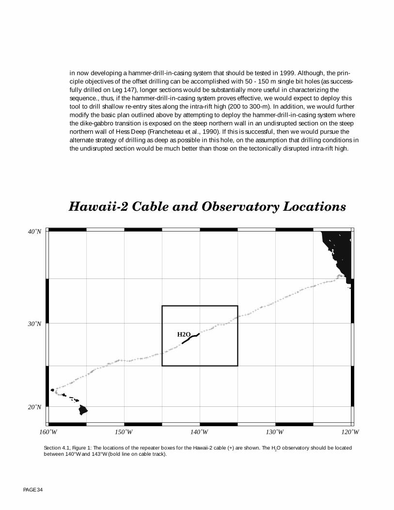
PAGE 34
in now developing a hammer-drill-in-casing system that should be tested in 1999. Although, the prin-ciple objectives of the offset drilling can be accomplished with 50 - 150 m single bit holes (as success-fully drilled on Leg 147), longer sections would be substantially more useful in characterizing thesequence., thus, if the hammer-drill-in-casing system proves effective, we would expect to deploy thistool to drill shallow re-entry sites along the intra-rift high (200 to 300-m). In addition, we would furthermodify the basic plan outlined above by attempting to deploy the hammer-drill-in-casing system wherethe dike-gabbro transition is exposed on the steep northern wall in an undisrupted section on the steepnorthern wall of Hess Deep (Francheteau et al., 1990). If this is successful, then we would pursue thealternate strategy of drilling as deep as possible in this hole, on the assumption that drilling conditions inthe undisrupted section would be much better than those on the tectonically disrupted intra-rift high.
160˚W 150˚W 140˚W 130˚W 120˚W
20˚N
30˚N
40˚N
Hawaii-2 Cable and Observatory Locations
H2O
Section 4.1, Figure 1: The locations of the repeater boxes for the Hawaii-2 cable (+) are shown. The H2O observatory should be locatedbetween 140°W and 143°W (bold line on cable track).
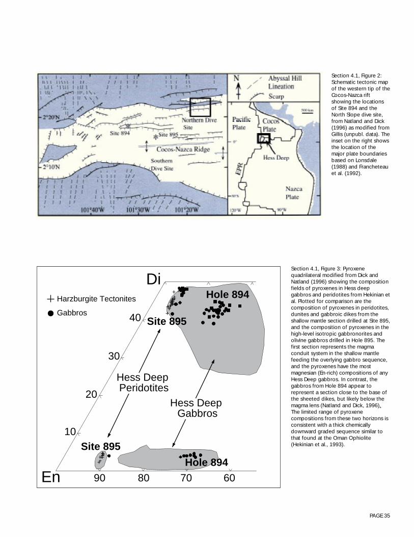
PAGE 35
Di
En 90 80 70 60
10
20
30
40
Site 895
Hole 894
Hole 894
Site 895
Harzburgite Tectonites
Gabbros
Hess Deep Gabbros
Hess Deep Peridotites
Section 4.1, Figure 3: Pyroxenequadrilateral modified from Dick andNatland (1996) showing the compositionfields of pyroxenes in Hess deepgabbros and peridotites from Hekinian etal. Plotted for comparison are thecomposition of pyroxenes in peridotites,dunites and gabbroic dikes from theshallow mantle section drilled at Site 895,and the composition of pyroxenes in thehigh-level isotropic gabbronorites andolivine gabbros drilled in Hole 895. Thefirst section represents the magmaconduit system in the shallow mantlefeeding the overlying gabbro sequence,and the pyroxenes have the mostmagnesian (En-rich) compositions of anyHess Deep gabbros. In contrast, thegabbros from Hole 894 appear torepresent a section close to the base ofthe sheeted dikes, but likely below themagma lens (Natland and Dick, 1996).The limited range of pyroxenecompositions from these two horizons isconsistent with a thick chemicallydownward graded sequence similar tothat found at the Oman Ophiolite(Hekinian et al., 1993).
Section 4.1, Figure 2:Schematic tectonic mapof the western tip of theCocos-Nazca riftshowing the locationsof Site 894 and theNorth Slope dive site,from Natland and Dick(1996) as modified fromGillis (unpubl. data). Theinset on the right showsthe location of themajor plate boundariesbased on Lonsdale(1988) and Francheteauet al. (1992).

PAGE 36
4.2 - SLOW-SPREADING OCEAN RIDGES WORKING GROUP REPORTLithospheric Architecture at Slow-spreading Ridges
Participants: R.C. Searle (chair), S. Allerton, M. Cannat, J. Casey, R.S. Detrick, L. Dmitriev, G. Früh-Green, G. Hirth, P. Kelemen, J. Lin, R. Rihm, L. Silantyev, B. Tucholke.
Key recommendations
We propose two drilling experiments on the Mid-Atlantic Ridge to determine (A) the structure andcomposition of the crustal component of slow-spreading oceanic lithosphere and its evolution in time,and (B) the along-axis chemical and structural variations in the uppermost mantle and its relation to theslow-spreading crust. We recommend that an ODP Working Group for Crustal Drilling of the Mid-Atlantic Ridge be set up as soon as possible to develop detailed drilling plans and address site selectionand survey requirements.
Experiment A will require an initial phase of drilling an array of six single-bit holes in 2-10 Ma crust,three along the trace of a segment center and three along the gravity anomaly high near its end.
In a second phase, two holes will be drilled to the maximum depth obtainable by JOIDES Resolution tocontrast the segment center and the segment end.
In the final phase, these last two sites would be extended or redrilled using new technology to achievetotal crustal penetration.
Experiment B will require seven single-bit holes drilled into serpentinized peridotite in near-zero-ageseafloor, using the JOIDES Resolution. These holes will address the nature of the uppermost mantle, andasthenospheric flow and melt migration mechanisms at a slow-spreading ridge.
In a second phase, a site would be selected near one of these holes to achieve deep crustal penetrationand determine the lithology of the geophysically defined crust.
An unexplained, first order observation is that igneous crust has variable thickness and is locally absentalong slow-spreading ridges, but apparently has nearly constant thickness at fast-spreading ridges. Theproposed drilling experiments will directly address the reasons for this difference, focusing effort oncrustal variation along a “normal” segment of the northern Mid-Atlantic Ridge and on an “end-member”area to the south, where igneous crust is virtually absent on the scale of hundreds of kilometers alongaxis. These holes will finally allow us to study complete crustal sections at a slow-spreading ridge. Theywill allow us to determine the lithology of the geophysically defined crust, and will show the degree towhich the lower crust varies along segment and with age. The proposed drilling will reveal thegeochemistry and melt emplacement mechanisms of the whole system from the mantle, through thelower crust and magma chamber(s) to extrusives, and will address the nature of asthenospheric flow andmelt migration mechanisms in the uppermost mantle.
PAGE 37
Scientific rationale
Our aim is to understand the nature and formation of the oceanic crust and upper mantle created atslow-spreading ridges and to contrast it with that created at fast-spreading ridges. Over the past 10-15years, geoscientists have come to recognize that slow-spread oceanic lithosphere differs significantlyfrom fast-spread lithosphere in its degree of segmentation and igneous crustal thickness (see, e.g., reportsof the InterRidge Mesoscale Working Group Symposium and Workshop, Durham, UK, September 1993;InterRidge Workshop on 4-D Architecture of the Oceanic Lithosphere, Boston, USA, September 1994;FARA/InterRidge Conference on the Mid-Atlantic Ridge, Reykjavik, Iceland, June 1996 (InterRidge,1996)). Slow-spreading ridges are characterized by a segmented morphology, and strong along-axisvariations of spreading axis depth, seafloor morphology, gravity anomalies, outcropping lithologies, andlava composition. All of these variations are comparatively subdued at fast-spreading ridges.
Individual segments are typically tens of kilometers in length and offset by distances ranging fromkilometers to hundreds of kilometers. Offsets less than about 25-km are typically non-transform innature, and characterized by overlapping, en echelon, or oblique features whose off-axis traces arereflected in oblique, often disconnected, basins and valleys. Larger offsets take place via linear transformfaults parallel to the spreading direction. Although transform faults and their fossil fracture zone tracesare a major component of classical plate boundaries, the vast majority of slow-spreading segments arebounded by non-transform offsets.
CRUST
Geophysical studies (seismic refraction, and gravity profiling) and seafloor sampling indicate that crustformed at segment centers is thicker (~6 to 7-km) than at segment ends (~3 to 5-km) (Figure 1), and thereis a possibility that much of the variation is confined to the lower crust (i.e. seismic layer 3). This crustalthickness variation is believed to reflect both emplacement of a greater thickness of melt at segmentcenters and the effects of differential tectonic thinning along segments. The variable emplacement isthought to be linked to focused melt migration and/or focused mantle upwelling beneath centers(Whitehead et al., 1984). Either process could cause along-axis variations in lithospheric temperature,with a warmer lithosphere and therefore shallower brittle-ductile transition under segment centers. Theyoung crust is rapidly extended by faulting, which appears to be symmetric across-axis and relativelyminor at segment centers, but becomes highly asymmetric across-axis and of great importance atsegment ends. It leads to an extreme asymmetric morphology at segment ends, in which the insidecorner is unusually shallow and is referred to as an inside-corner-high.
Thus we have a model of a segment in which the magmatic crust is thicker and the lithosphere thinnerat the center, and in which both crust and lithosphere are symmetric at the center and asymmetric at theends. These variations are reflected in the Residual Mantle Bouguer Anomaly (RMBA - the gravityanomaly corrected for water depth and lithospheric cooling, assuming constant crustal thickness), whichis typically highly negative (interpreted as thick crust) at segment centers and their off-axis traces,moderately positive (moderately thin crust) along crust formed at outside corners, and highly positive(very thin crust) along the traces of inside corner highs. The thinnest crust occurs under the flanks of thenon-transform-offset valleys adjacent to the inside corner highs, rather than under the valley axes.
PAGE 38
MANTLE
Detailed sampling, along the length of the SW Indian Ridge and along the Mid-Atlantic Ridge south ofthe Kane Fracture Zone (24°N), has led to the recognition that ultramafic rocks crop out extensively onthe seafloor at slow-spreading ridges. This is particularly so at segment ends where the geophysically-defined crust is thin (3 to 5-km), but also in some places where it is thicker. This has called into questionthe simple association of the “geophysical” crust with mafic rocks. An alternative hypothesis is that partof the low-density, low-seismic-velocity crust inferred from geophysics is a mixture of mafic and ultra-mafic rocks exhibiting varying degrees of metamorphism and serpentinization (Figure 2). Drilling hasalready demonstrated that the layer 2/3 boundary does not correspond to the dike/gabbro transition. Thepossibility that the Moho is not a simple lithological boundary between mafic and ultramafic rocks, butrather a metamorphic transition within the ultramafic sequence, is a first order question which urgentlyneeds to be addressed. The only conclusive way of determining the correspondence between thegeophysical structure and lithology is by deep-drilling. Beyond this, determination of the physicalproperties of representative rock samples must be used to develop geophysical techniques capable ofdistinguishing igneous rocks from partially serpentinized, ultramafic “crust”, in order for the scientificcommunity to continue to use regional geophysical surveys to characterize global magmatic fluxes atthe mid-ocean ridges.
Seafloor spreading requires the upflow of the asthenosphere with associated melting and production ofcrust and lithosphere, yet our understanding of these processes is largely model-driven, and has notbeen tested by robust observation. Theoretical models for asthenospheric flow and melt migrationmechanisms can be constrained by drilling where there are extensive exposures of peridotite on theseafloor, and a variety of predications can be tested.
Geodynamic processes can also be addressed in a unique way by mantle drilling. To understand theoverall structure of the ridge axis it is necessary to understand the nature and evolution of strain parti-tioning involved in bringing ultramafic rocks from the asthenosphere into the lithospheric mantle, asindicated by the evolution of tectonic fabrics and fault rocks. Furthermore, mantle drilling can be usedto determine the paleo-geotherm beneath a slow-spreading ridge. The crystallization temperatures andpressures of gabbroic intrusions within peridotite record the pressure-temperature path of the ascendingmantle within the lithosphere. Spinel crystals within residual peridotites can be used to characterize thecooling rate of the lithospheric mantle, and together with the spreading rate this information may evenbe used to constrain the physical upwelling trajectory.
Our knowledge of the oceanic mantle is largely based on observations from dredge samples, which arehighly altered, and yield little information on the spatial variability or on the scales of mantle heteroge-neity. Drilling is the only way to detect the presence of volumetrically minor veins which may play amajor role in melt transport, and is the only way to evaluate the relative proportions of different residualperidotite lithologies. Contact relationships between different lithologies can only be recovered bydrilling, and provide essential data in understanding melting and melt extraction processes.
PAGE 39
Planning for ridge drilling
Over the past few years the mid-ocean ridge community has recognized the understanding of the “four-dimensional architecture” of slow-spread lithosphere as one of its key outstanding scientific problems(InterRidge Mesoscale Working Group Symposium and Workshop, Durham, UK, September 1993). BothInterRidge and RIDGE have convened international meetings (4-D Architecture of the Oceanic Lithos-phere, Boston, September 1994 (InterRidge, 1995); RISES meeting, Boston, September 1994: Lin et al,1994) to begin the detailed planning of integrated interdisciplinary experiments to tackle this problem,and have recognized Ocean Drilling as a vital component of these.
The 1994 InterRidge meeting in Boston developed an outline for a scientific plan for the study of ridgesegmentation which is summarized in Figure 3. It envisages a strong framework of geophysical andgeological work around two segments, complemented by flow-line and isochron arrays of sampling anddrilling, and culminating in drilling two deep holes for total crustal penetration, one centered on anRMBA high and the other on an RMBA low. Geophysical work would include regional gravity, bathym-etry and magnetics, regional and segment scale seismic experiments, and near-bottom high resolutionmapping and imaging. An important objective of the higher resolution work would be to link outcropgeology to the broader and deeper structure. This plan included an array of drill holes along an outcrop-ping belt of serpentinite to address along-segment variations in mantle chemistry and structure.
Our working group took this plan as a starting point, and refined the drilling component of it. However,whereas the InterRidge plan envisioned that the array of serpentinite holes would be in the same seg-ment as the other studies, we have compelling reasons for believing that many of the crustal and mantleobjectives can best be addressed in two separate areas. Below, we develop plans for two geographicallyseparate, though thematically linked, experiments to achieve this.
The MAR between about 22° N and 35° N has an extremely well developed segmentation pattern andincludes a number of areas that have been intensively studied, but does not have extensive outcrops ofmantle peridotites. In this area, we are confident that a suitable site exists for our crustal objectives(Experiment A), though we have not yet selected a specific site. Recent work has identified a region,centered on the Fifteen-Twenty Fracture Zone at 15°20' N (also known as the Cape Verde Fracture Zone)and extending for more than 200-km along the Mid-Atlantic Ridge, where peridotite forms more thanhalf the outcrop area, and sparse lava flows are locally emplaced directly on a peridotite seafloorwithout intervening gabbro. This represents a situation of nearly “amagmatic” spreading which isunknown in the Pacific but which may be typical in the equatorial Atlantic as well as at “super slow”spreading ridges. In addition, there is a strong gradient in basaltic lava composition as a function oflatitude along the ridge. The region thus offers unparalleled opportunities for studying melt generation,mantle deformation patterns, and the effects of variable mantle composition and temperature on ridgemorphology and lava chemistry. It is ideally suited to drilling to understand melt formation and extrac-tion processes, but its off-axis segmentation pattern is poorly developed compared with other areas sothat it is not ideal for understanding crustal thickness and other within-segment variables. We thereforechoose this area for the mantle drilling objectives (Experiment B).
The following sections of this report therefore deal separately with these two components of our plan.
PAGE 40
Experiment A: Crustal drilling
(Contributors: Allerton, Cannat, Detrick, Hirth, Lin, Rhim, Searle, Tucholke)
SCIENTIFIC RATIONALE
The aim of this experiment is to characterize the crustal structure in the center and at the end of a singlewell-defined slow-spreading segment, and its variation with time.
One of the most important questions currently facing the mid-ocean ridge community is the origin of so-called Mantle Bouguer Anomaly “Bull’s Eyes”, i.e. the MBA lows that occur over segment centers. Dothese indeed reflect variations in crustal thickness and, if so, what is the nature and cause of the varia-tions? Do the MBA lows in segment centers, which we interpret as evidence for thick crust, actuallycorrespond with areas of thick igneous crust? At segment ends, where the MBA is high, indicatingthinner crust, can we confirm a smaller thickness of igneous crust? If so, are these variations the result oflocally variable mantle melting, or has melt been focused at segment centers, perhaps by along-axistransport in crustal dikes or by sub-crustal transport? Alternatively, are along-axis variations in crustalthickness the result of inhomogeneous stretching and thinning? Interpretations of seismic refractionsuggest that along-segment variations in crustal thickness occur mainly in seismic layer 3 (gabbroicrocks according to the ophiolite model), but this needs to be confirmed, and at present there is nosuggested mechanism to explain it.
Off-axis geophysical studies to crust of ~10 Ma or more show that the segmentation pattern evolves overtime. Segments may lengthen or shorten along-axis, and migrate up and down the axis. Gravity mea-surements suggest that, even at the center of a single segment, the crustal thickness may vary signifi-cantly with time. Such variations are suspected to result mainly from variations in the magmatic flux tothe segment, but may also be related to variations in tectonism. A full understanding of ridge segmenta-tion requires this hypothesis to be tested.
Another vital aspect of the time-evolution of the crust concerns its alteration and metamorphosis. Lavaserupted onto the seafloor are fresh and generally have high porosity. As the crust evolves, accumulationof sediment and hydrothermal deposits in their interstices, and consolidation due to burial, will reducetheir porosity and permeability and increase their density and seismic velocity. The depth of hydrother-mal circulation in the crust is not well constrained, but it has a vital effect on crustal temperature, andhence rheology and deformation. Hydrothermal circulation will also evolve with time, first being opento the seafloor, and later probably occurring in closed systems capped by sediment. The change fromone regime to another will have important effects on the alteration of the crust, but its timing is currentlynot well constrained.
Variations in the gravity signature between lithosphere at the inside- and outside-corners of both trans-form and non-transform offsets has been interpreted as indicating extensive crustal thinning by faultingin the inside-corner. Both geophysical and geological observations indicate relatively symmetric faultingat segment centers, but highly asymmetric faulting at segment ends. Lower crustal and upper mantlerocks are exposed on inside-corners by what some have suggested are low-angle detachment faults,analogous to those which have exposed metamorphic core complexes in subaerial environments. Thecharacterization of tectonic processes along the length of segments and over the full depth range at
PAGE 41
which they operate is vital to understanding the development of segmentation and the early evolution ofthe oceanic lithosphere. We need to know how extension is accommodated in 3D, and how it ispartitioned into brittle, ductile and magmatic processes. Critical to this characterization is determiningthe rheology and strain localization in the mid- and lower crust.
Geochemical studies indicate that at least some extrusives are derived from lithospheric magma cham-bers, and plutonic rocks have been extensively sampled by dredging. However, we know nothing of thesize, position, average composition or longevity of magma chambers, which have never been imagedgeophysically on the Mid-Atlantic Ridge, except where it is under the influence of the Icelandic hot spotalong the Reykjannes Ridge (Sinha et al., 1997 ; Constable et al., in press). We do not know how melt isdelivered to the crust from the mantle, or how melt moves from magma chambers to the seafloor. Islateral diking important? Can significant chemical fractionation occur in magma chambers and/or duringmagma transport? More generally, how closely does the architecture of the oceanic crust follow theophiolite model? Ophiolites are potentially very powerful analogues for aiding the understanding ofridges. They have traditionally been seen as fitting the layered seismic model of the crust, althoughrecent recognition (at ODP hole 504B) that the seismic layer 2/3 transition does not correspond to thedike/gabbro contact casts doubt on their applicability. Moreover, geochemistry suggests that manyophiolites are from arc or back-arc environments. By determining how well (or poorly) the crust of theMid-Atlantic Ridge follows the ophiolite model, we shall be in a much better position to use knowledgeof ophiolites in interpreting ridge structure and processes.
Virtually all of the questions discussed above require drilling to answer them, and many of them requiredrilling to mid- and lower crustal levels. It must be emphasized that exposures of lower crustal rocks arerare at segment centers. Lower crustal and upper mantle rocks may be exposed at segment ends or beaccessible to offset drilling, but only in this very particular tectonic environment; this gives us noinformation about segment centers. Furthermore, offset drilling does not allow the comparison of upperand lower crustal rocks that formed coevally, although such comparisons are vital for understandingissues of magma differentiation and transport. Equally, comparison of rocks formed along the sameisochron but at both segment center and segment end is needed for addressing questions of along-axismelt differentiation and delivery. Drilling is also necessary to recover samples whose spatial relation-ships are known, whether it be to sample successive lavas in a continuous pile (e.g., to establish theirchemical evolution), to examine dikes and veins in relation to their host rocks, or to examine thedevelopment and structure of strain localization in faults and ductile zones. Oriented samples will beimportant for structural and paleomagnetic studies. In addition to samples, drilling enables furthercharacterization of the rock column through logging and down-hole experiments. Examples are thedetermination of crustal porosity and permeability, their evolution with age, and their relation to hydro-thermal alteration and seismic velocity. Emplacement of down-hole seismometers will significantlyenhance the ability to image the crust tomographically.
DRILLING STRATEGY
The experimental objectives will be approached through three phases of drilling. Phase 1 is within thepresent capabilities of the JOIDES Resolution and should therefore happen prior to 2003 (Phase III of theDrilling Program). Phase two (1 to 3-km deep holes) is within the nominal capability of the Resolution.Its implementation should therefore start prior to the end of the present ODP program in 2003. It offers aprecious opportunity to test the JOIDES potential for deep hard rock drilling. Stage 3 requires deeperdrilling capabilities and should be competed during Phase IV of the Drilling Program.
PAGE 42
Phase 1
During phase 1, an array of six single-bit holes will be drilled in 2-10 Ma crust along two flow-lines, onein the RMBA low at the segment center, and one on the RMBA high at segment end (Figure 3). Alongeach flow-line, the holes will be sited on local RMBA extrema to sample temporal variations, with twoof the segment center holes on local lows and one on a local high, and two of the segment end holes onlocal highs and one on a local low. Detailed surveys may show that the local RMBA highs at segmentends expose important structural and stratigraphic relations that reflect exhumation of the deep lithos-phere and the accompanying transition from ductile to brittle deformation (i.e., the detachment model).In this case, two or more drill sites may be needed on one of these features in order to sample andcorrelate these relations within the mapped geological context of the seafloor. Precise site selectionshould follow extensive dredging and near-bottom surveying and imaging (to determine local variationsin geology, lithology and geochemistry). All holes should be logged if possible, and at least some wouldbe instrumented for further studies (e.g. segment scale seismic studies using natural earthquakes).
The single-bit holes will serve the dual objectives of comparing the shallow crust formed coevally at thesegment center and the segment end, and of investigating the temporal variability of this crust. However,they will also serve the vital function of testing and selecting sites for the deeper drilling that is to follow,so that we follow a strategy of gradually focusing and deepening as the project extends.
While the segment center holes are likely not to penetrate below the extrusive layer or possibly shallowdikes, carefully sited holes at the segment end should be able to sample lower crust and/or uppermantle. The comparison of segment center and segment end will address the along-axis variability ofupper crustal lithostratigraphy (lithologies, volcanic style, magma delivery system), geochemistry (meltcomposition, source composition, degree of melting, extent of fractionation), and structure (nature oflithological contacts, number and type of faults and fissures, degree and rate of tilting) between segmentcenter and end. It will also address the question of the source of magnetic anomalies in slow-spreadcrust and of the nature and extent of upper crustal hydrothermal alteration.
Along-flow-line holes will look for similar variations with age. They will assess variations in volume andnature of magmatism and magma source with time, and test whether thick crust correlates with moreevolved chemistry, higher degree of melting of the mantle source, or variations in source composition.These holes will also address the question of crustal aging. They will examine the chemical alteration ofthe crust; the nature, depth, and duration of specific alteration and mineralization events; evolution fromopen to closed hydrothermal systems; and evolution of crustal porosity profiles.
Phase Two
Two reentry holes will be drilled to the maximum depth achievable with JOIDES Resolution, probably inthe range 1 to 3-km. Sites for these will be selected along an isochron, based on drilling conditionsobserved during phase one: one on the RMBA low at segment center, and one on the RMBA high atsegment end.
PAGE 43
These holes will extend the along-segment comparative studies to the mid crustal levels: determining thethickness of extrusives at both places, and the nature and depth of the seismically defined layer 2/layer 3boundary. They will allow for detailed studies of magma chambers in slow-spreading environments,linking both the chemistry and the melt delivery systems to the extrusive layer directly above. Importantquestions on strain partitioning and mid-crustal flow and faulting will also be accessible.
These holes will provide the opportunity to do deep crustal monitoring experiments (e.g., heat flow,seismicity, hydrothermal flow etc.). A further possibility at this stage, though of lower priority, is to drillthe conjugate outside-corner crust for comparison with the inside-corner on the opposite plate. Thiswould directly test ideas of highly asymmetric crustal generation and extension. For example, it wouldgive a measure of the total amount of extrusives produced at the axis, and how they are subsequentlypartitioned into the two plates.
Phase Three
The last stage would involve the drilling, at or near phase two sites, of two deep holes for total crustalpenetration, using new technology. The hole at the segment center will need to be 6 to 7-km deep,starting in seafloor 2 to 3-km deep. The segment end hole will be shallower (3 to 4-km), but possiblylocated in deeper seafloor (up to about 3.5-km). These holes will need to be cored and logged to themaximum extent possible. They will finally make it possible to study complete crustal sections, allowingus to determine the lithology of the geophysically defined crust. They will show the degree to which thelower crust varies along segment, and will reveal the geochemistry and melt emplacement mechanismsof the whole system from mantle, through lower crust/magma chamber to extrusives.
Our working group did not discuss the implementation of this deep-drilling phase in great detail.Drilling to intermediate depths during Stage 2 is expected to take a significant number of legs (4 to 6);thus, Stage 3 is unlikely to begin until well after the end of the present drilling program. The opinion wasalso expressed that although total crustal penetration was an exciting objective at slow-spreading ridges,it was more of a priority for fast-spreading settings (where crustal structures are expected to be lessheterogeneous and where seafloor exposures of ultramafic and gabbroic rocks are uncommon).
SITE SURVEYS AND SELECTION
The drilling sites for this experiment will be part of a multi-disciplinary and multi-scale study of Mid-Atlantic ridge segmentation (as outlined in the InterRidge and Ridge workshops; Figure 2). It is essentialthat all drilling be done within areas where the full geological context of a drill site is understood fromdetailed seafloor mapping and sampling. Thus, our preliminary recommendations for survey require-ments are as follows: complete bathymetric, gravity and magnetic coverage up to 10 Ma, detailedseismic refraction and tomographic experiments, deep-towed high resolution side scan sonar andmagnetic survey, and extensive rock sampling and visual observation using towed vehicle, ROV orsubmersible.
PAGE 44
Experiment B: Drilling a serpentine belt along the Mid-Atlantic Ridge at 15°N
(Contributors: Casey, Cannat, Detrick, Dmitriev, Früh-Green, Hirth, Kelemen, Silantyev)
SCIENTIFIC RATIONALE
The aim of this experiment is to characterize upper mantle and melt geochemistry, melting and meltmigration mechanisms, deformation structures in the asthenospheric and lithospheric mantle below theridge, and hydrothermal alteration, as well as the variation of these characteristics along axis. It involvesthe drilling of an array of seven single-bit holes in exposures of serpentinized peridotites that form asignificant part of the axial valley walls in the 15°N region. In a later phase, a site would be selectednear one of these holes to achieve deep penetration into seismically defined crust and determine itslithology.
It has been hypothesized that oceanic crustal thickness is largely independent of spreading rate, and is afunction only of mantle temperature. However, along slow-spreading ridges, regions of normal mantlepotential temperature have been found to have thin and/or discontinuous magmatic crust. Along theflanks of the Mid-Atlantic Ridge south of the Fifteen-Twenty Fracture Zone, peridotite crops out nearlycontinuously, and in some cases lava flows lie directly over it, without intervening gabbroic “lowercrust”. This occurs both at segment ends and segment centers. This indicates that the ridge here is a“magma-starved” extreme end-member compared to the magmatically “robust” East Pacific Rise. It hasbeen proposed that this results from a combination of slow-spreading rate and limited magma supply,with extensive conductive cooling of the upper mantle restricting the depth interval of decompressionmelting and initiating the onset of crystal fractionation at substantial depths (ca. 25-km?) beneath theseafloor. Such a process may be common along the Mid-Atlantic Ridge.
Related to this is the petrological hypothesis that Mid-Ocean Ridge Basalt (MORB) at slow-spreadingridges is compositionally distinct from that at fast-spreading ridges, due to the deeper onset of fractionalcrystallization. This can be directly tested if extensive samples of plutonic rocks emplaced withinperidotite can be obtained. As suggested in the introduction, studies of gabbros can be used to deter-mine the paleo-geotherm and even the trajectory. Sampling by dredging and from submersibles hasyielded gabbroic dikes within peridotite; however, sections of more extensive “cumulate” gabbrobodies, in which the vector of geochemical variation can be used to provide additional constraints onthe pressure of crystallization and the nature of liquids extracted from these bodies, can only be ob-tained by drilling.
Surprisingly, geophysical surveys of regions of the Mid-Atlantic Ridge that have abundant outcrops ofresidual ultramafics yield significant crustal thicknesses. This paradox represents a first order problem. Ifgeophysical surveys are to be used to estimate magmatic flux, they must be calibrated to detect thedifference between igneous crust and crust composed predominantly of altered mantle peridotite.Obtaining extensive samples of altered mantle-derived peridotite from well below the surface weather-ing horizon in order to determine their physical properties is a fundamental step in resolving this prob-lem.
PAGE 45
Conductive cooling has predictable effects on axial deformation patterns: the upper limit for low-stressasthenospheric flow in the axial upper mantle should be located at depths greater than the base of thecrust. Crust in the axial region must be directly underlain by a root of cooler mantle able to sustainsignificant deviatoric stresses. The existence of this rigid mantle lithosphere has been inferred fromthermo-mechanical models of axial valley formation, but such models are built on rheological estimatesbased only on small-scale, laboratory rock deformation experiments.
Micro-structural studies of ultramafic rocks collected in the walls of the Mid-Atlantic Ridge medianvalley indicate that 1) there is much strain localization in the ductile part of the mantle lithosphere, and2) samples of these rocks retain a good micro-structural record of successive deformation events, fromthe onset of conductive cooling until their emplacement near the seafloor. The first point indicates thatthe uniform rheology often used for modeling misses essential processes in the deformation of mantlelithosphere beneath slow-spreading ridges. The second offers a way to unravel the deviatoric stress,strain, temperature and deformation history of this lithosphere. These control both the mechanics andgeometry of the axial region and the mode of magma emplacement. Is mantle deformation characterizedby “three-dimensional” patterns with radial expression in plan view? Does the shallow mantle undergo“corner flow”, developing a sub-horizontal, Moho-parallel foliation? Drilling is the best way to getultramafic samples that can yield such information, because it provides vertically continuous sectionsthat can be at least partially restored to their ridge-axis orientation. Because the objective is ultimately toconstrain the lithosphere rheology at the scale of a few tens of kilometers, samples are needed fromseveral sites distributed along-axis at this length scale.
The temperature and depth of onset of hydrothermal alteration affect both the rheological parameters inthe axial lithosphere and the nature of the crust-mantle boundary in regions of extensive ultramaficoutcrop. This is because serpentinization produces decreases both in the resistance to brittle failure andin seismic velocity and density. ODP legs 109 and 153 showed that some ultramafic samples have beenserpentinized at over 350°C. Such temperatures correspond to depths of several kilometers belowseafloor, consistent with Hess’ hypothesis that the Moho could locally be a serpentinization front. Inorder to test this hypothesis, we need to constrain serpentinization conditions in a significant number ofsubseafloor ultramafic samples again distributed over along-axis distances of a few tens of kilometers.
In some regions along slow-spreading ridges, major element indices suggest an unusually high degree ofmantle melting, if one assumes that the source composition and melting processes are constant. Incontrast, trace element indices, interpreted in the same way, would indicate a very small degree ofmelting; thus the mantle source composition and/or the nature of the melting process is probably notconstant along the ridge, as is partially borne out by radiogenic isotope ratios. Classically, such areas areinterpreted as mantle “hot spots” (e.g., the Reykjanes Ridge south of Iceland). Because temperature andgeochemical enrichment are correlated in a way that is poorly understood, and which may vary fromplace to place, there is little quantitative understanding of the relative importance of these factors incontrolling geodynamically important variables such as crustal thickness, axial depth and geoid height.The contributions of mantle temperature and composition can in principal be sorted out in the Fifteen-Twenty area, which is unusually deep and has thin to absent igneous crust. On this basis, one wouldpredict a cold mantle with very little partial melting during decompression. Paradoxically, the peridotitesconsistently record high degrees of melting in their major element concentration, while many basaltsshow characteristics of long-term enrichment. Thus, in this region, geochemical indices of mantletemperature and enrichment contrast strongly with geodynamic indicators of mantle temperature. Thereis a substantial geochemical gradient over just 150-km along the ridge in the Fifteen-Twenty area, from
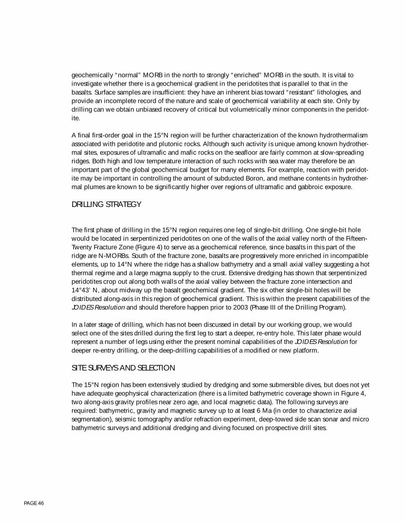
PAGE 46
geochemically “normal” MORB in the north to strongly “enriched” MORB in the south. It is vital toinvestigate whether there is a geochemical gradient in the peridotites that is parallel to that in thebasalts. Surface samples are insufficient: they have an inherent bias toward “resistant” lithologies, andprovide an incomplete record of the nature and scale of geochemical variability at each site. Only bydrilling can we obtain unbiased recovery of critical but volumetrically minor components in the peridot-ite.
A final first-order goal in the 15°N region will be further characterization of the known hydrothermalismassociated with peridotite and plutonic rocks. Although such activity is unique among known hydrother-mal sites, exposures of ultramafic and mafic rocks on the seafloor are fairly common at slow-spreadingridges. Both high and low temperature interaction of such rocks with sea water may therefore be animportant part of the global geochemical budget for many elements. For example, reaction with peridot-ite may be important in controlling the amount of subducted Boron, and methane contents in hydrother-mal plumes are known to be significantly higher over regions of ultramafic and gabbroic exposure.
DRILLING STRATEGY
The first phase of drilling in the 15°N region requires one leg of single-bit drilling. One single-bit holewould be located in serpentinized peridotites on one of the walls of the axial valley north of the Fifteen-Twenty Fracture Zone (Figure 4) to serve as a geochemical reference, since basalts in this part of theridge are N-MORBs. South of the fracture zone, basalts are progressively more enriched in incompatibleelements, up to 14°N where the ridge has a shallow bathymetry and a small axial valley suggesting a hotthermal regime and a large magma supply to the crust. Extensive dredging has shown that serpentinizedperidotites crop out along both walls of the axial valley between the fracture zone intersection and14°43’ N, about midway up the basalt geochemical gradient. The six other single-bit holes will bedistributed along-axis in this region of geochemical gradient. This is within the present capabilities of theJOIDES Resolution and should therefore happen prior to 2003 (Phase III of the Drilling Program).
In a later stage of drilling, which has not been discussed in detail by our working group, we wouldselect one of the sites drilled during the first leg to start a deeper, re-entry hole. This later phase wouldrepresent a number of legs using either the present nominal capabilities of the JOIDES Resolution fordeeper re-entry drilling, or the deep-drilling capabilities of a modified or new platform.
SITE SURVEYS AND SELECTION
The 15°N region has been extensively studied by dredging and some submersible dives, but does not yethave adequate geophysical characterization (there is a limited bathymetric coverage shown in Figure 4,two along-axis gravity profiles near zero age, and local magnetic data). The following surveys arerequired: bathymetric, gravity and magnetic survey up to at least 6 Ma (in order to characterize axialsegmentation), seismic tomography and/or refraction experiment, deep-towed side scan sonar and microbathymetric surveys and additional dredging and diving focused on prospective drill sites.

PAGE 47
Moho7.9
7.2
6.96.5
3.0
6.46.8
3.0
7.97.2
7.9
6.96.5
15
10
5
0 S N
Dep
th (
km)
Cru
stal
thic
knes
s (k
m)
2
6
10
seismicgravity
OceanographerFZ
0 50kilometers
Section 4.2, Figure 1: Seismic crustalstructure across the OceanographerFracture Zone from Sinha and Louden(1983) as modified by Detrick et al.(1995). Seismic velocities are inkilometers per second.
Section 4.2, Figure 2: Sketch from Cannat et al. (1995) showing along-axis section of two idealized magmatic segments (4Xvertical exaggeration). Lithosphere is inferred to be 10 km thick beneath segment ends, on the basis of natural seismicitydata. Minimum lithospheric thickness beneath centers of segments is arbitrarily chosen as 2 km. Depth to Moho is shown as4 km at ends of segments and 7 km at segment centers, on the basis of gravity and seismic data. Magmatic crust is shown ascontinuous and layered at magma-rich segment centers but thinner and more discontinuous towards magma-poor segmentends where ultramafic outcrops are common.
lithosphere
asthenosphere
0
10 km
basalt dike complex gabbroic rocks ultramafic rocks
MOHO
Magmatic Segment Center Magmatic Segment Center
strike-slip andoblique-slip faults
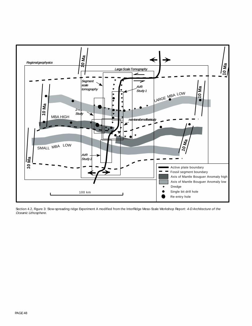
PAGE 48
Section 4.2, Figure 3: Slow-spreading ridge Experiment A modified from the InterRidge Meso-Scale Workshop Report: 4-D Architecture of theOceanic Lithosphere.
SSeeggmmeennttssccaalleettoommooggrraapphhyy
nnoonn--ttrraannssffoorrmm ooffffsseett ssttuuddyy
10 M
a
10 M
a
10 M
a
LARGELOW
MBA
AAVVRRSSttuuddyy 22
10 M
a
22--44 MMaaSSttuuddyy
10 M
a
SMALL
10 M
a
MBA LOW
MBA HIGH
100 km
AAVVRRSSttuuddyy 11
LLaarrggee SSccaallee TToommooggrraapphhyy
RReeggiioonnaall ggeeoopphhyyssiiccss
Active plate boundary
Re-entry hole
Single bit drill hole
Axis of Mantle Bouguer Anomaly low
Axis of Mantle Bouguer Anomaly high
Fossil segment boundary
Dredge
PAGE 49
Section 4.2, Figure 4: Bathymetric map of the 15°20’N region of the MAR outlining possible locations for slow-spreading ridgeExperiment B to test the along-axis lateral variability of the shallow mantle.
100 km
Serpentinite belt
Single-bit holes
Reference hole
Experiment B
15°20' Transform Fault
MA
R S
prea
ding
Axi
s
PAGE 50
4.3 - ACTIVE PROCESSES WORKING GROUP REPORT
Participants: Mike Mottl (Chair), Jill Karsten (Steering Committee Rep), Susan Agar, Keir Becker, JohnDelaney, Gretchen Früh-Green, David Goldberg, Debbie Kelley, Robert Kidd, Victor Kurnosov, MarvLilley, Andy Magenheim, Jim McClain, Peter Rona, Debra Stakes, Damon Teagle, Jean Whelan, BobZierenberg, Boris Zolotarevplus several more who came and went.
OverviewOceanic crust is the end product of a complex suite of active tectonic, magmatic, hydrothermal, andbiological processes, that occur primarily at divergent plate boundaries (i.e., mid-ocean ridges andback-arc spreading centers). Off-axis and intraplate tectonism, hydrothermalism and volcanism subse-quently modify the oceanic plate formed at the spreading centers. The last twenty years of seafloorexploration has immensely increased our knowledge of the first-order features of the oceanic crust, thedistribution of these components in space and time, and the fundamental processes which govern theirformation and evolution. As our insights into the nature of oceanic crust and the processes attendingcrustal accretion have matured, the focus of exploration has shifted increasingly toward questions aboutthe temporal variability of these processes over observable (i.e., decadal) time scales and the linkagesand feedback mechanisms which exist between them. In addition, the recent recognition that significantmicrobial populations may reside within the upper oceanic crust has raised an exciting new area ofinquiry regarding active processes in the oceanic crust. While studying the products of these variousprocesses integrated in the geologic record has yielded valuable constraints on such scientific problems,only by direct observation and monitoring of active processes can these questions be fully answered.Two-types of approaches have been envisioned: in situ monitoring of individual sites in order to docu-ment temporal changes in specific active processes, and seafloor “observatories”, consisting of net-worked instrumentation at several sites, in order to establish interactions between different types ofactive processes. Conducting real-time investigations of active processes is both imperative for answer-ing the scientific problems of interest and a logical extension of the work which has been conducted inthe last several decades of ocean crust research.
Ocean drilling has played a vital role in past explorations of the oceanic crust, by providing a windowinto the sub-surface portions of oceanic crust. Similarly, ocean drilling and instrumented boreholes willprovide an integral component of in situ and long-term monitoring strategies to study oceanic crust in avariety of tectonic settings. In this report, we briefly describe: 1) the scientific rationale for seafloorobservatories and the role of instrumented boreholes for in situ monitoring, 2) a number of specificdrilling targets and observatory strategies where active monitoring is essential, 3) criteria for site selec-tion and pre-drilling surveys, and 4) technological and logistical considerations that are necessary forthese studies to be implemented. Defining the scientific rationale and generic sites for observatoriesutilizing instrumented boreholes is relatively straightforward, and indeed, has already received consider-able attention and discussion (e.g., RIDGE Observatory Framework document, ION Workshop report,Borehole Report). Implementation of and detailed planning for such experiments, however, is criticallydependent on several challenging technological advances, which are also discussed briefly here. Activeprocesses are, by their nature, primarily located in areas of young crustal formation, which has beennotoriously difficult to drill; thus, most of the experiments described here are strongly dependent onsuccessful development of technologies for drilling in young volcanic terrains (e.g., DCS). Althoughseveral recent ODP programs have developed some of the logging and borehole instrumentationcapabilities needed (e.g., CORKs), additional types of chemical and physical sensors, tools for “slim”
PAGE 51
drill holes, and innovative tools/strategies which utilize closely-spaced boreholes (e.g., cross-holetomography) and seafloor installations, all need to be developed. It is expected that the insights obtainedby in situ monitoring strategies will ultimately lead to a later generation of innovative “active experi-ments”, which utilize borehole opportunities.
Active processes occur in a variety of tectonic settings on the seafloor, and the basic concept of usingborehole instrumentation to study such processes can be applied to many different sites. Four examplesof observatory sites are discussed here - 1) a hydrothermally active ridge axis, 2) an off-axis or ridgeflank hydrothermal system, 3) a volcanically and hydrothermally active intraplate volcano, and 4) aconvergent margin hydrothermal system. Of these four sites, the ridge axis site is given highest priority asa drilling target in the near-term because it represents the first order end-member of ocean crust accre-tionary processes and because it is one of the most mature and broadly-supported of the programs ofthis type. At present, there is significant national and international community support for ridge crestmonitoring (e.g., InterRIDGE) and there is already a commitment by U.S. and Canadian scientists toinstrument portions of the spreading center in the NE Pacific along the Juan de Fuca Ridge. It is impor-tant to emphasize, however, that the other observatory targets discussed here (as well as others notmentioned) are as important scientifically, and are considered a very high priority for an extendeddrilling program or as alternative targets, should the technological developments required for drilling atthe ridge axis prove untenable
Key recommendations of the working group
• Highest priority in the Active Processes Working Group is given to drilling and instrumenting 5boreholes in conjunction with a ridge axis observatory experiment. The ideal configuration wouldconsist of 4 holes to ~500-m depth and 1 hole to ~2-km depth, distributed in an L-shaped array. Allfive holes would be logged, CORKed and instrumented in order to determine the physico-chemicalstate of the crust in the region of an active volcano-hydrothermal system and to monitor fluid andgeochemical evolution of the hydrothermal system over decade time scales.
• Obtaining the technological capabilities for drilling and CORKing 5 holes to ~500-m depth isconsidered a very high priority for Phase III (1998-2003) drilling (approximately 2 legs), but requiressuccessful development of hammer-in casings and DCS capabilities in order to be implemented. Anew generation of borehole instrumentation and logging tools designed to measure the physical andchemical properties of the system will also need to be developed (e.g., CORKs for “slim” holesproduced by DCS).
• Deepening existing observatory holes to 2-km depths at the ridge crest observatory and initiating newobservatories at alternative sites (e.g., ridge flank or different spreading rate environment) are identi-fied as very high priorities for Phase IV (>2003) drilling. These experiments will require a JOIDESResolution-like (i.e., non-riser) drilling capability for Phase IV of the program.
• New borehole technologies and shipboard laboratory capabilities for sampling the sub-surfacebiogeosphere are needed immediately for mapping and exploring this largely unknown componentof oceanic crust development and evolution.
• Many of the drilling, coring, and borehole instrumentation technologies required for implementing aridge axis borehole observatory are similar to those needed by other programs in the marine commu-nity (e.g., OSN/ION). It is essential that technological developments be coordinated between thesevarious groups, in order to proceed most efficiently.

PAGE 52
• In order to implement the ridge axis observatory experiment, the Working Group recommends thatODP convene a Borehole Instrumentation Program Planning Group which provides oversight to aDetailed Planning Group on a Ridge Axis Borehole Observatory Experiment. This RABOE DPG musthave a liaison to the InterRidge Active Processes Working Group, in order to coordinate with otherobservatory efforts and site selection.
Monitoring of sctive processes: Scientific rationale
SEAFLOOR OBSERVATORIES
The concept of seafloor observatories for in situ and real-time monitoring of active magmatic, tectonic,hydrothermal and biological processes has been extensively discussed in recent years, and has been ahigh priority component of the U.S. RIDGE and InterRidge programs. Numerous workshop reports havedetailed the specific rationale for seafloor observatories, most recently the Final Reports for WorkshopsAddressing Temporal Variability of Ridge Crest Processes, the Framework and Guidelines for the Juan deFuca Seafloor Observatory document (Spiess et al., 1996), the ION meeting report, and the Marseillesmeeting report. The scientific issues which can be addressed by observatories span a wide range ofdisciplines and spatial and temporal scales. An example of the broad array of questions which has beenused to lay the foundation for an observatory approach, repeated from the ION report, includes:• How often, and in what pattern and quantity, is magma delivered from the mantle to the crust?• What are the spatial and temporal characteristics of magma movement into the upper crust and onto
the seafloor through rifting, diking and eruptive events?• In what manner does new crust achieve its rigidity and become an integral part of the adjacent plate?• What are the primary heat transfer, chemical and biological consequences of diking events?• What are the components and space/time extent of the subseafloor biosphere?• What are the nature and origins of spatial/temporal variability in submarine hydrothermal systems?
What are the dominant physical processes involved?• What is the space/time extent of exchange of heat, fluid volume and chemical mass between hydro-
thermal systems and the overlying ocean?• How do the nature and longevity of hydrothermal systems influence ecosystem development, faunal
succession and biological productivity?• To what degree does hydrothermal venting influence the physical, chemical and biological character
of the overlying water column? What is the relative importance of episodic vs steady state outputs?
While these questions represent important research areas on their own, they reach greater potential formaking major progress on the fundamental behavior of active seafloor systems when they are studiedsimultaneously and together. These questions can be addressed by monitoring several key parameters,such as ground deformation (e.g., elevation, strain), seismicity, seafloor permeability, extent and natureof rock alteration and mineralization, and hydrothermal effluent properties (e.g., temperature, velocity,composition, biological activity, water column particulates), as well as detailed mapping and samplingsurveys. The compelling scientific arguments which underpin efforts to establish seafloor observatorieshave led to successful attempts at prototype experiments on the Juan de Fuca Ridge and Northern EastPacific Rise over the last few years. These efforts have recently culminated in the preparation of theFramework and Guidelines for the Juan de Fuca Ridge Seafloor Observatory document (Spiess et al.,1996), which endorses very specific experiments and instrumental needs for realization of a ridge crest

PAGE 53
observatory. Ocean drilling is identified as an important component of that effort, although specificborehole experiments are not discussed in great detail. Drilling-related aspects of ridge crest observato-ries are, thus, considered in more detail below.
The questions and strategies proposed in the Framework document are also readily applied to otherseafloor sites which involve coupled volcanic-tectonic-hydrothermal-biological processes, such as off-axis hydrothermal systems, convergent margins, and active intraplate volcanoes (e.g., Loihi). Ultimately,when these questions are investigated in a variety of tectonic settings (e.g., fast vs slow ridge axes,intraplate volcanoes, convergent margins), comparisons between the different settings will help establishthe control of key first-order parameters, such as spreading rate, pressure and magmatic compositionand volatile content, on the nature and evolution of these processes.
Subseafloor biosphere studies
There is one active process associated with development of oceanic crust which has not receivedextensive discussion by the community — biological activity. It has recently become evident that certainhard rock, subseafloor portions of oceanic spreading centers harbor a substantial, unexplored microbialinfauna supported essentially by mantle-derived volatile fluxes focused though divergent plate bound-aries. The evidence for this assertion is that in six out of six submarine diking-eruptive events that havebeen studied, massive effusions of microbial material (e.g. Huber et al, 1990; Haymon et al, 1993;Holden et al, 1996) have been observed and a significant subset have yielded culturable thermophilicarchae, or primitive microbes especially adapted for growth in aqueous fluids at temperatures above60°C.
The precise cause of these outpourings is not certain. Event-triggered changes in flow regime may haveflushed existing biological products from the pores and cracks within the seafloor. It is also possible thatfracturing and magmatic intrusion may have generated enhanced nutrient fluxes resulting in event-triggered microbial blooms that simply overflowed the confining space in the enclosing rock. In therecent Gorda Ridge event, thermophiles (optimum growth range—40 to 60°C) were cultured from themassive megaplume released within hours to days of event initiation. The 1993 Coaxial event producedculturable hyperthermophiles in vent fluids issuing at temperatures no higher than 18°C, three timeslower than the optimal growth range.
It is clear that microbial life forms thrive in water-saturated pores and cracks within deep, volcanicallyactive portions of our planet. In fact, a most intriguing suggestion is that these organisms may be distrib-uted throughout the hottest, youngest rocks on the planet. It may well be that seafloor hydrothermal ventfields are only the “tip of the iceberg” in terms of the total biomass supported by submarine hydrother-mal effluent. By designing innovative strategies to explore linkages between active volcanoes and thelife forms they support, we gain essential knowledge about processes on our own planet, while obtain-ing critical new insights about how to explore for life on other planets.
The marine science community and the Ocean Drilling Program have a unique opportunity to assume adefining role in the early exploration of a potentially powerful planetary scale biogeological paradigm.Essentially, the concept that a significant fraction of this planet’s biomass exists within the brittle portionof the oceanic crust, proximal to zones of active volcanism, has gained strong support from observations

PAGE 54
of submarine diking eruptive events. But it will require drilling integrated into long-term experimentsand time-series observations to “flesh out” the concept and to validate the degree to which it is appli-cable to volcanic systems in general.
Complementary strategies for examining the extent, distribution, abundance, dynamical behavior andnutritional requirements of subsurface microbia communities in active volcanoes should include:• Rapid response to diking-eruptive events — Comprehensive and immediate response with a full
suite of interdisciplinary tools and researchers is essential to obtain complete and systematic charac-terization of the microbial productivity set in motion by these events.
• Drilling into zones of potential microbial productivity — Only drilling will enable us to sampledirectly microbial communities below the seafloor, to explore the depth, variability and abundanceof the deep volcanic biosphere. Optimal approaches might involve drilling hard rock targets selectedfor effluent testing of well-framed hypotheses that bear on the volcanic ecology of this newly discov-ered subseafloor habitat. Especially intriguing will be perturbation experiments using tracer injectionof nutrients or even specific microbial strains into arrays of drill holes designed to allow hole-to-holecommunication.
• Long term instrumentation and time-series sampling of known vent fields — The spatial variabilityof near subsurface microbial communities may be reflected in output of high and low temperatureventing within now stable hydrothermal systems.
Proposed drilling experiments
Active processes which occur in a variety of tectonic settings can all benefit from in situ or long-termmonitoring strategies which utilize borehole instrumentation. Here, only four types of experiments arediscussed. Highest priority for Phase III drilling is given to the Ridge Axis Borehole Observatory (RABO)Experiment.
THE RIDGE AXIS BOREHOLE OBSERVATORY (RABO) EXPERIMENT
Scientific Objectives:
Drilling-related experiments which mesh with the observatory objectives outlined in several RIDGE andInterRidge documents are primarily focused on two aspects: 1) defining the sub-surface physico-chemi-cal structure of the upper oceanic crust, which will fundamentally control the permeability and chemi-cal evolution of hydrothermal fluids that pass through it, and 2) monitoring the physical and chemicalproperties of these fluids over time scales of several years. Specifically, drilling and borehole instrumen-tation can be used to assess the 3-D pattern of: lithostratigraphy and alteration assemblages, porosityand permeability structure and their relationship with fracturing, temperature-pressure fields, pore fluidcomposition and flow direction (both chemical and biological components), and, with deeper penetrat-ing holes, processes which occur in the “reaction zone”, where fluid-rock interactions are most extreme.When combined with other parameters measured by observatory instruments deployed on the seafloor(e.g., micro seismicity, vent fluid composition), relationships between sub-surface properties and featuresexpressed on the seafloor can be constrained, and the consequences of perturbations induced byspecific magmatic and tectonic events (e.g., dike intrusion) can be determined.

PAGE 55
Experimental Design:
The ideal ridge axis observatory experiment will consist of an array of five CORKed boreholes distrib-uted in an L-shaped array (Figure 1). It is expected that this experiment will take a minimum of 2 legsduring Phase III (1998-2003) and 1 leg during Phase IV (>2003) of the Ocean Drilling Program.
Phase III: During Stage 1, three holes will be drilled to ~500-m depth and ~500-m apart. In past attemptsto drill young ridge crest environments, it has been extremely difficult to spud the drill into the typicallyrubbly volcanic terrain of such sites. Implementation of this experiment, thus, assumes successfuldevelopment of either the DCS or a combination of hammer-in casing/DCS tools (see Technologysection below). During the initial drilling, holes will be deepened as far as possible without casing, inorder to allow logging. Logging-while-drilling (LWD) strategies do not appear to be compatible with theDCS as presently configured, so that logging will have to be done afterwards. During Stage 2, twoadditional holes will be drilled to ~500-m depth and between 500-m - 2-km from the first three holes,depending on the ridge configuration. At least one of these five holes will penetrate through an activefault zone, in order to evaluate fluid movement along such structures. All five holes will be logged andCORKed with instrumentation for long-term monitoring of the physical and chemical properties of theborehole.
Phase IV: During Stage 3, at least one of the holes will be un-CORKed, cored to a depth of ~2-km, andre-CORKed. The primary objective of this deep hole will be to evaluate chemical processes occurring inthe main reaction zone of the hydrothermal system, and their relationship to shallower portions of thesystem.
Logistical Considerations:
The significant technological constraints associated with this experiment are considered more thor-oughly in a later section. Should a combination of hammer-in casing and DCS tools be required, it willbe necessary to have a mid-leg port call to reconfigure the deck for the DCS heave compensationsystem, since it is apparently incompatible with the set-up for hammer-in casings.
Site Selection Criteria and Pre-Drilling Survey Needs:
Site selection of the appropriate drilling targets for any of these efforts should include well-mapped andwell-characterized areas in which other international scientific groups or programs are committed toproviding substantial supporting activities. In essence, the true power of the drilling capability here liesnot in full crustal penetration but in integrating carefully selected arrays of drill sites into the existingplanning efforts of groups like InterRIDGE and ION. Thus, the primary site selection criterion is tocouple the ridge axis borehole observatory with other efforts to install a ridge axis seafloor observatoryby RIDGE and InterRidge, who have already developed criteria for site selection and pre-observatorysurvey needs (e.g., see Framework document). In addition to those, it would be extremely beneficial tohave constraints on the sub-surface hydrology, so high resolution seismic or active EM experiments todefine permeability anisotropy are also highly recommended as pre-drilling surveys. One importantissue which must be given considerable thought, however, is the impact of drilling on other plannedseafloor observatories. Thus, pre-drilling baseline and syn-drilling monitoring studies of the output andbehavior of the hydrothermal vent field, in order to fully understand what perturbations have beenintroduced by drilling into the system, are also necessary.

PAGE 56
The drilling configuration outlined above is idealized for a generic spreading center, and the finalplacement of holes must take into consideration the ridge axis morphology, that will depend to firstorder on the spreading rate. Furthermore, the scientific questions which can be best addressed byobservatory studies, which will dictate the specific type of borehole instrumentation to be utilized, willalso depend enormously on the environment chosen. For example, at faster spreading sites, where axialvalleys are narrow and shallow, and the crust is structurally less complex and spatially more uniform,site selection may be primarily influenced by factors such as the ease of drilling. At these ridges, theemphasis will naturally focus on shorter time scale hydrothermal phenomena, and their linkages withactive magmatism. In the tectonized, broad and deep axial valleys of slower spreading ridges, carefulconsideration of the structural complexity of the setting will have to be made when selecting specificdrill targets. At slow ridges, scientific questions about the temporal variability and evolution of hydro-thermal processes over time scales of ~150 kyr or more are better studied because of the complex suiteof vents and assemblages exposed (e.g., TAG) in such regions. Ideally, it is anticipated that ridge crestobservatories with a borehole component will be realized at both of the tectonic end members (i.e.,slow-spreading and fast-spreading ridges), in order to fully characterize their very different modes ofcrustal accretion.
THE RIDGE FLANK OBSERVATORY EXPERIMENT
Scientific Objectives:
Hydrothermal circulation continues within the crust for millions to 10’s of millions of years after accre-tion at the spreading axis. Although the fluid flow is lower temperature and more diffuse than thefocused axial systems, the longevity and potential volumetric importance suggest that it may play a moresignificant role in global geochemical cycles. Understanding of the hydrologic and structural controls onoff-axis circulation and its linkage with the axial hydrothermal system is at a nascent stage. One suchsystem has been drilled by ODP in the Middle Valley of the northern Juan de Fuca Ridge (Leg 139 in1991). The Resolution has returned to Middle Valley and the Escanaba Trough in 1996 and will also drillon the distal flank of the Endeavour segment of the Juan de Fuca Ridge. The results of Leg 139 drillingsuggest that the off-axis fluids may in fact be derived from a zone of high heat flow nearer the axis,channeled laterally by zones of high permeability that are likely determined by active faults. In situmeasurements of permeability (packer experiments) and subsequent time series monitoring of pore fluidpressure (CORK experiments) tracked the perturbation and recovery of the flow regime within a fewyears after drilling. Active experiments planned for the upcoming return drilling leg will test many of thehypotheses based on data from the initial cruise.
Middle Valley, however, is not merely a sedimented section of normal mid-ocean ridge. Contemporane-ous sedimentation and volcanic activity has transformed much (if not all) of layer two into a sheeted sillcomplex. The sill complex imparts a fundamental horizontal control of the permeability structure of thecrust. The active hydrothermal vents are sited over a buried seamount which may have provided an off-axis source of heat and topographic dam for the circulating fluids. Although Middle Valley is an ex-tremely important laboratory for ongoing monitoring and active experiments, it cannot be assumed torepresent the same structural or hydrologic regime of an unsedimented piece of mid-ocean ridge.
Developing an experimental site on the flanks of an active (bare-rock) axial system is considered a highpriority of the Active Processes Working Group. Such a site could optimally be correlated to a suite ofobservatory experiments and would be correlateable to an observatory site on the zero age crust of the
PAGE 57
spreading center. A flank observatory would also contribute to monitoring processes associated with theaging of the oceanic crust. Crucial measurements for a flank observatory are the determination ofsubsurface porosity and permeability structure using long-term (6-12 months) detailed micro seismicstudies, seismic refraction and reflection surveys, active electromagnetic studies and detailed mappingof fault distribution. It is essential that these detailed studies occur prior to the system perturbationinherent in a drilling program. One goal of the preliminary studies would be to locate a major activesubsurface fault since they almost certainly play a large role in controlling the fluid flow. Intersection ofsuch a structure at two different depths by drill holes (Figure 2) would permit sampling of microbialcommunities, mineralization and fluids within permeable zones. Cores from deviated boreholes wouldprovide a complete cross section of an active fault for mineralogical, and micro structural characteriza-tion. Subsequent isolation and instrumentation of active faults (strain, stress, temperature, fluid flowrates) would permit long-term monitoring of fluid flow and direct correlation of micro seismic activity,movement along the fault and surficial venting. At least one of the boreholes intersecting the fault shouldbe over 1-km deep, as strain measurements at shallower depths are ambiguous. An adjacent deep drillhole (2 to 2.5-km) extended to the dike-gabbro boundary would provide samples of the horizons mostlikely to be the reaction zones for the high-temperature hydrothermal circulation. An important questionis whether the major faults controlling fluid flow off-axis are the same as the on-axis structures, tappinginto strongly altered fluids within a deep high-temperature reaction zone. Finally, the relationship offault movement and fluid flow can be determined by active experiments within CORKed holes, such asthose planned for Middle Valley (BOREHOLE Workshop Report p. 81-83; ION Workshop Report p. 44-45) as well as hole to hole tomographic surveys to assess evolution of porosity structure. ConcurrentOBS arrays would capture the seismic signature of the failure/movement within the instrumentedboreholes.
Experimental Design:
This generic description of a Rise Flank Observatory could be sited in several places. The optimal sitewould be adjacent to the Ridge Axis Borehole Observatory described above so that the transition fromthe axial to the flank hydrological and structural framework could be mapped in detail. An alternativesite would be in conjunction with the H2O site being planned for the eastern Pacific. This alternative siteis consistent with a drill hole proposed to study fast-spread crust and would benefit from the suite ofinstrumentation being planned for this Observatory. The H2O site would have the additional advantageof a cable connection to land-based laboratories, providing a real-time data link.
INTRAPLATE VOLCANO OBSERVATORY EXPERIMENT
It is well-established from studies on active subaerial volcanoes like Kilauea, that intraplate volcanoesare fundamentally different from mid-ocean ridges. Two key differences are the geometry of the volcanicconduit systems (i.e., caldera and rift zone formation) and the volume of magma supply (significantlymore than MOR). These differences primarily stem from the different stress regime (i.e., not an exten-sional spreading environment) and the mantle source and melting conditions of intraplate environments.Comparison of the behavior of the volcano-tectonic processes in the intraplate environment with thosefound in the MOR environment will, thus, provide important constraints on the behavior of thesestructures. Furthermore, hydrothermal activity during the submarine phase of intraplate volcano devel-opment may prove to have important differences compared with MOR systems, because of the differ-ences in permeability structure (and its influence on fluid flow), magma composition, and low pressuresof eruption as the edifice grows (which may allow two-phase separation of hydrothermal fluids).
PAGE 58
Loihi seamount is the youngest volcano in the Hawaiian chain in the submarine stage of development,yet it has all of the key attributes of the more mature Hawaiian volcanoes, such as flank rift zones and asummit crater. The summit region is also known to be hydrothermally active (Pele’s Vents) with abun-dant bacterial mats. The HUGO (Hawaii Undersea Geo-Observatory) experiment to establish a seafloorobservatory near the summit of Loihi (~1-km water depth) will include seismometers, tilt meters, bottompressure sensors, cameras, thermal and chemical sensors to monitor earthquakes, eruptions, tsunamis,and related hydrothermal and biological phenomena. The observatory will be connected to the shore ofthe island of Hawaii via a fiber optic cable donated by AT&T; this cable will allow both “data-up” and“power-down” transmissions. A prototype tilt meter package has already been installed on Loihi, and thefiber optic cable is currently scheduled to be installed within the year. Drilling and borehole experi-ments which might dovetail with the HUGO experiment would have many of the same objectives asoutlined for the ridge axis setting, but the geometry of the borehole sites would have to be tailored to thedifferent geological setting. ODP drilling has been proposed previously for Loihi, with high ranking, andearlier DSDP drilling on the flanks of Iceland (e.g., Leg 38) has demonstrated the feasibility of drilling inthis environment.
CONVERGENT MARGIN OBSERVATORY EXPERIMENT
The same scientific questions and strategies which have been outlined above pertain to active processesin oceanic crust associated with convergent margin settings. Of particular interest are the hydrothermalsystems associated with submarine fore-arc and back-arc volcanism. These hydrothermal systems,because of the siliceous and volatile-rich magma compositions and low system pressures which canallow two-phase separation in hydrothermal fluids, are of both scientific and economic interest, becausethey tend to be enriched in precious and strategic metals (see section 4.5, Convergent Margins). Thisworking group did not discuss in detail a specific experimental design for a borehole-based observatoryin this environment, but recognized that many of the strategies outlined above are readily applied to thishigh priority environment.
Technological Requirements
DRILLING/CORING CAPABILITIES
While there is strong consensus among the community that monitoring active processes with seafloorobservatories that include borehole instrumentation is of extremely high scientific priority, discussions ofhow to implement such observatories very quickly encounter a number of logistical constraints whichmust be considered. Active processes by their very nature occur primarily in young volcanic terrain,whether at a mid-ocean ridge system or intraplate volcano. Drilling into young, unsedimented anduncemented seafloor has been notoriously difficult for the Ocean Drilling Program and its predecessorDSDP, and has spurred efforts to develop new technologies such as the Diamond Coring System (DCS),in order to achieve greater success in such rubbly environments. Previous attempts to drill in youngridge axis environments (e.g., Leg 142 and TAG) have demonstrated the inability of Rotary Coring Bits(RCB) to penetrate the rubbly volcanic surface of the ridge axis environment. DCS was intended to solvethis problem, but has been set-back by difficulties during development. The Working Group agreed thatDCS is ESSENTIAL to the implementation of the ridge axis borehole observatory experiment, andstrongly endorses its continued and expeditious development.
PAGE 59
One important result of this working group’s discussions was uniform agreement that the most importantobjective of observatory-related drilling was to obtain boreholes which could host logging and monitor-ing instrumentation, with the recovery of drill core from that borehole being of relatively lower priority.It was concluded that the most promising strategy appeared to be the use of hammer-in casings, whichwould hopefully penetrate the most rubbly zone of the seafloor, followed by subsequent deepening withthe DCS. Hammer-in casings will not recover the topmost ~40-m of drill core (and possible can beextended to ~150 m), which was considered an acceptable loss, if it meant that the DCS could be moresuccessfully applied in young seafloor environments. These technologies (hammer-in casings and DCS)are expected to be operational sometime during Phase III, and the Working Group endorses all efforts toexpedite this process. In Phase IV of the drilling program, observatory-related drilling will involveapplying the strategy to new sites and deepening existing holes to ~2-km depths. Both of these canprobably be accomplished with a JOIDES Resolution type drilling capability (i.e., riser capabilities notrequired), and the Working Group strongly endorses maintenance of such a capability during Phase IV.
Two additional concerns were addressed by the group. First, the question was raised as to what extentdrilling perturbed the hydrologic system which was to be studied by long-term monitoring? Results fromthe TAG and Middle Valley experiments indicate that some temporary modifications to the flow regimeoccur as a result of the drilling process, but that an equilibrium configuration can be reattained after arelatively short (< 1 year?) time frame. This problem can also be mitigated by pre-drilling studies of keyparameters in the observatory site to establish baseline conditions and monitoring of these parametersduring the drilling process with seafloor instrumentation. The second concern raised involved theintrinsic incompatibility of casing boreholes, which is necessary for deepening holes, and the scientificobjectives of an observatory, which include logging and monitoring processes within the borehole.Ideally, minimal casing will be installed during the drilling process. Side-wall coring may also benecessary in areas which are cased, although this technology has met with uneven success in the ODP.Furthermore, new casing strategies, which may allow partitioning of the borehole (so that different depthintervals can be monitored separately), would be valuable technological advances for the purpose ofobservatories.
BOREHOLE INSTRUMENTATION CAPABILITIES
While the benefits of a borehole-mounted observatory strategy are largely self-evident, implementationof such a concept is technologically extremely challenging in terms of down hole instrumentation. Threetypes of borehole instrumentation will be required for implementation of an observatory strategy:relatively standard down hole logging instruments, long-term borehole monitoring instruments (e.g.,CORK), and instruments for cross-hole and “active” experiments. The current status of borehole instru-mentation and plans for future development has been clearly summarized in the Down hole Measure-ments in the Ocean Drilling Program: A Scientific Legacy document and the report of the recent work-shop on “BOREHOLE Observatories, Laboratories, and Experiments” (Carson, et al., 1996). Althoughseveral of these tools, or prototypes, already exist, a key issue concerns modification of these tools forthe “slim” holes (~4") that would be produced by DCS coring, as well as instrumentation that canwithstand possibly high temperatures and corrosive fluids in the ridge axis hydrothermal environment.
Utilization of an instrumented borehole seal (Circulation Obviation Retrofit Kit, CORK), has been highlysuccessful for monitoring pressure and temperature changes within boreholes at several sites over aperiod of several years. Active experiments (e.g., packer and pump tests) have been successfully carriedout at Hole 892B on the Oregon Margin (Screaton et al., 1995). CORK-to-CORK experiments to exam-
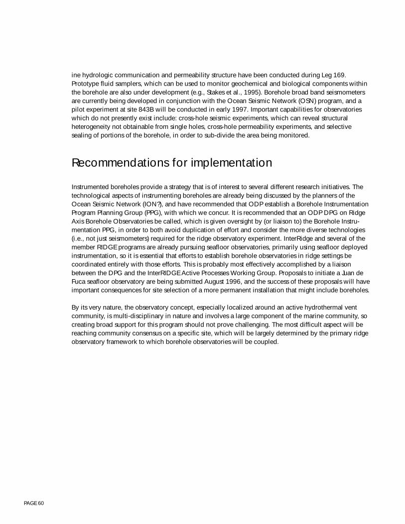
PAGE 60
ine hydrologic communication and permeability structure have been conducted during Leg 169.Prototype fluid samplers, which can be used to monitor geochemical and biological components withinthe borehole are also under development (e.g., Stakes et al., 1995). Borehole broad band seismometersare currently being developed in conjunction with the Ocean Seismic Network (OSN) program, and apilot experiment at site 843B will be conducted in early 1997. Important capabilities for observatorieswhich do not presently exist include: cross-hole seismic experiments, which can reveal structuralheterogeneity not obtainable from single holes, cross-hole permeability experiments, and selectivesealing of portions of the borehole, in order to sub-divide the area being monitored.
Recommendations for implementation
Instrumented boreholes provide a strategy that is of interest to several different research initiatives. Thetechnological aspects of instrumenting boreholes are already being discussed by the planners of theOcean Seismic Network (ION?), and have recommended that ODP establish a Borehole InstrumentationProgram Planning Group (PPG), with which we concur. It is recommended that an ODP DPG on RidgeAxis Borehole Observatories be called, which is given oversight by (or liaison to) the Borehole Instru-mentation PPG, in order to both avoid duplication of effort and consider the more diverse technologies(i.e., not just seismometers) required for the ridge observatory experiment. InterRidge and several of themember RIDGE programs are already pursuing seafloor observatories, primarily using seafloor deployedinstrumentation, so it is essential that efforts to establish borehole observatories in ridge settings becoordinated entirely with those efforts. This is probably most effectively accomplished by a liaisonbetween the DPG and the InterRIDGE Active Processes Working Group. Proposals to initiate a Juan deFuca seafloor observatory are being submitted August 1996, and the success of these proposals will haveimportant consequences for site selection of a more permanent installation that might include boreholes.
By its very nature, the observatory concept, especially localized around an active hydrothermal ventcommunity, is multi-disciplinary in nature and involves a large component of the marine community, socreating broad support for this program should not prove challenging. The most difficult aspect will bereaching community consensus on a specific site, which will be largely determined by the primary ridgeobservatory framework to which borehole observatories will be coupled.

PAGE 61
Section 4.3, Figure 1: Ridge Axis Borehole Observatory Experiment
1
2
3
5
4
~500
m
~500 m
5 holes initially ~500 m deep; at least 1 hole deepened to ~2 km
Vents
Phase III: Stage 1 - drill holes 1, 2, 3 and CORK Stage 2 - drill holes 4 & 5 and CORK
Phase IV: Stage 3 - deepen one hole to ~2 km
PAGE 62
Section 4.3, Figure 2: Rise Flank Observatory Experiment
DIKES
GABBROS
CORK
Boreholes deviatedto Cross Fault
Major FaultControllingFluid Flow
CORK
CORK> 1km
Seal hole
PAGE 63
4.4 - LARGE IGNEOUS PROVINCES WORKING GROUP REPORTCretaceous LIPs: Mantle Overturn and Environmental Consequences
Participants: N. Arndt, C. Büecker, G. Brugmann, P. Castillo, D. Christie, M. Coffin, R. Duncan, O.Eldholm, G. Ito, P. Janney, P. Johnson, P. Kelemen, E. Kikawa, L. Kroenke, H. Lapierre, J. Ludden,J.O’Connor, M. Pringle, W. Sager, D. Weiss, B. WestAdditional comments provided after the meeting by: J. Mahoney, M. Richards, and J. Tarduno.
Executive summary
Large igneous provinces (LIPs) are voluminous emplacements of mafic rock not clearly explained by theplate tectonics paradigm. LIPs provide the strongest evidence that at specific times in the past, energytransfer from the Earth’s interior to its surface has occurred in a manner substantially different frommodern plate tectonics processes. These provinces form the largest expressions of transient basalticvolcanism on Earth, and emplacement rates of the largest provinces may have exceeded the globalintegrated mid-ocean ridge production rate over time periods of roughly a million years. Furthermore,LIPs may have been important contributors to crustal growth and continental stabilization throughoutEarth history.
The Cretaceous period (144-65 Ma) is marked by voluminous and episodic basaltic magmatic eventsgenerated from the mantle, and these events appear to correlate with extreme states or rapid changes inthe oceans, atmosphere and biosphere. These Cretaceous LIPs are associated with high average globaltemperatures; high sea level; punctuated episodes of oceanic anoxia; several mass extinctions; a longnormal magnetic polarity chron; apparently significant relative motion between Atlantic and Pacific hotspot groups; and possible increased rates of seafloor spreading. Although only 180 m.y., or <5% of Earthhistory is recorded in the ocean basins, it is sufficiently long to document a dramatic change in theEarth’s mode of energy transfer from the Cretaceous, dominated by widespread intraplate volcanism andhigh spreading rates, to the Cenozoic, which is characterized by limited intraplate volcanism and lowerspreading rates. Age correlations between LIPs and environmental parameters raise the strong possibilityof solid earth causal mechanisms. Through ocean drilling, we seek to better understand the timing,genesis, and environmental effects of voluminous and episodic mafic magmatism during the Cretaceous,when mantle dynamics and crustal accretion were markedly different from those of the Cenozoic era.
Our specific scientific objectives address fundamental Earth problems. First and foremost, we mustdetermine the chronology of individual LIP emplacements as well as the timing of all LIPs during theentire Cretaceous period. Determination of source composition, melting regime, and melt migration iscritical for understanding asthenospheric and lithospheric geodynamic processes. The tectonic settingand deformational history of LIP emplacement must be defined so that the interaction between LIPs andplate tectonics can be better understood. Finally, the impact of Cretaceous LIP emplacements on thebiosphere, hydrosphere, and atmosphere is potentially significant and should be fully investigated bydrilling proximal and distal sites with detailed sedimentary records.
Approximately twenty oceanic plateaus, volcanic passive margins, and continental flood basalts wereemplaced during Cretaceous time. Two of these LIPs, Ontong Java and Kerguelen plateaus, are giants,each covering an area of ~2 x 10⁶-km2, or approximately one-third the size of the contiguous UnitedStates. To meet our scientific objectives, exploratory drilling and associated geophysical investigations ofthese two features are necessary. In addition, other members of the Cretaceous LIPs family, both olderand younger, must be surveyed and drilled to address key LIP issues. The preferred, focused LIP drilling

PAGE 64
strategy is for one leg on the Kerguelen Plateau/Broken Ridge prior to the end of Phase II; three legs(Ontong Java, an older plateau, and a younger plateau) during Phase III; and one deep (Ontong Java orKerguelen) and two intermediate depth holes during Phase IV.
Implementation of our drilling strategy will be enhanced by formation of a LIP Working Group withinthe ODP system. We advocate that JOIDES closely liaise and consult with the International Associationof Volcanology and Chemistry of the Earth’s Interior (IAVCEI) Commission on Large-Volume BasalticProvinces in forming such a group.
Phases II and III will involve exploratory drilling of Cretaceous LIPs using existing technology aboardJOIDES Resolution. New technology will be needed for the deep and intermediate depth holes requiredin Phase IV. The necessity of appropriate crustal and mantle geophysical surveys on Cretaceous LIPsmust be emphasized; integration of these geophysical data and drilling results is critical to addressingfundamental LIP science objectives.
Scientific rationale
Large igneous provinces (LIPs) are voluminous emplacements of mafic rock not clearly explained by theplate tectonics paradigm. LIPs, comprising oceanic plateaus, volcanic passive margins, and continentalflood basalts (Fig. 1), provide the strongest evidence that at specific times in the past, most obviously theCretaceous, energy transfer from the Earth’s interior to its surface has occurred in a mode substantiallydifferent from present-day processes (Fig. 2). In fact, large igneous pulses may have occurred repeatedlyfrom Archean to Cretaceous time, but much of the evidence for pre-Cretaceous LIPs is either obscuredby collisional tectonics or removed be erosion. LIPs form the largest expressions of transient basalticvolcanism on Earth, and emplacement rates of the largest provinces may have exceeded the global mid-ocean ridge production rate over time periods of roughly a million years. Probable analogs to LIPs areobserved on Venus, Mars, the Moon, and possibly Mercury, and the paucity of evidence for platetectonics on these planetary bodies implies that the Cretaceous mode of abrupt mantle overturn andinternal heat loss on Earth is more common and fundamental throughout the solar system than thesteady-state plate tectonic mode that we observe on Earth today. Despite the global occurrence andimportance of LIPs to the Earth’s dynamics, heat budget, chemical differentiation, and environment (Fig.3), our knowledge of LIPs is rudimentary due to a profound lack of constraining geological and geo-physical data. For example, estimates of such basic LIP parameters as ages, volumes, fluxes, composi-tion, and relationship to plate boundary changes are crude for most provinces and unknown in some.
Today, we investigate upper mantle circulation by studying the mid-ocean ridge system, which accountsfor ~95% of the mass and heat transfer from mantle to crust. During certain intervals of the Cretaceousperiod, however, 50% or more of the mantle mass and heat flux may have occurred via emplacement ofthe ~20 Cretaceous oceanic plateaus, volcanic passive margins, and continental flood basalts (Fig. 1).Therefore, to investigate Cretaceous mantle dynamics, including the state of the mantle before and afterindividual LIP events, we need to examine the spectrum of Cretaceous LIPs. Through exploratorydrilling, the Ocean Drilling Program (ODP) has played a key role in discovering the significance ofoceanic LIPs and in defining outstanding scientific problems. Furthering our understanding of oceanicLIPs critically depends on focused ODP investigations employing both existing and new technologies.We seek to describe and understand the upper crustal to upper mantle magmatic, metamorphic, hydro-
PAGE 65
thermal, and deformational processes related to LIP emplacement, to investigate how LIPs relate todeeper mantle processes and dynamics, and to determine how LIPs affect the environment, includingthe biosphere.
FIRST ORDER SCIENTIFIC PROBLEMS
Four first order problems related to characterization and quantification of mafic igneous crustal produc-tion and its effects during Cretaceous time are addressable by ocean drilling. The first problem is toestablish a chronology of LIP magmatism between 144 and 65 Ma; the second is to constrain sourcecompositions, melting systematics, and movement of melt; the third is to identify relationships betweenLIP formation and tectonic processes; and the fourth is to determine the effects of LIP formation on theenvironment, including the biosphere, hydrosphere, and atmosphere.
1) Chronology of LIP magmatism.
A fundamental distinction between Cretaceous LIPs and modern hot spot volcanism is the rate ofmelt production. Limited basement samples yield narrow age ranges for individual LIPs and somebimodal age distributions, suggesting catastrophic or episodic volcanic events with magma fluxessignificantly greater than those at modern hot spots. In addition, existing age data suggest that manyconstructional episodes of different LIPs occurred contemporaneously, which results in an apparentepisodicity of the global magmatic flux in Cretaceous time. Thus, the primary objectives are to:
a) Quantify volumes and duration of individual magmatic events as well as time-averaged fluxes overthe entire period of formation. Did individual LIPs form catastrophically by single massive events,episodically by two or more large events, or continuously by many small events? Such results willallow testing of existing hypotheses of LIP formation. One such hypothesis is that LIPs may haveformed by rapid surfacing of plume heads, which resulted in massive flood basalt volcanism. Avariant, which may explain episodic construction, is a double plume head scenario in which theinitial plume head breaks into two separate heads as it ascends through the viscosity discontinuitybetween the lower and upper mantle. Another model for episodic volcanism involves initial meltingof material from just below the 670-km discontinuity, ascent of material to the mantle solidus causedby mantle avalanches from beneath subduction zones, followed by plume volcanism originating atthe core-mantle boundary driven by rapidly sinking slabs. Yet a third hypothesis is that these giantedifices formed relatively continuously by long-lived plume-ridge interactions, such as the modernIceland-Mid-Atlantic Ridge system. Acquisition of spatially distributed drilling samples in a LIP isrequired to determine the age range of plateau emplacement. Age information combined withgeophysical—seismic reflection, seismic refraction, and gravity—constraints on magma volume, isvital to test these hypotheses and to formulate new interpretations. Furthermore, observations ofphysical volcanology, such as flow thicknesses and directions, morphology, vesicle distribution, andpresence and nature of interbeds, can provide information about the distribution of melt conduits andfluxes.
b) Establish temporal relationships among different Cretaceous LIPs. What is the relative timing offormation of different LIPs, and how might this reflect dynamic processes in the mantle? Are theresimultaneities among emplacements of LIPs, or episodicities? Do LIPs reflect the ‘pulse’ of the deepmantle?
PAGE 66
c) Quantify LIP contributions to the global magmatic flux throughout the Cretaceous period. To under-stand geodynamic mantle processes in the Cretaceous, we must determine relationships betweenmagmatic flux and other global processes such as changes in patterns of plate subduction, platevelocities, MORB compositions (e.g., appearance of Dupal anomaly), true polar wander, motionbetween Atlantic and Pacific hot spot groups, and magnetic reversal frequencies.
2) Source composition, melting regime, and melt migration.
Massive decompressional melting of mantle, whether initiated by plumes originating at boundarylayers within the Earth, by lithospheric plate separation, or from extraterrestrial impacts, is required tomake LIPs. Important, but poorly known aspects of LIP formation include the thermal regime, historyof melt production and migration, the relative contributions of various mantle sources, and relatedhydrothermal metamorphism. Horizontal and vertical sampling of LIP stratigraphy will providerequisite compositional data to:
a) Determine compositional ranges of LIP extrusive and intrusive rocks. This information can be in-verted to estimate composition, extent of partial melting, temperature, and pressure of theasthenospheric source and lithosphere, as well as magma migration mechanisms and plumbingsystems. Because parental magmas of basalts in various models originate at different mantle depthsand follow different time-temperature paths, petrological and geochemical studies of basalts andintrusive rocks, combined with estimates of magma production rates, will provide insight into thecauses of anomalous melting. It is important to sample both extrusive and intrusive LIP rocks to fullyassess melt generation, accumulation, fractionation, migration, and evolution histories, throughwhich the thermodynamic, compositional, and metamorphic development of lithosphere-asthenos-phere interactions can be constrained.
b) Determine spatial distributions of compositions and compositional gradients. Such systematics mayreflect the size of the melting region, source mixing processes, and temporal variability of melts.Because LIPs probably contaminate the MORB reservoir, compositional studies should eventuallyyield a time scale for mixing in the upper mantle.
3) Relationships between LIPs and tectonics.
LIPs are emplaced in tectonic environments ranging from purely extensional to intraplate. Somecontroversy exists as to whether changes in plate motion, especially continental breakup, are thecause of most LIPs, or whether LIPs are a major influence on plate motions changes. The temporalrelationship between LIP emplacement and plate boundary changes is critical but unclear, especiallyfor the two giant Cretaceous LIPs, Ontong Java and Kerguelen (Fig. 4). In some instances, CretaceousLIPs (e.g., Shatsky, Paraná/Etendeka) are close in age to adjacent oceanic crust, implying that LIPformation, seafloor spreading, and continental breakup might be related in some way, which isclearly the case with volcanic margins. Some LIPs (e.g., Manihiki, Kerguelen) are extensively de-formed by normal faults, suggesting that post-emplacement tectonics may be important in shapingmorphology. Currently at least one oceanic plateau (Ontong Java) is being obducted to form part ofan island arc, and two others (Caribbean and Wrangellia) form accreted terranes in mountain belts.Many continental nuclei are Archean greenstone belts, which have been proposed to beunsubducted oceanic plateaus. Knowledge of the composition, density structure, and hence buoy-ancy of LIPs, to be gained in significant part through ODP, will further our understanding of the role
PAGE 67
of LIPs in continental growth and also in the generation of much of the Earth’s mineral wealth. Todetermine relationships between LIP formation and tectonics during and subsequent to emplacement,we must:
a) Determine stratigraphic and structural relationships between LIPs and adjacent oceanic crust, andwithin individual LIPs. Combined seismic and litho-stratigraphy can reveal temporal and spatialpatterns of LIP emplacement in a regional tectonic framework, as well as test for synchronous orasynchronous post-emplacement tectonism of the LIP and adjacent ocean basin(s). Stratigraphic andstructural analyses within individual LIPs have the potential to reveal relationships between tectonicevents and magmatic episodes.
b) Establish spatial, temporal, and compositional relationships between LIP magmatism and magmatismat spreading ridges. What are the relationships between the formation of LIPs and changes in plateboundary geometry, seafloor spreading rates, plate motion, and oceanic crustal compositions? Suchplate boundaries include continental rifts, mid-ocean spreading centers, triple junctions, and trans-form boundaries.
c) Determine vertical and horizontal tectonic histories. Such information, recorded in overlying sedi-ments and in the physical volcanology (whether submarine or subaerial), reflect mantle upwelling,crustal thinning, lithospheric thermal histories, crustal growth histories, and post-emplacementsubsidence and faulting. Uplift histories can constrain LIP emplacement models. Some LIPs (e.g.,Kerguelen, East Greenland) have subsided similarly to cooling oceanic lithosphere or rifted lithos-phere, whereas others (e.g., Ontong Java, Caribbean) have not. Is LIP lithosphere thermally rejuve-nated by post-primary magmatism? Are the boundaries of LIPs zones of lithospheric weakness thatcan be readily reactivated by changing stress patterns in the ocean basins?
4) Environmental impact: biosphere, hydrosphere, and atmosphere.
Cretaceous oceans were characterized by global variations in ocean chemistry, relatively hightemperatures, high relative sea level, episodic deposition of black shales, high production of hydro-carbons, and mass extinctions of marine organisms. Intense pulses of igneous activity associated withtransient LIP emplacement affect the physical and chemical character of the mantle, oceans, andatmosphere to an undetermined extent, and may have significant effects on the biosphere. Tentativetemporal correlations of Cretaceous pulses and rates of LIP formation with major environmentalchanges require further analysis to define linkages and causes. Ocean drilling will help to evaluatepotential causal relationships between LIP formation and environmental events by addressing thefollowing problems:
a) Effects on the hydrosphere and atmosphere. Submarine and subaerial volcanism have substantiallydifferent effects on the Earth’s environment, yet the emplacement environments for many CretaceousLIPs are unknown. Once drilling and geophysical results establish submarine/subaerial volcanicratios for individual LIPs and volatile contents for lavas are determined, fluxes of volatiles, particu-lates, and heat from LIPs into the atmosphere-hydrosphere-biosphere system can be estimated andtheir environmental impact can be assessed. Ocean drilling is critical for determining precise tempo-ral relationships between LIP emplacements and changes in environmental parameters (e.g., 87Sr/86Srin sea water, black shale ‘events’, mass extinctions, sea level), and for providing insight into possiblethreshold levels for the LIP ‘impacts’.
PAGE 68
b) The role of hydrothermal and metamorphic processes. What are the chemical fluxes, depths, spatialdistribution, geometry, and alteration processes of hydrothermal circulation and metamorphism atLIPs? The thermal and permeability structure of old oceanic and transitional crust invaded by LIP heatsources likely differs from mid-ocean ridges. Therefore, the products and consequences of hydrother-mal activity and metamorphism in this setting may differ significantly from the spreading ridgeenvironment. Gradients in trace metals resulting from hydrothermal activity may “fingerprint” eachLIP and enable precise correlation with global oceanic anoxic events.
A drilling strategy for oceanic LIPs
LIPs are enormous igneous constructions that present considerable challenges for adequate sampling toaddress our first order questions. Our knowledge of these features is rudimentary, similar, perhaps, tothat of mid-ocean ridges prior to general acceptance of the plate tectonics paradigm in the late 1960s.Considerable shallow basement drilling as well as significant geophysical surveying are necessary tobegin to address issues of Cretaceous mantle dynamics and environmental consequences. At somefuture time, deep (>2000 m) drilling on LIPs will be vital for elucidating the density structure andcomposition of middle to lower crust beneath LIPs. The LIP drilling strategy described below representsa refinement and further evolution of thought from strategies previously outlined by Coffin & Eldholm(1991); JOIDES Lithosphere Panel (1994); ODP Long-Range Plan (1996); Intraplate Marine Geoscience:Hot LIPs and Cracked Plates (1996).
Understanding the complete temporal and compositional history of features of this scale will require avariety of approaches in several opportune locations. In Figure 3 we have summarized these samplingapproaches. Seismic imaging of oceanic LIPs has revealed several common features: crustal thicknessvaries from that of normal oceanic lithosphere to greater than five times that in extreme cases. Volcanicsections, commonly lying beneath sediments several 100s to 1000s of meter thick, range from a fewkilometers to possibly 10-km thick. Lava flow sequences commonly exhibit a strong fabric of dippingreflectors in seismic profiles, indicating a temporal sequence related to eruption location and magmasupply. Internal reflectors and velocity structure indicate the presence of thick sections of higher densitymaterial, probably mafic sill complexes, cumulate layers, and ultramafic bodies.
A significant sampling of the total igneous stratigraphy using current drilling capabilities can be obtainedby a combination of several strategies:
1) Transects of shallow (~200 m) basement holes across the surface of the LIP over crust of varyingthickness, i.e., from feather-edge to LIP center, guided by temporal relations indicated in dipping reflec-tor sequences.2) Offset drilling in tectonic windows that expose deep levels of the LIP otherwise inaccessible. Thesesites occur at tectonized margins or interiors of many LIPs and must be well-characterized by geophysi-cal and submersible surveying and surface sampling.3) On-land sections of obducted portions of LIPs or of autochthonous LIPs along volcanic passive
PAGE 69
margins provide opportunities for detailed sampling of parts of the stratigraphy. In most instances,however, it is difficult to relate these tectonized sections to the intact (submarine) portions of the LIP bygeophysical methods.4) Reference holes address three important components of our LIP sampling strategy: (1) Samples areneeded to establish the age and composition of the older plate on which some or all of the LIP is built,in order to properly assess the effects of lithospheric contamination on the LIP compositions, to evaluatepre-LIP asthenospheric mantle compositions, and to model uplift and subsidence of the LIP. (2) Thesedimentary section on older adjacent crust records the near field environmental impact of the LIPemplacement. (3) debris shed from the LIP during construction accumulates in sedimentary aprons onthe old plate, providing a means of establishing the volcanic history.5) Holes of opportunity involve penetrating basement to bit destruction whenever any ODP hole iswithin reach of basement on any LIP. Basement samples from such holes will provide age and composi-tional data for the LIP, data which do not exist for the overwhelming majority of submarine LIPs.
To assess the range of environmental responses to LIP formation, we require sampling of the hydrother-mal fields and metamorphic zones to determine fluid compositions from alteration effects, and timingand scale of discrete events. Effects can also be observed in high resolution sedimentary sections drilledin the near- and far-field, e.g., on topographic highs such as older plateaus or seamounts.
All basement drill holes in LIPs should be logged. In cases of poor core recovery or loss, only downhilllogging can provide critical information on physical and chemical properties of formations penetratedby the borehole. Furthermore, the state of stress, and dynamic parameters such as permeability, tempera-ture, and pressure can be determined from spatially discrete data acquired by down hole tools.
It must be emphasized that no one LIP can address every major scientific LIP issue. A family of LIPs,therefore, must be investigated. The two most voluminous LIPs known, the Ontong Java and Kerguelenplateaus, are both Cretaceous in age. It is of the highest scientific priority to first investigate these twoprovinces, which may provide both the strongest insights into Cretaceous mantle dynamics and into theenvironmental impact of LIP formation. We also strongly advocate drilling one Cretaceous LIP older thanthe two giant plateaus, and one Cretaceous LIP younger than the two giants. The older LIP will enableassessment of Early Cretaceous LIP basalt compositions and eruption rates prior to the largest basalticvolcanism episodes, as well as provide a sedimentary record of environmental changes prior to, during,and subsequent to the formation for the giant plateaus. The younger LIP will provide important informa-tion on massive basaltic volcanism occurring in many locations throughout the world between 85 and90 Ma.
Our recommended specific strategy for Phases II, III, and IV of the Ocean Drilling Program, consistentwith Table 1, is:Phase II - one leg on Kerguelen Plateau, including one site on Broken RidgePhase III - three legs: one on Ontong Java Plateau, one on an older plateau (e.g., Shatsky); one on ayounger plateau (e.g., Caribbean)Phase IV - two intermediate (1000 to 2000-m into basement) holes; one deep (>2000-m into basement)hole on one of two giant LIPs
PAGE 70
Implementation
WORKING GROUPS
We recommend that a “Large Igneous Provinces” Program Planning Group be constituted to provideadvice within the Ocean Drilling Program planning structure on issues related to scientific ocean drillingof large-volume basaltic provinces. Such a PPG would ideally consist of ~15 members drawn fromappropriate disciplines, including, but not necessarily limited to volcanology, geochronology, petrology,geochemistry, geophysics, geodynamics, oceanography, paleontology, paleomagnetism, planetology,and climatology. The LIP PPG would include proponents from all active LIP proposals in the JOIDESsystem.
COORDINATION WITH GLOBAL INITIATIVES
In 1992, the International Association of Volcanology and Chemistry of the Earth’s Interior (IAVCEI)initiated the Commission on Large-Volume Basaltic Provinces. IAVCEI is a member of the InternationalUnion of Geodesy and Geophysics (IUGG), which in turn is part of the International Council of Scien-tific Unions (ICSU). The Commission on Large-Volume Basaltic Province’s main missions are to encour-age and promote interest in and research on large-volume basaltic provinces; to foster interchange ofideas and relevant data among earth scientists; and to maintain and distribute up-to-date bibliographicdata bases and compendia of active research projects. Since the Commission’s founding, it has grown toinclude ~500 members from five continents. The commission’s activities are guided by a steeringcommittee consisting of ~20 members.
Given the broad expertise, widespread community involvement, and international composition ofIAVCEI’s Commission on Large-Volume Basaltic Provinces, we recommend that the Ocean DrillingProgram consult closely with the Commission in filling membership on a JOIDES “Large Igneous Prov-inces” working group.
Technological requirements
Previous drilling of volcanic margin LIPs has proven the feasibility of drilling thick volcanic sequenceswith reasonably good core recovery (legs 104, 152, 163). In fact, the JOIDES Resolution’s full capabili-ties for LIP basement penetration have not yet been tested, because drilling ceased at the two deepestvolcanic margin basement sites (642 @ 914 m; 917 @ 779 m) due to time limitations and achievementof objectives, and not to technical difficulties or technological limitations. Furthermore, it has beenshown that integration of core and log data allows the construction of a complete, detailed lava stratig-raphy.
PAGE 71
The exploratory phase of shallow (≤200 m) basement LIP drilling during Phase II and Phase III (1998-2003) does not require new technologies or platforms. It is expected that knowledge gained duringPhase III, however, will provide essential information for identifying sites for deep drill holes in Phase IVand beyond. New drilling technologies will be needed to penetrate deeply into LIPs to recover completestratigraphic sections through oceanic LIPs. These drill holes will allow recovery of both the extrusiveand intrusive igneous layers of LIPs,, thus, constraining temporal, compositional, structural, and meta-morphic evolution of emplacement.
The recent recognition of the importance of LIPs in earth history has not yet developed into many ODPproposals. Of approximately 20 Cretaceous LIPs, mature proposals for four have been submitted as ofJune 1996, and one of the two critical LIPs, the Ontong Java Plateau, lacks necessary site survey data.The possibility of LIP drilling becoming a significant component of ODP Phases III-IV should be madeknown to the scientific community in the form of soliciting Phase III proposals.
With the exception of some volcanic margins, most LIPs are currently poorly surveyed by geophysicaltechniques. It is therefore of utmost importance that additional geophysical surveys be undertaken. Inparticular, there is need for geophysical exploration of the giant Ontong Java Plateau, where drillingrequires new regional studies followed by detailed site surveying. We urge ODP member nations tosupport surveying of this kind.
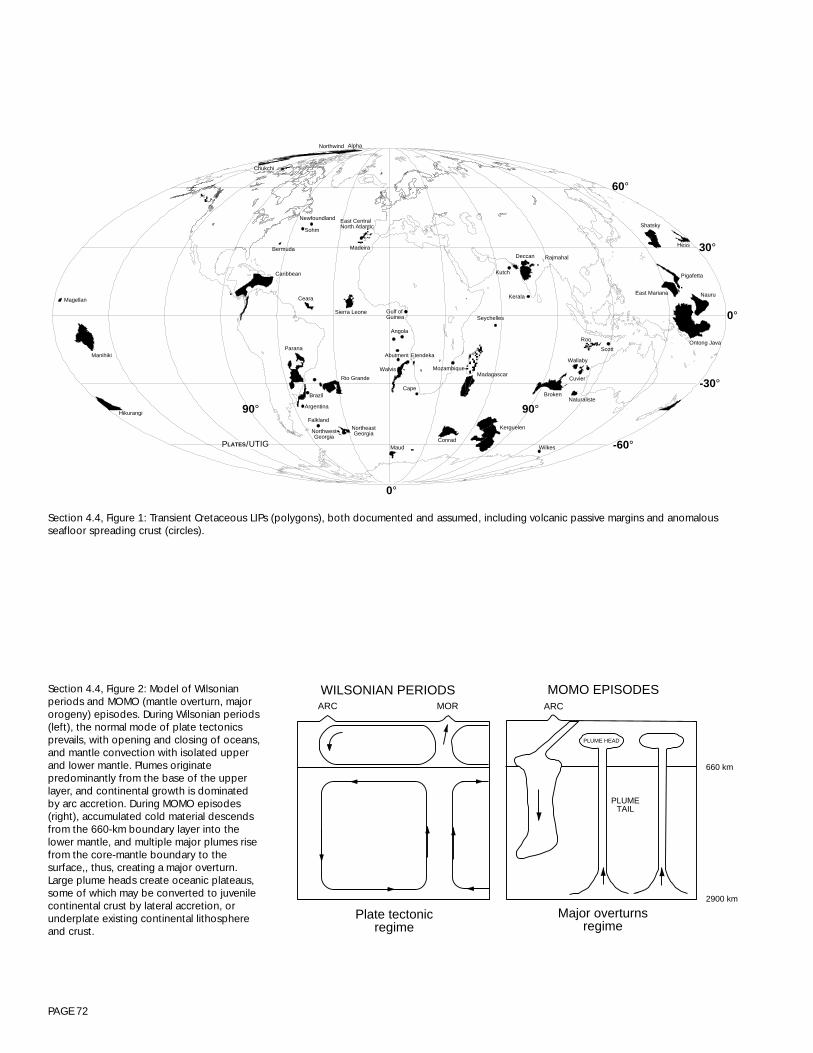
PAGE 72
WILSONIAN PERIODSARC MOR
Plate tectonicregime
PLUME HEAD
MOMO EPISODESARC
PLUMETAIL
Major overturnsregime
2900 km
660 km
Ceara
Caribbean
Bermuda
Sohm
Chukchi
Newfoundland
ManihikiParana
90°
Madeira
East CentralNorth Atlantic
Kerala
Kutch
Deccan Rajmahal
AlphaNorthwind
Rio Grande
Sierra Leone
NorthwestGeorgia
NortheastGeorgia
Maud
Walvis
Gulf ofGuinea
Conrad
Angola
Kerguelen
Abutment
Cape
Falkland
Argentina
Brazil
Etendeka
BrokenNaturaliste
Wilkes
90°
Seychelles
Wallaby
MadagascarMozambique
Cuvier
Roo
Scott
Hess
Shatsky
Ontong Java
Nauru
Pigafetta
East MarianaMagellan
0°
-60°
-30°
0°
30°
60°
Hikurangi
P /LATES UTIG
Section 4.4, Figure 1: Transient Cretaceous LIPs (polygons), both documented and assumed, including volcanic passive margins and anomalousseafloor spreading crust (circles).
Section 4.4, Figure 2: Model of Wilsonianperiods and MOMO (mantle overturn, majororogeny) episodes. During Wilsonian periods(left), the normal mode of plate tectonicsprevails, with opening and closing of oceans,and mantle convection with isolated upperand lower mantle. Plumes originatepredominantly from the base of the upperlayer, and continental growth is dominatedby arc accretion. During MOMO episodes(right), accumulated cold material descendsfrom the 660-km boundary layer into thelower mantle, and multiple major plumes risefrom the core-mantle boundary to thesurface,, thus, creating a major overturn.Large plume heads create oceanic plateaus,some of which may be converted to juvenilecontinental crust by lateral accretion, orunderplate existing continental lithosphereand crust.
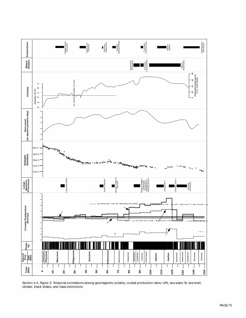
PAGE 73
Section 4.4, Figure 3: Temporal correlations among geomagnetic polarity, crustal production rates, LIPs, sea water Sr, sea level,climate, black shales, and mass extinctions.
15
0
14
00
20 50
60
70
80
90
10
0
11
0
12
0
13
0
10
30 40
Ple
isto
ce
ne
Plio
ce
ne
Mio
ce
ne
Eo
ce
ne
Ma
astr
ich
tia
n
Ca
mp
an
ian
Sa
nto
nia
n
Co
nia
cia
n
Tu
ron
ian
Ce
no
ma
nia
n
Alb
ian
Ba
rre
mia
n
Ha
ute
rivia
n
Va
lan
gin
ian
Ap
tia
n
Tith
on
ian
Be
rria
sia
n
Pa
leo
ce
ne
No
rth
Atla
ntic
La
rge
Ign
eo
us
Pro
vin
ce
s
Ke
rgu
ele
n I
Onto
ng J
ava I
Pa
ran
á,
Ete
nd
eka
Sa
nto
nia
n-
Co
nia
nia
n
Tu
ron
ian
-C
en
om
an
ian
Alb
ian
-B
arr
em
ian
Bla
ck
Sh
ale
s
43
21
0-1
ice s
heets
possib
le ice-f
ree
51
01
52
02
5
Pa
leo
tem
pe
ratu
re(°
C,
ice f
ree)
Se
a L
eve
l(m
above p
resent-
day)
Extin
ctio
ns
Mid
dle
-Ea
rly
Mio
ce
ne
Olig
oce
ne
-E
oce
ne
Eo
ce
ne
-P
ale
oce
ne
Da
nia
n-
Ma
astr
ich
tia
n
Tu
ron
ian
-C
en
om
an
ian
Alb
ian
-A
ptia
n
Va
lan
gin
ian
-B
err
iasia
n
Atla
ntic δ
18O
Clim
ate
0
Tim
e(M
a)
Ep
och
(Cz)
Po
lar-
ity
Olig
oce
ne
Ag
e(M
z)
WORLD TOTALBASELEVEL
WORLD TOTALEPT TETHYS)
OCEAN RIDGESBASELEVEL
RIDGES HYS)
S &
Cru
sta
l P
rod
uctio
n(k
m3/y
r)
Bro
ken R
idge I
,C
ari
bb
ea
n,
Ke
rgu
ele
n,
Ma
da
ga
sca
r,O
nto
ng J
ava I
I
Bro
ken R
idge I
I,D
ecca
n
Co
lum
bia
Riv
er
0.7090
0.7085
0.7080
0.7070
0.7075Sea
wat
erS
tron
tium
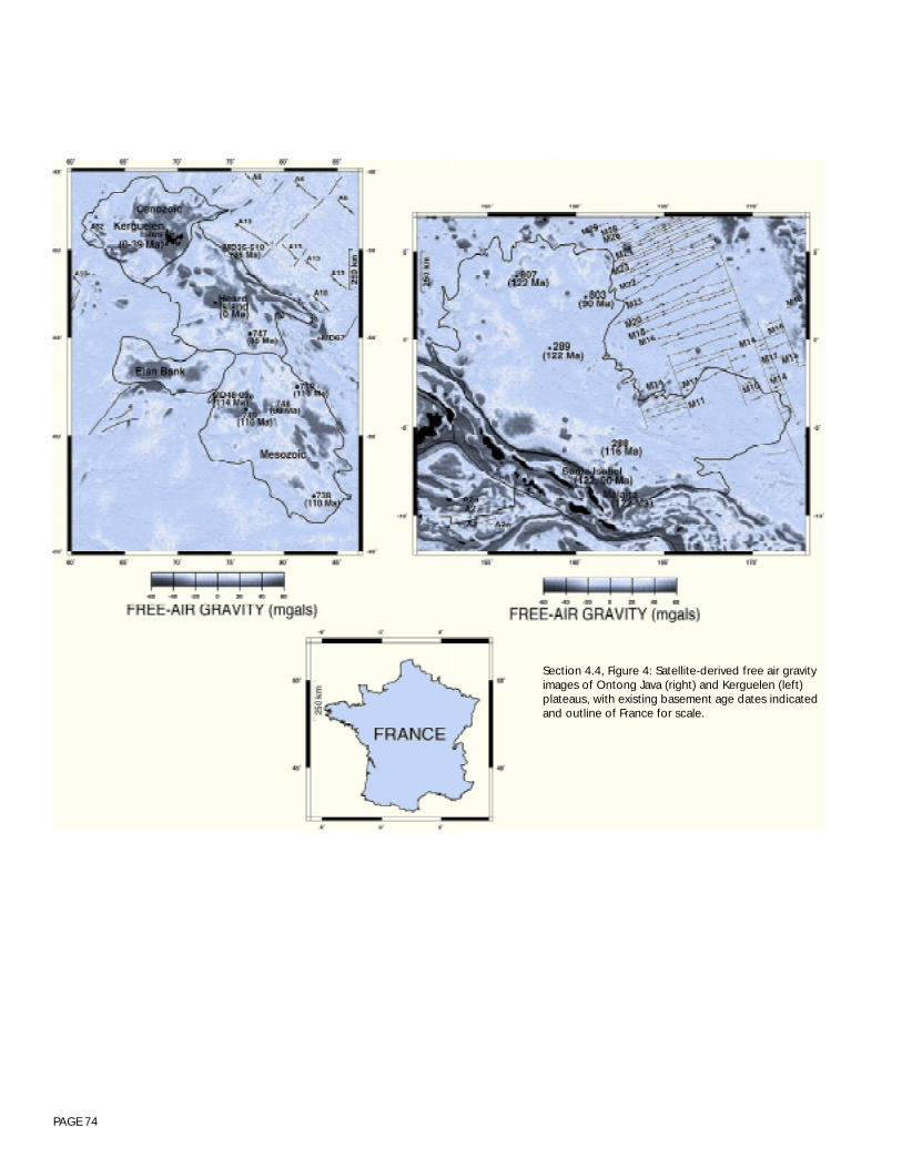
PAGE 74
Section 4.4, Figure 4: Satellite-derived free air gravityimages of Ontong Java (right) and Kerguelen (left)plateaus, with existing basement age dates indicatedand outline of France for scale.
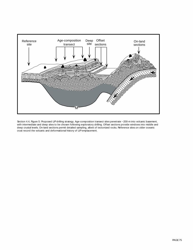
PAGE 75
Section 4.4, Figure 5: Proposed LIP drilling strategy. Age-composition transect sites penetrate ~200-m into volcanic basement,with intermediate and deep sites to be chosen following exploratory drilling. Offset sections provide windows into middle anddeep crustal levels. On-land sections permit detailed sampling, albeit of tectonized rocks. Reference sites on older oceaniccrust record the volcanic and deformational history of LIP emplacement.
M
On-landsections
Offsetsections
Age-compositiontransect
Referencesite
Deepsite

PAGE 76
Participants: Dick Arculus (WG chair), Pamela Kempton (Steering Committee rep), Yildrem Dilek, TimFrancis, Brent McInnes, Hazel Prichard, Kensaku Tamaki, Brian Taylo and Rob Zierenberg.
Introduction
Subduction of oceanic lithosphere plays a fundamental part in global plate tectonic and mantle convec-tion cycles. It is arguably the primary contributor to the global chemical flux between the lithosphereand mantle, and is the principal means by which lithospheric and entrained exospheric material is(re)cycled into the mantle. Long-term, global chemical differentiation of the Earth occurs at convergentmargins through several mechanisms including material that fails to subduct and is accreted to orsubcreted beneath the fore-arc, and/or a combination of fluid/melt transfer from subducted lithospherethat triggers melting in the overlying asthenosphere and lithosphere. All of these processes ultimatelycontribute to the growth of continents. This is a first order and continuing process within the Earth,equivalent in terms of cumulative chemical impact with the formation of the core some ~ 4.5 Ga ago.
In spite of the tremendous progress made from studies of convergent margins over the past 40 years,including major contributions from the DSDP and ODP (for a review, see Taylor and Natland, 1995),fundamental first order problems remain that are particularly relevant to lithospheric formation. Forexample, how is subduction initiated and how do island arcs originate and evolve? What is the relation-ship between suprasubduction zone environments and ophiolites? What are the mantle dynamicsassociated with the transition from rifting to true ocean spreading in the back-arc environment? Whatprocesses operating in active convergent margins contribute to, or provide appropriate environments for,concentrating metals in massive sulfide deposits, particularly those which may be analogues for some ofthe larger, economically significant world-class precious and base metal deposits?
The breadth of these problems encompasses more than the interests of the oceanic lithosphere commu-nity. Indeed, the interests of the working group on “Evolution of Oceanic Lithosphere at ConvergentMargins” lie at the interface between the oceanic lithosphere and the continental margins communities.The Long Range Plan of the ODP identifies the understanding of global geochemical recycling as one ofthe major tasks ahead, and resolution of these issues requires a range of studies at convergent margins,including spatial and secular geochemical evolution of arc systems and the determination of fluxes ataccretionary/non accretionary prisms. There are also clear overlaps of interest between these variousgroups of scientists and those currently involved in the planning and execution of studies in back-arcbasins through InterRidge.
As an immediate priority, we recommend that the ODP planning structure establish a Program PlanningGroup on Active Convergent Margins to develop and coordinate the drilling plans of these differentgroups. In the interim, our conclusions are focused on drilling goals that are most directly relevant to theoceanic lithosphere community, and of broad significance to the wider geosciences. These goals are:1. Testing the ophiolite model, and2. Understanding hydrothermal processes and formation of ore deposits.
4.5 - CONVERGENT MARGINS WORKING GROUP REPORTEvolution of Oceanic Lithosphere at Convergent Margins
PAGE 77
Testing the ophiolite model
SCIENTIFIC RATIONALE
The sheeted dikes in ophiolites and the abundant structural evidence for synmagmatic normal faultingprovide compelling arguments for their formation by seafloor spreading. Hence, ophiolites are typicallyassumed to reflect the structure and stratigraphy of oceanic crust formed at mid-ocean ridges. However,it has been known for a number of years that several of the large, relatively intact Tethyan ophiolitessuch as the Troodos in Cyprus or the Semail in Oman differ in significant respects from the mafic crustformed at mid-oceanic spreading centers. In particular, systematics of the geochemistry of the magmasthat formed these ophiolites clearly requires that the parental melts were generated above a subductionzone. This recognition has demanded a radical reappraisal of the use of the majority of the world’sophiolites as direct analogues for oceanic lithosphere formed by spreading at mid-ocean ridges. Unfor-tunately, this reappraisal has apparently not permeated far into the general geoscience community.
Appropriate modern analogues for supra-subduction zone ophiolites have been difficult to find, espe-cially as their subsurface characteristics are only accessible through drilling. Back-arc basins haveprovided the most appealing analog, but ophiolites rarely have an associated remnant or active arc, norare they covered by volcaniclastic sediments shed from those arcs, as is the case for most crust formedin a back-arc basin. Efforts by the DSDP and ODP at the convergent margins of the western Pacific haveidentified clear alternatives.
We now know from numerous land- and marine-based studies of convergent margins that a range ofprocesses - including rifting, seafloor spreading, under-, intra- and over-plating - contribute to lithos-pheric growth in zones of tectonic plate convergence. Deep ocean drilling of the Izu-Bonin-Marianasystem, for example, has shown that the nascent stages of growth from ~ 48 to 35 Ma were accompa-nied by major suprasubduction zone extension and formation of new lithosphere with a surface areacomprising some ~ 3000-km strike length by ~ 300-km across-strike width (see Taylor, 1992). The rocktypes characterizing this early extensive phase were boninite and low-K tholeiitic rocks (Pearce et al.,1992) and fractionated derivatives. Subsequent restriction and apparent focusing of magma supply to anarrow outlet termed the ‘volcanic front’ in the Izu-Bonin-Mariana system represents a transition fromseafloor spreading to a different style of lithospheric growth, clearly involving over- and intraplating.Underplating of mafic materials and selective removal during advective erosion by the asthenosphericmantle wedge of both mafic and ultramafic complements of erupted, fractionated magmas is alsoprobable, but not demonstrated. The underlying tectonomagmatic controls governing the transition fromthe early, seafloor spreading to the ‘mature’ mode of lithospheric growth at convergent margins are notclearly understood and desperately need further study, including new drilling initiatives.
One of the prominent successes of ODP drilling in the Izu-Bonin-Mariana system was the intersection atSite 786B in the Bonin fore-arc (Fig. 1) of ~ 700-m of volcaniclastic rocks, pillow lavas, and dikesoverlying a sheeted dike complex dominated by boninite and tholeiitic rock series (Fig. 2). This recoverywas achieved within 14 days of single rotary cone bit drilling. A number of studies (see Fryer, Pearce,Stokking et al., 1992, for summaries) have documented the tectonic and structural history (includingsubsidence) of this site, and the petrogenesis of the rock suites, documenting the close parallels withmajor ophiolite bodies. Subsequently, Alt et al. (1996) have also demonstrated a close analogy of stableisotopic systematics (O and S) and alteration style at Hole 786B with those characteristic of the Cyprusand Oman ophiolites. Confirmation of the equivalence of the supra-subduction sequence recovered at

PAGE 78
Hole 786B with ophiolites representing a significant fraction of the continental lithosphere is of majorinterest to a wide geoscience audience.
POSSIBLE GOALS
One possible location for testing the ophiolite model is a return to Site 786 to attempt recovery of adeeper section of crust from the sheeted dike complex, and penetration of the dike feeder zone to themafic and ultramafic crustal units of layer 3, representing plutonic equivalents of the volcanic andhypabyssal rocks. The composition and petrogenesis of the units, alteration style and mineralogy, andphysical properties of recovered rocks - accompanied by a comprehensive, down-hole logging program- can be correlated to at least the shallower components of the remarkably detailed crustal velocitystructure obtained across the Bonin arc at the latitude of Hole 786B (e.g., Suyehiro et al., 1996). Theimportance of this is that it would contribute some ‘ground-truth’ for geophysical models of lithosphericarchitecture. The thermobarometric and compositional evolution of magma sources in the upper mantlecan be inferred by inversion of the geochemical characteristics of the rock units. Direct comparison ofthis modeling with the variety of upper mantle-derived, ultramafic rocks recovered by the ODP throughdrilling of neighboring serpentinite extrusions (e.g., Site 784) trenchward of Hole 786B will constrainmelt generation and migration processes in this environment. Of further specific interest, and of rel-evance to the growth of continental crust, are the specifics of platinum-group element chemistry and Re-Os systematics in these sequences.
DRILLING STRATEGY
Of primary importance is penetration to a depth of at least 2-km proximal to the existing Hole 786. Thishole lacks a reentry cone, but of course has all relevant surveys from previous efforts and so drillingshould be feasible with currently available technology within Phase III of the Program. A reentry coneshould be emplaced for potential deepening of the Site during Phase IV.
Understanding hydrothermal processes
SCIENTIFIC RATIONALE
ODP has made important contributions to our understanding of the genesis of metallic ore depositsthrough drilling of active hydrothermal systems on seafloor spreading centers. Leg 139 drilled sediment-hosted hydrothermal systems on the Juan de Fuca Ridge in Middle Valley and demonstrated the capabil-ity of the Resolution to drill in formations at temperatures approaching 300°C. Penetration of 95-m ofmassive sulfide mineralization conclusively demonstrated that some seafloor deposits have developedon the scale of economically exploitable on-land ore deposits. Drilling of the TAG hydrothermal depositon the Mid Atlantic Ridge on Leg 158 significantly advanced our understanding of the complex pro-cesses responsible for the compositional heterogeneity of hydrothermal deposits. Recrystallization,brecciation, and fluid mixing due to subsurface entrainment of cold sea water into the hydrothermalsystem contribute to the formation and evolution of the TAG deposit. This leg also provided the firstsignificant penetration into the high-temperature alteration zone underlying an active massive sulfidedeposit. Drilling established that the TAG deposit is similar in tonnage and grade to ophiolite hosteddeposits that have been economically exploited in Cyprus and Oman (Hannington et al., in press;Figure 3a).
PAGE 79
The processes controlling hydrothermal mineralization at ocean ridge spreading centers are applicableto “Cyprus-type” massive sulfide deposits that are developed in the extrusive section of ophiolites.However, as important as the past contributions have been to investigating seafloor sulfide deposits onspreading centers (and by analogy ophiolite-hosted massive sulfide deposits), there are exciting newopportunities for ODP to contribute to the investigation of the genesis of metallic mineral deposits in avariety of tectonic environments, many of which are analogous to mineral deposits of considerablygreater economic importance than ophiolite-hosted deposits. Ophiolite-hosted massive sulfide depositsshow a limited compositional range and have been exploited primarily for their copper, and to a lesserextent, zinc contents. Low concentrations of other economically important metals, including Pb, Ag andAu, are a reflection of the low concentration of these elements in the basaltic source rocks. Ophiolite-hosted deposits also tend to have relatively low tonnages and grades relative to other types of massivesulfide deposits (Figure 3b). Therefore, although ridge-crest hydrothermal systems and ophiolite-hostedmassive sulfide deposits are important natural laboratories for investigating some of the process leadingto ore-deposit formation, these deposits are not significant contributors to the resource base and are ofless interest to the economic geology community than other types of massive sulfide deposits.
Throughout the geologic record, volcanic-arc-related hydrothermal deposits are more abundant and aresignificantly larger and higher grade than ophiolite-hosted deposits (Figure 3). Volcanogenic massivesulfides appear to have formed in a variety of tectonic setting, but initial stages of rifting of either conti-nental or island arc crust appears to be a productive environment for the formation of large ore deposits.volcanogenic massive sulfides deposits are hosted by a variety of rock types ranging from mafic to felsicvolcanics and associated syn-volcanic sedimentary and volcaniclastic rocks. Subvolcanic intrusive areimportant local heat sources in sustaining long-lived hydrothermal systems capable of forming largemetal deposits. The diversity of potential source rocks in arc-related environments is reflected in themetal content of the associated hydrothermal deposits, especially in the abundance of minor elementsthat are concentrated in more evolved igneous rocks. Noranda-type and especially Kuroko-typevolcanogenic massive sulfides deposits tend to have higher Cu-Zn grades than ophiolite-hostedvolcanogenic massive sulfides deposits and some contain significant resources of Pb, Ag, Au, Sb andother metals. Although back-arc basins make up less than 10% of the world’s ridge system, hydrother-mal processes in this environment are not insignificant with respect to the surface environment of theEarth. As noted in the InterRidge workshop report on Back-Arc Basins, CO2 and CH4 contents of hydro-thermal solutions in the JADE site in the Okinawa Trough (NW Pacific) is about two orders of magnitudegreater than those of mid-ocean ridges. Therefore, at least for some volatile components, the mantledischarge from back-arc basins may be no less significant than mid-ocean ridges, despite their muchshorter ridge length. The ephemeral nature of magmatic fluids makes investigation of these processesdifficult in on-land ore deposits.
The largest, and economically most important, massive sulfide deposits are not directly associated withvolcanic rocks, but occur in sedimentary sequences that are typically associated with early rifting ofcontinent or continental margins. The source of fluids for these sedimentary-exhalative deposits isgenerally thought to be primarily from dewatering of sedimentary basins and often involves high salinityfluids derived from dissolution of evaporites. High heat flow in the rifting environment is thought toprovides the driving force for hydrothermal circulation.
The Atlantis II Deep in the Red Sea was the first active seafloor hydrothermal deposit discovered and isstill the only known seafloor deposit for which the size and grade have been established to be equiva-lent to the largest massive sulfide deposits known on-land (Fig. 3). It is also the only known settingwhere high-temperature, high-salinity fluid/rock interaction can be directly investigated on the seafloor.

PAGE 80
Although the geochemical setting of the Atlantis II Deep is similar to many volcanic-hosted massivesulfide deposits, the depositional setting is more analogous to the larger and economically more impor-tant sedimentary-exhalative deposits (Zierenberg, 1990) and therefore provides an important drillingtarget for understanding these important deposits.
Massive sulfide deposits are only one of the ore deposit types associated with arc rocks. Porphyrycopper deposits form in subduction environments and are the most economically important source ofcopper world-wide. Although porphyry copper deposit formation occurs at depths that are not likely tobe addressed by oceanic drilling, these systems often drive shallower hydrothermal systems that are alsoimportant sources of economic resources. Some of the epithermal systems that produce gold depositsmay be related to porphyry copper systems and base-metal and precious-metal-rich vein systems areextensively developed in arc settings. An example is the world class Ladolam gold deposit on LahirIsland in the Tabor-Feni island chain in the New Ireland fore-arc basin. This young deposit contains inexcess of 15 million ounces of Au, and is still an active site of hydrothermal discharge. Recent surveyshave discovered similar hydrothermal activity offshore associated with alkalic volcanism. Samplesrecovered from the floor of the Tubaf caldera include a diverse suite of crustal and mantle xenoliths andhydrothermal precipitates the include ore grade Au mineralization (B. McInnes, abstract, this workshop).
The caldera of the Tubaf submarine volcano also contains a hydrothermal field inhabited by chemosyn-thetic vent fauna. As identified by the InterRidge Back-Arc Basin Working Group Report, the geologicalisolation of back-arc basins from mid-ocean ridges is an important variable when considering thebiological and ecological evolution of vent communities. Several new species of mega-fauna, whichwere not observed at mid-ocean ridges, have been found in back-arc basins. The chemosyntheticbacteria also show a unique character in each hydrothermal community. There is a great potential forcarrying out experiments to monitor the interaction between the hydrothermal flux and the ecosystem inback-arc basins.
In summary, although the investigation of water-rock interactions in normal oceanic crust and drilling inactive ridge crest hydrothermal systems have significantly enhanced our understanding of ore formingprocesses, these settings represent only a fraction of the geological settings that can result in economicaccumulations of minerals. ODP has the capabilities to make significant contributions to the field ofeconomic geology, and thereby contribute to the societally important goals of creation of wealth andimprovement in the standard of living. Many of the important oceanic drilling targets for advancing ourunderstanding of mineral deposit genesis are associated with continental margins and subduction zonesettings. Expanding the investigation of the processes of water-rock interaction to include the diversetectonic settings that host mineral deposits should be a component of lithospheric drilling in to the nextcentury.
POSSIBLE GOALS
The economic importance of subduction zone related volcanogenic massive sulfides deposits to theavailability of metals world-wide argues that research drilling in this environment should be a priority.There are potentially many targets and even though the modern arc environments have not beenextensively explored, twenty percent of seafloor hydrothermal systems have been discovered in thewestern Pacific fore-arc-back-arc systems. Certain aspects of water-rock interaction can not be investi-gated on normal mid-ocean ridge crust, but must be investigated in an arc setting. One example ishydrothermal alteration and ore-fluid formation resulting from high-temperature interaction of sea water
PAGE 81
with evolved volcanic rocks. Many volcanogenic massive sulfides deposits, particularly those of theKuroko district in Japan, are hosted by dacitic to rhyolitic rocks. The higher levels of elements like Pb,Sb, and Ag in these deposits, relative to basalt hosted volcanogenic massive sulfides deposits, indicatedthat the fluids responsible for ore formation have equilibrated at high temperature with felsic igneousrocks, but the details of water-rock interaction in these systems are less well known. Arc related rocksalso have much higher volatile contents than MORB, raising the possibility of direct magmatic input tothe ore forming systems. The differences in viscosity and buoyancy between felsic and mafic lavas mayalso lead to important differences in the emplacement of evolved volcanic rocks on the seafloor, whichcould change the porosity/permeability structure of the crust, thereby leading to different controls onhydrothermal circulation. Investigating any of these processes requires access to the subsurface environ-ment in active hydrothermal systems, access that can only be provide by ocean drilling.
One possible drilling target is the PacManus hydrothermal site located 30-km off shore of New Britain.An extensive hydrothermal system developed in andesitic to dacitic rocks has been discovered, and thesite has been proposed for ODP drilling (Fig. 4). If detailed site survey work shows that the deposits aresufficiently large, mature, and amenable to drilling with existing technology, this site may be suitable foraddressing many of the questions regarding the formation of large arc-related volcanogenic massivesulfides deposits.
Mature drilling targets for addressing other styles of mineralization related to arcs, such as epithermaldeposits related to the upper levels of porphyry Cu deposits, remain to be defined. Gold-rich seafloorhydrothermal systems, such as the one discovered off-shore of the world class Ladolam Au deposit arecertainly intriguing possibilities, but more extensive site survey work is needed before drilling canproceed. However, scientific drilling in an area such as this would certainly generate intense interest in alarge portion of the economic geology community that at present is not directly involved with ODPrelated studies.
Drilling targets for investigating the large sedimentary-exhalative type massive sulfide deposits have notbeen identified to date. Identifying a seafloor analog to these important systems would be a majordiscovery and could easily justify a high priority for drilling by ODP. Some questions regarding forma-tion of these deposits can be addressed by drilling in the very large sulfide deposit developed in theAtlantis II Deep in the Red Sea, and this must be considered as one of the high priority sites for address-ing metallogenesis. However, discovery of a large hydrothermal deposit in a continental margin settingtypical of sedimentary-exhalative deposits remains an unfulfilled goal.
DRILLING STRATEGY
The drilling strategy for investigating arc-related hydrothermal systems will parallel that which wassuccessfully applied in investigating the Middle Valley and TAG hydrothermal systems. We can concep-tually divided hydrothermal systems in to three inter-related parts. The most difficult to investigate is therecharge portion of the system because the system is diffuse and geochemical changes are subtle, soproperly targeting drill holes to investigate these processes is challenging. The high-temperature portionof the system that both drives fluid flow and controls the composition of hydrothermal fluids requiresdeep-drilling. Because active fluid flow and geochemical processes are difficult to investigate in deep,high-temperature borehole environments, the optimal strategy for investigating the reaction zone is todrill a large, mature hydrothermal system so that 1) there is a reasonable chance of intersecting the targetof interest, and 2) there is an integrated record of water-rock interaction that can be addressed by
PAGE 82
examination of the recovered core. The hydrothermal upflow zone is the site of mineral deposition, bothon and below the seafloor. Shallow subsurface fluid flow and mixing can have a large influence on thedevelopment of mineral deposits. Investigation of this portion of the system requires a higher density ofdrill holes and the ability to precisely site drill holes relative to seafloor targets such as active dischargesites. The complexities and spatial heterogeneity of these systems are best addressed by drilling tech-nologies that have high core recoveries, but drilling in the porous and brecciated upper portions ofimmature hydrothermal systems has proven to be technologically challenging.
Massive sulfide deposits on-land are primarily investigated by slim line diamond core drilling. The majortechnological advancement that would improve our ability to investigate active hydrothermal systemswould be successful development of a diamond-coring system for the drilling vessel. The improvementin core recovery and hole stability that are anticipated in sulfide drilling using this system would greatlyenhance our ability to investigate the upper portions of these systems and should improve our ability todrill the deeper portions of hydrothermal systems. Drilling at both the Middle Valley and TAG hydrother-mal sites have demonstrated that high temperatures in active hydrothermal systems have not posedmajor problems for drilling due to efficient cooling by circulating drilling fluids. However, the availabil-ity of high-temperature logging tools and cables, particularly if we switch to slim line drilling, remains asa significant limitation that should be addressed through technological development.
Coordination with other initiatives
The InterRidge Meso-scale Studies Working Group report Back-Arc Basin Studies: A Workshop(InterRidge, 1994) identified the study of the influence of subduction on ocean ridge processes in back-arc basins as one of their principal goals. They highlighted 3 areas of study in particular: (1) thegeochemical influence of subduction on melt generation and hydrothermal activities, (2) the geophysi-cal and tectonic effects of subduction on ridge segmentation and ridge evolution in back-arc setting, and(3) the influence of the biological and chemical fluxes from back-arc basins on the global environment.Such objectives are clearly of interest to the oceanic lithosphere community. The actual seagoingresearch program for this InterRidge initiative, which will be achieved by international, multi-countryefforts, was being prepared, at the time of this workshop, and was planned to be completed be com-pleted in September, 1996. The tentative program stressed seismic tomographic experiments using anOBS transect to get a detailed image of the upper mantle beneath the back-arc basin spreading system,intensive geophysical mapping by swath bathymetry along with other conventional geophysical map-ping, and detailed rock sampling.
This working group is in sympathy with many of the objectives identified by the InterRidge workinggroup on Back Arc Basins, and can foresee an important role for ocean drilling, relevant not only to theInterRidge community, but also to the oceanic lithosphere community. Not surprisingly, the researchactivities outlined by the InterRidge report are based largely on the results of ODP drilling in the westernPacific (e.g., Taylor and Natland, 1995). Furthermore, considerable survey efforts in the western Pacificare planned for the near future or already underway. Nevertheless, identifying a strategy for drilling inthis environment is beyond the scope of the working group from this meeting. Clearly, a meeting thatincluding individuals from all of the interested groups (e.g. oceanic lithosphere, margins, InterRidge) isneeded to develop the scientific rationale for such a program in the near future.

PAGE 83
Section 4.5, Figure 1: Bathymetric map of the northern Philippine Sea showing the location of ODP Sites 782, 784 and 786.
0
786
4
8
9
3
2
1
4 3
3
2
1
5
4
4
6
34
3
2
2
1
5
3
5
7
8
9
3
4
2
7
1
JAPAN
Hachijo Jima
Aoga Shima
Myojin Sho
Sumisu Jima
Torishima
782 784
Sofugan
Nishinoshima
Chichijima
Shikoku B
asin
25
30
3535
30
140 145 25
140 145
Hakone
Hahajima
Bonin T
rough
A
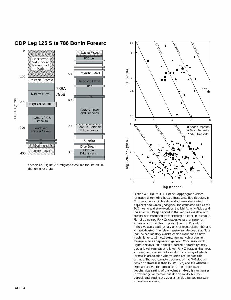
PAGE 84
Section 4.5, Figure 3: A. Plot of Copper grade versestonnage for ophiolite-hosted massive sulfide deposits inCyprus (squares, circles show stockwork dominateddeposits) and Oman (triangles). The estimated size of theTAG mound and stockwork on the Mid Atlantic Ridge andthe Atlantis II Deep deposit in the Red Sea are shown forcomparison (modified from Hannington et al., in press). B.Plot of combined Pb + Zn grades verses tonnage forsedimentary exhalative deposits (circles), Beshi-type(mixed volcanic-sedimentary environment; diamonds), andvolcanic-hosted (triangles) massive sulfide deposits. Notethat the sedimentary-exhalative deposits tend to havemuch higher total metal contents than volcanogenicmassive sulfides deposits in general. Comparison withFigure A shows that ophiolite-hosted deposits typicallyplot at lower tonnage and lower Pb + Zn grades than mostvolcanogenic massive sulfides deposits, many of whichformed in association with volcanic arc like tectonicsettings. The approximate positions of the TAG deposit(which contains less than 1% Pb + Zn) and the Atlantis IIDeep are shown for comparison. The tectonic andgeochemical setting of the Atlantis II deep is most similarto volcanogenic massive sulfides deposits, but thedepositional setting provides an analog for sedimentary-exhalative deposits.
TTAAGG
AAIIII DDeeeepp
1100 44
ttoonnnneess CCuu
1100 55
ttoonnnneess CCuu
1100 66
ttoonnnneess CCuu
10
5
1
0.5
0.1
4 5 6 7 8
5 6 7 8 90
1
2 1100 55 ttoonnnneess ((PP
bb ++ ZZnn))
110055 ttoonnnneess ((PPbb ++ ZZnn))
110055 ttoonnnneess ((PPbb ++ ZZnn))
Sedex Deposits
VMS DepositsBeshi Deposits
TTAAGG
AAIIII DDeeeepp
lloogg ((ttoonnnneess))
lloogg
((PP
bb++
ZZnn
)) ((ww
tt %%
))CC
uu ((
wwtt
%%))
Section 4.5, Figure 2: Stratigraphic column for Site 786 inthe Bonin Fore-arc.
High-Ca Boninite
ICBrzA Flows
AndesiteBreccia / Flows
ICBrzA / ICBBreccias
ICB
ICB
0
100
200
300
400
DE
PT
H (
mbs
f)
ICBrzA
Rhyolite Flows
HCB
Andesite Flows
ICBrzA Flows and Breccias
ICB
Low-Ca BoninitePillow Lavas
ICBRhyolite
Dike Swarm
ICB
LCBrzADike Swarm
500
600
700
800
786A786B
ODP Leg 125 Site 786 Bonin Forearc
Pleistocene-Mid.-EoceneNannofossil
Marls
Volcanic Breccia
Sediment
Dacite Flows
Dacite Flows

PAGE 85
Section 4.5, Figure 4: Tectonic setting of the PACMANUS hydrothermal deposit in the Manus back-arc basin, Papua New Guinea.
138 E 140 E 142 E 144 E 146 E 148 E 150 E 152 E 154 E 156 E0
NewGuinea Trench
(Late Miocene-Q
uaternary)
Ramu-Markham
F.Z.
(M Miocene-Quaternary)
Pocklington
Manus
Manus
Trench(Oligocene-E.Miocene)
Ontong
Java
Plateau
Bismarck Sea
New
New
Britain
Ireland
Bougainville
Solomon SeaTrobriand
Trough
Woodlark Basin
Trobriand Platform
NewBritain Trench
Woodlar
k Rise
Coral Sea
Aure
Trough
(Paleocene- Oligocene)
Trough
ContinentalPlatform
Papu
a N
ew G
uine
aIr
ian
Jay
a
Central Orogenic
Belt
Fold Belt
Active volcano
Extinct volcano
o o o o o o o o o o
2 So
4 So
6 So
8 So
10 So
12 So
OSFZ
Papuan Peninsular
After Cooper and Taylor (1987)
PACMANUS

PAGE 86
Allan J. F. and Dick H. J. B. (1996) Cr-spinel as a tracer for melt migration and melt-wall rock interaction in the mantle: Hess Deep, Leg 147. InProceedings of the Ocean Drilling Program, Vol. 147 (ed. C. Mével, K. M. Gillis, J. F. Allan, and P. S. Meyer), pp. 157-172. Ocean DrillingProgram.
Arai S. and Matsukage K. (1996) Petrology of gabbro-troctolite-peridotite complex from Hess Deep, equatorial Pacific: implications for mantle-meltinteraction within the oceanic lithosphere. In Proceedings of the Ocean Drilling Program, Vol. 147 (ed. C. Mével, K. M. Gillis, J. F. Allan, and P.S. Meyer), pp. 157-172. Ocean Drilling Program.
Alt, J.C., Teagle, D., Brewer, T., Shanks, P., and Halliday, A. (1996) Hydrothermal alteration and mineralization in a volcanic fore-arc section, ODPSite 786: comparison with oceanic and ophiolitic crust. Geochim. Cosmochim. Acta, submitted.
Alt, J.C. and Brewer, T. (1995) Submarine alteration and mineralization of volcanic basement from the izu-bonin fore-arc: comparison with MORBand ophiolite sections EOS 76, p F710.
Cannat M. (1996) How thick is the magmatic crust at slow spreading oceanic ridges. Journal of Geophysical Research 101(B2), 2847-2857.Cannat, M., C. Mével, M. Maia, C. Deplus, C. Durand, P. Gente, P.Agrinier, A. Belarouchi, G. Dubuisson, E. Humler, and J. Reynolds (1995) Thin
crust, ultramafic exposures, and rugged faulting patterns at Mid-Atlantic Ridge (22° - 24°N). Geology, 23 (1), 49-52.Carson, B., Becker, K., Purdy, G.M., Wilkens, R., Gieskes, J. and Hildebrand, Eds. (1996) BOREHOLE: A plan to advance post-drilling subseafloor
science. Joint Oceanographic Institutions/U.S. Science Advisory Committee, Washington D.C., 83 pp.Coffin M. F. and Eldholm O. (1990) Large Igneous Provinces: A workshop to develop Scientific drilling initiatives on volcanic margins and oceanic
plateaus. Joint Oceanographic Institutions Inc.Coleman R. G. and Irwin W. P. (1974) Ophiolites and ancient continental margins. In The Geology of Continental Margins (ed. C. A. Burk and C. L.
Drake), pp. 921-931. Springer-Verlag.Constable, S.C., C. Peirce, and M.C. Sinha, (1997) RAMESSES finds a magma chamber beneath a slow-spreading ridge, InterRidge News, 6 (1), in
press, .Cooper, P., and Taylor, B. (1987) Seismotectonics of New Guinea: A model for arc reversal following arc-continent collision. Tectonics, 6, 53-67.Detrick, R.S., H.D. Needham, and V. Renard (1995) Gravity anomalies and crustal thickness variations along the Mid-Atlantic Ridge between 33°N
and 40°N, Jour. Geophys. Res., 100, 3767-3787.Dick H. J. B. (1989) JOI/USSAC Workshop Report: Drilling the Oceanic Lower Crust and Mantle. Woods Hole Oceanographic Inst., 115 pp.Dick H. J. B., Meyer, P.S., Bloomer, S., Kirby, S., Stakes, D., and Mawer, C. (1991) Lithostratigraphic evolution of an in situ section of oceanic layer 3.
In Proceedings of the Ocean Drilling Program, Scientific Results, Vol. 118 (ed. R. P. Von Herzen, P. T. Robinson, and e. al.), pp. 439-540.Ocean Drilling Program.
Dick H. J. B. and Natland J. H. (1996) Late stage melt evolution and transport in the shallow mantle beneath the East Pacific Rise. In Proceedings ofthe Ocean Drilling Program, Scientific Results, Vol. 147 (ed. K. Gillis, C. Mével, J. Allan, and e. al.), pp. 103-134. Ocean Drilling Program,Texas A&M University.
Francheteau J., Armiho R., Cheminee J. L., Hekinian R., Lonsdale P., and Blumm N. (1990) 1 Ma East Pacific Rise oceanic crust and uppermostmantle exposed by rifting in Hess Deep (equatorial Pacific Ocean). Earth and Planetary Science Letters 101, 281-295.
Fryer, Pearce, Stokking et al. (1990) Proceedings of the Ocean Drilling Prgram, Scientific Results, 125, Ocean Drilling Program, College Station,Texas, 1092pp.
Gillis K., Mével C., Allan J., and al. (1993) Proceedings of the Ocean Drilling Program, Initial Reports, Vol. 147, Ocean Drilling Program, CollegeStation, TX, pp. 352.
Grevemeyer, I. and Weigel, W. (1997) Increase of seismic velocities in upper oceanic crust: The “superfast” spreading East Pacific Rise at 14 14’S,Geophys. Res. Lett. 24, 217-220.
Haymon, R. M., Fornari, D. J., Von-Damm, K. L., Lilley, M. D., Perfit, M. R., Edmond, J. M., Shanks, W. C., Lutz, R. A., Grebmeier, J. M., Carbotte, S.,Wright, D., McLaughlin, E., Smith, M., Beedle, N., and Olson, E. (1993) Volcanic eruption of the mid-ocean ridge along the East Pacific Risecrest at 9 degrees 45-52’N; direct submersible observations of seafloor phenomena associated with an eruption event in April, 1991. Earth andPlanetary Science Letters 119, 85-101.
Hekinian R., Bideau D., Francheteau J., Cheminee J. L., Armijo R., Lonsdale P., and Blum N. (1993) Petrology of the East Pacific Rise crust and uppermantle exposed in Hess Deep (Eastern Equatorial Pacific. Jour. Geophys. Res. 98, 8069-8094.
Holden, J.F., B.C. Crump, M. Summit, and Baross, J.A. (1995) Microbial blooms at the CoAxial segment, Juan de Fuca Ridge deep-sea hydrothermalvent site following a magma intrusion. Eos, Transactions, American Geophysical Union.76; 46, Suppl., 411.
Huber, R., P. Stoffers, J.L. Cheminee, H.H. Richrow, and K.O. Stetter, Hyperthermophilic archaebacteria within the crater and open-sea plume oferupting Macdonald Seamount, Nature 345, 179-182, 1990.
InterRidge (1994) Meso-Scale Working Group Reports 1993: Segmentation and Fluxes at Mid-Ocean Ridges: A Symposium, Durham, UK, September22-25, 1993; and Back-Arc Basin Studies: A Workshop, Seattle, WA, USA, October 11-13, 1993. InterRidge Office, Durham UK, 67pp.
InterRidge (1995) Meso-Scale Workshop Report: 4-D Architecture of the Oceanic Lithosphere. InterRidge Office, Durham UK, 15pp.InterRidge (1996) FARA-InterRidge Mid-Atlantic Ridge Symposium: Results from 15° N to 40 ° N. A Ewing Symposium, Reykjavik, Iceland, June 19-
22, 1996. Journal of Conference Abstracts, vol. 1, no. 2, pp. 749-888.Intraplate Marine Geoscience: Hot LIPs and Cracked Plates, (1996)JOIDES (1996) ODP Long Range Plan. JOINT Oceanographic Institutions, Washington D.C.Kennedy, L. A., Kronenberg, A. K., and Dick H. J. B. (1996) Structural history and significance of gabbroic rocks in the uppermost mantle: Hess Deep,
EPR (Site 895). In Proceedings of the Ocean Drilling Program, Vol. 147 (ed. C. Mével, K. M. Gillis, J. F. Allan, and P. S. Meyer), pp. 357-372.Ocean Drilling Program.
Larson, R.L. (1997) Model hole parameters for older oceanic crust: the 21st Century Mohole. In Report and Proceedings of the InternationalWorkshop on Riser Technology: JAMSTEC (Yokohama, Japan), 112-126.
Lin, J., Karson, J., and Sinton, J., 1994. Design Workshop for Experimental Approaches to Ridge Segment Structure and Dynamics (RISES), September26-27, 1994, Wakefield, MA, 22 pp., published by RIDGE.
Luyendyk, B.P. (1970) Origin and history of abyssal hills in the northeast Pacific Ocean. Geol. Soc. Am. Bull. 81, 2237-2260.
5 - REFERENCES
PAGE 87
Manning C. E. and MacLeod C. J. (1996) Fracture-controlled metamorphism of Hess Deep gabbros, Site 894: constraints on the roots of mid-ocean-ridge hydrothermal systems at fast-spreading centers. In Proceedings of the Ocean Drilling Program, Vol. 147 (ed. C. Mével, K. M. Gillis, J. F.Allan, and P. S. Meyer), pp. 189-212. Ocean Drilling Program.
Manning C. E. and MacLeod C. J. (1996) Fracture-controlled metamorphism of Hess Deep gabbros, Site 894: constraints on the roots of mid-ocean-ridge hydrothermal systems at fast-spreading centers. In Proceedings of the Ocean Drilling Program, Vol. 147 (ed. C. Mével, K. Gillis, J. F.Allan, and P. S. Meyer), pp. 189-212. Ocean Drilling Program.
Menard, H.W. (1964) Marine Geology of the Pacific. McGraw Hill Inc.,Mével C. and Cannat M. (1991) Lithospheric stretching and hydrothermal processes in oceanic gabbros from slow-spreading ridges. In Ophiolite
Genesis and Evolution of the Oceanic Lithosphere (ed. T. Peters, et. al.), pp. 293-312. Ministry of Petroleum and Minerals.Multidisciplinary Observatories on the Deep Seafloor, Worshop Report, Marseilles, 11-13/1/95, 229 pp.Natland J. H. and Dick H. J. B. (1996) Melt migration through high-level gabbroic cumulates of the East Pacific Rise at Hess Deep: the origin of
magma lenses and the deep crustal structure of fast-spreading ridges. In Proceedings of the Ocean Drilling Program, Vol. 147 (ed. C. Mével, K.M. Gillis, J. F. Allan, and P. S. Meyer), pp. 21-58. Ocean Drilling Program.
Natland J. H., Meyer P. S., Dick H. J. B., and Bloomer S. H. (1991) Magmatic oxides and sulfides in gabbroic rocks from ODP Hole 735B and thelater development of the liquid line of descent. In Proc. ODP, Sci. Results, Vol. 118, (ed. R. P. Von Herzen, P. T. Robinson), pp. 75-112. OceanDrilling Program.
Parkes R. J., Cragg B. A., Bale S. J., Getleiff J. M., Goodman K., Rochelle P. A., Fry J. C., Weightman A. J., and Harvey S. M. (1994) Deep bacterialbiosphere in Pacific Ocean Sediments. Nature 371, 410-413.
Parsons L., Lin J., and Mével C. (1994) InterRidge Meso-Scale Workshop Report: 4-D Architecture of the Oceanic Lithosphere. InterRidge Office.Pedersen R. B., Malpas J., and Falloon T. (1996) Petrology and geochemistry of gabbroic and related rocks from Site 894, Hess Deep. In Scientific
Results, Vol. 147 (ed. K. Gillis, C. Mével, J. Allan, and e. al.), pp. 1-20. Ocean Drilling Program.Pariso, J.E., J.-C. Sempéré, and C. Rommevaux (1995) Temporal and spatial variations in crustal accretion along the Mid-Atlantic Ridge (29° -
31°30’N) over the last 10 m.y.: Implications from a three-dimensional gravity study, Jour. Geophys. Res., 100 (B9), 17,787-17,794.Pearce, J.A., van der Laan, S. R., Arculus, R.J., Murton, B.J., Ishii, T., Peate, D.W., and Parkinson, I.J. 1992. Boninite and harzburgite from Leg 125
(Bonin-Mariana fore-arc): a case study of magma genesis during the initial stages of subduction, in Proceedings of the Ocean Drilling Program,Sci. Results, 125, P. Fryer, J.A. Pearce, L.B. Stokking et al., p. 623-659, Ocean Drilling Program, College Station, TX.
Raitt, R.W. (1963) The Crustal Rocks. In Hill, M. N. (ed.), The Sea, III: New York (Interscience), 85-102.Riedel W. R., Ladd H. S., Tracey J. I., and Bramlette M. N. (1961) Preliminary drilling phase of Mohole Project; Part 2, Summary of coring operations
(Guadalupe Site). Bulletin of the American Association of Petroleum GeologistsPages l793-l798. 1961. 45, l793-l798.Lin, J., Karson, J. and Sinton, J. Eds. (1994) Design Workshop for Experimental Approaches to Ridge Segment Structure and Dynamics (RISES),
Wakefield, MA, September 26-27, RIDGE Office, 24pp.Montagner, J.-P., and Lancelot, Y. (Ed.) (1995). Multidisciplinary observatories on the deep seafloor (INSU/CNRS, IFREMER, ODP-France, OSN,
USSAC, ODP-Japan, Marseille).Purdy, G.M., and Orcutt, J.A. (Ed.) (1995). Broadband seismology in the oceans - Towards a five-year plan (Ocean Seismic Network / Joint
Oceanographic Institutions, Inc., Washington, D.C.).Screaton, E.J., Carson, B., Lennon, G.P. (1995) Hydrogeologic properties of a thrust fault within the Oregon accretionary prism., Journal of Geophys.
Res., 100, 20,025-20,035Sinha, M.C. and Louden, K.E. (1983) The Oceanographer fracture zone, I, Crustal structure form seismic refraction studies. Geophys. Jour. Roy.
Astron. Soc, 75, 713-736.Sinha, M.C., D.A. Navin, L.M. MacGregor, S.C. Constable, C. Peirce, A. White, G. Heinson, and M.A. Inglis (1997) Evidence for accumulated melt
beneath the slow-spreading Mid-Atlantic Ridge, Philosophical Transactions of the Royal Society, London, Series A, 355, 233-253.Spiess, F.N., Delaney, J.R., Cowen, J.P, Embley, R.W., Fisher, C.A., Juniper, S.K, and Tivey, M.K. (1996) Framework and Guidelines for the Juan de
Fuca Seafloor Observatory, a technical report by the Ad Hoc Observatory Planning Group, November, 1995, 33 pp.Spudich, P. and Orcutt, J. (1980) Petrology and porosity of an oceanic crustal site: results from wave-form modelling of seismic refraction data. Jour.
Geophys. Res. 85, 1409-1433.Stakes D., Mével C., Cannat M., and Chaput T. (1991) Metamorphic stratigraphy of Hole 735B. In Proceedings of the Ocean Drilling Program,
Scientific Results, Vol. 118 (ed. R. P. Von Herzen, P. T. Robinson, and e. al.), pp. 153-180. Ocean Drilling Program.Stakes, D.S., E. Mellinger, H.W. Jannasch and T. Tengdin (1995) ROV, Deployment of instrument packages using a multiple-barrel submersible drill.
In Multidisciplinary Observatories on the Deep Seafloor, ION/ODP, Marseille, France Jan. 11-13, Proceed., 188-199.Stetter K. O. (1995) Microbial life in hydrothermal environments. ASM News, American Society for Microbiologists 61, 285-290.Suyehiro, K., Takahashi, N., Ariie, Y., Yokoi, Y., Hino, R., Shinohara, M., Kanazawa, T., Hirata, N., Tokuyama, H., Taira, A. (1996) Continental crust,
crustal underplating, and low-Q upper mantle beneath an oceanic island arc. Science.272; 5260, 390-392.Taylor, B. (1992) Rifting and the volcanic-tectonic evolution of the Izu-Bonin-Mariana arc. In Proceedings of the Ocean Drilling Program, Scientific
Results, 126, B.Taylor, K. Fujioka et al., 627-651, Ocean Drilling Program, College Station, TX.Taylor, B. and Natland, J. (eds.) (1995) Active Margins and Marginal Basins of the Western Pacific. American Geophysical Union, Geophysical
Monograph 88.Tucholke, B.E., and J. Lin (1994) A geological model for the structure of ridge segments in slow-spreading ocean crust, Jour. Geophys. Res. 99,
11,937-11,958.Weigel, W., I. Grevemeyer, N. Kaul, H. Villinger, T. Ludmann and H.K. Wong (1996) Aging of oceanic crust at the southern East Pacific Rise, EOS, 77/
50, 504.Whitehead J. A., Jr., Dick H. J. B., and Schouten H. (1984) A mechanism for magmatic accretion under spreading centres. Nature 312, 146-148.
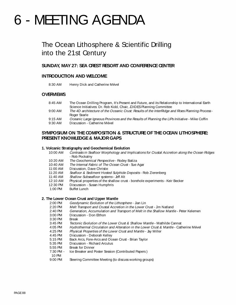
PAGE 88
The Ocean Lithosphere & Scientific Drillinginto the 21st Century
SUNDAY, MAY 27: SEA CREST RESORT AND CONFERENCE CENTER
INTRODUCTION AND WELCOME
8:30 AM Henry Dick and Catherine Mével
OVERVIEWS
8:45 AM The Ocean Drilling Program, It’s Present and Future, and its Relationship to International EarthScience Initiatives: Dr. Rob Kidd, Chair, JOIDES Planning Committee
9:00 AM The 4D architecture of the Oceanic Crust: Results of the InterRidge and Rises Planning Process -Roger Searle
9:15 AM Oceanic Large Igneous Provinces and the Results of Planning the LIPs Initiative - Mike Coffin9:30 AM Discussion - Catherine Mével
SYMPOSIUM ON THE COMPOSITION & STRUCTURE OF THE OCEAN LITHOSPHERE:PRESENT KNOWLEDGE & MAJOR GAPS
1. Volcanic Stratigraphy and Geochemical Evolution10:00 AM Contrasts in Seafloor Morphology and Implications for Crustal Accretion along the Ocean Ridges
- Rob Pockalny10:20 AM The Geochemical Perspective - Rodey Batiza10:40 AM The Internal Fabric of The Ocean Crust - Sue Agar11:00 AM Discussion, Dave Christie11:20 AM Seafloor & Sediment Hosted Sulphide Deposits - Rob Zierenberg11:40 AM Shallow Subseafloor systems - Jeff Alt12:10 AM Physical properties of the shallow crust - borehole experiments - Keir Becker12:30 PM Discussion - Susan Humphris 1:00 PM Buffet Lunch
2. The Lower Ocean Crust and Upper Mantle 2:00 PM Geodynamic Evolution of the Lithosphere - Jian Lin 2:20 PM Melt Transport and Crustal Accretion in the Lower Crust - Jim Natland 2:40 PM Generation, Accumulation and Transport of Melt in the Shallow Mantle - Peter Kelemen 3:00 PM Discussion - Don Elthon 3:30 PM Break 3:45 PM Tectonic Evolution of the Lower Crust & Shallow Mantle - Mathilde Cannat 4:05 PM Hydrothermal Circulation and Alteration in the Lower Crust & Mantle - Catherine Mével 4:25 PM Physical Properties of the Lower Crust and Mantle - Jay Miller 4:45 PM Discussion - Deborah Kelley 5:15 PM Back Arcs, Fore-Arcs and Ocean Crust - Brian Taylor 5:35 PM Discussion - Richard Arculus 5:55 PM Break for Dinner 7:30 PM - Ice Breaker and Poster Session (Contributed Papers ) 10 PM 9:00 PM Steering Committee Meeting (to discuss working groups)
6 - MEETING AGENDA
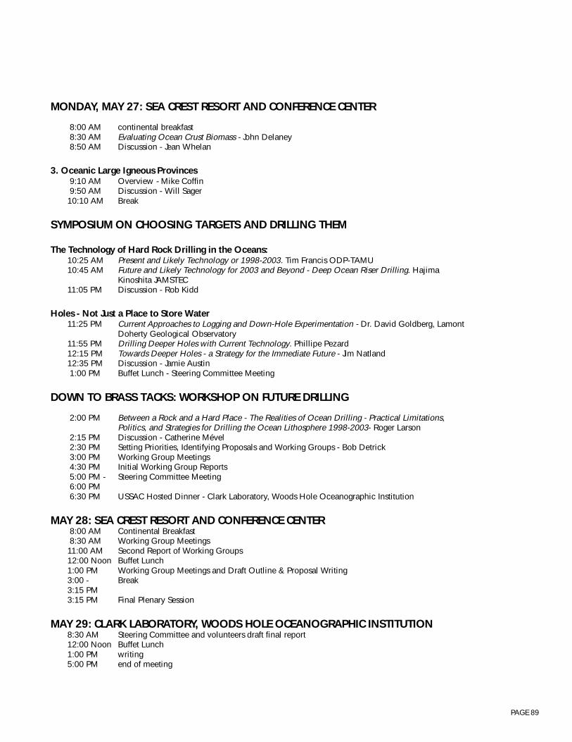
PAGE 89
MONDAY, MAY 27: SEA CREST RESORT AND CONFERENCE CENTER
8:00 AM continental breakfast 8:30 AM Evaluating Ocean Crust Biomass - John Delaney 8:50 AM Discussion - Jean Whelan
3. Oceanic Large Igneous Provinces 9:10 AM Overview - Mike Coffin 9:50 AM Discussion - Will Sager10:10 AM Break
SYMPOSIUM ON CHOOSING TARGETS AND DRILLING THEM
The Technology of Hard Rock Drilling in the Oceans:10:25 AM Present and Likely Technology or 1998-2003. Tim Francis ODP-TAMU10:45 AM Future and Likely Technology for 2003 and Beyond - Deep Ocean Riser Drilling. Hajima
Kinoshita JAMSTEC11:05 PM Discussion - Rob Kidd
Holes - Not Just a Place to Store Water11:25 PM Current Approaches to Logging and Down-Hole Experimentation - Dr. David Goldberg, Lamont
Doherty Geological Observatory11:55 PM Drilling Deeper Holes with Current Technology. Phillipe Pezard12:15 PM Towards Deeper Holes - a Strategy for the Immediate Future - Jim Natland12:35 PM Discussion - Jamie Austin 1:00 PM Buffet Lunch - Steering Committee Meeting
DOWN TO BRASS TACKS: WORKSHOP ON FUTURE DRILLING
2:00 PM Between a Rock and a Hard Place - The Realities of Ocean Drilling - Practical Limitations,Politics, and Strategies for Drilling the Ocean Lithosphere 1998-2003- Roger Larson
2:15 PM Discussion - Catherine Mével 2:30 PM Setting Priorities, Identifying Proposals and Working Groups - Bob Detrick 3:00 PM Working Group Meetings 4:30 PM Initial Working Group Reports 5:00 PM - Steering Committee Meeting 6:00 PM 6:30 PM USSAC Hosted Dinner - Clark Laboratory, Woods Hole Oceanographic Institution
MAY 28: SEA CREST RESORT AND CONFERENCE CENTER 8:00 AM Continental Breakfast 8:30 AM Working Group Meetings11:00 AM Second Report of Working Groups12:00 Noon Buffet Lunch1:00 PM Working Group Meetings and Draft Outline & Proposal Writing3:00 - Break3:15 PM3:15 PM Final Plenary Session
MAY 29: CLARK LABORATORY, WOODS HOLE OCEANOGRAPHIC INSTITUTION8:30 AM Steering Committee and volunteers draft final report12:00 Noon Buffet Lunch1:00 PM writing5:00 PM end of meeting
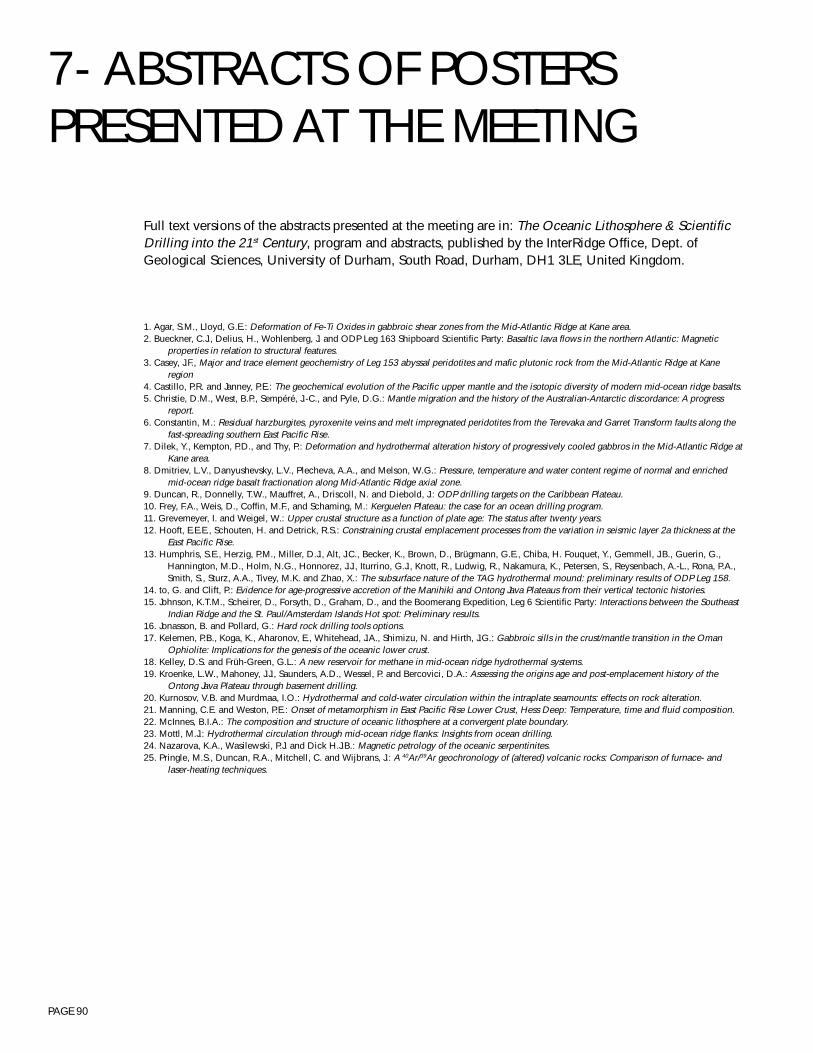
PAGE 90
Full text versions of the abstracts presented at the meeting are in: The Oceanic Lithosphere & ScientificDrilling into the 21st Century, program and abstracts, published by the InterRidge Office, Dept. ofGeological Sciences, University of Durham, South Road, Durham, DH1 3LE, United Kingdom.
1. Agar, S.M., Lloyd, G.E.: Deformation of Fe-Ti Oxides in gabbroic shear zones from the Mid-Atlantic Ridge at Kane area.2. Bueckner, C.J., Delius, H., Wohlenberg, J. and ODP Leg 163 Shipboard Scientific Party: Basaltic lava flows in the northern Atlantic: Magnetic
properties in relation to structural features.3. Casey, J.F., Major and trace element geochemistry of Leg 153 abyssal peridotites and mafic plutonic rock from the Mid-Atlantic Ridge at Kane
region4. Castillo, P.R. and Janney, P.E.: The geochemical evolution of the Pacific upper mantle and the isotopic diversity of modern mid-ocean ridge basalts.5. Christie, D.M., West, B.P., Sempéré, J.-C., and Pyle, D.G.: Mantle migration and the history of the Australian-Antarctic discordance: A progress
report.6. Constantin, M.: Residual harzburgites, pyroxenite veins and melt impregnated peridotites from the Terevaka and Garret Transform faults along the
fast-spreading southern East Pacific Rise.7. Dilek, Y., Kempton, P.D., and Thy, P.: Deformation and hydrothermal alteration history of progressively cooled gabbros in the Mid-Atlantic Ridge at
Kane area.8. Dmitriev, L.V., Danyushevsky, L.V., Plecheva, A.A., and Melson, W.G.: Pressure, temperature and water content regime of normal and enriched
mid-ocean ridge basalt fractionation along Mid-Atlantic Ridge axial zone.9. Duncan, R., Donnelly, T.W., Mauffret, A., Driscoll, N. and Diebold, J.: ODP drilling targets on the Caribbean Plateau.10. Frey, F.A., Weis, D., Coffin, M.F., and Schaming, M.: Kerguelen Plateau: the case for an ocean drilling program.11. Grevemeyer, I. and Weigel, W.: Upper crustal structure as a function of plate age: The status after twenty years.12. Hooft, E.E.E., Schouten, H. and Detrick, R.S.: Constraining crustal emplacement processes from the variation in seismic layer 2a thickness at the
East Pacific Rise.13. Humphris, S.E., Herzig, P.M., Miller, D.J., Alt, J.C., Becker, K., Brown, D., Brügmann, G.E., Chiba, H. Fouquet, Y., Gemmell, J.B., Guerin, G.,
Hannington, M.D., Holm, N.G., Honnorez, J.J., Iturrino, G.J., Knott, R., Ludwig, R., Nakamura, K., Petersen, S., Reysenbach, A.-L., Rona, P.A.,Smith, S., Sturz, A.A., Tivey, M.K. and Zhao, X.: The subsurface nature of the TAG hydrothermal mound: preliminary results of ODP Leg 158.
14. to, G. and Clift, P.: Evidence for age-progressive accretion of the Manihiki and Ontong Java Plateaus from their vertical tectonic histories.15. Johnson, K.T.M., Scheirer, D., Forsyth, D., Graham, D., and the Boomerang Expedition, Leg 6 Scientific Party: Interactions between the Southeast
Indian Ridge and the St. Paul/Amsterdam Islands Hot spot: Preliminary results.16. Jonasson, B. and Pollard, G.: Hard rock drilling tools options.17. Kelemen, P.B., Koga, K., Aharonov, E., Whitehead, J.A., Shimizu, N. and Hirth, J.G.: Gabbroic sills in the crust/mantle transition in the Oman
Ophiolite: Implications for the genesis of the oceanic lower crust.18. Kelley, D.S. and Früh-Green, G.L.: A new reservoir for methane in mid-ocean ridge hydrothermal systems.19. Kroenke, L.W., Mahoney, J.J., Saunders, A.D., Wessel, P. and Bercovici, D.A.: Assessing the origins age and post-emplacement history of the
Ontong Java Plateau through basement drilling.20. Kurnosov, V.B. and Murdmaa, I.O.: Hydrothermal and cold-water circulation within the intraplate seamounts: effects on rock alteration.21. Manning, C.E. and Weston, P.E.: Onset of metamorphism in East Pacific Rise Lower Crust, Hess Deep: Temperature, time and fluid composition.22. McInnes, B.I.A.: The composition and structure of oceanic lithosphere at a convergent plate boundary.23. Mottl, M.J.: Hydrothermal circulation through mid-ocean ridge flanks: Insights from ocean drilling.24. Nazarova, K.A., Wasilewski, P.J. and Dick H.J.B.: Magnetic petrology of the oceanic serpentinites.25. Pringle, M.S., Duncan, R.A., Mitchell, C. and Wijbrans, J.: A 40Ar/39Ar geochronology of (altered) volcanic rocks: Comparison of furnace- and
laser-heating techniques.
7- ABSTRACTS OF POSTERSPRESENTED AT THE MEETING
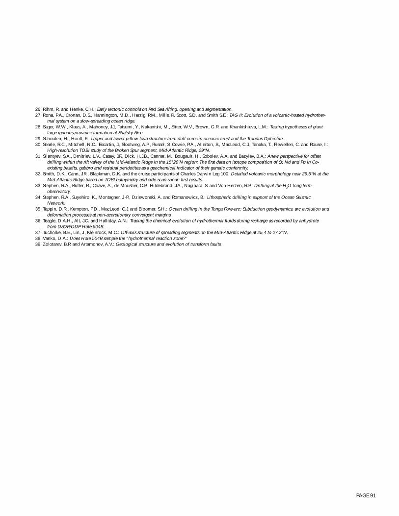
PAGE 91
26. Rihm, R. and Henke, C.H.: Early tectonic controls on Red Sea rifting, opening and segmentation.27. Rona, P.A., Cronan, D.S., Hannington, M.D., Herzig, P.M., Mills, R. Scott, S.D. and Smith S.E.: TAG II: Evolution of a volcanic-hosted hydrother-
mal system on a slow-spreading ocean ridge.28. Sager, W.W., Klaus, A., Mahoney, J.J., Tatsumi, Y., Nakanishi, M., Sliter, W.V., Brown, G.R. and Khankishieva, L.M.: Testing hypotheses of giant
large igneous province formation at Shatsky Rise.29. Schouten, H., Hooft, E.: Upper and lower pillow lava structure from drill cores in oceanic crust and the Troodos Ophiolite.30. Searle, R.C., Mitchell, N.C., Escartin, J., Slootweg, A.P., Russel, S. Cowie, P.A., Allerton, S., MacLeod, C.J., Tanaka, T., Flewellen, C. and Rouse, I.:
High-resolution TOBI study of the Broken Spur segment, Mid-Atlantic Ridge, 29°N.31. Silantyev, S.A., Dmitriev, L.V., Casey, J.F., Dick, H.J.B., Cannat, M., Bougault, H., Sobolev, A.A. and Bazylev, B.A.: Anew perspective for offset
drilling within the rift valley of the Mid-Atlantic Ridge in the 15°20’N region: The first data on isotope composition of Sr, Nd and Pb in Co-existing basalts, gabbro and residual peridotites as a geochemical indicator of their genetic conformity.
32. Smith, D.K., Cann, J.R., Blackman, D.K. and the cruise participants of Charles Darwin Leg 100: Detailed volcanic morphology near 29.5°N at theMid-Atlantic Ridge based on TOBI bathymetry and side-scan sonar: first results.
33. Stephen, R.A., Butler, R., Chave, A., de Moustier, C.P., Hildebrand, J.A., Nagihara, S. and Von Herzen, R.P.: Drilling at the H2O long termobservatory.
34. Stephen, R.A., Suyehiro, K., Montagner, J.-P., Dziewonski, A. and Romanowicz, B.: Lithospheric drilling in support of the Ocean SeismicNetwork.
35. Tappin, D.R., Kempton, P.D., MacLeod, C.J. and Bloomer, S.H.: Ocean drilling in the Tonga Fore-arc: Subduction geodynamics, arc evolution anddeformation processes at non-accretionary convergent margins.
36. Teagle, D.A.H., Alt, J.C. and Halliday, A.N.: Tracing the chemical evolution of hydrothermal fluids during recharge as recorded by anhydrotefrom DSDP/ODP Hole 504B.
37. Tucholke, B.E., Lin, J., Kleinrock, M.C.: Off-axis structure of spreading segments on the Mid-Atlantic Ridge at 25.4 to 27.2°N.38. Vanko, D.A.: Does Hole 504B sample the “hydrothermal reaction zone?”39. Zolotarev, B.P. and Artamonov, A.V.: Geological structure and evolution of transform faults.
PAGE 92
Dr. Susan M. AgarDept. of Geological Sci.Northwestern Univ.1847 Sheridan RoadEvanston IL [email protected]
Dr. James F. AllanOcean Drilling ProgramTexas A&M Univ. Research Park1000 Discovery DriveCollege Station TX [email protected]
Dr. Simon AllertonDept. of Geology & GeophysicsUniv. of EdinburghWest Mains RoadEdinburghEH9 [email protected]
Dr. Jeffrey C. AltDept. of Geological Sci.The Univ. of Michigan2534 C.C. Little BuildingAnn Arbor MI [email protected]
Prof. Richard J. ArculusDept. of GeologyAustralian National Univ.G.P.O. Box 4CanberraACT [email protected]
Prof. Nicholas T. ArndtGeosciencesUniversit‚ de Rennes 1Campus BeaulieuAvenue Generale LeClercF-35042 Rennes [email protected]
Prof. Rodey BatizaDept. of Geology & GeophysicsSchool of Ocean & Earth Science & Tech.Univ. of Hawaii2525 Correa RoadHonolulu HI [email protected]
Prof. Keir BeckerMarine Geology & GeophysicsRosenstiel School of Marine & Atm. Sci.Univ. of Miami4600 Rickenbacker CausewayMiami FL [email protected]
Dr. Gerhard E. BrügmannAbteilung GeochemieMax-Planck Institut fÅr ChemiePostfach 3060
D-55020 [email protected]
Christian Josef BueckerAngewandte GeophysikRW Technische Hochschule AachenLochnerstrasse 4-20D-52064 [email protected]
Dr. Mathilde CannatLaboratoire de P‚trologieCNRS-URA 736Universit‚ Pierre et Marie Curie (Paris VI)4 place JussieuF-75252 Paris cedex [email protected]
Dr. John F. CaseyDept. of GeosciencesUniv. of Houston4800 Calhoun RoadHouston TX [email protected]
Dr. Paterno R. CastilloGeological Research DivisionScripps Inst. of OceanographyUniv. of California, San DiegoLa Jolla CA [email protected]
Dr. David M. ChristieCollege of Oceanic & Atm.Sci.Oregon State Univ.104 Oceanography Admin. Bldg.Corvallis OR [email protected]
Dr. Millard F. CoffinInst. of GeophysicsUniv. of Texas at Austin8701 North Mopac ExpresswayAustin TX [email protected]
Dr. Marc ConstantinMarine Geology Research Lab.Dept. of GeologyUniv. of Toronto22 Russell StreetTorontoON M5S [email protected]
Dr. Patricia A. CooperDept. of Geology & GeophysicsUniv. of Hawaii at ManoaBachman Hall 1052444 Dole StreetHonolulu HI [email protected]
Dr. Leonid V. DanyushevskyDept. of GeologyUniv. of TasmaniaGPO Box 252CHobart, Tasmania [email protected]
J. Paul DauphinAssociate Program DirectorOcean Drilling ProgramNational Science Foundation4201 Wilson BoulevardFairfax VA [email protected]
Prof. John R. DelaneySchool of OceanographyUniv. of WashingtonBox 357940Seattle WA [email protected]
Dr. Robert S. DetrickDept. of Geology & GeophysicsWoods Hole Oceanographic Inst.360 Woods Hole RoadWoods Hole MA [email protected]
Dr. Henry J.B. DickDept. of Geology & GeophysicsWoods Hole Oceanographic Inst.Woods Hole MA [email protected]
Dr. Yildirim DilekDept. of GeologyMiami Univ.Oxford OH [email protected]
Prof. Leonid V. DmitrievVernadsky Inst.Russian Academy of Sci.Kosygin Street, 19117975 [email protected]
Prof. Robert A. DuncanCollege of Oceanic & Atm. Sci.Oregon State Univ.Oceanography Admin. Building 104Corvallis OR [email protected]
Prof. Olav EldholmDept. of GeologyUniv. of OsloP.O.Box 1047BlindernN-0316 [email protected]
Dr. Don ElthonDept. of ChemistryUniv. of Houston
8 - LIST OF ATTENDEES
PAGE 93
Houston TX [email protected]
Mr. Javier Escart¡nDept. of Geology & GeophysicsWoods Hole Oceanographic Inst.Clark 224A, Mail stop 22Woods Hole MA [email protected]
Prof. P. Jeffrey FoxDirector, Ocean Drilling ProgramTexas A&M Univ. Research Park1000 Discovery DriveCollege Station TX [email protected]
Prof. Timothy J.G. FrancisOcean Drilling ProgramTexas A&M Univ. Research Park1000 Discovery DriveCollege Station TX [email protected]
Prof. Frederick A. FreyDept. of Earth, Atm. & Planetary Sci.Massachusetts Inst. of Tech.Cambridge MA [email protected]
Dr. Gretchen Früh-GreenInst. for Mineralogy & PetrographyETH-ZurichSonneggstrasse 5CH-8092 [email protected]
Dr. Kentaro FujiokaDeep Sea Research Dept.Japan Marine Science & Techology Ctr.2-15 Natsushina-choYokosuka-shiKanagawa [email protected]
Dr. David GoldbergDirector, Borehole Research GroupLamont-Doherty Earth ObservatoryColumbia Univ.Palisades NY [email protected]
Dr. Ingo GrevemeyerCtr. for Marine & Climate ResearchInstitut für GeophysikUniversität HamburgBundesstrasse 55D-20146 Hamburg [email protected]
Dr. Stanley R. HartDept. of Geology & GeophysicsWoods Hole Oceanographic Inst.Woods Hole MA [email protected]
Ms. Deborah R. HasslerWoods Hole Oceanographic Inst.Woods Hole MA [email protected]
Prof. James W. Head, IIIDept. of Geological Sci.Brown Univ.Box 1846Providence RI [email protected]
Dr. James R. HeirtzlerLaboratory for Terrestrial PhysicsGeophysics BranchNASA Goddard Space Flight CenterCode 920Greenbelt RoadGreenbelt MD [email protected]
Dr. Jan HertogenAfdeling Fysico-chemische geologieKatholieke Universiteit LeuvenCelestijnenlaan 200CB-3001 [email protected]
Dr. J. Gregory HirthDept. of Geology & GeophysicsWoods Hole Oceanographic Inst.Woods Hole MA [email protected]
Dr. Albrecht HofmannAbteilung GeochemieMax-Planck Institut fÅr ChemiePostfach 3060D-55020 MainzGERMANY
Ms. Emilie E.E. HooftDept. of Geology & GeophysicsWoods Hole Oceanographic Inst.Woods Hole MA [email protected]
Dr. Susan E. HumphrisDept. of Geology & GeophysicsWoods Hole Oceanographic Inst.Woods Hole MA [email protected]
Mr. Garrett T. ItoDept. of Geology & GeophysicsWoods Hole Oceanographic Inst.Mail Stop 22Woods Hole MA [email protected]
Philip E. JanneyScripps Inst. of OceanographyUniv. of California, San Diego9500 Gilman DriveLa Jolla CA [email protected]
Dr. Kevin T.M. JohnsonBishop Museum-Natural Sci.1525 Bernice StreetHonolulu HI [email protected]
Brian JonassonEngineering Development & DrillingOperationsOcean Drilling ProgramTexas A&M Univ. Research Park1000 Discovery DriveCollege Station TX 77845-9547c/o [email protected]
Dr. Jill L. KarstenDept. of Geology & GeophysicsSchool of Ocean & Earth Science & Tech.Univ. of Hawaii2525 Correa RoadHonolulu HI [email protected]
Dr. Peter B. KelemenDept. of Geology & GeophysicsWoods Hole Oceanographic Inst.Maclean LaboratoryWoods Hole MA [email protected]
Dr. Deborah S. KelleySchool of OceanographyUniv. of WashingtonBox 357940Seattle WA [email protected]
Dr. Pamela D. KemptonNERC Isotope Geosciences LaboratoryKingsley Dunham Ctr.KeyworthNottinghamshireNG12 [email protected]
Prof. Eiichi KikawaGlobal Environmental LaboratoryFaculty of EducationToyama Univ.3190 GofukuToyama [email protected]
Dr. Hajimu KinoshitaDeep Sea Research Dept.Japan Marine Science & Techology Ctr.2-15 Natsushima-choYokosuka-shiKanagawa [email protected]
Dr. Loren W. KroenkeHawaii Inst. of Geophysics & PlanetologyUniv. of Hawaii at Manoa2525 Correa RoadHonolulu HI [email protected]
PAGE 94
Dr. Victor B. KurnosovGeological Inst.Russian Academy of Sci.Pyzhevsky Per. 7109017 [email protected]
Prof. Henriette LapierreUPRES A 5025 Institut DolomieuUniversit‚ Joseph Fourier15 rue Maurice GignouxF-38031 Grenoble [email protected]
Dr. Roger L. LarsonGraduate School of OceanographyUniv. of Rhode IslandNarragansett RI [email protected]
Dr. Marvin D. LilleySchool of OceanographyUniv. of WashingtonBox 357940Seattle WA [email protected]
Dr. Jian LinDept. of Geology & GeophysicsWoods Hole Oceanographic Inst.Woods Hole MA [email protected] or [email protected]
Dr. John N. LuddenCRPG-CNRSUniversit‚ de Nancy15 Rue Notre Dame des PauvresF-54501 Vandoeuvre-les-Nancy [email protected]
Ms. Laura S. MagdeDept. of Geology & GeophysicsWoods Hole Oceanographic Inst.Clark South 272Woods Hole MA [email protected]
Dr. Andrew J. MagenheimBaylor Brooks Inst. for Isotope GeochemistryDept. of GeologySan Diego State Univ.5300 Camanile DriveSan Diego CA [email protected]
Craig ManningDept. of Earth & Space Sci.Univ. of California, Los AngelesLos Angeles CA [email protected]
Lise D. MaringComputer Sci. CorporationMailstop 157B, Langley DAAC
NASA Langley Research CenterHampton VA [email protected]
Dr. James S. McClainDept. of GeologyUniv. of California, DavisDavis CA [email protected]
Dr. Brent I.A. McInnesMagmatic-Hydrothermal Systems GroupCSIRO Division Exploration & MiningP.O. Box 136North RydeNew South Wales [email protected]
Dr. Catherine MévelLaboratoire de PétrologieCNRS-URA 736Universit‚ Pierre et Marie Curie (Paris VI)4 place JussieuF-75252 Paris cedex [email protected]
Dr. Peter S. MeyerDept. of Geology & GeophysicsWoods Hole Oceanographic Inst.Woods Hole MA [email protected]
Dr. D. Jay MillerOcean Drilling ProgramTexas A&M Univ. Research Park1000 Discovery DriveCollege Station TX [email protected]
Prof. Michael J. MottlDept. of OceanographySchool of Ocean & Earth Science & Tech.Univ. of Hawaii1000 Pope RoadHonolulu HI [email protected]
Dr. Seiichi NagiharaDept. of GeosciencesUniv. of HoustonHouston TX [email protected]
Prof. James H. NatlandDivision of Marine Geology & GeophysicsRosenstiel School of Marine & Atm. Sci.Univ. of Miami4600 Rickenbacker CausewayMiami FL [email protected]
Katherine Nazarova10738 Faulkner Ridge CircleColumbia MD [email protected]
Ms. Kirsten E. NicolaysenDept. of Earth, Atm. & Planetary Sci.Massachusetts Inst. of Tech.Cambridge MA [email protected]
Dr. John O’ConnorGeologisch-Pal„ontologisches InstitutUniversit„t KielOlshausenstrasse 40D-24118 [email protected]
Dr. Lindsay M. ParsonSouthampton Oceanography Ctr.European Way, Empress DockSouthamptonSO14 [email protected]
Dr. Philippe A. PézardLaboratoire de Mesures en ForageUnite de Genie OceaniqueInstitut M‚diterran‚en de TechnologieTechnop“le de Chƒteau-GombertF-13451 Marseille cedex [email protected]
Dr. Robert PockalnyDept. of Marine Geology & GeophysicsGraduate School of OceanographyUniv. of Rhode Island207 Horn LaboratorySouth Ferry RoadNarragansett RI [email protected]
Eugene C. Pollard, Jr.Ocean Drilling ProgramTexas A&M Univ. Research Park1000 Discovery DriveCollege Station TX [email protected]
Dr. Hazel M. PrichardDept. of Earth Sci.Univ. of Wales, College of CardiffPO Box 914CardiffCF1 [email protected]
Malcolm S. PringleIsotope Geosciences UnitScottish Universities Research & Reactor Ctr.Scottish Enterprise Tech. ParkRankine AvenueEast KilbrideG75 0QF, [email protected]
Ms. Louise ProckterPlanetary GeologyBrown Univ.
PAGE 95
Box 1846Providence RI [email protected]
Dr. Roland RihmGEOMARForschungszentrum fÅr MarineGeowissenschaftenWischofstrasse 1-3Geb. 12D-24148 [email protected]
Prof. Peter A. RonaInst. of Marine & Coastal Sci.Rutgers Univ.P.O. Box 231New Brunswick NJ [email protected]
Prof. William W. SagerDept. of OceanographyTexas A&M Univ.College Station TX [email protected]
Dr. Hans SchoutenDept. of Geology & GeophysicsWoods Hole Oceanographic Inst.Woods Hole MA [email protected]
Prof. Roger C. SearleDept. of Geological Sci.Univ. of DurhamSouth RoadDurham, DH1 3LE, [email protected]
Dr. Sergei A. SilantyevVernadsky Inst..Russian Academy of Sci.Kosygin Street, 19117975 [email protected]
Dr. Heather SloanDept. of Geological Sci.Univ. of DurhamSouth RoadDurham, DH1 3LE, [email protected]
Dr. Deborah K. SmithDept. of Geology & GeophysicsWoods Hole Oceanographic Inst.Clark 243, Mail Stop 22Woods Hole MA [email protected]
Dr. Shiri SrivastavaGeological Survey of Canada (Atlantic)Bedford Inst. of OceanographyPO Box 1006
1 Challenger DriveDartmouth, NS B2Y [email protected]
Dr. Debra S. StakesMonterey Bay Aquarium Research Inst.PO Box 6287700 Sandholdt RoadMoss Landing CA [email protected]
Dr. Ralph A. StephenDept. of Geology & GeophysicsWoods Hole Oceanographic Inst.Woods Hole MA [email protected]
Shinichi TakagawaDeep Sea Tech. Dept.Japan Marine Science & Tech. Ctr.2-15 Natsushina-choYokosuka-shiKanagawa [email protected]
Dr. Kensaku TamakiOcean Research Inst.Univ. of Tokyo1-15-1 MinamidaiNakano-kuTokyo [email protected]
Dr. John A. TardunoDept. of Earth & Environmental Sci.Univ. of Rochester227 Hutchison Hall,Rochester NY [email protected]
Dr. Brian TaylorDept. of Geology & GeophysicsSchool of Ocean & Earth Sci. & Tech.Univ. of Hawaii2525 Correa RoadHonolulu HI [email protected]
Mr. Damon A.H. TeagleDept. of Geological Sci.Univ. of Michigan1006 C.C. Little BuildingAnn Arbor MI [email protected]
Dr. Brian E. TucholkeDept. of Geology & GeophysicsWoods Hole Oceanographic Inst.Clark 241, Mail Stop 22Woods Hole MA [email protected]
Prof. David A. VankoDept. of GeologyGeorgia State Univ.Unversity PlazaAtlanta GA [email protected]
Dr. Richard P. Von HerzenDept. of Geology & GeophysicsWoods Hole Oceanographic Inst.Woods Hole MA [email protected]
Dr. Dominique A.M. WeisDept. des Sci. de la Terre & de l’Environ.Universit‚ Libre de BruxellesCP 160/02Avenue F.D. Roosevelt, 50B-1050 [email protected]
Mr. Brian P. WestSchool of OceanographyUniv. of WashingtonBox 357940Seattle WA [email protected]
Dr. Jean K. WhelanDept. of Marine Chem. & Geochem.Woods Hole Oceanographic Inst.Woods Hole MA [email protected]
Dr. Robert A. ZierenbergWestern Mineral ResourcesUnited States Geological SurveyDept. of GeologyUniv. of California, DavisDavis CA [email protected]
Dr. Boris P. ZolotarevGeological Inst.Russian Academy of Sci.Pyzhevsky Per. 7109017 MoscowRUSSIA Contact via Kurnosov
PAGE 96
JOINT OCEANOGRAPHIC INSTITUTIONS1755 MASSACHUSETTS AVENUE, NW, SUITE 800
WASHINGTON, DC 20036-2102 USA