Embed Size (px)
Citation preview
1
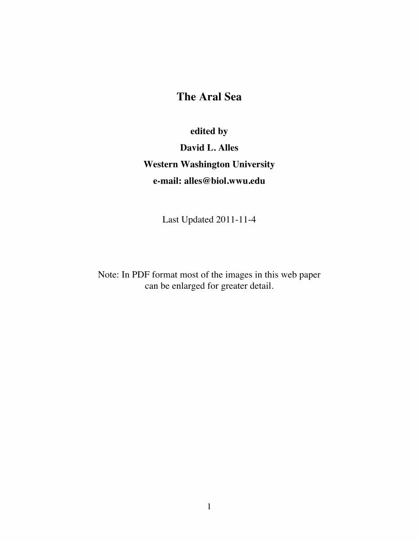
The Aral Sea
edited by
David L. Alles
Western Washington University
e-mail: [email protected]
Last Updated 2011-11-4
Note: In PDF format most of the images in this web paper can be enlarged for greater detail.
2
Introduction The Aral Sea was once the world's fourth largest lake, slightly bigger than Lake Huron, and one of the world's most fertile regions. Today it is little more than a string of lakes scattered across central Asia east of the Caspian Sea. The sea disappeared for several reasons. One is that the Aral Sea is surrounded by the Central Asian deserts, whose heat evaporates 60 square kilometers (23 sq. miles) of water from its surface every year. Second is four decades of agricultural development and mismanagement along the Syr Darya and Amu Darya rivers that have drastically reduced the amount of fresh water flowing into the sea. The two rivers were diverted starting in the 1960s in a Soviet scheme to grow cotton in the desert. Cotton still provides a major portion of foreign currency for many of the countries along the Syr Darya and Amu Darya rivers. By 2003, the Aral Sea had lost approximately 75% of its area and 90% of its pre-1960 volume. Between 1960 and January 2005, the level of the northern Aral Sea fell by 13 meters (~ 43 ft) and the larger southern portion of the sea by 23 meters (75.5 ft) which means that water can now only flow from the north basin to the south (Roll, et al., 2006). Evaporation and agricultural runoff have left portions of the Aral much saltier than the ocean, which in turn has killed off most fish. All 24 of the Aral's native species have long since perished (Stone, 1999). The surrounding region now has one of the highest infant mortality rates in the world, and anemia and cancers caused by chemicals blowing off the dried sea bed are common. Economic mismanagement has turned the area surrounding the sea into a toxic desert. There are four recognized severe environmental impacts caused by the evaporation of the Aral Sea: desertification, dust and salt winds, changes in regional climate, and health problems of the local population (Roll, et al., 2006). Because the Aral Sea lies in a closed desert basin, it is particularly susceptible to desertification. As defined by the United Nations, desertification is the decrease or destruction of the biological potential of land, which can ultimately lead to desert-like conditions. Desertification is one aspect of the widespread deterioration of ecosystems, and diminishes or destroys the biological potential of an area for multiple use at a time when increased productivity is needed to support growing populations.
Web Reference http://en.wikipedia.org/wiki/Aral_Sea
3
This web paper is part of a series of papers on global ecology. In addition to this paper the series includes:
Asian Air Pollution http://fire.biol.wwu.edu/trent/alles/AirPollution.pdf
Freshwater Shortage and Desertification http://fire.biol.wwu.edu/trent/alles/WaterShortage.pdf
Geomorphology and Dust Storms in China http://fire.biol.wwu.edu/trent/alles/ChinaDust.pdf
The Colorado River: An Ecological Case Study http://fire.biol.wwu.edu/trent/alles/ColoradoRiver.html
The common thread in all of these papers is how complex coupled natural systems and human interactions have led to the ecological crises of our times.
4
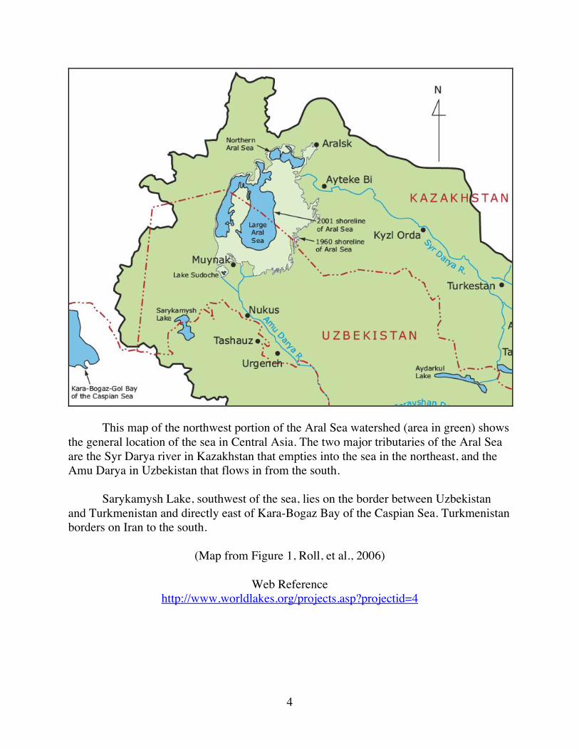
This map of the northwest portion of the Aral Sea watershed (area in green) shows the general location of the sea in Central Asia. The two major tributaries of the Aral Sea are the Syr Darya river in Kazakhstan that empties into the sea in the northeast, and the Amu Darya in Uzbekistan that flows in from the south. Sarykamysh Lake, southwest of the sea, lies on the border between Uzbekistan and Turkmenistan and directly east of Kara-Bogaz Bay of the Caspian Sea. Turkmenistan borders on Iran to the south.
(Map from Figure 1, Roll, et al., 2006)
Web Reference http://www.worldlakes.org/projects.asp?projectid=4
5
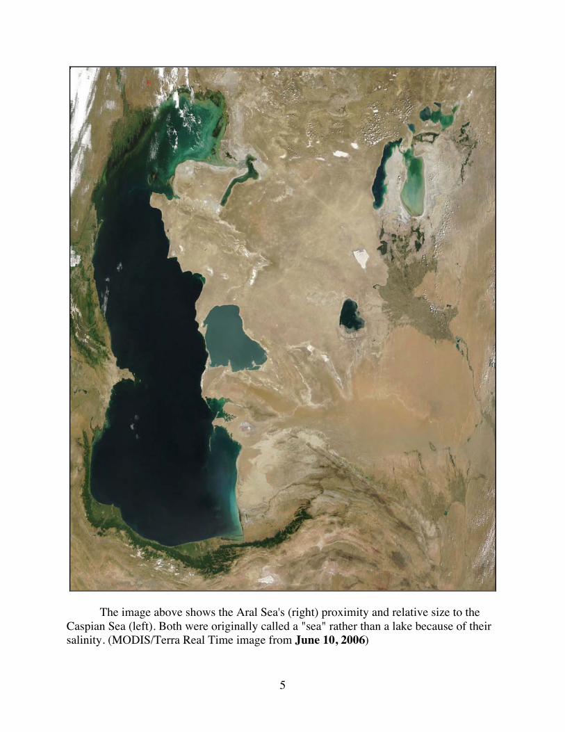
The image above shows the Aral Sea's (right) proximity and relative size to the Caspian Sea (left). Both were originally called a "sea" rather than a lake because of their salinity. (MODIS/Terra Real Time image from June 10, 2006)
6
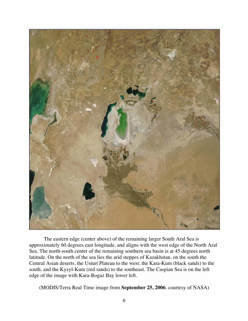
The eastern edge (center above) of the remaining larger South Aral Sea is approximately 60 degrees east longitude, and aligns with the west edge of the North Aral Sea. The north-south center of the remaining southern sea basin is at 45 degrees north latitude. On the north of the sea lies the arid steppes of Kazakhstan, on the south the Central Asian deserts, the Usturt Plateau to the west, the Kara-Kum (black sands) to the south, and the Kyzyl-Kum (red sands) to the southeast. The Caspian Sea is on the left edge of the image with Kara-Bogaz Bay lower left.
(MODIS/Terra Real Time image from September 25, 2006, courtesy of NASA)
7
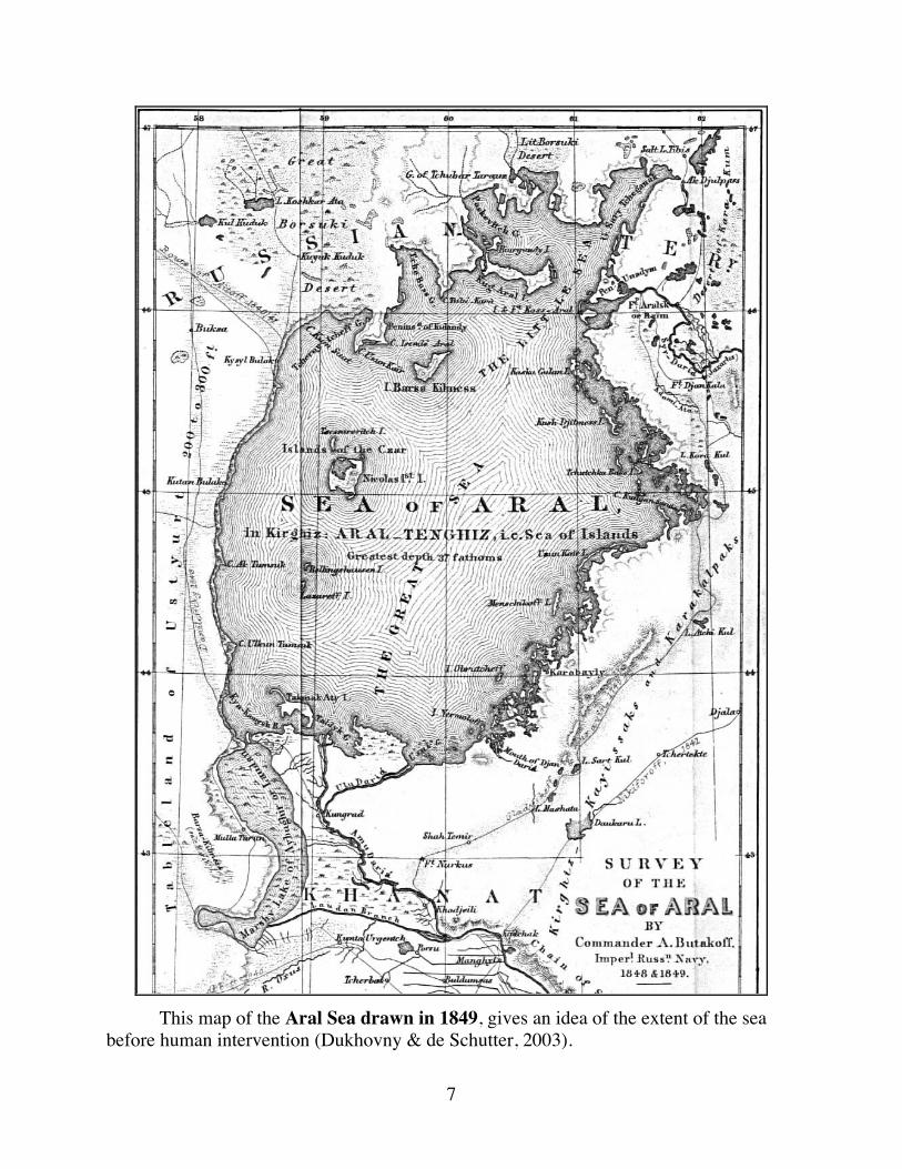
This map of the Aral Sea drawn in 1849, gives an idea of the extent of the sea before human intervention (Dukhovny & de Schutter, 2003).
8
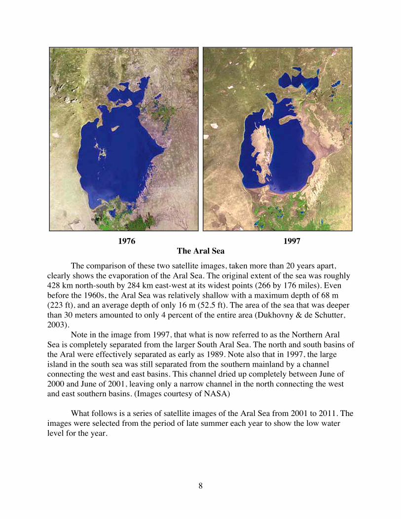
1976 1997
The Aral Sea
The comparison of these two satellite images, taken more than 20 years apart, clearly shows the evaporation of the Aral Sea. The original extent of the sea was roughly 428 km north-south by 284 km east-west at its widest points (266 by 176 miles). Even before the 1960s, the Aral Sea was relatively shallow with a maximum depth of 68 m (223 ft), and an average depth of only 16 m (52.5 ft). The area of the sea that was deeper than 30 meters amounted to only 4 percent of the entire area (Dukhovny & de Schutter, 2003). Note in the image from 1997, that what is now referred to as the Northern Aral Sea is completely separated from the larger South Aral Sea. The north and south basins of the Aral were effectively separated as early as 1989. Note also that in 1997, the large island in the south sea was still separated from the southern mainland by a channel connecting the west and east basins. This channel dried up completely between June of 2000 and June of 2001, leaving only a narrow channel in the north connecting the west and east southern basins. (Images courtesy of NASA) What follows is a series of satellite images of the Aral Sea from 2001 to 2011. The images were selected from the period of late summer each year to show the low water level for the year.
9
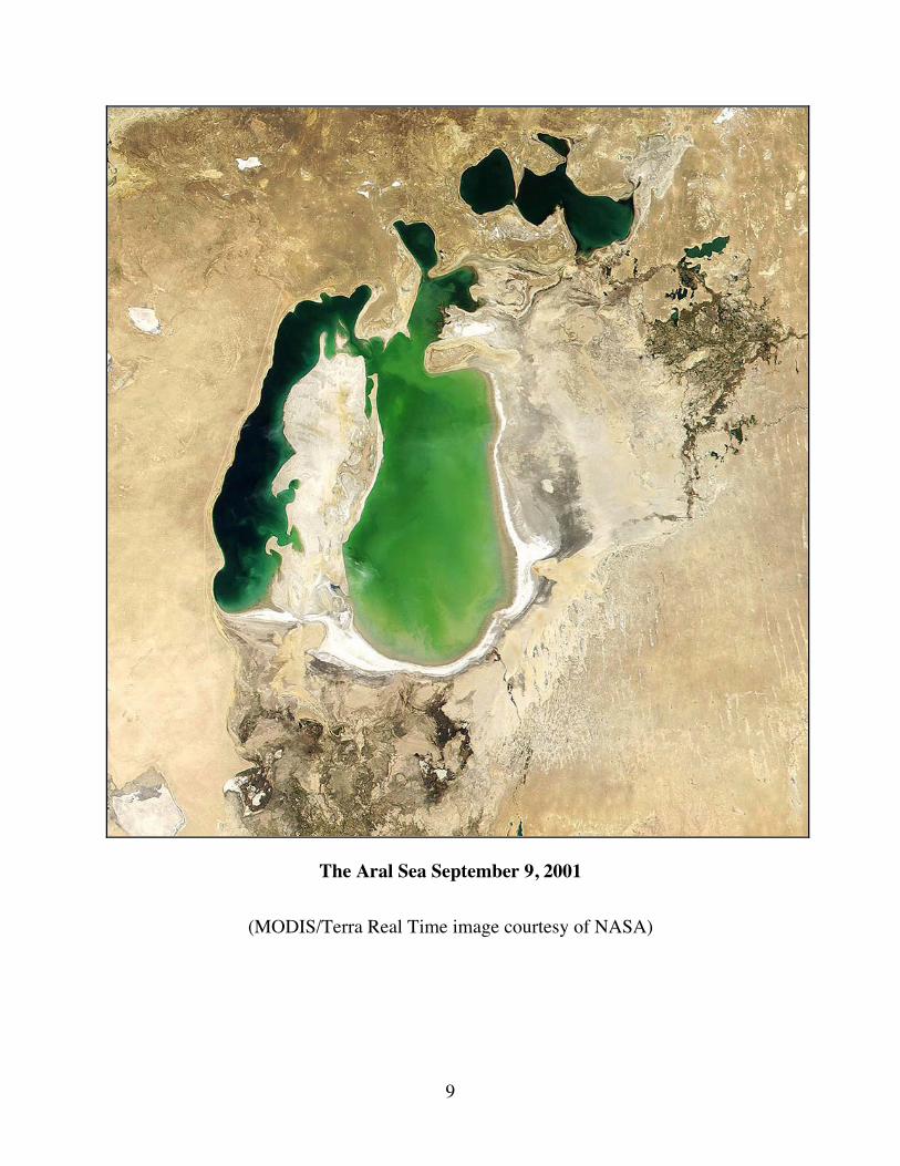
The Aral Sea September 9, 2001
(MODIS/Terra Real Time image courtesy of NASA)
10
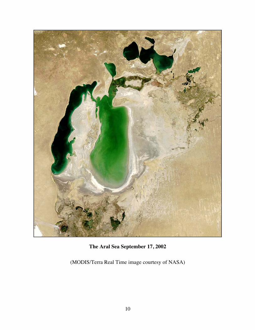
The Aral Sea September 17, 2002
(MODIS/Terra Real Time image courtesy of NASA)
11
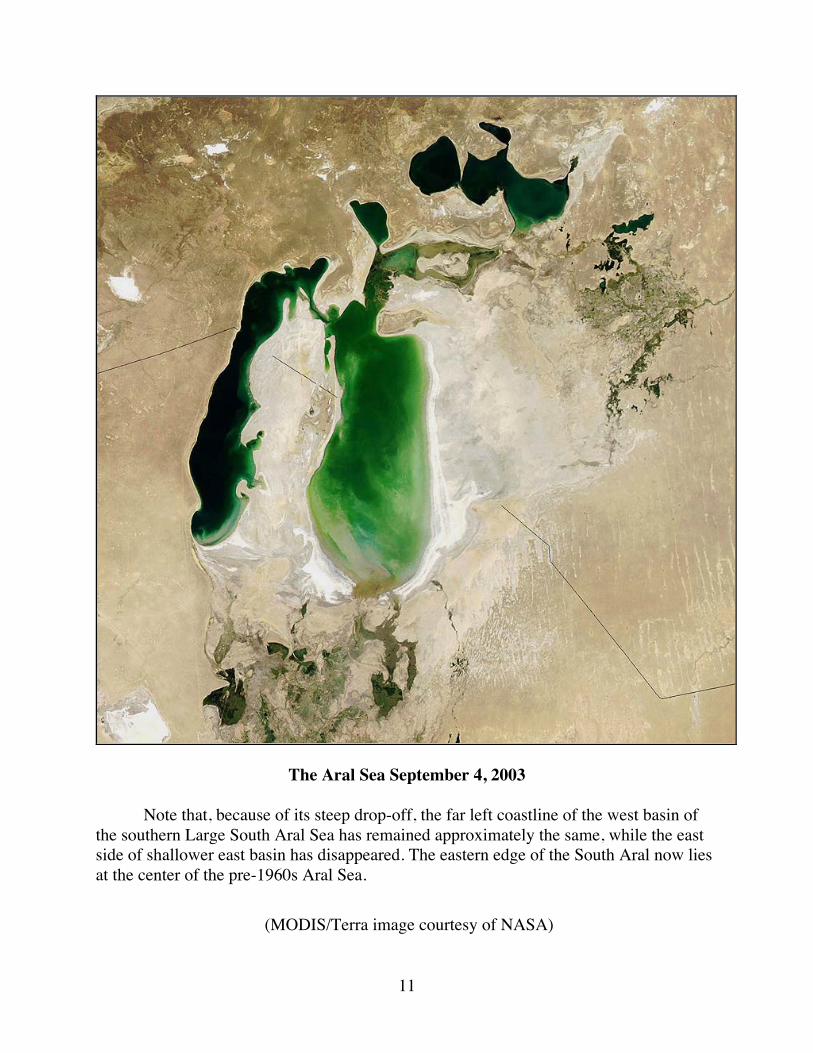
The Aral Sea September 4, 2003
Note that, because of its steep drop-off, the far left coastline of the west basin of the southern Large South Aral Sea has remained approximately the same, while the east side of shallower east basin has disappeared. The eastern edge of the South Aral now lies at the center of the pre-1960s Aral Sea.
(MODIS/Terra image courtesy of NASA)
12
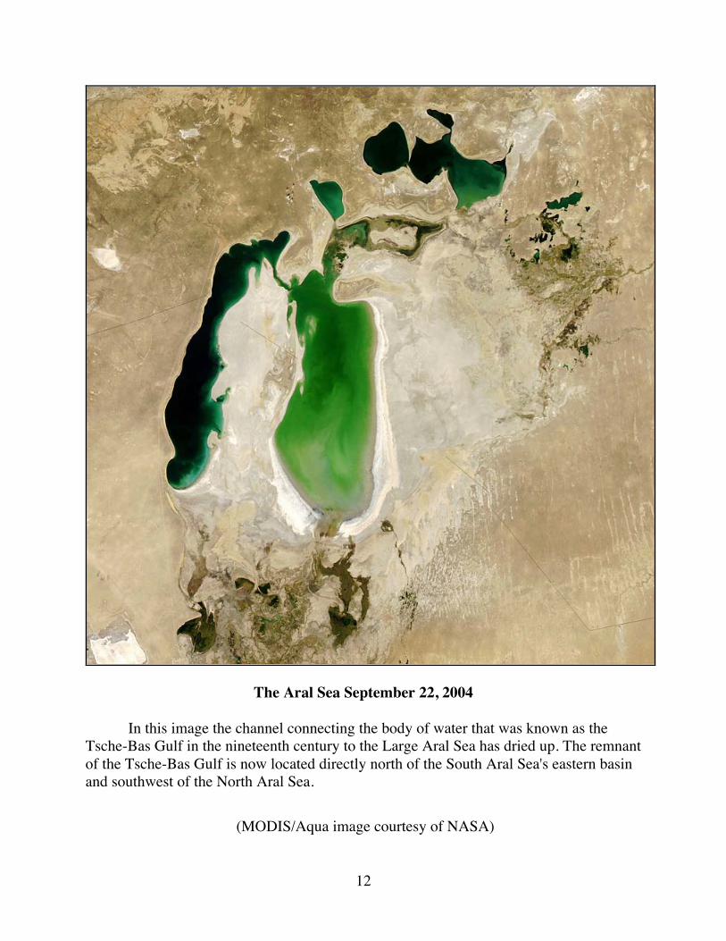
The Aral Sea September 22, 2004
In this image the channel connecting the body of water that was known as the Tsche-Bas Gulf in the nineteenth century to the Large Aral Sea has dried up. The remnant of the Tsche-Bas Gulf is now located directly north of the South Aral Sea's eastern basin and southwest of the North Aral Sea.
(MODIS/Aqua image courtesy of NASA)
13
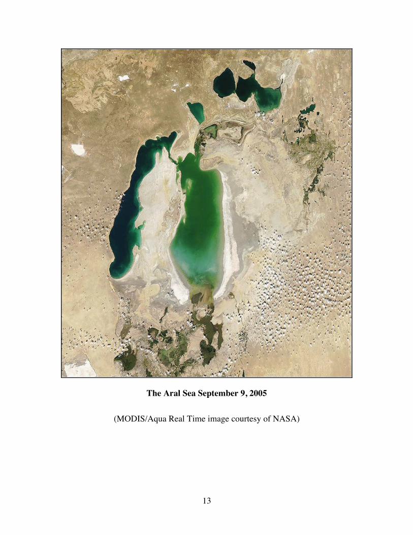
The Aral Sea September 9, 2005
(MODIS/Aqua Real Time image courtesy of NASA)

14
The Aral Sea August 29, 2006
(MODIS/Aqua Real Time image courtesy of NASA)
15
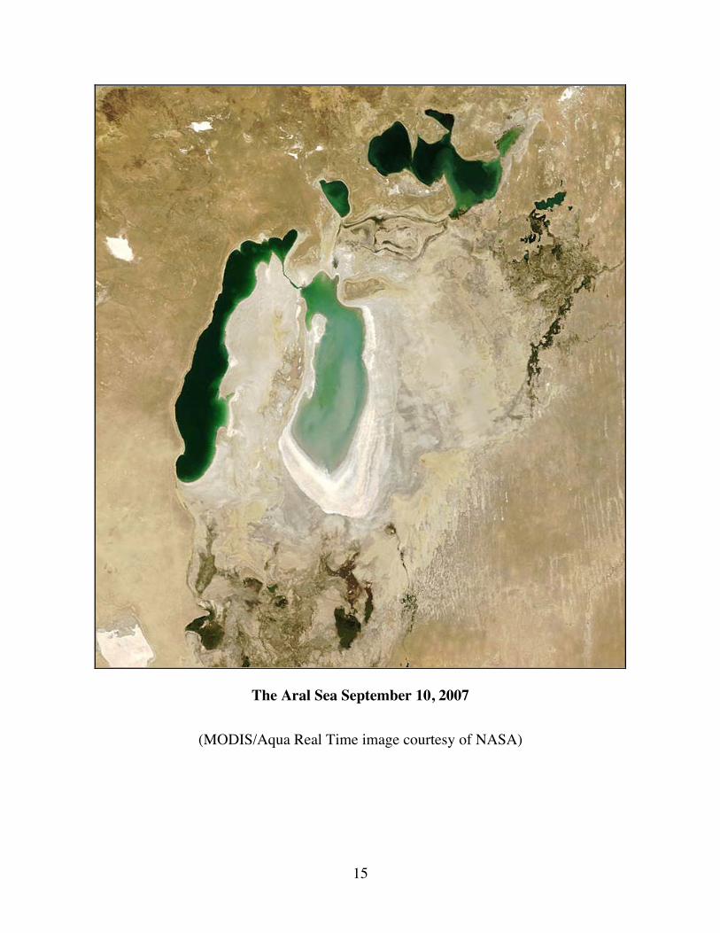
The Aral Sea September 10, 2007
(MODIS/Aqua Real Time image courtesy of NASA)
16
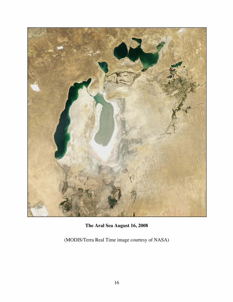
The Aral Sea August 16, 2008
(MODIS/Terra Real Time image courtesy of NASA)
17
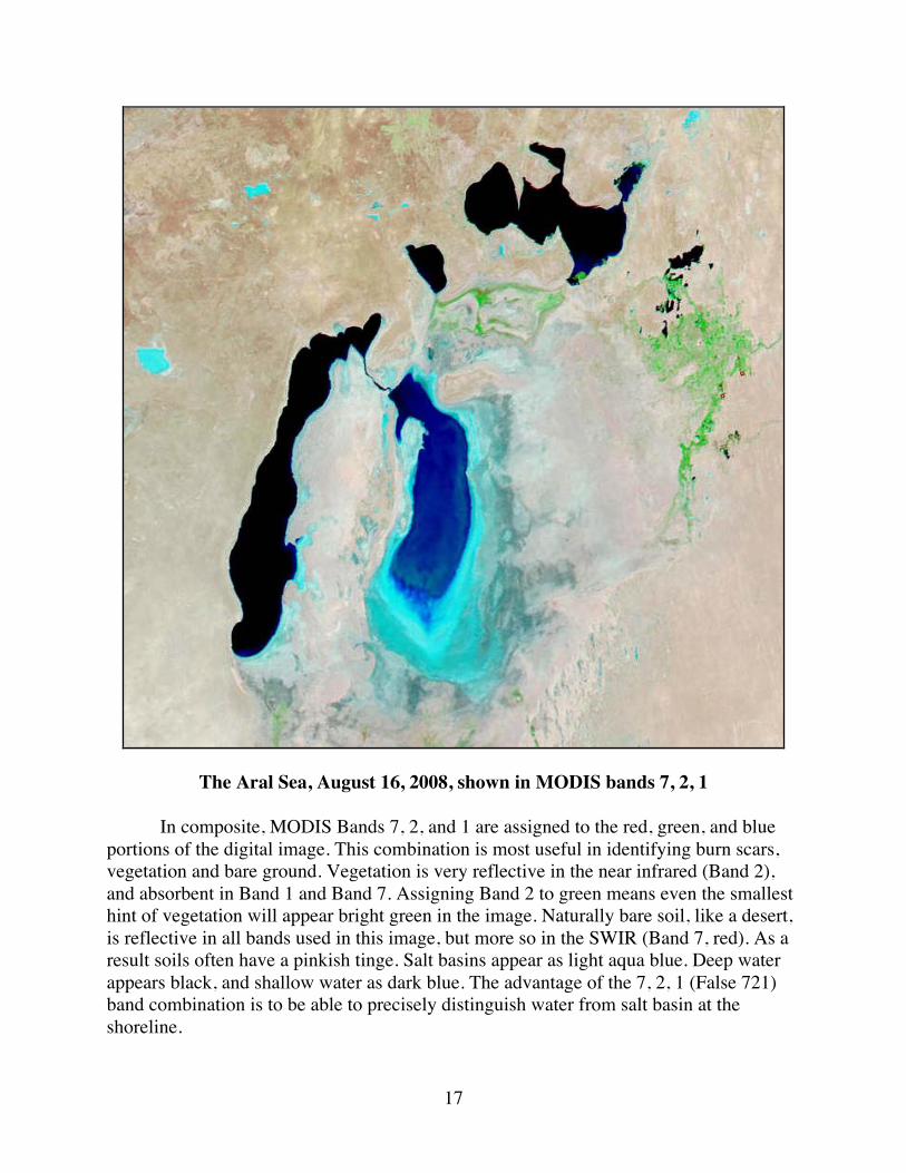
The Aral Sea, August 16, 2008, shown in MODIS bands 7, 2, 1
In composite, MODIS Bands 7, 2, and 1 are assigned to the red, green, and blue portions of the digital image. This combination is most useful in identifying burn scars, vegetation and bare ground. ���Vegetation is very reflective in the near infrared (Band 2), and absorbent in Band 1 and Band 7. Assigning Band 2 to green means even the smallest hint of vegetation will appear bright green in the image. Naturally bare soil, like a desert, is reflective in all bands used in this image, but more so in the SWIR (Band 7, red). As a result soils often have a pinkish tinge. Salt basins appear as light aqua blue. Deep water appears black, and shallow water as dark blue. The advantage of the 7, 2, 1 (False 721) band combination is to be able to precisely distinguish water from salt basin at the shoreline.
18
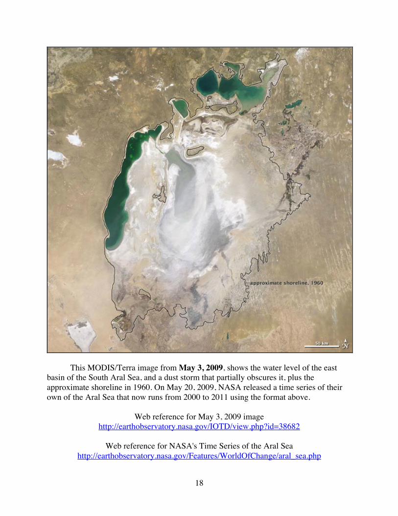
This MODIS/Terra image from May 3, 2009, shows the water level of the east basin of the South Aral Sea, and a dust storm that partially obscures it, plus the approximate shoreline in 1960. On May 20, 2009, NASA released a time series of their own of the Aral Sea that now runs from 2000 to 2011 using the format above.
Web reference for May 3, 2009 image http://earthobservatory.nasa.gov/IOTD/view.php?id=38682
Web reference for NASA's Time Series of the Aral Sea
http://earthobservatory.nasa.gov/Features/WorldOfChange/aral_sea.php
19
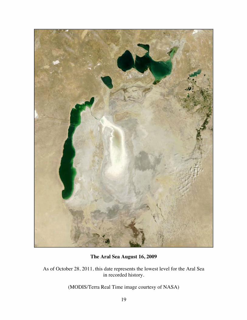
The Aral Sea August 16, 2009
As of October 28, 2011, this date represents the lowest level for the Aral Sea in recorded history.
(MODIS/Terra Real Time image courtesy of NASA)
20
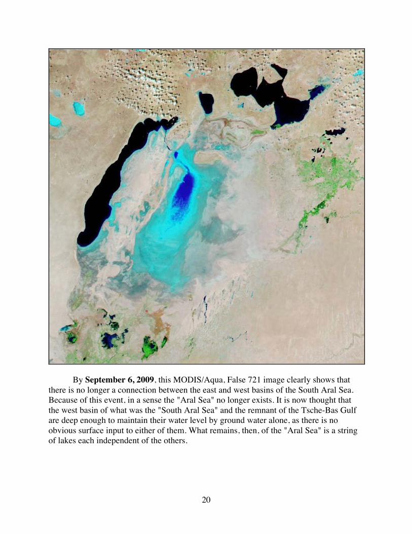
By September 6, 2009, this MODIS/Aqua, False 721 image clearly shows that there is no longer a connection between the east and west basins of the South Aral Sea. Because of this event, in a sense the "Aral Sea" no longer exists. It is now thought that the west basin of what was the "South Aral Sea" and the remnant of the Tsche-Bas Gulf are deep enough to maintain their water level by ground water alone, as there is no obvious surface input to either of them. What remains, then, of the "Aral Sea" is a string of lakes each independent of the others.
21
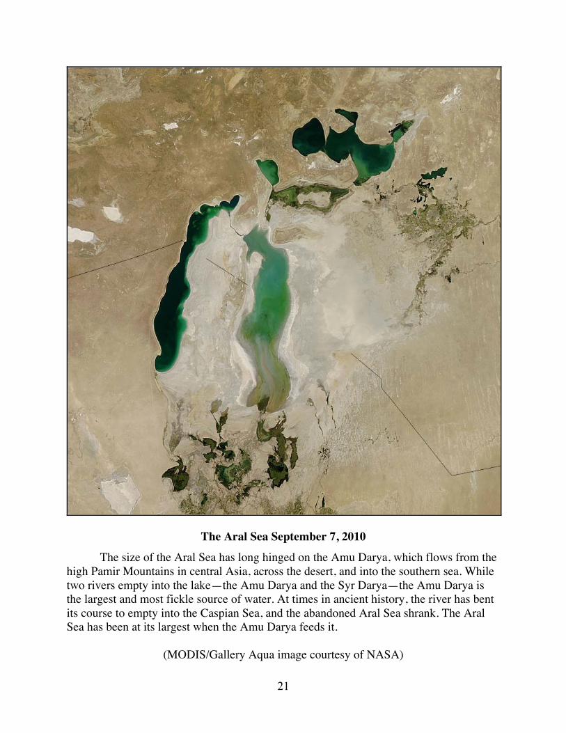
The Aral Sea September 7, 2010 The size of the Aral Sea has long hinged on the Amu Darya, which flows from the high Pamir Mountains in central Asia, across the desert, and into the southern sea. While two rivers empty into the lake—the Amu Darya and the Syr Darya—the Amu Darya is the largest and most fickle source of water. At times in ancient history, the river has bent its course to empty into the Caspian Sea, and the abandoned Aral Sea shrank. The Aral Sea has been at its largest when the Amu Darya feeds it.
(MODIS/Gallery Aqua image courtesy of NASA)
22
Modern trends are no exception: when water began to be diverted from the Amu Darya for vast agricultural projects starting in 1960, the Aral Sea began to shrink. This image, taken on September 7, 2010, by the MODIS instrument on NASA’s Aqua satellite, demonstrates the close connection between the Aral Sea and the Amu Darya River. Between 2000 and 2009, the Aral Sea steadily shrank. In 2006, severe drought settled in over Amu Darya Basin. Very little water reached the Aral Sea in 2007, and nothing flowed from the Amu Darya to the Aral Sea in 2008 and 2009. Without water from the Amu Darya, the southern Aral Sea rapidly declined, the eastern lobe all but disappearing in 2009. In 2010, however, the drought broke. Snow in the Pamir Mountains was normal, and enough water flowed into the Amu Darya that the river reached the Aral Sea. The muddy pulse of water settled in a shallow layer over the bed of the eastern lobe of the South Aral Sea, making it look much larger than it had in 2009.
(Portions of edited text used courtesy of NASA's Earth Observatory)
Web Reference http://earthobservatory.nasa.gov/IOTD/view.php?id=46685
23
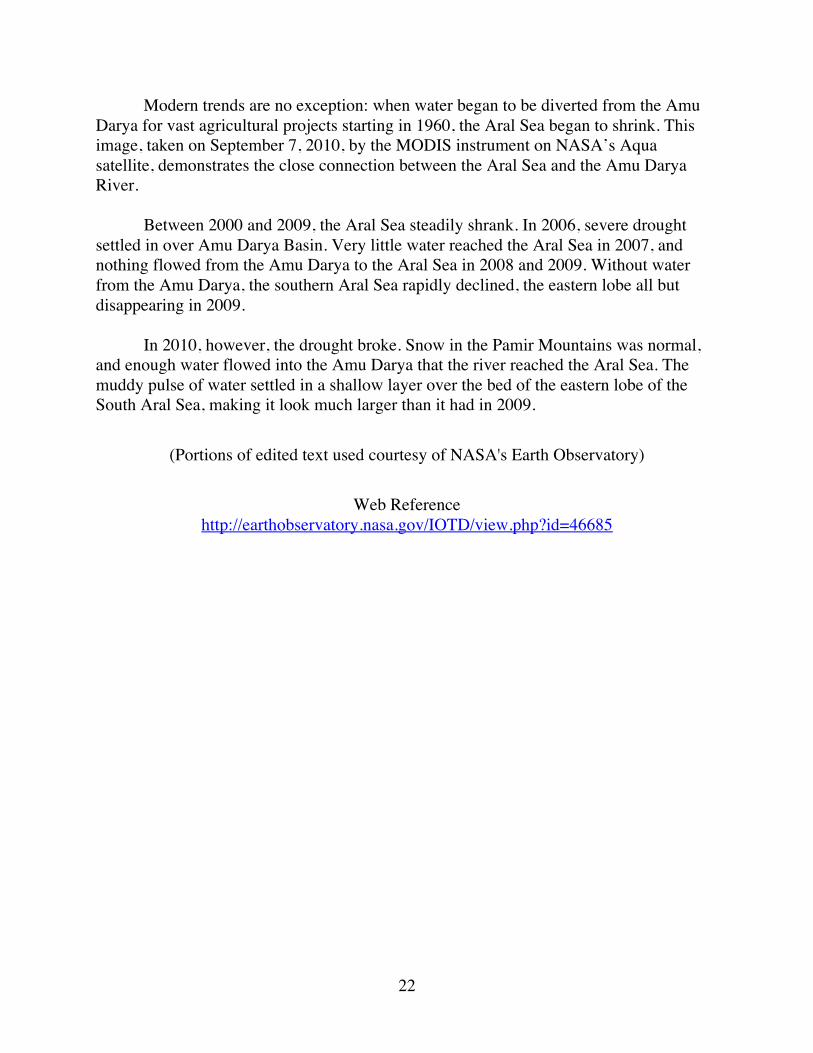
The Aral Sea September 23, 2011
This image shows the lowest level for the Aral Sea in 2011.
(MODIS/Terra Aral Sea Subset image courtesy of NASA)
24
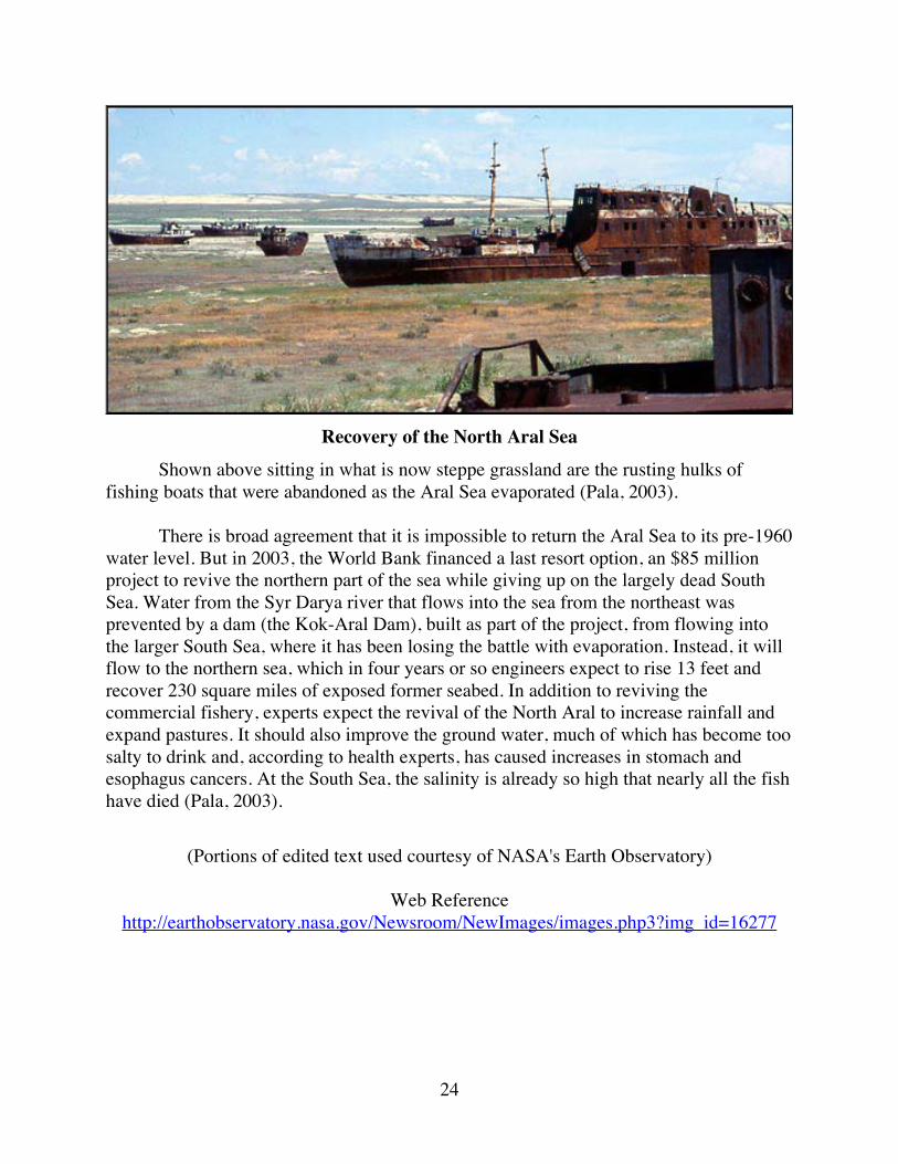
Recovery of the North Aral Sea
Shown above sitting in what is now steppe grassland are the rusting hulks of fishing boats that were abandoned as the Aral Sea evaporated (Pala, 2003). There is broad agreement that it is impossible to return the Aral Sea to its pre-1960 water level. But in 2003, the World Bank financed a last resort option, an $85 million project to revive the northern part of the sea while giving up on the largely dead South Sea. Water from the Syr Darya river that flows into the sea from the northeast was prevented by a dam (the Kok-Aral Dam), built as part of the project, from flowing into the larger South Sea, where it has been losing the battle with evaporation. Instead, it will flow to the northern sea, which in four years or so engineers expect to rise 13 feet and recover 230 square miles of exposed former seabed. In addition to reviving the commercial fishery, experts expect the revival of the North Aral to increase rainfall and expand pastures. It should also improve the ground water, much of which has become too salty to drink and, according to health experts, has caused increases in stomach and esophagus cancers. At the South Sea, the salinity is already so high that nearly all the fish have died (Pala, 2003).
(Portions of edited text used courtesy of NASA's Earth Observatory)
Web Reference http://earthobservatory.nasa.gov/Newsroom/NewImages/images.php3?img_id=16277
25
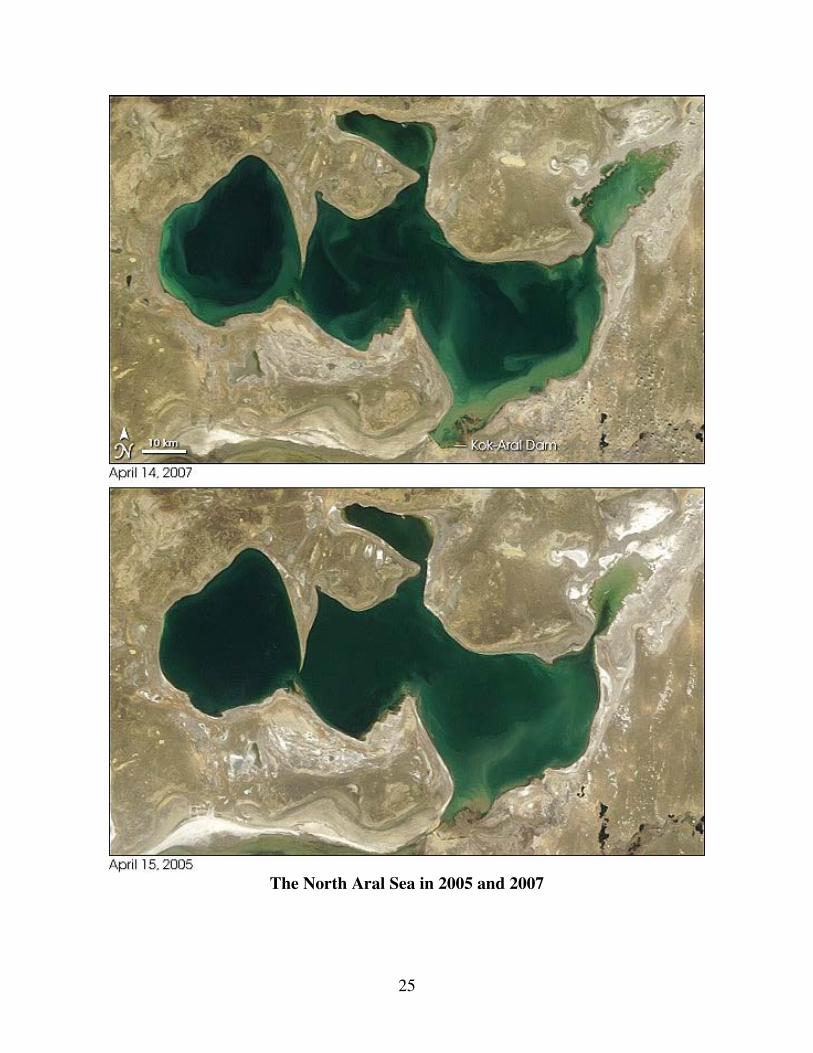
The North Aral Sea in 2005 and 2007
26
According to articles published in 2006 (Greenberg, 2006; Pala, 2006), since the Kok-Aral Dam’s completion in the summer of 2005, the North Sea has been filling up more rapidly than planners expected. This pair of MODIS/Terra images shows the changes in the North Aral Sea over the past two years. The top image is from April 14, 2007, while the bottom image is from April 15, 2005. The most obvious expansion of the lake’s area is in the northeast, where a narrow channel from the main body of the lake connects to a widening pool of shallow, sediment-clouded water. The former shorelines of the lake appear paler brown than the surrounding landscape. A more subtle change is in the width of the channel that connects the main body of the lake to the lake’s most western part; the tip of the peninsula jutting down into the lake appears farther from the southern shore in 2007, than it did in 2005. At lower right in each image is the Kok-Aral Dam, and the northern sea’s only tributary, the Syr Darya, just north of the dam.
(Portions of edited text and images used courtesy of NASA's Earth Observatory)
Web Reference http://earthobservatory.nasa.gov/Newsroom/NewImages/images.php3?img_id=17634
27
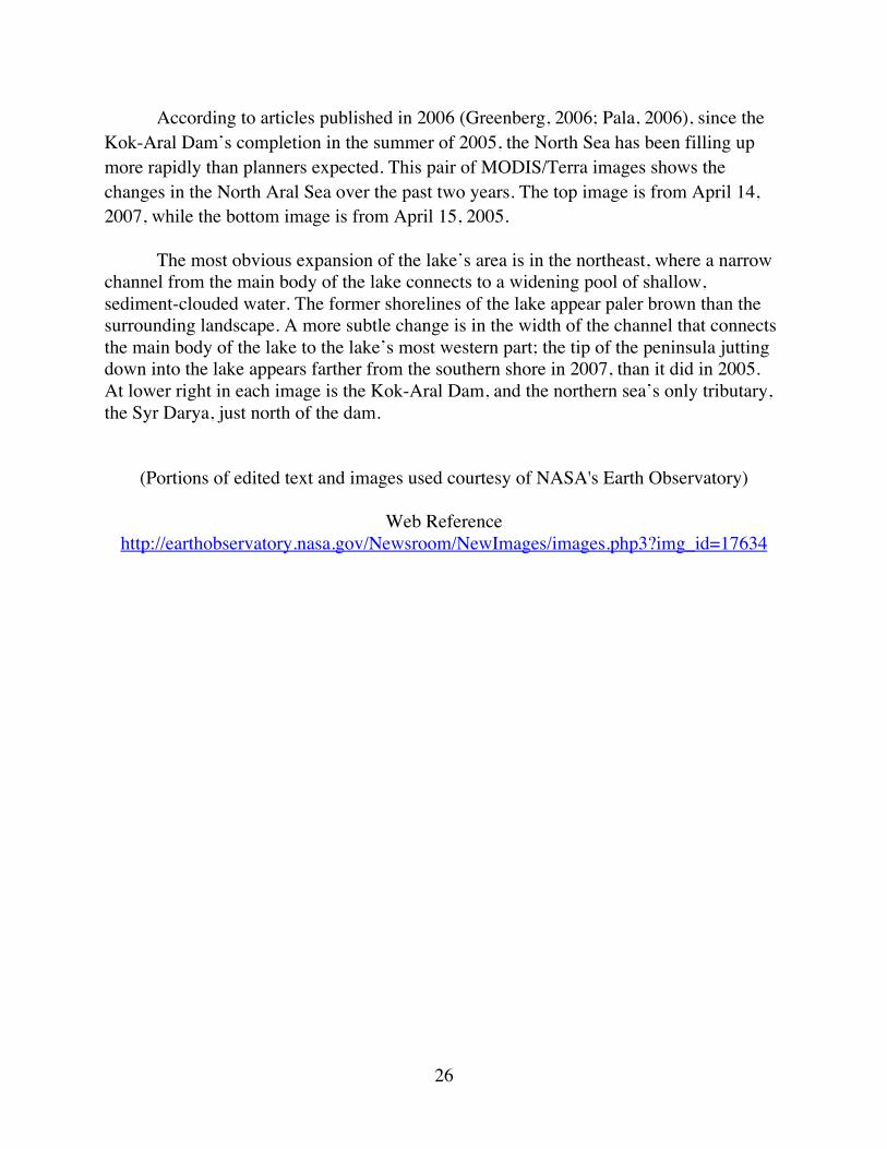
Tastubek, Kazakhstan on the North Aral Sea "At a fishing camp near this village on the Northern Aral Sea, a dozen small boats recently returned to shore bathed in a soft morning light. Their nets bulged with carp, pike, flounder, perch, and a half-dozen other species, all edible and ready for sale. It was a scene unimaginable just 6 years ago, when the Aral had shrunk to one-tenth of its original size. Soviet-era planners had diverted most of the water that flowed into the lake from two rivers to irrigate cotton, creating three smaller lakes that became too salty for most fish. Catches that once totaled more than 50,000 tons a year plummeted to just 52 tons in 2004. Now, since the 2005 construction of a $65 million dike, the northern part of the Aral has become a remarkably healthy fishery. The biomass, or weight of all the fish in the Northern Aral, has soared from an estimated 3500 tons in 2005 to 18,000 tons today, says Zaualkhan Yermakhanov, the Kazakh government’s regional fisheries director. “And it’s still growing.'" (Pala, 2011).
(Portions of edited text and image used courtesy of the journal Science)
28
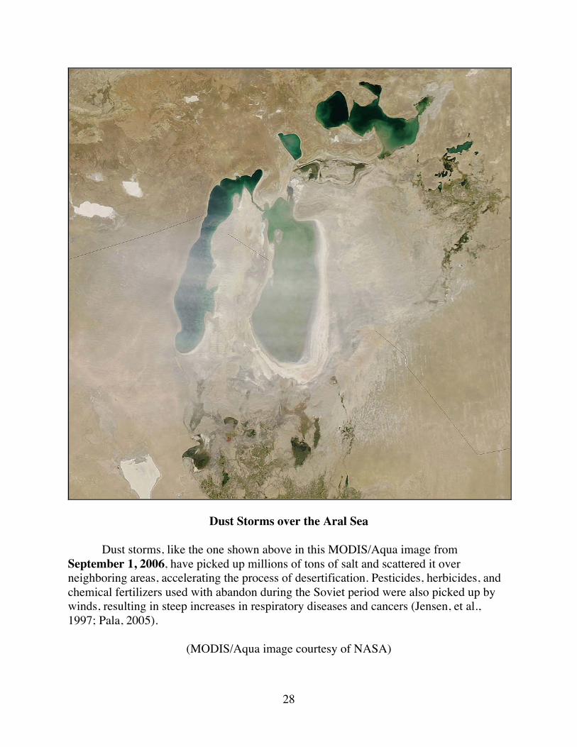
Dust Storms over the Aral Sea
Dust storms, like the one shown above in this MODIS/Aqua image from September 1, 2006, have picked up millions of tons of salt and scattered it over neighboring areas, accelerating the process of desertification. Pesticides, herbicides, and chemical fertilizers used with abandon during the Soviet period were also picked up by winds, resulting in steep increases in respiratory diseases and cancers (Jensen, et al., 1997; Pala, 2005).
(MODIS/Aqua image courtesy of NASA)
29
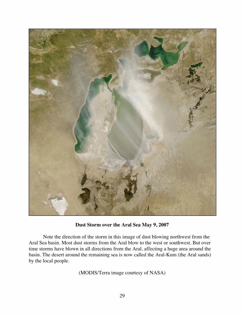
Dust Storm over the Aral Sea May 9, 2007
Note the direction of the storm in this image of dust blowing northwest from the Aral Sea basin. Most dust storms from the Aral blow to the west or southwest. But over time storms have blown in all directions from the Aral, affecting a huge area around the basin. The desert around the remaining sea is now called the Aral-Kum (the Aral sands) by the local people.
(MODIS/Terra image courtesy of NASA)
30
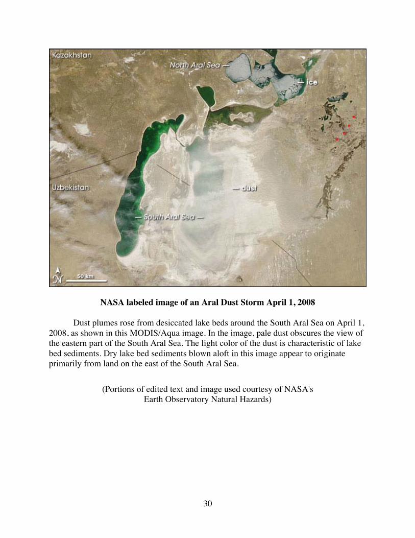
NASA labeled image of an Aral Dust Storm April 1, 2008
Dust plumes rose from desiccated lake beds around the South Aral Sea on April 1, 2008, as shown in this MODIS/Aqua image. In the image, pale dust obscures the view of the eastern part of the South Aral Sea. The light color of the dust is characteristic of lake bed sediments. Dry lake bed sediments blown aloft in this image appear to originate primarily from land on the east of the South Aral Sea.
(Portions of edited text and image used courtesy of NASA's Earth Observatory Natural Hazards)
31
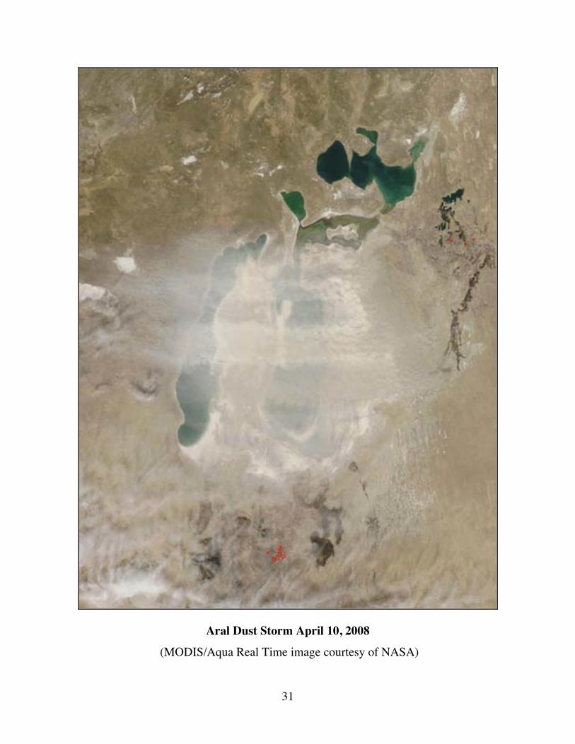
Aral Dust Storm April 10, 2008
(MODIS/Aqua Real Time image courtesy of NASA)
32
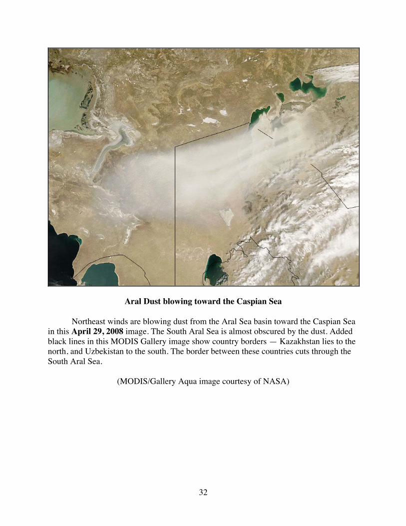
Aral Dust blowing toward the Caspian Sea Northeast winds are blowing dust from the Aral Sea basin toward the Caspian Sea in this April 29, 2008 image. The South Aral Sea is almost obscured by the dust. Added black lines in this MODIS Gallery image show country borders — Kazakhstan lies to the north, and Uzbekistan to the south. The border between these countries cuts through the South Aral Sea.
(MODIS/Gallery Aqua image courtesy of NASA)
33
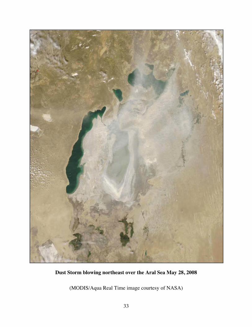
Dust Storm blowing northeast over the Aral Sea May 28, 2008
(MODIS/Aqua Real Time image courtesy of NASA)
34
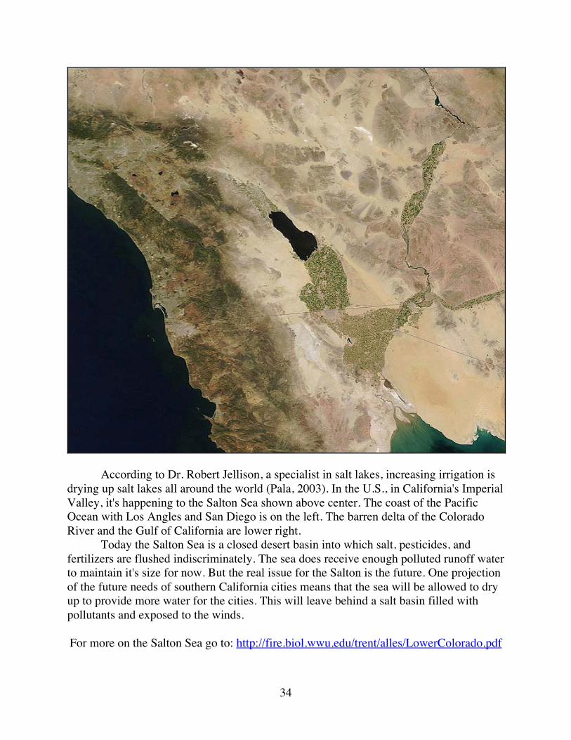
According to Dr. Robert Jellison, a specialist in salt lakes, increasing irrigation is drying up salt lakes all around the world (Pala, 2003). In the U.S., in California's Imperial Valley, it's happening to the Salton Sea shown above center. The coast of the Pacific Ocean with Los Angles and San Diego is on the left. The barren delta of the Colorado River and the Gulf of California are lower right. Today the Salton Sea is a closed desert basin into which salt, pesticides, and fertilizers are flushed indiscriminately. The sea does receive enough polluted runoff water to maintain it's size for now. But the real issue for the Salton is the future. One projection of the future needs of southern California cities means that the sea will be allowed to dry up to provide more water for the cities. This will leave behind a salt basin filled with pollutants and exposed to the winds.
For more on the Salton Sea go to: http://fire.biol.wwu.edu/trent/alles/LowerColorado.pdf
35
References
Dukhovny, V. & de Schutter, J. (Eds.) (2003). South Priaralie: New Prospects. Scientific-Information Center of ICWC. Last accessed 2011-10-16: http://www.cawater-info.net/aral/index_e.htm
Greenberg, I. (2006, 6 April). As a Sea Rises, So Do Hopes for Fish, Jobs and Riches. The New York Times, World.
Jensen, S., Mazhitova, Z., Zetterström, R. (1997). Environmental pollution and child health in the Aral Sea region in Kazakhstan. Science of the Total Environment.
Micklin, P. (2010, September 16). The past, present, and future Aral Sea. Lakes & Reservoirs: Research & Management, 15 (3), 193-213.
Pala, C. (2003, 5 August). $85 Million Project Begins for Revival of the Aral Sea. The New York Times, Science.
Pala, C. (2005). To Save a Vanishing Sea. Science, 307(Feb. 18), 1032-1034.
Pala, C. (2006). Once a Terminal Case, the North Aral Sea Shows New Signs of Life. Science, 312(April 14), 183.
Pala, C. (2011). In Northern Aral Sea, Rebound Comes With a Big Catch. Science, 334(Oct. 21), 303.
Roll, G., et al. (2006, 27 February). Aral Sea: Experience and Lessons Learned Brief, Final. World Lake Basin Management Initiative. Last accessed 2011-10-16: http://www.worldlakes.org/projects.asp?projectid=4
Stone, R. (1999). Coming to Grips With the Aral Sea's Grim Legacy. Science, 284, (April 2), 30-33.
Wiggs, G.F., O’Hara, S.L., Wegerdt, J., Van der Meer, J., Small, I., Hubbard, R. (2003). The Dynamics and Characteristics of Aeolian Dust in Dryland Central Asia: Possible Impacts on Human Exposure and Respiratory Health in the Aral Sea Basin. The Geographical Journal, 169(2), 142–157.
-------------------------
For further information on related topics go to:
Global Ecology and Remote Sensing http://fire.biol.wwu.edu/trent/alles/GlobalEcologyindex.html
Alles Biology Home Page
http://fire.biol.wwu.edu/trent/alles/index.html