Embed Size (px)
Citation preview
Giornale di Geologia Applicata 1 (2005) 147 –156, doi: 10.1474/GGA.2005-01.0-15.0015
The 1976 Friuli (NE Italy) earthquake
Giovanni Battista Carulli1 & Dario Slejko2
1 Dipartimento di Scienze Geologiche, Ambientali e Marine dell’Università di Trieste2 Istituto Nazionale di Oceanografia e di Geofisica Sperimentale - OGS, Trieste
ABSTRACT. On May 6, 1976 an ML 6.4 earthquake caused about 1,000 casualties in central Friuli (where the hamlets ofGemona, Venzone, and Trasaghis suffered widespread destruction). Even though more than 25 years have passed since itsoccurrence, the 1976 Friuli event is still being studied. The reason for this is that it could represent the maximum possiblequake in the Southern Alps and it was the first event that took place in Italy for which a large amount of seismological datawere collected. Moreover, good geological and geophysical information is available for this region which also has a well-known seismological history. Nevertheless, some scientific aspects of the 1976 – 1977 seismic sequence are still underdebate. This paper offers a general overview of the present knowledge about the earthquake and open the door to futureinvestigations.
Key terms: Seismicity, Neotectonics, Southern Alps, Friuli, Italy
IntroductionThe Friuli region, in NE Italy, and its surrounding areaswere hit by several destructive earthquakes over thecenturies, especially in the strip along the foothills(Cividale, Gemona, Tramonti, Belluno; locations shown inFIGS. 1 and 2), whereas the area of the plain and the Alpsare less seismic. The seismic hazard of Friuli (REBEZ et alii,2001) is conditioned by the lesser seismicity of the northernarea on the border with Carinthia (Austria) and especiallyby that of the eastern area on the border with Slovenia.
Information about several earthquakes which occurredin the distant past is poor while some strong events of the20th century (Tolmezzo 1928, Cansiglio 1936) are quitewell reported because specific surveys were scientificallydocumented (GORTANI, 1928; CAVASINO, 1929;ANDREOTTI, 1937). The May 6, 1976 earthquake isprobably the strongest event ever to have occurred in Friuli.It fostered geological and seismological studies aimed atgiving a better understanding of the 1976 earthquake and,more generally, the regional seismicity (see references inSLEJKO, 2000) as well as the geodynamical and structuralcontext (see references in CARULLI & PONTON, 1993 andPOLI et alii, 2002). In this framework, several scientificactivities were, and still are, financed by the regionalgovernment. Among many others, it is worth citing theregional seismometric network, which has been operatingsince May 1977, and the regional seismic risk map(CARULLI et alii, 2003), which is an important tool in urbanplanning and building retrofitting.
Geological SettingThe mountainous part of the Friuli Region comprises theeastern portion of the Southern Alps that in this area passes
gradually towards the east into the Dinaric orogenic belt.The southern parts of these mountain chains (Carnian andJulian pre-Alps) face the Friuli plain to the south (theeastern part of the Po plain), which can be considered theirforeland basin. The structural lineaments of the Dinaricorogenic belt have a SW vergence, while the Alpine oneshave a S-SE one.
The stratigraphic succession cropping out in Friuli(Middle Ordovician to Recent) attains a total thickness of20 km and can be considered unique in Italy for itsgeological time span and continuity. It is made mostly ofsedimentary rocks that belong to the Adriatic microplate,today cropping out in E-W oriented structural domains, aconsequence of the Hercynic, eo-Alpine, Dinaric and neo-Alpine orogenic events. In these structural compartments,the terrains become younger moving southwards from theItalian-Austrian border, in proximity to the PeriadriaticLineament, to the Friuli plain, a poorly deformed edge ofthe Adriatic microplate.
The central and external parts of the Carnian and Julianmountain chains (neglecting the more internal part made upof the Hercynian Paleocarnic mountain belt) were emplacedin distinct tectonic phases during the Paleogene p.p. and,with associated maximum deformation, during the LateMiocene-Quaternary. The latter tectonic phase determinedthe highest crustal shortening of the entire Southern Alps inthe Friuli region (up to 1/3 of the original terrain extension)(CASTELLARIN, 1979; CASTELLARIN & VAI, 1981). Theorogenic belt is composed of closely-spaced, generallysouth-verging overthrusts that originate an embricatedstructure. The footwall of the southernmost overthrusts ismade of Neogene and Pleistocene successions (CARULLI &PONTON, 1993), in the maximum shortening zone that
Carulli G. B., Slejko D. / Giornale di Geologia Applicata 1 (2005) 147 – 156 148
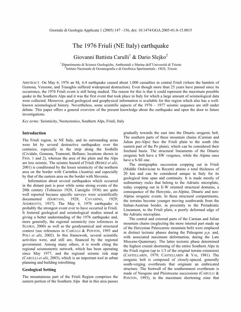
developed in response to the more recent N-S orientedcompressional stresses (ZANFERRARI et alii, 2000) (FIG. 1).
Modern and recent activity of these tectonic lines isamply documented by geological data (CARULLI et alii,1980; ZANFERRARI et alii, 1982) and high-precision
topographic measurements (TALAMO et alii, 1978) of thepre-Alpine area in particular. Here, this neotectonic activityfinds its expression in the extremely high reliefs and innumerous fresh and evident surface ruptures.
Fig. 1 - Sketch of the geological and seismological information for the epicentral area of the May 6, 1976 earthquake (partially modifiedfrom CAVALLIN et alii, 1990). The main causative faults of the 1976 sequence are indicated: a = Buja-Tricesimo line; b = Periadriaticoverthrust.
Carulli G. B., Slejko D. / Giornale di Geologia Applicata 1 (2005) 147 – 156 149
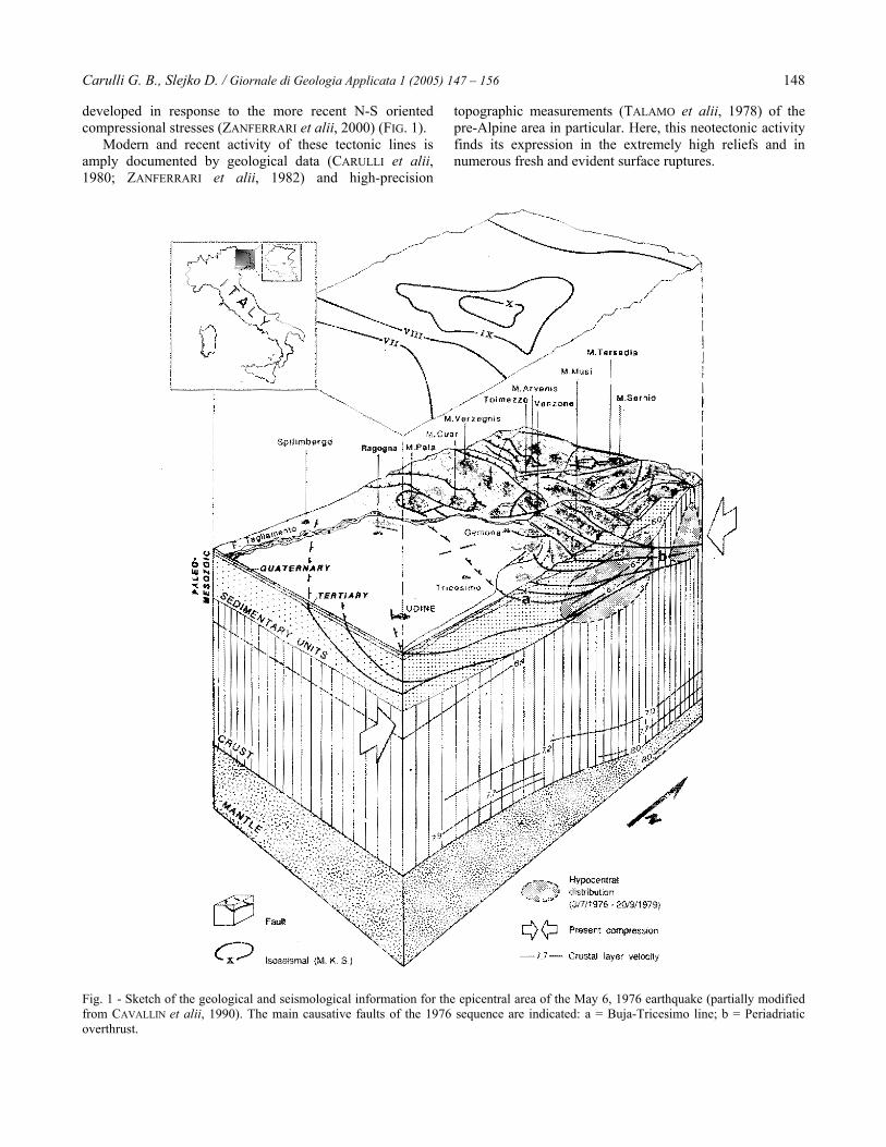
Fig. 2 - Epicenters of the earthquakes (mainshocks only) with magnitude larger than, or equal to, 3.5 from year 1000 to May 5, 1976. Thecircles indicate the events after 1894.
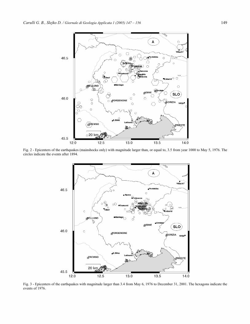
Fig. 3 - Epicenters of the earthquakes with magnitude larger than 3.4 from May 6, 1976 to December 31, 2001. The hexagons indicate theevents of 1976.
Carulli G. B., Slejko D. / Giornale di Geologia Applicata 1 (2005) 147 – 156 150
The Regional Seismicity before 1976The historical seismicity of Friuli and surrounding areas israther well known (BONITO, 1691; BARATTA, 1901) becausesome settlements were already established in Roman timesand developed during the Middle Ages (Belluno, Cividale,Trieste). The most recent earthquake catalogues of Italy(CAMASSI & STUCCHI, 1996; BOSCHI et alii, 1995, 1997;GRUPPO DI LAVORO CPTI, 1999) and some studies on theregional seismicity (e.g.: SLEJKO et alii, 1989) give a fairlyprecise view about the most seismically active areas.
The Friuli - Venezia Giulia region has a long history ofinstrumental data collection because the OsservatorioMarittimo seismographic station has been operating since1906. Already in 1958, it became part of a public institution(Osservatorio Geofisico Sperimentale, the present-dayIstituto Nazionale di Oceanografia e di GeofisicaSperimentale - OGS). In 1963, the seismographic stationwas moved from downtown Trieste (Campo Marzio) to alow-noise site (Grotta Gigante) and equipped with theinstruments of the World Wide Standardized SeismographicNetwork, coordinated by the U. S. Geological Survey. Someother stations close-by (e.g.: Ljubljana, Pula, Padova,Venezia, Treviso) have contributed to the data collection ofearthquakes in the eastern Alps since the beginning of the20th century.
Figure 2 shows the epicenters of the earthquakes(mainshocks only) with magnitude larger than, or equal to,3.5 which occurred from the year 1000 to May 5, 1976(GRUPPO DI LAVORO CPTI, 1999). Different symbols showthe accuracy of the locations: hexagons indicate post-1894events, which are considered well located because regularseismological data reports have been available since then.The figure shows that the major seismicity occurred alongthe piedmont belt, from Cividale to Belluno, with itsmaximum in Friuli. The seismicity of eastern Veneto wasparticularly strong in the Belluno area, where largeearthquakes occurred in 1873 (Io = IX-X Mercalli-Cancani-Sieberg, MCS), with damage in 50 villages of Alpago(BOSCHI et alii, 1995), and in 1936 (Io = IX MCS) withdestruction in Cansiglio (ANDREOTTI, 1937). The mostseismically active area in Friuli lies between Gemona andTolmezzo: the return period of destructive earthquakes thereis less than 100 years. Some strong events are associatedwith that area, like the 1389 (Io = VIII MCS), 1908 (Io =VIII MCS), and 1928 (Io = IX MCS; BOSCHI et alii, 1995)quakes. Another seismically active area is that of Tramonti,where the destructive quakes of 1776 (Io = VIII MCS) and1794 (Io = IX MCS) occurred; an VIII - IX MCS event hitthe neighboring village of Maniago in 1812. The Cividalearea shows, on the contrary, a peculiar seismicity with somelarge earthquakes, like those of 1278 (Io = VIII MCS), 1279(two quakes both with Io = VIII MCS), and 1898 (Io = VII-VIII MCS) but with only a few small-magnitude events.Furthermore, the quake that hit Raveo in 1700 (Io = X
MCS), whose effects were relevant only in a very limitedarea (about 70 km2) must also be mentioned.
A characteristic of the Friuli region is the mutualactivation of some seismic sources. The most remarkableexample is given by the seismic sequence which started in1788 with an VIII MCS quake at Tolmezzo, followed by anVIII MCS event one year later at Tramonti and a IV-VMCS quake at Sutrio in 1790 (BOSCHI et alii, 1995).Another example is the 1511 event (RIBARIC, 1979; BOSCHIet alii, 1995), which destroyed Idria (X MCS) and Gemona(IX MCS) on March 26 and severely hit Cividale (IX MCS)on August 8 of the same year. Some other seismic areas areimportant for the Friuli seismic hazard, although they arelocated outside the present Italian borders. Southern Austriawas affected by the large earthquake which destroyedVillach and many hamlets along the Gail valley in 1348 (Io= IX MCS) and was felt over the whole of Friuli (BORST,1988; HAMMERL, 1994; BOSCHI et alii, 1995). Anotherdestructive earthquake again hit Villach (Io = VIII-IX MCS)in 1690 (EISINGER & GUTDEUTSCH, 1994; BOSCHI et alii,1995). Lower seismicity characterizes western Slovenia,especially the Mt. Sneznik area, SE of Trieste. Furthereastwards, some large quakes hit Ljubljana (Io = VIII MCSin 1895; BOSCHI et alii, 1995) and the Croatian coastal areaaround Rijeka (Io = IX MCS in 1323, 1574, and 1721). Ingeneral, seismicity appears more uniform in Slovenia and inCroatia than in Veneto and Friuli (DEL BEN et alii, 1991).
The 1976 Earthquake and the SubsequentSeismicityOn May 6, 1976 a 6.4 local magnitude (ML) hit a 5700 km2
area in central Friuli, destroying several villages(AMBRASEYS, 1976) and causing 989 deaths and 4,500billion Italian liras of damage (at the 1976 value;CAVALLIN et alii, 1990). The maximum intensity (X degreeMedvedev-Sponheuer-Karnik, MSK) was reached atGemona, Venzone and Trasaghis (GIORGETTI, 1976) andwas felt as far as the Baltic coast and the Netherlands(KARNIK et alii, 1978). Several seismologists located theevent (see more details in SLEJKO, 2000), the updatedcoordinates (SLEJKO et alii, 1999) are 46°15.8'N and13°18.0'E, Gran Monte area, with a 6 km depth. CAPUTO(1976) computed a 10-13 bar stress drop, a 10 25.9-10 26.1
dyne x cm seismic moment, an 800 km2 fault area, and a 32-54 cm dislocation for the event. The fault-plane solution,computed by the first arrival onsets, as well as by waveformmodeling (see more details in SLEJKO, 2000), is of reversedip-slip type and refers to a gently north-dipping overthrust.The main shock was preceded one minute before by a 4.5ML magnitude event. Four small quakes occurred somemonths before May 6 much more to the south, around themouth of the Tagliamento River, an almost aseismic area:they were interpreted as foreshocks of the May 6 mainshock (FINETTI et alii, 1979). The May 6 main shock wasfollowed by a long series of aftershocks, among which the
Carulli G. B., Slejko D. / Giornale di Geologia Applicata 1 (2005) 147 – 156 151
5.3 ML event of May 9, which was the strongest. After aquiescence in August, two strong quakes occurred onSeptember 11 (ML 5.1 and 5.6) and a further two onSeptember 15 (ML 5.8 and 6.1), with additional deaths anddamage especially in the Gemona area. FINETTI et alii(1976) studied the seismic sequence using the data of atemporary network installed after the May and Septemberquakes. While the May seismicity remained concentrated ineastern Friuli, it propagated westwards in central Friuliduring the month of September. All hypocenters weresurficial, with a depth of less than 20 km. Differentinterpretations were given to the aftershock fault-planesolutions: reverse, normal, and transcurrent motions wereproposed for the associated faults. The updated
interpretation (SLEJKO et alii, 1999) suggests similarmechanisms for the majority of the events of reverse dip-slip type with a plane gently dipping N-NW, similar then tothe mechanism of the main shock. Figure 3 shows the spacedistribution of the events of the seismic sequence: theconcentration in central Friuli is evident although theepicenters spread from the Tagliamento River to the borderwith Slovenia. A few events can be seen in the Friuli plainand, as mentioned before, in the southernmost part of theTagliamento River.
The OGS seismometric network of Friuli - VeneziaGiulia started operating on May 6, 1977, exactly one yearafter the main shock: its goal, at this early stage, was todocument the seismic sequence and, later, to collect data of
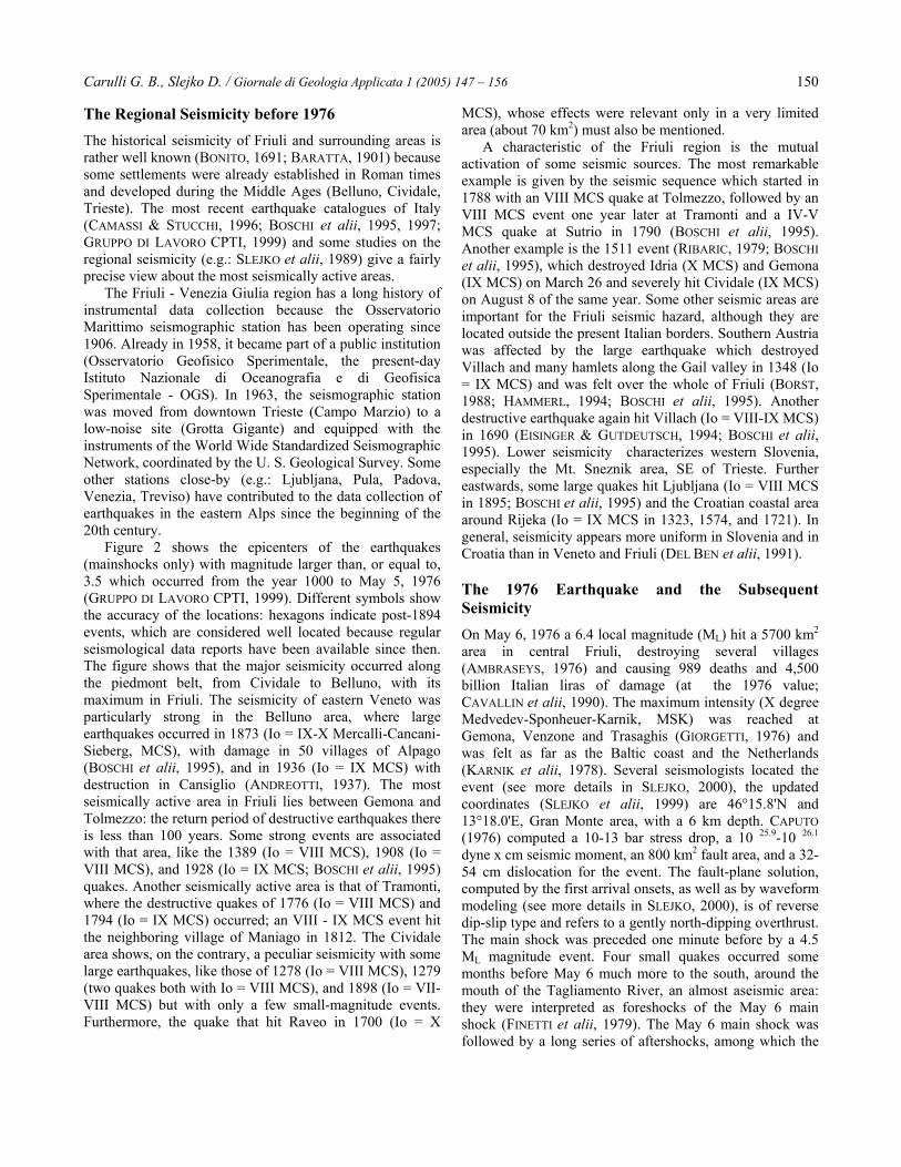
Fig. 4 – Fault-plane solutions of the main earthquakes which occurred from 1928 to 1986 (from SLEJKO et alii, 1989). Black sectorsindicate compressions in the lower hemisphere of the stereographic projection. The numbers follow the chronological sequence andnumber 18 indicates the May 6, 1976 main shock.
Carulli G. B., Slejko D. / Giornale di Geologia Applicata 1 (2005) 147 – 156 152
the regional seismicity (OGS, 1977-1981, 1982-1990, 1991-2001). A new seismic phase started on September 16, 1977with a 5.3 ML event west of the Tagliamento River and,consequently, outside the bulk of the 1976 seismicity.According to FINETTI et alii (1976, 1979), the May 6, 1976main shock was generated by the Buja-Tricesimo line (a inFIG. 1), a NW-SE (Dinaric) trending fault on the Friulipiedmont belt. From June onwards, the earthquakes affectedAlpine faults as well, in particular the PeriadriaticOverthrust (Barcis - Starasella line: b in FIG. 1): the mainevents of May and September 1976, and September 1977identified a detachment plane, dipping about 40° north,related to the Periadriatic Overthrust.
The strong September aftershocks were due to thedynamic re-equilibrium following the decompression of thewestern rocky blocks caused by the main shock. Furtherstudies suggested a model with asperities and barriers forthe seismic sequence (LYON-CAEN, 1980) with a normalstress-drop in May and a larger one in September 1977(SUHADOLC, 1981). A northward dipping plane, between adepth of 5 and 19 km, was identified for the September1977 sequence. With the passing of time, the earthquakesaffected an area which was vaster than the Gemona -Venzone epicentral area of the main events of 1976.
Figure 4 collects the fault-plane solutions of theprincipal events. They are rather similar to each other,representing a dip-slip mechanism in agreement with an E-W to NE-SW trending plane, gently dipping to the north. Alink between earthquakes and surficial faults is verydifficult to establish and a complex geometry of the faults indepth was proposed (SLEJKO et alii, 1989): faults couldmerge together upon contact with the crystalline basementat a depth of about 10 km, producing a detachment plane.
The surficial cracks (AMBRASEYS, 1976; BOSI et alii,1976; PANIZZA, 1977; MARTINIS & CAVALLIN, 1978;CAVALLIN et alii, 1990) were not linked to any seismogenicfault because of the complexity of the regional tectonics andtheir long reactivation history, which is testified by thegeometry of the structural elements. Only AOUDIA et alii(2000) related the ground cracks to a blind thrust buriedunder the Ragogna structure. It is proposed that this thrust is19 km long, from Susàns to Mt. Bernadia (SE of Gemona)and it is considered the causative fault of the 1976 mainshock. From geodetic data (TALAMO et alii, 1978), themaximum deformation caused by the earthquake waslocated around Venzone. The inversion of those data (ARCAet alii, 1985; BRIOLE et alii, 1986) suggested a fault-plane inagreement with that obtained from the seismological datawith ruptures east and west of the Tagliamento River, thelatter presenting also a strike-slip component. AMATO &MALAGNINI (1990) used tomographic inversion to identify ahigh-density south-verging body with a depth of 5 to 10 km,which was interpreted as being a wedge of the PaleocarnicInfrastructure (this feature was already suggested byCASTELLARIN et alii, 1979). This overthrust the crystallinebasement and could have been the major cause of the
seismicity in Friuli and, consequently, also of the 1976earthquake.
A recent reconstruction, obtained by fault-plane solutioninversion (SLEJKO et alii, 1999), of the stress fieldresponsible for the sequence which started on May 6, 1976shows that the stress field was not constant in time. After aninitial phase, which lasted till mid-September, during whichthe stress field was homogeneous and coherent with theregional tectonics, a heterogeneous situation was reached.This heterogeneity started in July and increased after themiddle of September and was probably caused by thesuperimposition of local responses to the regional field. Themain quakes of September 1976 and September 1977 seem,anyway, again produced by the regional field.
As said before, the seismometric network of Friuli -Venezia Giulia has been operating since May 6, 1977. Thenumber of stations has increased over the years from theinitial 3 to the present-day 15. Considering also the data ofthe stations in the neighboring countries, most of the eventswith ML larger than 1.0 have been located: 13,895earthquakes were located between May 6, 1977 andDecember 31, 2001.
Using this huge data set, good information about theregional seismicity can be obtained. Figure 3 shows theepicenters of the events with magnitude larger than 3.5which occurred from the installation of the seismometricnetwork till December 2001. As can be seen, the seimicityis always located mainly along the Friuli foothills: the highdensity in its central sector is partly due to the coda of theMay 6, 1976 sequence. Lower seismicity can be seen in thenorthernmost Alpine sector and in the Friuli plain. The NW-SE alignment in Slovenia refers to the 1998 Bovec sequencewhich started with the 5.6 ML main shock of April 12, 1998(an ML=5.1 earthquake occurred in the same area on July12, 2004). The general agreement between the spacedistribution of the historical seismicity in FIG. 2 and thepresent-day one in FIG. 3 is worth noting: almost all thezones which were active in the past are active nowadayswith the major events occurring in the Gemona, Trasaghis,and Tolmezzo areas.
Seismotectonic Interpretation of the 1976Earthquake and of the Present-day RegionalSeismicityThe latest interpretation of the seismic sequence, whichstarted on May 6, 1976, was recently proposed by POLI etalii (2002). On the basis of new geological data, theyconstructed a 2D structural model for the South-Alpinechain. According to the classical tectonic setting suggestedfor the eastern South-Alpine chain, the cross-section showsa south-verging thrust-belt arranged in an embricate fangeometry. At the Gemona latitude, at a depth of 5-8 km, anorth-verging steep back-thrusting system becomes active:there seems to be a concentration of cracks in the carbonaticrocks. On the contrary, the 1977-1999 seismicity appears
Carulli G. B., Slejko D. / Giornale di Geologia Applicata 1 (2005) 147 – 156 153
distributed in a larger crustal volume, with an evidentwestward shift of the maximum seismic activity. The stressredistribution caused by the 1976 sequence possiblyproduced a transfer of the deformation to the western sector.The main event of May 6, 1976 is associated with theSusans - Tricesimo fault, a new interpretation of the deepsector of the Buja-Tricesimo line of FINETTI et alii (1976) (ain FIG. 1) while the strong aftershock of September 15,1976 is related to the buried Trasaghis fault (GALADINI etalii, 2002), lateral ramp of the Pozzuolo line. This regionaloverthrust (POLI et alii) crops out a few kilometers south ofUdine.
The distribution of the present-day seismicity (FIGS 3and 4) shows the clear alignment of epicenters along thepre-Alpine and Dinaric belts as far as the Croatian coast.The bulk of this active belt is located in Friuli. Theseismicity in Slovenia is more diffuse and quite uniformlydistributed from the surface to a 20 km depth, while inFriuli the foci mainly affect the surficial 12 km of depth,with the maximum concentration between 8 and 10 km. Thespace distribution of the recent seismicity suggests a linkbetween the earthquakes and the Alpine overthrusts, whichhave sometimes reactivated older Dinaric structures (POLI etalii, 2002). The main seismic release occurs at the point ofcontact between the crystalline basement and thesedimentary cover (SIRO & SLEJKO, 1982), which must havebeen detached from the basement itself (BRESSAN et alii,1992). CARULLI & PONTON (1993), in their structuralinterpretation of the crust in the central Friuli - Carniasector, suggested that the south-verging overthrusts formeda progressive sequence towards the foreland. They linked,moreover, the earthquakes to the area of maximum crustalinterference with the Dinaric structural system, not only
inside the sedimentary cover, but also at the top of theHercynic formations and of the magnetic basement (CATI etalii, 1989); the seismicity decreases abruptly below thiszone. In the border area with Slovenia, the earthquakestestify the strike-slip activity of the Dinaric faults (see e. g.:the 1998 Bovec sequence; BERNARDIS et alii, 1998). Theregional stress tensor, computed by inversion of theearthquake fault-plane solutions (BRESSAN et alii, 1998)indicates that seismicity refers both to the Alpine andDinaric systems but a precise link between earthquake andfault was proposed only for the 1976 event (AMATO et alii,1976; FINETTI et alii, 1979; AOUDIA et alii, 2000; GALADINIet alii, 2002) and for the two strong historical quakes of1348 (GALADINI et alii, 2002) and 1511 (FITZKO et alii,2001; GALADINI et alii, 2002). The high density of faults,with poorly known deep geometry, which belong to the twodifferent tectonic systems and interfere with them does nothelp the detailed kinematic interpretation of the regionalseismogenesis.
The global seismotectonic context (SLEJKO et alii, 1989;CARULLI et alii, 1990; DEL BEN et alii, 1991) points to themain seismic areas as being located between the presentlyactive Alpine and Dinaric fronts and some vertical faults,which are supposed to act as disengaging elements (Fella -Sava and Idrija lines). These faults, which are seismicallyactive and show recent vertical tectonic activity, seem todisengage the Adriatic microplate from the stable Europeanplate kinematically.
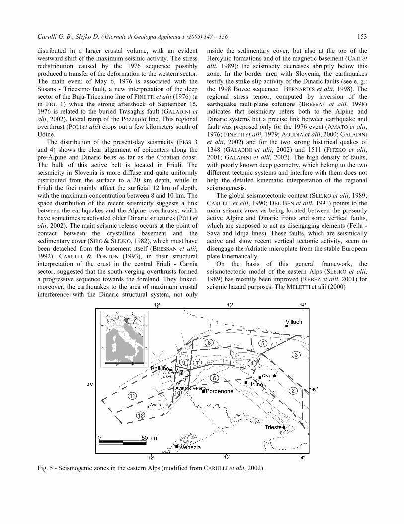
On the basis of this general framework, theseismotectonic model of the eastern Alps (SLEJKO et alii,1989) has recently been improved (REBEZ et alii, 2001) forseismic hazard purposes. The MELETTI et alii (2000)
Fig. 5 - Seismogenic zones in the eastern Alps (modified from CARULLI et alii, 2002)
Carulli G. B., Slejko D. / Giornale di Geologia Applicata 1 (2005) 147 – 156 154
seismogenic zones, which were used for the seismic hazardassessment of Italy, were considered a starting point for therevision of the regional seismogenic zonation. This modeldefined only two seismogenic zones in Friuli. The detailedanalysis of the regional seismicity, in terms of spacedistribution and focal mechanisms, within its geologicalcontext led to the identification of six seismogenic zoneswith different seismotectonic characteristics (FIG. 5).This seismogenic zonation was recently used for the soil-dependent seismic hazard map of the Friuli - Venezia Giuliaregion (REBEZ et alii, 2001), where the horizontal peakground acceleration with a 475-year return period wasmapped, taking into account the specific soil typologies inthe study area. This seismic hazard map contributed to theseismic risk assessment for the Friuli - Venezia Giuliaregion (CARULLI et alii, 2003), providing information ofparamount importance for urban planning and buildingretrofitting.
ConclusionsContrary to other earthquakes, the 1976 Friuli event is stillbeing studied, regardless of the fact that 25 years havepassed since its occurrence. This is because it is a complexphenomenon (the aftershocks lasted about 20 months,migrating northwestwards from the border with Slovenia tocentral Friuli) and a huge amount of seismological data wasacquired, especially by temporary stations. This earthquakeis surely a key element in understanding the seismogenesisof this region. Together with the data from recentseismicity, it is well documented because of the presence ofthe regional seismometric network, and thus it gives clearindications about the activity of the Alpine and Dinarictectonic structures. This activity remains located inside thesedimentary cover with its maximum at the top of thecrystalline basement.
Ten centuries of historical seismicity give quite a goodvision of the active sources and this picture is coherent withthat given by recent seismicity. The main seismic sourcesare: Belluno, Claut, Gemona-Trasaghis-Tolmezzo, Kobarid,and, to a lesser extent, Cividale. The seismotectoniccharacteristics of the region between Tarvisio and Villachare less evident, the occurrence there of some strongearthquakes of the past (1348 and 1690) is not supported bythe very low recent seismicity. Furthermore, that region isfar away from the external deformation front of the Alpinechain and does not show remarkable evidence of recenttectonic activity. The low magnitude earthquakes whichoccur in the vicinity of the Adriatic coast (Latisana and SanStino) are less important for the regional seismogenesis butare interesting because it is difficult to insert them into theregional geodynamical framework. To give a kinematicexplanation of the mutual activation of neighboring sourcesis difficult as well.
The general structural-geological framework is alsorather well known: the tectonic structures belong to a south-
verging thrust belt arranged in a strictly embricate fangeometry. The seismicity is definitely connected with theAlpine faults or with faults with Dinaric orientation, whichwere re-activated during the neo-Alpine tectonic phase. Thisstatement is supported by the fault-plane solutions availablefor Friuli. But it is not yet clear how the Alpine and Dinaricstructures interfere or, better, how the presence in the Friuliregion of the Dinaric structures, which are often reactivatedby the present Alpine stress tensor, influences the presentstructural evolution. Furthermore, the relevance of thereactivation in a strike-slip fashion of the Mesozoicextensional paleostructures in the Tagliamento River gorgeremains unclear.
Two different interpretations were proposed recently forthe rupture model and the fault responsible for the 1976seismic sequence. AOUDIA et alii (2000) suggested that themain active deformation was a fault-propagation foldassociated with a blind thrust ramp. This model produceswaveforms in agreement with the accelerograms recorded inthe area. POLI et alii (2002) and GALADINI et alii (2002),updating the previous mainly cylindrical interpretations,presented a new picture of the Plio-Quaternary deformationfront in Friuli: the Authors drew the deformation frontsegmented by a system of curved thrusts laterally piled bymeans of oblique ramps. The 1976 mainshocks and somelarge earthquakes which occurred during the past in Friuli(1348, 1511) are associated with some of these thrusts.
The very long duration of the seismic sequence whichstarted on May 6, 1976 indicates that the energy wasreleased progressively in time. A sudden energy releasecould have produced more severe effects and indicated thepossibility of a larger maximum magnitude for the region.Evidence of this larger event is not documented in theearthquake catalogue, but doubts remain about the 1511quake whose widely damaged area makes it difficult toidentify its epicenter.
In conclusion, although the seismicity in Friuli is ratherwell documented in the literature, a huge amount ofseismological data was collected for the 1976 earthquakesequence, good quality seismological data have beencollected since 1977, geological surveys and studies wereand are performed, nevertheless the regional seismogenesisstill presents some cloudy aspects regarding the location andsize of the maximum possible earthquake and itsseismotectonic interpretation. Using the availableseismotectonic knowledge, some specific studies wererecently performed and some paramount results wereobtained: the regional seismic hazard (REBEZ et alii, 2001)and seismic risk (CARULLI et alii, 2003) maps. Not only dothese products have a scientific value but also a socialrelevance because they can be the bases for urban planningand building retrofitting.
AcknowledgementsThe seismometric network of Friuli - Venezia Giulia ismanaged by OGS with financial support from the Regione
Carulli G. B., Slejko D. / Giornale di Geologia Applicata 1 (2005) 147 – 156 155
Autonoma Friuli - Venezia Giulia. The Civil ProtectionDirection of the same regional government financed the
seismic risk map, which was produced by Trieste and UdineUniversities and OGS.
ReferencesAMATO A., BARNABA P.F., FINETTI I., GROPPIG., MARTINIS B. & MUZZIN A.(1976) -Geodynamic outline and seismicity of FriuliVenetia Julia region. Boll. Geof. Teor. Appl., 18,217-256.AMATO A. & MALAGNINI L. (1990) - A blindthrust beneath the Friuli region? Evidence fromlocal earthquake tomography. In: ROCA A. &MAYER-ROSA D. (eds), Proceedings ESC 22ndGeneral Assembly, 121-126.AMBRASEYS N.N.(1976) - The Gemona di Friuliearthquake of 6 May 1976. In: PICHARD P.,AMBRASEYS N.N. & ZIOGAS G.N., UnescoRestricred Technical Report RP/1975-762.222.3., Paris, part 2.ANDREOTTI G. (1937) - Il terremoto del 18ottobre 1936. Mem. Regio Ist. Veneto Sc. Lett.Arti, 30 (3), 3-24.AOUDIA A., SARAÒ A., BUKCHIN B. &SUHADOLC P. (2000) - The 1976 Friuli (NEItaly) thrust faulting earthquake: a reappraisal23 years later. Geoph. Res. Lett., 27, 573-576.ARCA S., BONASIA V., DE NATALE G., PINGUEF. & SCARPA R. (1985) - A multiple fault systemas the fracture mechanism for the 1976-1977Friuli earthquakes, from inversion of geodeticdata. Boll. Geod. Scienze Aff., 44, 101-124.BARATTA M. (1901) - I terremoti d'Italia.Fratelli Bocca, Torino, 951 pp.BERNARDIS G., POLI M.E., SNIDARCIG A. &ZANFERRARI A. (1998) - Il terremoto di Bovec(Slovenia NW) del 12 aprile 1998. In: 17° Conv.Naz. GNGTS, Riassunti Estesi delleComunicazioni, ESA, Roma, 137-138.BONITO M. (1691) - Terra tremante. Parrino -Muti, 822 pp., NapoliBORST A. (1988) - Il terremoto del 1348.Laveglia, 64 pp., SalernoBOSCHI E., FERRARI G., GASPERINI P.,GUIDOBONI E., SMRIGLIO G. & VALENSISE G.(1995) - Catalogo dei forti terremoti italiani dal461 a. C. al 1980. Istituto Nazionale diGeofisica, SGA storia geofisica ambiente, 973pp., RomaBOSI C., CAMPONESCHI B., & GIGLIO G. (1976) -Indizi di possibili movimenti lungo faglie inoccasione del terremoto del Friuli del 6 maggio1976. Boll. Soc. Geol. It., 95, 803-830.BRESSAN G., DE FRANCO R. & GENTILE F.(1992) - Seismotectonic study of the Friuli (Italy)area based on tomographic inversion andgeophysical data. Tectonophysics, 207, 383-400.BRESSAN G., SNIDARCIG A. & VENTURINI C.(1998) - Present state of tectonic stress of theFriuli area (eastern Southern Alps).Tectonophysics, 292, 211-227.BRIOLE P., DE NATALE G., GAULON R., PINGUEF., & SCARPA R. (1986) - Inversion of geodeticdata & seismicity associated with the Friuli
earthquake sequence (1976-1977). Ann. Geofis.,4 , B4, 481-492.CAPUTO M. (1976) - The area of the fault, thedislocation, the stress-drop & the seismicmoment of the Friuli earthquake of May 6th1976. Boll. Geof. Teor. Appl., 18, 405-409.CARULLI G.B., CAROBENE L., CAVALLIN A.,MARTINIS B. & ONOFRI R. (1980) - Evoluzionestrutturale Plio-quaternaria del Friuli e dellaVenezia Giulia. Contrib. prelim. allarealizzazione della Carta Neotettonica d'Italia,Pubbl. n.265, P.F. Geodinamica, 487-532,Napoli.CARULLI G.B., NICOLICH R., REBEZ A. &SLEJKO,D. (1990) - Seismotectonics of theNorthwest External Dinarides. Tectonophysics,179, 11-25.CARULLI G.B. & PONTON M. (1993) -Interpretazione strutturale profonda del settorecentrale carnico - friulano. Studi Geol. Camerti,vol. spec. 1992/2 CROP 1 - 1A, 275-284.CARULLI G.B., RIUSCETTI M. & SLEJKO D.(2003)CARULLI G.B., CUCCHI F., REBEZ A., PERUZZAL, SLEJKO D. & CODEMATZ R. (2002) – Seismichazard in the Friuli-Venezia Giulia region (NEItaly) considering different soil typologies. Mem.Soc. Geol. It., 57, 401-408.CASTELLARIN A. (1979) - Il problema deiraccorciamenti crostali del Sudalpino. Rend.Soc. Geol. It, 1, 21-33,CASTELLARIN A., FRASCARI F. & VAI G.B.(1979) - Problemi di interpretazione geologicaprofonda del Sudalpino orientale. Rend. Soc.Geol. It., 2, 55-60.CASTELLARIN A. & VAI G.B. (1981) -Importance of the Hercynian tectonics within theframe of the Southern Alps. Journ. Struct. Geol.,3 (4), 477-486.CATI A., FICHERA R. & CAPPELLI V. (1989) –Northeastern Italy, integrated processing ofgeophysical and geological data. Mem. Soc.Geol. It., 40 (1987), 273-288.CAVALLIN A., BROILI L., CARULLI G.B.,MARTINIS B., MELE M., SIRO L. & SLEJKO D.(1990) - Case history: Friuli earthquake, 1976.In: COTECCHIA V. (ed), Proceedings of theinternational symposium on EngineeringGeology Problems in Seismic Areas, Bari 13-19April 1986, Geologia Applicata ed Idrogeologia,Bari, 6, 1-82.CAVASINO A. (1929) - Il terremoto nelle PrealpiCarniche orientali del 27 marzo 1928. Boll. Soc.Sism. It., 28, 77-100.DEL BEN A., FINETTI I., REBEZ A., & SLEJKO D.(1991) - Seismicity and seismotectonics at theAlps - Dinarides contact. Boll. Geof. Teor.Appl., 33, 155-176.EISINGER U. & GUTDEUTSCH R.. (1994) - TheVillach earthquake of December 4th, 1690 in the
German sources. In: ALBINI P. & MORONI A.(eds), Historical investigation of Europeanearthquakes 2, C.N.R. Ist. Ric. Rischio Sism.,Milano, 133-137.FINETTI I., GIORGETTI F., HAESSLER H., HOANGT.P., SLEJKO D. & WITTLINGER G. (1976) - Timespace epicenter and hypocenter distribution andfocal mechanism of 1976 Friuli earthquakes.Boll. Geof. Teor. Appl., 18, 637-655.FINETTI I., RUSSI M. & SLEJKO D. (1979) - TheFriuli earthquake (1976-1977). Tectonophysics,53, 261-272.FITZKO F., SUHADOLC P., AUDIA A. & PANZAG.F. (2001) - Constrains on the location andmechanism of the 1511 western Sloveniaearthquake from active-tectono studies andmodelling of macroseismic data. In: SLEJKO D.(a cura di), 20° Convegno Nazionale G.N.G.T.S.Riassunti estesi delle comunicazioni, TipografiaMosetti, Trieste, pp. 233.GALADINI F., POLI M.E. & ZANFERRARI A.(2002) - Sorgenti sismogenetiche responsabili diterremoti distruttivi nell'Italia nord-orientale. In:SLEJKO D. & REBEZ A. (a cura di), G.N.G.T.S.21° Convegno Nazionale - Riassunti estesi dellecomunicazioni, Tip. Mosetti, 27-30, Trieste.GIORGETTI F. (1976) - Isoseismal map of theMay 6, 1976 Friuli earthquake. Boll. Geof. Teor.Appl., 18, 707-714.GORTANI N. (1928) - Il terremoto del 27 marzo1928 nelle Prealpi dell'Arzino (Friuli). Notegeologiche. L'Universo, 9, 1155-1210.GRUPPO DI LAVORO CPTI (BOSCHI E.,GASPERINI P., VALENSISE G., CAMASSI R.,CASTELLI V., STUCCHI M., REBEZ A.,MONACHESI G., BARBANO M.S., ALBINI P.,GUIDOBONI E., FERRARI G., MARIOTTI D.,COMASTRI A. & MOLIN D.) (1999) - CatalogoParametrico dei Terremoti Italiani. ING, GNDT,SGA, 92 pp., Bologna.HAMMERL C. (1994) - The earthquake ofJanuary 25th, 1348: discussion of sources. In:ALBINI P. & MORONI A. (eds), Historicalinvestigation of European earthquakes 2, C.N.R.Ist. Ric. Rischio Sism., Milano, 225-240.KARNIK V., PROCHAZKOVA, SCHENKOVA Z.,RUPRECHTOVA L., DUDEK A., DRIMMEL J.,SCHMEDES E., LEYDECKER G., ROTHE' J.P.,GUTERCH B., LEWANDOWSKA H., MAYER-ROSAD., CVIJANOVIC D., KUK V., GIORGETTI F.,GRUNTHAL G. & HURTIG E. (1978) - Map ofisoseismals of the main Friuli earthquake of 6May 1976. Pageoph, 116, 1307-1313.LYON-CAEN H. (1980) - Séismes du Frioul(1976): modèles de source à l'aide desismogrammes synthetiques d'ondes de volume.Thèse dipl. doct. 3e cycle, Univ. Paris, 113 pp.MARTINIS B. & CAVALLIN A. (1978) - Groundcracks caused by the Friuli earthquake, 1976from M. Cuarnan and Tremugna valley. In:Proceedings Spec. Meet. on the 1976 Friuli
Carulli G. B., Slejko D. / Giornale di Geologia Applicata 1 (2005) 147 – 156 156
earthquake & the antiseismic design of nuclearinstallation, CNEN, Roma, pp. 87-102.MELETTI C., PATACCA E. & SCANDONE P.(2000) - Construction of a seismotectonic model: the case of Italy. Pure Appl. Geophys., 157, 11-35.OGS (1977-1981) - Bollettino della ReteSismologica del Friuli-Venezia Giulia. OGS,Trieste.OGS (1982-1990) - Bollettino della ReteSismometrica dell'Italia Nord Orientale. OGS,Trieste.OGS (1991-2001) - Bollettino della ReteSismometrica del Friuli - Venezia Giulia. OGS,Trieste.PANIZZA M. (1977) - Geologia dei depositisuperficiali: settore intravallivo. In: Martinis B.(ed.), Studio geologico dell'area maggiormentecolpita dal terremoto friulano del 1976. C. N. R.P. F. Geodinamica, Milano, 269-273.POLI M.E., PERUZZA L., REBEZ A., RENNER G.,SLEJKO D. & ZANFERRARI A. (2002) - Newseismotectonic evidence from the analysis of the1976-1977 and 1977-1999 seismicity in Friuli(NE Italy). Boll. Geof. Teor. Appl., 43, 53-78.
REBEZ A., CARULLI G.B., CODERMATZ R.,CUCCHI F., PERUZZA L. & SLEJKO D. (2001) -Soil type dependent spectral seismic hazard inFriuli - Venezia Giulia (NE Italy). Boll. Geof.Teor. Appl., 42, 121-138.RIBARIC V. (1979) - Idrija earthquake of March26, 1511: a reconstruction of some seismologicalparameters. Tectonophysics, 53, 315-324.SIRO L. & SLEJKO D. (1982) - Space-timeevolution of the 1977-1980 seismicity in theFriuli area & its seismotectonic implications.Boll. Geof. Teor. Appl., 24, 67-77.SLEJKO D. (2000) - Sosta 1.1.1 - Il terremoto delFriuli del 6 maggio 1976 nel contesto dellasismicità regionale. In: CARULLI G.B. (ed.), 80°Riunione Estiva Soc. Geol. It. Guida alleEscursioni, Ediz. Università di Trieste, 293-300.SLEJKO D., CARULLI G.B., NICOLICH R., REBEZA., ZANFERRARI A., CAVALLIN A., DOGLIONI C.,CARRARO F., CASTALDINI D., ILICETO V.,SEMENZA E. & ZANOLLA C. (1989) -Seismotectonics of the eastern Southern-Alps: areview. Boll. Geof. Teor. Appl., 31, 109-136.SLEJKO D., NERI G., OROZOVA I., RENNER G &WYSS M. (1999) - Stress field in Friuli (NE Italy)from fault plane solutions of activity following
the 1976 main shock. Bull. Seism. Soc. Am., 89,1037-1052.SUHADOLC P. (1981) - Spatial distribution of theaftershock sequence relative to the September16, 1977 Friuli earthquake. Boll. Geof. Teor.Appl., 23, 331-348.TALAMO R., PAMPALONI M. & GRASSI S. (1978)- Risultati delle misure di livellazione di altaprecisione eseguite dall'Istituto GeograficoMilitare nelle zone del Friuli interessate dallerecenti attività sismiche. Boll. Geod. Sc. Aff., 1,6-75.ZANFERRARI A., BOLLETTINARI G., CAROBENEL., CARTON A., CARULLI G.B., CASTALDINI D.,CAVALLIN A., PANIZZA M., PELLEGRINI G.B.,PIANETTI F. & SAURO U. (1982) - Evoluzioneneotettonica dell'Italia Nord Orientale. Mem. Sc.geol., 35, 355-376, Padova.ZANFERRARI A., ROGLEDI S. & POLI M.E.(2000) - Il fronte della Catena Sudalpinaorientale nelle Prealpi Carniche centro-orientali(Friuli): caratteri strutturali ed evoluzionepliocenico-quaternaria. In: 80° Riunione EstivaS.G.I., Trieste 6-8 settembre 2000, Riassuntidelle comunicazioni orali e dei poster. (CARULLIG.B. & LONGO SALVADOR G. Edts.), 467-468.


![305 Advanced Earthquake Resistant Building Techniques · risks are not satisfactory in the Tangshan earthquake, 1976 [6]. SCC relate with masonry involvement by horizontal reinforcements](https://img.pdfslide.us/doc/110x75/5fc06a9db2a14b55fe37f0a9/305-advanced-earthquake-resistant-building-techniques-risks-are-not-satisfactory.jpg)