Embed Size (px)
Citation preview
The 1856 Tsunami of Djidjelli (Eastern Algeria): Seismotectonics,
Modelling and Hazard Implications for the Algerian Coast
ABDELKARIM YELLES-CHAOUCHE,1 JEAN ROGER,2 JACQUES DEVERCHERE,3,4 RABAH BRACENE,5
ANNE DOMZIG,6 HELENE HEBERT,2 and ABDELAZIZ KHERROUBI1
Abstract—On August 21st and 22nd 1856, two strong earthquakes occurred off the seaport of Djidjelli, a
small city of 1000 inhabitants, located 300 km east of Algiers (capital of Algeria). In relation to these two
earthquakes, an important tsunami (at least one) affected the western Mediterranean region and the eastern
Algerian coastline between Algiers and La Calle (Algero-Tunisian border). Based on historical information as
well as on data recently collected during the Maradja 2 survey conducted in 2005 over the Algerian margin, we
show that the tsunami could have been generated by the simultaneous rupture of a set of three en echelon faults
evidenced off Djidjelli. From synthetic models, we point out that the area affected along the Algerian coast
extended from Bejaia to Annaba. The maximum height of waves reached 1.5 m near the harbor of Djidjelli.
Key words: Djidjelli, Algeria, 1856 tsunami, Faults, Wave modelling, Runup.
1. Introduction
Although the Algerian margin demonstrated its ability to potentially generate
hazardous tsunamis (e.g., YELLES et al., 1991; SOLOVIEV et al., 2000; LORITO et al., 2008,
and references therein) as for instance during the recent May 21, 2003 Boumerdes
earthquake, little is known about the size and impact of past or future tsunami events on
the western Mediterranean coasts and mainly on the Algerian coast. This could be
attributed mostly to the lack of historical informations and the fact that tsunamigenic
events are rare (YELLES-CHAOUCHE, 1991). Historically, although some reports mention a
tsunami related to the destructive earthquake of Algiers in 1365 (IBN KHALDOUN, 1369) or
to the moderate event of Gouraya of January 15, 1891 (SOLOVIEV et al., 2000), the first
1 CRAAG, Route de l’Observatoire, B.P.63, Algiers, Algeria. E-mail: [email protected] CEA-DASE, Bruyeres-le-Chatel, 91297 Arpajon, France.3 Universite Europeenne de Bretagne, France.4 CNRS, UMR 6538, Domaines Oceaniques, Institut Universitaire Europeen de la Mer, Universite de
Brest, Place Copernic, 29280 Plouzane, France.5 Division Exploration, Sonatrach, Boumerdes, Algeria.6 Laboratoire de Planetologie et Geodynamique, UMR 6112, Universite de Nantes, France. Now at
Midland Valley Exploration, 144 West George Street, Glasgow G2 2HG.
Pure appl. geophys. 166 (2009) 283–300 � Birkhauser Verlag, Basel, 2009
0033–4553/09/010283–18
DOI 10.1007/s00024-008-0433-6Pure and Applied Geophysics

well documented event remains the Djidjelli tsunami associated with the seismic crisis of
August 21–22, 1856 (ROTHE, 1950; AMBRASEYS, 1982; BENHALLOU, 1985; Fig. 1).
During the instrumental period, two tsunamigenic events are evidenced as they were
the first recorded by geophysical instruments. The first one occurred after the destructive
El Asnam event of October 10, 1980 (Ms: 7.3; OUYED et al., 1981). Although located at a
distance of about 60 km from the coast, the earthquake triggered a submarine landslide
inducing a weak tsunami recorded by several tide gauge stations of southeastern Spain
(SOLOVIEV et al., 1992; PAPADOPOULOS and FOKAEFS, 2005). The second tsunami, the more
recent one, is the tsunami of Boumerdes of May, 21, 2003. This event, one of the most
important in the western Mediterranean region within the last century, was generated by
an earthquake of magnitude Mw 6.8 that occurred on the offshore reverse fault of
Zemmouri (YELLES et al., 2003; ALASSET et al., 2006). This thrust fault, with a length of
about 50–55 km, is assumed to outcrop near the seafloor at about 10–15 km from the
shoreline (DEVERCHERE et al., 2005). Effects of this tsunami were felt in the entire western
Mediterranean region and especially along the Balearic coasts (ALASSET et al., 2006). The
Boumerdes tsunami demonstrated for the first time the high potential of the Algerian
margin for tsunami generation.
If the Algerian tsunamis are mainly related to strong earthquakes that could happen
along the coastal region, landslides along the margin could also be another potential
source of tsunamigenic events as discussed by some authors for the Orleansville and the
El Asnam earthquakes (AMBRASEYS, 1982; YELLES, 1991).
The recent swath bathymetry survey, Maradja 2 survey, conducted along the eastern
Algerian margin in November 2005 allowed us to map the seafloor of the region between
Figure 1
Isoseismal map of the Djidjelli earthquake of August 22, 1856 (I: VIII) after HARBI et al. (2003).
284 A.K. Yelles-Chaouche et al. Pure appl. geophys.,
Dellys and Annaba by using a high resolution swath bathymetric system (DOMZIG, 2006)
(Fig. 2a). These new bathymetric data, together with seismic sections recently carried out
in the area, offer the opportunity through seafloor mapping and densification of the
seismic sources, to revisit and discuss on a new basis the origin of the important historical
Djidjelli tsunami event. Using numerical modelling of the tsunami waves triggered by the
earthquake only, the aim of this study is to estimate and to discuss the effects of the
tsunami due to the source inferred, and to compare this modelling to the available
historical observations along the Algerian coast, and more particularly in the Djidjelli
harbor area.
2. The Djidjelli Earthquake of August 21 and 22, 1856
The tsunami occurred during the French occupation of Algeria. Based on several
historical archives available (newspapers, reports, etc) the seismic crisis of Djidjelli was
well described by authors like ROTHE (1950) and AMBRASEYS (1982) who reported many
details on its effects on the Algerian and western Mediterranean coasts.
The Djidjelli sequence was marked by the occurrence of two main shocks, one on the
night of August 21, and the second, more violent, on the night of August 22, 1856. The
first shock, considered as a foreshock, happened at 21 h 45 mn (local time). It destroyed
the old Genoese tower of the city and claimed the lives of a few people. Following the
shock, ROTHE (1950) and AMBRASEYS (1982) indicated that the sea receded for some
distance and suddenly flooded the low-lying parts of the coast. Damage was equally
serious in the region between Djidjelli and Collo (Fig. 1). The earthquake was felt over a
large area from Algiers in the West to La Calle in the East and from Batna in the South to
Nice (France) to the North. At Mahon in Minorca (Balearic Islands), the shock was
followed by a rapid flooding of the harbor. As a result of it, many boats broke their
moorings (AMBRASEYS, 1982, SOLOVIEV, 2000).
The second shock occurred on August 22, at 11 h 40 min (local time). It was more
violent than the first one and it is generally considered as the main shock. It destroyed
what remained of local houses and killed few people, as the population was evacuated the
day before. The shock triggered a sea wave of 2 to 3 meters high (observed at Djidjelli)
that flooded the eastern Algerian coast several times. At Bougie (Bejaia) and
Philippeville (Skikda), small towns located eighty kilometers west and east of Djidjelli,
AMBRASEYS (1982) and SOLOVIEV (2000) reported that the sea rose from about 5 meters,
flooding the shore five to six times. In Bone, the sea rose by about one meter, flooding the
parade grounds in a succession of waves that continued for twelve hours. These authors
also reported that the shock was felt at Cagliari (Island of Sardinia) and Caloforte (Island
of S. Pietro) as well as at Mahon in Spain. There the shock was less intense than that of
the previous day but it was stronger in Nice and in Genoa in Italy.
Considering all these pieces of information and on the basis of the isoseismal map
(Fig. 1), the earthquake was located a few kilometers offshore of Djidjelli, with an
Vol. 166, 2009 Hazard Implications of the Djidjelli Tsunami (1856) 285
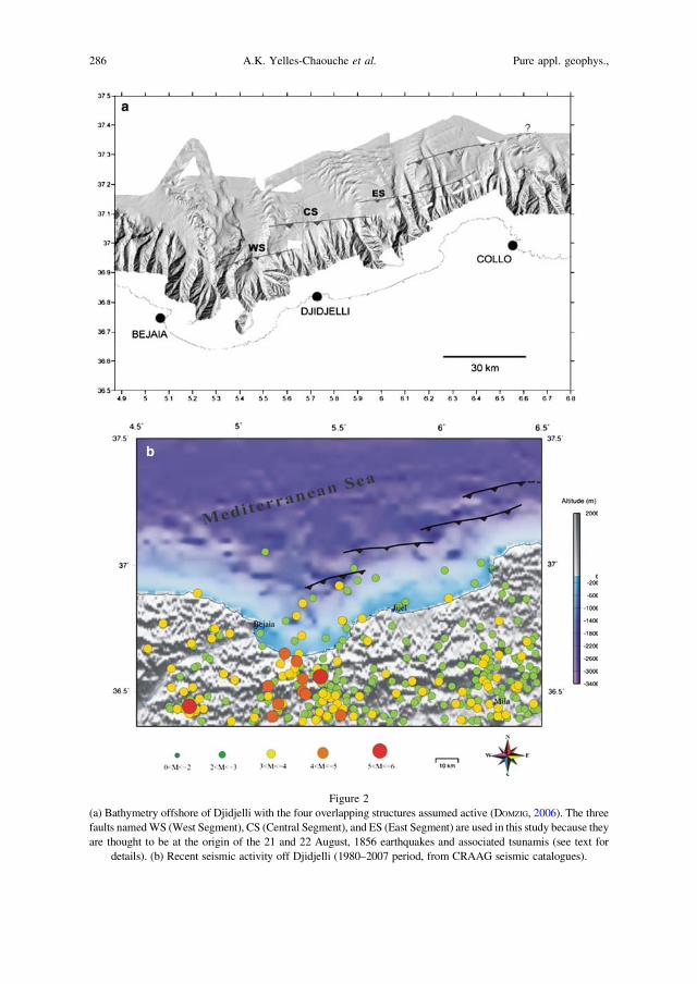
Figure 2
(a) Bathymetry offshore of Djidjelli with the four overlapping structures assumed active (DOMZIG, 2006). The three
faults named WS (West Segment), CS (Central Segment), and ES (East Segment) are used in this study because they
are thought to be at the origin of the 21 and 22 August, 1856 earthquakes and associated tsunamis (see text for
details). (b) Recent seismic activity off Djidjelli (1980–2007 period, from CRAAG seismic catalogues).
286 A.K. Yelles-Chaouche et al. Pure appl. geophys.,
estimated maximum intensity of VIII. PAPADOPOULOS and FOAKEFS (2005) estimate that the
tsunami intensity of 21 August 1856 was equal to 3 on the 6-point tsunami intensity scale
and 5 on the 12-point scale. This places this particular tsunami among the significant ones
observed in the Mediterranean Sea in the last two centuries.
3. Physiography of the Margin off Djidjelli
Off the coast of Djidjelli, the bathymetric map has been obtained from the Maradja 2
survey data (Fig. 2a). This survey was conducted in November 2005 on the French R/V
Suroit and aimed firstly at obtaining a precise bathymetric map of the structures between
Dellys and Annaba (eastern Algeria). For this purpose, a Kongsberg EM300 Simrad
multibeam echosounder (EM 1000 for the continental shelf) for bathymetry and
reflectivity was used. Simrad EM300 is a 32-kHz multibeam system which allows for an
overall swath coverage up to 5 times water depth, increasing with depth to a maximum
width of 5000 m at 1000 m depth. The reached resolution was of 15 9 35 m at 1000 m
depth with a vertical accuracy from 2 m (central beam) to 10 m (lateral beam).
The survey was limited to the continental slope and part of the deep basin (DOMZIG,
2006). Between Bejaia and Collo, the margin is marked by a narrow shelf and a steep
slope in front of the massif of Lesser Kabylia. The continental shelf disappears totally
near Collo. In the bay of Bejaia, the slope is outlined by two main canyons with a N-S
direction (Fig. 2a). They correspond to the marine extension of the Soummam River
(DOMZIG, 2006). Further east, between Djidjelli and Collo, the slope of the margin is
incised by several canyons. Off Djidjelli, these canyons are short whereas off Collo they
extend down to the abyssal plain. According to the bathymetric map (Fig. 2a), the deep
basin depicts a series of elongated ridges that can be interpreted as sediment waves or
contourites developing at the foot of the slope. However, several linear topographic
anomalies that can hardly be due to sedimentary processes only are also observed at the
foot of the slope and upslope. They present a general NE-SW to E-W strike as presented
in Figure 2a.
4. Seismotectonics of the Djidjelli Margin
Northern Algeria lies along the Eurasian-African plate boundary. With an average
rate of about 5 mm/yr in a N 60�W, the convergence between the two main plates is
responsible for the seismic activity which affects Algeria. Seismicity on land is generated
by active faults oriented mostly NE-SW, located along the Atlasic mountains and the
Neogene basins. Strong earthquakes could occur in the northern region, as the last one of
Boumerdes of May 21, 2003. For a long time, offshore seismicity remained poorly known
due to the lack of investigations along the margin.
In the Djidjelli region, the seismic activity deduced from historical catalogs
(MOKRANE et al., 1994; BENOUAR, 1994) seems to be low with an activity mostly focused
Vol. 166, 2009 Hazard Implications of the Djidjelli Tsunami (1856) 287

along the southern suture between the internal and external domains. Nevertheless, since
the recent installation of the Algerian Digital Seismic Network by the CRAAG (Centre de
Recherche en Astronomie, Astrophysique et Geophysique), many seismic events were
recorded recently along the coastline between Bejaia and Djidjelli. An updated seismic
map of the region of Djidjelli (Fig. 2b) shows activity in proximity to the four scarp
segments reported hereafter, which favors possible activity of these faults, and therefore,
their ability to generate tsunamis.
From the analysis of the seismic lines carried out during the Maradja survey and of
Sonatrach (Algerian Oil Company) commercial seismic lines (see location on Fig. 3a),
cross sections along the margin in the region of Djidjelli were obtained. We observe that
the central part of the margin is uplifted (Figs. 3b and c), whereas the lower slope is
dominated by low-angle normal faults and slides rooted at the base of the Messinian salt
layer (Fig. 3c). By correlating the bathymetry and the seismic lines, we find that uplifts
are related to reverse faulting near the slope break or below the lower slope, although the
geometry of thrusts is hardly visible (Figs. 3b and c). Thereafter, we could identify four
en echelon segments, widely overlapping, which can be followed near the foot of the
slope or in the lower slope (Fig. 2a). In front of Djidjelli, a first segment (named west
segment) oriented NE-SW (N 75�E) has a surface extent of *25 km. This is a thrust
fault related to an asymmetrical fold which produces the growth of a basin on its
backlimb that is tilted towards the continent (Fig. 3b). The second one (named central
segment) is observed north of the City of Djidjelli. This segment, about 30 km far from
the coast is apparently slightly longer than the previous one (*35 km). This reverse fault
striking N85�E is also related to another asymmetrical fold. Finally, two other scarps,
with apparent lengths of *40–45 km and *30 km, are found northwest of Collo City.
Among these two segments, the one located in the deep basin and striking N 80� is not
clearly related to a deeper fault activity and could only result from salt tectonics; a
process quite well identified in the eastern part of the studied area (Fig. 3c). We will
therefore consider in the following only the segment located upslope and designate it east
segment. Note that this segmentation pattern of the fault zone with similar lengths has
also been observed during the May 21, 2003 Boumerdes earthquake rupture: Indeed, two
main slip zones have been identified from a joint inversion of seismological waveforms
and ground displacement observations (DELOUIS et al., 2004) which are interpreted as
being related to the two main cumulative scarps evidenced at the sea floor (DEVERCHERE
et al., 2005).
Then, from bathymetric maps and seismic lines, the main characteristics of these
three fault segments (length, width, depth) are determined (Table 1). It is worth to note
that these parameters are only mean values deduced from the combination of
observations made on bathymetry, seismic sections, and assumptions deduced from
literature. Uncertainties remain, especially for strike and dip of faults that cannot be
accurately determined from the available data set, since there is no means to directly
describe the geometry of faults at depth and their spatial continuity.
288 A.K. Yelles-Chaouche et al. Pure appl. geophys.,
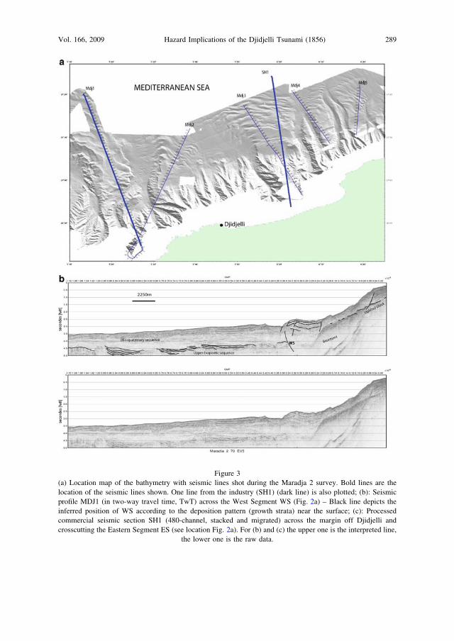
Figure 3
(a) Location map of the bathymetry with seismic lines shot during the Maradja 2 survey. Bold lines are the
location of the seismic lines shown. One line from the industry (SH1) (dark line) is also plotted; (b): Seismic
profile MDJ1 (in two-way travel time, TwT) across the West Segment WS (Fig. 2a) – Black line depicts the
inferred position of WS according to the deposition pattern (growth strata) near the surface; (c): Processed
commercial seismic section SH1 (480-channel, stacked and migrated) across the margin off Djidjelli and
crosscutting the Eastern Segment ES (see location Fig. 2a). For (b) and (c) the upper one is the interpreted line,
the lower one is the raw data.
Vol. 166, 2009 Hazard Implications of the Djidjelli Tsunami (1856) 289

Figure 3
contd.
Table 1
Longitude
(�)
Latitude
(�)
Center of
fault plane
deep (km)
Slip
(m)
Strike
(�)
Dip
(�)
Rake
(�)
Half
length
(m)
Width
(m)
Shear
modulus
(Pa) =
rigidity
West 5.4764 36.95 10 1.0 75 40 90 12500 20000 4,5*1010
Center 5.736 37.0791 10 1.5 85 40 90 18500 20000 4,5*1010
East 6.15 37.1784 10 1.5 75 40 90 22000 20000 4,5*1010
290 A.K. Yelles-Chaouche et al. Pure appl. geophys.,
Finally, we note that the overall length of the three segments considered here is about
100–105 km. According to WELLS and COPPERSMITH law (1994), this value is consistent
with the approximate magnitude inferred for the 1856 earthquake sequence from the
isoseismal map, i.e., 71/2 (Fig. 1; HARBI et al., 2003, and references therein). Therefore,
considering their effects at the surface, their apparent connection to deformed areas at
depth (see e.g., Figs. 3b and c) and the consistency of cumulative length with the
magnitude hypothesized, we assume that these segments, which are distributed as en
echelon faults, could be (for at least two of them) responsible for the Djidjelli events of
August 1856 (YELLES et al., 2007; ROGER and HEBERT, 2008). Subsequently we propose to
take into account these three western segments in order to model the tsunami of August
21–22, 1856, and we combine them in order to determine a range of possible triggering
effects.
5. Modelling of the Tsunami
5.1. Method
For the generation of the tsunami wave, the coseismic deformation corresponds to an
elastic dislocation model which involves the vertical deformation of the seafloor in the
epicentral area as a function of the ground elastic parameters and the fault plane geometry
(OKADA, 1985). The different parameters used are also related to each other by the seismic
moment relation: M0 5 lULW (AKI, 1966), where l is the rigidity constant, U the
average slip in the fault, and L and W the length and width of the fault plane,
respectively.
In order to model the propagation of the sea waves, we use the depth averaged,
nonlinear hydrodynamical equations of continuity (1) and motion (2) conservation
describing the conservation of mass and momentum:
oð�g� hÞ þ r � ½vð�gþ hÞ� ¼ 0
otð1Þ
ovþ ðv � rÞv ¼ �gr�gþ Rf
ot;ð2Þ
where h is the water depth, g9 the water elevation above mean sea level, v the depth-
averaged horizontal velocity vector, g the acceleration of gravity and f the bottom friction
and Coriolis forces. Thus nonlinear terms are taken into account, and the resolution is
carried out using a Crank Nicolson finite-difference method centered in time and using an
upwind scheme in space.
Amplification of the sea waves from the seafloor are based on the use of the available
bathymetric data. In this study we use the GEBCO world bathymetric dataset (BRITISH
OCEANOGRAPHIC DATA CENTRE, 1997) mixed with the Maradja 2 data (200 m resolution)
Vol. 166, 2009 Hazard Implications of the Djidjelli Tsunami (1856) 291

along the eastern Algerian margin. Near the coast and due to the lack of swath
bathymetry coverage of the continental shelf where the depth is less than 200 meters (a
band of about 5 miles wide) digitized bathymetric maps from LECLAIRE (1972) were used.
On the other hand and in order to be complementary from other studies related to
tsunamis in the western Mediterranean region (LORITO et al., 2008; ROGER and HEBERT,
2008), we choose to focus our study on the impact of the tsunami along the Algerian
coastline and more specifically in Djidjelli. Figure 4 depicts the topography of the region
of Djidjelli. The city is located along the coastline, at the foot of the Lesser Kabylian
massif. This particular location could influence the runup on land, by stopping invasion of
the water on the continent. One can also note that the present-day configuration of the
lower part of the city with the old and new port of Djendjen (suburb of Djidjelli) is very
different from the one of August 1856. Indeed, the harbor of the city, situated in the
western part of the Djidjelli bay, depicts structures that directly develop over the seafloor
Figure 4
Topographic map on land in the region of Djidjelli.
292 A.K. Yelles-Chaouche et al. Pure appl. geophys.,
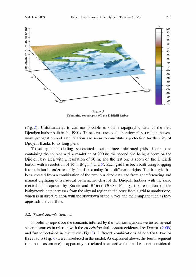
(Fig. 5). Unfortunately, it was not possible to obtain topographic data of the new
Djendjen harbor built in the 1990s. These structures could therefore play a role in the sea-
wave propagation and amplification and seem to constitute a protection for the City of
Djidjelli thanks to its long piers.
To set up our modelling, we created a set of three imbricated grids, the first one
containing the sources with a resolution of 200 m; the second one being a zoom on the
Djidjelli bay area with a resolution of 50 m; and the last one a zoom on the Djidjelli
harbor with a resolution of 10 m (Figs. 4 and 5). Each grid has been built using krigging
interpolation in order to unify the data coming from different origins. The last grid has
been created from a combination of the previous cited data and from georeferencing and
manual digitizing of a nautical bathymetric chart of the Djidjelli harbour with the same
method as proposed by ROGER and HEBERT (2008). Finally, the resolution of the
bathymetric data increases from the abyssal region to the coast from a grid to another one,
which is in direct relation with the slowdown of the waves and their amplification as they
approach the coastline.
5.2. Tested Seismic Sources
In order to reproduce the tsunamis inferred by the two earthquakes, we tested several
seismic sources in relation with the en echelon fault system evidenced by DOMZIG (2006)
and further detailed in this study (Fig. 3). Different combinations of one fault, two or
three faults (Fig. 6) were introduced in the model. As explained above, the fourth segment
(the most eastern one) is apparently not related to an active fault and was not considered.
Figure 5
Submarine topography off the Djidjelli harbor.
Vol. 166, 2009 Hazard Implications of the Djidjelli Tsunami (1856) 293
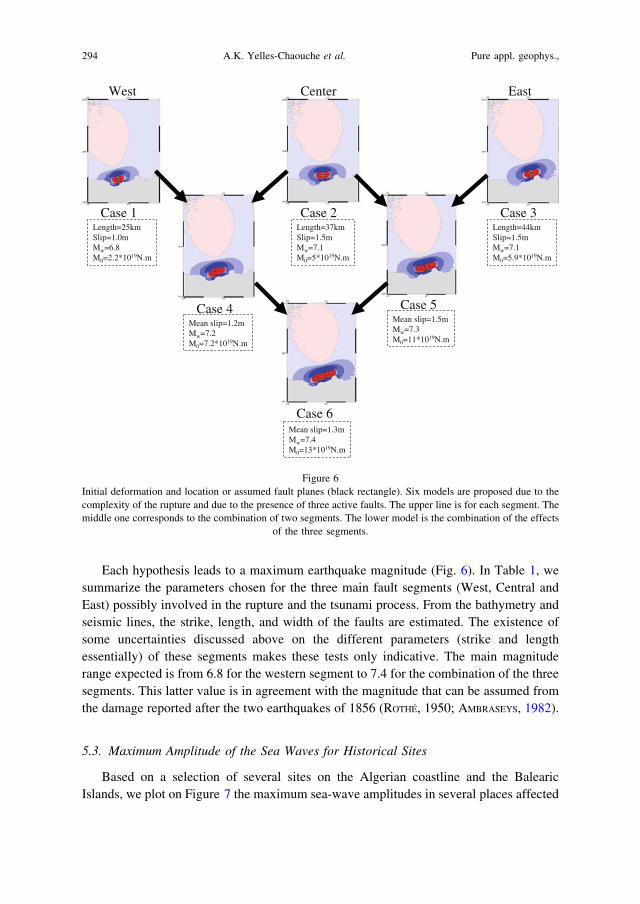
Each hypothesis leads to a maximum earthquake magnitude (Fig. 6). In Table 1, we
summarize the parameters chosen for the three main fault segments (West, Central and
East) possibly involved in the rupture and the tsunami process. From the bathymetry and
seismic lines, the strike, length, and width of the faults are estimated. The existence of
some uncertainties discussed above on the different parameters (strike and length
essentially) of these segments makes these tests only indicative. The main magnitude
range expected is from 6.8 for the western segment to 7.4 for the combination of the three
segments. This latter value is in agreement with the magnitude that can be assumed from
the damage reported after the two earthquakes of 1856 (ROTHE, 1950; AMBRASEYS, 1982).
5.3. Maximum Amplitude of the Sea Waves for Historical Sites
Based on a selection of several sites on the Algerian coastline and the Balearic
Islands, we plot on Figure 7 the maximum sea-wave amplitudes in several places affected
EastWest
Length=37kmSlip=1.5mMw=7.1M0=5*1019N.m
Length=25kmSlip=1.0mMw=6.8M0=2.2*1019N.m
Mean slip=1.2mMw=7.2M0=7.2*1019N.m
Center
Case 1 Case 2 Length=44kmSlip=1.5mMw=7.1M0=5.9*1019N.m
Case 3
Mean slip=1.5mMw=7.3M0=11*1019N.m
Case 5Case 4
Case 6Mean slip=1.3mMw=7.4M0=13*1019N.m
Figure 6
Initial deformation and location or assumed fault planes (black rectangle). Six models are proposed due to the
complexity of the rupture and due to the presence of three active faults. The upper line is for each segment. The
middle one corresponds to the combination of two segments. The lower model is the combination of the effects
of the three segments.
294 A.K. Yelles-Chaouche et al. Pure appl. geophys.,

by the tsunami. We observe first, that in the Balearic Islands, some sites where the waves
arrived an hour after the earthquake are more affected than others (ROGER and HEBERT,
2008). The maximum is observed in the Minorca Island where the height reached 1.5 m
at the southeastern point of the Island. This could be explained by the exposure of the
sites to the sea wave propagation and also by the seafloor topography (HEBERT et al.,
2007; ROGER and HEBERT, 2007, 2008).
Secondly six sites were selected between Algiers in the west and Annaba in the east
along the Algerian coastline. The maximum amplitude of the sea waves is measured near
Djidjelli and Bejaia. Thus, in this region the maximum sea wave amplitude reaches
respectively 1.5 m between 5� 42 E and 6� E. In Bejaia City the height does not exceed
one meter. From Figure 7, one can see that on the Algerian coastline, the influence of the
tsunami does not extend further than Algiers to the West and Annaba to the East. From
our model, one can consider that the maximum energy of the tsunami dissipates more
easily towards the North than laterally, indicating that the majority of exposed areas are
located southward and northward of the seismic sources.
In order to measure the flooding of the lower part of the city of Djidjelli, a map of the
zones invaded by the sea is proposed. Figure 8 shows a first attempt to quantify the
maximum wave height and flooding limits in the Djidjelli coastline area. It is obtained by
using the model of the three seismic sources with a maximum magnitude of Mw = 7.4.
On this map we can see that the eastern part of the city is the most affected area, and that
the runup may reach a height of 1.5 m. However, the use of our model does not allow us
to reach runup values higher than two meters, whereas historical observations locally
Figure 7
Maximum wave calculated amplitude for historical observations sites. This result is obtained from the
combination of the three segments (case 6) and after a time propagation of 5400 s.
Vol. 166, 2009 Hazard Implications of the Djidjelli Tsunami (1856) 295
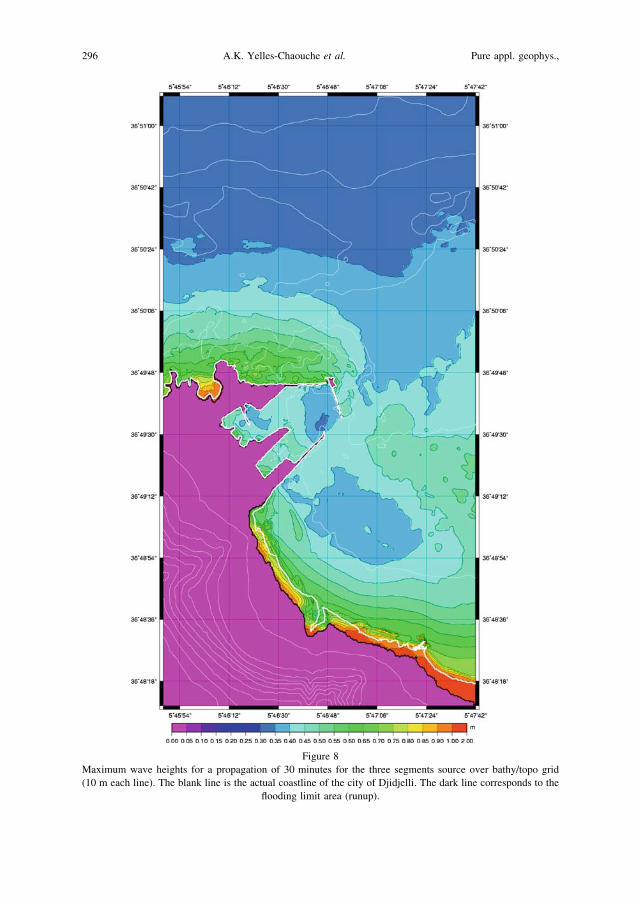
Figure 8
Maximum wave heights for a propagation of 30 minutes for the three segments source over bathy/topo grid
(10 m each line). The blank line is the actual coastline of the city of Djidjelli. The dark line corresponds to the
flooding limit area (runup).
296 A.K. Yelles-Chaouche et al. Pure appl. geophys.,

provide values of more than 4 meters. This discrepancy could be attributed to the
inaccuracy of the values reported by the observers at that time or to the poor bathymetric
coverage near the shoreline, preventing us from predicting local wave amplifications. We
also note that no flooding is evidenced in the western part of the city near the harbor,
therefore the harbor with its present-day structure could play the role of a barrier to
protect the old city.
6. Discussion and Concluding Remarks
The Djidjelli tsunami of August 1856 could be considered as one of the significant
events in the Mediterranean region. Indeed, this is one of the well described tsunamigenic
events which took place in the western Mediterranean region during the 19th century.
Numerous observations on the impact of this event are available in literature, newspapers
or reports. However, no attempt was made until now to explore the possible range of
coastal impact of such an event, mainly because of the lack of knowledge related to the
source of the event and regarding the bathymetry of the area. The Maradja 2 cruise
conducted in 2005 is the first modern bathymetric survey carried out along the eastern
margin and offers the opportunity to make a first approach of the implications of this
active faulting occurring offshore. Based on the data collected during this survey and on a
deep seismic section from the industry, the possible seismic sources of the Djidjelli
tsunami (Algeria) of August 21 and 22 are hypothesized, and the possible triggered
tsunami is presented. The en echelon pattern of the faults (3 segments) that have been
identified for the first time near the foot of the margin expresses the deformation process
of the margin as observed in other regions of the margin recently studied as Boumerdes or
Annaba (DEVERCHERE et al., 2005; DOMZIG, 2006; KHERROUBI et al., in press). This set of
faults with an NE-SW or E-W direction is in agreement with the deformation pattern
on land (MEGHRAOUI, 1988) which results from the slow convergence of the African
and Eurasian plates with an estimate rate of about 0.5–0.7 cm/yr (DE METS, 1990). In
accordance with literature, which mentioned two main shocks and many series of waves,
we propose that the western fault segment (WS, Fig. 2) may have ruptured first, followed
by the rupture of one or two other fault segments (CS and/or ES, Fig. 2) located further
east. Despite the complexity of the rupture process, we propose that the use of the model
with the involvement of the three segments is the more realistic scenario.
Based on the historical information on the area affected by the tsunami, our work
proposes several sea-wave propagation scenarios, trying to reach the best fit to the
historical observations. The tsunami affected mainly the eastern Algerian coast and the
coast of the Balearic Islands. We would like to emphasize that, because of the proximity
of the epicenter from the shoreline, all the tested sources gave the same effects in the
harbor area. The discrepancy of sea-wave predictions with the historical observations
could be explained by several factors, such the poor bathymetry coverage near the shore,
which do not allow the creation of a very realistic bathymetric map for modelling.
Vol. 166, 2009 Hazard Implications of the Djidjelli Tsunami (1856) 297

Furthermore, we must mention the lack of precise temporal information on the arrival
times of the tsunami on the Algerian and Balearic coasts. Indeed, the available archives
do not report any approximate time delay between the earthquake and the sea-wave
arrival on the coast. This could be related to the time occurrence of the first earthquake
which struck in the evening and to the induced panic. Therefore, more temporal
investigations of these data will be necessary to precisely determine the propagation of
the tsunami.
In spite of our effort to build a realistic grid for the harbor with respect to the
structures as piers, docks, etc. for the Algerian coast, the lack of very precise bathymetry
as approaching the coast and especially in harbors prevents us from better knowing the
role of the bathymetric structures, as submarine canyons for example, near the shore, on
the wave amplification. Future bathymetric surveys on the Algerian continental shelf will
allow to refine the runup model. Whatsoever, the occurrence of the Djidjelli tsunami
indicates that waves of some meters could reach the different coastlines of the western
Mediterranean region. LORITO et al. (2008) also demonstrate that the coastal area of
Djidjelli could be affected by tsunamis triggered in the Sicily channel.
The tsunami hazard in Algeria became more obvious by the occurrence of the last
Boumerdes tsunami of May 2003, also evidencing that the Algerian margin hosts several
important active tsunamigenic faults that can cause damage on both parts of the western
Mediterranean Sea. The acquisition of the recent data through the Maradja 1 and 2 surveys
along the margin will allow us to re-assess the tsunamigenic hazard in Algeria, poorly
constrained in the past owing to the lack of accurate and up-to-date surveys in this region.
Acknowledgments
We thank reviewers G.A. Papadopoulos and A.C. Yalciner for useful advice which
enhanced clarification and improve the content and presentation of this paper. This work
is a contribution to ANR (Agence Nationale de la Recherche) Projects ISIS and
DANACOR (CATTELL: « Catastrophes telluriques et tsunamis » Programme, France).
We have benefited from exchanges in the frame of the TASSILI CMEP (Comite Mixte
d’Evaluation et de Prospective de la cooperation scientifique franco-algerienne)
Programme number 014MDU619.
REFERENCES
AKI, K. (1966), Generation and propagation of G-waves from the Nigata earthquake of June 16, 1964, Part 2:
Estimation of earthquake moment, released energy, and stress-strain drop from the G wave spectrum, Bull.
Earthquake Res. Inst. Tokyo, Univ. 44, 73–88.
ALASSET, J.P., HEBERT, H., MAOUCHE, S., CALBINI, V., and MEGHRAOUI, M. (2006), The tsunami induced by the
2003 Zemmouri earthquake (Mw: 6.9, Algeria): Modelling and results, Geophys, J. Int., doi:10.111/j.1365-
246X.
298 A.K. Yelles-Chaouche et al. Pure appl. geophys.,

AMBRASEYS, N.N. (1982), The seismicity of North Africa: the earthquake of 1856 at Jijelli, Algeria, Bollettino Di
Geofisica a Teoritica ed Applicata, XXIV, 93, 31–17.
BENHALLOU, H. (1985), Les catastrophes sismiques de la region d’Echelif dans le contexte de la sismicite
historique de l’Algerie. These d’Etat. USTHB. Alger, 294 p.
BENOUAR, D. (1994), The seismicity of Algeria and the Maghreb during the twentieth century, Ph.D. dissertation,
Imperial College London, U.K.
BRITISH OCEANOGRAPHIC DATA CENTRE (1997) The Centenary Edition of the Gebco Digital Atlas, Liverpool,
U. K.
DELOUIS, B., VALLEE, M., MEGHRAOUI, M., CALAIS, E., MAOUCHE, S., LAMMALI, K., MAHSAS, A., BRIOLE, P.,
BENHAMOUDA, F. and YELLES, K. (2004), Slip distribution of the 2003 Boumerdes Zemmouri earthquake
Algeria from teleseismic, GPS and coastal uplift data, Geophys. Res. Lett. 31, L18607, doi 10 1029/2004
GL020687.
DE METS, C., GORDON, R., ARGUS, D.F., and STEIN, S.(1990), Current plate motions, Geophys. J. Int. 101,
425–478.
DEVERCHERE, J., YELLES, K., DOMZIG, A., MERCIER DE LEPINAY, B., BOUILLIN, J.-P., GAULLIER, V., BRACENE, R.,
CALAIS, E., SAVOYE, B., KHERROUBI, A., LE ROY, P., PAUC, H., and DAN, G. (2005), Active thrust faulting
offshore Boumerdes, Algeria, and its relations to the 2003 Mw 6.9 earthquake, Geophys. Res. Lett.
32:L04311, doi:10.1029/2004GL021646.
DOMZIG, A. (2006), Deformation active et recente et structuration tectono-sedimentaire de la marge sous marine
algerienne, Ph.D. Thesis, UBO-IUEM, Brest, France, 332 pp.
HARBI, A., BENOUAR, D., and BENHALLOU, H. (2003), Re-appraisal of seismicity and seismotectonics in the north-
eastern Algeria. Part I: Review of historical seismicity, J. Seismol. 7, 115–136.
HEBERT, H., ROGER, J., and SCHINDELE, F. (2007), Advances in tsunami hazard assessment in the western
Mediterranean sea, Geophys. Res. Abstracts, 9, 06341, EGU Vienna, 15–20 April 2007.
IBN KHALDOUN, A.Z.Y. (1369), Kitab al-Ibar, edited in 1959, Maison du Livre Libanais, Beyrut.
KHERROUBI, A., DEVERCHERE, J., YELLES, K., MERCIER LEPINAY, B., DOMZIG, A., CATTANEO, A., BRACENE, R.,
GAULLIER, V. and GRAINDORGE, D., Recent and active deformation pattern off the easternmost Algerian
margin: New evidence for tectonic reactivation, Marine Geology, in press.
LECLAIRE, L. (1972), La sedimentation holocene sur le versant meridional du bassin algero-baleare
(precontinent algerien), Mem. Mus. Nat. Hist. Nat. Paris, Nouv. Serv., C.24, 391 p.
LORITO, S., TIBERTI, M.M., BASILI, R., PIATANESI, A., and VALENSISE, G. (2008), Earthquake-generated tsunamis in
the Mediterranean Sea: Scenarios of potential threats to Southern Italy, J. Geophys. Res., 113, B01301,
doi:10.1029/2007JB004943.
MEGHRAOUI, M. (1988), Geologie des zones sismiques du nord de l’Algerie: Paleosismologie, Tectonique active
et Synthese Sismotectonique, These de Doctorat es Science, U. de Paris XI, France, 356 pp.
MOKRANE, A., AIT MESSAOUD, A., SEBAI, A., MENIA, N., AYADI, A., and BEZZEGHOUD, M. (1994), Les seismes en
Algerie de 1365 a 1992, Publication CRAAG.
OUYED, M., MEGHRAOUI, M., CISTERNAS, A., DESCHAMPS, A., DOREL, J., FRECHET J., GAULON, R., HATZFELD, D., and
PHILLIP, H. (1981), Seismotectonics of the El Asnam earthquake, Nature 292, 26–31.
OKADA, E.A. (1985), Surface deformation due to shear and tensile faults in a half-space, Bull. Seismol. Soc.
Am. 75, 1135–1154.
PAPADOPOULOS, G.A. and FOKAEFS, A. (2005), Strong tsunamis in the Mediterranean Sea: A re-evaluation, ISET
J. of Earthq. Technol. 42, 159–170.
ROGER, J. and HEBERT, H. (2007), Tsunami hazard in western Mediterranean: Preliminary study of scenarios for
the Balearic, EOS Trans. AGU, 88(52), Fall Meet. Suppl., Abstract S53A–1009.
ROGER, J. and HEBERT, H. (2008), The 1856 Djidjelli (Algeria) earthquake and tsunami: Source parameters and
implications for tsunami hazard in the Balearic Islands, Natural. Hazards Earth Syst. Sci., 8, 721–731.
ROTHE, J.P. (1950), Les seismes de Kerrata et la seismicite de l’Algerie, Bull. Serv. Carte Geol. Algerie, Serie 4, 3.
SOLOVIEV, S.L., CAMPOS-ROMERO, M.L., and PLINK, N.L. (1992), Orleansville tsunami of 1954 and El Asnam
tsunami of 1980 in the Alboran Sea (Southwestern Mediterranean Sea), Izvestiya, Earth Phys. 28(9), 739–760.
SOLOVIEV, S.L., SOLOVIEVA, O.N., GO, C.N., KIM, K.S., and SHCHETNIKOV, N.A., Tsunamis in the Mediterranean
Sea 2000 B.C.-2000 A.D: Advances in Natural and Technological Hazards Research (Kluwer Publications
2007). Vol. 13, 237 pp.
Vol. 166, 2009 Hazard Implications of the Djidjelli Tsunami (1856) 299
WELLS, D.L. and COPPERSMITH, K.J. (1994), New empirical relationships among magnitude, rupture length,
rupture width, rupture area, and surface displacement, Bull. the Seismol. Soci. Am. 84(4), 974–1002.
YELLES-CHAOUCHE, A.K. (1991), Coastal Algerian earthquakes. A potential risk of tsunamis in Western
Mediterranean? Preliminary investigations, Science Tsunami Hazards, 9(1), 47–54.
YELLES-CHAOUCHE, A.K., DJELLIT, H., and HAMDACHE, M. (2003), The Boumerdes Algiers (Algeria) earthquake of
May, 21, 2003 (Mw: 6.8), CSEM Lett., 20, 1–3.
YELLES-CHAOUCHE, A.K., DEVERCHERE, J., DOMZIG, A., MERCIER DE LEPINAY, B., BABONNEAU, N., HEBERT, H.,
ROGER, J., KHERROUBI, A., GRAINDORGE, D., BRACENE, R., CATTANEO, A., GAULLIER, V., SAVOYE, B., LEROY, P.,
and AIT OUALI, R. (2007), The tsunami of Djidjelli (eastern Algeria) of August 21–22, 1856: The
seismotectonic context and its modelling, IUGG Meeting, Perugia, Italy, 2–13 July 2007.
(Received February 2, 2008, revised September 17, 2008)
Published Online First: February 20, 2009
To access this journal online:
www.birkhauser.ch/pageoph
300 A.K. Yelles-Chaouche et al. Pure appl. geophys.,