Embed Size (px)
Citation preview
Hutchison, A. A., Cashman, K. V., Williams, C. A., & Rust, A. C. (2016).The 1717 eruption of Volcán de Fuego, Guatemala: Cascading hazards andsocietal response. Quaternary International, 394, 69-78. DOI:10.1016/j.quaint.2014.09.050
Peer reviewed version
Link to published version (if available):10.1016/j.quaint.2014.09.050
Link to publication record in Explore Bristol ResearchPDF-document
University of Bristol - Explore Bristol ResearchGeneral rights
This document is made available in accordance with publisher policies. Please cite only the publishedversion using the reference above. Full terms of use are available:http://www.bristol.ac.uk/pure/about/ebr-terms

Take down policy
Explore Bristol Research is a digital archive and the intention is that deposited content should not beremoved. However, if you believe that this version of the work breaches copyright law please [email protected] and include the following information in your message:
• Your contact details• Bibliographic details for the item, including a URL• An outline of the nature of the complaint
On receipt of your message the Open Access Team will immediately investigate your claim, make aninitial judgement of the validity of the claim and, where appropriate, withdraw the item in questionfrom public view.
lable at ScienceDirect
Quaternary International xxx (2014) 1e10
Contents lists avai
Quaternary International
journal homepage: www.elsevier .com/locate/quaint
The 1717 eruption of Volc�an de Fuego, Guatemala: Cascading hazardsand societal response
A.A. Hutchison a, K.V. Cashman b, *, C.A. Williams c, A.C. Rust b
a Department of Earth Sciences, University of California, Riverside, CA 92521, USAb School of Earth Sciences, University of Bristol, Bristol BS8 1RJ, UKc School of Modern Languages, University of Bristol, Bristol BS8 1TE, UK
a r t i c l e i n f o
Article history:Available online xxx
Keywords:Volcanic hazardsMudflowsVolcanic riskHistoric documents
* Corresponding author.E-mail address: [email protected] (K.V. Cashman
http://dx.doi.org/10.1016/j.quaint.2014.09.0501040-6182/© 2014 Elsevier Ltd and INQUA. All rights
Please cite this article in press as: Hutchisoresponse, Quaternary International (2014), h
a b s t r a c t
Assessing and communicating the risks posed by natural hazards requires not only a thorough under-standing of the hazards themselves but also an understanding of the spatial and temporal impact ofsuccessive events from the same source(s). This approach is enhanced by the lens of time, which is oftenmissing from modern responses to recent hazards. Archaeological studies, in contrast, examine the long-term consequences of hazardous events, but often lack details of the event chronology and immediatehuman impact that are available for recent events. Here we show ways in which historical records canbridge the gap between modern and prehistoric studies. We focus on the volcanically and seismicallyactive region that hosts the capital city of Guatemala, a city that has been relocated twice in response tohazardous events since its original founding in 1527. More specifically, we examine documents e “AutosHechos Sobre el Lastimoso, Estrago y Ruina que Padecio esta Ciudad de Guatemala…” [Autos] e that werecollected in response to a cascading sequence of volcanic, seismic and mudflow events in 1717 to supporta request to the Spanish government to relocate the capital city for a second time. These documentsprovide exceptional detail about the location of the witnesses, the nature of the hazardous activity andthe response of local communities. This detail allows us not only to reconstruct the sequence of eventsbut also to link volcanic activity at Volc�an de Fuego to local seismicity and mudflows from Volc�an deAgua, which we interpret as triggered by magma intruded after the eruption of Fuego ceased. At thesame time, the long and well documented history of the region allows us to examine ways in which asingle catastrophic event e in this case a large rainfall-triggered debris flow from Agua in 1541, whichdestroyed the first capital city e can reverberate through the centuries and affect the response of thelocal community almost 200 years later, in 1717. The long-term effects are particularly apparent becauseboth the origin and affected area of the mudflow hazard were very different in the two cases. Thisexample thus illustrates the importance of “memorability” (e.g., Slovic, 2000) in both the perception of,and response to, hazardous events.
© 2014 Elsevier Ltd and INQUA. All rights reserved.
1. Introduction
Recent volcanic eruptions, such as that of Eyjafjallaj€okull volcanoin Iceland in 2010, have stimulated important interactions amongscientists, social scientists and emergencymanagers. Such studies ofrecent events tend naturally to focus on immediate impacts; asso-ciated hazard management studies focus on responses to immedi-ate physical impacts of hazard (vulnerability), often at the expense ofdeveloping long-term (and sustainable) strategies for hazard miti-gation (resilience; e.g., White et al., 2001). This approach ignores the
).
reserved.
n, A.A., et al., The 1717 eruptttp://dx.doi.org/10.1016/j.qua
‘long shadow’ (e.g., Grattan and Torrence, 2007) of such disasters,where ‘long’ refers to time scales relevant for either political orcultural change (e.g., Birkmann et al., 2010; Diamond and Robinson,2010). A long view is provided, in contrast, by archaeological studiesof the impact of past volcanic disasters on human societies (e.g.,Sheets and Grayson, 1979). A challenge to archaeological studies,however, is that causality must be assumed rather than proven(Coombes and Barber, 2005; Leroy, 2006). The time gap betweenarchaeological and present day research can be bridged by thehistorical record, which contributes robust chronologies that allowcause and effect to be linked (e.g., Vittori et al., 2007).
Here we draw on documentary sources from eighteenth centuryGuatemala to examine an unusual cascading sequence of events
ion of Volc�an de Fuego, Guatemala: Cascading hazards and societalint.2014.09.050
A.A. Hutchison et al. / Quaternary International xxx (2014) 1e102
that affected the second capital of Guatemala, Santiago deGuatemala (nowAntigua; Fig.1), in August and September 1717. Theexperiences of 1717 prompted debate among Santiago's inhabitantsregarding the situation of the city, which had been relocated to this(higher) site in the aftermath of a disastrous mudflow from thedormant Volc�an de Agua that destroyed the original Spanish capitalin 1541 (14 years after it was founded). Debate after the 1717 eventscentered on the precise nature of the hazards and risks posed to thecity by nearby volcanoes, specifically Agua and neighboring,frequently active, Volc�an de Fuego. The extensive documentationgenerated as these risks and hazards were assessed reveals a rangeof perspectives and understandings; particularly striking, however,is the extent to which the 1541 event loomed large in the memoryof the city's population, and served to inform the arguments ofthosewho supported a second relocation of the Guatemalan capital.This is the side of the debate that is reflected in the Autos. Detailedanalysis of these documents allows us not only to reconstruct thesequence, and analyse the nature, of the events that occurred in1717, but also to explore the role of past events on the response ofthe population to an immediate crisis.
2. Background
It is well known that disastrous events can act as natural ex-periments (Diamond and Robinson, 2010) and/or catalysts ofchange (e.g., Burby et al., 2000; P�erez, 2001; Birkmann et al., 2010).Change may occur by migration (abandoning the hazardous loca-tion) or adaptation, such as risk-based land use planning. To beeffective, such planning must balance the benefits, as well as thedrawbacks, of living in hazardous areas (e.g., White et al., 2001;Glavovic et al., 2010), and engage both community members andgovernment officials (e.g., Cronin et al., 2004; Cashman and Cronin,2008; Ricci et al., 2013). A key factor that affects community per-ceptions of risk is thememorability (and imaginability) of individualhazards (e.g., Slovic, 2000), such that an event that is memorablewithin the community for its real or perceived impact will be
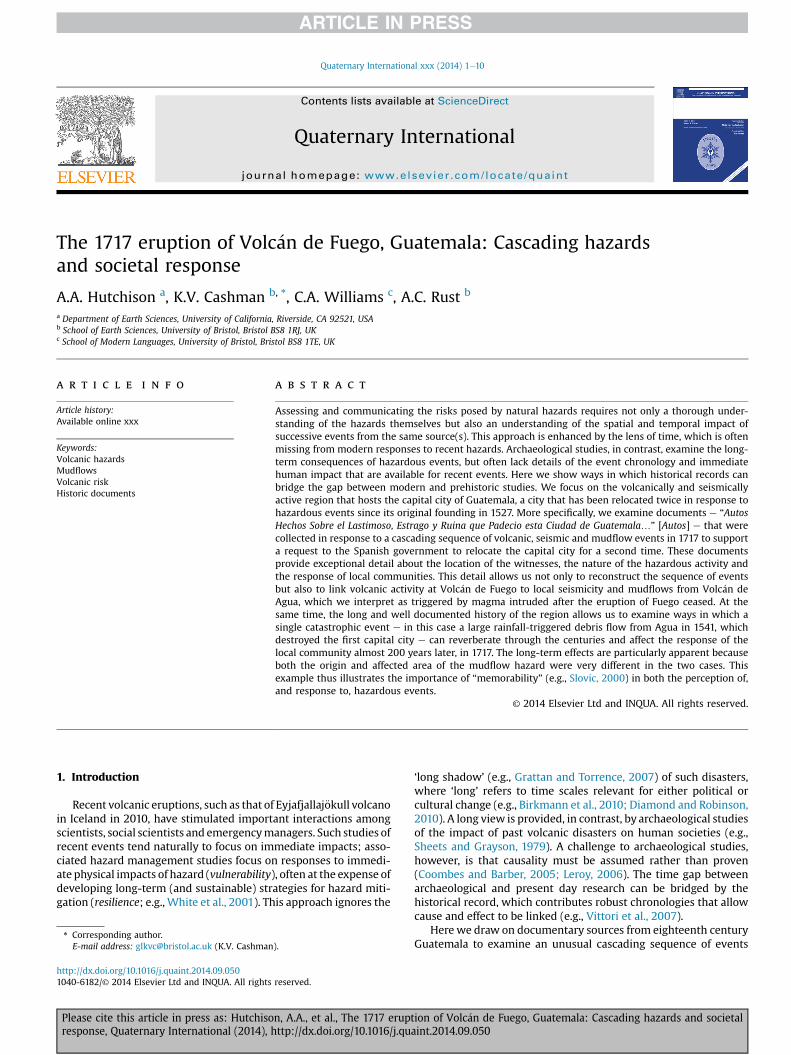
Fig. 1. Location map showing the three capital cities of Guatemala and the nearbyvolcanoes. The cities are currently known as Ciudad Vieja (formerly Santiago de losCaballeros, founded in 1527), Antigua (formerly Santiago de Guatemala, relocated in1542), and Guatemala City (relocated in 1773 following a large regional earthquake).The volcanoes Atitlan, Fuego, Agua and Pacaya lie along the Central America volcanicarc. All have been active during historical times except Agua.
Please cite this article in press as: Hutchison, A.A., et al., The 1717 eruptresponse, Quaternary International (2014), http://dx.doi.org/10.1016/j.qu
weighted more heavily in planning decisions than an event that isnot as easily imagined. A modern example is the 1979 Three MileIsland nuclear accident in the US and the effect of that accident onperceptions of risk related to nuclear power (e.g., Slovic et al., 1982;Kasperson et al., 1988). A different perspective on memorability canbe found in studies of oral traditions. When stories must be passedorally from generation to generation, a community disaster maybecome “a defining experience that passes into shared memory”(P�erez, 2001). In this way, inherited stories, whether oral or written,are often preserved where the knowledge contained is critical tocommunity survival (e.g., Barber and Barber, 2006), and thus mayinfluence community planning of future generations.
The long history (~300 years) of Spanish colonisation inGuatemala, which was centered on the city of Santiago, producedan extensive written record of hazard events in the area aroundVolc�an de Fuego [Fuego] and neighboring Volc�an de Agua [Agua].Both volcanoes form part of the Central American volcanic arc(Fig. 1). Fuego has been one of the most persistently active of theGuatemalan volcanoes, with 57 confirmed eruptions, and severalmore unconfirmed, since the arrival of Spanish colonists in 1524(Smithsonian Institute, Global Volcanism Program [GVP] database).Agua, in contrast, has no documented eruptions in the Holocene(Bonis and Salazar, 1973; Schilling, 2001; GVP). It has had, instead,numerous mudflows that have typically affected the area to thenorth of the volcano, including the first capital city (PeraldoHuertas and Montero Pohly, 1996).
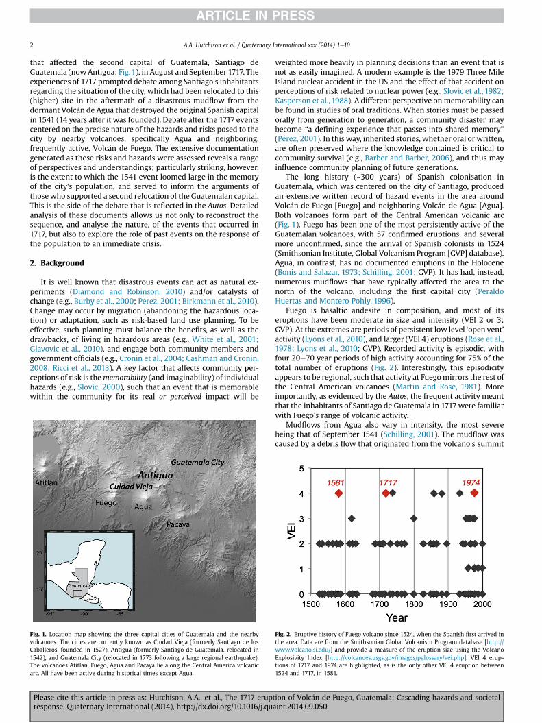
Fuego is basaltic andesite in composition, and most of itseruptions have been moderate in size and intensity (VEI 2 or 3;GVP). At the extremes are periods of persistent low level ‘open vent’activity (Lyons et al., 2010), and larger (VEI 4) eruptions (Rose et al.,1978; Lyons et al., 2010; GVP). Recorded activity is episodic, withfour 20e70 year periods of high activity accounting for 75% of thetotal number of eruptions (Fig. 2). Interestingly, this episodicityappears to be regional, such that activity at Fuegomirrors the rest ofthe Central American volcanoes (Martin and Rose, 1981). Moreimportantly, as evidenced by the Autos, the frequent activity meantthat the inhabitants of Santiago de Guatemala in 1717 were familiarwith Fuego's range of volcanic activity.
Mudflows from Agua also vary in intensity, the most severebeing that of September 1541 (Schilling, 2001). The mudflow wascaused by a debris flow that originated from the volcano's summit
Fig. 2. Eruptive history of Fuego volcano since 1524, when the Spanish first arrived inthe area. Data are from the Smithsonian Global Volcanism Program database [http://www.volcano.si.edu/] and provide a measure of the eruption size using the VolcanoExplosivity Index [http://volcanoes.usgs.gov/images/pglossary/vei.php]. VEI 4 erup-tions of 1717 and 1974 are highlighted, as is the only other VEI 4 eruption between1524 and 1717, in 1581.
ion of Volc�an de Fuego, Guatemala: Cascading hazards and societalaint.2014.09.050
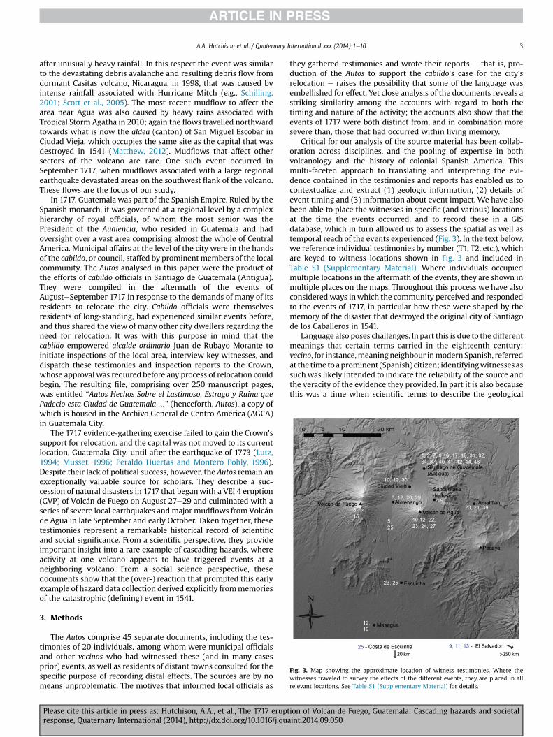
Fig. 3. Map showing the approximate location of witness testimonies. Where thewitnesses traveled to survey the effects of the different events, they are placed in allrelevant locations. See Table S1 (Supplementary Material) for details.
A.A. Hutchison et al. / Quaternary International xxx (2014) 1e10 3
after unusually heavy rainfall. In this respect the event was similarto the devastating debris avalanche and resulting debris flow fromdormant Casitas volcano, Nicaragua, in 1998, that was caused byintense rainfall associated with Hurricane Mitch (e.g., Schilling,2001; Scott et al., 2005). The most recent mudflow to affect thearea near Agua was also caused by heavy rains associated withTropical Storm Agatha in 2010; again the flows travelled northwardtowards what is now the aldea (canton) of San Miguel Escobar inCiudad Vieja, which occupies the same site as the capital that wasdestroyed in 1541 (Matthew, 2012). Mudflows that affect othersectors of the volcano are rare. One such event occurred inSeptember 1717, when mudflows associated with a large regionalearthquake devastated areas on the southwest flank of the volcano.These flows are the focus of our study.
In 1717, Guatemala was part of the Spanish Empire. Ruled by theSpanish monarch, it was governed at a regional level by a complexhierarchy of royal officials, of whom the most senior was thePresident of the Audiencia, who resided in Guatemala and hadoversight over a vast area comprising almost the whole of CentralAmerica. Municipal affairs at the level of the city were in the handsof the cabildo, or council, staffed by prominentmembers of the localcommunity. The Autos analysed in this paper were the product ofthe efforts of cabildo officials in Santiago de Guatemala (Antigua).They were compiled in the aftermath of the events ofAugusteSeptember 1717 in response to the demands of many of itsresidents to relocate the city. Cabildo officials were themselvesresidents of long-standing, had experienced similar events before,and thus shared the view of many other city dwellers regarding theneed for relocation. It was with this purpose in mind that thecabildo empowered alcalde ordinario Juan de Rubayo Morante toinitiate inspections of the local area, interview key witnesses, anddispatch these testimonies and inspection reports to the Crown,whose approval was required before any process of relocation couldbegin. The resulting file, comprising over 250 manuscript pages,was entitled “Autos Hechos Sobre el Lastimoso, Estrago y Ruina quePadecio esta Ciudad de Guatemala …” (henceforth, Autos), a copy ofwhich is housed in the Archivo General de Centro Am�erica (AGCA)in Guatemala City.
The 1717 evidence-gathering exercise failed to gain the Crown'ssupport for relocation, and the capital was not moved to its currentlocation, Guatemala City, until after the earthquake of 1773 (Lutz,1994; Musset, 1996; Peraldo Huertas and Montero Pohly, 1996).Despite their lack of political success, however, the Autos remain anexceptionally valuable source for scholars. They describe a suc-cession of natural disasters in 1717 that beganwith a VEI 4 eruption(GVP) of Volc�an de Fuego on August 27e29 and culminated with aseries of severe local earthquakes andmajor mudflows from Volc�ande Agua in late September and early October. Taken together, thesetestimonies represent a remarkable historical record of scientificand social significance. From a scientific perspective, they provideimportant insight into a rare example of cascading hazards, whereactivity at one volcano appears to have triggered events at aneighboring volcano. From a social science perspective, thesedocuments show that the (over-) reaction that prompted this earlyexample of hazard data collection derived explicitly frommemoriesof the catastrophic (defining) event in 1541.
3. Methods
The Autos comprise 45 separate documents, including the tes-timonies of 20 individuals, among whom were municipal officialsand other vecinos who had witnessed these (and in many casesprior) events, as well as residents of distant towns consulted for thespecific purpose of recording distal effects. The sources are by nomeans unproblematic. The motives that informed local officials as
Please cite this article in press as: Hutchison, A.A., et al., The 1717 eruptresponse, Quaternary International (2014), http://dx.doi.org/10.1016/j.qua
they gathered testimonies and wrote their reports e that is, pro-duction of the Autos to support the cabildo's case for the city'srelocation e raises the possibility that some of the language wasembellished for effect. Yet close analysis of the documents reveals astriking similarity among the accounts with regard to both thetiming and nature of the activity; the accounts also show that theevents of 1717 were both distinct from, and in combination moresevere than, those that had occurred within living memory.
Critical for our analysis of the source material has been collab-oration across disciplines, and the pooling of expertise in bothvolcanology and the history of colonial Spanish America. Thismulti-faceted approach to translating and interpreting the evi-dence contained in the testimonies and reports has enabled us tocontextualize and extract (1) geologic information, (2) details ofevent timing and (3) information about event impact. We have alsobeen able to place the witnesses in specific (and various) locationsat the time the events occurred, and to record these in a GISdatabase, which in turn allowed us to assess the spatial as well astemporal reach of the events experienced (Fig. 3). In the text below,we reference individual testimonies by number (T1, T2, etc.), whichare keyed to witness locations shown in Fig. 3 and included inTable S1 (Supplementary Material). Where individuals occupiedmultiple locations in the aftermath of the events, they are shown inmultiple places on the maps. Throughout this process we have alsoconsideredways inwhich the community perceived and respondedto the events of 1717, in particular how these were shaped by thememory of the disaster that destroyed the original city of Santiagode los Caballeros in 1541.
Language also poses challenges. Inpart this is due to the differentmeanings that certain terms carried in the eighteenth century:vecino, for instance,meaningneighbour inmodern Spanish, referredat the time toaprominent (Spanish) citizen; identifyingwitnesses assuch was likely intended to indicate the reliability of the source andthe veracity of the evidence they provided. In part it is also becausethis was a time when scientific terms to describe the geological
ion of Volc�an de Fuego, Guatemala: Cascading hazards and societalint.2014.09.050
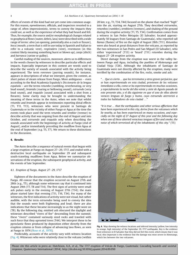
Fig. 4. Map showing the witness locations and inferred intensity (yellow, low intensityto orange, high intensity) of the September 29, 1717 earthquake. Key is the evidencefromwitnesses in El Salvador that they did not feel this event, which means that it waslocal. Also important is the evidence that the damage was most severe in Alotenango,which lies between the two volcanoes.
A.A. Hutchison et al. / Quaternary International xxx (2014) 1e104
effects of events of this kind had not yet come into common usage.For this reason, eyewitnesses, officials, and inspectors resorted to arange of, often impressionistic, terms to convey the impacts theycould see, as well as the experience of what they had heard and felt.Thus, for example, the source and/ormorphological changes relatedto geophysicalflows (water, debris, lava)weredescribedwith awiderange of terms: abra (an opening, potentially also a crack or fissure),boca (mouth; a term that is still in use today in Spanish and Italian torefer to a volcanic vent), respiradero (vent), reventazon (in thiscontext likely meaning something burst or blown up), zanja (ditch)and barranca (ravine or gulley).
Careful reading of the sources, moreover, alerts us to differencesin the words chosen by witnesses to describe particular effects andimpacts. Especially important in this context are words used todescribe the variety of sounds associated with the activity beingexperienced. The term ronroneo (purring sounds), for instance,appears in descriptions of what we interpret, given the context, asshort pulses of steam release from Fuego. More ambiguous e evenaccording to the Real Academia Espa~nola’s Diccionario de la lenguaespa~nola e are the terms retumbo (rumbling, reverberating, or veryloud sound), bramido (roaring or bellowing sound), estruendo (veryloud sound), and traquido (sound associated with a shot from afirearm). Some clarity may be brought to understanding themeaning of these terms in the Autos, when we note that whilstretumbo and bramido appear in testimonies reporting distal effects(T1, T11, T13), witnesses who were present in Santiago deGuatemala or in the vicinity of either Fuego or Agua at the time theevents took place used the term retumbo and temblor (tremor) todescribe activity that was ongoing from the end of August and intoOctober, and estruendo and traquido only when describing thesounds associated with the beginnings of activity at Fuego (end ofAugust), and/or immediately preceding the mudflow from Agua atthe end of September (e.g. T5, T7). We return to these distinctionsin the discussion.
4. Results
The Autos describe a sequence of natural events that began witha large eruption at Fuego on August 27e29, 1717, and ended with adestructive local earthquake on September 29 and subsequentsouth-traveling mudflows from Agua. Below we summarize ob-servations of the eruption, the subsequent geophysical activity, andthe events of late September.
4.1. Eruption of Fuego, August 27e29, 1717
Eighteen of the documents in the Autos describe the eruption ofFuego. All concur that the eruption occurred on August 27th and28th (e.g., T5), although some witnesses say that it continued intoAugust 29th (T7, T8 and T14). The first signs of activity were smallash pulses early in the evening of August 27th (T14); the mainphase started later that evening (T11, T16, T34). For many of thewitnesses, the first indications of activity were not visual, but ratheraudible, with the term estruendos being used to convey the ideathat the sounds were both frightening and loud; there are alsoindications that these became increasingly so as the night wore on(T8). By the following day, emitted ash obscured the daylight andwitnesses described “rivers of fire” descending from the summit;these “rivers” contained variously sized rocks and traveled withsuch force that they uprooted trees (T44). We interpret these to bepyroclastic flows produced by deposition either directly from theeruption column or from collapse of advancing lava flows, as seenat Fuego in 1974 (Rose et al., 1978).
Predictably, accounts of the activity vary with witness location(Fig. 4). Witnesses who were relatively close to the volcano (within
Please cite this article in press as: Hutchison, A.A., et al., The 1717 eruptresponse, Quaternary International (2014), http://dx.doi.org/10.1016/j.qu
20 km; e.g., T1, T34, T44) focused on the plume that reached “high”into the air, starting on August 27th. They described estruendos,retumbos (rumbles), temblores (tremors), and shaking of the groundduring the eruptive activity (T1, T5, T34). Confirmation comes froma witness in San Pedro Metap�an (El Salvador; located approxi-mately 50 leagues from Santiago de Guatemala), who reported tallllamas (flames) of fire on the night of August 28th (T11). Retumboswere also heard at great distances from the volcano, as reported bythe two witnesses in San Pedro and San Miguel (El Salvador), whoeither ‘experienced’ (T13) or ‘heard’ (T11) retumbos during theAugust 27e28 eruptive activity.
Direct damage from the eruption was worst in the valley be-tween Fuego and Agua, including the pueblos of Alotenango andCiudad Vieja (T26). Although the inhabitants of Santiago deGuatemala were not directly affected by the eruption, many wereterrified by the combination of the fire, rocks, smoke and ash:
“…Que es cierto… que los terremotos y otros graves perjuicios, quese han experimentado en esta ciudad, provienen de los volcanesinmediatos a ella, como se ha experimentado en muchas ocasiones,y especialmente la noche del día veinte y siete de Agosto pasado deeste presente a~no, y el día siguiente en que el uno de ellos abort�ovoraces lenguas de fuego y humo, cuyo estruendo aterroriz�o atodos los habitadores de esta ciudad …”
“It is true … that the earthquakes and other serious afflictions thathave been experienced in this city, derive from the volcanoes whichlie nearby, as has been experienced on many occasions, and espe-cially on the night of 27 August of this year and the following daywhen one of these aborted voracious tongues of fire and smoke, thenoise of which terrorized all of the inhabitants of this city.” (T5)
ion of Volc�an de Fuego, Guatemala: Cascading hazards and societalaint.2014.09.050
A.A. Hutchison et al. / Quaternary International xxx (2014) 1e10 5
4.2. Post-eruptive activity e August 29eSeptember 29, 1717
During, and for at least 33 days following, the eruption of Fuegoon August 27th, the volcano showed signs of unrest in the form ofboth retumbos and temblores (T1, T8, T14, T44). According to ac-counts in the Autos, retumbos were primarily heard (T5, T10),although in some instances they were also felt (T1, T14); the tem-blores often mentioned in the same context were always felt(ground shaking). Witnesses in proximal locations insisted thatboth were from sources near (T10), or even “inside” (T5), thevolcano.
During the same period, the Autos also provide numerous de-scriptions of abras (openings), bocas (mouths), respiraderos (vents)zanjas (ditches), and barrancas (ravines), the latter said to haveincreased from meters to tens to hundreds of meters in width anddepth (T2, T5, T8, T10; T14, T15, T27, T28). It is unclear from theaccounts how many of the barrancas formed during, as opposed toafter, the August eruption. The testimonies are clear, however, thatthere were major changes in geomorphology on Fuego during thistime period (e.g. T5, T7, T17):
“… con la ocasi�on del reconocimiento que hizo del dicho Volc�an deFuego, temiendo el que sus piedras no atajasen el dicho rio desagüede esta ciudad y de dichas haciendas, subi�o parte de el arriba comohasta m�as quemedio volc�an, y vio una barranca que corre a la cimapara abajo, tan profunda que le caus�o terror y miedo, que al par-ecer tendr�a como hasta cien varas de hondura, y de ancho comomedia cuadra, la cual le dijo un indio que llevaba en su compa~níaque era nuevamente abierta con la ocasi�on del fuego que habíaechado porque antes de �el solo era una peque~na barranquilla devara y media de hondo, por donde con facilidad bajaban y con-ducían madera…”
“…at the time of the survey of Volc�an de Fuego which he conducted… [due to concerns] that its rocks might block the river drainage ofthis city and [surrounding] haciendas, he climbed more than half-way up the volcano and saw a ravine that ran from the summitdownwards, so deep that [on seeing it] he felt terror and fear. Itappears to be up to 100 varas in depth [~83 m], and about a halfcuadra in width [125 m], and according to an Indian who accom-panied him, it had opened recently, at the same time as the firespewed [by the volcano], because previously it was only a shallowravine, 1.5 varas in depth, down which they comfortably trans-ported wood…” (T5)
This witness also noted that the barranca must have carried alarge current of water because of the branches and trees that it hadtransported to the river. Other witnesses claimed that anotherbarranca had formed from the volcano's summit to the south (T14,T17), and that additional openings produced smoke or steam, andemanated heat and a stench so unpleasant that it made people feelill (T14, T15).
During the same period, seven of the accounts in Autos describean unusual sensation that they felt when traveling near the vol-cano, which they likened to walking on hollow ground, or the noisemade by horses or carriages in motion (T1, T7, T14, T17, T29, T44). Areport from the eastern slopes of Fuego (T15) recounts more spe-cifically the sensation that the volcano was either hollow (perhapsreinforced by the appearance of sinkholes (hoyo and apertura) nearAlotenango, T6, T17, T29), or that there was a subterranean b�oveda(vault) beneath it:
“…y que …las cabalgaduras … con su piso parecía pisaban sobreuna b�oveda y así mismo vieron salir algún humo del centro de dichobarranca como de unos ronroneos expeliendo tanto calor yhedor…”
Please cite this article in press as: Hutchison, A.A., et al., The 1717 eruptresponse, Quaternary International (2014), http://dx.doi.org/10.1016/j.qua
“…And … it felt as though their horses were treading over a vaultand they also saw some steam rise from the said ravine, like purrsreleasing a lot of heat and odor…”
4.3. Earthquake of September 29, 1717
On the evening of September 29, 1717, several large earth-quakes inflicted significant damage on Santiago de Guatemala andthe surrounding pueblos, with some loss of life (T1). Oneeyewitness estimated that the earthquakes destroyed half thecapital (T31). Although bias could have led to exaggerated impacts,the adverse impacts were real, as indicated by one account thatprovided a detailed and specific list of the damages to importantreligious and government buildings (T32). Outside the capital, itwas said that the earthquakes were felt on the Costa de Escuintla(then called Costa de Escuintepeque), about 70 km south of San-tiago de Guatemala (Fig. 4). The most severe damage, however,was reported in Alotenango and Ciudad Vieja, which lie between,and close to, both volcanoes (T10, T12, T29; Fig. 4). Evidence thatno earthquake was felt in El Salvador, and the earthquakes werefelt most strongly in the vicinity of the volcanoes (T10, T11, T13,T18), is consistent with a local origin, and indeed many witnesses(T5, T14, T15) were convinced that the earthquakes were causedby the volcanoes:
“…Y que el asentar que dichos terremotos provienen de los vol-canes es porque tiene el declarante su residencia en las haciendasque … est�an casi en la falda del Volc�an de Fuego por un lado, y porel otro lado con inmediaci�on al de Agua, y por ello hall�andose en elcampo le cogieron dichos terremotos, en el, los cuales sinti�o conimponderable fuerza, o estr�epito, y tal que fue preciso arrodilladoacercarse de un palo para poderse mantener, y como estaba en lafrente del dicho Volc�an de Fuego, sinti�o que el ruido y fuerza de losterremotos salían de �el, cuya presunci�on le confirman los retumbosque hacen mover la tierra porque los oye en el dicho volc�an, el quetiene profundas barrancas, o abras recientes…”
“…Because the witness resides in the haciendas … which on oneside extend almost to the slopes of Volc�an de Fuego, and on theother lie close to [Volc�an] de Agua, he can assert that said earth-quakes come from the volcanoes … he found himself in his fieldswhen the earthquakes struck, with such strength … that, kneeling,he had to lean on a stick to steady himself. And as he was in front ofVolc�an de Fuego, he felt that the noise and force of the earthquakescame from it [the volcano]. His assumption is confirmed by theretumbos that make the earth move, because he hears them in saidvolcano [Fuego] which has [formed] new deep barrancas oropenings…” (T5)
4.4. Mudflow from Volc�an de Agua, September 29, 1717
The impact of the September 29 earthquakes was compoundedby mudflows from Agua that were apparently triggered by theseismic activity. The flows originated high on the southwest slopesof the volcano and travelled south, away from the primary popu-lation centers, and, it was said, eventually reached the ocean(Fig. 5). Not surprisingly, the pueblos ofMasagua andMistlan on theRio Guacalate were most impacted by the mudflows (T12). Themost detailed description of the source of the mudflows comesfrom a witness from the pueblo of Escuintla (T23). He was, he said,‘four leagues’ up the slopes of Volc�an de Agua when the flows
ion of Volc�an de Fuego, Guatemala: Cascading hazards and societalint.2014.09.050
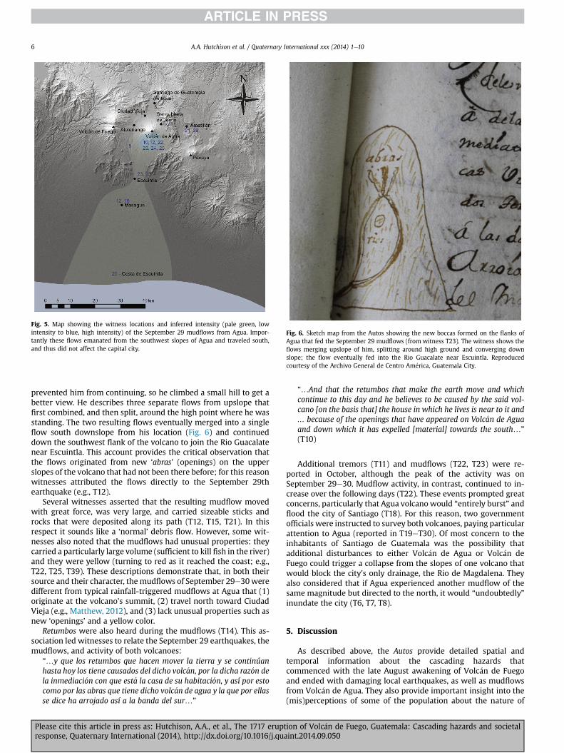
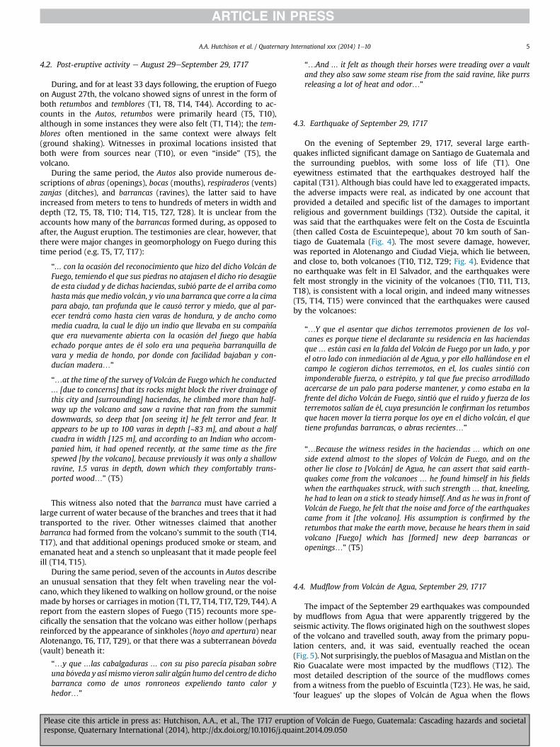
Fig. 5. Map showing the witness locations and inferred intensity (pale green, lowintensity to blue, high intensity) of the September 29 mudflows from Agua. Impor-tantly these flows emanated from the southwest slopes of Agua and traveled south,and thus did not affect the capital city.
Fig. 6. Sketch map from the Autos showing the new boccas formed on the flanks ofAgua that fed the September 29 mudflows (from witness T23). The witness shows theflows merging upslope of him, splitting around high ground and converging downslope; the flow eventually fed into the Rio Guacalate near Escuintla. Reproducedcourtesy of the Archivo General de Centro Am�erica, Guatemala City.
A.A. Hutchison et al. / Quaternary International xxx (2014) 1e106
prevented him from continuing, so he climbed a small hill to get abetter view. He describes three separate flows from upslope thatfirst combined, and then split, around the high point where he wasstanding. The two resulting flows eventually merged into a singleflow south downslope from his location (Fig. 6) and continueddown the southwest flank of the volcano to join the Rio Guacalatenear Escuintla. This account provides the critical observation thatthe flows originated from new ‘abras’ (openings) on the upperslopes of the volcano that had not been there before; for this reasonwitnesses attributed the flows directly to the September 29thearthquake (e.g., T12).
Several witnesses asserted that the resulting mudflow movedwith great force, was very large, and carried sizeable sticks androcks that were deposited along its path (T12, T15, T21). In thisrespect it sounds like a ‘normal’ debris flow. However, some wit-nesses also noted that the mudflows had unusual properties: theycarried a particularly large volume (sufficient to kill fish in the river)and they were yellow (turning to red as it reached the coast; e.g.,T22, T25, T39). These descriptions demonstrate that, in both theirsource and their character, themudflows of September 29e30weredifferent from typical rainfall-triggered mudflows at Agua that (1)originate at the volcano's summit, (2) travel north toward CiudadVieja (e.g., Matthew, 2012), and (3) lack unusual properties such asnew ‘openings’ and a yellow color.
Retumbos were also heard during the mudflows (T14). This as-sociation led witnesses to relate the September 29 earthquakes, themudflows, and activity of both volcanoes:
“…y que los retumbos que hacen mover la tierra y se continúanhasta hoy los tiene causados del dicho volc�an, por la dicha raz�on dela inmediaci�on con que est�a la casa de su habitaci�on, y así por estocomo por las abras que tiene dicho volc�an de agua y la que por ellasse dice ha arrojado así a la banda del sur…”
Please cite this article in press as: Hutchison, A.A., et al., The 1717 eruptresponse, Quaternary International (2014), http://dx.doi.org/10.1016/j.qu
“…And that the retumbos that make the earth move and whichcontinue to this day and he believes to be caused by the said vol-cano [on the basis that] the house in which he lives is near to it and… because of the openings that have appeared on Volc�an de Aguaand down which it has expelled [material] towards the south…”
(T10)
Additional tremors (T11) and mudflows (T22, T23) were re-ported in October, although the peak of the activity was onSeptember 29e30. Mudflow activity, in contrast, continued to in-crease over the following days (T22). These events prompted greatconcerns, particularly that Agua volcano would “entirely burst” andflood the city of Santiago (T18). For this reason, two governmentofficials were instructed to survey both volcanoes, paying particularattention to Agua (reported in T19eT30). Of most concern to theinhabitants of Santiago de Guatemala was the possibility thatadditional disturbances to either Volc�an de Agua or Volc�an deFuego could trigger a collapse from the slopes of one volcano thatwould block the city's only drainage, the Rio de Magdalena. Theyalso considered that if Agua experienced another mudflow of thesame magnitude but directed to the north, it would “undoubtedly”inundate the city (T6, T7, T8).
5. Discussion
As described above, the Autos provide detailed spatial andtemporal information about the cascading hazards thatcommenced with the late August awakening of Volc�an de Fuegoand ended with damaging local earthquakes, as well as mudflowsfrom Volc�an de Agua. They also provide important insight into the(mis)perceptions of some of the population about the nature of
ion of Volc�an de Fuego, Guatemala: Cascading hazards and societalaint.2014.09.050
A.A. Hutchison et al. / Quaternary International xxx (2014) 1e10 7
those hazards and their potential impact on the capital city. Herewe first provide a geologic interpretation of the volcanic activity,the subsequent earthquakes and the culminating mudflows fromVolc�an de Agua. We then examine the local response to theseevents, particularly the perception of the people of Santiago deGuatemala that their city was in an unsafe location.
5.1. Interpretation of the events of AugusteSeptember 1717
The evidence provided above supports previous interpretationsof the August 27e29, 1717 eruption as a VEI 4 event (GVP), partic-ularly when compared with detailed descriptions of the mostrecent VEI 4 eruption in 1974 (Rose et al., 1978). Similarities be-tween the two eruptions include the small precursory episodes ofash release, the high ash plumes that characterized the peak ac-tivity, and the accompanying ‘rivers of fire’ (pyroclastic flows).Eruptive activity in 1717 appears, however, to have peaked morequickly (between August 27 and 29), and decayed more rapidly,than the 1974 activity, which continued for two weeks. Anothersimilarity is the formation of hot and steaming abras (openings,fissures) on the volcano. In 1717, openings variously described asabras, bocas, zanjas, and barrancas appeared on both the south flankand on the east flank (toward Agua). In 1974, fissures and seismicitydefined a dominant structural trend along a NNE-SSW axis, while aweakness to the east was suggested by microseismicity immedi-ately following the 1974 activity (Rose et al., 1978).
Several months of microseismicity recorded after the 1974Volc�an de Fuego eruption were interpreted to result fromcontinued activity of the dyke-like conduit responsible for feedingthe eruptive activity (Rose et al., 1978). Similar near-surface magmamigration may have continued after the end of the visible eruptionin 1717. Evidence for continued magmatic activity includes thenumerous reported retumbos (heard) and temblores (felt) earth-quakes in September (Fig. 3). Descriptions of barrancas and thewidely reported sensation of ‘hollow ground’ underfoot in the re-gion between Fuego and Agua may also record surface and near-surface openings created by extension above intruding magma,although this sensation may also record properties of fresh (un-consolidated) volcanic deposits. Heat from young pyroclasticdebris, perhaps enhanced by hydrothermal waters, could explainthe numerous observations of steam.
The most unusual element of the post-eruption unrest was itsculmination in several strong earthquakes on September 29, 1717.Witness testimonies indicate that these events were local, and notregional. Support for this interpretation comes from accounts thatshow that, although the earthquakes clearly affected parts of thecapital city Santiago de Guatemala and were felt to a lesser degreealong the Costa de Escuintla (over 70 km to the south), they werefelt most intensely in Alotenango and Ciudad Vieja (that is betweenVolc�an de Agua and Volc�an de Fuego; T5; Fig. 4). In fact, sometestimonies state explicitly that the earthquake activity was hardlyexperienced outside of those towns (e.g., T10), and that the townsmost severely affected were those on the slopes of Volc�an de Agua(T12). This pattern of impact strongly suggests that seismic activitywas related to the volcano(es), as so many of thewitnesses claimed.
Even more unusual were the mudflows from Agua, whichseveral witnesses claimed to have been triggered by e and coin-cided precisely with e the seismic activity (e.g. T5). Evidence fortriggering includes not only the synchroneity of the events but alsoemanation of the mudflows from new abras on the SW flanks of thevolcano (Fig. 6) and abundance of yellow mud, both of whichsuggest involvement of a hydrothermal system within Agua'sedifice. Witnesses also note that the mudflows were accompaniedby loud sounds described as estruendos. Here the interpretation ofthe language is important. T10, who was in Ciudad Vieja when the
Please cite this article in press as: Hutchison, A.A., et al., The 1717 eruptresponse, Quaternary International (2014), http://dx.doi.org/10.1016/j.qua
earthquake took place, stated that ‘such was the noise that the saidvolcano [Agua] was making that it terrified him’, thinking it toindicate that it had ‘burst’. T5's testimony specifically differentiatesretumbos heard in or from Fuego at the time of the earthquake, andthe traquido that came from Agua a short while after, at preciselythe moment that he (and, he said, many others) heard a largevolume of water ‘spout’ from it as well. Thus although it is possiblethat the estruendosmay have been generated by sustained crashingof debris carried within the mudflows, we favor the interpretationthat this term referred to an explosive source, particularly becausethe term is sometimes accompanied by strong qualifying adjectivessuch as ‘terrifying’ and ‘horrifying’ (T17). Also important is theabsence of reports of heavy rain in 1717 of the kind that was widelyreported in relation to the events of 1541 (e.g. in the Autos). Fromthis we conclude that the mudflows could not have been generatedby excessive rainfall, but instead resulted from groundwateremerging from within the volcano.
Taken together, we hypothesize that a magmatic intrusion fromFuego (probably in the form of a dyke) triggered both theSeptember 29 earthquakes and the mudflows from Agua. Supportfor this hypothesis comes not only from the timing of the eventsand the nature of the mudflow activity (from apparently newopenings and directed down southern, rather than northern,drainages, as well as the large volume of water and description ofyellow mud), but also from reports of increased flow intensity overthe next few days (T22), continued flow through October 13 (T22),and a new flow on Oct 15 (T23). Continued emanation of waterfrom these new vents is not consistent with a rainfall-triggeredflood, particularly as there is no description of unusual rainfallduring this time period. Instead, it strongly suggests rupturing ofAgua's hydrothermal system, most likely as a consequence offaulting related to magma movement from Fuego.
5.2. Other examples of cascading volcano hazards involvinghydrothermal systems
Magma-induced changes in subsurface hydrologic systems arenot uncommon. Manifestations of such changes include phreatic(steam-driven) explosions, changes in hydrothermal systems,groundwater-triggeredmudflows and elevated fluxes in local rivers(e.g., Gadow and Lake, 1930; Roobol and Smith, 1975; Witze andKanipe, 2014) or even large landslides (e.g., Voight et al., 1981,1983; Siebert, 2002). Less common, although not unheard of, isdisturbance of a hydrothermal system in one volcano by magmaticactivity at a neighboring volcano. Perhaps the most dramaticexample of such triggered activity is provided by the 1792 eruptionof Unzen volcano, Japan (e.g., Siebert et al., 1987; Siebert, 2002).
Mount Unzen is a volcanic complex that includes the active peake Fugen-dake e and an older (dormant) peak, the Mayu-yamadome. Fugen-dake erupted on February 10, 1792, after threemonths of precursory seismicity and phreatic eruptions. Explosiveactivity gave way to lava flows on March 1; by late April, seismicactivity (both felt and heard) had propagated to Mayu-yama, 5 kmto the east. An earthquake on April 29 caused the dome to slide200 m, and prompted evacuation of the local population. Threeweeks later, on May 21, two strong earthquakes triggered a debrisavalanche from Mayu-yama that traveled to the sea; the resultingtsunami killed ~15,000 people, making it the most devastatingvolcanic disaster in Japanese history (e.g., Siebert et al., 1987). In theweeks following the collapse, hot water continued to flow from thescarp, consistent with release of a pressurized hydrothermal sys-tem (Siebert, 2002).
The collapse of Mayu-yama dome was probably caused bysaturation of the volcanic edifice as hydrothermal waters migratedin front of advancing magma from Fugen-dake. We suggest a
ion of Volc�an de Fuego, Guatemala: Cascading hazards and societalint.2014.09.050
A.A. Hutchison et al. / Quaternary International xxx (2014) 1e108
similar scenario for the 1717 mudflows from Agua volcano. As inJapan, both seismic activity and fissure formation suggest subter-ranean magma migration between the late August Fuego eruptionand the late September earthquakes andmudflows from Agua. Alsosimilar is the sustained emission of initially over-pressured water(sufficient to form new outlets on the flanks of Agua) from a hy-drothermal system (evidenced by the temperature, color and smellof the mud). “Remotely”-triggered activity between nearby activeand dormant volcanic systems is not often considered in volcanichazard assessment, either because of its rarity or because triggeringhas not been recognized. In the specific case of Agua, we suggestthat this event was sufficiently unusual (in both location and in thenature of the flows themselves) to add to the anxiety of localcommunities already stressed by the rather severe eruption and the33 days of subsequent unrest.
5.3. The long shadow of 1541
The events of AugusteSeptember 1717, although clearlydisruptive, were not catastrophic, at least in comparisonwith eitherthe events of 1541 or 1773. Since the time of settlement, people inthis part of Guatemala had lived with frequent volcanic and seismicactivity, and over time some came to recognize that thesegeophysical events were linked (T36). Why, then, did the events ofAugust to September 1717 provoke such a strong reaction, and leadso many of the inhabitants of Santiago de Guatemala to firstevacuate the city and then demand that a new capital be built at agreater distance from Agua? Above we suggest that both thesequence and nature of the events were sufficiently unusual toprovoke concern. Here we provide a context for this hypothesis byreviewing the types of information provided by the eyewitnessesand municipal officials regarding previous destructive eventsrelated to both eruptions from Fuego and regional seismic activity.We then examine the specific nature of threats posed by Agua,particularly when placed in the context of memories of the cata-strophic 1541 debris avalanche and mudflow.
Volc�an de Fuego is frequently active, and has been since theSpanish conquest; in fact, Fuego may have been erupting when theSpanish first arrived in the region (Restall and Asselbergs, 2007).The Autos demonstrate that local residents were familiar withFuego's eruptive history. For example, witnesses explicitlymentioned eruptions earlier in the century, while municipal offi-cials drew attention to the fact that much of the land was “made byvolcanoes” (T17). Official reports about the 1717 events includeaccounts of the 1705 Fuego eruption, particularly the “exceptionalquantity of sand and ash that obscured the sun and the daylight”.More generally, it is stated that more residents of Guatemala hadbeen killed by “fuegos del volc�an” than had died from human con-flict (T46).
Several of the testimonies in the Autos also relate to seismicactivity. One witness (T17) stated that the city of Santiago deGuatemala had to be rebuilt three times since the 16th centurybecause of numerous eruptions and earthquakes, and another (T30)noted that the terrain was ‘sandy’ (probably covered with volcanicash) and therefore unstable. Accounts documenting damage causedby the earthquake of September 29 include (1) descriptions of theunusual places where Mass was being celebrated because ofdamage to churches (T2, T30), (2) the total destruction of Alote-nango (T29), (3) the estimated costs of rebuilding Santiago deGuatemala (T32, T41), (4) the prominent families who in December1717 were still living on the streets because of earthquake damageand fear of further tremors (T37, T44), and (5) the effect of theseimpacts on tax collection (T40, T46). These statements provided therationale for relocating the city farther away from the “pernicious”and “nearby enemy volcanoes”.
Please cite this article in press as: Hutchison, A.A., et al., The 1717 eruptresponse, Quaternary International (2014), http://dx.doi.org/10.1016/j.qu
The most striking feature of the Autos, however, is the reactionto the mudflows from Agua, which were considered not only un-usual but also terrifying. The testimonies show that fears provokedby the mudflows were inflated relative to the actual hazard, andwere deeply rooted in memories of the devastating mudflows thatdestroyed the original capital city in 1541. The 1541 event is spe-cifically invoked by three accounts in the Autos (T6, T36, T44), all ofwhich refer to the >600 casualties from that event. This informa-tion was transmitted in both oral and written form, an example ofthe latter being the inclusion in the Autos of an extract from Fran-ciscan friar and historian Francisco Vasquez's 1714 Cronica de laProvincia del Santisimo Nombre de Jesus de Guatemala, in which hereviewed the natural disasters that had affected the city since itsfounding, beginningwith the “fatal flood” of 1541. In his descriptionof the event he emphasized the heavy hurricane-generated rainfallthat preceded the 1541 mudflows, as well as the terrible noises andground shaking that accompanied the collapse. Although otherwitnesses did not refer specifically to the events of 1541, many didexpress fears of inundation (by water) during the night ofSeptember 29 (T6, T7, T8, T10, T12, T13, T15, T16, T18, T21). Morespecifically, witnesses were concerned about spontaneous gener-ation ofmudflows from the flanks of Agua and consequent blockageof the only drainage from the city (Rio de Magdalena), which ranbetween the two volcanoes (Fuego and Agua). These fearspromptedmany to consider moving farther from the volcanoes (T8,T12, T16, T17) and underpinned the arguments made at a publicmeeting on October 20 to request permission to relocate the capitalcity (T42).
5.4. Social memory and hazard perception
The critical importance of the 1541 events in the communityinterpretation of, and response to, the cascading hazards ofAugusteSeptember 1717 provides a clear example of ‘social mem-ory’ (McIntosh et al., 2000) and the role of past events in deter-miningwhat is perceived to be a disaster (Slovic, 2000; P�erez, 2001;Bankoff et al., 2004). The time frame of community memory andvulnerability has been recognized (e.g., Oliver-Smith, 1996, 2002;Bankoff et al., 2004) but commonly does not find a place withintheoretical frameworks of disaster and change (e.g., Birkmann et al.,2010). This omission reflects (1) recent theoretical advances indisaster studies, which focus on either modern disasters or cata-strophic collapse of ancient empires, neither of which provide thetime resolution required for studies of the impacts of social mem-ories (e.g., Diamond and Robinson, 2010; Cooper et al., 2012); (2)the limited number of historical studies of regions prone torepeated events (e.g., Chester et al., 2012); and (3) neglect, untilrecently, of social memories preserved within oral traditions (e.g.,Masse et al., 2007; Cronin and Cashman, 2008; Cashman andCronin, 2008; Cashman and Giordano, 2008 and referencestherein).
Here we use the 1717 events to illustrate the power of socialmemory to drive hazard mitigation. For example, populationdisplacement (migration) has been a common response to recentdisastrous events (Witham, 2005); it also represents an effectivelong-term strategy for coping with hazards (Riede, 2014). From thisperspective, we can view the inhabitants of Santiago de Guatemalaas engaging in a response driven not by irrational fears or mis-perceptions of the actual hazards, but by attempts to employ arational strategy to reduce their vulnerability to future events. Thatthey were attempting to do this within the restrictions imposed bya colonial structuree restrictions that required extensive evidence-based documentation of the natural events and their impacts e
provides a unique window into the workings of social memory in apre-industrial and semi-autonomous community.
ion of Volc�an de Fuego, Guatemala: Cascading hazards and societalaint.2014.09.050
A.A. Hutchison et al. / Quaternary International xxx (2014) 1e10 9
The Autos also provide an example of an early systematic surveyof both a cascade of hazardous events and their impact. The Autosare systematic in the formulaic structure of each testimony, whichimposes uniformity on eyewitness data collection that presages theformat of social science surveys developed more than three cen-turies later. Of critical importance to our study are data related tothe position of each witness, and the extent to which the accountsare based on first hand observations or second hand consultation ofeyewitnesses. Also interesting is the application of scientificmethods to establish, for example, the local origin of the September29 earthquake, which they did by soliciting accounts from bothlocal and distant (El Salvador) observers. The Autos thus provide“scientific” documentation of hazardous events and their impacts;we suggest that this type of historical documentation is critical toimprove both scientific understanding of specific past events andcommunity resilience in the face of future events.
6. Summary and conclusions
Here we have demonstrated ways in which Spanish archivalsources provide key information about both the physical nature of acascading sequence of natural hazards and a long-term cascade ofresponses triggered bymemories of an early catastrophic event. Wehave also shown that documentation of the 1717 activity in theform of the Autos is unusual from the perspective of natural hazardstudies, in that it provides an early example of both a systematicsurvey of the physical nature and impact of a complex sequence ofnatural events, as well as a social science survey of human re-sponses to this activity.
The scientific importance of the events of 1717 lies in the sug-gestion that magmatic (and associated seismic) activity at Fuegotriggered a disturbance of the hydrothermal system at neighbour-ing Agua. Although not unprecedented (e.g., Siebert et al., 1987),remote triggering of hydrothermal activity is unusual, and raisesimportant questions about hazard assessment of apparentlydormant volcanoes such as Agua (e.g., Schilling, 2001). Our inter-pretation of a cascading sequence of hazards transferred fromFuego to Agua also provides a newand integrated perspective of the1717 activity. This integrated view contrasts with previous geologicand historic interpretations, which consider, separately, the volca-nic (e.g., Vallance, 2001; Martin and Rose, 1981), seismic (e.g.,Feldman, 1993) and hydrologic (e.g., Schilling, 2001) events. Morebroadly, our analysis places the AugusteSeptember, 1717, activity atFuego and Agua within a larger framework of volcano-triggeredhydrologic hazards that includes the under-appreciated hazardposed by interactions between volcanic systems.
The historical importance of this work lies in the systematiceyewitness accounts assembled in the Autos. Organized scientificresponses to volcanic eruptions can be dated to the 1883 eruptionof Krakatau, which was followed by detailed studies of bothregional and global impacts of the event (e.g., Simkin and Fiske,1983). Modern social science studies of natural hazards, incontrast, start with seminal work in the 1960s that was summa-rized by Burton et al. (1978). As a social survey, the Autos providesurprising detail, particularly given the low physical impact of theevents (they did not create a natural disaster). From the ‘longshadow’ perspective, the key observation is that this response e
systematic collection of witness accounts from a broad geographicregion e can be linked directly to the still-vivid memories of acatastrophic mudflow 176 years earlier. The strength of thesememories, as demonstrated by the extremity of the response (aplea by many citizens to relocate the capital city), not only supportsSlovic's (2000) emphasis on memorability as a key element of riskperception, but also shows the potential complexity of responses ofpast societies to hazardous events. This view supports the idea that
Please cite this article in press as: Hutchison, A.A., et al., The 1717 eruptresponse, Quaternary International (2014), http://dx.doi.org/10.1016/j.qua
natural disasters may be viewed as both historical processes andsequential events (Bankoff et al., 2004).
Finally, our research illustrates the challenges and limitations ofworking with archival data, as well as the new insights that his-torical sources provide into the chronology and impact on com-munities of past natural hazard events. Critical for this type ofarchival research is collaboration among historians and scientists.The witnesses lacked formal scientific nomenclature for the eventsdescribed and so the descriptions in the Autos are qualitative and ofvarying detail; the language is descriptive and often metaphorical,and thus requires (necessarily subjective) translation into modernscientific language, which require the input of volcanologists.Additionally, however, information gleaned from historical sourcesrequires detailed contextual knowledge of the source and themeanings of the words used at the time they were written, asprovided by historians. For example, collection of the Autos for theexpress purpose of providing evidence to persuade the Spanishgovernment to support the municipal government's request torelocate the capital city led us to consider the degree of exaggera-tion in the accounts. We conclude that this context does not seemto have compromised the veracity of the observations of the eventsthemselves and may, if anything, have encouraged the witnesses toinclude key historical details about past eruptions, earthquakes andmudflows. Explicit consideration of past events (particularly the1541 mudflow), in turn, helps to explain what appears, initially, tobe an extreme over-reaction to a moderate eruption and strong, butnot unprecedented, earthquakes and mudflows.
In summary, recent studies have shown the importance ofemploying the “usable past” (Stump, 2013) to provide immediacyto both hazard forecast scenarios and evidence-based policy rec-ommendations (Riede, 2014). The mudflows from Agua triggeredby magmatic activity at Fuego provide such an example, and sug-gest the importance of assessing volcanic hazard from regional, aswell as the more typical single-volcano, perspectives. At the sametime, this work illustrates the role of memory in risk perception.Understanding communal memories is crucial not only for effectiverisk communication and improved resilience, but also for inferringcausal relationships between hazardous events and apparent re-sponses in historical and archaeological records.
Acknowledgements
We thank two anonymous reviews for thoughtful commentsthat led us to refine our analysis and interpretations of colonialSpanish documents; we also thank the editor for encouraging us inthe entire submission and revision process. KC acknowledges crit-ical support from the Axa Research Fund.
Appendix A. Supplementary data
Supplementary data related to this article can be found at http://dx.doi.org/10.1016/j.quaint.2014.09.050.
References
Bankoff, G., Frerks, G., Hilhorst, D., 2004. Mapping Vulnerability: Disasters, Devel-opment, and People. Routledge.
Barber, E.W., Barber, P.T., 2006. When They Severed Earth from Sky: How the Hu-man Mind Shapes Myth. Princeton University Press.
Birkmann, J., Buckle, P., Jaeger, J., Pelling, M., Setiadi, N., Garschagen, M.,Fernando, N., Kropp, J., 2010. Extreme events and disasters: a window of op-portunity for change? Analysis of organizational, institutional and politicalchanges, formal and informal responses after mega-disasters. Natural Hazards55 (3), 637e655.
Bonis, S., Salazar, O., 1973. The 1971 and 1973 eruptions of volcan Fuego, Guatemala,and some socio-economic considerations for the volcanologist. Bulletin Volca-nologique 37 (3), 394e400.
ion of Volc�an de Fuego, Guatemala: Cascading hazards and societalint.2014.09.050

A.A. Hutchison et al. / Quaternary International xxx (2014) 1e1010
Burby, R.J., Deyle, R.E., Godschalk, D.R., Olshansky, R.B., 2000. Creating hazardresilient communities through land-use planning. Natural hazards review 1 (2),99e106.
Burton, I., Kates, R.W., White, G.F., 1978. The Environment as Hazard. Oxford Uni-versity Press, 240 pp.
Cashman, K.V., Cronin, S.J., 2008. Welcoming a monster to the world: myths, oraltradition, and modern societal response to volcanic disasters. Journal ofVolcanology and Geothermal Research 176 (3), 407e418.
Cashman, K.V., Giordano, G., 2008. Volcanoes and human history. Journal ofVolcanology and Geothermal Research 176 (3), 325e329.
Chester, D.K., Duncan, A.M., Sangster, H., 2012. Human responses to eruptions ofEtna (Sicily) during the late-Pre-Industrial Era and their implications forpresent-day disaster planning. Journal of Volcanology and Geothermal Research225, 65e80.
Coombes, P., Barber, K., 2005. Environmental determinism in Holocene research:causality or coincidence? Area 37 (3), 303e311.
Cooper, J., Sheets, P.D., Abbott, D.A., 2012. Surviving Sudden Environmental Change:Understanding Hazards, Mitigating Impacts, Avoiding Disasters. UniversityPress of Colorado.
Cronin, S.J., Cashman, K.V., 2008. Volcanic oral traditions in hazard assessment andmitigation: living under the Shadow. Cultural Impacts of Volcanic Eruption175e202.
Cronin, S.J., Gaylord, D.R., Charley, D., Alloway, B.V., Wallez, S., Esau, J.W., 2004.Participatory methods of incorporating scientific with traditional knowledge forvolcanic hazard management on Ambae Island, Vanuatu. Bulletin of Volca-nology 66 (7), 652e668.
Diamond, J., Robinson, J.A., 2010. Natural Experiments of History. Harvard Univer-sity Press.
Feldman, L.H., 1993. Mountains of Fire, Lands that Shake. Labyrinthos, Calver City,CA, p. 295.
Gadow, H., Lake, P., 1930. Jorullo: the History of the Volcano of Jorullo and theReclamation of the Devastated District by Animals and Plants. University Press.
Glavovic, B., Saunders, W., Becker, J., 2010. Land-use planning for natural hazards inNew Zealand: the setting, barriers, ‘burning issues’ and priority actions. NaturalHazards 54 (3), 679e706.
Grattan, J., Torrence, R., 2007. Living under the Shadow: Cultural Impacts of VolcanicEruptions. Left Coast Press, p. 320.
Kasperson, R.E., Renn, O., Slovic, P., Brown, H.S., Emel, J., Goble, R., Kasperson, J.X.,Ratick, S., 1988. The social amplification of risk: a conceptual framework. Riskanalysis 8 (2), 177e187.
Leroy, S.A., 2006. From natural hazard to environmental catastrophe: past andpresent. Quaternary International 158 (1), 4e12.
Lutz, C.H., 1994. Santiago de Guatemala, 1541e1773: City, Caste, and the ColonialExperience. University of Oklahoma Press, Norman and London, p. 346.
Lyons, J., Waite, G., Rose, W., Chigna, G., 2010. Patterns in open vent, strombolianbehavior at Fuego volcano, Guatemala, 2005e2007. Bulletin of Volcanology 72(1), 1e15.
Martin, D.P., Rose Jr., W.I., 1981. Behavioral patterns of Fuego volcano, Guatemala.Journal of Volcanology and Geothermal Research 10 (1e3), 67e81.
Masse, W.B., Barber, E.W., Piccardi, L., Barber, P.T., 2007. Exploring the Nature ofMyth and its Role in Science. In: Geological Society, London, Special Publica-tions, vol. 273 (1), pp. 9e28.
Matthew, L.E., 2012. Memories of Conquest: Becoming Mexicano in ColonialGuatemala. University of North Carolina Press, Chapel Hill, p. 320.
McIntosh, R.J., Tainter, J.A., McIntosh, S.K., 2000. The Way the Wind Blows: Climate,History, and Human Action. Columbia University Press.
Musset, A., 1996. ‘Mudarse o desaparecer. Traslado de ciudades hispanoamericanasy desastres (siglos XVIeXVIII). In: García Acosta, V. (Ed.), Historia y desastres enAm�erica Latina (3 vols.), La Red/CIESAS, vol. 1, pp. 41e69.
Please cite this article in press as: Hutchison, A.A., et al., The 1717 eruptresponse, Quaternary International (2014), http://dx.doi.org/10.1016/j.qu
Oliver-Smith, A., 1996. Anthropological research on hazards and disasters. Annualreview of anthropology 303e328.
Oliver-Smith, A., 2002. Theorizing Disasters: Nature, Power and Culture: Catastro-phe & Culture. School of American Research Press, Santa Fe, pp. 23e47.
Peraldo Huertas, G., Montero Pohly, W., 1996. La secuencia sísmica de agosto aoctubre de 1717 en Guatemala. Efectos y respuestas sociales. In: GarcíaAcosta, V. (Ed.), Historia y desastres en Am�erica Latina (3 vols.), La Red/CIESAS,vol. 1, pp. 295e324.
P�erez, L.A., 2001. Winds of Change: Hurricanes & the Transformation of Nineteenth-century Cuba. Univ of North Carolina Press.
Restall, M., Asselbergs, F., 2007. Invading Guatemala: Spanish, Nahua, and MayaAccounts of the Conquest Wars. University Park, Pennsylvania State UniversityPress, p. 132.
Ricci, T., Barberi, F., Davis, M., Isaia, R., Nave, R., 2013. Volcanic risk perception in theCampi Flegrei area. Journal of Volcanology and Geothermal Research 254,118e130.
Riede, F., 2014. Towards a science of past disasters. Natural Hazards 71 (1),335e362.
Roobol, M., Smith, A., 1975. A comparison of the recent eruptions of Mt. Pel�ee,Martinique and Soufri�ere, St. Vincent. Bulletin Volcanologique 39 (2), 214e240.
Rose Jr., W.I., Anderson Jr., A.T., Woodruff, L.G., Bonis, S.B., 1978. The October 1974basaltic tephra from Fuego volcano: description and history of the magma body.Journal of Volcanology and Geothermal Research 4 (1e2), 3e53.
Schilling, S.P., 2001. Lahar Hazards at Agua Volcano. USGS/Cascades Volcano Ob-servatory, Guatemala.
Scott, K.M., Vallance, J.W., Kerle, N., Luis Macías, J., Strauch, W., Devoli, G., 2005.Catastrophic precipitation-triggered lahar at Casita volcano, Nicaragua: occur-rence, bulking and transformation. Earth Surface Processes and Landforms 30(1), 59e79.
Sheets, P.D., Grayson, D.K., 1979. Volcanic Activity and Human Ecology.Siebert, L., 2002. Landslides resulting from structural failure of volcanoes. Geol Soc
Am Rev Eng Geol 15, 209e235.Siebert, L., Glicken, H., Ui, T., 1987. Volcanic hazards from Bezymianny-and Bandai-
type eruptions. Bulletin of Volcanology 49 (1), 435e459.Simkin, T., Fiske, R.S., 1983. Krakatau, 1883ethe Volcanic Eruption and its Effects.
Smithsonian Inst Pr.Slovic, P., Fischhoff, B., Lichtenstein, S., 1982. Psychological aspects of risk percep-
tion: accident at Three Mile Island. The human dimensions 11e19.Slovic, P.E., 2000. The Perception of Risk. Earthscan Publications.Stump, D., 2013. On applied archaeology, indigenous knowledge, and the usable
past. Current Anthropology 54 (3), 268e298.Vallance, J., 2001. Volcano Hazards at Fuego and Acatenango. USGS/Cascades Vol-
cano Observatory, Guatemala.Vittori, E., Fulloni, S., Piccardi, L., 2007. Environment and Natural Hazards in Roman
and Medieval Texts: Presentation of the CLEMENS Database Project. In:Geological Society, London, Special Publications, vol. 273 (1), pp. 51e59.
Voight, B., Glicken, H., Janda, R., Douglass, P., 1981. Catastrophic rockslide avalancheof May 18. US Geol. Surv. Prof. Pap 1250, 347e378.
Voight, B., Janda, R., Douglass, P., 1983. Nature and mechanics of the Mount StHelens rockslide-avalanche of 18 May 1980. Geotechnique 33 (3), 243e273.
White, G.F., Kates, R.W., Burton, I., 2001. Knowing better and losing even more: theuse of knowledge in hazards management. Global Environmental Change PartB: Environmental Hazards 3 (3e4), 81e92.
Witham, C., 2005. Volcanic disasters and incidents: a new database. Journal ofVolcanology and Geothermal Research 148 (3), 191e233.
Witze, A., Kanipe, J., 2014. Island on Fire: the Extraordinary Story of Laki, the Vol-cano that Turned Eighteenth-century Europe Dark. Profile Books.
ion of Volc�an de Fuego, Guatemala: Cascading hazards and societalaint.2014.09.050