Embed Size (px)
Citation preview
AISD
Welcome to the
Texas CoCoRaHS Observer newsletter.
The purpose of this news-letter is to keep observers informed of the latest news, events and happenings re-lated to the CoCoRaHS program here in Texas, as well as news about the lat-est weather patterns affect-ing each region of Texas. If you have ques-tions, comments or sugges-tions, feel free to contact us via the emails listed on the back page.
Inside this issue:
“Tax Day Flood” in the Houston 1 San Antonio Hail-storms 1 South Texas Squall Line 5 Panhandle Hail and Tornadoes 7 CoCoRaHS state tour 8 Multi-Day Report-ing tips 9 Submitting com-ments 11
TEXAS CoCoRaHS OBSERVER Spring 2016
“Because every drop counts, as do all Zeros.”
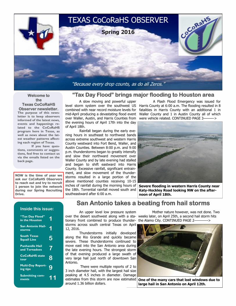
“Tax Day Flood” brings major flooding to Houston area A slow moving and powerful upper level storm system over the southwest US combined with near record moisture levels for mid-April producing a devastating flood event over Waller, Austin, and Harris Counties from the evening hours of April 17th into the day of April 18th. Rainfall began during the early eve-ning hours in southeast to northwest bands across extreme southwest and western Harris County westward into Fort Bend, Waller, and Austin Counties. Between 8:00 p.m. and 9:00 p.m. thunderstorms began to greatly intensify and slow their northward movement over Waller County and by late evening had stalled and began to shift eastward into Harris County. Excessive rainfall, significant entrain-ment, and slow movement of the thunder-storms resulted in a large portion of the above mentioned counties receiving 10-15 inches of rainfall during the morning hours of the 18th. Torrential rainfall moved south and southeastward after 6:00 a.m.
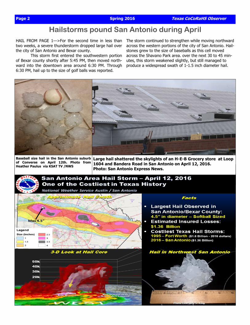
San Antonio takes a beating from hail storms An upper level low pressure system over the desert southwest along with a sta-tionary front combined to produce thunder-storms across south central Texas on April 12, 2016. Thunderstorms initially developed along the Rio Grande and quickly became severe. These thunderstorms continued to move east into the San Antonio area during the late evening hours. The strongest storm of that evening produced a large swath of very large hail just north of downtown San Antonio. There were multiple reports of 2 to 3 inch diameter hail, with the largest hail size peaking at 4.5 inches in diameter. Damage estimates from this storm are now estimated around 1.36 billion dollars.
Mother nature however, was not done. Two weeks later, on April 25th, a second hail storm hits the Alamo City. CONTINUED PAGE 2————->
One of the many cars that lost windows due to large hail in San Antonio on April 12th.
A Flash Flood Emergency was issued for Harris County at 6:00 a.m. The flooding resulted in 8 fatalities in Harris County with an additional 1 in Waller County and 1 in Austin County all of which were vehicle related. CONTINUED PAGE 3———->
Severe flooding in western Harris County near Katy-Hockley Road looking NW on the after-noon of April 18th.
NOW is the time of year we ask our CoCoRaHS Observers to reach out and try to recruit 1 person to join the network during our Spring Recruiting Drive.
Page 2 Spring 2016 Texas CoCoRaHS Observer
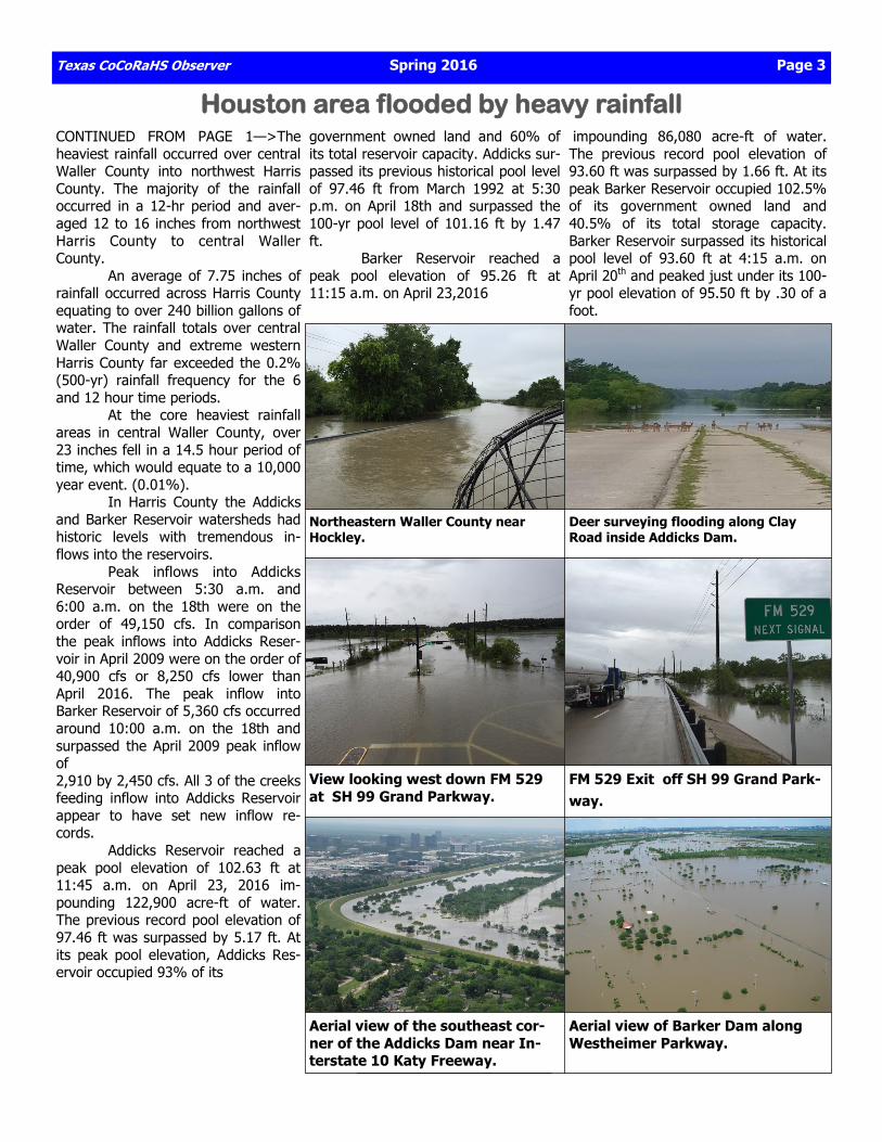
HAIL FROM PAGE 1—>For the second time in less than two weeks, a severe thunderstorm dropped large hail over the city of San Antonio and Bexar county. This storm first entered the southwestern portion of Bexar county shortly after 5:45 PM, then moved north-ward into the downtown area around 6:30 PM. Through 6:30 PM, hail up to the size of golf balls was reported.
Hailstorms pound San Antonio during April
Baseball size hail in the San Antonio suburb of Converse on April 12th. Photo from Heather Paulus via KSAT TV /NWS
Large hail shattered the skylights of an H-E-B Grocery store at Loop 1604 and Bandera Road in San Antonio on April 12, 2016. Photo: San Antonio Express News.
The storm continued to strengthen while moving northward across the western portions of the city of San Antonio. Hail-stones grew to the size of baseballs as this cell moved across the Shavano Park area. over the next 30 to 45 min-utes, this storm weakened slightly, but still managed to produce a widespread swath of 1-1.5 inch diameter hail.
Texas CoCoRaHS Observer Spring 2016 Page 3
Houston area flooded by heavy rainfall CONTINUED FROM PAGE 1—>The heaviest rainfall occurred over central Waller County into northwest Harris County. The majority of the rainfall occurred in a 12-hr period and aver-aged 12 to 16 inches from northwest Harris County to central Waller County. An average of 7.75 inches of rainfall occurred across Harris County equating to over 240 billion gallons of water. The rainfall totals over central Waller County and extreme western Harris County far exceeded the 0.2% (500-yr) rainfall frequency for the 6 and 12 hour time periods. At the core heaviest rainfall areas in central Waller County, over 23 inches fell in a 14.5 hour period of time, which would equate to a 10,000 year event. (0.01%). In Harris County the Addicks and Barker Reservoir watersheds had historic levels with tremendous in-flows into the reservoirs. Peak inflows into Addicks Reservoir between 5:30 a.m. and 6:00 a.m. on the 18th were on the order of 49,150 cfs. In comparison the peak inflows into Addicks Reser-voir in April 2009 were on the order of 40,900 cfs or 8,250 cfs lower than April 2016. The peak inflow into Barker Reservoir of 5,360 cfs occurred around 10:00 a.m. on the 18th and surpassed the April 2009 peak inflow of 2,910 by 2,450 cfs. All 3 of the creeks feeding inflow into Addicks Reservoir appear to have set new inflow re-cords. Addicks Reservoir reached a peak pool elevation of 102.63 ft at 11:45 a.m. on April 23, 2016 im-pounding 122,900 acre-ft of water. The previous record pool elevation of 97.46 ft was surpassed by 5.17 ft. At its peak pool elevation, Addicks Res-ervoir occupied 93% of its
government owned land and 60% of its total reservoir capacity. Addicks sur-passed its previous historical pool level of 97.46 ft from March 1992 at 5:30 p.m. on April 18th and surpassed the 100-yr pool level of 101.16 ft by 1.47 ft. Barker Reservoir reached a peak pool elevation of 95.26 ft at 11:15 a.m. on April 23,2016
impounding 86,080 acre-ft of water. The previous record pool elevation of 93.60 ft was surpassed by 1.66 ft. At its peak Barker Reservoir occupied 102.5% of its government owned land and 40.5% of its total storage capacity. Barker Reservoir surpassed its historical pool level of 93.60 ft at 4:15 a.m. on April 20th and peaked just under its 100-yr pool elevation of 95.50 ft by .30 of a foot.
Northeastern Waller County near Hockley.
Deer surveying flooding along Clay Road inside Addicks Dam.
View looking west down FM 529 at SH 99 Grand Parkway.
FM 529 Exit off SH 99 Grand Park-way.
Aerial view of the southeast cor-ner of the Addicks Dam near In-terstate 10 Katy Freeway.
Aerial view of Barker Dam along Westheimer Parkway.
Page 4 Spring 2016 Texas CoCoRaHS Observer
Houston area “Tax-Day Flooding”
Above: aerial view of State Highway 6 facing north from In-terstate 10-Katy Freeway Below: Buffalo Bayou at Milam Street in Downtown Houston
Above: Radar estimated rainfall totals from April 17th to April 21st. The white areas represent at least 12 inches or more of rain-fall. The highest rainfall totals in central Waller County were around 23 inches. Below: Total rainfall as reported by CoCoRaHS observers from April 15 to April 22nd.
Texas CoCoRaHS Observer Spring 2016 Page 5
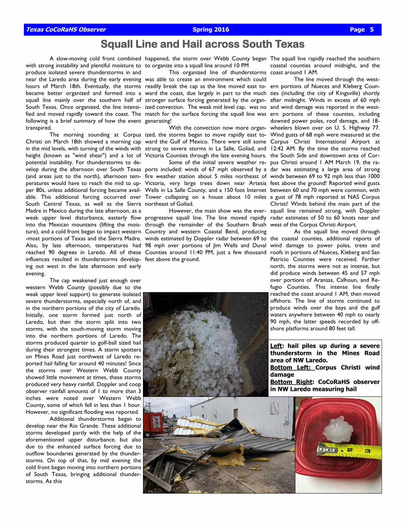
Squall Line and Hail across South Texas A slow-moving cold front combined with strong instability and plentiful moisture to produce isolated severe thunderstorms in and near the Laredo area during the early evening hours of March 18th. Eventually, the storms became better organized and formed into a squall line mainly over the southern half of South Texas. Once organized, the line intensi-fied and moved rapidly toward the coast. The following is a brief summary of how the event transpired. . The morning sounding at Corpus Christi on March 18th showed a morning cap in the mid levels, with turning of the winds with height (known as "wind shear") and a lot of potential instability. For thunderstorms to de-velop during the afternoon over South Texas (and areas just to the north), afternoon tem-peratures would have to reach the mid to up-per 80s, unless additional forcing became avail-able. This additional forcing occurred over South Central Texas, as well as the Sierra Madre in Mexico during the late afternoon, as a weak upper level disturbance, easterly flow into the Mexican mountains (lifting the mois-ture), and a cold front began to impact western-most portions of Texas and the Sierra Madre. Also, by late afternoon, temperatures had reached 90 degrees in Laredo. All of these influences resulted in thunderstorms develop-ing out west in the late afternoon and early evening. The cap weakened just enough over western Webb County (possibly due to the weak upper level support) to generate isolated severe thunderstorms, especially north of, and in the northern portions of the city of Laredo. Initially, one storm formed just north of Laredo, but then the storm split into two storms, with the south-moving storm moving into the northern portions of Laredo. The storms produced quarter to golf-ball sized hail during their strongest times. A storm spotters on Mines Road just northwest of Laredo re-ported hail falling for around 40 minutes! Since the storms over Western Webb County showed little movement at times, these storms produced very heavy rainfall. Doppler and coop observer rainfall amounts of 1 to more than 3 inches were noted over Western Webb County, some of which fell in less than 1 hour. However, no significant flooding was reported. Additional thunderstorms began to develop near the Rio Grande. These additional storms developed partly with the help of the aforementioned upper disturbance, but also due to the enhanced surface forcing due to outflow boundaries generated by the thunder-storms. On top of that, by mid evening the cold front began moving into northern portions of South Texas, bringing additional thunder-storms. As this
happened, the storm over Webb County began to organize into a squall line around 10 PM This organized line of thunderstorms was able to create an environment which could readily break the cap as the line moved east to-ward the coast, due largely in part to the much stronger surface forcing generated by the organ-ized convection. The weak mid level cap, was no match for the surface forcing the squall line was generating! With the convection now more organ-ized, the storms began to move rapidly east to-ward the Gulf of Mexico. There were still some strong to severe storms in La Salle, Goliad, and Victoria Counties through the late evening hours. Some of the initial severe weather re-ports included: winds of 67 mph observed by a fire weather station about 5 miles northeast of Victoria, very large trees down near Artesia Wells in La Salle County, and a 150 foot Internet Tower collapsing on a house about 10 miles northeast of Goliad. However, the main show was the ever-progressive squall line. The line moved rapidly through the remainder of the Southern Brush Country and western Coastal Bend, producing winds estimated by Doppler radar between 69 to 98 mph over portions of Jim Wells and Duval Counties around 11:40 PM, just a few thousand feet above the ground.
The squall line rapidly reached the southern coastal counties around midnight, and the coast around 1 AM. The line moved through the west-ern portions of Nueces and Kleberg Coun-ties (including the city of Kingsville) shortly after midnight. Winds in excess of 60 mph and wind damage was reported in the west-ern portions of these counties, including downed power poles, roof damage, and 18-wheelers blown over on U. S. Highway 77. Wind gusts of 68 mph were measured at the Corpus Christi International Airport at 12:42 AM. By the time the storms reached the South Side and downtown area of Cor-pus Christi around 1 AM March 19, the ra-dar was estimating a large area of strong winds between 69 to 92 mph less than 1000 feet above the ground! Reported wind gusts between 60 and 70 mph were common, with a gust of 78 mph reported at NAS Corpus Christi! Winds behind the main part of the squall line remained strong, with Doppler radar estimates of 50 to 60 knots near and west of the Corpus Christi Airport. As the squall line moved through the coastal counties, additional reports of wind damage to power poles, trees and roofs in portions of Nueces, Kleberg and San Patricio Counties were received. Farther north, the storms were not as intense, but did produce winds between 45 and 57 mph over portions of Aransas, Calhoun, and Re-fugio Counties. This intense line finally reached the coast around 1 AM, then moved offshore. The line of storms continued to produce winds over the bays and the gulf waters anywhere between 40 mph to nearly 90 mph, the latter speeds recorded by off-shore platforms around 80 feet tall.
Left: hail piles up during a severe thunderstorm in the Mines Road area of NW Laredo. Bottom Left: Corpus Christi wind damage Bottom Right: CoCoRaHS observer in NW Laredo measuring hail
Page 6 Spring 2016 Texas CoCoRaHS Observer
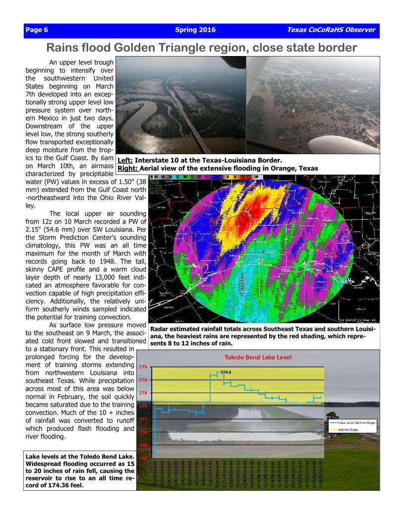
Rains flood Golden Triangle region, close state border An upper level trough beginning to intensify over the southwestern United States beginning on March 7th developed into an excep-tionally strong upper level low pressure system over north-ern Mexico in just two days. Downstream of the upper level low, the strong southerly flow transported exceptionally deep moisture from the trop-ics to the Gulf Coast. By 6am on March 10th, an airmass characterized by precipitable water (PW) values in excess of 1.50" (38 mm) extended from the Gulf Coast north-northeastward into the Ohio River Val-ley. The local upper air sounding from 12z on 10 March recorded a PW of 2.15" (54.6 mm) over SW Louisiana. Per the Storm Prediction Center's sounding climatology, this PW was an all time maximum for the month of March with records going back to 1948. The tall, skinny CAPE profile and a warm cloud layer depth of nearly 13,000 feet indi-cated an atmosphere favorable for con-vection capable of high precipitation effi-ciency. Additionally, the relatively uni-form southerly winds sampled indicated the potential for training convection. As surface low pressure moved to the southeast on 9 March, the associ-ated cold front slowed and transitioned to a stationary front. This resulted in prolonged forcing for the develop-ment of training storms extending from northwestern Louisiana into southeast Texas. While precipitation across most of this area was below normal in February, the soil quickly became saturated due to the training convection. Much of the 10 + inches of rainfall was converted to runoff which produced flash flooding and river flooding.
Left: Interstate 10 at the Texas-Louisiana Border. Right: Aerial view of the extensive flooding in Orange, Texas
Radar estimated rainfall totals across Southeast Texas and southern Louisi-ana, the heaviest rains are represented by the red shading, which repre-sents 8 to 12 inches of rain.
Lake levels at the Toledo Bend Lake. Widespread flooding occurred as 15 to 20 inches of rain fell, causing the reservoir to rise to an all time re-cord of 174.36 feel.
Texas CoCoRaHS Observer Spring 2016 Page 7
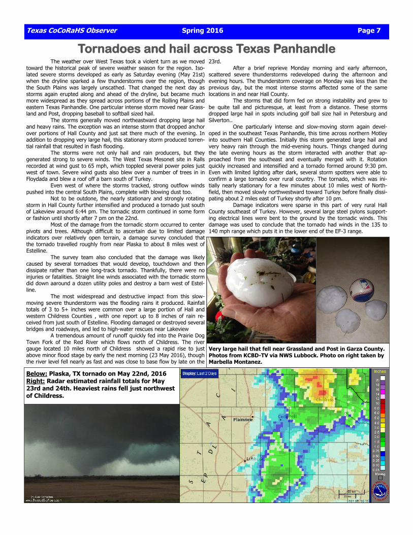
Tornadoes and hail across Texas Panhandle The weather over West Texas took a violent turn as we moved toward the historical peak of severe weather season for the region. Iso-lated severe storms developed as early as Saturday evening (May 21st) when the dryline sparked a few thunderstorms over the region, though the South Plains was largely unscathed. That changed the next day as storms again erupted along and ahead of the dryline, but became much more widespread as they spread across portions of the Rolling Plains and eastern Texas Panhandle. One particular intense storm moved near Grass-land and Post, dropping baseball to softball sized hail. The storms generally moved northeastward dropping large hail and heavy rains. The exception was an intense storm that dropped anchor over portions of Hall County and just sat there much of the evening. In addition to dropping very large hail, this stationary storm produced torren-tial rainfall that resulted in flash flooding. The storms were not only hail and rain producers, but they generated strong to severe winds. The West Texas Mesonet site in Ralls recorded at wind gust to 65 mph, which toppled several power poles just west of town. Severe wind gusts also blew over a number of trees in in Floydada and blew a roof off a barn south of Turkey. Even west of where the storms tracked, strong outflow winds pushed into the central South Plains, complete with blowing dust too. Not to be outdone, the nearly stationary and strongly rotating storm in Hall County further intensified and produced a tornado just south of Lakeview around 6:44 pm. The tornadic storm continued in some form or fashion until shortly after 7 pm on the 22nd. Most of the damage from the tornadic storm occurred to center pivots and trees. Although difficult to ascertain due to limited damage indicators over relatively open terrain, a damage survey concluded that the tornado travelled roughly from near Plaska to about 8 miles west of Estelline. The survey team also concluded that the damage was likely caused by several tornadoes that would develop, touchdown and then dissipate rather than one long-track tornado. Thankfully, there were no injuries or fatalities. Straight line winds associated with the tornadic storm did down aaround a dozen utility poles and destroy a barn west of Estel-line. The most widespread and destructive impact from this slow-moving severe thunderstorm was the flooding rains it produced. Rainfall totals of 3 to 5+ inches were common over a large portion of Hall and western Childress Counties , with one report up to 8 inches of rain re-ceived from just south of Estelline. Flooding damaged or destroyed several bridges and roadways, and led to high-water rescues near Lakeview A tremendous amount of runoff quickly fed into the Prairie Dog Town Fork of the Red River which flows north of Childress. The river gauge located 10 miles north of Childress showed a rapid rise to just above minor flood stage by early the next morning (23 May 2016), though the river level fell nearly as fast and was close to base flow by late on the
23rd. After a brief reprieve Monday morning and early afternoon, scattered severe thunderstorms redeveloped during the afternoon and evening hours. The thunderstorm coverage on Monday was less than the previous day, but the most intense storms affected some of the same locations in and near Hall County. The storms that did form fed on strong instability and grew to be quite tall and picturesque, at least from a distance. These storms dropped large hail in spots including golf ball size hail in Petersburg and Silverton.. One particularly intense and slow-moving storm again devel-oped in the southeast Texas Panhandle, this time across northern Motley into southern Hall Counties. Initially this storm generated large hail and very heavy rain through the mid-evening hours. Things changed during the late evening hours as the storm interacted with another that ap-proached from the southeast and eventually merged with it. Rotation quickly increased and intensified and a tornado formed around 9:30 pm. Even with limited lighting after dark, several storm spotters were able to confirm a large tornado over rural country. The tornado, which was ini-tially nearly stationary for a few minutes about 10 miles west of North-field, then moved slowly northwestward toward Turkey before finally dissi-pating about 2 miles east of Turkey shortly after 10 pm. Damage indicators were sparse in this part of very rural Hall County southeast of Turkey. However, several large steel pylons support-ing electrical lines were bent to the ground by the tornadic winds. This damage was used to conclude that the tornado had winds in the 135 to 140 mph range which puts it in the lower end of the EF-3 range.
Below: Plaska, TX tornado on May 22nd, 2016 Right: Radar estimated rainfall totals for May 23rd and 24th. Heaviest rains fell just northwest of Childress.
Very large hail that fell near Grassland and Post in Garza County. Photos from KCBD-TV via NWS Lubbock. Photo on right taken by Marbella Montanez.
Page 8 Spring 2016 Texas CoCoRaHS Observer
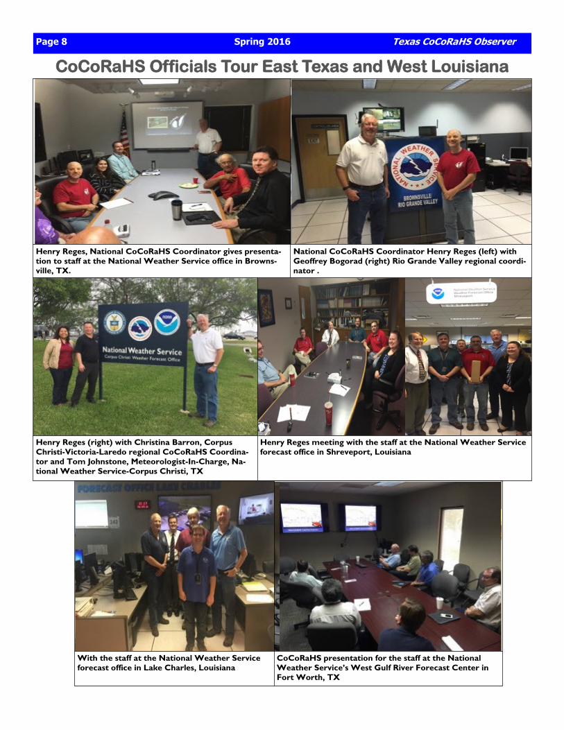
CoCoRaHS Officials Tour East Texas and West Louisiana
Henry Reges, National CoCoRaHS Coordinator gives presenta-tion to staff at the National Weather Service office in Browns-ville, TX.
National CoCoRaHS Coordinator Henry Reges (left) with Geoffrey Bogorad (right) Rio Grande Valley regional coordi-nator .
Henry Reges (right) with Christina Barron, Corpus Christi-Victoria-Laredo regional CoCoRaHS Coordina-tor and Tom Johnstone, Meteorologist-In-Charge, Na-tional Weather Service-Corpus Christi, TX
Henry Reges meeting with the staff at the National Weather Service forecast office in Shreveport, Louisiana
With the staff at the National Weather Service forecast office in Lake Charles, Louisiana
CoCoRaHS presentation for the staff at the National Weather Service’s West Gulf River Forecast Center in Fort Worth, TX
Texas CoCoRaHS Observer Spring 2016 Page 9
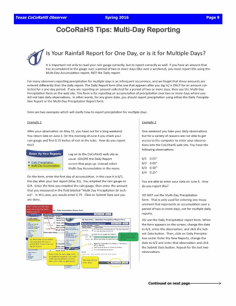
CoCoRaHS Tips: Multi-Day Reporting
Continued on next page—————————>

Page 10 Spring 2016 Texas CoCoRaHS Observer
Multi-Day reporting procedures
CoCoRaHS Webinar Schedule In December 2011 CoCoRaHS kicked off a new and exciting monthly Webinar series called CoCoRaHS WxTalk (wx is shorthand for weather). CoCoRaHS WxTalk consists of a series of monthly one-hour interactive Webinars featuring engaging experts in the fields of atmospheric science, climatology and other pertinent disciplines. These easy to follow presentations are live and approximately sixty minutes long. The audience is given the chance to submit questions which the experts answer live on the air. Topics have included: Snow, Satellites, Hurricanes, Lightning, Clouds, Tornadoes, Flash Floods, Fire Weather, Weather History, Ra-dar and How to become a Meteorologist, just to name a few. There are many exciting Webinars on the agenda in the months ahead, so please tell your friends to join us. All WxTalk Webi-nars are free and most are recorded for later viewing. *Although headphones are a good way of listening to the Webinars, only a set of speakers is required to hear the Webinar. The audience will be muted so there is no need for a mi-crophone. All incoming correspon-dence during the Webinar should be in typed form.
Thursday, June 23, 2016 - 12PM CDT Weather, climate and extremes in the western U.S. Nina Oakley Western Regional Climate Center Reno, NV
Thursday, July 14, 2016 - 12PM CDT The Climate of the Southeast U.S.: Geographic Patterns and Trends in Extreme Weather Events Chip Konrad Southeastern Regional Climate Center Chapel Hill, NC
Thursday, August 4, 2016 - 12PM CDT The Weather and Climate of the Northeast U.S. Samantha Borisoff Northeastern Regional Climate Center Cornell University Cornell, NY
Texas CoCoRaHS Observer Spring 2016 Page 11
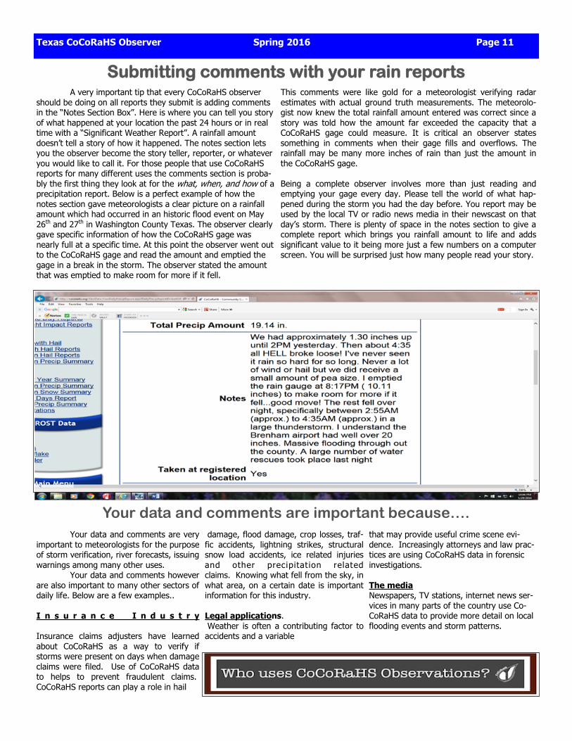
Submitting comments with your rain reports A very important tip that every CoCoRaHS observer should be doing on all reports they submit is adding comments in the “Notes Section Box”. Here is where you can tell you story of what happened at your location the past 24 hours or in real time with a “Significant Weather Report”. A rainfall amount doesn’t tell a story of how it happened. The notes section lets you the observer become the story teller, reporter, or whatever you would like to call it. For those people that use CoCoRaHS reports for many different uses the comments section is proba-bly the first thing they look at for the what, when, and how of a precipitation report. Below is a perfect example of how the notes section gave meteorologists a clear picture on a rainfall amount which had occurred in an historic flood event on May 26th and 27th in Washington County Texas. The observer clearly gave specific information of how the CoCoRaHS gage was nearly full at a specific time. At this point the observer went out to the CoCoRaHS gage and read the amount and emptied the gage in a break in the storm. The observer stated the amount that was emptied to make room for more if it fell.
This comments were like gold for a meteorologist verifying radar estimates with actual ground truth measurements. The meteorolo-gist now knew the total rainfall amount entered was correct since a story was told how the amount far exceeded the capacity that a CoCoRaHS gage could measure. It is critical an observer states something in comments when their gage fills and overflows. The rainfall may be many more inches of rain than just the amount in the CoCoRaHS gage. Being a complete observer involves more than just reading and emptying your gage every day. Please tell the world of what hap-pened during the storm you had the day before. You report may be used by the local TV or radio news media in their newscast on that day’s storm. There is plenty of space in the notes section to give a complete report which brings you rainfall amount to life and adds significant value to it being more just a few numbers on a computer screen. You will be surprised just how many people read your story.
Your data and comments are important because…. Your data and comments are very important to meteorologists for the purpose of storm verification, river forecasts, issuing warnings among many other uses. Your data and comments however are also important to many other sectors of daily life. Below are a few examples.. I n s u r a n c e I n d u s t r y Insurance claims adjusters have learned about CoCoRaHS as a way to verify if storms were present on days when damage claims were filed. Use of CoCoRaHS data to helps to prevent fraudulent claims. CoCoRaHS reports can play a role in hail
damage, flood damage, crop losses, traf-fic accidents, lightning strikes, structural snow load accidents, ice related injuries and other precipitat ion related claims. Knowing what fell from the sky, in what area, on a certain date is important information for this industry. Legal applications. Weather is often a contributing factor to accidents and a variable
that may provide useful crime scene evi-dence. Increasingly attorneys and law prac-tices are using CoCoRaHS data in forensic investigations. The media Newspapers, TV stations, internet news ser-vices in many parts of the country use Co-CoRaHS data to provide more detail on local flooding events and storm patterns.
Page 12 Spring 2016 Texas CoCoRaHS Observer
CoCoRaHS Tips: Significant Weather & Hail Reports
Important Tips To Remember To Be An Outstanding CoCoRaHS Observer
> Always remember to report days with zero rainfall since this data is very important to know
exactly what occurred at your location and is critical data for Drought Monitor Mapping.
> Make sure to empty your gage after you have read the observation amount. Make sure all
water is out of the large funnel and small inner tube so none of this rainfall gets recorded on
the next days observation amount.
> Make sure you double check the amount you have entered on the days observation by going
into the CoCoRaHS web site and looking at the observations entered for your county and then
finding and verifying you observation amount.
> Make sure you keep you CoCoRaHS rain gage clean of mold and debris which can give a false
reading in your gage. Use a spray bottle with a mixture of 1/4 glass cleaner and 3/4 water to
clean the gage. Several paper towels can be used to clean the bottom of the inner tube by
twisting them around down the tube after adding about 0.10 of water in the tube.
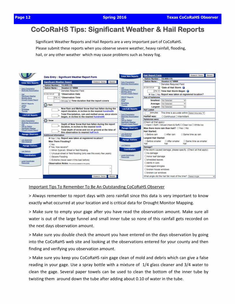
Significant Weather Reports and Hail Reports are a very important part of CoCoRaHS.
Please submit these reports when you observe severe weather, heavy rainfall, flooding,
hail, or any other weather which may cause problems such as heavy fog.
Texas CoCoRaHS Observer Spring 2016 Page 13
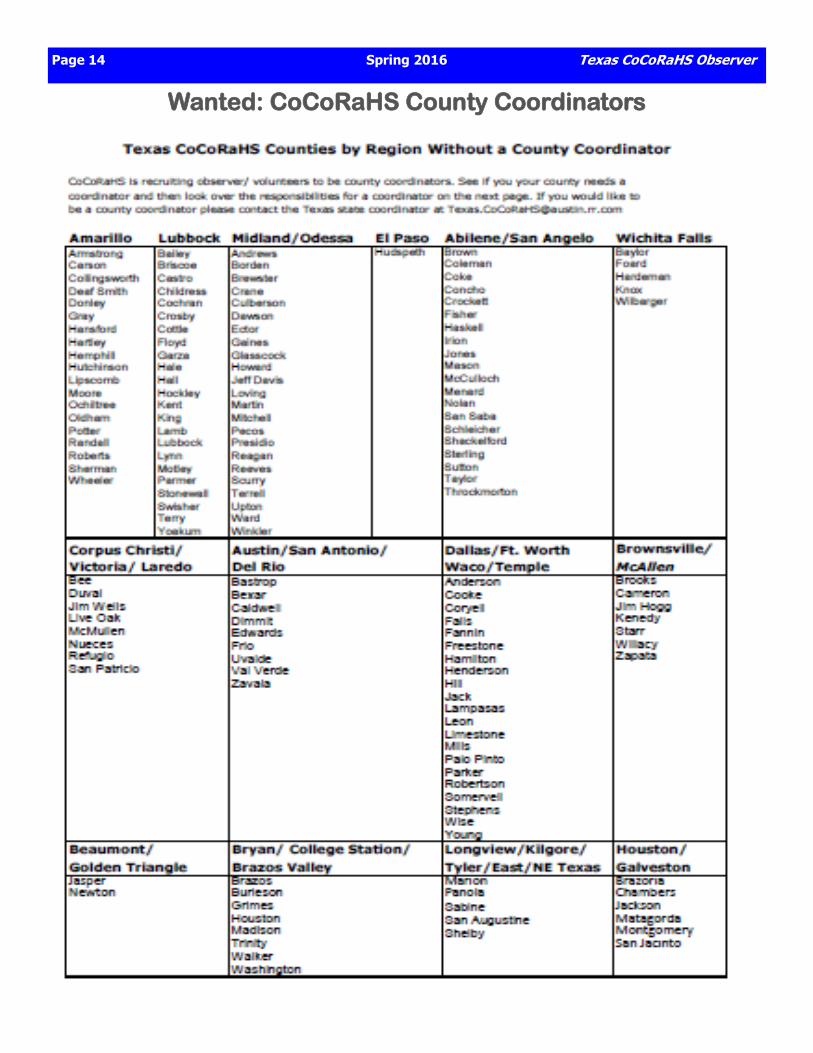
Wanted: CoCoRaHS Coordinators
NOW is the time of year we ask our CoCoRaHS Observers to reach out and try to recruit 1 person to join the network during our Spring Recruiting Drive.
Page 14 Spring 2016 Texas CoCoRaHS Observer
Wanted: CoCoRaHS County Coordinators
Texas CoCoRaHS Observer Spring 2016 Page 15
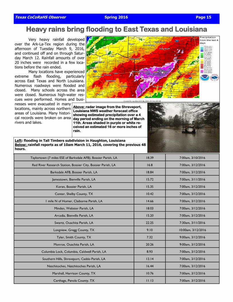
Heavy rains bring flooding to East Texas and Louisiana Very heavy rainfall developed over the Ark-La-Tex region during the afternoon of Tuesday March 9, 2016, and continued off and on through Satur-day March 12. Rainfall amounts of over 20 inches were recorded in a few loca-tions before the rain ended. Many locations have experienced extreme flash flooding, particularly across East Texas and North Louisiana. Numerous roadways were flooded and closed. Many schools across the area were closed. Numerous high-water res-cues were performed. Homes and busi-nesses were evacuated in many locations, mainly across northern areas of Louisiana. Many histori-cal records were broken on area rivers and lakes.
Taylortown (7 miles ESE of Barksdale AFB), Bossier Parish, LA 18.39 7:00am, 3/10/2016
Red River Research Station, Bossier City, Bossier Parish, LA 16.8 7:00am, 3/12/2016
Barksdale AFB, Bossier Parish, LA 18.84 7:00am, 3/12/2016
Jamestown, Bienville Parish, LA 15.72 7:00am, 3/11/2016
Koran, Bossier Parish, LA 15.35 7:00am, 3/12/2016
Center, Shelby County, TX 10.42 7:00am, 3/12/2016
1 mile N of Homer, Claiborne Parish, LA 14.66 7:00am, 3/12/2016
Minden, Webster Parish, LA 18.03 7:00am, 3/12/2016
Arcadia, Bienville Parish, LA 15.20 7:00am, 3/12/2016
Swartz, Ouachita Parish, LA 22.25 7:30am, 3/11/2016
Longview, Gregg County, TX 9.10 10:00am, 3/12/2016
Tyler, Smith County, TX 7.32 9:00am, 3/12/2016
Monroe, Ouachita Parish, LA 20.26 9:00am, 3/12/2016
Columbia Lock, Columbia, Caldwell Parish, LA 8.93 7:00am, 3/12/2016
Southern Hills, Shreveport, Caddo Parish, LA 13.14 7:00am, 3/12/2016
Natchitoches, Natchitoches Parish, LA 16.44 7:00am, 3/12/2016
Marshall, Harrison County, TX 10.76 7:00am, 3/12/2016
Carthage, Panola County, TX 11.13 7:00am. 3/12/2016
Above: radar image from the Shreveport, Louisiana NWS weather forecast office showing estimated precipitation over a 4 day period ending on the morning of March 11th. Areas shaded in purple or white re-ceived an estimated 16 or more inches of rain.
Left: flooding in Tall Timbers subdivision in Haughton, Louisiana Below: rainfall reports as of 10am March 11, 2016, covering the previous 48 hours.
Page 16 Spring 2016 Texas CoCoRaHS Observer
Houston-Galveston Region Rain and Climate Summary
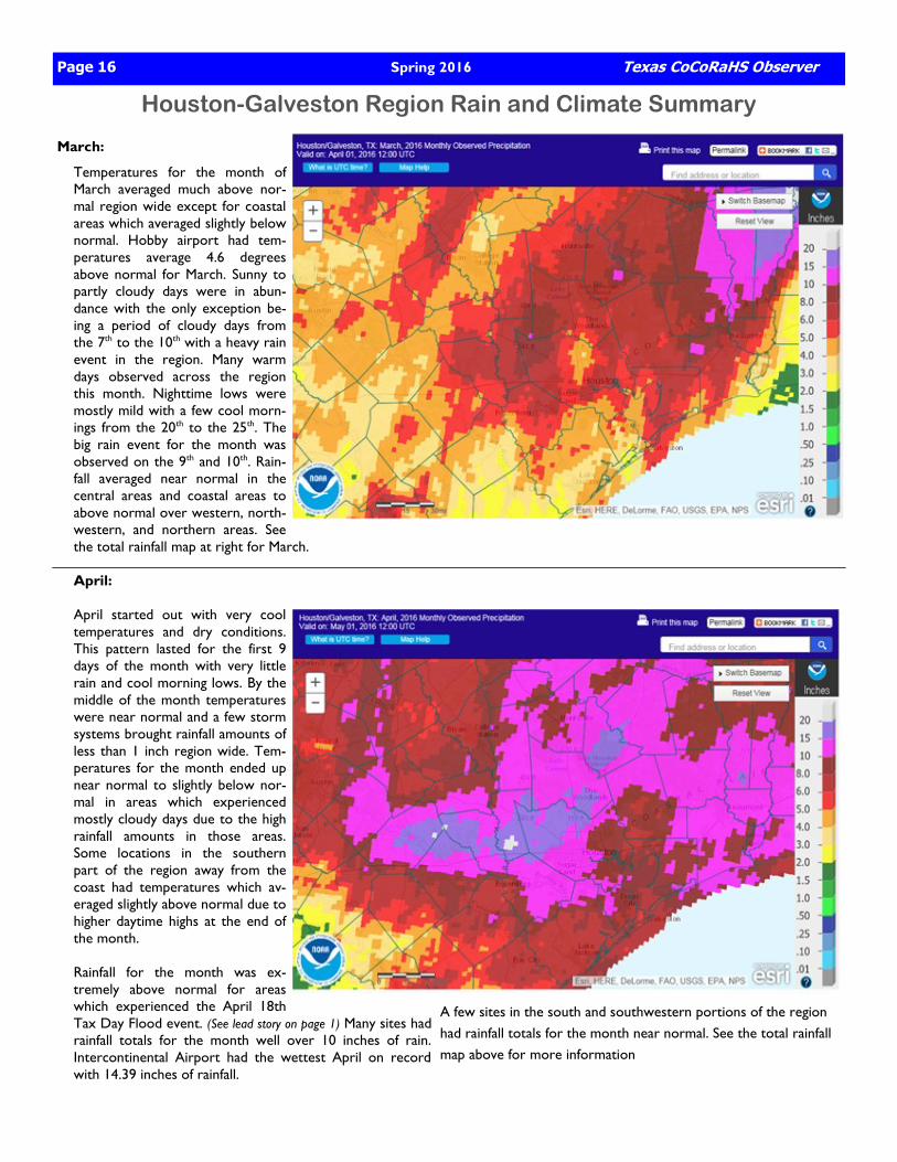
March:
Temperatures for the month of March averaged much above nor-mal region wide except for coastal areas which averaged slightly below normal. Hobby airport had tem-peratures average 4.6 degrees above normal for March. Sunny to partly cloudy days were in abun-dance with the only exception be-ing a period of cloudy days from the 7th to the 10th with a heavy rain event in the region. Many warm days observed across the region this month. Nighttime lows were mostly mild with a few cool morn-ings from the 20th to the 25th. The big rain event for the month was observed on the 9th and 10th. Rain-fall averaged near normal in the central areas and coastal areas to above normal over western, north-western, and northern areas. See the total rainfall map at right for March. April: April started out with very cool temperatures and dry conditions. This pattern lasted for the first 9 days of the month with very little rain and cool morning lows. By the middle of the month temperatures were near normal and a few storm systems brought rainfall amounts of less than 1 inch region wide. Tem-peratures for the month ended up near normal to slightly below nor-mal in areas which experienced mostly cloudy days due to the high rainfall amounts in those areas. Some locations in the southern part of the region away from the coast had temperatures which av-eraged slightly above normal due to higher daytime highs at the end of the month. Rainfall for the month was ex-tremely above normal for areas which experienced the April 18th Tax Day Flood event. (See lead story on page 1) Many sites had rainfall totals for the month well over 10 inches of rain. Intercontinental Airport had the wettest April on record with 14.39 inches of rainfall.
A few sites in the south and southwestern portions of the region had rainfall totals for the month near normal. See the total rainfall map above for more information
Houston-Galveston May Rain and Climate Summary
Texas CoCoRaHS Observer Spring 2016 Page 17
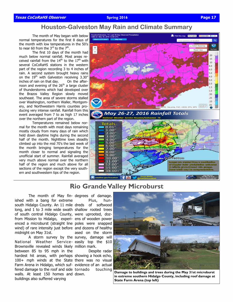
The month of May began with below normal temperatures for the first 8 days of the month with low temperatures in the 50’s to near 60 from the 3rd to the 7th. The first 10 days of the month had much below normal rainfall. Most areas re-ceived rainfall from the 14th to the 17th with several CoCoRaHS stations in the western part of the region recording 3 to 4 inches of rain. A second system brought heavy rains on the 19th with Galveston receiving 3.30” inches of rain on that day. On the after-noon and evening of the 26th a large cluster of thunderstorms which had developed over the Brazos Valley Region slowly moved southeast. The area of severe storms stalled over Washington, northern Waller, Montgom-ery, and Northwestern Harris counties pro-ducing very intense rainfall. Rainfall from this event averaged from 7 to as high 17 inches over the northern part of the region. Temperatures remained below nor-mal for the month with most days remaining mostly cloudy from many days of rain which held down daytime highs during the second half of the month. Nighttime lows steadily climbed up into the mid 70’s the last week of the month bringing temperatures for the month closer to normal and signaling the unofficial start of summer. Rainfall averaged very much above normal over the northern half of the region and much above for all sections of the region except the very south-ern and southwestern tips of the region.
Rio Grande Valley Microburst The month of May fin-ished with a bang for extreme south Hidalgo County. An 11 mile long, and 1 to 3 mile wide swath of south central Hidalgo County, from Mission to Hidalgo, experi-enced a microburst (straight line wind) of rare intensity just before midnight on May 31st. A storm survey by the National Weather Service-Brownsville revealed winds likely between 85 to 95 mph in the hardest hit areas, with perhaps 100+ mph winds at the State Farm Arena in Hidalgo, which suf-fered damage to the roof and side walls. At least 150 homes and buildings also suffered varying
degrees of damage. Plus, hun-dreds of softwood shallow rooted trees were uprooted, doz-ens of wooden power poles were snapped and dozens of healthy ased on the storm survey, damage will easily top the $10 million mark. Despite radar showing a hook echo, there was no visual evidence of an actual tornado touching down.
Damage to buildings and trees during the May 31st microburst in extreme southern Hidalgo County, including roof damage at State Farm Arena (top left)
Page 18 Spring 2016 Texas CoCoRaHS Observer
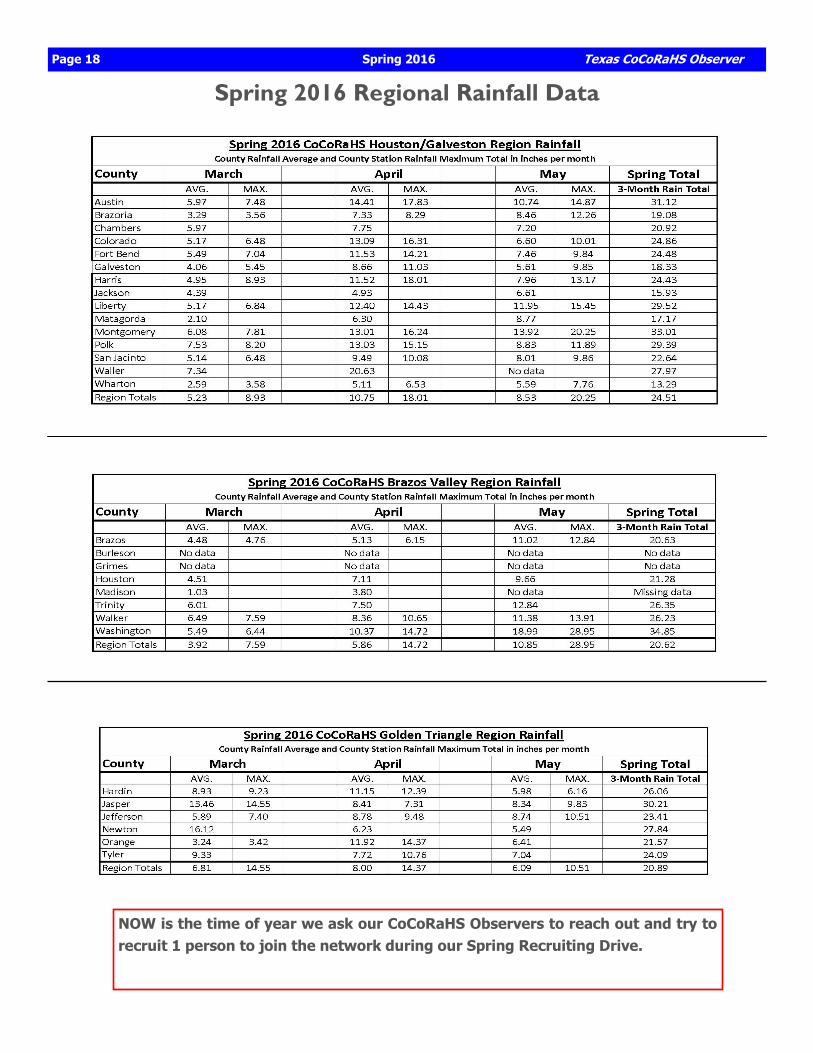
Spring 2016 Regional Rainfall Data
NOW is the time of year we ask our CoCoRaHS Observers to reach out and try to recruit 1 person to join the network during our Spring Recruiting Drive.
Texas CoCoRaHS Observer The official newsletter of Texas CoCoRaHS
Newsletter Editors: Juan Alanis Jr., NOAA/National Weather Service-Corpus Christi [email protected] Ronald Havran, Harris County Flood Control District (Houston) [email protected]
Texas CoCoRaHS: William (Bill) Runyon, Texas State Coordinator [email protected]
Texas CoCoRaHS Observer Spring 2016 Page 19
Texas CoCoRaHS
CoCoRaHS of South Texas
@Texas_CoCoRaHS
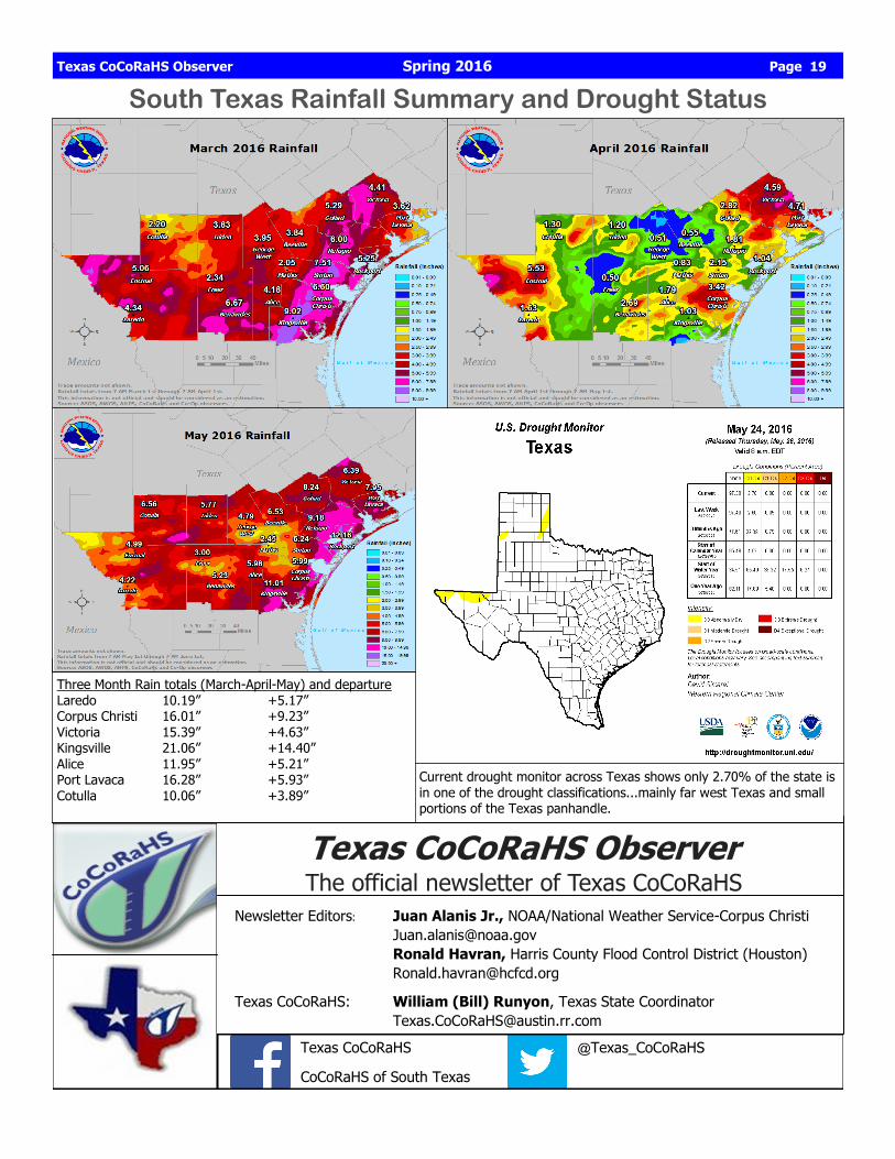
South Texas Rainfall Summary and Drought Status
Three Month Rain totals (March-April-May) and departure Laredo 10.19” +5.17” Corpus Christi 16.01” +9.23” Victoria 15.39” +4.63” Kingsville 21.06” +14.40” Alice 11.95” +5.21” Port Lavaca 16.28” +5.93” Cotulla 10.06” +3.89”
Current drought monitor across Texas shows only 2.70% of the state is in one of the drought classifications...mainly far west Texas and small portions of the Texas panhandle.