Embed Size (px)
Citation preview
APPENDIX O Tetra Tech Site Assessment Report
and Supplemental Data


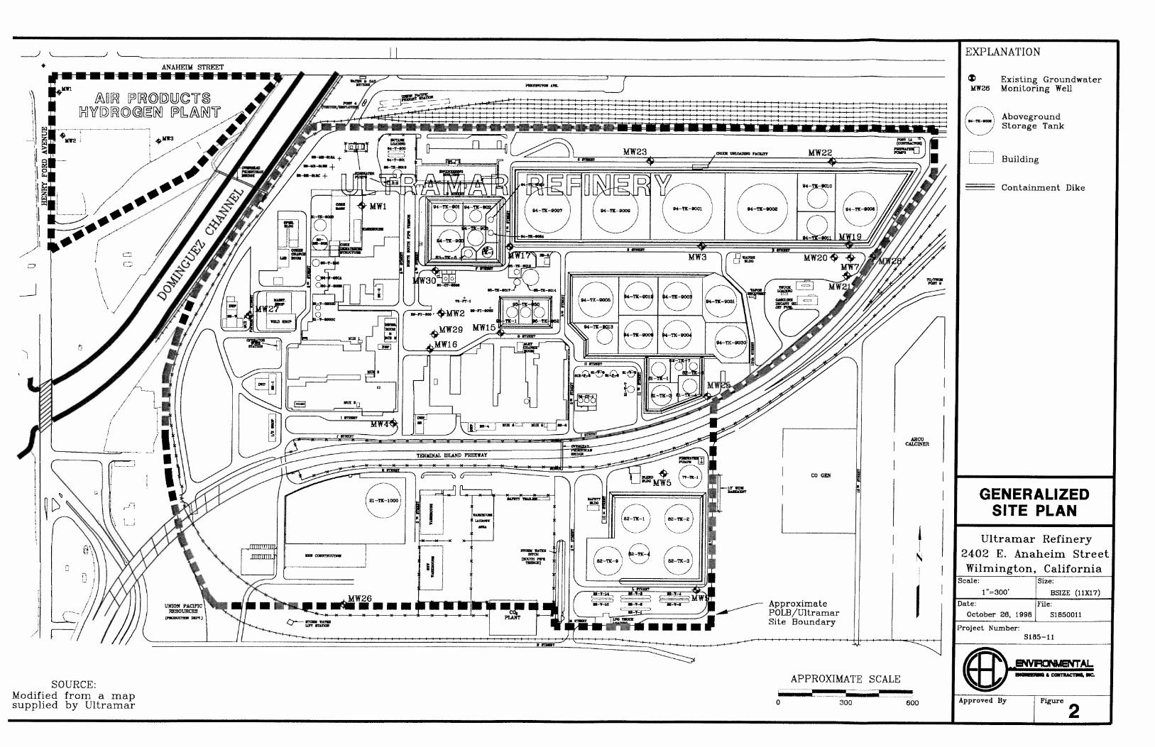
December 4, 2007 Mr. Ken Ragland, P.G. Port of Los Angeles 425 S. Palos Verdes Street San Pedro, CA 90731 RE: Preliminary Review of Environmental and Geological Conditions in the Vicinity of
the Proposed Pacific Energy Pipeline Dear Mr. Ragland, Tetra Tech, Inc. (Tetra Tech) has conducted a preliminary review of available documents regarding the environmental and geological conditions in the vicinity of the proposed Pacific Energy pipeline at the Port of Los Angeles (POLA). The objective of the review was to: 1) assess the presence of contaminants and their potential impacts to the proposed pipeline project, and 2) recommend appropriate actions to be taken in the areas of potential concern. The pipeline sections reviewed include: segments H – M, M – N, and N – T (Drawing Numbers 2917-Ex-101 and 2917-Ex-114); and sections C – B and B – A (Drawing Numbers 2917-Ex-012). The drawings are included in Attachment 1. Shallow subsurface contamination (i.e., < 25 feet below ground surface (bgs)) exists throughout the industrial and commercial areas at POLA (Komex 2004a; Tetra Tech 2006; Tetra Tech 2007; and The Source Group 2007); however, there is limited environmental data for deeper soils and groundwater. Consequently, Tetra Tech prepared schematic cross sections beneath the proposed pipeline bore routes to assess whether contamination may have impacted the deeper soils and groundwater, and to assess whether pipeline borings may provide a conduit for the shallow subsurface contamination to the enter into the deeper subsurface (Figures 1 - 3). 1.0 Regional Geology The proposed pipeline route is situated on the southern edge of the Coastal Plain Los Angeles County in the Peninsular Ranges geomorphic province of California. The Peninsular Ranges are characterized by steep, elongated ranges intervening valleys that trend northwestward. The Peninsular Ranges extend over 900 miles south from the Transverse Ranges (including the San Gabriel and San Bernardino Mountains) to the tip of Baja California. The Peninsular Ranges are bound to the east by the Salton Trough and extend to approximately 80 miles off the coast of Southern California (Oakeshott 1978). The project is located on the southern portion of the Dominguez Gap area of the Downey Plain physiographic region. The Downey Plain extends from the Ballona Gap near Santa Monica across the central lowland of the Coastal Plain of Los Angeles County into the Coastal Plain of Orange County nearly to Santa Ana. It is bound on the north and east by the Santa Monica Mountains, the Elysian, Reppetto, Merced, and Puente Hills and their adjacent piedmont areas, and on the southwest by the Newport-Inglewood Uplift. The Downey Plain extends through the Newport-Inglewood Uplift to the Pacific Ocean at Dominguez Gap. The Dominguez Gap is an

Preliminary Environmental Review Proposed Pacific Energy Pipeline Port of Los Angeles
Page 2 of 13
erosional feature through the Newport-Inglewood Uplift between Dominguez and Signal Hills created by the Los Angeles River. The Dominguez Gap physiographic area is approximately 2 miles wide from east to west and extends the Downey Plain south of the Newport-Inglewood Uplift to the Pacific Ocean at Long Beach and San Pedro (CADWR 1961). The project area is underlain by Quaternary and Tertiary age sediments of both marine and terrestrial origin above basement bed rock. The Quaternary deposits are mainly of marine and non-marine origin, composed of fluvial sediments (alluvium) extending to approximately 30 to 50 feet bgs originally derived from the Los Angeles River (CADWR 1961). The underlying Pleistocene age sediments are up to 3,000 feet thick and were deposited within marine and non-marine depositional environments. The major geological structural features in the vicinity of the project area include the steeply southwest dipping, northwest trending Palos Verdes Fault Zone. The Palos Verdes Fault Zone, the Newport-Inglewood Structural Zone, the Lomita – Wilmington Syncline, and the Wilmington Anticline. The Palos Verdes fault zone is located approximately 0.5 to 1 mile southwest of the Site. The Newport-Inglewood Structural Zone is located approximately 5 miles to the northeast of the Site. The Lomita – Wilmington Syncline is located beneath the proposed pipeline route (CADWR 1961). 2.0 Regional Hydrogeology The proposed pipeline route is located in the southern portion of the West Coast (groundwater) Basin. The West Coast Basin extends southwesterly from the Newport-Inglewood uplift (including the Baldwin Hills, Rosecrans Hills, Dominguez Hill, Signal Hill, and Bixby Ranch Hill), to Santa Monica Bay, to the drainage divide on the Palos Verdes Hills, and to San Pedro Bay. It extends from the Ballona Escarpment (near Santa Monica) on the northwest to the Los Angeles County line on the southeast. It is approximately 24 miles long and 7.5 miles wide, encompassing an area of approximately 160 square miles (CADWR 1961). Fresh water bearing sediments of the West Coast Basin extend from the ground surface to depths of over 1,500 feet bgs. The fresh water bearing formations of the West Cost Basin are, in descending order:
• Recent alluvial materials derived from fluvial and eolian processes; and • The alluvial Pleistocene age Lakewood and San Pedro formations.
The Recent alluvial materials contain a semi-perched aquifer, the Gaspur Aquifer, and portions of the Bellflower Aquiclude. The Lakewood Formation contains portions of the Bellflower Aquiclude, the confined Gardena Aquifer, and the confined Gage Aquifer (CADWR 1961).

Preliminary Environmental Review Proposed Pacific Energy Pipeline Port of Los Angeles
Page 3 of 13
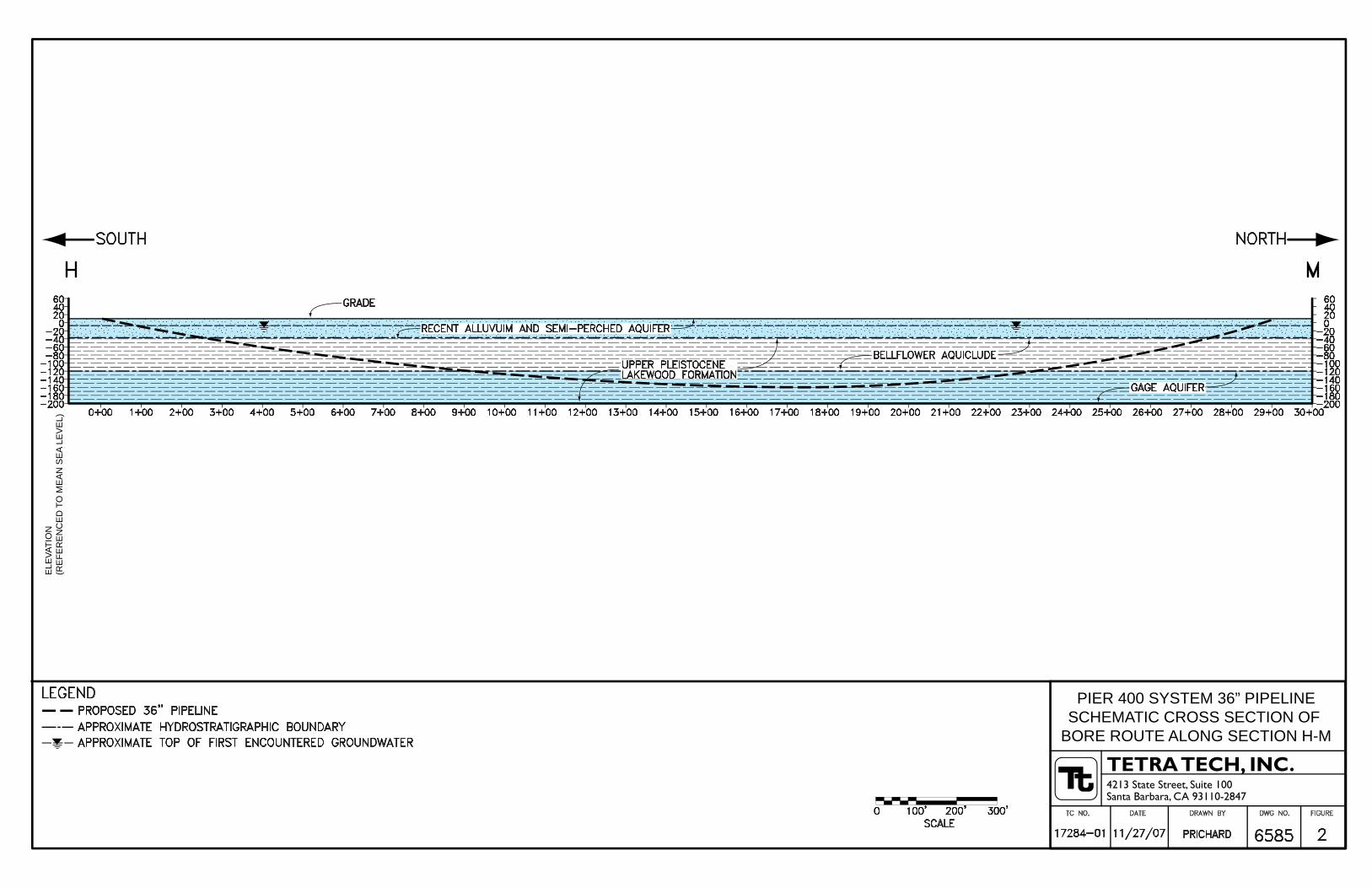
3.0 Project Area Geology and Hydrogeology 3.1 Geologic and Hydrostratigraphic Units 3.1.1 General Description The schematic cross section lines identified on Figure 1 and shown in Figures 2 and 3 were prepared based on data presented in Appendix A of CADWR Bulletin No. 104, Planned Utilization of the Ground Water Basins of the Coastal Plain of Los Angeles County. They summarize general features of the project area geology and hydrogeology along the proposed pipeline bore routes in Sections H – M and N – T. As shown on Figures 2 and 3, the hydrostratigraphic units and corresponding sedimentary formations of the West Coast Basin that may be penetrated by the proposed pipeline bore routes in Sections H – M and N – T in the project area are, in descending order:
• A shallow, unconfined semi-perched aquifer in Recent alluvium exposed at the ground surface;
• The Bellflower Aquiclude of the upper Pleistocene Lakewood Formation; and • The confined Gage aquifer of the upper Pleistocene Lakewood Formation.
The San Pedro Formation and Lynwood and Silverado aquifers are present in the project area at elevations below those that would be penetrated by the proposed pipeline bore routes in Sections H – M and N – T. The Gaspur and Gardena Aquifers are not present in the project area (CADWR 1961). In the project area, the semi-perched Recent age aquifer extends from the ground surface to approximately 30-50 feet bgs; the Bellflower Aquiclude occurs from approximately 30-50 feet bgs to 120-140 feet bgs; the Gage Aquifer occurs from approximately 120-150 feet bgs to 200-220 feet bgs; the Lynwood Aquifer occurs from approximately 250-400 feet bgs to 400-550 feet bgs; and the Silverado Aquifer occurs from approximately 600-800 feet bgs to 900-1,100 feet bgs (CADWR 1961). 3.2 Occurrence of Groundwater 3.2.1 Semi-perched Aquifer The first encountered groundwater in the project area is the unconfined groundwater of the semi-perched aquifer (Figures 2 and 3; CADWR 1961). It is estimated to extend from the ground surface to approximately 30 to 50 feet bgs in the project area. The proposed pipeline bore routes will completely penetrate through the semi-perched aquifer. The semi-perched aquifer is generally composed of Recent age alluvium composed sand and gravel with minor amounts of silt and clay derived from stream deposition, estuary deposits, and beach sand. The hydraulic conductivity of the semi-perched aquifer is reported to be relatively low at 0.9 feet per day (Riedel 1990). Due to the proximity of the East Basin Channel, the depth to groundwater of the semi-perched aquifer in the project area is dependent on the local tide. Groundwater has been generally reported between 3.5 and 10 feet bgs on Mormon Island, and it is likely that similar conditions are present throughout the proposed pipeline route. Likewise, the direction of groundwater flow in the project area is tidally influenced, with gradient reversals occurring with the changing tide.

Preliminary Environmental Review Proposed Pacific Energy Pipeline Port of Los Angeles
Page 4 of 13
The project area contains natural land features that have been expanded at some locations, such as Mormon Island, by the placement of fill deposits including dredge tailings derived from Recent alluvium and construction debris. On Mormon Island, debris, such as electrical tape tar, wood, concrete and asphalt, have been are known to occur within upper section of the fill material. The dredged fill soils that extend to approximate 30 feet bgs consist primarily of gray, very fine- to fine-grained sand and silts with relatively low hydraulic conductivity (9.0x10⁻¹ ft/day) and transmissivity (4.08 – 13.38 ft2/day). The maximum thickness of fill underlying Mormon Island is estimated to be between 35 to 45 feet (Riedel 1990). Recent alluvial deposits or the sediments of the Pleistocene Bellflower Aquiclude, are encountered beneath the dredged fill materials. It is likely that other areas containing similar fill materials in the shallow subsurface are present along the proposed pipeline route. 3.2.2 Bellflower Aquiclude The Bellflower Aquiclude of the Lakewood Formation lies directly underneath the semi-perched aquifer (Figures 2 and 3). It is estimated to be approximately 100 to 120 feet thick in the project area. The cross section shown on Figure 2 indicates that the proposed pipeline bore route will completely penetrate through the Bellflower Aquiclude in Section H – M. The cross section shown on Figure 3 indicates that the proposed pipeline bore route will partially penetrate through the Bellflower Aquiclude in Section N – T. The Bellflower Aquiclude is a heterogeneous mixture of fine grained continental, marine, and wind blown sediments composed of clay, silt, sandy silt to silty sand, clayey sand to sandy clay, and gravelly clays that generally inhibit groundwater movement between the semi-perched aquifer and Gage Aquifer. The composition of the sediments generally restricts movement of groundwater, allowing groundwater to percolate slowly through them. However, local areas with moderate permeability that allow significant groundwater movement are present. The vertical movement of groundwater movement through the Bellflower Aquiclude is dependent on the hydrostatic pressure of the underlying aquifer, and may be either up or down (CADWR 1961). 3.2.3 Gage Aquifer The Gage Aquifer of the Lakewood Formation directly underlies the Bellflower Aquiclude. It is estimated to be approximately 80 to 100 feet thick in the project area. The cross section shown on Figure 2 indicates that the proposed pipeline bore route will penetrate into the upper portion of the Gage Aquifer in Section H – M. The cross section shown on Figure 3 indicates that the proposed pipeline bore route will not penetrate into the Gage Aquifer in Section N – T. The Gage Aquifer is in the lowest portion of the Lakewood Formation. In the project area, it is composed of fine to medium sand with variable amounts of gravel, sandy silt, and clay of marine and continental origin with moderate to low permeability, and is confined by the Bellflower Aquiclude (CADWR 1961). 4.0 Soil and Groundwater Contamination The project area has been used for industrial purposes, including petroleum production, storage, and marine terminal operations since the early 1900s (Riedel 1990). Consequently, the soil and groundwater of the semi-perched aquifer of the project area are impacted with petroleum hydrocarbons, volatile organic compounds (VOCs), polynuclear aromatic hydrocarbons (PAHs), and metals. The Mormon Island area is known to be impacted with petroleum hydrocarbons released from historic petroleum production, storage, and marine terminal operations. Other areas where the soil and groundwater of the semi-perched aquifer are known to be impacted with

Preliminary Environmental Review Proposed Pacific Energy Pipeline Port of Los Angeles
Page 5 of 13
petroleum hydrocarbons in the project area exist along Harry Bridges Street and Alameda Street. It is therefore likely that areas impacted with petroleum hydrocarbon contamination will be encountered in the shallow soil and groundwater of the semi-perched aquifer during pipeline construction. 4.1 Pipeline Section H – M The proposed pipeline section H – M would be installed in a north-south alignment, originating in the central portion of Mormon Island (Drawing Number 2917-Ex-101). Mormon Island is a man-made land peninsula created from fill and dredged material within the Port of Los Angeles. Historic and present industrial and commercial operations at Mormon Island include:
• Shell Oil Marine Terminal, located at Berths 167-169, has been used for liquid bulk storage and shipping;
• Former GATX Los Angeles Marine Terminal Tank, located at Berths 171-173 formerly
used for crude oil bulk storage;
• U.S. Borax, located northwest at 300 Falcon Street, has been used for borate product storage, refining, and shipping;
• Ultramar/Valero Oil, located at 961 La Paloma Avenue, has been used for liquid bulk
storage and shipping;
• Rio Doce Pasha Marine Terminal, located at 802 S. Fries Avenue, Berths 174-176, has been utilized as an omni-mixed terminal; and
• Port of Los Angeles Construction and Maintenance Yard, Berths 159-161, located on the
northwest portion of Mormon Island. A variety of petroleum hydrocarbons including crude oil and several refined products such as gasoline, diesel fuel, bunker fuel, and gas oil have been stored in aboveground storage tanks (ASTs) at numerous tank farms. The petroleum hydrocarbons have been transferred via pipeline, truck, barge, and shipped to and from facilities at Mormon Island (Tetra Tech 2006). Subsurface contamination in both soil and groundwater, including the presence of free petroleum product, is known to exist throughout Mormon Island (Tetra Tech 2006 and Tetra Tech 2007a). 4.1.1 Former GATX Los Angeles Marine Terminal Tank (Berths 171-173) The former GATX Los Angeles Marine Terminal (Berths 171-173) is located immediately south of the proposed entrance point for the pipeline section H – M (Drawing Number 2917-Ex-101). Tetra Tech has conducted quarterly groundwater monitoring and free product recovery at the former GATX facility since the first quarter 2006. The most recent results, Third Quarter 2007 Groundwater Monitoring Report, indicated that light non-aqueous phase liquid (LNAPL) is present in onsite monitoring wells (Tetra Tech 2007a). Groundwater samples were collected from 29 monitoring wells and analyzed for total petroleum hydrocarbons (TPH) carbon chain (C7-C36) by EPA Method 8015M and for VOCs, including fuel oxygenates, by EPA Method

Preliminary Environmental Review Proposed Pacific Energy Pipeline Port of Los Angeles
Page 6 of 13
8260B. At the time of sampling, depth-to-groundwater ranged from 3.95 feet to 9.38 feet below top of casing (TOC); groundwater elevations ranged from 0.93 feet to 4.39 feet above MLLW; and due to the proximity to the East Basin Channel, groundwater is tidally influenced. The laboratory data indicated that the majority of the groundwater beneath the former Tank Farms No. 1 and No. 2 contains a layer of sheen or contains total TPH concentrations greater than 5,000 micrograms per liter (µg/L). Total TPH concentrations in groundwater beneath former Tank Farm No. 3 were less than 3,000 µg/L, with the exception of free product that was observed in a monitoring well located in Fries Avenue. TPH-diesel range petroleum hydrocarbons are the dominant fingerprint of the total TPH detected in most of the groundwater samples. Additionally, twenty (20) VOCs, primarily aromatic VOCs and fuel oxygenates were detected at varying concentrations in the shallow groundwater samples. 4.2 Pipeline Section M – N The proposed pipeline section M – N is located north of Mormon Island (Drawing Number 2917-Ex-101). Trans Pacific (TRAPAC) Terminals facility is located at Berths 134 through 147, west of pipeline section M – N. Tetra Tech conducted a Phase I Environmental Site Assessment (ESA) of Harry Bridges Boulevard, TRAPAC Terminals, and Pier A Street Rail Yard (Tetra Tech 2007b), which included data from The Source Group, Inc.’s Draft Site Characterization Report (The Source Group 2007). Based on the review of various environmental reports, the following was noted:
• Groundwater at Berth 142 is impacted with dense non-aqueous phase liquid (DNAPL), TPH (total TPH ranging from 540 µg/L to 610,000 µg/L), and PAHs (ranging from 18 µg/L to 29,000 µg/L for naphthalene).
• Elevated concentrations of organic compounds in soil were found at Berth 144, before the
wharf reconstruction in 1996, at a depth of 6 feet to 10 feet bgs.
• Berth 147 was also impacted by elevated concentrations of copper, lead, and nickel in soil, greater than 10 times the Soluble Threshold Limits Concentrations (STLC), at a depth of 2 feet to 4 feet bgs.
• Free product (i.e., LNAPL) and elevated levels of gasoline range organics (>10,000
µg/L) plumes exist north and south of Harry Bridges Boulevard.
• Soil contamination at the Pier A Street Rail Yard occurred at several specific areas such as around the aboveground storage tank, roundhouse, and pipeline right-of way areas. VOCs, PAHs, and metals concentrations were above the U.S. EPA’s industrial Preliminary Remediation Goals (PRGs). Additionally, soil TPH ranged from 48 mg/kg to 110,000 mg/kg.
4.3 Pipeline Section N – T 4.3.1 Former Koppers Facility The former Koppers facility was located within POLA on the northeastern corner of the intersection of South Avalon Boulevard and East Water Street, northwest of Berths 195-199 and northeast of Berths of 185-187. A portion of the proposed pipeline, section N – T (Drawing Number 2917-Ex-114), would traverse beneath the former Koppers facility (at a depth > 80 feet

Preliminary Environmental Review Proposed Pacific Energy Pipeline Port of Los Angeles
Page 7 of 13
bgs). Consequently, Tetra Tech reviewed three documents prepared by Komex to evaluate whether operations at the former Koppers facility have impacted the subsurface environment. The reviewed document included: the Phase I ESA (Komex 2003), the Preliminary Soil and Groundwater Characterization Report (Komex 2004a), and the Feasibility Study (Komex 2005). Based on these investigations at the former Koppers facility, the shallow subsurface soil (i.e., ≤ 15 feet bgs) and shallow groundwater have been impacted with metals, volatile organic compounds, semi-volatile organic compounds, and total petroleum hydrocarbons (as diesel fuel). According to Komex, historic land usage included oil tank farms, the presence oil wells, ASTs, and oil pipelines. The majority of the property area is currently operated by Distribution and Auto Services (DAS) and is covered with a parking lot. Four small buildings are located at the western portion of the property; the northeastern portion of the property is undeveloped. Railroad tracks are present on the western border of the Site and in the vicinity. The site was occupied American Lumber and Treating, a wood-treating facility, from the 1920s through approximately 1954, when Koppers took over operations of the Site. Onsite activities included treatment of wood (telephone poles, dock pilings, lumber, and railroad ties). A variety of wood preservatives were used including creosote, creosote mixed with diesel fuel, “Wolman Salts” (a mixture of sodium fluoride and dinitrophenol with sodium or potassium dichromate), copper chromate, copper chromated arsenate (CCA), and pentachlorophenol (PCP) in oil. Unknown quantities of hazardous wastes containing arsenic, selenium, antimony, zinc, cadmium, copper, chromium, fungicides, halogenated compounds, and, dioxins were reported to have been disposed of in onsite wastewater ponds and other areas. In 1972, Koppers ceased operations and demolished their structures before turning over control of the site to POLA. Reportedly, when wood treating operations ceased onsite, unknown quantities of sediments and residues which had accumulated in the former wastewater ponds were removed. Subsequently, the site was covered with approximately eight feet of fill by POLA, prior to its current development and operation by DAS. According to Komex, in 1981, the California Department of Health Services (DHS) considered the Site a hazardous waste property. In 1984, the California Environmental Protection Agency, Department of Toxic Substances Control (DTSC) added the Site to the State Superfund List. The elevation of the former Koppers facility is approximately 10-15 feet above mean sea level. Shallow soils primarily consist of clayey silt, sandy silt, silty sand, and sand to a depth of about 80 feet bgs. Shallow subsurface sediments consist of recent alluvium and artificial fill. No surface water bodies exist onsite. Shallow groundwater is encountered at 8-14 feet bgs. The shallow groundwater flow direction is toward the northwest, according to Komex. Between January 21 and 27, 2004, 37 boreholes were advanced at the Site targeting the five potential areas of concern (Komex 2004a). The boreholes were advanced to first groundwater throughout the site and offsite. The analytical results indicated the following:
• TPHd concentrations detected in soil ranged from non-detect to 40,000 milligrams per kilogram (mg/kg)
• TPHd concentrations detected in groundwater ranged from 130 ug/L to 290,000 µg/L • The highest concentrations of metals in soil include: chromium (36 mg/kg - 5,700
mg/kg), arsenic (13 mg/kg - 2,900 mg/kg), and copper (24 mg/kg - 9,000 mg/kg)

Preliminary Environmental Review Proposed Pacific Energy Pipeline Port of Los Angeles
Page 8 of 13
Additionally, PAHs, including Benzo(a)pyrene and naphthalene, and VOCs were detected in shallow subsurface soil and groundwater samples throughout the site. The highest VOC levels were found at the former treatment plant area, the former creosote and fuel area farm, and the former wastewater pond area. PCP concentrations detected in groundwater at concentrations greater than 100 µg/L. Polychlorinated biphenyls (PCBs) were not detected in soil or groundwater at the site. Dioxin was found in three groundwater samples, but at concentrations below the MCL of 30 picograms per liter. Based on the investigations conducted by Komex, the shallow subsurface environment (soil and groundwater) at the former Koppers facility has been impacted with various organic and inorganic contaminants. It is important to note that the full lateral and vertical extent of soil and groundwater contamination has not been delineated. 4.3.2 Former Auto Warehousing Company Facility The Former Auto Warehousing Company Facility is located within the Port of Los Angeles at the southern terminus of McFarland Avenue, near the intersection of Alameda Street. The property is also known as Berth 200A and is located approximately 50 feet north of the East Basin of the Los Angeles Harbor. A portion of the proposed pipeline, section N – T (Drawing Number 2917-Ex-114), would traverse beneath the Former Auto Warehousing Company Facility (at a depth > 80 feet bgs). Tetra Tech reviewed the Phase II ESA prepared by Komex (Komex 2004b) to evaluate the potential for deep subsurface contamination. The facility was a former automobile-processing center, which was operated by Auto Warehousing Company from 1993-2003. The majority of the site consists of asphalt and concrete-paved parking lots, a 33,000 square foot service garage and office building, a spray painting area, a car wash rack and associated wastewater clarifier. From about 1925 until the late 1950s or early 1960s, the site was part of a lumber mill. At least two oil wells were formerly located onsite. On March 25 and 26, 2004, Komex advanced 10 boreholes at the site. Samples were collected at 1 foot, 10 feet, and 15 feet bgs. Once groundwater was encountered, temporary wells were installed and groundwater was sampled. Based on lithologic data obtained from the soil boreholes, the shallow soils consist primarily of light olive brown to dark gray sandy silt and silty sand with shells, with lesser amounts of silt, sand, and clayey silt to a depth of 16 feet bgs. Gray to black staining was observed in nine of 10 soil boreholes at depths ranging from 7.5 feet to 16 feet bgs. Groundwater was encountered between 8.5 feet and 13.5 feet bgs. Analytical results indicated the following:
• TPH gasoline and VOCs were not detected above laboratory reporting limits for soil samples selected for analysis.
• Metals were detected above laboratory reporting limits for all of the soil samples selected
for analysis. The results of the analysis indicate that the metal concentrations are below the RWQCB soil Environmental Screening Levels (ESLs) for commercial/industrial land

Preliminary Environmental Review Proposed Pacific Energy Pipeline Port of Los Angeles
Page 9 of 13
use, with the exception of arsenic. Arsenic was detected at a concentration of 6.1 mg/kg slightly above the ESL (6.1 mg/kg) in a soil sample collected at 1 foot bgs. However, arsenic occurs naturally in soils throughout southern California and this concentration is typical of background conditions.
• TPH gasoline was not detected above laboratory reporting limits for the groundwater
samples selected for analysis.
• VOCs were detected in low concentrations in groundwater: benzene was detected at 2.2 µg/L, naphthalene at 1.6 µg/L, n-butylbenzene at 0.5 µg/L, and methylbenzene was detected at 0.5 µg/L. The concentrations of benzene and naphthalene are below the RWQCB groundwater ESLs for non-beneficial use groundwater at commercial sites (46 µg/L and 24 µg/L, respectively); the RWQCB has not published ESLs for butylbenzene and methylbenzene.
Based on the findings of the Komex Phase II ESA, it appears that historical operations have not significantly impacted the shallow subsurface environment at the Former Auto Warehousing Company Facility. 4.4 Pipeline Section C – B 4.4.1 Los Angeles Export Terminal (LAXT) LAXT is located on Terminal Island, adjacent to Pier 300. The proposed pipeline route of segment C – B (Drawing Numbers 2917-Ex-012) would originate at the LAXT facility and would be installed in trenches. In 1998, Tetra Tech conducted an environmental baseline study to assess conditions at the LAXT facility (Tetra Tech 1998). Analytical results of surficial soil samples indicated:
• Relatively low TPH concentrations ranging from 165 mg/kg to 738 mg/kg in composite soil samples
• Metal concentrations were consistent with regional background concentrations • PAHs were detected at relatively low concentrations; however, dibenz(a,h)anthracene
was detected above the industrial PRGs • VOCs were not detected in soil samples • PCBs (Aroclor 1248) was detected in one composite soil sample at a concentration (0.18
mg/kg), which is below the industrial PRG 4.4.2 Pacific Energy Future Crude Oil Terminals Pacific Energy Future Crude Oil Terminals is located on Terminal Island, east of LAXT. The proposed route of pipeline section C – B (Drawing Numbers 2917-Ex-012) would be installed in a trench beneath Site 3 of Pacific Energy Future Crude Oil Terminals. In 2006, Tetra Tech performed a Baseline Environmental Assessment for the proposed Pacific Energy Crude Oil Terminal (Tetra Tech 2006b). The investigation included collecting shallow (i.e., ≤ 5 feet bgs) soil sampling. Analytical results for soil indicated the following:
• TPH results were all below the LA-RWQCB maximum soil screening criteria above non-drinking water aquifers
• VOC results were all below the industrial PRGs

Preliminary Environmental Review Proposed Pacific Energy Pipeline Port of Los Angeles
Page 10 of 13
• PAH results were compared to the industrial PRGs. One sample contained dibenz(a,h)anthracene at a concentration that exceeds the PRG
• PCB results were non-detect (<50 µg/kg) or were below the industrial PRG of 740 µg/kg for Aroclor-1260
• Metal results were below the industrial PRGs
The TPH-impacted soil may be left in place based on the 1996 LA-RWQCB Interim Site Assessment Cleanup Guidebook given that the site groundwater is non-potable. However, if the soil is excavated, the soil should be reanalyzed for TPH. If the soil contains TPH above 1,000 mg/kg, then the soil may require treatment prior to reuse or off-site disposal. 4.4.3 Pier 400 The proposed route of pipeline sections C – B and B – A (Drawing Number 2917-Ex-012) would be installed in trenches beneath Navy Way and Pier 400. The subsurface soils at Pier 400 consist of hydraulic fill overlying natural alluvial soils. Most of the hydraulic fill consists of silty sands. Groundwater is tidally influenced and is typically encountered at 5 feet MLLW, approximately 12 feet bgs (Diaz Yourman 2006). 4.4.4 Exxon/Mobil Southeast Terminal Tetra Tech did not have access to and, therefore, did not review environmental data for the Exxon/Mobil Southeast Terminal or the immediate vicinity. This area includes the following proposed pipeline sections: C – D, D – E, E – F, C – G, C – I, and I – E, and C – J (Drawing Number 2917-Ex-013). 4.4.5 Valero Refinery Tetra Tech did not have access to and, therefore, did not review environmental data for the Valero Refinery or the immediate vicinity. This area includes the following proposed pipeline sections: T – U, U – V, U – W, and T – X (Drawing Number 2917-Ex-014). 5.0 Impact Analysis During the pipeline construction the following activities may be performed:
• Soil excavation and pipeline construction in the surface soils, shallow subsurface soils, and groundwater of the semi-perched aquifer;
• Grading of shallow subsurface soils; • Dewatering of the shallow subsurface soils and groundwater of the semi-perched aquifer
for pipeline construction; and • Drilling and pipeline construction in surface soils, shallow subsurface soils, and
groundwater of the semi-perched aquifer, and the deeper Bellflower Aquiclude and Gage Aquifer.
If contaminated soil and/or groundwater are encountered during pipeline construction, the potential impacts to construction workers, the general public, and the environment should be mitigated. However, routine transportation and disposal of contaminated and/or hazardous materials generated from the proposed project should not pose a significant concern to the public.
Preliminary Environmental Review Proposed Pacific Energy Pipeline Port of Los Angeles
Page 11 of 13
Further, based on the geological conditions at the project area, there is a low probability that contamination from the shallow subsurface has migrated through the Bellflower Aquiclude into the Gage aquifer. There is a potential, however, for contaminated groundwater in the semi-perched aquifer to be introduced into deeper hydrostratigraphic zones during the proposed pipeline boring activities. 6.0 Mitigation Measures Tetra Tech conducted a preliminary review of the available documents regarding the environmental and geological conditions in the vicinity of the proposed Pacific Energy pipeline. The data indicates that a variety of inorganic (i.e., metals) and organic constituents (petroleum hydrocarbons, PAHs, and chlorinated compounds) may have existed in the shallow subsurface soil and groundwater of the proposed pipeline route at a wide-range of concentrations. In addition to the dissolved constituents, shallow groundwater contains LNAPL. Furthermore, contamination in the vicinity of the proposed pipeline route has not been fully delineated laterally or vertically. Consequently, the environmental conditions in the deep zone (i.e., >25 feet bgs) are not well documented or understood. Prior to and during construction activities, Tetra Tech recommends the following mitigation measures:
1. A Phase I Environmental Assessment should be performed for the proposed pipeline route to identify areas where known and potential environmental hazards are present that could pose impacts to the proposed project.
2. If warranted, a Phase II Environmental Assessment should be performed, to further define the nature and extent of the known and potential environmental hazards in the proposed pipeline route identified in the Phase I Environmental Assessment. The Phase II Environmental Assessment should be performed under appropriate regulatory agency oversight if constituents are identified at concentrations that exceed regulatory guidelines, and may include: advancing soil borings or performing cone penetration tests (CPT) in areas where shallow contamination is known to exist, near the proposed pipeline route, which may impact deeper soils and groundwater. Soil and groundwater samples may be collected and analyzed to identify the extent and magnitude of contamination.
3. A construction monitoring and protection plan should be developed based on the results of the Phase II Environmental Assessment to provide protection to construction workers and the general public from potentially contaminated and hazardous materials that may be encountered, excavated, dewatered, transported and disposed of during the project. The plan should be prepared in accordance with all relevant federal, state, and local regulations. Further, the soil and water wastes generated during additional investigation activities and during the pipeline installation need to be characterized to determine the hazardous status of the wastes and to evaluate disposal options.
4. If dewatering is required for pipeline construction, additional characterization of the groundwater will be necessary. Groundwater characterization would likely include groundwater well installation for sampling and constituent analysis, and pumping tests to evaluate the groundwater extraction rate and volume. The groundwater samples would be analyzed for total petroleum hydrocarbons, volatile organic compounds, semivolatile organic compounds, polycyclic

Preliminary Environmental Review Proposed Pacific Energy Pipeline Port of Los Angeles
Page 12 of 13
aromatic hydrocarbons, pesticides, polychlorinated biphenyls, Title 22 metals, or other parameters as required by the National Pollutant Discharge Elimination System (NPDES). If constituents are identified in groundwater at concentrations above regulatory guidelines, a treatment and discharge/disposal plan and NPDES permit will likely be required for groundwater extracted for construction dewatering.
5. Additional assessment of the hydrologic conditions of the semi-perched aquifer, Bellflower Aquiclude, and Gage Aquifer should be performed in areas where contaminated groundwater in the semi-perched aquifer could be introduced into deeper hydrostratigraphic zones along the pipeline bore routes. Groundwater characterization would include groundwater well installation for sampling and constituent analysis, pumping tests to evaluate aquifer characteristics, including storage, transmissivity, and hydraulic conductivity. Groundwater samples would be analyzed for total petroleum hydrocarbon, volatile organic compounds, semivolatile organic compounds, polycyclic aromatic hydrocarbons, pesticides, polychlorinated biphenyls, and Title 22 metals. Groundwater samples would also be analyzed for physical groundwater characteristics including pH, conductivity, metals, general mineral content, and other parameters. At least one set of cluster wells should be completed to evaluate the vertical gradient and potential for vertical flow between the semi-perched aquifer, Bellflower Aquiclude, and Gage Aquifer.
6. A plan should be developed and implemented for specialized drilling and pipeline construction practices to prevent the introduction of contaminated groundwater from the semi-perched aquifer into deeper hydrostratigraphic zones along the pipeline bore routes. The plan should be developed based on the results of an assessment of the hydrologic conditions of the semi-perched aquifer, Bellflower Aquiclude, and Gage Aquifer in the areas where contaminated groundwater in the semi-perched aquifer could be introduced into deeper hydrostratigraphic zones along the pipeline bore routes by drilling activities and/or along the pipeline boring. The plan may include using a conductor casing during the pipeline bore drilling through the semi-perched aquifer into the underlying Bellflower Aquiclude.
Please contact me at (626) 470-2427 or Dr. David Liu at (626) 470-2441 with any questions or comments. Sincerely, TETRA TECH Robert Kurkjian, PhD Enclosures: Attachment 1, Pipeline Drawings Figure 1, Proposed Bore Route Figure 2, Schematic Cross Section of Bore Route Along Section H-M Figure 3, Schematic Cross Section of Bore Route Along Section N-T
Preliminary Environmental Review Proposed Pacific Energy Pipeline Port of Los Angeles
Page 13 of 13
References California Department of Water Resources (CA DWR). 1961. Planned Utilization of the Ground Water Basins of the Coastal Plain of Los Angeles County, Appendix A – Ground Water Geology: CDWR, Bulletin 104. Diaz Yourman & Associates. 2006. Geotechnical Investigation, Pier 400 Crude Oil Marine Terminal Site 1, 3000 Navy Way, Los Angeles, California. February 3, 2006. Komex. 2003. Phase I Environmental Site Assessment. Former Koppers Facility, 210 South Avalon Boulevard, Wilmington, CA 90744. November 6, 2003. Komex. 2004a. Preliminary Soil and Groundwater Characterization Report. Former Koppers Facility, 210 South Avalon Boulevard, Wilmington, CA 90744. June 9, 2004. Komex. 2004b. Phase I Environmental Site Assessment. Former Auto Warehousing Company Facility, 200 McFarland Avenue, Wilmington, CA. May 17, 2004. Komex. 2005. Feasibility Study, Former Koppers Facility, Port of Los Angeles, Wilmington, California. December 19, 2005. Oakeshott, Gordon B. 1978. California’s Changing Landscapes, McGraw-Hill Publishing Company. Riedel Environmental Services, Inc. 1990. Additional Subsurface Investigation and Hydrocarbon Recovery Testing GATX Los Angeles Marine Terminal Berth 172 Port of Los Angeles, June 1990. Tetra Tech, Inc. 1998. Environmental Baseline Study. LAXT Dry Bulk Handling Facilities (Remote and Near Berth Storage Areas), Port of Los Angeles, California. April 1998. Tetra Tech, Inc. 2006. Offsite Investigation Report, Former GATX Marine Terminal, Berths 171-173, Wilmington, California. July 2006. Tetra Tech, Inc. 2006b. Draft Baseline Environmental Assessment of Pacific Energy Future Crude Oil Terminals. Pacific Energy Group, Proposed Crude Oil Tank Facility, Terminal Island, CA 91522. May 2006. Tetra Tech, Inc. 2007a. Third Quarter 2007, Groundwater Monitoring Report, Former GATX Marine Terminals, Port of Los Angeles, Berths 171-173, Wilmington, California. October 2007. Tetra Tech, Inc. 2007b. Draft Phase I Environmental Site Assessment for Harry Bridges Boulevard, Trans Pacific Terminals, and Pier A Street Rail Yard, Wilmington, California. June 29, 2007. The Source Group, Inc. 2007. Draft Site Characterization Report, Wilmington Waterfront Development. Volume I.

This page intentionally left blank.

FIGURES

This page intentionally left blank.
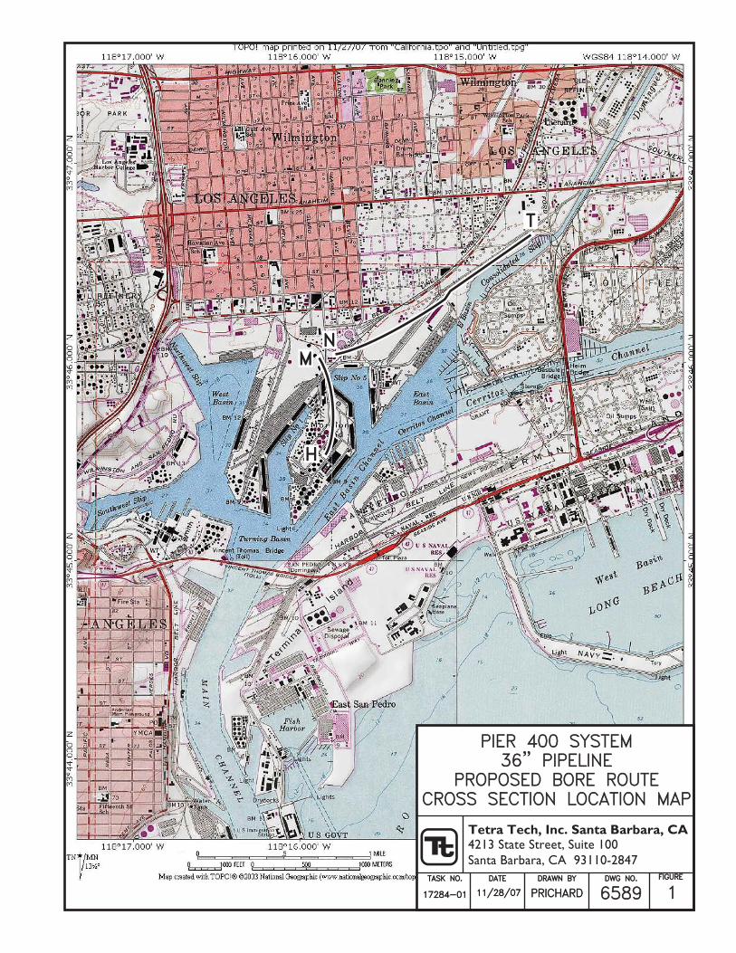
PIER 400 SYSTEMPIER 400 SYSTEM36" PIPELINE36" PIPELINE
PROPOSED BORE ROUTEPROPOSED BORE ROUTECROSS SECTION LOCATION MAPCROSS SECTION LOCATION MAP
DATEDATE
11/28/0711/28/07
TASK NO.TASK NO.
17284-0117284-01
DRAWN BYDRAWN BY
PRICHARDPRICHARD
DWG NO.DWG NO.
65896589FIGUREFIGURE
1
H
MN
T

This page intentionally left blank.
H
SOUTH
M
NORTH
-2000+00 1+00 2+00 3+00 4+00 5+00 6+00 7+00 8+00 9+00 10+00 11+00 12+00
UPPER PLEISTOCENELAKEWOOD FORMATION
RECENT ALLUVUIM AND SEMI-PERCHED AQUIFER
GAGE AQUIFER
13+00 14+00 15+00 16+00 17+00 18+00 19+00 20+00 21+00 22+00 23+00 24+00 25+00 26+00 27+00 28+00 29+00 30+00
-100-120-140-160-180
0204060
-20-40-60-80
-200
-100-120-140-160-180
200
4060
-20-40-60-80BELLFLOWER AQUICLUDE
GRADE
TETRA TECH, INC.4213 State Street, Suite 100Santa Barbara, CA 93110-2847
FIGUREDWG NO.DRAWN BYDATETC NO.
2658517284-01 11/27/07 PRICHARD
0SCALE
100' 200' 300'
LEGENDPROPOSED 36" PIPELINE
APPROXIMATE TOP OF FIRST ENCOUNTERED GROUNDWATERAPPROXIMATE HYDROSTRATIGRAPHIC BOUNDARY
PIER 400 SYSTEM 36” PIPELINESCHEMATIC CROSS SECTION OF
BORE ROUTE ALONG SECTION H-M
ELE
VATI
ON
(RE
FER
EN
CE
D T
O M
EA
N S
EA
LEV
EL)

This page intentionally left blank.

NSOUTHWEST
T
NORTHEAST
SOUTHWEST NORTHEAST
UPPER PLEISTOCENE
RECENT ALLUVUIM AND SEMI-PERCHED AQUIFER
GAGE AQUIFER
BELLFLOWER AQUICLUDE
GRADE
UPPER PLEISTOCENELAKEWOOD FORMATION
RECENT ALLUVUIM AND SEMI-PERCHED AQUIFER
GAGE AQUIFER
BELLFLOWER AQUICLUDE
GRADE
-2000+00
0-40-80-120-160
1208040
-200
0-40-80-120-160
1208040
2+00 4+00 6+00 8+00 10+00 12+00 14+00 16+00 18+00 20+00 22+00 24+00 26+00 28+00 30+00 32+00 34+00 36+00 38+00
-2000+00
0
-40-80-120-160
1208040
-200
0-40-80-120-160
1208040
2+00 4+00 6+00 8+00 10+00 12+00 14+00 16+00 18+00 20+00 22+00 24+00 26+00 28+00 30+00
TETRATECH, INC.4213 State Street, Suite 100Santa Barbara, CA 93110-2847
FIGUREDWG NO.DRAWN BYDATETC NO.
3658417284-01 11/28/07 PRICHARD
0SCALE
150' 300' 450'
LEGENDPROPOSED 36" PIPELINE
APPROXIMATE TOP OF FIRST ENCOUNTERED GROUNDWATERAPPROXIMATE HYDROSTRATIGRAPHIC BOUNDARY
LAKEWOOD FORMATION
PIER 400 SYSTEM 36” PIPELINESCHEMATIC CROSS SECTION OF
BORE ROUTE ALONG SECTION N-T
ELE
VATI
ON
(RE
FER
EN
CE
D T
O M
EA
N S
EA
LEV
EL)
ELE
VATI
ON
(RE
FER
EN
CE
D T
O M
EA
N S
EA
LEV
EL)
WEST SECTION
EAST SECTION

This page intentionally left blank.


This page intentionally left blank.


This page intentionally left blank.

This page intentionally left blank.


This page intentionally left blank.


This page intentionally left blank.


This page intentionally left blank.

This page intentionally left blank.


This page intentionally left blank.


This page intentionally left blank.