Embed Size (px)
Citation preview
Private Bag 9023 | Whangarei 0148 | New Zealand
T: 09 430 4200 | 0800 WDC INFO | 0800 932 463 | F: 09 438 7632
W: www.wdc.govt.nz | E: [email protected]
RESCONS-2046405167-2927 15 June 2017
Decision on a subdivision application at 215 Awaroa River Road by Terence and Gail Hickey by Hearings Commissioner Mr Greg Hill
Whangarei District Council has delegated all the functions, powers and duties as provided under the Resource Management Act 1991 to the Commissioner to consider and decide the application on behalf of Council. The application was heard in the May Bain room, Whangarei Library on 15 June 2017
The Hearings Commissioner heard the resource consent application from Terence and Gail Hickey, lodged by Resource Management and Assessment Ltd relating to a subdivision proposal being a two lot subdivision of 215 Awaroa River Road; a site of 4.6510 hectares in the Countryside Environment - seeking to create Lot 1 of 1.05ha and Lot 2 of 3.60ha. The application, made in accordance with the Resource Management Act 1991 (RMA), was lodged with Whangarei District Council and referenced as SD1700034.
Present Hearings Commissioner
Mr Greg Hill
Applicant Mrs Gail Hickey (Applicant)
Ms Colleen Prendergast (Counsel for the Applicant)
Mr Russell Mortimer (Planner)
Mr Simon Cocker (Landscape Architect)
Submitters
Consent Authority
Ms Rachel Bean and Ms Sonya Rogers
Mr Ueli Sasagi (Planner)
Mr Vladimer Rozov (Environmental Engineer)
Miss Keryn Ryan (Hearings Administrator)
1
RESCONS-2046405167-2927 15 June 2017
This resource consent is REFUSED. The reasons are set out below.
1 Description of the proposal and the existing environment
The Proposal
The proposal is to subdivide 215 Awaroa River Road - Onerahi, legally described as Lot 2 DP 385691 into two allotments. The total area of the site is 4.6510 hectares, with proposed Lot 1 to have an area of 1.05 hectares and Lot 2 an area of 3.60 hectares.
Proposed Lot 1 will be a vacant site, and proposed Lot 2 will contain the existing dwelling. Access to proposed Lot 1 will be via a new crossing off Awaroa River Road located approximately 90m north of the access to Lot 1 DP 385691 (221 Awaroa River Road). Access to Lot 2 will utilise the existing crossing off Awaroa River Road. The site The site is located on the western side of Awaroa River Road approximately 750 metres from its junction with Whangarei Heads Road. It is a horseshoe shaped site with a separate lot (0.507 hectares) located between the two frontages with Awaroa River Road (Lot 1 DP 385691 - the Bean/Rogers property).
The site slopes down from Awaroa River Road towards the west to a gully containing a covenanted area for conservation purpose. There are also existing covenants along the entire western boundary and part of the eastern boundary with Awaroa River Road. These are a conservation covenant and land covenant preventing the removal of trees on this part of the site respectively.
Towards the middle of the site is the Hickey's dwelling with a detached outbuilding. Other than the dwelling area, the driveway, associated gardens and the covenanted areas, the site is in pasture.
The Surrounding Environment and "Locality". The site and surrounding land is zoned Countryside Environment in the Whangarei District Plan. It is proposed to be Rural Production Environment in the recently notified Rural Plan Change 85A.
The surrounding environment is characterised by a range of lot sizes, many being approximately 4 hectares immediately surrounding and near the site to the west of Awaroa River Road. The Bean/Rogers property which adjoins the applicant's site is 0.507 hectares in area. There are also two larger blocks in the area (33 and 41 hectares). These lots are mainly used for pastoral grazing and lifestyle purposes with associated residential activities.
On the eastern side of Awaroa River Road, across the road from the site, there are a number of lots ranging between 1 and 2 hectares, with built development nestled within a more heavily treed area. The eastern side of Awaroa River Road is in a different visual catchment than the subject site, with Awaroa River Road being the dividing ridge.
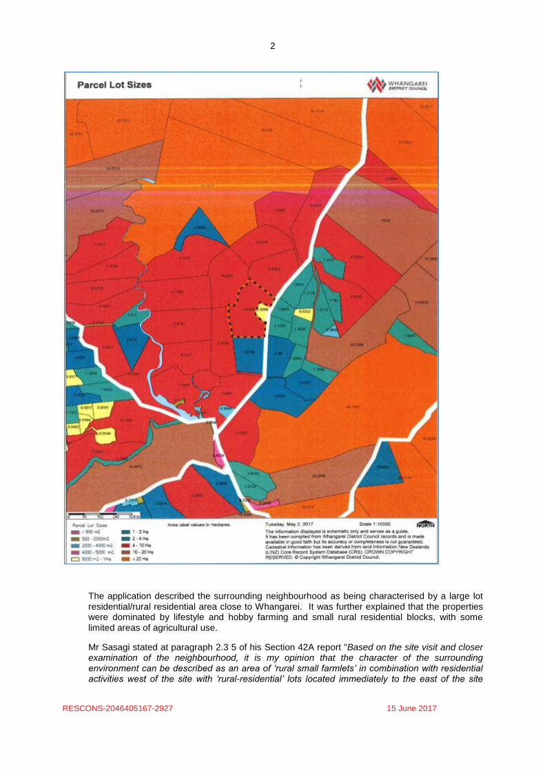
Mr Sasagi, in his section 42A report, usefully provided a Parcel Lot Size map (shown below). It clearly shows the subdivision pattern of the area.
2
RESCONS-2046405167-2927 15 June 2017
The application described the surrounding neighbourhood as being characterised by a large lot residential/rural residential area close to Whangarei. It was further explained that the properties were dominated by lifestyle and hobby farming and small rural residential blocks, with some limited areas of agricultural use.
Mr Sasagi stated at paragraph 2.3 5 of his Section 42A report "Based on the site visit and closer examination of the neighbourhood, it is my opinion that the character of the surrounding environment can be described as an area of ‘rural small farmlets’ in combination with residential activities west of the site with ‘rural-residential’ lots located immediately to the east of the site
3
RESCONS-2046405167-2927 15 June 2017
across Awaroa River Road. Beyond these two-adjacent character areas is largely open rural
land with larger farm holdings".
Mr Cocker set out in his evidence (Context of the site) that the site is:
"..situated within a visual catchment which is defined by the hydrological catchment of Awaroa Creek, which extends to the north west from the estuarine inlet adjoining the Whangarei Harbour, and a second, unnamed watercourse which extends to the north east. These two watercourses drain the southern flanks of the elevated and dissected landscape associated with Mount Tiger, whilst the site occupies a gentle and rolling valley landscape which characterises the foothills of Mount Tiger" (paragraph 12 of his evidence in chief).
He continued at paragraphs 14, 16 and 21respectively:
"...the flanks of the Mount Tiger ‘ridge’ at its western end tend to be dominated by plantations of Pinus radiata, and whilst providing a containing backdrop to views, have a limited influence on the character of the landscape within which the site is situated. The backdrop does however, lend the landscape a somewhat ‘contained’ and inwardly focused character, although longer views are available and sought by residents, along the axis of the valley to the south west towards the Harbour
Awaroa River Road traces the south eastern edge of the estuarine creek, before tracing a low southern trending spur which separates two of the hydrological sub-catchments. The ridge also separates the mildly rolling pastoral landscape within the western portion of the catchment, from the more dissected, and vegetated eastern portion.
To the east of the ‘dividing’ ridge, the settlement pattern is more clearly dictated by the terrain with dwellings aligned along a private access which traces a southerly trending ridge.
It is clear from Mr Cockers evidence, and in answering questions at the hearing, that he considered the site's "locality" to be within the visual catchment he described. He was of the view that the eastern side of Awaroa River Road, opposite the site, was in a different visual catchment, and this area had a different form of development than the western side of the road. This was because the eastern side of the road near the subject site falls away steeply to the east from the road, with Awaroa River Road being the dividing ridge.
Mr Mortimer and Mr Cocker held differing opinions on what was the locality. Mr Cocker (and Mr Sasagi) considered the site's locality to be its visual catchment being defined by the western side of Awaroa River Road (as described above). Mr Mortimer stated at the hearing that he considered the locality to be an area within a 500m radius from the Hickey property. He said that he accepted that this was an arbitrary area/figure and that while he did not disagree with Mr Cockers description, he preferred his locality identification.
In relation to the 500m distance, Mr Mortimer set out the following in his evidence (paragraphs 19 and 20):
In preparing the application we had undertaken a review of lot sizes in the area using Quick Map software system (see pages 37 and 38 of Agenda). That cadastral analysis showed 41 properties under separate titles within 500m of the boundary of the Hickey property. Of those, three (3) are less than 1ha in area, 10 are between 1 and 2ha, five (5) are 2 - 3ha and further 14 between 3 - 5ha. As can be seen, the proposal is similar in size to many of the surrounding properties that make up the receiving environment. My analysis of effects is that when the proposal is considered in the context of the surrounding environment the effects are less than minor. The size and layout of the proposed block was carefully considered and is based on providing desirable rural residential blocks consistent with the receiving environment. The smaller of the two lots to be created is just over 1 ha and is twice the area of the adjacent neighbouring rural residential site of 5070m2 (the Bean Rogers property).
4
RESCONS-2046405167-2927 15 June 2017
Having been to the site, considered the evidence, including the section 42A report, I prefer the locality as that set out by Mr Cocker and Mr Sasagi. I accept the evidence of Mr Mortimer as being factually correct, but it is not an 'on the ground' accurate or logical description of the "locality".
I have provided a detailed description of the surrounding environment and the locality. This is because a number of the relevant objectives and policies, addressed later in this decision, tend to have a focus on the "locality". It is therefore important to define it.
2 Reasons for the application - district plan rule(s) affected.
The application to subdivide the property in the manner proposed is a non-complying activity under Rule 73.3.1 of the District Plan. The reasons for this are set out below. As a controlled activity, Rule 73.3.1 ‘Allotment Area’ of the District Plan requires a minimum net site area of 20 hectares. This rule also makes provision for subdivision as a discretionary activity where a number of qualifications are met and an average net site area of 4 hectares is achieved. As the application proposes an average net site area of 2.325 hectares, the subdivision does not comply with the standards for a controlled or discretionary activity. Accordingly the application is non-complying.
Rule 73.3.7 - Property Access - stipulates that subdivision is a controlled activity if vehicular access to a road is shared where there are 2 or more allotments in the subdivision and the access complies in all respects with the relevant standards in Whangarei District Council’s Environmental Engineering Standards 2010 and the relevant provisions in Appendix 9. In this case the access as proposed does not comply with the Standard, and therefore this aspect of the proposal is a Restricted Discretionary Activity.
The proposal meets the relevant standards and terms as a controlled activity under additional rules of relevance including Rule 73.3.5 Existing Buildings, Rule 73.3.6 Sites of Significance to Maori (none identified), Rule 73.3.8 Vehicle Crossings, Rule 73.3.10 Provision for Extension of Services, Rule 73.3.11 Water Supply, Rule 73.3.12 Stormwater, Rule 73.3.14 Sewage, Rule 73.3.16 Telecommunications and Rule 73.3.17 Earthworks.
Proposed District Plan - Rural.
Whangarei District Council publicly notified Plan Changes 85 - A-D and 86A & B, 87, 102 and 114 on 10 August 2016. The proposed rezoning of the area is Rural Production Environment. Hearings of the submissions to these plan changes will commence on the 3 July2017.
Pursuant to section 86B of the RMA the rules of the above plan changes do not have legal effect. However it is noted that in terms of the notified plan change provisions this subdivision application would be a non-complying activity.
Overall the application is a non-complying activity.
3 Notification and submissions received The application was publicly notified on 22 March 2017, with submissions closing on 21 April 2017.
The Council received three submissions; two in support and one in opposition within the notification period. These were from:
• The New Zealand Fire Service - conditional support,
• P & M Hanmore of 174 Awaroa River Road in support, and
• RE Bean & SM Rodgers of 221 Awaroa River Road in opposition.
5
RESCONS-2046405167-2927 15 June 2017
The following is a summary of those submissions
The NZ Fire Service sought to ensure that access and adequate water for fire fighting purposes were provided. They sought a number of conditions to be imposed if consent were to be granted.
P & M Hanmore sought that the application be approved.
RE Bean & SM Rodgers sought the application be refused on the basis that:
• Any new development on new lot 1 will be clearly visible from their house, and
• The proposal would have direct impact on their social and economic values as they acquired their property due to its rural quality having unimpeded rural views and no direct neighbours overlooking their site.
A number of written approvals were provided as part of the application. They are:
Name Owner/Occupier Address
DC Finlayson & JM Haselden
Owners and occupiers
193 Awaroa River Road
AE Pegram, DC Pegram, SK Bennet & LC
Herbert
Owner and occupier
249 Awaroa River Road
KJ & AN Birch Owners and occupiers
187 Awaroa River Road
VR Cowsill Owner and occupier
216 Awaroa River Road
G Luthi Owner and occupier
Lot 11 DP 200893
IN Baker, RJ Baker & IJS
Reeves
Owners and occupiers
220 Awaroa River Road
4 Procedural matters
No procedural matters were raised in relation to this application
5 Submissions and evidence heard The following is a summary of the legal submissions and evidence (lay and expert) heard.
Applicant’s submissions and evidence
Legal Counsel
Ms Prendergast provided opening and closing legal submissions. In her opening submissions she set out the proposal, the conditions offered by the applicant to further avoid or mitigate any adverse effects. These included (at paragraphs 6 and 7):
• screen planting along part of the common boundary of proposed lot 1 with Lot 1 DP 385691 (the Bean/Rogers site) in order to protect the amenity values of the existing dwelling on that site;
• additional riparian planting on proposed Lot 1 to consolidate the existing vegetation and protect the stream channels;
• registration of Consent Notices requiring ongoing compliance with the planting set out in the two bullet points above; and

6
RESCONS-2046405167-2927 15 June 2017
• registration of Consent Notices prohibiting the construction of minor residential units on both lots.
Ms Prendergast addressed: the section 104D matters; issues relating to the section 42A report; the District Plan provisions; the effects of the proposal including cumulative effects; and the issue of precedent. Ms Prendergast also provided a written closing reply submissions. This included a section titled "Landscape character: differences between the subdivisions at Awaroa River Road and Three Oaks Drive, Auckland". This was in response to questions asked of Mr Cocker at the hearing. She also addressed in some detail the issue of "Precedent" including citing a number of case law decisions. Applicant Mrs Hickey set out that she and her husband sought to subdivide to reduce the amount of land they needed to maintain and to enable their son to build a house on the additional lot. She set out the improvements they had made to the property which included fencing off the creek to remove cattle from accessing it, planting native trees and shrubs as well as shelter belts and domestic gardens.
Landscape Architect
Mr Cocker provided evidence-in-chief and a summary statement. He set out the site's context, the landscape and visual amenity effects and addressed matters raised in the section 42A report. He specifically addressed the landscape and amenity effects of the proposal on the Bean/Rogers property.
His opinion was that given the landscape context, the nature of the proposed development and the mitigation and limitations proposed and offered by the applicant, that the "carrying capacity" of the landscape was such that it could absorb this development without resulting in actual, potential or cumulative adverse effects (paragraph 25 of his summary statement).
Planning
Mr Mortimer provided evidence-in-chief and a summary statement. He addressed the application, the amendments that had been made to it and the submissions lodged and matters raised in the section 42A report. He also addressed the permitted baseline and the issue of precedent.
Mr Mortimer presented, in some detail, an analysis of what he considered to be the relevant District Plan provisions. He set out why he held a contrary view to that of the Council's Reporting Planner (who had recommended that the application be refused). He also addressed the provisions of Proposed Plan Change 85A-D and 86A & B.
It was his opinion that the proposal was appropriate in this locality; that the effects were minor and had been further avoided or mitigated by the additional conditions offered by the applicant. He also considered that the proposal was not contrary to the relevant objectives and policies of the Regional Policy Statement and the District Plan. He considered the proposal met both limbs of section 104D of the RMA.
Mr Mortimer considered that the application should be approved, subject to a set of conditions which he had provided.
Submitter evidence Ms Bean and Ms Rogers attended the hearing and Ms Rogers presented a statement of evidence. Their concerns were as set out in their submission, notably:
7
RESCONS-2046405167-2927 15 June 2017
• Any new development on the newly created lot would be clearly visible from their house, and affect their visual amenity, and
• The proposal would have a direct impact on their social and economic values as they acquired their property due to its rural quality having unimpeded rural view and no direct neighbours overlooking their site.
Ms Rogers did not think that that the conditions offered by the applicant would satisfy their concerns. She accepted that the location of proposed new house would be less visible than the photo she provided in terms of its location (Mr Cocker's figure 4 of his Appendix 1 showed the correct location). Notwithstanding this, she remained opposed to the subdivision.
Ms Rogers said she and Ms Bean would not have an issue if the subdivided lot and proposed house were located at the southern end of the Hickey's site (rather than the northern end).
Council’s reporting officer’s report and evidence
Mr Sasagi's section 42A report, along with the comments of Mr Rozov, had been pre- circulated. At the beginning of the hearing Mr Sasagi's confirmed his recommendation that the application should be refused, not been persuaded by the additional information provided by the applicant; including the landscape evidence and the additional mitigation measures offered.
Mr Sasagi's, once having heard all the evidence, remained of the opinion that the application should be refused. He reconfirmed his position that the locality was the western side of Awaroa River Road and referred to the red coloured area on the Parcel Lot Sizes map at page 5 of the Section 42A report (and reproduced in this report). He stood by his initial recommendation that the application would have more than minor adverse landscape, amenity and cumulative effects, would be contrary to the relevant objectives and policies, and would create a precedent.
Mr Rozov said he had heard nothing that changed his view regarding any engineering and traffic effects. He considered that any effects would be minor, and could be addressed by 'standard' consent conditions, including those of the NZ Fire Service, should consent be granted.
6 Principal issues in contention The entire application was in contention due to:
• the opposing submission from RE Bean & SM Rodgers. They sought that the application be refused for the reasons set out in their submission and the evidence presented at the hearing (summarised above), and
• The Council's reporting officer had recommended that the application be refused. The reasons for this were set out in his section 42A report.
The issues focused on:
• Whether the subdivision would have adverse effects on the amenity and character of the area due to the creation of a smaller site and the ability to have an additional dwelling (and associated activities), and whether those effects were minor or more than minor:
• Whether the subdivision would have an adverse cumulative effects that was more than minor,
• Whether the subdivision was contrary to, or consistent with, the relevant objectives and policies of the District Plan (and those of the notified Rural plan changes), and
• Whether the subdivision would create a precedent.
7 Relevant policy statements and plan provisions
8
RESCONS-2046405167-2927 15 June 2017
In considering this application the following planning documents have been relevant:
• the Northland Regional Policy Statement (RPS);
• the Whangarei District Plan (District Plan);
• the Proposed Whangarei District Plan (Rural Plan Changes); and
• The National Environmental Standard for Assessing and Managing Contaminants in Soil to Protect Human Health (NES).
8 Relevant statutory provisions
It is necessary to set out the ‘statutory tests’ relevant to this application – and to then apply them. The application is a non complying activity and therefore subject to Section 104D of the RMA, commonly referred to as ‘the gateway tests’. Section 104D requires an application to ‘pass’ at least one of the two tests before it can be fully assessed under section 104 of the RMA and determined under section 104B. If the application fails both section 104D tests then it must be refused.
The section 104D tests require that either the adverse effects of the application on the environment must be minor when taking into account any mitigation proposed or reasonably able to be imposed (section 104D(1)(a)), or the application must not be contrary to the objectives and policies of any relevant plan and proposed plan (Section 104D (1)(b)).
In deciding this matter it is important to understand both the existing environment and the likely future environment should consent be granted. It is also necessary to review the relevant objectives and policies in the District Plan (and the proposed rural plan changes) to determine if the application is consistent with or contrary to them, and also to determine if the adverse effects of the proposal are more than minor.
I record here, for the reasons set out below, the proposal would satisfy the section 104D 'gateway tests' in relation to the effects of the proposal. Accordingly the proposal has been determined having considered the provisions of section 104. Section 104, which is subject to Part 2 of the RMA, sets out the matters that must be had regard to when considering an application for resource consent and any submissions received. This includes having regard to the relevant statutory planning provision listed above and the effects, both positive and adverse, on the environment.
9 Main findings on the principal issues in contention and reasons.
Objectives and policies of the relevant planning documents
I have set out the relevant RPS and District Plan provisions below. These provisions are those identified and addressed by both Mr Sasagi and Mr Mortimer in the section 42A report and evidence. I agree between the two they have addressed the relevant provisions.
Regional Policy Statement (RPS)
Both Mr Sasagi and Mr Mortimer addressed RPS policy 5.1.1 - Planned and coordinated development. The policy is:
Subdivision, use and development should be located, designed and built in a planned and co-ordinated manner which:
(a) Is guided by the ‘Regional Form and Development Guidelines’ in Appendix 2;
(b) Is guided by the ‘Regional Urban Design Guidelines’ in Appendix 2 when it is urban in nature;
9
RESCONS-2046405167-2927 15 June 2017
(c) Recognises and addresses potential cumulative effects of subdivision, use, and development, and is based on sufficient information to allow assessment of the potential long-term effects;
(d) Is integrated with the development, funding, implementation, and operation of transport, energy, water, waste, and other infrastructure;
(e) Should not result in incompatible land uses in close proximity and avoids the potential for reverse sensitivity;
(f) Ensures that plan changes and subdivision to/in a primary production zone, do not materially reduce the potential for soil-based primary production on land with highly versatile soils, or if they do, the net public benefit exceeds the reduced potential for soil-based primary production activities; and
(g) Maintains or enhances the sense of place and character of the surrounding environment except where changes are anticipated by approved regional or district council growth strategies and / or district or regional plan provisions.
(h) Is or will be serviced by necessary infrastructure.
Neither Mr Sasagi nor Mr Mortimer considered that the proposed subdivision was contrary to this policy. Mr Mortimer's evidence is that it was consistent with it, while Mr Sasagi's view, at 7.2.6 of his section 42A report, was that "Overall, the proposal is not considered to be wholly consistent with the RPS....".
While I accept that the RPS provides 'higher order' provisions that must be given effect to in the District Plan, and that it was unlikely to have been designed to address 'one-off' proposals such as this, it is difficult to see how this subdivision is designed in a "planned and co-ordinated manner". I address issue in more detail in the following sections.
Operative District Plan
The principal objectives and policies relating to amenity values are the following:
Objective 5.3.1
The characteristic amenity values of each Environment are maintained and where
appropriate enhanced.
Objective 5.3.5
The actual or potential effects of subdivision use and development is appropriately controlled and those activities located and designed, are to be compatible with existing and identified future patterns of development and levels of amenity in the surrounding environment.
Policy 5.4.1 Effects on the Local Environment
To ensure that activities do not produce, beyond the boundaries of the site, adverse effects that are not compatible with the amenity values characteristic of the surrounding and/or adjacent environment unless, such effects are authorised by a district plan, a designation, a resource consent or otherwise. The following effects should be given particular consideration in this respect:
• Noise and effects; • Shading; • Glare; • Light spill; • Dust; • Smoke; • Odour; • Vibration; • Spray drift;
10
RESCONS-2046405167-2927 15 June 2017
• Visual amenity.
Where internalisation of effects cannot be wholly achieved, the Council will consider a Best Practicable Option approach.
Policy 5.4.5 Countryside Environments
To ensure rural amenity values in the Countryside Environments are protected from subdivision, use or development that is sporadic or otherwise inappropriate in character, intensity, scale or location.
Policy 5.4.7 Intensity and Design of Subdivision and Development
To ensure that subdivision and development do not unduly compromise the outlook and privacy of adjoining properties, and should be compatible with the character and amenity of the surrounding environment. Particular regard should be given to:
• The layout and intensity of subdivision;
• The location, design and siting of buildings and structures except, where such buildings and structures provide a specific service for the surrounding environment. In the latter case, any building or structure shall be designed, laid out and located, so as to avoid, remedy or mitigate any adverse effects on the environment.
Restrictions on density of development and subdivision size may be required to ensure new development does not increase population concentration in noise sensitive areas.
Section 5.2 - Overview of the Amenity Values chapter set out that the Countryside Environment "tends to be used predominantly for primary production, but is also used for low-density residential purposes". The objective 5.3.1 seeks to maintain and where appropriate enhance the
characteristic amenity values of each Environment.
The Countryside Environment covers an extensive area of the District. Given this Environment is used for primary production and low-density residential purposes, it is difficult at the 'macro' scale of the Environment to find that this subdivision would be contrary to the objective when considered in light of the policies and the mitigation measures offered by the applicant.
The policies seek that subdivisions do not have a range of effects (policy 5.4.1) or unduly compromise the outlook and privacy of adjoining properties (policy 5.4.7). I find that, notwithstanding Ms Bean and Ms Rogers concerns, that the subdivision with the offered conditions would not be contrary to or inconsistent with those policies.
However policy 5.4.5 - Countryside Environments is worded in a more directive way that most others. Rural amenity values are to be protected from subdivision that is sporadic. I set this out in greater detail below with respect to the provisions that more specifically address "locality", but find that this subdivision is "sporadic" and is otherwise inappropriate in its character and location.
The finding in relation to policy 5.4.5 is due to the small size of the proposed allotment being within a visual catchment of mostly similarly sized or larger lots, as shown in the Parcel Lot Size map; the Bean/Rogers site being the exception. The proposed new lot would introduce a much small lot into and area of predominately 4 hectare lots (the size of lots that the District Plan specifies as a discretionary activity) and would therefore be sporadic and out of character within this area. Accordingly I find the proposal would be contrary to this policy.
The District Plan at section 8.0 -Subdivision and Development, contains the following objectives and policies that relate to the location of development.
11
RESCONS-2046405167-2927 15 June 2017
Objective 8.3.2
Subdivision and development that does not detract from the character of the locality and avoids conflicts between incompatible land use activities.
Objective 8.3.7
Subdivision and development that provides for comprehensive development of land with a range of allotment sizes and is appropriate to the character of the Environment in which it is located.
Policy 8.4.3 Density of Development
To ensure that subdivision and development results in a pattern and density of land use which reflects flexibility in allotment size, and is of a density appropriate to the locality.
Policy 8.4.4 Cumulative Effects
To ensure that the cumulative effects of on-going subdivision and development do not compromise the objectives and policies of this Plan, in particular those objectives and policies relating to reducing conflicts between incompatible land use activities, the consolidated and orderly development of land and the density of development.
As already mentioned there is a theme running through the relevant objectives and policies that has a focus on localities within the extensive Countryside Environment. It is for this reason I set out what I considered the locality to be earlier in this decision.
I accept that the receiving environment is a mixture of rural residential, lifestyle and farming. However as already set out, the proposed site is not generally characteristic of the lot sizes that exist in the locality and would therefore be out of character with the existing local environment. While I also accept that the character of the Countryside Environment derives from its wide mixture of lot sizes and land uses, this locality is characterised by more consistent lot sizes. This proposal would of itself but also in combination with the Bean/Rogers site, introduce a different and more intensive subdivision pattern. Given my findings on the locality, I find that the proposal would detract from the overall character of the locality. I accept the proposal would avoid conflicts between incompatible land use activities given the nature of the surrounding land uses. The District plan also set out in Chapter 6 – Built Form and Development some relevant in objectives and policies. These are:
Objective 6.3.2
Subdivision and development that ensures consolidated development in appropriate locations and avoids sprawling or sporadic subdivision and ribbon development patterns in the coastal and rural environment.
6.4.2 - Consolidated Development
To consolidate urban development by:
i. Further develop within existing built up areas, so as to avoid sporadic or sprawling
subdivision and ribbon development patterns, particularly in rural areas and along the coast.
12
RESCONS-2046405167-2927 15 June 2017
ii Directing rural lifestyle and rural-residential development to appropriate locations adjacent to existing settlements, rather than allowing sporadic development throughout rural and coastal areas
I note that Mr Sasagi addressed these provisions, but that Mr Mortimer did not. In terms of these provisions, the Environment Court in Decision No. [2012] NZEnvC 54 - J Blampied vs WDC (Blampied), which was a non-complying application to subdivide a 6285 m2 site in the Countryside Environment into two allotments, stated the following at paragraphs 63 and 64:
"Even though chapter 6 (Built form and development) focuses primarily on the urban areas of the District, we accept its relevance here in one respect, albeit of indirect relevance to the rural area; objective 6.3.2 is designed to set up the council's policy of consolidating development in appropriate locations and avoiding sprawl and sporadic subdivision...in the rural environment; and policy 6.4.2, amongst other things, directs rural lifestyle and rural residential development to appropriate locations adjacent to existing settlements. Analysed in these ways, [the Court was also addressing the issue of location, which I address later] the proposal is clearly contrary (in the sense of repugnant) to the objectives and policies of the Plan viewed overall".
I find the reasons set out by the Environment Court above are relevant to this subdivision proposal. The objective and policy seek to "avoid" sporadic subdivision, and I have already set out that I find this subdivision "sporadic". The objective and policy also seek to direct rural lifestyle and rural-residential development to appropriate locations adjacent to existing settlements, rather than allowing sporadic development throughout rural areas. This proposal would undermine that direction. The proposal is contrary to these provisions.
It is clear to me that the proposal is contrary to and/or inconsistent with some of the suite of objectives and policies, but consistent with others. While the proposal is not contrary to all of the objectives and policies, when read together and with my findings regarding the "locality", I find the proposal overall, on balance, is contrary to the relevant provisions.
The Proposed Rural Plan Changes PC 85 - 87.
Ms Prendergast and Mr Mortimer both considered that little weight should be placed on the objectives and policies of these plan changes. This was on the basis that the submissions period had closed but the submission hearings had not yet been heard (due to commence on the 3 July 2017). According to Mr Mortimer there are a substantial number of submissions, many seeking significant changes to the provisions.
Mr Sasagi considered that some weight should be placed on the proposed provision. He set out at section 8.1.4 of his report, the following:
The following Objectives and Policies are considered of relevance in consideration of the proposal and in my view, offend them:
RPE.1.2 Objectives:
2– Recognise, maintain and where appropriate protect the rural character of the RPE, acknowledging that character is formed through a combination of values such as ecology values, openness, topography and heritage.
4– Support a range of amenity values associated with the RPE
5- Minimise fragmentation of rural land and promote allotment sizes that facilitate productive rural land use
13
RESCONS-2046405167-2927 15 June 2017
RPE.1.3 Policies
4- To maintain rural amenity, privacy, openness and rural character by ensuring that all new building and rural landuse
(a) are of a scale and character to the RPE (b) Are sited in a location sufficiently set back from site boundaries to enable privacy,
the retention of openness and access to sunlight. (c) Avoid ribbon development.
5- To preserve openness, rural character and amenity by limiting the density of residential units.
10- To avoid the subdivision of land into allotments less than 20ha unless it is demonstrated that:
(a) The subdivision of rural land and associated building is for the purpose of supporting an existing farm, forestry or horticultural enterprise associated with rural production.
(b) The size, shape and arrangement of allotments is a practical size for rural land use activities and does not restrict the range of options for the use of production land.
(c) The existing farm, forestry or horticultural enterprise can continue to operate efficiently at the subdivided scale.
(d) The subdivision and subsequent development will not result in significant adverse effects on the operation and viability of any adjoining farm, forestry or horticultural activity.
(e) The land and buildings have greater potential to produce primary products, forestry or crops because of the subdivision.
At the hearing both Mr Sasagi and Mr Mortimer addressed these provisions, and in particular policy 10. Both agreed that the proposed plan change provisions were written in a more 'directive' way that those of the operative plan. It is for this reason and the stage at which the plan changes are at, that I agree with the applicant that very limited weight should be given to these provisions.
National Environmental Standard
As set out by Mr Mortimer in his evidence, a "Preliminary Site Investigation" did not identify any indication of current or previous activities in the area or on the site that are included in the current version of the Hazardous Activities and Industries List (HAIL) issued for the Ministry for the Environment. It was therefore concluded that it is highly unlikely that there will be a risk to human health if the proposed subdivision proceeds. I agree.
Effects of the Proposal
There was common ground between Mr Sasagi and Mr Mortimer about what the effects of the proposal were. These were:
• Amenity, landscape and character effects on the surrounding area,
• productive capacity of the land,
• Archaeological matters,
• Cumulative effects,
• Traffic, and
• Infrastructure servicing.
Both agreed that any adverse effects on archaeological matters, those relating productive capacity of the land, traffic and infrastructure servicing effects, including the issues raised by the
14
RESCONS-2046405167-2927 15 June 2017
NZ Fire Service, would be no more than minor and cold have been appropriately addressed by conditions of consent.
Mr Sasagi and Mr Mortimer parted company in respect of the effects on amenity, character and cumulative effects. Mr Sasagi considered that they were more than minor. Mr Mortimer's opinion, relying on Mr Cocker expert landscape evidence, and his evidence, was that those effects were no more than minor, and had been reduced further by the suite of conditions offered by the applicant.
Mr Mortimer also addressed the permitted baseline in terms of what buildings and associated activities could occur as of right. In questioning Mr Mortimer and Mr Sasagi, both agreed farm buildings (barns and shed up to eight metres in height and complying with the relevant plan controls) were a permitted activity. Mr Mortimer acknowledged that there may be some loss of privacy to the adjoining properties, but this would be mitigated by the conditions offered by the applicant.
Ms Bean and Ms Rogers considered there would be adverse rural landscape effects as well as impinging and their views across the Hickey property and beyond. They stated in their evidence that:
"We have no problem with development on the southern side of the Hickey's property(adjacent to Jo and Duncan Finlayson, section 3). As that has no direct impact on us or our property as well as the surrounding neighbours, the rural landscape or impact on proposed site view".
I accept the evidence of Mr Cocker that an additional dwelling, along with the proposed landscaping and planting, could be absorbed into the environment. I also agree with Mr Mortimer's evidence; that the adverse effects, including any cumulative effects, would be no more than minor given the suite of conditions offered by the applicant and the level of development that is permitted as of right.
On this basis the 'effects' gateway test set out in section 104D is met.
Precedent
The issue of precedent become a significant focus of the hearing. Mr Sasagi set out in section
8.2 of his section 42 A report that:
"Case law has established that the precedent of granting resource consent is a relevant factor for a consent authority in considering whether to grant non-complying resource consent. A precedent effect is likely to arise in situations where consent is granted to a non-complying activity that lacks the evident unique, unusual or distinguishing qualities that serve to take the application outside of the generality of cases or similar sites in the vicinity.
If consent is granted to allow increased built development in an area that is characterised by a rural small farmlet outlook, this could give rise to an expansion of a cluster of higher density development (rural residential character) that is on the eastern side of Awaroa River Road, rather than attempting to consolidate a pattern in the residential area in the Living 1 Environment located some 550 metres south of the site. Given that the proposal could reasonably be replicated for many of sites in the vicinity (e.g. 249 Awaroa Rover Road of 4.258ha, 255 Awaroa River Road of 4.3209ha, 187 Awaroa River Road of 4.99ha, and 193 Awaroa River Road of 2.97ha to mention a few), I am not satisfied that the proposal is unique enough that it will not set an adverse precedent for the subdivision of these other sites within the locality.
Ms Prendergast addressed the issue of precedent in some detail in her opening, but more particularly, in her closing statement. At paragraphs 6 and 7 of her reply submissions she stated:
15
RESCONS-2046405167-2927 15 June 2017
The issue of “precedent” is inextricably linked with the concepts of plan integrity and consistent administration, and has been considered in a number of cases by the Court of Appeal and the High Court as well as the Environment Court. Principles arising from those cases include:
(a) The precedent resulting from granting a resource consent is a relevant factor for a consent authority to take into account under s 104(1)(c) when considering an application for consent a non-complying activity. It is a permissive rather than a mandatory consideration.1
(b) A precedent effect is not a cumulative effect. A cumulative effect is something that will occur as a result of the application, rather than something that may occur.2
(c) Noncompliance with a Plan cannot of itself create a precedent effect. But precedent may occur where there is a nexus between that precedent effect and a cumulative effect that follows.3
There is however, no clear line of authority as to when, and if, grant of consent to an
application will create a precedent such that the integrity of the district plan or its consistent
administration will be threatened. Rather, what is clear is that each application is to be
considered on its merits, with an expectation (but not an absolute entitlement4) that like
cases will be treated alike.5
I agree with Ms Prendergast that this application must be considered on its merits, but with an expectation, but not an absolute entitlement, that like cases would need to be treated alike. The question of precedent also arose at the hearing in the context of: - whether the proposal had any particular unusual qualities or if there were any truly exceptional circumstances such that it could be differentiated from other proposals. This was in the context of like cases needing to be treated alike. Mr Mortimer's opinion was that that the proposal had limited ability to be used as a precedent as set out in his evidence and which he confirmed at the hearing. I do not agree. Contrary to his view that this proposal could be significantly distinguished from other consent applications, I find that the circumstances he describes would likely apply to many sites in the District and within the locality of the subject site.
Mr Mortimer set out in his evidence in chief (paragraphs 70 and 71) that:
"In my view the Hickey proposal has limited ability to be used as a precedent as it is significantly distinguished from other consent applications that may arise for the following reasons
• It is located in an appropriate receiving environment
1 Dye v Auckland CC [2001] NZRMA 513 (CA); Auckland Regional Council v Living Earth Limited [2008] NZCA
349 (CA)
2 Ibid
3 Rosscroft Orchards Ltd v Waimakariri DC EnvC C160/01
4 Feron v Central Otago DC EnvC C075/09, at [65]
5 Murphy v Rodney District Council [2004] 3 NZLR 421 (HC), at [39]. But see also Feron v Central Otago DC
EnvC C075/09 where the Court observed that the precedent created by earlier decisions provides an expectation, not an absolute entitlement, of like treatment and that it would be wrong to grant consent to an application simply on the basis that another similar application had been approved.
16
RESCONS-2046405167-2927 15 June 2017
• does not detract from the character of the locality
• is consistent with the provision of a range of lot sizes and is appropriate to the receiving environment
• no irreconcilable clash with important plan provisions Further items that limit it used as a precedent relate to
• The topography of the site restricts the visibility of any development
• Existing and proposed consent notices provide screening of built development
• The application is likely to be one of the last to be determined under the current Planning regime i.e. prior to hearings and decisions being released on the suite of Proposed Rural Plan Changes.
I note in terms of the final bullet point, that while this may be correct, I do not see how it is particularly relevant given that little weight can and has been given to the recently notified plan changes.
The issue of precedent is relevant in this case. I do not find that there are unusual qualities or exceptional circumstances that would distinguish this proposal from others. Having considered the section 42A report, evidence and undertaken a site/area inspection, it is my finding that there are a number of properties in the immediate locality (see the Parcel Lot Map) which are of a similar in size to the applicant's property, and which do not appear greatly different in terms of their place in the visual catchment as I have defined it (relying largely on Mr Cockers evidence).
I accept there will always be some points of difference between sites, but those other properties appear sufficiently similar, and sufficiently close, being in the same visual catchment such that they would expect to be treated in the same manner as this proposal had consent been granted. This would potentially lead to a much more intensive subdivision pattern and a potential loss of rural amenity and character in this locality.
On the above basis, given I find there is nothing unusual or exceptional about this site, granting consent could lead to the outcome outline by Mr Sasagi in section 8.2 of the section 42A report and quoted above. This finding adds weight to my view that that this proposal would not meet the purpose of the RMA.
Part 2 of the RMA Section 104 is subject to Part 2. I record that there are no relevant section 6 (Matters of National Importance) or section 8 (Principles of the Treaty) matters relating to this proposal. The relevant section 7 (Other Matters) include:
(b) the efficient use and development of natural and physical resources: (c) the maintenance and enhancement of amenity values: and (f) maintenance and enhancement of the quality of the environment:
These have all been addressed earlier in this decision, particularly relating to rural amenity values, the quality of the rural environment, and efficiency in terms of the effects of the productive capacity of the land (i.e. not affected). However, section 5 sets out the purpose of the Act; to promote the sustainable management of natural and physical resources. For the reasons set out above, namely that the proposal is contrary to the District Plan's relevant objectives and policies and due to the precedent implications, the proposal would not meet the purpose of the RMA. I record here that had the proposal not been contrary to the relevant objectives and policies, I would have found that it was inconsistent with them. On this basis I would have also refused consent for the same reasons set out in this decision.
17
RESCONS-2046405167-2927 15 June 2017
10 Decision
Pursuant to Section 104B of the RMA, the application is refused. The reasons for this are those
set out above in this decision.
Issued this 30 day of June 2017
Greg Hill
Hearings Commissioner