Embed Size (px)
Citation preview

12/26/16, 2:35 PMTensions In The South China Sea Explained In 18 Maps - Business Insider
Page 1 of 21http://www.businessinsider.com/tensions-in-the-south-china-sea-explained-in-18-maps-2015-1/#1a-political-map-1
Tensions in the South China Sea explainedin 18 mapsCENTER FOR STRATEGIC AND INTERNATIONAL STUDIESMAR. 11, 2016, 10:41 AM
An aerial photo taken though a glass window of a Philippine military plane shows the alleged on-goingland reclamation by China on mischief reef in the Spratly Islands in the South China Sea, west ofPalawan, Philippines, May 11, 2015.
REUTERS/Ritchie B. Tongo
The Asia Maritime Transparency Initiative, partners of the Center for Strategic and International Studies, is aninteractive, regularly-updated source for information, analysis, and policy exchange on maritime security issuesin Asia.
Below are 18 republished maps from their report (and here is the full analysis and methodology).
12/26/16, 2:35 PMTensions In The South China Sea Explained In 18 Maps - Business Insider
Page 2 of 21http://www.businessinsider.com/tensions-in-the-south-china-sea-explained-in-18-maps-2015-1/#1a-political-map-1
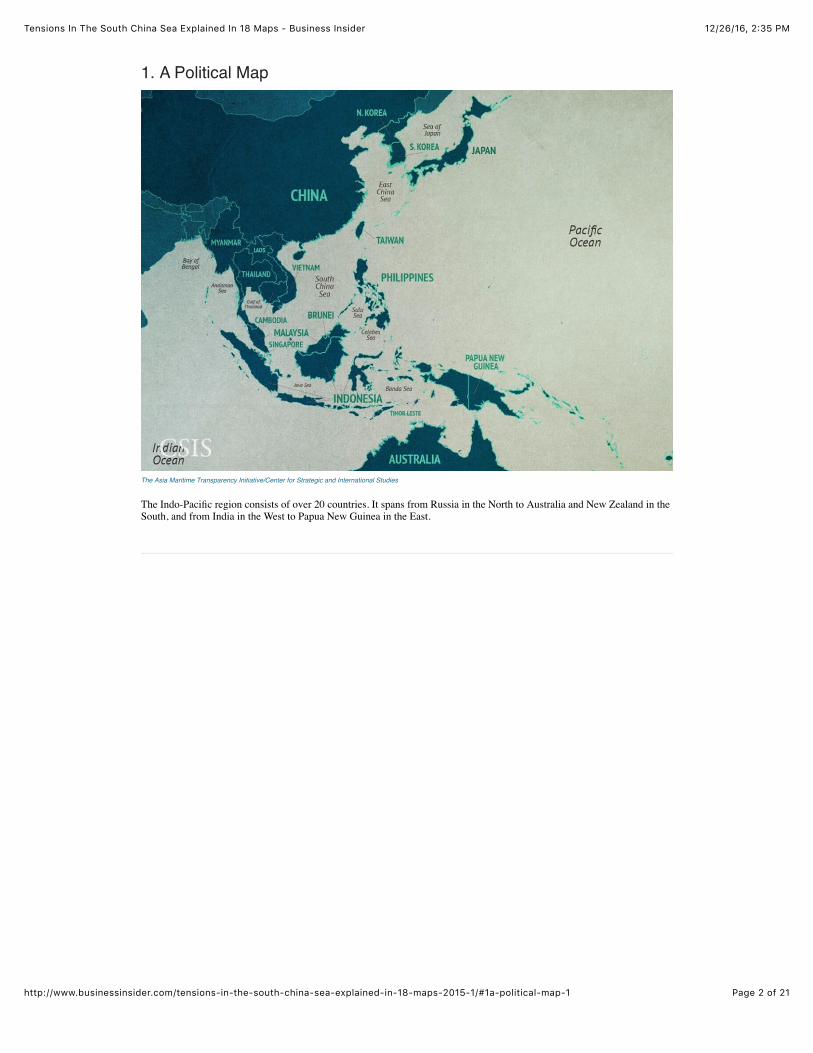
1. A Political Map
The Asia Maritime Transparency Initiative/Center for Strategic and International Studies
The Indo-Pacific region consists of over 20 countries. It spans from Russia in the North to Australia and New Zealand in theSouth, and from India in the West to Papua New Guinea in the East.
12/26/16, 2:35 PMTensions In The South China Sea Explained In 18 Maps - Business Insider
Page 3 of 21http://www.businessinsider.com/tensions-in-the-south-china-sea-explained-in-18-maps-2015-1/#1a-political-map-1
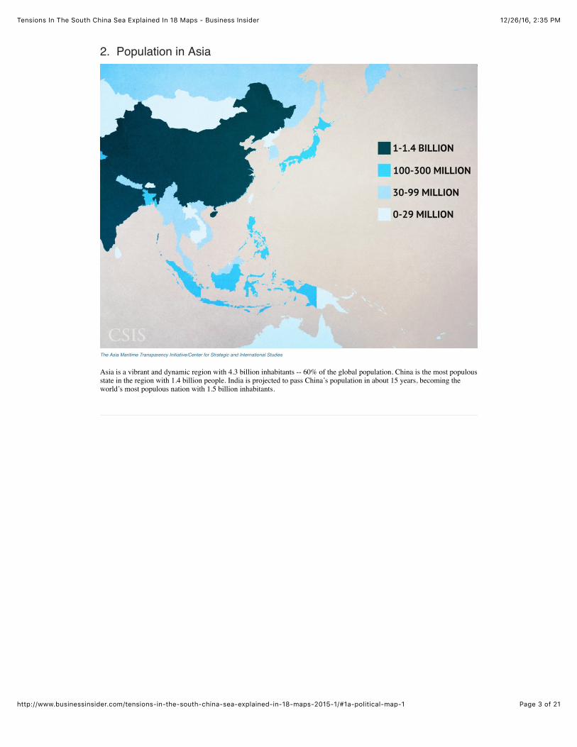
2. Population in Asia
The Asia Maritime Transparency Initiative/Center for Strategic and International Studies
Asia is a vibrant and dynamic region with 4.3 billion inhabitants -- 60% of the global population. China is the most populousstate in the region with 1.4 billion people. India is projected to pass China’s population in about 15 years, becoming theworld’s most populous nation with 1.5 billion inhabitants.
12/26/16, 2:35 PMTensions In The South China Sea Explained In 18 Maps - Business Insider
Page 4 of 21http://www.businessinsider.com/tensions-in-the-south-china-sea-explained-in-18-maps-2015-1/#1a-political-map-1
3. Trade Routes and Straits
The Asia Maritime Transparency Initiative/Center for Strategic and International Studies
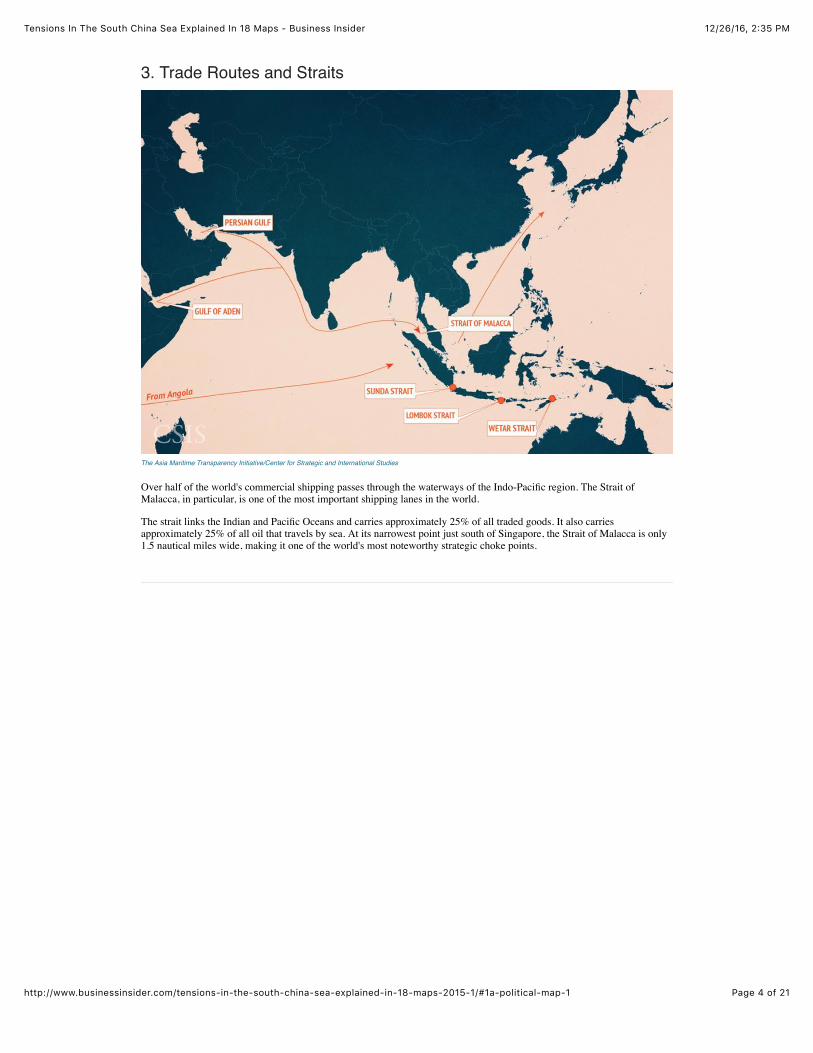
Over half of the world's commercial shipping passes through the waterways of the Indo-Pacific region. The Strait ofMalacca, in particular, is one of the most important shipping lanes in the world.
The strait links the Indian and Pacific Oceans and carries approximately 25% of all traded goods. It also carriesapproximately 25% of all oil that travels by sea. At its narrowest point just south of Singapore, the Strait of Malacca is only1.5 nautical miles wide, making it one of the world's most noteworthy strategic choke points.
12/26/16, 2:35 PMTensions In The South China Sea Explained In 18 Maps - Business Insider
Page 5 of 21http://www.businessinsider.com/tensions-in-the-south-china-sea-explained-in-18-maps-2015-1/#1a-political-map-1
4. South China Sea LNG Flows
The Asia Maritime Transparency Initiative/Center for Strategic and International Studies
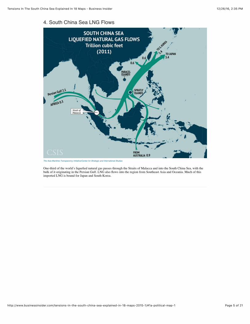
One-third of the world’s liquefied natural gas passes through the Straits of Malacca and into the South China Sea, with thebulk of it originating in the Persian Gulf. LNG also flows into the region from Southeast Asia and Oceania. Much of thisimported LNG is bound for Japan and South Korea.
12/26/16, 2:35 PMTensions In The South China Sea Explained In 18 Maps - Business Insider
Page 6 of 21http://www.businessinsider.com/tensions-in-the-south-china-sea-explained-in-18-maps-2015-1/#1a-political-map-1
5. Natural Resources in the South China Sea
The Asia Maritime Transparency Initiative/Center for Strategic and International Studies
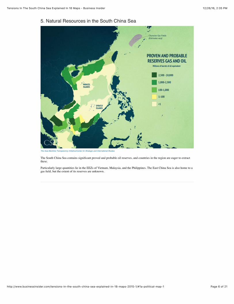
The South China Sea contains significant proved and probable oil reserves, and countries in the region are eager to extractthese.
Particularly large quantities lie in the EEZs of Vietnam, Malaysia, and the Philippines. The East China Sea is also home to agas field, but the extent of its reserves are unknown.

12/26/16, 2:35 PMTensions In The South China Sea Explained In 18 Maps - Business Insider
Page 7 of 21http://www.businessinsider.com/tensions-in-the-south-china-sea-explained-in-18-maps-2015-1/#1a-political-map-1
6. Trade Flows In Asia
The Asia Maritime Transparency Initiative/Center for Strategic and International Studies
In addition to providing passage for incoming commodities, the states of Maritime Asia also have deeply interdependenttrade relations among themselves.
China and ASEAN (Southeast Asia), China and Japan, and Japan and ASEAN states have robust trade relations. The China-ASEAN trade relationship is especially strong.
12/26/16, 2:35 PMTensions In The South China Sea Explained In 18 Maps - Business Insider
Page 8 of 21http://www.businessinsider.com/tensions-in-the-south-china-sea-explained-in-18-maps-2015-1/#1a-political-map-1
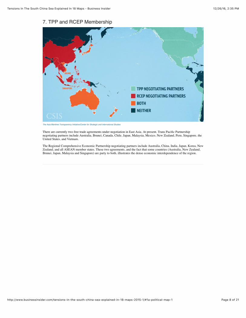
7. TPP and RCEP Membership
The Asia Maritime Transparency Initiative/Center for Strategic and International Studies
There are currently two free trade agreements under negotiation in East Asia. At present, Trans Pacific Partnershipnegotiating partners include Australia, Brunei, Canada, Chile, Japan, Malaysia, Mexico, New Zealand, Peru, Singapore, theUnited States, and Vietnam.
The Regional Comprehensive Economic Partnership negotiating partners include Australia, China, India, Japan, Korea, NewZealand, and all ASEAN member states. These two agreements, and the fact that some countries (Australia, New Zealand,Brunei, Japan, Malaysia and Singapore) are party to both, illustrates the dense economic interdependence of the region.
12/26/16, 2:35 PMTensions In The South China Sea Explained In 18 Maps - Business Insider
Page 9 of 21http://www.businessinsider.com/tensions-in-the-south-china-sea-explained-in-18-maps-2015-1/#1a-political-map-1
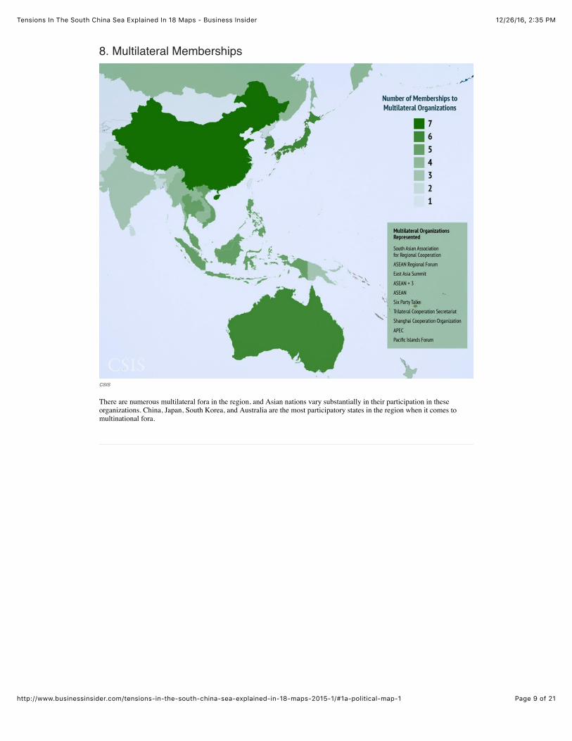
8. Multilateral Memberships
CSIS
There are numerous multilateral fora in the region, and Asian nations vary substantially in their participation in theseorganizations. China, Japan, South Korea, and Australia are the most participatory states in the region when it comes tomultinational fora.
12/26/16, 2:35 PMTensions In The South China Sea Explained In 18 Maps - Business Insider
Page 10 of 21http://www.businessinsider.com/tensions-in-the-south-china-sea-explained-in-18-maps-2015-1/#1a-political-map-1
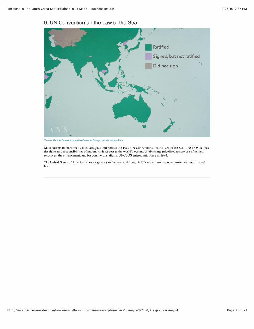
9. UN Convention on the Law of the Sea
The Asia Maritime Transparency Initiative/Center for Strategic and International Studie
Most nations in maritime Asia have signed and ratified the 1982 UN Conventional on the Law of the Sea. UNCLOS definesthe rights and responsibilities of nations with respect to the world’s oceans, establishing guidelines for the use of naturalresources, the environment, and for commercial affairs. UNCLOS entered into force in 1994.
The United States of America is not a signatory to the treaty, although it follows its provisions as customary internationallaw.
12/26/16, 2:35 PMTensions In The South China Sea Explained In 18 Maps - Business Insider
Page 11 of 21http://www.businessinsider.com/tensions-in-the-south-china-sea-explained-in-18-maps-2015-1/#1a-political-map-1
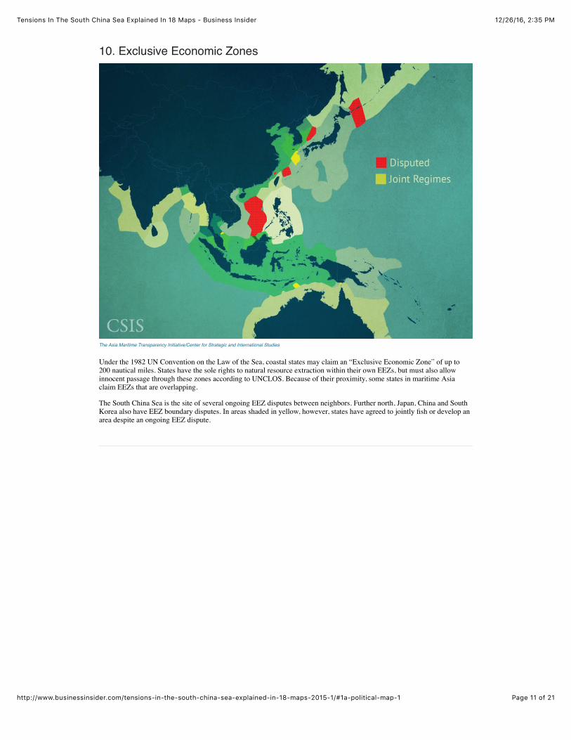
10. Exclusive Economic Zones
The Asia Maritime Transparency Initiative/Center for Strategic and International Studies
Under the 1982 UN Convention on the Law of the Sea, coastal states may claim an “Exclusive Economic Zone” of up to200 nautical miles. States have the sole rights to natural resource extraction within their own EEZs, but must also allowinnocent passage through these zones according to UNCLOS. Because of their proximity, some states in maritime Asiaclaim EEZs that are overlapping.
The South China Sea is the site of several ongoing EEZ disputes between neighbors. Further north, Japan, China and SouthKorea also have EEZ boundary disputes. In areas shaded in yellow, however, states have agreed to jointly fish or develop anarea despite an ongoing EEZ dispute.
12/26/16, 2:35 PMTensions In The South China Sea Explained In 18 Maps - Business Insider
Page 12 of 21http://www.businessinsider.com/tensions-in-the-south-china-sea-explained-in-18-maps-2015-1/#1a-political-map-1
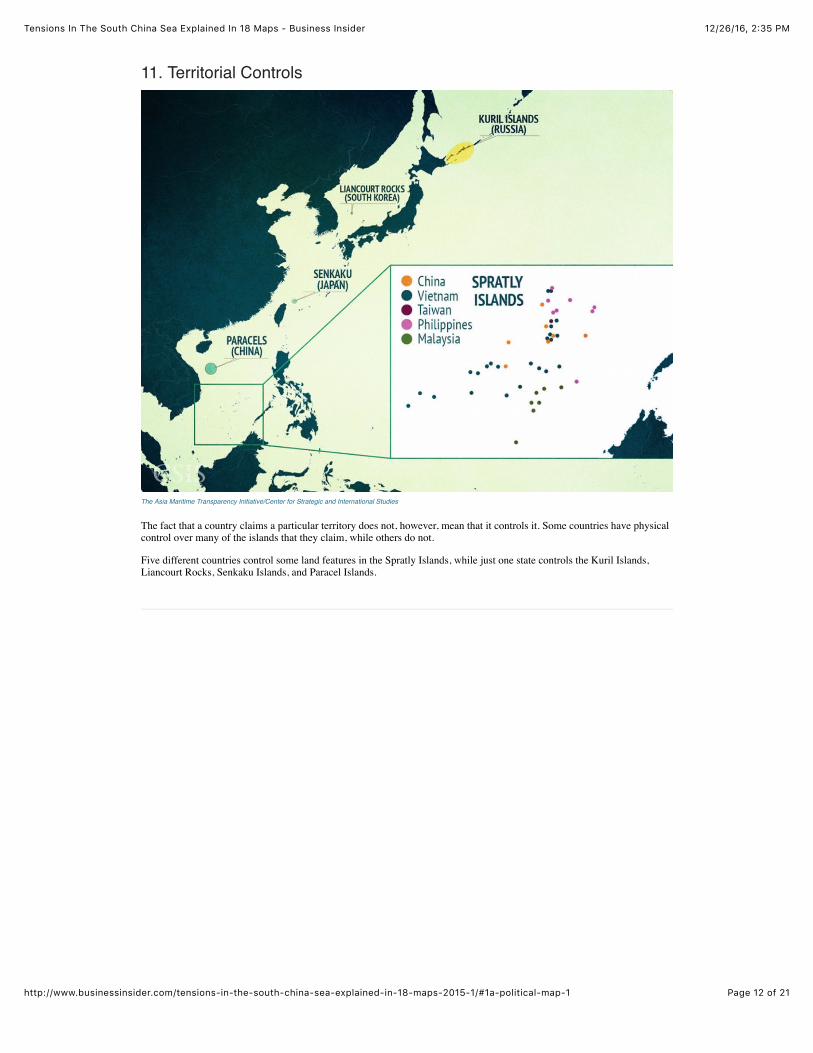
11. Territorial Controls
The Asia Maritime Transparency Initiative/Center for Strategic and International Studies
The fact that a country claims a particular territory does not, however, mean that it controls it. Some countries have physicalcontrol over many of the islands that they claim, while others do not.
Five different countries control some land features in the Spratly Islands, while just one state controls the Kuril Islands,Liancourt Rocks, Senkaku Islands, and Paracel Islands.

12/26/16, 2:35 PMTensions In The South China Sea Explained In 18 Maps - Business Insider
Page 13 of 21http://www.businessinsider.com/tensions-in-the-south-china-sea-explained-in-18-maps-2015-1/#1a-political-map-1
12. The Nine-Dash Line
The Asia Maritime Transparency Initiative/Center for Strategic and International Studies
One unique claim is China’s Nine-Dash Line, which depicts Beijing’s claims in the South China Sea. The map originallycontained 11 dashes and was issued by the Nationalist Chinese government in 1947. The Communist government adopted itwhen it took power in 1949, and later dropped two dashes to allow China and Vietnam to settle their claims in the Gulf ofTonkin.
The Nine-Dash Line encompasses much of the South China Sea, but Beijing has not clarified whether it is making territorialclaims on the land features inside this line or whether it is asserting maritime rights as well. In 2014, Beijing released a newmap that featured an additional 10th dash to the east of Taiwan. Because it predates UNCLOS by several decades, the Nine-Dash Line is unrelated to an EEZ claim.
12/26/16, 2:35 PMTensions In The South China Sea Explained In 18 Maps - Business Insider
Page 14 of 21http://www.businessinsider.com/tensions-in-the-south-china-sea-explained-in-18-maps-2015-1/#1a-political-map-1
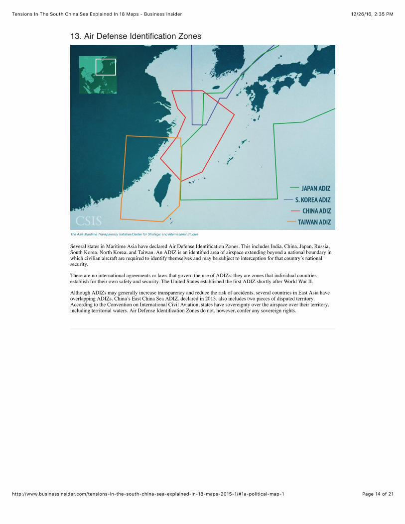
13. Air Defense Identification Zones
The Asia Maritime Transparency Initiative/Center for Strategic and International Studies
Several states in Maritime Asia have declared Air Defense Identification Zones. This includes India, China, Japan, Russia,South Korea, North Korea, and Taiwan. An ADIZ is an identified area of airspace extending beyond a national boundary inwhich civilian aircraft are required to identify themselves and may be subject to interception for that country’s nationalsecurity.
There are no international agreements or laws that govern the use of ADIZs: they are zones that individual countriesestablish for their own safety and security. The United States established the first ADIZ shortly after World War II.
Although ADIZs may generally increase transparency and reduce the risk of accidents, several countries in East Asia haveoverlapping ADIZs. China’s East China Sea ADIZ, declared in 2013, also includes two pieces of disputed territory.According to the Convention on International Civil Aviation, states have sovereignty over the airspace over their territory,including territorial waters. Air Defense Identification Zones do not, however, confer any sovereign rights.

12/26/16, 2:35 PMTensions In The South China Sea Explained In 18 Maps - Business Insider
Page 15 of 21http://www.businessinsider.com/tensions-in-the-south-china-sea-explained-in-18-maps-2015-1/#1a-political-map-1
14. Maritime Hotspots
CSIS
In the last several decades there have been multiple interstate incidents—vehicle collisions, armed clashes, close militaryencounters and other standoffs—in maritime Asia. Incidents have clustered around the Spratly Islands, Paracel Islands andScarborough Shoal in the South China Sea, the Senkaku Islands in the East China Sea, and the Northern Limit Line in theYellow Sea.
Other hotspots include the Kuril Islands in the Northern Pacific, and the Liancourt Rocks in the Sea of Japan. This raisesconcern that these could be the sites of serious accidents or potential flashpoints for escalation in the future.
15. Asian Military Budgets
12/26/16, 2:35 PMTensions In The South China Sea Explained In 18 Maps - Business Insider
Page 16 of 21http://www.businessinsider.com/tensions-in-the-south-china-sea-explained-in-18-maps-2015-1/#1a-political-map-1
The Asia Maritime Transparency Initiative/Center for Strategic and International Studies
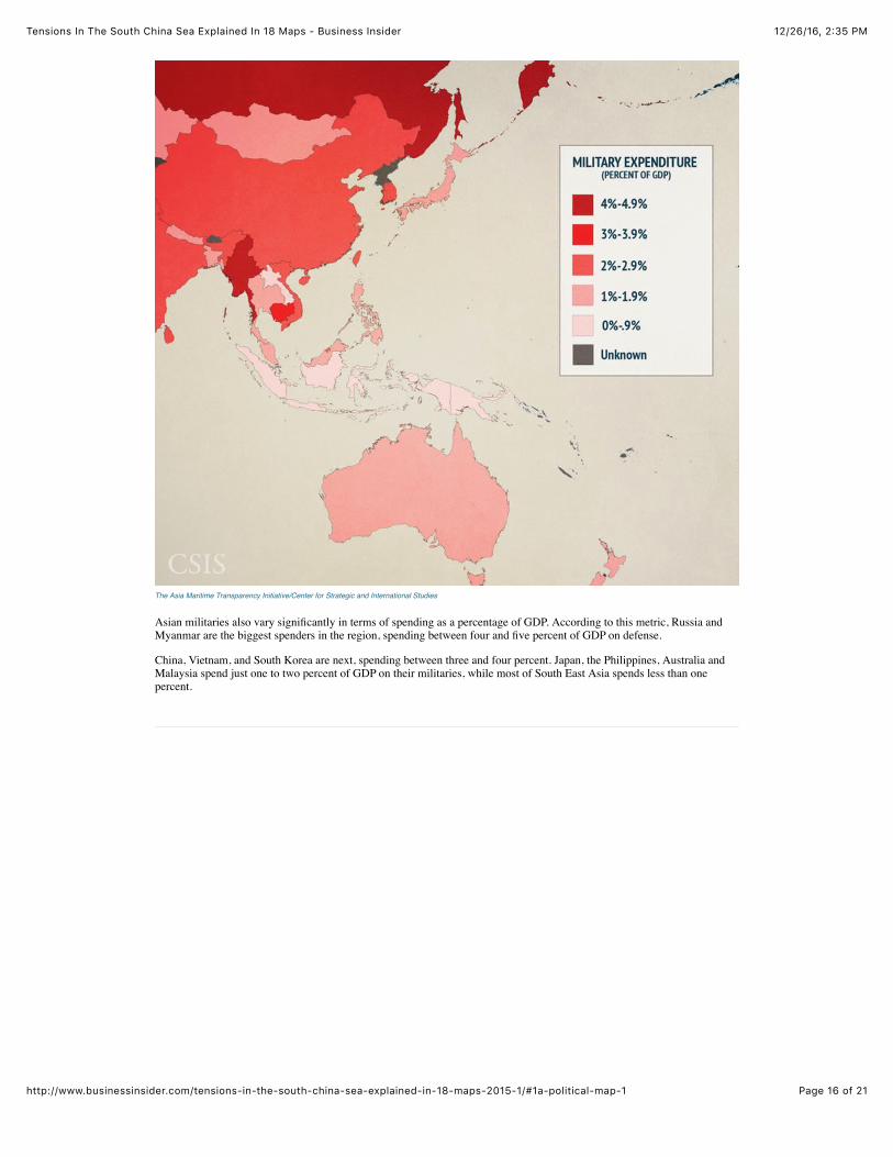
Asian militaries also vary significantly in terms of spending as a percentage of GDP. According to this metric, Russia andMyanmar are the biggest spenders in the region, spending between four and five percent of GDP on defense.
China, Vietnam, and South Korea are next, spending between three and four percent. Japan, the Philippines, Australia andMalaysia spend just one to two percent of GDP on their militaries, while most of South East Asia spends less than onepercent.
12/26/16, 2:35 PMTensions In The South China Sea Explained In 18 Maps - Business Insider
Page 17 of 21http://www.businessinsider.com/tensions-in-the-south-china-sea-explained-in-18-maps-2015-1/#1a-political-map-1
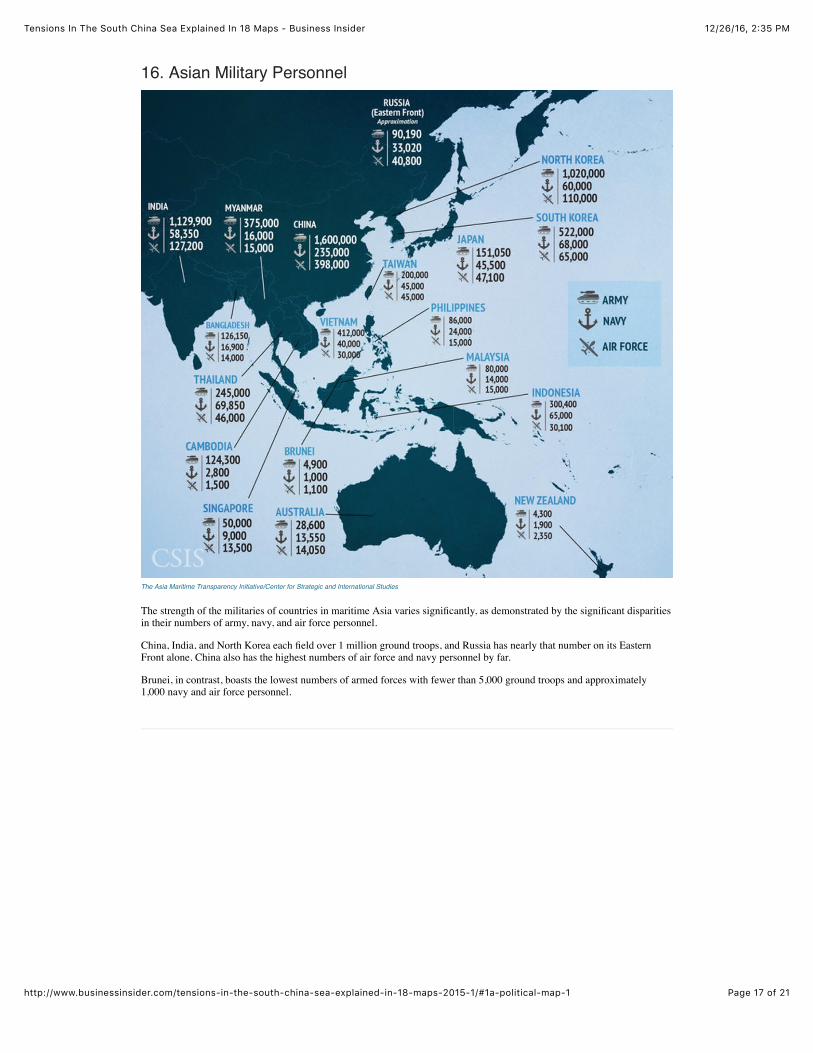
16. Asian Military Personnel
The Asia Maritime Transparency Initiative/Center for Strategic and International Studies
The strength of the militaries of countries in maritime Asia varies significantly, as demonstrated by the significant disparitiesin their numbers of army, navy, and air force personnel.
China, India, and North Korea each field over 1 million ground troops, and Russia has nearly that number on its EasternFront alone. China also has the highest numbers of air force and navy personnel by far.
Brunei, in contrast, boasts the lowest numbers of armed forces with fewer than 5,000 ground troops and approximately1,000 navy and air force personnel.
12/26/16, 2:35 PMTensions In The South China Sea Explained In 18 Maps - Business Insider
Page 18 of 21http://www.businessinsider.com/tensions-in-the-south-china-sea-explained-in-18-maps-2015-1/#1a-political-map-1
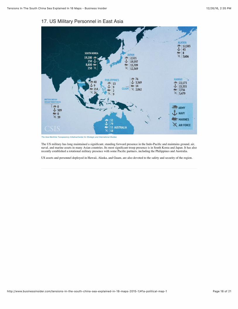
17. US Military Personnel in East Asia
The Asia Maritime Transparency Initiative/Center for Strategic and International Studies
The US military has long maintained a significant, standing forward presence in the Indo-Pacific and maintains ground, air,naval, and marine assets in many Asian countries. Its most significant troop presence is in South Korea and Japan. It has alsorecently established a rotational military presence with some Pacific partners, including the Philippines and Australia.
US assets and personnel deployed in Hawaii, Alaska, and Guam, are also devoted to the safety and security of the region.
12/26/16, 2:35 PMTensions In The South China Sea Explained In 18 Maps - Business Insider
Page 19 of 21http://www.businessinsider.com/tensions-in-the-south-china-sea-explained-in-18-maps-2015-1/#1a-political-map-1
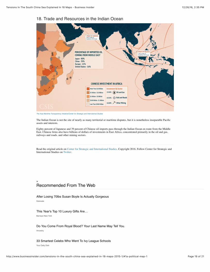
18. Trade and Resources in the Indian Ocean
The Asia Maritime Transparency Initiative/Center for Strategic and International Studies
The Indian Ocean is not the site of nearly as many territorial or maritime disputes, but it is nonetheless inseparable Pacificassets and interests.
Eighty percent of Japanese and 39 percent of Chinese oil imports pass through the Indian Ocean en route from the MiddleEast. Chinese firms also have billions of dollars of investments in East Africa, concentrated primarily in the oil and gas,railways and roads, and other mining sectors.
Read the original article on Center for Strategic and International Studies. Copyright 2016. Follow Center for Strategic andInternational Studies on Twitter.
× Recommended From The Web
Detonate
Barneys New York
Ancestry
Your Daily Dish
After Losing 70lbs Susan Boyle Is Actually Gorgeous
This Year's Top 10 Luxury Gifts Are…
Do You Come From Royal Blood? Your Last Name May Tell You.
33 Smartest Celebs Who Went To Ivy League Schools
12/26/16, 2:35 PMTensions In The South China Sea Explained In 18 Maps - Business Insider
Page 20 of 21http://www.businessinsider.com/tensions-in-the-south-china-sea-explained-in-18-maps-2015-1/#1a-political-map-1
Definition
Bowflex
GlassesUSA.com
An In Depth View Of The People Who Are Working In RetirementMerrill Lynch
These Are 2016'S Stand Out VehiclesKelley Blue Book
4 Early Warning Signs Of Type 1 DiabetesWebMD
Look No Further, Here Are The Top Sedans For 2016VoteItUp Referrals
How Much Do You Know About Car Engines? Take This Quiz To Find Out!HowStuffWorks
Your 401(K) Isn't Growing As Fast As It Should - Here's WhyMint | Future Advisor
These Are The Heroes Fighting For HIV VictimsHealthiNation
15 Never Before Seen Inventions That Solve Annoying Problems
2018'S Resolution: Thank Yourself For Starting 2017 With A Bowflex
This Article Will Change The Way You Buy Glasses Forever

12/26/16, 2:35 PMTensions In The South China Sea Explained In 18 Maps - Business Insider
Page 21 of 21http://www.businessinsider.com/tensions-in-the-south-china-sea-explained-in-18-maps-2015-1/#1a-political-map-1