Embed Size (px)
Citation preview
Ten years of archaeoseismological research in Armenia (2004e2013)
Bruno Helly a, *, Alain Rideaud b
a Laboratory HISOMA, CNRS, UMR 5869, Maison de l'Orient M�editerran�een, 7 rue Raulin, 69007 Lyon, Franceb Architect DPLG, 4 place du Champ-de-Mars, 71700 Tournus, France
a r t i c l e i n f o
Article history:Available online 23 November 2015
Keywords:ArchaeoseismologyArmenia1st millennium BCMiddle AgesTraditional rural constructionsCultural heritage
a b s t r a c t
The results of the observations made during our 2003e2013 missions in Armenia are described here:I. Several seismic events, unknown in the written sources and the latest catalogs, were identified: A) At
Erebuni, in the Ararat plain, an earthquake ruined the temple of Khaldi at the end of the Urartu periodand led to the abandonment and the transformation of the quarter where it had been established,probably around the end of the 7th c. BC; B) At Benjamin, in northwestern Armenia, an earthquakecaused important damage to parts of the Hellenistic settlement, in particular on the tower-porch at theeast; the traces of repairs indicate that this event dates to the same period; C) The study of the bridge atGarni and the church of the village, southeast of Yerevan, have revealed a seismic event that occurred atleast earlier than the earthquake of 1679, the only one mentioned in the texts, which is used as areference for all the destruction dates in the region.
II. The observations made of the traditional rural constructions called “hazarashen” have not onlyenabled the dating of this building tradition to at least as early as the Hellenistic period (4th c. BC); theyhave also enabled identification of the lozenge-shaped deformation in these structures as a characteristiceffect of the disturbances caused by the earthquake, a deformation resulting from and accompanied bycompression or extension of the walls according to their position in relation to the direction of theground motion.
© 2015 Elsevier Ltd and INQUA. All rights reserved.
1. Introduction
Since 2004, within a program of the French National Centre forScientific Research (Programmes Internationaux de CollaborationScientifique), we have worked in collaborationwith our Armeniancolleagues A. Karakhanyan and A. Avagyan (Institute of GeologicalSciences, Academy of Sciences of the Republic of Armenia), as wellas their collaborators, on the subject of archaeoseismology. Ourtask has been to observe the evidence for damage and distur-bances present on archaeological sites and in ancient buildings, inorder to reveal past earthquakes for which we have no trace in thewritten sources. In this article, we present the observations andinterpretations that we have carried out on different sites andmonuments, at Erebuni, Benjamin and Garni, as well as analysesof recurrent phenomena of destruction and deformation in thetraditional houses of Armenia, called “hazarashen” houses.
2. In search of unrecorded past earthquakes in Armenia
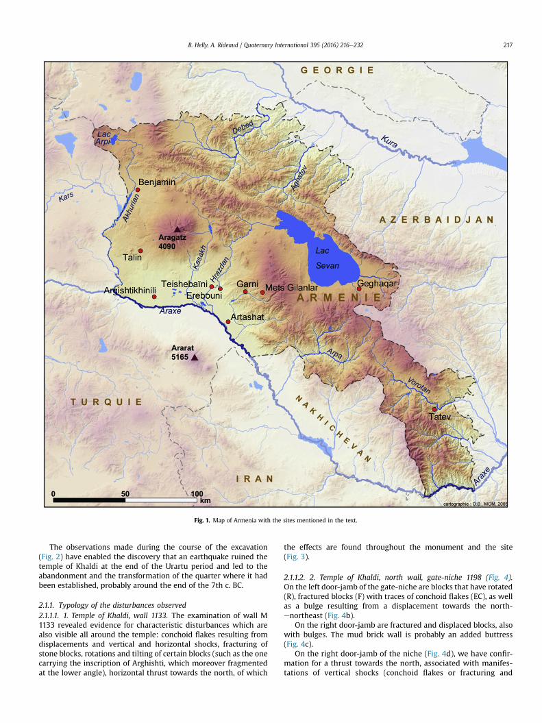
Fig. 1 Location map for the sites studied.
2.1. Archaeoseismological observations at the excavations of theFranco-Armenian archaeological mission at Erebouni (temple ofKhaldi)
The archaeological site of Erebuni, on the hill called Arin-Berd,south-west of the city of Erevan (Fig. 1), has been the object ofexcavations since 1950. The vestiges of a large fortified settlementhave been brought to light, including monumental constructionsand many other buildings considered to be storehouses. The in-scriptions found in some of these constructions have shown thatthe foundation of this fortress should be attributed to a king ofUrartu, Arghisti 1st, in 782 BC, “to the glory of the god Khaldi”, theprincipal god of Urartu, who had a temple there. In 2010 excavationof the temple of Khaldi was resumed by a Franco-Armenian team inorder to define the conditions and chronology of the transitionbetween the end of the kingdom of Urartu and the period ofAchaemenid occupation that followed.
* Corresponding author.E-mail addresses: [email protected] (B. Helly), [email protected]
(A. Rideaud).
Contents lists available at ScienceDirect
Quaternary International
journal homepage: www.elsevier .com/locate/quaint
http://dx.doi.org/10.1016/j.quaint.2015.08.0871040-6182/© 2015 Elsevier Ltd and INQUA. All rights reserved.
Quaternary International 395 (2016) 216e232
The observations made during the course of the excavation(Fig. 2) have enabled the discovery that an earthquake ruined thetemple of Khaldi at the end of the Urartu period and led to theabandonment and the transformation of the quarter where it hadbeen established, probably around the end of the 7th c. BC.
2.1.1. Typology of the disturbances observed2.1.1.1. 1. Temple of Khaldi, wall 1133. The examination of wall M1133 revealed evidence for characteristic disturbances which arealso visible all around the temple: conchoid flakes resulting fromdisplacements and vertical and horizontal shocks, fracturing ofstone blocks, rotations and tilting of certain blocks (such as the onecarrying the inscription of Arghishti, which moreover fragmentedat the lower angle), horizontal thrust towards the north, of which
the effects are found throughout the monument and the site(Fig. 3).
2.1.1.2. 2. Temple of Khaldi, north wall, gate-niche 1198 (Fig. 4).On the left door-jamb of the gate-niche are blocks that have rotated(R), fractured blocks (F) with traces of conchoid flakes (EC), as wellas a bulge resulting from a displacement towards the north-enortheast (Fig. 4b).
On the right door-jamb are fractured and displaced blocks, alsowith bulges. The mud brick wall is probably an added buttress(Fig. 4c).
On the right door-jamb of the niche (Fig. 4d), we have confir-mation for a thrust towards the north, associated with manifes-tations of vertical shocks (conchoid flakes or fracturing and
Fig. 1. Map of Armenia with the sites mentioned in the text.
B. Helly, A. Rideaud / Quaternary International 395 (2016) 216e232 217