Embed Size (px)
Citation preview
Temperatures in the mountainous Tibetan plateau 5 km above sea level can reach minus six degrees at night, so the government quickly arranged to send five thousand tents and fifty thousand blankets for the homeless
survivors.

The government allocated $30 million for relief and mobilized more than 5,000 soldiers, medical workers and other rescue workers to join with 700 troops already on
the ground.

TAIWAN: APRIL 26, 2010

APRIL 26, 2010
M6.5 EARTHQUAKE AND 3- DAYS OF RAIN CREATE
CONDITIONS FOR LANDSLIDES
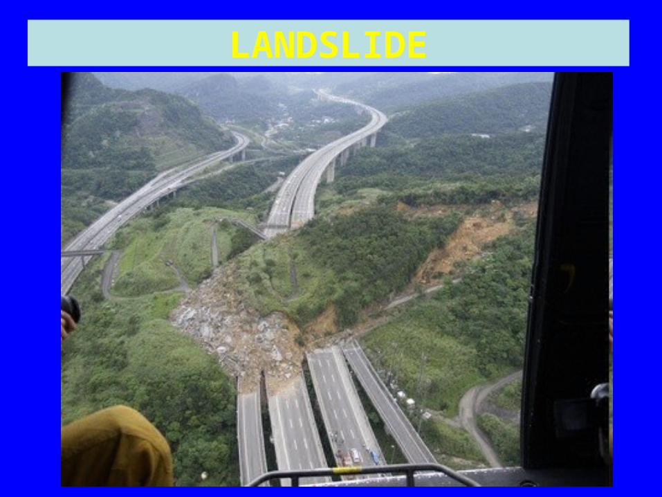
LANDSLIDE

LANDSLIDE

SEARCH AND RESCUE
INDONESIA’S TRIPLE DISASTER STARTED WITH EARTHQUAKE AND TSUNAMI ON OCTOER 25,
2010
October 25-27 – November 24, 2010
A M7.7 EARTHQUAKE, A 3 M-TSUNAMI-WAVE RUN UP, AND A LONG
ERUPTION OF MOUNT MERAPI CAUSED LOSSES IN THE TENS OF
MILLIONS, DISPLACED OVER 340,000, KILLING NEARLY 1,000 , AND
POTENTIALLY AFFECTING THE HEALTH AND QUALITY OF LIFE FOR
THOUSANDS,

INDONESIA HAS MORE THAN 17,000 ISLANDS
Sandwiched between two active earthquake belts, the Pacific “Ring of fire,” and the Alpide Belt, Indonesia experiences some of the most powerful earthquakes and volcanic
eruptions on Earth.

Indonesia is home to 129 active volcanoes, with the two most active
ones — Mount Kelut and Mount Merapi — located on the island of
Java, which also contains the Indonesian capital of Jakarta,
roughly 500 km (300 mi) northwest of them.

INDONESIA’S 129 ACTVE VOLCANOES (MOUNT MERAPI IS BOTTOM LEFT CENTER)
Monday and Tuesday: Oct 25-26
Indonesia endured two days of environmental extremes after a powerful earthquake, a tsunami,
and a volcanic eruption struck the Java region of the Indonesian
archipelago.
CASUALTIES: 538 ON OCT 26, BUT TOLL LIKELY TO RISE IN THE
FUTURE
The earthquake and tsunami run up left at least 500 dead, and the initial volcanic eruption left 38 dead, BUT,
health impacts associated with Mount Merapi’s continuing eruption
may have long-term impacts.

THE M7.7 EARTHQUAKE
Early response was hindered by twenty-two aftershocks
ranging from M5- 6.2

TECTONICS OF THE REGION
• The Australian and Eurasian plates meet in Indonesia, creating a tectonic setting favorable for generating earthquakes, tsunamis, and volcanic eruptions.

TECTONICS OF THE REGION (Continued)
• The Australian plate is moving northward and being subducted under the Eurasian plate in a zone marked by a submarine trench that can be traced from the northern tip of Sumatra to the Lesser Islands.

SUBDUCTION ZONE SUBDUCTION ZONE

SEISMICITY MARKS THE PLATE BOUNDARIES

THE TSUNAMI
RESPONSE WAS EXACERBATED BY REMOTENESS OF THE
ISLANDS

INDONESIA: LOCATION OF HISTORICAL TSUNAMIS
INDONESIA: LOCATION OF HISTORICAL TSUNAMIS

The M7.7 earthquake generated a near-source tsunami with 3 m (10 ft) waves that struck within 5 minutes
after the quake---so quickly that the regional tsunami warning system
that was improved after the December 26, 2004 tsunami disaster, was ineffective..
The tsunami, triggered by the 7.7-magnitude undersea quake, hit the Mentawai Islands late Monday,
leaving thousands homeless, killing at least 500 people, and sweeping hundreds out to sea.
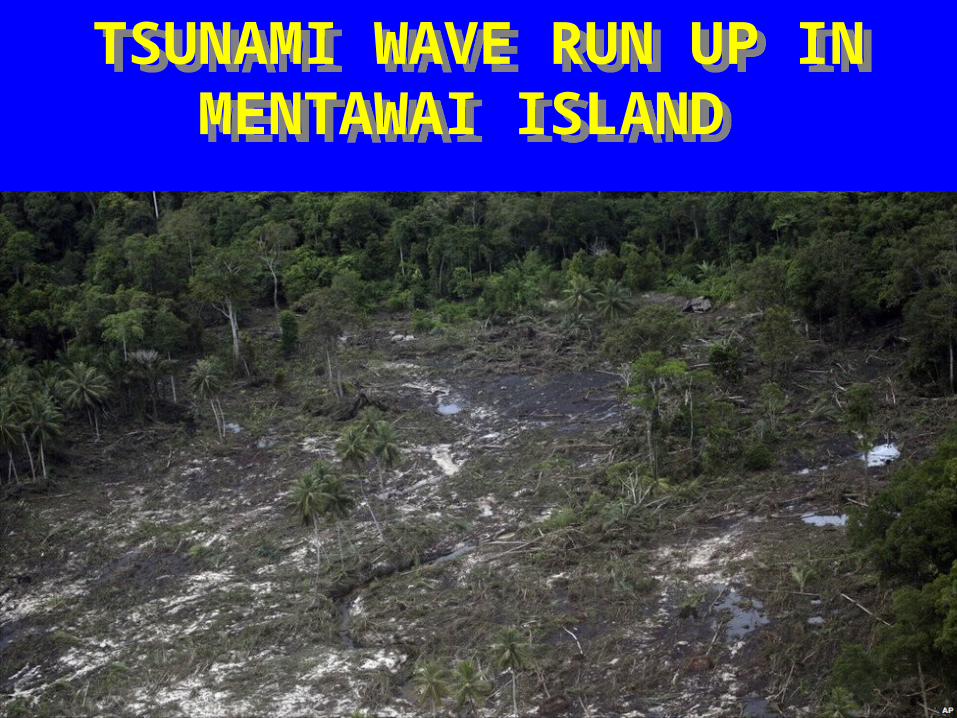
TSUNAMI WAVE RUN UP IN MENTAWAI ISLAND
TSUNAMI WAVE RUN UP IN MENTAWAI ISLAND
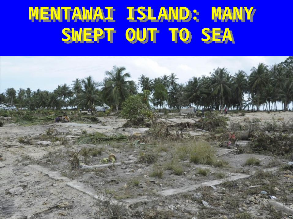
MENTAWAI ISLAND: MANY SWEPT OUT TO SEA
MENTAWAI ISLAND: MANY SWEPT OUT TO SEA

SEARCH AND RESCUE HINDERED BY POOR COMMUNICATIONS
SEARCH AND RESCUE HINDERED BY POOR COMMUNICATIONS

KNOWING WHERE, WHEN, AND WHY A TSUNAMI OCCURS IS A VITAL PART OF THE ART
AND SCIENCE OF INTELLIGENT RISK REDUCTION.

Tsunamis Are Associated with Subduction Zone Earthquakes
• M7 or larger earthquakes that occur in oceanic subduction zones can cause:
Tsunamis

A TSUNAMI WAVE CAN REACH 10 M OR MORE IN HEIGHT
A TSUNAMI WAVE CAN REACH 10 M OR MORE IN HEIGHT

TSUNAMI HAZARDS (AKA POTENTIAL DISASTER AGENTS)
• HIGH-VELOCITY, LONG-PERIOD WATER WAVES
• WAVE RUNUP • FLOODING• WAVE RETREAT• SHORELINE EROSION

HIGH VELOCITY IMPACT OF INCOMING WAVES
TSUNAMIS TSUNAMIS
INLAND DISTANCE OF WAVE RUNUP
VERTICAL HEIGHT OF WAVE RUNUP
INADEQUATE RESISTANCE OF BUILDINGS
FLOODING
INADEQUATE HORIZONTAL AND VERTICAL EVACUATION
PROXIMITY TO SOURCE OF TSUNAMI
CAUSES OF DAMAGE
CAUSES OF DAMAGE
“DISASTER LABORATORIES”
“DISASTER LABORATORIES”

THE ART AND SCIENCE OF KNOWING WHEN TO EVACUATE
BEFORE A TSUNAMI WAVE ARRIVES AND WHERE TO GO
CAN BE THE DIFFERENCE BETWEEN LIFE AND DEATH.

YOU CAN’T OUTRUN OR DIVERT10-M-HIGH, DEBRIS-LADEN,
OCEAN WAVES THAT ARRIVE WITH A HIGH VELOCITY (E.G., 30 TO 300 KM/HR) AND MOVE
INLAND FOR 2-3 KM, OR MORE
DECEMBER 21, 2010
M6.5 EARTHQUAKE STRIKES SOUTHEASTERN
IRAN
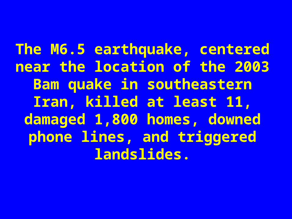
The M6.5 earthquake, centered near the location of the 2003 Bam quake in southeastern Iran, killed at least 11,
damaged 1,800 homes, downed phone lines, and triggered landslides.
Almost exactly seven years ago in the same region, a M6.6 earthquake
struck the nearby city of Bam, killing more than 25,000 people and
destroying a medieval castle that was one of Iran's most treasured
archaeological sites.

TSUNAMI WARNING ISSUED, THEN WITHDRAWN
DECEMBER 25, 2010
M7.2 EARTHQUAKE STRIKES VANUATU

VANUATU


![Friday Night Funkin' Minus (MINUS...3/19/2021 Friday NightFunkin' Minus (MINUS MOM & BF SKINS) [Friday NightFunkin'] [Skin Mods] 2/ 2 Feedback Bugs Support Site](https://img.pdfslide.us/doc/110x75/614011f6e59fcb3c636a4315/friday-night-funkin-minus-minus-3192021-friday-nightfunkin-minus-minus.jpg)