Embed Size (px)
Citation preview
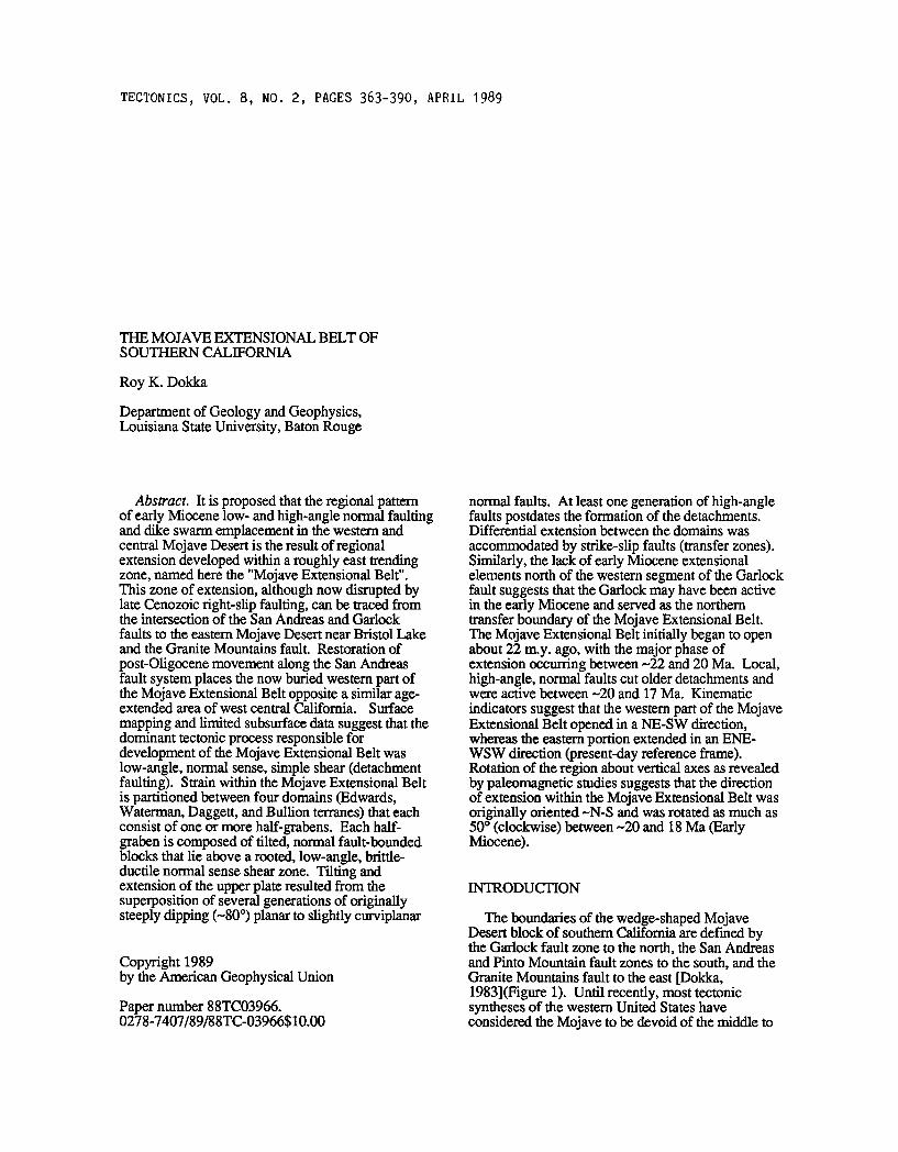
TECTONICS, VOL. 8, NO. 2, PAGES 363-390, APRIL 1989
THE MOJAVE EXTENSIONAL BELT OF SOUTHERN CALIFORNIA
Roy K. Dokka
Department of Geology and Geophysics, Louisiana State University, Baton Rouge
Abstract. It is proposed that the regional pattern of early Miocene low- and high-angle normal faulting and dike swarm emplacement in the western and central Mojave Desert is the result of regional extension developed within a roughly east trending zone, named here the "Mojave Extensional Belt". This zone of extension, although now disrupted by late Cenozoic right-slip faulting, can be traced from the intersection of the San Andreas and Garlock
faults to the eastern Mojave Desert near Bristol Lake and the Granite Mountains fault. Restoration of
post-Oligocene movement along the San Andreas fault system places the now buried western part of the Mojave Extensional Belt opposite a similar age- extended area of west central California. Surface
mapping and limited subsurface data suggest that the dominant tectonic process responsible for development of the Mojave Extensional Belt was low-angle, normal sense, simple shear (detachment faulting). Strain within the Mojave Extensional Belt is partitioned between four domains (Edwards, Waterman, Daggett, and Bullion terranes) that each consist of one or more half-grabens. Each half- graben is composed of tilted, normal fault-bounded blocks that lie above a rooted, low-angle, brittle- ductile normal sense shear zone. Tilting and extension of the upper plate resulted from the superposition of several generations of originally steeply dipping (-80 ø) planar to slightly curviplanar
Copyright 1989 by the American Geophysical Union
Paper number 88TC03966. 0278-7407/89/88TC-03966510.00
normal faults. At least one generation of high-angle faults postdates the formation of the detachments. Differential extension between the domains was
accommodated by strike-slip faults (transfer zones). Similarly, the lack of early Miocene extensional elements north of the western segment of the Garlock fault suggests that the Garlock may have been active in the early Miocene and served as the northern transfer boundary of the Mojave Extensional Belt. The Mojave Extensional Belt initially began to open about 22 m.y. ago, with the major phase of extension occurring between --22 and 20 Ma. Local, high-angle, normal faults cut older detachments and were active between --20 and 17 Ma. Kinematic
indicators suggest that the western part of the Mojave Extensional Belt opened in a NE-SW direction, whereas the eastern portion extended in an ENE- WSW direction (present-day reference frame). Rotation of the region about vertical axes as revealed by paleomagnetic studies suggests that the direction of extension within the Mojave Extensional Belt was originally oriented-N-S and was rotated as much as 50 ø (clockwise) between •-20 and 18 Ma (Early Miocene).
INTRODUCTION
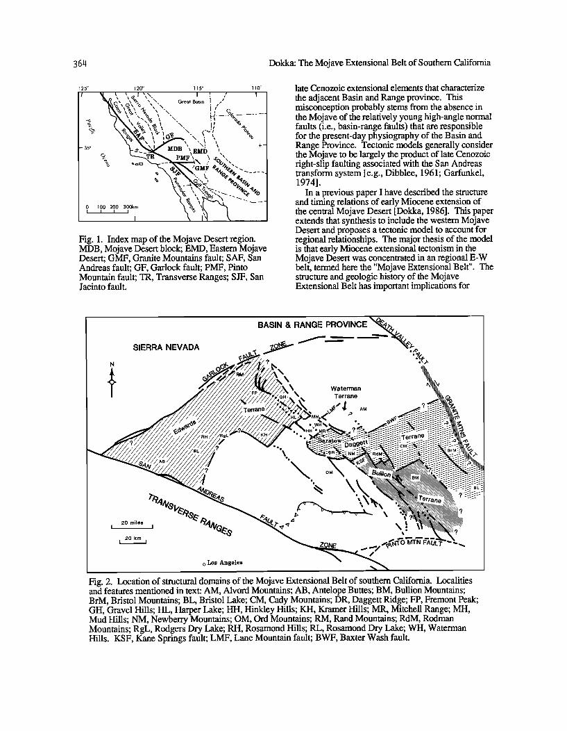
The boundaries of the wedge-shaped Mojave Desert block of southern California are defined by the Garlock fault zone to the north, the San Andreas and Pinto Mountain fault zones to the south, and the Granite Mountains fault to the east [Dokka, 1983](Figure 1). Until recently, most tectonic syntheses of the western United States have considered the Mojave to be devoid of the middle to
36t1 Dokka: The Mojave Extensional Belt of Southem Califomia
125 ø 120 ø 115 ø 110 ø
•/(, tX \ o•. x N. Great Basin I
-3s' ;.+_• MDB ', EMb " +-
N '• • ',•o,.'.--
I
Fig. 1. Index map of the Mojave Desert region. MDB, Mojave Desert block; EMD, Eastern Mojave Desert; GMF, Granite Mountains fault; SAF, San Andreas fault; GF, Garlock fault; PMF, Pinto Mountain fault; TR, Transverse Ranges; SJF, San Jacinto fault.
late Cenozoic extensional elements that characterize the adjacent Basin and Range province. This misconception probably stems from the absence in the Mojave of the relatively young high-angle normal faults (i.e., basin-range faults) that are responsible for the present-day physiography of the Basin and Range Province. Tectonic models generally consider the Mojave to be largely the product of late Cenozoic fight-slip faulting associated with the San Andreas transform system [e.g., Dibblee, 1961; Garfunkel, 1974].
In a previous paper I have described the structure and timing relations of early Miocene extension of the central Mojave Desert [Dokka, 1986]. This paper extends that synthesis to include the western Mojave Desert and proposes a tectonic model to account for regional relationships. The major thesis of the model is that early Miocene extensional tectonism in the Mojave Desert was concentrated in an regional E-W belt, termed here the "Mojave Extensional Belt". The structure and geologic history of the Mojave Extensional Belt has important implications for
N
SIERRA NEVADA
BASIN & RANGE PROVINCE
,\ \
\ Waterman
AM
ee e
ß e
• OM
20 miles 04,•,,•, e I I ,,•. '"•
20 km I i
o Los Angeles
Fig. 2. Location of structural domains of the Mojave Extensional Belt of southem Califomia. Localities and features mentioned in text: AM, Alvord Mountains; AB, Antelope Buttes; BM, Bullion Mountains; BrM, Bristol Mountains; BL, Bristol Lake; CM, Cady Mountains; DR, Daggett Ridge; FP, Fremont Peak; GH, Gravel Hills; HL, Harper Lake; HH, Hinkley Hills; KH, Kramer Hills; MR, Mitchell Range; MH, Mud Hills; NM, Newberry Mountains; OM, Ord Mountains; RM, Rand Mountains; RdM, Rodman Mountains; RgL, Rodgers Dry Lake; RH, Rosamond Hills; RL, Rosamond Dry Lake; WH, Waterman Hills. KSF, Kane Springs fault; LMF, Lane Mountain fault; BWF, Baxter Wash fault.
Dokka: The Mojave Extensional Belt of Southern California 365
models of the tectonic evolution of the westem
United States as well as the structural development of rifted continental margins.
translated the Mojave Extensional Belt into its present configuration [Dokka, 1983, 1987; R. K. Dokka and C. J. Travis, manuscript in preparation, 1988].
ARCHITECTURE OF THE MOJAVE EXTENSIONAL BELT
General Relations
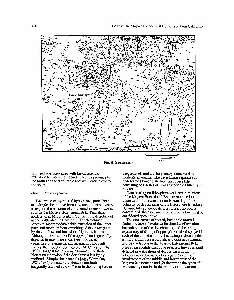
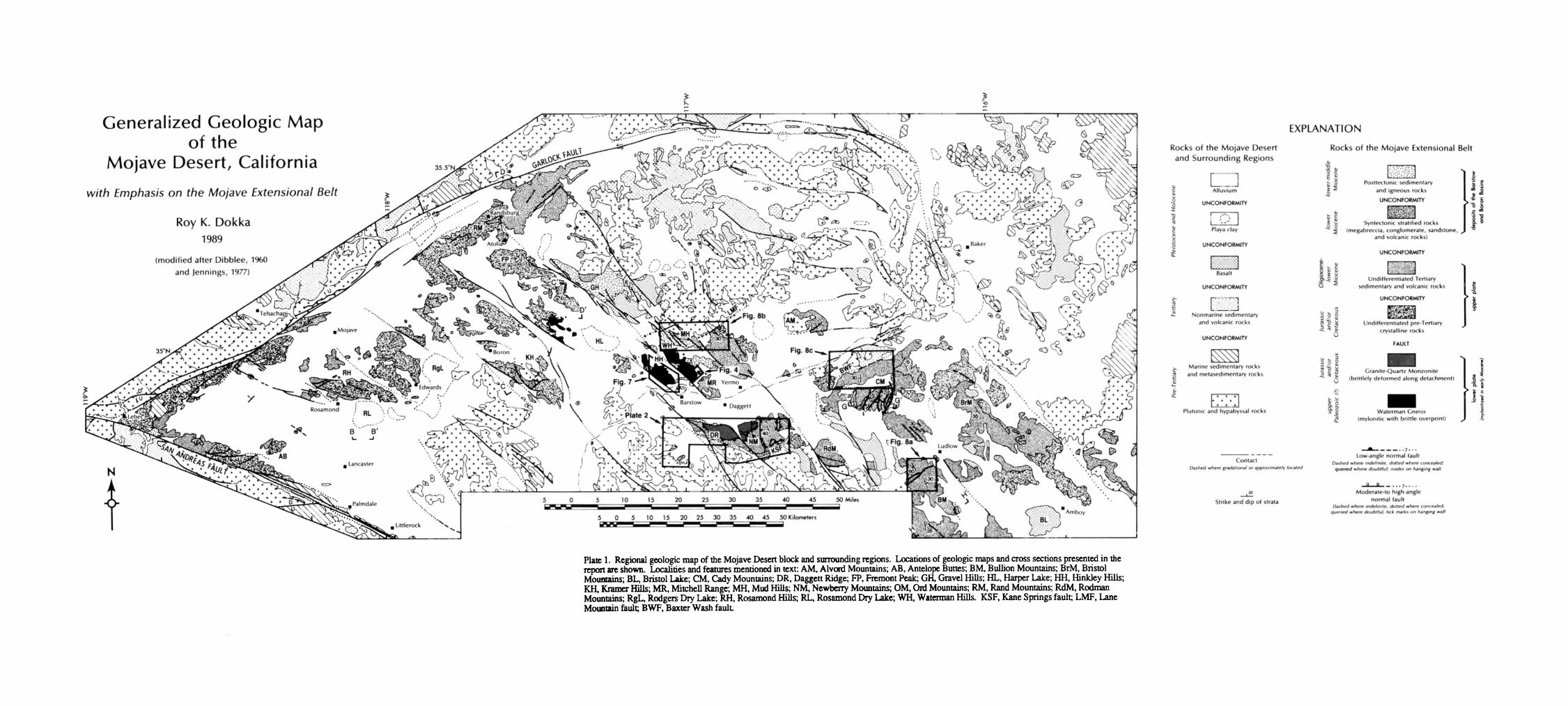
Plate 1 is a generalized geologic map of the Mojave region highlighting early Miocene extensional elements as well as syntectonic and posttectonic sedimentary rocks. This map also shows the location of detailed geologic maps and cross sections that are presented below. The inferred location of the Mojave Extensional Belt is shown in Figure 2.
Data presented here and elsewhere [Dokka, 1986] suggest that the upper crust and at least portions of the middle crust of the Mojave Extensional Belt were extended in early Miocene time and that extension was accomplished by low-angle normal faulting, high-angle normal faulting, and extension fracturing accompanied by intermediate to silicic composition intrusion. At its present level of exposure, most of the Mojave Extensional Belt is composed of moderately tilted fault blocks that lie in an upper plate position relative to detachment faults that underlie the extended region. These fault blocks typically consist of Oligocene-lower Miocene volcanic and/or sedimentary rocks that rest unconformably on pre- Tertiary igneous and metamorphic rocks (Plate 1). Exposures of detachment faults, associated brittle and/or ductile fault rocks, and subdetachment rocks are limited to the Newberry Mountains and to a series of low mountains from near the hamlet of Lockhart
to the Mitchell Range (Plate 1). Brittle structures and fault rocks of the Newberry Mountains detachment occur on the perimeter of a large, east-trending arch in the western Newberry Mountains (Plate 2). In contrast, early Miocene age mylonites and mylonitic gneisses crop out in the footwalls of detachment faults in the Mitchell Range, Waterman Hills, Hinkley Hills, and western Harper Lake area (Plate 1, Figure 3). These rocks are upper greenschist to amphibolite grade metamorphic rocks and represent the deepest level exhumed by extensional processes. The overall structural and petrologic relationships exposed in these areas are similar to the metamorphic core complexes of the western United States [c.f. Davis and Coney, 1979; Crittenden et al., 1980].
The Mojave Extensional Belt can be subdivided into four domains on the basis of differences in fault
geometry and associated tilt pattern of lower Miocene strata; from northwest to southeast, the terranes are named Edwards, Waterman, Daggett, and Bullion (Figure 2). Post-13 Ma (perhaps 5 Ma) fight-slip faulting along NW- striking shears has cut and
Internal Structure of the Extensional Domains
The overall structure of an individual extensional
domain of the Mojave Extensional Belt is that of a single or a series of half-grabens (usage after Bally [1981]), in which an upper plate of multiply deformed, tilted, normal fault-bounded blocks lie above a rooted, low-angle detachment fault (usage after Davis et al. [1980] and Dokka [1980]). Seismic data from the western Mojave Desert suggest that the western part of the Edwards terrane is composed of several NE dipping detachments (Cheadle et al. [1986], Spongberg and Henyey [1987], Lawson [ 1987], Serpa and Dokka [ 1988], and this paper). This imbricate character is also suspected but not yet documented for the Daggett terrane. Plate 3 is a series of geologic and seismic sections that illustrate the structure of the domains of the Mojave Extensional Belt.
Edwards terrane. The current surface of the
Edwards terrane is composed of tilted upper plate fault blocks that are surrounded by Quaternary sediments (Plate 1). In all but the southernmost portion of the terrane near the San Andreas fault (e.g., Antelope Buttes), upper plate rocks are tilted 30o-50 ø to the southwest in association with NE
dipping, moderate angle, normal faults. Strikes change from-WNW to-N-S on approach to the San Andreas (Dibblee, 1967b), probably reflecting postextension strain.
Evidence that detachment faults floor the tilted normal fault-bounded blocks of the Edwards terrane
is provided by seismic reflection surveys (Cheadle et al. [1986] (Plate 3a), this paper (Plate 3b), Spongberg and Henyey [ 1987], Lawson [ 1987], Serpa and Dokka [1988]) and surface mapping [Dokka et al., 1988] in the Harper Lake area (Plate 3c and 3d). Plate 3c is a schematic cross section that illustrates the general geometric relationships between extended and tilted normal fault-bounded blocks of the Kramer Hills and the brittle-ductile, normal sense shear zone exposed west of Harper Lake. Apparently, the Edwards terrane ends abruptly against the western part of the Garlock fault to the northwest and the San Andreas fault to the
west (Figure 2). Waterman terrane. Although the Waterman
terrane is the smallest of the domains of the Mojave Extensional Belt (Figure 2), geologic relations exposed there provide important information on the sequence of events and on the processes involved in extension. The surface of the domain consists of
variably SW dipping Miocene sedimentary and volcanic rocks that rest unconformably on upper plate pre-Tertiary crystalline complex (Plate 1).
366 Dokka: The Mojave Extensional Belt of Southern California
ß
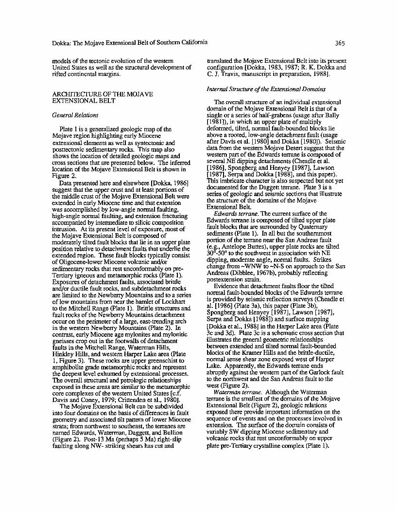
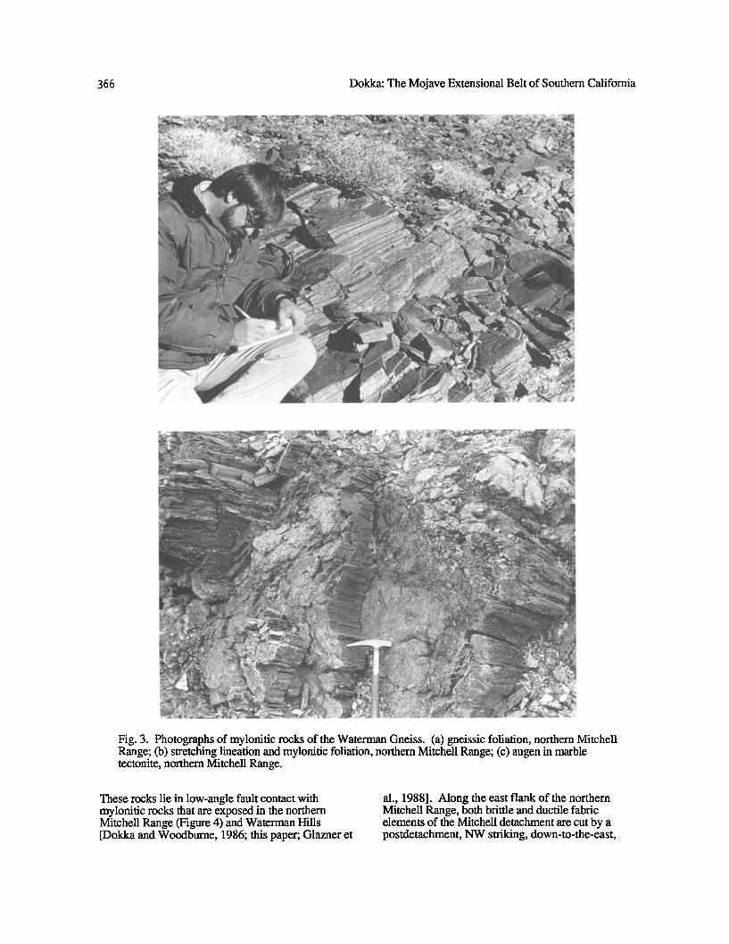
ß
Fig. 3. Photographs of mylonitic rocks of the Waterman Gneiss. (a) gneissic foliation, northern Mitchell Range; (b) stretching lineation and mylonitic foliation, northern Mitchell Range; (c) augen in marble tectonite, northern Mitchell Range.
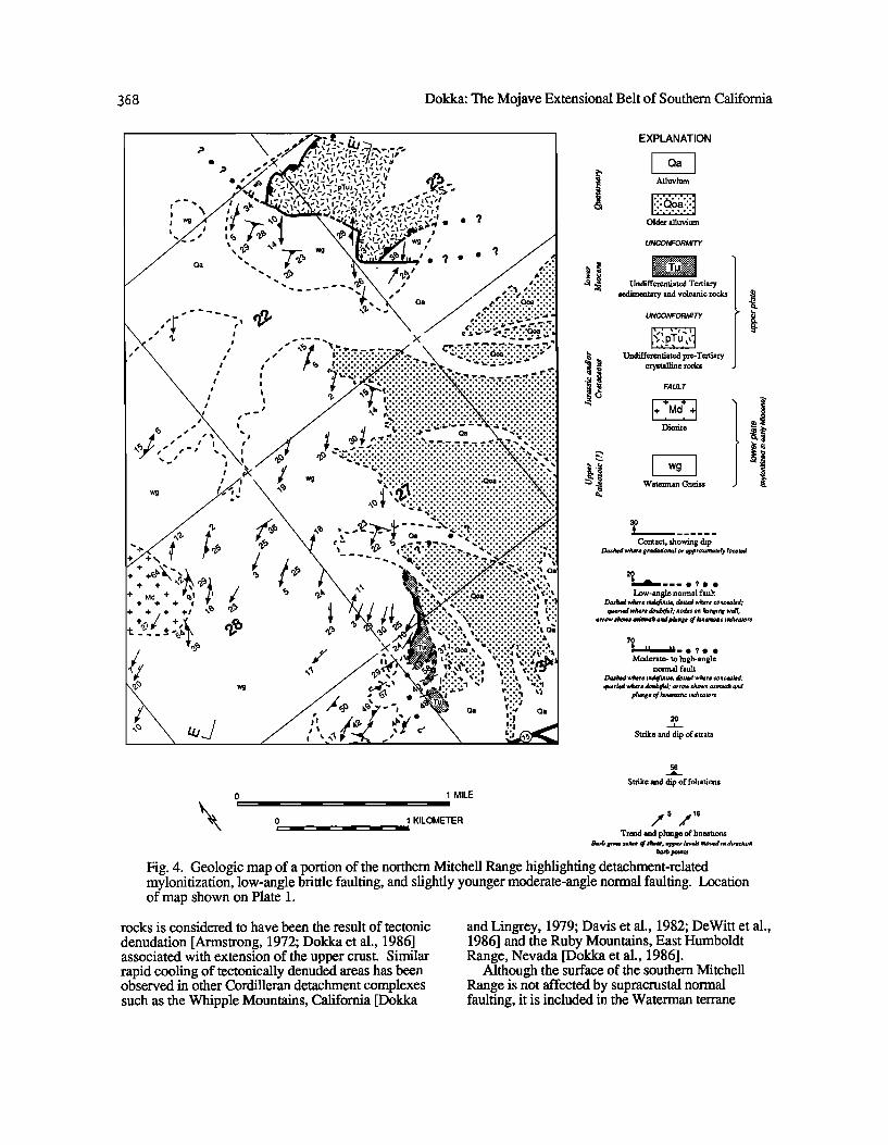
These rocks lie in low-angle fault contact with mylonitic rocks that are exposed in the northern Mitchell Range (Figure 4) and Waterman Hills [Dokka and Woodburne, 1986; this paper; Glazner et
al., 1988]. Along the east flank of the northern Mitchell Range, both brittle and ductile fabric elements of the Mitchell detachment are cut by a postdetachment, NW striking, down-to-the-east,
Dokka: The Mojave Extensional Belt of Southern California 36 ?
Fig. 3. (continued)
normal fault zone (Plate 3e, and Figure 4). The fault continues to the northwest between the Waterman
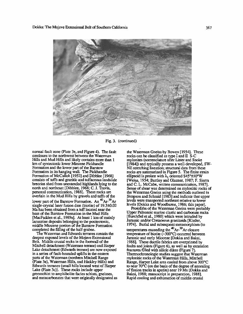
Hills and Mud Hills and likely contains more than 1 km of syntectonic lower Miocene Pickhandle Formation and the lower part of the Barstow Formation in its hanging wall. The Pickhandle Formation of McCulloh [1952] and Dibblee [1968] consists of tuffs and granitic and tuffaceous landslide breccias shed from unextended highlands lying to the north and northeast [Dibblee, 1968; C. J. Travis, personal communication, 1988]. These rocks are overlain in the Mud Hills by gravels and tuffs of the lower part of the Barstow Formation. An 4øAr-39Ar single-crystal laser fusion date (biotite) of 19.3_+0.02 Ma has been obtained from a tuff located near the base of the Barstow Formation in the Mud Hills
[MacFadden et al., 1989a]. At least 1 km of mainly lacustrine deposits belonging to the posttectonic, middle Miocene portion of the Barstow Formation completed the filling of the half-graben.
The Waterman and Edwards terranes contain the
deepest exposed levels of the Mojave Extensional Belt. Middle crustal rocks in the footwall of the
Mitchell detachment (Waterman terrane) and Harper Lake detachment (Edwards terrane) are now exposed in a series of fault-bounded uplifts in the eastern parts of the Waterman (northern Mitchell Range (Plate 3e), Waterman Hills, and Hinkley Hills) and Edwards terranes (small hills located west of Harper Lake (Plate 3c)). These rocks include upper greenschist to amphibolite facies schists, gneisses, and metacarbonates that were originally designated as
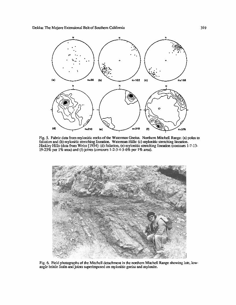
the Waterman Gneiss by Bowen [ 1954]. These rocks can be classified as type I and II S-C mylonites (nomenclature after Lister and Snoke [1984]) and typically possess a well-developed, SW- NE stretching lineation; structural data from these rocks are summarized in Figure 5. The finite strain ellipsoid is prolate with 3.• oriented S45ø+10øW [Weiss, 1954; Bartley and Glazner, 1987; F. Sierra and C. L. McCabe, written communication, 1987]. Sense of shear was determined on mylonitic rocks of the Waterman Gneiss using the methods outlined in Simpson and Schmid [1983] and indicate that upper levels were transported northeast relative to lower levels [Dokka and Woodbume, 1986; this paper].
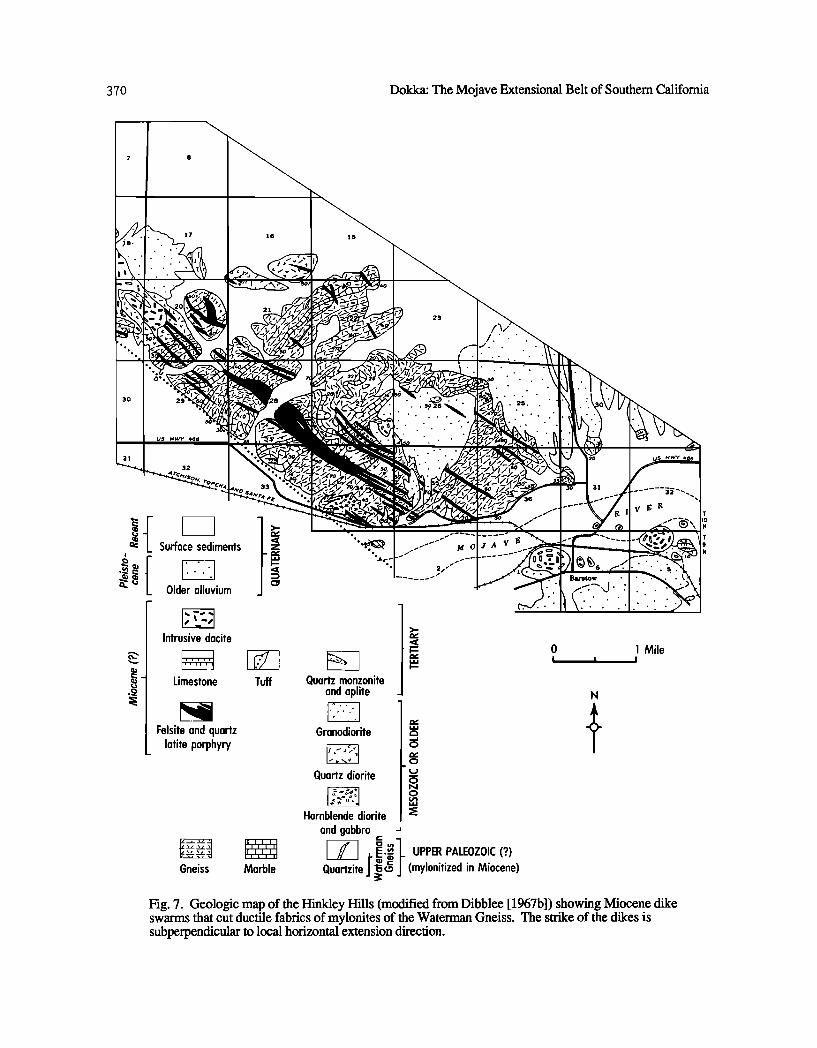
Protoliths of the Waterman Gneiss were probably Upper Paleozoic marine clastic and carbonate rocks [Burchfiel et al., 1980] which were intruded by Jurassic and/or Cretaceous granitoids [Kistler, 1974]. Burial and subsequent metamorphism (to temperatures exceeding the 4øAr-39Ar closure temperature of biotite (-300øC) occurred between Jurassic and early Miocene [Dokka and Baksi, 1988]. These ductile fabrics are overprinted by faults and joints (Figure 6), as well as by extension fractures filled with silicic dikes (Figure 7). Thermochronologic studies suggest that Waterman mylonitic rocks of the Waterman Hills, Mitchell Range, Harper Lake area cooled from above 300øC to near 70øC (on the basis of the degree of annealing of fission tracks in apatite) near 19 Ma [Dokka and Baksi, 1988; manuscript in preparation, 1988]. Rapid cooling and exhumation of middle crustal
368 Dokka: The Mojave Extensional Belt of Southem Califomia
' "..',;' ß, .;x_ ,- .. œ,.•,:'--,'_•,, •_ ,,, ,, ,,
/,- -% i•.` .'..,,,_-•..•';_,.-_-:;;-,,-..',,• ,-,, ...:_.';- . x/,.• •' -.'•'•:d";:.c•,;,,,;;,5,'-,"'i
,/,, ,s • •,'• . ,• Xø-'•I I•.,,,,,-,,•. •, , / • f o• \!l_;l•,•r•t,, _ • . ? ß •
/ ø' "-. t," ' / ,._'::ii • ', o.,%X /, / _ ,:':':':
....... '•/ X , / -:'• -x x, --• ,..'.:.'.,'..f_.:.:.:.:.
,_ .. ,•',.-N. ø" / ,.':.:.:.:.:?..:.:.: ,1' -, •,t,, ' -N / :.:.:.:.:.:.:c,:•-':..-.
x ,' i ' • / •:.'.'.'-•"'-":'•'"" •.- q- • X • •'""" "":'"'"' ' ' ½' ,•. t , n •t ......... ../ X •, .'.'.'.'.'.'.t.'.'.'.'. ß .'.':, • X ,, • ! I".".'.".".".".'.'.',P'.'.% \ %' ..'.'.'.'. •oa .'.'.'.'.' ß
,' • .oo......o..oo... o..o.o.,•...• "'..•. ß .........._. ,I, '• • , , •s , ....... ::.j•..::::::...-..•.k..
'• Ioø,ø.ø.",øoø.øo '• .".øoøoøo"oøo".øo". ',1, .,• •- I ! •..,•............................. ..-,..• •..• ..... ,• . ......
•, , X :• :::::::::::::::::::::::::::::::::::::::::::::::::::::::: ,X. , / "::::::::::::::::::::::::::::::::::::::::::::::::::::
s , - ß. ,--..:.:.:.:.:-:.:.:.:.;..':;•..F.•..?.*..:.: .. '.:., ;::.:.:. ß ,'¾',' ,-, ',_k , /• ' ' ' '•':':••:...:.'.::i:'.'.'-'....-.':':'.'.•::::::::::.X.'::...., •....1 , -,., ,; %,. / •- o,,• "'•- ":" :"-.::•.'.':.:.•:.:i:i::.::::'"'"""'""... '.....'.':'•".'..:'.:::.•::::.'.,";•
• '• Y • ";':':':':':':"'"'""-'"'"'•:':'.".".".".".".X:':':'." J I I • g ..................... ' •.•,• \ o• v (............'.'.'.'.'.'.'.'•.'.'.ooa ...'. :.'.. :. :..N:.'.'.I • /•"'_': X ' • ::::::::::::::::::::::::::::::::::::::::::::::::::
• - • o, ================================================= F - ? -/• ,• ,,,•_-,•.• .... --•;.,::•,•.:.:.:.:.:.:.:.:.:.::.:'•.: ,q•' p,, % V Qa '½.'.'.'.'.'.'.'.'.'.' .'.'.'.'. /i • r, % k • ,- •,, • ..---...- ,:...........::_::Z/...:i::':i:.. "' • l,, '1,, ....... '• 4,," ..... ."o'."'%" ß
.'",4/ •Z •, o,,, ,• ',z, ,_ __ o; ,'.:.3 :.:.:.:.:-:.'.-.-, ,::':'•:, ::.'.'::::?'•.: +/* x , ' Y / 'x ' "' '•.'"' ' """ ...... ,'•'. -•'C:::':':'• -i /.,. t, -, ß .:.:.......:.:.:.:.:.:.. •'&.:.:.:.: . ß * •Pi,-, • . • ,po> F, •.:..% .... .:.:.:.:".)•.".':'... '"-'...:,..";;:•::'.,ø"
+ + + ',•-• %[ , i. • • ., •iii:•, :':"'Z'-. "....":':'•'....".'!.:',•,.':., vL• % ":•."I ,ø •o .".•."o"o".øo".ø.•oøoø•'• '.",
+ + + , r•_ •,• .• ,,• / / ., [. •.:.:.:.:.:.:.:.:.:.:.:.:.:.:• + + . + +t .,.o .• 1 t x 2 j // ,¾'.•; , <.-:':':':':':':':-:':-:':-u •:':
+ + Y ß It'Y i•l ,, "-'.'-'-'.'.'.'.'.'.'.'.'t ,& t '3 fo .:. -' • ........... ..... •' •,- v -;• ...:.:. '.' .-, ,%•.......•o ß ..Oo•o.. ,,,j., , X /ol•4iii ...... ,,..........:.:........•
,,• _ ><, q,•!i:tt; •..:; •,. -.....-../,......-.-.•
• '-' --- ',::•:* .... ' .', '.'.'.', c.'-',v':'( '• J • :::: .:::: .... .' ß V ....
•'.'.il' •' • ß . .I •,'.'. ".
/ '..f• -x • .','. ::, ,-.-. ?• • / :-•c _• •';' ,'::½, •:,' F o. !::,'o.
to .,,,Y • ,.:'•
..oO.'•. ,•,...o.......O..o...%..., .:.:.:...'.:.-....::•:•! ! ! :. ß .'.'.....-.'.'.'_ .•_•-. :',,'.'.. :. :. :• v
•, ... :-:-:-:.:-:-:-'.,,•.-:..'.'.:•,<.,;.:.:• oa'
•i•:• ,' ¾. :. :-:' 52' '..'. ".-'-" :. ':.....' :...'........• '.;:';!:., ß .:.•...•, .•.•o •o ...•.-o.o..O•..•.•o•oO• ß .., . .• • ............ •.'•
.-.:.: ;..:.:.:.:.:.:.:.:.:.:.:.:.:.:• ..: ,•'.':,.•:.-.'. ?-;i.?:i:!:i:i:i:!:i:i:i:; t:.: ß ß ............... •,15' •'"'""', x'.'.'•..:.:.....'..' :.. -..:.:•
ß ::. %.....o.o• •."•"•o•.".•.".ø•'."o•. •.-.•,........, .......•.... :.• '• :.....-.:.': ? t'"'•'* •'" "-' -•'•'.' :...... ß :'•-." :-." :' :': •' ...... ß . -..-'•, c.'.a ' • •, '•:.:•.••• :.'.'[5:.:, D/eiii•.': ? .•.'...'. • ' •.'.'.• •.'.'. v ;•,
'-•z•.'_ ,•.'•, '.'. ß t,".', ' '. • x,,-•" !'-'-'..• ,,' "-"..% 1•',• ,.-.',. •'- •.'-,; ,.'.'. '. - •s;I ¾....•
EXPLANATION
IOal Alluvium
Older alluvium
UNCONFORMITY
ß ........•• Undifferentiated Tertiary
sedimentary and volcanic rocks
UNCONFORMITY
Undifferentiated pre-Tmxiary crystalline rocks
FAULT
Diorite
I wgl Waterman Gneiss
3O
Contact, showing dip Dashed wh•re gradational or approximately 1ocat•cl
20
• ,m, _.. ß ? ß ß Low-angle nomaal fault
Dashe•l whtr e ind•inite, dott•l wh•re concealed; q•eried where doubtful; lOdeS on hanging wall;
arrow shows a•irnuth and plungt of Idntrnatic indicators
70
Moderate- to high-angle normal fault
Dashed whert indefinitt, don•d whert concealed; queri. d wh•r e doub{ful ; arrow shows azimuth and
plunge of Idnematic indicators
2O
Strike and dip of strata
0 1 MILE
Strike and dip of foliations
0 1 KILOMETER ,,,/S /,6 L • • • m • Tread and plunge of lineations
Barb giv• sere of ahe*,r, upper l•vels rno•d in direction barb points
Fig. 4. Geologic map of a portion of the northern Mitchell Range highlighting detachment-related mylonitization, low-angle brittle faulting, and slightly younger moderate-angle normal faulting. Location of map shown on Plate 1.
rocks is considered to have been the result of tectonic denudation [Armstrong, 1972; Dokka et al., 1986] associated with extension of the upper crest. Similar rapid cooling of tectonically denuded areas has been observed in other Cordilleran detachment complexes such as the Whipple Mountains, California [Dokka
and Lingrey, 1979; Davis et al., 1982; DeWitt et al., 1986] and the Ruby Mountains, East Humboldt Range, Nevada [Dokka et al., 1986].
Although the surface of the southern Mitchell Range is not affected by supracrustal normal faulting, it is included in the Waterman terrane
Dokka: The Mojave Extensional Belt of Southern California 369
N N N
.- o
Fig. 5. Fabric data from mylmfitic rocks of the Waterman Gneiss. Northern Mitchell Range: (a) poles to foliation and (b) mylonitic stretching lineation. Waterman Hills: (c) mylonitic stretching lineation. Hinkley Hills (data from Weiss [ 1954]: (d) foliation, (e) mylonitic stretching lineation (contours 1-7-13- 19-25% per 1% area) and (f) joints (contours 1-2-3-4-5-6% per 1% area).
Fig. 6. Field photographs of the Mitchell detachment in the northern Mitchell Range showing late, low- angle brittle faults and joints superimposed on mylonitic gneiss and mylonite.
370 Dokka: The Mojave Extensional Belt of Southern California
ß . •.o26 ß .
Surface sediments
Older alluvium
Intrusive dacite
Limestone
Felsite and quartz latite porphyry
Tuff
Gneiss Marble
Quartz monzonite and aplite
'
Granodiorite o
o
Quartz diorite o
Hornblende diorite and gabbro
Quartzite I•.ø (mylonitized in Miocene)
Mile
N
-.)
Fig. 7. Geologic map of the Hinkley Hills (modified from Dibblee [1967b]) showing Miocene dike swarms that cut ductile fabrics of mylonites of the Waterman Gneiss. The strike of the dikes is subperpendicular to local horizontal extension direction.
Dokka: The Mojave Extensional Belt of Southern California 3 71
because of regional structural considerations. The range is surrounded on the west and north by the Waterman terrane and on the east and south by the Daggett terrane (Figure 2). Mapping of the southern Mitchell Range shows that it contains an intact, late Oligocene-early Miocene age caldera complex [Lambert, 1987]. Tilting of the strata is only seen along the southeastern margin of the range and is considered to be related to drag associated with a upper plate of the Waterman terrane. This model predicts that the Mitchell detachment should lie beneath the range. An alternative hypothesis is that the southern Mitchell Range was fixed to an unextended portion of the crust as surrounding areas extended. The southern Mitchell Range may be similar in structural setting to the Butte Mountains and northern White Pine Range of east central proposed strike-slip fault boundary between the Daggett and Waterman terranes [Lambert, 1987]. Lambert proposed that the southern Mitchell Range was a large, intact block that lay within the extended Nevada, considered to be large, unextended, supracrustal blocks within the northern Basin and Range province [Gans,1987].
Daggett terrane. Stratified 25-20 Ma rocks of the Daggett terrane generally dip 40øSW and sit in the hanging walls of down-to-the-NE, moderately dipping, normal faults [Dokka, 1980, 1986; Mathis, 1986; and Mathis and Dokka, 1986]. The southwestern edge of this terrane occurs in the Newberry Mountains and is marked by the S toddard Valley fault, a curviplanar normal fault ("breakaway" in the terminology of Howard et al. [1982])(Plates 2 and 3f). The breakaway fault is considered to have a "scoop-shaped" geometry by Dokka [1986] because of the development of reverse drag-related features in the hanging wall and by the curved trace of the fault. Its inferred downward flattening geometry and temporal coincidence with the detachment suggest that the breakaway fault may be the uppermost portion of the Newberry Mountains detachment [Dokka, 1986]. Internal deformation of the upper plate in the breakaway region was the result of (1) multiple generations of high-angle, curviplanar normal faults, and (2) the translation of the blocks to less steeply dipping portions of the detachment [Dokka and Glazner, 1982]. Early, originally high- angle (-80ø), normal faults have been rotated to subhorizontal positions by later families of faults [Dokka, 1986]. Three generations of originally high-angle normal faults have been recognized in the Newberry Mountains (Plates 2 and 3f). In contrast, only one generation of planar to slightly curviplanar normal faults can be observed at the surface in the
central part of the terrane (central Cady Mountains; Plate 3g)[Mathis, 1986].
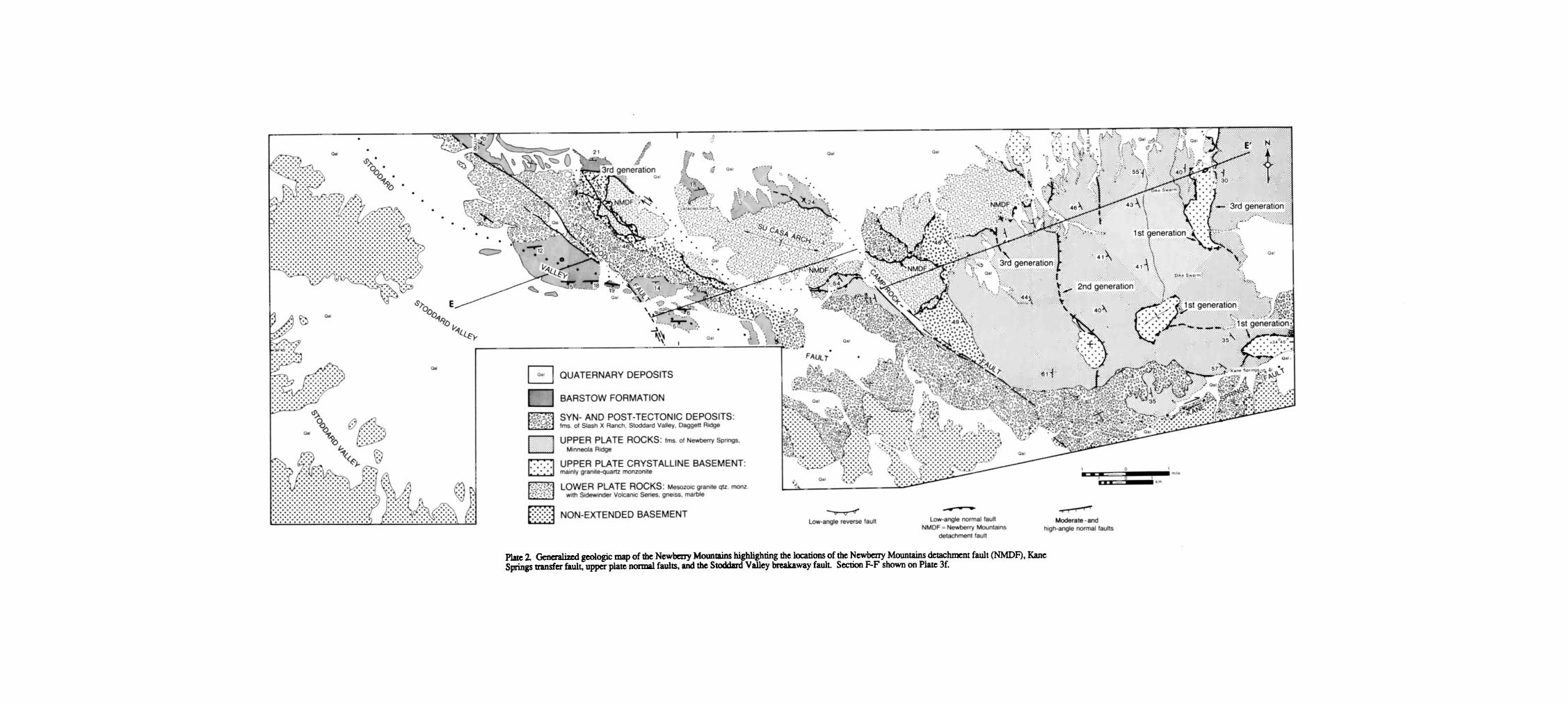
The Newberry Mountains detachment fault crops out near the breakaway of the Daggett terrane (Plate 2 and 3f) and shows evidence of only brittle deformation [Dokka, 1986]. The lower plate
consists of Jurassic and/or Cretaceous hypautomorphic granite-quartz monzonite and diorite, along with Mesozoic Sidewinder Volcanic Series (dacite tuff and flows). A 10- to 100-m-thick zone of chaos composed of microbreccias and cataclasites (Plate 3f) lies directly beneath the detachment. This chaos is probably the result of the small openings created by rotation of the fault blocks above the detachment [Wemicke and Burchfiel, 1982; Gross and Hillemeyer, 1982]. These gaps are now filled with faulted and shattered rock, suggesting that the gaps were closed by a combination of small-scale faulting and cataclastic flow. Zircon fission track thermochronometers from
the fault zone indicate that temperatures have not been above -175øC since the early Tertiary [Dokka, 1986; Dokka and Baksi, 1988]. Exposure of the shallow upper part of the Newberry Mountains detachment by syntectonic and posttectonic arching may be due to isostatic uplift caused by unloading of the footwall of the detachment, as has been proposed by Spencer [ 1984].
Bullion terrane. Upper plate lower Miocene strata of the Bullion terrane generally dip-30øNE in association with steep, SW dipping high-angle normal faults (Plates 1 and 3h)[Dibblee, 1967c; Polovina, 1980; Dokka, 1986]. The Bullion terrane is unique because the polarity of tilting of extended supracrustal rocks is opposite to that of the other terranes. On the basis of the lower degree of tilting the Bullion terrane may be the least extended of all the domains of the Mojave Extensional Belt.
Transfer Zones
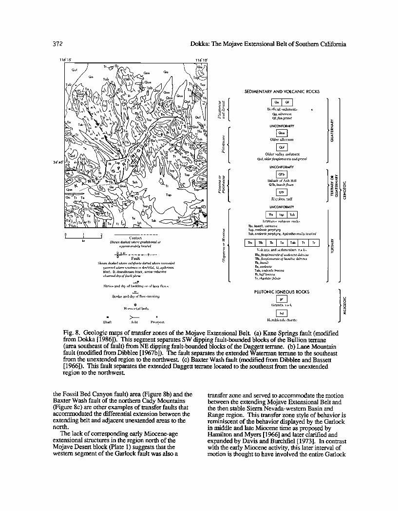
Although most segments of the boundaries between domains of the Mojave Extensional Belt are obscured by syntectonic and posttectonic sedimentary rocks, map-scale geometric and kinematic relations and mapping of exposed portions suggest that these boundaries are strike-slip fault zones. These faults are similar to transfer faults of
rifted continental margins described by Bally [ 1981], Gibbs [1984], and Etheridge et al. [1985]. Transfer zones of the Mojave Extensional Belt accommodated the differential extension between adjacent extensional domains or between an extensional
domain and an unextended region [Dokka, 1986; Dokka and Baksi, 1986]. These fault zones typically have straight traces and yield subhorizontal fault plane kinematic indicators that trend parallel to the extension axis determined for the adjacent terranes. The Kane Springs fault of the Newberry, Rodman, and Bullion Mountains separates the Daggett and Bullion terranes (Figure 8a) and is the best documented example of this type of structure [Dokka, 1986; Dokka and Baksi, 1986]. The Lane Mountain fault of the Lane Mountain-Coyote Lake- Calico Mountains-Mud Hills (locally referred to as
372 Dokka: The Mojave Extensional Belt of Southern California
116o15 '
34 ø 40 ø
Qoa
Tah
• Co ntact Show• dashed where gradat•onal or
approximately located
O f•o ....... ? ..... D Fault
Shown dashed where •ndefimte dotted where concealed querr•ed where existence •s doubtful, U, upthrown block, D, downthrown block; arrow indicates observed &p of /ault plane.
_•o
Strike and dip of beddine or of lava fioxx •
Strike and dip of fioxx-bandln,u
116o10 '
SEDIMENTARY AND VOLCANIC ROCKS
I Qa Qf I Surficial sediment•
Qa, alluwum Qf,fan gravel
UNCONFORMITY
Older alluvium
Older valley •edilnent Oof, older fanglomerate and gravel
UNCONFORMITY
Balsalt of Ash Hill
Qrb, basalt flows
Rhyolitic tuff
UNCONFORMITY
Intrusive wdcanic rock•
Tbi, basalt, •ntrus•ve Tap, andes•te porphyvy Tah, andes•te porphyry, hydrothermally leached
Volcanic and sedilnentarv rock•
Tfa,fanglomerate of a•ules•t'•c detritus Tfb,fanglom erate of ba salt•c detwetus Tb, basalt Ta, andes•te Tab, andestte brecc•a It, tuff breccm Tr, rhyol•ttc Jelszte
Horizontal beda
Shaft Adit Prospect
PLUTONIC IGNEOUS ROCKS
Granitic rock
Hornblende diorite
Fig. 8. Geologic maps of transfer zones of the Mojave Extensional Belt. (a) Kane Springs fault (modified from Dokka [ 1986]). This segment separates SW dipping fault-bounded blocks of the Bullion terrane (area southeast of fault) from NE dipping fault-bounded blocks of the Daggett terrane. (b) Lane Mountain fault (modified from Dibblee [1967b]). The fault separates the extended Waterman terrane to the southeast from the unextended region to the northwest. (c) Baxter Wash fault (modified from Dibblee and Bassett [ 1966]). This fault separates the extended Daggett terrane located to the southeast from the unextended region to the northwest.
the Fossil Bed Canyon fault) area (Figme 8b) and the Baxter Wash fault of the northern Cady Mountains (Figure 8c) are other examples of transfer faults that accommodated the differential extension between the
extending belt and adjacent unextended areas to the noah.
The lack of corresponding early Miocene-age extensional structures in the region north of the Mojave Desert block (Plate 1) suggests that the western segment of the Garlock fault was also a
transfer zone and served to accommodate the motion
between the extending Mojave Extensional Belt and the then stable Sierra Nevada-western Basin and
Range region. This transfer zone style of behavior is reminiscent of the behavior displayed by the Garlock in middle and late Miocene time as proposed by Hamilton and Myers [1966] and later clarified and expanded by Davis and Burchfiel [ 1973]. In contrast with the early Miocene activity, this later interval of motion is thought to have involved the entire Garlock

Dokka: The Mojave Extensional Belt of Southem Califomia 373
/
/
37q Dokka: The Mojave Extensional Belt of Southem Califomia
Qog ? Qoa
Baxter Wash fault•
Qa
•"Qof
ß Qa
•Ta
Fig. 8. (continued)
o .... 1 M, ILE
0 -- -- -- 1 KILOsMETER
SCALE
fault and was associated with the differential
extension between the Basin and Range province to the north and the then stable Mojave Desert block to the south.
Overall Pattern of Strain
Two broad categories of hypotheses, pure shear and simple shear, have been advanced in recent years to explain the structure of continental extension zones such as the Mojave Extensional Belt. Pure shear models [e.g., Miller et al., 1983] treat the detachment as the brittle-ductile transition. The detachment
serves to accommodate brittle extension of the upper plate and more uniform stretching of the lower plate by ductile flow and intrusion of igneous bodies. Although the structure of the upper plate is generally depicted in most pure shear type models as consisting of symmetrically arranged, tilted fault blocks, the model experiments of McClay and Ellis [1987] suggest that a strong asymmetry of these blocks may develop if the detachment is slightly inclined. Simple shear models [e.g., Wernicke, 1981, 1985] consider that detachment faults (originally inclined at < 30 ø) root in the lithosphere or
deeper levels and are the primary elements that facilitate extension. The detachment separates an undeformed lower plate from an upper plate consisting of a series of similarly oriented tilted fault blocks.
Data bearing on lithosphere-scale strain relations of the Mojave Extensional Belt are restricted to the upper and middle crust; an understanding of the behavior of deeper parts of the lithosphere is lacking. Because lithosphere-scale relations are so poorly constrained, the assessment presented below must be considered speculative.
The occurrence of rooted, low-angle normal faults, the lack of evidence for ductile deformation beneath some of the detachments, and the strong asymmetry of tilting of upper plate rocks displayed in each of the domains imply that a simple shear model is more useful than a pure shear model in explaining geologic relations in the Mojave Extensional Belt. Pure shear models cannot be rejected, however, until detailed investigations of deeper parts of the lithosphere enable us to (1) gauge the extent of involvement of the middle and lower crust of the
Mojave in extension and (2) determine the types of Miocene-age strains in the middle and lower crust.

West East
B B'
-- I I J: J .-.;t [: t I I- I l--,J: I- I • • ;,i t_-. •:• x-t•.---.l•--'.• :t -'•:•E:.•--O ....... . • - :._: .•..• . . ..• ..... '•,• - •-• •-•"•
o _.
MOJAVE
f 3:- I ,2
LINE 6 I I Km I
Plate 3. Architecture of extensional domains of the Mojave Extensional Belt. Locations for sections are •ven on Plate 1, except where noted below. (a) Block diagram of the western Mojave Desert (Edwards terrane) based on Consortium for Continental Reflection Proffiing seismic reflection dan [Cheadle et al., 1986]. Note reflection B and the inferred high-angle normal faults that lie above it. Reflection B is interpreted to be a detachment tault (b) Migrated industry seismic line (Texaco) and interpretation of a portion of the Edwards terrane in Antelope Valley illustrating character of modeme angle normal faults, associated tilted upper plate fault blocks, and low-angle normal faults. Mg, Mesozoic granitoid (probably mylonific at depth); Fmu, undifferenfiated Miocene swam; Tins, Miocene syntectonic sedimentary rocks; Trap, Miocene posttectonic sedimentary rocks; QT, undifferenfiated Quaternary and/or Tertiary sedimentary rocks and sediments; (c) Schematic structure section from the Kramer Hills to hills west of Harper Lake (Edwards terrane), based on maps presented in Dibblee [1960a, b, 1968] and Dokka et al. [1988]. wg, Waterman Gneiss; Mg, Mesozoic granitoid qm, quartz monzonite; gd, granodiorite of Fremont Peak; Tmfl, Tropico Group (lower part); Tmrb, Red Buttes dacite; Tmtu, Tropico Group (upper pan); Trak, formation of Kramer Hills; Qal, Quaternary alluvium. (d) Schematic slructure section from Harper Lake to the Rand Mountains (Edwards terrane)[Serpa and Doldca, 1988]. wg, Waterman Gneiss; Mg, Mesozoic gnmitoid; Tmu, undifferentiated Miocene swam. (e) Geologic section across the northern Mitchell Range (Waterman terrane), based on relations shown in Figure 4. Note truncation of brittle and ductile sn-uctures of the Mite[ell detachment by late normal fault (f) Geologic section (balanced) across the northern Newberry Mountains (Daggett terrane), based on map relations presented in Plate 2. (g) Geologic section of the central Cady Mountains (Daggett terrane)[after Mathis, 1986]. Mg, Mesozoic granitoicl; Tvu, unclifferentiated lower Miocene volcanic rocks; Qal, Quaternary alluvium. (h) Geologic section across the Bullion Mountains (Bullion termne)(mo•fied from Dibblee [ 1967c]. Mg, Mesozoic granitoid; Tt, lower Miocene tuff; Tb, lower Miocene basalt; Ta, lower Miocene andesite-dacite; Tap, lower Miocene andesite-dacite intrusives; Qf, Quaternary fanglomerate; Qoal, Quaternary older alluvium; Qai, Quaternary alluvium.
Breakaway Zone Core Complex C • C
• c • -• NNE SSW • '-
-• f : _• LOCK.ART Z'e • K • • & • •r Lake • •ME FRE• P•K • I• ' •ER HILLS ß K•-Mc• • -'•. • • • •E
' ß ß •. , • .... .:,-• . '/ ,[•:'f•-,'-•:,,; . '-'- -,•:• •-;.:: lllt• • v a, •.; v.• •h • • • ............... .. :: : / -.•.. .: ..... ?•:.•-• :'.-: ....... :-"•:- --•,..,,;-:• •wn •-- -
Core Complex Transfer Zane
D õ ; LOCKHART D' NW • .•- DOME ESE Western Garlock Rand Thrust • • Harper Lake
Fault -,•
,• • •' RAND MOUNTAINS - S • ,• .... •• - •o•ecte
4000-
3000-
•2000- 1000-
0
F
• •o,,: DAGGEI"[ •<•. RIDGE
'•o.f,• Oa Oa Oa Tmdr •,•.• --,.._c•.:.-*....:;:*:....=.• ' '• ' '•' ' ' ' . . . . '••••'. ,
ß ._.' :• , -' -'- ß ß '-'- --'- -" -- '" • .
E E'
a•,•raximr. location of Milchel• detochm_ent 2700-• • • '• '• • • / • / /• • • •'• pTu
ENE
• • •• .... , •• • •-• • 1st generaban •- • NEWBERRY ß • • . •:: .• :.... ,• o I •1 • , • • • • • 1st generati• SPRINGS & /•••,•-• ......... :::•:::::•.• •' I •• - • - . • • • - • • Tmn• •'•-'•"••••'• ß -' ...................... :: ...... •1•.• ........................ •.•chaos-- • ••"• ' .: . ' ß • ' '••• '••'•
"• '•'-••••:"-•:: •"::::::::::::": ........ •h[I ..... ::-:":::::::::::::::::::::::'••••"•••-•-••••.%X.•• ;•.• ................. • ......... :::::::::::: ........ Mg ........ . ..;
• ....................... : :• :::: •.• X .. • x •"'"' '•' '••' '• ••• :• -•:• "::::::.::::::.:: ......... ..
G G'
Plate 3. (continued)
Generalized Geologic Map of the
Mojave Desert, California with Emphasis on the Mojave Extensional Belt
Roy K. Dokka 1989
(modified after Dibblee, 1960
and Jennings, 1977)
N
ß MoJave
Rosamonc•
ß Lancaster
Palmdale
RgL Edw,'a rds ,,"
++++++:+I
Littlerock
+ + ++:++ ++
++ +
+ +
+ + +
Fig.
Barstow
,(
ß Daggett • • ".
Ludlow ß
5 I 0 15 20 25 30 35 40 45 50 Miles ,) '-... ß Amboy
5 0 5 10 15 20 25 30 35 40 45 50 Kilometers
Rocks of the Mojave Desert and Surrounding Regions
Alluvium
UNCONFORMITY
Playa clay
UNCONFORMITY
':'.':::• Basalt
UNCONFORMITY
Nonmarine sedimentary and volcanic rocks
UNCONFORMITY
Marine sedimentary rocks and metasedimentary rocks
Plutonic and hypabyssal rocks
Contact
Dashed where gradatJonal or approximately located
Strike and dip of strata
EXPLANATI O N
Rocks of the Mojave Extensional Belt
Posttectonic sedimentary and igneous rocks UNCONFORMITY
Syntectonic stratified rocks (megabreccia, conglomerate, sandstone,
and volcanic rocks)
UNCONFORMITY
Undifferentiated Tertiary
sedimentary and volcanic rocks
UNCONFORMITY Undifferent,ated pre-Tertiary
crystalline rocks FAUL1
Granite-Quartz Monzonite (brittlely deformed along detachment)
Waterman Gneiss (mylonitic with brittle overprint)
Low-angle normal fault
quened where doubtful, nodes on hanging wall
II II .... ? .... Moderate-to high-angle
normal fault Dashed where mdefinffe, dotted where concealed;
queried where doublful; t•ck n•arks on hanging wall
Hate 1. Regional geologic map of the Mojave Desert block and surrounding regions. Locations of geologic maps and cross sections presented in the report are shown. Localities and features mentioned in text: AM, Alvord Mountains; AB, Antelope Buttes; BM, Bullion Mountains; BrM, Bristol Mountains; BL, Bristol Lake; CM, Cady Mountains; DR, Daggett Ridge; FP, Fremont Peak; GH, Gravel Hills; HL, Harper Lake; I-IH, Hinldey Hills; KH, Kramer Hills; MR, Mitchell Range; MH, Mud Hills; NM, Newberry Mountains; OM, Ord Mountains; RM, Rand Mountains; RdM, Rodman Mountains; RgL, Rodgers Dry Lake; RH, Rosamond Hills; RL, Rosamond Dry Lake; WH, Waterman Hills. KSF, Kane Springs fault; LMF, Lane Mountain fault:, BWF, Baxter Wash fault.
;ø% .• I ß '.:i:i:::i::'::::::,' ........ ""'":':':':'
/ " •,'' ½ '•'• ' :::::::::::::::::::::: E ....... ::••_ • ß ,•, :• ',•..¾•;.• ............ '":'::::::::::':'. •0 - 3rdgeneration .? ; •. , ..... •' • ......................... ..... . •.•--• •., •'•% -• • x: •, :-:::::::::.:::::' ' '
•:::u .:_• .• ,,,, ,=., -- '...::::::::::::::::::::::::::::::::: ::::::::::::::::::::::::::: . • .. ..: .... sE:•:•:E:E:E:•:E::.:.:.:. ' . . '" :t.
ß ============================= 1 St •e•eration' ..-.-- '• '• ::: : :::: '
:'.: ' ß ,ss• 3rd generation: ::::::::::::::::::::::::::::::::::::::::::::::::::: • -"-'-'-'-'-'--.' -- ........ --.' ::•]]•E]]• :':':::-- '"• ':'":'"'"':'"'"'"'"'"'"" .......
o=• .... -•' ...• :•:•:•: ß ß -:-:-:-:-:-:-:-:':':':'• " •? • '"': .......... •' st le ........... • • -. :.::...•:•:•:: ::::::::::::: •. •?:::;:::::•:::: • •:: ..:.•: ::•:;•:?.•:.•::?'.. • •" %% ...................... s:•::.::::.::,:, .......... ::. '""':%'. ::::• - --, • -'• '•7 • , ............. • - -' -.;½ '• • ' •; ':::¾;)?•?.::::::• -- -.-.-.-.-.-...-.---- :::-:'::M:E:•...::?•:' . .....
• '%' * ß • • % ':::::¾:::::'::::: ..... •aULT" ):.. ss':.?:;:':.:: -: ssssss:' ........ :.:-':::-:::':-:"
•' • QUATERNARY DEPOSITS :• .- e'•-]-::' ':':':':' ............ ..:•?: .. ..- ..
• BARSTOW FORMATION •,, • . •.
% •;;• S YN- AND POST-TECTONIC DEPOSITS: --'-"-"-"-'-"-2-= -, ........ fins of Slash X Ra•ch. StCdard Valley. DaggeH R•dge '.'.%".".'.".'.' .., • .....
..';:'• ". . .-...-.-.- ...• ,. ............... ;.:.:.;.., ,.-,.-:,....< :................................-.- ß • -.-.• UPPER P•TE ROCKS: f•s. oJ Newber• S•rmgs, , • ......................... Minn•la Ridge .-:=:-:":? ":?•'•½ ,.-.-.-.-., ,..,,,................................. - ;.• UPPER PLATE CRYSTALLINE BASEMENT: ..... -' •-'-' '• '-'-'-'-'-'-'-'-'-""•-'-" .=."."r;• • - . .- ........ • - .
•,, k;.:½ •:-;-: :'-j- ß. , LOWER PLATE ROCKS: MesozOic granite ½. monz - •
with S•dewinder Volcanic Series, gneiss, ma•le
• NON-EXTENDED BASEMENT • • • Low-angle reverse fault Low-angle normal fau• •erale- and NMDF = Newber• Mountains h•gh-angle normal faults
detachment faull
Plate 2. Generalized geologic map of the Newberry Mountains highlighting the locations of the Newberry Mountains detachment fault (NMDF), Kane Springs transfer fault, upper plate normal faults, and the Stoddard Valley breakaway fault. Section F-F shown on Plate 3f.
Dokka: The Mojave Extensional Belt of Southem Califomia 379
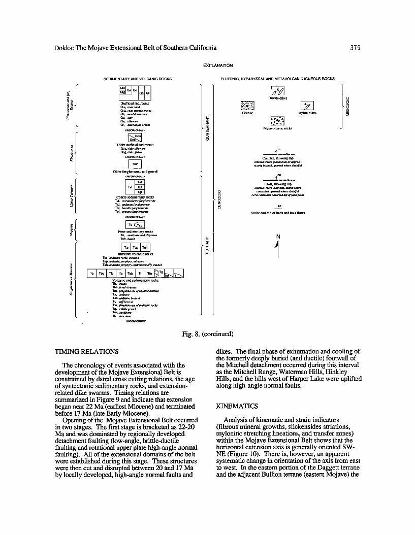
EXPLANATION
SEDIMENTARY AND VOLCANIC ROCKS
Oa Qf Surficial sediments
Qrs, rlver sand Qrg, river terrace gravel Qs, wtndblown sand Qc, day Qa, alluwutn Qf, alluwal fan gravel
UNCONFOFIMITY
Older surficial sediments Qoa, older alluwum Oog, older gravel
UNCONFORMITY
Older fanglomerate and gravel UNCONFORMITY
Coarse .sedimentary rocks T•, volcaniclastic fanglomerate Taf, andesitic fanglomerate Tbf, basaltic fanglomerate Tgf, granitic fanglomerate
UNCONFORMITY
Finer sedimentary rocks Ts, sandstone and claystone Tsb, basalt
Tai Tap Tab Intrusive volcanic rocks
Tai, andesitic rock, intrusive Tap, andesitic porphyry, intrusive Tah, andesitic porphyry, hydrothermally leached
Volcanic and sedimentary rocks Tb, basalt Tbb, basalt breccta Tfb, fanglomerate of basaltic detritus Ta, andesite Tab, andesitic breccia Tt, tuff breccia Tfa, fanglomerate of andesitic roc• Tg, cobble gravel T$$, sandstone TI, limestone
UNCONFORMITY
PLUTONIC, HYPABYSSAL AND METAVOLCANIC IGNEOUS ROCKS
Diorite dikes
Granite Aplite dikes
Merevolcanic rocks
7O
•_--.•--- Contact, showing dip
Dashed where gradational or approxz- mately located, queried where doubtful
30
/• ll•l I I Fault, showing dip
Dashed where tndefintte, dotted where concealed; queried where doubtful.
Arrow tnchcates observed chp of fault plane
lO
Slxike and dip of beds and lava flows
N
Fig. 8. (continued)
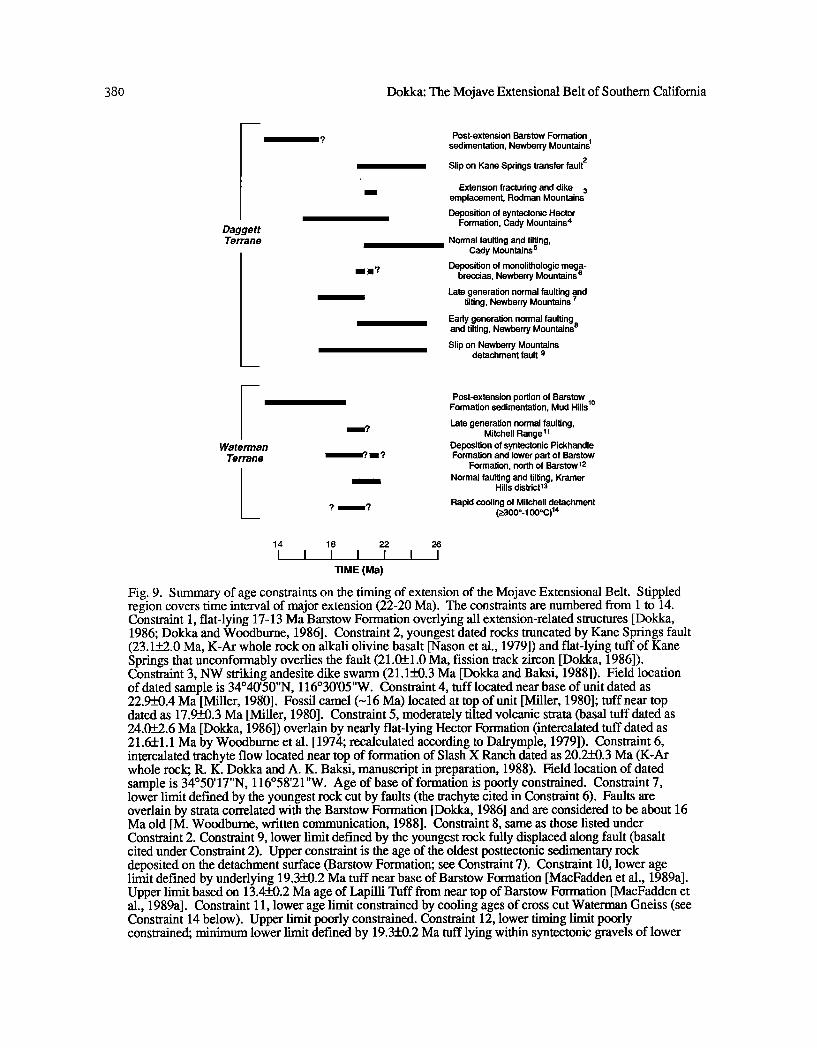
TIMING RELATIONS
The chronology of events associated with the development of the Mojave Extensional Belt is constrained by dated cross cutting relations, the age of syntectonic sedimentary rocks, and extension- related dike swarms. Timing relations are summarized in Figure 9 and indicate that extension began near 22 Ma (earliest Miocene) and terminated before 17 Ma (late Early Miocene).
Opening of the Mojave Extensional Belt occurred in two stages. The first stage is bracketed as 22-20 Ma and was dominated by regionally developed detachment faulting (low-angle, brittle-ductile faulting and rotational upper plate high-angle normal faulting). All of the extensional domains of the belt were established during this stage. These structures were then cut and disrupted between 20 and 17 Ma by locally developed, high-angle normal faults and
dikes. The final phase of exhumation and cooling of the formerly deeply buried (and ductile) footwall of the Mitchell detachment occurred during this interval as the Mitchell Range, Waterman Hills, Hinkley Hills, and the hills west of Harper Lake were uplifted along high-angle normal faults.
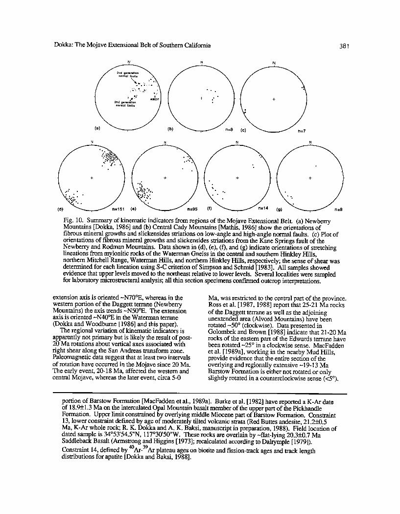
KINEMATICS
Analysis of kinematic and strain indicators (fibrous mineral growths, slickensides striations, mylonitic stretching lineations, and transfer zones) within the Mojave Extensional Belt shows that the horizontal extension axis is generally oriented SW- NE (Figure 10). There is, however, an apparent systematic change in orientation of the axis from east to west. In the eastern portion of the Daggett terrane and the adjacent Bullion terrane (eastern Mojave) the
380 Dokka: The Mojave Extensional Belt of Southern California
Daggett Terrane
Waterman Terrane
.........
.......
Post-extension Barstow Formation
sedimentation, Newberry Mountains 1
Slip on Kane Springs transfer fault 2
Extension fracturing and dike 3 emplacement, Rodman Mountains
Deposition of syntectonic Hector Formation, Cady Mountains 4
Normal faulting and tilting, Cady Mountains 5
Deposition of monolithologic mega- breccias, Newberry Mountains 6
Late generation normal faulting •nd tilting, Newberry Mountains
Early generation normal faulting and tilting, Newberry Mountains 8 Slip on Newberry Mountains
detachment fault 9
Post-extension portion of Barstow Formation sedimentation, Mud Hills 1ø Late generation normal faulting,
Mitchell Range 11 Deposition of syntectonic Pickhandle Formation and lower part of Barstow
Formation, north of Barstow12 Normal faulting and tilting, Kramer
Hills district13
Rapid cooling of Mitchell detachment (>300o-100øC) 14
14 18 22 26
TIME (Ma)
Fig. 9. Summary of age constraints on the timing of extension of the Mojave Extensional Belt. Stippled region covers time interval of major extension (22-20 Ma). The constraints are numbered from 1 to 14. Constraint 1, flat-lying 17-13 Ma Barstow Formation overlying all extension-related structures [Dokka, 1986; Dokka and Woodburne, 1986]. Constraint 2, youngest dated rocks truncated by Kane Springs fault (23.1+_2.0 Ma, K-Ar whole rock on alkali olivine basalt [Nason et al., 1979]) and flat-lying tuff of Kane Springs that unconformably overlies the fault (21.05-_1.0 Ma, fission track zircon [Dokka, 1986]). Constraint 3, NW striking andesite dike swarm (21.1_-+0.3 Ma [Dokka and Baksi, 1988]). Field location of dated sample is 34ø40'50"N, 116ø30'05"W. Constraint 4, tuff located near base of unit dated as 22.9_+0.4 Ma [Miller, 1980]. Fossil camel (N16 Ma) located at top of unit [Miller, 1980]; tuff near top dated as 17.950.3 Ma [Miller, 1980]. Constraint 5, moderately tilted volcanic strata (basal tuff dated as 24.0+_2.6 Ma [Dokka, !986]) overlain by nearly flat-lying Hector Formation (intercalated tuff dated as 21.6+1.1 Ma by Woodburne et al. [ 1974; recalculated according to Dalrymple, 1979]). Constraint 6, intercalated trachyte flow located near top of formation of Slash X Ranch dated as 20.2+0.3 Ma (K-Ar whole rock; R. K. Dokka and A. K. Baksi, manuscript in preparation, 1988). Field location of dated sample is 34ø50'17"N, 116ø58'21"W. Age of base of formation is poorly constrained. Constraint 7, lower limit defined by the youngest rock cut by faults (the trachyte cited in Constraint 6). Faults are overlain by strata correlated with the Barstow Formation [Dokka, 1986] and are considered to be about 16 Ma old [M. Woodburne, written communication, 1988]. Constraint 8, same as those listed under Constraint 2. Constraint 9, lower limit defined by the youngest rock fully displaced along fault (basalt cited under Constraint 2). Upper constraint is the age of the oldest posttectonic sedimentary rock deposited on the detachment surface (Barstow Formation; see Constraint 7). Constraint 10, lower age limit defined by underlying 19.3_+0.2 Ma tuff near base of Barstow Formation [MacFadden et al., 1989a]. Upper limit based on 13.4_+0.2 Ma age of Lapilli Tuff from near top of Barstow Formation [MacFadden et al., 1989a]. Constraint 11, lower age limit constrained by cooling ages of cross cut Waterman Gneiss (see Constraint 14 below). Upper limit poorly constrained. Constraint 12, lower timing limit poorly constrained; minimum lower limit defined by 19.3+0.2 Ma tuff lying within syntectonic gravels of lower
Dokka: The Mojave Extensional Belt of Southem Califomia 381
N N N
N N N N
ø o o
o
(d) e
Fig. 10. Summary of kinematic indicators from regions of the Mojave Extensional Belt. (a) Newberry Mountains [Dokka, 1986] and (b) Central Cady Mountains [Mathis, 1986] show the orientations of fibrous mineral growths and slickensides striations on low-angle and high-angle normal faults. (c) Plot of orientations of fibrous mineral growths and slickensides striations from the Kane Springs fault of the Newberry and Rodman Mountains. Data shown in (d), (e), (f), and (g) indicate orientations of stretching lineations from mylonitic rocks of the Waterman Gneiss in the central and southern Hinkley Hills, northern Mitchell Range, Waterman Hills, and northern Hinkley Hills, respectively; the sense of shear was determined for each lineation using S-C criterion of Simpson and Schmid [ 1983]. All samples showed evidence that upper levels moved to the northeast relative to lower levels. Several localities were sampled for laboratory microstructural analysis; all thin section specimens confkmed outcrop interpretations.
extension axis is oriented-•N70øE, whereas in the western portion of the Daggett terrane (Newberry Mountains) the axis trends .•N50øE. The extension axis is oriented .•N40øE in the Waterman terrane (Dokka and Woodburne [1986] and this paper).
The regional variation of kinematic indicators is apparently not primary but is likely the result of post- 20 Ma rotations about vertical axes associated with fight shear along the San Andreas transform zone. Paleomagnetic data suggest that at least two intervals of rotation have occurred in the Mojave since 20 Ma. The early event, 20-18 Ma, affected the western and central Mojave, whereas the later event, circa 5-0
Ma, was restricted to the central part of the province. Ross et al. [ 1987, 1988] report that 25-21 Ma rocks of the Daggett terrane as well as the adjoining unextended area (Alvord Mountains) have been rotated-*50 ø (clockwise). Data presented in Golombek and Brown [1988] indicate that 21-20 Ma rocks of the eastern part of the Edwards terrane have been rotated-•25 ø in a clockwise sense. MacFadden et al. [ 1989a], working in the nearby Mud Hills, provide evidence that the entire section of the overlying and regionally extensive -•19-13 Ma Barstow Formation is either not rotated or only slightly rotated in a counterclockwise sense (<5ø).
portion of Barstow Formation [MacFadden et al., 1989a]. Burke et al. [ 1982] have reported a K-Ar date of 18.9-k-_1.3 Ma on the intercalated Opal Mountain basalt member of the upper part of the Pickhandle Formation. Upper limit constrained by overlying middle Miocene part of Barstow Formation. Constraint 13, lower constraint defined by age of moderately tilted volcanic strata (Red Buttes andesite, 21.2_+0.5 Ma, K-Ar whole rock; R. K. Dokka and A. K. Baksi, manuscript in preparation, 1988). Field location of dated sample is 34ø53'54.5"N, 117ø30'50"W. These rocks are overlain by -•flat-lying 20.3+0.7 Ma Saddleback Basalt (Armstrong and Higgins [ 1973]; recalculated according to Dalrymple [1979]). Constraint 14, defined by 4øAr-39Ar plateau ages on biotite and fission-track ages and track length distributions for apatite [Dokka and Baksi, 1988].
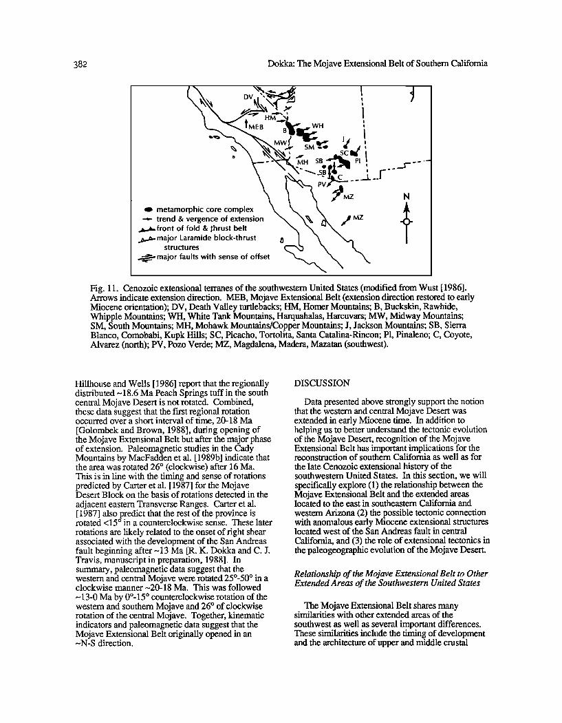
382 Dokka: The Mojave Extensional Belt of Southern Califomia
e metamorphic core complex
--,.- trend & vergence of extension •,/MZ • front of fold & •hrust belt ..•.•,,major Laramide block-thrust i•
structu res
• major faults with sense of offset
ß
N
Fig. 11. Cenozoic extensional terranes of the southwestem United States (modified from Wust [ 1986]. Arrows indicate extension direction. MEB, Mojave Extensional Belt (extension direction restored to early Miocene orientation); DV, Death Valley turtlebacks; HM, Homer Mountains; B, Buckskin, Rawhide, Whipple Mountains; WH, White Tank Mountains, Harquahalas, Harcuvars; MW, Midway Mountains; SM, South Mountains; MH, Mohawk Mountains/Copper Mountains; J, Jackson Mountains; SB, Sierra Blanco, Comobabi, Kupk Hills; SC, Picacho, Tortolita, Santa Catalina-Rincon; P1, Pinaleno; C, Coyote, Alvarez (north); PV, Pozo Verde; MZ, Magdalena, Madera, Mazatan (southwest).
Hillhouse and Wells [ 1986] report that the regionally distributed --18.6 Ma Peach Springs tuff in the south central Mojave Desert is not rotated. Combined, these data suggest that the first regional rotation occurred over a short interval of time, 20-18 Ma [Golombek and Brown, 1988], during opening of the Mojave Extensional Belt but after the major phase of extension. Paleomagnetic studies in the Cady Mountains by MacFadden et al. [ 1989b] indicate that the area was rotated 26 ø (clockwise) after 16 Ma. This is in line with the timing and sense of rotations predicted by Carter et al. [ 1987] for the Mojave Desert Block on the basis of rotations detected in the
adjacent eastern Transverse Ranges. Carter et al. [ 1987] also predict that the rest of the province is rotated <15 ø in a counterclockwise sense. These later
rotations are likely related to the onset of fight shear associated with the development of the San Andreas fault beginning after--13 Ma [R. K. Dokka and C. J. Travis, manuscript in preparation, 1988]. In summary, paleomagnetic data suggest that the westem and central Mojave were rotated 25ø-50 ø in a clockwise manner--20-18 Ma. This was followed
--13-0 Ma by 0ø-15 ø counterclockwise rotation of the western and southern Mojave and 26 ø of clockwise rotation of the central Mojave. Together, kinematic indicators and paleomagnetic data suggest that the Mojave Extensional Belt originally opened in an -*N-S direction.
DISCUSSION
Data presented above strongly support the notion that the western and central Mojave Desert was extended in early Miocene time. In addition to helping us to better understand the tectonic evolution of the Mojave Desert, recognition of the Mojave Extensional Belt has important implications for the reconstruction of southern California as well as for the late Cenozoic extensional history of the southwestern United States. In this section, we will specifically explore (1) the relationship between the Mojave Extensional Belt and the extended areas located to the east in southeastern California and western Arizona (2) the possible tectonic connection with anomalous early Miocene extensional structures located west of the San Andreas fault in central California, and (3) the role of extensional tectonics in the paleogeographic evolution of the Mojave Desert.
Relationship of the Mojave Extensional Belt to Other Extended Areas of the Southwestern United States
The Mojave Extensional Belt shares many similarities with other extended areas of the
southwest as well as several important differences. These similarities include the timing of development and the architecture of upper and middle crustal
Dokka: The Mojave Extensional Belt of Southern California 383
strain. The differences between the regions are mainly kinematic in nature and may give us insights into the dynamics of late Cenozoic extension of the southwestern United States.
The same array of early Miocene-age extensional structures (brittle-ductile detachment faults, multiple generations of high-angle nom•al faults, and extension fractures and associated dike swanks) found in the Mojave Extensional Belt have been described along the Colorado River (e.g., Whipple Mountains [Davis et al. 1980; Davis, 1988], Homer Mountains [Spencer, 1985], and Chemehuevi Mountains [John, 1987]) and western Arizona (e.g., Buckskin-Rawhide Mountains [Reynolds and Spencer, 1985]). However, the Mojave Extensional Belt and the extended terranes lying to the east differ markedly in terms of the orientation of their horizontal extension directions and in the relative
amount of exposed exhumed middle crustal rocks. Figure 11 shows the location of coincident extensional terranes of the southwest, with arrows indicating the orientation of the local horizontal extension axis. The Mojave Extensional Belt opened in an ~N-S direction, whereas the terranes of the Colorado River and of western Arizona apparently extended in a ENE-WSW direction [Davis et al., 1980; Spencer and Reynolds, 1986]. The ~50 ø difference of trend seems to reflect fundamental
differences in the kinematics of development. Some have recently advocated that late Cenozoic
extension of the western United States was the result of failure of an overthickened crustal welt created in
Mesozoic time by the stacking of thrust sheets and by intrusion [e.g., Coney and Hanns, 1984; Wust, 1986; Wemicke et al., 1987]. The kinematics of failure may have been controlled by the trend of the welt; the direction of extension in southeastern California and western Arizona as well the rest of the
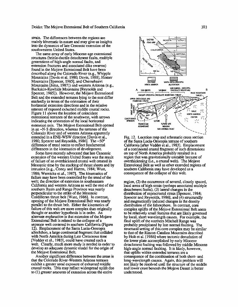
southern Basin and Range Province was nearly perpendicular to the strike of the Mesozoic Cordilleran thrust belt [Wust, 1986]. In contrast, opening of the Mojave Extensional Belt was nearly parallel to the thrust belt. Either the kinematics of failure of this welt are more complex than originally thought or another hypothesis is in order. An alternate explanation is that extension of the Mojave Extensional Belt is related to the collapse of a separate welt centered in southern California (Figure 12). Emplacement of the Santa Lucia-Orocopia allochthon, a large continental fragment that collided with North America during Late Cretaceous time [Vedder et al., 1983], could have created such a welt. Clearly, much more study is needed in order to develop an adequate dynamic model for the origin of the Mojave Extensional Belt.
Another significant difference between the areas is that the Colorado River-•Vestern Arizona terranes
exhibit a greater areal exposure of exhumed middle crustal rocks. This may reflect widespread uplift due to (1) greater amounts of extension across the entire
!i;.:k• Sr87/86 '.. NEVA•)A• i:;;;•!iT• .7060 LINE • .... ' , -
iiiiilili!i:ii::: .... CALIFOR•41A " • ,/•/•/• ' -,,.• ARIZONA: ................. • •••. • • •/J•l>•2 ,
............. ••"""•"•':••:••':•:•••••'. ;•t_____..____• .... '"" ....... '"'"" .... -• ....................... • •ziiil•1111•
MEXICO • ß
CR•IONIC S•NIg LBCI•-OROCOPI•
NORTH •ERIC• •LLOCHIHON
S•N G•BRIEL, OROCOPI•, A S•R-OBISPO S•LINI•N CliOCOLlIE •O•NI•INS
I I i • • • • • • •BLE •OBNI•INS
IHRBSI. IHRBSI'
UPPER CRETACEOUS AND •' .LEOCE.ESTT ' '
• • •.; /
FRANCISCAN FUTURE SITE
Fig. 12. Location map and schematic cross section of the Santa Lucia-Orocopia terrane of southern California [after Vedder et al., 1983]. Emplacement of a continental crustal fragment of such dimensions on top of North America probably resulted in a region that was gravitationally unstable because of overthickening (i.e., a crustal welt). The Mojave Extensional Belt as well as other extended regions of southern California may have developed as a consequence of the collapse of this welt.
region, (2) the occurrence of several, closely spaced, local areas of high strain (perhaps associated multiple detachment faults), (3) lateral changes in the distribution of supracrustal strain [Spencer, 1984; Spencer and Reynolds, 1986], and (4) structurally and magrnatically induced changes in the density' distribution of the lithosphere. In contrast, core complex uplifts of the Mojave Extensional Belt seem to be relatively small features that are likely governed by local, short wavelength causes. For example, the final uplift of the northern Mitchell Range was probably precipitated by late normal faulting. The structural setting of this core complex may be similar to that of the Rincon-Catalina Mountains described by Holt et al. [1986] where tectonic denudation of the lower plate accomplished by early Miocene detachment faulting was followed by middle Miocene high-angle normal faulting. It is likely, however, that uplifts within extended terranes are a consequence of the combination of both short- and long-wavelength causes. Again, this problem will not likely be resolved until the structure of the middle and lower crust beneath the Mojave Desert is better understood.
384 Dokka: The Mojave Extensional Belt of Southem California
The Mojave Extensional Belt and the San Andreas Fault
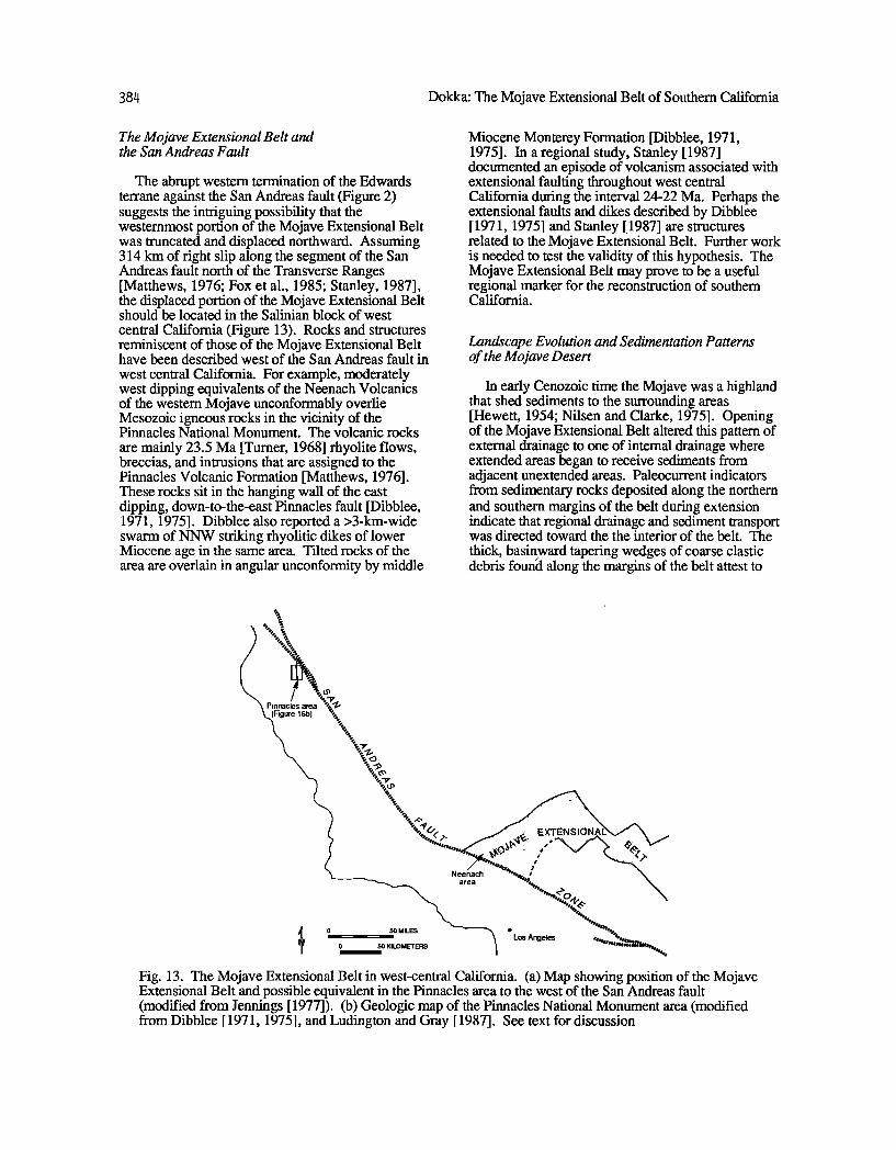
The abrupt western termination of the Edwards terrane against the San Andreas fault (Figure 2) suggests the intriguing possibility that the westernmost portion of the Mojave Extensional Belt was truncated and displaced northward. Assuming 314 km of fight slip along the segment of the San Andreas fault north of the Transverse Ranges [Matthews, 1976; Fox et al., 1985; Stanley, 1987], the displaced portion of the Mojave Extensional Belt should be located in the Salinian block of west
central California (Figure 13). Rocks and structures reminiscent of those of the Mojave Extensional Belt have been described west of the San Andreas fault in
west central California. For example, moderately west dipping equivalents of the Neenach Volcanics of the western Mojave unconformably overlie Mesozoic igneous rocks in the vicinity of the Pinnacles National Monument. The volcanic rocks
are mainly 23.5 Ma [Turner, 1968] rhyolite flows, breccias, and intrusions that are assigned to the Pinnacles Volcanic Formation [Matthews, 1976]. These rocks sit in the hanging wall of the east dipping, down-to-the-east Pinnacles fault [Dibblee, 1971, 1975]. Dibblee also reported a >3-km-wide swarm of NNW striking rhyolitic dikes of lower Miocene age in the same area. Tilted rocks of the area are overlain in angular unconformity by middle
Miocene Monterey Formation [Dibblee, 1971, 1975]. In a regional study, Stanley [1987] documented an episode of volcanism associated with extensional faulting throughout west central California during the interval 24-22 Ma. Perhaps the extensional faults and dikes described by Dibblee [ 1971, 1975] and Stanley [ 1987] are structures related to the Mojave Extensional Belt. Further work is needed to test the validity of this hypothesis. The Mojave Extensional Belt may prove to be a useful regional marker for the reconstruction of southern California.
Landscape Evolution and Sedimentation Patterns of the Mojave Desert
In early Cenozoic time the Mojave was a highland that shed sediments to the surrounding areas [Hewett, 1954; Nilsen and Clarke, 1975]. Opening of the Mojave Extensional Belt altered this pattern of external drainage to one of internal drainage where extended areas began to receive sediments from adjacent unextended areas. Paleocurrent indicators from sedimentary rocks deposited along the northern and southern margins of the belt during extension indicate that regional drainage and sediment transport was directed toward the the interior of the belt. The
thick, basinward tapering wedges of coarse clastic debris foun•l along the margins of the belt attest to
Neenach area
• 0•0 MILES 0 50 KILOMETERS "• ß Los Angeles Fig. 13. The Mojave Extensional Belt in west-central California. (a) Map showing position of the Mojave Extensional Belt and possible equivalent in the Pinnacles area to the west of the San Andreas fault (modified from Jennings [ 1977]). (b) Geologic map of the Pinnacles National Monument area (modified from Dibblee [1971, 1975], and Ludington and Gray [1987]. See text for discussion
Dokka: The Mojave Extensional Belt of Southem California
121ø15 '
Qa GLORIA
/
121o10 '
i
,Tsg
Tsg
36o30 '
385
36025 '
,• Tpr Q•p! ß
QTp ß
1 2 Miles I I
Tsg
/30
ß NORTH CHALONE ' •-•, PEAK
/•3269 ( ( •,SOUTH CHALONE PEAK (
Jpv "•/ •__•.,,.• •....•
/
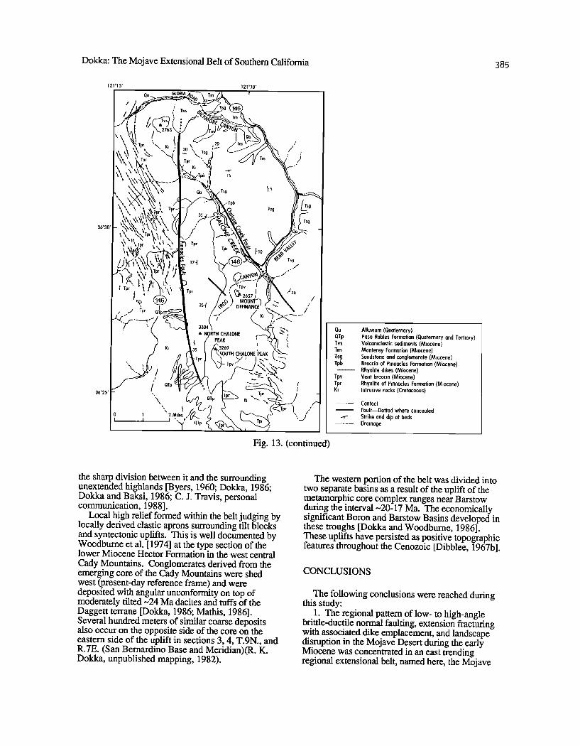
Fig. 13. (continued)
Qa Alluvium (Quaternary) QTp Paso Robles Formation (Quaternary and Tertiary) Tvs Volcaniclastic sediments (Miocene) Tm Monterey Formation (Miocene) Tsg Sandstone and conglomerate (Miocene) Tpb Breccia of Pinnacles Formation (Miocene)
Rhyolite dikes (Miocene) Tpv Vent breccia (Miocene) Tpr Rhyolite of Pinnacles Formation (Miocene) Ki Intrusive rocks (Cretaceous)
Contact
Fault--Dotted where concealed Strike and dip of beds Drainage
the sharp division between it and the surrounding unextended highlands [Byers, 1960; Dokka, 1986; Dokka and Baksi, 1986; C. J. Travis, personal communication, 1988].
Local high relief formed within the belt judging by locally derived clastic aprons surrounding tilt blocks and syntectonic uplifts. This is well documented by Woodburne et al. [1974] at the type section of the lower Miocene Hector Formation in the west central Cady Mountains. Conglomerates derived from the emerging core of the Cady Mountains were shed west (present-day reference frame) and were deposited with angular unconformity on top of moderately tilted-•24 Ma dacites and tuffs of the Daggett terrane [Dokka, 1986; Mathis, 1986]. Several hundred meters of similar coarse deposits also occur on the opposite side of the core on the eastern side of the uplift in sections 3, 4, T.9N., and R.7E. (San Bernardino Base and Meridian)(R. K. Dokka, unpublished mapping, 1982).
The western portion of the belt was divided into two separate basins as a result of the uplift of the metamorphic core complex ranges near Barstow during the interval -•20-17 Ma. The economically significant Boron and Barstow Basins developed in these troughs [Dokka and Woodburne, 1986]. These uplifts have persisted as positive topographic features throughout the Cenozoic [Dibblee, 1967b].
CONCLUSIONS
The following conclusions were reached during this study:
1. The regional pattern of low- to high-angle brittle-ductile normal faulting, extension fracturing with associated dike emplacement, and landscape disruption in the Mojave Desert during the early Miocene was concentrated in an east trending regional extensional belt, named here, the Mojave
386 Dokka: The Mojave Extensional Belt of Southem Califomia
Extensional Belt. The now disrupted surface expression of this extended zone can be traced west from near the western edge of the extended terranes of the Colorado River to the San Andreas fault. The San Andreas fault truncated the western part of the Mojave Extensional Belt and transported it to its present position in west central California.
2. Strain within the Mojave Extensional Belt was partitioned into at least four extensional domains. The domains are separated by strike-slip faults (transfer zones) that accommodated the differences in extension between the domains and surrounding unextended areas. The lack of early Miocene extensional elements north of the western segment of the Gatlock fault suggests that the Garlock may have been active during early Miocene time and served as the northern transfer zone boundary of the Mojave Extensional Belt.
3. The Mojave Extensional Belt was active between -22 and 17 Ma, with the major phase of opening occurring between -22 and 20 Ma. This major phase was dominated by regional detachment faulting, whereas later extension was concentrated in local areas and was marked by high-angle normal faulting and by the emplacement of silicic dike swarms.
4. The architecture of an individual extensional
domain is that of a single or family of half-graben. The upper part of a half-graben consists of moderately tilted fault blocks that are bounded by planar to slightly curviplanar normal faults. Multiple generations of originally high-angle normal faults are apparently responsible for extension and tilting of the upper plate. Each half-graben is floored by a low- angle, regional, brittle-ductile, simple shear zone (detachment fault). First-order extension of the upper and middle crust of the region was dominantly accomplished by large-scale simple shear. The nature of the overall strain of the Mojave Extensional Belt must remain speculative until the degree of extension of the subjacent lower crust and mantle is determined.
Acknowledgements. Gratitude is expressed to G. Couples, E. L. Miller, B.C. Burchfiel, S. M. Jones, M. O. Woodbume, and S. Wust for their careful and constructive reviews. Discussions with R. B lom, J. Brem, B. Cox, G. A. Davis, G. H. Davis, J. Ford, M. McCurry, E.G. Frost, J, Lambert, R. Lawson, B. Luyendyk, R. H. Merriam, R. Mathis, B. McFaddon, N. Opdyke, T. Ross, L. Serpa, and C. J. Travis were invaluable. I also thank P. Frost, V. Iliff, C. Johnson, M. Kolb, M. Mahaffie, and the late J. Meystayer for their able assistance in the field and in the laboratory. Very little could have been accomplished without the efforts of co-workers on the Mojave Desert team, A. K. Baksi, D. Henry, J. Lambert, C. McCabe, S. Jones, R. Mathis, J. Nunn, L. Serpa, and C. J. Travis. I also thank Texaco USA, especially M. Cole, J. Bihm, D.
LeCorgne, and K. Stewart, for making available seismic and related geophysical data of the western Mojave. R. L. Parrart of Santa Fe Mining, Inc. graciously made available copies of unpublished geologic maps of the Mojave Desert. The figures and plates were carefully prepared by M. Eggart, C. Duplechin, and J. Kennedy. C. J. Travis and the author electronically drafted the geologic map depicted on Figure 4 using a microcomputer, scanner, and laser printer. Prompt and professional editorial and production assistance was provided by P. Hanback and J. Ring. Finally, my deepest thanks go out to B. Page, Editor-in-chief, for his good cheer, clear advice, and encouragement throughout the course of this effort.
This work was made possible by grants from the National Science Foundation (EAR-8107524, EAR- 8407136, and EAR-8721022). Additional support was provided by an Arco Junior Faculty award.
REFERENCES
Armstrong, R. L., Low-angle (denudation) faults, hinterland of the Sevier orogenic belt, eastern Nevada and western Utah, Geol. Soc. Am. Bull., 83, 1729-1754, 1972.
Armstrong, R. L., and R. Higgins, K-Ar dating of the beginning of Tertiary volcanism in the Mojave Desert, California, Geol. Soc. Am. Bull., 84, 1095-1100, 1973.
Bally, A. W., Atlantic-type margins, in Geology of Passive Continental Margins, History, Structure and SedimentoIogic Record, Education Course Note Series #19, pp. 1-48, American Association of Petroleum Geologists, Tulsa, Okla., 1981.
Bartley, J. M., and A. F. Glazner, Tertiary deformation beneath the Waterman detachment, central Mojave Desert, California, Geol. Soc. Am. Abstr. with Programs, 19, 582, 1987.
Bowen, O. E., Jr., Geology and mineral deposits of the Barstow quadrangle, San Bernardino County, California, Bull. Calif., Div. Mines, 165, 1-185, 1954.
Burchfiel, B.C., C. S. Cameron, P. L. Guth, J. E. Spencer, and T. A. McCulloh, A Triassic overlap assemblage in Northern Mojave/Death Valley region, California, An interpretation, Geol. Soc. Am. Abstr. with Programs, 12,395, 1980.
Burke, D. B., J. W. Hillhouse, E. H. McKee, S. T. Miller, and J. L. Morton, Cenozoic rocks in the Barstow Basin area of southern California-
Stratigraphic relations, radiometric ages, and paleomagnetism, U.S. Geol. Surv. Bull., 1529- E, 1-16,1982.
Byers, F. M., Jr., Geology of the Alvord Mountain quadrangle, San Berdardino County, California, U.S. Geol. Surv. Bull., 1089-A, 71 pp., 1960.
Carter, J. N., B. P. Luyendyk, and R. R. Terres, Neogene clockwise rotation of the eastern Transverse Ranges, California, suggested by
Dokka: The Mojave Extensional Belt of Southern California 387
paleomagnetic vectors, Geol. Soc. Am. Bull. 9& 199-206, 1987.
Cheadle, M. J., B. L. Czuchra, T. Byrne, C. A. Ando, J. E. Oliver, L. D. Brown, S. Kaufman, P. E. Malin, and R. A. Phinney, The deep crustal structure of the Mojave Desert, California, from COCORP seismic reflection data, Tectonics, 5, 293-320, 1986.
Coney, P. J., and T. A. Harms, Cordilleran metamorphic core complexes, Cenozoic extensional relics of Mesozoic compression, Geology, 12, 550-554, 1984.
Crittenden, M., P. Coney, and G. H. Davis, Cordilleran metamorphic core complexes, Mem. Geol. Soc. Am. 153, 1980.
Dalrymple, G. B., Critical tables for conversion of K-Ar ages from old to new constants, Geology, 7, 558-560, 1979.
Davis, G. A., Rapid upward transport of mid-crustal mylonitic gneisses in the footwall of a Miocene detachment fault, Whipple Mountains, southeastern California, Geol. Rundsch., 77, 191-209, 1988.
Davis, G. A., and B.C. Burchfiel, Garlock fault, an intracontinental transform structure, southern California, Geol. Soc. Am. Bull., 84, 1407-1422, 1973.
Davis, G. A., J. L. Anderson, E.G. Frost, and T. J. Shackelford, Mylonitization and detachment faulting in the Whipple-Buckskin-Rawhide Mountains terrane, southeastern California and western Arizona, Cordilleran Metamorphic Core Complexes, edited by M.D. Crittenden, P. J. Coney, and G. H. Davis, Mem. Geol. Soc. Am. 153, 79-130, 1980.
Davis, G. A., D. L. Martin, D. Krummenacher, E. G. Frost, and R. L. Armstrong, Geologic and geochronologic relations in the lower plate of the Whipple detachment fault, Whipple Mountains, California, a progress report, in Mesozoic- Cenozoic Tectonic Evolution of the Colorado River Region, California, Arizona, and Nevada, edited by E.G. Frost, and D. L. Martin, pp. 408- 432, Cordilleran Publishers, San Diego, Calif., 1982.
Davis, G. H., and P. J. Coney, Geologic development of Cordilleran metamorphic core complexes, Geology, 7, 120-124, 1979.
DeWitt, E., J. F. Sutter, G. A. Davis, and J. L.
Anderson, 4øAr-39Ar age-spectrum dating of Miocene mylonitic rocks, Whipple Mountains, southeastern California, Geol. Soc. Am. Abstr. with Programs, 18, 584, 1986.
Dibblee, T. W., Jr., Geologic map of the Hawes quadrangle, California, scale 1:62,500, U.S. Geol. Surv. Miner. Invest. Field Stud., Map MF- 226, 1960a.
Dibblee, T. W., Jr., Geology of the Rodgers Lake and Kramer quadrangles, California, U.S. Geol. Surv. Bull. 1089-B, 1-139, 1960b.
Dibblee, T. W., Jr., Evidence of strike-slip faulting along northwest-trending faults in the Mojave Desert, U.S. Geol. Surv. Prof. Pap., 424-B, B 197-B 199, 1961.
Dibblee, T. W., Jr., Geologic map of the Broadwell Lake quadrangle, San Berdardino County, California, scale 1:62,500, U.S. Geol. Surv. Misc. Geol. Map Invest., 1-478, 1967a.
Dibblee, T. W., Jr., Areal geology of the western Mojave Desert, California, U.S. Geol. Surv. Prof. Pap. 522, 1-153, 1967b.
Dibblee, T. W., Jr., Geologic map of the Ludlow quadrangle, San Bernardino County, California, scale 1:62,500, U.S. Geol. Surv. Misc. Geol. Map Invest., 1-477, 1967c.
Dibblee, T. W., Jr., Geology of the Fremont Peak and Opal Mountain quadrangles, California, Bull. Calif. Div. Mines Geol., 188, 1-64, 1968.
Dibblee, T. W., Jr., Geologic map of the Greenfield quadrangle, California, scale 1:62,500,U. S. Geol. Surv. Open File Rept., 71-38, 1971.
Dibblee, T. W., Jr., Geologic map of the San Benito quadrangle, California, scale 1:62,500, U.S. Geol. Surv. Open File Rept., 75-394, 1975.
Dibblee, T. W., Jr., and A. Bassett, Geologic map of the Cady Mountains quadrangle, San Berdardino County, California, scale 1:62,500, U.S. Geol. Surv. Misc. Geol. Map Invest., 1- 467, 1966.
Dokka, R. K., Late Cenozoic tectonics of the central Mojave Desert, California, Ph.D. dissertation, 220 pp., Univ. South. Calif., Los Angeles, 1980.
Dokka, R. K., Displacements on late Cenozoic strike-slip faults of the central Mojave Desert, California, Geology, 11,305-308, 1983.
Dokka, R. K., Patterns and modes of early Miocene extension of the central Mojave Desert, California, Continental Extension Processes, edited by L. Mayer, Spec. Pap. Geol. Soc. Am. 208, 75-95, 1986.
Dokka, R. K., New perspectives on late Cenozoic strike-slip faults of the Mojave Desert and their relationship to the Garlock fault, Geol. Soc. Am. Abstr. with Programs, 19, 645-646, 1987.
Dokka, R. K., and A. K. Baksi, Structure and sedimentation along the lateral boundaries of a detachment fault terrane, Central Mojave Extensional Complex, California, Geol. Soc. Am. Abstr. with Programs, 18, 102, 1986.
Dokka, R. K., and A. K. Baksi, Thermochronology and geochronology detachment faults of the Mojave Extensional Belt, California: A progress report, Geol. Soc. Am. Abstr. with Programs, 20, A16, 1988.
Dokka, R. K., and A. Glazner, Aspects of early Miocene extension of the central Mojave Desert, in Geologic excursions in the California Desert, compiled by J. Cooper, pp. 31-45, Cordilleran Section, Geological Society of America, Anaheim, Calif., 1982.
388 Dokka: The Mojave Extensional Belt of Southem Califomia
Dokka, R. K., and S. H. Lingrey, Fission track evidence for a Miocene cooling event, Whipple Mountains, southeastem California, in Cenozoic palcogeography of the western United States, edited by J. Armentrout, M. Cole, and H. TerBest, Jr., pp. 141-145, Pacific Section, Society of Economic Paleontologists and Mineralogists, Bakersfield, Calif., 1979.
Dokka, R. K., M. J. Mahaffie, and A. W. Snoke, Thermochronologic evidence of major tectonic denudation associated with detachment faulting, northern Ruby Mountains-East Humboldt Range, Nevada, Tectonics, 5, 995-1006, 1986.
Dokka, R. K., M. McCurry, M. O. Woodburne, E. G. Frost, and D. Okaya, Field guide to the Cenozoic crustal structure of the Mojave Desert, in This Extended Land, Geological Journeys in the Southern Basin and Range, edited by D. L. Weide, and M. L. Faber, pp. 21-44, Cordilleran Section, Geological Society of America, Las Vegas, Nev., 1988.
Dokka, R. K., and Michael O. Woodburne, Mid- Tertiary extensional tectonics and sedimentation, central Mojave Desert, California, La. State Univ. Pubs. Geol. Geophys., Tectonics Sediment., 1, 55 pp., 1986.
Etheridge, M. A., J. C. Branson, and G. Stuart- Smith, Extensional basin-forming structures in Bass Strait and their importance for hydrocarbon exploration, APEA J., 25, 344-361, 1985.
Fox, K. F., Jr., R. J. Fleck, G. H. Curtis, and C. E. Meyer, Implications of the northwestwardly younger age of the volcanic rocks of west-central California, Geol. Sac. Am. Bull., 96, 647-654, 1985.
Gans, P., An open-system, two-layer crustal stretching model for the eastern Great Basin, Tectonics, 6, 1-12, 1987.
Garfunkel, Z., Model for the late Cenozoic tectonic history of the Mojave Desert rand its relation to adjacent areas, Geol. Soc. Am. Bull., 85, 1931- 1944, 1974.
Gibbs, A.D., Structural evolution of extensional basin margins, J. Geol. Soc. London, 141,609- 620, 1984.
Glazner, A., J., Bartley, and J. Walker, Geology of the Waterman Hills detachment fault, central Mojave Desert, in This Extended Land, Geological Journeys in the Southern Basin and Range, edited by D. L. Weide, and M. L. Faber, pp. 225-238, Cordilleran Section, Geological Society of America, Las Vegas, Nev., 1988.
Golombek, M., and L. Brown, Clockwise rotation of the western Mojave Desert, Geology, 16, 126- 130, 1988.
Gross, W. W., and F. L. Hillemeyer, Geometric analysis of upper plate fault patterns in the Whipple-Bucksk/n detachment terrane, in Mesozoic-Cenozoic tectonic evolution of the
Colorado River region, California, Arizona, and Nevada, edited by Frost, E.G., and Martin, D. L., pp. 256-266, Cordilleran Publishers, San Diego, Calif., 1982.
Hamilton, W., and W. B. Myers, Cenozoic tectonics of the western United States, Rev. Geaphys., 4, 509-549, 1966.
Hewett, D. F., General geology of the Mojave Desert region, California, in Geology of Southern California, edited by R. Jahns, Bull. Calif. Div. Mines, 170, 15-18, 1954.
Hillhouse, J., W., and R. E. Wells, Assessment of rotations in the eastern Mojave Desert, California, and Arizona, from palcomagnetism of the Peach Springs tuff, EOS Trans. AGU, 67, 922, 1986.
Holt, W. E., C. G. Chase, and T. C. Wallace, Crustal structure from three-dimensional gravity modeling of a metamorphic core complex: A model for uplift, Santa Catalina-Rincon Mountains, Arizona, Geology, 14, 927-930,1986.
Howard, K., P. Stone, M. Pernokos, and R. Marvin, Geologic and geochronologic reconnaissance of the Turtle Mountains area, California, West border of the Whipple Mountains detachment terrane, in Mesozoic-Cenozoic tectonic evolution of the Colorado River region, California, Arizona, and Nevada, edited by Frost, E.G., and Martin, D. L., pp. 341-354, Cordilleran Publishers, San Diego, Calif., 1982.
Jennings, C. (compiler), Geologic map of California, scale 1:750,000, Calif. Div. Mines and Geol., Sacramento, Calif., 1977.
John, B., Geometry and evolution of a mid-crustal extension fault system, Chemehuevi Mountains, southeastern California, Continental extensional tectonics, edited by M. Coward, J. Dewey, and P. Hancock, Spec. Publ. Geol. Sac. London, 28, 313-335, 1987.
Kistler, R., Phanerozoic batholiths in western North America: A summary of recent work on variations in time, space, chemistry, and isotopic compositions, Earth Planet. Sci. Annu. Rev., 2, 403-418, 1974.
Lambert, J. R., Middle Tertiary structure and stratigraphy of the southem Mitchell Range, San Berdardino County, Califomia, M.S. thesis, 120 pp., La. State Univ., Baton Rouge, 1987.
Lambert, J. R., R. K. Dokka, and A. K. Baksi, Lead Mountain caldera complex, earliest Tertiary magrnatism in the central Mojave Desert, California, Geol. Sac. Am. Abstr. with Programs, I9, 1987.
Lawson, H. R., Geophysical study of the western Mojave Desert, M.S. thesis, 163 pp., Univ. South. Calif., Los Angeles, 1987.
Lister, G. S., and A. W. S noke, S-C mylonites, J. $truct. Geol., 6, 617-638, 1984.
Ludington, S., and K. Gray, Mineral resources of the Pinnacles Wilderness Study area, Monterey
Dokka: The Mojave Extensional Belt of Southern California 389
and San Benito Counties, California, U.S. Geol. Surv. Bull. 1705-C, C1-C13, 1987.
MacFadden, B. J., N. Opdyke, M. O. Woodburne, Paleomagnetism in the middle Miocene Barstow Formation, Mohave Desert, southern California, Magnetic polarity stratigraphy and tectonic rotation, EOS Trans. A GU, 68, 291, 1987.
MacFadden, B. J., C. C. Swisher III, N. D. Opdyke, and M. O. Woodbume, Paleomagnetism, geochronology, and possible tectonic rotation of the middle Miocene Barstow Formation, Mojave Desert, southern California, Geol. Soc. Am. Bull., in press, 1989a.
MacFadden, B. J., M. O. Woodburne, and N. D. Opdyke, Paleomagnetism and Neogene clockwise rotation of the northern Cady Mountains, Mojave Desert, California, J. Geophys. Res., in press, 1989b.
Mathis, R.S., Structural geology of a portion of the central Cady Mountains, San Berdardino County, California, M.S. thesis, 136 pp., La. State Univ., Baton Rouge, 1986.
Mathis, R.S., and R. K. Dokka, Upper plate structure of the Central Mojave Extensional Complex, Cady Mountains, California, Geol. Soc. Am. Abstr. with Programs, 18, 154, 1986.
Matthews, V., III, Correlation of the Pinnacles and Neenach Volcanic Formations and their bearing on the San Andreas fault problem, Am. Assoc. Pet. Geol. Bull., 60, 2128-2141, 1976.
McClay, K. R., and P. G. Ellis, Geometries of extensional fault systems developed in model experiments, Geology, 15, 341-344, 1987.
McCulloh, T. H., Geology of the southern half of the Lane Mountain quadrangle, California, Ph.D. dissertation, 182 pp., Univ. Calif., Los Angeles, 1952.
Miller, E. L., P. B. Gans, and J. Garing, The Snake Range decollement: An exhumed mid-Tertiary ductile-brittle transition, Tectonics, 2,239-263, 1983.
Miller, S. T., Geology and mammalian biostratigraphy of a part of the northern Cady Mountains, California, U.S. Geol. Surv. Open File Rept. 80-978, 121 pp. 1980.
Nason, G. W., T. E. Davis, and R. J. Stull, Cenozoic volcanism in the Newberry Mountains, San Bernardino County, California, in Cenozoic paleogeography of the western United States, edited by J. Armentrout, M. Cole, and H. TerBest, Jr., pp. 89-96, Pacific Section, Society of Economic Paleontologists and Mineralogists, Bakersfield, Calif., 1979.
Nilsen, T. H., and S. H. Clarke, Jr., Sedimentation and tectonics in the early Tertiary continental borderland of central California, U. $. Geol. Surv. Prof. Pap. 925, 64 pp., 1975.
Polovina, J., Geology and mineral deposits of the Bagdad Chase mine and vicinity, Stedman District, San Bernardino County, California, M.S. Thesis, 125 pp., Univ. Calif., Los Angeles, 1980.
Reynolds, S., and J. Spencer, Evidence for large- scale transport on the Bullard detachment fault, west-central Arizona, Geology, 13,353-356, 1985.
Ross, T. M., B. P. Luyendyk, and R. B. Haston, Neogene rotations in the Cady Mountains, Mojave Desert, California, Geol. Soc. Am. Abstr. with Programs, 19, 824, 1987.
Ross, T. M., B. P. Luyendyk, and R. B. Haston, Paleomagnetic evidence for Neogene tectonic rotations in the Central Mojave Desert, California, Geol. Soc. Am. Abstr. with Programs, 20, 226, 1988.
Serpa, L., and R. K. Dokka, Reinterpretation of Mojave COCORP data, Implications for the structure of the Mojave Rift, Geol. Soc. Am. Abstr. with Programs, 20, 229-230, 1988.
Simpson, C., and S. Schmid, Microstructural indicators of sense of shear in shear zones, Geol. Soc. Am. Bull., 94, 1281-1288, 1983.
Spencer, J., Role of tectonic denudation in warping and uplift low-angle normal faults, Geology, 12, 95-98, 1984.
Spencer, J., Miocene low-angle normal faulting and dike emplacement, Homer Mountains and surrounding areas, southeastern California and southernmost Nevada, Geol. Soc. Am. Bull., 96, 1140-1155, 1985.
Spencer, J., and S. J. Reynolds, Some aspects of middle Tertiary tectonics of Arizona, Frontiers in Geology and Ore Deposits of Arizona and the Southwest, edited by B. Beatty, and A. K. Wilkinson, Ariz. Geol. Soc. Dig., 16, 102-107, 1986.
Spongberg, M. E., and T. L. Henyey, Crustal reflection profiling in the western Mojave Desert, California, Geol. Soc. Am. Abstr. with Programs, 19, 454, 1987.
Stanley, R. G., Implications of the northwestwardly younger age of the volcanic rocks of west-central California, Alternative interpretation, Geol. Soc. Am. Bull., 98, 612-614, 1987.
Turner, D. L., Potassium-argon dates concerning the Tertiary Foramiferal time scale and San Andreas fault displacement, Ph.D. Dissertation, 99 p., Univ. Calif., Berkeley, 1968.
Vedder, J. G., D. Howell, and H. McClean, Stratigraphy, sedimentation and tectonic accretion of exotic terranes, southern Coast Ranges, California, Studies in Continental Margin Geology, edited by J. Watkins, and C. Drake, Mem. Am. Assoc. Pet. Geol. 34, 471-498, 1983.
Weiss, L. E., A study of tectonic style - structural investigation of a marble quartzite complex in southern California, Univ. Calif. Publ. Geol. Sci., 30, 1-102, 1954.
Wemicke, B., Low-angle normal faults in the Basin and Range province--Nappe tectonics in an extending orogen, Nature, 291,645-648, 1981.
390 Dokka: The Mojave Extensional Belt of Southem Califomia
Wernicke, B., Theory of large-scale, uniform-sense normal simple shear of the continental lithosphere, Can. J. Earth Sci., 22, 108-125, 1985.
Wemicke, B., and B.C. Burchfiel, Modes of extensional tectonics, J. Struct. Geol., 4, 105- 115, 1982.
Wemicke, B., R. L. Christiansen, P. C. England, and L. J. Sonder, Tectonomagmatic evolution of Cenozoic extension in the North American Cordillera, Continental Extensional Tectonics, edited by M. Coward, J. Dewey, and P. Hancock, Spec. Publ. Geol. Soc. London, 28, 203-221, 1987.
Woodbume, M., R. Tedford, M. Stevens, and B. Taylor, Early Miocene mammalian faunas, Mojave Desert, Califomia, J. Paleontol., 48, 6-26, 1974.
Woodburne, M., S. T. Miller, and R. Tedford, Stratigraphy and geochronology of Miocene strata
in the Central Mojave Desert, Califomia, in Geologic excursions in the California Desert, compiled by J. Cooper, pp. 47-64, Cordilleran Section, Geological Society of America, Anaheim, Calif., 1982.
Wust, S., Regional correlation of extension directions in Cordilleran metamorphic core complexes, Geology, 14, 828-830, 1986.
R. K. Dokka, Department of Geology and Geophysics, Louisiana State University, Baton Rouge, LA 70803
(Received February 16, 1988, revised October 3, 1988, accepted October 7, 1988.)