Embed Size (px)
Citation preview

1
TECHNICAL REPORT
Surficial Geology of the Vandalia and Jones 7.5 Minute Quadrangles, Cass County, Michigan;
Award No. G 15AC00336
Michigan Geological Survey, Western Michigan University PI: Alan E. Kehew, MGS. Co-PI: John A. Yellich
Contract Mapper: John M. Esch, MDEQ Cartography/GIS: John Esch & Sita Karki
February 2017
2
Abstract
Surficial geologic mapping of the Vandalia and Jones 7.5 Minute Quadrangles, located in Cass County, Michigan were completed by the Michigan Geological Survey. The map area is located in complex interlobate deposits of the Lake Michigan and Saginaw Lobes of the Laurentide Ice Sheet.
Major glacial geological features mapped in the quads include the outer Kalamazoo Moraine complex, the western end of the Sturgis Moraine of the Saginaw Lobe, large outwash fans, tunnel valleys, numerous ice-walled lake plains and eskers. The bedrock topography and drift thickness were also mapped due to the thick glacial drift and limited bedrock well control. A prominent bedrock valley was mapped, which is significant because even in a prolific drift aquifer system with significant high capacity irrigation, in most places only the upper half or less of the glacial deposits been characterized or are being used for aquifers. The large fans, ice-walled lake plains, eskers and bedrock valleys were not previously mapped.
Recommended Citations
Esch, J.M., Yellich. J.A., Kehew, A.E. and Karki, S., 2017, Surficial Geology of the Vandalia 7.5 Minute Quadrangle, Cass County, Michigan, Surficial Geologic Map Series SGM-16-03 Scale 1:24,000.
Kehew, A.E., Esch, J.E. and Karki, S., 2017. Surficial Geology of the Jones 7.5 Minute Quadrangle, Cass County, Michigan, Surficial Geologic Map Series SGM-16-04, Scale 1:24,000.
Acknowledgements
The following people greatly assisted in this project: Mark Spatz, Thomas Mosier, James Mosier, Jon Lewis, Mike McCuistin, Jon VanSchoick, Roger Bowser, Joe Theiss, Steve Lucas, Travis Griest, Aaron Blacker, Richard Padilla, James Wiseman, and Scot Wyman.

3
Introduction
In Oct. 2011, the Michigan State Legislature transferred responsibility for applied geological research and geological mapping within the state to the Michigan Geological Survey (MGS), which was created by this act within the Geosciences Dept. at Western Michigan University. The Geological Survey Division of the Michigan Dept. of Environmental Quality (MDEQ), which previously conducted geologic mapping, was renamed the Office of Oil, Gas, and Minerals.
These quadrangles were chosen was part of a larger project initiated by MDEQ of Cass County under the Great Lakes Geologic Mapping Coalition, composed of eight state geological surveys and USGS.
Location and Geologic Setting
The Vandalia and Jones Quadrangles, which was were mapped as part of the larger Cass County project area, are underlain by unconsolidated deposits of glacial and post-glacial origin from the Saginaw and Lake Michigan Lobes (Leverett and Taylor 1915) of the Laurentide Ice Sheet. Kehew et al. (2012) describe the regional sediment-landform associations of the Saginaw Lobe and Kehew et al. (2005) discuss the dynamics of the Lake Michigan Lobe. The sediments include diamicton (till), sand and gravel and interbedded silt and clay. Till is a characteristic type of glacial deposit that is unsorted and has a range of grain sizes from clay to boulders. The glacial deposits are late Wisconsinan (~30,000 to ~15,000 yrs. before present) in age, although some deeply buried deposits may be Illinoian or older (Winters and Rieck 1982). The glacial geology in the Vandalia quad and the Jones quad to the east shows very complex interactions between the Saginaw Lobe and the Lake Michigan Lobe. A likely interlobate area occurs within these quads as well as evidence for the different lobes advancing and depositing sediment over buried ice from a different lobe.
Purpose and Justification
The mission of the Great Lakes Geologic Mapping Coalition (GLGMC) includes mapping the surficial geology in the high priority areas of the coalition states. This project is within one of the Michigan high priority areas. This task fulfills the mapping priorities of the GLGMC by providing these previously unavailable detailed surficial geologic map products to the public within these priority areas and it will deliver scientific information in formats readily usable by public policymakers. It also supports sustainable development of resources and understanding of environmental issues. Cass County includes portions of the Kalamazoo Moraine of the Lake Michigan Lobe in the western part of the county transitioning to the east into Saginaw Lobe terrain. Detailed mapping has never been done in this area. This project will also contribute to the effort to develop a Quaternary Stratigraphic framework for the Lake Michigan and Saginaw Lobes.

4
Cass County lies just south and east of I-94, the major interstate connecting Chicago and Detroit. This project fits well with Michigan’s long-range plan of mapping around development corridors and to consolidate areas where mapping has already been done. Berrien County to the west has been mapped by the U.S.G.S. and St. Joseph and Van Buren Counties to the east and north, respectively, have been mapped by the Michigan Geological Survey.
One of the most pressing and significant scientific problems in Michigan is management of groundwater resources using the Michigan Water Withdrawal Assessment Tool (MI-WWAT). Every new high capacity well (>70 gal per min) must be permitted using this tool, which is based on modeling of stream flow response from water withdrawals from aquifers connected to streams and aquatic ecosystems. Wells that are predicted to produce an adverse response by the tool then must proceed to and pass the site specific review (SSR) process, in which owners must submit site specific drilling and hydrogeologic data. For areas utilizing aquifers in glacial deposits, the SSR currently uses the statewide Quaternary geology map, which is highly generalized and outdated. Detailed surficial geologic maps and more accurate subsurface data (relative to water well logs which are currently used) are urgently needed. These maps make a huge contribution to the accuracy of the MI-WWAT process where they are available. Cass County is located in the southwest part of the state, in which the demand for new irrigation wells is the highest in the state.
There are several objectives to this project in sequential order, namely:
•To produce surficial geological maps in a high priority area having complex geology with little available public domain surficial and subsurface geological data.
•Make these maps available to the geological community, groundwater management staff of MDEQ, engineering firms, aggregate industry, water supply industry, researchers, teachers, and to the public.
•To complete the detailed mapping in Cass County.
•To map the interlobate area between the Lake Michigan and Saginaw Lobes. New subsurface data will be used for correlation with deep boreholes in Saginaw Lobe deposits in Barry County to the north and in Kalamazoo and St. Joseph Counties to the northeast and east, respectively. The Lake Michigan Lobe portion of the county will be correlated with borings in Van Buren County to the north. The ultimate goal is to develop a regional stratigraphic framework for the Wisconsinan deposits of both lobes, which can be tested against future borings.
•To delineate the occurrence and stratigraphy of aquifers and sand and gravel deposits, the abundance of which are not known in these quads. This project will provide support for the proposed aquifer study and modeling project being implemented by a coalition composed of MDEQ and private entities.

5
Methods and Personnel
Surficial geologic maps are produced by field investigation of surficial materials observed in natural exposures, road and stream cuts, building and construction excavations, shallow hand-augered borings, and small pits dug by the investigators. Depth of investigation is generally around 6 feet except in areas of greater exposure like deep cuts and gravel pits. In addition, aerial photographs, topographic maps, digital elevation models (DEMs), county soil surveys, existing geologic maps, reports, and the geologic literature for the area are reviewed. Farmers often provided valuable insight into the soils in the area. LiDAR data, which include high-resolution elevations of the land surface, were available for Cass County and were used to create DEMs. The LiDAR data was a critical tool to allow interpreting the subtle features like the ice-walled lakes, eskers, and terraces. Without the LiDAR data many of these features would not have been recognized. Subsurface information concerning the thickness, extent, and stratigraphic position of surficial geologic units was obtained to the extent possible by reviewing digital well log data from the MDEQ Wellogic and historical scanned water-well log databases.
Test borings using the rotary wireline coring methods were drilled as part of this mapping project and are plotted on the maps. Cores and samples are archived at the MGRRE facility at the Michigan Geological Survey. These borings are essential to an understanding of the subsurface glacial deposits. Gamma-ray logs are made of the borehole at the time of drilling. This method involves measurement of the natural gamma ray content of surficial materials detected as a probe is lowered down and up the borehole within the drill pipe. Clays and other fine-grained materials emit more gamma radiation than sands and gravels and the gamma ray log is compared to the cores for interpretation of the contacts between different types of strata. Geologic cross-sections are created from the digital water well data and a representative cross-section is shown on each map. For mapping projects in areas of thick glacial drift, logs from oil and gas test wells are reviewed. Due to the limited number of bedrock control points in the quad, a Tromino passive seismic instrument was used at 121 locations to determine the depth to bedrock and the bedrock topography. This technique uses the horizontal -to-vertical spectral ratio method to record ambient seismic noise with 3-component geophones (Lane, et al., 2008). Primary field mapping of the Vandalia Quad was done by and John Esch (contract mapper), Alan Kehew and John Yellich.
Results Vandalia 7.5 Minute Quad
The elevation ranges from 794 feet to 1032 feet above mean sea level across the quadrangle with an average elevation of 895 feet. The most prominent glacial landforms in the Vandalia Quadrangle are the high relief rolling to hummocky hills in the northwestern part of the quad mapped as the Outer Kalamazoo Moraine Complex of the Lake Michigan lobe. These deposits consist mostly of bedded sand and gravel as well as diamicton in places. Two ice margins are

6
interpreted to make up the Outer Kalamazoo Morainal Complex. One of the ice margins is marked by the leading edge of a narrow band of parallel thrust ridges occurs within this upland.
Another prominent upland occurs on the east side of the quad consisting of diamicton sediments. This upland is interpreted to consist of Saginaw Lobe deposits but Cass County lies in an interlobate area and the diamicton could be in part, of Lake Michigan Lobe origin. The relief of the area is very high and it is likely that stagnant, debris-covered ice was present throughout the area, perhaps from the Lake Michigan Lobe. The diamicton is not uniform in thickness and may not cover the entire area so the composition of the deposit is variable. These deposits may represent the westward continuation of the Sturgis Moraine in St. Joseph County. This moraine was formed at the margin of the Saginaw Lobe after a significant re-advance.
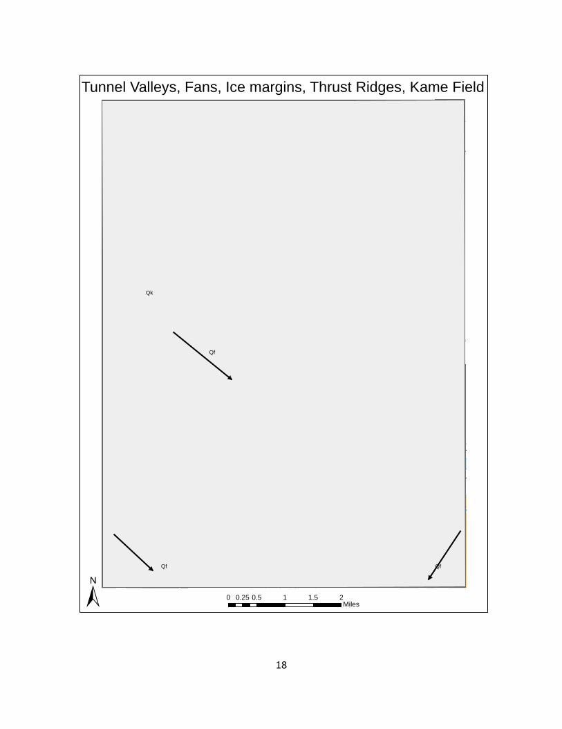
A large outwash fan (or a series of coalescing fans) occurs on the west side of the Vandalia quad is mapped as Qf. This fan slopes down to the southeast and consists mostly of sand and gravel. This fan contains mollisol soil types and is known locally as Young’s Prairie. This fan originated when the Lake Michigan Lobe ice margin was just to the west at the Outer Kalamazoo Moraine.
The fan (Qf) in the southeast corner of the quad slopes downward to the southwest so is most likely of Saginaw Lobe origin. This fan crosses a Lake Michigan Lobe tunnel valley indicating that the tunnel valley was within buried ice and debris first and the fan was later deposited over it.
The areas of outwash mapped as Qsg2 are irregular sand and gravel deposits that lack a distinct fan shape. They are also very hummocky, which suggests that they were deposited on discontinuous masses of stagnant ice which melted out and collapsed to form the high relief hummocks and depressions.
Several ice-walled lake plains are mapped in the uplands in the northern part of the quad. Generally flat topped, these landforms represent the formation of a short-lived lake that existed while glacial ice was still in the area. Stagnant ice masses formed the boundary of the lake and left the flat-topped lake deposits of sand to clay size material in a relatively high position on the landscape as the surrounding buried ice melted away.
Just north of the center of section 18, Penn Township is a cluster of circular knobs which are interpreted as kames.
The WNW-ESE linear valleys (some of which contain elongated lakes) are interpreted to be tunnel valleys of subglacial fluvial origin as the Lake Michigan Lobe occupied this terrain at different times. Tunnel valleys of Saginaw Lobe origin are described by Kehew et al. (2013).
A wide tunnel valley enters the quad from the west and is likely the source for the large fan on the west side of the quad. This tunnel valley which extends 6 miles to the northwest forms the large reentrant in the Outer Kalamazoo Moraine Complex.

7
The exact ages of the glacial deposits have not been determined in the study area but are correlated to dated features elsewhere. Some recent optically stimulated luminescence (OSL) dates suggest that the Kalamazoo Moraine of the Saginaw Lobe in Calhoun County, which lies northeast of the Vandalia Quadrangle was probably formed about 19,000 years ago (Kehew and Esch, unpublished). Two samples were collected for OSL dating in the northeast part of the Vandalia quad as part of this mapping project on the edges of what are interpreted as iced-walled lake plains. Preliminary data at CASS-OSL-16-01 indicate was deposited around 19,800 years ago and CASS-OSL-16-02 was deposited around 17,700 years ago. These dates have an uncertainty of a thousand years or more.
Studies of tunnel valleys observed in the Saginaw Lobe (Kehew et al. 1999, 2005, 2013) northeast of Cass County indicate that the Saginaw and Lake Michigan Lobes were not synchronous in the timing of their advances and retreats. The orientation of tunnel valleys is generally perpendicular to the ice margin (Clayton et al. 1999). Kehew et al. (1999, 2005, 2013) found morainal deposits and outwash fans within the Lake Michigan Lobe portion of the Kalamazoo Moraine that were deposited across northeast-southwest trending Saginaw Lobe tunnel valleys. This relationship indicates that the Saginaw Lobe tunnel valleys formed first and were filled with ice and debris during retreat of the lobe. The Lake Michigan Lobe then advanced over these buried tunnel valleys and deposited till and outwash. The modern valleys formed by collapse as the buried ice gradually melted out, which could have taken hundreds or even thousands of years. This collapse process produced extremely undulating tunnel valley floors, which is why they often contain chains of lakes rather than streams. The opposite appears to have occurred in the southwest sloping fan in the southeast corner of the Vandalia quad. This likely Saginaw Lobe fan crosses a Lake Michigan Lobe tunnel valley indicating that in this case Lake Michigan Lobe tunnel valley formed first and was filled with ice and debris during retreat of the lobe. The Saginaw Lobe then deposited the outwash fan over this buried tunnel valley which later melted out and collapsed. Further information about the Saginaw Lobe tunnel valleys is available in Kehew and Kozlowski (2007) and Kehew et al. (2013).
An esker (Qe) is a ridge of sand and gravel deposited in a subglacial ice tunnel. One was mapped in this quad and it has an anomalous NE-SW orientation that would suggest that is was formed under the Saginaw Lobe ice even though it lies near the Lake Michigan lobe Outer Kalamazoo ice margin. The other ice margin marked by the narrow band of parallel thrust ridges generally occurs less than a mile northwest of this esker. This may indicate that the Lake Michigan Lobe thrust ridges were being thrust up against Saginaw Lobe ice under which the NE-SW trending esker formed. A number of NE-SW trending streamlined features occur just south of the esker.
A boring with continuous wireline coring was drilled as part of mapping this project (CAS-16-03). This boing was terminated at 104 feet because of lost-circulation problems. Two nearby water wells were gamma-ray logged as part of this study. Samples were collected from a mud rotary drilled boring on another project (MWE-16-01). Their logs are shown on this sheet below.

8
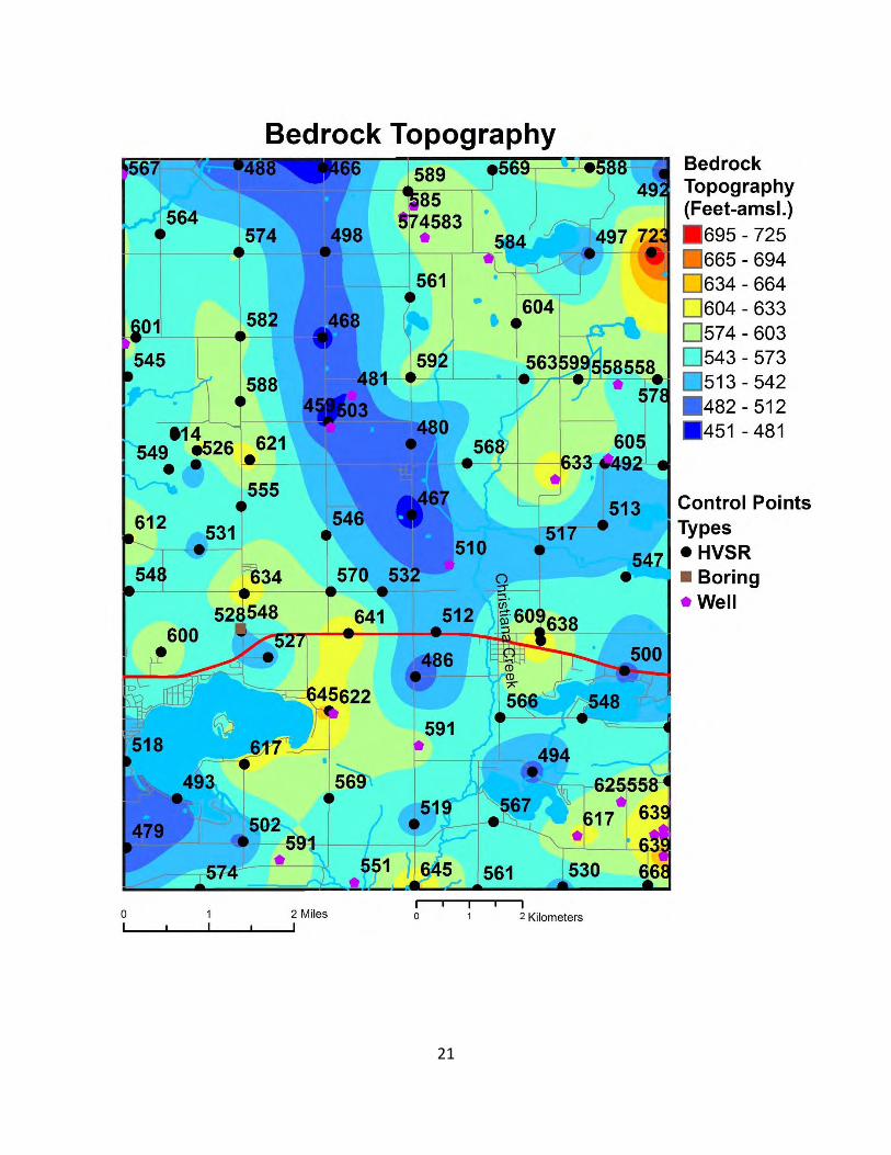
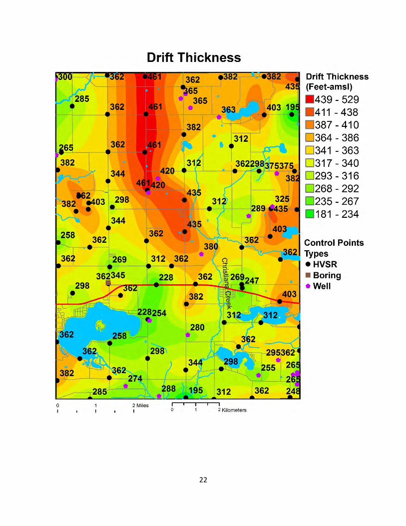
Bedrock of Mississippian Coldwater Shale underlies the northeastern two-thirds of Cass County. The underlying Ellsworth Shale forms the bedrock surface in the southwestern one-third of the county. These formations dip to the northeast toward the center of the Michigan Basin. The Coldwater Shale is the bedrock subcrop underlying the Vandalia quad. Although the Ellsworth Shale doesn’t subcrop beneath the quad, (it subcrops to the west) its distinctive light green color, often tabular rectangular clasts and cobbles are common in the drift in the southern part of the quad which are dominated by outwash deposits from the Lake Michigan Lobe from the west. The bedrock surface ranges from 460 feet to 720 feet above mean sea level (msl) within the quad. A pronounced buried bedrock valley runs SSE to NNW through the northern part of the Vandalia quad. This bedrock valley likely is an extension of a deep bedrock valley that runs SE-NW across Van Buren County to the north. The glacial deposits in the Vandalia Quad average 350 feet thick with a range from 200 to 460 feet thick. An area of thicker drift overlie the buried bedrock valley.
Scattered sand and gravel mining operations occur within the quad. Most of the gravel pits are associated with outwash fans, outwash or the Outer Kalamazoo Morainal Complex, especially within the northern high relief side. Significant additional sand and gravel deposits may potentially occur in these deposits and also along the newly mapped esker, along and within the tunnel valleys and along the Little Dowagiac Creek lowland.
The majority of the quad is within the Christiana Creek watershed which has its headwaters within the quad. The Rocky River watershed also has its headwaters in the northeast corner of the quad. The northwest corner of the quad is within the Dowagiac River watershed.
All the water wells in the quad are screened in glacial drift aquifers. The average depth of water wells in the quad is 82 feet and average water table depth is 30 feet. Most of the land use within the quad is for agriculture. Agricultural irrigation is prevalent across the quad with a significant number of high capacity irrigations wells.
A relatively consistent clay or diamicton unit is reported on water well logs under most of the quad and parts of the Jones quad to the east at an elevation around 825 feet msl. This unit typically is 3-7 feet thick.
Western Michigan University’s Geology Department conducted a number of hydrogeological investigations in the Donnell Lake area due to the nitrate contamination of the groundwater and surface water in the area. See references for more information on those studies.
Results: Jones 7.5 Minute Quadrangle
The Jones Quadrangle, which was mapped as part of the larger Cass County project area, is underlain by unconsolidated deposits of glacial and post-glacial origin from the Saginaw and Lake Michigan Lobes (Leverett and Taylor 1915) of the Laurentide Ice Sheet. Kehew et al. (2012) describe the regional sediment-landform associations of the Saginaw Lobe and Kehew et al. (2005) discuss the dynamics of the Lake Michigan Lobe. The sediments include diamicton (till),

9
sand and gravel and interbedded silt and clay. Till is a characteristic type of glacial deposit that is unsorted and has a range of grain sizes from clay to boulders. The diamicton sediments in the northern half of the quad are interpreted to be Saginaw Lobe deposits but Cass County lies in an interlobate area and the diamicton could be in part, of Lake Michigan Lobe origin. The relief of the area is very high and it is likely that stagnant, debris-covered ice was present throughout the area, perhaps from the Lake Michigan Lobe. The diamicton is not uniform in thickness and may not cover the entire area. At the CAS-16-01 drilling site, the diamicton overlies thick sands of probable lacustrine origin and it is likely that this area of hummocky glacial stagnation topography is highly discontinuous laterally in sediment characteristics. The glacial deposits are late Wisconsinan (~30,000 to ~15,000 yr before present) in age, although some deeply buried deposits may be middle Wisconsinan or older (Winters and Rieck 1982). Borings CAS-16-01 and CAS-16-02 encountered a leached zone at depth which may be the Sangamon geosol. If this is the case, the deposits below would be Illinoisan in age (~130,000 yr BP). The total thickness of glacial deposits typically ranges between 50 and 500 ft (15-150 m).
The most prominent glacial landforms in the Jones Quadrangle are the hills in the hummocky northern part of the quad mapped as Qds. These deposits may represent the westward continuation of the Sturgis Moraine in St. Joseph County. This moraine was formed at the margin of the Saginaw Lobe after a significant re-advance. The composition of the deposits is variable and discontinuous and outwash fans extend from the moraine to the south. A large fan of this type in the Jones quad is mapped as Qf. The areas of outwash mapped as Qsg2 are irregular sand and gravel deposits that lack a distinct fan shape. They are also very hummocky, which suggests that they were deposited on discontinuous stagnant ice which melted out and collapsed to form the high relief hummocks and depressions.
Several ice-walled lake plains are mapped in the northern part of the quad. Generally flat topped, these landforms represent the formation of a short-lived lake that existed while glacial ice was still in the area. Stagnant ice masses formed the boundary of the lake and left the flat-topped lake deposits of sand to clay size material in a relatively high position on the landscape.
A north-south ridge in sections 25 and 30 of Newberg and Fabius Townships, south of Corey and Harwood Lakes, is mapped as diamicton of the Lake Michigan Lobe. The orientation of linear valleys interpreted to be tunnel valleys of subglacial fluvial origin suggests that both the Lake Michigan and Saginaw Lobes occupied this terrain at different times. Tunnel valleys of Saginaw Lobe origin are described by Kehew et al. (2013). This particular ridge is assigned to the Lake Michigan Lobe because of its orientation but this cannot be conclusively proven at this time. The fan (Qf) in the southwest corner of the quad is most likely of Saginaw Lobe origin associated with the Kalamazoo Moraine to the west.
The exact ages of the glacial deposits have not been determined in the study area but are correlated to dated features elsewhere. Some recent optically stimulated luminescence (OSL) dates suggest that the Kalamazoo Moraine of the Saginaw Lobe, which lies northeast of the Jones Quadrangle, was probably formed about 19,000 years ago (Kehew and Esch,

10
unpublished). Studies of tunnel valleys observed in the Saginaw Lobe (Kehew et al. 1999, 2005, 2013) northeast of Cass County indicate that the Saginaw and Lake Michigan Lobes were not synchronous in the timing of their advances and retreats. The orientation of tunnel valleys is generally perpendicular to the ice margin (Clayton et al. 1999). Kehew et al. (1999, 2005, 2013) found morainal deposits and outwash fans within the Lake Michigan Lobe portion of the Kalamazoo Moraine that were deposited across northeast-southwest trending Saginaw Lobe tunnel valleys. This relationship indicates that the Saginaw Lobe tunnel valleys formed first and were filled with ice and debris during retreat of the lobe. The Lake Michigan Lobe then advanced over these buried tunnel valleys and deposited till and outwash. The modern valleys formed by collapse as the buried ice gradually melted out, which could have taken hundreds or even thousands of years. This collapse process produced extremely undulating tunnel valley floors, which is why they often contain chains of lakes rather than streams. Further information about the Saginaw Lobe tunnel valleys is available in Kehew and Kozlowski (2007) and Kehew et al. (2013).
Other map units include an esker (Qe), which is a ridge of sand and gravel deposited in a subglacial ice tunnel and peat and muck found in depressions on the landscape with a high water table.
Two deep borings with continuous wireline coring were drilled as part of this project and their logs are shown on this sheet below. These borings are among the deepest cored borings of the glacial drift in southern Michigan.
Conclusions
Mapping of the Vandalia 7.5 and minute quadrangle has provided new, detailed information on surficial landforms and deposits within the Lake Michigan and Saginaw Lobes in southern Michigan. This mapping project is part of a larger project to map Cass County. The maps produced in this project will be of use to aggregates producers exploring for new deposits, planners, and hydrogeologists in MDEQ who must evaluate permits for high-capacity water wells that now require a permit and must be shown to not deplete streams in the area beyond an amount that will not affect fish populations.
Bibliography and Related References
Bowman, W. L., Soil survey of Cass County, Michigan. Soil Conservation Service, United States Department of Agriculture, 1991
Case, E.C., Scott, I.D., Badenoch, B. M., White, T.E., 1935, Discovery of Elephas primigenius americanus in the bed of glacial Lake Mogodore, in Cass County, Michigan, Papers of the Michigan Academy of Science, Arts and Letters 20: 449-454
11
Clayton L., Attig J. W. and Mickelson D. M., 1999. Tunnel channels formed in Wisconsin during the last glaciation. In Mickelson D. M. and Attig J. W.: (eds.), Glacial Processes Past and Present, Geological Society of America Special Paper 337, pp. 69-82.
Clayton, L., Attig J. W. and Mickelson D. M., 1999. Tunnel channels formed in Wisconsin during the last glaciation. In Mickelson D. M. and Attig J. W.: (eds.), Glacial Processes Past and Present, Geological Society of America Special Paper 337, pp. 69-82.
Farrand W.R., 1982. Quaternary geology of southern Michigan; Michigan Geological Survey Division, scale 1:500,000.
Farrand W.R., and Bell, W.R., 1982. Quaternary geology of southern Michigan; Michigan Geological Survey Division, scale 1:500,000.
Fullerton D. S., 1980. Preliminary correlation of Post-Erie interstadial events (16,000-10,000 radiocarbon years before present), central and eastern Great Lakes region, and Hudson, Champlain and St. Lawrence lowlands, United States and Canada. U.S. Geological Survey Professional Paper 1089.
Kehew A.E., Nicks L.P. and Straw W.T. 1999. Palimpsest tunnel valleys: evidence for relative timing of advances in an interlobate area of the Laurentide Ice Sheet, Annals of Glaciology, 28:47-52.
Kehew, A. E. and Kozlowski, A.L. 2007. Tunnel Channels of the Saginaw Lobe, Michigan, USA, in, Johannsson, P., and Sarala, P. (eds.) Applied Quaternary research in the central part of glaciated terrain, Geological Survey of Finland, Special Paper 46, pp. 69-77.
Kehew, A.E., Beukema, S. P., Bird, B.C., and Kozlowski, A.L. 2005. Fast flow of the Lake Michigan Lobe of the Laurentide Ice Sheet: evidence from sediment-landform assemblages in southwestern Michigan, USA, Quaternary Science Reviews 24 2335-2353
Kehew, A.E., Esch, J.M., Kozlowski, A.L. and Ewald, S.K. 2012. Glacial landsystems and dynamics of the Saginaw Lobe of the Laurentide Ice Sheet, Michigan, USA. Quaternary International 60, 21-31.
Kehew, A.E., Ewald, S.K., Esch, J.M. and Kozlowski, A.L. 2013. On the origin of tunnel channels of the Saginaw Lobe, Laurentide Ice Sheet, Michigan, USA. Boreas, Vol. 42, pp. 442–462.
Lane, J.W., Jr., White, E.A., Steele, G.V., and Cannia, J.C., 2008. Estimation of bedrock depth using the horizontal-to-vertical (H/V ) ambient-noise seismic method, in Symposium on the Application of Geophysics to Engineering and Environmental Problems, April 6–10, 2008, Philadelphia, Pennsylvania, Proceedings: Denver, Colorado, Environmental and Engineering Geophysical Society, pp. 13.

12
Leverett F. 1907. Flowing wells and municipal water supplies in the middle and northern portions of the Southern Peninsula of Michigan. US Geological Survey Water-Supply Paper 183.
Leverett, F. 1924. Map of the surface formations of the southern peninsula of Michigan, Michigan Geological Survey, Scale 1:750,000.
Leverett, F. and Taylor, F. 1915. Pleistocene of Indiana and Illinois and the History of the Great Lakes. U.S. Geological Survey Monograph 53, 529 p.
Martin, H.M., 1955, Map of the surface formations of the southern peninsula of Michigan, Michigan Geological Survey Division, Publication 49, Scale 1:500,000.
Western Michigan University Donnell Lake Study Area References
Barrese, P.G., 1991, A Hydrogeochemical Characterization of a Glacial-Drift Aquifer System in Southwest Michigan: Unpublished M.S. Thesis, Western Michigan University, Kalamazoo, 219 p.
Betts, M.A., 1994, The effects of a wetland on ground water quality in a agriculturally impacted aquifer, Unpublished M.S., Thesis Western Michigan University.
Ervin, J.L., and Kittleson, 1988, Assessment of Rural Groundwater Contamination by Agricultural Chemicals in Sensitive Areas of Michigan: Institute for Water Research, Michigan State University, Report NO. 61429-03, 51 p.
Ervin, J.L., and Lusch, D.P., 1992, Selection and Analysis of Sites Highly Vulnerable to Groundwater Contamination in Southwest Michigan: Institute for Water Research, Michigan State University, FY 1991, Technical Completion Report USGS Award No 14-08-0001-G2026.
Ervin, J.L., and Lusch, D.P., 1990, Preliminary Report: Groundwater Investigation on Cass County, Institute for Water Research, Michigan State University.
Ervin, J. L., Preliminary Report: Groundwater investigations in Cass County: Institute for Water Research, Michigan State University, Michigan, 1988
Ervin, J. L. and Lusch, D.P., 1992, Selection and analysis of sites highly vulnerable to groundwater contamination in Southwestern Michigan, FY 1991 Technical Completion Report: Institute of Water Research, Michigan State University, Michigan, 1992
Grace, J., 1994, Geological Society of America, North Central Section, Field Trips Guidebooks, Kalamazoo, Michigan, 1994, Hydrogeology of Kalamazoo and Cass Counties, Michigan: Hydrogeology of Selected Locations in Southwest Michigan and Surface and Ground-Water Quality in the Donnell Lake Area, Cass County, Michigan, W.T., Straw, R. R.,
13
Passero. A.E., Kehew, J.L., Ervin, D.P., Lusch, M.A., Stuk, M. Betts, C., Lovett, E., Atekwana, S., Bahling.
Kehew, A.E., Passero, R.N., Krishnamurthy, R.V., Lovett, C.K., Bettsc, M.A. and Dayharsh, B.A., 1998. Hydrogeochemical interaction between a wetland and an unconfined glacial drift aquifer Southwestern Michigan. Ground Water, 36(5), pp.849-856.
Kehew, A.E., Passero, R.N., Sauck, W.A., Straw, W.T., Lovett, C. K., Stuk, M.A., and Betts, M. A., 1994, Hydrogeology of the Donnell Lake Watershed, in Ervin, J. L. et al., eds., A Study of Ground Water and Ground Water/Surface Water Interfaces in a Priority Agricultural Watershed, Cass County, Michigan, Part B, Michigan State University, Institute of Water Research.
Lovett, C. K., Krishnamurthy, R. V., Kehew, A. E., & Passero, R. N., 1995, 3H and δ18O as indicators of connectivity in a multi-aquifer complex, Cass County, southwestern Michigan. In C. Leibundgut (Ed.), IAHS-AISH Publication. (229 ed., pp. 23-30). IAHS.
Lovett, C.K., 1995, A wellhead protection study of a small agricultural community in glaciated terrain, as a model for wellhead protection efforts by similar communities, Ph.D., Dissertation, Department of Geology, Western Michigan University, Kalamazoo, Michigan
Nascimento, C., Atekwana, E. A., Krishnamurthy, R. V., 1997, Concentrations and isotope ratios of dissolved inorganic carbon in denitrifying environments, Geophysical Research Letters, Vol. 24, Issue 12
Passero, R.N., Kehew, A.E., Ervin, J. L., Sauck, W.A., Straw, W.T., Atekwana, E. A., Stuk, M. A, Lovett, C. K., Betts, M. A., and Chidester, S., 1994, Determinants of Groundwater Quality in a Multi-layer Glacial Drift Aquifer System: Implications for Wellhead Protection of Small Community Water Supply Systems in Agricultural Settings, Michigan State University, Institute of Water Research.
Stuk, M. A., 1992, A study of Ground-Water Quality in a Priority Agricultural and Livestock Watershed, Cass County, Michigan, Unpublished M.S., Thesis Western Michigan University, 85 p.
14
Figures
Vandalia Quadrangle
Vandalia 7.5 Minute Topographic Map
0 0.5 1 1.5 20.25Miles±

15

16
Hillshade
0 0.5 1 1.5 20.25Miles±

17
18
Qf
Qf Qf
Qk
Tunnel Valleys, Fans, Ice margins, Thrust Ridges, Kame Field
0 0.5 1 1.5 20.25Miles±

19
CASS-OSL-16-02
CASS-OSL-16-01
Qkmo
Qds
Qdu
Qdu
Qdu
Qdu
Qdu
Qdu
Diamicton Units, Ice margins, Thrust Ridges, OSL Samples
0 0.5 1 1.5 20.25Miles±

20
Ice margins, Ice-Walled Lake Plains, Esker
0 0.5 1 1.5 20.25Miles±
21
22

23
Dowagiac River-C
hristia
na Creek Waters
hedBou
nd
ary
Rocky River-Christiana Creek WatershedBoundary
Qp
Qp
Qp
Qp
Qp
Qp
Qp
QpQp
Qp
Qp
Qp
Qp
Qp
Qp
Qp
Qp
QpQp
Qp
Qp
Qp
Qp
Qp
Qp
Qp, Lakes, Streams & Watershed Boundaries
0 0.5 1 1.5 20.25Miles±

24
Regional Water Table
0 0.5 1 1.5 20.25Miles±

25

26

27

28

29
30
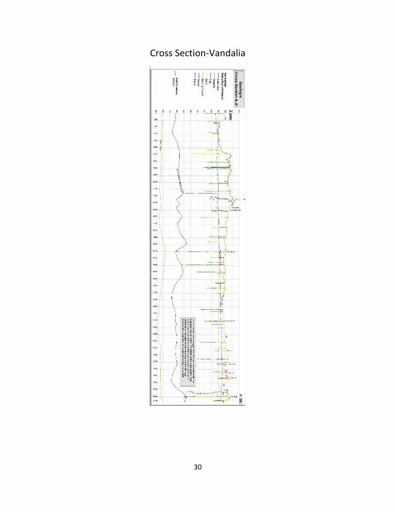
Cross Section-Vandalia

31
Jones Quadrangle
Jones Surficial Geologic Map

32

33

34

35

36

37
Cross Section-Jones