Embed Size (px)
Citation preview

TECHNICAL REPORT
ON THE
NORTH RANGE PROPERTIES,
SUDBURY, ONTARIO
For
WALLBRIDGE MINING COMPANY LIMITED
By
JOSHUA BAILEY, M.Sc., P.Geo.
Effective Date:
DECEMBER 31, 2011

Technical Report on the North Range Properties, Sudbury, Ontario Wallbridge Mining Company Limited Effective December 31, 2011
i
Table of Contents
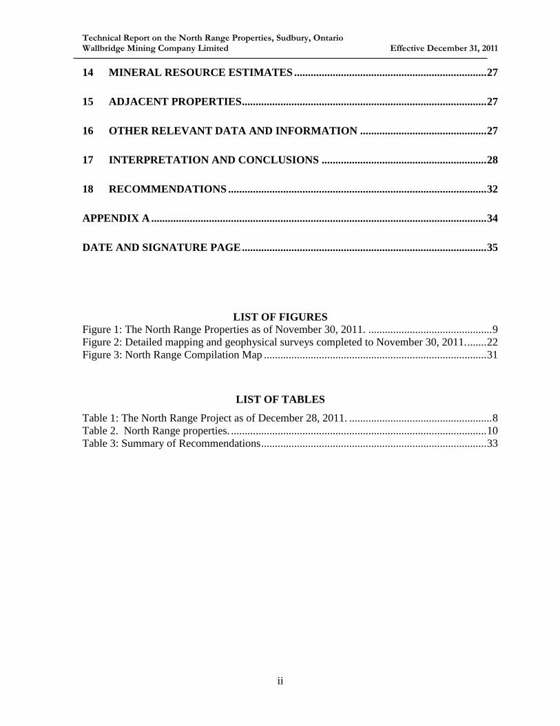
1 SUMMARY ...................................................................................................................... 3
2 INTRODUCTION ........................................................................................................... 6
3 RELIANCE ON OTHER EXPERTS ............................................................................ 7
4 PROPERTY DESCRIPTION AND LOCATION ........................................................ 7
4.1 UNDERLYING INTERESTS ................................................................................. 15
4.1.1 CBA HESS .................................................................................................... 15
4.1.2 CBA ERMATINGER ................................................................................... 15
4.1.3 FOY NORTH ................................................................................................ 15
4.1.4 CARTIER ..................................................................................................... 16
4.1.5 PELE ............................................................................................................. 16
4.1.6 LEVACK NORTH ........................................................................................ 17
4.1.7 RUZA LEVACK .......................................................................................... 17
4.1.8 DAIGLE ........................................................................................................ 17
5 ACCESSIBILITY, CLIMATE, LOCAL RESOURCES, INFRASTRUCTURE
AND PHYSIOGRAPHY ............................................................................................... 18
6 HISTORY....................................................................................................................... 18
7 GEOLOGICAL SETTING AND MINERALIZATION ........................................... 19
7.1 SUDBURY GEOLOGY .......................................................................................... 19
7.2 PROPERTY GEOLOGY AND MINERALIZATION ............................................ 20
8 DEPOSIT TYPES.......................................................................................................... 20
9 EXPLORATION ........................................................................................................... 21
10 DRILLING ..................................................................................................................... 23
11 SAMPLE PREPARATION, ANALYSES, AND SECURITY .................................. 23
12 DATA VERIFICATION ............................................................................................... 26
13 MINERAL PROCESSING AND METALLURGICAL TESTING ......................... 27
Technical Report on the North Range Properties, Sudbury, Ontario Wallbridge Mining Company Limited Effective December 31, 2011
ii
14 MINERAL RESOURCE ESTIMATES ...................................................................... 27
15 ADJACENT PROPERTIES ......................................................................................... 27
16 OTHER RELEVANT DATA AND INFORMATION .............................................. 27
17 INTERPRETATION AND CONCLUSIONS ............................................................ 28
18 RECOMMENDATIONS .............................................................................................. 32
APPENDIX A .......................................................................................................................... 34
DATE AND SIGNATURE PAGE ......................................................................................... 35
LIST OF FIGURES
Figure 1: The North Range Properties as of November 30, 2011. ............................................. 9 Figure 2: Detailed mapping and geophysical surveys completed to November 30, 2011. ....... 22
Figure 3: North Range Compilation Map ................................................................................. 31
LIST OF TABLES
Table 1: The North Range Project as of December 28, 2011. .................................................... 8 Table 2. North Range properties. ............................................................................................. 10
Table 3: Summary of Recommendations .................................................................................. 33

Technical Report on the North Range Properties, Sudbury, Ontario Wallbridge Mining Company Limited Effective December 31, 2011
3
1 SUMMARY
Introduction
The North Range properties (the “Property”) are located in the Sudbury Mining District, in the
North Range of the Sudbury structure, Ontario. The Property is being explored by Wallbridge
Mining Company Limited (Wallbridge) for copper, platinum group metals, nickel and gold.
Property Description and Location
The North Range Project includes fourteen properties covering 40,814 hectares. Several of the
properties are subject to a number of underlying joint ventures and other interests.
In June 2007, Lonmin Plc completed a private placement of 10,800,000 Units in Wallbridge.
Under the terms of the subscription agreement, a minimum of 60% of the proceeds of the sale of
the Purchased Units ($3.88 M) were to be directed to exploration work or acquisitions of
interests to advance the North Range Project during the period to December 31, 2009.
The terms of the private placement were amended by letter, dated November 27, 2008, extending
the work period to December 31, 2010. The terms of the private placement were amended again
by letter, dated July 6, 2010, extending the work period to December 28, 2011. The North Range
Project Boundary was extended by way of letters dated November 22, 2010, January 7, 2011,
and October 13, 2011, to cover additional claims staked as part of the Ermatinger property.
On December 23, 2011, the Company notified Lonmin Plc it had completed its spending commitment of
$3,880,000 on the North Range Properties as set out in the terms of the private placement with Lonmin
Plc made in June 2007. As a result Lonmin Plc has the option until March 28, 2012 to elect to enter into
Joint Ventures on any of the properties and to earn a 50% interest in such properties by spending twice
the amount of expenditures to date by the Company. Lonmin can then earn an additional 15% interest by
completing a Feasibility Study and securing the Company’s portion of development funding on a loan
basis.
Geologic Setting
The Sudbury area hosts one of the most prolific Ni-Cu-PGE mining camps in the world. The
deposits occur within and adjacent to the Sudbury Structure that formed as a result of a major
Early Proterozoic meteorite impact 1,850 million years ago (Ma). The Properties occur in the

Technical Report on the North Range Properties, Sudbury, Ontario Wallbridge Mining Company Limited Effective December 31, 2011
4
North Range footwall to the Sudbury Structure and are largely underlain by granitoids and
gneisses of the Archean Cartier Batholith and cross-cutting Matachewan diabase dykes and
pyroxenite dykes. These are unconformably overlain by Early Proterozoic Huronian
metasediments. All rocks are cut by younger Proterozoic Nipissing diabase dykes, offset dykes
and Sudbury breccia structures of the Sudbury Structure and the younger Sudbury Swarm olivine
diabase.
Deposit Types
There are three main types of mineral deposits in the Sudbury area:
1. Contact deposits, along the lower contact of the SIC, both within the contact sublayer and
within the immediately adjacent Footwall Breccia.
2. Footwall deposits, in the footwall rocks themselves, often associated with zones of
pseudotachyllite and associated melt rock.
3. Offset dyke deposits, associated with offset dykes.
The North Range Project was conceived to explore for the following PGE, copper and nickel
targets in the North Range footwall to the Sudbury Basin:
Buried thrust slices of SIC at reasonable depths beneath portions of the footwall beyond
the currently mapped limits of the SIC.
Offset dykes with massive to disseminated Ni-Cu-PGE mineralization.
Exploration and Drilling
From June 2007 to November 30, 2011, Wallbridge incurred expenditures of $3,861,427 to
complete:
97 square kilometres of geological mapping
mechanical trenching/stripping in 18 places
2820 line kilometres of airborne magnetic and electromagnetic surveys on 5 grids;
126.4 line kilometres of ground resistivity/IP surveys on 3 grids;
71 line kilometres of ground electromagnetic surveys on 3 grids.
And 4,701 metres drilling in 28 drill holes.

Technical Report on the North Range Properties, Sudbury, Ontario Wallbridge Mining Company Limited Effective December 31, 2011
5
Interpretation and Conclusions
In terms of metal endowment, infrastructure, community support and regulatory stability,
Sudbury is the most attractive place in the world to explore for and develop large-scale copper,
nickel and PGE mining projects. Despite over 125 years of mining in the Sudbury area, very large
and high grade deposits continue to be discovered.
Geological mapping and prospecting has been successful in identifying and delineating several
large Sudbury breccia structures with a combined strike length of approximately 37 kilometres,
several new Offset dykes with a combined strike length of 17.5 kilometres and a 29 km
extension to the Hess Offset dyke in a previously unexplored area.
Follow-up airborne magnetic and electromagnetic surveys and ground IP/resistivity and
electromagnetic surveys have been completed on some, but not all, of the geological targets
identified.
The North Range project is a very large project at an early stage of exploration. Work to date
has been very successful in expanding the search space of favourable geology in Sudbury and it
remains to systematically test the potential for economic mineralization.
Recommendations
Significant further work is recommended to fully explore the Properties potential for mineable
nickel, copper and platinum group element mineralization. An $11.1 million program including
drilling, geophysics and geological mapping is recommended to be completed over the course of
several years.

Technical Report on the North Range Properties, Sudbury, Ontario Wallbridge Mining Company Limited Effective December 31, 2011
6
2 INTRODUCTION
The North Range properties (the “Property”) are located in the Sudbury Mining District, in the
North Range of the Sudbury structure, Ontario. The Property is being explored by Wallbridge
Mining Company Limited (Wallbridge) for copper, platinum group metals, nickel and gold.
This report was prepared for Wallbridge to provide a summary of exploration and results on the
North Range Project during the work period to December 28, 2011.
The report is based on work carried out by the author and by Wallbridge personnel and
contractors under the supervision of the author. The author has made numerous site visits to the
Property. A complete list of reference material reviewed is provided at the end of this report.
This report has been prepared in compliance with the requirements of National Instrument 43-
101 and Form 43-101F1.
Joshua Bailey, M.Sc., P.Geo, Vice President of Corporate Development for Wallbridge Mining
Company Limited, is the author and Qualified Person responsible for the technical content of this
report.
Metric units are used throughout this report unless otherwise specified. Assay and analytical
results are quoted in grams per tonne (g/t), parts per million (ppm), parts per billion (ppb) or
weight percent (%). 1 g/t is equivalent to 1 ppm and 1000 ppb; 10,000 g/t is equivalent to 1 %.
Total precious metals (TPM) are the sum of platinum, palladium and gold values returned for a
sample. All dollar amounts are expressed in Canadian funds.

Technical Report on the North Range Properties, Sudbury, Ontario Wallbridge Mining Company Limited Effective December 31, 2011
7
3 RELIANCE ON OTHER EXPERTS
Third party contractors performed geophysical and analytical work for Wallbridge on the
Property in 2011. Although Wallbridge has made every reasonable effort to ensure data quality,
it cannot absolutely guarantee the data integrity. Based on its review of third party data, the
author has no reason to believe that any significant errors exist in the data.
4 PROPERTY DESCRIPTION AND LOCATION
The North Range Project includes fourteen properties covering 40,814 hectares (Table 1, Figure
1, Table 2). Several of the properties are subject to a number of underlying joint ventures and
other interests.
In June 2007, Lonmin Plc completed a private placement of 10,800,000 Units in Wallbridge.
Under the terms of the subscription agreement, a minimum of 60% of the proceeds of the sale of
the Purchased Units ($3.88 M) were to be directed to exploration work or acquisitions of
interests to advance the North Range Project during the period to December 31, 2009.
The terms of the private placement were amended by letter, dated November 27, 2008, extending
the work period to December 31, 2010. The terms of the private placement were amended again
by letter, dated July 6, 2010, extending the work period to December 28, 2011. The North Range
Project Boundary was extended by way of letters dated November 22, 2010, January 7, 2011,
and October 13, 2011, to cover additional claims staked as part of the Ermatinger property.
On December 23, 2011, the Company notified Lonmin Plc it had completed its spending commitment of
$3,880,000 on the North Range Properties as set out in the terms of the private placement with Lonmin
Plc made in June 2007. As a result Lonmin Plc has the option until March 28, 2012 to elect to enter into
a Joint Venture on any of the properties to earn a 50% interest in such properties by spending twice the
expenditures to date by the Company. Lonmin can then earn an additional 15% interest by completing a
Feasibility Study and securing the Company’s portion of development funding on a loan basis.

Technical Report on the North Range Properties, Sudbury, Ontario Wallbridge Mining Company Limited Effective December 31, 2011
8
Table 1: The North Range Project as of December 28, 2011.
Project Hectares Property description Terms
1 Cartier 10368 Staked claims Option from Xstrata to earn 100%,
Xstrata retains right of first refusal to
recover 60% interest
2 Cascaden N 7808 Staked claims 100% Wallbridge
3 CBA
Ermatinger
1934 Staked mining claims
and 3 leases
50/50 JV with Champion Bear and
Wallbridge
4 CBA Hess 2752 CBRL 50/50 JV with Champion Bear and
Wallbridge
5 Daigle 160 Staked claims 100% Wallbridge, Daigle retains 2%
NSR royalty
6 Foy N 400 Staked claims 100% Wallbridge, subject to
Crowflight JV agreement - AOI
7 Ruza 608 Staked claims 100% Wallbridge, Ruza Resources
retains 2% NSR royalty
8 Ermatinger 9280 Staked claims 100% Wallbridge
9 Harty 336 Staked claims 100% Wallbridge
10 Ministic 1392 Staked claims 100% Wallbridge
11 North Range 80 Staked claims 100% Wallbridge
12 Pele JV 5312 Staked claims 50/50 JV with Pele and Wallbridge
13 Levack N 240 Staked claims 100% Wallbridge, subject to Pele JV
14 Rudy's Lake 144 Staked claims 100% Wallbridge
Total 40,814 ha

Technical Report on the North Range Properties, Sudbury, Ontario Wallbridge Mining Company Limited Effective December 31, 2011
9
Figure 1: The North Range Properties as of November 30, 2011.

Technical Report on the North Range Properties, Sudbury, Ontario Wallbridge Mining Company Limited Effective December 31, 2011
10
Table 2. North Range properties.
1
claim number map area area (ha) holder recorded date work due date Status
($) work
required
work
reserve
1 3000388 CARTIER 12 192 XCC 26-Apr-2013 A 4,800 0
2 4201127 HESS 14 224 XCC 25-Nov-2005 25-Nov-2012 A 5,600 0
3 4201128 HESS 16 256 XCC 25-Nov-2005 25-Nov-2012 A 6,400 0
4 4201129 HESS 12 192 XCC 25-Nov-2005 25-Nov-2012 A 4,800 0
5 4201130 CARTIER 16 256 XCC 25-Nov-2005 25-Nov-2012 A 6,400 0
6 4201131 HESS 16 256 XCC 25-Nov-2005 25-Nov-2012 A 6,400 0
7 4201132 CARTIER 16 256 XCC 25-Nov-2005 25-Nov-2012 A 6,400 0
8 4201133 CARTIER 15 240 XCC 25-Nov-2005 25-Nov-2012 A 6,000 0
9 4201134 CARTIER 16 256 XCC 25-Nov-2005 25-Nov-2012 A 6,400 0
10 4201137 CARTIER 10 160 XCC 25-Nov-2005 25-Nov-2012 A 4,000 0
11 4201138 hart 8 128 XCC 25-Nov-2005 25-Nov-2012 A 3,200 0
12 4201139 HESS 7 112 XCC 25-Nov-2005 25-Nov-2012 A 2,800 0
13 4201140 HART 16 256 XCC 25-Nov-2005 25-Nov-2012 A 6,400 0
14 4201141 HART 7 112 XCC 25-Nov-2005 25-Nov-2012 A 2,800 0
15 4201142 HART 16 256 XCC 25-Nov-2005 25-Nov-2012 A 6,400 0
16 4201143 HART 8 128 XCC 25-Nov-2005 25-Nov-2012 A 3,200 0
17 4201144 CARTIER 2 32 XCC 25-Nov-2005 25-Nov-2012 A 800 0
18 4201162 LEVACK 1 16 XCC 14-Nov-2005 27-Sep-2012 A 400 0
19 04208821 HESS 8 128 XCC 25-Nov-2005 25-Nov-2012 A 3,200 0
20 4208880 HESS 16 256 XCC 25-Nov-2005 25-Nov-2012 A 6,400 0
21 4208882 HESS 16 256 XCC 25-Nov-2005 25-Nov-2012 A 6,400 0
22 4208883 CARTIER 12 192 XCC 25-Nov-2005 08-Oct-2012 A 4,800 0
23 4208884 CARTIER 16 256 XCC 25-Nov-2005 08-Oct-2012 A 6,400 0
24 4208885 CARTIER 16 256 XCC 25-Nov-2005 08-Oct-2012 A 6,400 0
25 4208886 CARTIER 16 256 XCC 25-Nov-2005 25-Nov-2012 A 6,400 0
26 4208887 CARTIER 16 256 XCC 25-Nov-2005 25-Nov-2012 A 6,400 0
27 4208888 CARTIER 5 80 XCC 25-Nov-2005 25-Nov-2012 A 2,000 0
28 4208889 CARTIER 5 80 XCC 25-Nov-2005 25-Nov-2012 A 2,000 0
29 4208890 CARTIER 8 128 XCC 25-Nov-2005 08-Oct-2012 A 3,200 0
30 4208891 HESS 16 256 XCC 25-Nov-2005 25-Nov-2012 A 6,400 0
31 4208892 HESS 16 256 XCC 25-Nov-2005 25-Nov-2012 A 6,400 0
32 4208893 HESS 6 96 XCC 25-Nov-2005 25-Nov-2012 A 2,400 0
33 4208894 HESS 3 48 XCC 25-Nov-2005 25-Nov-2012 A 1,200 0
34 4208895 CARTIER 3 48 XCC 25-Nov-2005 25-Nov-2012 A 1,200 0
35 4208896 CARTIER 16 256 XCC 25-Nov-2005 25-Nov-2012 A 6,400 0
36 4208897 CARTIER 16 256 XCC 25-Nov-2005 25-Nov-2012 A 6,400 0
37 4208898 CARTIER 13 208 XCC 25-Nov-2005 25-Nov-2012 A 5,200 0
38 4208899 CARTIER 12 192 XCC 25-Nov-2005 25-Nov-2012 A 4,800 0
39 4208916 HARTY 4 64 XCC 25-Nov-2005 25-Nov-2012 A 1,600 0
40 4208917 LEVACK 2 32 XCC 25-Nov-2005 08-Oct-2012 A 800 0
41 4208918 CARTIER 16 256 XCC 25-Nov-2005 08-Oct-2012 A 6,400 0
42 4208919 CARTIER 16 256 XCC 25-Nov-2005 08-Oct-2012 A 6,400 0
43 4208920 LEVACK 16 256 XCC 25-Nov-2005 08-Oct-2012 A 6,400 0
44 4208921 LEVACK 16 256 XCC 25-Nov-2005 08-Oct-2012 A 6,400 0
45 4208922 HARTY 16 256 XCC 25-Nov-2005 25-Nov-2012 A 6,400 0
46 4208923 LEVACK 14 224 XCC 14-Nov-2005 27-Sep-2012 A 5,600 0
47 4208924 LEVACK 12 192 XCC 14-Nov-2005 27-Sep-2012 A 4,800 0
48 4208925 LEVACK 8 128 XCC 14-Nov-2005 27-Sep-2012 A 3,200 0
49 4208926 LEVACK 16 256 XCC 14-Nov-2005 27-Sep-2012 A 6,400 0
50 4208928 HARTY 6 96 XCC 25-Nov-2005 25-Nov-2012 A 2,400 0
51 4208929 HARTY 6 96 XCC 25-Nov-2005 25-Nov-2012 A 2,400 0
52 4208930 HARTY 13 208 XCC 25-Nov-2005 25-Nov-2012 A 5,200 0
53 4208931 HARTY 7 112 XCC 25-Nov-2005 25-Nov-2012 A 2,800 0
54 4208932 HARTY 12 192 XCC 25-Nov-2005 25-Nov-2012 A 4,800 0
55 4208933 LEVACK 9 144 XCC 25-Nov-2005 25-Nov-2012 A 3,600 0
56 4208934 HARTY 16 256 XCC 25-Nov-2005 25-Nov-2012 A 6,400 0
10368 ha 259,200 $0
Cartiermining claims:
Project totals

Technical Report on the North Range Properties, Sudbury, Ontario Wallbridge Mining Company Limited Effective December 31, 2011
11
2
claim number map area area (ha) holder recorded date work due date Status
($) work
required
work
reserve
1 03005794 Cartier 128 WMCL 21-Sep-2006 21-Sep-2012 A 3,200 0
2 3009803 Cartier 256 WMCL 08-Feb-2006 08-Feb-2012 A 6,400 0
3 3009804 Cartier 256 WMCL 08-Feb-2006 08-Feb-2012 A 6,400 0
4 3009805 Cartier 256 WMCL 08-Feb-2006 08-Feb-2012 A 6,400 0
5 3009806 Cartier 128 WMCL 08-Feb-2006 08-Feb-2012 A 3,200 0
6 3009807 Cartier 256 WMCL 08-Feb-2006 08-Feb-2012 A 6,400 0
7 3009808 Cascaden 176 WMCL 21-Feb-2006 21-Feb-2012 A 4,400 0
8 3009809 Cascaden 256 WMCL 21-Feb-2006 21-Feb-2012 A 6,400 0
9 3009810 Cascaden 224 WMCL 21-Feb-2006 21-Feb-2012 A 5,600 0
10 3009813 Cascaden 256 WMCL 21-Feb-2006 21-Feb-2013 A 6,400 0
11 3009814 Ermatinger 80 WMCL 21-Feb-2006 21-Feb-2012 A 2,000 0
12 3009815 Cartier 256 WMCL 21-Feb-2006 21-Feb-2013 A 6,400 0
13 3009816 Cartier 256 WMCL 21-Feb-2006 21-Feb-2013 A 6,400 0
14 3009817 Hart 176 WMCL 21-Feb-2006 21-Feb-2012 A 4,400 0
15 3009818 Hart 256 WMCL 21-Feb-2006 21-Feb-2012 A 6,400 0
16 3009819 Cartier 256 WMCL 21-Feb-2006 21-Feb-2013 A 6,400 0
17 3009820 Cartier 256 WMCL 21-Feb-2006 21-Feb-2013 A 6,400 0
18 3009821 Hart 128 WMCL 21-Feb-2006 21-Feb-2012 A 3,200 0
19 3009822 Hart 176 WMCL 21-Feb-2006 21-Feb-2012 A 4,400 0
20 3009823 Cartier 240 WMCL 21-Feb-2006 21-Feb-2012 A 6,000 0
21 3009824 Cartier 256 WMCL 21-Feb-2006 21-Feb-2012 A 6,400 0
22 3009825 Cartier 240 WMCL 16-Mar-2006 16-Mar-2012 A 6,000 0
23 3009826 Cartier 256 WMCL 16-Mar-2006 16-Mar-2012 A 6,400 0
24 3009827 Cartier 256 WMCL 16-Mar-2006 16-Mar-2012 A 6,400 0
25 3009828 Cartier 256 WMCL 16-Mar-2006 16-Mar-2012 A 6,400 0
26 3016653 Cascaden 128 WMCL 08-Feb-2006 08-Feb-2012 A 3,200 0
27 3017353 Cascaden 240 WMCL 08-Feb-2006 08-Feb-2012 A 6,000 0
28 3017485 Cascaden 96 WMCL 08-Feb-2006 08-Feb-2012 A 2,400 0
29 3018772 Cascaden 256 WMCL 08-Feb-2006 08-Feb-2012 A 6,400 0
30 3018774 Cascaden 128 WMCL 08-Feb-2006 08-Feb-2012 A 3,200 0
31 3018775 Cartier 256 WMCL 08-Feb-2006 08-Feb-2012 A 6,400 0
32 3018792 Cartier 256 WMCL 08-Feb-2006 08-Feb-2012 A 6,400 0
33 3018793 Cascaden 144 WMCL 08-Feb-2006 08-Feb-2013 A 3,600 0
34 4205045 Cascaden 256 WMCL 27-Feb-2006 27-Feb-2012 A 6,400 0
35 4206117 Cascaden 160 WMCL 05-Jun-2006 05-Jun-2012 A 4,000 0
36 4206118 Hart 112 WMCL 05-Jun-2006 05-Jun-2012 A 2,800 0
37 4206119 Hart 240 WMCL 05-Jun-2006 05-Jun-2012 A 6,000 0
7808 ha 195,200 $0
mining claims:
Cascaden N
Project totals
3
claim number map area area (ha) holder recorded date work due date Status
($) work
required
work
reserve
1 1214586 Ermatinger 192 WMCL CBRL 23-Feb-1998 18-Mar-2013 A 4,800 0
2 1214587 Ermatinger 80 WMCL CBRL 23-Feb-1998 18-Mar-2013 A 2,000 0
3 1239141 Ermatinger 64 WMCL CBRL 13-Apr-2000 06-May-2013 A 1,600 0
4 1239142 Ermatinger 192 WMCL CBRL 13-Apr-2000 06-May-2013 A 4,800 0
5 1239143 Ermatinger 208 WMCL CBRL 13-Apr-2000 06-May-2014 A 5,200 0
6 1244383 Ermatinger 256 WMCL CBRL 31-Jul-2000 23-Aug-2013 A 6,400 0
7 1244384 Ermatinger 224 WMCL CBRL 31-Jul-2000 23-Aug-2013 A 5,600 0
8 1244385 Ermatinger 240 WMCL CBRL 31-Jul-2000 23-Aug-2013 A 6,000 0
9 1244386 Ermatinger 192 WMCL CBRL 31-Jul-2000 23-Aug-2013 A 4,800 0
10 1244387 Ermatinger 224 WMCL CBRL 31-Jul-2000 23-Aug-2013 A 5,600 0
1872 ha 46,800 $0
mining claims:
Totals
CBA Ermatinger
legal description PID # map area area (ha) rights held holder
lease renew
date
lease
number
work
reserve
11 S630298 73356-0001 Ermatinger 12.02 MSR CBRL 31-May-2012 106568 0
12 S630294 73356-0002 Ermatinger 24.53 MSR CBRL 31-May-2012 106567 0
13 S630295 73356-0003 Ermatinger 25.59 MRO CBRL 31-May-2012 106566 0
Totals 62.14 ha $0
mining leases:

Technical Report on the North Range Properties, Sudbury, Ontario Wallbridge Mining Company Limited Effective December 31, 2011
12
4
claim number map area area (ha) holder recorded date work due date Status
($) work
required
work
reserve
1 1174455 Harty 192 WMCL CBRL 06-Dec-2001 12-Apr-2014 A 4,800 0
2 1179646 Harty 96 WMCL CBRL 26-Nov-1996 02-Apr-2014 A 2,400 92
3 1179647 Harty 144 WMCL CBRL 26-Nov-1996 02-Apr-2014 A 3,600 0
4 1179649 Harty 240 WMCL CBRL 26-Nov-1996 02-Apr-2014 A 6,000 0
5 1203894 Hess 32 WMCL CBRL 25-May-1995 25-May-2014 A 800 0
6 1218245 Harty 64 WMCL CBRL 01-Dec-1997 08-Apr-2015 A 1,600 0
7 1223181 Hess 160 WMCL CBRL 26-Nov-1996 02-Apr-2014 A 4,000 57
8 1224157 Hess 240 WMCL CBRL 20-Apr-1998 20-Apr-2014 A 6,000 28
9 1229424 Hess 80 WMCL CBRL 10-Jun-1999 16-Oct-2014 A 2,000 474
10 1230272 Hess 96 WMCL CBRL 09-Mar-2000 15-Jul-2014 A 2,400 13,498
11 1230789 Harty 96 WMCL CBRL 22-Oct-1998 27-Feb-2015 A 2,400 0
12 1230847 Hess 16 WMCL CBRL 20-Apr-1998 20-Apr-2014 A 400 0
13 1231175 Hess 192 WMCL CBRL 09-Dec-1998 16-Apr-2014 A 4,800 0
14 1231176 Hess 256 WMCL CBRL 09-Dec-1998 16-Apr-2014 A 6,400 27
15 1231179 Hess 160 WMCL CBRL 09-Dec-1998 16-Apr-2014 A 4,000 27,799
16 1241361 Hess 192 WMCL CBRL 09-Mar-2000 15-Jul-2014 A 4,800 0
17 3002857 Hess 48 WMCL CBRL 02-Aug-2002 02-Aug-2014 A 1,200 8,198
18 3002858 Hess 96 WMCL CBRL 02-Aug-2002 02-Aug-2014 A 2,400 1,323
19 3004319 Hess 16 WMCL CBRL 11-Sep-2002 11-Sep-2014 A 400 0
20 4205043 Hess 32 WMCL CBRL 08-Sep-2005 08-Sep-2014 A 800 0
21 4255394 Harty 64 WMCL CBRL 31-Dec-2010 31-Dec-2014 A 1,600 0
22 4255395 Harty 112 WMCL CBRL 31-Dec-2010 31-Dec-2014 A 2,800 0
23 4255396 Harty 80 WMCL CBRL 31-Dec-2010 31-Dec-2014 A 2,000 0
24 4255397 Harty 48 WMCL CBRL 31-Dec-2010 31-Dec-2014 A 1,200 0
2752 ha 68,800 $51,496Project totals
CBA Hessmining claims:
6
claim number map area area (ha) holder recorded date work due date Status
($) work
required
work
reserve
1 3017412 Levack 160 WMCL 18-May-2006 18-May-2012 A 4,000 298
160 ha 4,000 $298
mining claims:
Project totals
Daigle
7
claim number map area area (ha) holder recorded date work due date Status
($) work
required
work
reserve
1 1241797 Tyrone 256 WMCL 11-Feb-2009 11-Feb-2017 A 6,400 3,558
2 4212987 Tyrone 144 WMCL 11-Feb-2009 11-Feb-2016 A 3,600 0
400 ha 10,000 $3,558
Foy Nmining claims:
Project totals
8
claim number map area area (ha) holder recorded date work due date Status
($) work
required
work
reserve
1 3009421 Levack 160 WMCL 03-May-2004 03-May-2012 A 4,000 0
2 3009422 Levack 224 WMCL 03-May-2004 03-May-2013 A 5,600 6,627
3 3009423 Levack 48 WMCL 03-May-2004 03-May-2012 A 1,200 2,054
4 3009424 Levack 176 WMCL 03-May-2004 03-May-2012 A 4,400 0
608 ha 15,200 $8,681
mining claims:
Ruza
Project totals

Technical Report on the North Range Properties, Sudbury, Ontario Wallbridge Mining Company Limited Effective December 31, 2011
13
9
claim number map area area (ha) holder recorded date work due date Status
($) work
required
work
reserve
1 1246165 Ermatinger 64 WMCL 09-Aug-2001 09-Aug-2012 A 1,600 0
2 1246166 Ermatinger 96 WMCL 09-Aug-2001 09-Aug-2012 A 2,400 0
3 1246167 Ermatinger 256 WMCL 09-Aug-2001 09-Aug-2012 A 6,400 0
4 1246168 Ermatinger 256 WMCL 09-Aug-2001 09-Aug-2012 A 6,400 0
5 3004868 Ermatinger 224 WMCL 28-Jul-2003 28-Jul-2012 A 5,600 0
6 4201305 Hart 240 WMCL 24-Jul-2006 24-Jul-2012 A 6,000 0
7 4206115 Hart 256 WMCL 19-May-2006 19-May-2012 A 6,400 0
8 4206116 Hart 64 WMCL 19-May-2006 19-May-2012 A 1,600 0
9 4245183 Ermatinger 112 WMCL 18-Nov-2010 18-Nov-2012 A 2,800 0
10 4255351 Totten 256 WMCL 12-Nov-2010 12-Nov-2012 A 6,400 0
11 4255352 Totten 256 WMCL 12-Nov-2010 12-Nov-2012 A 6,400 0
12 4255353 Ermatinger 256 WMCL 12-Nov-2010 12-Nov-2012 A 6,400 0
13 4255354 Ermatinger 256 WMCL 12-Nov-2010 12-Nov-2012 A 6,400 0
14 4255355 Ermatinger 256 WMCL 12-Nov-2010 12-Nov-2012 A 6,400 0
15 4255356 Ermatinger 256 WMCL 12-Nov-2010 12-Nov-2012 A 6,400 0
16 4255357 Ermatinger 256 WMCL 12-Nov-2010 12-Nov-2012 A 6,400 0
17 4255358 Ermatinger 256 WMCL 12-Nov-2010 12-Nov-2012 A 6,400 0
18 4255359 Ermatinger 256 WMCL 12-Nov-2010 12-Nov-2012 A 6,400 0
19 4255360 Ermatinger 256 WMCL 12-Nov-2010 12-Nov-2012 A 6,400 0
20 4255361 Totten 256 WMCL 12-Nov-2010 12-Nov-2012 A 6,400 0
21 4255362 Totten 256 WMCL 12-Nov-2010 12-Nov-2012 A 6,400 0
22 4255388 Vernon 128 WMCL 31-Dec-2010 31-Dec-2012 A 3,200 0
23 4255389 Vernon 256 WMCL 31-Dec-2010 31-Dec-2012 A 6,400 0
24 4255390 Vernon 256 WMCL 31-Dec-2010 31-Dec-2012 A 6,400 0
25 4255391 Vernon 256 WMCL 31-Dec-2010 31-Dec-2012 A 6,400 0
26 4255392 Vernon 256 WMCL 31-Dec-2010 31-Dec-2012 A 6,400 0
27 4255393 Vernon 256 WMCL 31-Dec-2010 31-Dec-2012 A 6,400 0
28 4262273 Venturi 256 WMCL 29-Jul-2011 29-Jul-2013 A 6,400 0
29 4262274 Vernon 256 WMCL 29-Jul-2011 29-Jul-2013 A 6,400 0
30 4262275 Vernon 256 WMCL 29-Jul-2011 29-Jul-2013 A 6,400 0
31 4262276 Vernon 256 WMCL 29-Jul-2011 29-Jul-2013 A 6,400 0
32 4262277 Vernon 256 WMCL 29-Jul-2011 29-Jul-2013 A 6,400 0
33 4262278 Vernon 256 WMCL 29-Jul-2011 29-Jul-2013 A 6,400 0
34 4262279 Vernon 256 WMCL 29-Jul-2011 29-Jul-2013 A 6,400 0
35 4262280 Vernon 240 WMCL 29-Jul-2011 29-Jul-2013 A 6,000 0
36 4262281 Vernon 144 WMCL 29-Jul-2011 29-Jul-2013 A 3,600 0
37 4262282 Vernon 144 WMCL 29-Jul-2011 29-Jul-2013 A 3,600 0
38 4262283 Vernon 144 WMCL 29-Jul-2011 29-Jul-2013 A 3,600 0
39 4262284 Vernon 128 WMCL 29-Jul-2011 29-Jul-2013 A 3,200 0
40 4262285 Vernon 256 WMCL 29-Jul-2011 29-Jul-2013 A 6,400 0
41 4262286 Vernon 128 WMCL 29-Jul-2011 29-Jul-2013 A 3,200 0
42 4262287 Venturi 256 WMCL 09-Aug-2011 09-Aug-2013 A 6,400 0
9280 ha 232,000 $0
Ermatingermining claims:
Project totals
10
claim number map area area (ha) holder recorded date work due date Status
($) work
required
work
reserve
1 4212454 isolated Leinster 48 WMCL 12-Feb-2007 12-Feb-2014 A 1,200 0
2 4212458 Leinster 240 WMCL 12-Feb-2007 12-Feb-2013 A 6,000 0
3 4212461 Harty 48 WMCL 12-Feb-2007 12-Feb-2013 A 1,200 0
336 ha 8,400 $0Project totals
Hartymining claims:
11
claim number map area area (ha) holder recorded date work due date Status
($) work
required
work
reserve
1 1199058 Cascaden 112 WMCL 13-Mar-2002 13-Mar-2012 A 2,800 0
2 1199059 Cascaden 48 WMCL 06-Mar-2002 06-Mar-2012 A 1,200 0
3 1199060 Cascaden 240 WMCL 13-Mar-2002 13-Mar-2012 A 6,000 0
4 1229362 Cascaden 256 WMCL 29-Oct-1998 29-Oct-2012 A 6,400 0
5 1244715 Cascaden 160 WMCL 10-May-2000 10-May-2012 A 4,000 0
6 1244716 Cascaden 32 WMCL 10-May-2000 10-May-2012 A 800 0
7 1244717 Cascaden 112 WMCL 10-May-2000 10-May-2012 A 2,800 0
8 1244718 Ermatinger 176 WMCL 10-May-2000 10-May-2012 A 4,400 0
9 1244719 Ermatinger 144 WMCL 10-May-2000 10-May-2012 A 3,600 0
10 3000892 Cascaden 112 WMCL 13-Mar-2002 13-Mar-2012 A 2,800 0
1392 ha 34,800 $0
mining claims:
Project totals
Ministic

Technical Report on the North Range Properties, Sudbury, Ontario Wallbridge Mining Company Limited Effective December 31, 2011
14
12
claim number map area area (ha) holder recorded date work due date Status
($) work
required
work
reserve
1 4205093 adj to Pele Harty 32 WMCL 11-May-2006 11-May-2014 A 800 0
2 4205099 adj to Pele Harty 48 WMCL 11-May-2006 11-May-2014 A 1,200 0
80 ha 2,000 $0
North Range
Project totals
mining claims:
13
claim number map area area (ha) holder recorded date work due date Status
($) work
required
work
reserve
1 3005863 Foy 64 PMRI 13-Jun-2005 13-Jun-2012 WRP 1,600 0
2 3011523 Foy 176 PMRI 11-May-2005 11-May-2012 WRP 4,400 0
3 3011768 Foy 256 PMRI 11-May-2005 11-May-2012 WRP 6,400 978
4 3011847 Harty 208 PMRI 13-Jun-2005 13-Jun-2012 WRP 5,200 0
5 3016232 Harty 256 PMRI 13-Jun-2005 13-Jun-2012 WRP 6,400 14,735
6 3016233 Harty 256 PMRI 13-Jun-2005 13-Jun-2012 WRP 6,400 0
7 3016234 Harty 256 PMRI 13-Jun-2005 13-Jun-2012 WRP 6,400 0
8 3016235 Foy 256 PMRI 13-Jun-2005 13-Jun-2012 WRP 6,400 0
9 3017389 Harty 192 PMRI 08-Jul-2005 08-Jul-2012 WRP 4,800 0
10 3017391 Harty 256 PMRI 08-Jul-2005 08-Jul-2012 WRP 6,400 0
11 3017393 Harty 256 PMRI 08-Jul-2005 08-Jul-2012 WRP 6,400 0
12 3018762 Harty 224 PMRI 29-Aug-2005 29-Aug-2012 WRP 5,600 0
13 3018763 Harty 128 PMRI 29-Aug-2005 29-Aug-2012 WRP 3,200 0
14 3018764 Harty 128 PMRI 29-Aug-2005 29-Aug-2012 WRP 3,200 0
15 3018765 Harty 208 PMRI 29-Aug-2005 29-Aug-2012 WRP 5,200 0
16 3018766 Harty 48 PMRI 29-Aug-2005 29-Aug-2012 WRP 1,200 0
17 3018767 Harty 256 PMRI 29-Aug-2005 29-Aug-2012 WRP 6,400 242
18 3018768 Harty 256 PMRI 29-Aug-2005 29-Aug-2012 WRP 6,400 0
19 3018769 Harty 128 PMRI 29-Aug-2005 29-Aug-2012 WRP 3,200 0
20 3018770 Harty 256 PMRI 29-Aug-2005 29-Aug-2012 WRP 6,400 19,897
21 3018771 Harty 256 PMRI 29-Aug-2005 29-Aug-2012 WRP 6,400 8,798
22 3018794 Harty 176 PMRI 06-Sep-2005 06-Sep-2012 WRP 4,400 0
23 3018795 Harty 192 PMRI 06-Sep-2005 06-Sep-2012 WRP 4,800 0
24 3018796 Harty 256 PMRI 06-Sep-2005 06-Sep-2012 WRP 6,400 0
25 3018797 Harty 256 PMRI 06-Sep-2005 06-Sep-2012 WRP 6,400 0
26 3018798 Harty 112 PMRI 06-Sep-2005 06-Sep-2012 WRP 2,800 0
5312 ha 132,800 $44,650
Pele JVmining claims:
Project totals
14
claim number map area area (ha) holder recorded date work due date Status
($) work
required
work
reserve
1 4205044 Harty 240 WMCL 24-Oct-2005 24-Oct-2013 A 6,000 0
240 ha 6,000 $0
mining claims:
Project totals
Levack North (Pele JV area of interest)
15
claim number map area area (ha) holder recorded date work due date Status
($) work
required
work
reserve
1 1225797 Morgan 144 WMCL 27-Jan-1999 27-Jan-2014 A 3,600 135
144 ha 3,600 $135
Rudy's Lakemining claims:
Project totals

Technical Report on the North Range Properties, Sudbury, Ontario Wallbridge Mining Company Limited Effective December 31, 2011
15
4.1 UNDERLYING INTERESTS
4.1.1 CBA HESS
50% Wallbridge, 50% Champion Bear Resources Ltd.
Wallbridge is Operator.
Option and JV Agreement between Wallbridge and Champion Bear dated November
29, 2005.
o Consent Agreement between Wallbridge, Champion and Brady dated
September 30, 2010.
Underlying Agreements and amendments between Champion Bear, Richard Kantor
and John Brady dated September 3, 1998, and February 12, 1998.
o 2.5% NSR on some claims, 50% of which may be purchased for $1,000,000.
o 3% NSR on other claims, one third of which may be purchased for $1,500,000
o $4,720 semi-annual advanced royalty payment due to Brady.
o 400 metre radius area of mutual interest.
o If dropped, returned to Brady with ones year’s assessment in good standing.
4.1.2 CBA ERMATINGER
50% Wallbridge, 50% Champion Bear Resources Ltd.
Wallbridge is Operator.
Option and JV Agreement dated November 5, 2001, between Wallbridge and
Champion.
Underlying Agreements and amendments between Champion, Richard Kantor,
Harvey Wylie, John Brady, Ron Dumont, Ron Green and Cliff Hykin dated August 2,
2000, July 4, 2000, September 3, 1998, and February 12, 1998.
o 2% NSR on some claims, 50% of which may be purchased for $1,000,000.
o 2.5% NSR on other claims, 50% of which may be purchased for $1,500,000.
o $280 semi-annual advanced royalty payments due to Brady.
o If dropped, to be returned to Brady with one year’s assessment in good
standing.
4.1.3 FOY NORTH
The Foy North property was staked within the area of Interest of the Participation and
Joint Venture Agreement between Wallbridge and Crowflight Minerals Inc. (now
CaNickel Mining Limited) dated June 27, 2006, and amended by way of letters dated
May 13, 2009, and September 22, 2010.

Technical Report on the North Range Properties, Sudbury, Ontario Wallbridge Mining Company Limited Effective December 31, 2011
16
CaNickel Mining Limited retains a back-in right to earn up to a 25% participating
interest in the Foy North claims by reimbursing in cash 50% of Wallbridge’s costs on
that property to the point at which an Indicated Resource is declared. If CaNickel does
not elect to earn a participating interest in such property, their interest shall revert to a
2.5 % Net Smelter Royalty, not to exceed a maximum cumulative total of $3.0M.
4.1.4 CARTIER
Option Agreement dated January 1, 2011, between Wallbridge Mining Company
Limited and Xstrata nickel.
Wallbridge to earn 100% interest by making the following payments:
o $50,000 on signing
o $50,000 on first anniversary (on or before January 1, 2012)
o $50,000 on second anniversary (on or before January 1, 2013)
Xstrata retains right of first refusal to designate the facilities at which all products are
processed.
If a Feasibility Study defines a deposit with proven and probable reserves plus
measured and indicated mineral resources containing greater than US$750,000,000 of
contained metal value, then Xstrata may elect to increase its interest in the property to
a 60% participating interest by funding the implementation of the Feasibility Study
until it incurs 200% of Wallbridge’s total Expenditures. The following metal prices in
US$ will be used to determine the contained metal value of the Reserve and
Resources:
Nickel $4.50
Copper $1.00
Cobalt $15.00
Platinum $700.00
Palladium $200.00
Gold $400.00
4.1.5 PELE
Wallbridge is Operator.
62.9% Wallbridge, 38.1% Pele.
Joint Venture Agreement between Wallbridge and Pele Mountain Resources dated
January 1, 2010.
Quarterly non-interpretative reporting with statement of expenditures due to Pele.
Minimum $200,000 Programs.

Technical Report on the North Range Properties, Sudbury, Ontario Wallbridge Mining Company Limited Effective December 31, 2011
17
Subject to the Lonmin North Range Subscription Agreement
4.1.6 LEVACK NORTH
The Levack North property is subject to the Pele Joint Venture.
4.1.7 RUZA LEVACK
100% Wallbridge
Subject to a 2% NSR (1/3 each to Ruza Resources Ltd., Dan Patrie and Don Whorley)
with a 50% buy-back for $500,000.
4.1.8 DAIGLE
100% Wallbridge
Subject to a 2% NSR with a 50% buy-back for $750,000.

Technical Report on the North Range Properties, Sudbury, Ontario Wallbridge Mining Company Limited Effective December 31, 2011
18
5 ACCESSIBILITY, CLIMATE, LOCAL RESOURCES, INFRASTRUCTURE AND
PHYSIOGRAPHY
The North Range properties are accessible by secondary roads, logging roads and ATV trails that
branch east and west off Highway 144. Secondary roads and logging roads branching north off
Highway 17 west of Sudbury provided 4x4 vehicle access to the south west corner of the
Ermatinger Property. A 4x4 vehicle can be driven to within 300 meters of all North Range
properties.
The area has a moderate continental climate and temperatures average 24.8 C in summer and –
8.4 C in winter. Annual precipitation averages 62.2cm of rain and 247.5cm of snow.
Exploration work can be carried out year round.
The Regional Municipality of Sudbury is a major centre in Northeastern Ontario with a
population of about 166,000. Mining in Sudbury has been active for over 125 years. As home to
both Vale (INCO) and Xstrata (Falconbridge), the Sudbury area is the western world's largest
producer of nickel and the location of the largest fully integrated mining complex in the world.
Over 300 companies involved in mining related activities offer expertise covering all areas of
exploration, mining and environmental rehabilitation.
There is currently an excess of milling and smelting capacity in the Sudbury area. As such, a
ready market exists for products from any operation resulting from a discovery in Sudbury.
There are also ample supplies of both water and power to support any future mining operation.
6 HISTORY
A summary of the work history on each property is included in the project by project summaries
in Appendix A.

Technical Report on the North Range Properties, Sudbury, Ontario Wallbridge Mining Company Limited Effective December 31, 2011
19
7 GEOLOGICAL SETTING AND MINERALIZATION
7.1 SUDBURY GEOLOGY
The Sudbury area hosts one of the most prolific Ni-Cu-PGE mining camps in the world. The
deposits occur within and adjacent to the Sudbury Structure that formed as a result of a major
Early Proterozoic meteorite impact 1,850 million years ago (Ma). The Sudbury Structure
straddles the unconformity between Archean gneisses and plutons of the Superior Province and
overlying Paleoproterozoic Huronian supracrustal rocks of the Southern Province. It is
geographically divided into the North, South, and East Ranges and comprises four geologic
domains:
1. The Sudbury Igneous Complex (SIC) occurs as a 60 km x 27 km elliptical bowl-shaped
body that formed from a meteorite impact melt sheet. It consists of a basal xenolithic
norite breccia (contact sublayer) overlain by norite, quartz-gabbro and granophyre and
historically has been referred to as the "Nickel-Bearing Irruptive", the "Sudbury Nickel
Irruptive" and the "Nickel Irruptive".
2. Concentric and radial dykes of diorite, granodiorite, and quartz diorite (offset dykes).
3. The footwall to the SIC contains a zone, up to 80 km wide, of Archean and Proterozoic
rocks that are fractured, brecciated (Sudbury breccia), and locally partially melted (e.g.
Late Granite Breccia) or recrystallized due to the meteorite impact and subsequent
emplacement of the SIC.
4. The SIC is overlain by the Whitewater Group, comprising “fall-back” super-crustal
breccia of the Onaping Formation and the overlying basin-fill sedimentary rocks of the
Onwatin and Chelmsford Formations.
Recent Offset Dyke deposit discoveries in Sudbury include Vale’s Inco Kelly Lake Deposit,
Vale’s Inco Totten Deposit, QuadraFNX’s Victoria Deposit, the Wallbridge-Lonmin JV’s Trill
Offset Sulfide Lens, and the Wallbridge-Implats Parkin JV’s 1500 Zone.

Technical Report on the North Range Properties, Sudbury, Ontario Wallbridge Mining Company Limited Effective December 31, 2011
20
7.2 PROPERTY GEOLOGY AND MINERALIZATION
The Properties occur in the North Range footwall to the Sudbury Structure and are largely
underlain by granitoids and gneisses of the Archean Cartier Batholith and cross-cutting
Matachewan diabase dykes and pyroxenite dykes. These are unconformably overlain by Early
Proterozoic Huronian metasediments. All rocks are cut by younger Proterozoic Nipissing
diabase dykes, offset dykes and Sudbury breccia structures of the Sudbury Structure and the
younger Sudbury Swarm olivine diabase.
A detailed summary of property geology and mineralization are included in the project by project
summaries in Appendix A.
8 DEPOSIT TYPES
Sudbury is one of the most significant mining districts in the world and accounts for ~4% of
global production of platinum group metals and ~10% of global production of nickel. Historical
production over the past 125 years plus current reserves in Sudbury have been estimated at
approximately 1.6 billion tonnes of ore containing over 60 million ounces of platinum group
metals plus gold, over 40 billion pounds of nickel and over 35 billion pounds of copper
(Eckstrand and Hulbert, 2007; Ames and Farrow, 2007, Lightfoot and Farrow, 2002)
There are three main types of mineral deposits in the Sudbury area:
4. Contact deposits, along the lower contact of the SIC, both within the contact sublayer and
within the immediately adjacent Footwall Breccia.
5. Footwall deposits, in the footwall rocks themselves, often associated with zones of
pseudotachyllite and associated melt rock.
6. Offset dyke deposits, associated with offset dykes.
The North Range Project was conceived to explore for the following PGE, copper and nickel
targets in the North Range footwall to the Sudbury Basin:
Buried thrust slices of SIC at reasonable depths beneath portions of the footwall beyond
the currently mapped limits of the SIC.
Offset dykes with massive to disseminated Ni-Cu-PGE mineralization.

Technical Report on the North Range Properties, Sudbury, Ontario Wallbridge Mining Company Limited Effective December 31, 2011
21
Footwall copper-PGE deposits within belts of Sudbury breccia related to possible crater
collapse structures.
Airborne, ground and borehole magnetic and electromagnetic surveys are an important and
widely used tool for direct detection of electrically conductive nickel, copper and platinum group
metal mineralized sulfide.
9 EXPLORATION
In 2007, a phased $3.88 M exploration program was originally envisioned for the North Range
Project. At the time of the Lonmin private placement, regional geophysical coverage and
preliminary mapping had identified a number of unexplained magnetic and structural features
with potential to represent one of the target types described previously. Much of the area had
never been mapped with any detail and $750,000 was originally budgeted for geological
fieldwork to confirm and/or identify favourable geological targets. This anticipated 76 crew
weeks of geological mapping, prospecting and interpretation. Follow up programs of focussed
geophysics totalling $1,100,000 were envisioned to explore the highest priority geological
targets for sulfide mineralization and to develop sulfide drill targets for testing. Provision was
made for about 10,800 metres of diamond drill testing of appropriate targets.
From June 2007 to November 30, 2011, Wallbridge incurred expenditures of $3,861,427 to
complete:
97 square kilometres of geological mapping
mechanical trenching/stripping in 18 places
2820 line kilometres of airborne magnetic and electromagnetic surveys on 5 grids;
126.4 line kilometres of ground resistivity/IP surveys on 3 grids;
71 line kilometres of ground electromagnetic surveys on 3 grids.
And 4,701 metres drilling in 28 drill holes.
A summary of work completed and results are included in the project by project summaries in
Appendix A.

Technical Report on the North Range Properties, Sudbury, Ontario Wallbridge Mining Company Limited Effective December 31, 2011
22
Figure 2: Detailed mapping and geophysical surveys completed to November 30, 2011.

Technical Report on the North Range Properties, Sudbury, Ontario Wallbridge Mining Company Limited Effective December 31, 2011
23
10 DRILLING
A summary of drilling and results are included in the project by project summaries in Appendix
A.
11 SAMPLE PREPARATION, ANALYSES, AND SECURITY
All Wallbridge staff members are trained on the importance of sample security and integrity.
Grab samples and representative splits are described, bagged, and assigned a sample number in
the field, brought to the Wallbridge office in Lively, Ontario, and then transported to the ALS
Minerals sample preparation laboratory in Sudbury, Ontario. Representative sample splits are
stored, either permanently or temporarily, for future reference at the Wallbridge head office in
Lively, Ontario.
Field samples were taken of outcrops with visible sulfides or strong epidote, amphibole, chlorite,
or hematite alteration or signs of SIC-related partial melting. Representative samples of Sudbury
breccia matrix were taken for TPM (fire assay, ICP-AES), ICP-MS and Cl and F analyses, and
thin sections were made to determine the degree of thermal metamorphism and alteration of the
breccia. Any rock that was suspected to be quartz diorite, or was suspected to be the cause of
any geophysical anomaly was sampled and sent for whole rock and REE analysis in addition to
Wallbridge’s standard ICP-MS and TPM (fire assay, ICP-AES) analytical methods. Samples
and representatives were numbered and bagged in the field, sample locations were recorded
using a Garmin Etrex Legend GPS, and a metal tag with the sample number was left at the site.
Sample sites also were flagged, with the sample number written on the flag.
Drill core sampling was controlled by lithology, alteration or visible mineralization, with a
maximum sample length of 1.5m. All Sudbury breccia and quartz diorite was sampled. Diabase
was sampled to provide background values and to build a database of geochemical data that
could be used to differentiate this rock type from quartz diorite. All drill core samples were split
with a diamond saw. Half of the core was submitted to the lab for analysis and the other half
was retained as a representative sample or for possible re-sampling. Every effort was taken to
ensure that the sample sent to the lab was representative of the entire section of core; however,

Technical Report on the North Range Properties, Sudbury, Ontario Wallbridge Mining Company Limited Effective December 31, 2011
24
due to nugget effects and the heterogeneity that is common with this type of PGE mineralization,
it is not guaranteed that an assay could be repeated.
During the drilling program, core samples are transported from the field to the Wallbridge head
office by company personnel. Cores are logged and sample intervals are marked by Wallbridge
geologists. Cores were halved using a water cooled diamond saw that is cleaned regularly to
avoid sample to sample contamination. Half of the core was submitted to the lab for analysis and
the other half was retained on outdoor, roofed core racks at the Wallbridge head office at 129
Fielding Road, Lively, Ontario as a representative sample or for possible re-sampling. Every
effort was taken to ensure that the sample sent to the lab was representative of the entire section
of core; however, due to nugget effects and the heterogeneity that is common with this type of
mineralization, it is not guaranteed that an assay could be repeated. Representative splits from
grab samples and un-sampled half-cores are also placed in permanent storage for future reference
at the Wallbridge head office in Lively, Ontario.
All samples are sealed (stapled) in individual, labelled plastic bags with a sample tag. If a thin
section was requested, a portion of the sample is cut from the grab sample at the same time.
Blind standards (LDI-3 STD) and field blanks are submitted at least every twentieth sample, or
as the last samples to be submitted in a batch. The sample book used to track the samples has
four partitions with the sample number on each tag. One tag goes with the geological reference,
on with the lab sample, one with the thin section and the remaining part of the tag book is stored
at the Wallbridge Office in Lively, Ontario.
Since January, 2005, samples have been sent to ALS Minerals, an ISO 9001:2008 and ISO/IEC
17025:2005 certified service provider, for geochemical analyses. Before December, 2005,
samples were shipped to the ALS Minerals sample preparation facility in Toronto by an
independent trucking company.
At ALS Minerals, samples were checked against requisition documents prior to being dried,
weighed, crushed to ≥70% passing 2mm and split to 250 gram fractions using a Jones riffle and
pulverized split to ≥85% passing 75 micron and then transported by ALS Minerals to their
Technical Report on the North Range Properties, Sudbury, Ontario Wallbridge Mining Company Limited Effective December 31, 2011
25
analytical facilities in Vancouver, British Columbia. In 2011, Wallbridge began adopting the use
of 1kg splits to improve compositional representation for some sampling.
Samples are analyzed for gold, platinum, and palladium by standard lead collection fire assay
fusion followed by a combination of inductively coupled plasma mass spectrometry (ICP-MS)
and atomic emission spectrometry (ICP-AES). Samples are also analyzed for 48 base metals and
trace elements using a four acid (HNO3-HCIO4-HF and HCI) near total digestion and a
combination of ICP-MS and ICP-AES. ICP-MS overlimits are re-analyzed using HF-HNO3-
HClO4 acid digestion, HCl leach and ICP-AES. In the event of higher grade mineralization, the
preference is to analyze sample groups by submitting the samples directly for analytical methods
described for overlimits. These analytical methods, also referred to as High Grade/Ores
Methods, are comprised of HF-HNO3-HClO4 acid digestion, HCl leach and ICP-AES. In
addition to High Grade/Ores Methods, sulphur is analyzed using Total Sulphur by LECO to
accommodate the anticipated higher sulphur levels.
Selected samples are subjected to whole rock and rare earth element (REE) analysis. These
samples are subjected to Lithium Borate fusion with ICP-AES for oxides, and Lithium
Metaborate fusion with ICP-MS for trace and rare earth element evaluation.
Selected samples of Sudbury breccia matrix are analyzed for chlorine and fluorine using KOH
fusion specific ion electrode (ELE81A) and Neutron Activation (NAA-06) procedures.
ALS Minerals has a rigorous internal security and client confidentiality policy; details are
available through their website: www.alsglobal.com.
ALS Minerals provides assay results to the Wallbridge Assay Manager, and, in turn is sent to the
project geologist via email.
Prior to the 2005 exploration season, core and grab samples were analyzed by SGS Mineral
Services, an ISO 9000 certified, geochemical exploration and research analysis facility which
maintains a sample preparation lab in Sudbury. Samples sent to them were routinely dried,

Technical Report on the North Range Properties, Sudbury, Ontario Wallbridge Mining Company Limited Effective December 31, 2011
26
crushed, riffle split, and pulverized to produce 250 gram 85% -75 micron assay grade pulps.
These pulps were subsequently transported to SGS analytical facilities in Rouyn-Noranda, PQ,
for platinum group element analyses by fire assay, and to Toronto for ICP multi-element
geochemical analysis.
SGS analyzed the submitted samples for platinum group metals using a nominal 30 gram trace
level fire assay lead collection procedure with ICP finish. Over-limit samples were subjected to
an ore grade fire assay gravimetric analysis method. Base metal assaying was done in their
Toronto laboratory using a combination of multi-acid digestion (ICP-40B) and ICP-MS methods
to produce a 32 element suite of base metal and background results. Over-limit samples from the
ICM40B method for Cu, Ni, and Co were treated to dedicated analysis using a sodium peroxide
fusion ICP - resource definition procedure. Silver and sulfur values were determined by aqua-
regia digest, AA finish, and LECO titration methods.
12 DATA VERIFICATION
A blind standard (LDI-3 STD) is submitted at least every twentieth sample, or as the last sample
to be submitted in a batch. Blanks from un-mineralized quartzite were also submitted in
sequence following the standard and potentially high grade samples to check for contamination
during the sample preparation. LDI-3 is a non-certified standard supplied by North American
Palladium Ltd. It comprises high grade gabbro collected in 2001 at the Lac des Iles PGE
deposit, located 85km north of Thunder Bay Ontario. Provisional compositional data for it is
provided by the Ontario Geoscience Laboratories.
ALS Minerals has accreditation to ISO 9001:2000 standards and completes a rigorous internal
quality-assurance, quality control assessment prior to releasing the finalized analytical results
with a certificate. Details are available on their website: www.alsglobal.com
An initial visual inspection of the Wallbridge submitted standard and blank data included or
related to this report has been made. If there had been a discrepancy between the measured and
reported values of the standard and blank samples then the lab would have been contacted. The
results of the Wallbridge quality control analyses done by ALS Minerals for drill core samples

Technical Report on the North Range Properties, Sudbury, Ontario Wallbridge Mining Company Limited Effective December 31, 2011
27
are stored in the drill core database and those from the field samples are stored in the report
database. ALS Minerals also supplies their internal QC data which consists of standards, blanks
and duplicates; Wallbridge stores these in certificate form.
13 MINERAL PROCESSING AND METALLURGICAL TESTING
There has been no mineral processing or metallurgical testing completed on any of the
mineralized zones on the properties.
14 MINERAL RESOURCE ESTIMATES
No estimates of mineral resources have been prepared for mineralization on any of the properties.
15 ADJACENT PROPERTIES
Despite the long history of production, significant discoveries continue to be made in Sudbury.
For example, in 2001 Xstrata discovered the Nickel Rim South mine which includes contact and
footwall deposits with combine measured, indicated and inferred resource of over 18 million
tonnes containing 1.4 % nickel, 2.7 % copper, 1.7 g/t platinum and 1.8 g/t palladium. More
recently, Quadra FNX announced an inferred resource for their Victoria discovery including 12.5
million tonnes averaging 2.3% copper, 2.2% nickel, 3.2 g/t platinum, 4.3 g/t palladium and 1 g/t
gold.
Media reports project that over $ 107 million will be spent on mineral exploration in the Sudbury
basin in 2011. The majority of this is directed towards copper-nickel-PGE footwall and Offset
targets.
While the information regarding adjacent properties is believed accurate, NI 43-101 requires the
author state that he has been unable to verify the information. Information regarding adjacent
properties is not necessarily indicative of mineralization on the Property.
16 OTHER RELEVANT DATA AND INFORMATION
There is no other relevant data or information that the author is aware of that should be included
in this report.

Technical Report on the North Range Properties, Sudbury, Ontario Wallbridge Mining Company Limited Effective December 31, 2011
28
17 INTERPRETATION AND CONCLUSIONS
In terms of metal endowment, infrastructure, community support and regulatory stability,
Sudbury is the most attractive place in the world to explore for and develop large-scale copper,
nickel and PGE mining projects. Despite over 125 years of mining in the Sudbury area, very large
and high grade deposits continue to be discovered.
Geological mapping and prospecting has been successful in identifying and delineating several
large Sudbury breccia structures with a combined strike length of approximately 37 kilometres,
several new Offset dykes with a combined strike length of 17.5 kilometres and a 29 km
extension to the Hess Offset dyke in a previously unexplored area.
Follow-up airborne magnetic and electromagnetic surveys and ground IP/resistivity and
electromagnetic surveys have been completed on some, but not all, of the geological targets
identified.
The North Range project is a very large project at an early stage of exploration. Work to date
has been very successful in expanding the search space of favourable geology in Sudbury and it
remains to systematically test the potential for economic mineralization.
The following includes a brief summary of highlights from the recent work on the North Range.
Detailed discussion is included in the property by property summary in Appendix A.
Hess Offset Dyke and Splays
The Hess Offset dyke has been traced for 34.8 km across the North Range properties from the
Foy North property in the Northeast, across Hess CBA, Pele Mountain, Cartier, Cascaden North
and Ermatinger properties. Another 10.7 km strike length is likely on the Ermatinger property
but yet to be delineated. With less than 1% exposure along the length of the dyke and very
limited shallow drilling, the structure remains mostly unexplored.
Historical work on the Hess Offset dyke where it occurs on Vale’s adjacent Rivers Option
property illustrates the potential for the dyke to host economically interesting grades. Reports
from past drilling there describe about 20,900 Tonnes grading 0.82% Cu and 1.45% Ni and
intersections of up to 2.54g/t TPM over 7.25 metres.
Offset dyke deposits in Sudbury occur associated with inclusion bearing phases of quartz diorite
within structural traps controlled by pinches, splays, or bends in the dykes, often where they cut

Technical Report on the North Range Properties, Sudbury, Ontario Wallbridge Mining Company Limited Effective December 31, 2011
29
through large mafic bodies. Many of these structural traps have been recognized along the Hess
Offset dyke in the North Range, though none have been thoroughly tested.
Cascaden Offset Dyke
The radial Cascaden Offset dyke was discovered in 2008. It has since been mapped over six
kilometres across the Cascaden North property and another six kilometres strike length towards
the Sudbury Igneous Complex is interpreted but not confirmed in the field. With less than 1%
exposure along the length of the dyke and no drilling, the dyke has not been tested.
The interpreted six kilometre strike portion of the dyke includes four kilometres are interpreted
crossing the Cascaden North property, two kilometre interpreted crossing the Cascaden SCJV
property, and one kilometre interpreted crossing the Windy Lake SCJV property where it is
interpreted to be rooted in a Embayment structure beneath Tower Bay on the Windy Lake SCJV
property.
Pele Offset Dykes
Three radial SIC Offset dykes have been discovered within two kilometres of each other on the
Pele Mountain and Harty property. The combined strike length of the dykes on these properties
is 10 kilometre. These Offset dykes have similar geochemistry as the un-mineralized Quartz
Gabbro and Granophyre layer of the SIC while typical Sudbury Offset dykes have similar
geochemistry as the mineralized Norite. The origin and mode of emplacement of mineralization
in Offset dykes is not well understood and their occurrence may have large scale implications to
geological models for the Sudbury structure. The three dykes are not well explored.
Pele Breccia Belt
The Pele Breccia Belt includes an eight kilometre long concentric Sudbury breccia structure
mapped across the southern third of the Pele property and extending onto the Cartier property. It
forms an anastomosing unit, pinching and swelling (as wide as 300m) similar to other
occurrences of Sudbury breccia in the Sudbury basin and may represent the major concentric
faults along which the transient Sudbury impact crater is hypothesized to have collapsed.
Selected samples of the breccia from the Pele Breccia Belt contained weakly anomalous
concentrations of Pt and Pd (PGE), and pathfinder elements similar to enrichments encountered

Technical Report on the North Range Properties, Sudbury, Ontario Wallbridge Mining Company Limited Effective December 31, 2011
30
in breccias that host Cu-PGE mineralization at Xstrata’s Strathcona Mine and FNX’s McCreedy
West Mine in the Levack Trough about five to eight kilometres to the south.
North Range Breccia Belt
The North Range Breccia Belt includes a 29 kilometre long curvilinear Sudbury breccia structure
that is up to 200 metres wide and forms a continuous topographic and magnetic lineament that
extends from the Trillabelle Embayment in the southwest to the prolific Levack Embayment in
the northeast. It extends across the Cascaden North, Cartier and Ministic North Range properties
and the adjacent Trill and Cascaden SCJV properties. The North Range Breccia Belt may
represent a similar structural setting as the South Range Breccia Belt, which host the world class
Frood-Stobie deposit. Both have significant strike lengths and width hinting at their significance
as major zone of weakness and permeability which was active during the formation of the SIC.
New Mafic/Ultramafic Suites
Mapping for the North Range Project has outlined a combined 7.5 kilometre strike length of a
new pyroxenite dyke swarm on the Ermatinger, Ermatinger CBA and Cascaden North properties.
These dyke swarms are not previously documented in the Sudbury area and neither their origin,
age, depth extent, flow direction, overall dip are known. However, a number of observations
suggest these may be part of a larger magmatic system with economic Ni-Cu-PGE potential.
Cu/Zn >1, depleted PGE’s, sulphurous host rocks, high SiO2 concentrations suggest the dykes
reached sulphur saturation. If this is the case, the high concentration of Ni (up to 1200ppm) in
the silicate suggests the sulfides could have high Ni tenor given the right conditions.
As well, the pyroxenite has multiple phases, suggesting they are part of a larger magma chamber
at depth, and there is evidence of Ni depletion along the dyke. The pyroxenite also strongly
resembles inclusions in contact sublayer hosted ore deposits on the north range.
The pyroxenite appears to record at least two pulses of magma. One of which is a low Al2O3
and normal tholeiitic-type which is similar to the Bushveld, Great dyke and Stillwater intrusions
(Naldrett 2010). This could reflect recharging of the magmatic system, thus increasing the R-
factor and potentially creating higher tenor values in any potential sulfide accumulations.

Technical Report on the North Range Properties, Sudbury, Ontario Wallbridge Mining Company Limited Effective December 31, 2011
31
Figure 3: North Range Compilation Map
Technical Report on the North Range Properties, Sudbury, Ontario Wallbridge Mining Company Limited Effective December 31, 2011
32
18 RECOMMENDATIONS
Significant further work is recommended to fully explore the Properties potential for
mineable nickel, copper and platinum group element mineralization. An $11.1 million
program including drilling, geophysics and geological mapping is recommended to be
completed over the course of several years.
Table 3 provides a summary of recommendations for the Project. Recommendations are
discussed in detail in the project by project summaries in Appendix A.

Technical Report on the North Range Properties, Sudbury, Ontario Wallbridge Mining Company Limited Effective December 31, 2011
33
Table 3: Summary of Recommendations
Project Target Drilling (m)
Mapping
(weeks) Cost Sub Total
1 Cartier Surface EM over 2.7km of the Hess Offset 91,000
2 Cartier Drilling test EM targets generated 1,000 200,000
3 Cartier Trenching to try to expose primary EM targets below overburden 50,000
4 Cartier Mapping and prospecting potential QD, EM targets and mag features 120,000
5 Cartier Drilling Primary EM target not explained by prospecting or trenching 1,000 200,000 661,000
6 Cascaden North Drilling - Hess Cascaden Intersection 500 100,000
7 Cascaden North Surface EM over the 1.5km strike of the Hess Offset 48,750
8 Cascaden North AEM- Cascaden and Pyroxenite dykes 90,000
9 Cascaden North Mapping- Cascaden Offset 4 30,000
10 Cascaden North Mapping Pyroxenite 4 30,000
11 Cascaden North Surface EM over the Cascaden Offset 325,000
12 Cascaden North Drilling of identified targets 1,000 200,000
13 Cascaden North Surface EM over the Pyroxenite 48,750
14 Cascaden North Drilling of identified targets 500 100,000
15 Cascaden North Gravity-Over the property 100,000
16 Cascaden North Mapping 4 30,000 1,102,500
17 Foy North Surface EM to test the 2.3km of the Offset 71,500
18 Foy North Drilling Em targets generated 500 100,000
19 Foy North Drilling deep hole at the Foy/Hess Intersection with RIM 4,500 675,000
20 Foy North Mapping northern Block 1 7,500 854,000
21 Ermatinger Mapping extension of the Hess Offset 8 60,000
22 Ermatinger Drilling EM targets EM targets outlined by the VTEM 500 110,000
23 Ermatinger Trenching along dyke trend 35,250
24 Ermatinger Definition Drilling to confirm location of Hess Offset 5,000 1,000,000
25 Ermatinger Surface EM over Hess Offset 650,000
26 Ermatinger Drilling of identified targets 2,000 400,000
27 Ermatinger Mapping and beep mat propsecting EM anomalies generated by the VTEM 8 60,000
28 Ermatinger Trenching EM anomalies generated by the VTEM 3 35,000
29 Ermatinger Mapping for the extension of the Ministic and Trill Offset Dykes 8 60,000
30 Ermatinger Deep bore holes targeting favourable geologoical environments 5,000 1,000,000 3,410,250
31 Ermatinger CBA Trenching unexplained IP and mag highs 2 30,000
32 Ermatinger CBA Mapping and prospecting along pyroxenite and Offset Dyke 6 54,000
33 Ermatinger CBA Drilling of Ip targets on the margin of the Pyroxenite 800 160,000
34 Ermatinger CBA Surface Em over the 5.1 km strike length of the Ministic 154,000
35 Ermatinger CBA Surface EM over the 5 km outlined Pyroxenite 143,000
36 Ermatinger CBA Drilling of EM targets 1,000 200,000
37 Ermatinger CBA Mapping unmapped property 8 60,000
38 Ermatinger CBA 3D modeling of Magnetic data 2 15,000
39 Ermatinger CBA Gravity 9,000 825,000
40 Harty Mapping the remainder of the property 1 7,500
41 Harty Surface EM along the Qtz Gabbro 35,750
42 Harty Drill test deep mineralizatio n 3,000 525,000
43 Hess Drilling InfiniTEM 550 51,250
44 Hess Mapping 4 18,250 637,750
45 Hess Drilling Termination 1,200 240,000
46 Hess In fill Surface EM 227,500
47 Hess drilling of responses, with follow-up geophysics 1,000 200,000
48 Hess Drilling SW corner 500 75,000 742,500
49 Ministic Surface EM along 2.1 km Ministic Offset segment 30,250
50 Ministic Mapping along the Lobster Claw peninsula and the peninsula to north 2 15,000
51 Ministic Drilling of geophysical anomalies 1,000 150,000
52 Ministic Drilling Deep hole drill hole 6,000 900,000 1,095,250
53 Pele Drilling-Intersection of two splays at depth 1,000 175,000
54 Pele Mapping 8 60,000
55 Pele In fill Surface EM 78,000
56 Pele Drill anomalies 1,000 150,000
57 Pele Drilling deep drillhole along Hess 7,200 1,080,000 1,543,000
58 Rudy's Lake Surface EM 80,000
59 Rudy's Lake Drilling 1,000 160,000 240,000
60 Rusa/Daigle Mapping 3 22,500
61 Rusa/Daigle Drill EM 35,000 57,500
Total 46,750 76 11,168,750

Technical Report on the North Range Properties, Sudbury, Ontario Wallbridge Mining Company Limited Effective December 31, 2011
34
APPENDIX A
Appended.

Technical Report on the North Range Properties, Sudbury, Ontario Wallbridge Mining Company Limited Effective December 31, 2011
35
DATE AND SIGNATURE PAGE
To Accompany the Report entitled
“TECHNICAL REPORT ON THE NORTH RANGE PROPERTIES,
SUDBURY, ONTARIO”
For Wallbridge Mining Company Limited
Effective December 31, 2011
I, Joshua Bailey, M.Sc., P.Geo, residing at 90 Wembley Drive, Sudbury, Ontario P3E 1M8 do hereby
certify that:
I am currently employed as Vice President of Corporate Development with Wallbridge Mining
Company Limited. As an employee of Wallbridge Mining, I do not qualify as an independent
Qualified Person.
I am primarily responsible for all sections of this report and have most recently visited the
Property in February 2011.
I am a Qualified Person as defined in National Instrument 43-101.
I am a member in good standing of the Association of Professional Geoscientists of Ontario
(#1512).
I graduated from Laurentian University 2004 with a M.Sc. in Earth Science, and have been
practicing my profession continuously since that time.
I have experience working in the Sudbury area. My M.Sc. thesis project was completed at Thayer
Lindsley Mine in Sudbury from 2002-2004. From 2004 to the present I have worked continuously
with Wallbridge conducting exploration in Sudbury, Northeastern Ontario, British Columbia and
Nunavut.
I am not aware of any material fact or change with respect to the subject matter of this technical
report which is not reflected in the technical report effective December 31, 2011. Exploration of
the property is ongoing and an updated technical report may be prepared in the future.
This technical report has been prepared by me for use in conjunction with Wallbridge’s Annual
Information Form (AIF) and other corporate purposes.
I have read National Instrument 43-101 and Form 43-101F1. This technical report has been
prepared in compliance with those documents.
Joshua Bailey, M.Sc. P.Geo.
This 29 day of March 2012.

Technical Report on the North Range Properties, Sudbury, Ontario Wallbridge Mining Company Limited Effective December 31, 2011
APPENDIX A Page 1
CONTENTS:
O CARTIER ............................................................................................................................................................ 1
O CASCADEN NORTH ............................................................................................................................................ 5
O DAIGLE LEVACK ............................................................................................................................................. 13
O ERMATINGER .................................................................................................................................................. 16
O ERMATINGER CBA ......................................................................................................................................... 20
O HARTY ............................................................................................................................................................. 26
O HESS CBA ...................................................................................................................................................... 28
O MINISTIC......................................................................................................................................................... 33
O PELE JV .......................................................................................................................................................... 36
O RUDY’S LAKE .................................................................................................................................................. 41
O RUZA LEVACK ................................................................................................................................................ 45
o Cartier
PROPERTY OWNERSHIP AND DESCRIPTION
Ownership: Wallbridge option to earn 100% from Xstrata
Area: 10368 hectares
Title: 56 Unpatented Mining Claims
RELEVANT PREVIOUS WORK
1985: Airborne Dighem III survey
2005: Falconbridge – mapping including the collection of 25 samples
2008: Xstrata and Impala Platinum Holding Ltd. - 1307 line km VTEM
Reconnaissance geological mapping and prospecting; 981 samples
WORK CARRIED OUT BY WALLBRIDGE
2011: Property acquired. Revisited 33 of 49 historic samples sites suspected to be QD
and beep mat prospected and mapped 14 VTEM anomalies delineated by the previous
exploration company, explaining six. 125 samples
DISCUSSION OF RESULTS
Prior to the 2011 field season, Wallbridge reviewed the geochemical data from Impala’s samples
looking for potential Offset dyke quartz diorite. The Impala samples were not analysed for SiO2

Technical Report on the North Range Properties, Sudbury, Ontario Wallbridge Mining Company Limited Effective December 31, 2011
APPENDIX A Page 2
and were only analysed for a few REE elements making it difficult to discriminate between SIC
and non-SIC lithologies. Sr and V values were found to be fairly consistent in Offset dyke
samples collected elsewhere in the North Range and were available in the Impala assay data. 49
of the 981 samples had similar Sr and V as Offset dykes.
During the 2011, 33 of the 49 possible QD sample sites were mapped and prospected by
Wallbridge. Two of the 33 samples sites were confirmed to be part of concentric Offset dykes.
One from an outcrop of the extension of the Hess Offset dyke and the other a 2-5 meter wide
concentric Offset dyke 500 meters south of the Hess Offset trend. Subsequent mapping on the
property delineate a 2.7 kilometer strike length of the Hess Offset dyke and a 300 meter strike
length of the second 2-5 meter wide concentric Offset dyke.
Prior to Wallbridge option Xstrata completed a 1307 km VTEM survey. Consulting geophysicist
Martin St. Pierre reviewed the VTEM data and outlined 14 weak to moderate EM anomalies.
With the aid of a beep mat Wallbridge field crews were able to locate and explain six of the 14
primary VTEM anomalies. The explanations were either pyrite mineralization in the gneiss or a
culvert. Three of the eight unexplained anomalies do not appear to be hosted in Levack gneiss
and therefore are less likely to be Archean sulfides in gneiss and are thus more appealing.
EXPLORATION POTENTIAL
The Cartier property occurs in the footwall to Onaping-Levack which is one of the richest areas
of the Sudbury basin with a greater than 290 Mt endowment of contact and footwall style ore.
Radial Offset dykes emanating from mineralized portions of the SIC are also a very productive
geological environment in Sudbury. Discovery of an Offset dyke radiating from the Onaping-
Levack area would be very significant.
The Cartier property also includes 3 kilometres of the Hess Offset dyke which has only been
observed in sparse outcrops along it strike length. Airborne EM precludes any significant sulfide
mineralization in the very near surface, but below 200 metres the structure is unexplored.
The Cartier property also includes part of the North Range Breccia belt which radiates obliquely
from the Levack Embayment and may represent a similar geological environment as Vale’s Frood-Stobie
Mine and Quadra-FNX’s recent Victoria discovery, both of which contain very significant PGE’s.

Technical Report on the North Range Properties, Sudbury, Ontario Wallbridge Mining Company Limited Effective December 31, 2011
APPENDIX A Page 3
Finally, the majority of the property has never been mapped in detail and there are eight unexplained
weak to moderate EM anomalies and numerous other subtle EM responses.
PROPOSED WORK
Map and prospect around remaining 16 historic samples suspected to be QD
Trench the sight of the unexplained VTEM anomalies believed to be hosted bedrock.
Map and beep mat the near noise level/questionable VTEM EM responses.
Map unexplained magnetic and topographic lineaments which are concentric and radial to the
SIC contact.
Conduct ground EM along strike length of the Hess Offset dyke to explore for large highly
conductive bodies of mineralization to at least 400m depth

Technical Report on the North Range Properties, Sudbury, Ontario Wallbridge Mining Company Limited Effective December 31, 2011
APPENDIX A Page 4
Figure 1: Cartier Compilation

Technical Report on the North Range Properties, Sudbury, Ontario Wallbridge Mining Company Limited Effective December 31, 2011
APPENDIX A Page 5
o Cascaden North
PROPERTY OWNERSHIP AND DESCRIPTION
Ownership: 100% Wallbridge
Area: 7,808 hectares
Title: 37 Unpatented Mining Claims
RELEVANT PREVIOUS WORK
There has been no relevant previous work completed on the Cascaden North property.
WORK CARRIED OUT BY WALLBRIDGE
2006: Cascaden North was staked in February
2007: Limited mapping; collected 20 samples (all Sudbury breccia), Line cutting (10.2
line km)
2008: Mapping and prospecting, including 126 samples, Titan 24 DCIP/MT survey (10.2
line km), 3D inversion of Titan data
2009: Mapping and prospecting, including the collection of 34 samples, Limited ground
magnetic survey, U-Pb geochronology confirmed SIC-related age of dyke Pb-Pb isotopes
2010: mapping and prospecting, including the collection of 69 samples, Stripping of three
locations to determine the extent of the dyke
2011: 80 km VTEM plus survey with vertical and horizontal magnetic gradiometer
DISCUSSION OF RESULTS
Wallbridge mapping on Cascaden North has outlined a new Breccia structure now named the
North Range Breccia Belt, a new Offset dyke, a 1.5 km strike extension of the Hess Offset dyke,
and a pyroxenite dyke that may form part of a broader potentially mineralized magmatic system.
2007 and 2008 mapping outlined a 6.8 km long segment of a Sudbury breccia belt along a
magnetic and topographic low. It is interpreted to be part of the Sudbury breccia structure that
that extends from the Trillabelle Embayment in the southwest to the prolific Levack Embayment
in the northeast. This 29 kilometer long structure is significant and supports Wallbridge’s North
Range Concept of concentric belts of Sudbury breccia in the footwall to the SIC. This North
Range Breccia Belt may represent a similar structural setting as the South Range Breccia Belt,
which host the world class Frood-Stobie deposit. Both have significant strike lengths and width

Technical Report on the North Range Properties, Sudbury, Ontario Wallbridge Mining Company Limited Effective December 31, 2011
APPENDIX A Page 6
hinting at their significance as major zone of weakness and permeability which was active during
the formation of the SIC and formation of the nickel, copper and PGE deposits.
The Cascaden Offset dyke is a new radial Offset dyke discovered in 2008 and confirmed by Pb-
Pb isotopic analysis and whole rock geochemistry. On the Cascaden North property six
kilometers of the dyke have been delineated to within six kilometers of the Sudbury Igneous
Complex. There is an additional four kilometer strike length possible on the property. One
peculiarity of the portion of the dyke that has been delineated is the higher concentrations of
phosphorus, titanium, oxides and alteration when compared to other radial Offset dykes.
However, this may be related to the distance the sampled portion of the dyke is from the SIC
contact.
Extrapolation from mapping of the Hess Offset dyke on the North Range properties Cartier and
Ermatinger indicates a 1.5 km strike length of the Hess Offset dyke crosses the northwest corner
of the Cascaden North property. There is no exposure of the Hess Offset on the property because
the trend is covered by lakes and swamps. Airborne geophysics indicates there is a magnetic high
coincident with the Hess Offset trend’s intersection with the Cascaden Offset.
Mapping on the property also delineated a 1.5 kilometer strike length of a 15m wide mafic-
ultramafic pyroxenite dyke. Very little is known about the pyroxenite, including origin, age,
depth extent, flow direction, overall dip and whether it is mineralized. However Cu/Zn >1,
missing PGE’s, sulfur in the area and the high SiO2 concentration suggest the pyroxenite
intrusion had reached sulfur saturation. If this is the case, the high concentration of Ni (up to
1200ppm) and depleted PGE’s in the silicate suggests that any potential sulfides in the system
could have high Ni tenor and PGE content, given the right conditions.
EXPLORATION POTENTIAL
The greatest exploration potential on the Cascaden North property is associated with the Offset
dykes which have a combined potential strike length of 13.5 km. The dykes remain under
explored because less than 1% of the Cascaden Offset dyke and none of the Hess Offset dyke is
exposed at surface and there is no drilling and limited geophysics coverage. Since about 25% of

Technical Report on the North Range Properties, Sudbury, Ontario Wallbridge Mining Company Limited Effective December 31, 2011
APPENDIX A Page 7
the ore in Sudbury is from similar Offset dyke environments the property is considered very
prospective for significant deposits of nickel, copper, platinum, palladium and gold.
The discovery of Sudbury breccia in an arcuate magnetic low on the property suggests that there
is also the potential for breccia-hosted Cu-PGE mineralization as discovered in other Sudbury
breccia occurrences around the Sudbury Basin (e.g. Strathcona Deep Cu zone - Levack
Embayment).
The pyroxenite dykes discovered on the property appear to have the potential to host Ni-Cu PGE
mineralization. This rock unit is a newly recognized lithology in the North Range therefore very
little is known about this rock unit, including origin, age, depth extent, flow direction, overall dip
and whether it is mineralized. However Cu/Zn >1, missing PGE’s, sulphur in the area and the
high SiO2 concentration suggest these dykes had reached sulphur saturation. If this is the case,
the high concentration of Ni (up to 1200ppm) and depleted PGE’s in the silicate suggests that
any potential sulfides in the system could have high Ni tenor and PGE content, given the right
conditions.
Also encouraging is that the pyroxenite appears to have multiple phases of magmatism, a larger
magma chamber at depth, fluctuating morphology, evidence of Ni depletion along the dyke,
similar if not the same rock found as inclusion in contact sublayer hosted ore deposits in the
north range of the SIC. The limited sample population of the pyroxenite suggests at least two
pulses of magma formed the pyroxenite, a low Al2O3 and normal tholeiitic-type. This is similar
to the Bushveld, Great dyke and Stillwater intrusions (Naldrett 2010). The significance of this is
it may support a recharging of the magmatic system thus increasing the R-factor and potentially
creating higher tenor values in any sulfide accumulations the magma interacts with.
Also a large portion of the property has not been seen any relevant exploration.
PROPOSED WORK
Drill magnetic high at the intersection of the Hess and Cascaden Offset dyke
Continue Tracing the Cascaden Offset to the southeast.
Continue tracing the Pyroxenite dyke to the northwest and southeast.

Technical Report on the North Range Properties, Sudbury, Ontario Wallbridge Mining Company Limited Effective December 31, 2011
APPENDIX A Page 8
Conduct airborne EM/Magnetic survey over the strike extent of the Cascaden Offset and
the Pyroxenite to test the top 100 meters for mineralization and follow-up with 500m
drilling.
Conduct ground EM along strike length of the Hess and Cascaden Offset dyke and the
Pyroxenite to explore for large highly conductive bodies of mineralization to at least
400m depth.
Conduct gravity survey over the property to delineate additional mafic intrusions.
Continue geological mapping, prospecting and pathfinder element sampling of the
property in general with particular emphasis on unexplained magnetic features,
topographic and geophysical lineaments and mapped geological features that do not
accord with the regional magnetic signature.

Technical Report on the North Range Properties, Sudbury, Ontario Wallbridge Mining Company Limited Effective December 31, 2011
APPENDIX A Page 9
Figure 2: Cascaden North Compilation Map

Technical Report on the North Range Properties, Sudbury, Ontario Wallbridge Mining Company Limited Effective December 31, 2011
APPENDIX A Page 10
Foy North
PROPERTY OWNERSHIP AND DESCRIPTION
Ownership: 100% Wallbridge (Crowflight area of interest, see Section 1.3)
Area: 400 hectares
Title: 2 non-contiguous Unpatented Mining Claims
RELEVANT PREVIOUS WORK
1949-68: Falconbridge – mapping, magnetometer survey, and drilling
1950: Inco – 1 drill hole on the north block
1967: Inco – 2 drill holes on the south block totalling 137.5m
Anaconda American Brass – IP survey
1971-2: Flint Rock Mines – Magnetic and EM survey, 2 drill holes (south block)
1972: Alchib Development Company – magnetic survey (north block)
1980’s: BP Resources – drilling discovered QD (north block)
1989: BP Resources – 3 diamond drill holes (south block)
2001: Crowflight Minerals – AeroTEM survey
Tearlach Resources –geophysics, and mechanical stripping and washing of the junction
of the Hess and Foy Offsets
WORK CARRIED OUT BY WALLBRIDGE
2009: 2 claims staked
Trenching of the Hess-Foy Offset dykes intersection
Mapping and prospecting, including 43 samples
2010: 1 drill hole totalling 150.5m; 21 samples
1 borehole EM survey
Ground PEM survey
DISCUSSION OF RESULTS
Trenching, mapping and sampling on Foy North outlined 2.3 km strike length of the Hess/Foy
Offset dykes on the property. The Offset dykes on the property are up to 75 meters wide and
have many of the characteristics of mineralized environments of other QD dykes around the
Sudbury basin including mineralization, extensive inclusion bearing phases of quartz diorite,
flexures, pinches, bends and terminations in the dikes. Assays of Offset dyke from trenches in
the southern block contained anomalous TPM values of up to 232 ppb. The single 150m drill

Technical Report on the North Range Properties, Sudbury, Ontario Wallbridge Mining Company Limited Effective December 31, 2011
APPENDIX A Page 11
hole Wallbridge completed on Foy North outlined a 1.5 meter intercept which contained 0.66g/t
TPM, 0.25% Cu and 0.22% Ni.
Detailed mapping, geochemistry, and petrography, suggest the Foy and Hess Offset dykes are a
single fluent dyke. This is based mainly on available field observations but more work needs to
be done to conclusively say for sure. Lithological succession in the dykes follow the typical
progression from the center of the dyke outwards; large-inclusion bearing QD to small-inclusion
bearing QD to non-inclusion bearing QD to either a chilled margin or metamorphosed diabase to
country rock with mineralization collecting near the transition of the small inclusion IQD and the
non-inclusion QD.
EXPLORATION POTENTIAL
This property is being explored for Ni-Cu-PGE mineralization in the combined 2.3 km strike
length of the Hess/Foy quartz diorite Offset dykes on the property. The Offset dykes on the
property are up to 75 meters wide and have many of the characteristics of mineralized
environments of other QD dykes around the Sudbury basin including mineralization, extensive
inclusion bearing phases of quartz diorite (both large and small inclusion phase), flexures,
pinches, bends and terminations in the dikes. The Offset dykes on the property are virtually
untested because there have been only shallow drill holes targeting the dyke and there is no deep
penetrating geophysical coverage.
PROPOSED WORK
11 km Surface EM to test the 2.1km of the Offset dyke.
Drilling 500 m to follow- up EM survey anomalies.
Drilling three 1500m deep hole at the Foy/Hess Intersection with RIM
Mapping and sampling the northern block.
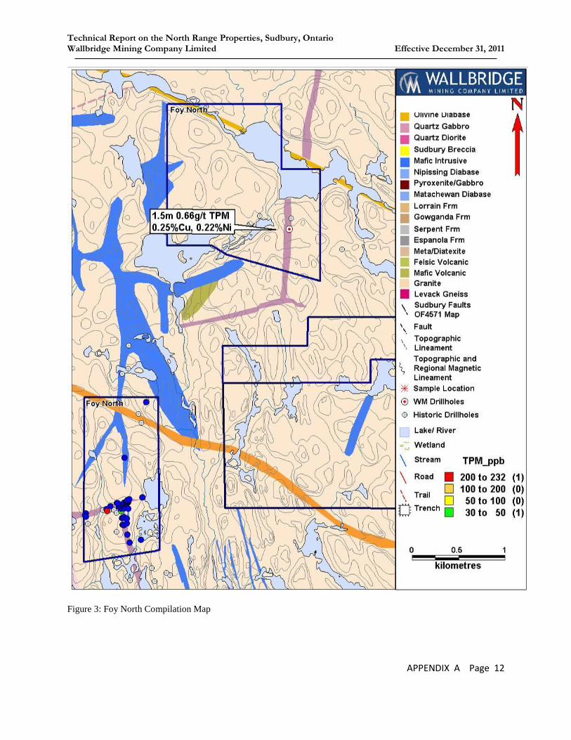
Technical Report on the North Range Properties, Sudbury, Ontario Wallbridge Mining Company Limited Effective December 31, 2011
APPENDIX A Page 12
Figure 3: Foy North Compilation Map
Technical Report on the North Range Properties, Sudbury, Ontario Wallbridge Mining Company Limited Effective December 31, 2011
APPENDIX A Page 13
o Daigle Levack
PROPERTY OWNERSHIP AND DESCRIPTION
Ownership: 100% Wallbridge
Area: 160 hectares
Title: 1 Unpatented Mining Claim
RELEVANT PREVIOUS WORK
1954 – 55: INCO – 17 diamond drill holes west of the Onaping River, and immediately
east of the eastern Ruza Option claim boundary
1960: Ontario Department of Mines – Geology of Levack Township; Langford
1987: Falconbridge – regional soil sampling
2002: a prospector – 1 sample from the northeast corner of adjacent Ruza Option
1.91% Ni, 0.36% Cu, 210 ppb Pt, 210 ppb Pd – but the location could not
be confirmed
2002: Platinum Group Metals – mag survey
2003: AeroTEM survey
WORK CARRIED OUT BY WALLBRIDGE
2007: Acquired claim from Richard Daigle
Mapping and Beep Mat prospecting, including the collection of 1 sample
2008: AeroTEM anomaly field checking; including 3 samples collected
2009: No work completed.
2010: No work completed.
DISCUSSION OF RESULTS
Prior to 2002 the property had undergone little or no focused exploration. The 2003 AeroTEM
survey delineated a number of weak conductors.

Technical Report on the North Range Properties, Sudbury, Ontario Wallbridge Mining Company Limited Effective December 31, 2011
APPENDIX A Page 14
Mapping and beep mat prospecting did not explain the cause of the AeroTEM anomalies though
the two southern-most anomalies are believed reflect the presence of a fault and concentrations
of sulfides have been found within the gneiss. Mapping to the north found only gneiss and
granite with cold Sudbury breccia coincident with the magnetic high however none of the
anomalies were explained.
EXPLORATION POTENTIAL
The property’s proximity to the Levack Embayment and the potential for footwall and Offset dyke
mineralization are the main exploration targets. The presence of Sudbury breccia in proximity to a
prominent cuspate magnetic low and with a single reported occurrence of Cu-Ni-PGE
mineralization in the adjacent Ruza Option suggests that the property is of interest.
PROPOSED WORK
Mapping and prospecting
Drilling weak AeroTEM anomalies

Technical Report on the North Range Properties, Sudbury, Ontario Wallbridge Mining Company Limited Effective December 31, 2011
APPENDIX A Page 15
Figure 4: Daigle and Ruza Levack Compilation Map
Daigle Ruza

Technical Report on the North Range Properties, Sudbury, Ontario Wallbridge Mining Company Limited Effective December 31, 2011
APPENDIX A Page 16
o Ermatinger
PROPERTY OWNERSHIP AND DESCRIPTION
Ownership: 100% Wallbridge
Area: 6,048 hectares
Title: 27 Unpatented Mining Claims
RELEVANT PREVIOUS WORK
1970’s: BP Minerals Ltd.–mapped at 1:5,000
3.8 km of line-cutting
1982: OGS – mapped 280 km2 at 1: 15,840, which included part of Ermatinger
1998: Champion Bear – HEM survey
WORK CARRIED OUT BY WALLBRIDGE
2001: 22 AMT stations
2002: ~80 line-km of ground mag
<1km of IP (overlap from the Ermatinger CBA IP survey)
9 AMT stations
2003: No work completed.
2004: No work completed.
2005: Limited mapping and collection of 13 rock samples
2006: No work completed.
2007: No work completed.
2008: overlapping coverage from an AeroTEM survey targeting the Ministic Offset on
the Ermatinger CBA property
2009: No work completed.
2010: Mapping and prospecting
Trenching and additional staking of claims
2011: Drilled 3 holes totalling 828 meters all of which intersected the Hess Offset dyke.
Trenched eight sites the largest of which had a 170m strike.
Conducted 1640 kilometer VTEM plus survey targeting the Hess Offset dyke.
Conducted recon mapping and prospecting along the suspected trend of the Hess
Offset dyke.

Technical Report on the North Range Properties, Sudbury, Ontario Wallbridge Mining Company Limited Effective December 31, 2011
APPENDIX A Page 17
DISCUSSION OF RESULTS
Trenching under a cluster of QD boulders in 2010 exposed a 25m wide dyke now known to be
the extension of the Hess Offset. Samples of angular QD float from the trench returned values of
0.1% Cu, 0.1% Ni and 0.35 g/t TPM. Subsequently in 2011 the Hess Offset dyke was exposed in
two additional trenches and intersected in all three drill holes. Drill hole WER-001 intersected a
40 meter wide Hess Offset dyke corridor containing an interpreted 18 meter wide inclusion
bearing main dyke and a 0.5 meter SQD (spherulitic quartz diorite) dyke. WER-002 intersected
an interpret 50 meter wide QD corridor with two narrow SQD dykes centered around a 40m wide
inclusion bearing dyke. In WER-003 a 95 meter QD corridor consisting of an interpreted 12
meter and 4 meter wide QD dykes and two 20 cm SQD dykes was intersected. The 2011
trenching, mapping and drilling increased the confirmed strike length of the Hess Offset dyke on
the property to nine kilometers from 25 meters in 2010. The total potential strike length of the
Hess Offset on the property could be as much as 19.7 km.
The spring 2011 VTEM survey outline 22 weak EM responses outlined as B-field spikes in
Figure 5. These anomalies are not believed to be related to culture and some of the anomalies are
associated with known mafic intrusions. The preliminary data from the fall 2011 survey
indicated there are seven 1-4 line weak responses, five of which are along the possible strike
extension of the Hess Offset dyke.
Mapping and prospecting east of the Trill West property located a 10 meter long segment of a
4m wide radial Offset dyke 500m southwest of the Ministic Offset Trend. The dyke may be a
splay off the Ministic Offset dyke. More mapping is required to extend the new dyke.
EXPLORATION POTENTIAL
The Ermatinger property covers 9 -19.7 km strike length of the Hess Offset that potentially hosts
Offset-style Ni-Cu-PGE mineralization. This is supported by historical work on Vale’s Rivers
Option property which delineated sulfide mineralization accumulations grading 0.82% Cu and
1.45% Ni and 1.29g/t TPM in the Hess Offset dyke. The dyke is virtually untested because it is
very poorly exposed, there is no deep penetrating geophysical coverage and the three drill holes
along Hess Offset dyke on the property were shallow.

Technical Report on the North Range Properties, Sudbury, Ontario Wallbridge Mining Company Limited Effective December 31, 2011
APPENDIX A Page 18
Also, in other QD dykes, mineralization is generally associated with inclusion bearing phases of
quartz diorite and are often focused at flexures, splices, pinches, splays, bends and terminations
in the dikes as well as where the dikes pass through large mafic bodies. There are several
locations along the Hess Offset on the property where IQD has been located. Also splays, areas
cutting large gabbro intrusions and fluctuating thicknesses were discovered during mapping and
drilling. There is also the potential that the segments of the Trill and Ministic Radial Offset
dykes and their intersection with the Hess Offset are hosted on the property.
Other targets are 29 weak EM responses (represented by the B-field spikes) some of which are
coincident with known Nipissing Gabbro sills, magnetic highs or the potential strike extension of
the Hess Offset dyke.
PROPOSED WORK
Continue with mapping and prospecting along the strike extent of the Hess Offset.
Trenching along Hess dyke trend to locate the dyke.
Drilling to target EM anomalies near the project Hess Offset trend.
Drilling 500m spaced 250m drill holes to locate the Hess Offset dyke to the end of the
property.
100km of Ground EM along the length of the Hess Offset dyke.
Ground truth VTEM anomalies with mapping and trenching.
Prospecting and mapping for possible extensions of the Ministic Offset dyke discovered
on the Ministic Offset and Ermatinger CB properties to the southwest and the Trill West
property to the northwest.
Conduct ground EM along strike length of the Hess Offset. Incorporating loop
configurations best suited for steeply dipping conductors and equipment best suited for
detecting highly conductive bodies such as an “on-time” or “B-field” system.
Drill deep drill holes targeting favourable geological mapped along the dykes trend such
as intersections with other dykes and large mafic bodies

Technical Report on the North Range Properties, Sudbury, Ontario Wallbridge Mining Company Limited Effective December 31, 2011
APPENDIX A Page 19
Figure 5: Ermatinger Compilation Map.

Technical Report on the North Range Properties, Sudbury, Ontario Wallbridge Mining Company Limited Effective December 31, 2011
APPENDIX A Page 20
o Ermatinger CBA
PROPERTY OWNERSHIP AND DESCRIPTION
Ownership: 50% Champion Bear, 50% Wallbridge, Champion Bear Ermatinger JV
Area: 1,934.14 hectares
Title: 10 Unpatented Mining Claims and 3 Leases
RELEVANT PREVIOUS WORK
1957: Prosco Limited– trenching, 4 samples taken
1982–86: Bear Tag Resources– 8 drill holes totalling 493.78 m
1988–90: Falconbridge– 47 soil samples, line-cutting, mapping, sampling, IP
WORK CARRIED OUT BY WALLBRIDGE
1999: Airborne electro-magnetic (EM) and magnetic (Mag.) surveys
2000: Champion Bear – 31.7 km of line-cutting
31.7 line-km of ground VLF-EM and Mag.
3 diamond drill holes totalling 603 m
2001: 5.5 line-km of IP
18.65 line-km of UTEM
2002: 161.7 km of line-cutting
161.7 line-km of ground Mag.
62.4 line-km of IP/resistivity
43 AMT stations
3 diamond drill holes totalling 1,014 m
Limited mapping and rock sample collection around the Bear Tag Showing
Discovery of quartz diorite extended the Ministic Offset
2003: limited mapping and sample collection along the Ministic Offset
Excavated and mapped 3 trenches at 1:500, collected 22 rock samples
2005: 3.2 line km of IP survey
2006: no work
2007: reconnaissance visit
2008: 257.8km AeroTEM III survey
Mapping and prospecting, including the collection of 115 samples

Technical Report on the North Range Properties, Sudbury, Ontario Wallbridge Mining Company Limited Effective December 31, 2011
APPENDIX A Page 21
Review of historical Bear tag core, and prospecting around the showing
2009: no work completed
2010: mapping and prospecting, including the collection of 48 samples
Traced a mafic/ultramafic intrusion for 5km
2011: Trenching along the Ministic Offset dyke
DISCUSSION OF RESULTS
Mapping, trenching and prospecting by Wallbridge has successfully traced the Ministic Offset
dyke for 5.1 km. The important inclusion phase and mineralization associated with the Offset
dyke has not yet been discovered, likely because the dyke has less than 1% exposure and has not
been drilled. The few trenched exposures of the Ministic Offset dyke indicate the dyke is up to
20 meters wide. Mapping on the adjacent Ermatinger property located a 30 meter segment of a
parallel Offset dyke which may be a splay off the Ministic Offset dyke. This dyke trends towards
the Ermatinger CBA property and where it intercepts the main Ministic dyke is a good
environment to explore.
Mapping delineated five kilometer length of a 1.5 to 100m wide northwest trending
mafic/ultramafic intrusion. The rock unit has been describe throughout the property as a
pyroxenite as the majority of the outcrop mapped consists of coarse grained, equigranular,
equant, dark green fresh rock that appear to be composed of pyroxene. Thin sections of the rock
reveal majority the pyroxene has been altered to amphibole with interstitial plagioclase replaced
by fine grained sericite. This unit also has characteristically high back ground nickel (up to
1200ppm), chromium (up to 1560ppm) and magnesium concentrations relative to other mafic
intrusion common to this area.
The exact age of the pyroxenite is unknown however it appears as clasts in a rock unit believed
to be Sudbury breccia and has a chilled contacted with the 2.64 Ga granitic pluton host rock.
Compared to the geochemistry of other mafic rocks from this area it is most similar to the rocks
generated from the SIC. The relation of the pyroxenite to the SIC is not clear at this point but the
chemical similarities of the two are remarkable and may suggest some close genetic link. Also,
the occurrence of similar pyroxenite as inclusions (so called “exotic xenoliths”) in sublayer
hosted contact ore may suggest a genetic link between the SIC contact ore deposits and the
pyroxenite. The pyroxenite is not confined to one dyke as it has been intersected in WML-005

Technical Report on the North Range Properties, Sudbury, Ontario Wallbridge Mining Company Limited Effective December 31, 2011
APPENDIX A Page 22
and has been identified on other Wallbridge properties in the North Range. This would suggest a
much larger magma source.
200 meters west of the thickest part of the pyroxenite dyke a clast in Sudbury breccia of coarse
grain actinolite with ~20% combined po and cpy was discovered. Assay results indicate the clast
contained 0.345 g/t Au, 20.6 g/t Ag, 2.75% Cu and 0.14% Ni. After reviewing historic core near
the sample site it was apparent that the mineralization in the drill core was hosted in similar
mineral assemblage as the aforementioned clast; though the actinolite in the clast was coarser
grained. It was also apparent that the metal distribution is zoned. Cu > Zn associated with
actinolite veins and quartz-carbonate-actinolite veins and Zn>Cu associated with the margins of
actinolite assemblages or hosted in fine grained epidote. The Cu, Au, and Ni concentrations in
the Sudbury breccia clast suggest the clast could have originated from an undiscovered portion of
the mineralized zone that hosts more favourable mineralization.
The hydrothermal system which generated the mineralization discussed above may have been
driven by the intrusion of the pyroxenite. This is evident by the proximity of the mineralization
to the thickest part of the pyroxenite dyke, the fact that the mineralization and associated
hydrothermal veins are observed cutting the host rock to the pyroxenite but not the pyroxenite
and the Sudbury breccia is younger than the mineralization indicating it is unlikely generated
from the SIC. The Cu-Zn could have been remobilized from the country rock but the Ni is an
oddity and may indicate remobilization from a nearby Ni-Cu mineralization.
EXPLORATION POTENTIAL
25% of the ore in Sudbury is from Sudbury Offset dyke environments. This is why the 5 km
strike length of the Ministic Offset dykes is very prospective for significant deposits of nickel,
copper, platinum, palladium and gold and considered the greatest exploration potential on the
Ermatinger CBA property. With less than 1% of the dyke exposed, no drilling and limited
geophysics coverage the dykes remain under explored.
The Pyroxenite dykes discovered on the property appear to have the potential to host Ni-Cu PGE
mineralization. This rock unit is a newly recognized lithology in the North Range therefore very
little is known about this rock unit, including origin, age, depth extent, flow direction, overall dip
and whether it is mineralized. However Cu/Zn >1, missing PGE’s, sulphur in the area and the

Technical Report on the North Range Properties, Sudbury, Ontario Wallbridge Mining Company Limited Effective December 31, 2011
APPENDIX A Page 23
high SiO2 concentration suggest these dykes had reached sulphur saturation. If this is the case,
the high concentration of Ni (up to 1200ppm) in the silicate suggests the sulfides could have high
Ni tenor given the right conditions.
Also encouraging is that the pyroxenite appears to have multiple phases of magmatism, a larger
magma chamber at depth, fluctuating morphology, evidence of Ni depletion along the dyke,
similar if not the same rock found as inclusion in contact sublayer hosted ore deposits in the
north range of the SIC. The limited sample population of the pyroxenite suggests at least two
pulses of magma formed the pyroxenite, a low Al2O3 and normal tholeiitic-type which is similar
to the Bushveld, Great Dyke and Stillwater intrusions (Naldrett 2010). The significance of this is
it may support a recharging of the magmatic system thus increasing the R-factor and potentially
creating higher tenor values in any sulfide accumulations the magma interacts with.
A large portion of the portion of the property has not been seen any relevant exploration.
PROPOSED WORK
Recommendations for the future exploration along the Ministic Offset include:
Trenching three sites where unexplained magnetic and chargeability highs are coincident
with the strike extent of the Ministic Offset dyke.
More detailed sampling along the Ministic Offset and pyroxenite dykes to better
understand the intrusions and help determine where to target future exploration along the
dykes.
Drill two 300 metre drill holes and extend BT-001 200 metre for the purpose of testing
chargeability high and determine the orientation of the pyroxenite dyke.
Mapping the remainder of the property.
Conduct ground EM along the 5.1 km strike length of the Ministic Offset. Incorporating
loop configurations best suited for steeply dipping conductors and equipment best suited
for detecting highly conductive bodies such as an “on-time” or “B-field” system.
Drill ten deep drill holes space ~600m apart along the length of the dyke coupled with
borehole RIM survey would be a method to test for mineralization below 400m.
Although this is very costly and past experience with the RIM system has indicated the
survey produces many false positives the alternative is 200-300m space drill holes along
the length of the dyke coupled with borehole EM.
Conducting a gravity survey to help interpret the source, orientation at depth and the
extent on surface and at depth.

Technical Report on the North Range Properties, Sudbury, Ontario Wallbridge Mining Company Limited Effective December 31, 2011
APPENDIX A Page 24
Conduct ground EM along the length of the dyke which incorporates loop configurations
best suited to help define the orientation of the intrusion as determined by the gravity
survey. The equipment best suited for detecting highly conductive bodies such as an “on-
time” or “B-field” system should be used as the mineralization will likely be highly
conductive.

Technical Report on the North Range Properties, Sudbury, Ontario Wallbridge Mining Company Limited Effective December 31, 2011
APPENDIX A Page 25
Figure 6: Ermatinger CBA and Ministic Compilation Map

Technical Report on the North Range Properties, Sudbury, Ontario Wallbridge Mining Company Limited Effective December 31, 2011
APPENDIX A Page 26
o Harty
PROPERTY OWNERSHIP AND DESCRIPTION
Ownership: 100% Wallbridge
Area: 336 hectares
Title: 3 Unpatented Mining Claims
RELEVANT PREVIOUS WORK
1969: Ontario Department of Mines, Geological Report 65, map at 1:31,680
2002: Champion Bear - Airborne EM survey
2005: Crowflight Minerals – MegaTEM survey
WORK CARRIED OUT BY WALLBRIDGE
2007: staking
2008: Mapping and prospecting
2009: mapping, including the collection of 6 samples
2010: 1 sample collected.
DISCUSSION OF RESULTS
2009 mapping on the property delineated 400 metre strike length of a north-south trending dyke
which has a similar geochemistry and oxide content to that of the Quartz Gabbro layer of the
SIC. The regional magnetic data indicates that the quartz gabbro dyke may extend from the
inclusion- and sulfide-bearing Hess Offset to the south and east, and may also have an ore-
hosting potential similar to the Hess Offset. The magnetic data also suggest that a splay of the
Hess Offset dyke might extend on to the Harty property.
Technical Report on the North Range Properties, Sudbury, Ontario Wallbridge Mining Company Limited Effective December 31, 2011
APPENDIX A Page 27
EXPLORATION POTENTIAL
The location of this property, only 200m from the mineralized portion of the Hess Offset, is an
opportune area for an Offset dyke occurrence with the potential of hosting Ni-Cu-PGE
mineralization.
The regional magnetic data indicates that the quartz gabbro dyke which was delineated on the
property may extend from the inclusion- and sulfide-bearing Hess Offset and may therefore have
ore-hosting potential similar to the Hess Offset. Exploration potential is also assigned to the
Quartz Gabbro dyke because the origin and mode of emplacement of mineralization in Offset
dykes is not well understood.
PROPOSED WORK
Map the remainder of the property.
Determine if the Quartz Gabbro Offset dyke has mineralization potential at depth.
Conduct ground EM along the strike length of the Quartz Gabbro dyke. Incorporating
loop configurations best suited for steeply dipping conductors and equipment best suited
for detecting highly conductive bodies such as an “on-time” or “B-field” system.
Drill deep drill holes space ~600m apart along the length of the dyke coupled with
borehole RIM survey would be a method to test for mineralization below 400m.
Although this is very costly and past experience with the RIM system has indicated the
survey produces many false positives the alternative is 200-300m space drill holes along
the length of the dyke coupled with borehole EM.

Technical Report on the North Range Properties, Sudbury, Ontario Wallbridge Mining Company Limited Effective December 31, 2011
APPENDIX A Page 28
o Hess CBA
PROPERTY OWNERSHIP AND DESCRIPTION
Ownership: 50 % Champion Bear, 50% Wallbridge, Champion Bear Hess JV
Area: 2,752 hectares
Title: 24 Unpatented Mining Claims
RELEVANT PREVIOUS WORK
1950–70: INCO – Mapping
Ground and airborne geophysics
27 drill holes totalling 2725 m
1957: Mining Endeavour Ltd.– 9 drill holes (all less than 20 m)
1966–69: Jaybee Landry Exploration– 9 drill holes totalling 171 m
Ground magnetic (Mag.) survey
1973–76: L.G. Bardswich– 11 diamond drill holes totalling 334 m
1975: Progress Engineering– 12 diamond drill holes totalling 339 m
1975: Dome Exploration– airborne radiometric and Mag. surveys
1988: BP Resources Ltd.– 6 drill holes totalling 795 m
1998: C. Woods– Mapped 23 line-km, including the collection of 9 rock samples
1999: Champion Bear– 1 diamond drill hole
2000: Champion Bear– 54.375 km line-cutting
3 drill holes completed; totalling 370 m
Ground VLF-EM, Mag. and gradient IP
Mapped 26.8 line-km
2001: Champion Bear – 5 diamond drill holes
2002: 10 stream sediment samples collected (kimberlite indicators)
2003: Champion Bear– 2 drill holes totalling 477.7 m
2005: Crowflight Minerals – MegaTEM survey that includes 66% of the property
WORK CARRIED OUT BY WALLBRIDGE
2006: Mapped and Beep Mat prospecting 1.8 km2 at 1:2,000; 55 samples collected
Technical Report on the North Range Properties, Sudbury, Ontario Wallbridge Mining Company Limited Effective December 31, 2011
APPENDIX A Page 29
Re-sampled Champion Bear drill core; 15 samples
2007: 11.2 km Titan 24 DCIP/MT
2008: 2 drill holes, totalling 217m, including 38 samples
Mapping and prospecting
2009: no work completed
2010: mapping and prospecting; including the collection of 41 samples
2011: 60 km InfiniTEM II B-field Survey with line spacing of 200m targeting the Hess
Offset dyke.

Technical Report on the North Range Properties, Sudbury, Ontario Wallbridge Mining Company Limited Effective December 31, 2011
APPENDIX A Page 30
Figure 7: Hess Compilation Map

Technical Report on the North Range Properties, Sudbury, Ontario Wallbridge Mining Company Limited Effective December 31, 2011
APPENDIX A Page 31
DISCUSSION OF RESULTS
Mapping and sampling has outlined a 10 kilometre strike length of the Hess Offset dyke on the
property with the potential for an additional 5 km strike length. Even though the Hess Offset has
only 1% surface exposure on the property, mapping along the Hess Offset on the northeast claim
block has located a 1.5 kilometre segment of inclusion-bearing QD dyke containing disseminated
pyrrhotite and chalcopyrite mineralization. Wallbridge drill holes across the dyke indicate the
Hess Offset is up to 75 metres thick on the property. Surface grab samples from this segment
contained up to 0.26% Cu, 0.18% Ni and 0.92 g/t TPM. Mapping west of the Rivers Option has
outlined two disseminated sulfide bearing phase of the Hess Offset with grab samples assays up
to 931 ppm Ni + Cu and 0.13 g/t TPM. Mapping has also identified multiple flexures, splices,
splays, possible terminations, areas cutting gabbro/diabase and fluctuating thicknesses which are
strong structural geological targets.
In 2011 an InfiniTEM II surface EM survey was conducted over the entire strike length of the
Hess Offset dyke on the property. The survey delineated nine very weak (30-80 Siemens) EM
anomalies and 30 questionable EM responses. Four of the very weak anomalies form a 600-800
metre conductive trend coincident with the Hess Offset dyke trend.
EXPLORATION POTENTIAL
The Hess property covers 10 -15 km strike length of the Hess Offset, and potentially hosts
Offset-style Ni-Cu-PGE mineralization. This is supported by historical work on Vale’s Rivers
Option property which reports a small near surface zone of sulfide mineralization grading 0.82%
Cu and 1.45% Ni and 1.29g/t TPM. The dyke is poorly exposed, and historical drilling along it
was shallow and has focused on small areas, with large portions of the dyke being left untested.
Wallbridge’s 2011 InfiniTEM II survey identified a very weak (80 Siemen) 600-800 metre
conductive trend along the Hess Offset dyke. This response is unlikely to reflect massive sulfide
but could indicate lower sulfide PGE bearing mineralization in the dyke or the top of something
at depth.
Offset mineralization is generally associated with inclusion bearing phases of quartz diorite and
are often focused at flexures, splices, pinches, splays, bends and terminations in the dikes as well
as where the dikes pass through large mafic bodies. There are several locations along the Hess

Technical Report on the North Range Properties, Sudbury, Ontario Wallbridge Mining Company Limited Effective December 31, 2011
APPENDIX A Page 32
Offset where IQD has been recognized and detailed mapping has identified multiple flexures,
splices, splays, possible terminations, areas cutting gabbro/diabase and fluctuating thicknesses
which are strong structural geological targets.
PROPOSED WORK
Target EM plates on L18 and L22 coincident with the Hess Offset trend delineated from
the 2011 InfiniTEM II with three drill holes totalling 550m.
Mapping property immediately east of Vale’s River Option property to delineate the Hess
Offset dyke.
Mapping and prospecting to ground truth other anomalies delineated from the 2011
InfiniTEM survey and to ground truth questionable responses coincident with the Hess
Offset.
Drill geological settings along the dyke that fit the genetic model for the formation of
Offset hosted ore deposit.
Infill ground Geophysics of 100m spaced lines to test the strike length of the Hess Offset
for smaller ore bodies.
Mapping the remainder of the property starting near the Hess Offset trend.
Drill IP anomalies in the South east corner if they prove to be coincident with the trend of
the Hess Offset.

Technical Report on the North Range Properties, Sudbury, Ontario Wallbridge Mining Company Limited Effective December 31, 2011
APPENDIX A Page 33
o Ministic
PROPERTY OWNERSHIP AND DESCRIPTION
Ownership: 100% Wallbridge
Area: 1,392 hectares
Title: 10 unpatented mining claims
RELEVANT PREVIOUS WORK
1953: Noranda – Mapping and magnetic (Mag) surveys
1956: INCO – 1 drill hole totalling 304.8 m
1957: Arcadia Nickel Corp. Ltd.– 3 drill holes totalling 342.9 m, intersecting
possible QD but not described as such.
1983: OGS – Reconnaissance mapping at 1”: ¼ mile
1987: Falconbridge – 22 soil samples
WORK CARRIED OUT BY WALLBRIDGE
1998: began staking claims
1999: GeoTEM survey flown at 200m line spacing
2001: Mapping, including the collection of 15 rock samples
2 diamond drill holes totalling 899 m, confirmed QD discovered by
Arcadia in 1957
1 borehole EM survey (WMC-002)
82 AMT stations
2002: 9.8 km line-cutting (extending from the Ermatinger CBA grid)
Mapping, including the collection of 8 rock samples
7 drill holes totalling 3,791 m
2 borehole PEM surveys
2.25 line-km IP
25 AMT stations
2008: Review of historical core and drill logs

Technical Report on the North Range Properties, Sudbury, Ontario Wallbridge Mining Company Limited Effective December 31, 2011
APPENDIX A Page 34
Mapping, prospecting and sampling
2009: Reconnaissance visit, 2 samples
2010: 1 sample collected
DISCUSSION OF RESULTS
Historical work has confirmed the strike extension of the Ministic Offset dyke to the north-
western boundary of the claim group. Shallow drilling (~350m) intersected anomalous metal
concentrations of up to 590ppm Ni, 470ppm Cu and 110 ppb platinum plus palladium within the
dyke.
Sudbury breccia was found to be coincident with a regional curvilinear magnetic and
topographic low in the north east corner of the property. To date, mapping has determined the
minimum thickness of the belt to be 104 metres.
The review of the drill logs has resulted in the identification of a pyroxenite in WML-009 and
WML-010 that is the same as the pyroxenite found at Bear Tag, on the adjacent Champion Bear
Ermatinger property.
EXPLORATION POTENTIAL
The property hosts 2.1 km of the Ministic Offset dyke which is only 3-5km from the SIC contact.
There is virtually no surface exposure of the dyke on the property and drilling was conducted at
600m spacing along the dyke and only tested down to 350m below surface. Samples from the
drill holes contained anomalous metal concentrations. The presences of meta-pyroxenite
intrusions along the Ministic Offset trend is also encouraging, because ore bodies on other Offset
dykes, such as Worthington, form where the dyke intersect amphibolite bodies. Recent
exploration has identified Offset-style mineralization on Wallbridge’s Milnet property at 1,600m
depth and on Quadra FNX’s Victoria property at about 1,000m depth. From this perspective, the
Ministic Offset remains virtually unexplored.

Technical Report on the North Range Properties, Sudbury, Ontario Wallbridge Mining Company Limited Effective December 31, 2011
APPENDIX A Page 35
PROPOSED WORK
Conduct ground EM along the strike length of the Ministic Offset. Incorporating
loop configurations best suited for steeply dipping conductors and equipment best
suited for detecting highly conductive bodies such as an “on-time” or “B-field”
system.
Drill deep drill holes space ~600m apart along the length of the dyke coupled
with borehole RIM survey would be a method to test for mineralization below
400m. Although this is very costly and past experience with the RIM system has
indicated the survey produces many false positives the alternative is 200-300m
space drill holes along the length of the dyke coupled with borehole EM.
Map and sample the meta-pyroxenite bodies in greater detail.

Technical Report on the North Range Properties, Sudbury, Ontario Wallbridge Mining Company Limited Effective December 31, 2011
APPENDIX A Page 36
o Pele JV
PROPERTY OWNERSHIP AND DESCRIPTION
Ownership: 100% Pele Mountain; Wallbridge Joint Venture
Area: 5,312 hectares
Title: 26 Unpatented Mining Claims
RELEVANT PREVIOUS WORK
1948: INCO – small area airborne magnetic (Mag) survey
1950: Falconbridge – limited mapping and small airborne Mag survey
1967: C. Lee – till sampling; 5 auger drill holes totalling 85.35m
1968: Falconbridge – 4 diamond drill holes totalling 488m
1987 Crimson Star Resources – mapping, airborne VLF-EM and mag,
ground IP, mag and VLF-EM
1988: Falconbridge – soil survey
1998: Champion Bear Resources Ltd. – Helicopter mag and EM
2003: Aurora Platinum – 15 line-km ground magnetic survey
2005: Crowflight Minerals – MegaTEM survey over the North Range
2005: Pele Mountain Resources – limited mapping, including 29 rock samples
Stripping of 25m x 5m
28 line km of EM-31
450 line-km Aerotem survey
Announced new QD Offset
WORK CARRIED OUT BY WALLBRIDGE
1999: regional GeoTEM survey covered the southern portion of the property
2005: VTEM survey covered the southern tip of the property
2006: Mapped 1.9 km2 at 1:2000, including the collection of 98 samples
Trenching: 60 x 3 m
3 diamond drill holes totalling 363m, including 83 samples
2007: Mapping of 7.2km2 at 1:2,000, including the collection of 208 samples

Technical Report on the North Range Properties, Sudbury, Ontario Wallbridge Mining Company Limited Effective December 31, 2011
APPENDIX A Page 37
Excavated 3 trenches
2008: 114 km line cutting
104.9 line km of IP
1 drill hole totalling 96m, including 41 samples
Mapping of 2.89km2 at 1:2,000, including the collection of 77 samples
2009: Mapping and prospecting (0.8km2), including the collection of 17 samples
4 diamond drill holes totalling 883m, including 71 samples
Localized magnetometer traverses
2010: Mapping, including the collection of 30 samples
2011: 11 km InfiniTEM II B-field Survey with line spacing of 200m targeting the Hess
Offset dyke.
DISCUSSION OF RESULTS
In the fraction of the property that has been explored mapping and trenching has outlined two
Granophyre Offset dykes totalling 9.1 km strike length, 3.6 km strike length of a Quartz Gabbro
Offset dyke, 2.5 km splay of the Hess Offset dyke and an 8 km concentric belt of Sudbury
breccia on the property. Sulfide mineralization has not been discovered on any of the Offset
dykes but the Hess Offset dyke has only been tested for large massive ore bodies to 400m depth
and the other three dykes have not been explored deeper than about 150 metres.
The Sudbury breccia (Pele Breccia Belt) corridor that trends across the southern third of the
property appears to be an anastomosing unit, pinching and swelling much like most occurrences
of Sudbury breccia in the Sudbury Basin. It does, however, seem to be trending concentrically to
the SIC which hints to a genetic link to the development of major concentric faults along which
the transient Sudbury impact crater is hypothesized to have collapsed. Exploration of these
concentric features should provide a better understanding of their genesis and give a clear idea of
the exploration potential of the SIC Footwall in their vicinity. A few samples of the breccia from
the Pele Breccia Belt contained weakly anomalous concentrations of Pt and Pd (PGE), and
pathfinder elements in recent sampling, similar to enrichments encountered in breccias that host
Cu-PGE mineralization at Xstrata’s Strathcona Mine and FNX’s McCreedy West Mine in the
Levack Trough about 8 kilometres to the south.

Technical Report on the North Range Properties, Sudbury, Ontario Wallbridge Mining Company Limited Effective December 31, 2011
APPENDIX A Page 38
Figure 8: Pele Compilation Map

Technical Report on the North Range Properties, Sudbury, Ontario Wallbridge Mining Company Limited Effective December 31, 2011
APPENDIX A Page 39
EXPLORATION POTENTIAL
There are two principal exploration target types including Quartz Diorite Offset dykes and
concentric zones of Sudbury breccia. The 2.5km strike length of the Hess Offset dyke
discovered in the northwest corner of the property is less than 1km from the Rivers Option
occurrence which hosts 20,900 tonnes at 0.82% Cu, 1.45% Ni which points to the economic
potential of this Offset dyke and has only been tested for the equivalent of a six million tonne
massive ore body to 400m. Also there are very few exposures of the dyke present and only two
drill holes intersecting the dyke on the property. Therefore it is not known if inclusion bearing
phases of quartz diorite are present or if flexures, splices, pinch, bends or terminations are
present along the strike extent. There are locations along the Hess Offset on the property where
splays and fluctuating thicknesses where observed which are strong structural geological targets.
Exploration potential is also assigned to the Quartz Gabbro and Granophyre Offset dykes
because of their size, the origin and mode of emplacement of mineralization in Offset dykes is
not well understood, the vast majority of the three dykes have not been tested and the proximity
of the dykes to the Foy Offset dyke. The latter is mineralized well into the footwall north of the
SIC contact with the most significant occurrence being the Cu-Ni-PGE mineralization of the Ni
Offset Mine.
The Sudbury breccia, which has produced high Cl and weakly anomalous pathfinder element
concentrations, are indicative of the passage of mineralizing fluids similar to breccia rocks
hosting copper-PGE mineralization at Xstrata's Strathcona Mine and FNX's McCreedy West
Mine in the Levack Trough 4-8 kilometres to the south.
PROPOSED WORK
Drill geological settings along the dyke that fit the genetic model for the formation of
Offset hosted ore deposit.
Infill surface EM with 100m spaced lines to test the 2.5km strike length of the Hess
Offset; for 100m wide orebody at least 200m down dip of current EM coverage

Technical Report on the North Range Properties, Sudbury, Ontario Wallbridge Mining Company Limited Effective December 31, 2011
APPENDIX A Page 40
Continue mapping and prospecting magnetic anomalies focusing on the discovery of new
Offset dykes and belts of Sudbury breccia, and to establish their prospectively to host Cu-
PGE mineralization.
Map and prospect the Quartz Gabbro dyke southward.
Test for mineralization along the new limb of the Hess Offset using a series of 1200m
deep drill holes as platforms for RIM surveys.
Continued mapping and prospecting of the Pele Offset dyke discovered in 2005 to better
constrain the dyke by filling in the gaps between outcrops and search for outcrops of
Inclusion Quartz Diorite.

Technical Report on the North Range Properties, Sudbury, Ontario Wallbridge Mining Company Limited Effective December 31, 2011
APPENDIX A Page 41
o Rudy’s Lake
PROPERTY OWNERSHIP AND DESCRIPTION 1.1.1
Ownership: 100% Wallbridge
Area: 144 hectares
Title: 1 Unpatented Mining Claim
RELEVANT PREVIOUS WORK 1.1.2
1953: T. Mungovan– ground magnetic (Mag) survey
1968 – 72: Falconbridge– 7 drill holes totalling 810.46 m (1 km west of property)
1970: INCO– 12 drill holes totalling 3,504.59 m (within and to the NE of prop.)
1987: Noramco Explorations Inc.– airborne Mag and VLF-EM
1988–89: Crimsonstar Resource Ltd./Noramco Exploration Ltd. – 2 drill holes
totalling 363.4 m (north of the property)
2001: Falconbridge– detailed mapping to N-NW of the property
WORK CARRIED OUT BY WALLBRIDGE 1.1.3
1999: Airborne EM and Mag.
2000: 6.62 km of line-cutting
Mapping at 1:5000, including the collection of 88 rock samples
25 AMT stations
2001: No work completed.
2002: 15.85 km of line-cutting and Mag.
Mapping at 1:2500, including the collection of 29 rock samples
12.18 km of IP
6.28 km of UTEM
Technical Report on the North Range Properties, Sudbury, Ontario Wallbridge Mining Company Limited Effective December 31, 2011
APPENDIX A Page 42
2003: No work completed.
2004: No work completed.
2005: prospecting, including the collection of 2 rock samples
2006: no work completed
2007: reconnaissance visit
2008: verification of QD occurrence
2009: Mapping and prospecting, including the collection of 1 sample
2010: mapping and washing, 7 samples collected
DISCUSSION OF RESULTS 1.1.4
The geochemical analysis of Rudy’s Lake QD supports the field and petrographic observations
by Wallbridge geologists, that this rock unit does in fact represent an SIC-related melt similar to
that of QD dykes. However, the silica content of the QD on Rudy’s Lake is much higher, than
that of typical QD dykes. Only the Pele Offset dykes (on Wallbridge’s Pele Mountain property)
have similarly high SiO2 concentrations.
The QD melt on the Rudy’s Lake property was emplaced into a recrystallized zone of Sudbury
breccia and both the SDBX and the QD appear to trend NE-SW. Within this zone, however, the
veins and dykes (up to 1.5 m in width) of QD show variable strike directions, some even trend
N-S and NW-SE.
Although the QD usually has a quite distinctive (often spherulitic) texture with acicular
amphibole crystals, however based on geochemistry samples thought to be SDBX matrix appears
to be QD. This indicates that the distinction between the two rock types is not straight-forward.
It is possible that the Rudy’s Lake QD and the Pele Offset dykes have a genetic relationship. The
geochemical similarity may indicate a common melt source and/or differentiation of the same
melt. A genetic relationship is also supported by the fact that the Rudy’s Lake QD occurrences
are on the projected strike extension Pele Offset dyke. In this case, the apparent NE-SW trend of
the Rudy’s Lake QD may actually represent the width of the zone in which a NW-SE migration
of QD melt occurred. Because the Rudy’s Lake QD occurs within the Sandcherry Creek Fault
zone, and the Pele Offset dykes have the same strike direction as the fault, it could be possible,

Technical Report on the North Range Properties, Sudbury, Ontario Wallbridge Mining Company Limited Effective December 31, 2011
APPENDIX A Page 43
that the fault was active during the crystallization of the SIC and that it tapped an upper level of
SIC melt (in contrast to other QD dykes, which are believed to have tapped the basal layer of the
SIC). The SIC melt may have escaped along the fault zone and emplaced into the Sudbury
breccia zone of the Rudy’s Lake property and intrude further into the footwall forming the Pele
Offset dykes.
EXPLORATION POTENTIAL 1.1.5
A high degree of prospectivity for contact- or footwall-style mineralization related to the SIC is
indicated by the widespread occurrences of quartz diorite outcrops, a possible, previously
unrecognised partially exposed quartz diorite Offset dyke, irregular zones of partial melt and
numerous chargeability anomalies.
Additional discoveries of melt pods of quartz-diorite, which extends melt pod occurrences over a
100x 300 metre area, 300 metres from the SIC contact. The QD is not of the composition
generally proven to be favourable for Cu-Ni-PGE mineralization and the base, as well as
precious metal contents are very low. However, it may be possible that the same structural
corridor used by this seemingly barren QD melt was also used by metal-bearing (QD) melts or
fluids. Thus, more work is warranted on the property, especially in the more underexplored
northern parts. Previous mapping located numerous outcrops described as QD and extensive
areas described as partial melt that were interpreted as related to the formation of the SIC. The
unit believed to be a quartz diorite body is irregular in distribution and appears to cut Sudbury
breccia whereas petrographic study indicates this unit is textural and mineralogical similar to
Quartz Diorite Offset dykes.
PROPOSED WORK 1.1.6
Conduct a surface electromagnetic survey to test for conductive sulfides.
Drill resulting targets and follow up with borehole EM.

Technical Report on the North Range Properties, Sudbury, Ontario Wallbridge Mining Company Limited Effective December 31, 2011
APPENDIX A Page 44
Figure 9: Ruza Compilation Map.

Technical Report on the North Range Properties, Sudbury, Ontario Wallbridge Mining Company Limited Effective December 31, 2011
APPENDIX A Page 45
o Ruza Levack
PROPERTY OWNERSHIP AND DESCRIPTION
Ownership: 100% Wallbridge
Area: 608 hectares
Title: 4 Unpatented Mining Claims
RELEVANT PREVIOUS WORK
1954 – 55: INCO – 17 diamond drill holes west of the Onaping River, and immediately
east of the eastern claim boundary
1960: Ontario Department of Mines – Geology of Levack Township; Langford
1987: Falconbridge – regional soil sampling
2002: a prospector – 1 sample from the northeast corner
1.91% Ni, 0.36% Cu, 210 ppb Pt, 210 ppb Pd – but location could not be
confirmed
2002: Platinum Group Metals – magnetic survey (2 northwest trending highs)
2003: AeroTEM – airborne EM
WORK CARRIED OUT BY WALLBRIDGE
2007: Acquired claim from Ruza Resources
Reinterpretation of 2002 AeroTEM results
Mapping and Beep Mat prospecting, including the collection of 11 samples
Excavated 2 areas: (1) over an AeroTEM anomaly and (2) over suspect QD
2008: U/Pb age for granophyric mafic dyke
Mapping, prospecting and sampling (88 samples)
Magnetometer traverses
Mechanical and manual excavation of AeroTEM anomalies
2009: No work completed.
2010: 2 samples collected

Technical Report on the North Range Properties, Sudbury, Ontario Wallbridge Mining Company Limited Effective December 31, 2011
APPENDIX A Page 46
DISCUSSION OF RESULTS
Mapping and prospecting in the northeast corner of the property outline narrow dykes which
have geochemical finger print of QD Offset dyke and may have explained three of nine EM
anomalies (Figure 4) but failed to locate the site of the Prospector’s sample which contained a
report 1.91% Ni, 0.36% Cu, 210 ppb Pt, 210 ppb Pd.
The potential QD Offset dykes discover on the property were 30cm wide and have not been trace
further than the original outcrop. Mapping and prospecting nine air borne EM anomalies on
claims 3009423 and 3017412 did not locate the source any of the conductive responses.
However, two conductive responses are coincident with a shear zone found on the southern
portion of claim 3017412 and pyrite in gneiss was located near another anomaly.
EXPLORATION POTENTIAL
The Ruza property lies approximately 2.5km from >250 Mt of Ni-Cu ore and >40 Mt of Footwall
ore contained in Levack Embayment. Mineralized Radial Offset dykes are rooted in other such
embayment structures around the Sudbury Basin however one has never been discovered
originating from Levack though the potential for one certainly exists.
Due to overburden cover and limited work this north east portion of the property is largely
unexplored. And Wallbridge has not explored any of the southern half of the property.
PROPOSED WORK
Mechanical/manual excavation of AeroTEM anomalies accessible by road to expose
the anomaly source.
Map AeroTEM anomalies to the south, one of which is related to a GeoTEM tau
anomaly.
Map the southern edge of the property looking for Offset dykes related to the Levack
Embayment Complex.
Re-submit dyke sample for Pb-Pb age to confirm SIC parentage.
Drill anomalies that have not been explained by mapping or trenching.