Embed Size (px)
Citation preview
technicalarticles
123

124
KEY WORDS:hydraulicengineering,harbourconstruction,lockconstruction,lockgatede-sign,buildinginanexistingcontext
MOTS-CLES:géniehydraulique,constructiondeports,constructiond’écluses,conceptiondeportesd’écluse,constructionenprenantencomptel’existant
1. HISTORY AND GENERAL PLANNING CIRCUMSTANCES
When theoldKaiserschleuse lock inBremer-havenwascompletedin1897,itwasthelarg-est lock in theworld, remaining inoperationuntil it was decommissioned on January 2,2008toenableconstructionofthenewlock.The original lock chamber was 215 m longand45mwide. Theclearpassagewidthatthelockheads,however,wasonly28m.Thesilldepthwas-8.95mbelowmeansealevel.Dependingonthetidesandwinds,onlyves-selswithamaxi-mumlengthof185m,amaxi-mumwidthof25mandamaximumdraughtof8.50mcouldpassthroughthelock.
Theouterheadhadbeendesignedasadou-blepairofmitregates,whilethe innerheadhadaslidinggate,thefirsttimethishadbeenusedinlockconstruction.
Apart fromtheextremely longservice lifeoftheold lockand the technicalandmainte-nanceproblemsthatnaturallyoccurafter110yearsofoperation,thedemandsoftheport
industryforcapableandwell-organisedportfacilitiesalsohadtobetakenintoaccounttoensureefficientcargohandlingatthetermi-nals.
Since the early 1970s, automobile tranship-ment – alongside container handling – hasevolved into a high value-added, centralpillar of Bremerhaven’s economy and locallabourmarket. Between 1995and thepres-ent day, the volumes handled have morethan doubled, from approx. 0.8 million tomorethan2millionvehicleunitsperannum.Furthersignificantgrowthratesarealsofore-castforBremerhaven infuture, regardlessofthestructuralchangesinpro-ductionandde-mandintheautomotivesector,particularlyinthe vehicle export segment.With an exportshareofmorethan60%in2006,theterminalatthemouthoftheWeserranksupamongsttheworld’sleadingautomobiletranshipmentlocationsand is the largest inter-continentalvehiclehubinEurope.
Butdespitethesepositivetrends,ithasbeenapparentformanyyearsthattheportwillonlybeabletodefenditsoutstandingpositioninthegrowingmarketofautomobilehandlingif itcanprovide thenecessary infrastructureconditions.
Owing to the tidal range of theWeser, theRoRovessels that specialise in vehicle trans-port have to use the non-tidal areas of theportandarethereforedependentonuseofthe locks.WhereasNordschleuse lock, inau-guratedin1932asasecondpointofaccess
CoNStrUCtIoN of thE NEW kAISErSChLEUSE LoCk IN BrEMErhAvEN
DIPL.-ING. CHRISTOPH TARRAS
ProjectManagerBremenportsGmbH&Co.KG,Bremerhaven,AmStrom227568Bremer-havenGermany
Tel.:+4947130901138E-mail:[email protected]
125
to theharbourareas, still satisfies virtuallyallthe present operational requirements, theold Kaiserschleuse lock was no longer abletocopewiththedemandsofmodernoceanshipping. As a result, Nordschleuse by andlargeprovidedtheonlymeansofaccessforshipping – with the corres-ponding risks forcargohandlingifthelockweretobeoutofoperationforanylengthoftime.
Thesearejustsomeofthereasonswhyitwasvital to provide Bremerhaven’s AutomobileTer-minalwith two locks thatcancopewithmainshippingandalsowhyitwasessentialtomakerapidprogressintheconstructionofthenewKaiserschleuselockandtodesignitwithappro-priatedimensions.
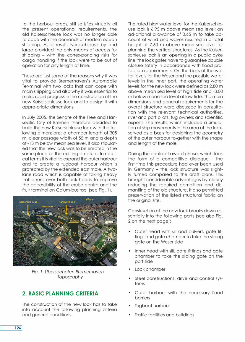
InJuly2005,theSenateoftheFreeandHan-seatic City of Bremen therefore decided tobuildthenewKaiserschleuselockwiththefol-lowingdimensions:achamber lengthof305m,clearpassagewidthof55mandadepthof-13mbelowmeansealevel.Italsostipulat-edthatthenewlockwastobeerectedinthesameplaceastheexistingstructure.Innauti-caltermsitisvitaltoexpandtheouterharbourand to create a tugboat harbour which isprotectedbytheextendedeastmole.Atwo-laneroadwhich iscapableof takingheavytraffic runsoverboth lockheads to improvetheaccessibilityofthecruisecentreandthefruitterminalonColum-businsel(seeFig.1).
Fig. 1: Überseehafen Bremerhaven – Topography
2. BASIC PLANNING CRITERIA
Theconstructionofthenewlockhastotakeinto account the following planning criteriaandgeneralconditions.
TheratedhighwaterlevelfortheKaiserschle-uselockis6.95mabovemeansealevel;anad-ditionalallowanceof0.65m to takeac-countofwindandwaves resulted ina totalheight of 7.60m abovemean sea level forplanningtheverticalstructures.AstheKaiser-schleuselockisanopeninginapublicdykeline,thelockgateshavetoguaranteedoubleclosuresafetyinaccordancewithfloodpro-tectionrequirements.Onthebasisofthewa-terlevelsfortheWeserandthepossiblewaterlevels in the innerport, theoperatingwaterlevelsforthenewlockweredefinedas2.80mabovemeansealevelathightideand-3.00mbelowmeansealevelatlowtide.Themaindimensionsandgeneralrequirementsfortheoverall structurewerediscussed inconsulta-tion with the relevant technical authorities,riverandportpilots,tugownersandscientificexperts.Theresults,whichincludedasimula-tionofshipmovementsintheareaofthelock,servedasabasisfordesigningthegeometryoftheouterharbourto-getherwiththeshapeandlengthofthemole.
Duringthecontractawardphase,whichtookthe form of a competitive dialogue – thefirsttimethisprocedurehadeverbeenusedin Germany – the lock structure was slight-ly turned compared to the draft plans. Thisbroughtconsiderableadvantagesbyclearlyreducing the required demolition and dis-mantlingoftheoldstructure.Italsopermittedpreservationof the listedstructural fabricontheoriginalsite.
Constructionofthenewlockbreaksdownes-sentiallyintothefollowingparts(seealsoFig.2onthenextpage):
• Outerheadwith sill andculvert,gate fit-tingsandgatechambertotaketheslidinggateontheWeserside
• Innerheadwithsill,gatefittingsandgatechamber to take the slidinggateon theportside
• Lockchamber
• Steelconstructions,driveandcontrol sys-tems
• Outer harbour with the necessary floodbarriers
• Tugboatharbour
• Trafficfacilitiesandbuildings
126
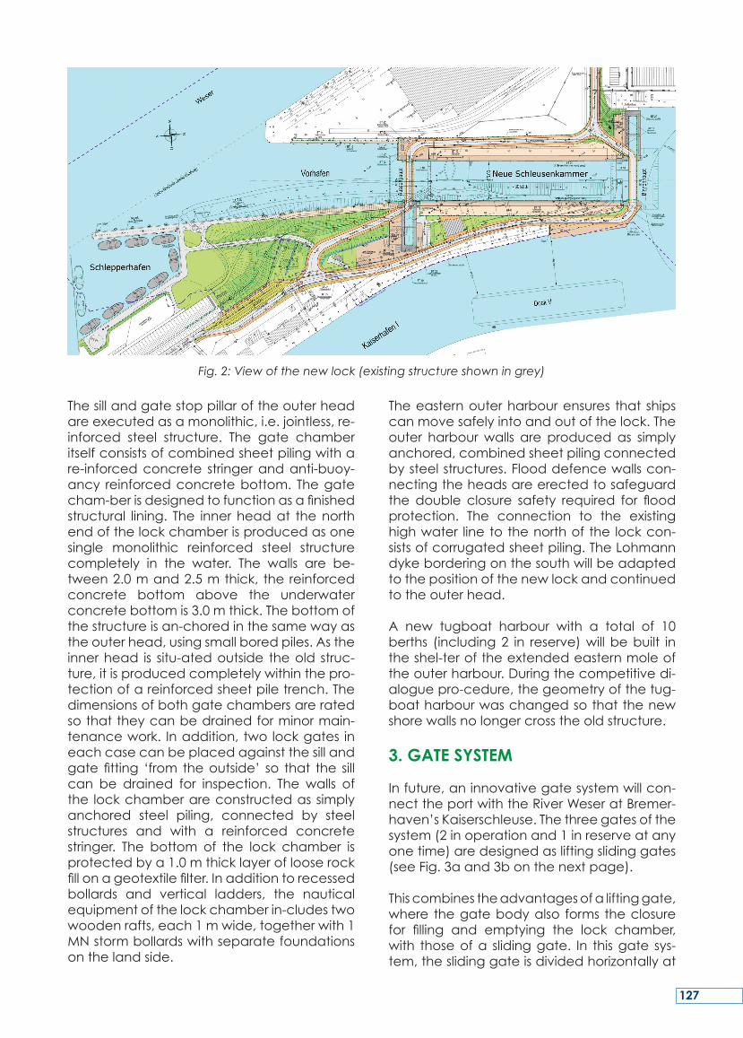
Thesillandgatestoppillaroftheouterheadareexecutedasamonolithic,i.e.jointless,re-inforced steel structure. The gate chamberitselfconsistsofcombinedsheetpilingwithare-inforcedconcrete stringerandanti-buoy-ancy reinforcedconcretebottom. Thegatecham-berisdesignedtofunctionasafinishedstructural lining. The innerheadat thenorthendofthelockchamberisproducedasonesingle monolithic reinforced steel structurecompletely in the water. The walls are be-tween2.0mand2.5mthick, thereinforcedconcrete bottom above the underwaterconcretebottomis3.0mthick.Thebottomofthestructureisan-choredinthesamewayastheouterhead,usingsmallboredpiles.Astheinnerhead is situ-atedoutside theold struc-ture,itisproducedcompletelywithinthepro-tectionofareinforcedsheetpiletrench.Thedimensionsofbothgatechambersareratedsothattheycanbedrainedforminormain-tenancework. Inaddition,twolockgates ineachcasecanbeplacedagainstthesillandgatefitting ‘from theoutside’ so that the sillcan be drained for inspection. The walls ofthe lockchamberareconstructedassimplyanchored steel piling, connected by steelstructures and with a reinforced concretestringer. The bottom of the lock chamber isprotectedbya1.0mthicklayeroflooserockfillonageotextilefilter.Inadditiontorecessedbollards and vertical ladders, the nauticalequipmentofthelockchamberin-cludestwowoodenrafts,each1mwide,togetherwith1MNstormbollardswithseparatefoundationsonthelandside.
Theeasternouterharbourensures that shipscanmovesafelyintoandoutofthelock.Theouter harbourwalls are producedas simplyanchored,combinedsheetpilingconnectedbysteelstructures.Flooddefencewallscon-nectingtheheadsareerectedtosafeguardthedouble closure safety required for floodprotection. The connection to the existinghighwater linetothenorthof the lockcon-sistsofcorrugatedsheetpiling.TheLohmanndykeborderingonthesouthwillbeadaptedtothepositionofthenewlockandcontinuedtotheouterhead.
A new tugboat harbour with a total of 10berths (including2 in reserve)willbebuilt intheshel-teroftheextendedeasternmoleoftheouterharbour.Duringthecompetitivedi-aloguepro-cedure,thegeometryofthetug-boatharbourwaschangedsothatthenewshorewallsnolongercrosstheoldstructure.
3. GATE SYSTEM
Infuture,aninnovativegatesystemwillcon-necttheportwiththeRiverWeseratBremer-haven’sKaiserschleuse.Thethreegatesofthesystem(2inoperationand1inreserveatanyonetime)aredesignedasliftingslidinggates(seeFig.3aand3bonthenextpage).
Thiscombinestheadvantagesofaliftinggate,where thegatebodyalso forms theclosurefor filling and emptying the lock chamber,with thoseofa slidinggate. In thisgate sys-tem,theslidinggateisdividedhorizontallyat
Fig. 2: View of the new lock (existing structure shown in grey)
127
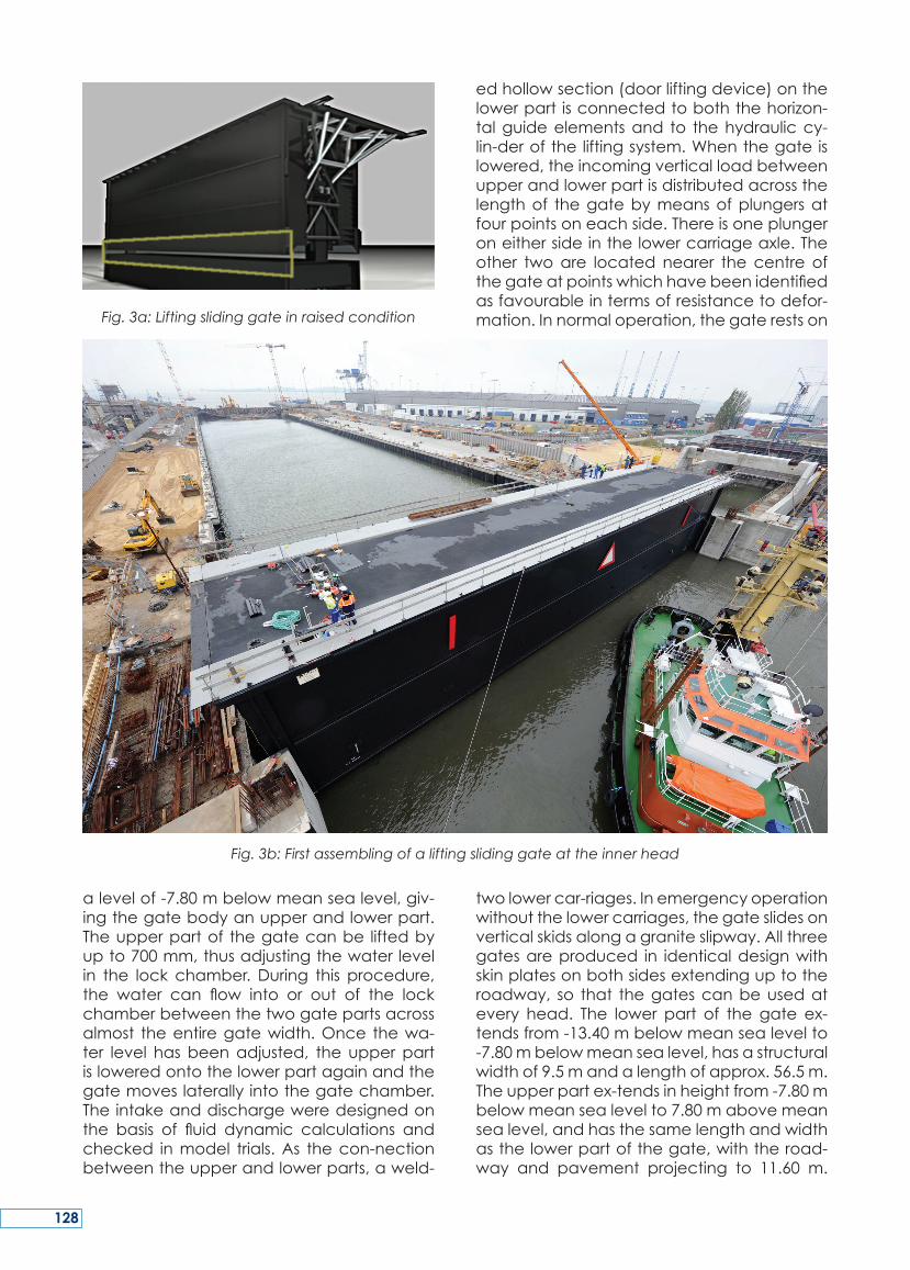
Fig. 3a: Lifting sliding gate in raised condition
alevelof-7.80mbelowmeansealevel,giv-ingthegatebodyanupperandlowerpart.Theupperpartof thegatecanbe liftedbyupto700mm,thusadjustingthewaterlevelin the lock chamber. During this procedure,the water can flow into or out of the lockchamberbetweenthetwogatepartsacrossalmost theentiregatewidth.Once thewa-ter level hasbeenadjusted, the upperpartisloweredontothelowerpartagainandthegatemoveslaterallyintothegatechamber.Theintakeanddischargeweredesignedonthe basis of fluid dynamic calculations andchecked inmodel trials.As thecon-nectionbetweentheupperandlowerparts,aweld-
edhollowsection(doorliftingdevice)onthelowerpart isconnectedtoboththehorizon-talguideelementsand to thehydrauliccy-lin-deroftheliftingsystem.Whenthegateislowered,theincomingverticalloadbetweenupperandlowerpartisdistributedacrossthelengthof thegatebymeansofplungersatfourpointsoneachside.Thereisoneplungeroneithersideinthelowercarriageaxle.Theother twoare located nearer the centre ofthegateatpointswhichhavebeenidentifiedasfavourableintermsofresistancetodefor-mation.Innormaloperation,thegaterestson
twolowercar-riages.Inemergencyoperationwithoutthelowercarriages,thegateslidesonverticalskidsalongagraniteslipway.Allthreegatesareproduced in identicaldesignwithskinplatesonbothsidesextendinguptotheroadway, so that thegatescanbeusedatevery head. The lower part of the gate ex-tendsfrom-13.40mbelowmeansealevelto-7.80mbelowmeansealevel,hasastructuralwidthof9.5mandalengthofapprox.56.5m.Theupperpartex-tendsinheightfrom-7.80mbelowmeansealevelto7.80mabovemeansealevel,andhasthesamelengthandwidthasthelowerpartofthegate,withtheroad-way and pavement projecting to 11.60 m.
Fig. 3b: First assembling of a lifting sliding gate at the inner head
128

Roadtrafficattheouterandinnerheadwillmove from the road onto the lifting slidinggateacross lifting slabs. The lockgatedrivesystemsconsistofcabledriveswithdeflectionpulleysandcabletensioningdevice.Eachlift-ingslidinggateisoperatedby2electricmo-torswith110kWeachand2gearmotorswithan output of 7.5 kWeach for emergencies.Thecablesareconnectedtothegatebyadrivecrossbar.
Fig. 4: View of the construction site in October 2010
129
When theoldKaiserschleuse lock inBremer-havenwascompletedin1897,itwasthelarg-estlockintheworld.Apartfromitsextremelylongservicelifeandthetechnicalandmainte-nanceproblemsthatnaturallyoccurafter110yearsofoperation,thedemandsoftheportindustryforcapableandwell-organisedportfacilitiesalsohadtobetakenintoaccounttoensureefficientcargohandlingatthetermi-nals.InJuly2005,theSenateoftheFreeandHan-seaticCityofBrementhereforedecided
tobuildthenewKaiserschleuselockwiththefollow-ing dimensions: a chamber length of305m, clear passagewidth of 55m and adepthof-13mbelowmeansealevel.
Thisarticlepresentsthemajoraspectsofthebasicplanningcriteriaof theoverallprojectandprovidesan insight into the innovationsofthegatesystemtobeusedatthenewKai-serschleuselock.
SUMMARY
En1897àlafindesaconstruction,l’ancienneécluse Kaiserschleuse à Bremerhaven étaitlaplusgrandeéclusedumonde.Enplusdesconséquencesd’uneduréedevieextrême-mentlongueetdesproblèmestechniquesetdemaintenancequiseproduisentnaturelle-ment après 110 ans de fonctionnement, lesexigencesde lapartde l’industrieportuaired’installations performantes ont égalementdûêtreprisesencompteafind’assureruneexploitationefficientedesterminaux.EnJuil-let2005,leSénatdelaVilleLibreetHanséa-
tiquedeBrêmeadoncdécidédeconstruireunenouvelleécluseKaiserschleuseavec lesdimensionssuivantes:longueurde305m,lar-geurutilede55metuneprofondeurde-13msousleniveaumoyendelamer.
Cet article présente les principaux critèresdeconceptionduprojetglobaletfournitunaperçudesinnovationsdusystèmedeportesutilisépourlanouvelleéclusedeKaiserschle-use.
RESUME
AlsdiealteKaiserschleuseinBremerhavenimJahr 1897 erbaut wurde, war sie die größteSchleusederWelt.NebenderäußerstlangenLebensdauerundderProblemeaus Technikund Unterhaltung, die sich natürlich nach110JahrenBetriebergeben,musstendieAn-forde-rungenderHafenindustrieanleistungs-fähigeundgutorganisierteHafeneinrichtun-gen eben-falls berücksichtigt werden, umeine effiziente Handhabung von Gütern anden Terminals zu gewährleisten. Im Juli 2005wurde folglichderBeschlussderFreienHan-
sestadtBremenunter-zeichnet,derdenBauderneuenKaiserschleusemitdenfolgendenAbmessungen festlegte: Kammerlänge 305m,Breite55mundeineDrempeltiefevon-13mNN.
ImvorliegendenArtikelwerdendieHauptas-pekte und grundsätzlichen PlanungskriteriendesProjektesvorgestellt,sowiedieInnovationdesanderneuenKaiserschleuseverwende-tenSchleusentoreserläutert.
ZUSAMMENFASSUNG
130
KEY WORDS: Kiel-Canal, Brunsbüttel, 5. lockchamber,supplytunnel,dock
MOTS-CLES:canaldeKiel,canalde lamerduNordàlaBaltique,Brunsbüttel,5èmesas,galerietechnique,dock
1. THE KIEL-CANAL
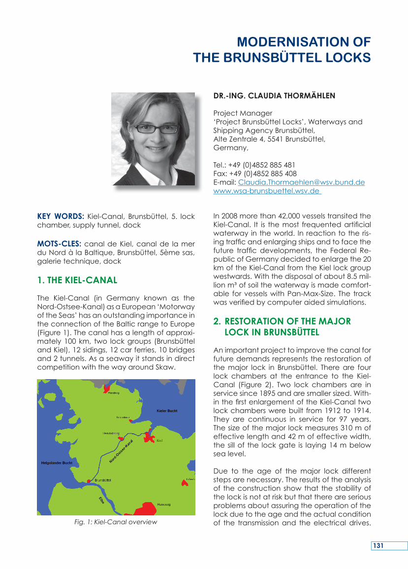
The Kiel-Canal (in Germany known as theNord-Ostsee-Kanal)asaEuropean‘MotorwayoftheSeas’hasanoutstandingimportanceintheconnectionoftheBalticrangetoEurope(Figure1).Thecanalhasalengthofapproxi-mately100km, two lockgroups (BrunsbüttelandKiel),12sidings,12carferries,10bridgesand2tunnels.AsaseawayitstandsindirectcompetitionwiththewayaroundSkaw.
Fig. 1: Kiel-Canal overview
In2008morethan42,000vesselstransitedtheKiel-Canal. It is themost frequentedartificialwaterwayintheworld. Inreactiontotheris-ingtrafficandenlargingshipsandtofacethefuture traffic developments, the Federal Re-publicofGermanydecidedtoenlargethe20kmoftheKiel-CanalfromtheKiellockgroupwestwards.Withthedisposalofabout8.5mil-lionm³ofsoilthewaterwayismadecomfort-able forvesselswithPan-Max-Size. The trackwasverifiedbycomputeraidedsimulations.
2. RESTORATION OF THE MAJOR LOCK IN BRUNSBÜTTEL
Animportantprojecttoimprovethecanalforfuturedemandsrepresentstherestorationofthemajor lock in Brunsbüttel. Thereare fourlock chambers at the entrance to the Kiel-Canal (Figure 2). Two lock chambers are inservicesince1895andaresmallersized.With-inthefirstenlargementoftheKiel-Canaltwolockchamberswerebuilt from1912to1914.They are continuous in service for 97 years.Thesizeofthemajorlockmeasures310mofeffectivelengthand42mofeffectivewidth,thesillof the lockgate is laying14mbelowsealevel.
Due to the age of the major lock differentstepsarenecessary.Theresultsoftheanalysisof theconstructionshowthat thestabilityofthelockisnotatriskbutthatthereareseriousproblemsaboutassuringtheoperationofthelockduetotheageandtheactualconditionof the transmissionand theelectricaldrives.
ModErNISAtIoN of thE BrUNSBÜttEL LoCkS
DR.-ING. CLAUDIA THORMÄHLEN
ProjectManager‘ProjectBrunsbüttelLocks’,WaterwaysandShippingAgencyBrunsbüttel,AlteZentrale4,5541Brunsbüttel,Germany,
Tel.:+49(0)4852885481Fax:+49(0)4852885408E-mail:[email protected]
131
Thetracksforthelockslide-gatesinthesluiceheadsaredamagedasaresultofthestressesandstrainsanddifferentaccidents.
3. NEW DEVELOPMENT FIFTH LOCK CHAMBER
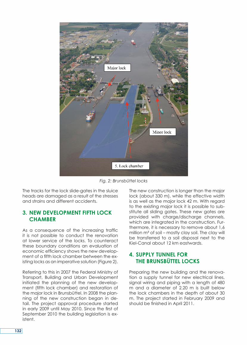
As a consequence of the increasing trafficit is not possible to conduct the renovationat lower service of the locks. To counteracttheseboundaryconditionsanevaluationofeconomicefficiencyshowsthenewdevelop-mentofafifthlockchamberbetweentheex-istinglocksasanimperativesolution(Figure2).
Referringtothisin2007theFederalMinistryofTransport, Building and Urban Developmentinitiated the planning of the new develop-ment(fifth lockchamber)andrestorationofthemajorlockinBrunsbüttel.In2008theplan-ning of the new construction began in de-tail. Theprojectapprovalprocedure startedinearly2009untilMay2010.SincethefirstofSeptember2010thebuildinglegislationisex-istent.
Thenewconstructionislongerthanthemajorlock(about330m),whiletheeffectivewidthisaswellasthemajorlock42m.Withregardtotheexistingmajorlockitispossibletosub-stituteall slidinggates. Thesenewgatesareprovided with charge/discharge channels,whichareintegratedintheconstruction.Fur-thermore,itisnecessarytoremoveabout1,6millionm³ofsoil–mostlyclaysoil.Theclaywillbe transferred to a soil disposal next to theKiel-Canalabout12kmeastwards.
4. SUPPLY TUNNEL FOR THE BRUNSBÜTTEL LOCKS
Preparingthenewbuildingandtherenova-tion a supply tunnel for newelectrical lines,signalwiringandpipingwithalengthof480m and a diameter of 2.20 m is built belowthe lockchambers inthedepthofabout30m. Theproject started in February2009andshouldbefinishedinApril2011.
Fig. 2: Brunsbüttel locks
132
5. NEW DOCK FOR RENOVATION OF THE SLIDING GATES
Every15-20yearsaslidinggatehastoberen-ovated.Duetoitsspecialdimensionsagreatdockyard isnecessary to repair thegate re-sulting high costs. Thus, for 15 sliding gates(Brunsbüttel:9/Kiel:6)itisefficienttodevelopanowndock,especiallyforthedimensionsofthemaximumgate–thenewslidinggateofthefifthlockchamber:
• Length:~48.20m• Width:~9.40m• Height:~21.20m• Draught:~11.0m
Like for the fifth lock chamber for the newdock since September 1, 2010, the buildinglegislationisexistent.
Furtherinformationcanbefoundathttp://www.portalnok.de/Projekte/Schleuse_Brunsbuettel/index.html.
133
The Kiel-Canal is theworld’s busiest artificialwaterway.Inreactiontotherisingtrafficandenlargingvesselsandtofacethefuturetrafficdevelopments the Federal Republic ofGer-manyinitiatedseveralprojects(amongotherthings):
• WideningthetwentykilometresoftheKiel-CanalfromtheKiellockgroupwestwards
• Restorationofthemajorlock(Brunsbüttel)• New development 5. lock chamber
(Brunsbüttel)• SupplytunnelfortheBrunsbüttellocks• Newdockforrenovationtheslidinggates
(Brunsbüttel)
SUMMARY
LecanaldelamerduNordàlaBaltique(oucanaldeKiel)estlavoienavigableartificiellela plus circulée au monde. En réponse àl’augmentationdutraficetdelatailledesba-teaux,laRépubliquefédéraled’Allemagneadécidéderéaliserplusieursprojets,pourquelecanaldemeuresûretadaptépourlesgé-nérationsfutures:
• élargissementdelapartieorientalesuren-viron20kmàl’ouestdeséclusesdeKiel
• restauration de la grande écluse àBrunsbüttel
• constructiond’uncinquièmesas(Brunsbüt-tel)
• construction d’une galerie technique(canalisationsetcâbles)souslecomplexed’éclusesdeBrunsbüttel
• constructiond’unenouveaudockpourlarénovation des portes à translation hori-zontale(Brunsbüttel).
RESUME
DerNord-Ostsee-Kanal(NOK)istdiemeistbe-fahreneWasserstraßederWelt.Aufgrunddersteigenden Anzahl sowie der wachsendenGröße der Schiffe wurden von der Bundre-publikDeutschlandmehrere Projekte veran-lasst,umdenNOKauchfürkommendeGen-erationen zukunftssicher auszubauen. Hierzugehörenu.a.dieProjekte:
• ErweiterungderOststrecke(ca.20km)• Grundinstandsetzung der Großen Schle-
use(Brunsbüttel)• Neubaueiner5.Schleusenkammer
(Brunsbüttel)• Rohr- und Kabeltunnelanlage unterhalb
derSchleusenanlageBrunsbüttel• Neubaueines Torinstandsetzungsdock für
Schiebetore(Brunsbüttel)
ZUSAMMENFASSUNG
134
KEY WORDS: lock elongation, lock refur-bishment, standardisation, lock gates, lockheads
MOTS-CLES: allongement d’écluse, trans-formation d’écluse, standardisation, portesd’écluse,têtesd’écluse
1. INTRODUCTION
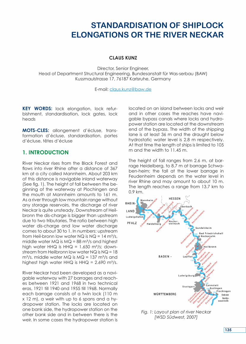
RiverNeckar rises from theBlack Forestandflows into riverRhineafteradistanceof367kmatacitycalledMannheim.About203kmofthisdistanceisnavigableinlandwaterway(Seefig.1).Theheightoffallbetweenthebe-ginningof thewaterwayatPlochingenandthemouthatMannheimamounts to161m.Asariverthroughlowmountainrangewithoutanystoragereservoirs, thedischargeof riverNeckarisquiteunsteady.DownstreamofHeil-bronnthedis-chargeisbiggerthanupstreamduetotwotributaries.Theratiobetweenhighwater dis-charge and low water dischargecomestoabout30to1.Innumbers:upstreamfromHeil-bronnlowwaterNQisNQ=14m³/s,middlewaterMQisMQ=88m³/sandhighesthighwaterHHQ isHHQ=1.650m³/s;down-streamfromHeilbronnlowwaterNQisNQ=18m³/s,middlewaterMQisMQ=137m³/sandhighesthighwaterHHQisHHQ=2.690m³/s.
RiverNeckarhadbeendevelopedasanavi-gablewaterwaywith27barragesandreach-esbetween1921and1968 in two technicaleras,1921till1940and1955till1968.Normallyeachbarrageconsistsofa twin lock(110mx12m),aweirwithupto6spansandahy-dropower station. The locks are located ononebankside,thehydropowerstationontheotherbanksideand inbetweenthere is theweir.Insomecasesthehydropowerstationis
locatedonanislandbetweenlocksandweirand in other cases the reaches have navi-gablebypasscanalswherelocksandhydro-powerstationarelocatedatthedownstreamendofthebypass.Thewidthoftheshippinglaneisat least36mandthedraughtbelowhydrostaticwater level is 2.8m respectively.Atthattimethelengthofshipsislimitedto105mandthewidthto11.45m.
Theheightof fall ranges from2.6m,atbar-rageHeidelberg,to8.7matbarrageSchwa-ben-heim; the fall at the lower barrage inFeudenheim depends on thewater level inriverRhineandmayamounttoabout10m.The lengthreachesarangefrom13.7kmto0.9km.
Fig. 1: Layout plan of river Neckar[WSD Südwest, 2007]
StANdArdISAtIoN of ShIPLoCk ELoNgAtIoNS or thE rIvEr NECkAr
CLAUS KUNZ
Director,SeniorEngineer,HeadofDepartmentStructuralEngineering,BundesanstaltfürWas-serbau(BAW)
Kussmaulstrasse17,76187Karlsruhe,Germany
E-mail:[email protected]
135
The‘Wasser-undSchifffahrtsdirektionSüdwest’inMainz(WaterwayandShippingDirectorateSouth-West, Mainz), WSD Südwest, and the‘Amt für Neckarausbau’ in Heidelberg (Wa-terway Construction Office in Heidelberg),ANH, plan to have 135m long ships travel-lingonriverNeckarwhereasonly105mlongshipscanpass riverNeckaratpresent time.Thismeansthat lockshavetobeelongatedbyabout40mandthatbendsofthefairwayhavetobechanged.Adjacentarestructuralimprovementscausedbynewtechnicalstan-dards.Thequestionhadbeenademandingtaskwhichhadbeenworkedoutunder theguidanceofthedepartmentofstructuralen-gineeringofBAWinco-operationwiththehy-draulic and geo-technical department andthe Fachstelle fürMaschinenwesen Südwest(FMSW), Koblenz. The aim of standardisa-tion is togetaharmonisedplanningphase,to achieve cost optimisationwhen erectingthestructureandtorealizeamoreeconomicmaintenanceoftheasset.
2. PROCEDURE
Startingwiththefeasibilitystudy,all involvedparties hadacomprehensiveon-site visit totypi-cal locks and had discussions with theoperation staff.Data fromtheexisting struc-tures,suchasdrawings,measurements,static
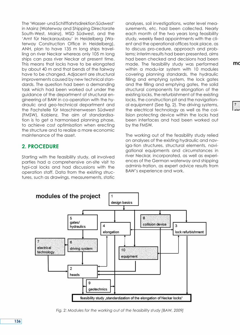
analyses,soilinvestigations,waterlevelmea-surements, etc. hadbeen collected. Nearlyeachmonthof thetwoyears longfeasibilitystudy,weeklyfixedappointmentswiththecli-entandtheoperationalofficestookplace,asto discuss pro-cedure, approach and prob-lems;interimresultshadbeenpresented,aimshadbeencheckedanddecisionshadbeenmade. The feasibility study was performedwithin a modu-lar system with 10 modulescovering planning standards, the hydraulicfilling and emptying system, the lock gatesandthefillingandemptyinggates,thesolidstructural components for elongation of theexistinglocks,therefurbishmentoftheexistinglocks,theconstructionpitandthenavigation-alequipment(Seefig.2).Thedrivingsystems,theelectrical technologyaswellas thecol-lisionprotectingdevicewithin the lockshadbeen interfaces and had beenworked outbytheFMSW.
Theworkingoutofthefeasibilitystudyreliedonanalysesoftheexistinghydraulicandnav-iga-tion structures, structural elements, navi-gational equipments and circumstances inriverNeckar, incorporated,aswellasexperi-encesoftheGermanwaterwayandshippingadminis-tration,asexpertadviceresultsfromBAW’sexperienceandwork.
Fig. 2: Modules for the working out of the feasibility study [BAW, 2009]
136
3. STANDARDISATION OF THE ELONGATION OF SHIPLOCKS
3.1. Basics
Due to nautical and topographical reasonsand sometimes due to neighboured struc-turessuchasbridges,theelongationshallbecarriedoutfor19lockstowardsdownstreamdirec-tionand for 7 locks towards upstreamdirection.Atone sitea totally new lockhastobeplanned.BecausenearlyalloftheriverNeckarlockshavetwinlockslocatedasalocksystembetweenlandsideandaweirsomeofthesewillbeelongatedonthelandside,oth-ersonthesidetotheweir.
Standardisationconceptsforexistingnaviga-tion lockswhere thenavigation through theneighboured lockshastobecontinueddur-ing the construction times are of a certaindiffi-culty.OtherdifficultiesarisefromtheriverNeckar asset as structures which had beenerected over a long time in different con-struction periods. Solid structures, hydraulicsteel engineering and the equipments arerepresentingdifferentsystemsandtechnolo-gies.Otheraspectstoconsiderarethediffer-entsidesoftheelongationdirection,someatlandside, someatwater-side,aswellas thedifferentneighbouringstructureslikeweirs,hy-
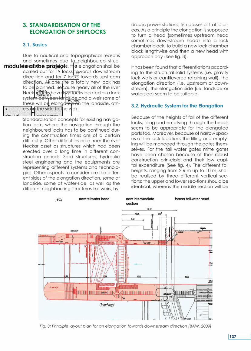
draulicpowerstations,fishpassesortrafficar-eas.Asaprincipletheelongationissupposedto turn a head (sometimes upstream headsometimes downstream head) into a lockchamberblock,tobuildanewlockchamberblocklengthwiseandthenanewheadwithapproachbay(Seefig.3).
Ithasbeenfoundthatdifferentiationsaccord-ingtothestructuralsolidsystems(i.e.gravitylockwallsorcantileveredretainingwall),theelongationdirection(i.e.upstreamordown-stream), theelongationside(i.e. landsideorwaterside)seemtobesuitable.
3.2. Hydraulic System for the Elongation
Becauseoftheheightsoffallofthedifferentlocks,fillingandemptyingthroughtheheadsseem to be appropriate for the elongatedpartstoo.Moreover,becauseofnarrowspac-esatthelocklocationsthefillingandempty-ingwillbemanagedthroughthegatesthem-selves. For the tail water gates mitre gateshave been chosen because of their robustconstruction prin-ciple and their low capi-talexpenditure (Seefig.4). Thedifferent fallheights,rangingfrom2.6mupto10m,shallbe realised by three different vertical sec-tions:theupperandlowersec-tionsshouldbeidentical,whereasthemiddlesectionwillbe
Fig. 3: Principle layout plan for an elongation towards downstream direction [BAW, 2009]
137
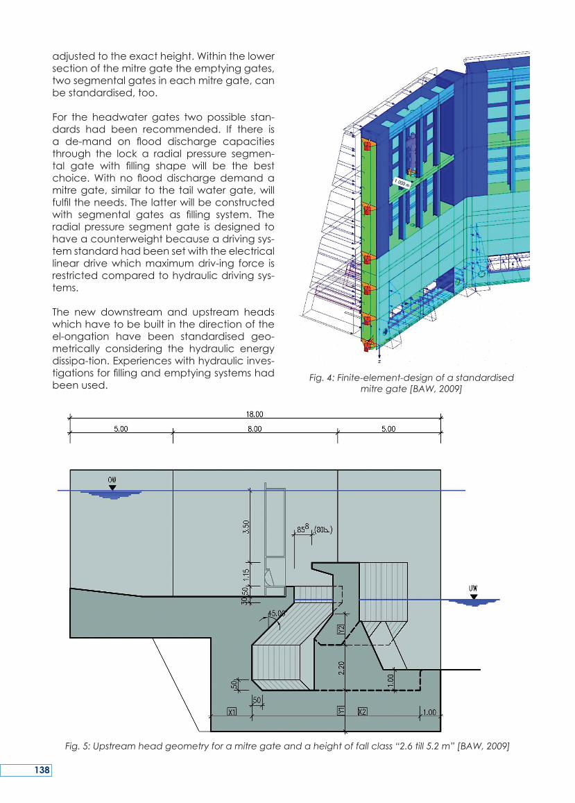
adjustedtotheexactheight.Withinthelowersectionofthemitregatetheemptyinggates,twosegmentalgatesineachmitregate,canbestandardised,too.
For the headwater gates twopossible stan-dards had been recommended. If there isa de-mand on flood discharge capacitiesthrough the lock a radial pressure segmen-tal gate with filling shape will be the bestchoice.With no flooddischargedemandamitregate,similar tothetailwatergate,willfulfiltheneeds.Thelatterwillbeconstructedwith segmental gates as filling system. Theradialpressure segmentgate isdesigned tohaveacounterweightbecauseadrivingsys-temstandardhadbeensetwiththeelectricallineardrivewhichmaximumdriv-ing force isrestrictedcomparedtohydraulicdrivingsys-tems.
The new downstream and upstream headswhichhavetobebuiltinthedirectionoftheel-ongation have been standardised geo-metrically considering the hydraulic energydissipa-tion.Experienceswithhydraulicinves-tigationsforfillingandemptyingsystemshadbeenused.
Fig. 4: Finite-element-design of a standardised mitre gate [BAW, 2009]
Fig. 5: Upstream head geometry for a mitre gate and a height of fall class “2.6 till 5.2 m” [BAW, 2009]
138
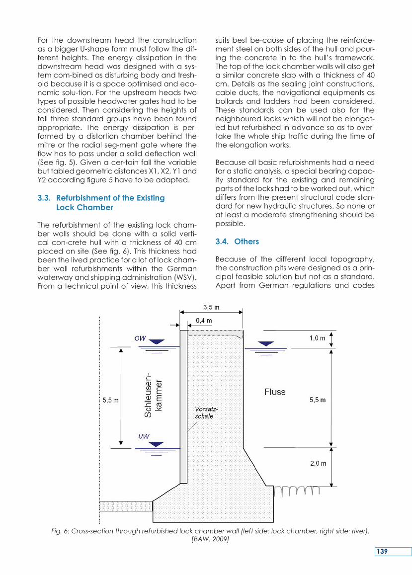
For the downstream head the constructionasabiggerU-shapeformmustfollowthedif-ferent heights. The energy dissipation in thedownstreamheadwasdesignedwitha sys-temcom-binedasdisturbingbodyandtresh-oldbecauseitisaspaceoptimisedandeco-nomicsolu-tion.Fortheupstreamheadstwotypesofpossibleheadwatergateshadtobeconsidered. Then considering the heights offall threestandardgroupshavebeenfoundappropriate. The energy dissipation is per-formedbyadistortionchamberbehind themitreortheradialseg-mentgatewheretheflowhastopassunderasoliddeflectionwall(Seefig.5).Givenacer-tainfallthevariablebuttabledgeometricdistancesX1,X2,Y1andY2accordingfigure5havetobeadapted.
3.3. Refurbishment of the Existing Lock Chamber
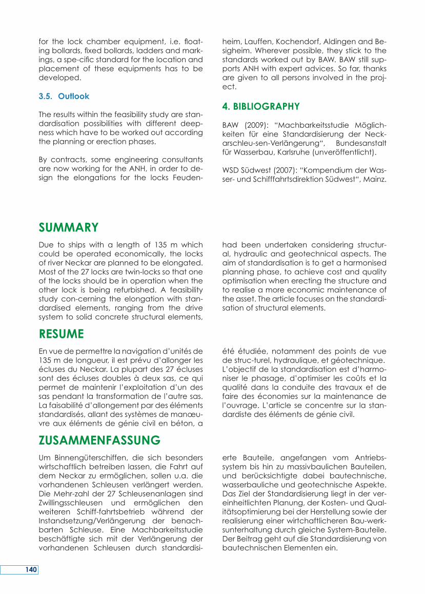
Therefurbishmentof theexisting lockcham-ber walls should be donewith a solid verti-calcon-cretehullwitha thicknessof40cmplacedonsite(Seefig.6).Thisthicknesshadbeenthelivedpracticeforalotoflockcham-ber wall refurbishments within the Germanwaterwayandshippingadministration(WSV).Fromatechnicalpointofview,thisthickness
suitsbestbe-causeofplacing the reinforce-mentsteelonbothsidesofthehullandpour-ing the concrete in to the hull’s framework.Thetopofthelockchamberwallswillalsogetasimilarconcreteslabwithathicknessof40cm.Detailsasthesealingjointconstructions,cableducts,thenavigationalequipmentsasbollards and ladders hadbeen considered.These standards can be used also for theneighbouredlockswhichwillnotbeelongat-edbutrefurbishedinadvancesoastoover-takethewholeshiptrafficduringthetimeoftheelongationworks.
Becauseallbasicrefurbishmentshadaneedforastaticanalysis,aspecialbearingcapac-ity standard for the existing and remainingpartsofthelockshadtobeworkedout,whichdiffersfromthepresentstructuralcodestan-dardfornewhydraulicstructures.Sononeoratleastamoderatestrengtheningshouldbepossible.
3.4. Others
Because of the different local topography,theconstructionpitsweredesignedasaprin-cipalfeasiblesolutionbutnotasastandard.Apart from German regulations and codes
Fig. 6: Cross-section through refurbished lock chamber wall (left side: lock chamber, right side: river), [BAW, 2009]
139
for the lock chamber equipment, i.e. float-ingbollards,fixedbollards,laddersandmark-ings,aspe-cificstandardforthelocationandplacement of these equipments has to bedeveloped.
3.5. Outlook
Theresultswithinthefeasibilitystudyarestan-dardisation possibilities with different deep-nesswhichhavetobeworkedoutaccordingtheplanningorerectionphases.
By contracts, some engineering consultantsarenowworkingfortheANH,inordertode-sign the elongations for the locks Feuden-
heim,Lauffen,Kochendorf,AldingenandBe-sigheim.Whereverpossible, theystick to thestandardsworkedoutbyBAW.BAWstill sup-portsANHwithexpertadvices.Sofar,thanksaregiven toallpersons involved in theproj-ect.
4. BIBLIOGRAPHY
BAW (2009): “Machbarkeitsstudie Möglich-keiten für eine Standardisierung der Neck-arschleu-sen-Verlängerung“, BundesanstaltfürWasserbau,Karlsruhe(unveröffentlicht).
WSDSüdwest(2007):“KompendiumderWas-ser-undSchifffahrtsdirektionSüdwest“,Mainz.
Due to ships with a length of 135 m whichcould be operated economically, the locksofriverNeckarareplannedtobeelongated.Mostofthe27locksaretwin-lockssothatoneofthelocksshouldbeinoperationwhentheother lock is being refurbished. A feasibilitystudy con-cerning theelongationwith stan-dardised elements, ranging from the drivesystemtosolidconcretestructuralelements,
had been undertaken considering structur-al,hydraulicandgeotechnicalaspects. Theaimofstandardisationistogetaharmonisedplanningphase,toachievecostandqualityoptimisationwhenerectingthestructureandtorealiseamoreeconomicmaintenanceoftheasset.Thearticlefocusesonthestandardi-sationofstructuralelements.
SUMMARY
Envuedepermettrelanavigationd’unitésde135mdelongueur,ilestprévud’allongerleséclusesduNeckar.Laplupartdes27éclusessontdeséclusesdoublesàdeuxsas,cequipermet demaintenir l’exploitation d’un dessaspendantlatransformationdel’autresas.Lafaisabilitéd’allongementpardesélémentsstandardisés,allantdessystèmesdemanœu-vreauxélémentsdegéniecivilenbéton,a
été étudiée, notamment des points de vuedestruc-turel,hydraulique,etgéotechnique.L’objectifdelastandardisationestd’harmo-niser le phasage, d’optimiser les coûts et laqualité dans la conduite des travaux et defairedeséconomies sur lamaintenancedel’ouvrage. L’article seconcentre sur la stan-dardistedesélémentsdegéniecivil.
RESUME
Um Binnengüterschiffen, die sich besonderswirtschaftlichbetreiben lassen,die FahrtaufdemNeckar zuermöglichen, sollenu.a.dievorhandenen Schleusen verlängert werden.DieMehr-zahlder27SchleusenanlagensindZwillingsschleusen und ermöglichen denweiteren Schiff-fahrtsbetrieb während derInstandsetzung/Verlängerung der benach-barten Schleuse. Eine Machbarkeitsstudiebeschäftigte sich mit der Verlängerung dervorhandenen Schleusen durch standardisi-
erte Bauteile, angefangen vom Antriebs-systembis hin zumassivbaulichenBauteilen,und berücksichtigte dabei bautechnische,wasserbaulicheundgeotechnischeAspekte.DasZielderStandardisierungliegtinderver-einheitlichtenPlanung,derKosten-undQual-itätsoptimierungbeiderHerstellungsowiederrealisierungeinerwirtchaftlicherenBau-werk-sunterhaltungdurchgleicheSystem-Bauteile.DerBeitraggehtaufdieStandardisierungvonbautechnischenElementenein.
ZUSAMMENFASSUNG
140
KEY WORDS: locks,newconstructions,Elbe-Havel Canal, development of the structuraldesign
MOTS-CLES:écluses,nouvellesconstructions,canaldel’ElbeàlaHavel,innovationdanslaconceptiondesstructures
1. INTRODUCTION
Forover17years,theWaterwayConstructionOfficeMagdeburg(WNAMD)hasbeenac-tive as a service to improve the navigationconditionsforinlandwaterwaytransport.TheWNAMDwasfoundedinMagdeburgonJan-uary1,1992toimplementthepoliticalman-date–therealisationofProject17oftheGer-manUnityTransportProjects(VDE17).
As a subdivision of the Federal Water andShippingAdministration(WSV)oftheFederalMinistryof Transport,BuildingandUrbanDe-velopment, theWNAMD of theWater andShippingDirectorateEast isbothbasedandco-ordinated inMagdeburg. As the projectdeveloperofvariousextensionandconstruc-tionmeasures,theWNAMDworkscloselywiththeseniorauthoritiesof theWaterandShip-ping Administration, the Federal Institute ofHydraulic Engineering, the Federal InstituteofHydrologyandtherespectiveagenciestoresolve technical and environmental issues.The planning is done in close co-operationwith authorities, societies, public agenciesandtheir integrationintotheconcept. Inor-der tocomplete theextensiveconstruction,
theWNAMD is supported in itsconstructionpreparationsbyqualifiedconsultantsandfortheconstructionwork itself,makesuseofef-ficient, regionally locatedconstructioncom-panies.
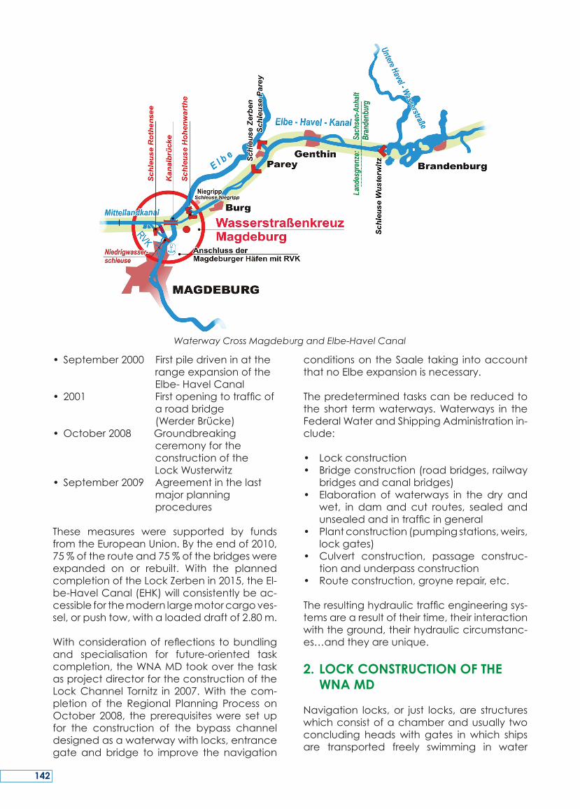
Themost relevant taskof theWNAMDwasfirsttopreparetheconstructionoftheWater-wayCrossMagdeburg(WKM).Thefollowingkeydatesmarkmilestonesoftheactivity:
• April1992 Preliminarydecisionon theWaterwayCross Magdeburg(WKM)asa bridgesolution
• 1997–1999Layingthefoundation stonefortheLock
Rothensee,theCanal BridgeovertheElbe andtheLockHohen warthe
•October10,2003Openingtotrafficofthe WKM
• June3,2008Foundationstonelaid fortheLow-WaterLock (LWLock)
From June 1992, the expansion of the El-be-Havel Canal from the Waterway CrossMagdeburg (WKM) to the estuary into the‘GroßenWendsee’inthecityofBrandenburgwastransferredtotheWNAMD.About55kmofcanal expansion, 2 locks, 19bridgesandvarious water management systems are tobeadapted to the requirementsofmoderncargovessels.Thefollowingdatashowthere-centrunofevents:
NEW CoNStrUCtIoNS of thE LoCkS of thE WAtErWAY CoNStrUCtIoN offICE MAgdEBUrg
HENRIK TÄGER
Dipl.-Ing.,ChiefOfficer,Wasserstraßen-NeubauamtMagdeburg,KleinerWerder5c,391114Magdeburg
Tel.:+49(0)3915352200Fax:+49(0)3915352114E-mail:[email protected]:http://www.wna-magdeburg.wsv.de
141
• September2000Firstpiledriveninatthe rangeexpansionofthe Elbe-HavelCanal
• 2001 Firstopeningtotrafficof aroadbridge
(WerderBrücke)•October2008Groundbreaking ceremonyforthe constructionoftheLockWusterwitz• September2009 Agreementinthelast majorplanning procedures
These measures were supported by fundsfromtheEuropeanUnion.Bytheendof2010,75%oftherouteand75%ofthebridgeswereexpanded on or rebuilt. With the plannedcompletionoftheLockZerbenin2015,theEl-be-HavelCanal(EHK)willconsistentlybeac-cessibleforthemodernlargemotorcargoves-sel,orpushtow,withaloadeddraftof2.80m.
Withconsiderationof reflections tobundlingand specialisation for future-oriented taskcompletion,theWNAMDtookoverthetaskasprojectdirectorfortheconstructionoftheLockChannel Tornitz in 2007.With thecom-pletion of the Regional Planning Process onOctober 2008, theprerequisiteswere set upfor the construction of the bypass channeldesignedasawaterwaywithlocks,entrancegateandbridge to improve the navigation
conditionsontheSaale taking intoaccountthatnoElbeexpansionisnecessary.
Thepredeterminedtaskscanbereducedtothe short termwaterways.Waterways in theFederalWaterandShippingAdministrationin-clude:
• Lockconstruction• Bridgeconstruction(roadbridges,railway
bridgesandcanalbridges)• Elaboration ofwaterways in the dry and
wet, in damand cut routes, sealed andunsealedandintrafficingeneral
• Plantconstruction(pumpingstations,weirs,lockgates)
• Culvert construction, passage construc-tionandunderpassconstruction
• Routeconstruction,groynerepair,etc.
Theresultinghydraulictrafficengineeringsys-temsarearesultoftheirtime,theirinteractionwiththeground,theirhydrauliccircumstanc-es…andtheyareunique.
2. LOCK CONSTRUCTION OF THE WNA MD
Navigation locks,or just locks,are structureswhichconsistofachamberandusuallytwoconcluding headswith gates inwhich shipsare transported freely swimming in water
Waterway Cross Magdeburg and Elbe-Havel Canal
142
throughwaterlevelchangefromonepositionintoanother.Thechanges inwater levelarebrought about by admitting water into thechamberoromittingit.Thedifferentiationbe-tweenlockstructuresisdiverse.Someexam-plescited:singlelock,doublelock,riverlock/canal lock, sea lock/waterway lock/sportboatlockorthetypeofclosurebodiessuchasmitregate,liftgate,swinggateorthefillinganddischargedevices,suchasfillingthroughthegate,fillingwiththegate,fillingwithsidecirculation, with longitudinal channels or abase-flowsysteminthebottom.
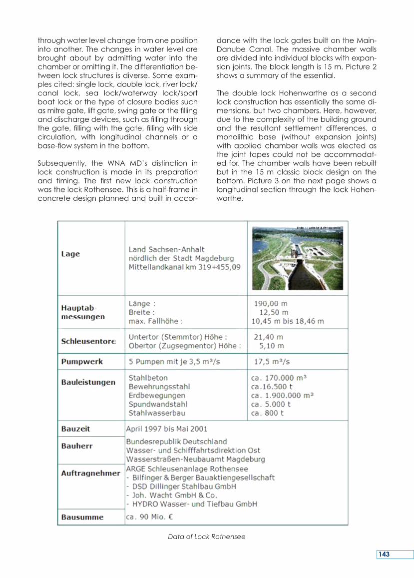
Subsequently, the WNA MD’s distinction inlock construction is made in its preparationand timing. The first new lock constructionwasthelockRothensee.Thisisahalf-frameinconcretedesignplannedandbuiltinaccor-
dancewiththelockgatesbuiltontheMain-Danube Canal. Themassive chamber wallsaredividedintoindividualblockswithexpan-sionjoints.Theblocklengthis15m.Picture2showsasummaryoftheessential.
The double lock Hohenwarthe as a secondlockconstructionhasessentiallythesamedi-mensions,buttwochambers.Here,however,duetothecomplexityofthebuildinggroundand the resultant settlement differences, amonolithic base (without expansion joints)withappliedchamberwallswaselectedasthe joint tapes could not beaccommodat-edfor.Thechamberwallshavebeenrebuiltbut in the 15mclassicblockdesignon thebottom.Picture3onthenextpageshowsalongitudinalsectionthroughthelockHohen-warthe.
Data of Lock Rothensee
143
Longitudinal Section through the Lock Hohenwarthe
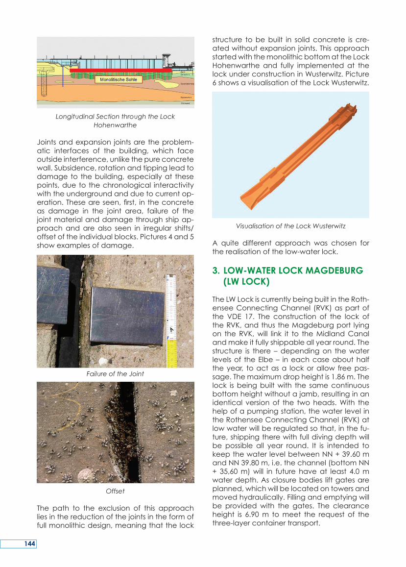
Jointsandexpansion jointsaretheproblem-atic interfaces of the building, which faceoutsideinterference,unlikethepureconcretewall.Subsidence,rotationandtippingleadtodamageto thebuilding,especiallyat thesepoints,duetothechronological interactivitywiththeundergroundandduetocurrentop-eration.Theseareseen,first, intheconcreteas damage in the joint area, failure of thejointmaterialanddamagethroughshipap-proachandare also seen in irregular shifts/offsetoftheindividualblocks.Pictures4and5showexamplesofdamage.
Failure of the Joint
Offset
The path to the exclusion of this approachliesinthereductionofthejointsintheformoffullmonolithicdesign,meaningthatthelock
structure tobebuilt in solidconcrete is cre-atedwithoutexpansionjoints.ThisapproachstartedwiththemonolithicbottomattheLockHohenwarthe and fully implemented at thelockunderconstructioninWusterwitz.Picture6showsavisualisationoftheLockWusterwitz.
Visualisation of the Lock Wusterwitz
A quite different approach was chosen fortherealisationofthelow-waterlock.
3. LOW-WATER LOCK MAGDEBURG (LW LOCK)
TheLWLockiscurrentlybeingbuiltintheRoth-enseeConnectingChannel (RVK)aspartofthe VDE 17. The construction of the lock oftheRVK,andthustheMagdeburgport lyingon theRVK,will link it to theMidlandCanalandmakeitfullyshippableallyearround.Thestructure is there –dependingon thewaterlevelsof theElbe– ineachcaseabouthalftheyear, toactasa lockorallow freepas-sage.Themaximumdropheightis1.86m.Thelock isbeingbuiltwith the samecontinuousbottomheightwithoutajamb,resultinginanidentical versionof the twoheads.With thehelpofapumpingstation,thewaterlevelintheRothenseeConnectingChannel(RVK)atlowwaterwillberegulatedsothat,inthefu-ture,shippingtherewithfulldivingdepthwillbe possible all year round. It is intended tokeepthewaterlevelbetweenNN+39.60mandNN39.80m,i.e.thechannel(bottomNN+ 35,60m)will in future haveat least 4.0mwaterdepth.Asclosurebodies liftgatesareplanned,whichwillbelocatedontowersandmovedhydraulically.Fillingandemptyingwillbe providedwith the gates. The clearanceheight is 6.90m tomeet the request of thethree-layercontainertransport.
144
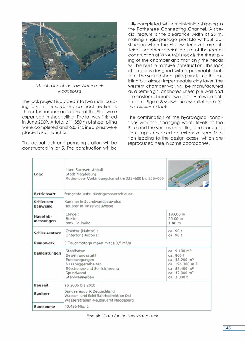
Visualisation of the Low-Water Lock Magdeburg
Thelockprojectisdividedintotwomainbuild-ing lots. In the so-called contract section 4,theouterharbourandbanksoftheElbewereexpandedinsheetpiling.ThelotwasfinishedinJune2009.Atotalof1,350mofsheetpilingwerecompletedand635inclinedpileswereplacedasananchor.
Theactual lockandpumpingstationwillbeconstructed in lot5. Theconstructionwillbe
fullycompletedwhilemaintainingshippingintheRothenseeConnectingChannel.A spe-cial feature is theclearancewidthof 25m,making single-passage possible without ob-structionwhentheElbewater levelsaresuf-ficient.AnotherspecialfeatureoftherecentconstructionofWNAMD’slockisthesheetpil-ingofthechamberandthatonlytheheadswillbebuilt inmassiveconstruction.Thelockchamberisdesignedwithapermeablebot-tom.Thesealedsheetpilingbindsintotheex-istingbutalmostimpermeableclaylayer.Thewesternchamberwallwillbemanufacturedasasemi-high,anchoredsheetpilewallandtheeasternchamberwallasa9mwidecof-ferdam.Figure8showstheessentialdataforthelow-waterlock.
The combination of the hydrological condi-tions with the changing water levels of theElbeandthevariousoperatingandconstruc-tion stages revealedanextensive specifica-tion leading to thedesigncases,whicharereproducedhereinsomeapproaches.
Essential Data for the Low-Water Lock
145
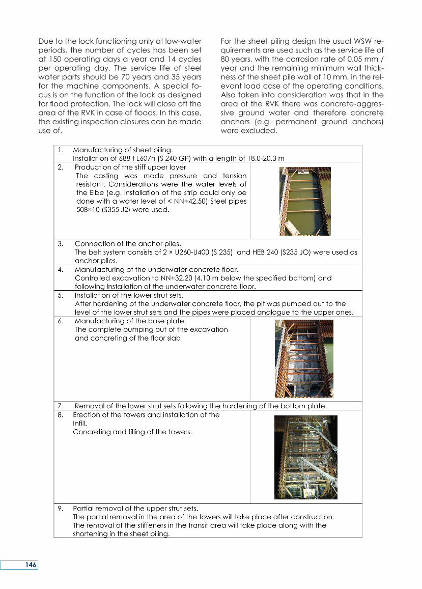
Duetothelockfunctioningonlyatlow-waterperiods, thenumberofcycleshasbeensetat150operatingdaysayearand14cyclesper operating day. The service life of steelwaterpartsshouldbe70yearsand35yearsfor themachinecomponents.A special fo-cusisonthefunctionofthelockasdesignedforfloodprotection.ThelockwillcloseofftheareaoftheRVKincaseoffloods.Inthiscase,theexistinginspectionclosurescanbemadeuseof.
ForthesheetpilingdesigntheusualWSWre-quirementsareusedsuchastheservicelifeof80years,withthecorrosionrateof0.05mm/yearandtheremainingminimumwall thick-nessofthesheetpilewallof10mm,intherel-evantloadcaseoftheoperatingconditions.AlsotakenintoconsiderationwasthatintheareaoftheRVKtherewasconcrete-aggres-sive ground water and therefore concreteanchors (e.g. permanent ground anchors)wereexcluded.
146
Thefollowingversionsarelimitedtothecon-struction process for the preparation of theheads based on steel construction. For theconstruction process, workflows for differentdesign cases were determined by the wa-ter level of the Elbe. The excavations havedimensions of 42m × 18m. The stiffening isdoneontwolevelsthroughwalingandpipesastransversestiffenerinthecorners.Figures9to11onthepreviouspageshowvariouscon-structionstages.
Duringthepredeterminedphase9,shiptraf-ficwilltakeplaceontheeastsideintheareaofthefuturepumpstation.Fortheprotectionagainstshipapproaches,steelpilingswerein-stalledwherebargesareanchoredasimpactprotection. Pictures 11and 12 show thedif-ferentnavigationconditionsintheRothenseeConnectingChanel(RVK).
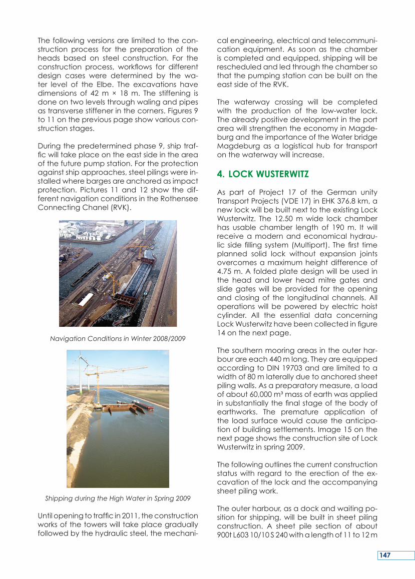
Navigation Conditions in Winter 2008/2009
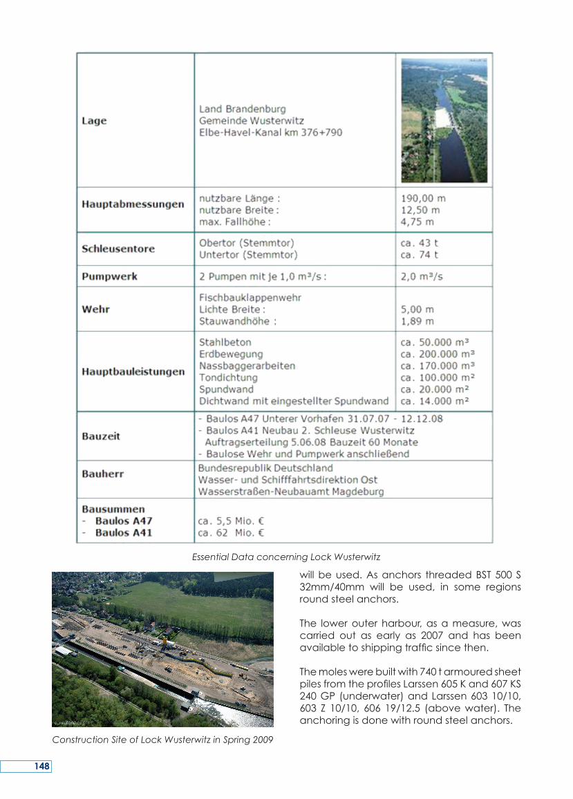
Shipping during the High Water in Spring 2009
Untilopeningtotrafficin2011,theconstructionworksofthetowerswilltakeplacegraduallyfollowedbythehydraulicsteel,themechani-
calengineering,electricalandtelecommuni-cationequipment.As soonas thechamberiscompletedandequipped,shippingwillberescheduledandledthroughthechambersothatthepumpingstationcanbebuiltontheeastsideoftheRVK.
The waterway crossing will be completedwith the production of the low-water lock.ThealreadypositivedevelopmentintheportareawillstrengthentheeconomyinMagde-burgandtheimportanceoftheWaterbridgeMagdeburgas a logistical hub for transportonthewaterwaywillincrease.
4. LOCK WUSTERWITZ
As part of Project 17 of the German unityTransportProjects(VDE17)inEHK376.8km,anewlockwillbebuiltnexttotheexistingLockWusterwitz. The 12.50mwide lock chamberhas usable chamber length of 190m. It willreceiveamodernandeconomicalhydrau-lic sidefillingsystem(Multiport). Thefirst timeplanned solid lock without expansion jointsovercomesamaximumheightdifferenceof4.75m.Afoldedplatedesignwillbeusedinthe head and lower headmitre gates andslidegateswill beprovided for theopeningandclosingof the longitudinalchannels.Alloperationswillbepoweredbyelectrichoistcylinder. All the essential data concerningLockWusterwitzhavebeencollectedinfigure14onthenextpage.
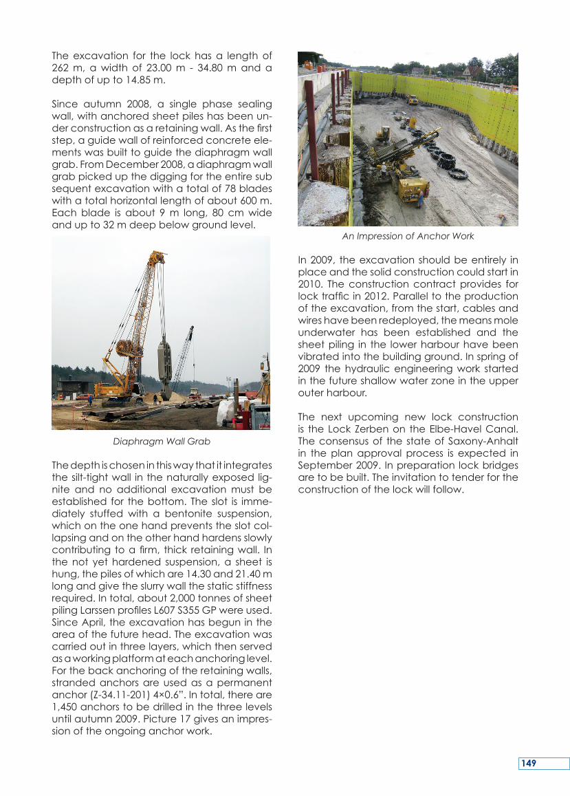
Thesouthernmooringareasintheouterhar-bourareeach440mlong.TheyareequippedaccordingtoDIN19703andarelimitedtoawidthof80mlaterallyduetoanchoredsheetpilingwalls.Asapreparatorymeasure,aloadofabout60,000m³massofearthwasappliedinsubstantiallythefinalstageofthebodyofearthworks. The premature application ofthe load surfacewouldcause theanticipa-tionofbuildingsettlements.Image15onthenextpageshowstheconstructionsiteofLockWusterwitzinspring2009.
Thefollowingoutlinesthecurrentconstructionstatuswith regard to theerectionof theex-cavationofthelockandtheaccompanyingsheetpilingwork.
Theouterharbour,asadockandwaitingpo-sition for shipping,willbebuilt in sheetpilingconstruction. A sheet pile section of about900tL60310/10S240withalengthof11to12m
147
Construction Site of Lock Wusterwitz in Spring 2009
willbeused.Asanchors threadedBST500S32mm/40mm will be used, in some regionsroundsteelanchors.
The lowerouterharbour,asameasure,wascarried out as early as 2007 and has beenavailabletoshippingtrafficsincethen.
Themoleswerebuiltwith740tarmouredsheetpilesfromtheprofilesLarssen605Kand607KS240GP(underwater)andLarssen60310/10,603 Z 10/10, 606 19/12.5 (abovewater). Theanchoringisdonewithroundsteelanchors.
Essential Data concerning Lock Wusterwitz
148
Theexcavation for the lockhasa lengthof262m, awidth of 23.00m - 34.80mandadepthofupto14.85m.
Since autumn 2008, a single phase sealingwall,withanchoredsheetpileshasbeenun-derconstructionasaretainingwall.Asthefirststep,aguidewallofreinforcedconcreteele-mentswasbuilttoguidethediaphragmwallgrab.FromDecember2008,adiaphragmwallgrabpickedupthediggingfortheentiresubsequentexcavationwithatotalof78bladeswithatotalhorizontallengthofabout600m.Eachblade is about 9m long, 80 cmwideandupto32mdeepbelowgroundlevel.
Diaphragm Wall Grab
Thedepthischoseninthiswaythatitintegratesthesilt-tightwall inthenaturallyexposedlig-nite and no additional excavationmust beestablished for thebottom.Theslot is imme-diately stuffed with a bentonite suspension,whichontheonehandpreventstheslotcol-lapsingandontheotherhandhardensslowlycontributing toafirm, thick retainingwall. Inthenot yethardened suspension,a sheet ishung,thepilesofwhichare14.30and21.40mlongandgivetheslurrywallthestaticstiffnessrequired.Intotal,about2,000tonnesofsheetpilingLarssenprofilesL607S355GPwereused.SinceApril,theexcavationhasbegunintheareaofthefuturehead.Theexcavationwascarriedoutinthreelayers,whichthenservedasaworkingplatformateachanchoringlevel.Forthebackanchoringoftheretainingwalls,strandedanchorsareusedasapermanentanchor(Z-34.11-201)4×0.6”.Intotal,thereare1,450anchorstobedrilledinthethreelevelsuntilautumn2009.Picture17givesanimpres-sionoftheongoinganchorwork.
An Impression of Anchor Work
In2009, theexcavationshouldbeentirely inplaceandthesolidconstructioncouldstartin2010. Theconstructioncontractprovides forlocktrafficin2012.Paralleltotheproductionoftheexcavation,fromthestart,cablesandwireshavebeenredeployed,themeansmoleunderwater has been established and thesheetpiling in the lowerharbourhavebeenvibratedintothebuildingground.Inspringof2009 thehydraulicengineeringwork startedinthefutureshallowwaterzoneintheupperouterharbour.
The next upcoming new lock constructionis theLockZerbenon theElbe-HavelCanal.Theconsensusof thestateofSaxony-Anhaltin theplanapprovalprocess is expected inSeptember2009. Inpreparationlockbridgesaretobebuilt.Theinvitationtotenderfortheconstructionofthelockwillfollow.
149
OnJanuary1,1992theWaterwayConstruc-tion Official Magdeburg (WNA MD) wasfoundedasaservice,inordertoimprovethenavigation conditions for inland waterwaytransport.ThemostrelevanttaskoftheWNAMDtoimplementthepoliticalmandate–therealisationofProject17oftheGermanUnityTransportProjects(VDE17)–wasfirstofalltoprepare the construction of the WaterwayCrossMagdeburg(WKM).Bytheendof2010,75%oftherouteand75%ofthebridgeswereexpanded on or rebuilt. With the plannedcompletionoftheLockZerbenin2015,theEl-be-HavelCanal(EHK)willconsistentlybeac-cessibleforthemodernlargemotorcargoves-sel,orpushtow,withaloadeddraftof2.80m.
Duringthistimethenewconstructionsofthelocksof theWNAMDdevelopedaccording
to the level of technical knowledge. Fromthe first new construction of the Lock Roth-ensee as a half-frame in concrete designwithadivisionofthemassivechamberwallsinlongitudinaldirectionintoindividualblockswithexpansion joints.Over thedouble LockHohenwarthewithamonolithicbasefor thefirsttimeandappliedchamberwallsuntiltheLockWusterwitz infullmonolithicdesignandtheLow-WaterLockMagdeburginsheetpilewalldesigntherewasacontinuousdevelop-mentprocess.
This article should give an overview as wellabouttheessentialtechnicalaspectsofthesebuildingsandthefurtherdevelopmentofthestructuraldesignastheactualstageofcon-struction.
SUMMARY
Leservicedeconstructiondesvoiesnaviga-blesdeMagdebourg(WNAMD)aétécrééle1erjanvier1992pouraméliorerlesconditionsdenavigationintérieure.LatâcheprincipaledelaWMAMDpourmettreenœuvreladé-cisionpolitique– leprojet17duprogrammedetransportpourl’Allemagneréunifiée(VDE17)–aétéenpremierlieudepréparerlacon-structionducroisementdesvoiesnavigablesdeMagdebourg (croix deMagdebourg ouWKM).
Fin2010,75%duparcoursetdespontsontétéagrandisoureconstruits.Avecl’achèvementprévuen2015de l’éclusedeZerben, leca-naldel’ElbeàlaHavel(EHK)seraaccessibleauxgrandsbateauxmodernesdefretetauxconvoispoussés, avecunenfoncementde2,80mètres.
Pendantcetemps,lesnouvellesd’éclusesdelaWNAMDsontétudiéesenfonctiondespro-grèsdesconnaissancestechniques.Delapre-mièreconstructiondel’éclusedeRothenseeavecunsasenUdebétondontlesbajoyersmassifsdusassontdivisés,danslesenslongi-tudinal,enblocsavecjointsdedilatation,puisladoubleéclusedeHohenwartheavecpourlapremièrefoisunradiermonolithiqueetdesbajoyers construits ultérieurement, jusqu’àl’éclusedeWusterwitzdeconceptionentière-mentmonolithiqueetl’éclusedebasseseauxdeMagdebourgenrideauxdepalplanches,ilyaeuuneévolutioncontinue.
Cetarticledécrit lesaspects techniqueses-sentielsdecesouvragesetdel’évolutionul-térieuredeleurconstructionainsiqu’unpan-oramad’ensemblesur l’avancementactueldeschantiers.
RESUME
150
Am01.01.1992wurdedasWasserstraßen-Neu-bauamtMagdeburg(WNAMD)alsDienstle-ister zurVerbesserungder Schifffahrtsverhält-nissefürdieBinnenschifffahrtgegründet.DiewichtigsteAufgabedesWNAMDzurUmset-zung des politischen Auftrages – der Real-isierungdesProjektes17derVerkehrsprojekteDeutscheEinheit(VDE17)–warzunächstdieVorbereitung zum Bau des Wasserstraßenk-reuzes(WKM)Magdeburg.
BisEnde2010sind75%derStreckeund75%derBrückenaus-bzw.neugebaut.Mitderge-plantenFertigstellungderSchleuseZerbenin2015wirdderElbe-Havel-Kanaldurchgängigfür dasmoderneGroßmotorgüterschiff bzw.SchubverbandmiteinerAbladetiefevon2,80mbefahrbarsein.
Während dieser Zeit entwickelten sich die
Schleusenbauten des WNA MD entsprech-end dem technischen Wissensstand. Vomersten Schleusenneubau der SparschleuseRothensee als Halbrahmen in Betonbau-weise mit einer Unterteilung der massivenKammerwände in Längsrichtung in einzelneBlöckemitDehnungsfugen.ÜberdieDoppel-sparschleuseHohenwarthemiterstmalseinermonolithischenSohlemitaufgesetztenKam-merwänden, bis zur Schleuse Wusterwitz invollständigmonolithischerBauweiseundderNiedrigwasserschleuseMagdeburginSpund-wandbauweisegabeseinenständigenEnt-wicklungsprozess.
DieserArtikel soll diewesentlichsten technis-che Aspekte dieser Bauwerke und der For-tentwicklungderBaukonstruktionsowieeinenÜberblick zumaktuellen Baugeschehen ver-mitteln.
ZUSAMMENFASSUNG
151

152
KEY WORDS:shiplift,verticallift,Oder-HavelCanal,generaldescription,designprinciples
MOTS-CLES: ascenseur à bateaux, ascen-seurverticale, leCanalOder-Havel,descrip-tiongénérale,principesdeconception
1. REASONS AND PRELIMINARY STUDIES
1.1 Basic Principles
Duetoitssoundconstruction,theshipliftthatopened in1934on theOder-Havelcanal inNiederfinowhasonlybeenoutofservicefor60unplanneddays in72yearsofoperation.Guaranteeingsuchahighlevelofoperation-alreadinesshas,however,ledtohighmainte-nancecostsandincreasinglyextensiverepairwork.
Thedimensionsofthepresentcaisson(85.0mx12.0mx2.5m)representasignificant limi-tationtoshippingwithtoday’svessels.More-
over, cost-effective container traffic cannotbe developed because of the maximumpermissiblepassageheightof 4.10m. Theseconsiderations ledtotheplanningandcon-structionofanewdescentontheHavel-Oderwaterway(HOW)inNiederfinow.
Asaresultofthepreparatorywork,thefollow-ingconceptwasdeveloped:
- The load-bearing structure extends overtheentirelengthofthecaisson.
- Theload-bearingelementssubjecttocom-pressionaremadeofconcrete,thosesub-jecttobendingforcesaremadeofsteel.
- Thecablesthatconnectthecaissonwiththecounterweightsareattacheddirectlytothecaisson.
- Inthesamewayasintheexistinglift,thecaissonissecuredbyarotarylockingbar/internalthreadcolumnsystem.
FurtherbasicprincipleswerepublishedinMay2006attheoccasionofthe31stPIANCCon-gressinEstoril,Portugal.
NEW ShIP LIft At NIEdErfINoW – thE PLANNINg ProCESS ANd tEChNICAL ASPECtS
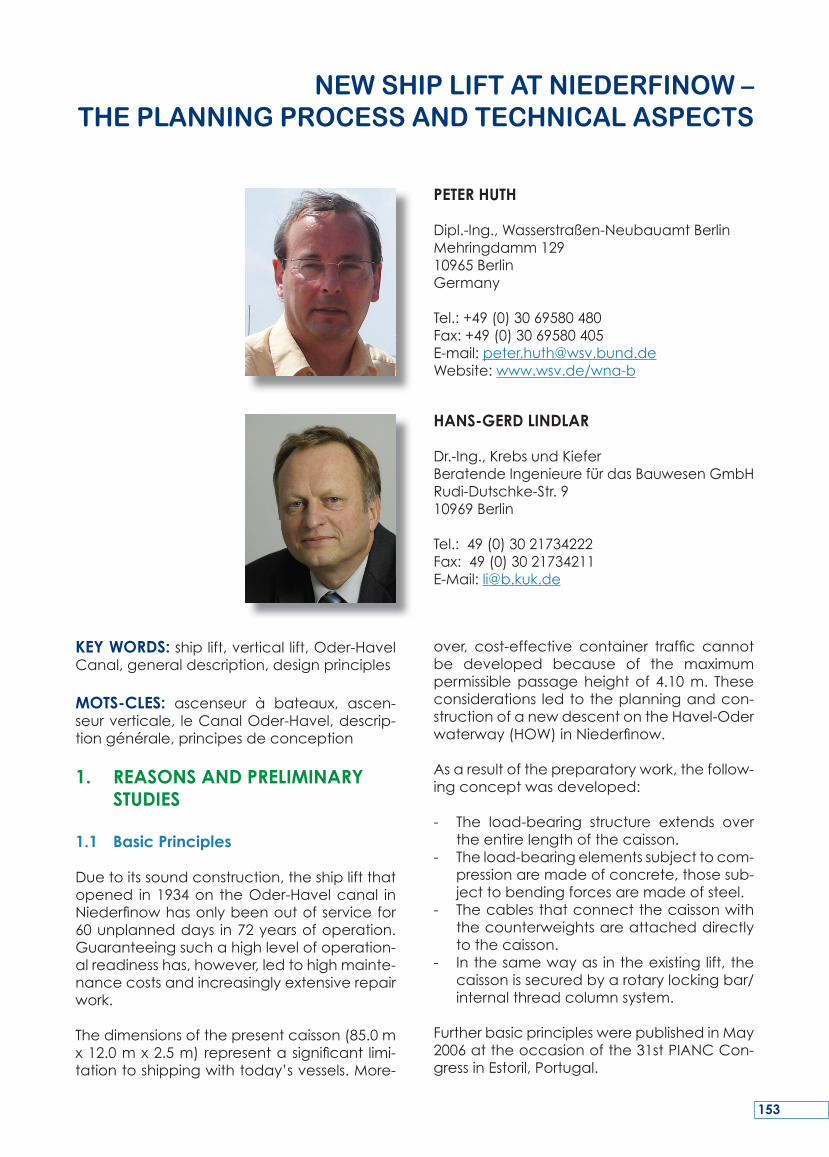
PETER HUTH
Dipl.-Ing.,Wasserstraßen-NeubauamtBerlinMehringdamm12910965BerlinGermany
Tel.:+49(0)3069580480Fax:+49(0)3069580405E-mail:[email protected]:www.wsv.de/wna-b
HANS-GERD LINDLAR
Dr.-Ing.,KrebsundKieferBeratendeIngenieurefürdasBauwesenGmbHRudi-Dutschke-Str.910969Berlin
Tel.:49(0)3021734222Fax:49(0)3021734211E-Mail:[email protected]
153
2. TECHNICAL SOLUTION
2.1 General Description
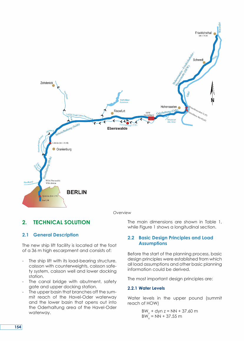
Thenewshipliftfacilityislocatedatthefootofa36mhighescarpmentandconsistsof:
- Theshipliftwithitsload-bearingstructure,caissonwithcounterweights,caissonsafe-tysystem,caissonwellandlowerdockingstation.
- The canal bridge with abutment, safetygateandupperdockingstation.
- Theupperbasinthatbranchesoffthesum-mit reach of the Havel-Oder waterwayand the lower basin that opens out intotheOderhaltungareaof theHavel-Oderwaterway.
The main dimensions are shown in Table 1,whileFigure1showsalongitudinalsection.
2.2 Basic Design Principles and Load Assumptions
Beforethestartoftheplanningprocess,basicdesignprincipleswereestablishedfromwhichallloadassumptionsandotherbasicplanninginformationcouldbederived.
Themostimportantdesignprinciplesare:
2.2.1 Water Levels
Water levels in the upper pound (summitreachofHOW)
BWo+dynz=NN+37.60m BWo=NN+37.55m
Overview
154
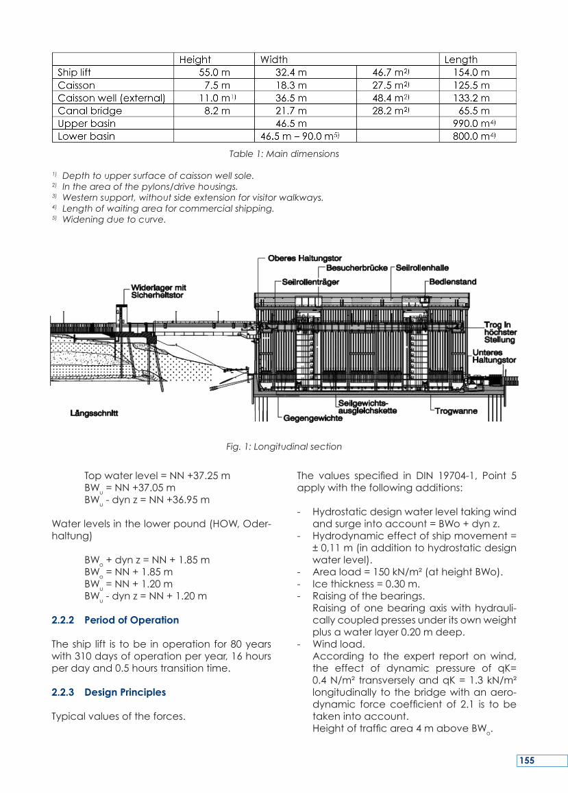
Topwaterlevel=NN+37.25m BWu=NN+37.05m BWu-dynz=NN+36.95m
Waterlevelsinthelowerpound(HOW,Oder-haltung)
BWo+dynz=NN+1.85m BWo=NN+1.85m BWu=NN+1.20m BWu-dynz=NN+1.20m
2.2.2 Period of Operation
Theship lift is tobe inoperationfor80yearswith310daysofoperationperyear,16hoursperdayand0.5hourstransitiontime.
2.2.3 Design Principles
Typicalvaluesoftheforces.
The values specified in DIN 19704-1, Point 5applywiththefollowingadditions:
- Hydrostaticdesignwaterleveltakingwindandsurgeintoaccount=BWo+dynz.
- Hydrodynamiceffectofshipmovement=±0,11m(inadditiontohydrostaticdesignwaterlevel).
- Areaload=150kN/m²(atheightBWo).- Icethickness=0.30m.- Raisingofthebearings. Raisingofonebearingaxiswithhydrauli-
callycoupledpressesunderitsownweightplusawaterlayer0.20mdeep.
- Windload. According to the expert report onwind,
the effect of dynamic pressure of qK=0.4N/m² transverselyandqK=1.3kN/m²longitudinally tothebridgewithanaero-dynamic forcecoefficient of 2.1 is tobetakenintoaccount.
Heightoftrafficarea4maboveBWo.
Table 1: Main dimensions
1) Depth to upper surface of caisson well sole.2) In the area of the pylons/drive housings.3) Western support, without side extension for visitor walkways. 4) Length of waiting area for commercial shipping.5) Widening due to curve.
Fig. 1: Longitudinal section
155
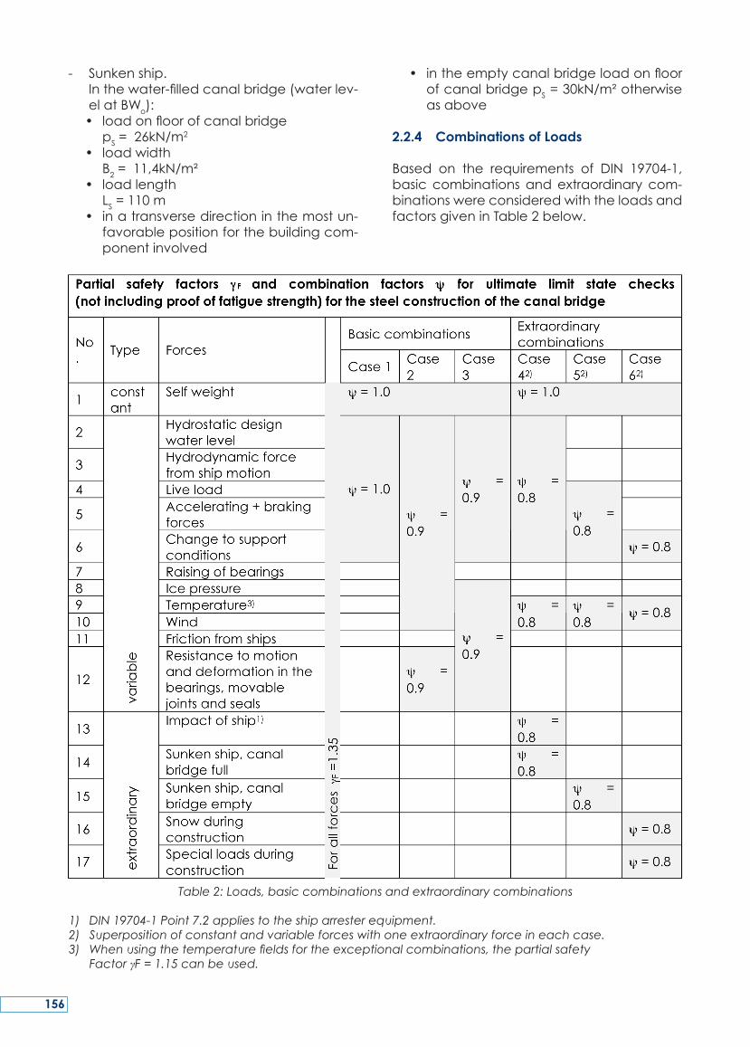
- Sunkenship. Inthewater-filledcanalbridge(waterlev-
elatBWo): • loadonfloorofcanalbridge pS=26kN/m
2
• loadwidth B2=11,4kN/m² • loadlength
LS=110m • inatransversedirectioninthemostun-
favorablepositionforthebuildingcom-ponentinvolved
• intheemptycanalbridgeloadonfloorofcanalbridgepS=30kN/m²otherwiseasabove
2.2.4 Combinations of Loads
Based on the requirements of DIN 19704-1,basic combinationsandextraordinary com-binationswereconsideredwiththeloadsandfactorsgiveninTable2below.
Table 2: Loads, basic combinations and extraordinary combinations
1) DIN 19704-1 Point 7.2 applies to the ship arrester equipment.2) Superposition of constant and variable forces with one extraordinary force in each case.3) When using the temperature fields for the exceptional combinations, the partial safety Factor γF = 1.15 can be used.
156
3. SHIP LIFT
3.1 Load-bearing Structure
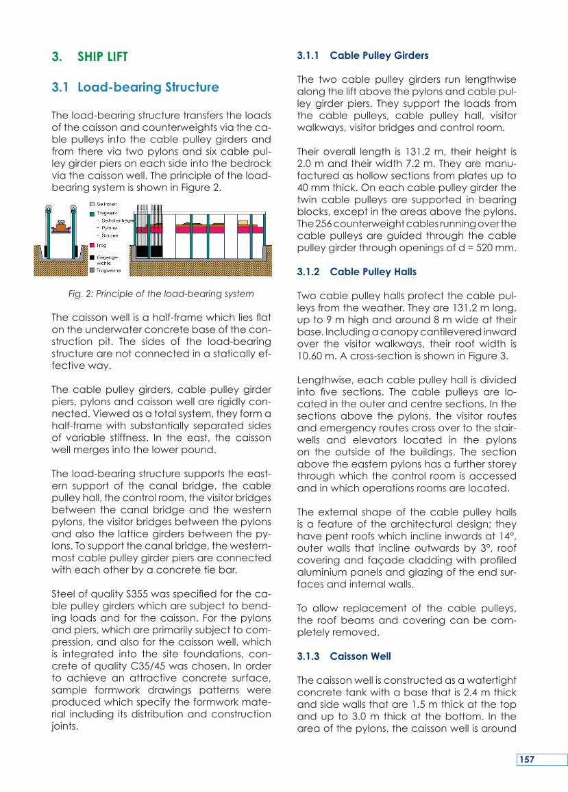
Theload-bearingstructuretransferstheloadsofthecaissonandcounterweightsviatheca-blepulleys into thecablepulleygirdersandfromthereviatwopylonsandsixcablepul-leygirderpiersoneachsideintothebedrockviathecaissonwell.Theprincipleoftheload-bearingsystemisshowninFigure2.
Fig. 2: Principle of the load-bearing system
Thecaissonwellisahalf-framewhichliesflatontheunderwaterconcretebaseofthecon-struction pit. The sides of the load-bearingstructurearenotconnectedinastaticallyef-fectiveway.
Thecablepulleygirders,cablepulleygirderpiers,pylonsandcaissonwellarerigidlycon-nected.Viewedasatotalsystem,theyformahalf-framewith substantially separated sidesof variable stiffness. In the east, the caissonwellmergesintothelowerpound.
Theload-bearingstructuresupportstheeast-ern support of the canal bridge, the cablepulleyhall,thecontrolroom,thevisitorbridgesbetween thecanalbridgeand thewesternpylons,thevisitorbridgesbetweenthepylonsandalsothelatticegirdersbetweenthepy-lons.Tosupportthecanalbridge,thewestern-mostcablepulleygirderpiersareconnectedwitheachotherbyaconcretetiebar.
SteelofqualityS355wasspecifiedfortheca-blepulleygirderswhicharesubjecttobend-ing loadsandforthecaisson.Forthepylonsandpiers,whichareprimarilysubjecttocom-pression,andalsoforthecaissonwell,whichis integrated into the site foundations, con-creteofqualityC35/45waschosen.Inorderto achieve an attractive concrete surface,sample formwork drawings patterns wereproducedwhichspecifytheformworkmate-rial including itsdistributionandconstructionjoints.
3.1.1 Cable Pulley Girders
The two cable pulley girders run lengthwisealongtheliftabovethepylonsandcablepul-leygirderpiers. They support the loads fromthe cable pulleys, cable pulley hall, visitorwalkways,visitorbridgesandcontrolroom.
Theiroverall length is 131.2m, their height is2.0mandtheirwidth7.2m.Theyaremanu-facturedashollowsectionsfromplatesupto40mmthick.Oneachcablepulleygirderthetwincablepulleysare supported inbearingblocks,exceptintheareasabovethepylons.The256counterweightcablesrunningoverthecablepulleysareguided through thecablepulleygirderthroughopeningsofd=520mm.
3.1.2 Cable Pulley Halls
Twocablepulleyhallsprotectthecablepul-leysfromtheweather.Theyare131.2mlong,upto9mhighandaround8mwideattheirbase.Includingacanopycantileveredinwardover the visitor walkways, their roof width is10.60m.Across-sectionisshowninFigure3.
Lengthwise,eachcablepulleyhallisdividedinto five sections. The cable pulleys are lo-catedintheouterandcentresections.Inthesections above the pylons, the visitor routesandemergencyroutescrossovertothestair-wells and elevators located in the pylonson the outside of the buildings. The sectionabovetheeasternpylonshasafurtherstoreythroughwhichthecontrol room isaccessedandinwhichoperationsroomsarelocated.
Theexternal shapeof thecablepulleyhallsisa featureof thearchitecturaldesign; theyhavepentroofswhichinclineinwardsat14°,outerwalls that incline outwards by 3°, roofcoveringandfaçadecladdingwithprofiledaluminiumpanelsandglazingoftheendsur-facesandinternalwalls.
To allow replacement of the cable pulleys,the roofbeamsandcoveringcanbecom-pletelyremoved.
3.1.3 Caisson Well
Thecaissonwellisconstructedasawatertightconcretetankwithabasethatis2.4mthickandsidewallsthatare1.5mthickatthetopandup to3.0m thickat thebottom. In theareaofthepylons,thecaissonwellisaround
157
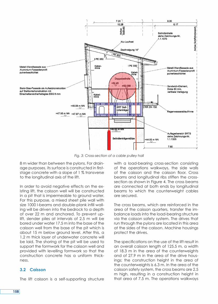
8mwiderthanbetweenthepylons.Fordrain-agepurposes,itssurfaceisconstructedinfirst-stageconcretewithaslopeof1%transversetothelongitudinalaxisofthelift.
Inordertoavoidnegativeeffectsontheex-istinglift,thecaissonwellwillbeconstructedinapitthatisimpermeabletogroundwater.Forthispurpose,amixedsheetpilewallwithsize1000I-beamsanddouble-plankinfillwall-ingwillbedrivenintothebedrocktoadepthofover22mandanchored. Topreventup-lift, slender piles at intervals of 2.5mwill beboredunderwater17.5mintothebaseofthecaissonwellfromthebaseofthepitwhichisabout15mbelowgroundlevel.Afterthis,a1.2mthicklayerofunderwaterconcretewillbelaid.Theshoringofthepitwillbeusedtosupporttheformworkforthecaissonwellandprovidedwith levelling formwork so that theconstruction concrete has a uniform thick-ness.3.2 Caisson
The lift caisson is a self-supporting structure
with a load-bearing cross-section consistingof the operations walkways, the side wallsof the caisson and the caisson floor. Crossbeamsandlongitudinalribsstiffenthecross-sectionasshowninFigure4.Thecrossbeamsareconnectedatbothendsby longitudinalbeams to which the counterweight cablesaresecured.
Thecrossbeams,whicharereinforcedintheareaofthecaissonquarters,transfertheim-balanceloadsintotheload-bearingstructureviathecaissonsafetysystem.Thedrivesthatrunthroughthepylonsarelocatedinthisareaatthesidesofthecaisson.Machinehousingsprotectthedrives.
Thespecificationsontheuseoftheliftresultinanoverallcaissonlengthof125.5m,awidthof18.3m in theareaof thecounterweightsandof27.9m intheareaofthedrivehous-ings; the construction height in the area ofthecounterweightsis6.3m.Intheareaofthecaissonsafetysystem,thecrossbeamsare2.5m high, resulting in a construction height inthatareaof7.5m.Theoperationswalkways
Fig. 3: Cross-section of a cable pulley hall
158
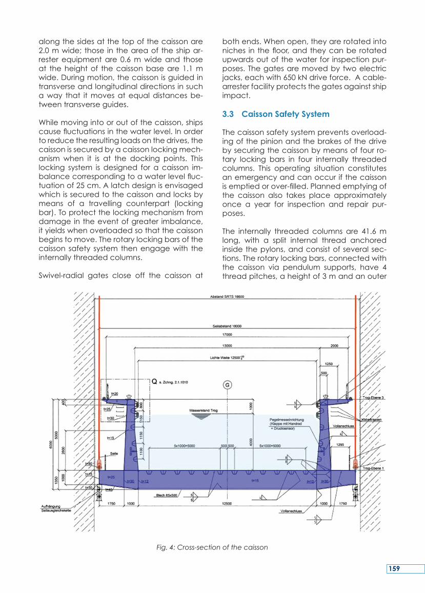
alongthesidesatthetopofthecaissonare2.0mwide;those intheareaoftheshipar-resterequipmentare 0.6mwideand thoseat theheightof thecaissonbaseare1.1mwide.Duringmotion,thecaissonisguidedintransverseandlongitudinaldirectionsinsuchaway that itmovesatequaldistancesbe-tweentransverseguides.
Whilemovingintooroutofthecaisson,shipscausefluctuationsinthewaterlevel.Inordertoreducetheresultingloadsonthedrives,thecaissonissecuredbyacaissonlockingmech-anism when it is at the docking points. Thislocking system is designed for a caisson im-balancecorrespondingtoawaterlevelfluc-tuationof25cm.Alatchdesignisenvisagedwhichissecuredtothecaissonandlocksbymeans of a travelling counterpart (lockingbar).Toprotectthelockingmechanismfromdamageintheeventofgreater imbalance,ityieldswhenoverloadedsothatthecaissonbeginstomove.Therotarylockingbarsofthecaisson safety system thenengagewith theinternallythreadedcolumns.
Swivel-radial gates close off the caisson at
bothends.Whenopen,theyarerotatedintoniches in thefloor,andtheycanberotatedupwardsoutofthewaterfor inspectionpur-poses.Thegatesaremovedbytwoelectricjacks,eachwith650kNdriveforce.Acable-arresterfacilityprotectsthegatesagainstshipimpact.
3.3 Caisson Safety System
Thecaissonsafetysystempreventsoverload-ingofthepinionandthebrakesofthedrivebysecuringthecaissonbymeansoffourro-tary locking bars in four internally threadedcolumns. This operating situation constitutesanemergencyandcanoccurifthecaissonisemptiedorover-filled.Plannedemptyingofthe caisson also takes place approximatelyonce a year for inspection and repair pur-poses.
The internally threaded columns are 41.6mlong, with a split internal thread anchoredinsidethepylons,andconsistofseveralsec-tions.Therotarylockingbars,connectedwiththe caisson via pendulum supports, have 4threadpitches,aheightof3mandanouter
Fig. 4: Cross-section of the caisson
159
diameterof1.08m.Eachweighsaround10t.Atrightanglestothecaisson,thefouraxesof the internally threadedcolumnsare30mapart,andlengthwisealongthecaissontheyare69.85mapart.
During normal operation, the caisson drivesrotatetherotarylockingbarsfreelyviaacou-pled shaft system. Up to the point of settle-mentontheinternallythreadedcolumns,theforceonthepinioncorrespondstotheexter-nalforceonthespringhousing,takinglever-age into account. Taking into account fric-tion, accelerating/braking forces and windforcesandawaterlevelinthecaissonoflessthan0.08m,theforceonthespringhousingislessthan200kN.
Thepre-loadingof the springs is selected sothatthepiniondoesnotstarttodeflectagainstthespringuntilaforceof200kNisexceeded.Incasespringdeflectioninonespringhousingstarts, the 4caissondrivesare stopped. Theforceonthepinionthen increases inaccor-dancewith the springcharacteristics.Whentheforceonthepinionreaches990kN,thero-tarylockingbarsettlesintheinternallythread-edcolumnandabsorbsthedifferentialloadsuntilthemaximumimbalanceloadhasbeenappliedandaforceof1090kNthereforeactsonthepinion.Theforceactingonthepinioniscontinuouslymeasured,bothwhilethecais-
sonisstationaryandwhileitismoving.Intheeventthatthemaximumoperatingforceonthepinionisexceeded,thedriveisswitchedoffandthepiniondeflectsagainstthespring.
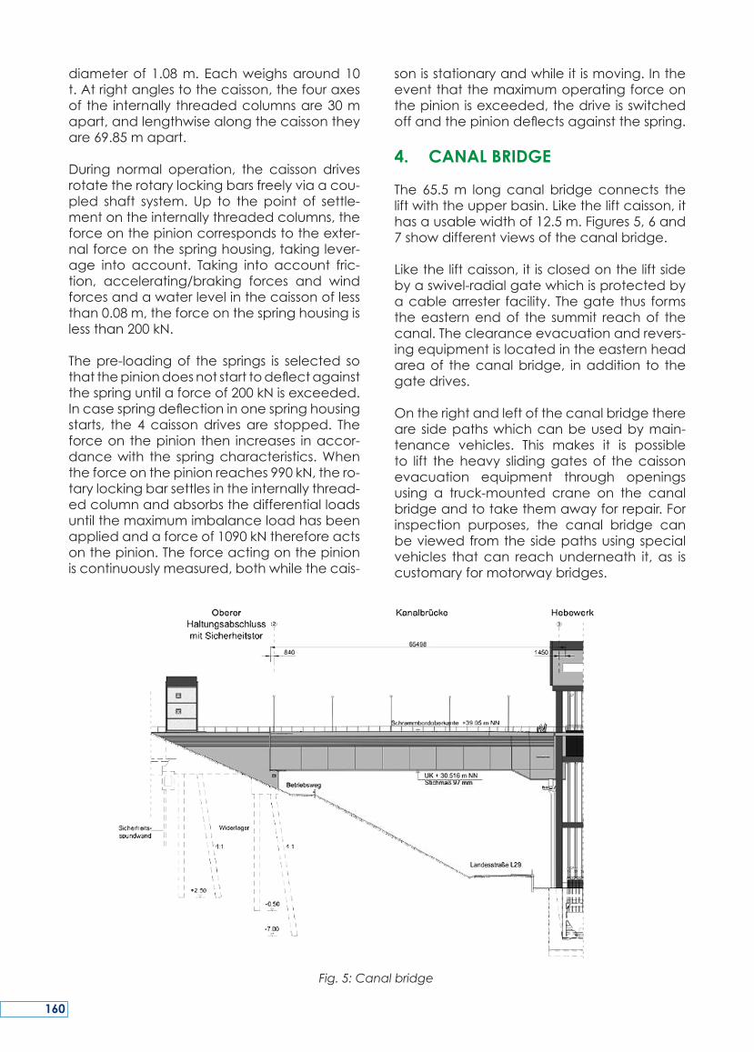
4. CANAL BRIDGE
The 65.5m longcanal bridgeconnects theliftwiththeupperbasin.Liketheliftcaisson,ithasausablewidthof12.5m.Figures5,6and7showdifferentviewsofthecanalbridge.
Liketheliftcaisson,itisclosedontheliftsidebyaswivel-radialgatewhichisprotectedbyacablearrester facility. Thegate thus formstheeasternendof the summit reachof thecanal.Theclearanceevacuationandrevers-ingequipmentislocatedintheeasternheadareaof thecanalbridge, inaddition to thegatedrives.
Ontherightandleftofthecanalbridgetherearesidepathswhichcanbeusedbymain-tenance vehicles. This makes it is possibleto lift theheavy slidinggatesof thecaissonevacuation equipment through openingsusing a truck-mounted crane on the canalbridgeandtotakethemawayforrepair.Forinspection purposes, the canal bridge canbeviewedfromthesidepathsusingspecialvehicles thatcan reachunderneath it, as iscustomaryformotorwaybridges.
Fig. 5: Canal bridge
160
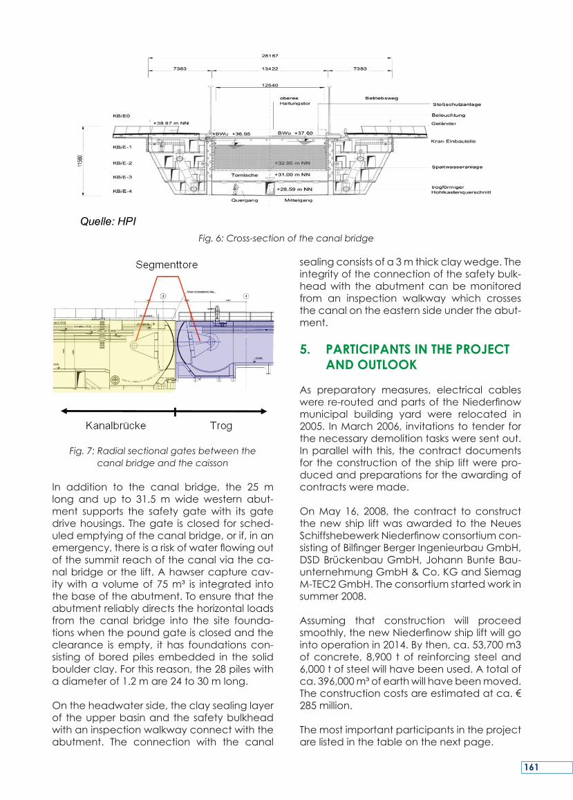
Fig. 7: Radial sectional gates between the canal bridge and the caisson
In addition to the canal bridge, the 25 mlong and up to 31.5 m wide western abut-ment supports the safety gatewith its gatedrivehousings.Thegate isclosedforsched-uledemptyingofthecanalbridge,orif,inanemergency,thereisariskofwaterflowingoutofthesummitreachofthecanalviatheca-nalbridgeorthe lift.Ahawsercapturecav-itywithavolumeof75m³ is integrated intothebaseoftheabutment.Toensurethattheabutmentreliablydirectsthehorizontalloadsfrom the canal bridge into the site founda-tionswhenthepoundgateisclosedandtheclearance is empty, it has foundations con-sistingofboredpilesembedded in the solidboulderclay.Forthisreason,the28pileswithadiameterof1.2mare24to30mlong.
Ontheheadwaterside,theclaysealinglayerof theupperbasinandthesafetybulkheadwithaninspectionwalkwayconnectwiththeabutment. The connection with the canal
sealingconsistsofa3mthickclaywedge.Theintegrityoftheconnectionofthesafetybulk-headwith theabutmentcanbemonitoredfrom an inspection walkway which crossesthecanalontheeasternsideundertheabut-ment.
5. PARTICIPANTS IN THE PROJECT AND OUTLOOK
As preparatory measures, electrical cableswerere-routedandpartsoftheNiederfinowmunicipal building yard were relocated in2005. InMarch2006, invitationstotenderforthenecessarydemolitiontasksweresentout.Inparallelwith this, thecontractdocumentsfor theconstructionof theship liftwerepro-ducedandpreparationsfortheawardingofcontractsweremade.
OnMay 16, 2008, thecontract to constructthenewship liftwasawarded to theNeuesSchiffshebewerkNiederfinowconsortiumcon-sistingofBilfingerBergerIngenieurbauGmbH,DSDBrückenbauGmbH,JohannBunteBau-unternehmungGmbH&Co.KGandSiemagM-TEC2GmbH.Theconsortiumstartedworkinsummer2008.
Assuming that construction will proceedsmoothly,thenewNiederfinowshipliftwillgointooperationin2014.Bythen,ca.53,700m3of concrete, 8,900 t of reinforcing steel and6,000tofsteelwillhavebeenused.Atotalofca.396,000m³ofearthwillhavebeenmoved.Theconstructioncostsareestimatedatca.€285million.
Themostimportantparticipantsintheprojectarelistedinthetableonthenextpage.
Fig. 6: Cross-section of the canal bridge
161
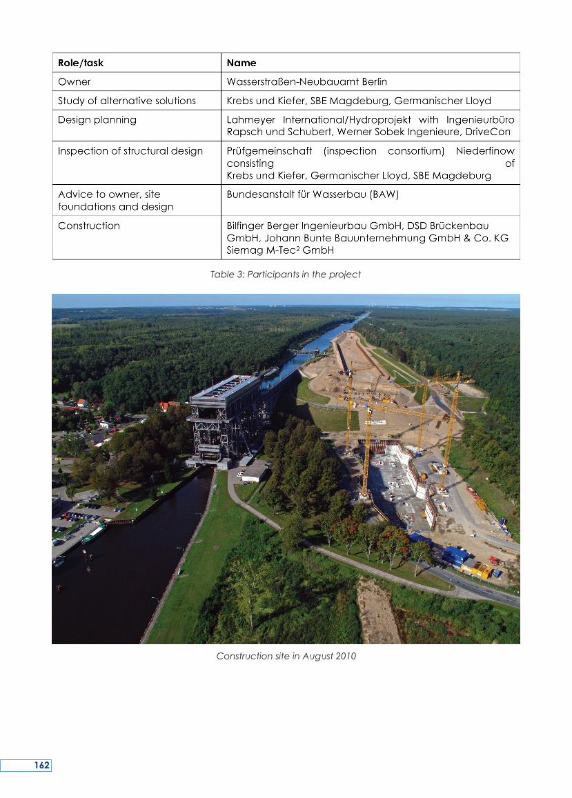
Table 3: Participants in the project
Construction site in August 2010
162
AsecondshipliftistobeconstructedinNie-derfinowadjacenttotheexistinglift.Afterex-tensivepreliminarystudies,theFederalWater-waysAdministrationdecidedonaverticalliftwithbalancingcounterweights.Aload-bear-ingstructureconsistingofreinforcedconcretetowers,columnsandcablepulleygirders,allwith foundations inacommoncaissonwell,transfers the loads fromthewater-filledcais-son(9000t)intothebedrockviacablepulleygirders. The caisson, which is suspended oncables and balanced with counterweights,hasausablelengthof115m,ausablewidthof12.5mandallowsawaterdepthof4.0m.Verticalmovementsofthecaissontakeplacebymeansofrackandpiniondrives.Asafetysystemconsisting of internally threadedcol-
umnsandrotarylockingbarsensuresthatthecaissonstopssafelyinanemergency.Officialpermission for construction was granted on04.01.2005andtheexecutiondesignoftheliftwasapprovedon03.01.2006.
OnMay 16, 2008, thecontract to constructthenewship liftwasawarded to theNeuesSchiffshebewerk Niederfinow consortium,consisting of Bilfinger Berger IngenieurbauGmbH, DSD Brückenbau GmbH, JohannBunte Bauunterneh¬mungGmbH&Co. KGand Siemag M-Tec² GmbH. The consortiumstartedworkinsummer2008.
Theship lift isexpectedtogo intooperationin2014.
SUMMARY
Un second ascenseur à bateaux doit êtreconstruitàNiederfinowàcôtédel’ascenseurexistant. Après des études préliminaires ap-profondies, l’administrationfédéraledesvoi-esnavigablesachoisiunascenseurverticalavecdescontrepoidsd’équilibre.Unestruc-tureporteusecomprenantdestoursenbétonarmé,despoteaux,despotences,despou-liesetdescâbles,letoutfondésurunpuitsencaissoncommuntransfèrelepoidsdesbacsremplisd’eau(9000tonnes)jusqu’aubedrockpardescâbles,despouliesetdespoutres.Lebacencaisson,suspendupardescâblesetéquilibrépardescontrepoidsaunelongueurutilede115m,unelargeurutilede12,5metunmouillagede4,0m.Lesmouvementsverti-cauxducaissonsontentraînéspardesengre-nagesàcrémaillère.Unsystèmedesécurité
basé sur des colonnes à filetage interne etdes verrous en rotationgarantit unarrêt sûrencasd’urgence.Lepermisdeconstruireaétéaccordé le4 janvier2005et laconcep-tiondétailléeapprouvéele03janvier2006.
Le16mai2008, lecontratpourconstruire lenouvelascenseuràbateaux futattribuéauconsortium Neues Schiffshebewerk Nieder-finow, qui consiste en Bilfinger Berger Ing-enieurbau, GmbH, DSD BrückenbauGmbH,Johann Bunte Bauunternehmung GmbH &Co.KGetSiemagM-Tec²GmbH.Leconsor-tiumcommençalestravauxenété2008.
L’ascenseuràbateauxestcenséêtremisenopérationen2014.
RESUME
163
In Niederfinow soll neben dem bestehen-den ein zweites Schiffshebewerk errichtetwerden. Nach umfangreichen Voruntersuc-hungenentschiedsichdieWasser-undSchiff-fahrtsverwaltung für ein Senkrechthebewerkmit Gegengewichtsausgleich. Ein Tragwerk,bestehend aus Stahlbetontürmen, –stützenund Seilrollenträgern, die in einer gemein-samen Trogwannegegründetwerden, leitetdieLastendeswassergefülltenTroges (9000t)überSeilrollenträgerindenUntergrundab.DeranSeilendurchGegengewichteimGle-ichgewicht gehaltene Trogerhält eine nutz-bareLängevon115m,einenutzbareBreitevon12,5mundlässteineWassertiefevon4,0mzu.DieVertikalbewegungendesTrogeser-folgen mittels Zahnstangenantrieb. Ein Sich-erungssystem aus Mutterbackensäulen und
Drehriegeln gewährleistet ein sicheres Ab-setzendes Troges inHavariefällen.DerPlan-feststellungsbeschluss zum Bau erging am04.01.2005 und der Ausführungsentwurf fürdasHebewerkwurdeam03.01.2006geneh-migt.
Am16.05.2008wurdedieArgeNeuesSchiff-shebewerk Niederfinow bestehend aus denFirmen Bilfinger Berger IngenieurbauGmbH,DSD Brückenbau GmbH, Johann BunteBauunterneh¬mung GmbH & Co. KG undSiemagM-Tec²GmbHmitdemNeubaudesSchiffshebewerkes beauftragt. Im Sommer2008nahmdieARGEdieArbeitenauf.
Mit einer Inbetriebnahme des Hebewerkeswird2014gerechnet.
ZUSAMMENFASSUNG
164
KEY WORDS:JadeWeserPortWilhelmshaven,ContainerTerminal,DeepSeaContainerPort,LogisticsZone,FreightVillage
MOTS-CLES: Port de JadeWeser, Wilhelms-haven, terminal à conteneurs, port à con-teneurs en eau profonde, zone logistique,‘FreightVillage’
1. INTRODUCTION
ThestateofNiedersachsenandtheFreeHan-seaticCityofBremeninitiatedoneofthelarg-estNorthGermaninfrastructureprojectsinthelastfiftyyearsinJune2002:theJadeWeserPortinWilhelmshaven–Germany’sonlydeepseaportforlargecontainerships.Commissioningofthefirst1000mofthequayisscheduledforAugust2012.
The port is ideally situated directly on theJadebusen: nautical simulations confirmedthat the port with a short navigation chan-nel of 23 seamiles canbeapproachedbylargecontainershipsindependentofthetide
–inotherwords,alsoshipswithcapacitiesofmore than 10,000 TEU (standard containers)with lengthsof up to 430m,widthsof 58manddraughtsofupto16.50m.Whenthefull1,725 m of riverside quay have been com-pleted,therewillberoomforfourlargecon-tainer shipsand feeder ships simultaneously,with transhipment handled by 16 containerbridgesoperatingatthesametime.
On completion, JadeWeserPort will be themosteasterndeepseaportintheEuropeanNorthRangebetweenLeHavreandHamburg.TheannualhandlingcapacityofJadeWeser-Portwill be approximately 2.7million TEU. IntheWilhelmshavenMAINHUB,around60%ofthe overseas container shipping activity willinvolveseatransithandlingofEuropeandistri-butionshippingwithseaportsinScandinavia,BalticEUcountriesandRussia.
The 130ha terminalareawill be flankedbythe ‘Hafengroden’, a 160 ha logistics zonewhichwillbehometoport-related industrialanddistributioncompanies.AFreightVillage
JAdEWESErPort WILhELMShAvEN – Port CoNStrUCtIoN ANd LogIStICS
AXEL KLUTH
Dipl.Ing.,ManagingDirectorJadeWeserPortRealisierungsGmbH&Co.KGKutterstr.3,26386WilhelmshavenGermany
Tel:+49(0)442140980-20,E-mail:[email protected]:www.jadeweserport.de
JOHANN EHMEN
Dipl.-Ing.,DeputyProjectManager,JadeWeserPortRealisierungsGmbH&Co.KG,Kutterstr.3,26386WilhelmshavenGermany
Tel:+49(0)442140980-20Website:www.jadeweserport.de
165
willalsobesetupinthisarea.Theportwillalsoboastefficientroadandrailconnections:withtheA29Germanmotorwayendingdirectlyinfrontoftheport.Thetotalinvestmentvolumeis € 950million. The EUROGATEGroupwhichoperatestheportwillspendupto€350millionofthesupra-structure.
2. LOCATION OF THE DEEP SEA PORT
The JadeWeserPort deep sea container ter-minal isbeingbuilton thewestbankof theInnerjade approximately 9 km north-east ofWilhelmshavencitycentre.Thecontainerter-minalisbeingconstructedtotheeastoftheVoslappersaltmarshesbetweentheNieder-sachsenbrückepierinthesouthandthetran-shipmentpieroftheWilhelmshavenerRaffin-eriegesellschaft(WRG)(refinery)inthenorth.Theterminalarea isbordereddirectlytothesouthby theNiedersachsenbrückepier. Theaverage distance to the WRG pier to thenorthanditsassociatedislandjettyisaround2,200m.
JadeWeserPort will be operated as a com-monuserterminalwhichcanbeaccessedbyallshippingcompanies.
3. CURRENT PROJECT STATUS
The project approved the construction ofJadeWeserPort pursuant to the FederalWa-terwaysAct(WaStrG)andencompassesthefollowingmeasures:
•Constructionofanewportzone: - Land reclamation with waterfront em-
bankments/seawalls. - Constructionofaquayandwingwalls
andwaterfrontwalls.
•Marinetransportconnections: - Relocationof the Jade shippingchan-
nel. - Construction of terminal access infra-
structure. - Relocatingtherangelights.
•Onshore transport infrastructure connec-tions:
- Constructingaroadconnection. - Constructingarailconnection.
• ProtectingtheNiedersachsenbrückepier.
4. CONSTRUCTING A NEW PORT AREA
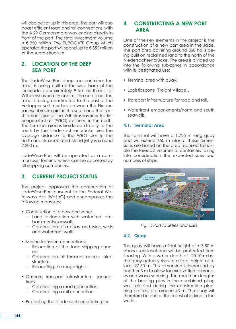
OneofthekeyelementsintheprojectistheconstructionofanewportareaintheJade.Theportareacoveringaround360haisbe-ingbuiltonreclaimedlandtothenorthoftheNiedersachsenbrücke.Theareaisdividedupinto the following sub-zones in accordancewithitsdesignateduse:
• Terminalareawithquay.
• Logisticszone(FreightVillage).
• Transportinfrastructureforroadandrail.
•Waterfrontembankments/northandsouthseawalls.
4.1. Terminal Area
The terminalwill have a 1,725m long quayandwill extend 650m inland. Thesedimen-sionsarebasedonthearearequiredtohan-dletheforecastvolumesofcontainerstakinginto consideration the expected sizes andnumbersofships.
Fig. 1: Port facilities and uses
4.2. Quay
Thequaywillhaveafinalheightof+7.50mabovesea levelandwillbeprotected fromflooding.Withawaterdepthof–20.10mbsl,thequayactuallyrisestoatotalheightofatleast27.60m.Thisdimension is increasedbyanother3mtoallowforexcavationtoleranc-esandwavescouring.Themaximumlengthsof the bearing piles in the combined pilingwall selected during the construction plan-ningprocessarearound43m.Thequaywillthereforebeoneofthetallestofitskindintheworld.
166
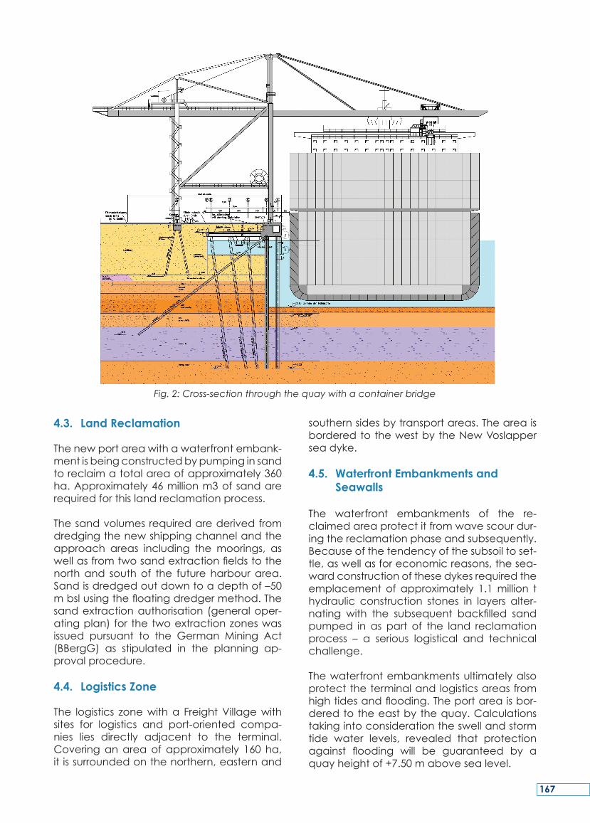
4.3. Land Reclamation
Thenewportareawithawaterfrontembank-mentisbeingconstructedbypumpinginsandtoreclaimatotalareaofapproximately360ha.Approximately46millionm3ofsandarerequiredforthislandreclamationprocess.
Thesandvolumesrequiredarederivedfromdredgingthenewshippingchannelandtheapproach areas including the moorings, aswellasfromtwosandextractionfieldstothenorthand southof the future harbourarea.Sandisdredgedoutdowntoadepthof–50mbslusingthefloatingdredgermethod.Thesandextractionauthorisation (generaloper-atingplan)forthetwoextractionzoneswasissued pursuant to the German Mining Act(BBergG) as stipulated in the planning ap-provalprocedure.
4.4. Logistics Zone
The logistics zonewitha FreightVillagewithsites for logistics and port-oriented compa-nies lies directly adjacent to the terminal.Coveringanareaof approximately 160 ha,itissurroundedonthenorthern,easternand
southernsidesbytransportareas.TheareaisborderedtothewestbytheNewVoslapperseadyke.
4.5. Waterfront Embankments and Seawalls
The waterfront embankments of the re-claimedareaprotectitfromwavescourdur-ingthereclamationphaseandsubsequently.Becauseofthetendencyofthesubsoiltoset-tle,aswellasforeconomicreasons,thesea-wardconstructionofthesedykesrequiredtheemplacement of approximately 1.1million thydraulic construction stones in layers alter-nating with the subsequent backfilled sandpumped in as part of the land reclamationprocess – a serious logistical and technicalchallenge.
Thewaterfrontembankmentsultimatelyalsoprotecttheterminalandlogisticsareasfromhightidesandflooding.Theportareaisbor-deredtotheeastbythequay.Calculationstakingintoconsiderationtheswellandstormtide water levels, revealed that protectionagainst flooding will be guaranteed by aquayheightof+7.50mabovesealevel.
Fig. 2: Cross-section through the quay with a container bridge
167
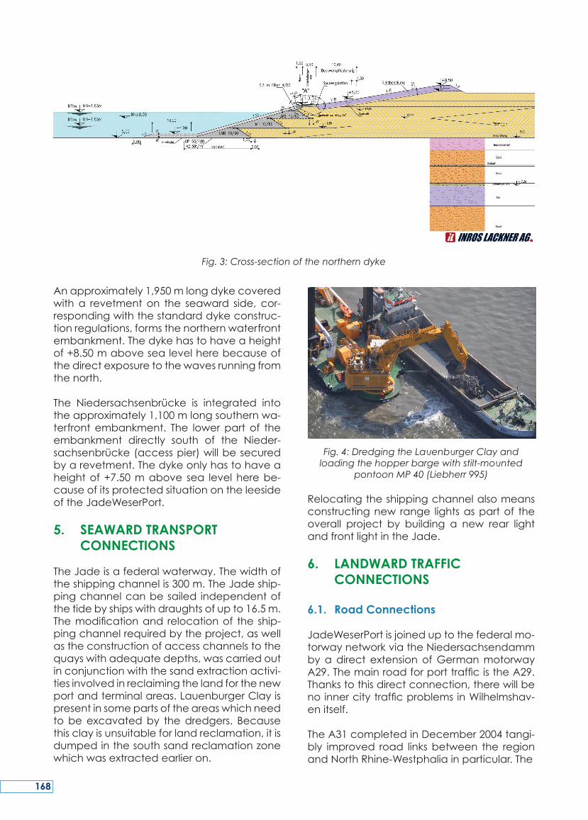
Anapproximately1,950mlongdykecoveredwitha revetmenton the seaward side, cor-respondingwiththestandarddykeconstruc-tionregulations,formsthenorthernwaterfrontembankment.Thedykehastohaveaheightof+8.50mabovesealevelherebecauseofthedirectexposuretothewavesrunningfromthenorth.
The Niedersachsenbrücke is integrated intotheapproximately1,100mlongsouthernwa-terfront embankment. The lowerpart of theembankment directly south of the Nieder-sachsenbrücke(accesspier)willbesecuredbyarevetment.Thedykeonlyhastohaveaheightof+7.50mabove sea levelherebe-causeofitsprotectedsituationontheleesideoftheJadeWeserPort.
5. SEAWARD TRANSPORT CONNECTIONS
TheJadeisafederalwaterway.Thewidthoftheshippingchannelis300m.TheJadeship-pingchannelcanbesailed independentofthetidebyshipswithdraughtsofupto16.5m.Themodificationand relocationof the ship-pingchannelrequiredbytheproject,aswellastheconstructionofaccesschannelstothequayswithadequatedepths,wascarriedoutinconjunctionwiththesandextractionactivi-tiesinvolvedinreclaimingthelandforthenewportandterminalareas.LauenburgerClayispresentinsomepartsoftheareaswhichneedtobeexcavatedby thedredgers. Becausethisclayisunsuitableforlandreclamation,itisdumpedinthesouthsandreclamationzonewhichwasextractedearlieron.
Fig. 4: Dredging the Lauenburger Clay and loading the hopper barge with stilt-mounted
pontoon MP 40 (Liebherr 995)
Relocatingtheshippingchannelalsomeansconstructingnew range lightsaspartof theoverall project by building a new rear lightandfrontlightintheJade.
6. LANDWARD TRAFFIC CONNECTIONS
6.1. Road Connections
JadeWeserPortisjoineduptothefederalmo-torwaynetworkviatheNiedersachsendammbyadirect extensionofGermanmotorwayA29.ThemainroadforporttrafficistheA29.Thankstothisdirectconnection,therewillbenoinnercitytrafficproblemsinWilhelmshav-enitself.
TheA31completedinDecember2004tangi-bly improved road linksbetween the regionandNorthRhine-Westphaliainparticular.The
Fig. 3: Cross-section of the northern dyke
168

A31 is reached from JadeWeserPort via theA29andA28motorways. Theport thereforehas a high capacity road link into the Ruhrand the Benelux countries, independent oftheA1motorway.
The planning and construction of the A29coastal motorway is another key transportproject for the north-west. The realisation ofthis project would create a new east-westconnectioninthenorthwest,independentoftheA1motorway.Itwouldalsosignificantlyre-ducethedrivingtimesbetweenJadeWeser-Portand theRuhr/Beneluxcountries,aswellas significantly shortening the distance be-tweenthesouth-westandGreaterHamburg,Schleswig-Holstein, Denmark, Sweden andNorway.TheeasternNetherlandswouldalsobe reached more quickly from JadeWeser-PortthanfromRotterdam.
The government representative office inLüneburg initiated the necessary regionalplanningprocessinOctober2007.
6.2. Rail Connections
TherailconnectionstoJadeWeserPortaredi-videdupintofourseparatesegments:
a) TrackfacilitiesforJadeWeserPort:
• 4 km branch line between IndustrialMainTrackNorth(DBline1552)andthenewVoslapperseadyke.
•Marshallingyardconsistingof16tracks. •Combined transport handling facility
(supra-structure)1.
b) IndustrialMainTrackNorth(DBline1552).
c) Sande-Esensline(DBline1540).
d) Wilhelmshaven-Oldenburg line (DB line1522).
The railway tracks at JadeWeserPort will beconnectedviaanapproximately 4 km longfeeder track to the single track branch line‘Industrial Main Track North’. This approxi-mately10kmlongbranchlineisusedexclu-sivelybyfreighttrafficandwillbeupgradedby DB into an efficient railway connectionfor JadeWeserPort before theport opens its
doors forbusiness – theupgradingworkhasalreadybegun.
Fig. 5: Feeder track from Industrial Main Track North showing the road and dyke crossings
The upgrading concept includes compre-hensiverenewalofthetracksandequippingthe industrialmain trackwith the necessarysignalling equipment. Around 100 timetableroutes per day (24 hours) will then becomeavailable, of which only eight services onaverageperday (corresponding to today’sshippingactivities)are required for traffic totheWilhelmshavenrefinery.
Inthefuture,theindustrialmaintrackwillbelinked upby points to the Sande-Esens line.ThislineendsatSandestationandjoinsuptoDBline1522(Wilhelmshaven-Oldenburg).Thisisamainlytwin-track,non-electrifiedmainrail-wayline.Thislinehandlesthehourlyregionalpassenger transport services between Wil-helmshavenandOldenburg,aswellaslocalfreight traffic. Everyday, this line is currentlyused by approximately 43 passenger trainsandonaverage8freighttrainsoveranoper-atingperiodof20hours.
DB line 1522 fromWilhelmshaven to Olden-burgcurrently stillhas twosectionsbetweenVarelandJaderberg,andHahnandRastedewitharound7and5kmlongsingle-tracksec-tions respectively.DeutscheBahnhasprom-ised tomake this line twin-track throughoutbefore JadeWeserPort is commissioned andtoelectrifythewholelinefromOldenburguptothetracksintheportby2014.
TrafficfromJadeWeserPortinthedirectionofBremen, Leer/Rheine and Osnabrück/RuhrbranchofffromthejunctioninOldenburg.
1 The assumption in the previous planning was that the combined transport handling facility would consist of six paral-lel train-long tracks.
169
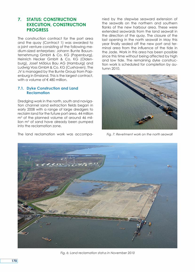
7. STATUS: CONSTRUCTION EXECUTION, CONSTRUCTION PROGRESS
The construction contract for the port areaandthequay(Contract1)wasawardedtoajointventureconsistingofthefollowingme-dium-sizedenterprises:JohannBunteBauun-ternehmungGmbH&Co. KG (Papenburg),Heinrich Hecker GmbH & Co. KG (Olden-burg),JosefMöbiusBauAG(Hamburg)andLudwigVossGmbH&Co.KG(Cuxhaven).TheJVismanagedbytheBunteGroupfromPap-enburginEmsland.Thisisthelargestcontract,withavolumeof€480million.
7.1. Dyke Construction and Land Reclamation
Dredgingworkinthenorth,southandnaviga-tionchannelsandextractionfieldsbegan inearly2008witharangeof largedredgerstoreclaimlandforthefutureportarea.44millionm3of theplannedvolumeofaround46mil-lionm3ofsandhavealreadybeenpumpedintothereclamationzone.
The land reclamation work was accompa-
nied by the stepwise seaward extension ofthe seawalls on the northern and southernflanksof thenewharbourarea. Thesewereextendedseawardsfromthelandseawall inthedirectionofthequay.Theclosureofthelastopening in thenorth seawall inMay thisyearfinally sealedoff thenewportand ter-minalarea from the influenceof the tide intheJade.Workinthisareahasbeenpossiblesincethistimewithoutbeingaffectedbyhighand low tide. The remainingdyke construc-tionworkisscheduledforcompletionbyau-tumn2010.
Fig. 7: Revetment work on the north seawall
Fig. 6: Land reclamation status in November 2010
170
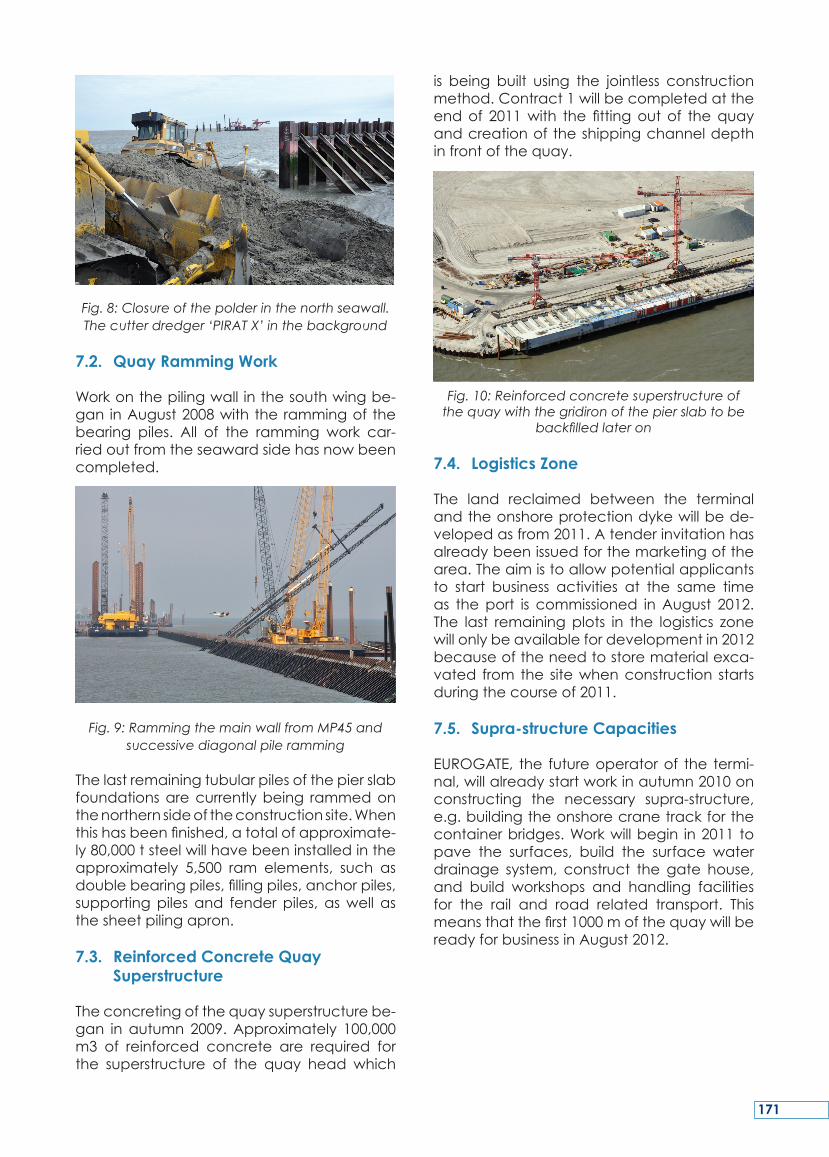
Fig. 8: Closure of the polder in the north seawall. The cutter dredger ‘PIRAT X’ in the background
7.2. Quay Ramming Work
Workonthepilingwall inthesouthwingbe-gan inAugust2008withtherammingof thebearing piles. All of the ramming work car-riedoutfromtheseawardsidehasnowbeencompleted.
Fig. 9: Ramming the main wall from MP45 and successive diagonal pile ramming
Thelastremainingtubularpilesofthepierslabfoundationsarecurrentlybeing rammedonthenorthernsideoftheconstructionsite.Whenthishasbeenfinished,atotalofapproximate-ly80,000tsteelwillhavebeeninstalledintheapproximately 5,500 ram elements, such asdoublebearingpiles,fillingpiles,anchorpiles,supportingpiles and fenderpiles, aswell asthesheetpilingapron.
7.3. Reinforced Concrete Quay Superstructure
Theconcretingofthequaysuperstructurebe-gan inautumn 2009.Approximately 100,000m3 of reinforced concrete are required forthe superstructure of the quay head which
is being built using the jointless constructionmethod.Contract1willbecompletedattheendof 2011with the fittingoutof thequayandcreationoftheshippingchanneldepthinfrontofthequay.
Fig. 10: Reinforced concrete superstructure of the quay with the gridiron of the pier slab to be
backfilled later on
7.4. Logistics Zone
The land reclaimed between the terminalandtheonshoreprotectiondykewillbede-velopedasfrom2011.Atenderinvitationhasalreadybeenissuedforthemarketingofthearea.Theaimistoallowpotentialapplicantsto start business activities at the same timeas theport is commissioned inAugust 2012.The last remainingplots in the logistics zonewillonlybeavailablefordevelopmentin2012becauseoftheneedtostorematerialexca-vated from the sitewhenconstruction startsduringthecourseof2011.
7.5. Supra-structure Capacities
EUROGATE, the futureoperatorof the termi-nal,willalreadystartworkinautumn2010onconstructing the necessary supra-structure,e.g.buildingtheonshorecranetrackforthecontainerbridges.Workwillbegin in2011topave the surfaces, build the surface waterdrainage system, construct the gate house,and build workshops and handling facilitiesfor the rail and road related transport. Thismeansthatthefirst1000mofthequaywillbereadyforbusinessinAugust2012.
171
7.6. Road Development
Constructionmeasures up to the lineof themaindykehavealreadybeencompletedfortheroaddevelopmentofJadeWeserPort.Thebridgeoverthe‘AmTiefenFahrwasser’roadandtheaccessroadslinkingthepublicareasuptothemaindykehavealsoalreadybeencompletedandasphalted.Workhasnowbe-gunontheemergencyaccessroadlocatedinthenorthofthesite.
7.7. Development of the Track Facilities
Work on the railway embankment and thebridge abutments for the rail connectionshavealreadybeencompleted,andthesteelbridge crossing the ‘Am Tiefen Fahrwasser’roadhasbeenliftedintoposition.Theworkonthetracksfortheaccessrailwaylineshasalsobeencompletedandthemeasurestoerectthenoiseprotectionwallandlayingthetracksforthemarshallingyardhavealreadystarted.Thefirstfreighttrainwith1,600toftrackballastwasdrivenintothefirstconstructionstageofthemarshallingyardatthebeginningofJuly2010.
8. FOUNDATION SOIL, DETAILS ON THE LAND RECLAMATION
ACTIVITIES
8.1. Foundation soil in the planning area
Thesedimentsbelowtheseafloorinthelandreclamationareaandthedredgingzonesinthe north and south sand extraction areas,thenewshippingchannelandthenewportchannel,mainly consist of post-glacial sedi-ments,andprimarilyofunconsolidatedtome-diumcompactedfineandmedium-grainedbeddedsand(Wattsand)witharangeofar-gillaceousandsiltyadmixtures,aswellassoftsedimentdepositsontheseafloor.Mudwasalsoencountered insomeareas.Theunder-lyingsequencebegins inpartswiththinhori-zonsofbasinalsiltswhicharepronetosettling,and which overly the pre-glacial sediments(LauenburgerClay,consolidatedPleistocenesand).
8.2. Foundation conditions beneath the quay
The foundationelementsof thequaywhichhavetobeabletowithstandheavyloads,are
setinPleistocenesandatadepthofaround–40.00mbsl,i.e.approximately30.00mdeepinthebuildinggroundoftheJade.Shorterfill-ingpiles,andalsosomeofthebackanchor-ingofthemainquaywall,alsoonlypenetrateinsomecasesintothedeeperhorizonsoftheLauenburgerClay.
8.3. Pumped sand of the port area, subsoil management
Theupperpost-glacialWattsandandpartic-ularlythecoarserPleistocenesands,withtheirlow silt concentrations, from the authoriseddredgingzones,aresuitableforuseasback-fill forthenewportarea.Thesoftsediments,highlysiltysandsandsiltslocatedclosetotheseafloorandtransportedalongwiththeback-fill during thedredgingprocess, have tobedistributedordepositedinacontrolledman-ner as part of the ground and reclamationmanagement process. This enables specificfurthertreatmentmeasurestobecarriedouttospeeduptheirconsolidation.Forinstance,the specifications for the maximum permis-siblesiltconcentrationandtheangleoffric-tioninthebackfillareaofthequayaremuchstricter than in theareabeing reclaimedforthe logistics zone. Guarantees have to begiven for both areas, however, confirmingadequate load-bearing capacity and ac-ceptableresidualsettlementpropertiesoncethefinalheightshavebeenreachedandtheareashavebeenhandedoverforthesubse-quentconstructionactivities.
8.4. Settlement of the port surfaces
Thepropertiesofthesubsoilinthelandrecla-mationareaaresuchthatsubsurfacesettle-mentresultingfrombackfillwithupto17.00mofpumpedsanddiminishesrelativelyquickly.Theprimarysettlingof0.30mtoapproximately1.50mhasalreadylargelytakenplacewhenthesandpumpingworkwasfinished.Residualsettlementonlyinvolvesafewcentimetresaf-tertheareashavebeenhandedovertothesubsequent construction activities. The onlyexceptionisinthoseareaswherethesubsur-face consists of slowly consolidating basinalsilts:here,residualsettlementcanbeashighas10cm ingeneral,andevenupto20cmin localisedareas.The residual settlementofthesedimentpumpedinforlandreclamationisnegligible.Pumpinginthesedimentmeansthatthesandisusuallylaiddowninamediumconsolidatedstate,andcanevenbetightly
172
to very tightly consolidated inparts. Ingen-eral,verylittleadditionalcompactionworkisnecessarybeforehandingthereclaimedar-easovertothesubsequentconstructionac-tivitiesforroadandtrackbuilding.
9. FLOATING DREDGER WORK FOR LAND RECLAMATION AND DREDGING THE REQUIRED DEPTH OF THE SHIPPING CHANNEL
9.1. Sand Extraction in the South and North Extraction Areas
Approximately35millionm3of thetotalvol-umeofaround46millionm3ofsandrequiredfor the reclamation work was extracted byfloatingdredger operations, involvingcutterandseafloorsuctionprocesses.Dredgingwascarriedouttoamaximumdepthof45-50mbelowsea level in thesouthextractionarea(approximately24millionm3)and thenorthextractionarea(approximately11millionm3).Sandwas thenpumped to the reclamationareas. The time schedulemeant that70,000m3ofsandonaveragehadtobeextractedandpumpedintothelandreclamationareaevery day. The 24/7 seafloor suction opera-tionsextractedupto1.0millionm3perweek.Theextractedsandwasinitiallyemplacedjustabove the surface ina layerup toapproxi-mately4-5mthick.Thesandwasdistributedfrom a pontoon controlled bywinches. Thethicknessof4-5mwasselectedtopreventex-cessiveoverburdenmassesbuildingupwhichcouldcause subsoil failuresorembankmentcollapses.
Inthenextstages,itwasthenpossibletoem-placethesandconventionallyusingpipelines.Becauseofthevariationsinsedimentqualitiesintheextractionareasontheonehand,andparticularly tosatisfy thespecifications stipu-lated for the land reclamation area on theother hand, the subcontractor had tocarryout the work using appropriate subsoil andreclamation management procedures tosatisfythespecificationsfortheoverallstruc-ture.Thedredgingandreclamationworkwascomplicatedbytheuncoveringofoldmuni-tions(unexplodedbombsaswellasmunitionsfrom theWilhelmshaven naval port arsenalsdumpedatseaaftertheSecondWorldWar).Themeasuresimplementedtocopewiththissituationinvolvedhavingaprivatemunitionsdisposalserviceonstand-by,andequipping
thedredgerswith‘munitionsgratings’atthefrontofthesuctionpipesorthecuttingheadsofthedredgers,topreventlargecalibremu-nitionsfromenteringthesandextractionma-chinery. Measures implemented to protectthecrewsonboardthedredgersandinthelandreclamationareasincludedarmourplat-ingand theuseof safetyglass inplantwin-dows.
9.2. Sand Extraction from the Relocated Shipping Channel and the Access
Channels to the Quay
In addition to the equipment describedabove,dredgingworkintherelocatednavi-gationchannelalsoinvolvedtheuseofhop-per dredgers. These were initially able todump the sand directly onto the surface,and then connect up to the onshore sandpipelines lateronusingappropriatedockingequipment.Dependingonthenatureofthesedimentsbelow the sea floor, sandwasei-therextracteddowntotheextractiondepth(plusadredgingtolerance)ofapproximate-ly 20.50m below sea level, or down to topLauenburgerClaybecausethismaterialisnotsuitable for filling the land reclamationareadesignatedfortheterminal.Thesandwasex-tractedusingcutter-suctionoperationsorus-ingthehopperdredgers,andthenpumpedintothelandreclamationarea.Theunavoid-ableextractionofbasinalsiltsdugoutbythedredgers,andwhichareproblematictoboththeextractionandthetransportprocess,notto mention their subsequent consolidationproperties and load-bearing capacities, re-quiredagreatdealofattentionandvigorousmanagementbytheconstructionsupervisorystaffandqualitycontroldepartments.
9.3. Dredging the Lauenburger Clay
Around4millionm3ofLauenburgerClayhadto be excavated from the new navigationchannel.Thiswasdoneusingastilt-mountedexcavatorwhich removed the LauenburgerClaydown toacuttingdepthplusdredgertolerance of approximately –20.50mbelowsea level. The Lauenburger Clay is not suit-able for land reclamationand therefore upto10,000m3ofclaywereloadedaroundtheclockeverydayintohopperbargesandthendumpedintothedeeperpartsofthealreadydredgedsouthsandextractionarea.Themu-nitionsdisposalservicewasalsoonstand-byduringthisactivity.
173
9.4. Remote Monitoring of the Dredging Activities
Allofthedredgingactivities,theactualposi-tionofthedredger,thedepthofthesuctionhead, the transportcapacity, thedensityofthepumpedmixture,andalloftheequipmentoperating parameters were recorded anddocumented around the clock by transmit-ting themeasurementdata fromtheequip-menttothecentralevaluationpositionwherethedatawascompiledintablesandcharts.This remotemonitoring enables instant con-trols tobecarriedoutatany time tocheckcompliancewiththeapproveddredginglim-itsanddetermining thedistributioncode fortheoriginof thesandvolumespumped intothenewportarea.
9.5. Dyke Construction Work
One of themain factors for successful landreclamation and subsequent flood protec-tionofthenewterminalareasishavingade-quatelydimensionedseawallsonthesouthernandnorthernflanksofJadeWeserPort,whicharealsoproperlydesignedwithrespecttotheconstruction schedule. In linewitha specialconceptproposedbytheexecutingjointven-turecompany,theuseofsubmergedstabilis-ing reinforcement/filters was dispensed withandloosegraniteballastwithagrainsizeof0/200mmwasdumpedontotheseaflooroftheJadeinthreedumpingphasesusinghop-perbargesandrockdischargingbargesfilledfrom a floating intermediate storage (pon-toon).Theloosegraniteballastwasdumpedin situ in water depths up to around 10 m,and subsequently profiled by stilt supportedexcavators.Thearound1milliontonnesoffillmaterialcamefromNorwegianquarriesandwas transportedbyships toan intermediatestoragepontoon.Everyfillhorizonwassubse-quentlybackfilledwithpumpedsandbeforethenextfillhorizonwasemplaced inaccor-dancewiththeembankmentprofileof1:3.5.Althoughtheballastisfilter-stable,thankstoitscompositionandgradingcurve,ageotex-tile sandmatwas laidon theoutside in thetidal zone for suffusion protection reasons,andcoveredwiththefinal65cmthickrevet-mentlayerconsistingofgraniteorsmelterslagblocks.Thefootofthedykeisstabilisedwitha10mwidetoe.Therevetmentstructureisalsopartiallygroutedwithacolloidalcement-mor-tar.Abovethespotheightofsealevel+3.00m,amaintenanceroadwaypavedwithbitu-
men is followedbyanembankmentof 1.50mmud soil partially stabilisedwithconcretedoubleinterlockingpavingblocks.Thisiscon-structeduptoaheightof+8.50maslbecauseoftheexposedpositionofthenortherndyke.Theheightofthesouthdykeis+7.50maslandthereforethesameasthefrontedgeof thequay.
9.6. Piling, Surveying, Soundings
Quality controls, progress monitoring andbookkeeping all require a detailed and ex-tensiveprogrammeofaquaticandterrestrialsurveying, as well as sampling, drilling andsoundingsofthereclaimedland.
174
The state of Niedersachsen and the FreeHanseatic City of Bremen initiated one ofthelargestNorthGermaninfrastructureproj-ects in the last fifty years in June 2002: theJadeWeserPort inWilhelmshaven –Germa-ny’sonlydeepseaport for largecontainerships.Commissioningofthefirst1000metresof the quay is scheduled for August 2012.Whenthefull1725mofriversidequayhavebeencompleted,therewillberoomforfourlargecontainershipsandfeedershipssimul-taneously, with transhipment handled bysixteen container bridges operating at thesametime.
On completion, JadeWeserPort will be themost eastern deep sea port in the Euro-peanNorth Rangebetween LeHavreandHamburg. The annual handling capacityof JadeWeserPortwillbeapproximately2.7millionTEU.The130haterminalareawillbeflankedbythe‘Hafengroden’,a160halogis-ticszonewhichwillbehometoport-relatedindustrialanddistributioncompanies.
TheprojectapprovedpursuanttotheFeder-alWaterwaysAct(WaStrG)fortheconstruc-tionofJadeWeserPortencompassesthefol-lowingmeasures:
• Terminalareawithquay•Logisticszone(FreightVillage)• Transportinfrastructureforroadandrail•Waterfrontembankments/northandsouthseawalls
Dredgingworkinthenorth,southandnavi-gationchannelsandextractionfieldsbeganinearly2008witharangeoflargedredgersto reclaim land for the futureportarea. 43millionm3oftheplannedvolumeofaround46 million m3 of sand have already beenpumpedintothereclamationzone.
The north and south protection dykes arenearlycompleted.Layingthereinforcedcon-cretefortheseamlessquaysuperstructureiscurrentlygoingaheadatfullspeed.Thispa-perby thetwoauthorshighlights themajorimportanceof JadeWeserPortamongst thecontainerportsintheNorthRange,andde-scribesthelogisticsobjectivesandplans,aswellastheplanningandconstructionoftheport. Special attention is given to the landreclamationworktocreatetheareafortheterminal,thetransportfacilitiesandthelogis-ticsarea.
SUMMARY
175
L’EtatdeBasse-Saxeetlavilleétat-hanséa-tiquedeBrêmeontcommencéenJuin2002l’un des plus grands projets d’infrastructuredepuis 50 ans en Allemagne du Nord : leportde JadeweseràWilhelmshaven – seulport Allemanden eauprofondeadaptéàl’accueildesgrandsporte-conteneurs.
Lamiseenservicedes1000premiersmètresde quai est prévue en Août 2012. Quandles1725mètreslinéairesdequaiserontinté-gralementachevés,ilpourraaccueillirqua-tre grands porte-conteneurs et leurs feed-erssimultanément,letransbordementétantopérésimultanémentpar16portiques.
Quandilseraenservice,leportdeJadeWes-erseraleplusorientaldesportseneaupro-fondedu‘RangeNord-Européen’s’étendantduHavreàHambourg.Lacapacitéannuelledemanutentionduport serad’environ 2,7millionsEVP.Les130hectaresduterminalse-rontbordésparle‘Hafengroden’,unezonelogistiquede160hectaresquiaccueilleralesindustriesetentrepriseslogistiquesenrelationavecleport.
Le projet de construction du port deJadeWeser,approuvéenapplicationde laloifédéralesurlesvoiesnavigables(WaStrG),englobelesaspectssuivants:
• Terminaletquai•Zonelogistique(‘Freightvillage’)• Infrastructuresroutièresetferroviaires•Endiguementde lacôte/digues nordetsud
LedragagedesabledansleschampsNord,Sud et dans le chenal de navigation ontcommencédébut 2008avec une série degrandedraguespour remblayer lesespac-esnécessairesàlafuturezoneportuaire.43surles46millionsdem3desableprévusontdéjàétépompésdans la zonede remblaihydraulique.
Lesdiguesdeprotectionnordetsudsontpr-esqueachevées.Lamiseenplacedubétonarmépour les superstructures dequai sansjointsedérouleactuellementàpleinevitesse.Cetarticledesdeuxauteursmetenavantl’importancemajeureduportdeJadeWeserparmilesportsdu«RangeNord»,etdécritles objectifs et schémas d’organisation lo-gistique, tout autant que la conception etla construction du port. Une attention par-ticulièreestportéeauxtravauxderemblaie-mentpourcréerl’assisefoncièreduterminal,aux infrastructuresdedesserteetà lazonelogistique.
RESUME
176
DasLandNiedersachsenunddieFreieHans-estadtBremenhabenimJuni2002einesdergrößten norddeutschen Infrastrukturvorha-ben der vergangenen 50 Jahre auf denWeg gebracht: den JadeWeserPort in Wil-helmshaven,DeutschlandseinzigenTiefwas-serhafenfürGroßcontainerschiffe.Diesersollmit den ersten 1.000Meter Kaje imAugust2012seinenBetriebaufnehmen.
Der Standort des Hafens direkt am Jade-busen ist ideal gewählt: Nautische Simula-tionenhabenbestätigt,dassderHafenmiteiner kurzen Revierfahrt von 23 Seemeilentideunabhängig vonGroßcontainerschiffenangelaufen werden kann, also auch vonSchiffsgrößenmit einer Kapazität vonmehrals 10.000 TEU (= Standard-Containern), biszu430mLänge,58mBreiteundTiefgängenbiszu16,50m.Andergeplanten1.725mlan-genStromkajesollen4GroßcontainerschiffeundFeederschiffemit16Containerbrückenzeitgleichabgefertigtwerden.
NachFertigstellungistderJadeWeserPortderöstlichsteTiefwasserhafendereuropäischenNordrangezwischenLeHavreundHamburg.SeineJahresumschlagskapazitätliegtbeica.2,7 Mio. TEU. Im MAIN HUB Wilhelmshavenwerdenetwa60ProzentderContainerüber-seeverkehrealsSeetransitverladungenineu-ropäischenVerteilerverkehrenmitSeehäfeninSkandinavien,denEU-OstseestaatenundRusslandabgewickelt.
AndieTerminalflächemit130hawirdsichderHafengrodenanschließen,eineLogistikzone
mit160haFlächezurAnsiedlunghafennaherIndustrie-undLogistikunternehmen.
DasindemVerfahrennachWaStrGgeneh-migteVorhabenzumBaudesJadeWeserPortumfasstdiefolgendenMaßnahmen:
• TerminalflächemitKaje•LogisticsZone(Hafengroden)•VerkehrsflächenfürStraßeundSchiene•Ufereinfassungen/SchutzdämmeNordundSüd
Im Frühjahr 2008 konnten die Baggerarbe-iten in den drei Sandabbaufeldern Nord,Süd und der Fahrrinne mit verschiedenenGroßbaggergeräten zur Aufspülung derzukünftigenHafenflächebegonnenwerden.Seitdem sindbereits 42Mio.m³der insge-samt benötigten Sandmenge von rd. 46Miom³ indaszukünftigeArealeingebrachtworden. Die Schutzdämme Nord und Südsind nahezu fertiggestellt. Zurzeit laufendieStahlbetonarbeiten des fugenlos herzustel-lendenKajenüberbauesaufHochtouren.DerBeitragderbeidenAutorenstelltdiebeson-dere Bedeutung des JadeWeserPort unterdenContainerhäfenderNordrangeherausundbeschreibtdielogistischenZieleundPla-nungensowiediePlanungunddenBaudesHafens. Hierbei wird insbesondere der As-pektder Landgewinnung fürdieSchaffungder Terminal-, Verkehrs- und Logistikflächenbetrachtet.
ZUSAMMENFASSUNG
177

178
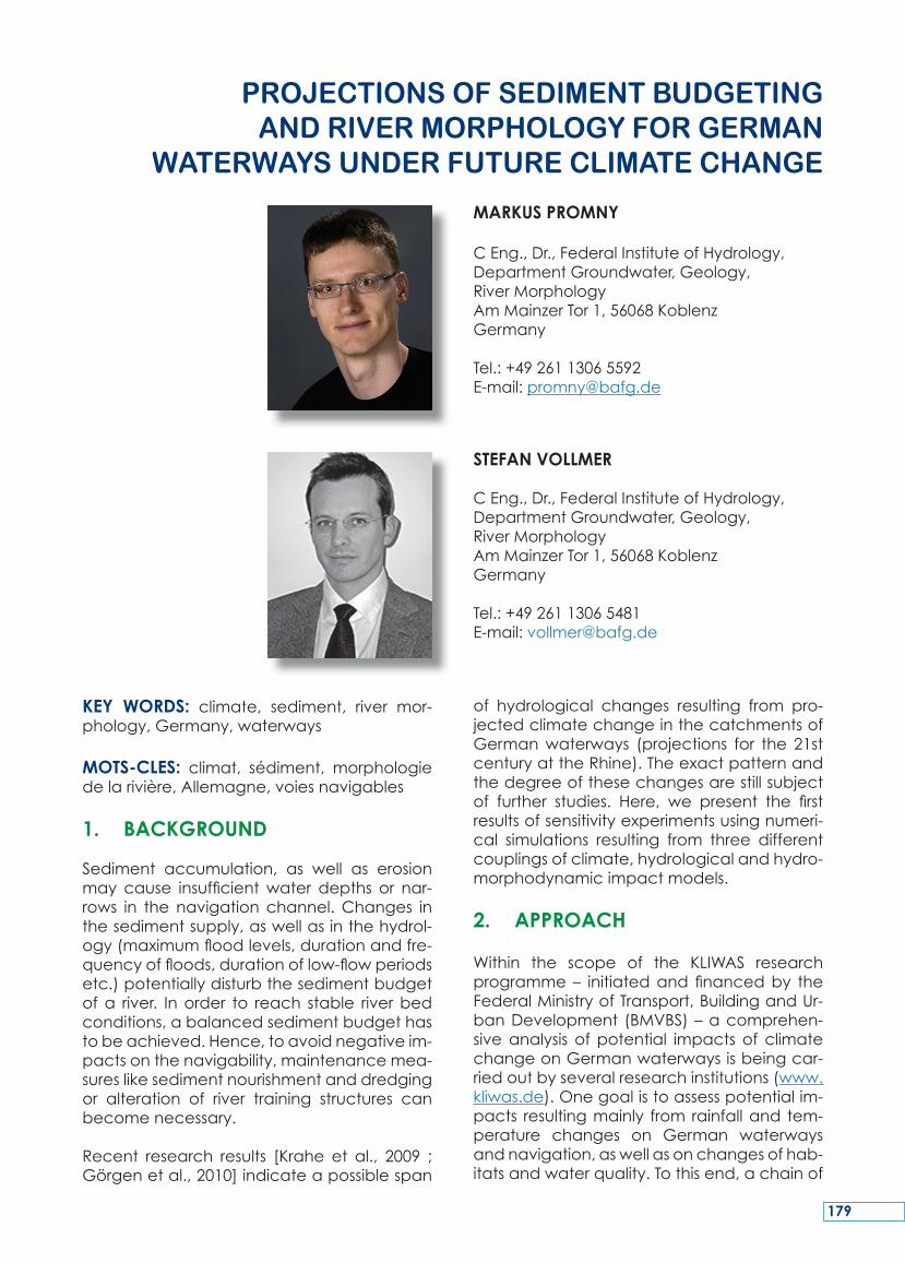
KEY WORDS: climate, sediment, river mor-phology,Germany,waterways
MOTS-CLES: climat, sédiment, morphologiedelarivière,Allemagne,voiesnavigables
1. BACKGROUND
Sediment accumulation, as well as erosionmay cause insufficientwater depths or nar-rows in the navigationchannel.Changes inthesedimentsupply,aswellasinthehydrol-ogy(maximumfloodlevels,durationandfre-quencyoffloods,durationoflow-flowperiodsetc.)potentiallydisturbthesedimentbudgetofa river. Inorder to reach stable riverbedconditions,abalancedsedimentbudgethastobeachieved.Hence,toavoidnegativeim-pactsonthenavigability,maintenancemea-sureslikesedimentnourishmentanddredgingor alteration of river training structures canbecomenecessary.
Recent research results [Krahe et al., 2009 ;Görgenetal.,2010]indicateapossiblespan
of hydrological changes resulting from pro-jectedclimatechangeinthecatchmentsofGermanwaterways (projections for the 21stcenturyattheRhine).Theexactpatternandthedegreeofthesechangesarestillsubjectof further studies. Here, we present the firstresultsofsensitivityexperimentsusingnumeri-cal simulations resulting from three differentcouplingsofclimate,hydrologicalandhydro-morphodynamicimpactmodels.
2. APPROACH
Within the scope of the KLIWAS researchprogramme– initiatedand financedby theFederalMinistryofTransport,BuildingandUr-banDevelopment (BMVBS)–acomprehen-siveanalysis of potential impacts of climatechangeonGermanwaterwaysisbeingcar-riedoutbyseveralresearchinstitutions(www.kliwas.de).Onegoalistoassesspotentialim-pacts resultingmainly from rainfalland tem-perature changes on German waterwaysandnavigation,aswellasonchangesofhab-itatsandwaterquality.Tothisend,achainof
ProJECtIoNS of SEdIMENt BUdgEtINg ANd rIvEr MorPhoLogY for gErMAN
WAtErWAYS UNdEr fUtUrE CLIMAtE ChANgE
MARKUS PROMNY
CEng.,Dr.,FederalInstituteofHydrology,DepartmentGroundwater,Geology,RiverMorphologyAmMainzerTor1,56068KoblenzGermany
Tel.:+4926113065592E-mail:[email protected]
STEFAN VOLLMER
CEng.,Dr.,FederalInstituteofHydrology,DepartmentGroundwater,Geology,RiverMorphologyAmMainzerTor1,56068KoblenzGermany
Tel.:+4926113065481E-mail:[email protected]
179
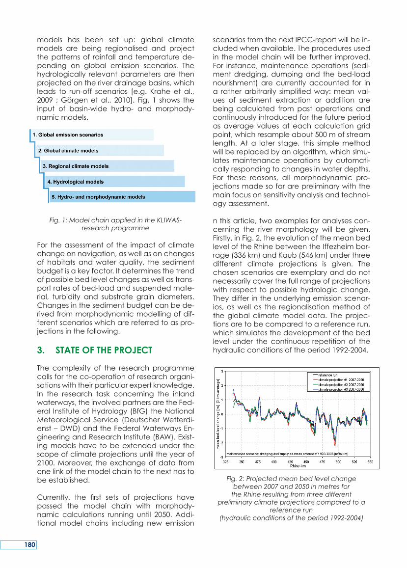
models has been set up: global climatemodels are being regionalised and projectthepatternsof rainfallandtemperaturede-pending on global emission scenarios. Thehydrologically relevantparametersare thenprojectedontheriverdrainagebasins,whichleads to run-off scenarios [e.g. Krahe et al.,2009 ;Görgenetal., 2010]. Fig. 1 shows theinput of basin-wide hydro- and morphody-namicmodels.
Fig. 1: Model chain applied in the KLIWAS-research programme
For theassessmentof the impactofclimatechangeonnavigation,aswellasonchangesof habitats andwater quality, the sedimentbudgetisakeyfactor.Itdeterminesthetrendofpossiblebedlevelchangesaswellastrans-portratesofbed-loadandsuspendedmate-rial, turbidity and substrate grain diameters.Changesinthesedimentbudgetcanbede-rivedfrommorphodynamicmodellingofdif-ferentscenarioswhicharereferredtoaspro-jectionsinthefollowing.
3. STATE OF THE PROJECT
The complexity of the research programmecallsfortheco-operationofresearchorgani-sationswiththeirparticularexpertknowledge.In the research task concerning the inlandwaterways,theinvolvedpartnersaretheFed-eral InstituteofHydrology(BfG)theNationalMeteorological Service (DeutscherWetterdi-enst–DWD)andtheFederalWaterwaysEn-gineeringandResearchInstitute(BAW).Exist-ingmodelshave tobeextendedunder thescopeofclimateprojectionsuntiltheyearof2100.Moreover, theexchangeofdata fromonelinkofthemodelchaintothenexthastobeestablished.Currently, the first sets of projections havepassed the model chain with morphody-namic calculations running until 2050. Addi-tional model chains including new emission
scenariosfromthenextIPCC-reportwillbein-cludedwhenavailable.Theproceduresusedin themodelchainwillbe further improved.For instance,maintenanceoperations (sedi-mentdredging,dumpingand thebed-loadnourishment) are currently accounted for ina ratherarbitrarily simplifiedway:meanval-ues of sediment extraction or addition arebeing calculated from past operations andcontinuouslyintroducedforthefutureperiodas average valuesat eachcalculationgridpoint,whichresampleabout500mofstreamlength. At a later stage, this simplemethodwillbereplacedbyanalgorithm,whichsimu-latesmaintenance operations by automati-callyrespondingtochangesinwaterdepths.For these reasons, all morphodynamic pro-jectionsmadesofararepreliminarywiththemainfocusonsensitivityanalysisandtechnol-ogyassessment.
nthisarticle,twoexamplesforanalysescon-cerning the river morphology will be given.Firstly,inFig.2,theevolutionofthemeanbedleveloftheRhinebetweentheIffezheimbar-rage(336km)andKaub(546km)underthreedifferent climate projections is given. Thechosenscenariosareexemplaryanddonotnecessarilycoverthefullrangeofprojectionswith respect topossiblehydrologicchange.Theydifferintheunderlyingemissionscenar-ios,aswellas the regionalisationmethodoftheglobal climatemodel data. Theprojec-tionsaretobecomparedtoareferencerun,whichsimulatesthedevelopmentofthebedlevel under the continuous repetition of thehydraulicconditionsoftheperiod1992-2004.
Fig. 2: Projected mean bed level change between 2007 and 2050 in metres for
the Rhine resulting from three different preliminary climate projections compared to a
reference run (hydraulic conditions of the period 1992-2004)
180
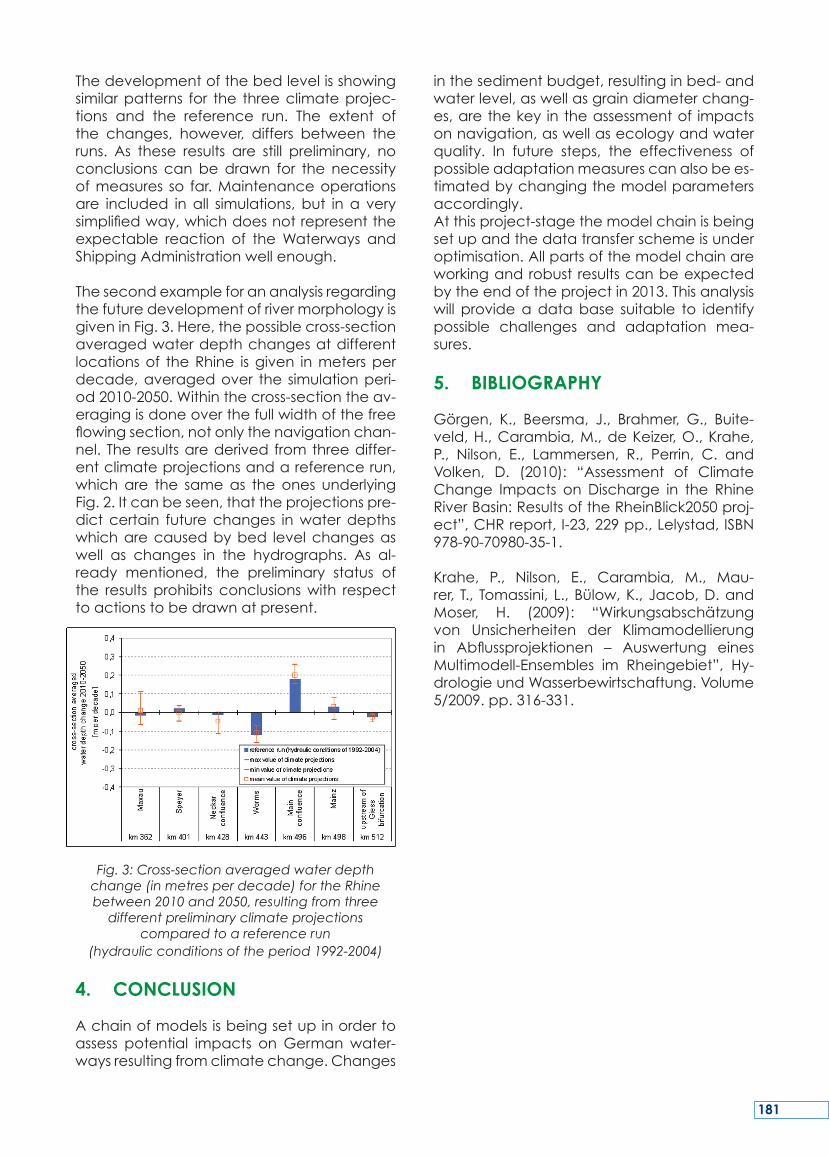
Thedevelopmentofthebedlevelisshowingsimilarpatterns for the threeclimateprojec-tions and the reference run. The extent ofthe changes, however, differs between theruns. As these results are still preliminary, noconclusions canbedrawn for the necessityofmeasures so far.Maintenanceoperationsare included inall simulations, but ina verysimplifiedway,whichdoesnotrepresenttheexpectable reaction of theWaterways andShippingAdministrationwellenough.
ThesecondexampleforananalysisregardingthefuturedevelopmentofrivermorphologyisgiveninFig.3.Here,thepossiblecross-sectionaveragedwaterdepthchangesatdifferentlocationsof theRhine isgiven inmetersperdecade,averagedover the simulationperi-od2010-2050.Withinthecross-sectiontheav-eragingisdoneoverthefullwidthofthefreeflowingsection,notonlythenavigationchan-nel.The resultsarederivedfromthreediffer-entclimateprojectionsandareferencerun,whichare the sameas the ones underlyingFig.2.Itcanbeseen,thattheprojectionspre-dictcertain futurechanges inwaterdepthswhicharecausedbybed levelchangesaswell as changes in the hydrographs. As al-ready mentioned, the preliminary status ofthe results prohibits conclusionswith respecttoactionstobedrawnatpresent.
Fig. 3: Cross-section averaged water depth change (in metres per decade) for the Rhine between 2010 and 2050, resulting from three
different preliminary climate projections compared to a reference run
(hydraulic conditions of the period 1992-2004)
4. CONCLUSION
Achainofmodelsisbeingsetupinordertoassess potential impacts onGermanwater-waysresultingfromclimatechange.Changes
inthesedimentbudget,resultinginbed-andwaterlevel,aswellasgraindiameterchang-es,arethekey intheassessmentof impactsonnavigation,aswellasecologyandwaterquality. In future steps, the effectiveness ofpossibleadaptationmeasurescanalsobees-timatedbychangingthemodelparametersaccordingly.Atthisproject-stagethemodelchainisbeingsetupandthedatatransferschemeisunderoptimisation.Allpartsofthemodelchainareworkingandrobust resultscanbeexpectedbytheendoftheprojectin2013.Thisanalysiswill provideadatabase suitable to identifypossible challenges and adaptation mea-sures.
5. BIBLIOGRAPHY
Görgen, K., Beersma, J., Brahmer, G., Buite-veld,H.,Carambia,M.,deKeizer,O.,Krahe,P., Nilson, E., Lammersen, R., Perrin, C. andVolken, D. (2010): “Assessment of ClimateChange Impacts on Discharge in the RhineRiverBasin:ResultsoftheRheinBlick2050proj-ect”,CHRreport,I-23,229pp.,Lelystad,ISBN978-90-70980-35-1.
Krahe, P., Nilson, E., Carambia, M., Mau-rer, T., Tomassini, L.,Bülow,K.,Jacob,D.andMoser, H. (2009): “Wirkungsabschätzungvon Unsicherheiten der Klimamodellierungin Abflussprojektionen – Auswertung einesMultimodell-Ensembles im Rheingebiet”, Hy-drologieundWasserbewirtschaftung.Volume5/2009.pp.316-331.
181
Recent research results indicate impacts ofclimatechangeonhydrologicalconditionsinGermanwaterways (projections for the 21stcenturyattheRhine).WithinthescopeoftheKLIWAS researchprogramme– initiatedandfinancedby theGermanFederalMinistryofTransport, Building and Urban Development(BMVBS) – a comprehensive analysis of po-tential impacts of climate change on Ger-manwaterways isbeingcarriedoutby sev-eralresearchinstitutions.Onegoalistoassesspotentialimpactsresultingmainlyfromrainfalland temperature changes onGermanwa-terwaysandnavigation,aswellasonchang-esofhabitatsandwaterquality.Toalltheseaspects,thesedimentbudgetisakeyfactor,determining the trend of possible bed levelandwaterlevelchangesaswellasgrainsizecompositions.
Achainofmodelsisbeingsetupinorderto
fulfil theprojectgoal:globalclimatemodelsarebeing regionalisedandproject thepat-ternsof rainfallandtemperaturedependingonglobal emission scenarios. The hydrologi-callyrelevantparametersarethenprojectedon the riverdrainagebasins,which leads torun-offscenarios.Thesearetheinputofbasin-widehydraulicmodelswhicharecoupledtosediment transport models. In this way, theimpactoftheglobalclimatechangeonthesedimentbudgetof theGermanwaterwayscanbeevaluated.Infuturesteps,theeffec-tivenessofpossibleadaptationmeasurescanalso be estimated by changing the modelparametersaccordingly.
Atthisproject-stagethemodelchainisbeingsetupandthedatatransferschemeisunderoptimisation.Allpartsofthemodelchainareworkingandrobust resultscanbeexpectedbytheendoftheprojectin2013.
SUMMARY
Lesrésultatsscientifiquesrécentsmontrentlapossibilitédel’influencedeschangementscli-matiquessurlesconditionshydrologiquesdesvoies fédérales navigables (projection 2071-2100pourleRhin).
Danslecadreduprogrammederecherchescientifique allemand appelé KLIWAS (Kli-mawandelundWasserstraßen=changementclimatique et voies navigables fédérales)– commissionné et financé par le ministèrefédéral allemand du trafic, de constructionet du développement urbain – une anal-ysedétaillée sur lesconséquencespossiblesdeschangementsclimatiquessur lanaviga-bilité est menée par différentes institutionsde recherche scientifique. Un des buts estl’évaluationdes conséquencespossibles surlanavigabilité,ainsiquel’aptitudedeshabi-tatsetlaqualitéd’eaudesvoiesnavigablesfédérales, qui s’ensuit principalement deschangements de précipitation et de tem-pérature. Pour tous ces aspects, l’inventairedu sédiment représente un aspect clé, quidétermine la tendance des changementsdehauteurduniveaudefondetduniveaud’eau ainsi que la composition granulomé-trique.
Pour obtenir le but du projet, une chaînedemodèles numériques a été réalisée: desmodèlesclimatiquesglobauxvontêtrerégion-alisésetprojeterunmodèledeprécipitationetdetempératureenfonctiondescénariosd’émissionsglobales.Ensuite, lesparamètreshydrologiquespertinentsserontprojetéssurlesbassinsdedrainagedesfleuvesparlesquellesont obtiendra des scénarios d’écoulement.Ceci représente les données d’entrée pourlesmodèlesdebassindefleuve,quisontliésàdesmodèlesdetransportdusédiment.Decette manière, les effets du changementclimatique global sur les voies navigablesfédérales peuvent être évalués. A l’avenir,l’efficacitédesoptionsd’ajustementpeutêtreestimépardeschangementsdeparamètresdumodèlecorrespondant.
Encemoment,lachainedemodèlesestcom-plètementinstalléeetleschémad’échangesdedonnées seraoptimisé. Toutes lespartiesdelachaînedemodèlesnumériquesserontutilisableset les résultatsfiablesserontatten-dusverslafinduprojeten2013.
RESUME
182
Aktuelle Forschungsergebnisse zeigen ein-enmöglichen Einfluss der Klimawandels aufdie hydrologischen Bedingungen an dendeutschen Bundeswasserstraßen (Projektion-en für das 21. Jahrhundert für den Rhein).Im Rahmen des Forschungsprogramms KLI-WAS – beauftragt und finanziert durch dasBundesministerium für Verkehr, Bau undStadtentwicklung (BMVBS) – wird eine um-fassende Analyse möglicher AuswirkungenvonKlimaänderungenaufdieBinnenwasser-straßenvonverschiedenenForschungsinstitu-tionendurchgeführt.EinZielistdieBewertungmöglicherAuswirkungenaufdieSchiffbarkeitsowiedieHabitateignungundWasserqualitätder Bundeswasserstraßen,diehauptsächlichausNiederschlags-undTemperaturänderun-genresultieren.FüralledieseAspektestelltderSedimenthaushalt eine Schlüsselgröße dar,welchedenTrendmöglicherSohlhöhen-undWasserspiegellagenänderungen sowie dieKorngrößenzusammensetzungenbestimmt.
Umdie Projektziele zuerreichenwurdeeine
Modellkette aufgebaut: Globale Klimamod-ellewerden regionalisiert undprojizierendieMuster vonNiederschlag und Temperatur inAbhängigkeitglobalerEmissionsszenarien.Diehydrologisch relevanten Parameter werdendannaufdieFlusseinzugsgebieteabgebildetwodurch Abflussszenarien erhalten werden.DiesestellendieEingangsgrößenvonhydrau-lischenFlussgebietsmodellendar,welcheanSedimenttransportmodelle gekoppelt sind.Auf diese Weise können die Auswirkungendesglobalen Klimawandels auf die Bundes-wasserstraßen beurteilt werden. In weiterenSchritten kann die Wirksamkeit möglicherAnpassungsoptionen durch Änderung derentsprechendenModellparameter ebenfallsabgeschätztwerden.
Zu diesem Zeitpunkt wird die Modellkettevollständig installiert und der Datenaus-tauschprozess wird optimiert. Alle Teile derModellkettesindfunktionstüchtigundbelast-bareResultatesindgegenEndedesProjektsimJahr2013zuerwarten.
ZUSAMMENFASSUNG
183

184
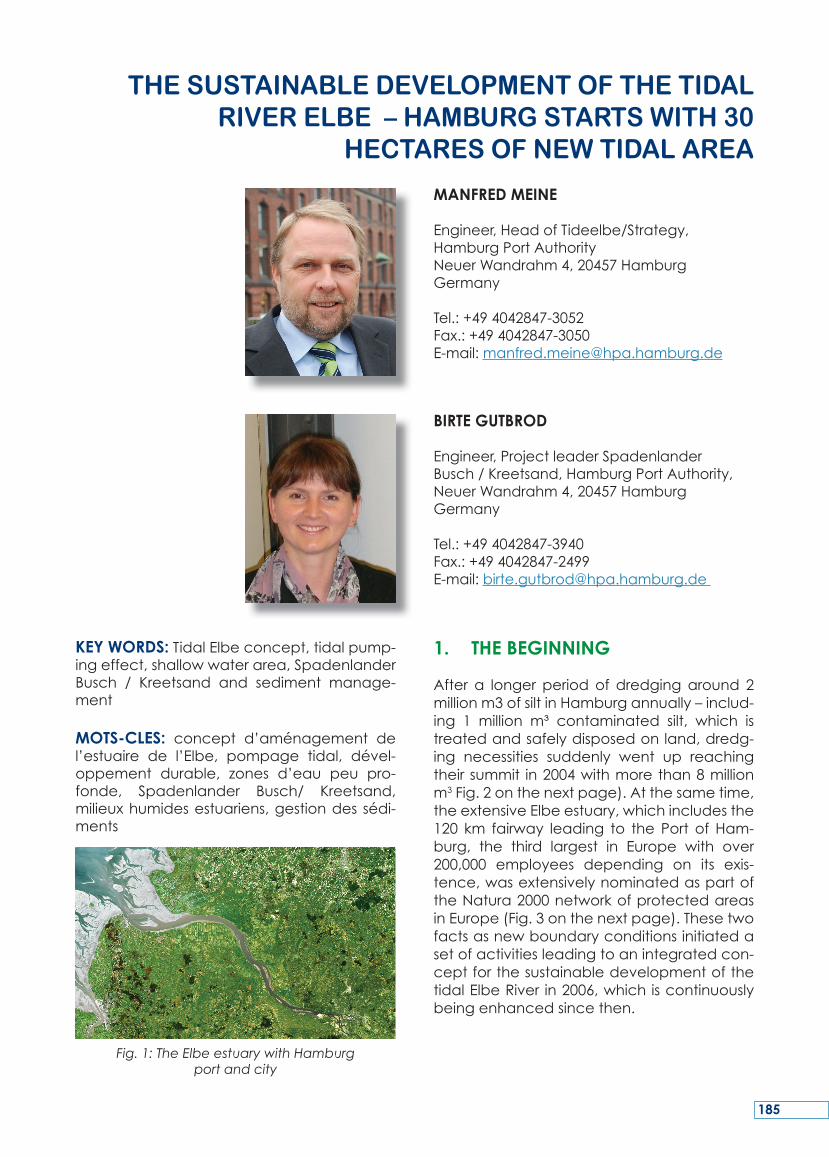
KEY WORDS:TidalElbeconcept,tidalpump-ingeffect,shallowwaterarea,SpadenlanderBusch / Kreetsand and sediment manage-ment
MOTS-CLES: concept d’aménagement del’estuaire de l’Elbe, pompage tidal, dével-oppement durable, zones d’eau peu pro-fonde, Spadenlander Busch/ Kreetsand,milieuxhumidesestuariens,gestiondessédi-ments
Fig. 1: The Elbe estuary with Hamburg port and city
1. THE BEGINNING
After a longer periodof dredgingaround 2millionm3ofsiltinHamburgannually–includ-ing 1 million m³ contaminated silt, which istreatedandsafelydisposedonland,dredg-ing necessities suddenly went up reachingtheirsummit in2004withmorethan8millionm3Fig.2onthenextpage).Atthesametime,theextensiveElbeestuary,whichincludesthe120 km fairway leading to the Port of Ham-burg, the third largest in Europe with over200,000 employees depending on its exis-tence,wasextensivelynominatedaspartoftheNatura2000networkofprotectedareasinEurope(Fig.3onthenextpage).Thesetwofactsasnewboundaryconditionsinitiatedasetofactivitiesleadingtoanintegratedcon-ceptforthesustainabledevelopmentofthetidalElbeRiver in2006,whichiscontinuouslybeingenhancedsincethen.
thE SUStAINABLE dEvELoPMENt of thE tIdAL rIvEr ELBE – hAMBUrg StArtS WIth 30
hECtArES of NEW tIdAL ArEA
MANFRED MEINE
Engineer,HeadofTideelbe/Strategy,HamburgPortAuthorityNeuerWandrahm4,20457HamburgGermany
Tel.:+494042847-3052Fax.:+494042847-3050E-mail:[email protected]
BIRTE GUTBROD
Engineer,ProjectleaderSpadenlanderBusch/Kreetsand,HamburgPortAuthority,NeuerWandrahm4,20457HamburgGermany
Tel.:+494042847-3940Fax.:+494042847-2499E-mail:[email protected]
185
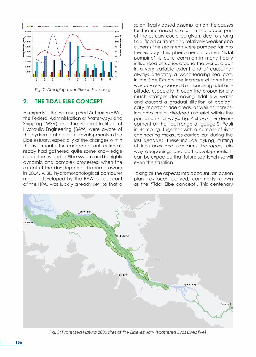
Fig. 2: Dredging quantities in Hamburg
2. THE TIDAL ELBE CONCEPT
AsexpertsoftheHamburgPortAuthority(HPA),theFederalAdministrationofWaterwaysandShipping (WSV) and the Federal Institute ofHydraulic Engineering (BAW)wereawareofthehydromorphologicaldevelopmentsintheElbeestuary,especiallyofthechangeswithintherivermouth,thecompetentauthoritiesal-readyhadgatheredquitesomeknowledgeabouttheestuarineElbesystemanditshighlydynamicandcomplexprocesses,when theextentofthedevelopmentsbecameawarein2004.A3Dhydromorphologicalcomputermodel, developedby the BAWonaccountoftheHPA,wasluckilyalreadyset,sothata
scientificallybasedassumptiononthecausesfor the increased siltation in the upper partoftheestuarycouldbegiven:duetostrongtidalfloodcurrentsandrelativelyweakerebbcurrentsfinesedimentswerepumpedfarintothe estuary. This phenomenon, called ‘tidalpumping’, is quite common in many tidallyinfluencedestuariesaroundtheworld,albeitin a very variable extent and of cause notalways affecting a world-leading sea port.IntheElbeEstuarytheincreaseofthiseffectwasobviouslycausedbyincreasingtidalam-plitude,especiallythroughtheproportionallymuch stronger decreasing tidal low waterand caused a gradual siltation of ecologi-callyimportantsideareas,aswellasincreas-ingamountsofdredgedmaterialwithin theportand its fairways.Fig.4showsthedevel-opmentofthetidal rangeatgaugeStPauliinHamburg,togetherwithanumberofriverengineeringmeasurescarriedoutduringthelast decades. These include dyking, cuttingof tributaries and side arms, barrages, fair-way deepenings and port developments. Itcanbeexpectedthatfuturesea-levelrisewilleventhesituation.
Takingalltheaspectsintoaccount,anactionplan has been derived, commonly knownas the ‘Tidal Elbe concept’. This centenary
Fig. 3: Protected Natura 2000 sites of the Elbe estuary (scattered Birds Directive)
186
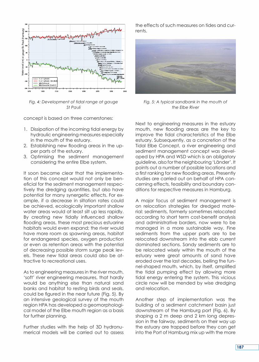
Fig. 4: Development of tidal range at gauge St Pauli
conceptisbasedonthreecornerstones:
1. Dissipationoftheincomingtidalenergybyhydraulicengineeringmeasuresespeciallyinthemouthoftheestuary.
2. Establishingnewfloodingareasintheup-perpartsoftheestuary.
3.Optimising the sediment managementconsideringtheentireElbesystem.
It soonbecameclear that the implementa-tionof thisconceptwouldnotonlybeben-eficialforthesedimentmanagementrespec-tively thedredgingquantities,butalsohavepotentialformanysynergeticeffects.Forex-ample, if adecrease in siltation rates couldbeachieved,ecologicallyimportantshallowwaterareaswouldatleastsiltuplessrapidly.By creating new tidally influenced shallowfloodingareas,thesemostpreciousestuarinehabitatswouldevenexpand;theriverwouldhavemoreroomasspawningareas,habitatforendangeredspecies,oxygenproductionorevenasretentionareaswiththepotentialofdecreasingpossiblestormsurgepeaklev-els. Thesenew tidalareascouldalsobeat-tractivetorecreationaluses.
Astoengineeringmeasuresintherivermouth,‘soft’riverengineeringmeasures,thathardlywould be anything else than natural sandbanksandhabitattorestingbirdsandseals,couldbefiguredinthenearfuture(Fig.5).Byan intensivegeological surveyof themouthregionHPAhasdevelopedageomorphologi-calmodeloftheElbemouthregionasabasisforfurtherplanning.
Further studieswith the helpof 3Dhydronu-mericalmodelswill be carriedout toassess
theeffectsofsuchmeasuresontidesandcur-rents.
Fig. 5: A typical sandbank in the mouth of the Elbe River
Next toengineeringmeasures in theestuarymouth, new flooding areas are the key toimprove the tidal characteristicsof the Elbeestuary.Subsequently,asaconcretionoftheTidal ElbeConcept,a riverengineeringandsedimentmanagementconceptwasdevel-opedbyHPAandWSDwhichisanobligatoryguideline,alsofortheneighbouring‘Länder’.Itpointsoutanumberofpossiblelocationsandafirstrankingfornewfloodingareas.PresentlystudiesarecarriedoutonbehalfofHPAcon-cerningeffects,feasibilityandboundarycon-ditionsforrespectivemeasuresinHamburg.
A major focus of sediment management ison relocation strategies for dredged mate-rial:sediments,formerlysometimesrelocatedaccordingtoshorttermcost-benefitanalysisandadministrativeborders,nowwere tobemanaged in a more sustainable way. Finesediments from the upper parts are to berelocateddownstream into theebbcurrentdominatedsections.Sandysedimentsaretobe relocatedwiselywithin themouthof theestuary were great amounts of sand haveerodedoverthelastdecades,bellingthefun-nel-shapedmouth,which,byitself,amplifiedthe tidal pumping effect by allowing moretidalenergyenteringthesystem.Thisviciouscirclenowwillbemendedbywisedredgingandrelocation.
Another step of implementation was thebuildingofa sedimentcatchmentbasin justdownstreamoftheHamburgport(Fig.6).Byshapinga2mdeepand2km longdepres-sioninthefairway,sedimentsontheirwayuptheestuaryaretrappedbeforetheycangetintothePortofHamburgmixupwiththemore
187
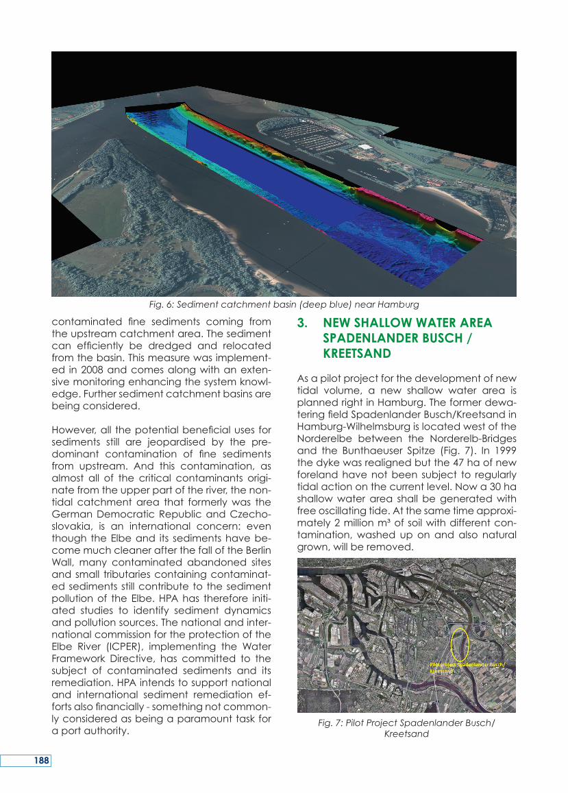
contaminated fine sediments coming fromtheupstreamcatchmentarea.Thesedimentcan efficiently be dredged and relocatedfromthebasin.Thismeasurewasimplement-ed in2008andcomesalongwithanexten-sivemonitoringenhancingthesystemknowl-edge.Furthersedimentcatchmentbasinsarebeingconsidered.
However,all thepotentialbeneficialusesforsediments still are jeopardised by the pre-dominant contamination of fine sedimentsfrom upstream. And this contamination, asalmost all of the critical contaminants origi-natefromtheupperpartoftheriver,thenon-tidal catchmentarea that formerlywas theGermanDemocraticRepublicandCzecho-slovakia, is an international concern: eventhough theElbeand its sedimentshavebe-comemuchcleanerafterthefalloftheBerlinWall, many contaminated abandoned sitesandsmall tributariescontainingcontaminat-edsedimentsstillcontributetothesedimentpollutionof theElbe.HPAhas therefore initi-ated studies to identify sediment dynamicsandpollutionsources.Thenationalandinter-nationalcommissionfortheprotectionoftheElbe River (ICPER), implementing the WaterFramework Directive, has committed to thesubject of contaminated sediments and itsremediation.HPAintendstosupportnationaland international sediment remediation ef-fortsalsofinancially-somethingnotcommon-lyconsideredasbeingaparamounttaskforaportauthority.
3. NEW SHALLOW WATER AREA SPADENLANDER BUSCH /
KREETSAND
Asapilotprojectforthedevelopmentofnewtidal volume, a new shallow water area isplannedrightinHamburg.Theformerdewa-teringfieldSpadenlanderBusch/KreetsandinHamburg-WilhelmsburgislocatedwestoftheNorderelbe between the Norderelb-Bridgesand the Bunthaeuser Spitze (Fig. 7). In 1999thedykewasrealignedbutthe47haofnewforelandhavenotbeen subject to regularlytidalactiononthecurrentlevel.Nowa30hashallowwaterarea shall begeneratedwithfreeoscillatingtide.Atthesametimeapproxi-mately2millionm³ofsoilwithdifferentcon-tamination,washed uponandalso naturalgrown,willberemoved.
Fig. 7: Pilot Project Spadenlander Busch/Kreetsand
Fig. 6: Sediment catchment basin (deep blue) near Hamburg
188
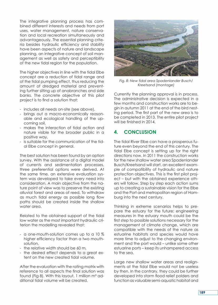
The integrative planning process has com-bineddifferentinterestsandneedsfromportuses,watermanagement, natureconserva-tionandlocalrecreationsimultaneouslyandadvantageously.Theessentialplanningcrite-ria besides hydraulic efficiency and stabilityhavebeenaspectsofnatureandlandscapeplanning,anintegrativeconceptofsoilman-agementaswellassafetyandperceptibilityofthenewtidalregionforthepopulation.
ThehigherobjectivesinlinewiththetidalElbeconceptarea reductionof tidal rangeandofthetidalpumpingeffect,thusreducingtheamount of dredged material and prevent-ingfurthersiltingupofanabranchesandsidebanks. The concrete objective of this pilotprojectistofindasolutionthat:
- includesallneedson-site(seeabove),- brings out a macro-economically reason-able and ecological handling of the up-comingsoil,
- makes the interaction of tidal action andnature visible for the broader public in apositiveway,
- issuitableforthecommunicationofthetid-alElbeconceptingeneral.
Thebestsolutionhasbeenfoundbyanoptionsurvey.Withtheassistanceofadigitalmodelof currents and sedimentation processes,three preferential options were derived. Atthe same time,anextensiveevaluation sys-temwasdevelopedtotakeeveryneedintoconsideration.Amainobjectivefromthena-turepointofviewwastopreservetheexistingalluvialforestandareasofreed.Towithdrawas much tidal energy as possible long flowpaths should be created inside the shallowwaterarea.
Relatedtotheobtainedsupportof thetidallowwaterasthemostimportanthydrauliccri-terionthemodellingrevealedthat:
- aone-mouth-solutioncomesuptoa10%higherefficiencyfactorthanatwomouth-solution,
- therelativewidthshouldbe60m,- thedesiredeffectdependstoagreatex-tentonthenewcreatedtidalvolume.
Aftertheevaluationwiththeratingmatrixwithreferencetoallaspectsthefinalsolutionwasfound(Fig8).Withthislayout,1millionm³ad-ditionaltidalvolumewillbecreated.
Fig. 8: New tidal area Spadenlander Busch/Kreetsand (montage)
Currentlytheplanningapprovalisinprocess.Theadministrativedecision is expected inafewmonthsandconstructionworksaretobe-gininautumn2011attheendofthebirdnest-ingperiod.Thefirstpartofthenewareaistobecompletedin2013.Theentirepilotprojectwillbefinishedin2014.
4. CONCLUSION
ThetidalRiverElbecanhaveaprosperousfu-tureevenbeyondtheendofthiscentury.Thetidal Elbeconcept is settingup for the rightdirectionsnow.In2011theconstructionworksforthenewshallowwaterareaSpadenlanderBusch/Kreetsandwillstart,anexcellentexam-pleofcompatibilityofhydraulicandnatureprotectionobjectives.Thisisthefirstpilotproj-ect–butwiththeobtainedexperienceoth-erswillfollow.StepbystepeachactionsumsuptocreatingasustainablevisionfortheElbeandthePortandmetropolitanregionofHam-burgintothenextcentury.
Thinking in extreme scenarios helps to pre-pare the estuary for the future: engineeringmeasuresintheestuarymouthcouldbethefirststeptopossiblesolutionsnecessaryforthemanagementofclimatechange,whicharecompatiblewith theneedsof thenatureasestuarine habitats and species would havemoretimetoadjusttothechangingenviron-mentandtheportwould–unlikesomeotherestuarineports–keepitsunhamperedaccesstothesea.
Largenewshallowwaterareasand realign-mentsatthetidalElbewouldnotbeuselessbythen.Inthecontrary,theycouldbefurtherdevelopedintostormfloodreliefpoldersandfunctionasvaluablesemi-aquatichabitatand
189
functionasretentioncapacityforhighfresh-water levelsfromheavyrainfallorsnowmelt.Hence,theestuarysurewillchange–butwehavetheopportunitytohelpitchangeinthebestpossibleway.
5. REFERENCES
More information can be found on thesewebsites:
www.hamburg-port-authority.dewww.tideelbe.de
www.portal-tideelbe.dewww.natura2000-unterelbe.dewww.tide-project.eu
6. COPYRIGHTS
Copyright of all figures: HPA, except Fig. 1:‘Processing,Copyrights:BrockmannConsult,CommonWaddenSeaSecretariat(c)2003’.
TheHamburgPortAuthority (HPA) is respon-sible for the development of a sustainablemaintenanceoftheportofHamburganditsaccesses. One important aspect is to safe-guardtherequiredwaterdepths.Thistaskhasbecomemoredifficult,duetounfavourablehydromorphologicaldevelopmentsover thelast decade. An increased tidal amplitudeand a comparatively stronger flood streamhave led to increased dredging necessitieswithamaximumofmorethan8millionm³inHamburgin2004.Atthesametime,ecologi-cal requirements resultingfromEuropeanDi-rectives,suchastheHabitatsDirective,havebeentightened.TheHPAandtheFederalWa-terways Administration faced this challengeand outlined a future-oriented concept forthesustainabledevelopmentoftheTidalElbeestuaryasanarteryforthemetropolitanRe-gionofHamburgandbeyond.
Derived fromextensive investigations includ-ing innovative3Dhydromorphologicalmod-elling,theconceptisbasedonthreecorner-stones:1. Dissipationoftheincomingtidalenergyby
hydraulicengineeringconstructionsespe-ciallyinthemouthoftheestuary,
2. Establishing new shallow water areas inandaroundHamburg,
3. Optimising the sediment managementconsideringtheentiresystem.
Consecutiveplanningandfirststepsofimple-mentationobviouslyhavealreadyachievedafirstpositiveresult:dredgingwentdowntoabout5millionm³.
Asapilotprojectforthecreationofnewshal-lowwaterareas,HPAwillopenupanareaof30 ha for the tidesdirectly inHamburgandthus create additional 1 million m³ of tidalvolume.Althoughthedykeinfrontoftheso-called Spadenlander Busch/Kreetsand areawas realigned already ten years ago, thepresent foreland is not subject to the dailytides.Thelargescaleexcavationof2millionm³ofsoil,partlyimpacted,willallowfreeoscil-latingtidesandsetthestakesforfuturedevel-opments.Constructionworkswillstartin2011.
Butthisisonlythestart.Theconceptisreadytogo for farmore than just reduceddredg-ing necessities. It is made to subsequentlychangethetidalestuary intoanevenmoreprosperous and valuable region for all thestakeholders:economy,nature,fishery,floodriskmanagement,climatechangeadaptionandrecreation–allconcernswithachanceto benefit from the concept over the nextcenturyandbeyond.
SUMMARY
190
LePortdeHambourg(HambourgPortAuthor-ity,HPA)estresponsabledel’entretiendura-bleduportdeHambourgetdesesaccès.Unpointimportantconcernelemaintiendespro-fondeursd’eaunécessaires.Cettetâcheestdevenueplusdifficileenraisondel’évolutionhydromorphologique défavorable au coursdeladernièredécennie.Uneamplitudeac-cruedemaréeetuneaugmentationducou-rant de flot ont entraîné un accroissementdesbesoinsdedragageavecunmaximumdeplusde8millionsdemètrescubesen2004à Hambourg. Dans le même temps les exi-gencesécologiquesdécoulantdesdirectiveseuropéennestellesqueladirective«Habitats»ontétérenforcées.LeHPAetl’AdministrationFédéraledesVoiesnavigablesontrelevécedéfietprésentéunconceptd’avenirpourledéveloppement durable de l’estuaire tidaldel’Elbeentantqu’artèredelarégionmét-ropolitainedeHambourgetaudelà.
Fondé sur des investigations approfondies,comprenant une modélisation hydromor-phologique 3D innovante, le concept estbasésurtroispiliers:
1. Dissipation de l’énergie des marées en-trantes par des installations hydrauliquesen particulier dans l’embouchure del’estuaire,
2. Création de nouvelles zones d’eau peuprofondesàl’intérieuretautourdeHam-bourg,
3. Optimisationde lagestiondessédiments
en prenant en considération l’ensembledusystème.
Laplanificationquienrésulteetlespremièresétapesdemiseenœuvreontde touteévi-dencedéjàatteintunpremierrésultatpositif:ledragageestdescenduàenviron5millionsdemètrescubes.
Entantqueprojetpilotepourlacréationdenouvelleszonesd’eaupeuprofonde,HPAvaouvrirdirectementàlamaréeunesuperficiede30haàHambourgetcréerainsi unvol-umeoscillantadditionnelde1milliondem³.Bienqueladigueenfacedelazonedénom-méeSpadenlanderBusch/Kreetsandaitdéjàétéré-alignéeilya10ans,l’avant-paysactu-eln’estpassoumisauxmaréesquotidiennes.L’extraction à grande échelle de 2 millionsdem³de sol, enpartie impacté,permettraunlibremarnageetfixeralesenjeuxpourlesdéveloppementsfuturs.Lestravauxdébuter-onten2011.
Maiscecin’estqueledébut.Leconceptestconçupourallerbienplusloinquelaréduc-tiondesnécessitésdedragage.Ilviseparlasuiteà faireévoluer l’estuaireenunerégionencoreplusprospèreetdequalitépourtouteslespartiesprenantes:l’économie,lanature,lapêche,lagestiondesrisquesd’inondation,l’adaptationauxchangementsclimatiquesetlesloisirs–touteslespréoccupationspouvantbénéficierduconceptaucoursdu siècleàveniretau-delà.
RESUME
191
DieHamburgPortAuthority (HPA) ist verant-wortlich für die Entwicklung einer nachhalti-gen Unterhaltung des Hamburger Hafensund seiner Zufahrten. Ein wichtiger Aspektist die Sicherung der erforderlichen Wasser-tiefen. Ungünstige hydromorphologischeEntwicklungen haben in den letzten zehnJahren die Gewässerunterhaltung erheblicherschwert.EinstarkvergrößerterTidehubundeinimVergleichstärkererFlutstromhabenzugestiegenen gestiegenen Unterhaltungsnot-wendigkeiten in Hamburg geführt mit mehrals8Mio.m³Baggergut in2004.GleichzeitighabensichdieökologischenAnforderungenaufgrund europäischer Vorgaben, wie diederVogelschutzrichtlinieverschärft.HPAunddie Wasser- und Schifffahrtsverwaltung desBundes haben sich dieser Herausforderunggestellt und ein zukunftsorientiertes Konzeptherausgebracht für eine nachhaltige Ent-wicklungdesTideelbeästuarsalsLebensaderfürdieMetropolregionHamburgunddarüberhinaus.
Abgeleitet von aufwändigen Untersuchun-gen,dieaucheineinnovativehydromorphol-ogische3D-Modellierungbeinhaltete,basiertdasKonzeptaufdreiEckpfeilern:
1. Dissipation der einschwingenden Tideen-ergie durch strombauliche Maßnahmen,insbesondereimMündungstrichter,
2. Schaffung von neuen Flachwasserbere-ichenimRaumHamburg,
3. Optimierungdes Sedimentmanagementsunter Berücksichtigung des Gesamtsys-tems.
Fortlaufende Planungen und erste Schrittezur Umsetzung haben bereits erste positiveErgebnisseerbracht:DieBaggermengensindzurückgegangenaufrd.5Mio.m³proJahr.
AlsPilotprojektfürdieSchaffungneuerFlach-wasserbereiche plant die HPA aktuell, eineFlächevonrd.30haandasTidegeschehenanzuschließenundsord.1Mio.m³zusätzlichesTidevolumenzuschaffen.DieBereitsvorzehnJahrenrückgedeichte,47hagroßehochlieg-ende Fläche „Spadenlander Busch / Kreet-sand“nimmtderzeitnichtamregelmäßigenTidegeschehenteil.DergroßflächigeAbtragvon rd. 2Mio.m³ zum Teil belasteter Bödenwird künftigdas freie Einschwingender Tideermöglichen und neue Maßstäbe für kün-ftige Entwicklungen setzen. Die Bauarbeitenwerdenin2011beginnen.
Dieses Pilotprojekt ist der Startpunkt für dienachhaltigeEntwicklungderTideelbe.DenndasKonzeptkannmehralsnurBaggermen-genreduzieren.Esistdarüberhinausgeeignet,dasTideästuarineineerfolgreicheundwert-volleRegionfüralleNutzerweiterzuentwick-eln: Natur, Fischerei, Hochwasserrisikoman-agement, Anpassung an den KlimawandelundFreizeit–alleBelangekönnenvondiesemJahrhundert-Konzept langfristig profitieren.
ZUSAMMENFASSUNG
192
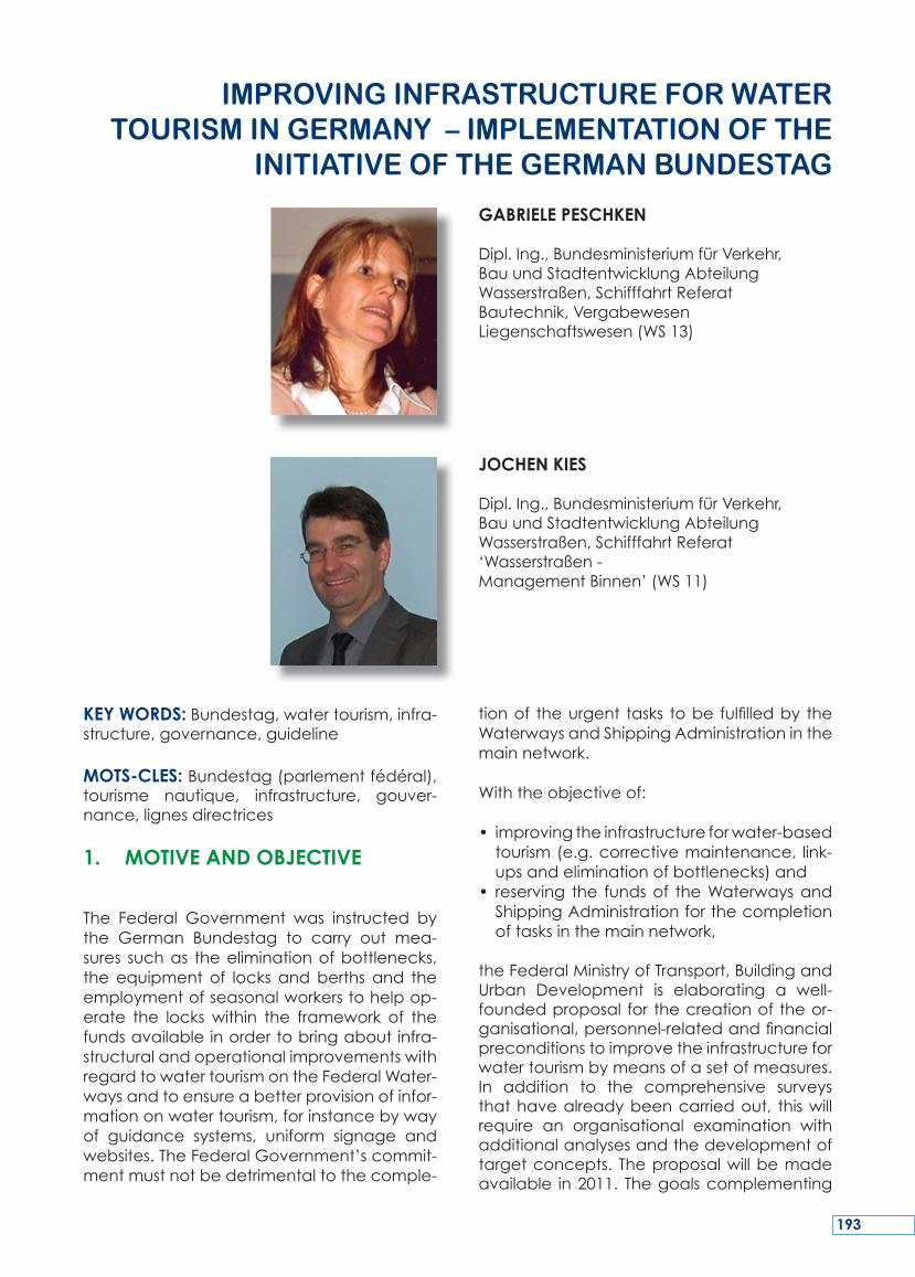
KEY WORDS:Bundestag,watertourism,infra-structure,governance,guideline
MOTS-CLES:Bundestag(parlementfédéral),tourisme nautique, infrastructure, gouver-nance,lignesdirectrices
1. MOTIVE AND OBJECTIVE
The Federal Government was instructed bythe German Bundestag to carry out mea-sures suchas theeliminationofbottlenecks,theequipment of locks andberths and theemploymentofseasonalworkerstohelpop-erate the lockswithin the framework of thefundsavailableinordertobringaboutinfra-structuralandoperationalimprovementswithregardtowatertourismontheFederalWater-waysandtoensureabetterprovisionofinfor-mationonwatertourism,forinstancebywayof guidance systems, uniform signage andwebsites.TheFederalGovernment’scommit-mentmustnotbedetrimentaltothecomple-
tionof theurgent tasks tobe fulfilledby theWaterwaysandShippingAdministrationinthemainnetwork.
Withtheobjectiveof:
• improvingtheinfrastructureforwater-basedtourism(e.g.correctivemaintenance, link-upsandeliminationofbottlenecks)and
• reserving the fundsof theWaterwaysandShippingAdministrationforthecompletionoftasksinthemainnetwork,
theFederalMinistryofTransport,BuildingandUrban Development is elaborating a well-foundedproposal forthecreationoftheor-ganisational,personnel-relatedandfinancialpreconditionstoimprovetheinfrastructureforwatertourismbymeansofasetofmeasures.In addition to the comprehensive surveysthathavealreadybeencarriedout, thiswillrequire an organisational examination withadditionalanalysesandthedevelopmentoftargetconcepts. Theproposalwillbemadeavailable in2011. Thegoalscomplementing
IMProvINg INfrAStrUCtUrE for WAtEr toUrISM IN gErMANY – IMPLEMENtAtIoN of thE
INItIAtIvE of thE gErMAN BUNdEStAg
GABRIELE PESCHKEN
Dipl.Ing.,BundesministeriumfürVerkehr,BauundStadtentwicklungAbteilungWasserstraßen,SchifffahrtReferatBautechnik,VergabewesenLiegenschaftswesen(WS13)
JOCHEN KIES
Dipl.Ing.,BundesministeriumfürVerkehr,BauundStadtentwicklungAbteilungWasserstraßen,SchifffahrtReferat‘Wasserstraßen-ManagementBinnen’(WS11)
193
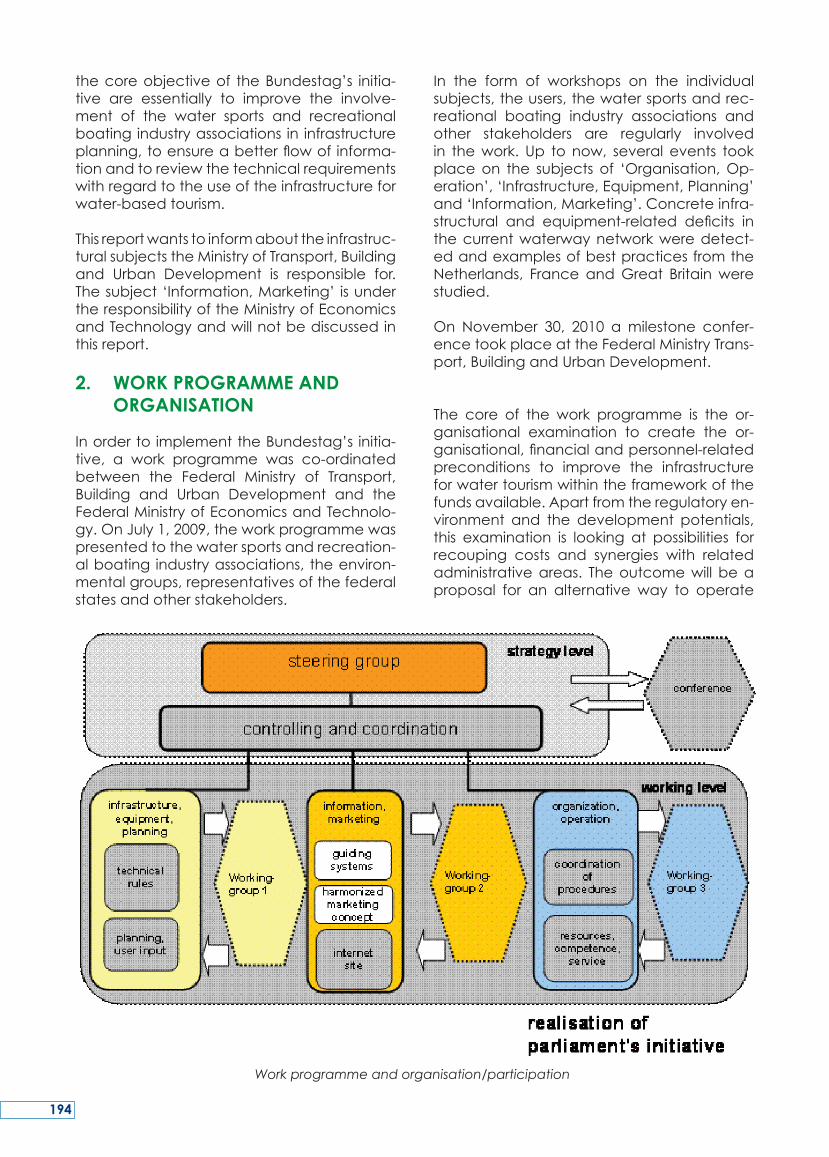
thecoreobjectiveof theBundestag’s initia-tive are essentially to improve the involve-ment of the water sports and recreationalboatingindustryassociations in infrastructureplanning,toensureabetterflowofinforma-tionandtoreviewthetechnicalrequirementswithregardtotheuseoftheinfrastructureforwater-basedtourism.
Thisreportwantstoinformabouttheinfrastruc-turalsubjectstheMinistryofTransport,Buildingand Urban Development is responsible for.Thesubject‘Information,Marketing’ isundertheresponsibilityoftheMinistryofEconomicsandTechnologyandwillnotbediscussedinthisreport.
2. WORK PROGRAMME AND ORGANISATION
InordertoimplementtheBundestag’s initia-tive, a work programme was co-ordinatedbetween the Federal Ministry of Transport,Building and Urban Development and theFederalMinistryofEconomicsandTechnolo-gy.OnJuly1,2009,theworkprogrammewaspresentedtothewatersportsandrecreation-alboating industryassociations, theenviron-mentalgroups,representativesofthefederalstatesandotherstakeholders.
In the form of workshops on the individualsubjects,theusers,thewatersportsandrec-reational boating industry associations andother stakeholders are regularly involvedin thework. Up to now, several events tookplaceon the subjects of ‘Organisation,Op-eration’,‘Infrastructure,Equipment,Planning’and‘Information,Marketing’.Concreteinfra-structural and equipment-related deficits inthecurrentwaterwaynetworkweredetect-edandexamplesofbestpracticesfromtheNetherlands, France andGreat Britainwerestudied.
On November 30, 2010 amilestone confer-encetookplaceattheFederalMinistryTrans-port,BuildingandUrbanDevelopment.
The core of the work programme is the or-ganisational examination to create the or-ganisational,financialandpersonnel-relatedpreconditions to improve the infrastructureforwatertourismwithintheframeworkofthefundsavailable.Apartfromtheregulatoryen-vironment and the development potentials,this examination is looking at possibilities forrecouping costs and synergies with relatedadministrativeareas. Theoutcomewill beaproposal for an alternative way to operate
Work programme and organisation/participation
194
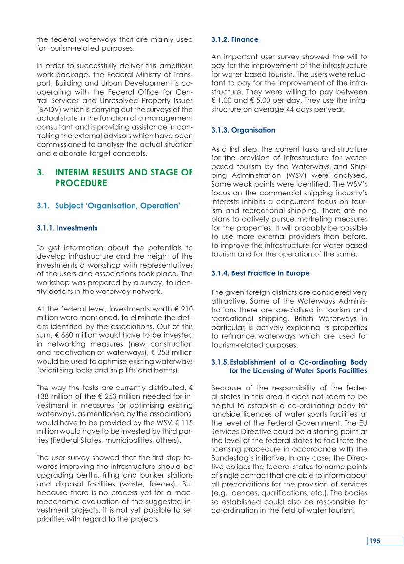
the federalwaterways thataremainlyusedfortourism-relatedpurposes.
Inorder to successfullydeliver thisambitiousworkpackage, theFederalMinistryof Trans-port,BuildingandUrbanDevelopmentisco-operating with the Federal Office for Cen-tral Services and Unresolved Property Issues(BADV)whichiscarryingoutthesurveysoftheactualstateinthefunctionofamanagementconsultantandisprovidingassistanceincon-trollingtheexternaladvisorswhichhavebeencommissionedtoanalysetheactualsituationandelaboratetargetconcepts.
3. INTERIM RESULTS AND STAGE OF PROCEDURE
3.1. Subject ‘Organisation, Operation’
3.1.1. Investments
To get information about the potentials todevelop infrastructureandtheheightof theinvestmentsaworkshopwith representativesoftheusersandassociationstookplace.Theworkshopwaspreparedbyasurvey,toiden-tifydeficitsinthewaterwaynetwork.
Atthefederal level, investmentsworth€910millionwerementioned,toeliminatethedefi-cits identifiedbytheassociations.Outofthissum,€660millionwouldhavetobeinvestedin networking measures (new constructionandreactivationofwaterways),€253millionwouldbeusedtooptimiseexistingwaterways(prioritisinglocksandshipliftsandberths).
Thewaythetasksarecurrentlydistributed,€138millionofthe€253millionneededforin-vestment inmeasures for optimising existingwaterways,asmentionedbytheassociations,wouldhavetobeprovidedbytheWSV.€115millionwouldhavetobeinvestedbythirdpar-ties(FederalStates,municipalities,others).
Theusersurveyshowedthatthefirststepto-wards improvingtheinfrastructureshouldbeupgrading berths, filling and bunker stationsand disposal facilities (waste, faeces). Butbecause there is noprocess yet foramac-roeconomicevaluationof the suggested in-vestmentprojects,it isnotyetpossibletosetprioritieswithregardtotheprojects.
3.1.2. Finance
An important user survey showed thewill topayfortheimprovementoftheinfrastructureforwater-basedtourism.Theuserswerereluc-tanttopayfortheimprovementoftheinfra-structure. Theywerewilling topaybetween€1.00and€5.00perday.Theyusetheinfra-structureonaverage44daysperyear.
3.1.3. Organisation
Asafirststep,thecurrenttasksandstructurefor the provision of infrastructure for water-based tourism by the Waterways and Ship-ping Administration (WSV) were analysed.Someweakpointswereidentified.TheWSV’sfocuson thecommercial shipping industry’sinterests inhibits a concurrent focus on tour-ismand recreational shipping. Thereare noplanstoactivelypursuemarketingmeasuresfortheproperties.Itwillprobablybepossibleto usemoreexternal providers thanbefore,toimprovetheinfrastructureforwater-basedtourismandfortheoperationofthesame.
3.1.4. Best Practice in Europe
Thegivenforeigndistrictsareconsideredveryattractive. Someof theWaterwaysAdminis-trations thereare specialised in tourismandrecreational shipping. British Waterways inparticular, is actively exploiting its propertiesto refinance waterways which are used fortourism-relatedpurposes.
3.1.5. Establishment of a Co-ordinating Body for the Licensing of Water Sports Facilities
Because of the responsibility of the feder-al states in thisarea itdoesnot seem tobehelpful toestablishaco-ordinatingbody forlandside licencesofwater sports facilitiesattheleveloftheFederalGovernment.TheEUServicesDirectivecouldbeastartingpointatthelevelofthefederalstatestofacilitatethelicensingprocedure inaccordancewith theBundestag’sinitiative.Inanycase,theDirec-tiveobligesthefederalstatestonamepointsofsinglecontactthatareabletoinformaboutallpreconditions for theprovisionof services(e.g.licences,qualifications,etc.).Thebodiesso established could also be responsible forco-ordinationinthefieldofwatertourism.
195
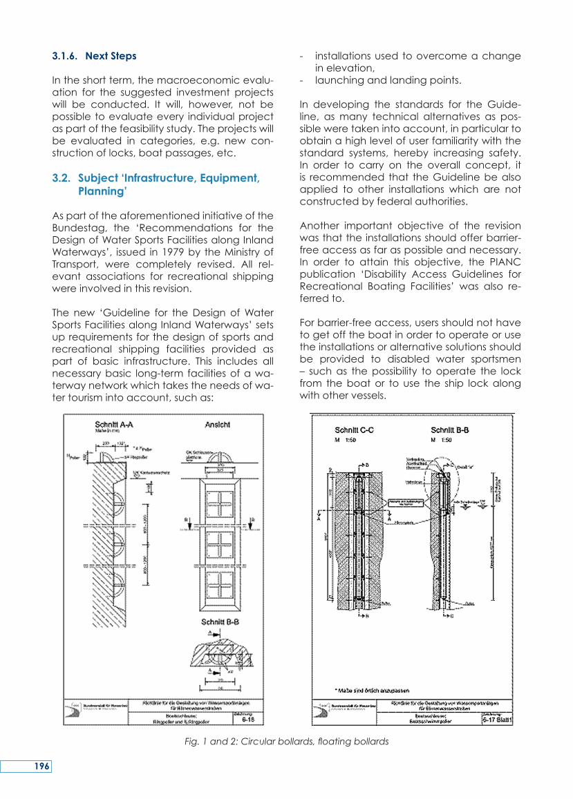
3.1.6. Next Steps
Intheshortterm,themacroeconomicevalu-ation for the suggested investment projectswill be conducted. It will, however, not bepossibletoevaluateevery individualprojectaspartofthefeasibilitystudy.Theprojectswillbe evaluated in categories, e.g. new con-structionoflocks,boatpassages,etc.
3.2. Subject ‘Infrastructure, Equipment, Planning’
AspartoftheaforementionedinitiativeoftheBundestag, the ‘Recommendations for theDesignofWaterSportsFacilitiesalongInlandWaterways’, issued in1979by theMinistryofTransport, were completely revised. All rel-evant associations for recreational shippingwereinvolvedinthisrevision.
The new ‘Guideline for theDesign ofWaterSportsFacilitiesalongInlandWaterways’setsuprequirementsforthedesignofsportsandrecreational shipping facilities provided aspart of basic infrastructure. This includes allnecessarybasic long-term facilitiesofawa-terwaynetworkwhichtakestheneedsofwa-tertourismintoaccount,suchas:
- installationsusedtoovercomeachangeinelevation,
- launchingandlandingpoints.
In developing the standards for the Guide-line, asmany technical alternatives as pos-sibleweretakenintoaccount,inparticulartoobtainahighlevelofuserfamiliaritywiththestandard systems, hereby increasing safety.In order to carry on the overall concept, itis recommended that theGuidelinebealsoapplied to other installations which are notconstructedbyfederalauthorities.
Another important objective of the revisionwasthattheinstallationsshouldofferbarrier-freeaccessasfaraspossibleandnecessary.In order to attain this objective, the PIANCpublication ‘Disability Access Guidelines forRecreational Boating Facilities’ was also re-ferredto.
Forbarrier-freeaccess,usersshouldnothavetogetofftheboatinordertooperateorusetheinstallationsoralternativesolutionsshouldbe provided to disabled water sportsmen– suchas thepossibility tooperate the lockfrom theboator to use the ship lockalongwithothervessels.
Fig. 1 and 2: Circular bollards, floating bollards
196
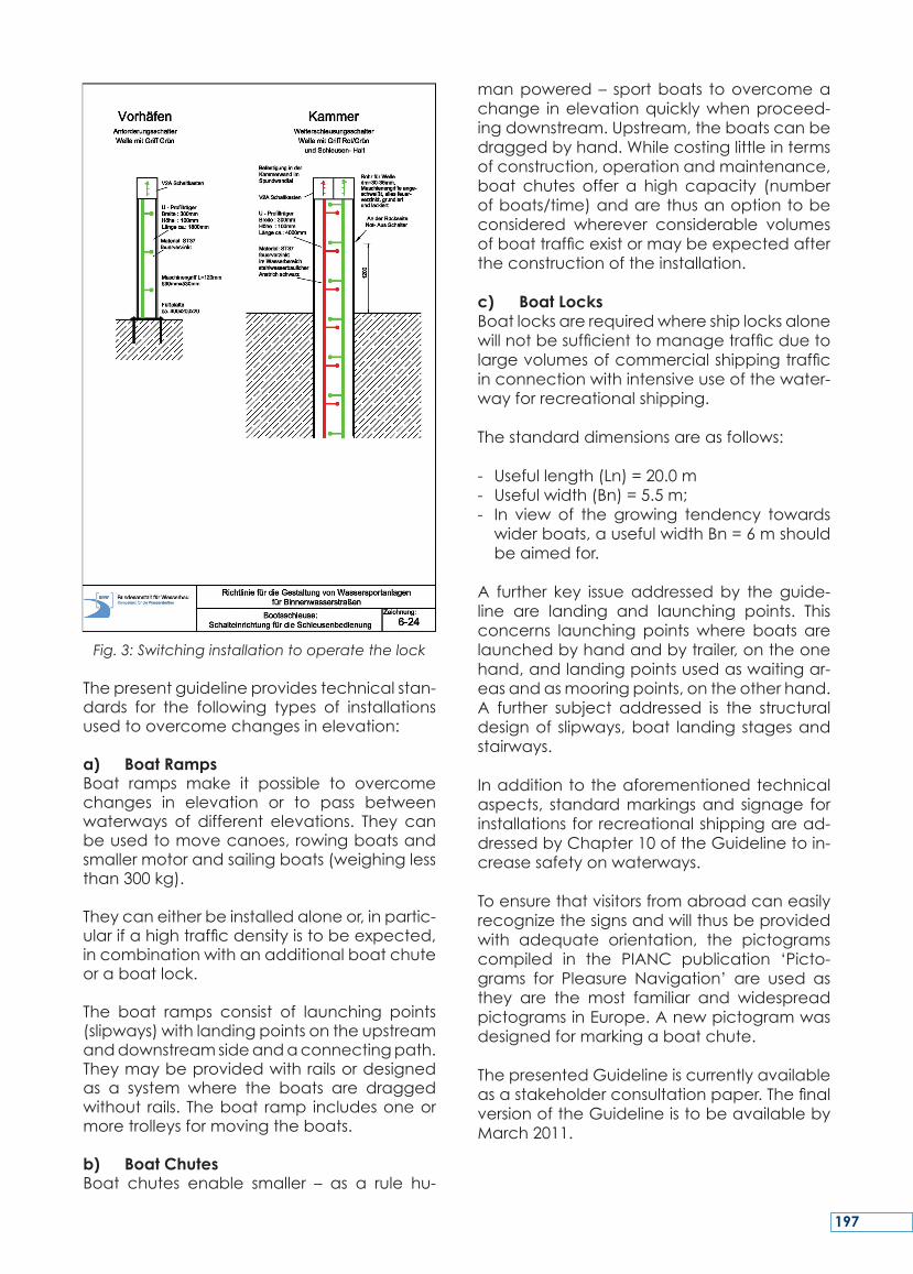
Fig. 3: Switching installation to operate the lock
Thepresentguidelineprovidestechnicalstan-dards for the following types of installationsusedtoovercomechangesinelevation:
a) Boat RampsBoat ramps make it possible to overcomechanges in elevation or to pass betweenwaterways of different elevations. They canbeusedtomovecanoes,rowingboatsandsmallermotorandsailingboats(weighinglessthan300kg).
Theycaneitherbeinstalledaloneor,inpartic-ularifahightrafficdensityistobeexpected,incombinationwithanadditionalboatchuteoraboatlock.
The boat ramps consist of launching points(slipways)withlandingpointsontheupstreamanddownstreamsideandaconnectingpath.Theymaybeprovidedwithrailsordesignedas a system where the boats are draggedwithout rails. Theboat ramp includesoneormoretrolleysformovingtheboats.
b) Boat ChutesBoat chutes enable smaller – as a rule hu-
manpowered– sportboats toovercomeachange inelevationquicklywhenproceed-ingdownstream.Upstream,theboatscanbedraggedbyhand.Whilecostinglittleintermsofconstruction,operationandmaintenance,boat chutes offer a high capacity (numberofboats/time)andarethusanoptiontobeconsidered wherever considerable volumesofboattrafficexistormaybeexpectedaftertheconstructionoftheinstallation.
c) Boat LocksBoatlocksarerequiredwhereshiplocksalonewillnotbesufficienttomanagetrafficduetolargevolumesofcommercialshippingtrafficinconnectionwithintensiveuseofthewater-wayforrecreationalshipping.
Thestandarddimensionsareasfollows:
- Usefullength(Ln)=20.0m- Usefulwidth(Bn)=5.5m;- In view of the growing tendency towardswiderboats,ausefulwidthBn=6mshouldbeaimedfor.
A further key issueaddressedby theguide-line are landing and launching points. Thisconcerns launching pointswhere boats arelaunchedbyhandandbytrailer,ontheonehand,andlandingpointsusedaswaitingar-easandasmooringpoints,ontheotherhand.A further subject addressed is the structuraldesignof slipways,boat landing stagesandstairways.
Inadditiontotheaforementionedtechnicalaspects, standardmarkingsand signage forinstallationsforrecreationalshippingaread-dressedbyChapter10oftheGuidelinetoin-creasesafetyonwaterways.
Toensurethatvisitorsfromabroadcaneasilyrecognizethesignsandwillthusbeprovidedwith adequate orientation, the pictogramscompiled in the PIANC publication ‘Picto-grams for Pleasure Navigation’ are used asthey are the most familiar and widespreadpictogramsinEurope.Anewpictogramwasdesignedformarkingaboatchute.
ThepresentedGuidelineiscurrentlyavailableasastakeholderconsultationpaper.ThefinalversionoftheGuidelineistobeavailablebyMarch2011.
197
The Federal Government was instructed bythe German Bundestag to carry out mea-sures suchas theeliminationofbottlenecks,theequipment of locks andberths and theemploymentofseasonalworkerstohelpop-erate the lockswithin the framework of thefunds available, in order to bring about in-frastructural and operational improvementswith regard towater tourismon the FederalWaterwaysand toensureabetterprovisionof informationonwatertourism,for instance
bywayofguidancesystems,uniformsignageandwebsites.
This report wants to inform about the infra-structural subjects the Ministry of Transport,BuildingandUrbanDevelopmentisresponsi-blefor.Thesubject‘Information,Marketing’isunderresponsibilityoftheMinistryofEconom-icsandTechnologyandnotdiscussedinthisreport.
SUMMARY
Leparlement fédéralallemandachargé legouvernementfédéraldeconduireun pro-grammedemesurestellesquelasuppressionde goulots d’étranglement, l’équipementd’écluses, et d’accostages, et l’emploi detravailleurs saisonniers pour la manœuvred’écluses,danslecadredesfondsdisponiblespouraméliorerl’infrastructureetl’exploitationpourletourismenautiquesurlesvoiesnaviga-blesfédéralesetpouraméliorer lafournitured’informations sur le tourisme nautique, par
exemplepardessystèmesdeguidage,unesignalétiqueuniformeetdessitesweb.
Ce rapport a pour ambition d’informer dessujetsliésàl’infrastructuredontleministèredutransport,delaconstructionetdudéveloppe-menturbainestchargé.Lesujet‘Information,Marketing’relèveduministèredel’économieetdelatechnologieetn’estpastraitédanscetarticle.
RESUME
Die Bundesregierung beauftragt, infrastruk-turelle und betriebliche Verbesserungen andenBundeswasserstraßenfürdenWassertour-ismus,wiez.B.Engpassbeseitigungen,Ausrüs-tung von Schleusen und Liegestellen sowieUnterstützung des Schleusenbetriebs durchSaisonkräfte, im Rahmen der verfügbarenHaushaltsmittel umzusetzen und für bessereInformationsbereitstellung zum Thema Was-sertourismus, z.B.durch Leitsysteme,einheitli-
cheBeschilderungenundInternetangebote,zusorgen.
DerAufsatzinformiertfürdieinfrastrukturellenThemenfelder imBereichdesBundesministe-riums fürVerkehr,BauundStadtentwicklung.Fürdas Themenfeld ’Information.Marketing’ist das Bundesministerium für Wirtschaft undTechnologie verantwortlich. Es wird im Rah-mendesAufsatzesnichtbehandelt.
ZUSAMMENFASSUNG
198
KEY WORDS: Germany, port development,infrastructure, hinterland, offshore wind en-ergy, container handling, vehicle handling,greenports
MOTS-CLES: Allemagne, développementportuaire, infrastructure, hinterland, énergieéolienne offshore, manutention de conte-neurs,manutentiondevéhicules,portsverts
1. INTRODUCTION
BremenportsGmbH&Co.KGmanages theportinfrastructureatBremen’sportsonbehalfoftheFreeHanseaticCityofBremen.Bremen-ports is responsible forproviding intact infra-structureintheportfacilitiesinBremenandinBremerhaven.
Bremen is the smallest federal state in Ger-manyandconsistsofthetwocitiesofBremenandBremerhaven,eachofwhichhasitsownport.InthecityofBremen,theportcompaniesdeal primarily with the typical conventional
cargo.TheIndustrialPortinBremenisahistori-callygrownandclassical universal-port. TheNeustädterPorton the leftbankof the riverWeserismoreaportwhereconventionalcar-goishandled,projectcargo,breakbulkandafewcontainers.ThecityofBremerhaven,65kmfurthernorth,standsforcontainerandau-tomobilethroughput.
Thearticleexplainstheeffortsfortheportin-frastructuremanagementcompanybremen-portstoimprovetheconnectionstoboth,seaandhinterlandandshowstheexcitingdevel-opmentsBremerhavenisundertakingtobuildupanewthirdcorebusiness,thehandlingofoffshorewindenergywindmillequipment.
2. CURRENT DEVELOPMENTS IN BREMEN AND BREMERHAVEN
Bremen/Bremerhaven is also a classicaluniversal port which handles all kinds ofbulk cargo. Right now, a cluster of offshorewind energy companies is developing
fUtUrE Port dEvELoPMENt IN gErMANY - thE vIEWPoINt of BrEMENPortS
STEFAN WOLTERING
ManagingDirectorAmStrom227568BremerhavenGermany
Tel.:+4947130901100E-mail:[email protected]
STEFAN FÄRBER
ManagementAssistantAmStrom227569BremerhavenGermany,
Tel.:+4947130901106E-mai:[email protected]
199
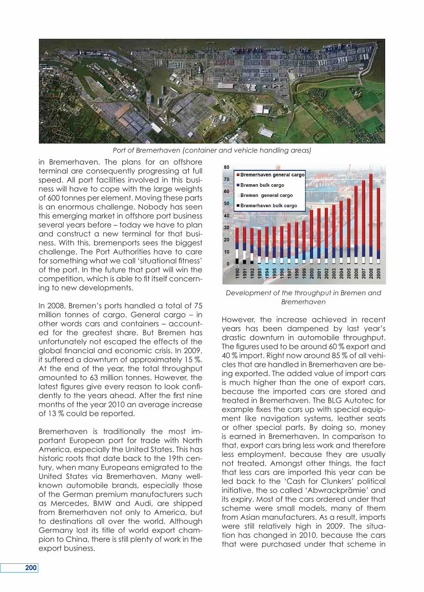
in Bremerhaven. The plans for an offshoreterminalareconsequentlyprogressingat fullspeed.All port facilities involved in thisbusi-nesswillhavetocopewiththelargeweightsof600tonnesperelement.Movingthesepartsisanenormouschallenge.Nobodyhasseenthisemergingmarketinoffshoreportbusinessseveralyearsbefore–todaywehavetoplanand construct a new terminal for that busi-ness.Withthis,bremenportsseesthebiggestchallenge.ThePortAuthoritieshavetocareforsomethingwhatwecall‘situationalfitness’oftheport.Inthefuturethatportwillwinthecompetition,whichisabletofititselfconcern-ingtonewdevelopments.
In2008,Bremen’sportshandledatotalof75million tonnes of cargo.General cargo – inotherwordscarsandcontainers–account-ed for the greatest share. But Bremen hasunfortunatelynotescapedtheeffectsoftheglobalfinancialandeconomiccrisis.In2009,itsufferedadownturnofapproximately15%.At theendof theyear, the total throughputamountedto63milliontonnes.However,thelatestfiguresgiveeveryreasontolookconfi-dentlytotheyearsahead.Afterthefirstninemonthsoftheyear2010anaverageincreaseof13%couldbereported.
Bremerhaven is traditionally the most im-portant European port for trade with NorthAmerica,especiallytheUnitedStates.Thishashistoricrootsthatdatebacktothe19thcen-tury,whenmanyEuropeansemigratedtotheUnited States via Bremerhaven. Many well-known automobile brands, especially thoseoftheGermanpremiummanufacturerssuchas Mercedes, BMW and Audi, are shippedfromBremerhavennotonly toAmerica,butto destinations all over the world. AlthoughGermany lost its title ofworld export cham-piontoChina,thereisstillplentyofworkintheexportbusiness.
Development of the throughput in Bremen and Bremerhaven
However, the increase achieved in recentyears has been dampened by last year’sdrastic downturn in automobile throughput.Thefiguresusedtobearound60%exportand40%import.Rightnowaround85%ofallvehi-clesthatarehandledinBremerhavenarebe-ingexported.Theaddedvalueofimportcarsismuchhigher than theoneofexportcars,because the imported cars are stored andtreatedinBremerhaven.TheBLGAutotecforexamplefixesthecarsupwithspecialequip-ment like navigation systems, leather seatsor other special parts. By doing so, moneyisearned inBremerhaven. Incomparison tothat,exportcarsbringlessworkandthereforeless employment, because they are usuallynot treated. Amongst other things, the factthat lesscarsare imported thisyearcanbeledback to the ‘Cash forClunkers’politicalinitiative,thesocalled‘Abwrackprämie’anditsexpiry.Mostofthecarsorderedunderthatscheme were small models, many of themfromAsianmanufacturers.Asaresult,importswere still relatively high in 2009. The situa-tionhaschangedin2010,becausethecarsthat were purchased under that scheme in
Port of Bremerhaven (container and vehicle handling areas)
200
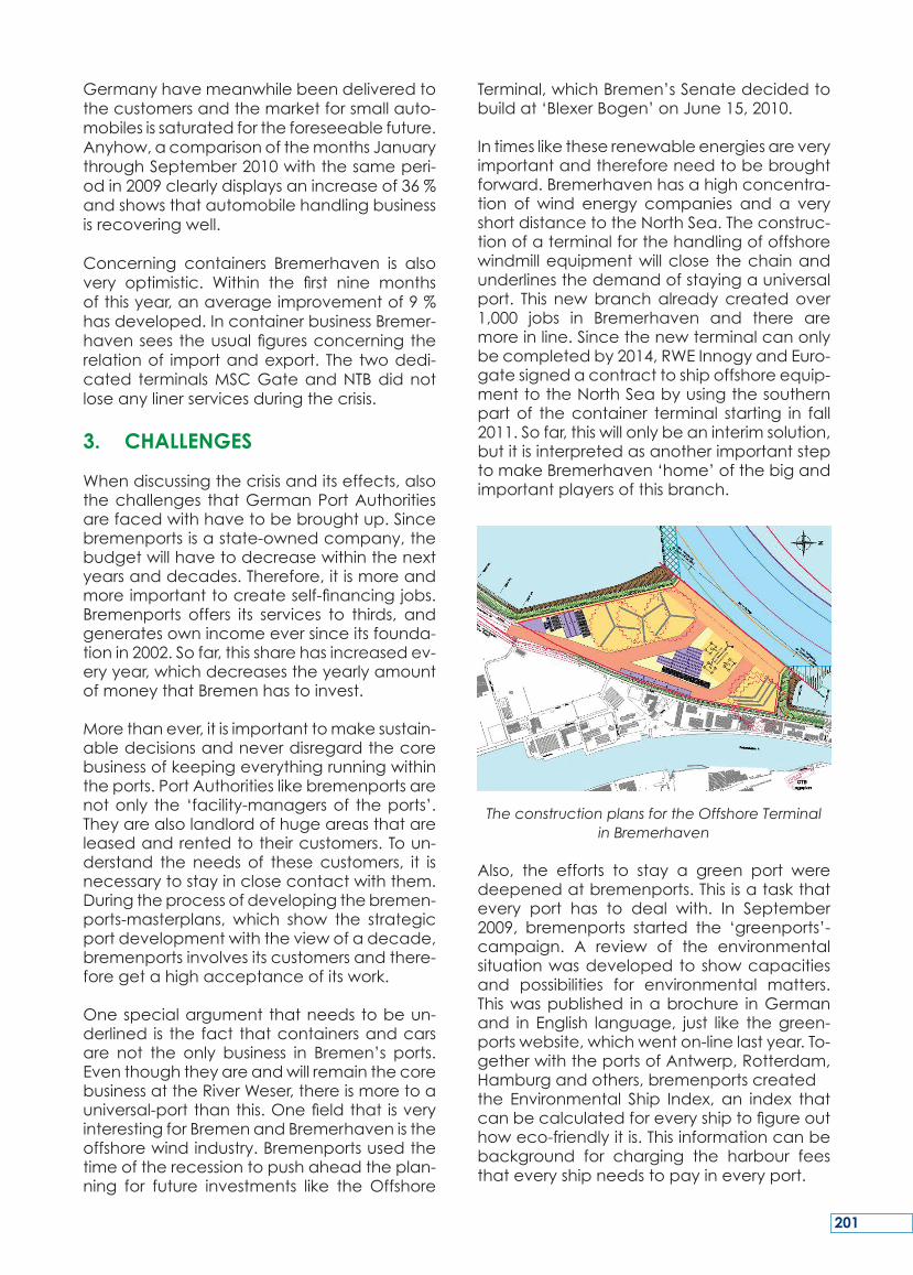
Germanyhavemeanwhilebeendeliveredtothecustomersandthemarketforsmallauto-mobilesissaturatedfortheforeseeablefuture.Anyhow,acomparisonofthemonthsJanuarythroughSeptember2010withthesameperi-odin2009clearlydisplaysanincreaseof36%andshowsthatautomobilehandlingbusinessisrecoveringwell.
Concerning containers Bremerhaven is alsovery optimistic. Within the first nine monthsofthisyear,anaverageimprovementof9%hasdeveloped.IncontainerbusinessBremer-havenseestheusualfiguresconcerningtherelationof importandexport. The twodedi-cated terminalsMSCGateandNTBdidnotloseanylinerservicesduringthecrisis.
3. CHALLENGES
Whendiscussingthecrisisanditseffects,alsothechallenges thatGermanPortAuthoritiesarefacedwithhavetobebroughtup.Sincebremenportsisastate-ownedcompany,thebudgetwillhavetodecreasewithinthenextyearsanddecades.Therefore,itismoreandmoreimportanttocreateself-financingjobs.Bremenports offers its services to thirds, andgeneratesownincomeeversinceitsfounda-tionin2002.Sofar,thissharehasincreasedev-eryyear,whichdecreasestheyearlyamountofmoneythatBremenhastoinvest.
Morethanever,itisimportanttomakesustain-abledecisionsandneverdisregardthecorebusinessofkeepingeverythingrunningwithintheports.PortAuthoritieslikebremenportsarenotonly the ‘facility-managersof theports’.Theyarealsolandlordofhugeareasthatareleasedandrentedtotheircustomers.Toun-derstand the needs of thesecustomers, it isnecessarytostayinclosecontactwiththem.Duringtheprocessofdevelopingthebremen-ports-masterplans, which show the strategicportdevelopmentwiththeviewofadecade,bremenportsinvolvesitscustomersandthere-foregetahighacceptanceofitswork.
Onespecialargumentthatneedstobeun-derlined is thefact thatcontainersandcarsare not the only business in Bremen’s ports.EventhoughtheyareandwillremainthecorebusinessattheRiverWeser,thereismoretoauniversal-portthanthis.Onefieldthat isveryinterestingforBremenandBremerhavenistheoffshorewindindustry.Bremenportsusedthetimeoftherecessiontopushaheadtheplan-ning for future investments like theOffshore
Terminal,whichBremen’sSenatedecidedtobuildat‘BlexerBogen’onJune15,2010.
Intimesliketheserenewableenergiesareveryimportantandthereforeneedtobebroughtforward.Bremerhavenhasahighconcentra-tion of wind energy companies and a veryshortdistancetotheNorthSea.Theconstruc-tionofaterminalforthehandlingofoffshorewindmillequipmentwillclose thechainandunderlinesthedemandofstayingauniversalport. This newbranchalreadycreatedover1,000 jobs in Bremerhaven and there aremoreinline.Sincethenewterminalcanonlybecompletedby2014,RWEInnogyandEuro-gatesignedacontracttoshipoffshoreequip-menttotheNorthSeabyusingthesouthernpartof thecontainer terminal starting in fall2011.Sofar,thiswillonlybeaninterimsolution,butitisinterpretedasanotherimportantsteptomakeBremerhaven‘home’ofthebigandimportantplayersofthisbranch.
The construction plans for the Offshore Terminalin Bremerhaven
Also, the efforts to stay a green port weredeepenedatbremenports.Thisisataskthatevery port has to deal with. In September2009, bremenports started the ‘greenports’-campaign. A review of the environmentalsituationwasdevelopedtoshowcapacitiesand possibilities for environmental matters.Thiswaspublished inabrochure inGermanand in English language, just like thegreen-portswebsite,whichwenton-linelastyear.To-getherwiththeportsofAntwerp,Rotterdam,Hamburgandothers,bremenportscreatedthe Environmental Ship Index, an index thatcanbecalculatedforeveryshiptofigureouthoweco-friendlyitis.Thisinformationcanbebackground for charging the harbour feesthateveryshipneedstopayineveryport.
201
Beyond that, E-Mobility was introduced atbremenports.Twoelectriccarswereinstalledinthecarpool.Besidesinstallingphotovoltaicfacilitiesontheworkshoproofandnoisepro-tection on the terminals, bremenports usesmonitoring systems in Weddewarden, a vil-lagenexttothecontainer-terminalinBremer-haven and on the container-terminal itself.ThePERS(PortEnvironmentalReviewSystem)certification of the environmental manage-mentisaimed.
Being‘green’isnotonlyahotissue,butalsoonethatshouldbetakenseriouslybyallportauthorities,alsooutsideGermany,becauseitisobtainingrelevanceandtheconsumerswillshowmoreinterest inthissubjectinthenearfuture.
4. CONNECTIONS
Sustainableportdevelopmentalsomeanstodeveloptheconnectionsoftheports.Ontheseaside,theportsareconnectedtotherestoftheworld.Ontheotherside,thelandside,theportsareconnectedwiththeirhinterland.Both connections consist of various compo-nentswhichhavetobeconstantlyupgradedandadaptedtomatchdemand.Andsincedemand changes over the course of theyears, it ismost important toensureefficientaccessfrombothseaandhinterland.
Duringthelastyears,Bremeninvestedaround€800millionintotheseasideconnections.In2008thelastextensionofthecontainer-termi-nal(CT4)wasfinished.
Toensurethatthehighnumberofshipscanbe loaded and discharged without disrup-tions, permanent seaward access must beguaranteed. Bremenports’ customers – thevehicle transporting shipping lines – men-tionedtheneedfortwofunctioningsealocks,tomakesuretheport isopenforshipstoar-riveanddepart7daysaweekand24hoursaday.Rightnow,bremenportsinthelastphaseofanothermajorconstruction,thebuildingofthenewsealock‘Kaiserschleuse’.
Also,theapprovaloftheplanstodredgetheRiverWeserforanadditionalmetreiseagerlyawaited. After these constructions the sea-wardaccessof Bremen’sportswill beevenbetterandthereforesustainable.
Thelogisticindustryisdependentonefficient
landside connections, whether road or rail,both for containers and vehicles exportedfrom Germany or imported into Germanyhave to be transported to or from Bremer-havenandBremen.
Atthemoment,inlandshippingplaysonlyaninsignificantroleforcarryingfreighttoinlanddestinations. Therefore, this field can be im-proved.ThelinkbetweentheRiverWeserandMittellandCanaliscurrentlybeingupgraded,so that an inland waterway with far highercapacityandgoodconnectionstotheGer-manwaterwaynetworkwill beavailableasfrom2012.
Because most of Germany’s premium carmanufacturersarelocatedinthesouthofthecountry,thelandsideconnectionstotheportmustbekeptup-to-date.Thisconcernsbothroadandrail.Linkstothehinterlandmustbeavailable forexport,aswellas import.80 to85%ofexportedcarsreachtheportbytrain.Almost 90%of the importedcars leave theportby truck.Even though it isnot thecorebusiness of a port authority to change themodalsplit,bremenportstriesitsverybest,toupgradetherailwaystogetmoreandmorecargoofftheroadsontherailways.
Thetrackinfrastructureoftheportrailwayalsohastobeupgradedtomanagetheincreas-ingcapacitieshandledattheports.Thankstoongoingconsultationbetweenbremenportsandthecargohandlingcompanies,bremen-ports is informedofproductivity increasesatthe companies and their demand for addi-tionalinfrastructure.Atthemoment,negotia-tionsareinprogresswithDeutscheBahnaboutnew storage capacities at Bremerhaven-Speckenbüttel station and the constructionofadditionaltrackandrailinfrastructure.Bre-men’sportshaveatotalofapproximately250km of railway tracks, which aremaintainedandoperatedbybremenports. These tracksaredirectlyconnectedtotheDeutscheBahnrailnetwork.
5. PORT AUTHORITIES AND OTHERS
Becauseportauthoritiesandterminalopera-torsarenotaloneintheportsandallthepar-ticipantsplayamajorroleineveryday’sportlife,bremenportsregularlydrawsmasterplans.Thisprovedtobeagoodwayofhandlingthedifferentmatters. Thisprocess regularly startswithakick-offmeetingandtheformationof
202
the working group. Bremenports then ques-tionstherelevantcompaniesandinstitutionsabout their current thoughts, worries andplans. The results of this and the strengths,weaknesses, opportunities and threats arebeinganalyzedbeforetheactualmasterplanisworkedout,publishedandpresented.Thiscanbethebasisforpoliticaldecisionsandin-vestmentsintotheportinfrastructure.
The article explains how Bremen investedaround€800millioninupgradingseawardac-cesstotheportsinrecentyears.Itshowshowimportantitis–nowandforthefuture–toim-provetheconnectionstothehinterland.Theplanstostrengthentheroad-andrailconnec-tionsarebeingdevelopedatfullspeedbyalltheparticipatingplayers,sothattheportsofBremenandBremerhavenarewellequippedtocopewiththeflowofgoodsinthefuture.
Alsoitismoreandmoreimportanttocreateself-financing jobs at the Port Authorities byofferingcertainservicestotheopenmarket.Thearticleistryingtogivearoughideaoftherangeoftaskshandledbytheportmanage-ment companybremenports. In doing so, ithighlightsthecurrentchallengesthatGermanPortAuthorities-andinspecialbremenports-arefacedwith.
SUMMARY
L’articleexpliquelesinvestissementsd’environ800 M € de Brème pour améliorer l’accèsmaritimede sesportscesdernièresannées.Ilmontre l’importance–aujourd’huietdansle futur–de l’améliorationdes liaisonsavecl’hinterland. Le programme d’améliorationdes connections routières et ferroviaires estmené tambour battant par tous les parte-naires,pourquelesportsdeBrèmeetBremer-havensoientbienadaptésauxfluxdemarch-
andisesdufutur. Ilestégalementdeplusenplusimportantdecréerdesemploisrentablesdanslesautoritésportuairesenproposantdesservicessurlemarchéconcurrentiel.L’articletentededonneruneidéegénéraledestâch-esréaliséesparlasociétéd’exploitationpor-tuaireBremenports.Ainsiilmetenlumièrelesdéfisauxquelslesportsallemands,etenpar-ticulierBremenports,sontconfrontés.
RESUME
DerBeitragerläutert,wieundwofürdieFreieHansestadtBremenindenvergangenenJah-ren etwa 800 Millionen Euro in den AusbauunddieEntwicklungderseeseitigenZufahrtenderHäfeninvestierthat.Erbetont,wiewich-tigesistdieVerbindungeninsHinterland,so-wohlaufderStraße,alsauchaufderSchieneunddenBinnenwasserweg,auszubauenundweiterzuentwickeln.DiehierzuerforderlichenPlanungen und Maßnahmen laufen bei al-len Beteiligten auf Hochtouren, so dass diebremischen Häfen für die Warenströme der
Zukunft gut aufgestellt sind. Außerdem wirdes für eine staatliche Hafenmanagement-gesellschaft zunehmendwichtig, selbstfinan-zierende Jobs zu schaffen, was durch dasAnbieten von Leistungen imauf dem freienMarkt im sog. Drittgeschäft erreicht werdenkann.ZusammenfassendgibtderBeitragein-enkurzenÜberblicküberdieAufgabeneinerdeutschenPortAuthority,wobeivorallemdieaktuellenHerausforderungenamBeispielderbremischenHäfenbeleuchtetwerden.
ZUSAMMENFASSUNG
203

204
KEY WORDS:Berlin,nature&people,watersport,shipping,ports&canals
MOTS-CLES: Berlin, nature et population,sport nautique, navigation professionnelle,portsetcanaux
1. BERLIN IS BUILT FROM BOATS
‘Berlinisbuiltfromboats’–thisfamiliarquota-tionisoneveryone’slipsinthiscity.IfyouthinkoftheearlydaysofBerlin,topographiccondi-tionsplayedadecisivepartinitssettlement.Importantparameterswerea sort of ford inthe riverandeasily-surmountedhillsonbothbanks.
Initially,twosettlementsweresetup:CöllnonanislandintheSpree,andBerlinontherightbankoftheSpree. Inthesecondhalfofthe13thcentury,theSpreewasdammedupforshipping,butalsoinorderforwaterpowertobeusedatMühlendamm.Overthecenturies,this developed into today’s Mühlendammlock.Asuccessfulsymbiosiswasformedherebythecombinationoftheuseofwaterpow-er for the formermillsandtheshippingnec-essary for trade. The region around the citycentreofBerlinhasprofitedfromthissincethe16thcentury.
Inadditiontothislocalincome,theHohenzo-llern,therulersofthestillyoungstateofPrus-sia,alsoaimed inall levelsofadministrationtoexpandtheshippingroutesfromHamburg,viaBerlin,totheeasternareasofPrussiaand
as farasPoland.Notonlywas the inner-citynetworkofwaterwaysdesignedtomeetthegrowingneedsof thecityofBerlin,butnewlinkswerealsomadetothesurroundingarea.Theywere initiallyonasmallscale,as intheFinowcanal,butlaterincludedthetargeteddevelopment of theHavel from the Elbe tothe Oder, exploiting the many natural con-ditionsof the respective rivercourses. Somewaterways around Berlin were also initiallyplannedandbuiltordevelopedforotherrea-sons,suchasdrainageimprovements.
However,respectiverulersalsopromotedthecharacterofBerlinasthecityonwaterinoth-erways:inparticular,bridgesofarchitecturalcharm haveadorned the city for centuries.The relationship betweenwater and naturewasalsoparticularlyimportanttoLenné,themostfamousBerlinlandscapearchitect,intheplanninganddesignoftheLandwehrcanal.
TherelationshipofthecitizensofBerlintothewatershouldalsobementionedhere.Anin-terestinwatertourismgrewupintheBieder-meierperiodatthestartofthe19thcentury.ThisproducedthedefiningimageoftheBerlinwaterways:today’sWeiβeFlotte(WhiteFleet).Onmanybanks,footpathsextendingforkilo-metresareaninvitationtostrollorhike.
In addition to the development of the wa-terwaysmentionedabove,referenceshouldalsobemadetotheemergenceoftheBerlinharbours.Freightshipping,whichstartedthesettlement of Berlin, has been well able toholditsownagainstthearrivalofothergoods
CoNStrUCtIoN of thE NEW kAISErSChLEUSE LoCk IN BrEMErhAvEN
THOMAS MENZEL
PresidentoftheWaterandShippingDirectoryEastGerhart-Hauptmann-Str.1639108Magdeburg,Germany
Tel.:+493912887-0E-mail:[email protected]:www.wsd-o.wsv.de
205
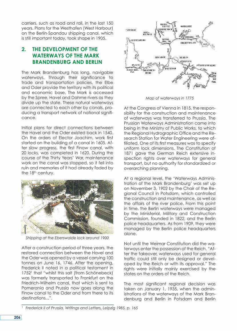
carriers,suchasroadandrail, inthelast150years.PlansfortheWesthafen(WestHarbour)ontheBerlin-Spandaushippingcanal,whichisstillimportanttoday,tookshapein1905.
2. THE DEVELOPMENT OF THE WATERWAYS OF THE MARK BRANDENBURG AND BERLIN
The Mark Brandenburg has long, navigablewaterways. Through their significance totrade and transportation policies, the ElbeandOderprovidetheterritorywithitspoliticaland economic base. TheMark is accessedbytheSpree,HavelandDahmeriversastheydivideupthestate.Thesenaturalwaterwaysareconnectedtoeachotherbycanals,pro-ducingatransportnetworkofnationalsignifi-cance.
Initial plans for direct connections betweentheHavelandtheOderexistedbackin1540.On the orders of Elector Joachim, work firststartedonthebuildingofacanalin1605.Af-ter slow progress, the first Finow canal, with20 locks,wascompleted in1620.DuringthecourseoftheThirtyYears’War,maintenanceworkonthecanalwasstopped,soitfellintoruinandmemoriesofithadalreadyfadedbythe18thcentury.
Shipping at the Eberswalde lock around 1900
Afteraconstructionperiodofthreeyears,therestoredconnectionbetweentheHavelandtheOderwasopenedbyavesselcarrying100tonnesonJune16,1746.After theopening,Frederick II noted in apolitical testament in17521that“whilstthissalt(fromSchönebeck)was formerly transported toFrankfurton theFriedrich-Wilhelmcanal,thatwhichissenttoPomeraniaandPrussia nowgoesalong theFinowcanaltotheOderandfromtheretoitsdestinations...”.
Map of waterways in 1775
AttheCongressofViennain1815,therespon-sibilityfortheconstructionandmaintenanceofwaterwayswas transferred toPrussia. ThePrussianWaterwaysAdministrationcameintobeingintheMinistryofPublicWorks,towhichtheRegionalHydrographicOfficeandtheRe-searchStationforWaterEngineeringwereaf-filiated.Oneofitsfirstmeasureswastospecifyuniform lock dimensions. TheConstitution of1871 gave the German Reich extensive in-spection rights over waterways for generaltransport,butnoauthorityforstandardizedoroverarchingplanning.
Ataregional level, the‘WaterwaysAdminis-trationoftheMarkBrandenburg’wassetuponNovember3,1902bytheChairoftheRe-gionalCouncil inPotsdam,whichcontrolledtheconstructionandmaintenance,aswellastheaffairsof the riverpolice.Fromthispointintime,theBerlinwaterwaysweremanagedby the Ministerial, Military and ConstructionCommission,foundedin1822,andtheBerlinpoliceheadquarters.Asfrom1909,theyweremanagedby theBerlinpoliceheadquartersalone.
NotuntiltheWeimarConstitutiondidthewa-terwaysenterthepossessionoftheReich.“Af-terthetakeover,waterwaysusedforgeneraltraffic could still only bedesignedor devel-opedbytheReichorwith itsapproval.”Therights were initially mainly exercised by thestatesontheordersoftheReich.
The most significant regional decision wastakenonJanuary1, 1935,when theadmin-istrationsofthewaterwaysoftheMarkBran-denburg and Berlin in Potsdam and Berlin
1 Frederick II of Prussia, Writings and Letters, Leipzig 1985, p. 165
206
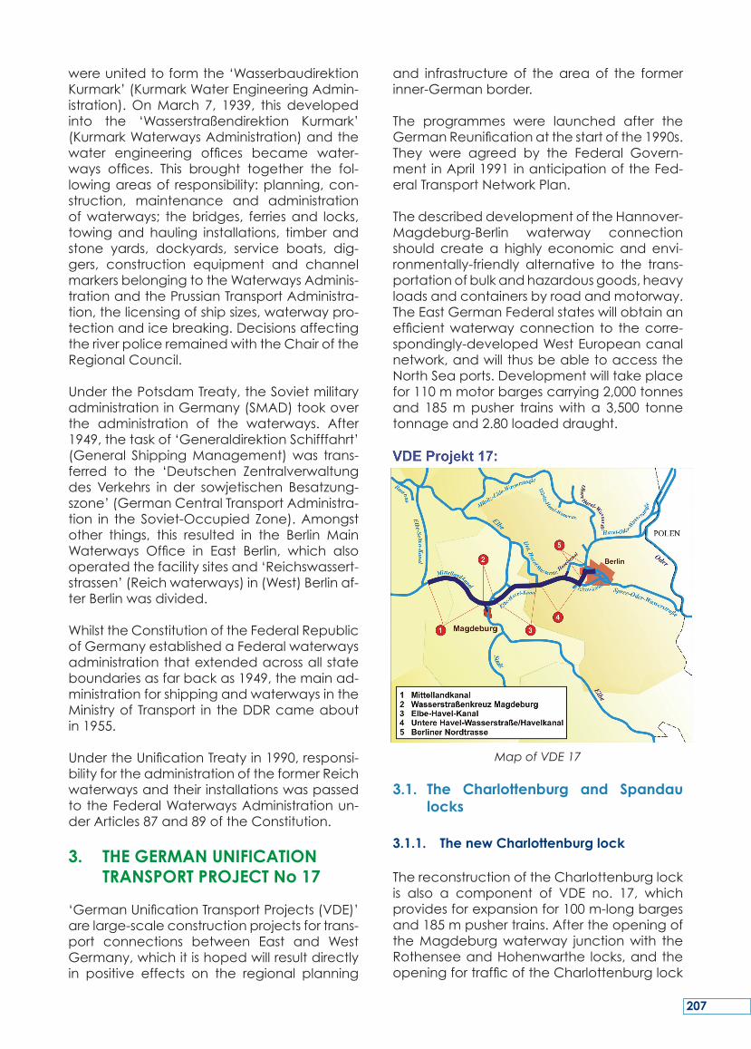
wereunitedtoformthe‘WasserbaudirektionKurmark’(KurmarkWaterEngineeringAdmin-istration).OnMarch 7, 1939, this developedinto the ‘Wasserstraßendirektion Kurmark’(KurmarkWaterwaysAdministration)andthewater engineering offices became water-ways offices. This brought together the fol-lowingareasof responsibility:planning,con-struction, maintenance and administrationofwaterways; thebridges, ferriesand locks,towingandhauling installations, timberandstone yards, dockyards, service boats, dig-gers, construction equipment and channelmarkersbelongingtotheWaterwaysAdminis-trationandthePrussianTransportAdministra-tion,thelicensingofshipsizes,waterwaypro-tectionandicebreaking.DecisionsaffectingtheriverpoliceremainedwiththeChairoftheRegionalCouncil.
UnderthePotsdamTreaty,theSovietmilitaryadministrationinGermany(SMAD)tookoverthe administration of the waterways. After1949,thetaskof‘GeneraldirektionSchifffahrt’(General ShippingManagement)was trans-ferred to the ‘Deutschen Zentralverwaltungdes Verkehrs in der sowjetischen Besatzung-szone’(GermanCentralTransportAdministra-tion in the Soviet-Occupied Zone).Amongstother things, this resulted in the Berlin MainWaterways Office in East Berlin, which alsooperatedthefacilitysitesand‘Reichswassert-strassen’(Reichwaterways)in(West)Berlinaf-terBerlinwasdivided.
WhilsttheConstitutionoftheFederalRepublicofGermanyestablishedaFederalwaterwaysadministrationthatextendedacrossallstateboundariesasfarbackas1949,themainad-ministrationforshippingandwaterwaysintheMinistryofTransport in theDDRcameaboutin1955.
UndertheUnificationTreatyin1990,responsi-bilityfortheadministrationoftheformerReichwaterwaysandtheirinstallationswaspassedtotheFederalWaterwaysAdministrationun-derArticles87and89oftheConstitution.
3. THE GERMAN UNIFICATION TRANSPORT PROJECT No 17
‘GermanUnificationTransportProjects(VDE)’arelarge-scaleconstructionprojectsfortrans-port connections between East and WestGermany,whichitishopedwillresultdirectlyin positive effects on the regional planning
and infrastructureof theareaof the formerinner-Germanborder.
The programmes were launched after theGermanReunificationatthestartofthe1990s.They were agreed by the Federal Govern-mentinApril1991inanticipationoftheFed-eralTransportNetworkPlan.
ThedescribeddevelopmentoftheHannover-Magdeburg-Berlin waterway connectionshould createa highly economicandenvi-ronmentally-friendly alternative to the trans-portationofbulkandhazardousgoods,heavyloadsandcontainersbyroadandmotorway.TheEastGermanFederalstateswillobtainanefficientwaterwayconnection to thecorre-spondingly-developedWestEuropeancanalnetwork,andwillthusbeabletoaccesstheNorthSeaports.Developmentwilltakeplacefor110mmotorbargescarrying2,000tonnesand 185mpusher trainswith a 3,500 tonnetonnageand2.80loadeddraught.
Map of VDE 17
3.1. The Charlottenburg and Spandau locks
3.1.1. The new Charlottenburg lock
ThereconstructionoftheCharlottenburglockis also a component of VDE no. 17, whichprovidesforexpansionfor100m-longbargesand185mpushertrains.AftertheopeningoftheMagdeburgwaterway junctionwith theRothenseeandHohenwarthe locks,andtheopeningfortrafficoftheCharlottenburglock
207
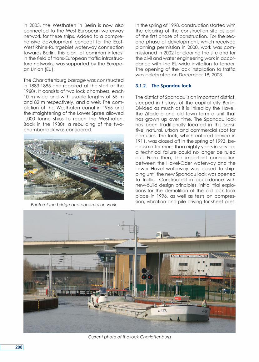
in 2003, the Westhafen in Berlin is now alsoconnectedto theWestEuropeanwaterwaynetworkfortheseships.Addedtoacompre-hensive development concept for the East-WestRhine-RuhrgebietwaterwayconnectiontowardsBerlin, thisplan,ofcommon interestinthefieldoftrans-Europeantrafficinfrastruc-turenetworks,wassupportedbytheEurope-anUnion(EU).
TheCharlottenburgbarragewasconstructedin1883-1885andrepairedatthestartofthe1960s.Itconsistsoftwolockchambers,each10mwideandwithusable lengthsof 65mand82mrespectively,andaweir.Thecom-pletionof theWesthafencanal in 1965andthestraighteningoftheLowerSpreeallowed1,000 tonne ships to reach the Westhafen.Back in the 1930s, a rebuilding of the two-chamberlockwasconsidered.
Photo of the bridge and construction work
Inthespringof1998,constructionstartedwiththe clearing of the construction site as partofthefirstphaseofconstruction.Forthesec-ondphaseofdevelopment,whichreceivedplanningpermission in 2000,workwascom-missionedin2002forclearingthesiteandforthecivilandwaterengineeringworkinaccor-dancewith theEU-wide invitation to tender.Theopeningof the lock installationtotrafficwascelebratedonDecember18,2003.
3.1.2. The Spandau lock
ThedistrictofSpandauisanimportantdistrict,steeped in history, of the capital city Berlin.Dividedasmuchas it is linkedbytheHavel,the Zitadelle and old town form a unit thathas grown up over time. The Spandau lockhas been traditionally located in this sensi-tive,natural,urbanandcommercialspotforcenturies.The lock,whichenteredservice in1911,wasclosedoffinthespringof1993,be-causeaftermorethaneightyyearsinservice,a technical failurecouldno longerbe ruledout. From then, the important connectionbetweentheHavel-OderwaterwayandtheLower Havel waterway was closed to ship-pinguntilthenewSpandaulockwasopenedto traffic. Constructed in accordance withnew-builddesignprinciples, initial trialexplo-sions for thedemolitionof theold lock tookplace in 1996, as well as tests on compres-sion,vibrationandpile-drivingforsheetpiles.
Current photo of the lock Charlottenburg
208
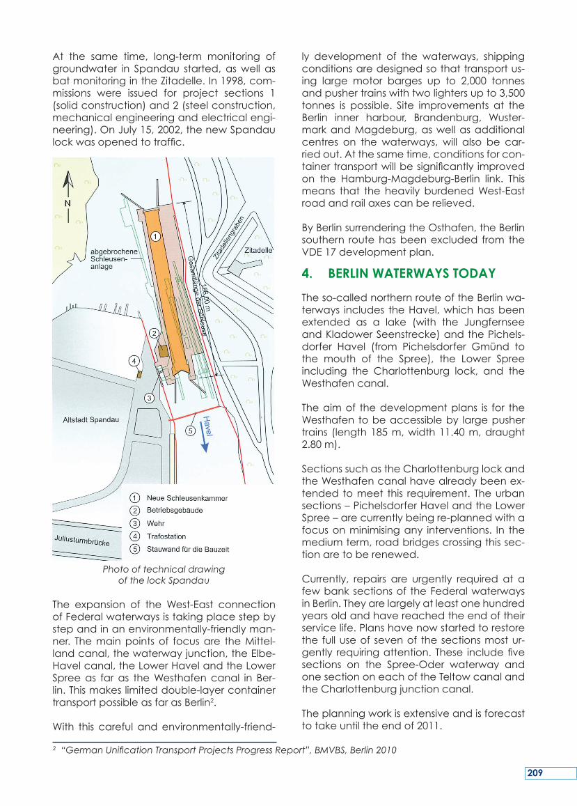
At the same time, long-term monitoring ofgroundwater in Spandau started, aswell asbatmonitoringintheZitadelle.In1998,com-missions were issued for project sections 1(solidconstruction)and2(steelconstruction,mechanicalengineeringandelectricalengi-neering).OnJuly15,2002,thenewSpandaulockwasopenedtotraffic.
Photo of technical drawing of the lock Spandau
The expansion of the West-East connectionofFederalwaterwaysistakingplacestepbystepandinanenvironmentally-friendlyman-ner. Themainpointsof focusare theMittel-landcanal,thewaterwayjunction,theElbe-Havelcanal,theLowerHavelandtheLowerSpreeas faras theWesthafencanal in Ber-lin.Thismakeslimiteddouble-layercontainertransportpossibleasfarasBerlin2.
With this careful andenvironmentally-friend-
ly development of the waterways, shippingconditionsaredesignedsothattransportus-ing large motor barges up to 2,000 tonnesandpushertrainswithtwolightersupto3,500tonnes is possible. Site improvements at theBerlin inner harbour, Brandenburg, Wuster-markandMagdeburg,aswellasadditionalcentres on the waterways, will also be car-riedout.Atthesametime,conditionsforcon-tainertransportwillbesignificantly improvedon the Hamburg-Magdeburg-Berlin link. Thismeans that the heavily burdenedWest-Eastroadandrailaxescanberelieved.
ByBerlinsurrenderingtheOsthafen,theBerlinsouthern routehasbeenexcluded from theVDE17developmentplan.
4. BERLIN WATERWAYS TODAY
Theso-callednorthernrouteoftheBerlinwa-terways includes theHavel,whichhasbeenextended as a lake (with the JungfernseeandKladowerSeenstrecke)andthePichels-dorfer Havel (from Pichelsdorfer Gmünd tothe mouth of the Spree), the Lower Spreeincluding the Charlottenburg lock, and theWesthafencanal.
Theaimof thedevelopmentplans is for theWesthafentobeaccessibleby largepushertrains (length185m,width11.40m,draught2.80m).
SectionssuchastheCharlottenburglockandtheWesthafencanalhavealreadybeenex-tended tomeet this requirement. Theurbansections–PichelsdorferHavelandtheLowerSpree–arecurrentlybeingre-plannedwithafocusonminimisingany interventions. In themediumterm,roadbridgescrossingthissec-tionaretoberenewed.
Currently, repairs are urgently required at afewbanksectionsof theFederalwaterwaysinBerlin.Theyarelargelyatleastonehundredyearsoldandhavereachedtheendoftheirservicelife.Planshavenowstartedtorestorethe fulluseof sevenof thesectionsmostur-gently requiringattention.These includefivesections on the Spree-Oder waterway andonesectiononeachoftheTeltowcanalandtheCharlottenburgjunctioncanal.
Theplanningworkisextensiveandisforecasttotakeuntiltheendof2011.
2 “German Unification Transport Projects Progress Report”, BMVBS, Berlin 2010
209
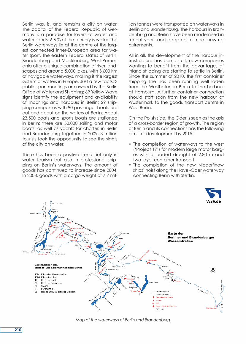
Berlin was, is, and remains a city on water.The capital of the Federal Republic ofGer-many is a paradise for lovers of water andwatersports;6.6%oftheterritoryiswater.TheBerlinwaterwayslieatthecentreofthelarg-est connected inner-Europeanarea forwa-tersport.TheeasternFederalstatesofBerlin,BrandenburgandMecklenburg-WestPomer-aniaofferauniquecombinationofriverland-scapesandaround5,000lakes,with3,600kmofnavigablewaterways,makingitthelargestsystemofwatersinEurope.Justafewfacts:3publicsportmooringsareownedbytheBerlinOfficeofWaterandShipping;69YellowWavesigns identify theequipmentandavailabilityof moorings and harbours in Berlin; 29 ship-pingcompanieswith90passengerboatsareoutandaboutonthewatersofBerlin.About23,500boatsand sportsboatsare stationedin Berlin; there are 50,000 sailing andmotorboats,aswellas yachts forcharter, in BerlinandBrandenburgtogether. In2009,3milliontouriststooktheopportunitytoseethesightsofthecityonwater.
There has been a positive trend not only inwater tourism but also in professional ship-ping on Berlin’s waterways. The amount ofgoodshascontinuedtoincreasesince2004.In2008,goodswithacargoweightof7.7mil-
liontonnesweretransportedonwaterwaysinBerlinandBrandenburg.TheharboursinBran-denburgandBerlinhavebeenmodernisedinrecentyearsandadapted tomeetnew re-quirements.
All inall,thedevelopmentoftheharbourin-frastructure has borne fruit; new companieswanting to benefit from the advantages ofinlandshippingarestartingtosettleinBerlin.Sincethesummerof2010,thefirstcontainershipping line has been running well ladenfrom theWesthafen in Berlin to the harbouratHamburg.Afurthercontainerconnectionshould start soon from the new harbour atWustermarktothegoodstransportcentre inWestBerlin.
OnthePolishside,theOderisseenastheaxisofacross-borderregionofgrowth.TheregionofBerlinanditsconnectionshasthefollowingaimsfordevelopmentby2015:
• Thecompletionofwaterways to thewest(‘Project17’)formodernlargemotorbarg-es with a loaded draught of 2.80 m andtwo-layercontainertransport.
• The completion of the new Niederfinowships’hoistalongtheHavel-OderwaterwayconnectingBerlinwithStettin.
Map of the waterways of Berlin and Brandenburg
210
Withitsmanyrivers,canalsandlakes,theEastGermanwaterwaynetworkoffersgoodcon-ditions for transportandpassengershipping,boat-basedtourismandleisureboating.Someofthewaterways,whichcannotbeusedbycargo ships due to their narrowdimensions,willbespeciallydevelopedforwatertourism.
CargoshippingisavailabletoandfromBer-lin’s waterways,making the city one of themost important intersections in theEastGer-manwaterwaynetwork.
‘Berlinisbuiltfromboats’–thisfamiliarquota-tionisoneveryone’slipsinthiscity.ImportantparametersforthesettlementofBerlinwereasortoffordintheriverandeasily-surmountedhillsonbothbanks.
Initially,twosettlementsweresetup:CöllnonanislandintheSpree,andBerlinontherightbank of the Spree. In the 13th century, theSpreewasdammedupforshipping,butalsoin order for water power. The Hohenzollernalso wanted to expand the shipping routesfromHamburg, via Berlin, to theeasternar-easofPrussiaandasfarasPoland.Theinner-city network ofwaterwayswas designed tomeetthegrowingneedsofthecityofBerlin,butnewlinkswerealsomadetothesurround-ingarea.TherespectiverulerspromotedthecharacterofBerlinasacityonwater;espe-cially bridges of architectural charm haveemblazed the city since centuries. The rela-tionshipbetweenwaterandnaturewasalso
particularlyimportantintheplanningandde-signofthewaterways.Acommoninterestinwatertourismgrewupatthebeginningofthe19thcentury.Thisproducednotonlythede-finingimageoftheBerlinwaterways:today’sWeiβeFlotte(WhiteFleet)butkilometreslongfootpathsonmanybanksareaninvitationtostrollorhike.
Fromahistoricalpointofview,thewaterwayssurrounding Berlin were and always will besmart logistic networks connecting differenttypesoftransport,inharmonywiththenatureandofsupra-regionalsignificance.Thecapi-talof the FederalRepublicofGermany isaparadise forwater touristsandwater sports;6.6%of the territory iswater. The Berlinwa-terwaysarelocatedintheheartofthelarg-estconnectedinner-Europeanareaforwatersport.
Berlinwas,is,andremainsacityonwater.
SUMMARY
211
‘Berlin s’estconstruitàpartirdesbateaux’ –cettecitationfamilièreestsurtoutesleslèvresdans cette ville. Des paramètres importantspourl’implantationdeBerlinétaientunesortedeguédanslarivièreetdescollinesfacilesàsurmontersurlesdeuxrives.
Initialement,deux implantationsontétéfon-dées:CöllndansuneîledanslaSpreeetBer-lin sur la rive droite de la Spree. Au 13èmesiècle,laSpreeaétéendiguéepourlanavi-gationetpourl’énergiehydraulique.LesHo-henzollernontaussivouluétendre les routesdenavigationdeHambourg, viaBerlin,auxsecteurs orientauxde la Prusse jusqu’en Po-logne.Leréseauinternedevoiesnavigablesaétéconçupourrépondreauxbesoinscrois-santsde lavilledeBerlin,maisdenouvellesliaisonsontétéaussiréaliséespourcommuni-queraveclesenvirons.Lesdirigeantsrespec-tifsdeBerlinontpromusoncaractèredevillesurl’eau;enparticulierdespontsdecharmearchitectural ont embelli la ville depuis dessiècles. La relation entre l’eau et la natureétaitaussiparticulièrement importantedans
la planification et la conception des voiesnavigables.Un intérêt répandupour le tour-ismenautiqueagrandiaudébutdu19èmesiècle.Celaaproduitnonseulementl’imagemarquante des voies navigables de Berlin,l’actuelleWeiße Flotte (flotte blanche)maisaussideskilomètresdesentierssurlesbergesquiinvitentàlapromenade.
D’unpointde vuehistorique, les voies navi-gables délimitant Berlin, étaient et seronttoujours des réseaux pour une logistique in-telligenteconnectant les typesdifférentsdetransport,dansl’harmonieaveclanatureetde signification supra-régionale. La capitalede la République fédérale d’Allemagne estunparadispour lestouristesattiréspar l’eauetlessportsnautiques;6.6%duterritoirecou-vertsparl’eau.LesvoiesnavigablesdeBerlinsontlocaliséesaucœurduplusgrandsecteurintérieur connecté en Europe pour le sportd’eau.
Berlinétait,estetresteunevillesurl’eau.
RESUME
‚Berlin wurde aus dem Kahn gebaut‘, dies-es geflügelte Zitat ist für diese Stadt in allerMunde.EineArtFurt imFlussundaufbeidenUfern bequem zu bewältigende AnhöhenwarenwesentlicheParameterfürdieBesied-lungBerlins.
ZunächstentstandenzweiSiedlungen.Im13.Jahrhundert stautemanfürdenSchiffstrans-port aber auch zurNutzungderWasserkraftdie Spreeauf.DieHohenzollern, hattendasZiel, mit dem Ausbau der SchifffahrtswegevonHamburgüberBerlindieöstlichenGebi-ete Preußensbis nach Polen zu erschließen.DasinnerstädtischeWasserstraßennetzwurdeandieBedürfnissederStadtBerlinausgelegtundauch imUmfeldentstandenneueRela-tionen.DiejeweiligenLandesherrenfördertenden Charakter Berlins als Stadt am Wasser,insbesonderearchitektonisch reizvolle Brück-enbauten schmücken seit einigen Jahrhun-dertendieStadt.ZusätzlichspieltedieBezie-hungdesWassers zurNatur einebesondere
Rolle bei der Planung und Gestaltung derWasserstraßen.Anfangdes 19. Jahrhundertswuchs zunehmend das Interesse am Was-sertourismus. Daraus entstand nicht nur dasfür die BerlinerWasserstraßenprägende BildderheutigenWeißenFlotte, zusätzlich ladenan vielen Ufern kilometerlange Wege zumSpazierengehenein.
AuseinemhistorischenBlickwinkelherauswar-enundwerdendieWasserstraßeninundumBerlin für intelligente logistische Verknüpfun-gender Transportwege und im EinklangmitderNatur,wichtigundvonüberregionalerBe-deutungbleiben!DieHauptstadtderBundes-republikisteinParadiesfürWassersportlerundWasserbegeisterte, schließlich macht dasWasser6,6%desTerritoriumsaus.DieBerlinerWasserwege liegen im Zentrumdes größtenzusammenhängendeneuropäischenBinnen-reviersfürWassersport.Berlinwar,istundbleibteineWasserstadt.
ZUSAMMENFASSUNG
212
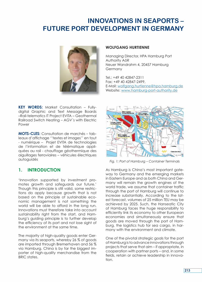
KEY WORDS: Market Consultation – Fully-digital Graphic and Text Message Boards–Rail-telematicsITProjectEVITA–GeothermalRailroadSwitchHeating–AGV´swithElectricPower
MOTS-CLES:Consultationdemarchés–tab-leauxd’affichage‘’textesetimages’’entout- numérique– Projet EVITAde technologiesde l’information et de télématique appli-quéesaurail-chauffagegéothermiquedesaiguillagesferroviaires–véhiculesélectriquesautoguidés
1. INTRODUCTION
‘Innovation supported by investment pro-motes growth and safeguards our future.’Thoughthisprincipleisstillvalid,somerestric-tions do apply because growth that is notbased on the principle of sustainable eco-nomic management is not something theworldwill beable to afford in the long run.Innovationsmustthereforetakeintoaccountsustainability right from the start, and Ham-burg’sguidingprinciple is to furtherdeveloptheefficiencyofitsportandnotlosesightoftheenvironmentatthesametime.
Themajorityofhigh-qualitygoodsenterGer-manyviaitsseaports,whereby26%ofgoodsareimportedthroughBremerhavenand56%viaHamburg.Chinaisbyfarthebiggest im-porter of high-qualitymerchandise from theBRICstates.
Fig. 1: Port of Hamburg – Container Terminals
AsHamburgisChina’smost importantgate-waytoGermanyandtheemergingmarketsinEasternEuropeandasbothChinaandGer-manywill remain thegrowthenginesof theworldtrade,weassumethatcontainertrafficthroughtheportofHamburgwillcontinuetoincrease substantially. According to the lat-estforecast,volumesof25millionTEUmaybeachievedby2025. Such, theHanseaticCityofHamburg faces thehuge responsibility toefficientlylinkitseconomytootherEuropeaneconomies and simultaneously ensure thatgoodsaremovedthroughtheportofHam-burg, the logisticshub for seacargo, inhar-monywiththeenvironmentandclimate.
OneofthepivotalstrategicgoalsfortheportofHamburgistoadvanceinnovationsthroughprojectsthatservethataim–ifappropriate,incooperationwithpartnerports–and,insomefields,retainorachieveleadershipininnova-tion.
INNovAtIoNS IN SEAPortS – fUtUrE Port dEvELoPMENt IN gErMANY
WOLFGANG HURTIENNE
ManagingDirector,HPAHamburgPortAuthorityAöRNeuerWandrahm4,20457HamburgGermany
Tel.:+494042847-2311Fax:+494042847-2499,E-Mail:[email protected]:www.hamburg-port-authority.de
213
2. MEASURES THAT DIRECTLY BENEFIT THE ENVIRONMENT AND CLIMATE PROTECTION
Ports are continuously forced to optimisetheir technical, organisational and logisticalpotential which may entail interventions inand disadvantages to the environment: riv-ersarechangedtoimprovefloodprotectionor deepen shippingchannels; theair is pol-luted by the emissions of ocean-going ves-sels.Tocombattheimpactofenvironmentaldegradation,Hamburghas initiatedasetofimprovementmeasuressuchas,forexample,an environmental discount granted on portdues,whichistopromotethedeploymentofenvironmentally friendly ships. Themeasuresoutlined inthetidalElbeconceptaimat re-storing close-to-nature hydrological condi-tionsand sustainably reduce sedimentation.Theconceptisbasedonthreecornerstones:
1.)Implementation of a holistic sedimentmanagement;
2.)Mitigation of the incoming tidal energythroughriver-engineeringmeasuresinthearea of the mouth of the Elbe estuary;and
3.)Creation of tidal flood plains betweenGlückstadtandGeesthachttoreducethetidalcurveintheareaofHamburg.
Thelatterincludesthe(re-)connectionofsidechannels,secondarychannelsandotherwa-terbodies,theclearingofareaswheresedi-mentsdepositedand Elbe sidechannels aswell as the re-alignment (setting back) ofdykes innon-inhabited lower-lyingareasac-companiedbythecreationofshallow-waterzones. Furthermore, the elimination of pol-lution in the middle and upper Elbe, whichHamburg takes an active role in, has beenassigned high priority. Sediments in the portareathatcannotberelocatedwithintheriversystemareprocessedindewateringfieldsoratMETHA,afacilitytomechanicallytreatanddewater harbour sediments. The sedimentsare then disposed of at special silt disposalsites. This time-consuming and costly treat-mentandthedisposalonlandlowertheloadofpollutantsbroughtintotheElbe,andcon-sequently into the North Sea, from the Elbecatchmentareabyabout30%to50%.
3. RESOURCE-FRIENDLY LAND DEVELOPMENT MANAGEMENT
InorderfortheportofHamburgtoretain itsplace in the premier league of the world’smajorportsandtomeettherisingdemandsoftheglobalmaritimeindustry,itisconstant-ly adjustedandmodernised.Oneof the in-dispensable prerequisites for achieving theabovegoalistohaveanadequateportfolioofavailableland.TheHamburgPortAuthority’s(HPA)landdevelopmentstrategyisbasedonfourprinciples:Highlyefficient,fullutilisationofexistingareasusedforport-relatedoperationsthroughtechnicalandorganisationalinnova-tionsandprocesses.TheHPAsupportsthisprin-ciplebycarefullyexpandinginfrastructurefa-cilitiesandbyincludingperformancetermsinrentandleaseagreements.Shouldadditionallandberequired,thepolicyistocreateandprovide new competitive land for develop-ment through intelligent restructuring withinexistingportboundaries.Ifmeasuresbeyondtheabovearenecessary,inorderfortheportof Hamburg tomaintain its leading positionamongthecompetingEuropeanports,asalast resort and in the interest of growthandemployment, the land in theportexpansionzoneswillhavetobeactivated.
4. MARKET CONSULTATION PROCESS – STEINWERDER
The future Central Terminal Steinwerder, lo-cated right in theheartof theportofHam-burg,comprisesoneofthelastlargerpiecesoflandwithintheareaoftheport,whichwillbe available soon for the development ofnewlydefinedparcels.Thedismantlingofoldwharffacilitiesandfillingofharbourbasinswillcreatea125halargesiteand,onthewater-side,aturningcircleforgiantcontainershipsofthenewgeneration.
In order to prepare the restructuring of thisvital sitetheHPA, for thefirst timeever,con-ductedaglobalmarketconsultationprocessintheformofacontesttogatherideas.Thisdirectandinnovativeapproachofpotentialoperators,investorsandconsultanciesaswellas the communication of the project to awidecircleofinterestedpartieswasnewterri-torytotheHPA.Criteriatoconsiderinthepro-posalswere,amongothers,limitedCO2-emis-sions,highland-useandeconomicefficiencyaswellassustainabletransportconceptsanddesignideaswiththeenvironmentinmind.
214
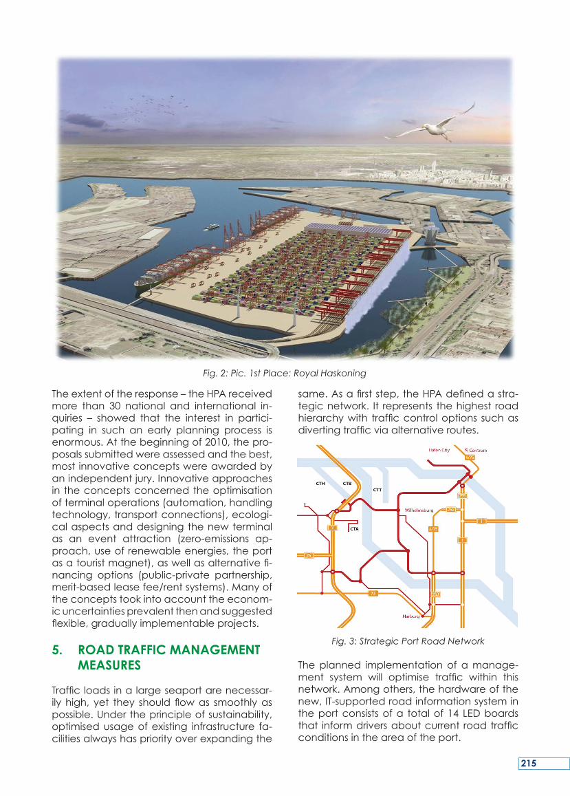
Theextentoftheresponse–theHPAreceivedmore than 30 national and international in-quiries – showed that the interest in partici-pating in such an early planning process isenormous.Atthebeginningof2010,thepro-posalssubmittedwereassessedandthebest,mostinnovativeconceptswereawardedbyanindependentjury.Innovativeapproachesin theconceptsconcernedtheoptimisationofterminaloperations(automation,handlingtechnology,transportconnections),ecologi-calaspectsanddesigningthenewterminalas an event attraction (zero-emissions ap-proach,useofrenewableenergies,theportasatouristmagnet),aswellasalternativefi-nancing options (public-private partnership,merit-basedleasefee/rentsystems).Manyoftheconceptstookintoaccounttheeconom-icuncertaintiesprevalentthenandsuggestedflexible,graduallyimplementableprojects.
5. ROAD TRAFFIC MANAGEMENT MEASURES
Trafficloadsinalargeseaportarenecessar-ily high, yet they should flowas smoothlyaspossible.Undertheprincipleofsustainability,optimisedusageofexisting infrastructure fa-cilitiesalwayshaspriorityoverexpandingthe
same.Asafirststep,theHPAdefinedastra-tegicnetwork. It represents thehighest roadhierarchywith trafficcontroloptions suchasdivertingtrafficviaalternativeroutes.
Fig. 3: Strategic Port Road Network
Theplanned implementationof amanage-ment system will optimise traffic within thisnetwork.Amongothers,thehardwareofthenew,IT-supportedroadinformationsystemintheportconsistsofa totalof14 LEDboardsthat informdriversaboutcurrent roadtrafficconditionsintheareaoftheport.
Fig. 2: Pic. 1st Place: Royal Haskoning
215
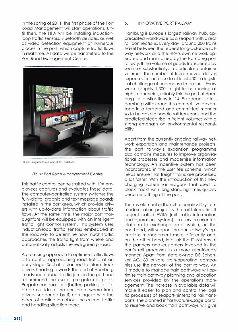
Inthespringof2011,thefirstphaseofthePortRoadManagementwill startoperations.Un-til then, the HPA will be installing induction-looptrafficsensors,Bluetoothdevices,aswellas videodetectionequipmentat numerousplacesintheport,whichcapturetrafficflowsinrealtime.AlldatawillbetransmittedtothePortRoadManagementCentre.
Fig. 4: Port Road Management Centre
ThistrafficcontrolcentrestaffedwithHPAem-ployeescapturesandevaluatesthesedata.Thecomputer-controlledsystemswitchesthefully-digitalgraphicandtextmessageboardsinstalledintheportarea,whichprovidedriv-erswithup-to-date informationabout trafficflows.Atthesametime,themajorportthor-oughfarewillbeequippedwithanintelligenttraffic light control system. This system usesinduction-loop traffic sensors embedded intheroadwaytodeterminehowmuchtrafficapproachesthetraffic light fromwhereandautomaticallyadjuststhered/greenphases.
Apromisingapproachtooptimisetrafficflowsis to control approaching road trafficat anearlystage.SuchitisplannedtoinformtruckdriversheadingtowardstheportofHamburginadvanceabouttrafficjamsintheportandrecommend the use of pre-gate car parks.Pregatecarparksare(buffer)parkinglotslo-catedoutsideof theportarea,where truckdrivers, supportedby IT,can inquirewith theplaceofdestinationaboutthecurrenttrafficandhandlingsituationthere.
6. INNOVATIVEPORTRAILWAY
HamburgisEurope’slargestrailwayhub,ap-preciatedworld-wideasaseaportwithdirectrailconnections.Everyday,around200trainstravelbetweenthefederallong-distancerail-waynetworkandtheHPA’sownnetworkop-eratedandmaintainedbytheHamburgportrailway.Ifthevolumeofgoodstransportedbysea rises substantially, inparticularcontainervolumes,thenumberoftrainsmoveddailyisexpectedtoincreasetoatleast400–alogisti-calchallengeofenormousdimensions.Everyweek, roughly1,300 freight trains, runningathighfrequencies,reliablylinktheportofHam-burg to destinations in 14 European states.Hamburgwillexpandthiscompetitiveadvan-tage ina targetedandcommittedmannersotobeabletohandlerailtransportsandthepredictedsteepriseinfreightvolumeswithastrong emphasis on environmental responsi-bility.
Apartfromthecurrentlyongoingrailwaynet-work expansion andmaintenance projects,the port railway’s expansion programmealsocontainsmeasurestoimproveorganisa-tional processes andmodernise informationtechnology. An incentive system has beenincorporated in theuser fee scheme,whichhelpsensurethatfreighttrainsareprocesseda lotfaster.Withthe introductionofthisnewcharging system rail wagons that used toblocktrackswithlongstandingtimesquicklybecameathingofthepast.
Thekeyelementoftherail-telematicsITsystemmodernisationproject is therail-telematics ITproject called EVITA (rail traffic informationandoperations system) –a service-orientedplatform to exchange data, which, on theonehand,will supporttheport railway’sop-erationsmanagementmore efficiently and,on theotherhand, interlink the IT systemsofthe partners and customers involved in theport’s rail processes in a more user-friendlymanner.Apart from state-ownedDB Schen-ker AG, 80 private train-operating compa-niesuse thenetworkof theport railway.AnITmoduletomanagetrainpathwayswillop-timisetrainpathwayplanningandallocationservices provided by the operations man-agement.Theincreaseinavailabledatawillmake it easier toplanandcontrol the logisticprocessesof seaport-hinterland rail trans-ports.Theplannedinfrastructure-usageportaltoreserveandbooktrainpathwayswillgive
216
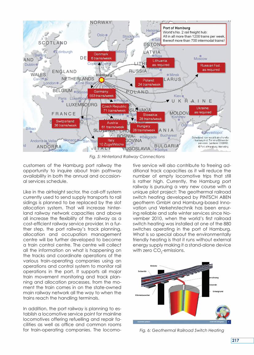
customers of the Hamburg port railway theopportunity to inquire about train pathwayavailabilityinboththeannualandoccasion-alservicesschedule.
Likeintheairfreightsector,thecall-offsystemcurrentlyusedtosendsupplytransportstorailsidingsisplannedtobereplacedbytheslotallocation system. That will increase hinter-land railwaynetworkcapacitiesandaboveall increase the flexibilityof the railwayasacost-efficientrailwayserviceprovider.Inafur-ther step, the port railway’s track planning,allocation and occupation managementcentrewillbefurtherdevelopedtobecomeatraincontrolcentre.Thecentrewillcollectall the informationonwhat ishappeningonthetracksandcoordinateoperationsof thevarious train-operating companies using anoperationsandcontrolsystemtomonitorrailoperations in the port. It supports all majortrainmovementmonitoring and track plan-ningandallocationprocesses,fromthemo-mentthetraincomesinonthestate-ownedmainrailwaynetworkallthewaytowhenthetrainsreachthehandlingterminals.
Inaddition,theportrailwayisplanningtoes-tablishalocomotiveservicepointformainlinelocomotivesofferingrefuellingandrepairfa-cilitiesaswellasofficeandcommon roomsfor train-operating companies. The locomo-
tiveservicewillalsocontributetofreeingad-ditionaltrackcapacitiesas itwill reducethenumber of empty locomotive trips that stillis rather high. Currently, the Hamburg portrailway ispursuingaverynewcoursewithauniquepilotproject:ThegeothermalrailroadswitchheatingdevelopedbyPINTSCHABENgeothermGmbHandHamburg-basedInno-vation undVerkehrstechnik has been ensur-ingreliableandsafewinterservicessinceNo-vember 2010,when theworld’s first railroadswitchheatingwasinstalledatoneofthe880switches operating in the port of Hamburg.Whatissospecialabouttheenvironmentallyfriendlyheatingisthatitrunswithoutexternalenergysupplymakingitastand-alonedevicewithzeroCO2-emissions.
Fig. 6: Geothermal Railroad Switch Heating
Fig. 5: Hinterland Railway Connections
217
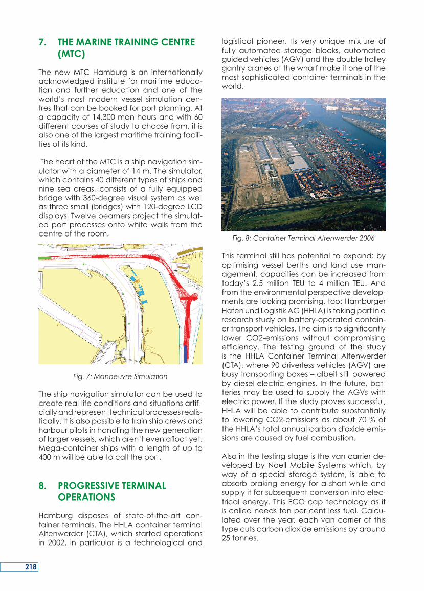
7. THE MARINE TRAINING CENTRE (MTC)
The newMTCHamburg is an internationallyacknowledged institute formaritimeeduca-tion and further education and one of theworld’s most modern vessel simulation cen-tresthatcanbebookedforportplanning.Atacapacityof14,300manhoursandwith60differentcoursesofstudytochoosefrom,itisalsooneofthelargestmaritimetrainingfacili-tiesofitskind.
TheheartoftheMTCisashipnavigationsim-ulatorwithadiameterof14m.Thesimulator,whichcontains40differenttypesofshipsandnine sea areas, consists of a fully equippedbridgewith360-degreevisual systemaswellasthreesmall(bridges)with120-degreeLCDdisplays.Twelvebeamersprojectthesimulat-edportprocessesontowhitewalls from thecentreoftheroom.
Fig. 7: Manoeuvre Simulation
Theshipnavigationsimulatorcanbeusedtocreatereal-lifeconditionsandsituationsartifi-ciallyandrepresenttechnicalprocessesrealis-tically.Itisalsopossibletotrainshipcrewsandharbourpilotsinhandlingthenewgenerationoflargervessels,whicharen’tevenafloatyet.Mega-containershipswitha lengthofupto400mwillbeabletocalltheport.
8. PROGRESSIVE TERMINAL OPERATIONS
Hamburg disposes of state-of-the-art con-tainerterminals.TheHHLAcontainerterminalAltenwerder (CTA),which startedoperationsin 2002, in particular is a technological and
logistical pioneer. Its very unique mixture offully automated storage blocks, automatedguidedvehicles(AGV)andthedoubletrolleygantrycranesatthewharfmakeitoneofthemostsophisticatedcontainerterminalsintheworld.
Fig. 8: Container Terminal Altenwerder 2006
This terminalstillhaspotential toexpand:byoptimising vessel berths and land useman-agement,capacitiescanbeincreasedfromtoday’s 2.5 million TEU to 4million TEU. Andfromtheenvironmentalperspectivedevelop-mentsarelookingpromising,too:HamburgerHafenundLogistikAG(HHLA)istakingpartinaresearchstudyonbattery-operatedcontain-ertransportvehicles.Theaimistosignificantlylower CO2-emissions without compromisingefficiency. The testing ground of the studyis the HHLA Container Terminal Altenwerder(CTA),where90driverlessvehicles(AGV)arebusytransportingboxes–albeitstillpoweredbydiesel-electricengines. In thefuture,bat-teriesmaybeused to supply theAGVswithelectricpower.Ifthestudyprovessuccessful,HHLAwillbeable tocontribute substantiallyto loweringCO2-emissionsasabout70%oftheHHLA’stotalannualcarbondioxideemis-sionsarecausedbyfuelcombustion.
Alsointhetestingstageisthevancarrierde-veloped by NoellMobile Systemswhich, byway of a special storage system, is able toabsorbbrakingenergy forashortwhileandsupplyitforsubsequentconversionintoelec-tricalenergy. ThisECOcap technologyas itiscalledneedstenpercentlessfuel.Calcu-latedover theyear,eachvancarrierof thistypecutscarbondioxideemissionsbyaround25tonnes.
218
Within the scope of the ‘Multiple-Load Proj-ect’, process control at the terminal hasbeenfurtheroptimised.TherevisedsoftwaredoubledutilisationratesoftheAGVpertrans-porttrip.Uptonow,theAGVcouldloadone20-footcontainerfromtheblockstore;todaythe AGV automatically heads for two posi-tionsandtransportstwoTEUatonegototheship. Theannual reduction inCO2-emissionsamountstoabout600tonnes.
EUROGATE GmbH operates Hamburg’s sec-ond-largest container terminal. Though theemptycontainerdepotislocatedjust200maway,itisseparatedfromtheoverseastermi-nalby rail tracks.Special tractorunits (multi-trailers) must be deployed to ferry emptyboxesonaroughlythree-kilometrelongstreetleadingaroundtherailyard.Tocrossthetracksdirectly,aheightofabout14mneedstobesurpassedona transport routecovering just200m.Underthesecircumstances,buildingabridgewasnot feasible, not tomention theadditionalcosts.Thatgaverisetotheideaofinstallingacablecar.TheBremen-basedInsti-tutfürProduktionundLogistik(BIBA)conduct-eda feasibility studyusingamodel to simu-latetheconceptandprocesses.Theprojectisviablefromthetechnicalandeconomicalpoint of view. Van carriers or reach stack-ers lowerthecontainerontoakindofchainconveyor,whichtakesittothecablecarandplaces it onto a platform there. Containersareunloadedthesameway,inreverseorder.Inabufferzone, thedifferentcycletimesofthe terminalvehiclesandthecablecararebalanced.Thesystem isdesignedtohandleupto60containersperhourandrunsfullyau-tomatically.
9. THE VIRTUALISATION PROJECT
TheHPAoperatesacomputercentrethat isinchargeofanarrayofhighlycomplexinfra-structurefacilitiessuchas,e.g.theportrailwayortheport’sradarsystem.Thecentreconsistsof about 90 physical servers, a huge tapedrive(streamer),alargestorageunitandnu-merousnetworkcomponents.Themajorityofthe servers (about 80%)areplanned tobevirtualisedby scalable,virtualBasic Technol-ogytotakeoverserverandstoragecapaci-ties.Inaddition,energy-savingstoragemediawillbemadeavailable.Themodernisationofthecomputercentre isa sustainable invest-mentsotobeabletomeetthegrowingen-ergydemandsofITservices.Serverutilisation
ratescurrentlystandatamaximumof20%.An intelligentmanagement systemwill raisethatfiguretoabout85%.Byincreasingutilisa-tionratesandconsequentlyreducingclimatecontrolneeds, theamountofenergy savedwillbesignificant.
10. MARITIME SCIENTIFIC & RESEARCH FACILITIES IN HAMBURG
Hamburgishometoamultitudeofmaritimeresearchinstitutions.Someofthemarelistedbelow:
-> Zentrum für Marine und AtmosphärischeWissenschaften (ZMAW); (Centre for Ma-rineandAtmosphericSciences)
-> Fraunhofer Center für Maritime Logistikund Dienstleistungen (CML), (Centre forMaritimeLogisticsandServices)
-> HamburgischeSchiffsbau-Versuchsanstalt,(TheHamburgShipModelBasin)
-> Deutsches Klimarechenzentrum (DKRZ),(TheGermanHighPerformanceComput-ingCentreforClimate-andEarthSystemResearch)
-> Technische Universität Hamburg-Harburg(TUHH), (Hamburg-Harburg TechnicalUni-versity)
-> MaritimeBusinessSchoolatHSBAHamburgSchoolofBusinessAdministration,
-> Kühne School of Logistics and Manage-mentGmbH
-> BundesamtfürSeeschifffahrtundHydrog-raphie(FederalMaritimeandHydrograph-icalAgency)
In a broader sense, the following institu-tionsalsobelong to thatgroup: the Interna-tional Seegerichtshof (International Tribunalfor the Law of the Sea) and the HamburgWeltwirtschaftsinstitut(HWWI)(Hamburg Insti-tute of International Economics), HSH Nord-bank(theworld’slargestshipfinancingbank)andmajorprivateshipfinancingcompaniesthat dispose of a comprehensive maritime-transportrelateddatabasewhich,combinedwiththeirknow-how,theybaseontoprovideservicesinscientificconsulting.TheyarepartofanalreadystrongmaritimeclusterbasedinHamburgthatwillbeabletoreinforceitspo-sitionasan innovativeengineon theglobalfrontthroughcloserlinkswiththeportofHam-burg.
219
‘Innovation supported by investment pro-motes growth and safeguards our future.’Thoughthisprincipleisstillvalid,somerestric-tions do apply because growth that is notbased on the principle of sustainable eco-nomic management is not something theworldwill beable to afford in the long run.Innovationsmustthereforetakeintoaccountsustainability right from the start, and Ham-burg’sguidingprinciple is to furtherdevelop
theefficiencyofitsportandnotlosesightoftheenvironmentatthesametime.
Themajorityofhigh-qualitygoodsenterGer-manyviaitsseaports,whereby26%ofgoodsareimportedthroughBremerhavenand56%viaHamburg.Chinaisbyfarthebiggest im-porter of high-qualitymerchandise from theBRICstates.
SUMMARY
‘L’innovationportéeparl’investissementnour-ritlacroissanceetpréservenotrefutur.’Siceprincipeestencorevrai,ildoitêtrerelativisécarlacroissancequin’estpasbaséesurleprinc-iped’unegestionéconomiquedurablen’estpasquelquechosequelemondepourrasup-porterà longterme.Les innovationsdoiventparconséquentprendreencompteladura-bilitédèsledépart,etleprincipedirecteurdeHambourg est de développer d’avantage
l’efficiencedesonport sans,dans lemêmetemps,perdredevuel’environnement.
Lamajoritédesmarchandisesàhautevaleurajoutée entre en Allemagne par ses portsmaritimes,26%decesmarchandisessontim-portéesviaBrêmeet56%viaHambourg.LaChineestdeloin leprincipal importateurdemarchandisesàfortevaleurajoutéeparmilespays«BRIC».
RESUME
‘Innovationunterstütztdurch Investition führtzu Wachstum und sichert unsere Zukunft.´DiesesPrinzipistzwarunverändertabernichtmehr uneingeschränkt gültig. Denn einWa-chstum,dasnichtdemGrundsatznachhalti-gen Wirtschaftens folgt, kann sich die Weltauf Dauer nicht mehr leisten. Innovationenmüssen in diesem Sinne von vornherein aufNachhaltigkeit ausgerichtet sein. HamburgsMaximeistdaher,dieLeistungsfähigkeitseinesHafenssoweiterzuentwickeln,dassdieszu-gleichauchumweltverträglichist.HamburgistdasbedeutendstegatewayfürChinanachDeutschlandunddieWachstumsmärkteinOs-teuropa.SowohlChinaalsauchDeutschlandwerden bis auf Weiteres WachstumstreiberdesWelthandelsbleiben.Wir gehen folglichvon einem weiterhin hohen Wachstums-po-
tenzial von Containerverkehren über denHamburger Hafen aus. Ein Potenzial von 25Mio. TEU in 2025 isteineraktuellenPrognosezufolge möglich. Die Hansestadt HamburgträgtdahereinegroßeVerantwortungfürdieleistungsfähigeAnbindungdereuropäischenVolkswirtschaftenundzugleicheinenumwelt-undklimafreundlichenWarenverkehrüberdieLogistikdrehscheibeHamburgerHafen.
Innovationen voranzutreiben, die in Projek-temünden,diediesemZieldienen–woesSinnmacht inKooperationmit Partnerhäfen– und in einigen Bereichen die Innovations-führerschaftzubehauptenbzw.zuerlangen,isteinesderstrategischenZielefürdenHam-burgerHafen.
ZUSAMMENFASSUNG
220


![Guest Host Frameworks of the Anionic Metal Complex [Fe(ox ...sevovlab/articles/JMP_CGD_2012.pdfGuest−Host Frameworks of the Anionic Metal Complex [Fe(ox) 3]3‑ and Cationic Bipyridinium-Based](https://img.pdfslide.us/doc/110x75/5e6041d842557d77132e6b89/guest-host-frameworks-of-the-anionic-metal-complex-feox-sevovlabarticlesjmpcgd2012pdf.jpg)