Embed Size (px)
Citation preview
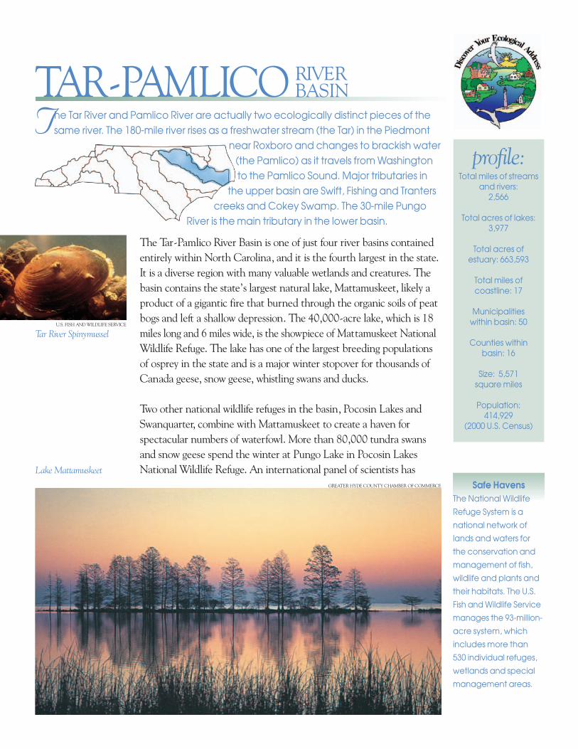
The Tar River and Pamlico River are actually two ecologically distinct pieces of thesame river. The 180-mile river rises as a freshwater stream (the Tar) in the Piedmont
near Roxboro and changes to brackish water(the Pamlico) as it travels from Washingtonto the Pamlico Sound. Major tributaries in
the upper basin are Swift, Fishing and Tranterscreeks and Cokey Swamp. The 30-mile Pungo
River is the main tributary in the lower basin.
profile:Total miles of streams
and rivers: 2,566
Total acres of lakes:3,977
Total acres ofestuary: 663,593
Total miles ofcoastline: 17
Municipalities within basin: 50
Counties withinbasin: 16
Size: 5,571 square miles
Population: 414,929
(2000 U.S. Census)
The Tar-Pamlico River Basin is one of just four river basins containedentirely within North Carolina, and it is the fourth largest in the state.It is a diverse region with many valuable wetlands and creatures. Thebasin contains the state’s largest natural lake, Mattamuskeet, likely aproduct of a gigantic fire that burned through the organic soils of peatbogs and left a shallow depression. The 40,000-acre lake, which is 18miles long and 6 miles wide, is the show piece of Mat tamuskeet NationalWildlife Refuge. The lake has one of the largest breeding popula tionsof osprey in the state and is a major winter stopover for thousands ofCan ada geese, snow geese, whistling swans and ducks.
Two other national wildlife refuges in the basin, Pocosin Lakes andSwanquarter, combine with Mattamuskeet to create a haven forspectacular numbers of waterfowl. More than 80,000 tundra swansand snow geese spend the winter at Pungo Lake in Pocosin LakesNational Wildlife Refuge. An international panel of scientists has
Tar River Spinymussel
Lake Mattamuskeet
GREATER HYDE COUNTY CHAMBER OF COMMERCE
U.S. FISH AND WILDLIFE SERVICE
TAR-PAMLICO RIVERBASIN
Safe HavensThe National Wildlife
Refuge System is a
national network of
lands and waters for
the conservation and
management of fish,
wildlife and plants and
their habitats. The U.S.
Fish and Wildlife Service
manages the 93-million-
acre system, which
includes more than
530 individual refuges,
wetlands and special
management areas.
named Pocosin Lakes among the 50 most significant bird areas in the world. Swanquarter refugecontains extensive coastal marshes and a National Wilderness Area that host large concentra -tions of diving ducks, sea ducks, American black ducks, wading birds and shorebirds. Swan quarterand Juniper bays on the fringes of the refuge are designated by the state as Outstanding ResourceWaters due to excellent water quality and exceptional ecological or recreational significance.
Twelve rare freshwater mussels live in waters of the upper basin. One of these, the federallyendangered Tar River spinymussel, is endemic to this region, which means it has been foundnowhere else on earth. The spiny mussel lives in only five short sections of the Tar River and itstribu taries and one area in the Neuse River Basin. It is one of only three freshwater mussels inthe world with spines. Other federally listed endangered species in the basin include the dwarfwedgemussel, the red-cockaded woodpecker and the West Indian manatee. The state furtherlists as endangered or threatened the American alligator, loggerhead sea turtle, peregrine fal -
con, bald eagle, gull-billed tern and piping plover. The endangered redwolf, which was reintroduced in the Alligator River National WildlifeRefuge in 1987, has expanded its range into the Pocosin Lakes refuge.Besides animal life, the basin is also home to the globally endangeredAtlantic white cedar ecosystem. Several agencies are working togetherto restore an 18,000-acre bog at Pocosin Lakes with these trees, alsoknown as junipers, and bald cypresses.
A gateway to the coast, the Tar-Pamlico River Basin feeds into a highlyproductive estuary that is a nursery for more than 90 percent of all thecommercial seafood species caught in North Carolina. The Albemarleand Pamlico sounds comprise the second largest estuary system in the
MELISSA MCGAW, NCWRC
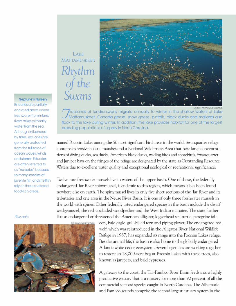
Rhythm of the Swans
Thousands of tundra swans migrate annually to winter in the shallow waters of LakeMattamuskeet. Canada geese, snow geese, pintails, black ducks and mallards also
flock to the lake during winter. In addition, the lake provides habitat for one of the largestbreeding populations of osprey in North Carolina.
U.S. FISH AND WILDLIFE SERVICE
LAKE
MATTAMUSKEET:
Blue crabs
Neptune’s NurseryEstuaries are partially
enclosed areas where
freshwater from inland
rivers mixes with salty
water from the sea.
Although influenced
by tides, estuaries are
generally protected
from the full force of
ocean waves, winds
and storms. Estuaries
are often referred to
as “nurseries” because
so many species of
juvenile fish and shellfish
rely on these sheltered,
food-rich areas.
United States. Blue crabs are an important fix -ture in the local economy. In the past, vast runsof river herring, shad, striped bass and sturgeonalso con tributed to the region’s culture. Theseanadromous fish live in the ocean but swimup freshwater rivers to spawn and breed.
The region is also steeped in a rich traditionof farming. It contains the state’s largesttobacco-producing county (Pitt) and thenumber one producer of corn, wheat andsorghum (Beaufort County).
Unfortunately, the Pamlico River has been plagued with environ mental problems. This regionbegan to attract public con cern in the 1980s. The excessive growth of algae and increasing num -bers of diseased and dying fish began to suggest a decline in water quality. Many municipal treat -ment plants were dis charging wastewater into rivers and streams. Runoff from “nonpoint” sources—such as farmland, timber operations and urban areas—also contributed pollution.
All of these sources increase levels of the nutrients nitrogen and phosphorus in the water shed.These nutrients can be beneficial to aquatic life in small amounts, but large amounts cancontribute to excessive plant growth and low levels of dissolved oxygen in the water. Both of these situations can be harmful to fish and other aquatic life.
In 1989, the state called for measures to reduce nutrient pollution in the watershed. Withpublic and private support, an association of point source dischargers—the Tar-Pamlico BasinAssociation—developed an innovative program to accomplish the reductions. They formed a coalition, and each municipality agreed to do the following: either reduce the nutrient levelsin the wastewater discharged by its treatment plant or offset its share of pollution by investingin farming practices that reduce nutrient runoff in the basin by an equal or greater amount.This “nutrient trading” system, the only one of its kind in North Carolina, was one of the firstsuch systems in the country.
Now new rules for reducing nutrient runoff are being imple -mented in the basin. One impor tant rule requires that exist -ing strips of trees and other plants along the edges of water -ways be protected. In these buffer areas, the roots of plantsprevent soil from eroding, and they help to filter out nutrients.Other rules provide guidelines for applying fertilizer and man -aging storm water. For more information, visit the followingWeb site: http://h2o.enr.state.nc.us/nps/tarpam.htm.
Many communities and organizations are working to preserveand protect land and water quality in the basin. For moreinformation, see the contacts on the back page.
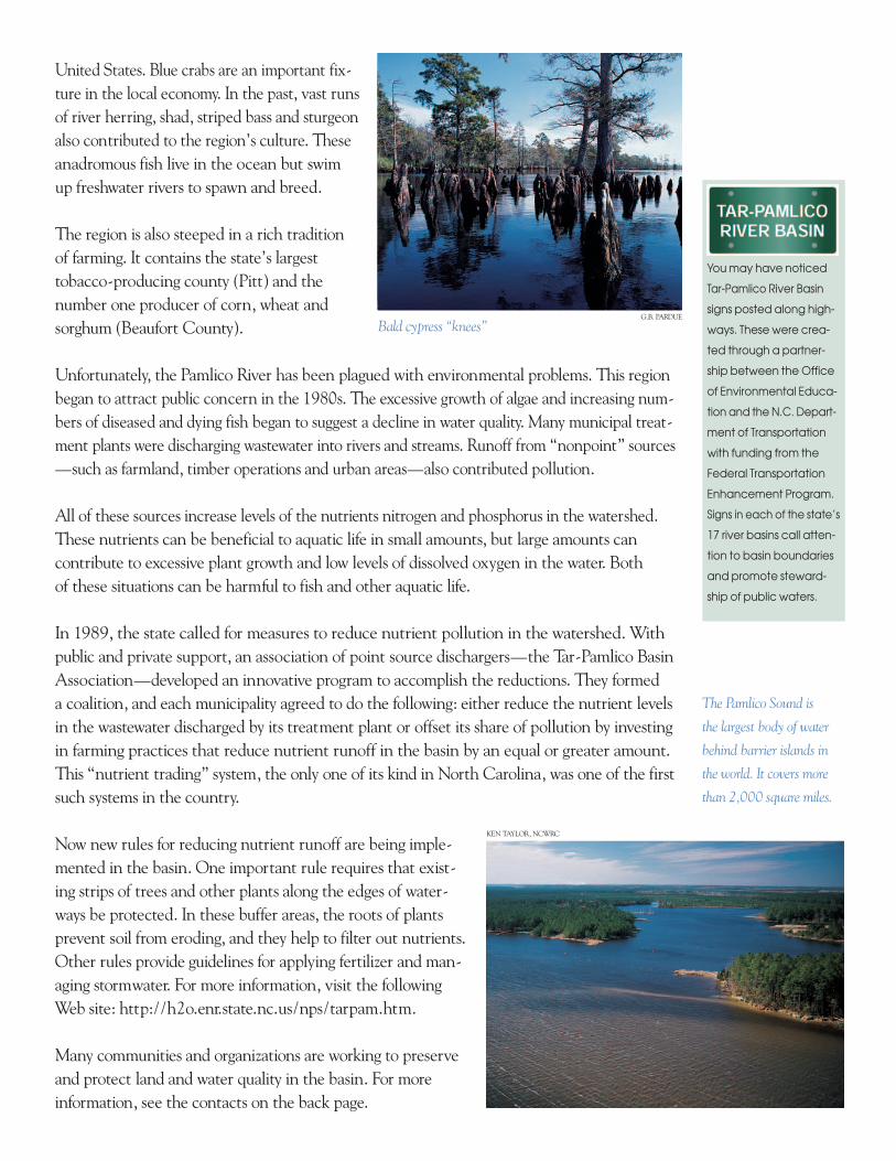
Bald cypress “knees”
You may have noticed
Tar-Pamlico River Basin
signs posted along high -
ways. These were crea -
ted through a partner-
ship between the Office
of Environ mental Edu ca -
tion and the N.C. Depart -
ment of Transportation
with funding from the
Fed eral Transportation
Enhancement Pro gram.
Signs in each of the state’s
17 river basins call atten -
tion to basin boundaries
and promote steward -
ship of public waters.
G.B. PARDUE
The Pamlico Sound is
the largest body of water
behind barrier islands in
the world. It covers more
than 2,000 square miles.
KEN TAYLOR, NCWRC
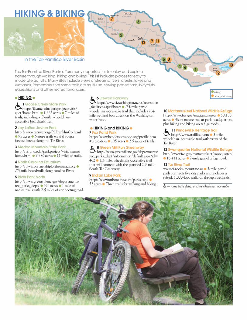
HIKING & BIKING
in the Tar-Pamlico River Basin
The Tar-Pamlico River Basin offers many opportunities to enjoy and explore nature through walking, hiking and biking. This list includes places for easy to moderate activity. Many sites include views of streams, rivers, creeks, lakes andwetlands. Remember that some trails are multi-use, serving pedestrians, bicyclists,equestrians and other recreational users.
�= some trails designated as wheelchair accessible
Henderson
RockyMount
Tarboro
Greenville
Oxford
Louisburg
Nashville
Warrenton
Washington
SwanQuarter
Pungo Lake
LakeMattamuskeet
Ta
r
Ri ve r
Intracoastal
Waterway
Pam l i co R i ve r
Gum Swamp
GRANVILLE VANCE
FRANKLIN
PITT
EDGECOMBE
NASH
WARREN
HALIFAX
MARTIN
BEAUFORT
WASHINGTON
D
HYDE
WILSON
�6 Stewart Parkwayhttp://www.ci.washington.nc.us/recreation
_facilities.aspx#boats ● .75-mile paved,wheel chair-accessible trail that includes a .4-mile wetland boardwalk on the Washingtonwaterfront.
● HIKING and BIKING ●
7 Fox Pond Parkhttp://www.hendersonvance.org/profile.htm#recreation ● 105 acres ● 2.5 miles of trails.
�8 Green Mill Run Greenwayhttp://www.greenvillenc.gov/departments/
rec_parks_dept/information/default.aspx?id=462 ● 1.3-mile, wheelchair-accessible trailthat will connect with the planned 2.9-mileSouth Tar Greenway.
9 Indian Lake Parkhttp://www.tarboro-nc.com/parks.aspx ●
52 acres ● Three trails for walking and biking.
● HIKING ●
�1 Goose Creek State Parkhttp://ils.unc.edu/parkproject/visit/
gocr/home.html ● 1,665 acres ● 7 miles oftrails, including a .7-mile, wheelchair-accessible boardwalk trail.
2 Joy LaRue Joyner Parkhttp://www.tarriver.org/PLFranklinCo.html● 95 acres ● Nature trails wind throughforested areas along the Tar River.
3 Medoc Mountain State Parkhttp://ils.unc.edu/parkproject/visit/memo/home.html ● 2,380 acres ● 11 miles of trails.
4 North Carolina Estuariumhttp://www.partnershipforthesounds.org ●
.75-mile boardwalk along Pamlico River.
5 River Park Northhttp://www.greenvillenc.gov/departments/rec_parks_dept/ ● 324 acres ● 1 mile ofnature trails with 2.5 miles of connecting road.
10 Mattamuskeet National Wildlife Refugehttp://www.fws.gov/mattamuskeet/ ● 50,180acres ● Short nature trail at park headquarters,plus hiking and biking on refuge roads.
�11 Princeville Heritage Trailhttp://www.traillink.com ● 3-mile,
wheel chair-accessible trail with views of theTar River.
12 Swanquarter National Wildlife Refugehttp://www.fws.gov/mattamuskeet/swanquarter/● 16,411 acres ● 2-mile gravel refuge road.
13 Tar River Trailwww.ci.rocky-mount.nc.us ● 3-mile pavedpath connects five city parks and includes araised, 1,000-foot walkway through wetlands.
● hiking
● hiking and biking
10
9
8
7
6
11
12
13
5
4
3
2
1
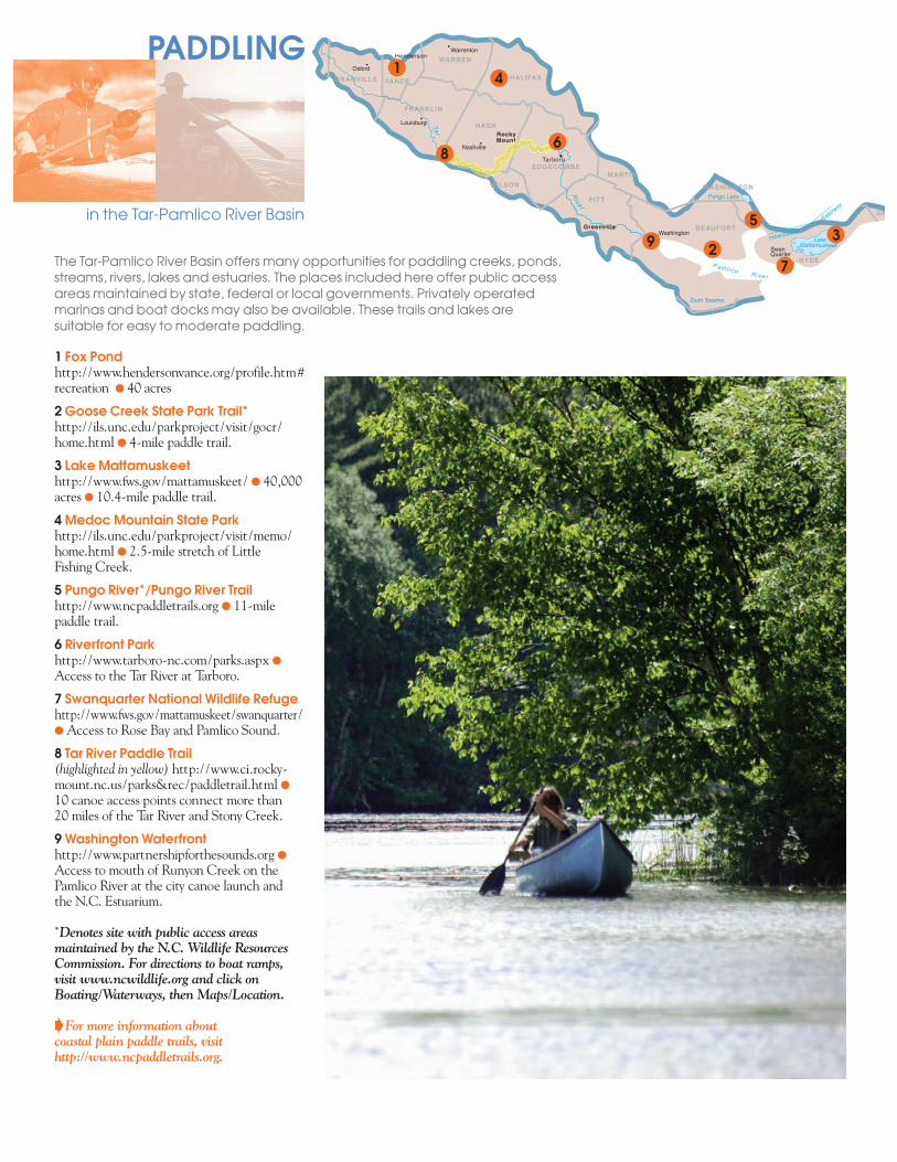
1 Fox Pondhttp://www.hendersonvance.org/profile.htm#recreation ● 40 acres
2 Goose Creek State Park Trail*http://ils.unc.edu/parkproject/visit/gocr/home.html ● 4-mile paddle trail.
3 Lake Mattamuskeethttp://www.fws.gov/mattamuskeet/ ● 40,000acres ● 10.4-mile paddle trail.
4 Medoc Mountain State Parkhttp://ils.unc.edu/parkproject/visit/memo/home.html ● 2.5-mile stretch of Little Fishing Creek.
5 Pungo River*/Pungo River Trail http://www.ncpaddletrails.org ● 11-milepaddle trail.
6 Riverfront Parkhttp://www.tarboro-nc.com/parks.aspx ●
Access to the Tar River at Tarboro.
7 Swanquarter National Wildlife Refugehttp://www.fws.gov/mattamuskeet/swanquarter/● Access to Rose Bay and Pamlico Sound.
8 Tar River Paddle Trail(highlighted in yellow) http://www.ci.rocky-mount.nc.us/parks&rec/paddletrail.html ●
10 canoe access points connect more than 20 miles of the Tar River and Stony Creek.
9 Washington Waterfronthttp://www.partnershipforthesounds.org ●
Access to mouth of Runyon Creek on thePamlico River at the city canoe launch and the N.C. Estuarium.
*Denotes site with public access areasmaintained by the N.C. Wildlife ResourcesCommission. For directions to boat ramps,visit www.ncwildlife.org and click onBoating/Waterways, then Maps/Location.
BFor more information about coastal plain paddle trails, visithttp://www.ncpaddletrails.org.
The Tar-Pamlico River Basin offers many opportunities for paddling creeks, ponds,streams, rivers, lakes and estuaries. The places included here offer public accessareas maintained by state, federal or local governments. Privately operatedmarinas and boat docks may also be available. These trails and lakes aresuitable for easy to moderate paddling.
PADDLING
in the Tar-Pamlico River Basin
Henderson
Tarboro
Greenville
Oxford
Louisburg
Nashville
Warrenton
Washington
SwanQuarter
RockyMount
Pungo Lake
LakeMattamuskeet
Ta
r
Ri ve r
Intracoastal
Waterw
ay
Pam l i co R i ve r
Gum Swamp
GRANVILLE VANCE
FRANKLIN
PITT
EDGECOMBE
NASH
WARREN
HALIFAX
MARTIN
BEAUFORT
WASHINGTON
DA
HYDE
WILSON
Tarbo
NashvilleMount
EDGEC
9
8
7
6
5
4
32
1
WHERE SHOULD
I GO
HOWCAN
I HELP
?
?
What makes the Tar-Pamlico River Basin special? See for yourself. The basin contains all orpart of three national wildlife refuges (Lake Mattamuskeet, Pocosin Lakes and Swan Quarter).Visit these Environ mental Education Centers to discover more about your ecological address.● Aurora Fossil Museum● Goose Creek State Park ● Lake Mattamuskeet● Medoc Mountain State Park● The North Carolina EstuariumFor more information about all the Environmental Education Centers in North Carolina,call the Office of Environmental Education at (919) 733-0711, or check out the Web site at http://www.eenorthcarolina.org.
You can gain a sense of community pride by learning more and helping to protect streams,rivers, lakes and estuaries in the Tar-Pamlico River Basin. The contacts listed below can helpyou do just that.
Albemarle-Pamlico National Estuary Programhttp://www.apnep.org/(919) 715-1327
Pamlico Rapid Response Teamhttp://www.esb.enr.state.nc.us/prrt.html1-(877) 337-2383
Pamlico Tar River Foundationhttp://www.ptrf.org(252) 946-7211
Partnership for the Soundshttp://www.partnershipforthesounds.org/1-(888) 737-0437
KEN TAYLOR, NCWRC
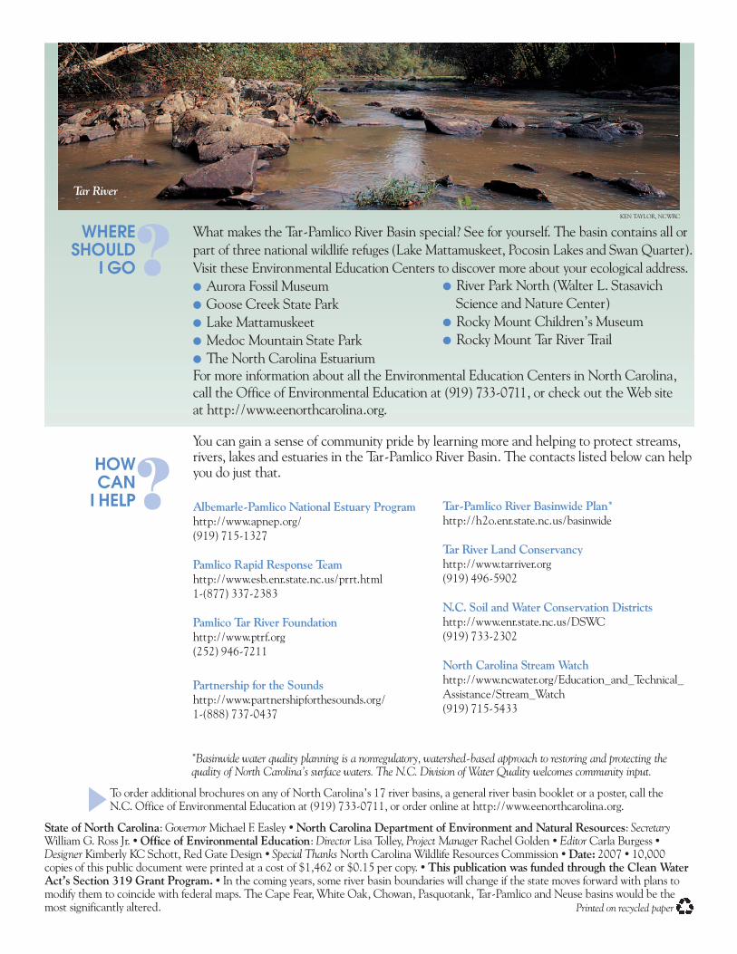
Tar River
State of North Carolina: Governor Michael F. Easley • North Carolina Department of Environment and Natural Resources: SecretaryWilliam G. Ross Jr. • Office of Environmental Education: Director Lisa Tolley, Project Manager Rachel Golden • Editor Carla Burgess •Designer Kimberly KC Schott, Red Gate Design • Special Thanks North Carolina Wildlife Resources Commission • Date: 2007 • 10,000copies of this public document were printed at a cost of $1,462 or $0.15 per copy. • This publication was funded through the Clean WaterAct’s Section 319 Grant Program. • In the coming years, some river basin boundaries will change if the state moves forward with plans tomodify them to coincide with federal maps. The Cape Fear, White Oak, Chowan, Pasquotank, Tar-Pamlico and Neuse basins would be themost significantly altered.
*Basinwide water quality planning is a nonregulatory, watershed-based approach to restoring and protecting thequality of North Carolina’s surface waters. The N.C. Division of Water Quality welcomes community input.
Printed on recycled paper
To order additional brochures on any of North Carolina’s 17 river basins, a general river basin booklet or a poster, call theN.C. Office of Environmental Education at (919) 733-0711, or order online at http://www.eenorthcarolina.org.▼
Tar-Pamlico River Basinwide Plan*http://h2o.enr.state.nc.us/basinwide
Tar River Land Conservancyhttp://www.tarriver.org(919) 496-5902
N.C. Soil and Water Conservation Districtshttp://www.enr.state.nc.us/DSWC(919) 733-2302
North Carolina Stream Watchhttp://www.ncwater.org/Education_and_Technical_Assistance/Stream_Watch(919) 715-5433
● River Park North (Walter L. StasavichScience and Nature Center)
● Rocky Mount Children’s Museum● Rocky Mount Tar River Trail