Embed Size (px)
Citation preview
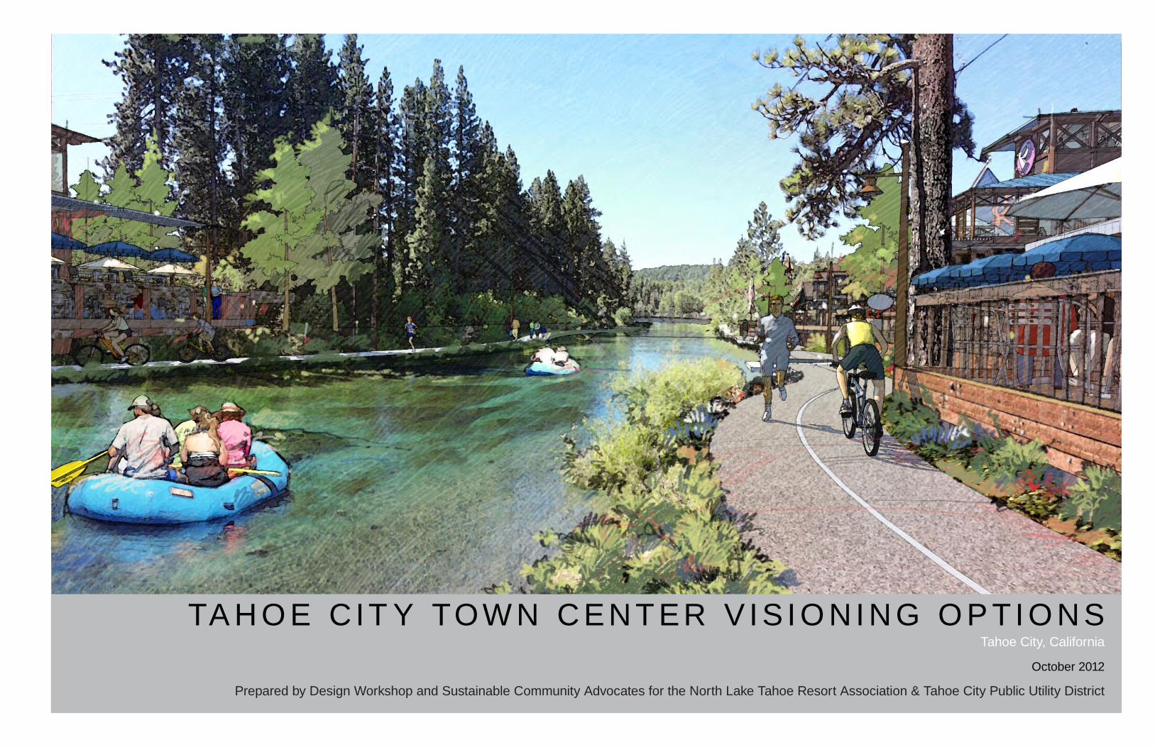
TA H O E C IT Y TOW N C ENT ER V IS I O NI N G O P TI O N STahoe City, California
October 2012
Prepared by Design Workshop and Sustainable Community Advocates for the North Lake Tahoe Resort Association & Tahoe City Public Utility District
TAHOE CITY TOWN CENTER VISIONING OPTIONS | Tahoe City, California
These visioning options were initiated by the Tahoe City Public Utility District, North Lake Tahoe Resort Association, and commercial property owners and business owners.
The plan was prepared by: Design Workshop 128 Market Street, Suite 3E Stateline, Nevada 89449 and 120 East Main Street Aspen, Colorado 81611 Sustainable Community Advocates PO Box 1875Zephyr Cove, Nevada 89448
Moon Design 4102 South 31st Street, #1200 Temple, Texas 76502

Contents | i
CONTENTSPROJECT SUMMARY .........................................................................................................................................1
Overview . . . . . . . . . . . . . . . . . . . . . . . . . . . . . . . . . . . . . . . . . . . . . . . . . . . . . . . . . . . . . . . . . . . . . . . . . . . 2
Project Participants . . . . . . . . . . . . . . . . . . . . . . . . . . . . . . . . . . . . . . . . . . . . . . . . . . . . . . . . . . . . . . . . . . . 3
EXISTING CONDITIONS ANALYSIS ..................................................................................................................5Current Planning Context . . . . . . . . . . . . . . . . . . . . . . . . . . . . . . . . . . . . . . . . . . . . . . . . . . . . . . . . . . . . . . . 6
Current Physical Context . . . . . . . . . . . . . . . . . . . . . . . . . . . . . . . . . . . . . . . . . . . . . . . . . . . . . . . . . . . . . . . 8
Existing Study Area Conditions . . . . . . . . . . . . . . . . . . . . . . . . . . . . . . . . . . . . . . . . . . . . . . . . . . . . . . . . . 10
Fundamental Issues and Challenges . . . . . . . . . . . . . . . . . . . . . . . . . . . . . . . . . . . . . . . . . . . . . . . . . . . . . 16
VISIONING OPTIONS ........................................................................................................................................19Principles of the Vision . . . . . . . . . . . . . . . . . . . . . . . . . . . . . . . . . . . . . . . . . . . . . . . . . . . . . . . . . . . . . . . . 20
Visioning Options Diagram & District Concepts . . . . . . . . . . . . . . . . . . . . . . . . . . . . . . . . . . . . . . . . . . . . . 24
PARTNERSHIPS ................................................................................................................................................39Partnerships and Moving Forward . . . . . . . . . . . . . . . . . . . . . . . . . . . . . . . . . . . . . . . . . . . . . . . . . . . . . . . 40
APPENDIX .........................................................................................................................................................41

CHAPTER TITLESUBTITLE
Project Summary | 1
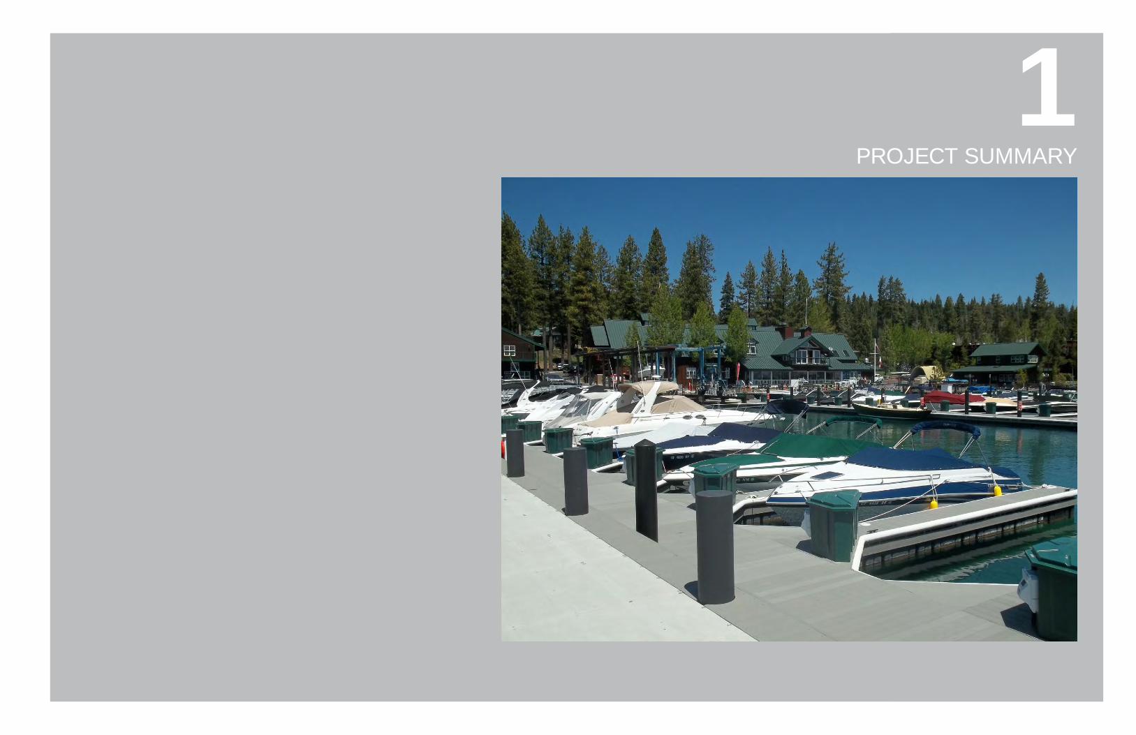
81PROJECT SUMMARY
TAHOE CITY TOWN CENTER VISIONING OPTIONS | Tahoe City, California2 | Project Summary
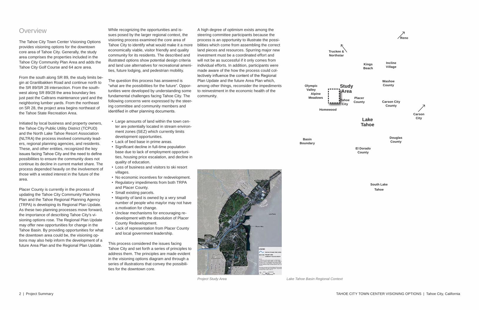
OverviewThe Tahoe City Town Center Visioning Options provides visioning options for the downtown core area of Tahoe City. Generally, the study area comprises the properties included in the Tahoe City Community Plan Area and adds the Tahoe City Golf Course and 64 acre area.
From the south along SR 89, the study limits be-gin at Granlibakken Road and continue north to the SR 89/SR 28 intersection. From the south-west along SR 89/28 the area boundary lies just past the Caltrans maintenance yard and the neighboring lumber yards. From the northeast on SR 28, the project area begins northeast of the Tahoe State Recreation Area.
Initiated by local business and property owners, the Tahoe City Public Utility District (TCPUD) and the North Lake Tahoe Resort Association (NLTRA) the process involved community lead-ers, regional planning agencies, and residents. These, and other entities, recognized the key issues facing Tahoe City and the need to define possibilities to ensure the community does not continue its decline in current market share. The process depended heavily on the involvement of those with a vested interest in the future of the area.
Placer County is currently in the process of updating the Tahoe City Community Plan/Area Plan and the Tahoe Regional Planning Agency (TRPA) is developing its Regional Plan Update. As these two planning processes move forward, the importance of describing Tahoe City’s vi-sioning options rose. The Regional Plan Update may offer new opportunities for change in the Tahoe Basin. By providing opportunities for what the downtown area could be, the visioning op-tions may also help inform the development of a future Area Plan and the Regional Plan Update.
While recognizing the opportunities and is-sues posed by the larger regional context, the visioning process examined the core area of Tahoe City to identify what would make it a more economically viable, visitor friendly and quality community for its residents. The described and illustrated options show potential design criteria and land use alternatives for recreational ameni-ties, future lodging, and pedestrian mobility.
The question this process has answered is “what are the possibilities for the future”. Oppor-tunities were developed by understanding some fundamental challenges facing Tahoe City. The following concerns were expressed by the steer-ing committee and community members and identified in other planning documents.
• Large amounts of land within the town cen-ter are potentially located in stream environ-ment zones (SEZ) which currently limits development opportunities.
• Lack of bed base in prime areas.• Significant decline in full-time population
base due to lack of employment opportuni-ties, housing price escalation, and decline in quality of education.
• Loss of business and visitors to ski resort villages.
• No economic incentives for redevelopment.• Regulatory impediments from both TRPA
and Placer County.• Small existing parcels.• Majority of land is owned by a very small
number of people who may/or may not have a motivation for change.
• Unclear mechanisms for encouraging re-development with the dissolution of Placer County Redevelopment.
• Lack of representation from Placer County and local government leadership.
This process considered the issues facing Tahoe City and set forth a series of principles to address them. The principles are made evident in the visioning options diagram and through a series of illustrations that convey the possibili-ties for the downtown core.
A high degree of optimism exists among the steering committee participants because the process is an opportunity to illustrate the possi-bilities which come from assembling the correct land pieces and resources. Spurring major new investment must be a coordinated effort and will not be as successful if it only comes from individual efforts. In addition, participants were made aware of the how the process could col-lectively influence the content of the Regional Plan Update and the future Area Plan which, among other things, reconsider the impediments to reinvestment in the economic health of the community.
Lake Tahoe Basin Regional ContextProject Study Area
Lake Tahoe
InclineVillage
KingsBeach
South Lake Tahoe
StudyArea
Carson City
BasinBoundary
PlacerCounty
El DoradoCounty
Douglas County
WashoeCounty
Carson CityCounty
Tahoe City
Homewood
Olympic Valley
Truckee & Northstar
Reno
Alpine Meadows
Project Summary | 3
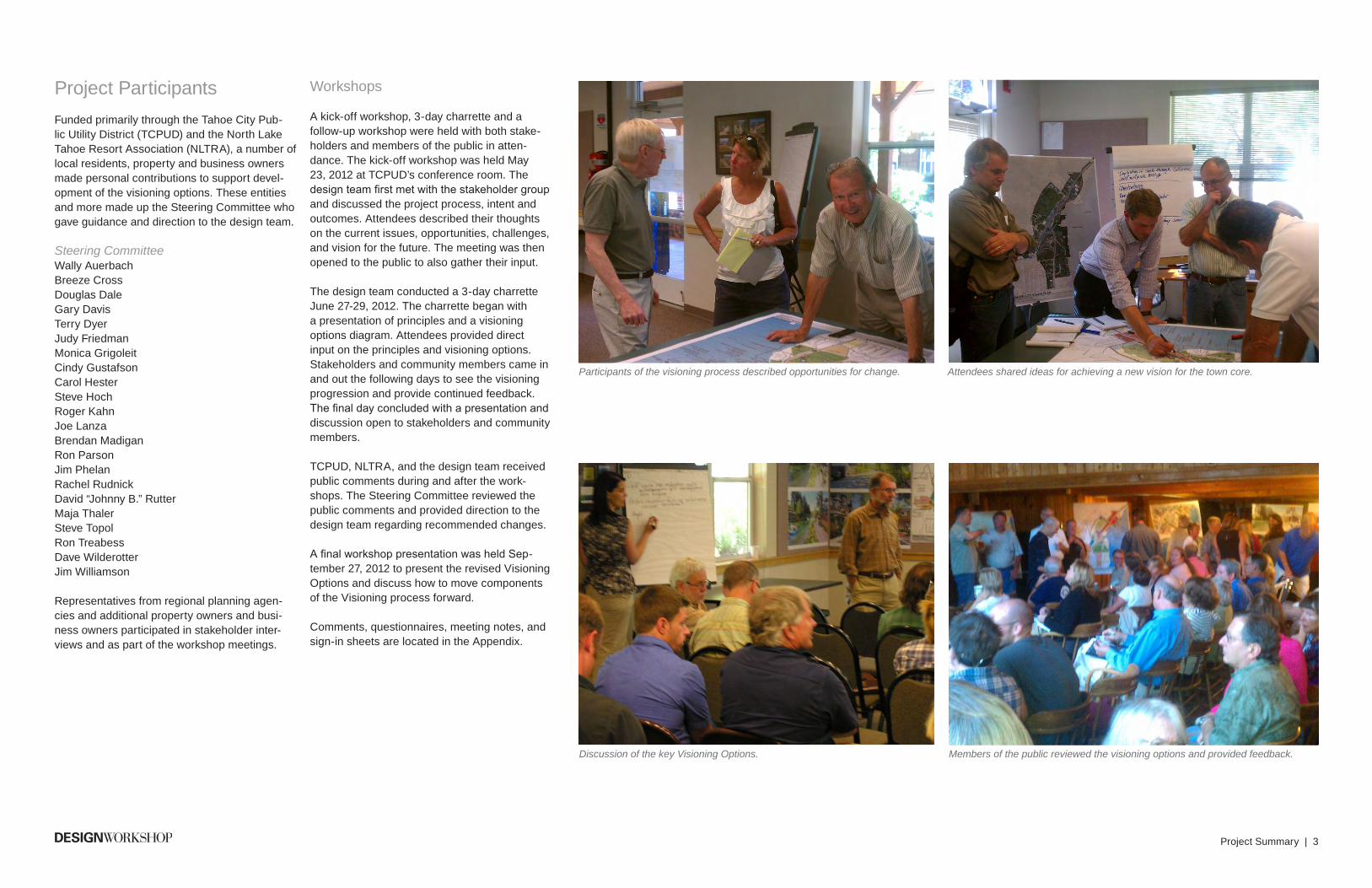
Project ParticipantsFunded primarily through the Tahoe City Pub-lic Utility District (TCPUD) and the North Lake Tahoe Resort Association (NLTRA), a number of local residents, property and business owners made personal contributions to support devel-opment of the visioning options. These entities and more made up the Steering Committee who gave guidance and direction to the design team.
Steering CommitteeWally AuerbachBreeze CrossDouglas DaleGary DavisTerry DyerJudy FriedmanMonica GrigoleitCindy GustafsonCarol HesterSteve HochRoger KahnJoe LanzaBrendan MadiganRon ParsonJim PhelanRachel RudnickDavid “Johnny B.” RutterMaja ThalerSteve TopolRon TreabessDave WilderotterJim Williamson
Representatives from regional planning agen-cies and additional property owners and busi-ness owners participated in stakeholder inter-views and as part of the workshop meetings.
Participants of the visioning process described opportunities for change. Attendees shared ideas for achieving a new vision for the town core.
Discussion of the key Visioning Options. Members of the public reviewed the visioning options and provided feedback.
Workshops
A kick-off workshop, 3-day charrette and a follow-up workshop were held with both stake-holders and members of the public in atten-dance. The kick-off workshop was held May 23, 2012 at TCPUD’s conference room. The design team first met with the stakeholder group and discussed the project process, intent and outcomes. Attendees described their thoughts on the current issues, opportunities, challenges, and vision for the future. The meeting was then opened to the public to also gather their input.
The design team conducted a 3-day charrette June 27-29, 2012. The charrette began with a presentation of principles and a visioning options diagram. Attendees provided direct input on the principles and visioning options. Stakeholders and community members came in and out the following days to see the visioning progression and provide continued feedback. The final day concluded with a presentation and discussion open to stakeholders and community members.
TCPUD, NLTRA, and the design team received public comments during and after the work-shops. The Steering Committee reviewed the public comments and provided direction to the design team regarding recommended changes.
A final workshop presentation was held Sep-tember 27, 2012 to present the revised Visioning Options and discuss how to move components of the Visioning process forward.
Comments, questionnaires, meeting notes, and sign-in sheets are located in the Appendix.

TAHOE CITY TOWN CENTER VISIONING OPTIONS | Tahoe City, California4 | Project Summary
CHAPTER TITLESUBTITLE
Existing Conditions Analysis | 5
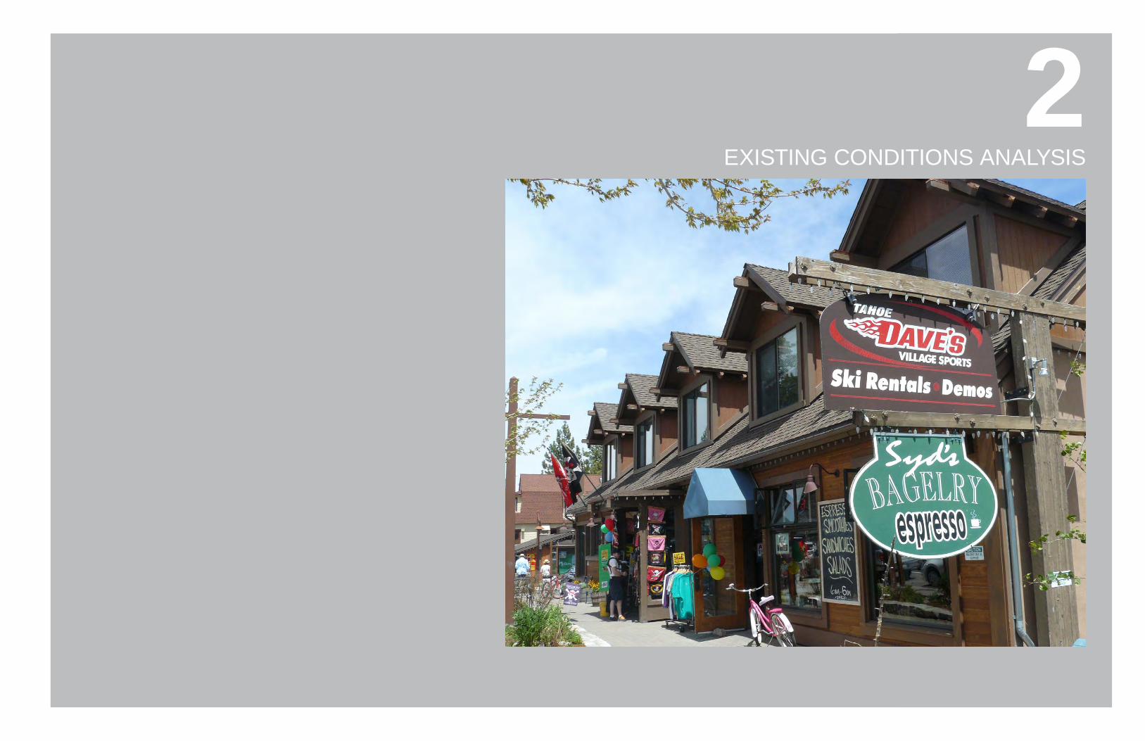
82EXISTING CONDITIONS ANALYSIS
TAHOE CITY TOWN CENTER VISIONING OPTIONS | Tahoe City, California6 | Existing Conditions Analysis
Current Planning ContextRegional Plan Update
The Tahoe Regional Planning Agency (TRPA) is moving into the final phases of adopting its Regional Plan Update.
In August 2012, the TRPA Governing Board voted to incorporate a package of revisions and recommendations from its Regional Plan Update Committee into the final plan documents for consideration later in 2012. The Final Draft was made available October 24th.
Part of that package included a suite of recom-mendations that came out of a bi-state consulta-tion group led by California Secretary of Natural Resources John Laird and Nevada Department of Conservation and Natural Resources Director Leo Drozdoff. Together the two led a core group of stakeholders representing the conservation and business communities, local government and TRPA Governing Board members in exten-sive discussions that resulted in key compro-mises presented to the Regional Plan Update Committee in early August.
Depending on the final outcome of the Regional Plan Update, proposed new policies and imple-mentation strategies may present fresh oppor-tunities for change in Tahoe City. Primarily, the updated Regional Plan is designed to reflect the following priorities:
• Accelerate environmental benefits by target-ing environmental redevelopment opportuni-ties in “community centers” such as Tahoe City.
• Eliminate regulatory barriers and stimulate the environmental redevelopment of run-down buildings.
• Allow for a greater concentration of uses and activities to support environmental and economic revitalization.
• Encourage walkable, bicycle friendly com-munity centers with improved and expanded public transit services.
• Allow for improved signage, and more efficiently manage traffic and community mobility.
• Create more flexibility in parking requirements.
• Provide more flexible policies for managing land coverage and incentives for removing excess coverage.
• Focus TRPA’s resources on regional plan-ning and integrate land use implementation into the procedures of local governments and agencies, like Placer County.
• Allow local governments to prepare and adopt “Area Plans” tailored to the needs of their communities and local objectives.
• Review Area Plans for conformity with the Regional Plan, consistency with the EIP and requirement to achieve and maintain TRPA Environmental Thresholds.
The Regional Plan Update offers a launching point for Tahoe City to go beyond previous vi-sioning efforts. The alternatives presented in the plan are aimed to eliminate regulatory barriers to stimulate redevelopment of aged buildings. It encourages redevelopment that upgrades and replaces the aging built environment in commu-nity centers to promote safe and walkable com-munities with environmental improvements.
For Tahoe City, this provides opportunities to address coverage and sensitive lands issues in a comprehensive manner thereby providing redevelopment opportunities which are limited when considered on a parcel by parcel basis. Environmental improvements can be made while also realizing economic and social benefits.
It is anticipated for the Regional Plan Update and corresponding Regional Transportation Plan updates to be completed by the end of calendar year 2012.
Placer County Area Plan/Community Plan Update
Coordinated with the Regional Plan Update, Placer County has initiated the update of its Tahoe Community Plans/General Plans. Cur-rently the County maintains nine Community/General Plans, including a Tahoe City Area General Plan and a Tahoe City Community Plan. The update intends to consolidate the nine Plans into a single over-arching Community Plan
policy document with four sub-planning areas, each with their own zoning ordinances and de-sign standards. One of the sub-areas includes the area previously addressed in the Tahoe City Area General Plan. This sub-area is also referred to as the Tahoe City Plan Area.
When completed and endorsed by the commu-nity and Placer County, the updated Community Plan/Area Plan will be reviewed by TRPA for conformity with the Regional Plan and con-sistency with the Lake Tahoe Environmental Improvement Program (EIP) and requirement to achieve and maintain TRPA Environmental Thresholds. It will then be the primary land man-agement tool for the area.
The options presented as part of this process have the opportunity to be considered as both the Regional Plan Update is finalized and the Tahoe City Area General Plan/Area Plan is developed.
Other Tahoe City Plans
The current Community Plan for Tahoe City was completed in 1994. It and other plans were referenced in the development of the Visioning Options. While Tahoe City has implemented a series of significant public improvements since the adoption of the Community Plan, the com-munity and its supporting agencies have yet to stimulate the broader private property improve-ments essential to fully activate the adopted Community Plan Vision. Key ideas and excerpts from a few of the documents are described below.
Tahoe City Community Plan, Chapter 1A fundamental cornerstone of this Community Plan is the conviction that Tahoe City should continue as a major commercial, cultural, recre-ational and tourist center. Policies must stimu-late the rehabilitation of the existing community and together point to a high quality destination resort community, of limited scale.
Destination tourism demands a full complement of goods, services and recreational opportuni-ties located within an easily accessible area. Tahoe City must be planned to maximize the op-
portunities for destination visitors and minimize the impacts created by the increasing number of day-users. Tahoe City already has many of the goods, services and recreational opportunities needed for a destination resort, but these ele-ments are not easily accessible.
Three qualities must be established in Tahoe City: 1) the diversity and concentrated mix of uses that creates a strong, lively market; 2) the quality of the physical environment that estab-lishes a distinctive sense of place; and 3) trans-portation improvements that provide for both vehicular circulation and pedestrian circulation. A mixture of complementary uses in a concen-trated area generates pedestrian activity and economic viability.
Tahoe City Strategic Plan (2000)• Tahoe City has long been recognized as the
hub of activity of the North Shore of Lake Tahoe.
• The community has enjoyed the benefits of its natural setting.
• Aging facilities, competitive forces from other destination resort areas, local compe-
tition from Squaw Valley, Truckee and Reno, development restrictions within the Tahoe Basin, and seasonal tourist trade have made it difficult for the community to estab-lish and sustain a stable economic base.
Economic and Redevelopment Strategies for Tahoe City (2007)
• Retail stagnation is of greatest concern. • Overall amount of retail space appears to
be appropriate given demand from residents and tourists.
Tahoe City’s need for newer, more contempo-rary lodging has been a reoccurring theme of the community’s many planning documents and discussions. As new full-service lodging properties have been constructed and opened in Squaw Valley, Northstar and Truckee, Tahoe City’s product has become increasingly dated, stagnant and less competitive. Planning docu-ments strongly suggest new lodging product in Tahoe City would help stimulate and sustain the community’s retail, recreation, and retail base.
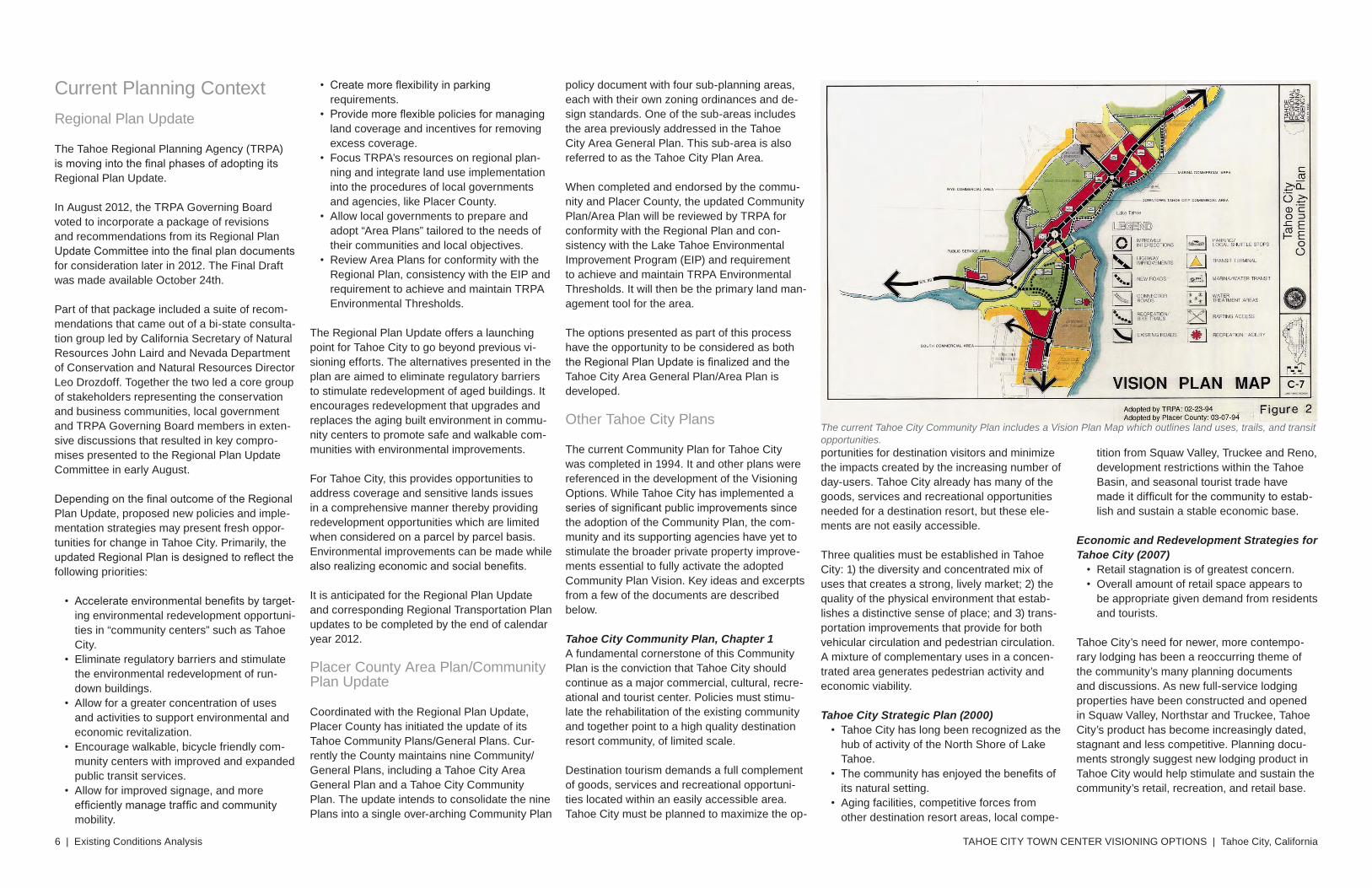
The current Tahoe City Community Plan includes a Vision Plan Map which outlines land uses, trails, and transit opportunities.
Existing Conditions Analysis | 7
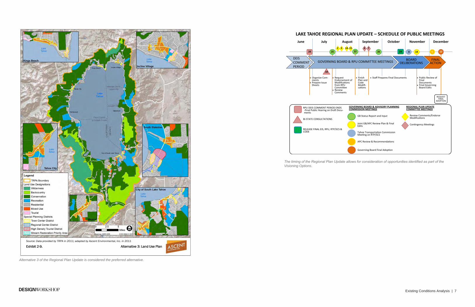
Ascent Environmental Regional Plan Update Alternatives
Tahoe Regional Planning Agency Regional Plan Update Draft EIS 2-35
Source: Data provided by TRPA in 2011; adapted by Ascent Environmental, Inc. in 2011
Exhibit 2-9. Alternative 3: Land Use Plan
June July August September October November December
24
RPU DEIS COMMENT PERIOD ENDS ‐Final Public Hearing on Dra� Docu‐ments
BI‐STATE CONSULTATIONS GB Status Report and Input
LAKE TAHOE REGIONAL PLAN UPDATE – SCHEDULE OF PUBLIC MEETINGS
GOVERNING BOARD & RPU COMMITTEE MEETINGS
DEIS COMMENT PERIOD
GOVERNING BOARD & ADVISORY PLANNING COMMISSION MEETINGS
REGIONAL PLAN UPDATE COMMITTEE MEETINGS
BOARD DELIBERATIONS
28
18
25
Joint GB/APC Review Plan & Final Edits
Tahoe Transporta�on Commission Mee�ng on RTP/SCS
26 22 14
FINAL ACTION
2 3 14 15
Review Comments/Endorse Modica�ons
Con�ngency Mee�ngs
6 7 12
RELEASE FINAL EIS, RPU, RTP/SCS & CODE
Staff Prepares Final Documents Request Endorsement of Modica�ons from RPU Commi�ee
Review Comments
Finish Plan and Code Modi‐ ca�ons
Organize Com‐ments
Prepare Issue Sheets
Public Review of Final Documents
Final Governing Board Edits
REQUEST FINAL
ADOPTION
APC Review & Recommenda�ons
9
Governing Board Final Adop�on
5
Alternative 3 of the Regional Plan Update is considered the preferred alternative.
The timing of the Regional Plan Update allows for consideration of opportunities identified as part of the Visioning Options.
TAHOE CITY TOWN CENTER VISIONING OPTIONS | Tahoe City, California8 | Existing Conditions Analysis
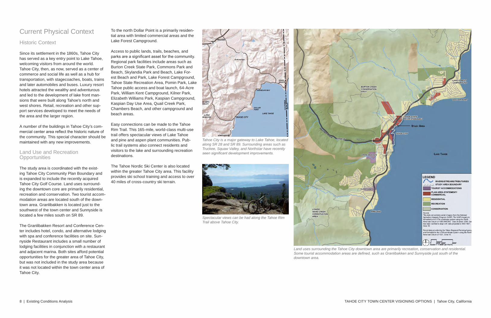
Current Physical ContextHistoric Context
Since its settlement in the 1860s, Tahoe City has served as a key entry point to Lake Tahoe, welcoming visitors from around the world. Tahoe City, then, as now, served as a center of commerce and social life as well as a hub for transportation, with stagecoaches, boats, trains and later automobiles and buses. Luxury resort hotels attracted the wealthy and adventurous and led to the development of lake front man-sions that were built along Tahoe’s north and west shores. Retail, recreation and other sup-port services developed to meet the needs of the area and the larger region.
A number of the buildings in Tahoe City’s com-mercial center area reflect the historic nature of the community. This special character should be maintained with any new improvements.
Land Use and Recreation Opportunities
The study area is coordinated with the exist-ing Tahoe City Community Plan Boundary and is expanded to include the recently acquired Tahoe City Golf Course. Land uses surround-ing the downtown core are primarily residential, recreation and conservation. Two tourist accom-modation areas are located south of the down-town area. Granlibakken is located just to the southwest of the town center and Sunnyside is located a few miles south on SR 89.
The Granlibakken Resort and Conference Cen-ter includes hotel, condo, and alternative lodging with spa and conference facilities on site. Sun-nyside Restaurant includes a small number of lodging facilities in conjunction with a restaurant and adjacent marina. Both sites afford potential opportunities for the greater area of Tahoe City, but was not included in the study area because it was not located within the town center area of Tahoe City.
To the north Dollar Point is a primarily residen-tial area with limited commercial areas and the Lake Forest Campground.
Access to public lands, trails, beaches, and parks are a significant asset for the community. Regional park facilities include areas such as Burton Creek State Park, Commons Park and Beach, Skylandia Park and Beach, Lake For-est Beach and Park, Lake Forest Campground, Tahoe State Recreation Area, Pomin Park, Lake Tahoe public access and boat launch, 64-Acre Park, William Kent Campground, Kilner Park, Elizabeth Williams Park, Kaspian Campground, Kaspian Day Use Area, Quail Creek Park, Chambers Beach, and other campground and beach areas.
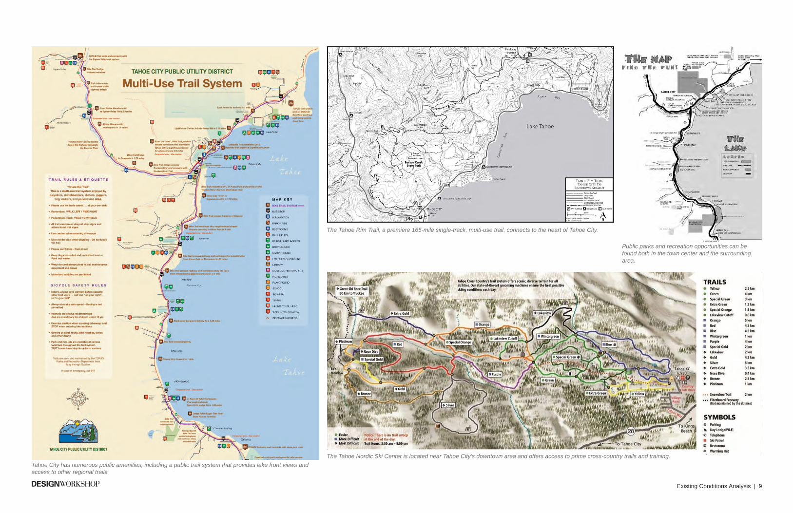
Easy connections can be made to the Tahoe Rim Trail. This 165-mile, world-class multi-use trail offers spectacular views of Lake Tahoe and pine and aspen plant communities. Pub-lic trail systems also connect residents and visitors to the lake and surrounding recreation destinations.
The Tahoe Nordic Ski Center is also located within the greater Tahoe City area. This facility provides ski school training and access to over 40 miles of cross-country ski terrain.
Tahoe City is a major gateway to Lake Tahoe, located along SR 28 and SR 89. Surrounding areas such as Truckee, Squaw Valley, and Northstar have recently seen significant development improvements.
Land uses surrounding the Tahoe City downtown area are primarily recreation, conservation and residential. Some tourist accommodation areas are defined, such as Granlibakken and Sunnyside just south of the downtown area.
Spectacular views can be had along the Tahoe Rim Trail above Tahoe City.
Existing Conditions Analysis | 9
Tahoe City has numerous public amenities, including a public trail system that provides lake front views and access to other regional trails.
The Tahoe Rim Trail, a premiere 165-mile single-track, multi-use trail, connects to the heart of Tahoe City.
Public parks and recreation opportunities can be found both in the town center and the surrounding area.
The Tahoe Nordic Ski Center is located near Tahoe City’s downtown area and offers access to prime cross-country trails and training.
TAHOE CITY TOWN CENTER VISIONING OPTIONS | Tahoe City, California10 | Existing Conditions Analysis
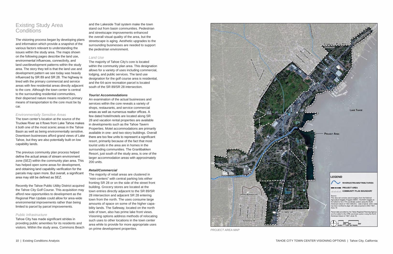
Existing Study Area ConditionsThe visioning process began by developing plans and information which provide a snapshot of the various factors relevant to understanding the issues within the study area. The maps shown on the following pages describe the land use, environmental influences, connectivity, and land use/development patterns within the study area. The story they tell is that the land use and development pattern we see today was heavily influenced by SR 89 and SR 28. The highway is lined with the primary commercial and service areas with few residential areas directly adjacent to the core. Although the town center is central to the surrounding residential communities, their dispersed nature means resident’s primary means of transportation to the core must be by car.
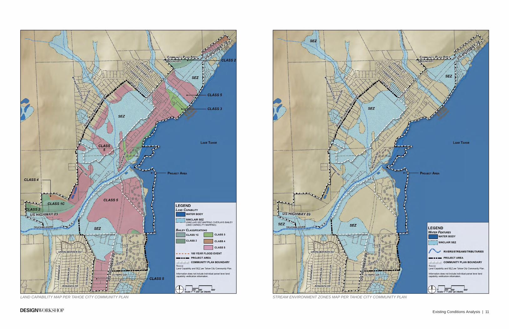
Environmentally Sensitive AreasThe town center’s location at the source of the Truckee River as it flows from Lake Tahoe makes it both one of the most scenic areas in the Tahoe Basin as well as being environmentally sensitive. Downtown businesses afford grand views of Lake Tahoe, but they are also potentially built on low capability lands.
The previous community plan process helped define the actual areas of stream environment zone (SEZ) within the community plan area. This has helped open some areas for development, and obtaining land capability verification for the parcels may open more. But overall, a significant area may still be defined as SEZ.
Recently the Tahoe Public Utility District acquired the Tahoe City Golf Course. This acquisition may afford new opportunities to development as the Regional Plan Update could allow for area-wide environmental improvements rather than being limited to parcel by parcel improvements.
Public InfrastructureTahoe City has made significant strides in providing public amenities for its residents and visitors. Within the study area, Commons Beach
PROJECT AREA MAP
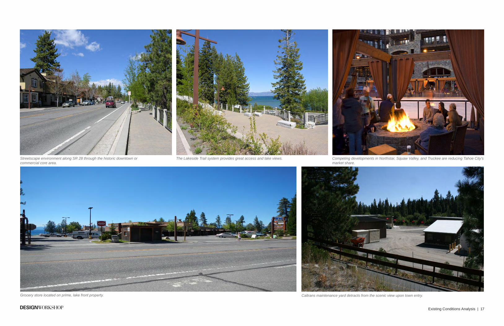
and the Lakeside Trail system make the town stand out from basin communities. Pedestrian and streetscape improvements enhanced the overall visual quality of the area, but the streetscape is aging. Aesthetic upgrades to the surrounding businesses are needed to support the pedestrian environment.
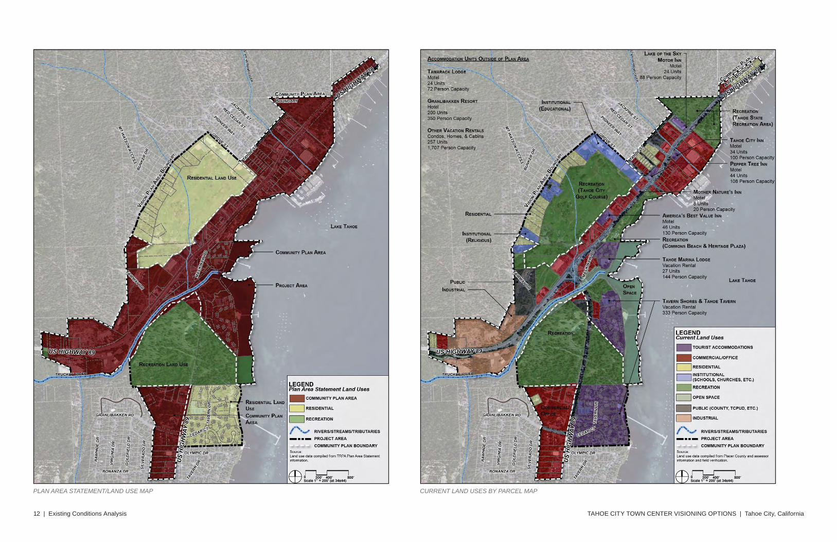
Land UseThe majority of Tahoe City’s core is located within the community plan area. This designation allows for a variety of uses including commercial, lodging, and public services. The land use designation for the golf course area is residential, and the 64-acre recreation parcel is located south of the SR 89/SR 28 intersection.
Tourist AccommodationsAn examination of the actual businesses and services within the core reveals a variety of shops, restaurants, and service commercial areas as well as numerous realtor offices. A few dated hotel/motels are located along SR 28 and vacation rental properties are available in developments such as the Tahoe Tavern Properties. Motel accommodations are primarily available in one- and two-story buildings. Overall there are too few units to represent a significant resort, primarily because of the fact that most tourist units in the area are in homes in the surrounding communities. The Granlibakken Resort, just south of the study area, is one of the larger accommodation areas with approximately 200 units.
Retail/CommercialThe majority of retail areas are clustered in “mini-centers” with central parking lots either fronting SR 28 or on the side of the street front building. Grocery stores are located at the town entries directly adjacent to the SR 89/SR 28 intersection and adjacent SR 28 entering town from the north. The uses consume large amounts of space on some of the higher capa-bility lands. The Safeway, located on the north side of town, also has prime lake front views. Visioning options address methods of relocating such uses to other locations in the town center area while to provide for more appropriate uses on prime development properties.
Existing Conditions Analysis | 11
LAND CAPABILITY MAP PER TAHOE CITY COMMUNITY PLAN STREAM ENVIRONMENT ZONES MAP PER TAHOE CITY COMMUNITY PLAN
TAHOE CITY TOWN CENTER VISIONING OPTIONS | Tahoe City, California12 | Existing Conditions Analysis
CURRENT LAND USES BY PARCEL MAPPLAN AREA STATEMENT/LAND USE MAP
Existing Conditions Analysis | 13
CONNECTIONS AND LINKAGES MAP
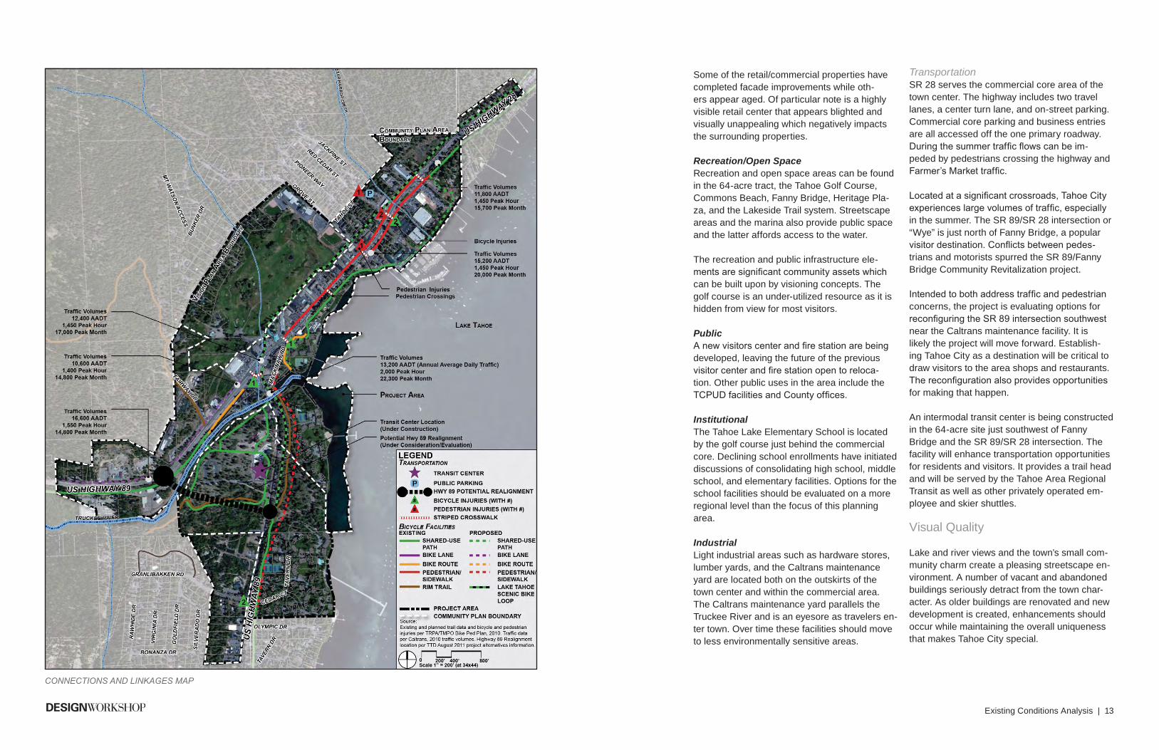
Some of the retail/commercial properties have completed facade improvements while oth-ers appear aged. Of particular note is a highly visible retail center that appears blighted and visually unappealing which negatively impacts the surrounding properties.
Recreation/Open SpaceRecreation and open space areas can be found in the 64-acre tract, the Tahoe Golf Course, Commons Beach, Fanny Bridge, Heritage Pla-za, and the Lakeside Trail system. Streetscape areas and the marina also provide public space and the latter affords access to the water.
The recreation and public infrastructure ele-ments are significant community assets which can be built upon by visioning concepts. The golf course is an under-utilized resource as it is hidden from view for most visitors.
PublicA new visitors center and fire station are being developed, leaving the future of the previous visitor center and fire station open to reloca-tion. Other public uses in the area include the TCPUD facilities and County offices.
InstitutionalThe Tahoe Lake Elementary School is located by the golf course just behind the commercial core. Declining school enrollments have initiated discussions of consolidating high school, middle school, and elementary facilities. Options for the school facilities should be evaluated on a more regional level than the focus of this planning area.
IndustrialLight industrial areas such as hardware stores, lumber yards, and the Caltrans maintenance yard are located both on the outskirts of the town center and within the commercial area. The Caltrans maintenance yard parallels the Truckee River and is an eyesore as travelers en-ter town. Over time these facilities should move to less environmentally sensitive areas.
TransportationSR 28 serves the commercial core area of the town center. The highway includes two travel lanes, a center turn lane, and on-street parking. Commercial core parking and business entries are all accessed off the one primary roadway. During the summer traffic flows can be im-peded by pedestrians crossing the highway and Farmer’s Market traffic.
Located at a significant crossroads, Tahoe City experiences large volumes of traffic, especially in the summer. The SR 89/SR 28 intersection or “Wye” is just north of Fanny Bridge, a popular visitor destination. Conflicts between pedes-trians and motorists spurred the SR 89/Fanny Bridge Community Revitalization project.
Intended to both address traffic and pedestrian concerns, the project is evaluating options for reconfiguring the SR 89 intersection southwest near the Caltrans maintenance facility. It is likely the project will move forward. Establish-ing Tahoe City as a destination will be critical to draw visitors to the area shops and restaurants. The reconfiguration also provides opportunities for making that happen.
An intermodal transit center is being constructed in the 64-acre site just southwest of Fanny Bridge and the SR 89/SR 28 intersection. The facility will enhance transportation opportunities for residents and visitors. It provides a trail head and will be served by the Tahoe Area Regional Transit as well as other privately operated em-ployee and skier shuttles.
Visual Quality
Lake and river views and the town’s small com-munity charm create a pleasing streetscape en-vironment. A number of vacant and abandoned buildings seriously detract from the town char-acter. As older buildings are renovated and new development is created, enhancements should occur while maintaining the overall uniqueness that makes Tahoe City special.
TAHOE CITY TOWN CENTER VISIONING OPTIONS | Tahoe City, California14 | Existing Conditions Analysis
Economic and Demographic Conditions
Tahoe City’s economy is heavily dependant on tourism. Once the center of commercial and resort activity in the area, Tahoe City has recently been impacted by new developments in Northstar, Truckee, and Squaw Valley. Although the community is busy during the summer, it is facing increasing pressure from neighboring communities to keep its place in the market, especially during the winter season.
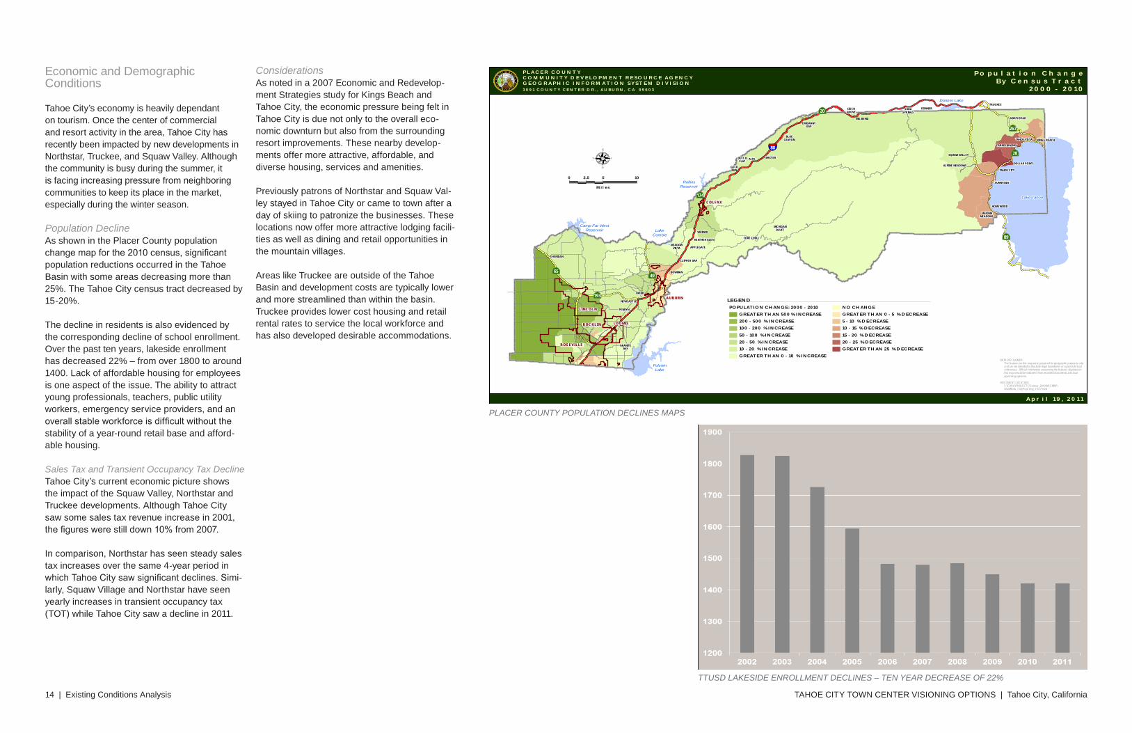
Population DeclineAs shown in the Placer County population change map for the 2010 census, significant population reductions occurred in the Tahoe Basin with some areas decreasing more than 25%. The Tahoe City census tract decreased by 15-20%.
The decline in residents is also evidenced by the corresponding decline of school enrollment. Over the past ten years, lakeside enrollment has decreased 22% – from over 1800 to around 1400. Lack of affordable housing for employees is one aspect of the issue. The ability to attract young professionals, teachers, public utility workers, emergency service providers, and an overall stable workforce is difficult without the stability of a year-round retail base and afford-able housing.
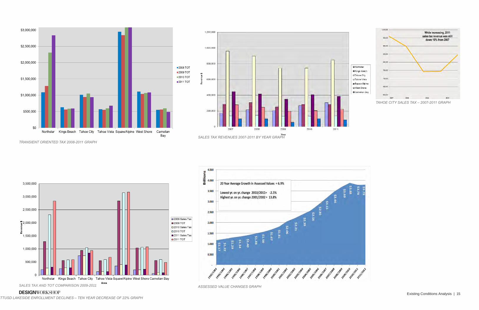
Sales Tax and Transient Occupancy Tax DeclineTahoe City’s current economic picture shows the impact of the Squaw Valley, Northstar and Truckee developments. Although Tahoe City saw some sales tax revenue increase in 2001, the figures were still down 10% from 2007.
In comparison, Northstar has seen steady sales tax increases over the same 4-year period in which Tahoe City saw significant declines. Simi-larly, Squaw Village and Northstar have seen yearly increases in transient occupancy tax (TOT) while Tahoe City saw a decline in 2011.
ConsiderationsAs noted in a 2007 Economic and Redevelop-ment Strategies study for Kings Beach and Tahoe City, the economic pressure being felt in Tahoe City is due not only to the overall eco-nomic downturn but also from the surrounding resort improvements. These nearby develop-ments offer more attractive, affordable, and diverse housing, services and amenities.
Previously patrons of Northstar and Squaw Val-ley stayed in Tahoe City or came to town after a day of skiing to patronize the businesses. These locations now offer more attractive lodging facili-ties as well as dining and retail opportunities in the mountain villages.
Areas like Truckee are outside of the Tahoe Basin and development costs are typically lower and more streamlined than within the basin. Truckee provides lower cost housing and retail rental rates to service the local workforce and has also developed desirable accommodations.
ROS EVI LLEROS EVI LLE
ROC KLI NROC KLI N LOO MISLOO MIS
LINC OL NLINC OL N
COLFAXCOLFAX
AUB URNAUB URN
TAHOMAMEADOWS
HOMEWOOD
SUNNYSIDE
SQUAW VALLEY
TAHOE VISTA KINGS BEACH
CARNELIAN BAY
NORTHSTAR
DONNERSODASPRINGS
BIG BEND
CISCOGROVE
EMIGRANTGAP
BLUECANYON
BAXTERDUTCHFLAT
GOLDRUN
MICHIGANBLUFF
FORESTHILLHEATHER GLEN
ALPINE MEADOWS
WEIMAR
APPLEGATEMEADOW
VISTA
CLIPPER GAP
BOWMAN
SHERIDAN
PENRYN
NEWCASTLE
OPHIR
DOLLAR POINT
TAHOE CITY
TRUCKEE
ALTA
GRANITEBAY
Donner Lake
RollinsReservoir
Lake Tahoe
Camp Far WestReservoir
FolsomLake
LakeCombie
80
49
267
28
20
174
193
89
65
P L A CE R COU N T YCOMMU N I T Y D E V E LOP M E N T R E S O U R C E A G E N C YG E OG R A P H I C I N F OR M A T I ON S Y S T E M D I V I S I ON3 0 9 1 C O U N T Y C E N T E R D R . , A U B U R N , C A 9 5 6 0 3
P o p u l at i o n C h a n g eBy C e n s u s T r a c t
2 0 0 0 - 2 0 1 0
LEGENDPOPULATION CHANGE: 2000 - 2010
GREATER THAN 500 % INCREASE200 - 500 % INCREASE100 - 200 % INCREASE50 - 100 % INCREASE20 - 50 % INCREASE10 - 20 % INCREASEGREATER THAN 0 - 10 % INCREASE
NO CHANGEGREATER THAN 0 - 5 % DECREASE5 - 10 % DECREASE10 - 15 % DECREASE15 - 20 % DECREASE20 - 25 % DECREASEGREATER THAN 25 % DECREASE
0 5 102.5
Miles
W E
N
pC
G
EM
MUNITY DEVEL
COM
OP
GO
R APHIC I NFODIVIS
OE
S
NTN
AE
RESOURCEG
NYC
RMAT NOI
I
A p r i l 1 9 , 2 0 1 1
DATA DISCLAIMER: The features on this map were prepared for geographic purposes only and are not intended to illustrate legal boundaries or supercede local ordinances. Official information concerning the features depicted on this map should be obtained from recorded documents and local governing agencies.
DOCUMENT LOCATION: S:\CDRA\PROJECTS\Census_2010\ARCMAP\ WorkBook_CntyPopChng_11x17.mxd
PLACER COUNTY POPULATION DECLINES MAPS
TTUSD LAKESIDE ENROLLMENT DECLINES – TEN YEAR DECREASE OF 22%
Existing Conditions Analysis | 15
SALES TAX AND TOT COMPARISON 2009-2011 ASSESSED VALUE CHANGES GRAPH
TAHOE CITY SALES TAX – 2007-2011 GRAPH
SALES TAX REVENUES 2007-2011 BY YEAR GRAPHTRANSIENT ORIENTED TAX 2008-2011 GRAPH
TTUSD LAKESIDE ENROLLMENT DECLINES – TEN YEAR DECREASE OF 22% GRAPH
TAHOE CITY TOWN CENTER VISIONING OPTIONS | Tahoe City, California16 | Existing Conditions Analysis
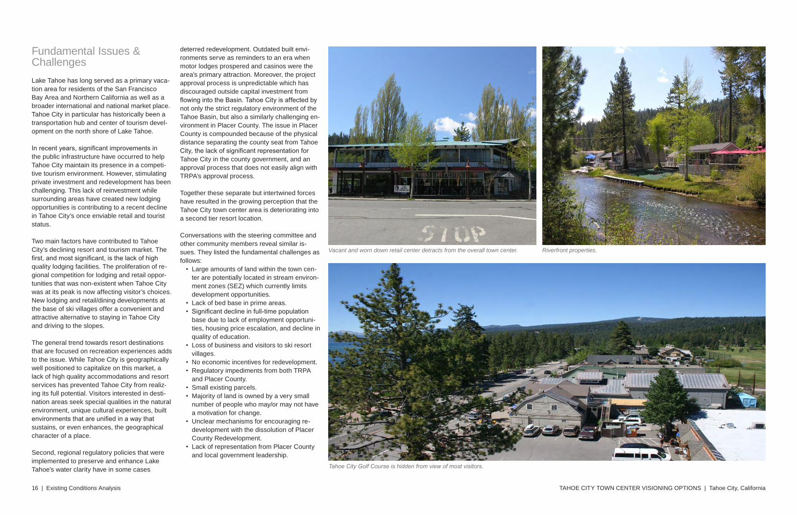
Fundamental Issues & ChallengesLake Tahoe has long served as a primary vaca-tion area for residents of the San Francisco Bay Area and Northern California as well as a broader international and national market place. Tahoe City in particular has historically been a transportation hub and center of tourism devel-opment on the north shore of Lake Tahoe.
In recent years, significant improvements in the public infrastructure have occurred to help Tahoe City maintain its presence in a competi-tive tourism environment. However, stimulating private investment and redevelopment has been challenging. This lack of reinvestment while surrounding areas have created new lodging opportunities is contributing to a recent decline in Tahoe City’s once enviable retail and tourist status.
Two main factors have contributed to Tahoe City’s declining resort and tourism market. The first, and most significant, is the lack of high quality lodging facilities. The proliferation of re-gional competition for lodging and retail oppor-tunities that was non-existent when Tahoe City was at its peak is now affecting visitor’s choices. New lodging and retail/dining developments at the base of ski villages offer a convenient and attractive alternative to staying in Tahoe City and driving to the slopes.
The general trend towards resort destinations that are focused on recreation experiences adds to the issue. While Tahoe City is geographically well positioned to capitalize on this market, a lack of high quality accommodations and resort services has prevented Tahoe City from realiz-ing its full potential. Visitors interested in desti-nation areas seek special qualities in the natural environment, unique cultural experiences, built environments that are unified in a way that sustains, or even enhances, the geographical character of a place.
Second, regional regulatory policies that were implemented to preserve and enhance Lake Tahoe’s water clarity have in some cases
deterred redevelopment. Outdated built envi-ronments serve as reminders to an era when motor lodges prospered and casinos were the area’s primary attraction. Moreover, the project approval process is unpredictable which has discouraged outside capital investment from flowing into the Basin. Tahoe City is affected by not only the strict regulatory environment of the Tahoe Basin, but also a similarly challenging en-vironment in Placer County. The issue in Placer County is compounded because of the physical distance separating the county seat from Tahoe City, the lack of significant representation for Tahoe City in the county government, and an approval process that does not easily align with TRPA’s approval process.
Together these separate but intertwined forces have resulted in the growing perception that the Tahoe City town center area is deteriorating into a second tier resort location.
Conversations with the steering committee and other community members reveal similar is-sues. They listed the fundamental challenges as follows:
• Large amounts of land within the town cen-ter are potentially located in stream environ-ment zones (SEZ) which currently limits development opportunities.
• Lack of bed base in prime areas.• Significant decline in full-time population
base due to lack of employment opportuni-ties, housing price escalation, and decline in quality of education.
• Loss of business and visitors to ski resort villages.
• No economic incentives for redevelopment.• Regulatory impediments from both TRPA
and Placer County.• Small existing parcels.• Majority of land is owned by a very small
number of people who may/or may not have a motivation for change.
• Unclear mechanisms for encouraging re-development with the dissolution of Placer County Redevelopment.
• Lack of representation from Placer County and local government leadership.
Riverfront properties.Vacant and worn down retail center detracts from the overall town center.
Tahoe City Golf Course is hidden from view of most visitors.
Existing Conditions Analysis | 17
3
Streetscape environment along SR 28 through the historic downtown or commercial core area.
The Lakeside Trail system provides great access and lake views. Competing developments in Northstar, Squaw Valley, and Truckee are reducing Tahoe City’s market share.
Grocery store located on prime, lake front property. Caltrans maintenance yard detracts from the scenic view upon town entry.

CHAPTER TITLESUBTITLE
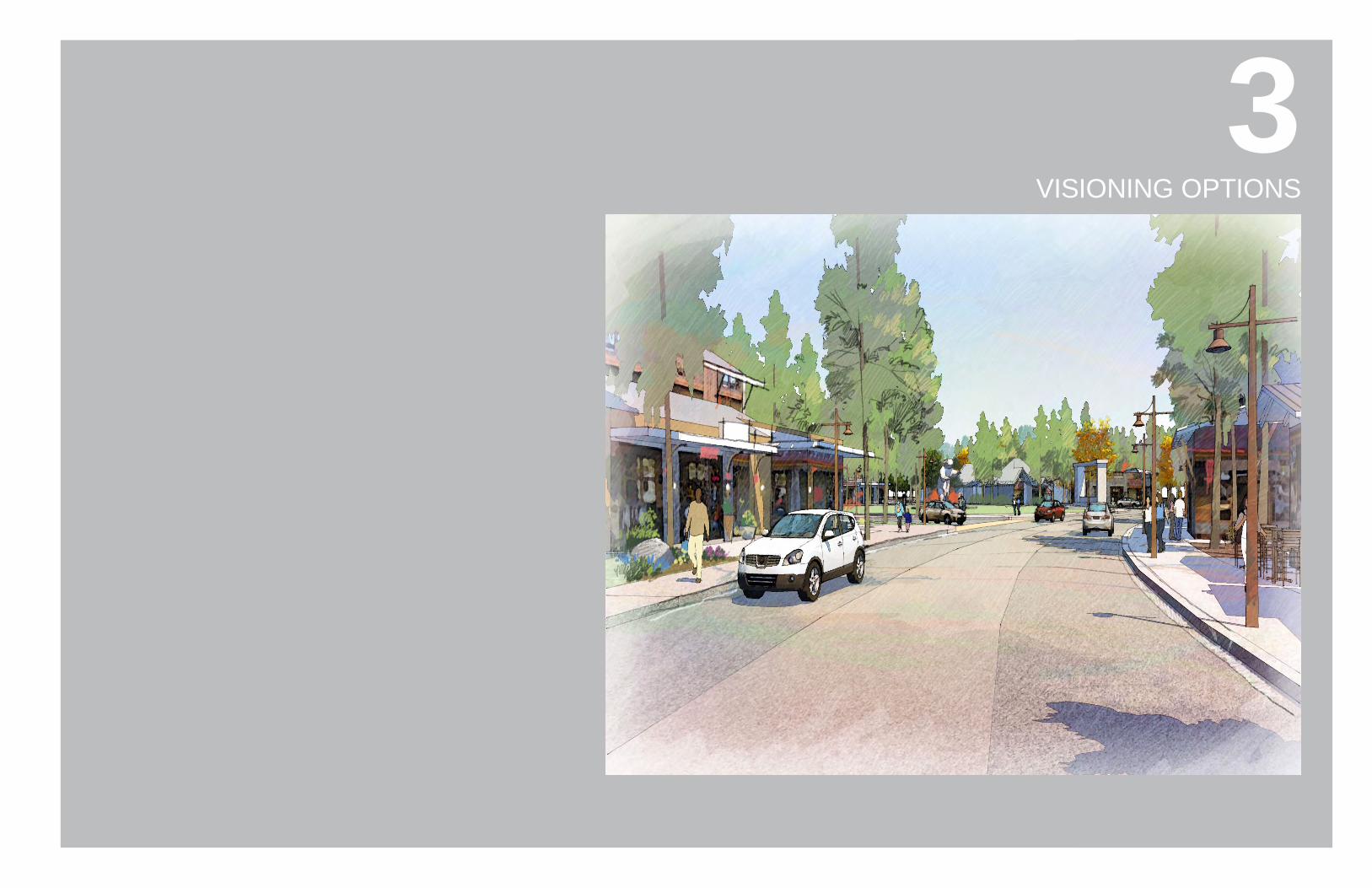
Vision Plan | 19
83VISIONING OPTIONS
TAHOE CITY TOWN CENTER VISIONING OPTIONS | Tahoe City, California20 | Vision Plan
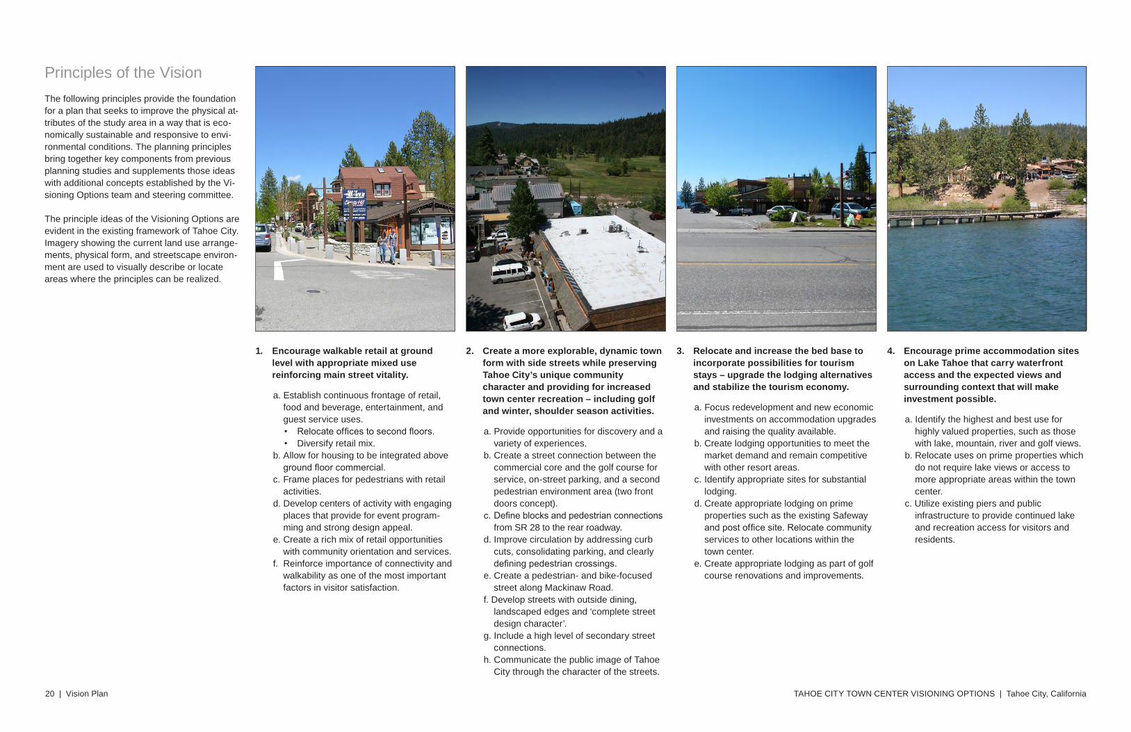
1. Encourage walkable retail at ground level with appropriate mixed use reinforcing main street vitality.
a. Establish continuous frontage of retail, food and beverage, entertainment, and guest service uses. • Relocate offices to second floors.• Diversify retail mix.
b. Allow for housing to be integrated above ground floor commercial.
c. Frame places for pedestrians with retail activities.
d. Develop centers of activity with engaging places that provide for event program-ming and strong design appeal.
e. Create a rich mix of retail opportunities with community orientation and services.
f. Reinforce importance of connectivity and walkability as one of the most important factors in visitor satisfaction.
2. Create a more explorable, dynamic town form with side streets while preserving Tahoe City’s unique community character and providing for increased town center recreation – including golf and winter, shoulder season activities.
a. Provide opportunities for discovery and a variety of experiences.
b. Create a street connection between the commercial core and the golf course for service, on-street parking, and a second pedestrian environment area (two front doors concept).
c. Define blocks and pedestrian connections from SR 28 to the rear roadway.
d. Improve circulation by addressing curb cuts, consolidating parking, and clearly defining pedestrian crossings.
e. Create a pedestrian- and bike-focused street along Mackinaw Road.
f. Develop streets with outside dining, landscaped edges and ‘complete street design character’.
g. Include a high level of secondary street connections.
h. Communicate the public image of Tahoe City through the character of the streets.
3. Relocate and increase the bed base to incorporate possibilities for tourism stays – upgrade the lodging alternatives and stabilize the tourism economy.
a. Focus redevelopment and new economic investments on accommodation upgrades and raising the quality available.
b. Create lodging opportunities to meet the market demand and remain competitive with other resort areas.
c. Identify appropriate sites for substantial lodging.
d. Create appropriate lodging on prime properties such as the existing Safeway and post office site. Relocate community services to other locations within the town center.
e. Create appropriate lodging as part of golf course renovations and improvements.
Principles of the VisionThe following principles provide the foundation for a plan that seeks to improve the physical at-tributes of the study area in a way that is eco-nomically sustainable and responsive to envi-ronmental conditions. The planning principles bring together key components from previous planning studies and supplements those ideas with additional concepts established by the Vi-sioning Options team and steering committee.
The principle ideas of the Visioning Options are evident in the existing framework of Tahoe City. Imagery showing the current land use arrange-ments, physical form, and streetscape environ-ment are used to visually describe or locate areas where the principles can be realized.
4. Encourage prime accommodation sites on Lake Tahoe that carry waterfront access and the expected views and surrounding context that will make investment possible.
a. Identify the highest and best use for highly valued properties, such as those with lake, mountain, river and golf views.
b. Relocate uses on prime properties which do not require lake views or access to more appropriate areas within the town center.
c. Utilize existing piers and public infrastructure to provide continued lake and recreation access for visitors and residents.
Vision Plan | 21
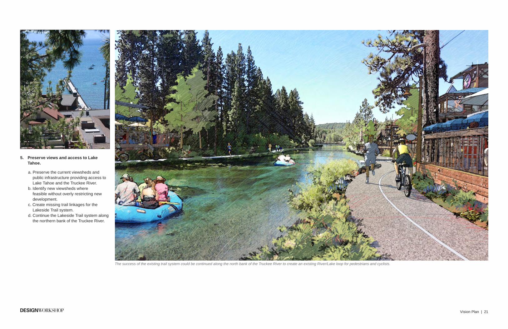
5. Preserve views and access to Lake Tahoe.
a. Preserve the current viewsheds and public infrastructure providing access to Lake Tahoe and the Truckee River.
b. Identify new viewsheds where feasible without overly restricting new development.
c. Create missing trail linkages for the Lakeside Trail system.
d. Continue the Lakeside Trail system along the northern bank of the Truckee River.
The success of the existing trail system could be continued along the north bank of the Truckee River to create an existing River/Lake loop for pedestrians and cyclists.
TAHOE CITY TOWN CENTER VISIONING OPTIONS | Tahoe City, California22 | Vision Plan
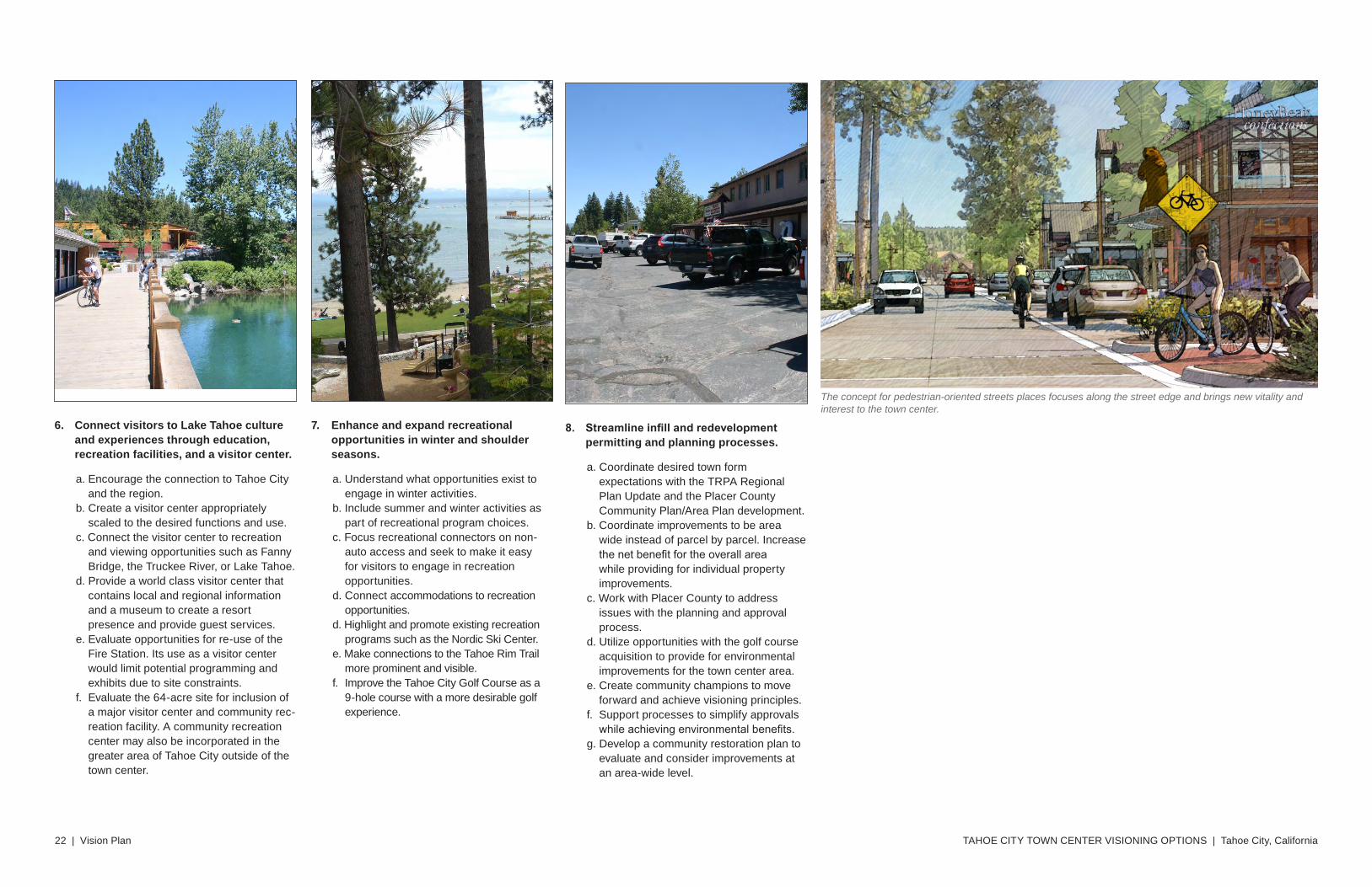
6. Connect visitors to Lake Tahoe culture and experiences through education, recreation facilities, and a visitor center.
a. Encourage the connection to Tahoe City and the region.
b. Create a visitor center appropriately scaled to the desired functions and use.
c. Connect the visitor center to recreation and viewing opportunities such as Fanny Bridge, the Truckee River, or Lake Tahoe.
d. Provide a world class visitor center that contains local and regional information and a museum to create a resort presence and provide guest services.
e. Evaluate opportunities for re-use of the Fire Station. Its use as a visitor center would limit potential programming and exhibits due to site constraints.
f. Evaluate the 64-acre site for inclusion of a major visitor center and community rec-reation facility. A community recreation center may also be incorporated in the greater area of Tahoe City outside of the town center.
7. Enhance and expand recreational opportunities in winter and shoulder seasons.
a. Understand what opportunities exist to engage in winter activities.
b. Include summer and winter activities as part of recreational program choices.
c. Focus recreational connectors on non-auto access and seek to make it easy for visitors to engage in recreation opportunities.
d. Connect accommodations to recreation opportunities.
d. Highlight and promote existing recreation programs such as the Nordic Ski Center.
e. Make connections to the Tahoe Rim Trail more prominent and visible.
f. Improve the Tahoe City Golf Course as a 9-hole course with a more desirable golf experience.
The concept for pedestrian-oriented streets places focuses along the street edge and brings new vitality and interest to the town center.
8. Streamlineinfillandredevelopmentpermitting and planning processes.
a. Coordinate desired town form expectations with the TRPA Regional Plan Update and the Placer County Community Plan/Area Plan development.
b. Coordinate improvements to be area wide instead of parcel by parcel. Increase the net benefit for the overall area while providing for individual property improvements.
c. Work with Placer County to address issues with the planning and approval process.
d. Utilize opportunities with the golf course acquisition to provide for environmental improvements for the town center area.
e. Create community champions to move forward and achieve visioning principles.
f. Support processes to simplify approvals while achieving environmental benefits.
g. Develop a community restoration plan to evaluate and consider improvements at an area-wide level.