Embed Size (px)
Citation preview

Tahquamenon River Assessment
TABLES
107

Tahquamenon River Assessment
This page was intentionally left blank.
108

Tahquamenon River Assessment
109
Table 1.–Percent of the Tahquamenon River watershed covered by various surficial materials and their permeability rates. Rates of permeability follow values given in Morris and Johnson (1967).
Surficial material Percent of
watershed soils Permeability (ft/day)·1000
High permeability soils 44.6 Coarse Glacial till 8.1 98.4 End Moraines of coarse-textured glacial till 23.3 98.4 Glacial Outwash coarse texture 13.2 98.4
Medium permeability soils 12.0 Lacustrine Sand and Gravel 32.8
Low permeability soils 42.7 Peat and Muck 37.0 3.3 Lacustrine Clay and Silt 4.9 1.6 Thin to Discontinuous over Bedrock 0.8 0.0
Water 0.6
110
Tahquamenon R
iver Assessm
ent
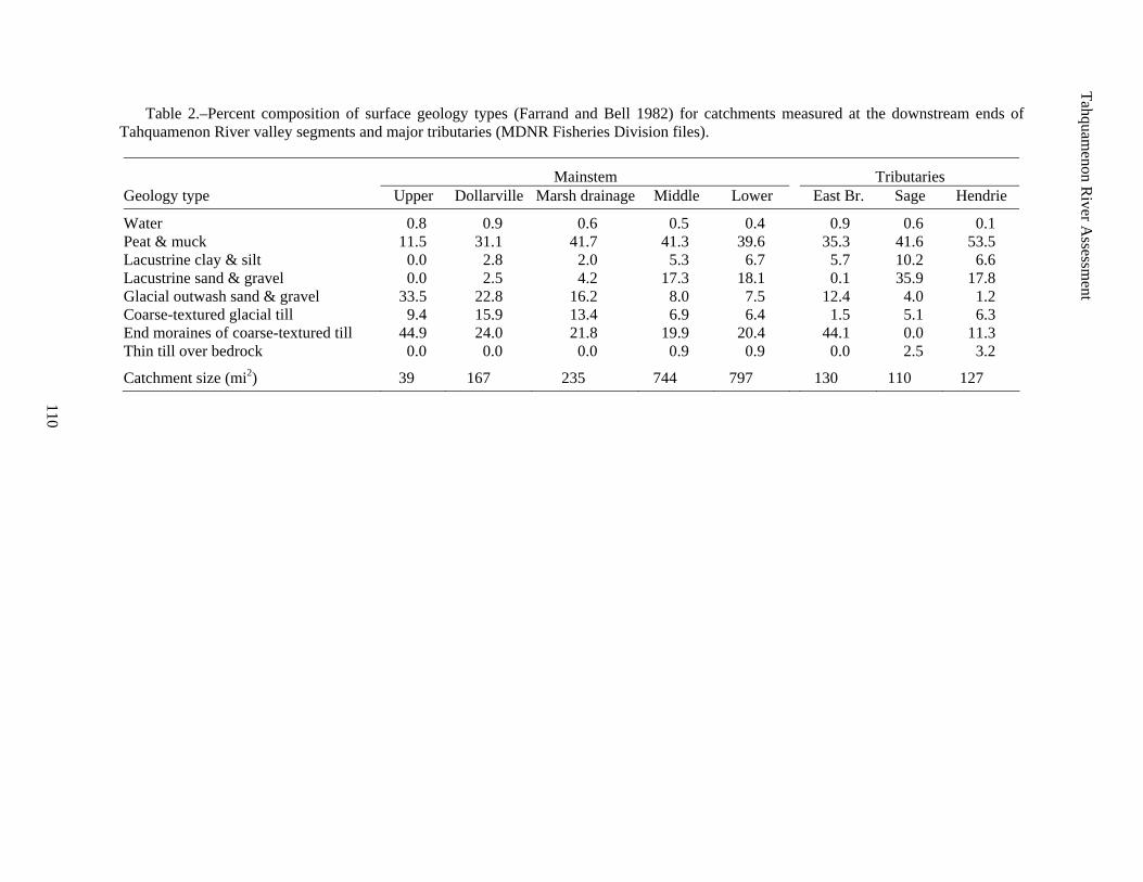
Table 2.–Percent composition of surface geology types (Farrand and Bell 1982) for catchments measured at the downstream ends of Tahquamenon River valley segments and major tributaries (MDNR Fisheries Division files).
Mainstem Tributaries Geology type Upper Dollarville Marsh drainage Middle Lower East Br. Sage Hendrie
Water 0.8 0.9 0.6 0.5 0.4 0.9 0.6 0.1 Peat & muck 11.5 31.1 41.7 41.3 39.6 35.3 41.6 53.5 Lacustrine clay & silt 0.0 2.8 2.0 5.3 6.7 5.7 10.2 6.6 Lacustrine sand & gravel 0.0 2.5 4.2 17.3 18.1 0.1 35.9 17.8 Glacial outwash sand & gravel 33.5 22.8 16.2 8.0 7.5 12.4 4.0 1.2 Coarse-textured glacial till 9.4 15.9 13.4 6.9 6.4 1.5 5.1 6.3 End moraines of coarse-textured till 44.9 24.0 21.8 19.9 20.4 44.1 0.0 11.3 Thin till over bedrock 0.0 0.0 0.0 0.9 0.9 0.0 2.5 3.2
Catchment size (mi2) 39 167 235 744 797 130 110 127
Tahquamenon River Assessment
111
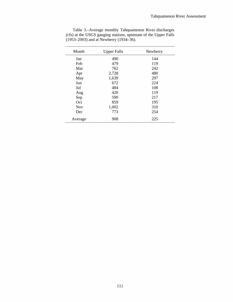
Table 3.–Average monthly Tahquamenon River discharges (cfs) at the USGS gauging stations, upstream of the Upper Falls (1953–2003) and at Newberry (1934–36).
Month Upper Falls Newberry
Jan 490 144 Feb 479 119 Mar 762 242 Apr 2,728 480 May 1,639 297 Jun 672 224 Jul 484 108 Aug 420 119 Sep 590 217 Oct 859 195 Nov 1,002 310 Dec 773 254
Average 908 225

Tahquamenon River Assessment
112
Table 4.–Seasonal flow stability attributes for the Tahquamenon River and selected Michigan river catchments of similar size as calculated from USGS streamflow data. Low-flow yield (LFY) is calculated as 90% exceedence flow/mi2/year, and the 10:90% exceedence flow ratio (10:90 ratio) is calculated as the 10% exceedence flow divided by the 90% exceedence flow. Qualitative ratings for the 10:90 ratio are: Very good–1.0–2.0; good–2.1–5.0; fair–5.1–10.0; and poor >10.0 (P. Seelbach, Michigan Department of Natural Resources, Fisheries Division, personal communication).
Watershed Location Size (mi2) LFY 10:90 ratio
Cass Dehmel Road 841 0.06 25.12 Clinton Moravian Drive 734 0.16 9.99 Huron Willow Road 807 0.25 6.12 Kalamazoo Raymond Road 824 0.35 4.30 Tahquamenon Above Upper Falls 790 0.38 6.34 Manistique UP–near Blaney 704 0.48 4.60 Manistee M-37 857 0.95 1.75 Clinton, N. Br. M59 199 0.04 45.64 Rouge Spinoza Rd. 187 0.09 16.42 Battle Creek Bellevue Cemetery 187 0.15 11.89 Black UP–near Bessemer 200 0.15 19.62 Sturgeon UP–near Foster City 237 0.18 9.31 St. Joseph 14 Mile Rd. 206 0.22 8.05 Flint, S. Br. Columbiaville Rd. 221 0.22 7.64 Sturgeon UP–near Nahma 183 0.36 6.00 Pine UP–near Rudyard 184 0.38 6.58 Tahquamenon M-123 (near Newberry) 200 0.58 3.33 Sturgeon Wolverine 198 0.80 1.86
Tahquamenon R
iver Assessm
ent
113
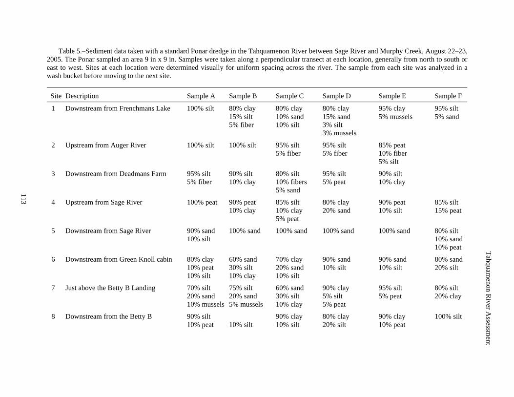
Table 5.–Sediment data taken with a standard Ponar dredge in the Tahquamenon River between Sage River and Murphy Creek, August 22–23, 2005. The Ponar sampled an area 9 in x 9 in. Samples were taken along a perpendicular transect at each location, generally from north to south or east to west. Sites at each location were determined visually for uniform spacing across the river. The sample from each site was analyzed in a wash bucket before moving to the next site.
Site Description Sample A Sample B Sample C Sample D Sample E Sample F
1 Downstream from Frenchmans Lake 100% silt 80% clay 80% clay 80% clay 95% clay 95% silt 15% silt 10% sand 15% sand 5% mussels 5% sand 5% fiber 10% silt 3% silt 3% mussels
2 Upstream from Auger River 100% silt 100% silt 95% silt 95% silt 85% peat 5% fiber 5% fiber 10% fiber 5% silt
3 Downstream from Deadmans Farm 95% silt 90% silt 80% silt 95% silt 90% silt 5% fiber 10% clay 10% fibers 5% peat 10% clay 5% sand
4 Upstream from Sage River 100% peat 90% peat 85% silt 80% clay 90% peat 85% silt 10% clay 10% clay 20% sand 10% silt 15% peat 5% peat
5 Downstream from Sage River 90% sand 100% sand 100% sand 100% sand 100% sand 80% silt 10% silt 10% sand 10% peat
6 Downstream from Green Knoll cabin 80% clay 60% sand 70% clay 90% sand 90% sand 80% sand 10% peat 30% silt 20% sand 10% silt 10% silt 20% silt 10% silt 10% clay 10% silt
7 Just above the Betty B Landing 70% silt 75% silt 60% sand 90% clay 95% silt 80% silt 20% sand 20% sand 30% silt 5% silt 5% peat 20% clay 10% mussels 5% mussels 10% clay 5% peat
8 Downstream from the Betty B 90% silt 90% clay 80% clay 90% clay 100% silt 10% peat 10% silt 10% silt 20% silt 10% peat
Tahquamenon R
iver Assessm
ent
114
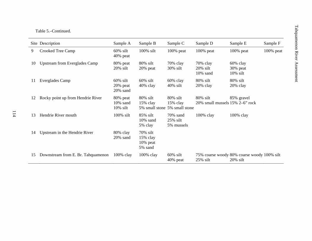
Table 5.–Continued.
Site Description Sample A Sample B Sample C Sample D Sample E Sample F
9 Crooked Tree Camp 60% silt 100% silt 100% peat 100% peat 100% peat 100% peat 40% peat
10 Upstream from Everglades Camp 80% peat 80% silt 70% clay 70% clay 60% clay 20% silt 20% peat 30% silt 20% silt 30% peat 10% sand 10% silt
11 Everglades Camp 60% silt 60% silt 60% clay 80% silt 80% silt 20% peat 40% clay 40% silt 20% clay 20% clay 20% sand
12 Rocky point up from Hendrie River 80% peat 80% silt 80% silt 80% silt 85% gravel 10% sand 15% clay 15% clay 20% small mussels 15% 2–6” rock 10% silt 5% small stone 5% small stone
13 Hendrie River mouth 100% silt 85% silt 70% sand 100% clay 100% clay 10% sand 25% silt 5% clay 5% mussels
14 Upstream in the Hendrie River 80% clay 70% silt 20% sand 15% clay 10% peat 5% sand
15 Downstream from E. Br. Tahquamenon 100% clay 100% clay 60% silt 75% coarse woody 80% coarse woody 100% silt 40% peat 25% silt 20% silt
Tahquamenon River Assessment
115
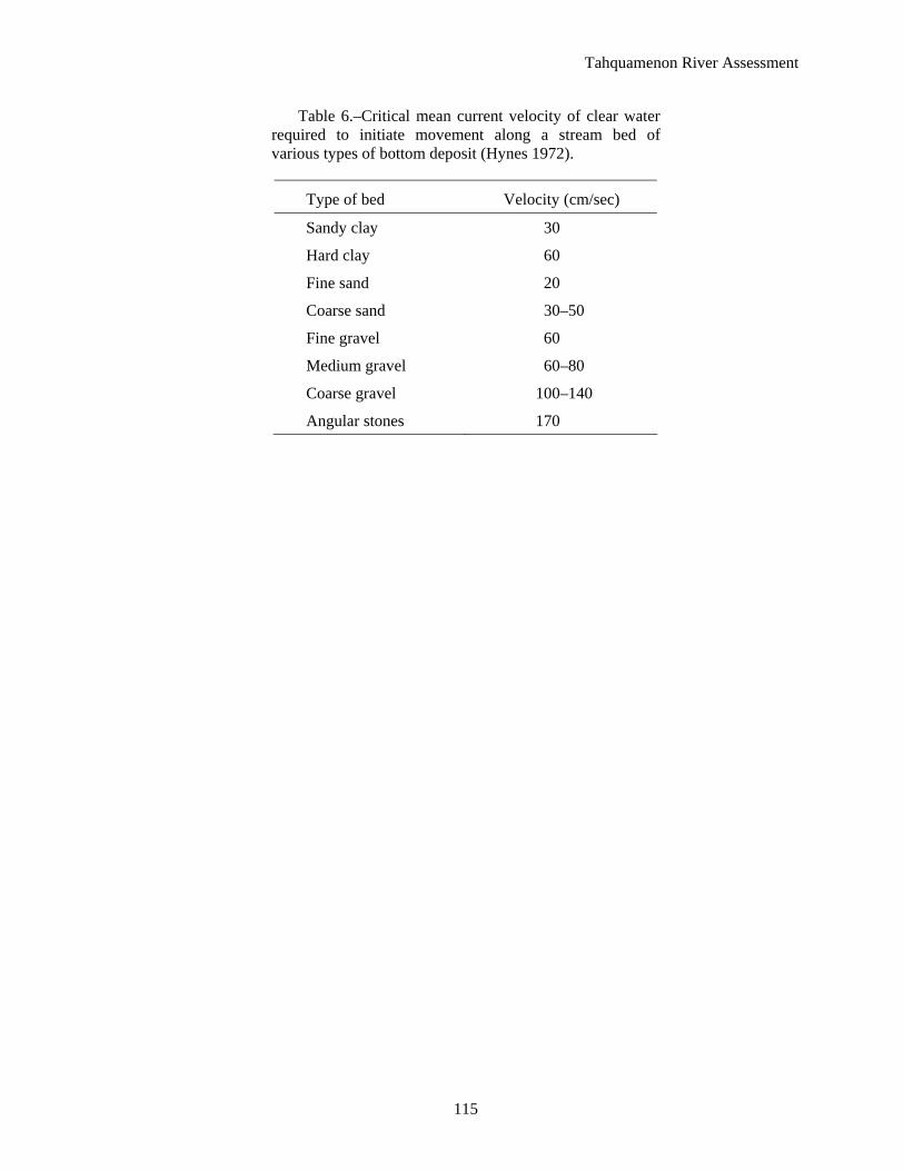
Table 6.–Critical mean current velocity of clear water required to initiate movement along a stream bed of various types of bottom deposit (Hynes 1972).
Type of bed Velocity (cm/sec)
Sandy clay 30
Hard clay 60
Fine sand 20
Coarse sand 30–50
Fine gravel 60
Medium gravel 60–80
Coarse gravel 100–140
Angular stones 170
Tahquamenon River Assessment
116
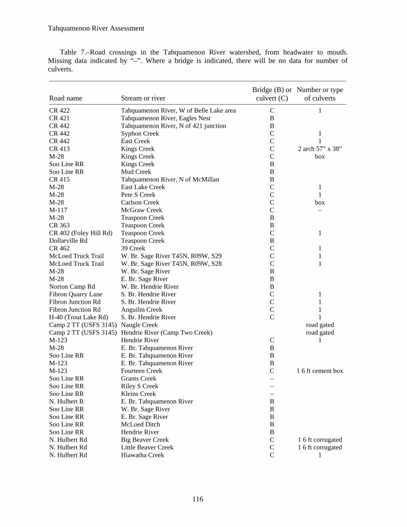
Table 7.–Road crossings in the Tahquamenon River watershed, from headwater to mouth. Missing data indicated by “–”. Where a bridge is indicated, there will be no data for number of culverts.
Road name Stream or river Bridge (B) or
culvert (C) Number or type
of culverts
CR 422 Tahquamenon River, W of Belle Lake area C 1 CR 421 Tahquamenon River, Eagles Nest B CR 442 Tahquamenon River, N of 421 junction B CR 442 Syphon Creek C 1 CR 442 East Creek C 1 CR 413 Kings Creek C 2 arch 57” x 38” M-28 Kings Creek C box Soo Line RR Kings Creek B Soo Line RR Mud Creek B CR 415 Tahquamenon River, N of McMillan B M-28 East Lake Creek C 1 M-28 Pete S Creek C 1 M-28 Carlson Creek C box M-117 McGraw Creek C – M-28 Teaspoon Creek B CR 363 Teaspoon Creek B CR 402 (Foley Hill Rd) Teaspoon Creek C 1 Dollarville Rd Teaspoon Creek B CR 462 39 Creek C 1 McLoed Truck Trail W. Br. Sage River T45N, R09W, S29 C 1 McLoed Truck Trail W. Br. Sage River T45N, R09W, S28 C 1 M-28 W. Br. Sage River B M-28 E. Br. Sage River B Norton Camp Rd W. Br. Hendrie River B Fibron Quarry Lane S. Br. Hendrie River C 1 Fibron Junction Rd S. Br. Hendrie River C 1 Fibron Junction Rd Anguilm Creek C 1 H-40 (Trout Lake Rd) S. Br. Hendrie River C 1 Camp 2 TT (USFS 3145) Naugle Creek road gated Camp 2 TT (USFS 3145) Hendrie River (Camp Two Creek) road gated M-123 Hendrie River C 1 M-28 E. Br. Tahquamenon River B Soo Line RR E. Br. Tahquamenon River B M-123 E. Br. Tahquamenon River B M-123 Fourteen Creek C 1 6 ft cement boxSoo Line RR Grants Creek – Soo Line RR Riley S Creek – Soo Line RR Kleins Creek – N. Hulbert R E. Br. Tahquamenon River B Soo Line RR W. Br. Sage River B Soo Line RR E. Br. Sage River B Soo Line RR McLoed Ditch B Soo Line RR Hendrie River B N. Hulbert Rd Big Beaver Creek C 1 6 ft corrugated N. Hulbert Rd Little Beaver Creek C 1 6 ft corrugated N. Hulbert Rd Hiawatha Creek C 1
Tahquamenon River Assessment
117
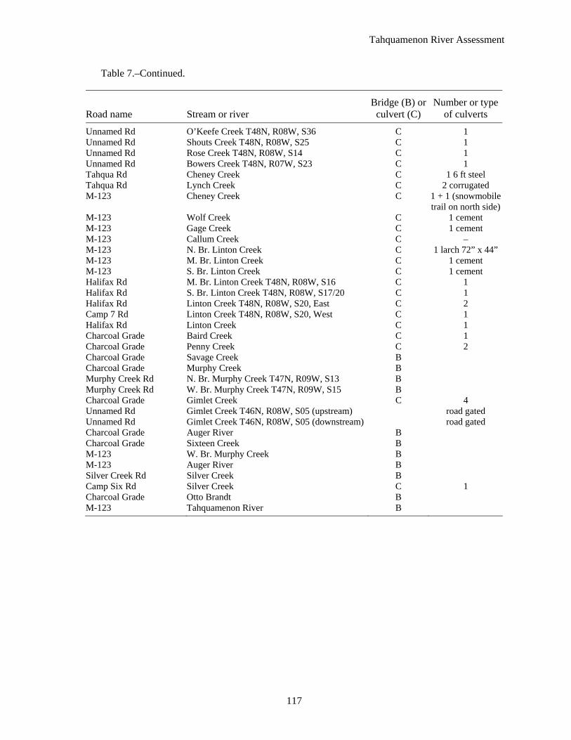
Table 7.–Continued.
Road name Stream or river Bridge (B) or
culvert (C) Number or type
of culverts
Unnamed Rd O’Keefe Creek T48N, R08W, S36 C 1 Unnamed Rd Shouts Creek T48N, R08W, S25 C 1 Unnamed Rd Rose Creek T48N, R08W, S14 C 1 Unnamed Rd Bowers Creek T48N, R07W, S23 C 1 Tahqua Rd Cheney Creek C 1 6 ft steel Tahqua Rd Lynch Creek C 2 corrugated M-123 Cheney Creek C 1 + 1 (snowmobile
trail on north side)M-123 Wolf Creek C 1 cement M-123 Gage Creek C 1 cement M-123 Callum Creek C – M-123 N. Br. Linton Creek C 1 larch 72” x 44” M-123 M. Br. Linton Creek C 1 cement M-123 S. Br. Linton Creek C 1 cement Halifax Rd M. Br. Linton Creek T48N, R08W, S16 C 1 Halifax Rd S. Br. Linton Creek T48N, R08W, S17/20 C 1 Halifax Rd Linton Creek T48N, R08W, S20, East C 2 Camp 7 Rd Linton Creek T48N, R08W, S20, West C 1 Halifax Rd Linton Creek C 1 Charcoal Grade Baird Creek C 1 Charcoal Grade Penny Creek C 2 Charcoal Grade Savage Creek B Charcoal Grade Murphy Creek B Murphy Creek Rd N. Br. Murphy Creek T47N, R09W, S13 B Murphy Creek Rd W. Br. Murphy Creek T47N, R09W, S15 B Charcoal Grade Gimlet Creek C 4 Unnamed Rd Gimlet Creek T46N, R08W, S05 (upstream) road gated Unnamed Rd Gimlet Creek T46N, R08W, S05 (downstream) road gated Charcoal Grade Auger River B Charcoal Grade Sixteen Creek B M-123 W. Br. Murphy Creek B M-123 Auger River B Silver Creek Rd Silver Creek B Camp Six Rd Silver Creek C 1 Charcoal Grade Otto Brandt B M-123 Tahquamenon River B

Tahquamenon River Assessment
118
Table 8.–Percent composition of land use types for catchments measured at the downstream ends of Tahquamenon River valley segments and major tributaries.
Mainstem Tributaries Land use type Upper Dollarville Marsh drainage Middle Lower East Br. Sage Hendrie
Water 2.7 2.9 2.7 2.4 2.5 2.9 1.4 2.2 Urban 0.0 0.1 0.4 0.1 0.1 0.1 0.1 0.0 Barren 0.0 0.0 0.0 0.0 0.0 0.0 0.0 0.0 Forest 68.1 53.1 45.6 45.0 46.2 59.2 31.7 38.5 Grassland 2.6 3.3 3.3 1.7 1.7 0.4 3.1 0.8 Agriculture, pasture, and recreational grass 1.0 3.5 3.2 1.5 1.4 0.6 2.0 0.3 Wetland 25.1 36.9 44.7 49.0 47.8 35.9 61.7 58.2

119
Tahquamenon R
iver Assessm
ent
Table 9.–Tributary stream characteristics in the Tahquamenon River watershed, including length (mi), length of designated trout stream (mi), average gradient (ft/mi), source, elevation above Lake Superior level (ft), and mouth description.
Name of stream Length
(mi) Trout (mi)
Gradient (ft/mi) Source
Mouth elev. (ft) Mouth description
39 Creek 2.5 2.5 21.4 Upland spring 704 Tahquamenon River Anchard Creek 1.2 0 147.5 Upland spring 701 Tahquamenon River Anguim Creek 1 1 1.0 Previous Fibron Pond 812 S Br. Hendrie River Atwood Creek 0.9 0 36.7 Upland spring 702 Murphy Creek Auger River 15 6.1 6.5 Cleveland Cliffs Lake 705 Tahquamenon River Baird Creek 3.1 3.1 34.5 Marsh 702 Tahquamenon River Basnau Creek 2.9 2.9 13.4 Marsh 704 Hendrie River Big Beaver Creek 2.6 2.6 20.0 Marsh 706 E Br Tahquamenon R Big Ditch 4.5 4.5 4.7 Marsh 705 West Br Sage River Bowers Creek 1.8 1.8 82.2 Upland spring 602 Tahquamenon River Callum Creek 1.4 0 31.4 Marsh 701 Tahquamenon River Carlson Creek 2.6 2.6 3.1 Kaks Lake 717 Teaspoon Creek Cheney Creek 5.7 5.7 18.4 Marsh 601 Tahquamenon River Creek #14 4.4 4.4 8.2 Marsh 714 E Br Tahquamenon R Creek #8 3.2 3.2 22.5 Upland spring 797 E Br Tahquamenon R E Br. Sage River 13.7 13.7 9.5 Marsh 705 Sage River E Br. Tahquamenon R 23.5 19.5 8.5 Marsh 702 Tahquamenon River East Creek 4.6 4.6 21.1 Upland spring 713 Tahquamenon River East Lake Creek 2.9 2.9 28.3 East Lake, Luce Co 714 Teaspoon Creek First Creek 3.9 3.9 25.4 Upland spring 716 West Br Sage River Freeman Creek E 0.8 0 47.5 Upland spring 702 Tahquamenon River Freeman Creek W 1.9 0 12.6 Marsh 702 Tahquamenon River Gage Creek 0.5 0 82.0 Upland spring 701 Tahquamenon River Gimlet Creek 8.4 0 6.3 Marsh 704 Tahquamenon River Grants Creek 2.9 2.9 29.0 Upland spring 716 E Br Tahquamenon R Hendrie River 24.5 0 6.4 Upland spring 702 Tahquamenon River Hiawatha Creek 1.6 1.6 30.0 Upland spring 702 Tahquamenon River Kings Creek 2.1 2.1 9.0 Marsh 721 Tahquamenon River Kleins Creek 1.7 1.7 6.5 Marsh 726 Rileys Creek
Tahquamenon R
iver Assessm
ent
120
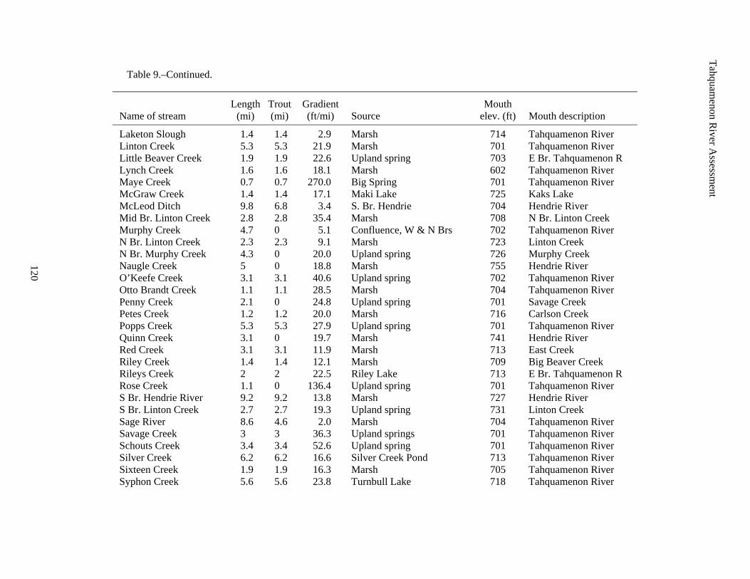
Table 9.–Continued.
Name of stream Length
(mi) Trout (mi)
Gradient (ft/mi) Source
Mouth elev. (ft) Mouth description
Laketon Slough 1.4 1.4 2.9 Marsh 714 Tahquamenon River Linton Creek 5.3 5.3 21.9 Marsh 701 Tahquamenon River Little Beaver Creek 1.9 1.9 22.6 Upland spring 703 E Br. Tahquamenon R Lynch Creek 1.6 1.6 18.1 Marsh 602 Tahquamenon River Maye Creek 0.7 0.7 270.0 Big Spring 701 Tahquamenon River McGraw Creek 1.4 1.4 17.1 Maki Lake 725 Kaks Lake McLeod Ditch 9.8 6.8 3.4 S. Br. Hendrie 704 Hendrie River Mid Br. Linton Creek 2.8 2.8 35.4 Marsh 708 N Br. Linton Creek Murphy Creek 4.7 0 5.1 Confluence, W & N Brs 702 Tahquamenon River N Br. Linton Creek 2.3 2.3 9.1 Marsh 723 Linton Creek N Br. Murphy Creek 4.3 0 20.0 Upland spring 726 Murphy Creek Naugle Creek 5 0 18.8 Marsh 755 Hendrie River O’Keefe Creek 3.1 3.1 40.6 Upland spring 702 Tahquamenon River Otto Brandt Creek 1.1 1.1 28.5 Marsh 704 Tahquamenon River Penny Creek 2.1 0 24.8 Upland spring 701 Savage Creek Petes Creek 1.2 1.2 20.0 Marsh 716 Carlson Creek Popps Creek 5.3 5.3 27.9 Upland spring 701 Tahquamenon River Quinn Creek 3.1 0 19.7 Marsh 741 Hendrie River Red Creek 3.1 3.1 11.9 Marsh 713 East Creek Riley Creek 1.4 1.4 12.1 Marsh 709 Big Beaver Creek Rileys Creek 2 2 22.5 Riley Lake 713 E Br. Tahquamenon R Rose Creek 1.1 0 136.4 Upland spring 701 Tahquamenon River S Br. Hendrie River 9.2 9.2 13.8 Marsh 727 Hendrie River S Br. Linton Creek 2.7 2.7 19.3 Upland spring 731 Linton Creek Sage River 8.6 4.6 2.0 Marsh 704 Tahquamenon River Savage Creek 3 3 36.3 Upland springs 701 Tahquamenon River Schouts Creek 3.4 3.4 52.6 Upland spring 701 Tahquamenon River Silver Creek 6.2 6.2 16.6 Silver Creek Pond 713 Tahquamenon River Sixteen Creek 1.9 1.9 16.3 Marsh 705 Tahquamenon River Syphon Creek 5.6 5.6 23.8 Turnbull Lake 718 Tahquamenon River
121
Tahquamenon R
iver Assessm
ent
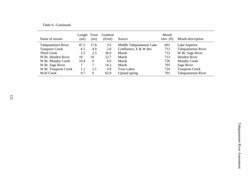
Table 9.–Continued.
Name of stream Length
(mi) Trout (mi)
Gradient (ft/mi) Source
Mouth elev. (ft) Mouth description
Tahquamenon River 87.3 17.8 3.2 Middle Tahquamenon Lake 601 Lake Superior Teaspoon Creek 6.1 4.9 2.0 Confluence, E & W Brs 712 Tahquamenon River Third Creek 2.5 2.5 36.0 Marsh 713 W Br. Sage River W Br. Hendrie River 10 10 12.7 Marsh 713 Hendrie River W Br. Murphy Creek 10.4 0 6.0 Marsh 726 Murphy Creek W Br. Sage River 7 7 14.3 Marsh 705 Sage River W Br. Teaspoon Creek 1.1 1.1 0.9 Twin Lakes 724 Teaspoon Creek Wolf Creek 0.7 0 62.9 Upland spring 701 Tahquamenon River
Tahquamenon R
iver Assessm
ent
122
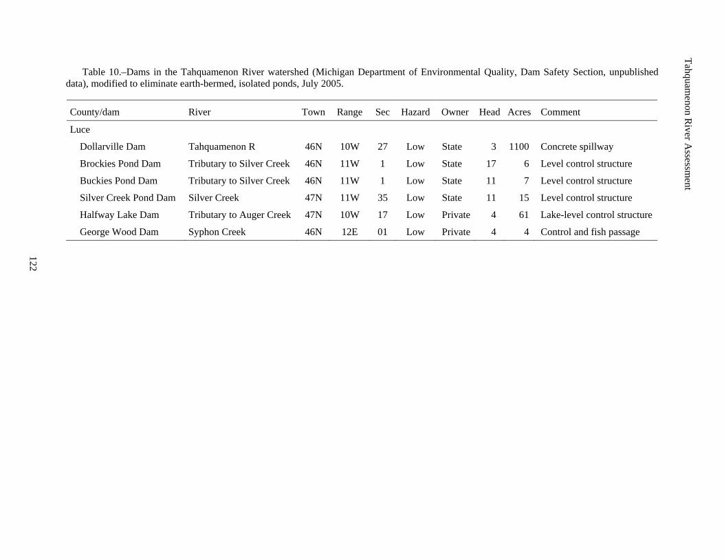
Table 10.–Dams in the Tahquamenon River watershed (Michigan Department of Environmental Quality, Dam Safety Section, unpublished data), modified to eliminate earth-bermed, isolated ponds, July 2005.
County/dam River Town Range Sec Hazard Owner Head Acres Comment
Luce
Dollarville Dam Tahquamenon R 46N 10W 27 Low State 3 1100 Concrete spillway
Brockies Pond Dam Tributary to Silver Creek 46N 11W 1 Low State 17 6 Level control structure
Buckies Pond Dam Tributary to Silver Creek 46N 11W 1 Low State 11 7 Level control structure
Silver Creek Pond Dam Silver Creek 47N 11W 35 Low State 11 15 Level control structure
Halfway Lake Dam Tributary to Auger Creek 47N 10W 17 Low Private 4 61 Lake-level control structure
George Wood Dam Syphon Creek 46N 12E 01 Low Private 4 4 Control and fish passage
Tahquamenon River Assessment
123
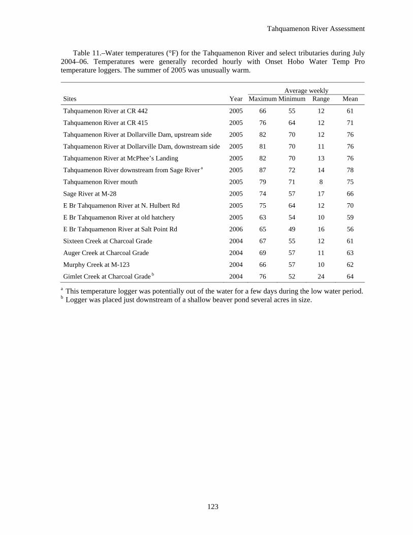
Table 11.–Water temperatures (°F) for the Tahquamenon River and select tributaries during July 2004–06. Temperatures were generally recorded hourly with Onset Hobo Water Temp Pro temperature loggers. The summer of 2005 was unusually warm.
Average weekly Sites Year Maximum Minimum Range Mean
Tahquamenon River at CR 442 2005 66 55 12 61
Tahquamenon River at CR 415 2005 76 64 12 71
Tahquamenon River at Dollarville Dam, upstream side 2005 82 70 12 76
Tahquamenon River at Dollarville Dam, downstream side 2005 81 70 11 76
Tahquamenon River at McPhee’s Landing 2005 82 70 13 76
Tahquamenon River downstream from Sage River a 2005 87 72 14 78
Tahquamenon River mouth 2005 79 71 8 75
Sage River at M-28 2005 74 57 17 66
E Br Tahquamenon River at N. Hulbert Rd 2005 75 64 12 70
E Br Tahquamenon River at old hatchery 2005 63 54 10 59
E Br Tahquamenon River at Salt Point Rd 2006 65 49 16 56
Sixteen Creek at Charcoal Grade 2004 67 55 12 61
Auger Creek at Charcoal Grade 2004 69 57 11 63
Murphy Creek at M-123 2004 66 57 10 62
Gimlet Creek at Charcoal Grade b 2004 76 52 24 64
a This temperature logger was potentially out of the water for a few days during the low water period. b Logger was placed just downstream of a shallow beaver pond several acres in size.
Tahquamenon River Assessment
124
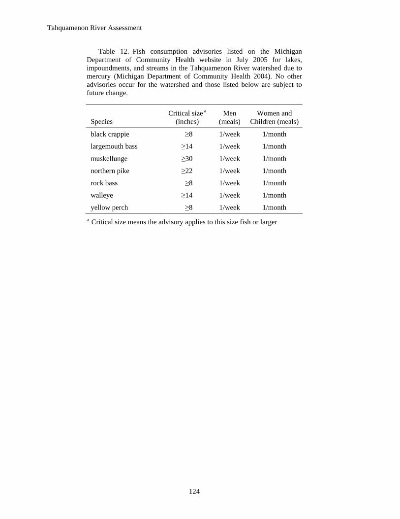
Table 12.–Fish consumption advisories listed on the Michigan Department of Community Health website in July 2005 for lakes, impoundments, and streams in the Tahquamenon River watershed due to mercury (Michigan Department of Community Health 2004). No other advisories occur for the watershed and those listed below are subject to future change.
Species Critical size a
(inches) Men
(meals) Women and
Children (meals)
black crappie ≥8 1/week 1/month
largemouth bass ≥14 1/week 1/month
muskellunge ≥30 1/week 1/month
northern pike ≥22 1/week 1/month
rock bass ≥8 1/week 1/month
walleye ≥14 1/week 1/month
yellow perch ≥8 1/week 1/month a Critical size means the advisory applies to this size fish or larger
Tahquamenon River Assessment
125
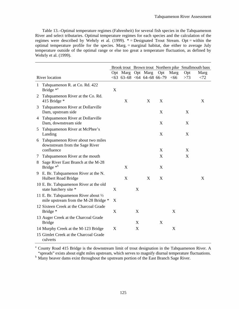
Table 13.–Optimal temperature regimes (Fahrenheit) for several fish species in the Tahquamenon River and select tributaries. Optimal temperature regimes for each species and the calculation of the regimes were described by Wehrly et al. (1999). * = Designated Trout Stream. Opt = within the optimal temperature profile for the species. Marg. = marginal habitat, due either to average July temperature outside of the optimal range or else too great a temperature fluctuation, as defined by Wehrly et al. (1999).
Brook trout Brown trout Northern pike Smallmouth bass
River location Opt <63
Marg 63–68
Opt <64
Marg 64–68
Opt66–79
Marg <66
Opt >73
Marg <72
1 Tahquamenon R. at Co. Rd. 422 Bridge *a X
2 Tahquamenon River at the Co. Rd. 415 Bridge * X X X X
3 Tahquamenon River at Dollarville Dam, upstream side X X
4 Tahquamenon River at Dollarville Dam, downstream side X X
5 Tahquamenon River at McPhee’s Landing X X
6 Tahquamenon River about two miles downstream from the Sage River confluence X X
7 Tahquamenon River at the mouth X X 8 Sage River East Branch at the M-28
Bridge *b X X 9 E. Br. Tahquamenon River at the N.
Hulbert Road Bridge X X X X 10 E. Br. Tahquamenon River at the old
state hatchery site * X X 11 E. Br. Tahquamenon River about ½
mile upstream from the M-28 Bridge * X 12 Sixteen Creek at the Charcoal Grade
Bridge * X X X 13 Auger Creek at the Charcoal Grade
Bridge X X 14 Murphy Creek at the M-123 Bridge X X X 15 Gimlet Creek at the Charcoal Grade
culverts a County Road 415 Bridge is the downstream limit of trout designation in the Tahquamenon River. A
“spreads” exists about eight miles upstream, which serves to magnify diurnal temperature fluctuations. b Many beaver dams exist throughout the upstream portion of the East Branch Sage River.
Tahquamenon River Assessment
126
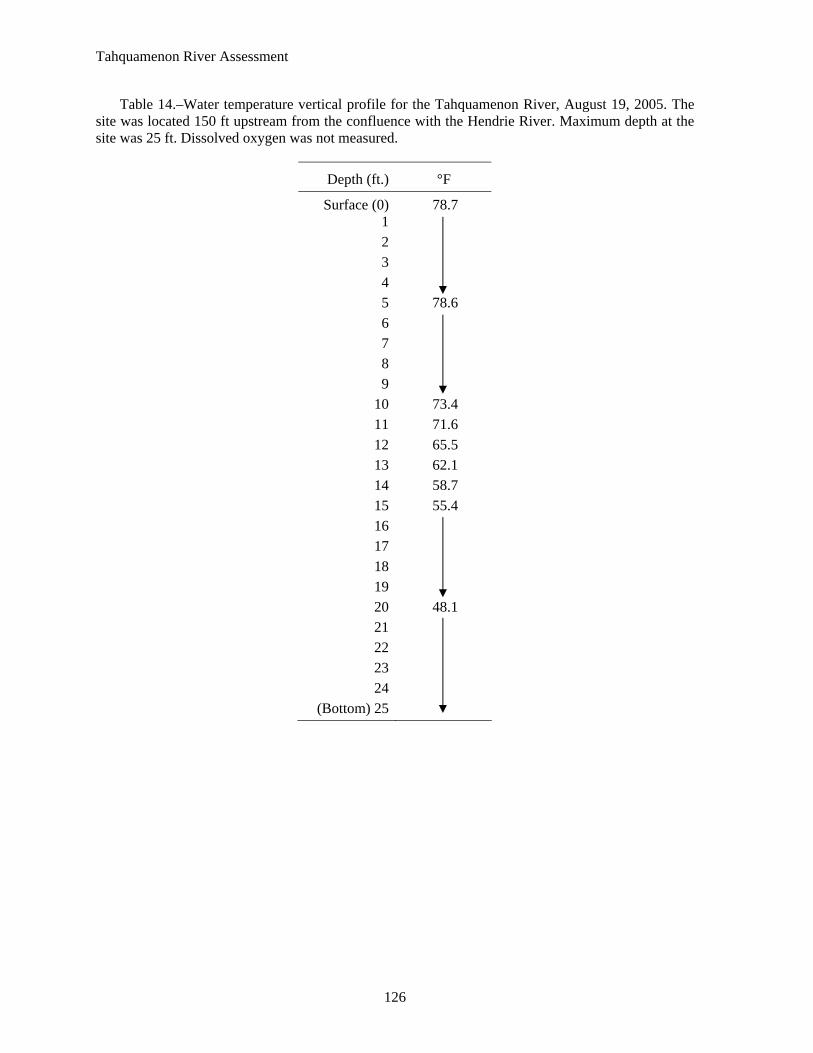
Table 14.–Water temperature vertical profile for the Tahquamenon River, August 19, 2005. The site was located 150 ft upstream from the confluence with the Hendrie River. Maximum depth at the site was 25 ft. Dissolved oxygen was not measured.
Depth (ft.) °F
Surface (0) 78.7 1 2 3 4 5 78.6 6 7 8 9
10 73.4 11 71.6 12 65.5 13 62.1 14 58.7 15 55.4 16 17 18 19 20 48.1 21 22 23 24
(Bottom) 25
Tahquamenon River Assessment
127
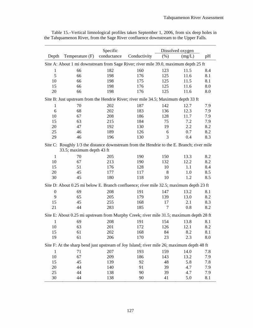
Table 15.–Vertical limnological profiles taken September 1, 2006, from six deep holes in the Tahquamenon River, from the Sage River confluence downstream to the Upper Falls.
Specific Dissolved oxygen Depth Temperature (F) conductance Conductivity (%) (mg/L) pH
Site A: About 1 mi downstream from Sage River; river mile 39.0, maximum depth 25 ft 1 66 182 160 123 11.5 8.4 5 66 198 176 125 11.6 8.1
10 66 198 175 125 11.5 8.1 15 66 198 176 125 11.6 8.0 20 66 198 176 125 11.6 8.0
Site B: Just upstream from the Hendrie River; river mile 34.5; Maximum depth 33 ft 1 70 202 187 142 12.7 7.9 6 68 202 183 136 12.3 7.9
10 67 208 186 128 11.7 7.9 15 63 215 184 75 7.2 7.9 20 47 192 130 19 2.2 8.2 25 46 189 126 6 0.7 8.2 29 46 196 130 3 0.4 8.3
Site C: Roughly 1/3 the distance downstream from the Hendrie to the E. Branch; river mile 33.5; maximum depth 43 ft
1 70 205 190 150 13.3 8.2 10 67 213 190 132 12.2 8.2 15 51 176 128 10 1.1 8.4 20 45 177 117 8 1.0 8.5 30 45 180 118 10 1.2 8.5
Site D: About 0.25 mi below E. Branch confluence; river mile 32.5; maximum depth 23 ft 0 69 208 191 147 13.2 8.1 9 65 205 179 139 13.0 8.2
15 45 255 168 17 2.1 8.3 21 44 283 185 7 0.8 8.2
Site E: About 0.25 mi upstream from Murphy Creek; river mile 31.5; maximum depth 28 ft 1 69 208 191 154 13.8 8.1
10 63 201 172 126 12.1 8.2 15 61 202 168 84 8.2 8.1 19 61 206 170 23 2.3 8.0
Site F: At the sharp bend just upstream of Joy Island; river mile 26; maximum depth 48 ft 1 71 207 193 159 14.0 7.8
10 67 209 186 143 13.2 7.9 15 45 139 92 48 5.8 7.8 20 44 140 91 39 4.7 7.9 25 44 138 90 39 4.7 7.9 30 44 138 90 41 5.0 8.1
Tahquamenon R
iver Assessm
ent
128
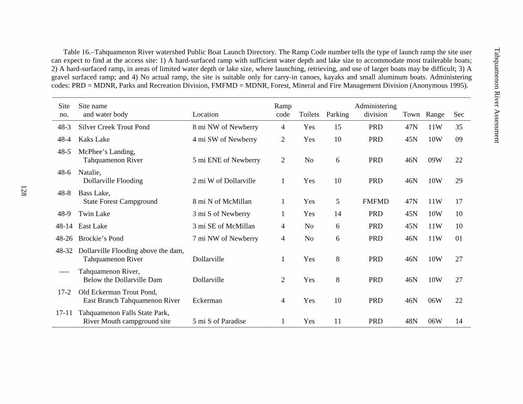
Table 16.–Tahquamenon River watershed Public Boat Launch Directory. The Ramp Code number tells the type of launch ramp the site user can expect to find at the access site: 1) A hard-surfaced ramp with sufficient water depth and lake size to accommodate most trailerable boats; 2) A hard-surfaced ramp, in areas of limited water depth or lake size, where launching, retrieving, and use of larger boats may be difficult; 3) A gravel surfaced ramp; and 4) No actual ramp, the site is suitable only for carry-in canoes, kayaks and small aluminum boats. Administering codes: PRD = MDNR, Parks and Recreation Division, FMFMD = MDNR, Forest, Mineral and Fire Management Division (Anonymous 1995).
Site no.
Site name and water body Location
Ramp code Toilets Parking
Administering division Town Range Sec
48-3 Silver Creek Trout Pond 8 mi NW of Newberry 4 Yes 15 PRD 47N 11W 35
48-4 Kaks Lake 4 mi SW of Newberry 2 Yes 10 PRD 45N 10W 09
48-5 McPhee’s Landing, Tahquamenon River 5 mi ENE of Newberry 2 No 6 PRD 46N 09W 22
48-6 Natalie, Dollarville Flooding 2 mi W of Dollarville 1 Yes 10 PRD 46N 10W 29
48-8 Bass Lake, State Forest Campground 8 mi N of McMillan 1 Yes 5 FMFMD 47N 11W 17
48-9 Twin Lake 3 mi S of Newberry 1 Yes 14 PRD 45N 10W 10
48-14 East Lake 3 mi SE of McMillan 4 No 6 PRD 45N 11W 10
48-26 Brockie’s Pond 7 mi NW of Newberry 4 No 6 PRD 46N 11W 01
48-32 Dollarville Flooding above the dam, Tahquamenon River Dollarville 1 Yes 8 PRD 46N 10W 27
---- Tahquamenon River, Below the Dollarville Dam Dollarville 2 Yes 8 PRD 46N 10W 27
17-2 Old Eckerman Trout Pond, East Branch Tahquamenon River Eckerman 4 Yes 10 PRD 46N 06W 22
17-11 Tahquamenon Falls State Park, River Mouth campground site 5 mi S of Paradise 1 Yes 11 PRD 48N 06W 14
Tahquamenon River Assessment
129
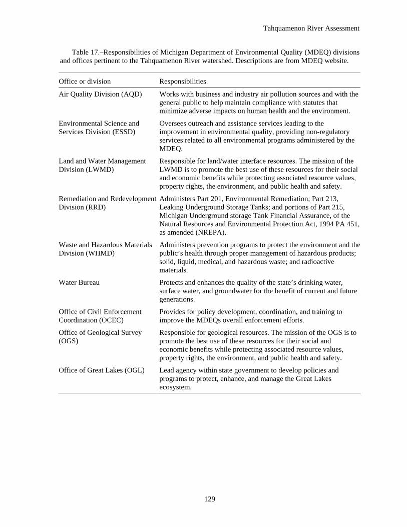
Table 17.–Responsibilities of Michigan Department of Environmental Quality (MDEQ) divisions and offices pertinent to the Tahquamenon River watershed. Descriptions are from MDEQ website.
Office or division Responsibilities
Air Quality Division (AQD) Works with business and industry air pollution sources and with the general public to help maintain compliance with statutes that minimize adverse impacts on human health and the environment.
Environmental Science and Services Division (ESSD)
Oversees outreach and assistance services leading to the improvement in environmental quality, providing non-regulatory services related to all environmental programs administered by the MDEQ.
Land and Water Management Division (LWMD)
Responsible for land/water interface resources. The mission of the LWMD is to promote the best use of these resources for their social and economic benefits while protecting associated resource values, property rights, the environment, and public health and safety.
Remediation and Redevelopment Division (RRD)
Administers Part 201, Environmental Remediation; Part 213, Leaking Underground Storage Tanks; and portions of Part 215, Michigan Underground storage Tank Financial Assurance, of the Natural Resources and Environmental Protection Act, 1994 PA 451, as amended (NREPA).
Waste and Hazardous Materials Division (WHMD)
Administers prevention programs to protect the environment and the public’s health through proper management of hazardous products; solid, liquid, medical, and hazardous waste; and radioactive materials.
Water Bureau Protects and enhances the quality of the state’s drinking water, surface water, and groundwater for the benefit of current and future generations.
Office of Civil Enforcement Coordination (OCEC)
Provides for policy development, coordination, and training to improve the MDEQs overall enforcement efforts.
Office of Geological Survey (OGS)
Responsible for geological resources. The mission of the OGS is to promote the best use of these resources for their social and economic benefits while protecting associated resource values, property rights, the environment, and public health and safety.
Office of Great Lakes (OGL) Lead agency within state government to develop policies and programs to protect, enhance, and manage the Great Lakes ecosystem.
Tahquamenon River Assessment
130
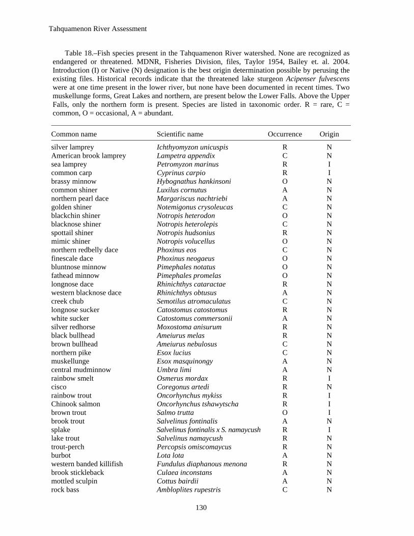
Table 18.–Fish species present in the Tahquamenon River watershed. None are recognized as endangered or threatened. MDNR, Fisheries Division, files, Taylor 1954, Bailey et. al. 2004. Introduction (I) or Native (N) designation is the best origin determination possible by perusing the existing files. Historical records indicate that the threatened lake sturgeon Acipenser fulvescens were at one time present in the lower river, but none have been documented in recent times. Two muskellunge forms, Great Lakes and northern, are present below the Lower Falls. Above the Upper Falls, only the northern form is present. Species are listed in taxonomic order. R = rare, C = common, O = occasional, A = abundant.
Common name Scientific name Occurrence Origin
silver lamprey Ichthyomyzon unicuspis R N American brook lamprey Lampetra appendix C N sea lamprey Petromyzon marinus R I common carp Cyprinus carpio R I brassy minnow Hybognathus hankinsoni O N common shiner Luxilus cornutus A N northern pearl dace Margariscus nachtriebi A N golden shiner Notemigonus crysoleucas C N blackchin shiner Notropis heterodon O N blacknose shiner Notropis heterolepis C N spottail shiner Notropis hudsonius R N mimic shiner Notropis volucellus O N northern redbelly dace Phoxinus eos C N finescale dace Phoxinus neogaeus O N bluntnose minnow Pimephales notatus O N fathead minnow Pimephales promelas O N longnose dace Rhinichthys cataractae R N western blacknose dace Rhinichthys obtusus A N creek chub Semotilus atromaculatus C N longnose sucker Catostomus catostomus R N white sucker Catostomus commersonii A N silver redhorse Moxostoma anisurum R N black bullhead Ameiurus melas R N brown bullhead Ameiurus nebulosus C N northern pike Esox lucius C N muskellunge Esox masquinongy A N central mudminnow Umbra limi A N rainbow smelt Osmerus mordax R I cisco Coregonus artedi R N rainbow trout Oncorhynchus mykiss R I Chinook salmon Oncorhynchus tshawytscha R I brown trout Salmo trutta O I brook trout Salvelinus fontinalis A N splake Salvelinus fontinalis x S. namaycush R I lake trout Salvelinus namaycush R N trout-perch Percopsis omiscomaycus R N burbot Lota lota A N western banded killifish Fundulus diaphanous menona R N brook stickleback Culaea inconstans A N mottled sculpin Cottus bairdii A N rock bass Ambloplites rupestris C N
Tahquamenon River Assessment
131
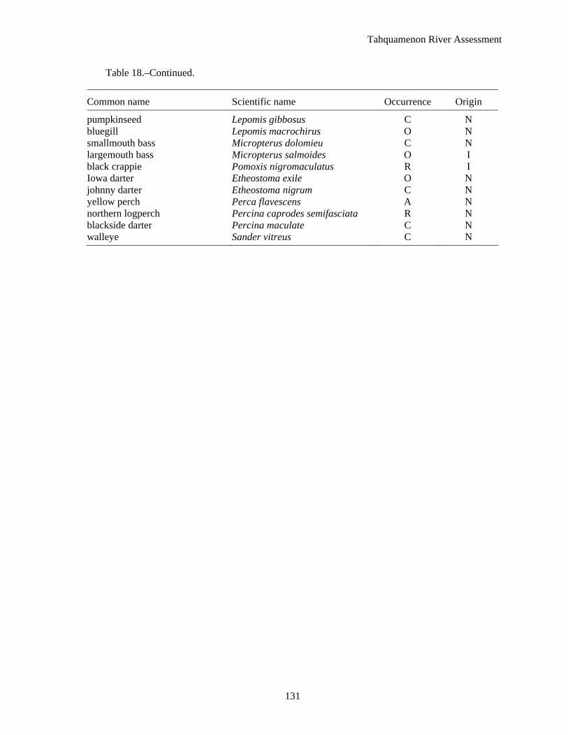
Table 18.–Continued.
Common name Scientific name Occurrence Origin
pumpkinseed Lepomis gibbosus C N bluegill Lepomis macrochirus O N smallmouth bass Micropterus dolomieu C N largemouth bass Micropterus salmoides O I black crappie Pomoxis nigromaculatus R I Iowa darter Etheostoma exile O N johnny darter Etheostoma nigrum C N yellow perch Perca flavescens A N northern logperch Percina caprodes semifasciata R N blackside darter Percina maculate C N walleye Sander vitreus C N
Tahquamenon River Assessment
132
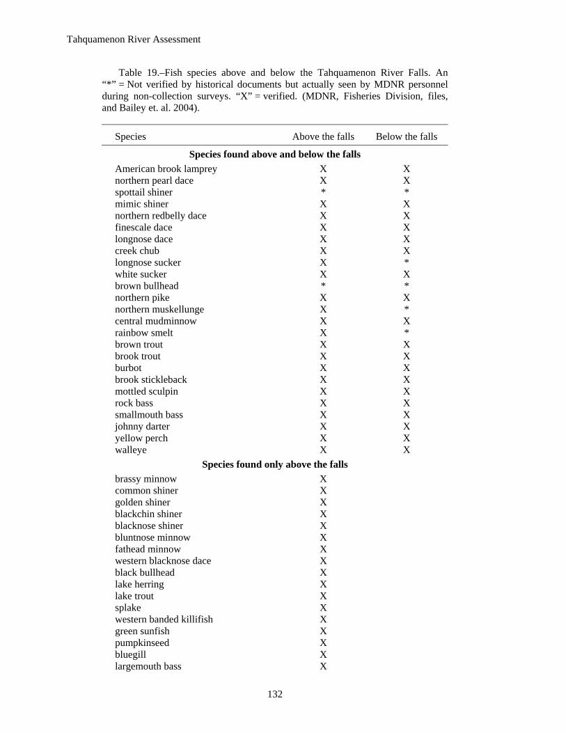
Table 19.–Fish species above and below the Tahquamenon River Falls. An “*” = Not verified by historical documents but actually seen by MDNR personnel during non-collection surveys. “X” = verified. (MDNR, Fisheries Division, files, and Bailey et. al. 2004).
Species Above the falls Below the falls
Species found above and below the falls American brook lamprey X X northern pearl dace X X spottail shiner * * mimic shiner X X northern redbelly dace X X finescale dace X X longnose dace X X creek chub X X longnose sucker X * white sucker X X brown bullhead * * northern pike X X northern muskellunge X * central mudminnow X X rainbow smelt X * brown trout X X brook trout X X burbot X X brook stickleback X X mottled sculpin X X rock bass X X smallmouth bass X X johnny darter X X yellow perch X X walleye X X
Species found only above the falls brassy minnow X common shiner X golden shiner X blackchin shiner X blacknose shiner X bluntnose minnow X fathead minnow X western blacknose dace X black bullhead X lake herring X lake trout X splake X western banded killifish X green sunfish X pumpkinseed X bluegill X largemouth bass X
Tahquamenon River Assessment
133
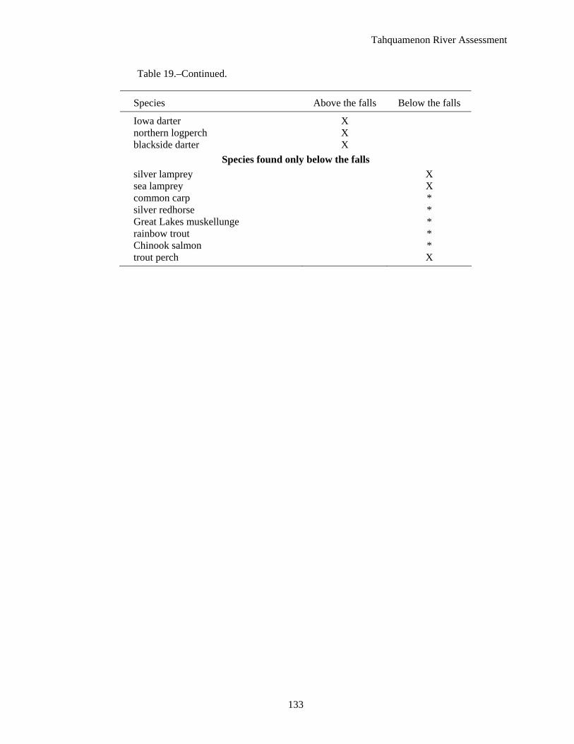
Table 19.–Continued.
Species Above the falls Below the falls
Iowa darter X northern logperch X blackside darter X
Species found only below the falls silver lamprey X sea lamprey X common carp * silver redhorse * Great Lakes muskellunge * rainbow trout * Chinook salmon * trout perch X
Tahquamenon River Assessment
134
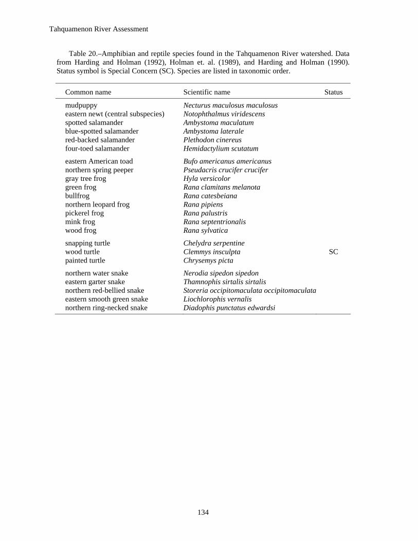
Table 20.–Amphibian and reptile species found in the Tahquamenon River watershed. Data from Harding and Holman (1992), Holman et. al. (1989), and Harding and Holman (1990). Status symbol is Special Concern (SC). Species are listed in taxonomic order.
Common name Scientific name Status
mudpuppy Necturus maculosus maculosus eastern newt (central subspecies) Notophthalmus viridescens spotted salamander Ambystoma maculatum blue-spotted salamander Ambystoma laterale red-backed salamander Plethodon cinereus four-toed salamander Hemidactylium scutatum
eastern American toad Bufo americanus americanus northern spring peeper Pseudacris crucifer crucifer gray tree frog Hyla versicolor green frog Rana clamitans melanota bullfrog Rana catesbeiana northern leopard frog Rana pipiens pickerel frog Rana palustris mink frog Rana septentrionalis wood frog Rana sylvatica
snapping turtle Chelydra serpentine wood turtle Clemmys insculpta SC painted turtle Chrysemys picta
northern water snake Nerodia sipedon sipedon eastern garter snake Thamnophis sirtalis sirtalis northern red-bellied snake Storeria occipitomaculata occipitomaculata eastern smooth green snake Liochlorophis vernalis northern ring-necked snake Diadophis punctatus edwardsi
Tahquamenon River Assessment
135
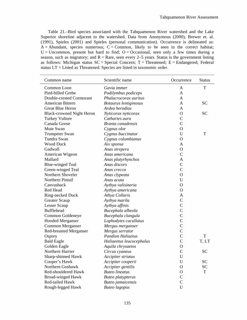
Table 21.–Bird species associated with the Tahquamenon River watershed and the Lake Superior shoreline adjacent to the watershed. Data from Anonymous (2000), Brewer et. al. (1991), Spieles (2001) and Spieles (personal communication). Occurrence is delineated as: A = Abundant, species numerous; C = Common, likely to be seen in the correct habitat; U = Uncommon, present but hard to find; O = Occasional, seen only a few times during a season, such as migratory; and R = Rare, seen every 2–5 years. Status is the government listing as follows: Michigan status SC = Special Concern; T = Threatened; E = Endangered; Federal status LT = Listed as Threatened. Species are listed in taxonomic order.
Common name Scientific name Occurrence Status
Common Loon Gavia immer A T Pied-billed Grebe Podilymbus podiceps A Double-crested Cormorant Phalacrocorax auritus A American Bittern Botaurus lentiginosus A SC Great Blue Heron Ardea herodias A Black-crowned Night Heron Nyticorax nyticorax O SC Turkey Vulture Cathartes aura C Canada Goose Branta canadensis C Mute Swan Cygnus olor O Trumpeter Swan Cygnus buccinator U T Tundra Swan Cygnus columbianus O Wood Duck Aix sponsa A Gadwall Anas strepera O American Wigeon Anas americana C Mallard Anas platyrhynchos A Blue-winged Teal Anas discors C Green-winged Teal Anas crecca C Northern Shoveler Anas clypeata O Northern Pintail Anas acuta U Canvasback Aythya valisineria O Red Head Aythya americana O Ring-necked Duck Athya Collaris A Greater Scaup Aythya marila C Lesser Scaup Aythya affinis C Bufflehead Bucephala albeola C Common Goldeneye Bucephala clangula C Hooded Merganser Lophodytes cucullatus C Common Merganser Mergus merganser C Red-breasted Merganser Mergus serrator C Osprey Pandion Haliaetus C T Bald Eagle Haliaeetus leucocephalus C T, LT Golden Eagle Aquila chrysaetos O Northern Harrier Circus cyaneus C SC Sharp-shinned Hawk Accipiter striatus U Cooper’s Hawk Accipiter cooperii U SC Northern Goshawk Accipiter gentilis O SC Red-shouldered Hawk Buteo lineatus O T Broad-winged Hawk Buteo platypterus C Red-tailed Hawk Buteo jamaicensis C Rough-legged Hawk Buteo lagopus U
Tahquamenon River Assessment
136
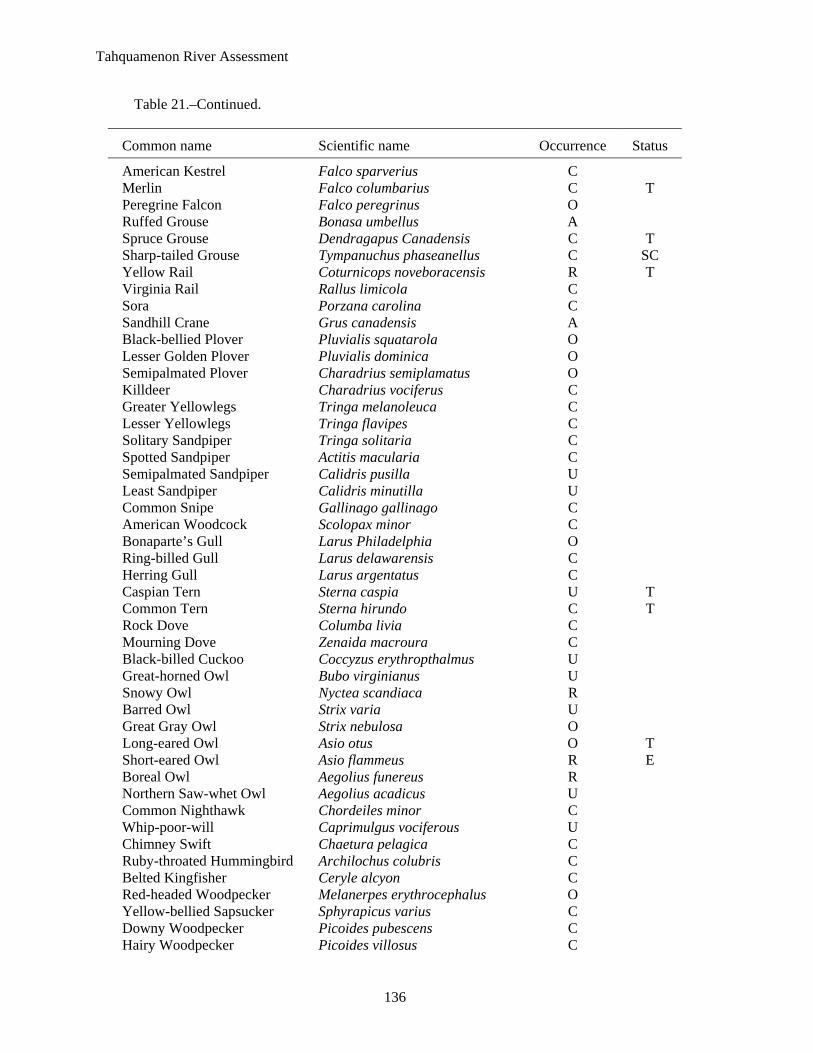
Table 21.–Continued.
Common name Scientific name Occurrence Status
American Kestrel Falco sparverius C Merlin Falco columbarius C T Peregrine Falcon Falco peregrinus O Ruffed Grouse Bonasa umbellus A Spruce Grouse Dendragapus Canadensis C T Sharp-tailed Grouse Tympanuchus phaseanellus C SC Yellow Rail Coturnicops noveboracensis R T Virginia Rail Rallus limicola C Sora Porzana carolina C Sandhill Crane Grus canadensis A Black-bellied Plover Pluvialis squatarola O Lesser Golden Plover Pluvialis dominica O Semipalmated Plover Charadrius semiplamatus O Killdeer Charadrius vociferus C Greater Yellowlegs Tringa melanoleuca C Lesser Yellowlegs Tringa flavipes C Solitary Sandpiper Tringa solitaria C Spotted Sandpiper Actitis macularia C Semipalmated Sandpiper Calidris pusilla U Least Sandpiper Calidris minutilla U Common Snipe Gallinago gallinago C American Woodcock Scolopax minor C Bonaparte’s Gull Larus Philadelphia O Ring-billed Gull Larus delawarensis C Herring Gull Larus argentatus C Caspian Tern Sterna caspia U T Common Tern Sterna hirundo C T Rock Dove Columba livia C Mourning Dove Zenaida macroura C Black-billed Cuckoo Coccyzus erythropthalmus U Great-horned Owl Bubo virginianus U Snowy Owl Nyctea scandiaca R Barred Owl Strix varia U Great Gray Owl Strix nebulosa O Long-eared Owl Asio otus O T Short-eared Owl Asio flammeus R E Boreal Owl Aegolius funereus R Northern Saw-whet Owl Aegolius acadicus U Common Nighthawk Chordeiles minor C Whip-poor-will Caprimulgus vociferous U Chimney Swift Chaetura pelagica C Ruby-throated Hummingbird Archilochus colubris C Belted Kingfisher Ceryle alcyon C Red-headed Woodpecker Melanerpes erythrocephalus O Yellow-bellied Sapsucker Sphyrapicus varius C Downy Woodpecker Picoides pubescens C Hairy Woodpecker Picoides villosus C
Tahquamenon River Assessment
137
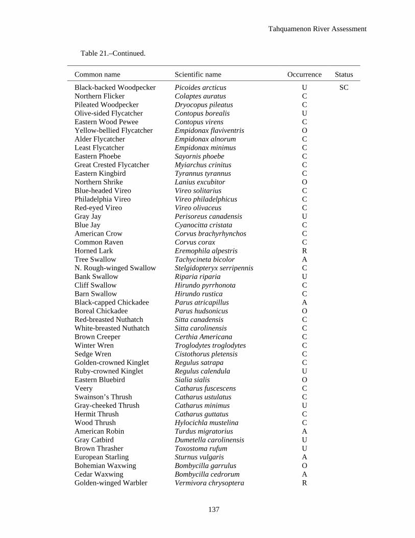
Table 21.–Continued.
Common name Scientific name Occurrence Status
Black-backed Woodpecker Picoides arcticus U SC Northern Flicker Colaptes auratus C Pileated Woodpecker Dryocopus pileatus C Olive-sided Flycatcher Contopus borealis U Eastern Wood Pewee Contopus virens C Yellow-bellied Flycatcher Empidonax flaviventris O Alder Flycatcher Empidonax alnorum C Least Flycatcher Empidonax minimus C Eastern Phoebe Sayornis phoebe C Great Crested Flycatcher Myiarchus crinitus C Eastern Kingbird Tyrannus tyrannus C Northern Shrike Lanius excubitor O Blue-headed Vireo Vireo solitarius C Philadelphia Vireo Vireo philadelphicus C Red-eyed Vireo Vireo olivaceus C Gray Jay Perisoreus canadensis U Blue Jay Cyanocitta cristata C American Crow Corvus brachyrhynchos C Common Raven Corvus corax C Horned Lark Eremophila alpestris R Tree Swallow Tachycineta bicolor A N. Rough-winged Swallow Stelgidopteryx serripennis C Bank Swallow Riparia riparia U Cliff Swallow Hirundo pyrrhonota C Barn Swallow Hirundo rustica C Black-capped Chickadee Parus atricapillus A Boreal Chickadee Parus hudsonicus O Red-breasted Nuthatch Sitta canadensis C White-breasted Nuthatch Sitta carolinensis C Brown Creeper Certhia Americana C Winter Wren Troglodytes troglodytes C Sedge Wren Cistothorus pletensis C Golden-crowned Kinglet Regulus satrapa C Ruby-crowned Kinglet Regulus calendula U Eastern Bluebird Sialia sialis O Veery Catharus fuscescens C Swainson’s Thrush Catharus ustulatus C Gray-cheeked Thrush Catharus minimus U Hermit Thrush Catharus guttatus C Wood Thrush Hylocichla mustelina C American Robin Turdus migratorius A Gray Catbird Dumetella carolinensis U Brown Thrasher Toxostoma rufum U European Starling Sturnus vulgaris A Bohemian Waxwing Bombycilla garrulus O Cedar Waxwing Bombycilla cedrorum A Golden-winged Warbler Vermivora chrysoptera R

Tahquamenon River Assessment
138
Table 21.–Continued.
Common name Scientific name Occurrence Status
Tennessee Warbler Vermivora peregrina R Nashville Warbler Vermivora ruficapilla A Northern Parula Parula Americana C Yellow Warbler Dendroica petechia A Chestnut-sided Warbler Dendroica pensylvanica U Magnolia Warbler Dendroica magnolia C Cape May Warbler Dendroica tigrina O Black-throated Blue Warbler Dendroica caerulescens C Black-throated Green Warbler Dendroica virens C Yellow-rumped Warbler Dendroica coronata C Blackburnian Warbler Dendroica fusca C Pine Warbler Dendroica pinus C Palm Warbler Dendroica palmarum C Bay-breasted Warbler Dendroica castanea U Blackpoll Warbler Dendroica striata U Black-and-white Warbler Mniotilta varia C American Redstart Setophaga ruticilla C Ovenbird Seiurus aurocapillus C Northern Waterthrush Seiurus noveboracensis U Connecticut Warbler Oporornis formosus R Mourning Warbler Oporornis philadelphia O Common Yellowthroat Geothlypis trichas C Wilson’s Warbler Wilsonia pusilla O Canada Warbler Wilsonia Canadensis O Scarlet Tanager Piranga olivacea C Rufous-sided Towhee Pipilo erythrophthalmus O American Tree Sparrow Spizella arborea O Chipping Sparrow Spizella passerine C Clay-colored Sparrow Spizella pallida O Vesper Sparrow Pooecetes gramineus U Savannah Sparrow Passerculus sandwichensis C Le Conte’s Sparrow Ammodramus leconteii C Fox Sparrow Passerella iliaca O Song Sparrow Melospiza melodia C Lincoln’s Sparrow Melospiza lincolnii U Swamp Sparrow Melospiza georgiana C White-throated Sparrow Zonotrichia albicollis C White-crowned Sparrow Zonotrichia leucophrys O Dark-eyed Junco Junco hyemalis C Snow Bunting Plectrophenax nivalis O Northern Cardinal Cardinalis cardinalis O Rose-breasted Grosbeak Pheucticus ludovicianus C Indigo Bunting Passerina cyanea C Bobolink Dolichonys oryzivorus C Red-winged Blackbird Agelaius phoeniceus A Eastern Meadowlark Sturnella magna O Rusty Blackbird Euphagus carolinus O
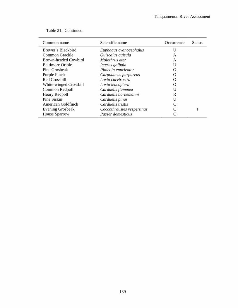
Tahquamenon River Assessment
139
Table 21.–Continued.
Common name Scientific name Occurrence Status
Brewer’s Blackbird Euphagus cyanocephalus U Common Grackle Quiscalus quisula A Brown-headed Cowbird Molothrus ater A Baltimore Oriole Icterus galbula U Pine Grosbeak Pinicola enucleator O Purple Finch Carpodacus purpureus O Red Crossbill Loxia curvirostra O White-winged Crossbill Loxia leucoptera O Common Redpoll Carduelis flammea U Hoary Redpoll Carduelis hornemanni R Pine Siskin Carduelis pinus U American Goldfinch Carduelis tristis C Evening Grosbeak Coccothraustes vespertinus C T House Sparrow Passer domesticus C

Tahquamenon River Assessment
140
Table 22.–Mammals of the Tahquamenon River watershed. Data from Baker (1983), Kristie Sitar, MDNR, Wildlife Division biologist, (personal communication), and Anonymous (2000). Occurrence codes: A = Abundant, species numerous; C = Common, likely to be seen in the suitable habitat; O = Occasional, seen only a few times during a season; and R = Rare, seen only every 2–5 years. State status rank: SC = Special Concern, T = Threatened, E = Endangered. Federal status rank: LE = Listed as Endangered. Species are listed in taxonomic order.
Common name Scientific name Occurrence Status
Arctic shrew Sorex arcticus C masked shrew Sorex cinereus C pigmy shrew Sorex hoyi C water shrew Sorex palustris C northern short-tailed shrew Blarina brevicauda A star-nosed mole Condylura noctivagans C northern long-eared bat Myotis septentrionalis little brown bat Myotis lucifugus C silver-haired bat Lasionycteris noctivagans O big brown bat Eptesicus fuscus C eastern red bat Lasiurus borealis O Keen’s bat Myotis keenii O hoary bat Lasiurus cinereus C snowshoe hare Lepus americanus C eastern chipmunk Tamias striatus A least chipmunk Tamias minimus C woodchuck Marmota monax C eastern gray squirrel Sciurus carolinensis C red squirrel Tamiasciurus hudsonicus A northern flying squirrel Glaucomys sabrinus O American beaver Castor Canadensis A southern red-backed vole Clethrionomys gapperi C meadow vole Microtus pennsylvanicus C muskrat Ondatra zibethicus A southern bog lemming Synaptomys cooperi O meadow jumping mouse Zapus hudsonius C woodland jumping mouse Napaeozapus insignis C American porcupine Erethizon dorsatum C coyote Canis latrans A gray wolf Canis lupus O T, LE red fox Vulpes vulpes C gray fox Urocyon cinereoargenteus O black bear Ursus americanus C raccoon Procyon lotor A American marten Martes martes C fisher Martes pennanti C ermine Mustela erminea O least weasel Mustela nivalis O long-tailed weasel Mustela frenata C mink Mustela vison C American badger Taxidea taxus O

Tahquamenon River Assessment
141
Table 22.–Continued.
Common name Scientific name Occurrence Status
striped skunk Mephitis mephitis C northern river otter Lutra canadensis C bobcat Lynx rufus C white-tailed deer Odocoileus virginianus C moose Alces alces C SC
Tahquamenon River Assessment
142
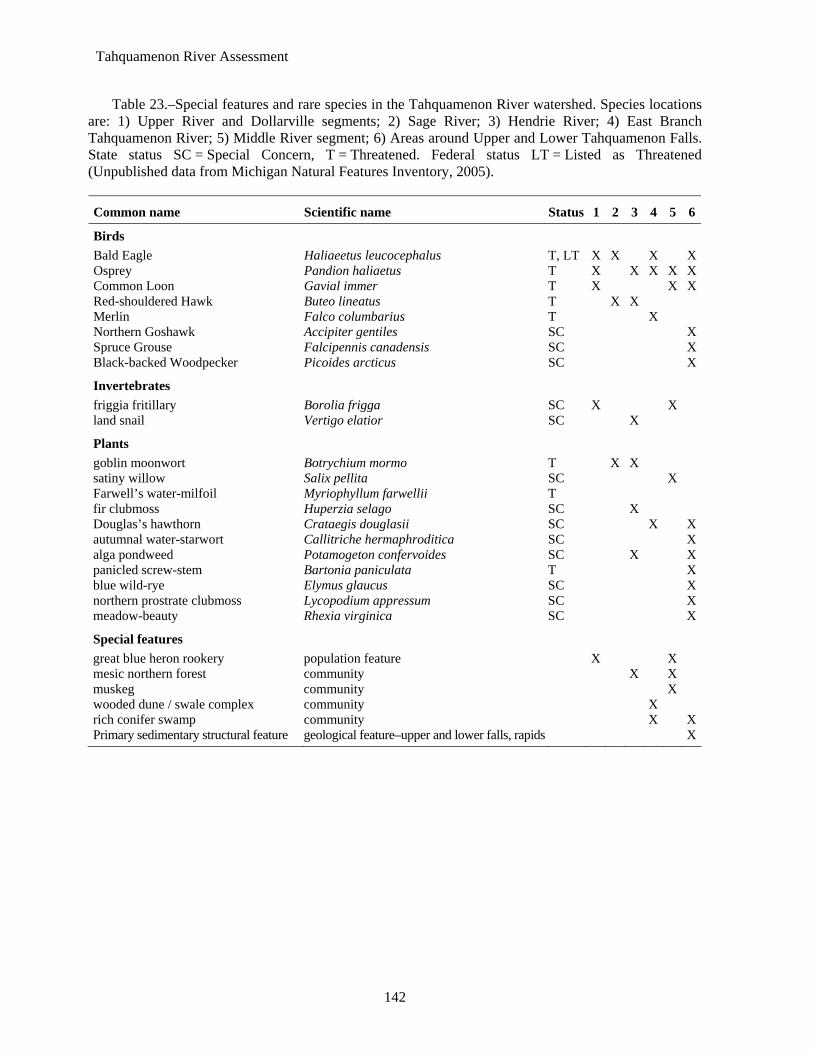
Table 23.–Special features and rare species in the Tahquamenon River watershed. Species locations are: 1) Upper River and Dollarville segments; 2) Sage River; 3) Hendrie River; 4) East Branch Tahquamenon River; 5) Middle River segment; 6) Areas around Upper and Lower Tahquamenon Falls. State status SC = Special Concern, T = Threatened. Federal status LT = Listed as Threatened (Unpublished data from Michigan Natural Features Inventory, 2005).
Common name Scientific name Status 1 2 3 4 5 6
Birds Bald Eagle Haliaeetus leucocephalus T, LT X X X XOsprey Pandion haliaetus T X X X X XCommon Loon Gavial immer T X X XRed-shouldered Hawk Buteo lineatus T X X Merlin Falco columbarius T X Northern Goshawk Accipiter gentiles SC XSpruce Grouse Falcipennis canadensis SC XBlack-backed Woodpecker Picoides arcticus SC X
Invertebrates friggia fritillary Borolia frigga SC X X land snail Vertigo elatior SC X
Plants goblin moonwort Botrychium mormo T X X satiny willow Salix pellita SC X Farwell’s water-milfoil Myriophyllum farwellii T fir clubmoss Huperzia selago SC X Douglas’s hawthorn Crataegis douglasii SC X Xautumnal water-starwort Callitriche hermaphroditica SC Xalga pondweed Potamogeton confervoides SC X Xpanicled screw-stem Bartonia paniculata T Xblue wild-rye Elymus glaucus SC Xnorthern prostrate clubmoss Lycopodium appressum SC Xmeadow-beauty Rhexia virginica SC X
Special features great blue heron rookery population feature X X mesic northern forest community X X muskeg community X wooded dune / swale complex community X rich conifer swamp community X XPrimary sedimentary structural feature geological feature–upper and lower falls, rapids X
Tahquamenon River Assessment
143
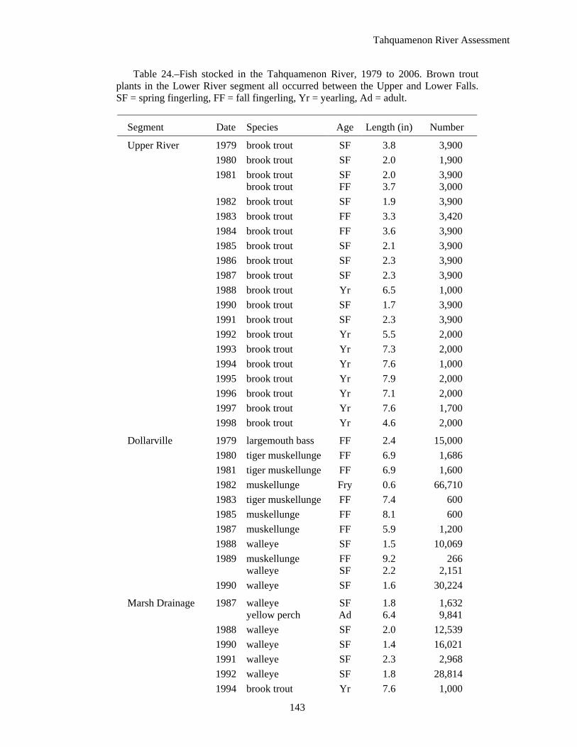
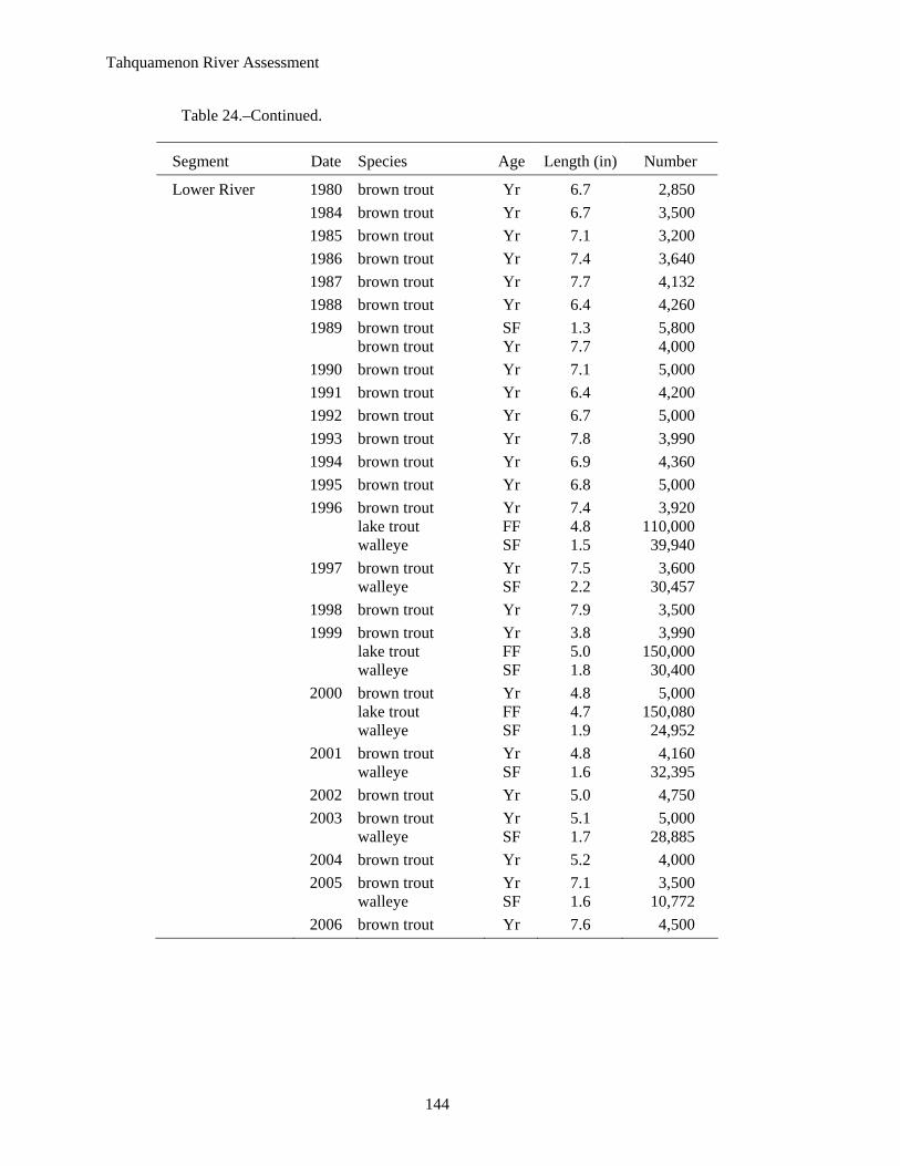
Table 24.–Fish stocked in the Tahquamenon River, 1979 to 2006. Brown trout plants in the Lower River segment all occurred between the Upper and Lower Falls. SF = spring fingerling, FF = fall fingerling, Yr = yearling, Ad = adult.
Segment Date Species Age Length (in) Number
Upper River 1979 brook trout SF 3.8 3,900 1980 brook trout SF 2.0 1,900 1981 brook trout SF 2.0 3,900 brook trout FF 3.7 3,000 1982 brook trout SF 1.9 3,900 1983 brook trout FF 3.3 3,420 1984 brook trout FF 3.6 3,900 1985 brook trout SF 2.1 3,900 1986 brook trout SF 2.3 3,900 1987 brook trout SF 2.3 3,900 1988 brook trout Yr 6.5 1,000 1990 brook trout SF 1.7 3,900 1991 brook trout SF 2.3 3,900 1992 brook trout Yr 5.5 2,000 1993 brook trout Yr 7.3 2,000 1994 brook trout Yr 7.6 1,000 1995 brook trout Yr 7.9 2,000 1996 brook trout Yr 7.1 2,000 1997 brook trout Yr 7.6 1,700 1998 brook trout Yr 4.6 2,000
Dollarville 1979 largemouth bass FF 2.4 15,000 1980 tiger muskellunge FF 6.9 1,686 1981 tiger muskellunge FF 6.9 1,600 1982 muskellunge Fry 0.6 66,710 1983 tiger muskellunge FF 7.4 600 1985 muskellunge FF 8.1 600 1987 muskellunge FF 5.9 1,200 1988 walleye SF 1.5 10,069 1989 muskellunge FF 9.2 266 walleye SF 2.2 2,151 1990 walleye SF 1.6 30,224
Marsh Drainage 1987 walleye SF 1.8 1,632 yellow perch Ad 6.4 9,841 1988 walleye SF 2.0 12,539 1990 walleye SF 1.4 16,021 1991 walleye SF 2.3 2,968 1992 walleye SF 1.8 28,814 1994 brook trout Yr 7.6 1,000
Tahquamenon River Assessment
144
Table 24.–Continued.
Segment Date Species Age Length (in) Number
Lower River 1980 brown trout Yr 6.7 2,850 1984 brown trout Yr 6.7 3,500 1985 brown trout Yr 7.1 3,200 1986 brown trout Yr 7.4 3,640 1987 brown trout Yr 7.7 4,132 1988 brown trout Yr 6.4 4,260 1989 brown trout SF 1.3 5,800 brown trout Yr 7.7 4,000 1990 brown trout Yr 7.1 5,000 1991 brown trout Yr 6.4 4,200 1992 brown trout Yr 6.7 5,000 1993 brown trout Yr 7.8 3,990 1994 brown trout Yr 6.9 4,360 1995 brown trout Yr 6.8 5,000 1996 brown trout Yr 7.4 3,920 lake trout FF 4.8 110,000 walleye SF 1.5 39,940 1997 brown trout Yr 7.5 3,600 walleye SF 2.2 30,457 1998 brown trout Yr 7.9 3,500 1999 brown trout Yr 3.8 3,990 lake trout FF 5.0 150,000 walleye SF 1.8 30,400 2000 brown trout Yr 4.8 5,000 lake trout FF 4.7 150,080 walleye SF 1.9 24,952 2001 brown trout Yr 4.8 4,160 walleye SF 1.6 32,395 2002 brown trout Yr 5.0 4,750 2003 brown trout Yr 5.1 5,000 walleye SF 1.7 28,885 2004 brown trout Yr 5.2 4,000 2005 brown trout Yr 7.1 3,500 walleye SF 1.6 10,772 2006 brown trout Yr 7.6 4,500
Tahquamenon River Assessment
145
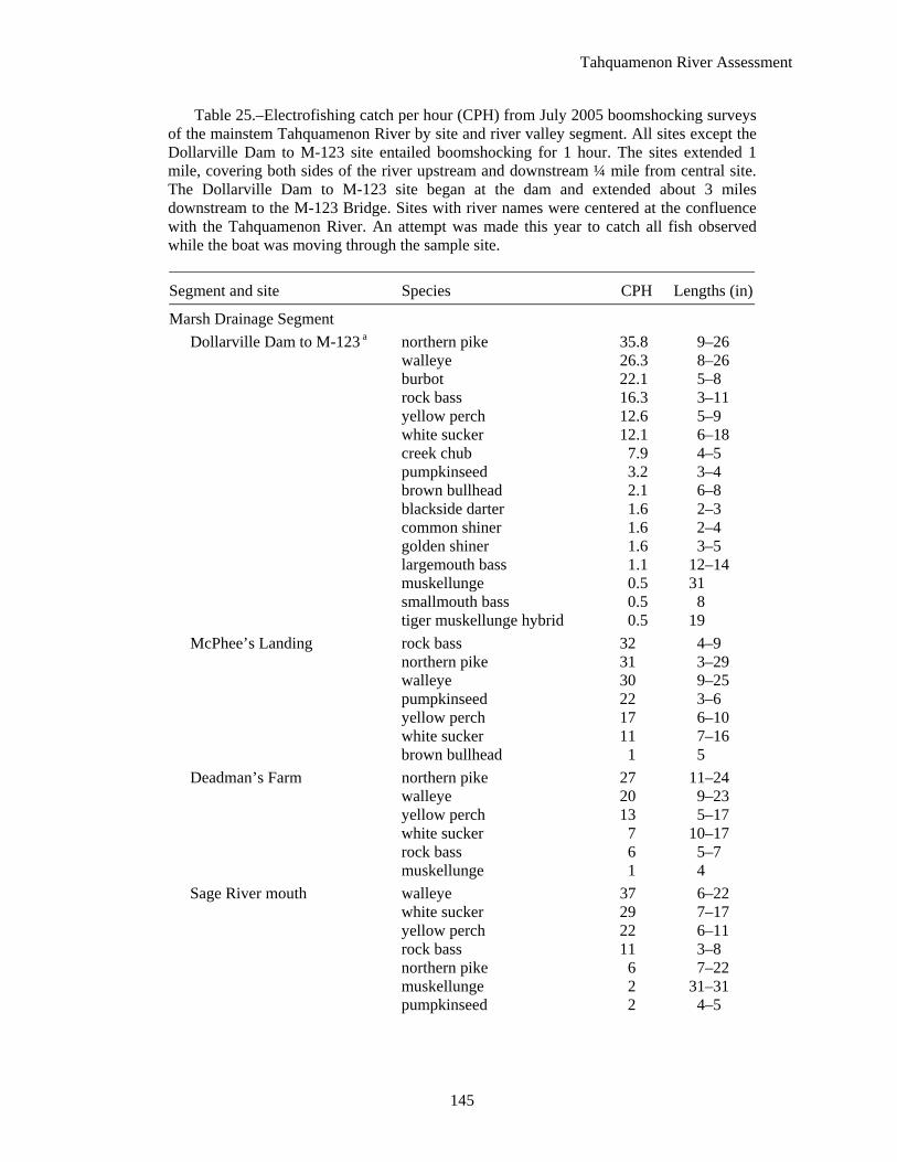
Table 25.–Electrofishing catch per hour (CPH) from July 2005 boomshocking surveys of the mainstem Tahquamenon River by site and river valley segment. All sites except the Dollarville Dam to M-123 site entailed boomshocking for 1 hour. The sites extended 1 mile, covering both sides of the river upstream and downstream ¼ mile from central site. The Dollarville Dam to M-123 site began at the dam and extended about 3 miles downstream to the M-123 Bridge. Sites with river names were centered at the confluence with the Tahquamenon River. An attempt was made this year to catch all fish observed while the boat was moving through the sample site.
Segment and site Species CPH Lengths (in)
Marsh Drainage Segment Dollarville Dam to M-123 a northern pike 35.8 9–26
walleye 26.3 8–26 burbot 22.1 5–8 rock bass 16.3 3–11 yellow perch 12.6 5–9 white sucker 12.1 6–18 creek chub 7.9 4–5 pumpkinseed 3.2 3–4 brown bullhead 2.1 6–8 blackside darter 1.6 2–3 common shiner 1.6 2–4 golden shiner 1.6 3–5 largemouth bass 1.1 12–14 muskellunge 0.5 31 smallmouth bass 0.5 8 tiger muskellunge hybrid 0.5 19
McPhee’s Landing rock bass 32 4–9 northern pike 31 3–29 walleye 30 9–25 pumpkinseed 22 3–6 yellow perch 17 6–10 white sucker 11 7–16 brown bullhead 1 5
Deadman’s Farm northern pike 27 11–24 walleye 20 9–23 yellow perch 13 5–17 white sucker 7 10–17 rock bass 6 5–7 muskellunge 1 4
Sage River mouth walleye 37 6–22 white sucker 29 7–17 yellow perch 22 6–11 rock bass 11 3–8 northern pike 6 7–22 muskellunge 2 31–31 pumpkinseed 2 4–5
Tahquamenon River Assessment
146
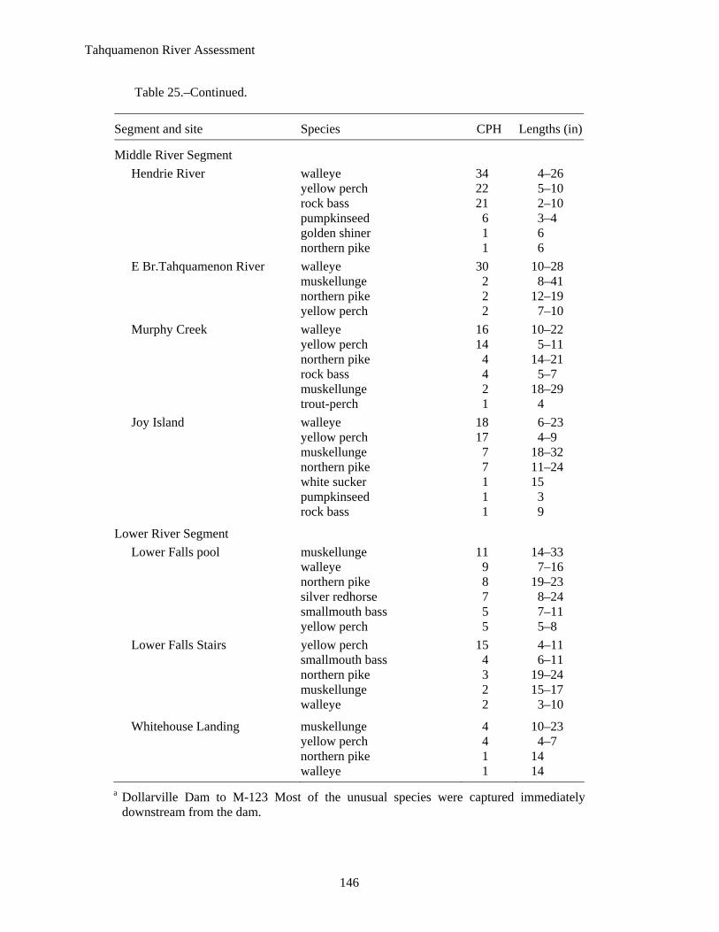
Table 25.–Continued.
Segment and site Species CPH Lengths (in)
Middle River Segment Hendrie River walleye 34 4–26
yellow perch 22 5–10 rock bass 21 2–10 pumpkinseed 6 3–4 golden shiner 1 6 northern pike 1 6
E Br.Tahquamenon River walleye 30 10–28 muskellunge 2 8–41 northern pike 2 12–19 yellow perch 2 7–10
Murphy Creek walleye 16 10–22 yellow perch 14 5–11 northern pike 4 14–21 rock bass 4 5–7 muskellunge 2 18–29 trout-perch 1 4
Joy Island walleye 18 6–23 yellow perch 17 4–9 muskellunge 7 18–32 northern pike 7 11–24 white sucker 1 15 pumpkinseed 1 3 rock bass 1 9
Lower River Segment Lower Falls pool muskellunge 11 14–33
walleye 9 7–16 northern pike 8 19–23 silver redhorse 7 8–24 smallmouth bass 5 7–11 yellow perch 5 5–8
Lower Falls Stairs yellow perch 15 4–11 smallmouth bass 4 6–11 northern pike 3 19–24 muskellunge 2 15–17 walleye 2 3–10
Whitehouse Landing muskellunge 4 10–23 yellow perch 4 4–7 northern pike 1 14 walleye 1 14 a Dollarville Dam to M-123 Most of the unusual species were captured immediately
downstream from the dam.

Tahquamenon River Assessment
147
Table 26.–Walleye and muskellunge radio tracking dates in the Tahquamenon River with water temperature (Fahrenheit), discharge, and survey type. Daily discharge rate was from the USGS gauge near the Upper Falls in cubic feet per second (CFS).
Date Water temperature CFS Survey type
10/21/2004 40 1020 boat 11/09/2004 36 1340 boat 11/10/2004 37 1280 boat 11/22/2004 34 1110 boat 12/15/2004 991 aerial 01/28/2005 471 aerial 03/29/2005 529 aerial 04/07/2005 3720 aerial 04/13/2005 45 3900 aerial 04/14/2005 48 3730 boat 04/18/2005 55.9 2840 boat 04/21/2005 54.3 2180 boat 04/26/2005 40.5 1490 boat 04/29/2005 42.7 1410 boat 05/02/2005 45 1260 boat 05/05/2005 42 1130 boat 05/09/2005 55 847 boat 05/17/2005 1070 aerial 05/26/2005 63.4 614 boat 06/01/2005 65.4 515 boat 06/07/2005 68 boat 06/29/2005 78 236 boat 07/22/2005 76.7 213 boat 09/23/2005 63.2 312 boat 10/06/2005 64 boat 10/08/2005 58 boat 10/18/2005 49.2 558 boat 11/01/2005 44.3 416 boat 11/03/2005 44.4 422 boat
Tahquamenon River Assessment
148
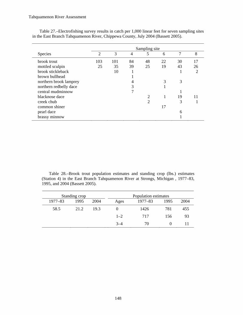
Table 27.–Electrofishing survey results in catch per 1,000 linear feet for seven sampling sites in the East Branch Tahquamenon River, Chippewa County, July 2004 (Bassett 2005).
Sampling site Species 2 3 4 5 6 7 8
brook trout 103 101 84 48 22 30 17 mottled sculpin 25 35 39 25 19 43 26 brook stickleback 10 1 1 2 brown bullhead 1 northern brook lamprey 4 3 3 northern redbelly dace 3 1 central mudminnow 7 1 blacknose dace 2 1 19 11 creek chub 2 3 1 common shiner 17 pearl dace 6 brassy minnow 1
Table 28.–Brook trout population estimates and standing crop (lbs.) estimates (Station 4) in the East Branch Tahquamenon River at Strongs, Michigan , 1977–83, 1995, and 2004 (Bassett 2005).
Standing crop Population estimates 1977–83 1995 2004 Ages 1977–83 1995 2004
58.5 21.2 19.3 0 1426 781 455
1–2 717 156 93
3–4 70 0 11

Tahquamenon River Assessment
REFERENCES
Aiello, C. 2004. Michigan water chemistry monitoring program, 2002 report. Michigan Department of Environmental Quality, Water Division, report MI/DEQ/WD/04-049, Lansing.
Albert, D.A., S.R. Denton, and B.V. Barnes. 1986. Regional Landscape Ecosystems of Michigan. University of Michigan, School of Natural Resources, Ann Arbor.
Alexander, G.R., and E.A. Hansen. 1983. Effects of sand bedload sediment on a brook trout population. Michigan Department of Natural Resources, Fisheries Research Report 1906, Ann Arbor.
Alexander, G.R., and E.A. Hansen. 1986. Sand bedload in a brook trout stream. North American Journal of Fisheries Management 6:9–23.
Alexander, G.R., J.L. Fenske, and D.W. Smith 1995. A fisheries management guide to stream protection and restoration. Michigan Department of Natural Resources, Fisheries Special Report 15, Ann Arbor.
Anderson, L.R. 1976. Unpublished file data. Michigan Department of Natural Resources, Fisheries Division, Newberry Operations Service Center, 5100 S. M-123, Newberry, MI, 49868.
Anderson, L.R. 1982. Tahquamenon River, a trout stream of Michigan. Page 266 in Luce County: A History Commemorating Newberry’s Centennial. The Luce County Historical Society, Newberry, Michigan.
Anonymous. 1985. Regulatory Program, EP 1145-2-1. United States Army, Corps of Engineers, Washington, D.C.
Anonymous. 1993. A guide to public rights on Michigan waters. Michigan Department of Natural Resources, Law Enforcement Division, Report 9, Lansing.
Anonymous. 1995. Michigan public boat launch directory 1995 thru 1996. Michigan Department of Natural Resources, Lansing.
Anonymous. 2000a. Michigan stream classification: 1967 system. Chapter 20 in Schneider, J.C. (ed.) 2000. Manual of fisheries survey methods II: with periodic updates. Michigan Department of Natural Resources, Fisheries Special Report 25, Ann Arbor.
Anonymous. 2000b. Vertebrate wildlife species of the Upper Peninsula: a tentative list compiled by the Michigan DNR and MSU Extension Service. MSU Upper Peninsula Forestry Extension Office, Michigan State University Cooperative Extension Service, East Lansing.
Anonymous. 2004. Michigan State University climatological page. Michigan State University. Available: http://climate.geo.msu.edu (November 2004).
Anonymous. 2005a. Ordinary High Water Mark. U.S. Army Corps of Engineers, Detroit District. Available: http://www.lre.usace.army.mil/greatlakes (March 2005).
Anonymous. 2005b. Michigan Department of Environmental Quality Vision Statement. Available: http://www.michigan.gov/deq (March 2005).
149

Tahquamenon River Assessment
Anonymous. 2005c. Michigan Natural Features Inventory, by watershed listing. Available: http:/www.msue.msu.edu/mnfi (April 2005).
Bailey, R.M., and G.R. Smith. 1981. Origin and geography of the fish fauna of the Laurentian Great Lakes basin. Canadian Journal of Fish and Aquatic Science 38:1539–1561.
Bailey, R.M., W.C. Latta, and G.R. Smith. 2004. An atlas of Michigan fishes with keys and illustrations for their identification. Museum of Zoology, University of Michigan, Miscellaneous Papers 192, Ann Arbor.
Baker, M.E. 2006. A landscape-based ecological classification system for river valley segments in Michigan’s Upper Peninsula. Michigan Department of Natural Resources, Fisheries Research Report 2085, Ann Arbor.
Baker, R.H. 1983. Michigan mammals. Michigan State University Press, Michigan State University, East Lansing.
Barnett, L. 1990. Taming the Tahquamenon. Pages 20–23 in Michigan History magazine, Michigan Department of State, Lansing. January/February 1990.
Bassett, C. 2005. East Branch Tahquamenon River fishery status report. Hiawatha National Forest, Escanaba, Michigan, cooperating with MDNR, USFS, Escanaba.
Bay Mills Indian Community, History Department. Available: http://www.baymills.org/history. (November, 2007).
Becker, G.C. 1983. Fishes of Wisconsin. The University of Wisconsin Press, Madison.
Berquist, S.G. 1936. The Pleistocene History of the Tahquamenon and Manistique Drainage Region of the Northern Peninsula of Michigan. Historical Society of Michigan, Lansing.
Blumer, S.P., T.E. Behrendt, C.R. Whited, J.M. Ellis, R.J. Minnerick, and R.L. Leu Voy. 2004. Water resources data, Michigan, water year 2003. United States Geological Survey, Michigan Water Science Center, Water Data Report MI-03-1, Lansing.
Bovee, K.D., T.J. Newcomb, and T.G. Coon. 1994. Relations between habitat variability and population dynamics of bass in the Huron River, Michigan. United States Department of the Interior, National Biological Survey, Biological Report 21, Washington, DC.
Brandt, G.W. 1935. Michigan’s beaver-trout management program. American Fisheries Society, Transactions 65:253–257.
Brewer, R., G.A. McPeek, and R.J. Adams, Jr. 1991. The atlas of breeding birds of Michigan. Michigan State University Press, East Lansing.
Coon, T.G. 1987. Responses of benthic riffle fishes to variation in stream discharge and temperature. Pages 77–85 in W.J. Mathews and D.C. Heins, editors. Community and evolutionary ecology of North American stream fishes. University of Oklahoma Press, Norman.
Dewberry, T.C. 1992. Protecting the biodiversity of riverine and riparian ecosystems: the national river public land policy development project. Transactions of the 57th North American Wildlife and Natural Resources Conference. pp. 434–4342.
150

Tahquamenon River Assessment
MDEQ–SWQD (Michigan Department of Environmental Quality, Surface Water Quality Division). 1997. Procedure 51. Qualitative biological and habitat survey protocols, wadable streams and rivers. Michigan Department of Environmental Quality, Surface Water Quality Division, Lansing.
Eagle, A.C., E.M. Hay-Chmielewski, K.T. Cleveland, A.L. Derosier, M.E. Herbert, and R.A. Rustem, eds. 2005. Michigan's Wildlife Action Plan. Michigan Department of Natural Resources. Lansing. 1592 pp. Available: http://www.michigan.gov/ wildlifeactionplandnr (March 2006).
Edwards, E.A., D.A. Krieger, M. Bacteller, and O.E. Maughn. 1982. Habitat suitability index models: black crappie. United States Department of the Interior, Fish and Wildlife Service, Biological Report 82 (10.6), Washington, DC.
Edwards, E. A., G. Gebhart, and O.E. Maughan. 1983. Habitat suitability index models: smallmouth bass. United States Department of the Interior, Fish and Wildlife Service, Biological Report 82 (10.6), Washington, DC.
Eschmeyer, P.H. 1946. A preliminary study of the relationship between untreated domestic sewage and condition for fish in the Tahquamenon River. Michigan Department of Natural Resources, Fisheries Research Report 1074, Ann Arbor.
Farrand, W.R. 1988. The Glacial Lakes around Michigan. Michigan Department of Natural Resources, Geological Survey Division, Bulletin 4, Lansing.
Farrand, W.R., and D.L. Bell. 1982. Quaternary geology of Michigan. Lansing, Michigan: Michigan Department of Natural Resources, Geological Survey Division. 2 sheets. Scale 1:500,000.
Fetterolf, C.M., Jr. 1960. Tahquamenon River bottom fauna survey, vicinity of Newberry, Luce County, Michigan. Michigan Department of Environmental Quality, Surface Water Quality, Report 60\000670, Lansing.
Fitting, J.E. 1970. The Archeology of Michigan, A guide to the prehistory of the Great Lakes region. The American Museum of Natural History, The Natural History Press, Garden City, N.Y. pg 146.
Goodwin, K. 2000. A biological survey of the Tahquamenon River and Manistique River watersheds; Luce, Chippewa, Mackinac, Schoolcraft and Alger counties, Michigan; August and September 1999. Michigan Department of Environmental Quality, Surface Water Quality Division, Report MI/DEQ/SWQ-00/107, Lansing.
Groundwater Education in Michigan Center. 1975. Publicly owned water treatment facilities in the Michigan portion of the Lake Superior watershed, Table 4.19b. Available: http://emml.mtu.edu/gem/community/planning/FinalReport/Appendix3Tables/SIT4-19B.pdf (June 2005).
Harding, J.H., and J.A. Holman. 1990. Michigan turtles and lizards. Michigan State University Press, East Lansing.
Harding, J.H., and J.A. Holman. 1992. Michigan frogs, toads, and salamanders. Michigan State University Press, East Lansing.
Heede, B.H. 1980. Stream dynamics: an overview for land managers. U.S. Department of Agriculture, Forest Service General Technical Report RM-72, Fort Collins, Colorado.
151
Tahquamenon River Assessment
Hinsdale, W.B. 1931. Archaeological Atlas of Michigan. University of Ann Arbor Press, Michigan Handbook Series No. 4, Ann Arbor. Map # 20.
Holden, S. 2005. A biological survey of the Tahquamenon River, Two Hearted River, and selected tributaries to Lake Superior located in Alger, Chippewa, and Luce Counties, August 2004. Michigan Department of Environmental Quality, Water Bureau, Report MI/DEQ/WB-05/125, Lansing.
Holman, J.A., J.H. Harding, M.M. Hensley, and G.R. Dudderar. 1989. Michigan Snakes. Michigan State University Press, East Lansing.
Hubbs, C.L. 1932. On condition of lake trout in Hulbert Lake, Chippewa County. Michigan Department of Natural Resources, Fisheries Research Report 145, Ann Arbor.
Hulbert, W.D. 1949. White Pine Days on the Tahquamenon. The Historical Society of Michigan, Lansing.
Hynes, H.B.N. 1972. The Ecology of Running Waters. University of Toronto Press, Toronto.
Inskip, P.D. 1982. Habitat suitability index models: northern pike. United States Department of the Interior, Fish and Wildlife Service, Biological Report 82 (10.17), Washington, DC.
Knighton, D. 1984. Fluvial forms and process. Edward Arnold Ltd., London.
Large, A.R.G., and G.E. Potts. 1994. Rehabilitation of river margins. Pages 401–418 in P. Calow and G.E. Pots, editors. The rivers handbook: hydrological and ecological principles, volume 2. Blackwell Scientific Publications, Oxford, England.
Leopold, L.B., and T. Maddock. 1953. The hydraulic geometry of stream channels and some physiographic implications. United States Geological Survey Professional Paper 252, Washington, D.C.
Leopold, L.B., and M.G. Wolman. 1957. River channel patterns: Braided, meandering and straight. United States Geological Survey Professional Paper 282b, pp. 33–85, Washington, D.C.
Loope, W.L., R.J. Goble, T.G. Fisher, H.M. Jol, H.M. Loope, and R.S. Regis. 2004. A dune-building signature of outbursts of glacial Lake Agassiz across eastern Upper Michigan. Annual meeting, Denver, November 7–10, 2004. The Geological Society of America.
Loope, W.L., R.J. Goble, H.M. Jol, T.G. Fisher, H.M. Loope, and G.D. Whitney. 2005. Lake Minong and the Holocene history of the Tahquamenon River, northern Michigan, USA. Annual meeting, Salt Lake City, October 16–19, 2005. The Geological Society of America.
Loope, W.L., H.M. Jol, R.J. Goble, T.G. Fisher. 2006. Geomorphic sedimentological and mineralogical signatures of early Holocene outbursts of glacial Lake Agassiz in eastern Upper Michigan. North-Central Section—40th annual meeting, University of Akron, April 20–21, 2006. The Geological Society of America.
McKee, Russell. 1966. Great Lakes County. Thomas Y. Crowell Company, New York, N.Y. pg 17.
McMahon, T.E. 1982. Habitat suitability index models: creek chub. United States Department of the Interior, Fish and Wildlife Service, Biological Report 82 (10.4), Washington, DC.
152
Tahquamenon River Assessment
McMahon, T.E., and P.C. Nelson. 1984. Habitat suitability index models: walleye. United States Department of the Interior, Fish and Wildlife Service Biological Report 82 (10.56), Washington, DC.
Merrit, R.W., and K.W. Cummins (Eds.). 1996. An introduction to the aquatic insects of North America, 3rd ed. Kendall/Hunt, Dubuque, Iowa.
Michigan Department of Community Health. 2004. Michigan fish advisory. Available: http://www.michigan.gov/mdch/0,1607,7-132-2945_5105-51514--,00.html. (July 2005).
Michigan Society of Planning Officials. 1995. Patterns on the land: our choices — our future. Final report of the MSPO Trend Future Project. Michigan Society of Planning Officials, Rochester.
Morris, D.A., and A.I. Johnson, 1967. Summary of hydrologic and physical properties of rock and soil materials as analyzed by the Hydrologic Laboratory of the U.S. Geological Survey, U.S. Geological Survey Water-Supply Paper 1839-D.
Nakano, S., and M. Murakami. 2001. Reciprocal subsidies: dynamic interdependence between terrestrial and aquatic food webs. National Academy of Sciences. 98(1):166–107.
Nuhfer, A.J., R.D. Clark Jr., and G.R. Alexander. 1994. Recruitment of brown trout in the South Branch of the Au Sable River, Michigan, in relation to stream flow and winter severity. Michigan Department of Natural Resources, Fisheries Research Report 2006, Ann Arbor.
Nute, G.L. 1944. Lake Superior. Page 25 in The American lake series, M.M. Quaife, editor. The Bobbs-Merrill Company, Indianapolis – New York.
Poff, N.L., and J.V. Ward. 1989. Implications of streamflow variability and predictability for lotic community structure: a regional analysis of streamflow patterns. Canadian Journal of Fisheries and Aquatic Sciences 46:1805–1818.
Poff, N.L., and J.D. Allan. 1995. Functional organization of stream fish assemblages in relation to hydrologic variability. Ecology 76(2):606–627.
Priegel, G.R. 1970. Reproduction and early life history of the walleye in the Lake Winnebago region. Wisconsin Department of Natural Resources, Technical Bulletin 45, Madison.
Raleigh, R.F. 1982. Habitat suitability index models: brook trout. United States Department of the Interior, Fish and Wildlife Service, Biological Report 82 (10.24), Washington, DC.
Raleigh, R.F., and P.C. Nelson. 1985. Habitat suitability index models and instream flow suitability curves: pink salmon. United States Department of the Interior, Fish and Wildlife Service, Biological Report 82 (10.109), Washington, DC.
Raleigh, R.F., W.J. Miller, and P.C. Nelson. 1986a. Habitat suitability index models and instream flow suitability curves: chinook salmon. United States Department of the Interior, Fish and Wildlife Service, Biological Report 82 (10.122), Washington, DC.
Raleigh, R.F., L.D. Zuckerman, and P.C. Nelson. 1986b. Habitat suitability index models and instream flow suitability curves: brown trout. United States Department of the Interior, Fish and Wildlife Service, Biological Report 82 (10.124), Washington, DC.
153
Tahquamenon River Assessment
Reynolds, D.B. 1948. A further study of the relationship between untreated domestic sewage and conditions for fish in the Tahquamenon River. Michigan Department of Natural Resources, Fisheries Research Report 1153, Ann Arbor.
Richards, R.P. 1990. Measures of flow variability and a new flow based classification of Great Lakes tributaries. Journal of Great Lakes Research 16(1):53–70.
Rumsey, C., and T. LaMarre. 1994. A preliminary report on the effects of F1 splake plantings on a stunted yellow perch population in a small Precambrian Shield lake. Unpublished report, Sir Sandford Fleming College, Lindsay, Ontario. 7 p.
Schoolcraft, H.R. 1833. Letter book. Outgoing correspondence, Office of Indian Affairs, Sault Ste. Marie, 1822–1833. National Archives, Washington, D.C.
Schneider, J.C. 1983. Significance of acid rain to Michigan lakes and their fisheries. Michigan Department of Natural Resources, Fisheries Technical Report 83-1, Ann Arbor.
Seelbach, P.W. 1986. Population biology of steelhead in the Little Manistee River, Michigan. Doctoral dissertation. University of Michigan, Ann Arbor.
Spieles, J., and J. Spieles. 2001. Birding, Tahquamenon Falls State Park. Michigan Department of Natural Resources pamphlet, Lansing.
Starrett, W.C. 1951. Some factors affecting abundance of minnows in the Des Moines River, Iowa. Ecology 32(1):13–27.
State of Michigan. 2004. Roosevelt’s Tree Army. Michigan’s Civilian Conservation Corps. Available: http://www.michigan.gov/hal/0,1607,7-160-17451_18670_18793-53515--,00.html. (November 2004).
State of Michigan. 2005. Michigan Spatial Data Library. Available: http://www.michigan.gov/cgi/1,1607,7-158-12693---,00.html. (April 2005).
Strange, E.M., P.B. Moyle, and T.C. Foin. 1992. Interactions between stochastic and deterministic processes in stream fish community assembly. Environmental Biology of Fishes 36:1–5.
Strand, R.M. 1996. Some effects of riparian habitat alteration on lotic invertebrate ecology. Doctoral dissertation. Michigan State University, East Lansing.
Strand, R.M., and R.W. Merritt. 1999. Impacts of livestock grazing activities on stream insect communities and the riverine environment. American Entomologist 45(1):13–29.
Stuber, R.J., G Gebhart, and O.E. Moughan. 1982b. Habitat suitability index models: largemouth bass. United States Department of the Interior, Fish and Wildlife Service, Biological Report 82 (10.16), Washington, DC.
Taft, W.H. 1989. A biological and water chemistry survey of the Tahquamenon River in the vicinity of the Newberry WWTP, Luce County, Michigan. Michigan Department of Natural Resources, Surface Water Quality Division, Report MI/DNR/SWQ-89/163, Lansing.
Taft, W.H. 1990. A biological survey of Carlson Creek at the M-28 crossing in the vicinity of Newberry, Michigan. Michigan Department of Natural Resources, Surface Water Quality Division, Report MI/DNR/SWQ-90/009, Lansing.
154
Tahquamenon River Assessment
Taft, W.H. 1992. A biological survey of Carlson Creek, Luce County, Michigan. Michigan Department of Natural Resources, Surface Water Quality Division, Report MI/DNR/SWQ-92/207, Lansing.
Taft, W.H. 1994. A biological survey of the upper Tahquamenon River, Luce County, Michigan, July 26, 1994. Michigan Department of Natural Resources, Surface Water Quality Division, Report MI/DNR/SWQ-94/095, Lansing.
Taylor, S. 1976. A Brief History of the Tahquamenon Valley, Luce County and Newberry. The Luce County Historical Society, Newberry, Michigan.
Taylor, S. 1991. Tahquamenon Country, A Look at Its Past. Historical Society of Michigan, Ann Arbor.
Taylor, W.R. 1954. Records of fishes in the John N. Lowe collection from the Upper Peninsula of Michigan. University of Michigan, Museum of Zoology, Miscellaneous Publications 87, University of Michigan Press, Ann Arbor.
The Nature Conservancy. 2005. Indicators of Hydrologic Alteration Version 7 User's Manual. Available: http://conserveonline.org/workspaces/IHA (October 2005).
Trautman, M.B. 1942. The fishes of Ohio. Ohio State University Press, Columbus.
Trautman, M.B. 1981. Fishes of Ohio, revised edition. Ohio State University Press, Columbus.
Trial, J.G., J.G. Stanley, M. Batcheller, G. Gebhart, O.E. Maughan, P.C. Nelson, R.F. Raleigh, and J.W. Terrell. 1983. Habitat suitability index models: blacknose dace. United States Department of the Interior, Fish and Wildlife Service, Biological Report 82 (10.41), Washington, DC.
Twomey, K.A., K.L. Williamson, P.C. Nelson, and C. Armour. 1984. Habitat suitability index models: white sucker. United States Department of the Interior, Fish and Wildlife Service, Biological Report 82 (10.64), Washington, DC.
U.S. EPA. 2005a. Region 5 Report. Available: http://www.epa.gov/owm/mab/smcomm/104g/region5.pdf (June 2005).
U.S. EPA. 2005b. Storet Databank, Tahquamenon River sites. Available: http://oaspub.epa.gov/storet/dw-home.html (June 2005).
U.S.G.S. 2005. United States Geological Survey, Michigan NWIS website, Available: http://nwis.waterdata.usgs.gov/mi/nwis (June 2005).
Ward, J.V., and J.A. Stanford. 1983. The serial discontinuity concept of lotic ecosystems. Pages 29–42 in Dynamics of lotic environments, T.D. Fontaine, and S.M. Bartell, editors. Ann Arbor Science, Ann Arbor, Michigan.
Waybrant, J.R. In press. Annual movements and associated habitats of walleyes and muskellunge in the Tahquamenon River, Michigan. Michigan Department of Natural Resources, Fisheries Technical Report, Ann Arbor.
Wehrly, K.E., M.J. Wiley, and P.W. Seelbach. 1999. A thermal stratification classification system for lower Michigan rivers. Michigan Department of Natural Resources, Fisheries Research Report 2038, Ann Arbor.
155
Tahquamenon River Assessment
156
Wesley, J.K., and J.E. Duffy. 1999. St. Joseph River assessment. Michigan Department of Natural Resources, Fisheries Special Report 24, Ann Arbor.
Wiley, M.J., S.L. Kohler, and P.W. Seelbach. 1997. Reconciling landscape and local views of aquatic communities: lessons from Michigan trout streams. Freshwater Biology 37:133–148.
Zorn, T.G., P.W. Seelbach, and M.J. Wiley. 1998. Patterns in the distributions of stream fishes in Michigan’s Lower Peninsula. Michigan Department of Natural Resources, Fisheries Research Report 2035, Ann Arbor.
Zorn, T.G., P.W. Seelbach, and M.J. Wiley. 2002. Distributions of stream fishes and their relationship to stream size and hydrology in Michigan’s Lower Peninsula. Transactions of the American Fisheries Society 131:70–85.
Zorn, T.G., and S.P. Sendek. 2001. Au Sable River assessment. Michigan Department of Natural Resources, Fisheries Special Report 26, Ann Arbor.
Tammy J. Newcomb, Editor Alan D. Sutton, Graphics Ellen S.G. Johnston, Desktop Publishing Approved by E.M. Hay-Chmielewski