Embed Size (px)
Citation preview

DCP 2001: Introduction to GIS I, Sustainability and the Built Environment, College of Design, Construction and Planning, UF
TABLES, ANATOMY OF A TABLE
week 6

DCP 2001: Introduction to GIS I, Sustainability and the Built Environment, College of Design, Construction and Planning, UF
topics of the week
Table structure
Working with tables
Table relationships
Cardinality, Joins and Relates

DCP 2001: Introduction to GIS I, Sustainability and the Built Environment, College of Design, Construction and Planning, UF
Table Jargon
What is a Database?
What is a Table?
What is a Record/Row?
What is a Field/Column?
What is a Primary Key?
What is a Query?
What is a Query Language?

DCP 2001: Introduction to GIS I, Sustainability and the Built Environment, College of Design, Construction and Planning, UF
Tables
Descriptive information about geographic features
Each geographic feature class has an associated table
Each geographic feature has an associated row – data element
Feature Attribute Table
DCP 2001: Introduction to GIS I, Sustainability and the Built Environment, College of Design, Construction and Planning, UF
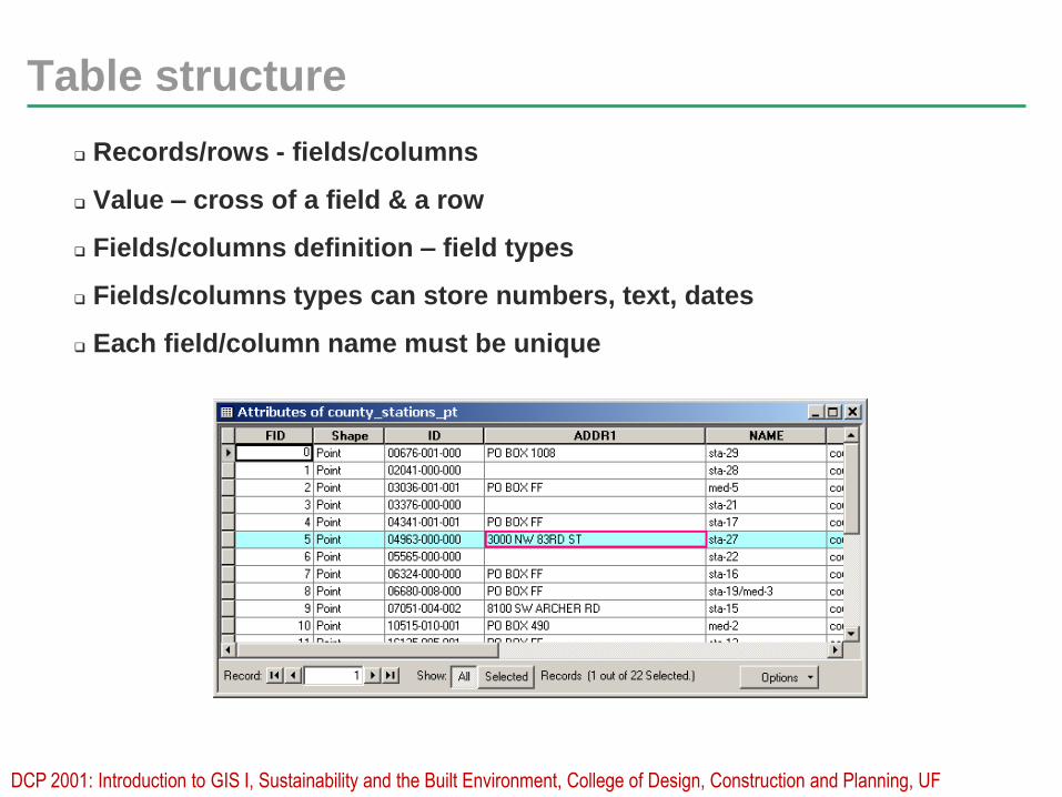
Table structure
Records/rows - fields/columns
Value – cross of a field & a row
Fields/columns definition – field types
Fields/columns types can store numbers, text, dates
Each field/column name must be unique

DCP 2001: Introduction to GIS I, Sustainability and the Built Environment, College of Design, Construction and Planning, UF
Tabular data - field data types
Different field data types store different kinds of values
Choose the right field type for the right value
Field types vary according to the file format of the table
Name: James
Age: 46
Height: 5.6
Date of birth: 2.12.00
Picture: jpg
James 46 5.6 2.12.00 picture

DCP 2001: Introduction to GIS I, Sustainability and the Built Environment, College of Design, Construction and Planning, UF
Working with tables in ArcGIS
In ArcCatalog – preview, edit existing, create new
Sort ascending or descending
Freeze/Unfreeze columns
Run statistics
In ArcMap
Select records
Edit existing values
Set up relationships
Make field calculations
etc.

DCP 2001: Introduction to GIS I, Sustainability and the Built Environment, College of Design, Construction and Planning, UF
Table options in ArcGIS
There are many options for table manipulations which can
be accessed from the virtual table interface.

DCP 2001: Introduction to GIS I, Sustainability and the Built Environment, College of Design, Construction and Planning, UF
ArcGIS tabular data formats
Each spatial format has a native tabular format
Coverages: INFO - closed
Shapefiles: dbf – open, interoperable
Geodatabases: mdb – somewhat operable
Can convert among the three or text format
Some can create links between them, independent on
the format
Can all be created in ArcGIS, but for the INFO which can
only be created in ArcInfo and ArcEditor

DCP 2001: Introduction to GIS I, Sustainability and the Built Environment, College of Design, Construction and Planning, UF
Associating tables
Spatial data store attributes in their feature table
Sometimes one or more separate tables exist that have
more information about our spatial data
An association can be made between the feature table and
the separate tables, to tie this additional information to the
spatial data
This association of tables is based on common column key
values
For this association to occur, the nature of the
relationships (cardinality) of these tables MUST BE KNOWN

DCP 2001: Introduction to GIS I, Sustainability and the Built Environment, College of Design, Construction and Planning, UF
Table Relationships - Cardinality
Four types of cardinality:
One-to-one
a unique value in one table associates to a unique record with same value in the other
One-to-many
a unique value in one table associates to many records with same value in the other
Examples:
One parcel – one owner i.e. one record
One parcel – multiple owners i.e. many records

DCP 2001: Introduction to GIS I, Sustainability and the Built Environment, College of Design, Construction and Planning, UF
Table Relationships – Cardinality
Four types of cardinality
Many-to-one
many unique values in one table associate to same value in the other
Many-to-many
many unique values in one table associate to many same values in the other
Examples:
Multiple parcels – one owner
Multiple parcels – multiple owners

DCP 2001: Introduction to GIS I, Sustainability and the Built Environment, College of Design, Construction and Planning, UF
Joins and Relates
Two ways are available in ArcMap for associating tables
Join - appends the attributes from one table onto the other based on
a common field, physically merges the two tables
Relate - defines a relationship between two tables
Use one or the other based on cardinality type

DCP 2001: Introduction to GIS I, Sustainability and the Built Environment, College of Design, Construction and Planning, UF
Joins
A Join insures a physical connection between the two tables into
one
A Join appends the attributes of the two tables
A Join assumes cardinality one-to-one or many-to-one
A Join is only virtual, does not change the data source
A Join can be removed at any time
One to one
matching records

DCP 2001: Introduction to GIS I, Sustainability and the Built Environment, College of Design, Construction and Planning, UF
Relates
Relates define a relationship between the two tables
Both tables remain independent, no physical merge
Relates assume cardinality one-to-many or many-to-many
A Relate is only virtual, does not change the datasource
A Relate can be removed at any time
The related table can be updated separately
One to many matching records
DCP 2001: Introduction to GIS I, Sustainability and the Built Environment, College of Design, Construction and Planning, UF
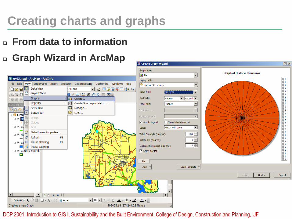
Creating charts and graphs
From data to information
Graph Wizard in ArcMap

DCP 2001: Introduction to GIS I, Sustainability and the Built Environment, College of Design, Construction and Planning, UF
More on charts and graphs
Dynamically summarize tabular information in a graph
ArcGIS supports a variety of graph types
ArcGIS allows for a variety of graphic properties to be set
ArcGIS graphs can tie to all or subsets of fields/records
ArcGIS graphs can be added to a map - Data View & Layout View
Graphs created outside of ArcGIS can be added to a map
Graphs update automatically as attributes or selections change in the layer
source, but they can also be made static i.e. disconnect from the layer
source.

DCP 2001: Introduction to GIS I, Sustainability and the Built Environment, College of Design, Construction and Planning, UF
What are reports?
A way to synthesize your results automatically and
store them in a commonly known format such as html,
pdf, etc.
A report may contain
tabular data
graphs and charts
maps
plain text
Reporting in ArcGIS
ArcMap > View > Reports > Create, Load, Run
DCP 2001: Introduction to GIS I, Sustainability and the Built Environment, College of Design, Construction and Planning, UF
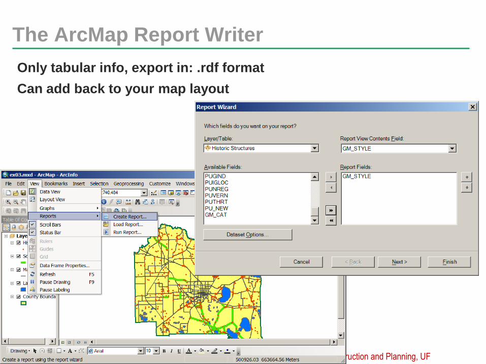
The ArcMap Report Writer
Only tabular info, export in: .rdf format
Can add back to your map layout