Embed Size (px)
Citation preview


August 17, 2008 TC-1
Table of Contents
Executive Summary .................................................................................................1
1.0 Introduction..............................................................................................................1 1.1 Project Description.......................................................................................2
2.0 Alternative Routing and Siting Methodologies .......................................................8 2.1 Study Area Description................................................................................8 2.2 Engineering Environment ............................................................................8 2.3 Natural Environment....................................................................................9 2.4 Routing and Siting Methodology.................................................................9
3.0 Alternative Routes and Sites..................................................................................13 3.1 Holland Cliff Shores ..................................................................................13 3.2 PEPCO 500 kV Crossing ...........................................................................19 3.3 Whispering Woods.....................................................................................21 3.4 Broomes Island Road Crossing..................................................................27 3.5 St. Leonard Shores/White Sands................................................................32 3.7 State Route 2/4/Patuxent River/Town Creek.............................................50 3.8 St. Mary’s/San Souci .................................................................................63 3.9 Southern Calvert Substation ......................................................................70
4.0 Conclusions and Recommendations ......................................................................72 4.1 Holland Cliff Shores ..................................................................................72 4.2 PEPCO 500 kV Crossing ...........................................................................72 4.3 Whispering Woods.....................................................................................73 4.4 Broomes Island Road Crossing..................................................................73 4.5 St. Leonard Shores/White Sands................................................................74 4.6 Dowell Road ..............................................................................................74 4.7 State Route 2/4/Patuxent River/Town Creek.............................................74 4.8 St. Mary’s/San Souci .................................................................................75
Figures
Figure 1-1 Calvert and St. Mary’s Counties.................................................................... 3 Figure 1-2 Alternate Route Locations ............................................................................. 4 Figure 1-3 Existing and Proposed Pole Configurations .................................................. 7 Figure 3-1A Holland Cliff Shores – Alternate A ............................................................. 16 Figure 3-1B Holland Cliff Shores – Alternate B.............................................................. 17 Figure 3-2 Pepco 500 kV Crossing................................................................................ 20 Figure 3-3A Whispering Woods – Alternate A................................................................ 23 Figure 3-3B Whispering Woods – Alternate B ................................................................ 24 Figure 3-3C Whispering Woods – Alternate C ................................................................ 25 Figure 3-4A Broomes Island Road Crossing – Alternate A............................................. 29

August 17, 2008 TC-2
Figure 3-4B Broomes Island Road Crossing - Alternate B.............................................. 30 Figure 3-5A St. Leonard Shores/White Sands - Alternate A ........................................... 36 Figure 3-5B St. Leonard Shores/White Sands - Alternate B............................................ 37 Figure 3-5C White Sands - Alternate C ........................................................................... 38 Figure 3-6A Dowell Road - Alternate A .......................................................................... 44 Figure 3-6B Dowell Road - Alternate B .......................................................................... 45 Figure 3-6C Dowell Road - Alternate C .......................................................................... 46 Figure 3-6D Dowell Road - Alternate D .......................................................................... 46 Figure 3-6E Dowell Road - Alternate E........................................................................... 48 Figure 3-7A State Route 4 / Patuxent River / Town Creek - Alternate A........................ 56 Figure 3-7B State Route 4 / Patuxent River / Town Creek - Alternate B ........................ 56 Figure 3-7C State Route 4 / Patuxent River / Town Creek - Alternate C ........................ 58 Figure 3-8A St. Mary’s/San Souci - Alternate A ............................................................. 66 Figure 3-8B St. Mary’s/San Souci - Alternate B.............................................................. 67 Figure 3-8C St. Mary’s/San Souci - Alternate C.............................................................. 68 Figure 3-9 Southern Calvert Substation ........................................................................ 71
Tables Table 3-1 Holland Cliff Shores Alternative Routes .................................................. 18 Table 3-2 Whispering Woods Alternative Routes .................................................... 26 Table 3-3 Broomes Island Road Crossing Alternative Routes.................................. 31 Table 3-4 St. Leonard Shores/White Sands Alternative Routes ............................... 39 Table 3-5 Dowell Road Alternative Routes .............................................................. 49 Table 3-6 State Route 4 / Patuxent River / Town Creek ........................................... 62 Table 3-7 St. Mary’s/San Souci ................................................................................ 69

August 17, 2008 ES-1
Executive Summary
The Southern Maryland Electric Cooperative, Inc. (SMECO) of Hughesville, Maryland is proposing to construct and operate a new multiple circuit transmission line from the general location of its existing Holland Cliff Switching Station near Holland Cliff, Maryland to its existing Hewitt Road Switching Station on Buck Hewitt Road in St. Mary’s County, Maryland. SMECO intends to use an existing right-of-way to the greatest extent feasible between the two terminal points for the proposed transmission line. The project is located in the counties of Calvert and St. Mary’s, and will require the crossing of the Patuxent River at or near Solomons, Maryland. The proposed transmission line is part of a major reliability improvement program to SMECO’s existing transmission network in the two counties. It will complete an essential 230 kV loop and tie its 230 kV transmission system together in its four-county service area (Calvert, St. Mary’s, Prince Georges, and Charles counties). Based on the Alternatives Evaluation Study, the proposal will include the construction of a new double circuit 230 kV transmission line, with provisions for two 69 kV circuits installed on the same structures. The project will also include the construction of a new Southern Calvert Switching Station near Maryland State Route 4 in the general area of the small community of Lusby. The Hewitt Road Switching Station will also be upgraded. The project may also require minor electrical upgrades to the following existing substations: Prince Frederick Substation, Dukes Inn Substation, Mutual Substation, St. Leonard Substation, Bertha Substation, and Solomons Substation, all within the existing fence lines. The proposed transmission line will measure approximately 30 miles in length. To minimize environmental impacts, and with the exception of the Patuxent River crossing described later in the report, SMECO intends to utilize its existing 69 kV line right-of-way, which is 100 feet wide for the majority of its length, between the two terminal points. The transmission line will consist of four circuits (two 230 kV and two 69 kV) on single tubular steel structures, with heights of 110 to 140 feet, for most of its length. SMECO recognizes that over the years, numerous land use developments have occurred adjacent to the existing 69 kV transmission line right-of-way. Several occupied single family dwellings and commercial establishments are now located adjacent to the existing line. In 2007, SMECO retained Black & Veatch Corporation (Black & Veatch) to provide engineering design services for the new transmission line, new switching station and substation upgrades. As part of these engineering services, Black & Veatch has conducted a preliminary survey to determine if viable and feasible alternative routing

August 17, 2008 ES-2
options exist at specified areas of congestion (presence of residential or commercial development very near the right-of-way) along the existing right-of-way. These areas of congestion, identified by SMECO and Black & Veatch, include the following:
• Holland Cliff Shores Subdivision. • PEPCO 500 kV lines. • Whispering Woods Subdivision. • Broomes Island Road Crossing. • St. Leonard Shores Subdivision and White Sands Subdivision. • Dowell Road area. • State Route 4 area and the crossings of the Patuxent River and Town Creek. • St. Mary’s and San Souci area in the vicinity of State Route 235. This report addresses possible alternative routing options at these congestion
points. It describes the methodology used to select alternative routings, describes the tools used in this process, and discusses each of the alternative routes, including a brief narrative and data table comparing each alternative with the existing right-of-way.

August 17, 2008 1
1.0 Introduction
SMECO is an unaffiliated electric transmission and distribution cooperative headquartered approximately twenty-five miles southeast of Washington D.C. in Hughesville, Maryland. SMECO presently serves more than 140,000 customer-members throughout Calvert, St. Mary’s, Charles, and southern Prince George’s Counties in southern Maryland, a service area of 1,150 square miles. In addition to its headquarters, SMECO has region offices in Prince Frederick, White Plains, and Leonardtown. SMECO shares service territory boundaries with two neighboring electric utilities: Potomac Electric Power Company (PEPCO) and Baltimore Gas & Electric (BG&E). There is no overlap, intermingling, or sharing of territory. SMECO has 3,688 miles of overhead distribution, 5,815 miles of underground distribution, 394 miles of transmission line, and more than 64,000 transformers. SMECO’s transmission system is primarily energized at 69 kV. SMECO purchases all of its power from utilities that operate generating facilities in the area. SMECO’s Holland Cliff - Hewitt Road 230kV Transmission Line Project is an expansion of SMECO’s existing 230 kV system, and its purposes are to meet long-term demand growth and provide better system reliability. To accomplish this, SMECO plans to construct the Proposed Project which will create a 230 kV transmission system loop. This approach also solves several short- and long-term issues regarding normal electric loads and outage contingency loads. These issues affect SMECO’s ability to continue to reliably serve its customer-members in the most efficient, cost-effective manner possible. The system demand and system reliability issues are addressed in more detail in the Alternatives Evaluation Study submitted separately to the Rural Utilities Service, an Agency that administers the programs of the USDA Rural Development Utilities Programs (USDA Rural Development).
In the past 30 years, SMECO’s customer base has tripled in number, but energy usage has increased by five times as the average customer’s energy consumption has grown. Southern Calvert County is currently served by a two-mile 69-kV submarine cable in the lower Patuxent River parallel to the Thomas Johnson Bridge near Solomons. This cable failed in January 2005 and restoring service to southern Calvert County required transmission circuits from northern Calvert County to supply power more than 21 miles on one of the coldest days of the year. Based on anticipated growth in population and energy demand, there will be insufficient capacity to restore service in this manner by 2015, and no alternatives exist at this time other than installing a new 230kV source in southern Calvert County.

August 17, 2008 2
The Hewitt Road switching station provides electric service to southern Calvert County and St. Mary’s County, including the Patuxent River Naval Air Station. If unexpected maintenance or a natural disaster were to severely damage or destroy a single structure along the 24-mile 230-kV double circuit transmission line, nearly one-third of SMECO’s system peak load would be out of service, including the Patuxent River Naval Air Station, and SMECO would have limited ability to restore service until the 230-kV structure could be repaired or replaced. Therefore, SMECO proposes to create a 230 kV transmission system loop in which areas that experience a service interruption can be quickly provided power from another direction. In addition to the transmission loop, there will be the need for a new substation to step down the 230 kV transmission line voltage to 69 kV for distribution to customers in the area. Existing distribution substations do not have the space to accommodate the facilities for a 230/69 kV substation. The location of the substation must be near the existing 69 kV line and in an area where enough vacant land is available to accommodate the facilities and to provide a visual buffer from existing residences. The new 230/69kV switching station fenced area will cover approximately 4 acres, thus resulting in approximately 5-6 acres of disturbance. The new 230/69kV switching station is proposed to be located in southern Calvert County in the vicinity of the existing Calvert Cliffs 69kV transmission line tap near the intersection of Pardue Road and Maryland State Route 4 (See Figure 1-2). 1.1 Project Description SMECO proposes to install 20 miles of new 230-kV single pole, double circuit transmission line from the Holland Cliff station to a new southern Calvert County switching station, construct a new 230/69-kV switching station located in southern Calvert County, construct a new two-mile river crossing from Solomons to Town Creek, install eight miles of new 230-kV single pole, double circuit transmission line from a new southern Calvert County switching station to the existing Hewitt Road switching station in Lexington Park (St. Mary’s County), and add a new line terminal position in the existing Hewitt Road switching station. Figure 1-1 shows the location of Calvert and St. Mary’s County and Figure 1-2 shows the proposed system loop.
The proposed transmission line will measure approximately 30 miles in length. After evaluating alternatives for location of the proposed transmission line, SMECO determined that maximizing the use of its existing right-of-way between the upgraded Holland Cliff Switching Station and the Hewitt Road Switching Station is the option with the least impact to the public and to the environment. Approximately 22 miles of the 30-

August 17, 2008 3
mile route is in right-of-way of 100 feet in width, five miles in 150-foot wide right-of-way, one mile in 122-foot wide right-of-way, and less than a mile in 75-foot right-of-way. The remainder of the length is at the Patuxent River crossing. The existing SMECO right-of-way contains one single circuit 69 kV transmission line on single wood or light duty (LD) steel poles with heights varying from 45 to 65 feet (see Figure 1-3). The existing 69 kV transmission line from Holland Cliff to the area of Southern Calvert will be replaced by a double-circuit 230 kV transmission line with positions for a double-circuit 69 kV underbuild. Only one 69 kV circuit will be installed initially. The existing 69 kV transmission line from the area of Southern Calvert to the existing Hewitt Road Switching Station will be replaced by a double-circuit 230 kV transmission line with positions for a double circuit 69 kV underbuild. Only one 230 kV circuit and one 69 kV circuit will be installed initially.
At this time, SMECO anticipates that very little new right-of-way is required for the project. However, the ongoing environmental assessment to support the Borrower’s Environmental Report will contain additional information needed to confirm the need for new right-of-way. The new Southern Calvert Switching Station will require land acquisition, and upgrades to the Hewitt Road Switching Station will occur within the existing fenced area of the station. It is anticipated that one lot adjacent to the existing Holland Cliff property will need to be purchased to accommodate the egress of the 230 kV transmission lines from the site. It is currently a lightly wooded lot that is part of a residential property. Upgrades at other substations should not require the purchase of additional lands. Tubular steel poles are being considered for the new line. The tubular steel structures with both the 230 kV and 69 kV circuits will measure approximately 110 feet to 140 feet in height, depending upon on structure type, terrain, span length, and required conductor spacing. In comparison, the existing 69 kV wood pole structures currently measure 45 feet to 65 feet in height. The new poles will be approximately 1.5 to 3 times the height of the existing structures. Two new 230 kV circuits will be placed near the top of the structures in a vertical configuration. Below the two 230 kV circuits, two 69 kV circuits can be installed in a vertical configuration (Figure 1-3). This arrangement, with the 230 kV lines on top and the 69 kV lines underneath, is called a 69 kV “underbuild”. The existing 69 kV line will use one of the two circuit arrangements on the new poles. A single fiber optical ground wire (OPGW) and one overhead shield wire will be strung at the top of each structure to provide lightning protection and a communications path between the various stations and switching facilities.

August 17, 2008 3
Figure 1-1 Calvert and St. Mary’s Counties

August 17, 2008 4
Figure 1-2 Alternate Route Locations

August 17, 2008 5
Typical foundations will consist of large drilled piers, one for each tubular steel structure. Each foundation will measure approximately 8 feet in diameter and be 25 feet deep. The foundation will consist of rebar and anchor bolts backfilled with concrete, and will sit approximately 6-18 inches above grade.
The two 230 kV circuits in a vertical configuration will be suspended on upswept davit arms with I-string insulators. Where the 69 kV underbuild is planned, the two 69 kV circuits will be suspended on horizontal davit arms with I-string insulators. A minimum ground clearance of 22 feet for the 69 kV conductors will be maintained along the length of the line and at road crossings. The proposed transmission line will have a typical span length of approximately 600 feet between the new structures, as compared to approximately 400 feet between the existing wood poles or LD steel structures. In effect, every fourth existing 69 kV structure will be removed from the existing right-of-way, reducing the number of structures by roughly one-quarter with the new construction. No additional right-of-way will be required if SMECO uses its existing right-of-way. The proposed transmission line will cross the Patuxent River and Town Creek. At present, four crossing options are being investigated. These include 1) attachment to a new state highway bridge for State Route 2/4, 2) submarine cables water jetted into the bottom of the river and creek, 3) a directional bore beneath the bottom of the Patuxent River and Town Creek, and 4) an overhead conductor span between large towers on each side of the river channel. In option 2, a high-pressure water jet digs a trench along the river bottom into which the transmission line cable is placed. Silt and mud naturally and immediately start filling the trenches and covering the cable. The proposed location of the southern Calvert County switching station is in southern Calvert County in the vicinity of the existing Calvert Cliffs 69kV transmission line tap near the intersection of Pardue Road and Maryland State Route 4. SMECO has not yet purchased a site, but anticipates that any site acquired in the area will require tree and brush clearing to accommodate the new facility. Final evaluation of the site property purchased will be in accordance with Section 2.0 of this report. Final engineering will determine the size of the site and the amount of clearing required. Environmental impacts associated with the southern Calvert County switching station will be addressed in the Environmental Assessment. The new 230kV/69kV switching station fenced area will cover approximately 4 acres, thus resulting in approximately 5-6 acres of disturbance. Any upgrades to other existing SMECO substations and the Hewitt Road Switching Station will occur on property already owned by SMECO. The Macro-Corridor Study is prepared in support of an Environmental Assessment from the Rural Utilities Service, an agency that administers the programs of

August 17, 2008 6
the USDA Rural Development Utilities Programs (USDA Rural Development). The Proposed Project is expected to take more than three years to construct; with a proposed start of construction activities in 2011 resulting in a scheduled completion of construction in 2015. SMECO is also currently developing information required to support the Certificate of Public Convenience and Necessity (CPCN) application for review by the Maryland Public Service Commission (PSC). Proposal and construction of this project must comply with the requirements of the National Environmental Policy Act (NEPA). The purpose of NEPA is to establish a policy that sets environmental protection goals and a means of achieving those goals. NEPA requires that federal agencies consider the environmental consequences of actions, or projects, before those actions are taken. The financial assistance that the Rural Development Utilities Program provides is considered a federal action. The determination of environmental consequences is typically made using an Environmental Assessment (EA) and/or an Environmental Impact Statement (EIS). The former is anticipated for this project.

August 17, 2008 7
Figure 1-3 Existing and Proposed Pole Configurations

August 17, 2008 8
2.0 Alternative Routing and Siting Methodologies
2.1 Study Area Description The study area is located in central and southern Calvert County and in a small portion of eastern St. Mary’s County. These are the locations in SMECO’s service area of greatest population growth and energy demand. The study area was focused on land in and on either side of SMECO’s existing 69 kV transmission line right of way because it runs down Calvert County parallel with the county’s primary transportation artery, State Highway 2/4. The frequent improvements to the highway over the last 20 years have attracted residential and commercial development to the county. Most of the area is privately owned land. Despite the development, much of land near SMECO’s right-of-way is agricultural. Truck crops, fruits and poultry are important sources of income in the area. Forage crops, soybeans, and grain for dairy and beef cattle also are important. Rural residences are on sites where farming is less favorable. But throughout the area, farmland is being converted to urban land at increasing rates, primarily for residential purposes. A narrow belt along the coast is developed for resorts to support recreation activities including numerous marinas or support services. 2.2 Engineering Environment The existing transmission line is a 69 kV line installed on single-pole structures throughout the 30 miles of right-of-way in the study area. The right-of-way width varies generally between 100 feet and 150 feet, depending on when the right-of-way was acquired and what constraints there were at the time of acquisition. Approximately 22 miles of the 30-mile route is in right-of-way of 100 feet in width, five miles in 150-foot wide right-of-way, one mile in 122-foot wide right-of-way, and less than a mile in 75-foot right-of-way. The remainder of the length is at the Patuxent River crossing. Calvert County is located along a topographic ridge that is bordered to the east by the Chesapeake Bay and to the west by the Patuxent River. Generally, the topography slopes gently towards the southeast. Steep slopes and ravines are frequently present along the Chesapeake Bay, the Patuxent River and in upland drainage areas. These drainage areas include the central portion of Calvert County where steep slopes and more rugged areas are present due to the headwaters of several streams. Inland elevations of Calvert County are generally between 100 feet and 150 feet above sea level. Local relief is variable and generally increases significantly near drainage features. Steep slopes can occur near the major streams and along the shorelines

August 17, 2008 9
of the Patuxent River and the Chesapeake Bay. Soil slopes near the proposed SMECO right-of-way indicate steep slopes are common. Drainage along the proposed SMECO line will enter the Patuxent River watershed or the Severn River watershed. In general, the western two-thirds of Calvert County drain to the Patuxent River and the eastern third drains into the Chesapeake Bay. The Severn River watershed runs along the west side of Chesapeake Bay. 2.3 Natural Environment Named streams crossed by the proposed transmission line include (from north to south) Hunting Creek, Mill Creek, Parker Creek, St. Leonard Creek, Planters Wharf Creek, St. Johns Creek, Helen Creek, St. Paul Branch, Town Creek and Kingston Creek. Several unnamed streams also are crossed, most of which are too small to be indicated on the US Geological Survey (USGS) topographic maps. There are 28 wetlands within the existing SMECO right-of-way or close enough to be affected by work in the right-of-way. Most are located in valley bottoms between steeply sloped hills and associated with small streams. Wetlands are also located within or adjacent to several constructed ponds used for stormwater detention adjacent to the right-of-way. The major watershed in the project area is the Patuxent River, with a small portion of the Upper Chesapeake Bay at the southernmost point. This area supports pine and hardwoods and most of the area was forested at one time. Most of the woodland in the area today is in farm woodlots, but there are some large holdings. Forested areas are separated by agricultural lands, urban development and related infrastructure. Wildlife habitat associated with the transmission line corridor consists mainly of open mixed hardwood and coniferous forests, some agricultural land, and urbanized areas. Portions of the transmission line right-of-way are located adjacent to or cross riparian areas associated with streams. Many of the streams have associated wetlands within the right-of-way, but none is large enough to support a diverse resident wildlife assemblage except in or near tidal wetlands associated with St. Leonard Creek, St. John’s Creek, Hunting Creek or the Patuxent River. A report containing the findings of a wetlands study and threatened and endangered species survey will be part of the Environmental Assessment. 2.4 Routing and Siting Methodology In order to evaluate alternative routes that would meet the needs described earlier in this report, SMECO considered several alternatives. The most obvious alternative, and the one ultimately selected for this study, was the use its existing 69 kV right-of-way for

August 17, 2008 10
the entire length of the project. But before this conclusion was reached, several questions were addressed.
• Is the existing right-of-way width sufficient to accommodate both the existing 69 kV line and the new 230 kV line and meet the required engineering requirements?
• Even with existing rights-of-way, are there other routes that will have less impact on nearby residents?
• If alternative routes are chosen, what will be the environmental impact even if the impact on nearby residents is minor?
• Can the project’s objectives be better served by selecting a route other than that along the existing SMECO right-of-way?
Wherever the existing right-of-way was considered to be congested-that is, having residential or commercial development very near the right-of-way, alternative routes were identified and assessed. Each of these areas of congestion was viewed on color aerial photography to identify the existing SMECO right-of-way, various land use features, possible constraints, and potential routing alternatives (if any).
Alternative routing options were evaluated relative to distance to existing structures (residences, schools, churches, and hospitals) and the crossing of wooded areas, agricultural lands, parkland, wetlands, waters, US Navy property, and other state or federal lands. Specifically, the information that appears in Tables 3-1 through 3-7 was collected and tabulated for those portions of the existing SMECO right-of-way that occur within an area of congestion and for each alternative route considered to avoid that area of congestion.
The significance of each of the criteria in the tables, with respect to the evaluation of alternative routes, is explained here in terms of constraints and opportunities. Use of existing right-of-way and new right-of-way required. Because the existing SMECO right-of-way has a 69 kV transmission line on it and is cleared and maintained, the use of existing right-of-way is normally an opportunity to be pursued. Environmentally, it is the option of least impact. From the public’s point of view, those who live and work nearby are aware of the presence of overhead lines. While placing new and larger structures in the existing right-of-way will have a visual impact, the number of structures in the right-of-way will decrease due to the longer spans. A constraint in using existing right-of-way occurs where the line is in a very congested area. Larger and taller structures have a greater visual impact and could pose engineering challenges.

August 17, 2008 11
Parallel of existing right-of-way. This refers to road and utilities rights-of way. An opportunity arises if the use of existing rights-of-way owned by others would minimize the visual and environmental impacts of a new transmission line. The new line would be in a corridor already dedicated to utility use or along a road in a highly developed area. Constraints occur if there is not sufficient room in the right-of-way for another overhead transmission line or if placement along a road or highway poses the possibility of a forced relocation for highway widening in the future. Overhead length and underground length. Whether a line is installed overhead or underground, length speaks primarily to costs and the opportunity lies with the shorter length. The longer an alterative route is the higher the costs, in general. However, the length of an alternative route can also be proportional to its impact on the environment if tree or habitat clearing is required or if waterways are crossed. Thus, the greater length of an alternative is a constraint on its use. Number of major angles 30º and greater. This has mostly to do with costs as major angle structures have construction costs in the range of 50% to 70% higher than for tangent structures. An additional constraint is the area needed to construct a major angle structure because guy wires are needed. The need for guy wires may require that part of a planted field or private property can no longer be used. The opportunity lies with the least number of angled structures. Residence, schools, churches, and hospitals within 200 feet. The opportunity lies with avoiding inhabited structures as much as possible. Therefore, the fewer of them close to the right-of-way, the lower the visual impact as well as the impact from construction and maintenance activities. Routing new lines close to these structures poses a constraint to be avoided. Agricultural land, woodlands crossed, parkland crossed. The use of agricultural and woodlands for new transmission lines can pose an opportunity or a constraint depending the on the monetary and aesthetic value of the land to be used. Since commercial tree farms or common cropland may continue operation adjacent to the right-of-way, they can be an attractive alternative to an existing right-of-way in a congested area. However, natural forests and high-quality farmlands are of limited supply and pose a greater cost of acquisition, both financial and environmental.

August 17, 2008 12
U. S. Navy property crossed. The use of the US Naval Recreation Center near Solomons poses more of an opportunity than a constraint. The land already houses SMECO’s 69 kV transmission line and is completely cleared and developed. Preliminary discussions with Navy personnel indicate that the new line could be built there with little or no impact on the general public nearby and only minor disruption of activities on the property itself.
Each alternative needs to be further investigated relative to existing and future land use impacts, right-of-way availability, access roads for construction and maintenance, constructability, cost, and additional environmental impacts resulting from establishing a new right-of-way on such features as wetlands, river and stream crossings, woodland clearing and woodlot fragmentation, protected species (threatened and endangered plant and animal species), cultural resources (historic and prehistoric sites, districts and features), and aesthetic (visual) impacts from the proposed transmission line. These same criteria will also be used to further investigate the option of using existing SMECO right-of-way for the proposed transmission line.
August 17, 2008 13
3.0 Alternative Routes and Sites
Eight potential areas of congestion have been identified by SMECO and Black & Veatch along the existing 69 kV transmission line right-of-way. Black & Veatch environmental and transmission line routing specialists performed a survey of potential alternative routing options at these congested areas. The areas of congestion that were evaluated for alternative routing options include to following and are discussed in the following sections.
• Holland Cliff Shores Subdivision. • Intersection of the existing SMECO transmission line right-of-way and
proposed PEPCO 500 kV transmission lines. • Whispering Woods Subdivision. • Broomes Island Road Crossing. • St. Leonard Shores Subdivision and White Sands Subdivision. • Dowell Road area just north of Solomons, Maryland. • State Route 4 area and the crossings of the Patuxent River and Town Creek at
Solomons. • St. Mary’s and San Souci area in the vicinity of State Route 235 and the
Hewitt Road Switching Station. 3.1 Holland Cliff Shores Holland Cliff Shores is a small subdivision that is located immediately south of SMECO’s existing Holland Cliff Switching Station. The subdivision consists of several single family residences interspersed throughout a wooded area. The main east-west road through the subdivision is Holland Drive. There is one primary north-south road that basically follows and, at times, shares the existing SMECO 69 kV transmission line right-of-way. To the north of Holland Drive, this road is named Power Line Drive. To the south of Holland Drive, the road is named Hidden Hill Drive. The existing 69 kV transmission line is within approximately 200 feet of 13 single family residences, most of which face the existing right-of-way and have their driveway access off of Power Line Drive and Hidden Hill Drive. Rebuilding the existing line to the new 230 kV facility within the existing right-of-way will not place the new line any closer to these or any other residences. It will not require the purchase of any additional land, nor will it cross any active agricultural lands. Some minor selective clearing along the right-of-way edges may be necessary to remove trees with limbs that would be close to the new overhead lines, but traditional clearing measures will not be required.
August 17, 2008 14
Two alternative routing options have been identified to route the proposed transmission line around the center of the subdivision. Alternative Route A is located to the west, while Alternative Route B is located to the east. Alternative A exits the site of the existing Holland Cliff Switching Station to the southwest for a short distance before turning to the southeast. The route remains in a ravine and wooded area for its entire length before returning back to the existing SMECO right-of-way south of the subdivision (Figure 3-1A). The alternative routing would place the new transmission line within approximately 200 feet of seven residences. The primary benefit of this alternative routing is that the new line would be located to the rear of most of these residences instead of in the front yards as is the case with the existing 69 kV line. The alternative measures approximately 0.9 miles in length whereas the existing 69 kV transmission line right-of-way measure 0.8 miles in length. However, it will require the acquisition of new right-of-way, three major angle structures will be needed to construct the new 230 kV transmission line along this route, about 11 acres of woodland will have to be cleared, and structures that might be located in a ravine to accommodate required span lengths will be taller than normal to achieve required clearances. But any low lying area identified as a wetland will be avoided for new pole placement if at all possible. If not possible, a wetland delineation will be performed and the required permits obtained, and mitigative measures taken. No threatened or endangered species or their habitats are in this immediate area. Alternative B provides a routing option to the east of the Holland Cliff Shores Subdivision. It exits the site of the proposed Holland Cliff Switching Station to the southeast, passing between two single family residences on Robinson Road. It continues to the southeast into a large wooded area before turning due south. It passes several residences along Robinson Road before turning back to the southwest to interconnect with the existing SMECO 69 kV transmission line right-of-way (Figure 3-1B). The routing option is located within 200 feet of nine single family residences, passing between and behind these homes. The alternative is about 1.5 miles in length, while SMECO’s original route is 1.3 miles in length. This option will require 1.5 miles of new right-of-way, three major angle structures to accommodate the new line along this route and the clearing of approximately 17 acres of woodland. Table 3-1 provides an initial comparative resource inventory of the two alternative routes as compared to using the existing SMECO right-of-way. If an alternative routing is selected, the impacts associated with using the existing right-of-way are basically shifted to other residents in the area. Alternative A does offer the small advantage of placing the proposed transmission line to the rear of the existing residences. Complete clearing of the new right-of-way along either route will be required, resulting

August 17, 2008 15
in greater environmental impacts. In addition, project costs will increase due to the need to purchase new right-of-way for either alternative and add at least three major angle structures.

August 17, 2008 16
Figure 3-1A Holland Cliff Shores – Alternate A

August 17, 2008 17
Figure 3-1B
Holland Cliff Shores – Alternate B

August 17, 2008 18
Table 3-1 Holland Cliff Shores Alternative Routes
Existing ROW Alternative A Existing ROW Alternative B
Length 0.8 miles 0.9 miles 1.3 miles 1.5 miles
Use of Existing ROW 0.8 miles 0 miles 1.3 miles 0 miles
New ROW Required 0 miles 0.9 miles 0 miles 1.5 miles
Parallel of Existing ROW 0 miles 0 miles 0 miles 0 miles
Overhead Length 0.8 miles 0.9 miles 1.3 miles 1.5 miles
Underground Length 0 miles 0 miles 0 miles 0 miles
Number of Major Angles (30º) 0 3 0 3
Residences Within 200 Feet 13 7 13 9
Schools Within 200 Feet 0 0 0 0
Churches Within 200 Feet 0 0 0 0
Hospitals Within 200 Feet 0 0 0 0
Agricultural Land Crossed 0 miles 0 miles 0.2 miles 0 miles
Woodlands Crossed 0 miles 0.9 miles 0 miles 1.4 miles
Parkland Crossed 0 miles 0 miles 0 miles 0 miles
US Navy Property Crossed 0 miles 0 miles 0 miles 0 miles
Creeks/Waters of US/Wetlands/USACE 0.01 mile 0.2 mile 0.01 mile 0.4 mile
Coastal Barriers 0 miles 0 miles 0 miles 0 miles
Federal lands 0 miles 0 miles 0 miles 0 miles

August 17, 2008 19
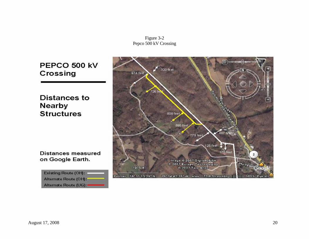
3.2 PEPCO 500 kV Crossing Approximately 0.8 miles south of the city of Prince Frederick, Maryland, and just south of Secretariat Drive, the existing SMECO 69 kV transmission line is crossed by a PEPCO 500 kV transmission line. The 500 kV line crosses over the 69 kV line and then parallels the SMECO line for roughly 0.7 miles on the east side before turning away from the SMECO right-of-way (Figure 3-2). The line is one of three 500 kV transmission lines emanating from the Calvert Cliffs Nuclear Station. PEPCO plans to add another 500 kV line out of Calvert Cliffs. This line will parallel its existing 500 kV line where it parallels the SMECO right-of-way. As such, SMECO may have to relocate its existing right-of-way, and the proposed new 230 kV transmission line, to the southwest. If relocation is necessary, it will be immediately adjacent to and southwest of SMECO’s existing right-of-way.
Several single family residences and small farms are located on German Chapel Road and Hilendale Way. At present, the closest residence to the southwest is more than 700 feet from the edge of the existing SMECO and PEPCO rights-of-way. As such, there is adequate space for SMECO to relocate its right-of-way to allow PEPCO to parallel its existing 500 kV transmission line with a second line. As the entire 0.7 miles is wooded, expanding the existing right-of-way in the area should not visually impact the residences and farms on German Chapel Road and Hilendale Way. However, any new right-of-way will require clearing of all large woody vegetation. A small pond will have to be crossed, but no agricultural lands will be crossed by the relocated right-of-way. But due to the needed relocation to accommodate the PEPCO 500 kV line, the land clearing and associated impacts would happen regardless of the proposed project.
August 17, 2008 20
Figure 3-2 Pepco 500 kV Crossing
August 17, 2008 21
3.3 Whispering Woods Approximately 3.5 miles south of the city of Prince Frederick, the original alignment of the 69 kV transmission line passed through the center of the Whispering Woods subdivision, crossing the two primary streets in the subdivision, Whispering Drive and Sequoia Way. Some years ago, SMECO relocated its existing 69 kV transmission line to the western edge of the subdivision in response to political pressure from a major landowner in this area. Currently, the existing 69 kV transmission line parallels a gas pipeline and passes through the far western portions of the subdivision. The right-of-way no longer crosses the two subdivision streets, but does cross a long driveway that serves three single family residences. As such, the alignment passes between several residences, with three to the north and three to the south of the line. In total, the existing route passes within 200 feet of 12 single family residences. Three alternative routing options have been identified for the area. One, Alternative A, removes the transmission line right-of-way altogether from the subdivision, while Alternatives B and C pass through other areas of the subdivision. Alternative A will require new right-of-way, while Alternatives B and C will use a portion of SMECO’s original and abandoned right-of-way as it approaches Whispering Woods before requiring new right-of-way. Alternative A starts at an angle point along the right-of-way and extends south for approximately 1,200 feet before turning east to return to the existing SMECO right-of-way (Figure 3-3A). This location places the routing option to the south of the Whispering Woods subdivision in a wooded area. The alignment is to the rear of homes in the subdivision, with the closest being approximately 300 feet away. This alternative has only one residence within 200 feet, with a dense wooded area separating this residence from the alternative alignment. Alternative A measures approximately 0.9 miles as compared to the existing SMECO right-of-way at 0.7 miles. Two major angles will be required with this alternative as compared to one if the existing right-of-way is used. Roughly 10 acres of woodland clearing will be required for this alternative route. Alternative B makes use of a portion of SMECO’s original cleared right-of-way as it approaches the Whispering Woods subdivision. This right-of-way was abandoned due to political opposition when the existing 69 kV line was relocated to parallel the natural gas pipeline. There is reason to believe that the use of the original right-of-way may no longer meet with opposition. Alternative B uses the original right-of-way for approximately 3,400 feet before turning to the east (Figure 3-3B). It then crosses a wooded area north of the subdivision before turning to the southeast to cross Whispering Drive between two residences. Once past the residences, it turns south through another wooded area to return to SMECO’s existing right-of-way. In this area, the alternative is

August 17, 2008 22
to the rear of residences located on Sequoia Way and Blackberry Lane. Seven single family residences are within 200 feet of the routing option as compared to 12 along the existing right-of-way. The routing option is shorter (1.5 miles) than the existing SMECO right-of-way (1.6 miles) but will require 0.8 miles of new right-of-way. Four major angles will be required and approximately 10 acres of woodland will have to be cleared to accommodate the new transmission line. Alternative C follows a similar path as Alternative B. It makes use of the original SMECO right-of-way and turns east at the same point as Alternative B. However, it extends farther to the east, crossing Whispering Drive near Abigail Court and between two residences. Once east of Whispering Drive, this alternative turns to the southeast for a short distance before turning south to intersect with the existing SMECO right-of-way (Figure 3-3C). The alignment is to the rear of several homes on Abigail Court and Blackberry Lane. It passes within 200 feet of 10 single family residences. The routing option is located in wooded areas, but does cross a small parcel of active agricultural lands. Its length is approximately 1.7 miles, while the existing SMECO right-of-way is 1.6 miles. This alternative will require 1.1 miles of new right-of-way, six new major angle structures, and the clearing of about 12 acres of area woodlands. The alignment would also place the new transmission line much closer to Maryland State Route 2/4 (625 feet), thereby increasing the potential for visual impacts to passing motorists. Of the three alternative routing options identified, only Alternative A offers some potential. It reduces the number of residences within 200 feet from 12 to one, it only requires one additional major angle structure and the amount of woodland clearing is similar to the other alternatives. Alternatives B and C propose to use former SMECO right-of-way that was relinquished to the property owner when the 69 kV transmission line was relocated to the west to parallel the natural gas pipeline. It is unlikely that the landowner would allow for a reuse of the right-of-way on his 500-acre parcel, especially since there are preliminary plans to develop this property. Project costs will likely increase with any of the alternative routings because of the need to acquire new right-of-way and add new and expensive angle structures. Table 3-2 provides an initial resource inventory that compares the three alternatives to the existing SMECO right-of-way.

August 17, 2008 23
Figure 3-3A
Whispering Woods – Alternate A

August 17, 2008 24
Figure 3-3B Whispering Woods – Alternate B

August 17, 2008 25
Figure 3-3C Whispering Woods – Alternate C

August 17, 2008 26
Table 3-2 Whispering Woods Alternative Routes Existing ROW Alternative A Existing ROW Alternative B Alternative C
Length 0.7 miles 0.9 miles 1.6 miles 1.5 miles 1.7 miles
Use of Existing ROW 0.7 miles 0 mile 1.6 miles 0.7 miles 0.6 miles
New ROW Required 0 mile 0.9 miles 0 mile 0.8 miles 1.1 miles
Parallel of Existing ROW 0 mile 0 mile 0 mile 0 mile 0 mile
Overhead Length 0.7 miles 0.9 miles 1.6 miles 1.5 miles 1.7 miles
Underground Length 0 mile 0 mile 0 mile 0 mile 0 mile
Number of Major Angles (30º) 1 2 3 4 6
Residences Within 200 Feet 12 1 12 7 10
Schools Within 200 Feet 0 mile 0 mile 0 mile 0 mile 0 mile
Churches Within 200 Feet 0 mile 0 mile 0 mile 0 mile 0 mile
Hospitals Within 200 Feet 0 mile 0 mile 0 mile 0 mile 0 mile
Agricultural Land Crossed 0 mile 0 mile 0 mile 0 mile 0 mile
Woodlands Crossed 0 mile 0.8 miles 0 mile 0.8 miles 0 mile
Parkland Crossed 0 mile 0 mile 0 mile 0 mile 0 mile
US Navy Property Crossed 0 mile 0 mile 0 mile 0 mile 0 mile
Creeks/Waters of US/Wetlands/USACE 0.1 mile 0.2 mile 0.1 mile 0.3 mile 0.3 mile
Coastal Barriers 0 mile 0 mile 0 mile 0 mile 0 mile
Federal lands 0 mile 0 mile 0 mile 0 mile 0 mile

August 17, 2008 27
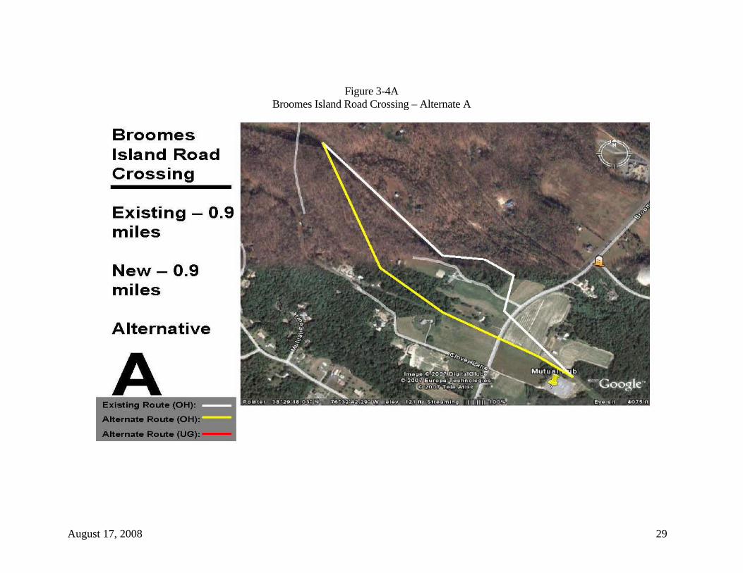
3.4 Broomes Island Road Crossing SMECO identified the Broomes Island Road (Maryland State Route 264) crossing as an area that should be investigated for possible alternative alignments. The existing SMECO right-of-way was relocated to the north some years ago to avoid several outbuildings on private property on the west side of the road. The landowner continues to express concerns about the proximity of the existing 69 kV line and may express more concern about any upgrades that increase the voltage levels in the existing right-of-way or the height of the transmission line structures. Though a landowner concern about existing structures is not necessarily a sufficient reason for relocating them, the installation of new structures provide an opportunity to revisit the issue. Once past the residence and outbuildings, the existing line turns to the south and crosses Cloverdale Road, which serves as the driveway to the residence on the property. On the same property along its frontage with Broome’s Island Road, an angle structure turns the existing line back to the southeast to continue down SMECO’s existing right-of-way. The angle structure that facilitates this turn is approximately 720 feet in front of the residence. Two possible alternative routing options were identified for this area of concern. Both remove the transmission line from the front of the property on the west side of the road. Alternative A starts about 0.5 miles northwest of and behind the residence near Sequoia Way (in the Whispering Woods subdivision). It angles more to the south-southeast than the SMECO right-of-way to a point about 1,600 feet northwest of Broome’s Island Road. It then passes through a coniferous woodlot and some agriculture land before crossing Broome’s Island Road about 325 feet south of the existing crossing (Figure 3-4A). It then continues to the southeast and ties back into the SMECO existing right-of-way at the Mutual Substation. This routing option measures approximately 0.9 miles, the same as the existing route. However, this will be all new right-of-way. It reduces the need for three major angles in the existing alignment, requires the clearing of more than six acres of deciduous and coniferous woodlots west of Broome’s Island Road, and still has portions of the alternate route on the private property in question. While the existing route has four single family residences with 200 feet, this alternate alignment places five residences within 200 feet. A similar amount of agriculture land is crossed by this optional route and the existing right-of-way. A second routing option was identified that just removed the existing line from the front of the private property (Alternative B). The option starts about 680 feet east of the residence at an existing angle in the route. Instead of turning to the south along the existing right-of-way, the option proceeds to the southeast, crosses Broome’s Island Road in an open agricultural area, and continues into a coniferous woodlot, where it turns to the

August 17, 2008 28
south-southwest to eventually intersect with SMECO’s existing right-of-way at the Mutual Substation (Figure 3-4B). The length of the option, 0.3 miles, is the same as the existing route. It too will require two major angles and will need 0.3 miles of new right-of-way. An additional 1.2 acres of pine woodlot will have to be cleared for this routing option. The option will cross slightly less active agricultural land than the existing route, reducing somewhat the impact to agricultural operations on the farm across Broomes Island Road from the private property in question. However, the upgraded 230 kV transmission line will still be in proximity to the residence and outbuildings. Table 3-3 provides an initial comparison of the two alternate routes with the existing SMECO right-of-way.
August 17, 2008 29
Figure 3-4A Broomes Island Road Crossing – Alternate A

August 17, 2008 30
Figure 3-4B Broomes Island Road Crossing - Alternate B

August 17, 2008 31
Table 3-3 Broomes Island Road Crossing Alternative Routes Existing ROW Alternative A Existing ROW Alternative B
Length 0.9 miles 0.9 miles 0.3 miles 0.3 miles
Use of Existing ROW 0.9 miles 0 miles 0.3 miles 0 miles
New ROW Required 0 miles 0.9 miles 0 miles 0.3 miles
Parallel of Existing ROW 0 miles 0 miles 0 miles 0 miles
Overhead Length 0.9 miles 0.9 miles 0.3 miles 0.3 miles
Underground Length 0 miles 0 miles 0 miles 0 miles
Number of Major Angles (30º) 3 0 2 2
Residences Within 200 Feet 4 5 2 1
Schools Within 200 Feet 0 0 0 0
Churches Within 200 Feet 0 0 0 0
Hospitals Within 200 Feet 0 0 0 0
Agricultural Land Crossed 0.3 miles 0.3 miles 0.3 miles 0.2 miles
Woodlands Crossed 0 miles 0.5 miles 0 miles 0.1 miles
Parkland Crossed 0 miles 0 miles 0 miles 0 miles
US Navy Property Crossed 0 miles 0 miles 0 miles 0 miles
Creeks/Waters of US/Wetlands/USACE 0.1 mile 0 mile 0 mile 0 mile
Coastal Barriers 0 miles 0 miles 0 miles 0 miles
Federal lands 0 miles 0 miles 0 miles 0 miles

August 17, 2008 32
3.5 St. Leonard Shores/White Sands About one mile south of the small community of St. Leonard, two subdivisions are crossed by SMECO’s existing 69 kV transmission line. The two are separated by St. Leonard Creek, with St. Leonard Shores to the north and White Sands to the south. Both developments are heavily wooded, with residential densities greater in White Sands. The existing transmission line right-of-way basically splits the two subdivisions. In White Sands, two subdivision streets parallel and at times share the SMECO right-of-way. They are identified as Power Drive and Field Road. Some 70 single family residences are within 200 feet of the existing transmission line in White Sands. While no residences in either subdivision will require removal or be physically impacted by the proposed 230 kV transmission line upgrade, some 96 occupied residences will be within 200 feet of the project. Three alternative routing options were identified for this area. Two (Alternatives A and B) basically bypass these two subdivisions, while the third (Alternative C) maintains the existing SMECO right-of-way through the St. Leonard Shores subdivision but relocates the existing right-of-way to a different area of the White Sands subdivision. Approximately 540 feet south of the existing tap to the St. Leonard Substation, Alternative A commences. It turns south away from the existing right-of-way and extends in a southerly direction for about 1.2 miles between Rawlings Road and Parran Road (Figure 3-5A). Just before the alignment crosses Parran Road, it emerges from a wooded area to cross about 1,300 feet of active agricultural lands. At a point about 1,500 feet south of the Parran Road crossing, the alternative turns to the south-southeast and traverses another large wooded area for about one mile before more agricultural lands are crossed. An unnamed private road that serves as access to single family residences and surrounding farmland is crossed by the alternative about 0.4 miles northwest of Mackall Road (SR 265). Approximately 540 feet of cropland is crossed on either side of this private road. Once past the private road crossing, the alternative turns more to the southeast for about 1.2 miles, passing through several small woodlots and two small cultivated fields to a point on the east side of St. Leonard Creek. This portion of the alternative crosses two small private roads off of Garrity Road that serve residences on St. Leonard Creek. The crossing of St. Leonard Creek occurs at a narrow point just south of the confluence with John’s Creek. The crossing measures approximately 1,000 feet in width as compared to the existing crossing of roughly 430 feet. On the east side of the creek, land coverage is a mix of cultivated fields and riparian woodlots, while the west side of the creek is heavily wooded. Once across St. Leonard Creek, the alternative extends for about 1.5 miles
August 17, 2008 33
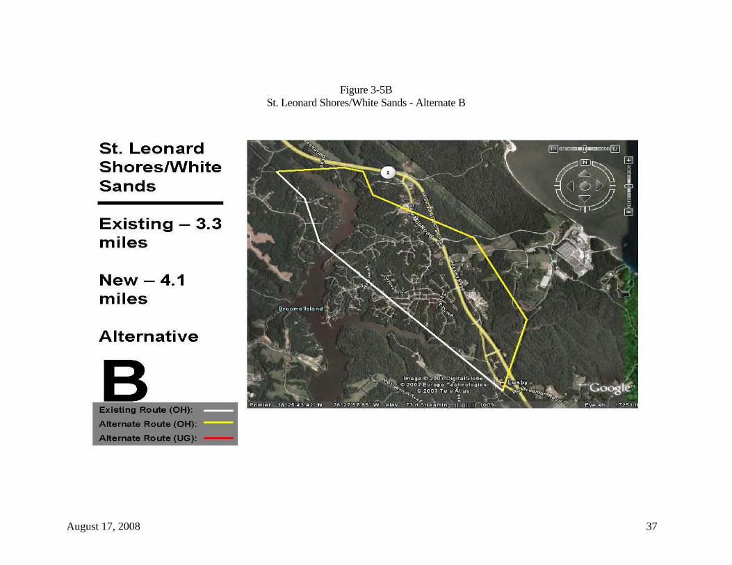
through a wooded area to return to the existing SMECO right-of-way near the small community of Lusby. Alternative A completely avoids both the St. Leonard Shores subdivision and the White Sands subdivision. It measures approximately 5.1 miles in length, all of which will require new right-of-way. It is located near the Dominion gas pipeline route. The existing SMECO right-of-way through the two subdivisions is about 4.4 miles in length. This alternative reduces the number of occupied residences within 200 feet from roughly 96 along the existing route to 10 along the alternative option. It will cross 0.5 miles of previously undisturbed agricultural lands as compared to 0.3 miles along the existing SMECO right-of-way. It should be noted that some of the small cultivated fields crossed by this alternative may be able to be spanned by the new 230 kV transmission line. Furthermore, approximately every other existing wood pole structure in the existing right-of-way will be removed when the transmission line upgrade is completed if the existing right-of-way is used. In some instance, existing wood poles may be removed from cultivated fields and the fields will be spanned by the new line. About 84 percent (4.3 miles) of the alternative is located in wooded areas. While this will offer the potential for seasonal screening, it will also require the clearing of approximately 52 acres of woodland to accommodate the new 230 kV transmission line. No clearing will required if the existing right-of-way is used, though an occasional danger tree may require removal. The new alignment will require two major angles, similar to the existing route. Because of the increased distance (1,000 feet) to cross St. Leonard Creek, larger and taller structures will be required on each side of the creek to accommodate such a crossing while maintaining required clearances for sailboats that frequent the creek. These structures will be substantially taller than the estimated heights of tangent structures for the new 230 kV line. The alignment for Alternative B starts at a point about 725 feet south of the crossing of Bond Street in the St. Leonard Shores subdivision. At this point, the alternative turns east for 0.6 miles, crossing a tributary to St. Leonard Creek and an extension of St. Leonard Road (Figure 3-5B). It then parallels Solomons Island Road (SR2/4) for approximately one-quarter mile before turning south again to avoid area residences. It drops south for about 1,500 feet, crossing Walnut Cove Road, before again turning to the southeast. It then crosses Tidehead Way, Saw Mill Road, Solomons Island Road South (SR 2/4), and Calvert Cliffs Parkway, which is the main entrance to the Calvert Cliffs Nuclear Station. At the intersection of Tidehead Way and Saw Mill Road, the alternative passes through an old sawmill yard. The routing option extends for approximately 1.1 miles in this southeasterly direction, passing through mostly wooded

August 17, 2008 34
areas. It crosses SR 2/4 on an angle, with fairly dense woods on either side of the highway. At a point just south of the Calvert Cliffs Parkway crossing, the alternative turns more to the south-southeast. It crosses cultivated fields on either side of the original Calvert Cliffs Nuclear Plant Road and continues south-southeast for another mile before intersecting with SMECO’s Calvert Cliffs transmission line tap. Along this one-mile segment, the alternative crosses about 1,300 feet of cultivated cropland. The remainder of this routing segment occurs in wooded areas. At the intersection with the existing transmission line, the alternative turns back to the southwest and extends some 0.9 miles back to SMECO’s existing right-of-way near the small community of Lusby. Along this segment, the alternative parallels SMECO’s existing 69 kV transmission line, but will require clearing along the entire length for the new proposed 230 kV transmission line. A minor reduction in cleared acres is possible, depending upon final design and clearance requirements with the existing line. Like Alternative A, this alternative avoids most of the St. Leonard Shores subdivision and all of the White Sands subdivision. It measures about 4.1 miles in length, while the existing right-of-way is 3.3 miles long. Alternative B will also require all new right-of-way, though there may be a small reduction with required width where it parallels the existing line coming from Calvert Cliffs. This alternative places about 13 occupied residences within 200 feet of the alignment, whereas 86 residences are within 200 feet of the existing SMECO right-of-way. It will cross 0.3 miles of previously undisturbed agricultural lands and the commercial/industrial/construction storage yard on Saw Mill Road. About 85 percent of its length (3.5 miles) will require woodland clearing (42 acres). Alternative B will avoid any crossings of navigable portions of St. Leonard Creek. Given its two crossings in wetland areas near SR 2/4, it is unlikely that conductor clearances will have to contend with tall sailboat traffic. However, this routing option does parallel and eventually require two crossings of Solomons Island Road South (SR2/4), which is not viable. The short parallel segment will be visible to passing motorists. While the first crossing of the highway is at an angle and in a wooded area, the industrial appearance of the quadruple circuit 230/69 kV transmission line will present a visual disruption to the wooded landscape along the highway. The second crossing near the community of Lusby will be at an existing transmission line crossing. To some degree, the visual disruption at the existing highway crossing has already occurred. Alternatives A and B attempt to avoid most, it not all, of the St. Leonard Shores and White Sands subdivisions. Alternative C is a possible routing option for just the

August 17, 2008 35
White Sands subdivision. This alternative starts at a point about 700 feet southeast of the existing transmission line’s crossing of St. Leonard Creek (Figure 3-5C). In a low wet area, the alignment turns to the east and works its way between homes built at the end of cul-de-sacs in White Sands. The option follows Planters Wharf Creek east through this natural drainage. The wooded hillsides offer some potential to screen portions of the new line along this route segment. The alternative extends east some 0.9 miles before crossing Pine Boulevard in the White Sands subdivision. After crossing Pine Boulevard, the alternative makes a slight deflection to the northeast to avoid existing residences. It then crosses Solomons Island Road South (SR 2/4) and Nursery Road between residential and commercial structures and the Calvary Bible Church. At a point about 1,500 feet southeast of the SR 2/4 crossing, the alternative turns more to the south-southeast and traverses 0.9 miles of woodland before intersecting with SMECO’s Calvert Cliffs tap. It then follows and parallels this existing right-of-way for approximately 0.4 miles back to the existing SMECO right-of-way near the community of Lusby. Alternative C measures 2.7 miles in length, while SMECO’s existing right-of-way is 2.2 miles. All of the routing option will require new right-of-way acquisition, though a short portion near Lusby can be less than 100 feet in width where it parallels an existing transmission line. The existing right-of-way has approximately 70 single family residences within 200 feet. This alternative will place 24 residences within 200 feet of the routing option, most within the White Sands subdivision. In effect, the visual impacts of the new line will be shifted to other White Sands residents while the existing line will be removed. Alternative C will not cross any agricultural lands, but will impact roughly 32 acres of area woodlands that will require clearing for the new right-of-way. As with Alternative B, this option also has two crossing of the SR 2/4. The first crossing is at a somewhat developed residential/commercial area, while the second crossing occurs near Lusby when the option parallels an existing transmission line across the highway. For all three alternative considered, the number of occupied residences within 200 feet is substantially reduced along each alternative alignment. Any impacts associated with transmission line construction and operations are shifted to other residents that currently do not experience such impacts. In addition, each alternative requires a significant amount of woodland clearing. The potential for forest fragmentation and impacts to area wildlife are distinct possibilities with each of these alternatives. Table 3-4 summarizes and compares primary features of each of the alternatives to SMECO’s existing right-of-way.

August 17, 2008 36
Figure 3-5A St. Leonard Shores/White Sands - Alternate A
August 17, 2008 37
Figure 3-5B St. Leonard Shores/White Sands - Alternate B

August 17, 2008 38
Figure 3-5C White Sands - Alternate C

August 17, 2008 39
Table 3-4 St. Leonard Shores/White Sands Alternative Routes
Existing ROW Alternative A Existing ROW Alternative B Existing ROW Alternative C
Length 4.4 miles 5.1 miles 3.3 miles 4.1 miles 2.2 miles 2.7 miles
Use of Existing ROW 4.4 miles 0 mile 3.3 miles 0 mile 2.2 miles 0 mile
New ROW Required 0 mile 5.1 miles 0 mile 4.1 miles 0 mile 2.7 miles
Parallel of Existing ROW 0 mile 0 mile 0 mile 1.0 mile 0 mile 0.4 miles
Overhead Length 4.4 miles 5.1 miles 3.3 miles 4.1 miles 2.2 miles 2.7 miles
Underground Length 0 mile 0 mile 0 mile 0 mile 0 mile 0 mile
Number of Major Angles (30º) 2 2 2 5 0 6
Residences Within 200 Feet 96 10 86 13 70 24
Schools Within 200 Feet 0 0 0 0 0 0
Churches Within 200 Feet 0 0 0 0 0 1
Hospitals Within 200 Feet 0 0 0 0 0 0
Agricultural Land Crossed 0.3 miles 0.5 miles 0 mile 0.3 miles 0 mile 0 mile
Woodlands Crossed 0 mile 4.3 miles 0 mile 3.5 miles 0 mile 2.6 miles
Parkland Crossed 0 mile 0 mile 0 mile 0 mile 0 mile 0 mile
US Navy Property Crossed 0 mile 0 mile 0 mile 0 mile 0 mile 0 mile
Creeks/Waters of US/Wetlands/USACE 0.4 mile 0.3 mile 0.4 mile 0.6 mile 0.2 mile 1.2 miles
Coastal Barriers 0 mile 0 mile 0 mile 0 mile 0 mile 0 mile
Federal lands 0 mile 0 mile 0 mile 0 mile 0 mile 0 mile

August 17, 2008 40
3.6 Dowell Road The Dowell Road area is located about one mile north of the community of Solomons, Maryland. SMECO’s existing Solomons 69 kV Substation is located on the southeast corner of Dowell Road and Newtown Road about 1,000 feet east of Solomons Island Road South (SR 2/4). The area supports a variety of commercial activity and multi-family dwellings in addition to the U. S. Navy Recreation Center, while Solomons has become a popular weekend getaway location for people from the Baltimore and Washington, D.C. areas. On the east side of SR 2/4, SMECO’s existing 69 kV transmission line crosses Dowell Road and parallels Newtown Road for some 1,500 feet before the road meanders beneath the existing line. The existing ROW width in this area is 150 feet, with the existing 69kV line located 35 feet from the east edge of the ROW. The 69 kV line then crosses SR 2/4 at the intersection with Newtown Road. Along Newtown Road, several single family residences are located on the east side of the road, while commercial establishments are located to the west. Newtown Road and the existing transmission line are located behind these commercial facilities, which have their primary customer entrances on H. G. Trueman Road. Trueman Road is basically a service road along the east side of SR 2/4. Five alternate routing options have been identified for the new 230 kV transmission line upgrade in the Dowell Road area. These are illustrated in Figures 3-6A through 3-6E. Three are for overhead configurations, while two are underground routing options. Alternative A generally follows the existing SMECO right-of-way for its entire length. It shifts the route slightly to the west, placing it along the back of the existing commercial establishments, moving it about 40 feet to the west of the existing SMECO right-of-way along Newtown Road (Figure 3-6A). Where the existing line crosses over the road and is in the front yard of a single family residence, Alternative A adds two angles to keep the new route to the west of the road and out of the residence’s front yard, where the existing line comes as close as 70 feet from the residence itself. In places, the proposed line using this route may overhang existing parking lots of the retail facilities on Trueman Road, though access to and number of parking spaces would not be affected. In fact, under this alternative, the placement of one or two structures within the parking areas might be determined to be necessary in final engineering design. This could cause the loss of a few (less than five) parking spaces. The alternative is the same length as SMECO’s existing right-of-way in the area – 0.4 miles. It will require the acquisition of new right-of-way, and the addition of one major angle. Presently, the existing alignment has 10 occupied single family residences with 200 feet of the route. The slight adjustment of this alternative reduces the number of residences within 200 feet to nine.
August 17, 2008 41
Alternative B provides an alignment that removes the right-of-way from much of Newtown Road. Furthermore, it assumes that a portion of the new transmission line upgrade being proposed by SMECO will pass through the existing Solomons Substation. Preliminary engineering indicates that only the 69 kV line will go into Solomons Substation and the 230 kV line must bypass it due to space constraints and the fact that the substation contains no equipment capable of handling 230 kV service.
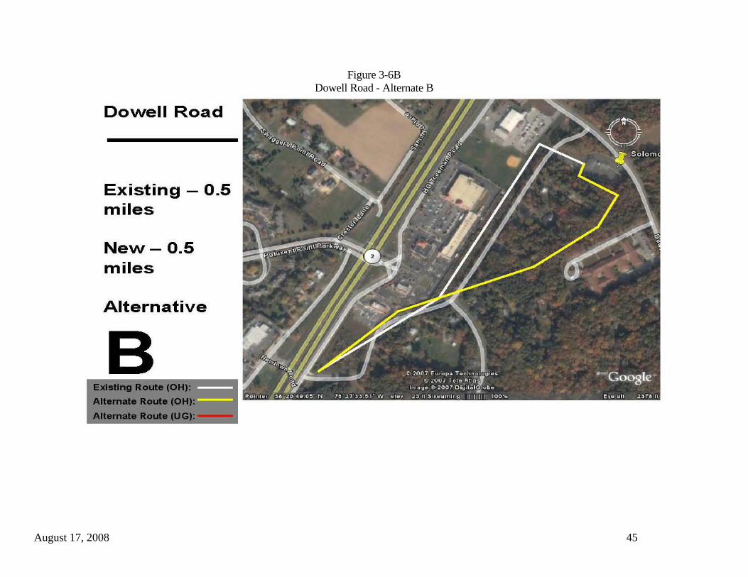
The Alternative B routing exits the Solomons Substation and makes two 90 degree turns in a wooded area south of Dowell Road before turning to the southwest (Figure 3-6B). It then traverses a wooded area before crossing Newtown Road, after which it then follows the same alignment as Alternative A. This routing option basically is the same length as the existing SMECO right-of-way, and will require the acquisition of new right-of-way for its entire length. It will also require three major angle structures. It crosses about 0.3 miles of wooded land cover and will require the clearing of about four acres of mature trees. It also is in proximity to a nursing home off of Dowell Road. Approximately 8 residences will be within 200 feet of this alternate as compared to 10 along the existing ROW.
Alternative C enables any of the new 230 kV on 69 kV circuits to interconnect with the existing Solomons 69 kV Substation. The routing option begins about 500 feet north of Dowell Road. At this point, the option turns due south, passing through a small woodlot, the corner of a cultivated field associated with Ann Marie Gardens, crossing over Dowell Road on an angle, and entering another wooded area east of Dowell Road (Figure 3-6C). The alternative then follows the route previously described alignment for Alternative B. This alternative routing option is 0.7 miles in length as compared to 0.6 miles for SMECO’s existing right-of-way. New right-of-way will have to be acquired for the entire length and two major angle structures will be required. The number of residences within 200 feet will decrease from 10 to eight. This alternative also passes close to the previously identified nursing home on Dowell Road. The route crosses approximately 0.4 miles of woodlands. Assuming a 100-foot-wide right-of-way, clearing of about five acres will be required for the new right-of-way.
Alternatives D and E represent underground options for the Dowell Road area. Placing two 230 kV circuits and two 69 kV circuits underground will add approximately $10 million to the overall cost of the project, due to underground line installation unit costs that average ten to eleven times those of overhead lines. While it will reduce visual impacts, construction may temporarily disrupt traffic flow, depending on the location of the final route. Furthermore, if the proposed transmission lines are placed underground in this area, it is assumed that underground construction will continue underground to the south to cross the Patuxent River and Town Creek.

August 17, 2008 42
Alternative D commences within the existing SMECO right-of-way just outside the Solomons Substation. The routing option transitions to underground construction in the right-of-way and turns northwest, narrowly crossing the corner of a parking lot and a small portion of an athletic field (Figure 3-6D), though these are not considered to be safety issues as neither crossing is in an occupied area. It makes a turn to the southwest as it crosses Trueman Road and SR 2/4. It then parallels and possibly shares SR 2/4 road right-of-way as it proceeds to a point about 400 feet south of the Newtown Road intersection. It is assumed that, from this point on, the project would continue underground until south of the Patuxent River and Town Creek. The alternative measures approximately 0.6 miles in length as compared to SMECO’s existing right-of-way at 0.5 miles. While new right-of-way will need to be acquired for this alternative, required right-of-way width will be less than what is required for an overhead configuration. This is because design standards allow underground conductors to be closer to one another and there is no lateral conductor movement from wind as there is with overhead conductors. The distance between structures in overhead lines allows for significant lateral motion, all of which must be well within the right-of-way. In addition, some right-of-way sharing may be possible with the Maryland Department of Transportation right-of-way where the alternative parallels SR 2/4.
Directional boring may be a suitable construction method to place the lines beneath the four lanes of SR 2/4 and the two lanes of Trueman Road, thereby eliminating lane closures and traffic disruptions on these major roads. Some traffic impacts, such as slowdowns and the narrowing of traffic lanes, are possible if this underground option is able to share highway right-of-way. But emergency maintenance is not an issue as all such work would be done from manholes on either side of the road crossings, away from vehicular traffic. The number of residences within 200 feet of the route is reduced to eight as compared to 10 along the existing right-of-way, with all eight of these residences being located on the west side of SR 2/4. Furthermore, these residences will only be impacted by noise and fugitive dust during construction. Once the lines are placed underground, they will not be visible to residents in this area. Underground construction may also temporarily impact a portion of a retail establishment’s parking lot and a small portion of the athletic field (about 200 feet). However, once construction is complete and the lines are underground, current land uses can return to normal activity. Alternative E is a second underground option that places the four proposed transmission lines underground basically within the existing SMECO right-of-way. Where the existing line crosses over Newtown Road, this alternative proposes that new right-of-way be acquired near the back of retail establishments in order to avoid
August 17, 2008 43
impacting the Newtown Road during construction (Figure 3-6E). The underground alternative then continues down the existing SMECO right-of-way across Trueman Road and SR 2/4 to a point about 400 feet south of the Newtown Road intersection with SR 2/4. Again, a directional boring method may be able to place the transmission lines beneath Trueman Road and SR 2/4 and eliminate traffic disruptions. Alternative E is a little shorter in length than the existing right-of-way, and will only require about 800 feet of new right-of-way that will have to be acquired. The number of residences within 200 feet remains the same at 10. However, the existing 69 kV line and the new transmission lines will all be underground, thereby reducing the visual impacts to these 10 residences. Table 3-5 compares preliminary data for each of these overhead and underground alternatives to SMECO’s existing right-of-way.

August 17, 2008 44
Figure 3-6A Dowell Road - Alternate A
August 17, 2008 45
Figure 3-6B Dowell Road - Alternate B

August 17, 2008 46
Figure 3-6C Dowell Road - Alternate C
Figure 3-6D
Dowell Road - Alternate D

August 17, 2008 47

August 17, 2008 48
Figure 3-6E Dowell Road - Alternate E

August 17, 2008 49
Table 3-5 Dowell Road Alternative Routes

August 17, 2008 50
3.7 State Route 2/4/Patuxent River/Town Creek SMECO has identified the crossing of the Patuxent River and Town Creek in the vicinity of SR 2/4 at Solomons as an area of concern for the new 230/69 kV transmission line. At present, one existing 69 kV transmission line crosses these two bodies of water with submarine cable laid on the bottom of the river and creek. This crossing takes the line from Calvert County to St. Mary’s County. Near the north bank of the Patuxent River, the overhead 69 kV line transitions to a short length of underground cable onshore, then transitions to submarine cable that was jetted into the bottom of the river along the west side of the existing SR 4 highway bridge. It transitions back to underground cable for a short distance on the south bank of the river, crosses Town Creek as a submarine cable jetted into the bottom of the creek, and then transitions back to an underground cable to cross beneath SR 4. East of the SR 4 underground crossing, the existing line resumes its overhead configuration. Preliminary planning indicates that the new 230 kV transmission line will cross the river and creek in one of four ways: 1) as an attachment to a new state highway bridge to be built adjacent to the existing bridge, 2) through the use of submarine cable, 3) by directional boring beneath the bottoms of the river and creek, or 4) an overhead conductor span between large towers on each side of the river channel. The existing 69 kV underground and submarine cable crossing will remain in place to serve as one 69 kV circuit. Six alternatives were identified for these two areas of concern. Five of the alternatives assume total underground and submarine cable construction (with or without directional boring), while one assumes a combination of underground, submarine cable and overhead construction to accommodate the crossings. Alternative A is an all-underground/submarine cable routing option. It commences at the intersection of Newtown Road and SR 2/4 within the existing SMECO right-of-way and transitions to an underground configuration on the east side of SR 2/4. It crosses beneath SR 2/4 and continues to the west onto a U.S. Navy recreation facility (formerly the U. S. Naval Surface Weapons Center). It follows Patuxent Drive on Navy property for some 2,500 feet to a point on the east bank of the Patuxent River, where the alternative turns to the southwest and parallels the shoreline for about 4,400 feet. The underground routing option is located between several residences and naval structures and the river bank. On Point Patience, the alternative makes a slight deflection and crosses beneath Point Patience Drive to a point on the north bank of the Patuxent River (Figure 3-7A). At this location, the transmission line would transition to either an underground directional bore or a submarine cable. The alternative makes a 4,000-foot crossing of the Patuxent River, emerging on the south bank at N. Patuxent Beach Road. SMECO owns a small parcel of land about

August 17, 2008 51
400 feet south of the Patuxent River at the intersection of N. Patuxent Beach Road and Clarks Road. It is already cleared, graveled, and fenced and is located favorably for the southern terminus of an under-river directional bore. The plot was originally purchased for the 69 kV line crossing landing, but the crossing was ultimately made at a point further down-river. The directional bore or submarine cable may transition to an underground system at the parcel’s location rather than at a site near the south bank of the river in N. Patuxent Beach Road. Using the SMECO property for a transition location would eliminate most traffic disruptions that would be associated with construction in or adjacent to N. Patuxent Beach Road. From the SMECO property, the alternative then proceeds underground to the southwest for approximately 1,700 feet, crossing beneath W. Patuxent Beach Road and SR 4 to the location of the existing 69 kV riser structure. At this point, the proposed transmission line would transition back to an overhead configuration. Alternative A measures approximately 2.6 miles in length, whereas the existing SMECO right-of-way is approximately 2.5 miles long. The underground routing option crosses 1.3 miles of Navy property, and will require 1.8 miles of new right-of-way. It requires a 0.8-mile crossing of the Patuxent River, but avoids Town Creek. While SMECO’s existing 69 kV transmission line, which is a combination of overhead, underground and submarine cable applications, has roughly 30 single family residences within 200 feet, Alternative A would have about 80 single and multi-family residences within 200 feet. However, as Alternative A is a proposed all-underground application, these residences will only have the potential to be impacted during construction. Once construction is complete, the lines will be underground and no longer be visible to local residents and Navy personnel. An additional benefit, stated in discussions with Navy personnel, is that underground lines are less disruptive to outdoor activities within the recreation facility. Local traffic on Patuxent Drive in the Navy recreation facility may be temporarily impacted by construction activities, as there appears to be inadequate space to place the underground line completely outside of the road surface. Depending upon the construction procedures finally selected by SMECO and approved by the Navy, Patuxent Road could be closed for the duration of construction, the road could be open during construction with only one lane of traffic, or the road would be covered with heavy steel plates at the end of each work day to allow for traffic flow. Construction work would be performed during off-peak times of the year and alternate routes around Patuxent Road are already available within the facility. Alternative B basically follows the same alignment as Alternative A except that, once on Navy property, it is located in Patuxent Drive to its intersection with B Avenue (Figure 3-7B). Construction of the underground transmission line would basically impact
August 17, 2008 52
all of Patuxent Drive (0.9 miles) on the naval facility. At a point south of the B Avenue intersection, it crosses beneath Point Patience Drive and follows the alignment previously described for Alternative A. It has the same length as Alternative A, the same crossing length of the Patuxent River and will require 1.8 miles of new right-of-way. Because the alternative is located within Patuxent Drive when on Navy property, approximately 97 single and multi-family residences will be within 200 feet of the route. In addition, there will likely be greater traffic disruptions during construction in Patuxent Drive. However, this alternative removes the underground construction from the east bank of the Patuxent River. Alternative C is an underground/submarine cable option that uses SMECO’s existing right-of-way along the west side of SR 2/4 north of the river (Figure 3-7C). It would then parallel the existing 69 kV submarine cable across the Patuxent River and Town Creek to the existing transition location along the east side of SR 4 in St. Mary’s County. The transition from overhead to underground could take place at the existing location north of the Patuxent River. However, for this study, the transition to underground occurs near the intersection of SR 2/4 with Newtown Road well north of the river. The longer underground length will place the new 230 kV transmission line underground along single family residences, a commercial area along the highway and in front of the Solomons Medical Center. Alternative D is significantly different from the previously described alternative alignments relative to configuration and location. The alternative proposes to use a combination of underground, submarine cable or directional bore, and overhead designs to support the proposed 230 kV transmission line. Alternative D follows the route of Alternative A from the Alternative A transition point on the east side of SR 2/4 through much of the Navy recreation center property. However, at a point about 680 feet southwest of the intersection of Patuxent Drive and B Avenue on Navy property, this alternative commences its crossing of the Patuxent River (Figure 3-7D). The crossing measures about 3,500 feet and could be made using submarine cables jetted into the bottom of the river, or by directional boring that would place the transmission lines beneath the bottom of the river. Once on the west bank of the river, this alternative would transition back to an overhead configuration in Myrtle Point Park. It then proceeds in a southwest direction for approximately 2.6 miles, crossing Clearbrook Lane and Lou’s Way while paralleling portions of Patuxent Boulevard and SR 4. It terminates at the southwest corner of the intersection of SR 4 and 3 Notch Road (SR 235) at an existing SMECO transmission line. This alternative measures approximately 4.5 miles in length. It is roughly two miles longer than the existing SMECO right-of-way and river crossing. The Patuxent

August 17, 2008 53
River crossing is about the same distance as SMECO’s existing submarine cable crossing, but this alternative avoids crossing Town Creek. It utilizes about 1.1 miles of Navy property and will require the acquisition of new right-of-way for 3.9 miles of the route. Its total underground/submarine length is 2.0 miles while its overhead length is 2.5 miles. It will require one major overhead angle at the interconnect point at SR 235. The alternative will place 60 single and multi-family homes within 200 feet of the route. It will also cross about 0.3 miles of active agricultural lands, and about 2.0 miles of woodlands south of the river. This will require the clearing of about 24 acres for the new right-of-way. While this alternative is feasible and constructible, it can also be expected to cost significantly more than the other identified alternatives, due to its overall length and the acquisition of nearly four miles of new right-of-way. It will also generate more adverse environmental impacts to area residents, land uses and land cover due to the need for tree clearing over a significant portion of the route. Alternatives E and F are located entirely to the east of SR 2/4 and the existing Governor Thomas Johnson Bridge that carries SR 4 over the Patuxent River. For purposes of this alternatives routing study, it is assumed that the crossing of the Patuxent River for Alternatives E and F could be a submarine cable, a directional bore beneath the river bottom, or as attachments to a new bridge. However, any directional bore or submarine cable east of the existing bridge must consider state plans for the new bridge. The final route must avoid planned footings for the support piers of the new bridge. This assumes the new bridge will be similar in design to the existing bridge. Alternative E starts at Newtown Road. It transitions to an underground configuration on the north side of the road, crosses beneath Newtown Road, and then parallels Trueman Road (and SR 2/4) on the east right-of-way edge for approximately 1,000 feet (Figure 3-7E). At Lynn Acres Lane, the underground option turns more to the south away from Trueman Road. It passes through a sparsely wooded area and a boat storage yard before crossing Hospitality Drive and Holiday Drive to the rear of several commercial/service establishments. South of Holiday Drive, the routing option is located along the edge of a commercial parking lot and then passes through a cultivated field behind the medical center. It passes through another commercial parking lot before intersecting with Lore Road. At Lore Road, the alternative makes a 90 degree turn to the west and is located in Lore Road to its intersection with Solomons Island Road South (SR 2). It makes another 90 degree turn and runs along the south edge of SR 2 for about 450 feet, crossing beneath Island Road, to a point in an agricultural field on the east side of the bridge approach, where the alternative turns to the southwest to cross the Patuxent River. It then parallels the east side of the existing bridge for a 0.6-mile crossing of the

August 17, 2008 54
river. Once on the south bank in an area named Planters Wharf, it transitions back to an underground line and crosses N. Patuxent Beach Road and Bill Dixon Road. At Town Creek, the alternative reverts back to submarine cable (or a directional bore) on the east side of and parallel to the SR 4 bridge over Town Creek. It continues to parallel SR 4 on the east side to the existing riser structures where it returns to an overhead configuration. This alternative measures about 2.7 miles length, or about 0.2 miles longer than the existing SMECO right-of-way. It will require that 2.1 miles of new right-of-way be acquired, though this figure could be reduced if the new underground line is able to share right-of-way with some of the local roads. It will place the underground transmission line within 200 feet of approximately 38 single family and multi-family units, several commercial and service establishments, and one medical center. Alternative E is located to the rear of the medical center, but away from emergency room road access. The alignment will also cross about 0.4 miles of active agricultural lands, and temporarily disrupt commercial activities at the boat storage yard. It will reduce parking spaces in parking lots that it passes through. However, once construction and surface restoration is completed, commercial and parking activities will be able to return to normal. Even if emergency maintenance is required in the future, it will be performed from manholes located outside of the parking areas. Alternative F maximizes the use of existing public rights-of-way. It proposes to use nearly 3,700 feet of Trueman Road from Newtown Road to Lore Road (Figure 3-7F). Once south of the Lore Road intersection, this alternative follows the alignment described above for Alternative E. This alternative is about 2.6 miles in length. It will require 2.0 miles of new right-of-way to be acquired, though use of public road rights-of-way could reduce this distance by almost half. Approximately 34 single and multi-family residential units will be within 200 feet of this alignment. Underground construction for the proposed transmission line will likely require the temporary closure of one lane of traffic on Trueman Road along with the adjoining shoulder. This assumes that existing underground utilities are minimal in Trueman Road and will allow for underground construction. The existence or absence of underground utilities would be confirmed only if Alternative F is selected, over the other alternatives, for further investigation. This routing option also crosses about 0.2 miles of agricultural land. Like Alternative E, once construction is completed, traffic, access to commercial and service establishment, farming, etc. will return to pre-construction activity levels.
Given the popularity of the Solomons area for tourists and weekend vacationers, all of the previously described alternatives will eliminate any potential visual impacts to this area by placing the proposed 230 kV transmission line completely underground from

August 17, 2008 55
the Newtown Road area to a point well south of the Governor Thomas Johnson Bridge. Minor traffic disruptions could be expected for very short periods, two to five minutes, when construction equipment crosses the highway (SR 2/4) to be put in position for construction. Table 3-6 provides a summary of initial data to compare the six alternatives to the existing SMECO right-of-way. A fourth option to cross the Patuxent River is to place the new 230 kV transmission line in an overhead configuration. This will require a span of at least 3,000 to 4,000 feet at any of the previously described crossing locations. According to the U. S. Army Corps of Engineers (COE), an overhead crossing for a 230 kV transmission line must provide a minimum clearance of 26 feet above any fixed bridge (existing or planned) across a navigable channel. For the Patuxent River in the Solomons area, the COE states that a fixed bridge must maintain a vertical clearance of at least 140 feet above the mean high water mark. Therefore, any overhead 230 kV conductors must provide a clearance of 166 feet above the water at maximum sag. As such, structure heights will be well in excess of 300 feet on each side of the river. With the Patuxent Naval Air Station to the southeast, it is unlikely that such clearances can be achieved while not posing an obstruction to navigable airspace and flight operations at the Naval Air Station. While an overhead crossing is technically possible, required clearances and structure heights necessary to achieve such clearances make such an option not viable at this location.

August 17, 2008 56
Figure 3-7A State Route 4 / Patuxent River / Town Creek - Alternate A
Figure 3-7B
State Route 4 / Patuxent River / Town Creek - Alternate B

August 17, 2008 57

August 17, 2008 58
Figure 3-7C State Route 4 / Patuxent River / Town Creek - Alternate C

August 17, 2008 59
Figure 3-7D State Route 4 / Patuxent River / Town Creek - Alternate D
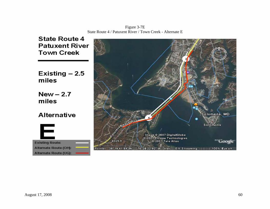
August 17, 2008 60
Figure 3-7E State Route 4 / Patuxent River / Town Creek - Alternate E

August 17, 2008 61
Figure 3-7F State Route 4 / Patuxent River / Town Creek - Alternate F

August 17, 2008 62
Table 3-6 State Route 4 / Patuxent River / Town Creek
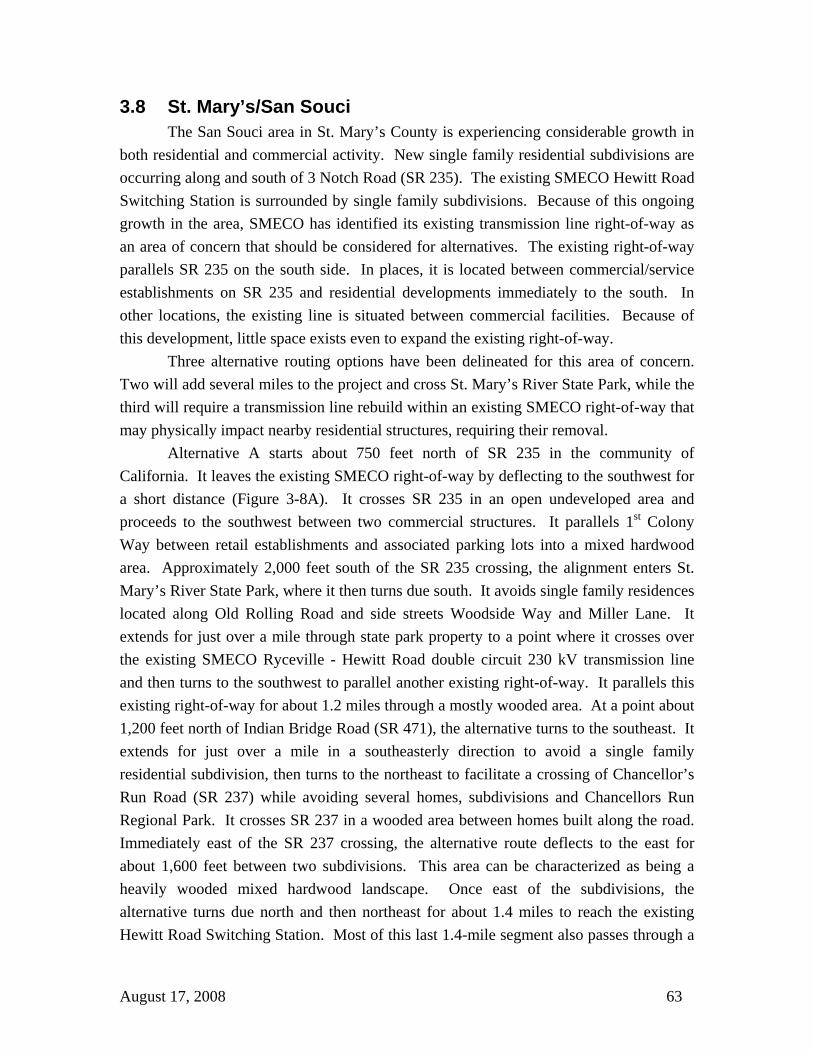
August 17, 2008 63
3.8 St. Mary’s/San Souci The San Souci area in St. Mary’s County is experiencing considerable growth in both residential and commercial activity. New single family residential subdivisions are occurring along and south of 3 Notch Road (SR 235). The existing SMECO Hewitt Road Switching Station is surrounded by single family subdivisions. Because of this ongoing growth in the area, SMECO has identified its existing transmission line right-of-way as an area of concern that should be considered for alternatives. The existing right-of-way parallels SR 235 on the south side. In places, it is located between commercial/service establishments on SR 235 and residential developments immediately to the south. In other locations, the existing line is situated between commercial facilities. Because of this development, little space exists even to expand the existing right-of-way. Three alternative routing options have been delineated for this area of concern. Two will add several miles to the project and cross St. Mary’s River State Park, while the third will require a transmission line rebuild within an existing SMECO right-of-way that may physically impact nearby residential structures, requiring their removal. Alternative A starts about 750 feet north of SR 235 in the community of California. It leaves the existing SMECO right-of-way by deflecting to the southwest for a short distance (Figure 3-8A). It crosses SR 235 in an open undeveloped area and proceeds to the southwest between two commercial structures. It parallels 1st Colony Way between retail establishments and associated parking lots into a mixed hardwood area. Approximately 2,000 feet south of the SR 235 crossing, the alignment enters St. Mary’s River State Park, where it then turns due south. It avoids single family residences located along Old Rolling Road and side streets Woodside Way and Miller Lane. It extends for just over a mile through state park property to a point where it crosses over the existing SMECO Ryceville - Hewitt Road double circuit 230 kV transmission line and then turns to the southwest to parallel another existing right-of-way. It parallels this existing right-of-way for about 1.2 miles through a mostly wooded area. At a point about 1,200 feet north of Indian Bridge Road (SR 471), the alternative turns to the southeast. It extends for just over a mile in a southeasterly direction to avoid a single family residential subdivision, then turns to the northeast to facilitate a crossing of Chancellor’s Run Road (SR 237) while avoiding several homes, subdivisions and Chancellors Run Regional Park. It crosses SR 237 in a wooded area between homes built along the road. Immediately east of the SR 237 crossing, the alternative route deflects to the east for about 1,600 feet between two subdivisions. This area can be characterized as being a heavily wooded mixed hardwood landscape. Once east of the subdivisions, the alternative turns due north and then northeast for about 1.4 miles to reach the existing Hewitt Road Switching Station. Most of this last 1.4-mile segment also passes through a
August 17, 2008 64
heavily wooded area. The routing option crosses an undeveloped and wooded section of Pegg Lane, and just after making a turn to the Hewitt Road Switching Station crosses Hewitt Road in a partially wooded and developing area. Alternate A measures approximately 6.2 miles in length, as compared to 2.1 miles for the existing SMECO right-of-way along SR 235, and will require 6.2 miles of new right-of-way. Some right-of-way sharing with an existing SMECO 69 kV line may be possible for about 1.2 miles of the Alternate’s north-south route. The additional 4.1 miles will also require 7 major angle structures as compared to two if the existing SMECO right-of-way is used. It reduces the number of residences within 200 feet from 34 to two, and the number of churches from two to zero. However, it will cross 5.6 miles of deciduous woodlands, requiring some 68 acres of clearing. One mile of this clearing (12 acres) will occur with the St. Mary’s River State Park. This alternative also crosses a small piece of agricultural land (0.1 miles) as it parallels an existing SMECO right-of-way. Lastly, if this 230 kV line fails at the crossing of the existing Ryceville-Hewitt Road 230 kV line, it could result in the loss of four 230 kV circuits if high winds or other forces were to topple the new 230 kV line structures. Alternative B follows the alignment of Alternative A until it crosses SR 237. Just east of the SR 237 crossing, this routing option extends some 4,400 feet due east to a point about 500 feet north of Pegg Road, where it intersects with another existing SMECO transmission line (Figure 3-8B). At this point, the alternate turns north for 1.3 miles while it parallels and is immediately adjacent to this existing transmission line on the west side. It then turns to the northwest, crosses Hewitt Road, and enters the existing Hewitt Road Switching Station. This alternate measures approximately 6.8 miles in length as compared to 2.1 miles for the existing route. It has only two residences within 200 feet, but it will require eight major angle structures, require the clearing of more woodlands (74 acres), and it still crosses about one mile of the St. Mary’s River State Park. Like Alternative A, this alternate would reduce the potential to impact area residents, but would likely produce greater environmental impacts to the state park, area woodlots, and any associated plant and animal species where such clearing occurs. In addition, there is some historical significance to the state park that would have to be addressed before any routing option through the park could be finalized and approved. Alternative C follows the first 1.1 miles of Alternative A and B into the St. Mary’s River State Park. The alternative then intersects with an existing SMECO east-west transmission line and turns east-southeast to follow the existing transmission line to the Hewitt Road Switching Station (Figure 3-8C). The routing option measures about 2.9 miles in length. It crosses Old Rolling Road and Torino Drive as it passes through single
August 17, 2008 65
family residential developments. In continues in the existing right-of-way for another 0.8 miles to Chancellor’s Run Road (SR 237), where it crosses the road between two large multi-family developments. East of SR 237, it crosses Sayre Drive, MacArthur Boulevard and Cornwall Drive as it passes between several single family residential developments. About 500 feet east of the Cornwall Drive crossing, the alternative turns to the south to enter the Hewitt Road Switching Station. SMECO’s existing right-of-way along SR 235 is located in a predominantly commercial area along the highway. It is within 200 feet of approximately 34 residences. However, Alternative C is located in a predominantly residential area, and places some 114 homes within 200 feet. Furthermore, it is doubtful that the existing east-west right-of-way can accommodate the proposed transmission line as a rebuild or a parallel line. This is because the east-west portion of the Alternative C route is in an existing SMECO 230 kV right-of-way and an on-site examination revealed that the right-of-way does not have the width to accommodate a new 230 kV line in addition to the existing one. In places along this existing right-of-way, there appears to additional lands available to expand the right-of-way. However, in other areas, it appears that the only way to expand the right-of-way is to acquire and remove existing single family residences. The alternate routing option would also require five major angle structures. While the alternative measures 2.9 miles in length, it may be able to utilize and share 1.9 miles of existing right-of-way. It also crosses less of the state park (0.6 miles) and will require much less clearing of wooded landscape. However, the potential to impact many more area residents is probably greatest along this alignment, more so than if the existing SMECO right-of-way along SR 235 were used for the project.
Table 3-7 provides a summary of initial data to compare these three alternatives to the existing SMECO right-of-way for this area of concern.
August 17, 2008 66
Figure 3-8A St. Mary’s/San Souci - Alternate A
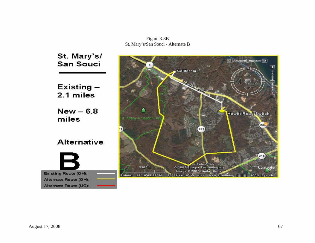
August 17, 2008 67
Figure 3-8B St. Mary’s/San Souci - Alternate B
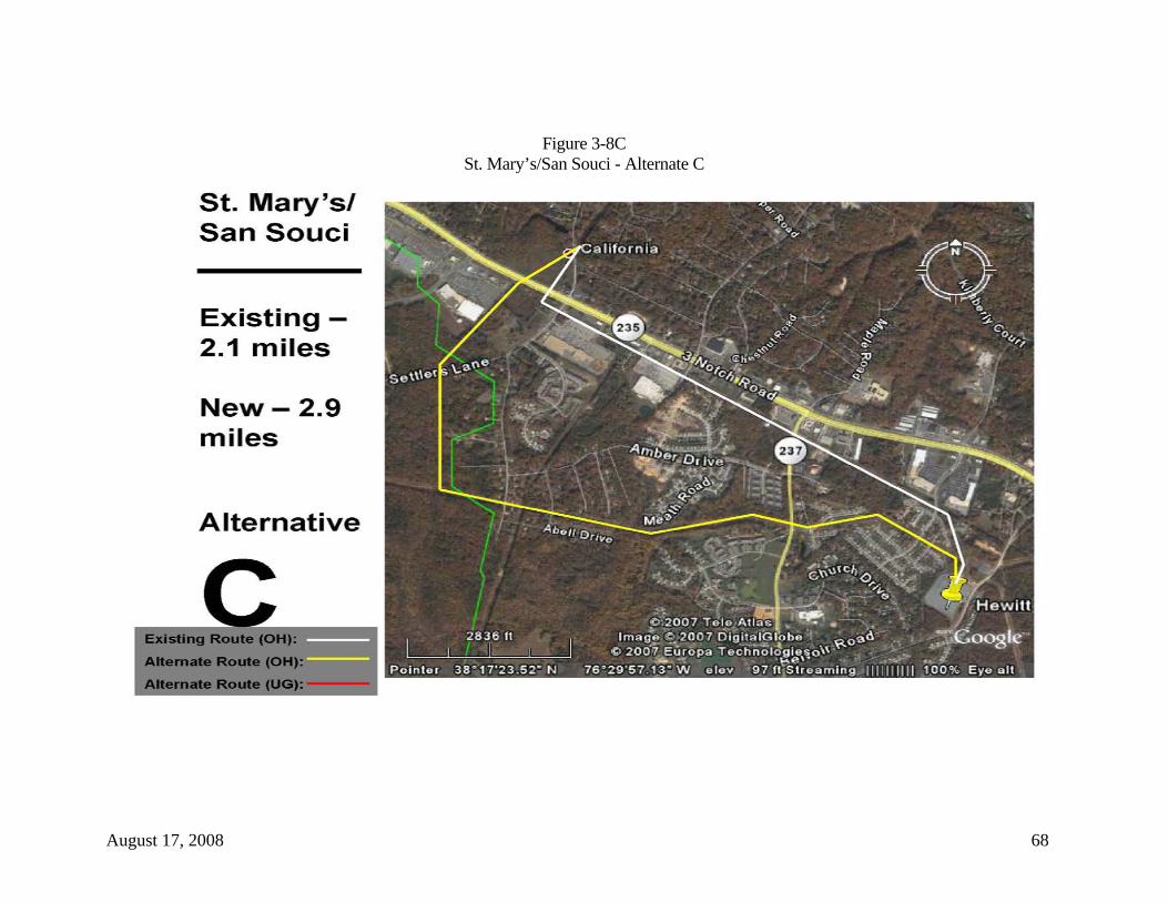
August 17, 2008 68
Figure 3-8C St. Mary’s/San Souci - Alternate C

August 17, 2008 69
Table 3-7 St. Mary’s/San Souci
Existing ROW Alternative A Alternative B Alternative C
Length 2.1 miles 6.2 miles 6.8 miles 2.9 miles
Use of Existing ROW 2.1 miles 0 mile 0 mile 1.9 miles
New ROW Required 0 mile 6.2 miles 6.8 miles 1.0 mile
Parallel of Existing ROW 0 mile 1.2 miles 2.6 miles 0 mile
Overhead Length 2.1 miles 6.2 miles 6.8 miles 2.9 miles
Underground Length 0 mile 0 mile 0 mile 0 mile
Number of Major Angles (30º+) 2 7 8 5
Residences Within 200 Feet 34 2 2 113
Schools Within 200 Feet 0 0 0 0
Churches Within 200 Feet 2 0 0 0
Hospitals Within 200 Feet 0 0 0 0
Agricultural Land Crossed 0 mile 0.1 miles 0.1 miles 0 mile
Woodlands Crossed 0 mile 5.6 miles 6.1 miles 0.7 miles
Parkland Crossed 0 mile 1.0 mile 1.0 mile 0.6 miles
US Navy Property Crossed 0 mile 0 mile 0 mile 0 mile
Creeks/Waters of US/Wetlands/USACE 0 mile 0.3 mile 0.7 mile 0.1 mile
Coastal Barriers 0 0 0 0
Federal lands 0 0 0 0

August 17, 2008 70
3.9 Southern Calvert Substation Specific alternative sites or properties for the Southern Calvert Substation have not yet been selected, though the general location is known. The proposed substation must be located along and near to the existing 69 kV transmission line near to the town of Lusby. The reason for this location has to do with the need to deliver lower voltage power to the distribution systems in this area that are distant from both the Holland Cliffs and Hewitt Road switching stations. Site characteristics include existing or easily constructed access from a public road, very limited visibility from nearby residences and public areas, and minimal disruption of natural environment (trees, wetlands, and habitat). The new 230/69kV switching station fenced area will cover approximately 4 acres, resulting in approximately 5-6 acres of disturbance, but SMECO is seeking a plot of land approximately 20 acres in size to provide a visual buffer from the public. SMECO is actively pursuing land acquisition in the area located in southern Calvert County in the vicinity of the existing Calvert Cliffs 69kV transmission line tap. This area is located near the intersection of Pardue Road and Maryland State Route 4 (see Figure 1-2).

August 17, 2008 71
Figure 3-9 Southern Calvert Substation

August 17, 2008 72
4.0 Conclusions and Recommendations
While all of the alternatives offered are technically feasible, several of the alternatives are not viable from one or more of the following factors: environmental, economic, land availability, and constructability. Four alternatives are considered to be viable and are recommended for further analysis and consideration by SMECO. They are:
• Whispering Woods – Alternative A. • Broomes Island Road Crossing – Alternative B. • St. Leonard Shores/White Sands – Alternative A and/or a parallel of the
Dominion pipeline route. • Patuxent River Crossing – Alternative B.
Each of these alternative alignments should now be investigated further relative to existing wetlands and stream crossings and associated permit requirements (Section 404 and Section 10), protected plant and animal species and habitats (Federal and state threatened and endangered species), Patuxent River shell fish industry, cultural resources (archaeological and historic sites), highway expansion plans, other utility planning, new residential and commercial developments, etc. 4.1 Holland Cliff Shores Two alternatives were identified for the Holland Cliff Shores development. Each would shift impacts to other residents in the area. Along Alternative A, the proposed transmission line would follow a wooded ravine and place the proposed transmission line in the back yards of homes, whereas the existing right-of-way has subdivision streets built within and parallel to the right-of-way. The low elevation of the ravine would require much taller structures to meet clearance requirements. Construction would also require clearing about 11 acres of hardwoods and would likely impact the intermittent stream at the bottom of the ravine. While Alternative B is located mostly in uplands, it could require the removal of at least one residence (depending upon final surveying), be in proximity to several other existing and future residences, and require the clearing of approximately 17 acres of upland forest.
Recommendation – Use existing right-of-way. 4.2 PEPCO 500 kV Crossing Currently, adequate space exists on the west (or south) side of the PEPCO 500 kV transmission lines and the existing SMECO 69 kV right-of-way for an expanded right-of-

August 17, 2008 73
way to accommodate the proposed 230 kV transmission line while not conflicting with PEPCO’s plans for another 500 kV transmission line in this area.
Recommendation – Acquire the required right-of-way on the west (or south) side of SMECO’s existing right-of-way to accommodate the installation of the new 500 kV-230 kV transmission line crossing.
4.3 Whispering Woods One viable option, Alternative A, is recommended for further environmental, engineering and economic analysis. While the other two alternatives appear viable on the surface, the old SMECO right-of-way has been relinquished to the current landowner, and there are plans for development of this former SMECO right-of-way and surrounding acreage. Furthermore, Alternatives B and C would shift the right-of-way and subsequent transmission line to the back yards of other residences in Whispering Woods. In addition, it would require the clearing of 10 acres and 12 acres of woodlands respectively. However, Alternative A places the alignment in a heavily wooded area away from all residences but one, and final surveying may be able to move the right-of-way even farther away from this one residence. Alternative A would also require the clearing of 10 acres of upland woodlots.
Recommendation – Consider Alternative A in the Environmental Assessment.
4.4 Broomes Island Road Crossing Two alternative alignments were identified at the Broomes Island Road crossing. Alternative A shifted the right-of-way to other properties in the area and require the clearing of about six acres of woodlands, while Alternative B removed the existing 69 kV angle structure from the front yard of the private residence on the west side of the road and placed the alignment between two residences in a densely wooded area (requiring less than half the amount of clearing from the other alternative). This alternative should be able to span most of the two agricultural fields that are crossed, and should visually improve the landscape along Broomes Island Road.
Recommendation – Consider Alternative B in the Environmental Assessment.

August 17, 2008 74
4.5 St. Leonard Shores/White Sands St. Leonard Shores and White Sands are two subdivisions that have, over the years, built up around the existing SMECO 69 kV right-of-way, with St. Leonard Creek separating the two. Three alternatives were evaluated to bypass these two residential developments. Alternative A relocates the SMECO right-of-way to the south, while Alternatives B and C are more circuitous alignments that require multiple crossings of State Route 2/4, may cross portions of the Calvert Cliffs Nuclear Plant property, and places the potential alignments in proximity to an active church and several residences. Alternative A is located, for the most part, in the general area that has been selected by Dominion Pipeline for a new gas pipeline through the area. It will require clearing of about 52 acres of woodlands, while Alternatives B and C require the clearing of 42 acres and 31 acres respectively. However, it appears that Alternatives B and C will encounter more wetlands associated with St. Leonard Creek. Alternative A, or a parallel of the proposed Dominion pipeline (now under construction), would be a viable option to avoid these subdivisions.
Recommendations – Consider Alternative A in the Environmental Assessment.
4.6 Dowell Road Five alternatives were identified for the Dowell Road area. Three are overhead options while two are underground options. However, because SMECO’s right-of-way in this area along Newtown Road is 150 feet wide instead of 100 feet, it is recommended that SMECO continue to use its right-of-way for the proposed 230 kV upgrade project, with slight adjustments of new structure locations to minimize visual impacts to residences along Newtown Road. Recommendation – Use existing right-of-way. 4.7 State Route 2/4/Patuxent River/Town Creek Six alternatives were identified for this area near Solomons, Maryland. Each required the crossing of the Patuxent River and five also crossed Town Creek. As previously stated, several crossing techniques are under consideration, but the most viable options appear to be either an underground (submarine cable or directional bore) crossing as described in Alternative B, or attaching cable to the State Route 2/4 bridge structure. Using submarine cable or directional boring will facilitate the crossing of the Patuxent River. Once the crossing is complete, underground construction will then continue across Town Creek and State Route 4 to SMECO’s existing transition structure
August 17, 2008 75
location. Other alternatives considered different crossing locations, but were eliminated from further consideration because of environmental factors (Myrtle Point Park and extensive tree clearing) and the potential for future bridge construction across the Patuxent River at Solomons. While the Navy and the Maryland Department of Transportation have not been contacted concerning the use of their facilities, SMECO intends to pursue such discussions in the near future.
Recommendation – Consider Alternative B in the Environmental Assessment.
4.8 St. Mary’s/San Souci Once south of the Patuxent River, the upgrade project approaches the Hewitt Road Switching Station in a rapidly growing area of St. Mary’s County (San Souci). Active commercial and residential growth continues throughout the area. While SMECO has several existing transmission line rights-of-way in the area that approach Hewitt Road, all are fully utilized and cannot be expanded. While three alternatives were presented for this area of congestion, none are viable because of existing utility development within the rights-of-way, the crossing of state parkland, impacts to wooded areas (required clearing of up to 74 acres), and surrounding urban and suburban developments. Use of the existing SMECO right-of-way that parallels State Route 235 provides the least impact of all alternatives. Recommendation – Use existing right-of-way.