Embed Size (px)
Citation preview
Page | 1
Table of Contents
PURPOSE ...........................................................................................................................................2
PROJECT LOCATION ............................................................................................................................2
DEVELOPMENT TEAM ........................................................................................................................5
REASONS FOR REQUEST FOR THE P.A.D. AND RE-ZONING ...................................................................5
P.A.D. OVERLAY DISTRICT ZONING .....................................................................................................5
DRAFT PROTECTIVE COVENANTS, CONDITIONS, AND RESTRICTIONS ...................................................6
CR-3 SINGLE RESIDENCE ZONE ............................................................................................................6
PARKS AND OPEN SPACE ....................................................................................................................7
LANDSCAPE PLANT PALETTE ...............................................................................................................9
TRAFFIC AND CIRCULATION ................................................................................................................9
UTILITY SERVICES ............................................................................................................................. 10
PUBLIC SCHOOLS .............................................................................................................................. 12
PROJECT SCHEDULE .......................................................................................................................... 12
DATA/ZONING AND TABLE ............................................................................................................... 12
Appendix
A GENERAL PLAN MAP
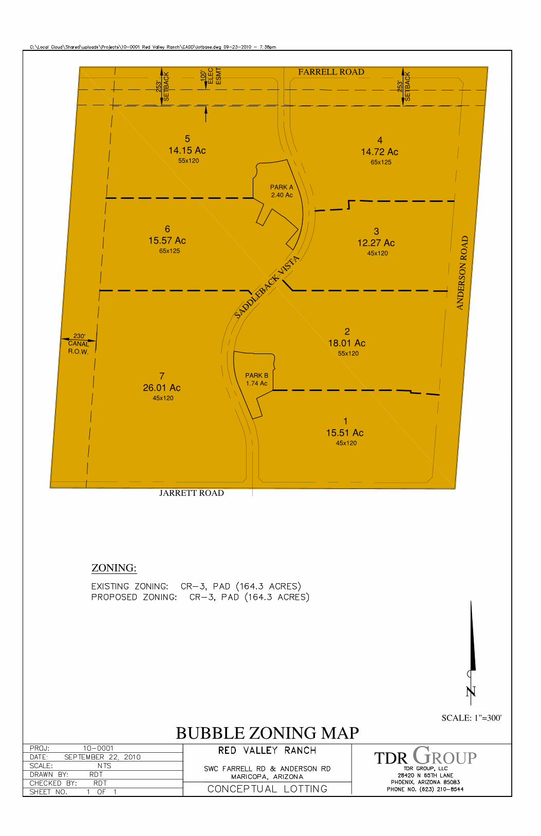
B BUBBLE ZONING MAP
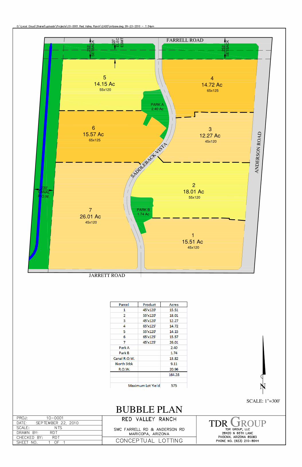
C BUBBLE PLAN
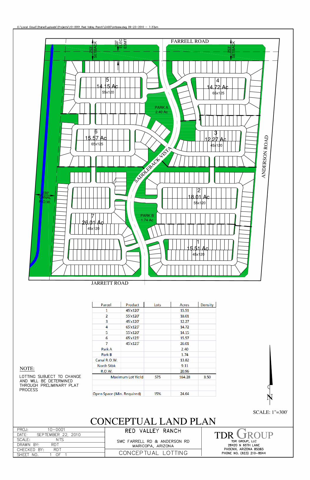
D CONCEPTUAL LAND PLAN
E CONNECTIVITY PLAN
F TRAFFIC STATEMENT
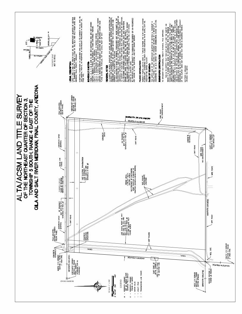
G ALTA
Page | 2
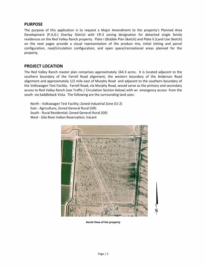
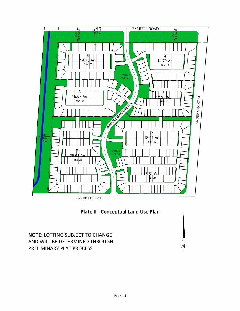
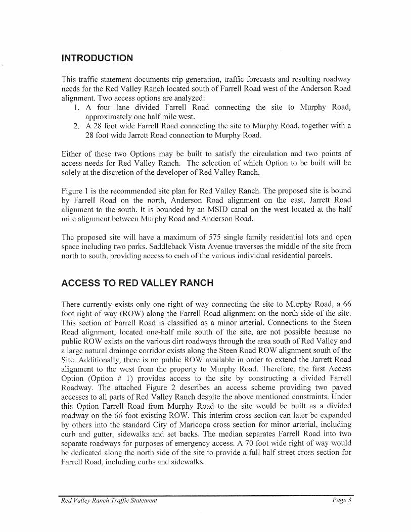
PURPOSE
The purpose of this application is to request a Major Amendment to the property’s Planned Area
Development (P.A.D.) Overlay District with CR-3 zoning designation for detached single family
residences on the Red Valley Ranch property. Plate I (Bubble Plan Sketch) and Plate II (Land Use Sketch)
on the next pages provide a visual representation of the product mix, initial lotting and parcel
configuration, road/circulation configuration, and open space/recreational areas planned for the
property.
PROJECT LOCATION
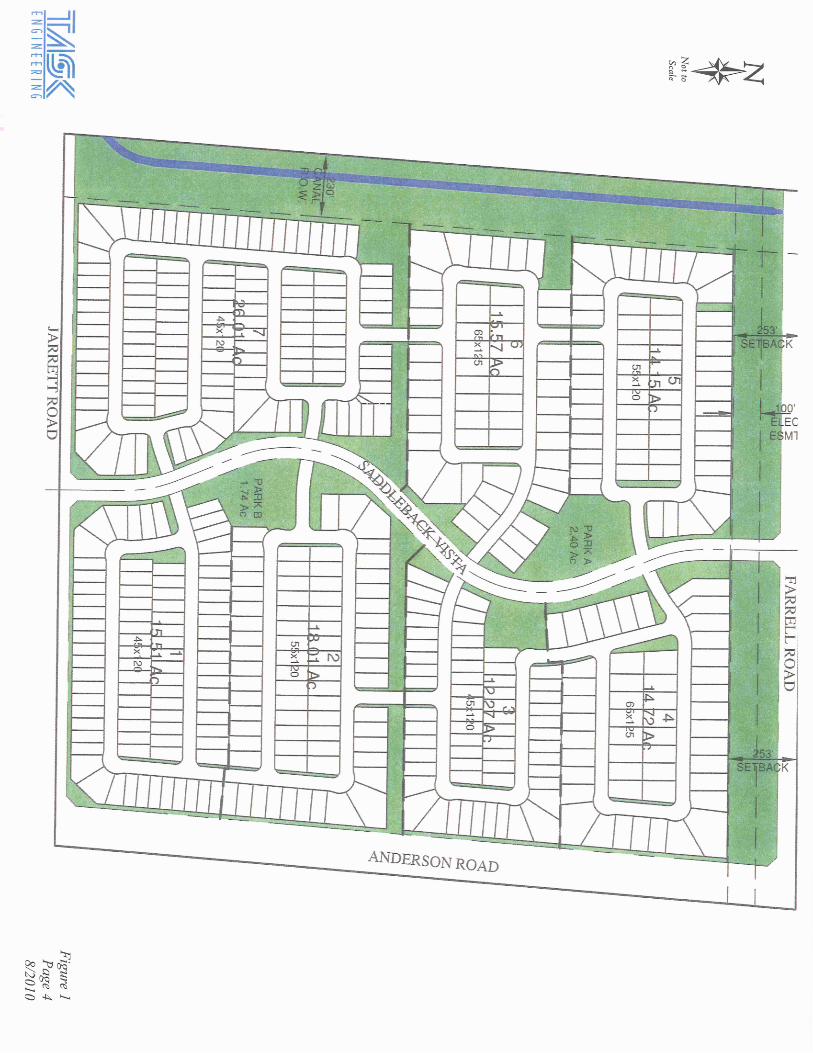
The Red Valley Ranch master plan comprises approximately 164.3 acres. It is located adjacent to the
southern boundary of the Farrell Road alignment, the western boundary of the Anderson Road
alignment and approximately 1/2 mile east of Murphy Road and adjacent to the southern boundary of
the Volkswagen Test Facility. Farrell Road, via Murphy Road, would serve as the primary and secondary
access to Red Valley Ranch (see Traffic / Circulation Section below) with an emergency access from the
south via Saddleback Vista. The following are the surrounding land uses:
North - Volkswagen Test Facility; Zoned Industrial Zone (CI-2)
East - Agriculture; Zoned General Rural (GR)
South - Rural Residential; Zoned General Rural (GR)
West - Gila River Indian Reservation; Vacant
Aerial View of the property
Page | 3
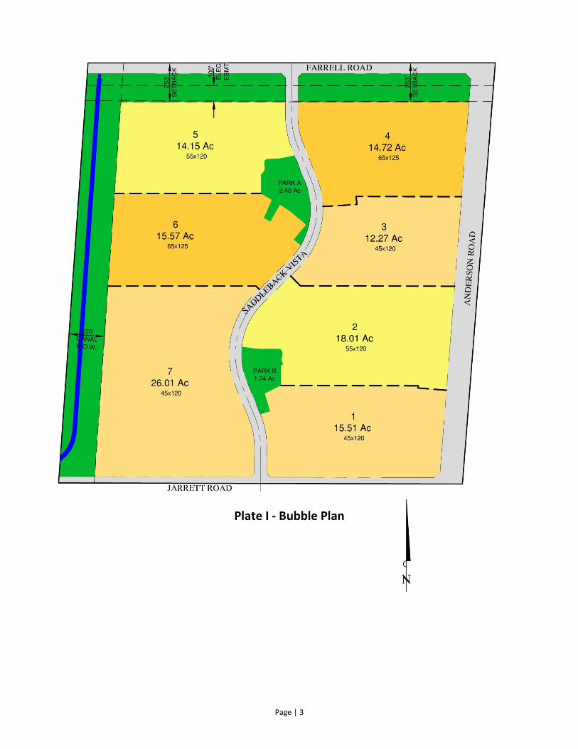
Plate I - Bubble Plan
Page | 4
Plate II - Conceptual Land Use Plan
NOTE: LOTTING SUBJECT TO CHANGE
AND WILL BE DETERMINED THROUGH
PRELIMINARY PLAT PROCESS
Page | 5
DEVELOPMENT TEAM
The master plan and initial engineering for Red Valley Ranch was prepared by the following project
team:
PAD Philip Miller - PM Consultants
Planning/Civil Engineering Roger Theis, P.E. - TDR GROUP
Traffic Circulation Letter Kenneth Howell, P.E. - Task Engineering
REASONS FOR REQUEST FOR THE P.A.D. AND RE-ZONING
The City of Maricopa has requested that Red Valley Ranch submit a new Amended P.A.D. and Re-Zoning
request for the project that will consolidate, revise, and restate the project's previous zoning and PAD
Major Amendment that are denoted by the following case numbers:
Original Pinal County zoning cases PZ-040-03 and PZ-PD-040-03, approved on June 16, 2004
Major P.A.D. Amendment to PZ-PD-040-03, City of Maricopa Case PAD 07.05, approved on
November 18, 2008
The City of Maricopa continues to realize significant builder/home buyer interest due to more
reasonable home costs combined with an easy commute to other Valley municipalities (shopping,
entertainment, and employment). Red Valley Ranch is within the area of the City of Maricopa and
within 1-1/2 miles of the Tortosa, Sorrento and Rancho Mirage Master Plan Communities all of which
contain the same 3.5 Dwelling Unit Density requested of this property. Red Valley Ranch has been
selected for development because utility services will be readily available by main line extensions by
Global Water from the Tortosa and Sorrento Master Planned Communities and it is not impacted by the
100-year flood plain designation. The property also has readily available access to Murphy Road, from
Farrell Road, with paved access to the Maricopa-Casa Grande Highway to the south and to the SR-347
via Honeycutt Road via Hartman Road to the northwest.
Being within close proximity to expanding development activities and having ready access to utilities and
major improved traffic corridors, Red Valley Ranch is in position for immediate development upon
approval of this Amendment to the PAD.
P.A.D. OVERLAY DISTRICT ZONING
The City of Maricopa Zoning Ordinance allows for conventional zoning of Red Valley Ranch for CR-3 with
lot size limitations and setback standards for this zoning designation. It is the preference of the City of
Maricopa for larger developments, such as Red Valley Ranch, to be rezoned under a P.A.D. Overlay
District, which requires a minimum of 20% of the residential property to be reserved for open space and
maximum density of 3.5 du/ac.
This PAD requests a 5% reduction in the required open space to 15% based on the amount of existing
and required encumbrances. First, the project has a combined 100' WAPA Electric Easement and a 253-
foot landscape buffer requested by Volkswagen of America, Inc. along the north side of the project.
Second, the developer has agreed to provide the full street 150-foot right of way for Anderson Road on
the east side of the project. Lastly, the west 230-feet of the project is encumbered by an MSIDD Canal
right of way. In exchange for the developer providing this 15% open space area and a better planned
Page | 6
development, the City of Maricopa has allowed for the development variations from conventional
zoning requirements including smaller lot sizes and decreased setbacks.
The City of Maricopa's 2008 General Plan designates this property as Master Planned Community.
Master Planned Community designations are for areas currently rural in character but are anticipated
for growth. A Master Planned Community could sustain uses consistent with Urban, Industrial and Rural
Community designations. Red Valley Ranch presents a master plan that would be consistent with Urban
or Rural Community reflecting medium density single-family detached housing (CR-3). The lot sizes
requested with this Red Valley Ranch Amended P.A.D. overlay zoning include lot widths of 45', 55', and
65' with minimum lot areas ranging from 5,400 SF to 8,125 SF and a maximum overall density of 3.5
du/ac.
DRAFT PROTECTIVE COVENANTS, CONDITIONS, AND RESTRICTIONS
Draft Protective Covenants, Conditions, and Restrictions (CC&Rs) have been prepared for Red Valley
Ranch and have been included with this Zoning Application. The draft CC&Rs contain provisions for the
formation of a Home Owner's Association for maintenance of common areas (open space), the powers
and duties of that Association, permitted uses of the property, and establishment of an Architectural
Review Committee.
These draft CC&Rs will become effective, and recorded, upon approval of the final plat(s) and
construction plans for this project.
CR-3 SINGLE RESIDENCE ZONE
Lot sizes being proposed for the development under this zoning district would be minimum 5,400 SF
(45'x120'), minimum 6,600 SF (55'x120'), and minimum 8,125 SF (65'x125'). The master plan for Red
Valley Ranch proposes a maximum of 575 lots with an overall density of 3.5 du/ac remaining consistent
with the General Plan for a Master Planned Community.
Red Valley Ranch is designated as a Master Planned Community under the 2008 General Plan. The open
space planned for Red Valley Ranch will provide a minimum of 20% open space, adhering to the 20%
minimum required for a PAD of between 3.2 - 4.0 du/ac. The following table is a comparison of the PAD
07.05 lotting mix to the proposed lot mix:
PAD 07.05 Proposed Lot Size
n/a 123* 65' x 125'
93 n/a 55' x 125'
n/a 147* 55' x 120'
106 n/a 45' x 125'
192 305* 45' x 120'
184 n/a 40' x 120'
Total Lots 575 575
Acres 164.3 164.3
Density 3.5 3.5
*Final lot counts and parcel lotting will be determined at the preliminary plat process
Page | 7
Additional key components of the master plan include the following:
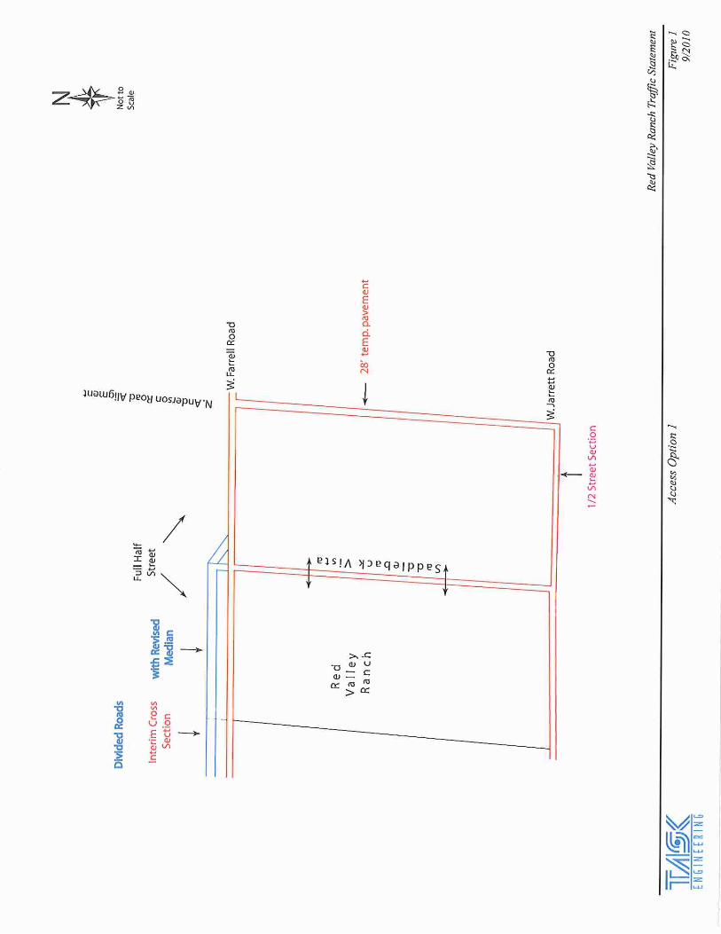
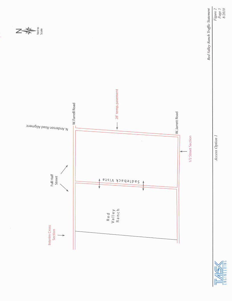
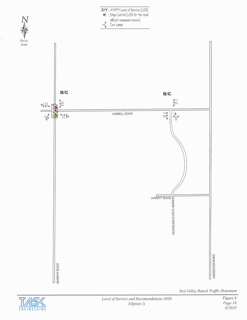
Option # 1 - Primary Access will be provided from Farrell Road to Murphy Road providing paved
access to the property from Casa Grande Highway to the south and Honeycutt Road from the
north. Access will also be available to the Maricopa Highway from Farrell Road to Hartman Road
to Honeycutt Road. Option #1 will provide for two access points to the project by utilizing a 4-
lane divided road design from Murphy Road to the west edge of the property and a raised
median separated design from the west edge of the property to Saddleback Vista (see attached
Traffic Statement - Appendix F for more specific details). Additionally, a 28' all-weather
emergency access only would be provided in the west half of the Anderson Road ROW between
Farrell and Jarrett Roads.
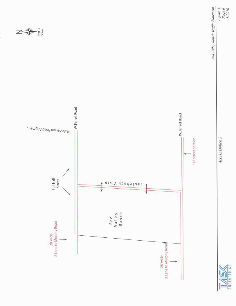
Option # 2 - Primary Access will be provided on Farrell Road from Murphy Road with 28' of 2-lane
pavement to the western property edge and then a 2-lane with continuous 2-way turn lane
along the project frontage to Anderson Road. A second point of access included with this
Option #2 is to be provided along the Jarrett Road alignment west to Murphy Road utilizing a
28' of 2-lane pavement section (see attached Traffic Letter for more specific details).
Fire Protection will be provided by the City of Maricopa Fire Department. There is a temporary fire
station just 1-1/2 miles north near the Hartman and Honeycutt Road intersection on the
Tortosa community.
A signed "Agreement Regarding Development Issues" exists between Volkswagen of America, Inc.
(VW) and Red Valley Investments LLC (Red Valley Ranch), which is dated January 14, 2004 and
impacts the property with the following design constraints:
All structures within 448 feet of the northern boundary of the Red Valley Ranch property
(measured from centerline of the existing Farrell Road right-of-way) shall be limited to
single-story homes (19 feet from finished floor) and the rear yard setback of all lots
bordering Farrell Road will increase from fifteen feet (15') to thirty feet (30')
A two hundred fifty three foot (253') wide landscape buffer along Farrell Road (as measured
from the centerline of existing Farrell Road right-of-way) shall be provided. Landscaping
in the buffer will include desert trees placed adjacent to Farrell Road and along the
north side of the buffer.
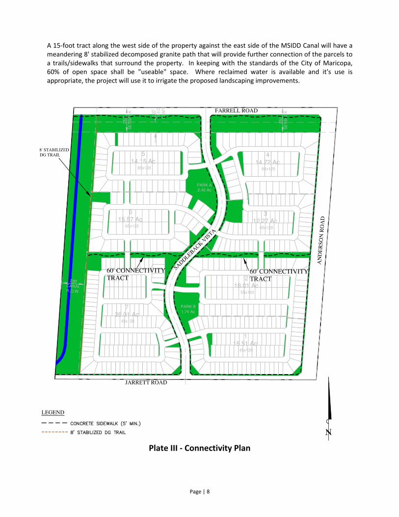
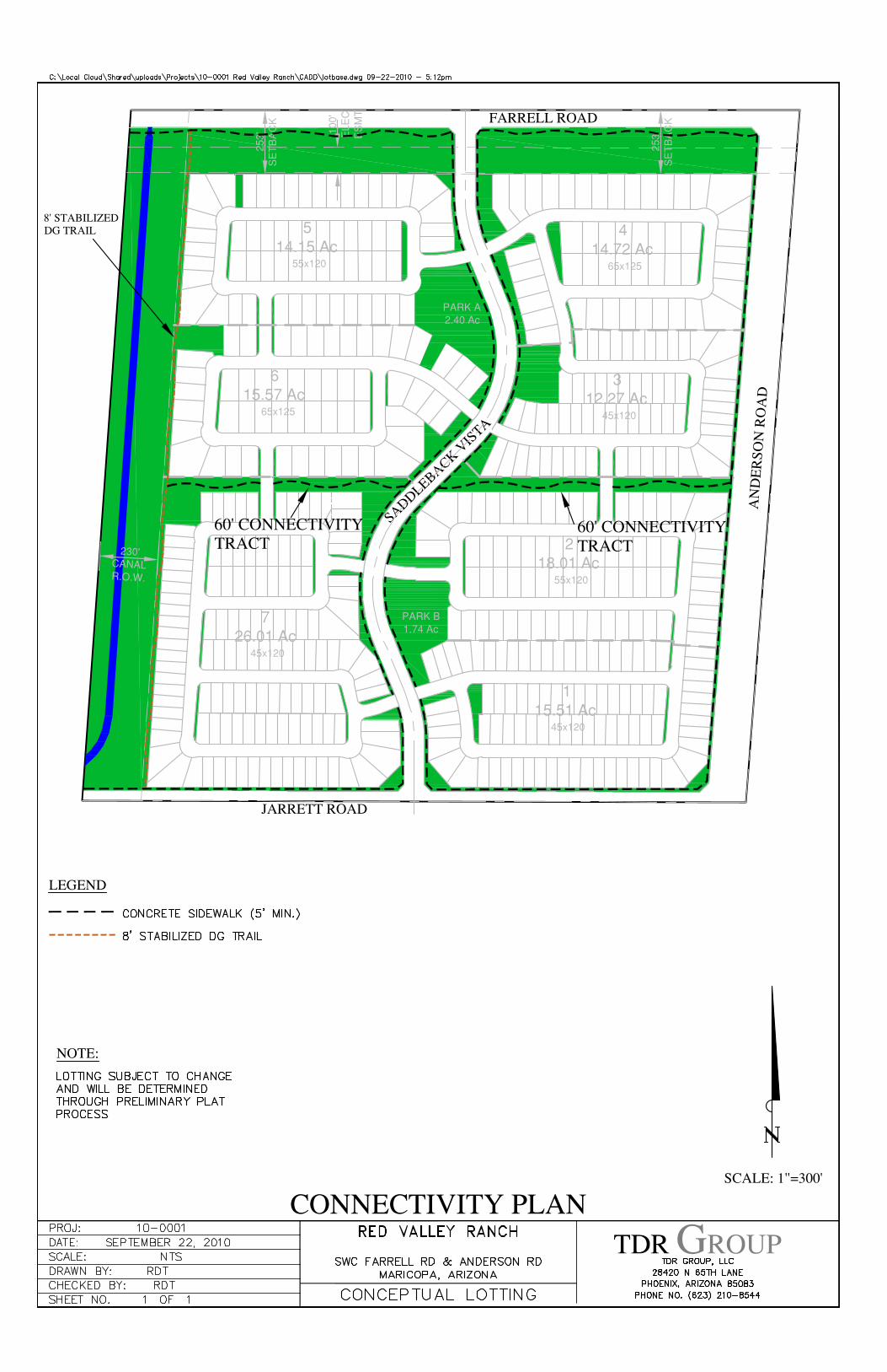
PARKS AND OPEN SPACE
Red Valley Ranch will provides a variety of open-space, park and recreational opportunities. Two
neighborhood parks (Parks A & B) will be provided and include both active and passive amenities (See
Plate III - Connectivity Plan & Appendix E). The proximity of the parks to each parcel allows the residents
of Red Valley Ranch to enjoy the park areas from anywhere in the development in under a quarter-mile
walk. A 60 foot wide landscape tract further enhances the "walkability" of Red Valley Ranch and
provides another means to provide further pathway opportunities. Additionally, open space areas
within each parcel will contain passive amenities and provide a visual break in the housing.
Page | 8
A 15-foot tract along the west side of the property against the east side of the MSIDD Canal will have a
meandering 8' stabilized decomposed granite path that will provide further connection of the parcels to
a trails/sidewalks that surround the property. In keeping with the standards of the City of Maricopa,
60% of open space shall be "useable" space. Where reclaimed water is available and it's use is
appropriate, the project will use it to irrigate the proposed landscaping improvements.
Plate III - Connectivity Plan
Page | 9
LANDSCAPE PLANT PALETTE
A preliminary landscape plan and landscape theme will be prepared in conjunction with the preliminary
plat. Entry Monuments, linear tracts, parcel signage, park and tot lot design will be developed and will
mimic the palettes used throughout the City of Maricopa. However, a combination of desert, xeriscape
treatments along the storm water collection areas and additional areas of highly vegetated treatments
and grass are envisioned to provide varied open spaces and recreational opportunities. The Desert
Palette will be used in portions of the open spaces along the western and northern boundaries of the
property. The Mediterranean/Palm Palette and Desert Palette will be utilized in the remainder of the
property. All landscaping improvements will be in accordance with the current City of Maricopa
standards and/or subsequent standards that will be developed by the City of Maricopa.
The selected palette below adheres to the low water use drought tolerant plants as per the Arizona
Department of Water Resources Pinal Active Management Area list. Where reclaimed water is available
and it's use is appropriate, the project will use it to irrigate the proposed landscaping improvements.
The following is a draft landscape palette list to be implemented in Red Valley Ranch:
Desert Planting Mediterranean/Palm
Trees Trees
Acacia Salacina Orchid Tree
Acacia Smallii
Palo Verde sp.
Ironwood
Mesquite sp.
Accents Palms
Ocotillo Mediterranean Fan Palm
Agave sp. Sago Palm
Shrubs Shrubs
Desert Spoon sp. Bougainvillea sp.
Hesperaloe Bush Morning Glory
Caesalpinia sp.
Cassia sp.
Calliandra sp.
Mex. Honeysuckle
Groundcovers Groundcovers
Lantana sp. Lantana sp.
Trl. Indigo Bush Hybrid Bermuda Grass
Hybrid Bermuda Grass
TRAFFIC AND CIRCULATION
Access to the surrounding road network is provided from Farrell Road to Murphy Road providing paved
access to the property from Casa Grande Highway to the south and Honeycutt Road from the north.
Access will also be available to the Maricopa Highway from Farrell Road to Hartman Road to Honeycutt
Road. See the attached Traffic Letter and Addendum #1 prepared by Mr. Ken Howell, which further
describes the access and circulation of the project (Appendix F).
Page | 10
As previously noted, the project is proposing two options for access to the property and they are the
following:
Option #1
The two all weather connections to the property from Murphy Road will be along the Farrell Road
alignment. The City of Maricopa has advised the utilization of a 4-lane divided/median separated road
from Farrell Road to Anderson Road will provide for two access points to the project. Farrell with be a
divided 4-lane road from Murphy Road to the west property line and a raised median separated 4-lane
road from the west property line to Saddleback Vista. Farrell Road from Saddleback Vista to Anderson
Road will be the south half-street for a minor arterial. The divided/median separation will serve the
purpose of creating two independent access routes. The configuration will be situated in the existing 33
foot right-of-way along the north centerline of Farrell Road and a total of 70 foot right-of-way along the
south side of the Farrell Road alignment for the project's frontage. Additionally, a 28' all-weather
emergency access only would be provide in the west half of the Anderson Road ROW between Farrell
and Jarrett Roads.
Option #2
The Primary Access is provided on Farrell Road from Murphy Road with 28' of 2-lane pavement to the
western property edge and then a 2-lane with a left turn pocket at Saddleback Vista along the project
frontage to Anderson Road. The second point of access is provided along the Jarrett Road alignment
east to Murphy Road utilizing a 28' 2-lane pavement section. This option requires obtaining right-of-way
from the adjacent property owner to the west.
Additional street dedications and improvements will include:
Anderson Road - 150 foot right-of-way dedication, no improvements required
Jarrett Road - 40 foot right-of-way dedication, option #1 (no improvements), option #2 (1/2 street)
Saddleback Vista - 80 foot right-of-way dedication, 50' b/c to b/c improvements
UTILITY SERVICES
Sanitary Sewer, Reclaimed Water, and Potable Water
The sanitary sewer, reclaimed water, and potable water services for Red Valley Ranch are provided by
Global Water Resources, LLC. (Global). Global owns both the Santa Cruz Water Company (potable water
provider) and Palo Verde Utilities Company (sanitary sewer and reclaimed water provider). Both Santa
Cruz Water Company (SCW) and Palo Verde Utilities Company (PVU) are fully accredited public service
companies who are approved by the Arizona Corporation Commission and have been granted a CC & N
(Certificate of Convenience and Necessity) to provide sewer and water services to the greater City of
Maricopa Area, which includes Red Valley Ranch.
On June 16, 2005 the property owners of Red Valley Ranch entered into an Infrastructure Coordination
Agreement (IFCA) with Global in which Global guaranteed the present and future property owners of
Red Valley Ranch (in perpetuity) that SCW and PVU would provide sanitary sewer, reclaimed water, and
potable water services to Red Valley Ranch in exchange for the developers of Red Valley Ranch paying
Page | 11
$1,900 per lot in utility services fees for each lot within a subdivision and the time of that given
subdivision's recordation of its final plat.
Global has not yet issued Sewer and Water "Will Serve Letters" and "Capacity Assurance Letters" to Red
Valley Ranch, but under the IFCA will do so once the Preliminary Plat for Red Valley Ranch has been
approved.
Presently all of Global's Regional Sewer & Water Trunk Lines servicing Red Valley Ranch are within one
mile of the property at the intersection of Hartman Road and Farrell Road. At the time Red Valley Ranch
commences land development it is Global's responsibility under the IFCA to bring the Regional Sewer &
Water Trunk Line to the northwest corner of the property.
Electrical Service
The electrical service for Red Valley Ranch will be provided by Electrical District No. 3 (ED3). There are
presently above ground electrical 65 kV service lines within a mile of Red Valley Ranch and underground
electrical 12 kV service lines in Hartman Road.
ED3 has provided a "Will Serve" Letter, dated July 22, 2010, advising upon final plat approval from the
City of Maricopa that ED3 and the property owner will enter into a developer service agreement. Once
the agreement is complete, ED3 will commence with the electrical infrastructure and street light design.
Cable Communications Service
The cable communications service for Red Valley Ranch will be provided by QWEST Corporation. QWEST
has underground trunk lines in Hartman Road. At this time there is no cable communication service
agreement between QWEST and Red Valley Ranch.
Gas Service
The natural gas service for this regional area is provided by Southwest Gas (SWG). SWG has a main
regional service trunk line in the Maricopa/Casa Grande Highway, roughly 1.5 miles south of Red Valley
Ranch. At this time there is no natural gas service agreement between SWG and Red Valley Ranch.
Fire Service
The fire protection service for this area is provided by the City of Maricopa Fire Department. There is a
temporary fire station just 1-1/2 miles north of Red Valley Ranch and a permanent fire station site (not
yet developed) near the northwest corner of Hartman Road and Bowlin Road.
Page | 12
PUBLIC SCHOOLS
Red Valley Ranch is located in the Casa Grande Elementary and High School Districts. Due to "Open
Enrollment Laws" in the State of Arizona, any child living in Red Valley Ranch may apply to Maricopa
Elementary or High School Districts for enrollment and so long as there is sufficient space in the
Maricopa Elementary of High School system the Red Valley Ranch families can send their children to the
nearby Maricopa Elementary and High Schools. Otherwise the closest Casa Grande Elementary School
at this time is located at 40 North Roosevelt Avenue, and the closest High School at this time is located
at 2730 North Trekell, both are several miles to the east of Red Valley Ranch.
On March 9, 2004 the Casa Grande Elementary School District entered into a Red Valley Ranch
Voluntary Donation Agreement. This Donation Agreement was executed by Mr. Larry Miller on behalf of
Red Valley Investments with the following voluntary contribution:
Pay a $456 per lot voluntary elementary school contribution fee 30 days following the issuance of
each building permit.
On February 26, 2004 the Casa Grande High School District, entered into a Red Valley Ranch Voluntary
Donation Agreement. This Donation Agreement was executed by Mr. Larry Miller on behalf of Red
Valley Investments with the following voluntary contribution:
Pay a $150 per lot voluntary high school contribution fee 30 days following the issuance of each
building permit.
PROJECT SCHEDULE
Red Valley Ranch planning and design will be dictated by market demand. Due to uncertain and
fluctuating market conditions/demand, an exact date of when that will occur cannot be determined at
this time.
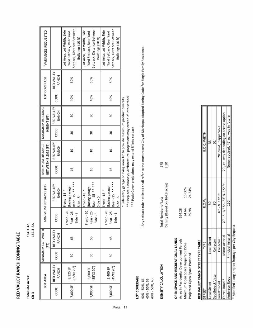
DATA/ZONING AND TABLE
The following attached table presents the requested zoning and land use for the project.
The requested reduction in front setback to 10' for side entry garage or living area will increase product
diversity. The setback reduction allows builders maximum flexibility in creating product diversity,
varying the street scene and providing unique parcel development.
RE
D V
ALLE
Y R
AN
CH
ZO
NIN
G T
AB
LE
To
ta
l S
ite
Acre
s:
16
4.3
Ac.
CR
-31
64
.3A
c.
CO
DE
RE
D V
ALL
EY
RA
NC
HC
OD
ER
ED
VA
LLE
Y
RA
NC
HC
OD
ER
ED
VA
LLE
Y
RA
NC
HC
OD
ER
ED
VA
LLE
Y
RA
NC
HC
OD
ER
ED
VA
LLE
Y
RA
NC
HC
OD
ER
ED
VA
LLE
Y
RA
NC
H
7,0
00
SF
8,1
25
SF
(65
'X1
25
')6
06
5
Fro
nt
- 2
0
Re
ar
- 2
5
Sid
e -
8
Fro
nt
- 1
8 *
(fa
cin
g g
ara
ge
)
Re
ar
- 1
5 *
* *
**
Sid
e -
5
16
10
30
30
40
%5
0%
7,0
00
SF
6,6
00
SF
(55
'X1
20
')6
05
5
Fro
nt
- 2
0
Re
ar
- 2
5
Sid
e -
8
Fro
nt
- 1
8 *
(fa
cin
g g
ara
ge
)
Re
ar
- 1
5 *
* *
**
Sid
e -
5
16
10
30
30
40
%5
0%
7,0
00
SF
5,4
00
SF
(45
'X1
20
')6
04
5
Fro
nt
- 2
0
Re
ar
- 2
5
Sid
e -
8
Fro
nt
- 1
8 *
(fa
cin
g g
ara
ge
)
Re
ar
- 1
5 *
* *
**
Sid
e -
5
16
10
30
30
40
%5
0%
* S
ide
en
try
ga
rag
e o
r li
vin
g a
rea
10
' to
pro
vid
e m
axi
mu
m p
rod
uct
div
ers
ity
**
Fir
ep
lace
, C
him
ne
ys,
Arc
hit
ect
ura
l p
roje
ctio
ns
ma
y e
xte
nd
2' i
nto
se
tba
ck
**
* P
ati
o C
ove
r p
roje
ctio
ns
ma
y e
xte
nd
5' i
nto
se
tba
ck
LO
T C
OV
ER
AG
E
40
% -
50
%,
65
'1A
ny
se
tba
ck r
ule
no
t li
ste
d s
ha
ll r
efe
r to
th
e m
ost
re
cen
t C
ity
of
Ma
rico
pa
ad
op
ted
Zo
nin
g C
od
e f
or
Sin
gle
Fa
mil
y R
esi
de
nce
.
40
% -
50
%,
55
'
40
% -
50
%,
45
'
DE
NS
ITY
CA
LC
ULA
TIO
NT
ota
l N
um
be
r o
f Lo
ts5
75
De
nsi
ty (
Ba
sed
on
16
4.3
acr
es)
3.5
0
OP
EN
SP
AC
E A
ND
RE
CR
EA
TIO
NA
L L
AN
DS
Acr
es
in R
esi
de
nti
al
De
ve
lop
me
nt
Pa
rce
ls1
64
.28
Min
imu
m O
pe
n S
pa
ce R
eq
uir
ed
(1
5%
)2
4.6
41
5.0
0%
Pro
ject
ed
Op
en
Sp
ace
Pro
vid
ed
39
.98
24
.34
%
RE
D V
ALLE
Y R
AN
CH
ST
RE
ET
TY
PE
TA
BLE
* M
od
ifie
d a
lon
g p
roje
ct f
ron
tag
e p
er
Cit
y R
eq
ue
st
Lot
Are
a,
Lot
Wid
th,
Sid
e
Ya
rd S
etb
ack
, R
ea
r Y
ard
Se
tba
ck,
Dis
tan
ce B
etw
ee
n
Bu
ild
ing
s (1
0 f
t)
Lot
Are
a,
Lot
Wid
th,
Sid
e
Ya
rd S
etb
ack
, R
ea
r Y
ard
Se
tba
ck,
Dis
tan
ce B
etw
ee
n
Bu
ild
ing
s (1
0 f
t)
33
'
B.O
.C.
WID
TH
MIN
IMU
M D
IST
AN
CE
BE
TW
EE
N B
LDG
S (
FT
)
R.O
.W.
50
'
Lot
Are
a,
Lot
Wid
th,
Sid
e
Ya
rd S
etb
ack
, R
ea
r Y
ard
Se
tba
ck,
Dis
tan
ce B
etw
ee
n
Bu
ild
ing
s (1
0 f
t)
MA
XIM
UM
BU
ILD
ING
HE
IGH
T (
FT
)LO
T C
OV
ER
AG
E1V
AR
IAN
CE
S R
EQ
UE
ST
ED
Pri
nci
pa
l A
rte
ria
l I
80
'
40
' - N
. 1
/2 S
t.
LOT
AR
EA
MIN
IMU
M L
OT
WID
TH
(FT
)M
INIM
UM
SE
TB
AC
KS
(F
T)
TY
PE
Loca
l S
tre
et
70
' - S
. 1
/2 S
t.,
33
' N.
1/2
St.
15
0'
Page | 13
No
ne
re
qu
ire
d,
45
' ea
. w
ay
in
fu
ture
ST
RE
ET
Loca
l S
tre
et
Sa
dd
leb
ack
Vis
ta
Jarr
ett
Ro
ad
Fa
rre
ll R
oa
d *
An
de
rso
n R
oa
d
29
', e
a.
wa
y d
ep
en
din
g o
n a
cce
ss o
pti
on
28
' pvm
t, i
f a
pp
lica
ble
51
'C
oll
ect
or
Co
lle
cto
r
Min
or
Art
eri
al
APPENDICES
APPENDIX A GENERAL PLAN MAP
APPENDIX B BUBBLE ZONING MAP
APPENDIX C BUBBLE PLAN
APPENDIX D CONCEPTUAL LAND USE PLAN
APPENDIX E CONNECTIVITY PLAN
APPENDIX F TRAFFIC STATEMENT
APPENDIX G ALTA

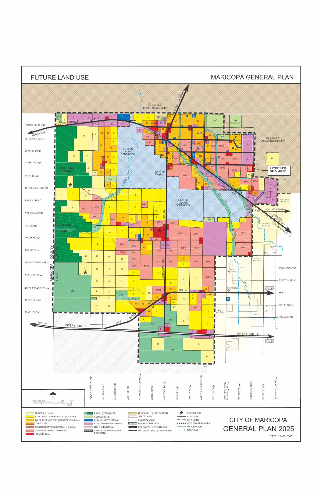
APPENDIX A
GENERAL PLAN MAP
��������������� ������������
APPENDIX B
BUBBLE ZONING MAP
APPENDIX C
BUBBLE PLAN
APPENDIX D
CONCEPTUAL LAND USE PLAN

APPENDIX E
CONNECTIVITY PLAN
APPENDIX F
TRAFFIC STATEMENT
APPENDIX G
ALTA