Embed Size (px)
Citation preview
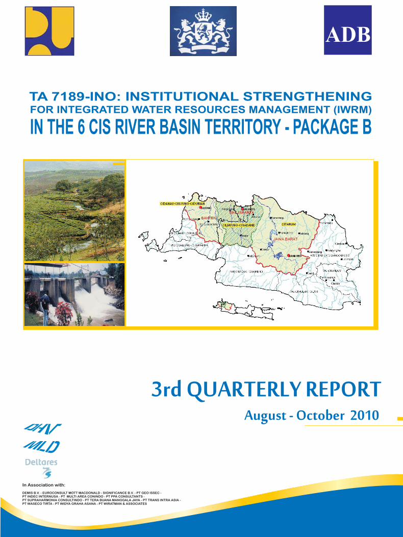
TA 7189-INO: INSTITUTIONAL STRENGTHENING
IN THE 6 CIS RIVER BASIN TERRITORY - PACKAGE BFOR INTEGRATED WATER RESOURCES MANAGEMENT (IWRM)
ADB
3rd QUARTERLY REPORTAugust - October 2010

TA 7189-INO Package B 3rd Quarterly Report October 2010
DHV, Deltares, MLD 1
3rd QUARTERLY REPORT FOR TA 7189-INO OCTOBER 2010
1 TA 7189-INO PACKAGE B ................................................................................................................1 1.1 Introduction ..................................................................................................................................1 1.2 Developments during this period .................................................................................................1 1.3 Logistics.......................................................................................................................................2
2 SUBCOMPONENT B1 INSTITUTIONAL STRENGTHENING AND PLANNING ...............................3 2.1 Status of B.1 Tasks......................................................................................................................3 2.2 Developments and Key Findings for Component B.1A................................................................4
2.2.1 Task 2.1 Stakeholder assessment ......................................................................................4 2.2.2 Institutional Strengthening...................................................................................................6
2.3 Developments / Key Findings in Sub-Component B.1B...............................................................7 2.3.1 Task B.1-3 Web-based Meta Data Base.............................................................................7 2.3.2 Task B.1-4 Decision Support Systems................................................................................8 2.3.3 Task B.1-5 Basin Planning, Development of Pola & Rencana ..........................................10 2.3.4 Task B.1-6 State Of The Basin Reporting: ........................................................................12
2.4 Issues ........................................................................................................................................12 2.4.1 Issues concerning Sub-component B.1A ..........................................................................12 2.4.2 Issues concerning Sub-component B.1B ..........................................................................13
2.5 Developments for the next Period..............................................................................................14
3 SUB COMPONENT B.2...................................................................................................................15 3.1 Status of B2 tasks......................................................................................................................15 3.2 Developments and issues..........................................................................................................15
3.2.1 Remote sensing data collection uncertainty......................................................................15 3.2.2 Extra GIS input needed for run-off protection zoning ........................................................15
3.3 Current status of the Java Spatial Model (JSM).........................................................................17 3.3.1 Work accomplished this period .........................................................................................17 3.3.2 Current trend case ............................................................................................................18 3.3.3 Good governance case .....................................................................................................19 3.3.4 Water resources protection case.......................................................................................19 3.3.5 Food sustainability case....................................................................................................19 3.3.6 Capital leaving Java case .................................................................................................20 3.3.7 Network City case .............................................................................................................23 3.3.8 Impact evaluation of the future development trends..........................................................26
3.4 JSM Results of future trends......................................................................................................26 3.4.1 Population growth .............................................................................................................26 3.4.2 Urban density reduction ....................................................................................................27 3.4.3 Urban area growth ............................................................................................................27 3.4.4 Loss of forest area ............................................................................................................28 3.4.5 Loss of irrigated paddy area..............................................................................................28 3.4.6 Drinking water demand growth..........................................................................................29 3.4.7 Waste load emission growth .............................................................................................29 3.4.8 Change in average travel time ..........................................................................................30
3.5 Developments in next period .....................................................................................................31
4 SUB COMPONENT B.3...................................................................................................................33 4.1 Status Tasks B.3........................................................................................................................33 4.2 Progress in implementation Tasks B.3.......................................................................................33
4.2.1 Task B3-1, B3-3 Groundwater Use in Bandung ................................................................33 4.2.2 Task B3-2 Water Allocation in Jatiluhur Scheme ..............................................................35
4.3 DEVELOPMENTS AND ISSUES...............................................................................................38 4.3.1 WISIMP activities on water allocation irrigation Jatiluhur ..................................................38 4.3.2 DKI’s approach on groundwater management ..................................................................38 4.3.3 Pricing bulk water supply ..................................................................................................39 4.3.4 Database development on registration, licensing groundwater .........................................39
4.4 COMPARISON WATER ALLOCATION MECHANISMS............................................................39 4.5 ESDM WORKSHOP ON GROUNDWATER MANAGEMENT ...................................................41 4.6 REPORTS .................................................................................................................................42 4.7 PERSONAL INPUTS .................................................................................................................42 4.8 PLANNING ................................................................................................................................43
5 PROJECT IMPLEMENTATION PACKAGE B..................................................................................45 Annex A : Personnel Planning Annex B : Conclusion of Work Plan Annex C : Overview of Reports

TA 7189-INO Package B 3rd Quarterly Report October 2010
DHV, Deltares, MLD 2
GLOSSARY 6 Cis RBT River Basin territory covering Cidanau, Ciujung, Cidurian + Ciliwung, Cisadane + Citarum ADB Asian Development Bank AM Asset Management Balai PSDA WRM Centre (at Provincial level) BAPPEDA Local Government Planning Board BAPPENAS National Planning Board BBWS Greater Basin Territory Centre (Balai Besar Wilayah Sungai), at MPW level BLU Public Service Organization, can collect charges BTA 155 Cisadane - Cimanuk Integrated Water Resources Development project
Strategic WRM Planning project in Indonesia (1985 – 1991) BWRMC Basin Water Resources Management Council BWRMP 1) Basin Water Resources Management Plan (Rencana) 2) Project for formulation of BWRMP (2001 – 2004) BWRP Basin Water Resources Planning (1996 – 2001, later changed to BWRMP) CDAP Capacity Development Action Plan CMT Change Management Team CRB Citarum River Basin CRBOM Centre for River Basin Organizations and Management CSO Community Service Organization or NGO DAS Daerah Aliran Sungai, River Basin DGWR Directorate General for Water Resources at MPW DMI Domestic, Municipal and Industrial (water demand) FEWS\HYMOS Hydrological data processing system based on Flood Early Warning System FHM Flood Hazard Mapping, component under Jakarta Flood Management (2007 – 2010) FMSB Flood Management in Selected Basins (2004 – 2005) GDP Gross Domestic Product GIS Geographic Information System GOI Government of Indonesia GWP Global Water Platform HRM Human Resources Management ICWRMIP Integrated Citarum WRM Investment program IWRM Integrated Water Resources Management JABOTABEK Area comprising Jakarta, Bogor, Tangerang, Bekasi JABODETABEK Area comprising Jakarta, Bogor, Depok Tangerang, Bekasi JSM Java Spatial Model JWRMS JABOTABEK WRM Study MFF Multi-tranche Facilitation Facility (for ADB loans) MIS Management Information System MOHA Ministry of Home Affairs MPW Ministry of Public Works NARBO Network for Asian River Basin Organizations NGO Non Government Organization O&M Operation and Maintenance ODS Organizational Development Specialist PBPB Performance Benchmarking for Physical Basins PISP Participatory Irrigation Sector Project PJT II National Corporation for Basin Management (for Citarum) PODES Data Base with statistical data at desa level PPTPA Present form of Water Resources Council at Basin Level PSDA WRM PTPA Present form of Water Resources Council at Provincial Level PusAir Agency for Research and Development in Water Resources, under MPW RBMO River Basin Management Organization RBT River Basin Territory (Wilayah Sungai, WS) RCMU Road Map Coordination Management Unit RIBASIM River Basin Simulation Model, Decision Support System for WR planning /management Sawah Rice Field SMP Strategic Water Resources Management Plan, (Pola) TA Technical Assistance TAMP Total Asset Management Program TKPSDA Coordination Team for WRM (Basin WRM Council) WB World Bank WISMP Water Resources and Irrigation Sector Management program WRM Water Resources Management WRMC WRM Council WTC West Tarum Canal
TA 7189-INO Package B 3rd Quarterly Report October 2010
DHV, Deltares, MLD 1
1 TA 7189-INO PACKAGE B
1.1 Introduction Institutional Strengthening for Integrated Water Resources Management (IWRM) in the 6 Cis (six rivers) River Basin Territory (TA 7189-INO) is located in the North Western part of Java island, comprising the metropolitan cities of Jakarta and Bandung. Component B, the subject of this report, is concerning institutional development of government institutions and civil service organizations for planning of IWRM. Several sub-components are identified:
B1A Institutional Strengthening for IWRM in 6 Cis RBT B1B IWRM Planning in 6 Cis RBT B2 Strategic Spatial Planning in 6 Cis RBT B3 Development of Key Policies and Strategies for IWRM
Implementation of component B1 started on November 11, after the contract was approved by ADB, and is intended to continue for 36 months until November 2012. Implementation of B2 started on February 15, 2010, and is envisaged to continue for 18 months until August 2011, or later, depending on availability of data from the population census 2010. Sub-component B3 started in November 2009 and is expected to deliver final results in January 2011. This third Quarterly Report presents the status on 31 October 2010 and progress achieved during the last three months of project implementation, and also presents an indication of developments and issues affecting implementation. Each sub-component is dealt with in chapters 2, 3 and 4, while general project implementation is discussed in chapter 5.
1.2 Developments during this period
During this period the major achievements under B.1A are that the Provincial Water Council of Jakarta has been inaugurated and started operation (all three are now operational), while the process for formation of the Basin Council (TKPSDA) for the 6 Cis area is in the final stages of establishment, waiting for signatures of the DG for Water Resources and the Minister. It is expected that the Basin Council will be established at the end of this year or next reporting period. PU-DGWR is going through significant changes in its organization, affecting both the DGWR staff in Jakarta and the BBWS in the regions. Therefore Capacity Building plans cannot be prepared yet. The first round of Public Consultation meetings as part of the formulation of the Pola has been completed in September / October 2010, as a joint effort under component B.1A and B.1B. It was very useful, as many of the candidate members of the TKPSDA were actively involved in the discussions, and many new data or new contacts for potential data emerged. For B.1B the specialists were engaged in active analysis and formulation of the Strategic Management Plans (Pola), which will be presented to DGWR and in Public Consultation Meetings next period. There is no platform for regular consultation, which means the consultation has to be done during the round of 2nd Public Consultations. Since the BBWS has no time available in December 2010, these meetings will be held in January 2011. This means a delay of two months. This may have impacts on the resource planning for B.1B, to be determined in January 2011
TA 7189-INO Package B 3rd Quarterly Report October 2010
DHV, Deltares, MLD 2
B.2 provided a new version of the Java Spatial Model (JSM), as well as a simulation of population growth and related urban growth for various scenarios until 2030 and 2050. Overall, B.2 is on schedule. Completion according to schedule in August 2011 depends on availability of the information from the 2010 population census and information from RS mapping, which will become clear in January 2011 B.3 presented the first results on groundwater on the workshop in Bandung on 2nd of November, resulting in clear recommendations to be followed up under TA 7189 or under next programs. Results on irrigation management of Jatiluhur will be presented in January 2011, and the final reports are expected also in by then. During the supervision mission of ADB in October it was recommended to add an extra component concerning pricing of water supply to Jakarta. This will be arranged under an additional variation order, and coordinated under component B.1. Overall, it is expected that B.3 will be completed according to the plan in January 2011, although some parts will be continued under B.1.. An important issue is the intention of DGWR to split the 6 Cis River Basin Territories (RBT) in three new RBTs This may have impacts on the work for Pola and Rencana, as well as for functioning of the TKPSDA. For the moment it is intended to complete the Pola as for the whole 6 Cis RBT, and adjust later after the PerPres about delineation of RBTs has been issued if necessary.
1.3 Logistics
Variations in the contract have been discussed as part of preparation of the Inception Report. This resulted in changes in person months and positions, as well as more precise specification of the provisional sums. The final proposal for the Variation Order has been submitted on August 3rd 2010. Unfortunately this Variation Order has not been endorsed yet by ADB Manila per 31 October 2010. We are pleased to mention that all counterparts from PU, comprising three from DG for Spatial Planning, two from DGWR Jakarta and two from each BBWS, have participated in implementation of Package B. They are all junior staff, but with good education (S.1 and S.2) and high motivation. The counterparts have also participated in trainings implemented for Package B. To support the team an excellent office space was provided in Jakarta in the former building of Directorate for Planning and Programming, with all facilities as furniture, water, electricity and telephone lines. However, this building will be demolished in January 2011, and therefore the office had to move to a much smaller location in the former building of Directorate of Rivers. Office space in Bandung is adequate, although there is no fixed telephone line. Space in the other two BBWS in Jakarta and Bandung has also been provided. In September / October a Review mission from ADB was done. Conclusions concerning Package B are summarized in chapter 5

TA 7189-INO Package B 3rd Quarterly Report October 2010
DHV, Deltares, MLD 3
2 SUBCOMPONENT B1 INSTITUTIONAL STRENGTHENING AND PLANNING
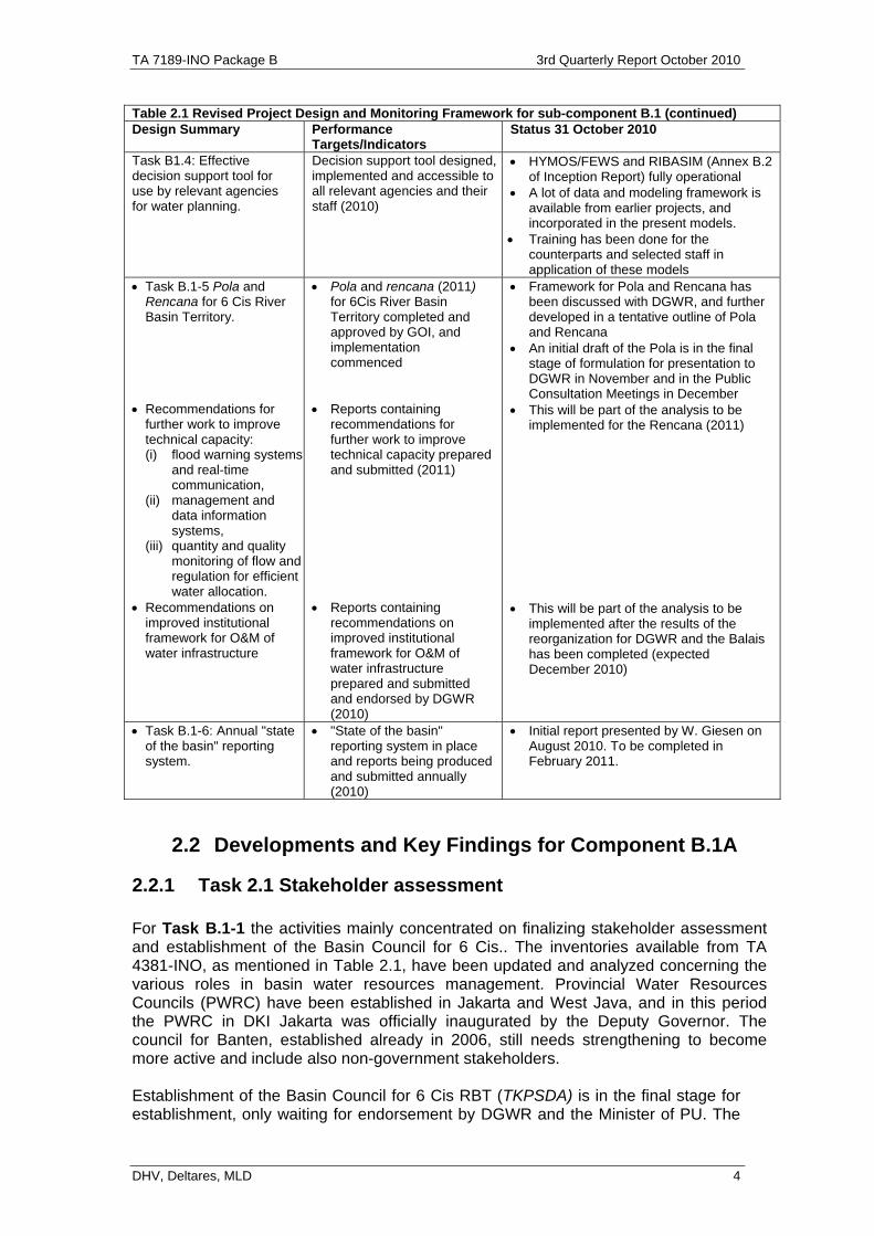
2.1 Status of B.1 Tasks Status of the Tasks for B.1 and achieved progress during the last months is indicated in the revised Project Design and Monitoring Framework (DMF) as presented in Table 2.1. Table 2.1 Revised Project Design and Monitoring Framework for sub-component B.1 Design Summary Performance
Targets/Indicators Status 31 October 2010
Task B.1.1 Ongoing support for Water Resources Council (WRC) and supporting office(s),
Water Resources Council operating effectively and making appropriate decisions and recommendations to GOI (2011).
WRC in provinces established as follows: - West Java per March 2010, first meeting July 2010,
- DKI Jakarta per Feb. 2010, first meeting April 2010, inauguration Sept 2010 - Banten: established in 2006, last met in 2009, non-government not well represented To be selected members of Basin
Council (TKPSDA) agreed in selection committee, and sent for formal approval to DG of WR and the Minister of PU.
Stakeholder analysis report in Citarum finalized, to be completed in other basins.
First Public Consultation Meetings in all three areas in September / October, proceedings submitted to ADB
Focus Group Discussions in Citarum regularly held..
Task B.1.2 Improved capacity of river basin management agencies (RBMOs).
Strengthened Balai Besar for three subbasins
Capacity of river basin management agencies to make decisions in an IWRM context improved (2010).
All three Balai Besar strengthened in areas of: (i) leadership and
teamwork, (ii) human resources
management, (iii) financial planning and
management (2012)
No follow up on CDAPs and CMT as formulated under TA 4381-INO, Problem is that there is no clear task distribution between BBWS and provinces. Official policy from DGWR is in preparation.
Functional Analysis of DGWR and Balais completed and resulted in re-organization on headlines in July 2010, but is still under preparation for the details.
The above functional analysis is aiming to result in a more service oriented organization, with clear indicators for benchmarking of performance, which will be a sound basis for the aimed strengthening of the Balai Besar.
Task B1.3:Internet-based meta-database for water, land and related data in Citarum River Basin
Meta-database designed, implemented and operational (2010)
Website will be established with general access to general information, reports and minutes of meeting, and more restricted access for persons involved in the project for other information
List for data collection presented in the Inception Report, based on the new guidelines for Pola preparation (KepMen 22/2009) and the current guidelines for Rencana preparation. Some 95% of all data has been collected, including verification and analysis of the data.
Asset management system has been tested in Ciujung basin, and found suitable for application, but current implementation is weak, especially data input needs to be verified.
TA 7189-INO Package B 3rd Quarterly Report October 2010
DHV, Deltares, MLD 4
Table 2.1 Revised Project Design and Monitoring Framework for sub-component B.1 (continued) Design Summary Performance
Targets/Indicators Status 31 October 2010
Task B1.4: Effective decision support tool for use by relevant agencies for water planning.
Decision support tool designed, implemented and accessible to all relevant agencies and their staff (2010)
HYMOS/FEWS and RIBASIM (Annex B.2 of Inception Report) fully operational
A lot of data and modeling framework is available from earlier projects, and incorporated in the present models.
Training has been done for the counterparts and selected staff in application of these models
Task B.1-5 Pola and Rencana for 6 Cis River Basin Territory.
Recommendations for
further work to improve technical capacity: (i) flood warning systems
and real-time communication,
(ii) management and data information systems,
(iii) quantity and quality monitoring of flow and regulation for efficient water allocation.
Recommendations on improved institutional framework for O&M of water infrastructure
Pola and rencana (2011) for 6Cis River Basin Territory completed and approved by GOI, and implementation commenced
Reports containing
recommendations for further work to improve technical capacity prepared and submitted (2011)
Reports containing
recommendations on improved institutional framework for O&M of water infrastructure prepared and submitted and endorsed by DGWR (2010)
Framework for Pola and Rencana has been discussed with DGWR, and further developed in a tentative outline of Pola and Rencana
An initial draft of the Pola is in the final stage of formulation for presentation to DGWR in November and in the Public Consultation Meetings in December
This will be part of the analysis to be implemented for the Rencana (2011)
This will be part of the analysis to be
implemented after the results of the reorganization for DGWR and the Balais has been completed (expected December 2010)
Task B.1-6: Annual "state of the basin" reporting system.
"State of the basin" reporting system in place and reports being produced and submitted annually (2010)
Initial report presented by W. Giesen on August 2010. To be completed in February 2011.
2.2 Developments and Key Findings for Component B.1A
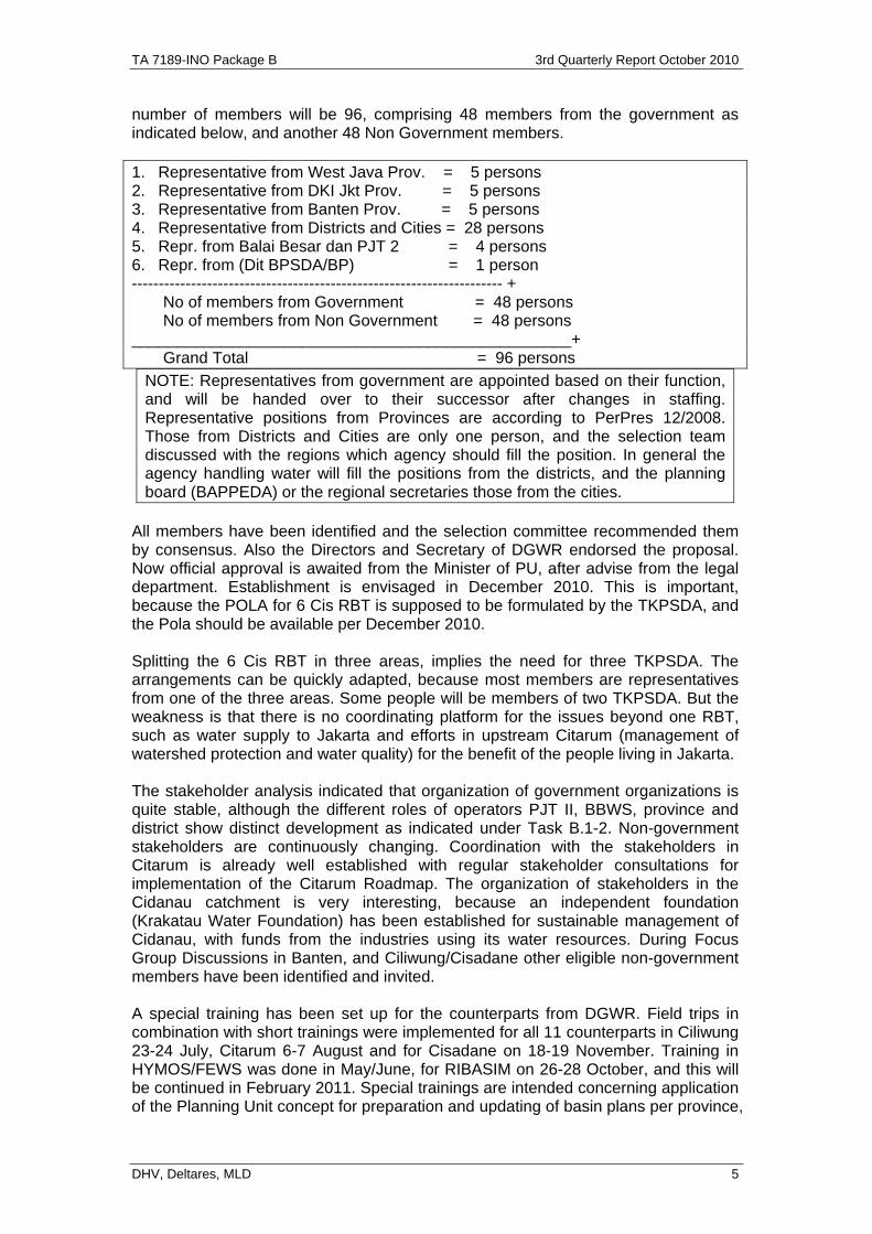
2.2.1 Task 2.1 Stakeholder assessment For Task B.1-1 the activities mainly concentrated on finalizing stakeholder assessment and establishment of the Basin Council for 6 Cis.. The inventories available from TA 4381-INO, as mentioned in Table 2.1, have been updated and analyzed concerning the various roles in basin water resources management. Provincial Water Resources Councils (PWRC) have been established in Jakarta and West Java, and in this period the PWRC in DKI Jakarta was officially inaugurated by the Deputy Governor. The council for Banten, established already in 2006, still needs strengthening to become more active and include also non-government stakeholders. Establishment of the Basin Council for 6 Cis RBT (TKPSDA) is in the final stage for establishment, only waiting for endorsement by DGWR and the Minister of PU. The
TA 7189-INO Package B 3rd Quarterly Report October 2010
DHV, Deltares, MLD 5
number of members will be 96, comprising 48 members from the government as indicated below, and another 48 Non Government members. 1. Representative from West Java Prov. = 5 persons 2. Representative from DKI Jkt Prov. = 5 persons 3. Representative from Banten Prov. = 5 persons 4. Representative from Districts and Cities = 28 persons 5. Repr. from Balai Besar dan PJT 2 = 4 persons 6. Repr. from (Dit BPSDA/BP) = 1 person --------------------------------------------------------------------- + No of members from Government = 48 persons No of members from Non Government = 48 persons _________________________________________________+ Grand Total = 96 persons
NOTE: Representatives from government are appointed based on their function, and will be handed over to their successor after changes in staffing. Representative positions from Provinces are according to PerPres 12/2008. Those from Districts and Cities are only one person, and the selection team discussed with the regions which agency should fill the position. In general the agency handling water will fill the positions from the districts, and the planning board (BAPPEDA) or the regional secretaries those from the cities.
All members have been identified and the selection committee recommended them by consensus. Also the Directors and Secretary of DGWR endorsed the proposal. Now official approval is awaited from the Minister of PU, after advise from the legal department. Establishment is envisaged in December 2010. This is important, because the POLA for 6 Cis RBT is supposed to be formulated by the TKPSDA, and the Pola should be available per December 2010. Splitting the 6 Cis RBT in three areas, implies the need for three TKPSDA. The arrangements can be quickly adapted, because most members are representatives from one of the three areas. Some people will be members of two TKPSDA. But the weakness is that there is no coordinating platform for the issues beyond one RBT, such as water supply to Jakarta and efforts in upstream Citarum (management of watershed protection and water quality) for the benefit of the people living in Jakarta. The stakeholder analysis indicated that organization of government organizations is quite stable, although the different roles of operators PJT II, BBWS, province and district show distinct development as indicated under Task B.1-2. Non-government stakeholders are continuously changing. Coordination with the stakeholders in Citarum is already well established with regular stakeholder consultations for implementation of the Citarum Roadmap. The organization of stakeholders in the Cidanau catchment is very interesting, because an independent foundation (Krakatau Water Foundation) has been established for sustainable management of Cidanau, with funds from the industries using its water resources. During Focus Group Discussions in Banten, and Ciliwung/Cisadane other eligible non-government members have been identified and invited. A special training has been set up for the counterparts from DGWR. Field trips in combination with short trainings were implemented for all 11 counterparts in Ciliwung 23-24 July, Citarum 6-7 August and for Cisadane on 18-19 November. Training in HYMOS/FEWS was done in May/June, for RIBASIM on 26-28 October, and this will be continued in February 2011. Special trainings are intended concerning application of the Planning Unit concept for preparation and updating of basin plans per province,
TA 7189-INO Package B 3rd Quarterly Report October 2010
DHV, Deltares, MLD 6
a special course on IWRM for the TKPSDA together with the secretariat supporting the TKPSDA, and a special course on IWRM for the BBWS together with the provincial and district agencies involved in IWRM to enhance their cooperation and coordination.
2.2.2 Institutional Strengthening Concerning Task B.1-2 an update of the diagnostic analysis implemented under TA 4381-INO, indicated that the Change Management Teams (CMT) were not active anymore, and Capacity Development Action Plans were not existing or not updated. The different roles of operators PJT II, BBWS, province and district show distinct development. Officially the BBWS are responsible for Water Resources Management (WRM) for the whole River Basin Territory (RBT), because it is a national basin. This includes O&M of all facilities, including the dams, rivers and the irrigation systems. But because there are already capable organizations dealing with parts of infrastructure there is a role sharing arrangements. For most irrigation systems (all < 3,000 ha) a mandate is given to the provincial services to implement this, through co-management or Tugas Perbantuan, TP. According to PP7/2010 PJT II is responsible for O&M of Jatiluhur dam and the main canals of the 240,000 ha irrigation system served from its reservoir, as well as operation of the secondary canals (maintenance is mandated to the province and districts); PJT II has its own funds from collected fees for bulk water supply and hydropower generation, and is using this also as cross subsidy for irrigation O&M. Role sharing arrangements are being formulated in a directive from PU-DGWR. MoUs between the various organizations should comprise multi-year arrangement, to allow more effective planning and implementation according to those plans. Annual arrangements based on available budgets can be arranged in annual joint operation letters (KSO). Inventories of personnel for BBWS were collected, based on quantitative and qualitative data, also as part of the preparations for the master plan for capacity building at the Ministry of Public Works (PU), DG Water Resources. This revealed that there is a wide variation in perception of how the various tasks and responsibilities have to be implemented, concentrating on questions as how much mandate is given to the provinces through TP, how much is done by own staff or by out-sourcing etc. A clear guideline from higher levels is required. Such guidelines will come as the Ministry of PU is one of the ministries going through administrative reforms, aiming at better performance of the ministries and higher salaries as a reward if better performance is achieved. For DGWR, including the BB/BWS, a thorough functional analysis has been implemented, which resulted in re-organization at the ministry in Jakarta in July 2010, on directorate level (see table 2.2). Details for the sub-directorates and BB/BWS are still under negotiation with the Ministry for National Government Facilities. This will be followed up in the next period. A major issue is the intention of DGWR to split the 6 Cis RBT in three smaller RBTs. Concerning management, this is easy, because there are already three BBWS. However, planning should be holistic, integrating the interests of all stakeholders, and this should be dealt with at the highest level where these interests are present. Since Jakarta, lying in the supposed RBT of Ciliwung-Cisadane, is relying on water resources from Citarum , and most promising future reservoirs are in Cidanau-Ciujung-Cidurian, the interests of the stakeholders in the three areas is inter-linked.

TA 7189-INO Package B 3rd Quarterly Report October 2010
DHV, Deltares, MLD 7
However, if the present larger RBT is split, there will be three Pola and Rencana, as well as three Basin WR Councils. A practical solution could be one Pola is prepared for the present RBT, which will be used as reference for Rencana of the three smaller RBTs. Coordination of the three TKPSDAs should have special arrangements. We are still assessing what will be the impacts on TA 7189 package B, and will report as soon as the decision is endorsed by the intended new Presidential Regulation (PER PRES). The first Public Consultation Meetings (PCM) for collection of ideas and aspirations from all kinds of stakeholders has been held on 28 September in Serang, on 12 October in Jakarta and on 20 October in Bandung. Three PCMs have been organized, one in each area managed by the three BBWS in the project area. Results from the first PCMs has been compiled and included in the analysis of constraints and issues and formulation of possible solutions and strategies. Proceedings have been submitted to the ADB. The three PCMs resulted in additional information collected and still to be collected, especially about conservation and water demand (more details in 2.3.3). Most promising strategies will be presented to a second round of PCMs in each area. This was planned for December, but since the data collection requires more time, and the BBWS has no time to organize the PCMs, it has been decided to organize these in January 2011. The conclusions from these PCMs will be presented as a draft Pola for 6 Cis RBT to a national PCM in February 2011, and it is assumed that after that the legalization process can be concluded.
2.3 Developments / Key Findings in Sub-Component B.1B
2.3.1 Task B.1-3 Web-based Meta Data Base Task B.1-3 concerns development of an Internet Based Meta-database. DGWR has several ongoing programs concerning development of water resources databases and information systems. It has been agreed with DGWR and the data center of Bina Program that the 6 Cis project will not develop new information systems that might overlap in scope with these existing Information systems and developments. It has been agreed that 6 Cis project will establish a project web site with the name sda.pu.go.id/6Cis, hosted at Water Resources Data Centre (WRDC) or PUSDATA PU. This project web site (MIS) will provide a (public/restricted) platform for sharing documents (minutes of meetings, project reports, etc) and other information in the form of tables and maps. Additional content can easily be added during the project. This web-site is still under development, to comply with all requirements of DGWR. The most important existing information systems relevant to 6Cis project are:
1) For Citarum roadmap, Bappenas developed an internet based MIS with document management and knowledge base functionalities to facilitate information exchange with roadmap stakeholders. (http://www.citarum.org). Our web-site will have a direct link to this system.
2) In the Citarum basin, PJT2 (formerly POJ) operates an existing Asset Management System (AMS) and it has been proposed that this system is to be established also in the BBWS Cilliwung-Cisadane and BBWS Ciujung-Cidanau-Cidurian. The main purpose of this system is to provide an overview of assets under responsibility of one BBWS, and how to assess priorities for maintenance. Trial application in Ciujung-Cidanau-Cidurian showed that this

TA 7189-INO Package B 3rd Quarterly Report October 2010
DHV, Deltares, MLD 8
tool is suitable for cases where a proposed budget has been reduced, and assets have to be ranked to assess which maintenance activities have the lowest priority. However, verification of data input is very important, since the first trial indicated that this is the weak part of the application.
3) Within the DGWR data center a internet Water Resources Information System (WRIS) has been developed and is operational (http://sda.pu.go.id). Our web-site will have a direct link to this system.
Within the WISMP/PISP projects (BWRM) a stand-alone (desktop) water resources data management application, PDSDA 3.0/4.0 is under development, including an Irrigation Asset Module. The application is based on open-source software components and can freely be distributed. Application by the BBWS is planned for the next period. Launching of the web-site at sda.pu.go.id/6Cis was still upheld, awaiting approval from DGWR.
2.3.2 Task B.1-4 Decision Support Systems Water Balance Model for the 6 Cis (Activity 4.2) Because of the selection of FEWS/HYMOS and RIBASIM already a functioning water balance model is available. Also a large time-series of records, spanning 1920– 2010, will become available For this, the model has been updated, and data are being converted. Additionally the new data from 1980 – 2010 need to be validated This is time consuming, because the location of most of the new stations has been indicated clearly, and the Balais had to verify the locations in correct coordinates (with GPS). Also for many periods data are missing data, or show dubious results of reliability checks in double mass curves. Therefore it has been decided that the available time series of 1951 – 1979 will be used for the Pola, and the complete series only for the Rencana. Continuous on-the-job training is part of these activities. Analysis of water supply and -demand is of great importance in the 6 Cis project. There is a number of reasons that motivate this:
1. Even though the project area is blessed with ample water resources, water demand, and in particular Domestic, Municipal and Industrial (DMI) water demand, has increased so dramatically in recent years that, with the existing water distribution system, shortages occur, in particular in the dry season.
2. While irrigated agriculture can adapt cropping patterns or reduce the cultivated area to cope with reduced water availability in the dry season, DMI water supply needs to be continued even during the dry season and with a higher reliability than irrigation supply. An example is the DMI water supply to Tangerang: even though the irrigation water demands at the Pasar Baru weir for the Cisadane irrigation scheme have been dramatically reduced because of urbanization, the water availability for DMI water supply to Tangerang is not sufficient at the required service level.
3. On top of that, pollution rendered certain water sources unfit for DMI water supply. Examples include the rivers that feed the West Tarum Canal (Cibeet, Cikarang and Bekasi), leading to increased pressure on other sources.
The validation of the decision support model concerning water balances has been completed in October, as well as the development of the base case for 2010, after completion of the JSM version 2.1 (see next chapter). This will not use the complete hydrologic data base, because we are still converting and validating additional data from other systems, which will continue until mid 2011. In October and early
TA 7189-INO Package B 3rd Quarterly Report October 2010
DHV, Deltares, MLD 9
November we have implemented trainings on RIBASIM and updates on HYMOS/FEWS.. Additional Activity: Flooding During the Inception workshop it was stressed that the 6Cis project should provide more attention to flooding, as that is part of the five main tasks defined in Law 7/2004. This is possible by making use of Flood Hazard Mapping (FHM) and developments under package C. However, this is on top of the requirements initially defined. Flooding, is caused by increasing urbanization, as it is:
1. continuously increasing the densities of the population and the value of the land, and thus increasing the potential victims and damages of floods
2. continuously decreasing infiltration capacity and potential for storage and retention, and thus making the occurrence of floods more likely.
3. causing continuous development, which could be guided by special rules concerning protected zones, building codes, compensations etc. to reduce the occurrence of floods or reduce the negative impacts of floods.
For Ciliwung a special study has been proposed to assess the effect of changing land use on hydrological characteristics. For this we need extensive data concerning hourly and daily discharges and rainfall at one point, and data on land use changes for the not too large catchment draining on that same point. A suitable measuring point is Katulampa, just upstream of Bogor in the upper part of the Ciliwung basin. At this weir long time series are available for hourly and daily discharges, and rainfall data in the catchment. We also know the land use changes that occurred in the catchment, based on records from 1990 and 2000 and possibly also for 2007 and 2009. This will have impact both on extra runoff in the wet season, causing floods, and on availability of water in the dry season, due to reduced infiltration and storage capacity. These data will be studied under a sub-contract with PusAir. Due to contractual problems the activities started only in October, and it is intended to have it completed in the beginning of February 2011. The result will be a better insight in the parameters to be changed in the rainfall-runoff relationships in a certain catchment for changes in land use in that same catchment. It is expected that this insight can also contribute to updates for parameters in the other basins in the project area. For Ciliwung a comprehensive Flood Hazard Model has been developed. With this model several types of measures can be simulated which may reduce floods or damages of floods. A measure with first priority should be dredging the existing main drainage canals, and bringing them back to the original design capacity. The same priority should be given to completion of the East Banjir Canal by connecting this with the Ciliwung river, as well as enforcing that each new development should not be in flood prone areas and use the proper building codes to make sure that it does not increase runoff from the premises (dQ = 0), by providing sufficient temporary storage and potential for infiltration etc. Other urgent measures are utilization of potential retention in the flood zone, building codes for new developments and present storage for hazardous materials in flood prone areas, regulation provided Also the various protection levels, against floods of one in five, 25, 50 or 100 years will be re-assessed. These simulations will be applied to assess benefits from such measures, and the related priority for such measures. During preparation of the pola this will be applied on a strategic scale, also incorporating results from package C in Bandung area. During preparation of rencana the results of the research on differences between
TA 7189-INO Package B 3rd Quarterly Report October 2010
DHV, Deltares, MLD 10
runoff from urban and rural areas as provided by PusAir, as well as results from assessment of vulnerable catchments from B.2 (see 5.4.5 under Task B2-5.3) will become available and applied in the simulations. Moreover, more information will be available concerning strategic plans for protection from the sea in the areas subject to land subsidence along the north coast. Additional Activity: Reservoir Operation Rules In March 2010 severe floods occurred in the Citarum river Flood Plains near Karawang, which had never happened since the Jatiluhur dam had been constructed in the 1960-s. Because of longer duration of high rainfall in the upper Citarum basin, the level in all three reservoirs reached dangerous levels, and therefore unprecedented amounts of water had to be released. However, the river near Karawang could not cope with these large discharges, and therefore floods occurred. The reservoir operators asked for help from all consultants to address the methodologies applied for operating the cascade of three reservoirs in the Citarum river, and identify alternative methods to avoid the floods that occurred in March 2010. It is clear that the capacity of the Citarum river near Karawang is not sufficient to discharge the extra water released in emergency situations from the Jatiluhur Dam in combination with stormwater runoff from the catchment of the Cikeas and Cibeet rivers: the capacity of the river is approximately 1600 m3/s, while in March 2010 stormwater run-off was some 1200 m3/s and some 700 m3/s was released from Jatiluhur. Much more could be released in case full discharge capacity of the spillway in the dam is used. The consultants from B.1 could help to review the current Standard Operation Procedures (SOP). This was done by simulating various runs with the parts of the RIBASIM model for reservoir operation, applying various alternative scenarios for different water supply needs (based on more accurate data from new land-use information for irrigation demand and actual DMI water demands), and recent storm rainfall and run-off measurements. It was concluded that the present SOP are sufficient, although they do not lead to optimal benefits. Some additional explicit rules for special conditions (especially wet conditions, when the water levels in the reservoirs are above the normal rule curve, but not yet near the spillway levels) are required to prevent emergency conditions as happened in March 2010. It was also concluded that application of the recommended additional rules in the SOP in dry years would not lead to extreme water shortages: only four times in a time series of 90 years. This frequency could even be brought down to one in 90 years, if PLN allowed some release from Citarum for additional assistance in water supply, outside the normal operation during peak demand for electricity. The report has been completed in October, and will be released in December. Further assistance in review of the Standard Operation Procedures is envisaged to be provided under the Dam Operation and Institutional Strengthening Project (DOISP) assisted by the World Bank. The World Bank team updating the Terms of Reference for the DOISP activities has made good use of the results of the study.
2.3.3 Task B.1-5 Basin Planning, Development of Pola & Rencana The table of contents for the Pola for 6 Cis has been established, and most contributions have been issued. Only three good examples of Polas exist: from RBT Bengawan Solo and RBT Pemali-Juana, both in Central Java, and from Cimanuk-Cisanggarung in West and Central Java. A guideline for preparation of Polas has recently been issued, Permen 22/2009.

TA 7189-INO Package B 3rd Quarterly Report October 2010
DHV, Deltares, MLD 11
First round of Public Consultation Meetings have been implemented in September and October in all three BBWS working areas. This resulted in additional data collection, especially concerning conservation plans and water demand (see below). Tool preparation mostly has been completed in September, and after that the analysis and simulations have been done in October / November, to be reported and discussed with DGWR in December and in the second Public Consultation Meetings. These meetings have been postponed to January, to give more time for data collection and because the BBWS do not have sufficient time in December. It is now proposed to have them in January 2011. The main issues still to be agreed upon are concerning water supply of Jakarta and Bandung. Jakarta presently supplies only 17.7 m3/s through PAM Jaya, while it is supposed to need 32 m3/s this year and over 41 m3/s in 2030. These figures include fasing out use of groundwater over time and are generally accepted and confirmed by the water supply companies and supervising bodies. Increased supplies are possible by providing extra infrastructure. Bandung presently only supplies some 2 m3/s through PDAM, while our estimates indicate that, when standards from Cipta Karya are fully applied, already some 26.3 m3/s is needed. But these standards are high, and assume a demand of 190 l per day and per capita for metropolitan areas, full coverage and no use of groundwater. At the moment supply is in the order of 60l/day/capita, only 40% is reached, and still much groundwater is used. Therefore the water supply to Bandung has to be upgraded in stages, starting with moderate standards first and gradually upgrading to full standards in the far future. To realize this, extra local surface water resources should be developed, and the obvious source is the Saguling reservoir. This was confirmed in a Master Plan for water supply development in Bandung formulated by PU- Cipta Karya However, this requires pumping water from this reservoir to some 100m higher elevation, and a serious start with waste water treatment along Citarum.
City / Urban Clusters DMI demand (m3/s)
2010 2030 2050
Cilegon, Kabupaten & Kota Serang 8.6 12.5 13.8
Lebak & Pandeglang 2.0 2.6 2.7
Tangerang : Kabupaten+Kota+TangSel 17.0 24.5 27.0
DKI Jakarta 32.2 41.3 42.7
Kab.+Kota Bandung, Bandung Barat, Cimahi 1) 13.3 25.5 35.3
Bekasi (Kab/Kota) 12.8 18.1 19.5
Kerawang + Purwakarta+Subang 12.0 15.7 17.0
Kota Bogor 2.8 4.0 4.1
Kab. Bogor 13.5 18.3 20.4
Kota Depok 1.9 6.7 7.7
Total 129.3 176.2 190.1 1) Applying reduced standards: 50% coverage in 2010, 75% in 2030 and 100% in 2050. .. This brings us to another major issue in conservation, because Bandung is not only polluting its own sources, especially the Saguling reservoir, but also the reservoir capacity is rapidly reducing because of sedimentation from the catchment area. This
TA 7189-INO Package B 3rd Quarterly Report October 2010
DHV, Deltares, MLD 12
requires urgent action in order not to loose time. It also has to be on a large scale. For conservation the present initiatives from Forestry in cooperation with PU and Agriculture can be used, upgrading to a much wider scale. But for water quality this requires a major shift in paradigm and large investments: catching waste water from all industries and settlements before it flows into the Citarum, and only release treated effluents. A third major issue is the scenario to be applied. For the analysis we have applied the scenario as developed for JSM 2.1 concerning rise of population and economic growth. Two alternative scenarios have been considered concerning governance
Government, just following current trends. Government pro-actively supports improvement in service performance and
law enforcement, esp. concerning spatial planning and conservation. This has been included in the Base Cases for 2030 and 2050, for analysis of constraints and issues. As can be seen in the next chapter the scenario for food security, limiting conversion of sawah, has clear advantages, and it is recommended to apply this scenario in the Good Governance Strategy.
2.3.4 Task B.1-6 State Of The Basin Reporting: In July the environmentalist started assessment of possibilities for basin performance evaluation. Preliminary findings indicate that the environmental data suggested in the Kei Saki report for use as performance criteria are not collected, while a lot of other environmental data are readily available, and can give a good indication of the state of the basin. A first preliminary report has been published in August, and after that data collection will start. A final report on methodology is expected in February. In principle there are two different methods concerning the environmental criteria: one method presents the overall picture, classifying the overall condition of the basin in four levels; the other method provides warnings for dangerous levels of pollutants based on lowest common nominators. The February report will provide more details.
2.4 Issues
2.4.1 Issues concerning Sub-component B.1A Establishment of TKPSDA for 6 Cis RBT has been delayed and is now envisaged end of 2010. If further delays occur and this body is not yet active when decisions have to be taken on the Pola (January 2011), possible alternative procedures should be defined. Then it will be important that the provincial councils are active. As such they need extra attention to have a significant role in the planning process. It has been agreed that the present organization development specialist (Darismanto) concentrates his efforts on that, and another specialist will be appointed to give more attention for capacity building of the RBMOs under Task B.1-2. It has been agreed that Mr. Guntoro, the Asset Management Specialist will take care of that. For Task B.1-2 a complete new start had to be made in Change Management Teams (CMT) and Capacity Development Action Plans (CDAP). To be more effective, these CDAPs should be linked to required activities, such as required under the on-going administrative reforms which are now pending decisions at higher level concerning distribution of tasks, especially concerning the perceptions on how to implement the tasks and responsibilities of the BBWS. A workshop held in Batam in August 2010
TA 7189-INO Package B 3rd Quarterly Report October 2010
DHV, Deltares, MLD 13
indicated that significant changes in the way the responsibility for O&M is distributed over the various RBMOs can be expected soon. DGWR has already gone through major changes, with a new directorate established for O&M, but this reorganization is not yet completed, awaiting confirmation of appointments at echelon III and IV (sub director and head of sections), and extension to the BBWS/BWS, A direction about role sharing is awaiting appointment of this new personnel in DGWR. Without changes to the organizational structure and staffing of the BBWS, they will not be able to undertake WRM functions in a serious degree. Pending these decisions, the capacity development analysis cannot be implemented, and the curriculum development cannot be started. It is intended to extend the assignment of Mr. Nidhom, not only as Public Policy Specialist for B.3 and for Pricing Bulk Water Supply (as mentioned in chapter 4), but also as institutional specialist for B.1. This will be proposed in a Variation Order as soon as the presently proposed VO 1 has been approved.
2.4.2 Issues concerning Sub-component B.1B Delay in formulation of Pola Formulation of Pola has been delayed. There are two reasons for that. Firstly, the first round of Public Consultation Meetings indicated that there are much more data available, and these had to be collected and processed. Secondly it has not been possible to have a second round of Public Consultation meetings in November/December. So far this delay can be accommodated, because the specialists are available, and continue their work for the Rencana. The input of the GIS specialists is critical, and needs to be extended, not only for B.2 as already approved and reported in chapter 3, but also for B.1. In January we will assess whether more resources are necessary, especially if 6Cis RBT is split in three RBT. Legislation of Pola and Rencana Legislation of Pola and Rencana is outside the scope of work for the consultants. The timing of the process heavily depends on the inputs from the various stakeholders, and the conclusions taken by the various decision makers at the important milestones. In principle the basic information for the Pola and Rencana can be provided in a structured process, but the final decisions by the councils, governors and ministers for legalization of the Pola and Rencana are part of a political process, which cannot be time-bound. A critical point arises when the Pola is presented, now planned for February 2011. It is very well possible that by then the council for the 6 Cis RBT (TKPSDA 6 Cis) is not yet capable to formulate an adequate recommendation to the decision makers, or the Governors and the Minister cannot take a decision regarding legislation. Moreover, the situation will be further complicated if 6 Cis RBT is split in three, requiring three Pola-s and three Rencanas. At that time a tri-partite meeting between GoI, ADB and consultants should decide how much more assistance will be given to the Pola process, and how to continue with the Rencana process. GIS data processing The project is making good progress in collecting data and processing that. Especially the GIS data base is rapidly growing, and overlays provide better insight. Under B.2 it is reported that results from the erosion vulnerability study by IPB and land use data are very useful in addressing zoning in spatial plans. To make this
TA 7189-INO Package B 3rd Quarterly Report October 2010
DHV, Deltares, MLD 14
available for Pola formulation some extra activities have to be done, which require some changes in planning of personnel. This is further elaborated under B.2.
2.5 Developments for the next Period In the next period we expect the establishment of the TKPSDA now before the end of the year. The members already started to get acquainted to each other during the first round of Public Consultations for the POLA, as discussed in section 2.3. We also expect to have more clarity on distribution of tasks. Only then more requirements for capacity building can be assessed and activities started. Capacity Building of BBWS will need an agreed MoU about role distribution concerning O&M of irrigation and other Water resources facilities. This is expected before the end of the year, and then Mr. Nidhom will be needed also as Organization Development Specialist. This will be proposed in VO2, after approval of VO1., In the next period the meta data base system will be available on the web-site of 6Cis. We will also conclude an assessment of the Asset Management System currently applied in some BBWS. In October/November we will complete a first version of the draft Pola, to be presented to DGWR and later in the second round of Public Consultation Meetings. The draft Pola will be completed in February 2011, after completion of the second round of Public Consultations. These are planned on January 11 and 12 in Cidanau-Ciujung-Cidurian, January 18 and 19 in Ciliwung-Cisadane and on January 25 and 26 in Citarum. It is assumed that the PerPres concerning delineation of River Basin Territories (RBT or Wilayah Sungai) will not be issued before that. By the time this Perpres is issued we will assess what has to be done to accommodate the impacts of splitting RBT 6 Cis. Starting December we will continue with preparation of the Rencana, based on the conclusions for the first version of the draft Pola. It is assumed that no major changes will be included during the public consultations and process of legalization, and only if this occurs we will need a tri-partite meeting to discuss the impacts (especially the split in three RBT). Impacts will not be clear before February 2011. In February 2011 we will continue formulation of guideline for formulation of the State of the Basin report. In July the international environmental specialist (originally planned under B.2) started to study the work done by Mr, Kei Saiki, together with the Indonesian watershed planner and the environmentalist. They will make an inventory of available data, and assess what other data are required, and how these can be collected. After that the mechanism as tried out under NARBO, concerning self assessment by BBWS and peer review for validation, will be applied.
TA 7189-INO Package B 3rd Quarterly Report October 2010
DHV, Deltares, MLD 15
3 SUB COMPONENT B.2
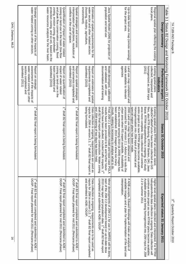
3.1 Status of B2 tasks The status of activities per 31 October and the expected status on 31 January 2011 is presented in table 3.1 on next page.
3.2 Developments and issues In the past quarter the following issues have arisen or changed their status:
1. Remote sensing data collection uncertainty 2. Extra GIS input needed for runoff protection zoning
3.2.1 Remote sensing data collection uncertainty
1. The list of available ALOS images for 2010 and 2009 has been obtained from JAXA. With around 50 images, which can be obtained for free we are able to cover the area. They are not ortho-rectified, such budget for that will be needed.
2. The 2010 images show too much clouds as was expected, so a combination of 2009-2010 ALOS images will be needed and possibly also ASTER images.
3. In January 2011 the remote sensing expert Eduard Westinga will analyze the available images and make a plan for interpretation of the remote sensing work
4. ALOS images are NOT ortho-rectified as requested in the acquisition TOR to ADB, therefore a separate action to solve this is needed.
5. As a back-up and also to be able cover the entire island of Java a 2007 and 2009 land use dataset from KLH has been bought. Other sources, such as MODIS, will be investigated as well.
6. A memo on the proposed approach will be sent to ADB shortly
3.2.2 Extra GIS input needed for run-off protection zoning
Developments in the field of water zoning after the inception period lead to a request for extra GIS input in order to address
1) runoff protection zoning: this involves the implementation of a new approach to establish a sufficiently accurate sensitivity of the flood peak to different parts of the catchment and its land-use; this forms the basis for runoff protection zoning, and
2) prepare zoning (runoff protection, erosion) for the upper Citarum area. The request has been accepted by ADB and work on implementation of the request has started in the past period. The methodology has been further developed and is now well established. A preliminary training and transfer of knowledge has taken place. Application to other sub-catchments and basins still has to take place. This was planned for Nov-Dec 2010. However in practice this will be carried out in combination of the next visit of Bart Adriaanse, early 2011 as the Indonesian GIS experts need further instruction on how to operate the rather complex Arc-GIS model builder scripts.
TA
7189-INO
Packag
e B
3
rd Quarterly R
eport October 201
0
DH
V, D
eltares, MLD
16
Table 3.1 S
tatus B2 D
esign and Monitoring F
ramew
ork (31 October 2010)
D
esign
sum
mary
Perfo
rman
ce targets /
ind
icators
Statu
s 31 Octo
ber 2010
Exp
ected statu
s 31 Janu
ary 2011
Region
al spatial plan reflectin
g the existin
g local plans.
Existing sp
atial plans collected, interpreted a
nd hom
ogen
ized as JS
M input
(2011)
Existing sp
atial plans RT
RW
at national, isla
nd,
JaBoD
eTaB
ekPunJur h
ave been co
llected as G
IS
files, also RT
R B
andun
g, RT
RW
Banten, D
KI, Ja
wa
Barat. R
TR
W kabu
paten/kota is ong
oing. 6C
i study
area more com
plete. Data collection w
ill continue
entire project as ne
w R
TR
W plans b
ecome a
vailable.
Hom
ogen
isation into JS
M inp
ut of provincial and special reg
ion pla
ns has been
made.
High
er level spatial p
lans collected and interpreted. F
or RT
RW
kabu
paten/kota data collectio
n is ongoing. D
ata collection w
ill contin
ue entire
project as new
RT
RW
plans becom
e available.
Available plans are being h
omoge
nised into JS
M input for JS
M
2.2 in summ
er 2011
Up-to-d
ate land-use m
ap (re
mote sensing)
for the project area. Lan
d use ma
p completed a
nd
made availab
le to relevant
agencies
2000 La
nd use m
ap has been
obtained a
nd processed for JS
M version 2.1. A
dvice is to redo the urba
n area w
hen R
S e
xpert a
vailable. A
vailability of
6Ci area rem
ote sensing 2010
(& 2009) im
ag
es has bee
n establish
ed. 2010 im
ag
es show
too man
y clou
ds, making
it necessary to analyse w
hat to do.
If AD
B accepts, E
duard Westinga w
ill make an an
alysis of availab
le ima
ges and a pla
n for implem
entation of the land use interpretation.
Java Spatial M
odel (JS
M) for projection of
population a
nd land-use
Mode
l develo
ped, calibrate
d and va
lidated, w
ith user docum
entation and train
ing
Final JS
M 2.1 sim
ulation mo
del an
d base case P
OLA
results have be
en provided to B
1 and further future
trends have been studied, include
d traffic impacts. 1
st draft B
2 final report und
er construction. W
ater zoning
and JSM
training of tw
o days has be
en held.
Minor d
evelopm
ents of JSM
2.1 for use in JWR
SS
will be don
e, start of the JS
M 2.2 develop
ment base
d on up-to-date desa
2010 m
ap laye
r and popu
lation data. 1
st draft B2 final report
completed a
nd subm
itted to AD
B / D
GS
P.
Estim
ates of spatial requ
irements for the
water sector a
nd other relate
d sectors (housing, in
dustry, agriculture,
environme
nt).
Rep
ort on estimates of spatia
l requ
ireme
nts completed a
nd subm
itted (201
0)
Data collectio
n is ongo
ing, requirem
ents are used as
inputs for JS
M in version 2.1. 1
st draft B2 fina
l report is being form
ulated.
Data collectio
n is ongo
ing, requirem
ents are to be used as
inputs for JS
M in version 2.2. 1
st draft B2 fina
l report comp
leted
and subm
itted to AD
B / D
GS
P.
Spatia
l strategies and scenarios:
interpretation of projections, resolution of
conflicts on the
use of space.
Rep
ort on spatial strategies and sce
narios completed a
nd
submitted (2
010)
1st draft B
2 final report is be
ing form
ulated.
1st draft B
2 final report com
ple
ted and submitted to A
DB
/ D
GS
P. F
inal report pla
nned fo
r mid 201
1 (Re
ncana ph
ase)
Quantification of im
pact of wa
ter related zoning o
n land
-use in the basin (lo
w-flo
w
and peak flo
w conservation zoning, floo
d zoning, erosion
zoning, grou
nd
water
protection zon
ing, and so on), based on the
water reso
urces analysis for the river b
asin.
Rep
ort on qua
ntification of im
pact of water related
zoning on lan
d-use in the
basin complete
d and subm
itted (201
0)
1st draft B
2 final report is be
ing form
ulated.
1st draft B
2 final report com
ple
ted and submitted to A
DB
/ D
GS
P. F
inal report pla
nned fo
r mid 201
1 (Re
ncana ph
ase)
Strategic asse
ssment of the im
pacts of w
ater related zoning on other sectors.
Rep
ort on strategic assessm
ent of the im
pacts of w
ater related zoning on other
sectors comple
ted and subm
itted (201
1)
1st draft B
2 final report is be
ing form
ulated.
1st draft B
2 final report com
ple
ted and submitted to A
DB
/ D
GS
P. F
inal report pla
nned fo
r mid 201
1 (Re
ncana ph
ase)
TA 7189-INO Package B 3rd Quarterly Report October 2010
DHV, Deltares, MLD 17
3.3 Current status of the Java Spatial Model (JSM)
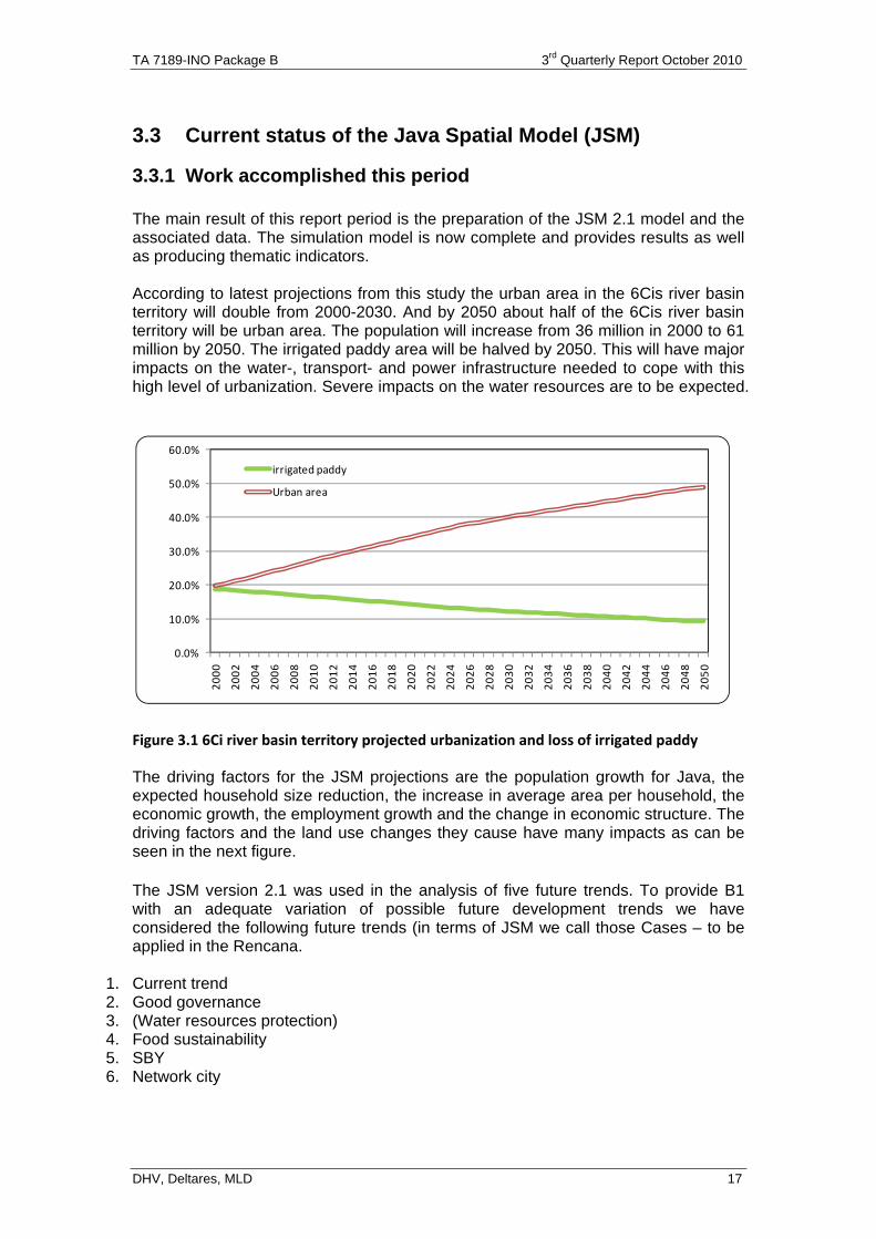
3.3.1 Work accomplished this period The main result of this report period is the preparation of the JSM 2.1 model and the associated data. The simulation model is now complete and provides results as well as producing thematic indicators. According to latest projections from this study the urban area in the 6Cis river basin territory will double from 2000-2030. And by 2050 about half of the 6Cis river basin territory will be urban area. The population will increase from 36 million in 2000 to 61 million by 2050. The irrigated paddy area will be halved by 2050. This will have major impacts on the water-, transport- and power infrastructure needed to cope with this high level of urbanization. Severe impacts on the water resources are to be expected.
0.0%
10.0%
20.0%
30.0%
40.0%
50.0%
60.0%
2000
2002
2004
2006
2008
2010
2012
2014
2016
2018
2020
2022
2024
2026
2028
2030
2032
2034
2036
2038
2040
2042
2044
2046
2048
2050
irrigated paddy
Urban area
Figure 3.1 6Ci river basin territory projected urbanization and loss of irrigated paddy
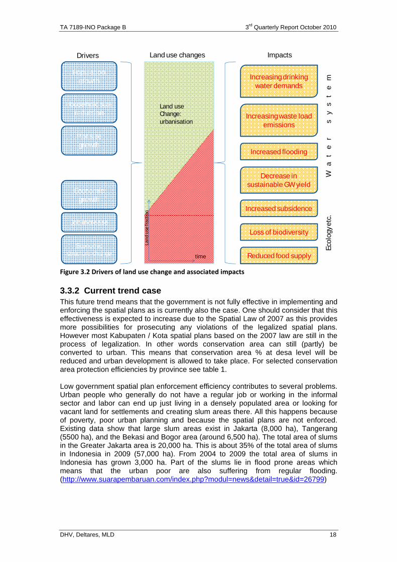
The driving factors for the JSM projections are the population growth for Java, the expected household size reduction, the increase in average area per household, the economic growth, the employment growth and the change in economic structure. The driving factors and the land use changes they cause have many impacts as can be seen in the next figure. The JSM version 2.1 was used in the analysis of five future trends. To provide B1 with an adequate variation of possible future development trends we have considered the following future trends (in terms of JSM we call those Cases – to be applied in the Rencana.
1. Current trend 2. Good governance 3. (Water resources protection) 4. Food sustainability 5. SBY 6. Network city
TA 7189-INO Package B 3rd Quarterly Report October 2010
DHV, Deltares, MLD 18
Populationgrowth
Economicgrowth
Household size reduction
Plot size growth
Job increase
Economic structure change
Land useChange:urbanisation
time
Lan
d u
se fr
act
ion
Drivers Land use changes Impacts
Increasing drinking water demands
Increasing waste load emissions
Reduced food supply
Loss of biodiversity
Increased flooding
W
a t
e
r
s
y
s
t e
m
Ecol
ogy
etc.
Decrease in sustainable GW yield
Increased subsidence
Figure 3.2 Drivers of land use change and associated impacts
3.3.2 Current trend case This future trend means that the government is not fully effective in implementing and enforcing the spatial plans as is currently also the case. One should consider that this effectiveness is expected to increase due to the Spatial Law of 2007 as this provides more possibilities for prosecuting any violations of the legalized spatial plans. However most Kabupaten / Kota spatial plans based on the 2007 law are still in the process of legalization. In other words conservation area can still (partly) be converted to urban. This means that conservation area % at desa level will be reduced and urban development is allowed to take place. For selected conservation area protection efficiencies by province see table 1. Low government spatial plan enforcement efficiency contributes to several problems. Urban people who generally do not have a regular job or working in the informal sector and labor can end up just living in a densely populated area or looking for vacant land for settlements and creating slum areas there. All this happens because of poverty, poor urban planning and because the spatial plans are not enforced. Existing data show that large slum areas exist in Jakarta (8,000 ha), Tangerang (5500 ha), and the Bekasi and Bogor area (around 6,500 ha). The total area of slums in the Greater Jakarta area is 20,000 ha. This is about 35% of the total area of slums in Indonesia in 2009 (57,000 ha). From 2004 to 2009 the total area of slums in Indonesia has grown 3,000 ha. Part of the slums lie in flood prone areas which means that the urban poor are also suffering from regular flooding. (http://www.suarapembaruan.com/index.php?modul=news&detail=true&id=26799)
TA 7189-INO Package B 3rd Quarterly Report October 2010
DHV, Deltares, MLD 19
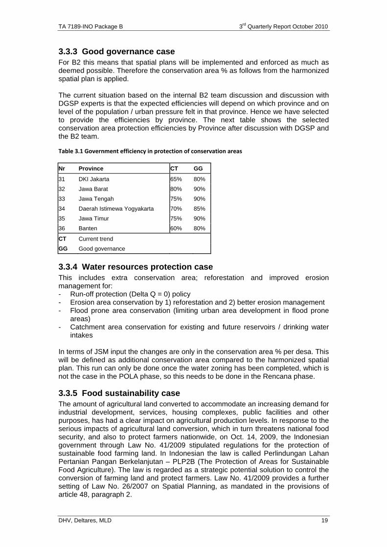
3.3.3 Good governance case For B2 this means that spatial plans will be implemented and enforced as much as deemed possible. Therefore the conservation area % as follows from the harmonized spatial plan is applied. The current situation based on the internal B2 team discussion and discussion with DGSP experts is that the expected efficiencies will depend on which province and on level of the population / urban pressure felt in that province. Hence we have selected to provide the efficiencies by province. The next table shows the selected conservation area protection efficiencies by Province after discussion with DGSP and the B2 team. Table 3.1 Government efficiency in protection of conservation areas
Nr Province CT GG
31 DKI Jakarta 65% 80%
32 Jawa Barat 80% 90%
33 Jawa Tengah 75% 90%
34 Daerah Istimewa Yogyakarta 70% 85%
35 Jawa Timur 75% 90%
36 Banten 60% 80%
CT Current trend
GG Good governance
3.3.4 Water resources protection case This includes extra conservation area; reforestation and improved erosion management for: - Run-off protection (Delta Q = 0) policy - Erosion area conservation by 1) reforestation and 2) better erosion management - Flood prone area conservation (limiting urban area development in flood prone
areas) - Catchment area conservation for existing and future reservoirs / drinking water
intakes In terms of JSM input the changes are only in the conservation area % per desa. This will be defined as additional conservation area compared to the harmonized spatial plan. This run can only be done once the water zoning has been completed, which is not the case in the POLA phase, so this needs to be done in the Rencana phase.
3.3.5 Food sustainability case The amount of agricultural land converted to accommodate an increasing demand for industrial development, services, housing complexes, public facilities and other purposes, has had a clear impact on agricultural production levels. In response to the serious impacts of agricultural land conversion, which in turn threatens national food security, and also to protect farmers nationwide, on Oct. 14, 2009, the Indonesian government through Law No. 41/2009 stipulated regulations for the protection of sustainable food farming land. In Indonesian the law is called Perlindungan Lahan Pertanian Pangan Berkelanjutan – PLP2B (The Protection of Areas for Sustainable Food Agriculture). The law is regarded as a strategic potential solution to control the conversion of farming land and protect farmers. Law No. 41/2009 provides a further setting of Law No. 26/2007 on Spatial Planning, as mandated in the provisions of article 48, paragraph 2.

TA 7189-INO Package B 3rd Quarterly Report October 2010
DHV, Deltares, MLD 20
The regulations for Law No. 41/2009 still need to be worked out in the form of guidelines and also it still needs to be implemented in the spatial plans at RTRW kabupaten / kota level. The new agricultural law specifies that for each kabupaten a percentage of the agricultural area needs to be defined as protected. For this trend scenario we will assume that all irrigated paddy will be fully protected. For WRM this is highly relevant for the potential future agricultural water demands. In this future trend scenario we will assume that GDP growth is not affected, however the distribution of growth between the sectors will change. We assume that the agriculture sector growth rate increases by 1% and the industrial and service sectors growth rates are reduced by 0.5%. Effects on employment growth are assumed to be 1% higher growth of employment in the agricultural sector.
3.3.6 Capital leaving Java case Traffic congestion in Greater Jakarta has prompted President Susilo Bambang Yudhoyono (SBY) to question the suitability of the metropolis as the center of commerce, government and the nation’s capital. “Honestly… it’s [Jakarta] no longer ideal” the President said while calling for an extraordinary solution to the problem, adding that there was no longer a balance in the ratio between people and their surrounding environment. With many parts of the capital slowly grinding to an inefficient standstill, the central government has begun taking steps to seek alternatives, such as moving the government (Jakarta Post, 8 September 2010). Different options can be considered: 1. First option is to maintain Jakarta as capital and resolve all the city’s problems. 2. The second option is to move the administration away from Jakarta, but retain
it as the center of trade, like in Malaysia. 3. The third is to move the whole capital, both as an economic and an
administrative center, such as in Brazil and Australia. In terms of moving jobs away from Jakarta the second option is deemed to be most likely as the investments involved are much less than the third option. The separation of the government centre and the economic centre in Jakarta has been one of the classical issues for spatial planning of this country. During the Suharto regime a Presidential Decree was prepared for Capital relocation to Jonggol, before Malaysia moved the seat of government from KL to Putrajaya. In fact this decree remained officially in effect until 2008 when Perpres 54 (Jabodetabek-Punjur) was launched. In response to the relocation plan many commentators argue that moving the capital to another location on Java Island will not be effective (based on experiences from the cases of Putrajaya in Malaysia, and Brasilia in Brasil). At the moment there is a lot of objection of this idea from different point of views. Such as socio-economic aspects regarding the majority of the urban poor, the "underpaid". Or the "disguised unemployment" in government sectors especially in government services. Another 'typical Indonesian” sentiment is 'Historical Heritages'. Implementation of a government relocation plan will take time as has been demonstrated in the cases on Brasilia and Putra Jaya. So it seems unlikely to be implemented during SBY's era, probably not even in the 20 years ahead. The main reason being that the country faces budget restrictions due to from the financial burden of current mega projects (“Selat Sunda Bridge” and the “Selat Melaka Infrastructure part of Asean Highways”). These mega projects are expected to 'boost' economic growth of the country through increased trade. Whereas relocating the

TA 7189-INO Package B 3rd Quarterly Report October 2010
DHV, Deltares, MLD 21
government is likely to be some relief of the congestion of Jakarta, but is less likely to boost economic growth. The “Leaving Java” case does however provide a possible future trend that needs to be analysed. In this trend scenario we will analyse what happens if the government institutes are moved away from Java as one extreme scenario. For example Palangka Raya in Kalimantan has been mentioned. In this future trend scenario we will assume that in the order of 650,000 government jobs will be shifted away from Jakarta to outside Java (see table 2 for a breakdown amongst the government institutes). The indirect job loss should be added to this. That is, when jobs are lost in one service sector in a local economy the reduction in demand has ‘spill over’ or ‘multiplier’ effects on other service sectors, such as consultants working for the government, etc. The multiplier effect can be estimated at around 1.5 (David Richardson and Richard Denniss, The regional impact of public service job cuts, August 2010, https://www.tai.org.au/file.php?file=/media_releases/PB%2018%20regional%20impact%20of%20public%20service%20job%20cuts.pdf) The total number of jobs lost in Jakarta in the service sector will therefore be around 1.6 million. In the model this is implemented by reducing service employment growth from 2010 to 2020 in such a way that 1.6 million less jobs are created in Jakarta. Instead of a 1% job gain this lead to a 4% annual job loss. With a labour participation of say 0.45 this means that about 3.5 million people will be affected. In practice only a small fraction of this number will actually migrate from Java. This has been demonstrated in many cases where large institutes have moved. Therefore in this future trend scenario we assume that same number of people as the number of jobs will leave Java. This is accounted for by a reduced Java population growth between 2010 and 2020, in other words a reduction of population growth by 0.11% per year from 2010 to 2020. The service sector GDP growth will be affected as well. The Jakarta service sector is 10% of the total service sector on Java. The Jakarta service sector employment growth is reduced by 5% and in JSM we input this as a Java service sector growth reduction of 0.5% for the period 2010-2020. Indonesia Vision 20331 team has estimated the cost of moving the capital of the Republic of Indonesia from Jakarta to one region on Borneo island reached 142.62 trillion Rupiah (15.8 billion US$). If this is carried out gradually over 10 years, the government must reserve 14 trillion Rupiah annually. That is 1 percent of the total state budget. The cost includes the preparation phase of 120 billion Rupiah (13.3 million US$). The preparation phase consists of preparation of the regulatory framework, the institutional framework, the policy framework, and urban planning. Most of the cost (142.5 trillion Rupiah) will be used at the time of execution, and includes land acquisition, land preparation, construction of urban infrastructure, construction of city facilities, the construction of state buildings, and housing for civil servants.
1 Suara Pembaruan 2010-10-14

TA 7189-INO Package B 3rd Quarterly Report October 2010
DHV, Deltares, MLD 22
Table 3.2 Breakdown of jobs in national government institutes in Jakarta Jobs No. Institute
Men Women Total
Possible to Move
1 Menko Bidang Politik dan Keamanan 65 18 83
2 Menko Bidang Perekonomian 140 25 165
3 Menko Bidang Kesejahteraan Rakyat 140 47 187
4 Meneg Riset dan Teknologi 155 54 209
5 Meneg Koperasi Dan UKM 535 244 779
6 Meneg Lingkungan Hidup 525 357 882
7 Meneg Kebudayaan dan Pariwisata 3,622 1,285 4,907 *
8 Meneg BUMN 237 59 296
9 Meneg Pemberdayaan Perempuan 127 113 240
10 Meneg Pendayagunaan Aparatur Negara 219 54 273
11 Meneg Percepatan Pembangunan KTI 121 45 166 *
12 Meneg Perencanaan Pembangunan Nasional 594 162 756
13 Meneg Pemuda Olah Raga 8 8
14 Dep. Dalam Negeri dan Otonomi Daerah 7,447 3,236 10,683 *
15 Dep. Luar Negeri 2,539 819 3,358
16 Dep. Pertahanan 4,380 2,935 7,315 *
17 Dep. Kehakiman dan Hak Asasi Manusia 28,726 7,923 36,649 *
18 Dep. Keuangan 56,004 16,225 72,229
19 Dep. Pertanian 14,768 6,238 21,006 *
20 Dep. Energi Dan Sumber Daya Mineral 4,912 1,093 6,005 *
21 Dep. Perhubungan 23,654 4,036 27,690 *
22 Dep. Pendidikan Nasional 79,642 39,800 119,442 *
23 Dep. Kesehatan 18,959 24,906 43,865 *
24 Dep. Agama 111,414 87,079 198,493 *
25 Dep. Tenaga Kerja Dan Transmigrasi 3,762 1,641 5,403 *
26 Dep. Sosial 2,176 1,579 3,755 *
27 Dep. Kehutanan 14,219 2,908 17,127 *
28 Dep. Kelautan Dan Perikanan 5,519 1,983 7,502
29 Dep. Komunikasi dan Informatika 2,489 960 3,449
30 Dep. Perdagangan 2,198 939 3,137
31 Dep. Perindustrian 4,140 1,936 6,076
32 Dep. Pekerjaan Umum 8,201 2,034 10,235 *
33 Sekretariat Negara 729 211 940
34 Kejaksaan Agung 12,518 5,247 17,765 *
35 Badan Inteligen Negara 1,282 14 1,296
36 Setjen MPR 203 98 301
37 Setjen DPA 142 50 192
38 Setjen DPR 1,004 420 1,424
39 Setjen MA 18,638 7,675 26,313
40 Badan Pemeriksa Keuangan 1,906 1,111 3,017 *
41 Setjen WANTANNAS 72 15 87
42 Lembaga Sandi Negara 466 154 620
43 Badan Kepegawaian Negara 5,560 1,374 6,934
44 Lembaga Administrasi Negara 387 252 639
TA 7189-INO Package B 3rd Quarterly Report October 2010
DHV, Deltares, MLD 23
Jobs No. Institute Men Women
Total Possible to
Move
45 Lembaga Penerbangan Antariksa Nasional 1,135 274 1,409 *
46 Lembaga Ilmu Pengetahuan Indonesia 3,652 1,212 4,864 *
47 Badan Tenaga Nuklir Nasional 2,896 751 3,647 *
48 Badan Pusat Statistik 8,513 3,104 11,617 *
49 Arsip Nasional Republik Indonesia 269 155 424
50 Badan Koord. Survei & Pemetaan Nasional 542 138 680 *
51 Badan Koordinasi KB Nasional 27,354 16,834 44,188 *
52 Badan Koordinasi Penanaman Modal 333 147 480
53 Badan Pengkajian & Penerapan Teknologi 2,205 391 2,596 *
54 Badan Pengawas Keuangan Dan Pembangunan 4,855 1,592 6,447
55 Badan Pertanahan Nasional 17,861 4,521 22,382 *
56 Perpustakaan Nasional RI 356 334 690 *
57 Badan Standardisasi Nasional 83 74 157 *
58 Badan Pengawas Tenaga Nuklir 178 86 264 *
59 Badan Pengawas Obat dan Makanan 1,317 2,061 3,378 *
60 Lembaga Ketahanan Nasional 213 91 304
61 Kepolisian Negara 10,458 10,489 20,947
62 MABES TNI 37,402 25,912 63,314
63 Badan Meteorologi dan Geofisika 2,650 598 3,248 *
64 Sekretariat Kabinet 209 87 296
65 Sekretariat Presiden 659 192 851
66 Sekretariat Wakil Presiden 165 52 217
67 Sekretariat Militer 45 17 62
68 Badan Narkotika Nasional 54 48 102 *
69 Komisi Pemilihan Umum 204 29 233 *
70 Komisi Pemeriksa Kekayaan Pejabat Negara 36 4 40 *
71 Bakornas PBP 43 29 72
72 KOMNAS HAM 37 41 78
73 Otorita Batam 680 222 902 *
74 Setjen Mahkamah Konstitusi 12 1 13
75 Komisi Pemberantasan Korupsi 3 3
Total 568,963 296,840 865,803 634,000 Source: BPS from BKN, 2006
3.3.7 Network City case Another alternative SBY mentioned concerns moving parts of government institutes from Jakarta to other locations in Java, such as Krawang, Djonggol and either Sukabumi or Subang. This variation on the “Leaving Java” case is worked out in more detail in the Network City Future trend scenario of the next section. In this future trend scenario we will assume that once more in the order of 650,000 government jobs will be shifted away from Jakarta to cities around Jakarta. The indirect job loss should be added to this. That is, when jobs are lost in one service sector in a local economy the reduction in demand has ‘spill over’ or ‘multiplier’ effects on other service sectors, such as consultants working for the government, etc.
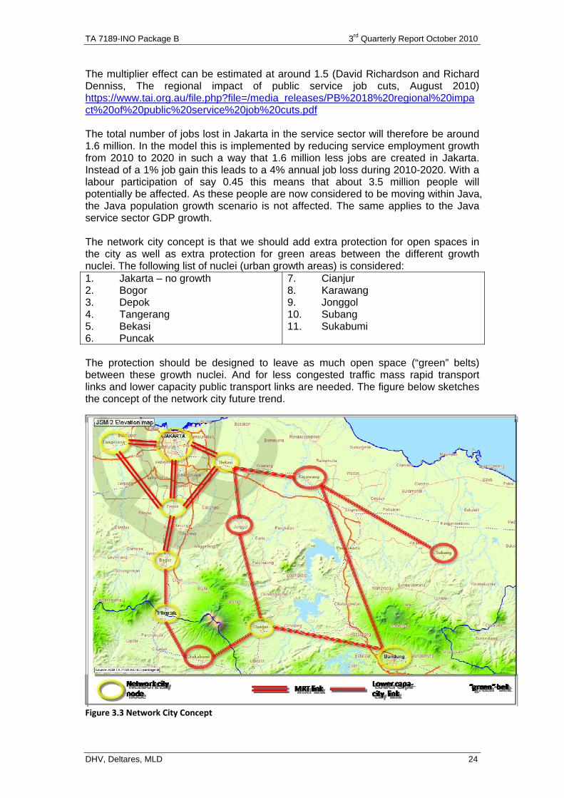
TA 7189-INO Package B 3rd Quarterly Report October 2010
DHV, Deltares, MLD 24
The multiplier effect can be estimated at around 1.5 (David Richardson and Richard Denniss, The regional impact of public service job cuts, August 2010) https://www.tai.org.au/file.php?file=/media_releases/PB%2018%20regional%20impact%20of%20public%20service%20job%20cuts.pdf The total number of jobs lost in Jakarta in the service sector will therefore be around 1.6 million. In the model this is implemented by reducing service employment growth from 2010 to 2020 in such a way that 1.6 million less jobs are created in Jakarta. Instead of a 1% job gain this leads to a 4% annual job loss during 2010-2020. With a labour participation of say 0.45 this means that about 3.5 million people will potentially be affected. As these people are now considered to be moving within Java, the Java population growth scenario is not affected. The same applies to the Java service sector GDP growth. The network city concept is that we should add extra protection for open spaces in the city as well as extra protection for green areas between the different growth nuclei. The following list of nuclei (urban growth areas) is considered: 1. Jakarta – no growth 2. Bogor 3. Depok 4. Tangerang 5. Bekasi 6. Puncak
7. Cianjur 8. Karawang 9. Jonggol 10. Subang 11. Sukabumi
The protection should be designed to leave as much open space (“green” belts) between these growth nuclei. And for less congested traffic mass rapid transport links and lower capacity public transport links are needed. The figure below sketches the concept of the network city future trend.
Figure 3.3 Network City Concept

TA 7189-INO Package B 3rd Quarterly Report October 2010
DHV, Deltares, MLD 25
An interesting observation is that the four alternative government relocation centers mentioned by SBY are all in the West Java province. Therefore in this future trend scenario we assume that the service sector employment growth for West Java grows from 2010 to 2020 in such a way that 1.6 million extra jobs are created. For this future trend we need to add additional protection (“green” belts) to the harmonised spatial plan. In the figure below it is obvious that the current plan doesn’t offer the protection needed.
Figure 3.4 Harmonised Spatial Plan 6Ci RBT
This has been implemented by adding the green belt protection areas to the existing harmonised spatial plan. The result is as follows (Blue areas have full protection):
Figure 3.5 Extra protection to create green belts

TA 7189-INO Package B 3rd Quarterly Report October 2010
DHV, Deltares, MLD 26
3.3.8 Impact evaluation of the future development trends According to the TOR for each Future development trend the impact must be analysed. In B2 this will be done based on available quick scan indicators produced by JSM and some further indicators that can easily be derived from existing data. The list of proposed indicators for comparing the future trends is as follows:
- Fraction urban area - Fraction forest area - Fraction irrigated paddy area. - Population growth - Urban density - Drinking water demand - Waste load emissions - Change in average travel time
Time horizon is 2000-2030 (2050). A formal evaluation of the “best” future development trend will not be needed according to the TOR. This is not really possible as we are not studying costs and benefits of the development trends. Nevertheless an overview score card of these indicators will be prepared for easy reference in the B1 analysis.
3.4 JSM Results of future trends The results are given as charts by selected indicator for the 6Ci River Basin Territory .
3.4.1 Population growth
32000000
37000000
42000000
47000000
52000000
57000000
62000000
2000 2005 2010 2015 2020 2025 2030 2035 2040 2045 2050
Current Trend
Good Governance
Food Sustainability
Leaves Java
Network City
Figure 3.6 Population growth
The population in the 6Ci grows from 36.2 million in 2000 to 56.6 million in 2030 and 60.9 million in 2050. The most effective future trend in reducing growth is the Food sustainability case. In other words implement agricultural law 41/2009 and the 6Ci area will not urbanise as fast as it does under the current trend.
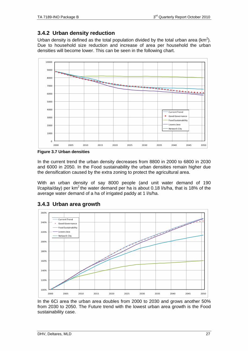
TA 7189-INO Package B 3rd Quarterly Report October 2010
DHV, Deltares, MLD 27
3.4.2 Urban density reduction Urban density is defined as the total population divided by the total urban area (km2). Due to household size reduction and increase of area per household the urban densities will become lower. This can be seen in the following chart.
0
1000
2000
3000
4000
5000
6000
7000
8000
9000
10000
2000 2005 2010 2015 2020 2025 2030 2035 2040 2045 2050
Current Trend
Good Governance
Food Sustainability
Leaves Java
Network City
Figure 3.7 Urban densities
In the current trend the urban density decreases from 8800 in 2000 to 6800 in 2030 and 6000 in 2050. In the Food sustainability the urban densities remain higher due the densification caused by the extra zoning to protect the agricultural area. With an urban density of say 8000 people (and unit water demand of 190 l/capita/day) per km2 the water demand per ha is about 0.18 l/s/ha, that is 18% of the average water demand of a ha of irrigated paddy at 1 l/s/ha.
3.4.3 Urban area growth
100%
120%
140%
160%
180%
200%
220%
240%
260%
2000 2005 2010 2015 2020 2025 2030 2035 2040 2045 2050
Current Trend
Good Governance
Food Sustainability
Leaves Java
Network City
In the 6Ci area the urban area doubles from 2000 to 2030 and grows another 50% from 2030 to 2050. The Future trend with the lowest urban area growth is the Food sustainability case.

TA 7189-INO Package B 3rd Quarterly Report October 2010
DHV, Deltares, MLD 28
3.4.4 Loss of forest area
86%
88%
90%
92%
94%
96%
98%
100%
2000 2005 2010 2015 2020 2025 2030 2035 2040 2045 2050
Current Trend
Good Governance
Food Sustainability
Leaves Java
Network City
Figure 3.8 Forest area
The forest area reduction is about 13%, in the food sustainability case it is 6% (due to the extra protection in this trend). It should be noted that the ‘forest’ area probably includes plantation area with higher trees, due to the classification used in Geocover.
3.4.5 Loss of irrigated paddy area.
40%
50%
60%
70%
80%
90%
100%
2000 2005 2010 2015 2020 2025 2030 2035 2040 2045 2050
Current Trend
Good Governance
Food Sustainability
Leaves Java
Network City
Figure 3.9 Loss of irrigated paddy area
The loss of paddy area is expected to be large, 35% by 2030 and 50% by 2050. This has major consequences for agriculture (food production) and agricultural water demands.
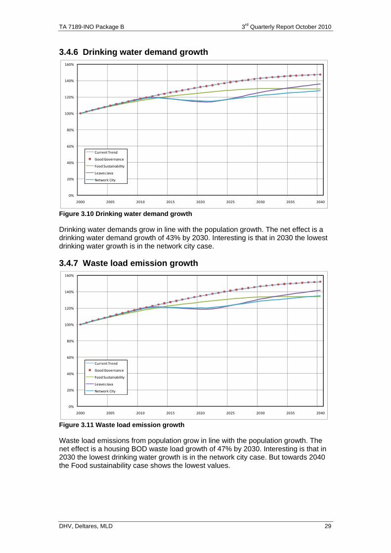
TA 7189-INO Package B 3rd Quarterly Report October 2010
DHV, Deltares, MLD 29
3.4.6 Drinking water demand growth
0%
20%
40%
60%
80%
100%
120%
140%
160%
2000 2005 2010 2015 2020 2025 2030 2035 2040
Current Trend
Good Governance
Food Sustainability
Leaves Java
Network City
Figure 3.10 Drinking water demand growth
Drinking water demands grow in line with the population growth. The net effect is a drinking water demand growth of 43% by 2030. Interesting is that in 2030 the lowest drinking water growth is in the network city case.
3.4.7 Waste load emission growth
0%
20%
40%
60%
80%
100%
120%
140%
160%
2000 2005 2010 2015 2020 2025 2030 2035 2040
Current Trend
Good Governance
Food Sustainability
Leaves Java
Network City
Figure 3.11 Waste load emission growth
Waste load emissions from population grow in line with the population growth. The net effect is a housing BOD waste load growth of 47% by 2030. Interesting is that in 2030 the lowest drinking water growth is in the network city case. But towards 2040 the Food sustainability case shows the lowest values.
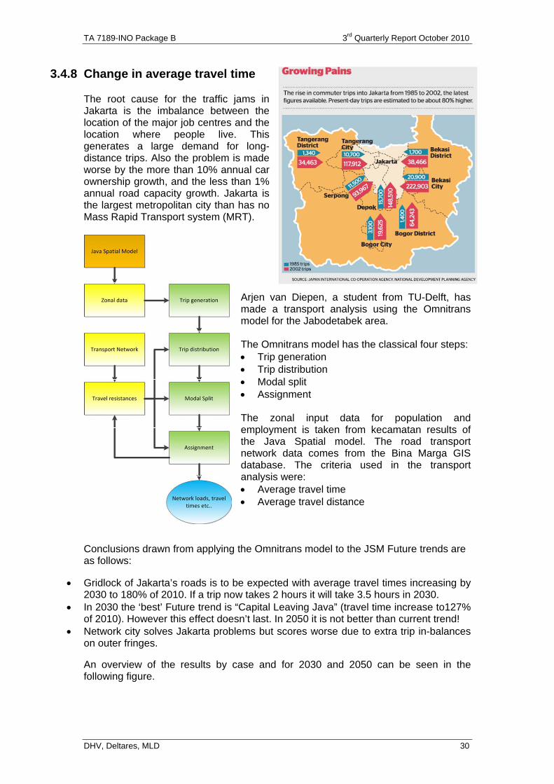
TA 7189-INO Package B 3rd Quarterly Report October 2010
DHV, Deltares, MLD 30
3.4.8 Change in average travel time The root cause for the traffic jams in Jakarta is the imbalance between the location of the major job centres and the location where people live. This generates a large demand for long-distance trips. Also the problem is made worse by the more than 10% annual car ownership growth, and the less than 1% annual road capacity growth. Jakarta is the largest metropolitan city than has no Mass Rapid Transport system (MRT).
Arjen van Diepen, a student from TU-Delft, has made a transport analysis using the Omnitrans model for the Jabodetabek area. The Omnitrans model has the classical four steps: Trip generation Trip distribution Modal split Assignment The zonal input data for population and employment is taken from kecamatan results of the Java Spatial model. The road transport network data comes from the Bina Marga GIS database. The criteria used in the transport analysis were: Average travel time Average travel distance
Conclusions drawn from applying the Omnitrans model to the JSM Future trends are as follows:
Gridlock of Jakarta’s roads is to be expected with average travel times increasing by 2030 to 180% of 2010. If a trip now takes 2 hours it will take 3.5 hours in 2030.
In 2030 the ‘best’ Future trend is “Capital Leaving Java” (travel time increase to127% of 2010). However this effect doesn’t last. In 2050 it is not better than current trend!
Network city solves Jakarta problems but scores worse due to extra trip in-balances on outer fringes. An overview of the results by case and for 2030 and 2050 can be seen in the following figure.
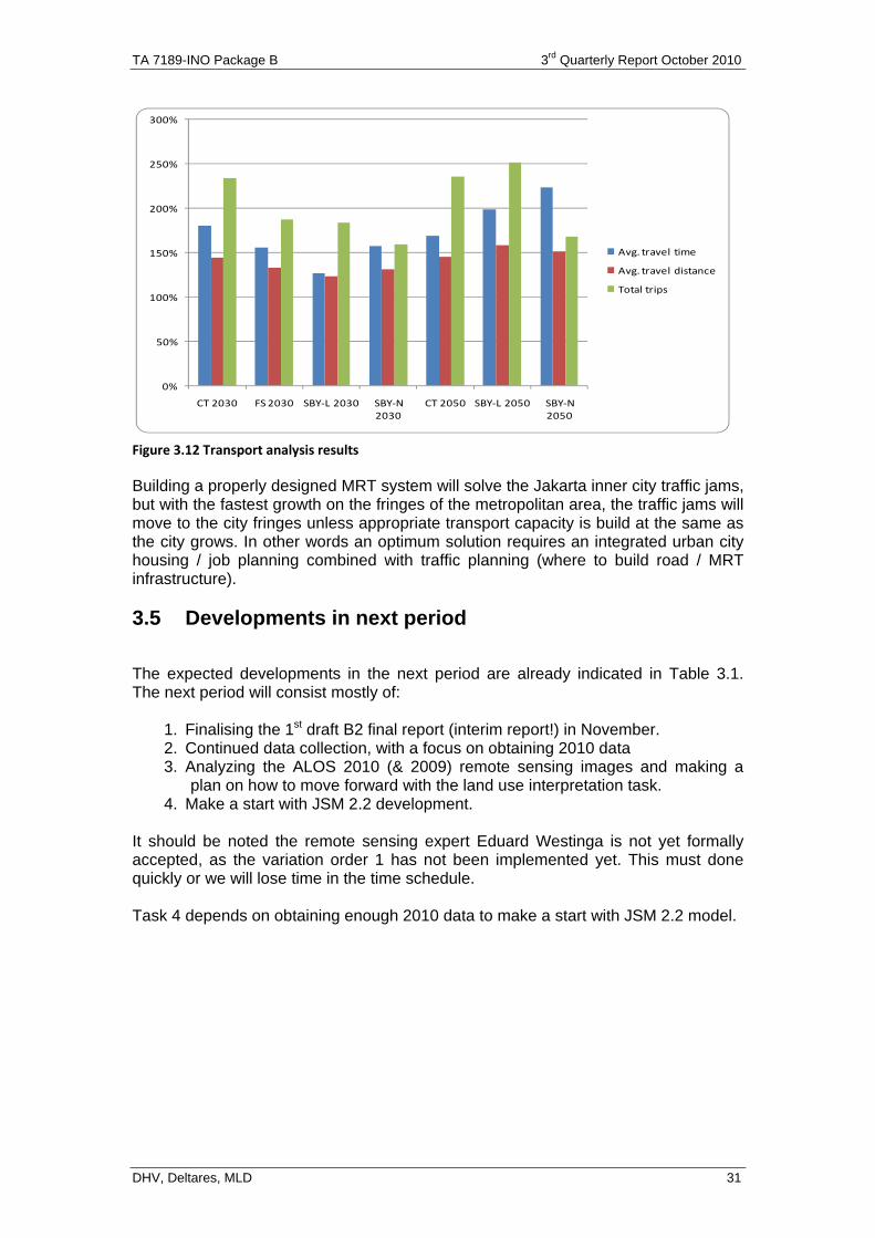
TA 7189-INO Package B 3rd Quarterly Report October 2010
DHV, Deltares, MLD 31
0%
50%
100%
150%
200%
250%
300%
CT 2030 FS 2030 SBY‐L 2030 SBY‐N 2030
CT 2050 SBY‐L 2050 SBY‐N 2050
Avg. travel time
Avg. travel distance
Total trips
Figure 3.12 Transport analysis results
Building a properly designed MRT system will solve the Jakarta inner city traffic jams, but with the fastest growth on the fringes of the metropolitan area, the traffic jams will move to the city fringes unless appropriate transport capacity is build at the same as the city grows. In other words an optimum solution requires an integrated urban city housing / job planning combined with traffic planning (where to build road / MRT infrastructure).
3.5 Developments in next period The expected developments in the next period are already indicated in Table 3.1. The next period will consist mostly of:
1. Finalising the 1st draft B2 final report (interim report!) in November. 2. Continued data collection, with a focus on obtaining 2010 data 3. Analyzing the ALOS 2010 (& 2009) remote sensing images and making a
plan on how to move forward with the land use interpretation task. 4. Make a start with JSM 2.2 development.
It should be noted the remote sensing expert Eduard Westinga is not yet formally accepted, as the variation order 1 has not been implemented yet. This must done quickly or we will lose time in the time schedule. Task 4 depends on obtaining enough 2010 data to make a start with JSM 2.2 model.

TA 7189-INO Package B 3rd Quarterly Report October 2010
DHV, Deltares, MLD 32
Monthly Work Plan Status for B3 (end November 2010)
2009Nov / Dec
Jan Feb Mar Apr May Jun Jul Aug Sep Oct Nov Dec Jan Feb
1 2 3 4 5 6 7 8 9 10 11 12 13 14 15
1
2 Review of international best practices Taylor 100% Review completed. Report on best practisescompleted.
3 Data collection, discussion with DINAS Enery & Mining/BPLHD on (a) Nidhom 100%(c ) abstraction, (d) licensing, (e) registration, (f) monitoring systems and(g) related problems (law enforcement, participation of the community)
4 Data collection, discussions with Pusat Lingkungan Geologi on (a) GW 100%(b) monitoring mechanisms and (c) monitoring activities in the CATBandung Soreang
5 Identify the current mechanisms and practises on licensing, registration,database, metering, law enforcement
Nidhom 100% Licensing mechanisms identified. Mechanismswere reviewed. These cover the issuing oflicenses by the Prov/District DINAS EPSD (inclextension licenses, monitoring of abstractionthrough metering and legal action in case of lawviolation) Activity completed
6 Carry out economic assessment of level groundwater charges for shifting tosurface water
Pribadi 90% Groundwater pricing study completed. Information on fees, charges collected. Groundwater directcosts 2-3 times cheaper than PDAM. Activitycompleted.
7 Analyse feasibility of raising groundwater charges for required level forindustry
Pribadi 100% see Task 6. Activity completed.
8 Review reports on alternatives groundwater usage (re-use, re-cycling etc);identify alternatives within the Bandung context (textile industry). Activity incoordination with B1 consultants.
van Beek 80% To be completed in Nov'10 during van Beek's lastinput in Dec'10.
9 Review River Basin Planning study reports on feasibility for usage of waterfrom lakes, reservoirs or other surface water sources as an alternative togroundwater; Activity in coordination with B1 consultants.
Soenarto 100% Three most promising alternatives identified.Discussions with PDAM, BBWSC on-going.Further study is/will be covered by 1) POLA atstrategic level, 2) upcoming ADB project, TranchII on Bandung Water Supply sources anddevelopment, 3) MoU between DG WR, DinasSDA Prov and 4 Kab/2 Kotas and 4) JointWorking Group (headed by BBWSC).
10 Conduct consultations with concerned parties (DINAS EPSDM, PAM,Badan Geologi, Industry); Discuss and obtain support for changes tocurrent pricing, licensing, monitoring systems; Assess willingness tochange from groundwater to surface water usage (price, water,reliability/quality delivery)
Nidhom 90% Consultation with provincial/kab agenciescompleted. Visiits to BPLHD DKI on groundwatermanagement are planned for Nov'10. List withconsultations with government stakeholders ispresented in the Annex.
11 Identify scope for improvement registration database Pratolo 50% Activity is cancelled (see 'Issues')12 Provide technical assistance to local Gov on developing registration
databasePratolo 0% Activity is cancelled (see 'Issues')
13 Develop recommendations on groundwater licensing, pricing, institutionalroles, monitoring activities etc
Hamming 90% Draft recommendations completed. Finalrecommendations will be drafted in next quarter.
14 Discuss recommendations with concerned parties Hamming 90% Discussed during stakeholder consultations andESDM workshop. In nex quarter final draftrecommendations will be discussed with ESDM.
15 Organize Workshop Nidhom 100% ESDM Workshop was held. Workshop reportunder preparation with compilation presentations,discussions and conclusions for follow up.
16 Finalize reports Hamming 80% Final report completed for 80%. Finalized by midDec'10 after discussion with ESDM Prov.
1 Review of current gov policies and legislation; identify ambiguities, overlaps Nidhom 100% Review of surface water legislation/policies completed.
2 Identify current practises on water allocation, water distribution andmaintenance down to the secondary irrigation scheme levels Tarum canal
Wibowo 100% Current water allocation mechanisms identified. Key player PJTII. Annually (DMI and irrigation) with bi-weekly adjustments for irrigation
3 Compare water allocation practises Tarum with other schemes with focuson the institutional arrangements
Nidhom 100% A comparison was made on water allocationbetween three basins. These are Bengewan-Solo,Brantas and Citarum (see table). Activitycompleted.
4 Assess consultation, information and participatory mechanisms (Panitia Irigasi, Rencana Tata Tanam etc )
Wibowo 100% An analysis of roles of various consultationmechanisms in the allocation process was carriedout. Key players are Dinas Kab, Kom Irigasi,Dinas Prov, BBWSC and PJTII. A standardmechanism for water allocation exists at annualand bimonthly periods. Activity completed.
5 Conduct consultations with concerned parties (PJTII, DINAS Prov/KabWR, members Irrigation Commission, members WUAs, staff from DINASAgriculture etc); Discuss and obtain support for development of waterallocation in identified areas
Wibowo 100% see Taks 4. Activity completed.
6 Identify scope for improved water allocation, develop recommendations including institutional roles
Wibowo 90% New ideas on improved water distribution werediscussed with PU Jakarta and BBWSC.Proposed is a measurable benchmark system forprimary irrigation off take points. Scope for fourMoUs on role sharing in aspects of waterdistribution is identified. Will be further discussedin final Workshop
7 Discuss recommendations with concerned parties Wibowo 90% see Taks 6.
8 Prepare report on Pricing Bulk Water Bandung Pribadi 0% ToR for Bulk Water Pricing is completed. Studywill be carried out by a national economist andlegal/institutional Sp and an internationaleconomist.
9 Organize Workshop Wibowo 20% BBWSC Workshop is planned for 18 Jan'10.Draft agenda, list of participants prepared.
10 Finalize reports Hamming 70% Final report completed for 70%. Finalized by midJan'10 after BBWSC Workshop and finaldiscussions with BBWSC.
Review of groundwater legislation/policies completed with the exception of Perda JaBarat 5/2008 on groundwater management which will be reviewed by the international Legal Sp in Nov'10.
Review of current gov policies and legislation on groundwater licensing,pricing (price policies, price agreements, cost recovery, tariffs, feecollection); identify ambiguities, overlaps
Data collection and evaluation completed. Information was obtained on regulatory, permit procedures; implementation and monitoring capacity. Activity completed.
Nugraha Various studies identified and reviewed.Understanding on groundwater basin, aquiferssystems. Problems identified. Activity completed.
STRATEGIC MANAGEMENT PLAN2010 2011
Status by end October 2010Primary Resp.
TA Task Name
Nidhom 95%
% Com -pleted
Task B3-3: Policy Development for Water Pricing related to groundwater Bandung
INCEPTION
Task B3-1: System Development for Licensing, Registration related to groundwater Bandung
Task B3-2: Policy Development for Water Allocation related to Irrigation Tarum System
completed on-going, planned
Table 4.1 - Monthly Work Plan Status (end of Oct’10)

TA 7189-INO Package B 3rd Quarterly Report October 2010
DHV, Deltares, MLD 33
4 SUB COMPONENT B.3
4.1 Status Tasks B.3 Status of the work is presented in Table 4.1 on the previous page.
4.2 Progress in implementation Tasks B.3
4.2.1 Task B3-1, B3-3 Groundwater Use in Bandung 1) Review of current government policies and legislation Review of groundwater legislation/policies completed with exception of Perda JaBar 5/2008 on groundwater management which will be reviewed by the international Legal Specialist in Nov. 2010. An overview of current legislation is given in Table 4.2. 2) Review of international best practice Review completed. Report on best practices completed. 3) Data collection, discuss with ESDM & BPLHD regulation licensing, monitoring Data collection and evaluation completed. Information was obtained on regulatory and permit procedures; implementation and monitoring capacity. Activity completed. 4) Data collection, discussions with Pusat Lingkungan Geologi on abstraction groundwater basin (CAT) Bandung Various studies identified and reviewed. Understanding on groundwater basin, aquifers systems. Problems identified. Activity completed. 5) Identify the current mechanisms and practices on licensing, registration, metering, law enforcement Licensing mechanisms identified. Mechanisms were reviewed. These cover the issuing of licenses by the Provincial/District DINAS ESDM (including extension licenses, monitoring of abstraction through metering and legal action in case of law violation). Activity completed. 6) Carry out economic assessment of level of groundwater charges Groundwater pricing study completed. Information on fees, charges collected. Current groundwater abstraction direct costs by industry are 2-3 times cheaper than water from PDAM. Activity completed. 7) Analyze feasibility of raising groundwater charges See Task 6. Activity completed. 8) Review reports of alternatives to groundwater use To be completed in November 2010 during last input of international River Basin Planning Sp in Dec'10. 9) Review basin planning study report on feasibility of water use from lakes, reservoirs etc Three most promising alternatives identified. Discussions with PDAM, BBWSC on-going. Further study is/will be covered by 1) POLA at strategic level, 2) upcoming ADB project, CWRMIP II on Bandung Water Supply sources and development, 3) MoU between DG WR, Dinas SDA Prov and 4 Kab/2 Kotas and 4) Joint Working Group (headed by BBWSC).
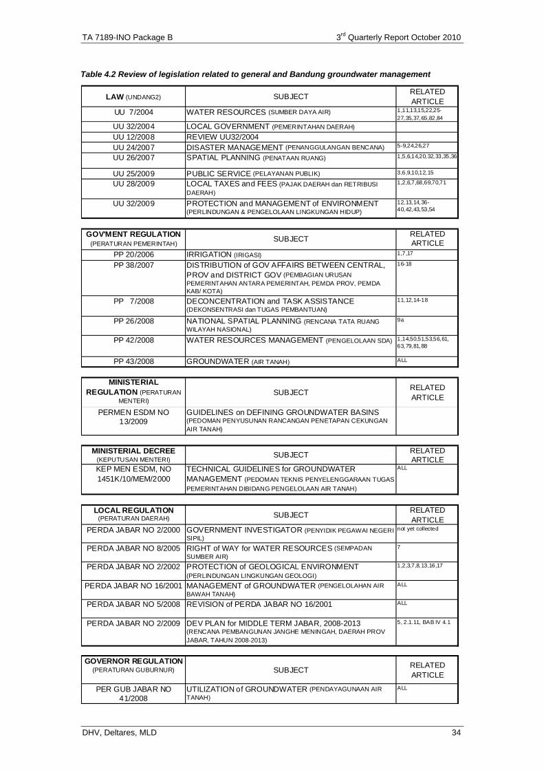
TA 7189-INO Package B 3rd Quarterly Report October 2010
DHV, Deltares, MLD 34
LAW (UNDANG2) SUBJECT
RELATED ARTICLE
UU 7/2004 WATER RESOURCES (SUMBER DAYA AIR) 1,11,13,15,22,25-27,35,37,65,82,84
UU 32/2004 LOCAL GOVERNMENT (PEMERINTAHAN DAERAH)
UU 12/2008 REVIEW UU32/2004UU 24/2007 DISASTER MANAGEMENT (PENANGGULANGAN BENCANA) 5-9,24,26,27
UU 26/2007 SPATIAL PLANNING (PENATAAN RUANG) 1,5,6,14,20,32,33,35,36
UU 25/2009 PUBLIC SERVICE (PELAYANAN PUBLIK) 3,6,9,10,12,15
UU 28/2009 LOCAL TAXES and FEES (PAJAK DAERAH dan RETRIBUSI DAERAH)
1,2,6,7,68,69,70,71
UU 32/2009 PROTECTION and MANAGEMENT of ENVIRONMENT (PERLINDUNGAN & PENGELOLAAN LINGKUNGAN HIDUP)
12,13,14,36-40,42,43,53,54
GOV'MENT REGULATION(PERATURAN PEMERINTAH)
PP 20/2006 IRRIGATION (IRIGASI) 1,7,17
PP 38/2007 DISTRIBUTION of GOV AFFAIRS BETWEEN CENTRAL, PROV and DISTRICT GOV (PEMBAGIAN URUSAN PEMERINTAHAN ANTARA PEMERINTAH, PEMDA PROV, PEMDA KAB/ KOTA)
16-18
PP 7/2008 DECONCENTRATION and TASK ASSISTANCE (DEKONSENTRASI dan TUGAS PEMBANTUAN)
11,12,14-18
PP 26/2008 NATIONAL SPATIAL PLANNING (RENCANA TATA RUANG WILAYAH NASIONAL)
9a
PP 42/2008 WATER RESOURCES MANAGEMENT (PENGELOLAAN SDA) 1,14,50,51,53,56,61, 63,79,81,88
PP 43/2008 GROUNDWATER (AIR TANAH) ALL
MINISTERIAL REGULATION (PERATURAN
MENTERI)SUBJECT
RELATED ARTICLE
PERMEN ESDM NO 13/2009
GUIDELINES on DEFINING GROUNDWATER BASINS (PEDOMAN PENYUSUNAN RANCANGAN PENETAPAN CEKUNGAN AIR TANAH)
MINISTERIAL DECREE (KEPUTUSAN MENTERI)
SUBJECT RELATED ARTICLE
KEP MEN ESDM, NO 1451K/10/MEM/2000
TECHNICAL GUIDELINES for GROUNDWATER MANAGEMENT (PEDOMAN TEKNIS PENYELENGGARAAN TUGAS
PEMERINTAHAN DIBIDANG PENGELOLAAN AIR TANAH)
ALL
LOCAL REGULATION (PERATURAN DAERAH) SUBJECT
RELATED ARTICLE
PERDA JABAR NO 2/2000 GOVERNMENT INVESTIGATOR (PENYIDIK PEGAWAI NEGERI SIPIL)
not yet collected
PERDA JABAR NO 8/2005 RIGHT of WAY for WATER RESOURCES (SEMPADAN SUMBER AIR)
7
PERDA JABAR NO 2/2002 PROTECTION of GEOLOGICAL ENVIRONMENT (PERLINDUNGAN LINGKUNGAN GEOLOGI)
1,2,3,7,8,13,16,17
PERDA JABAR NO 16/2001 MANAGEMENT of GROUNDWATER (PENGELOLAHAN AIR BAWAH TANAH)
ALL
PERDA JABAR NO 5/2008 REVISION of PERDA JABAR NO 16/2001 ALL
PERDA JABAR NO 2/2009 DEV PLAN for MIDDLE TERM JABAR, 2008-2013 (RENCANA PEMBANGUNAN JANGHE MENINGAH, DAERAH PROV JABAR, TAHUN 2008-2013)
5, 2.1.11, BAB IV 4.1
GOVERNOR REGULATION (PERATURAN GUBURNUR) SUBJECT
RELATED ARTICLE
PER GUB JABAR NO 41/2008
UTILIZATION of GROUNDWATER (PENDAYAGUNAAN AIR TANAH)
ALL
SUBJECTRELATED ARTICLE
Legislation related to general and Bandung groundwater managementTable 4.2 Review of legislation related to general and Bandung groundwater management

TA 7189-INO Package B 3rd Quarterly Report October 2010
DHV, Deltares, MLD 35
10) Consultation with relevant parties Consultation with provincial/kab agencies completed. Visits to BPLHD DKI on groundwater management are planned for Nov'10. List with consultations with government stakeholders is presented in Table 4.3. 11) Identify scope for improvement registration database and 12) Provide technical assistance to local Gov on developing registration database Activity is cancelled (see 'Issues') 13) Develop recommendations on groundwater licensing, pricing, institutional roles, monitoring activities etc
Draft recommendations completed. Final recommendations will be drafted in next quarter. 14) Discuss recommendations with concerned parties. Discussed during stakeholder consultations and ESDM workshop. In next quarter final draft recommendations will be discussed with ESDM. 15) Organize Workshop
ESDM Workshop was held. Workshop report under preparation with compilation presentations, discussions and conclusions for follow up. 16) Finalize reports
Final report ready for 80%. Finalized by mid Dec'10 after discussion with ESDM Prov.
4.2.2 Task B3-2 Water Allocation in Jatiluhur Scheme 1) Review current legislation and policies for surface water allocation Review of surface water legislation/policies completed. 2) Identify current practices on water allocation, water distribution Jatiluhur Current water allocation mechanisms identified. Key player is PJTII. Annually (DMI and irrigation) with bi-weekly adjustments for irrigation are prepared. 3) Compare water allocation practices Tarum with other schemes, focus on institutions A comparison was made on water allocation between three basins. These are Bengawan-Solo, Brantas and Citarum (see Table 4.4). Activity completed. 4) Assess consultation, information and participatory mechanisms An analysis of roles of various consultation mechanisms in the allocation process was carried out. Key players are Dinas Kab, Kom Irigasi, Dinas Prov, BBWSC and PJTII. A standard mechanism for water allocation exists at annual and bimonthly periods. Activity completed. 5) Consult with concerned parties See Task 4. Activity completed. 6) Identify scope for improved water allocation, including institutional roles& 7) Discuss recommendations with concerned parties New ideas on improved water distribution were discussed with PU Jakarta and BBWSC. Proposed is a measurable benchmark system for primary irrigation off take points. Scope for four MoUs on role sharing in aspects of water distribution is identified. Will be further discussed in final Workshop.
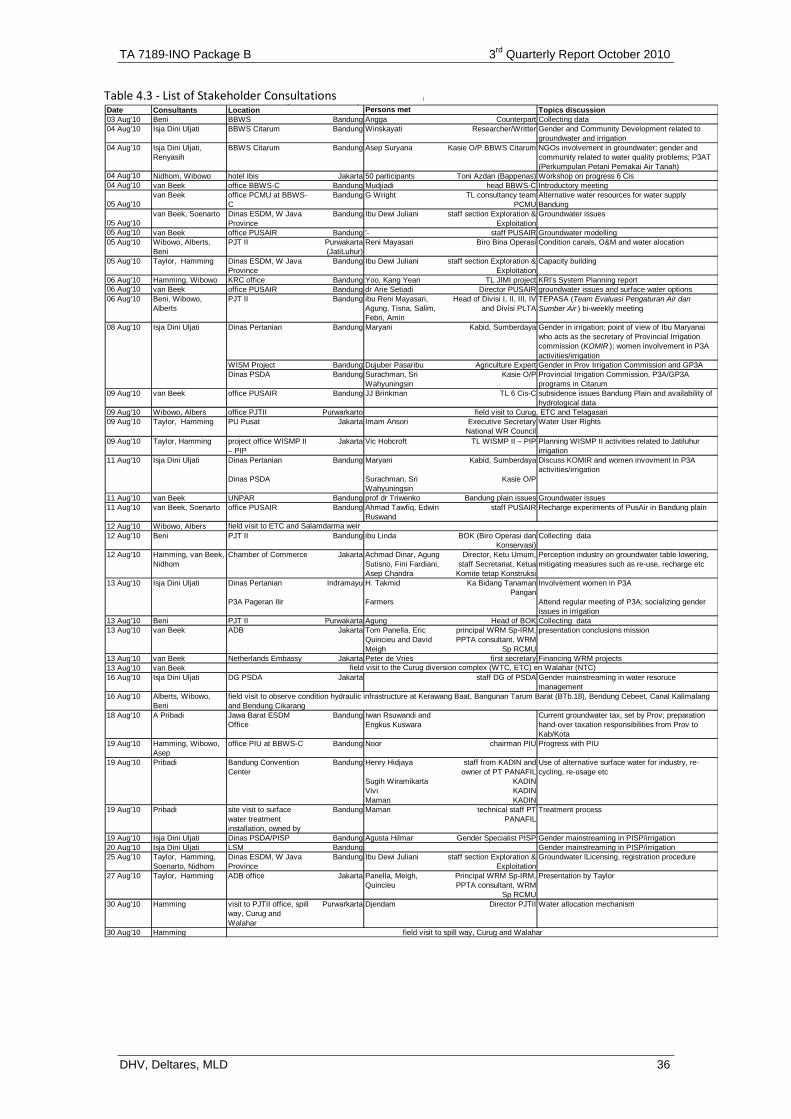
TA 7189-INO Package B 3rd Quarterly Report October 2010
DHV, Deltares, MLD 36
Date Consultants Topics discussion03 Aug'10 Beni BBWS Bandung Angga Counterpart Collecting data 04 Aug'10 Isja Dini Uljati BBWS Citarum Bandung Winskayati Researcher/Writter Gender and Community Development related to
groundwater and irrigation04 Aug'10 Isja Dini Uljati,
RenyasihBBWS Citarum Bandung Asep Suryana Kasie O/P BBWS Citarum NGOs involvement in groundwater; gender and
community related to water quality problems; P3AT (Perkumpulan Petani Pemakai Air Tanah)
04 Aug'10 Nidhom, Wibowo hotel Ibis Jakarta 50 participants Toni Azdan (Bappenas) Workshop on progress 6 Cis04 Aug'10 van Beek office BBWS-C Bandung Mudjiadi head BBWS-C Introductory meeting
05 Aug'10van Beek office PCMU at BBWS-
CBandung G Wright TL consultancy team
PCMUAlternative water resources for water supply Bandung
05 Aug'10van Beek, Soenarto Dinas ESDM, W Java
Province Bandung Ibu Dewi Juliani staff section Exploration &
Exploitation Groundwater issues
05 Aug'10 van Beek office PUSAIR Bandung '- staff PUSAIR Groundwater modelling05 Aug'10 Wibowo, Alberts,
BeniPJT II Purwakarta
(JatiLuhur)Reni Mayasari Biro Bina Operasi Condition canals, O&M and water alocation
05 Aug’10 Taylor, Hamming Dinas ESDM, W Java Province
Bandung Ibu Dewi Juliani staff section Exploration & Exploitation
Capacity building
06 Aug'10 Hamming, Wibowo KRC office Bandung Yoo, Kang Yean TL JIMI project KRI's System Planning report06 Aug'10 van Beek office PUSAIR Bandung dr Arie Setiadi Director PUSAIR groundwater issues and surface water options06 Aug'10 Beni, Wibowo,
AlbertsPJT II Bandung ibu Reni Mayasari,
Agung, Tisna, Salim, Febri, Amin
Head of Divisi I, II, III, IV and Divisi PLTA
TEPASA (Team Evaluasi Pengaturan Air dan Sumber Air ) bi-weekly meeting
08 Aug'10 Dinas Pertanian Bandung Maryani Kabid, Sumberdaya Gender in irrigation; point of view of Ibu Maryanai who acts as the secretary of Provincial Irrigation commission (KOMIR ); women involvement in P3A activities/irrigation
WISM Project Bandung Dujuber Pasaribu Agriculture Expert Gender in Prov Irrigation Commission and GP3ADinas PSDA Bandung Surachman, Sri
WahyuningsinKasie O/P Provincial Irrigation Commission, P3A/GP3A
programs in Citarum09 Aug'10 van Beek office PUSAIR Bandung JJ Brinkman TL 6 Cis-C subsidence issues Bandung Plain and availability of
hydrological data09 Aug'10 Wibowo, Albers office PJTII Purwarkarto09 Aug’10 Taylor, Hamming PU Pusat Jakarta Imam Ansori Executive Secretary
National WR CouncilWater User Rights
09 Aug’10 Taylor, Hamming project office WISMP II – PIP
Jakarta Vic Hobcroft TL WISMP II – PIP Planning WISMP II activities related to Jatiluhur irrigation
Dinas Pertanian Maryani Kabid, Sumberdaya Discuss KOMIR and women invovment in P3A activities/irrigation
Dinas PSDA Surachman, Sri Wahyuningsin
Kasie O/P
11 Aug'10 van Beek UNPAR Bandung prof dr Triwenko Bandung plain issues Groundwater issues11 Aug'10 van Beek, Soenarto office PUSAIR Bandung Ahmad Tawfiq, Edwin
Ruswand staff PUSAIR Recharge experiments of PusAir in Bandung plain
12 Aug'10 Wibowo, Albers12 Aug'10 Beni PJT II Bandung ibu Linda BOK (Biro Operasi dan
Konservasi)Collecting data
12 Aug'10 Hamming, van Beek, Nidhom
Chamber of Commerce Jakarta Achmad Dinar, Agung Sutisno, Fini Fardiani, Asep Chandra
Director, Ketu Umum, staff Secretariat, Ketua
Komite tetap Konstruksi
Perception industry on groundwater table lowering, mitigating measures such as re-use, recharge etc
Dinas Pertanian H. Takmid Ka Bidang Tanaman Pangan
Involvement women in P3A
P3A Pageran Ilir Farmers Attend regular meeting of P3A; socializing gender issues in irrigation
13 Aug'10 Beni PJT II Purwakarta Agung Head of BOK Collecting data13 Aug'10 van Beek ADB Jakarta Tom Panella, Eric
Quincieu and David Meigh
principal WRM Sp-IRM, PPTA consultant, WRM
Sp RCMU
presentation conclusions mission
13 Aug'10 van Beek Netherlands Embassy Jakarta Peter de Vries first secretary Financing WRM projects13 Aug'10 van Beek16 Aug'10 Isja Dini Uljati DG PSDA Jakarta staff DG of PSDA Gender mainstreaming in water resoruce
management16 Aug'10 Alberts, Wibowo,
Beni 18 Aug'10
19 Aug'10 Hamming, Wibowo, Asep
office PIU at BBWS-C Bandung Noor chairman PIU Progress with PIU
19 Aug'10 Pribadi Bandung Henry Hidjaya staff from KADIN and owner of PT PANAFIL
Sugih Wiramikarta KADINVivi KADINMaman KADIN
19 Aug'10 Pribadi Bandung technical staff PT PANAFIL
Treatment process
19 Aug'10 Isja Dini Uljati Dinas PSDA/PISP Bandung Agusta Hilmar Gender Specialist PISP Gender mainstreaming in PISP/irrigation20 Aug'10 Isja Dini Uljati LSM Bandung Gender mainstreaming in PISP/irrigation25 Aug’10 Taylor, Hamming,
Soenarto, NidhomDinas ESDM, W Java Province
Bandung Ibu Dewi Juliani staff section Exploration & Exploitation
Groundwater lLicensing, registration procedure
27 Aug’10 Taylor, Hamming ADB office Jakarta Panella, Meigh, Quincieu
Principal WRM Sp-IRM, PPTA consultant, WRM
Sp RCMU
Presentation by Taylor
30 Aug'10 Hamming visit to PJTII office, spill way, Curug and Walahar
Purwarkarta Djendam Director PJTII Water allocation mechanism
30 Aug'10 Hamming
Isja Dini Uljati
site visit to surface water treatment installation, owned by
Bandung Convention Center
field visit to ETC and Salamdarma weir
Use of alternative surface water for industry, re-cycling, re-usage etc
Maman
field visit to Curug, ETC and Telagasari
11 Aug'10 Isja Dini Uljati Bandung
field visit to the Curug diversion complex (WTC, ETC) en Walahar (NTC)
field visit to observe condition hydraulic infrastructure at Kerawang Baat, Bangunan Tarum Barat (BTb.18), Bendung Cebeet, Canal Kalimalang and Bendung Cikarang
13 Aug'10 Isja Dini Uljati Indramayu
Bandung
field visit to spill way, Curug and Walahar
List of Stakeholder Consultations, Meetings and Workshops (Aug-Oct'10)Location Persons met
Current groundwater tax, set by Prov; preparation hand-over taxation responsibilities from Prov to Kab/Kota
Iwan Rsuwandi and Engkus Kuswara
A Pribadi Jawa Barat ESDM Office
Table 4.3 ‐ List of Stakeholder Consultations
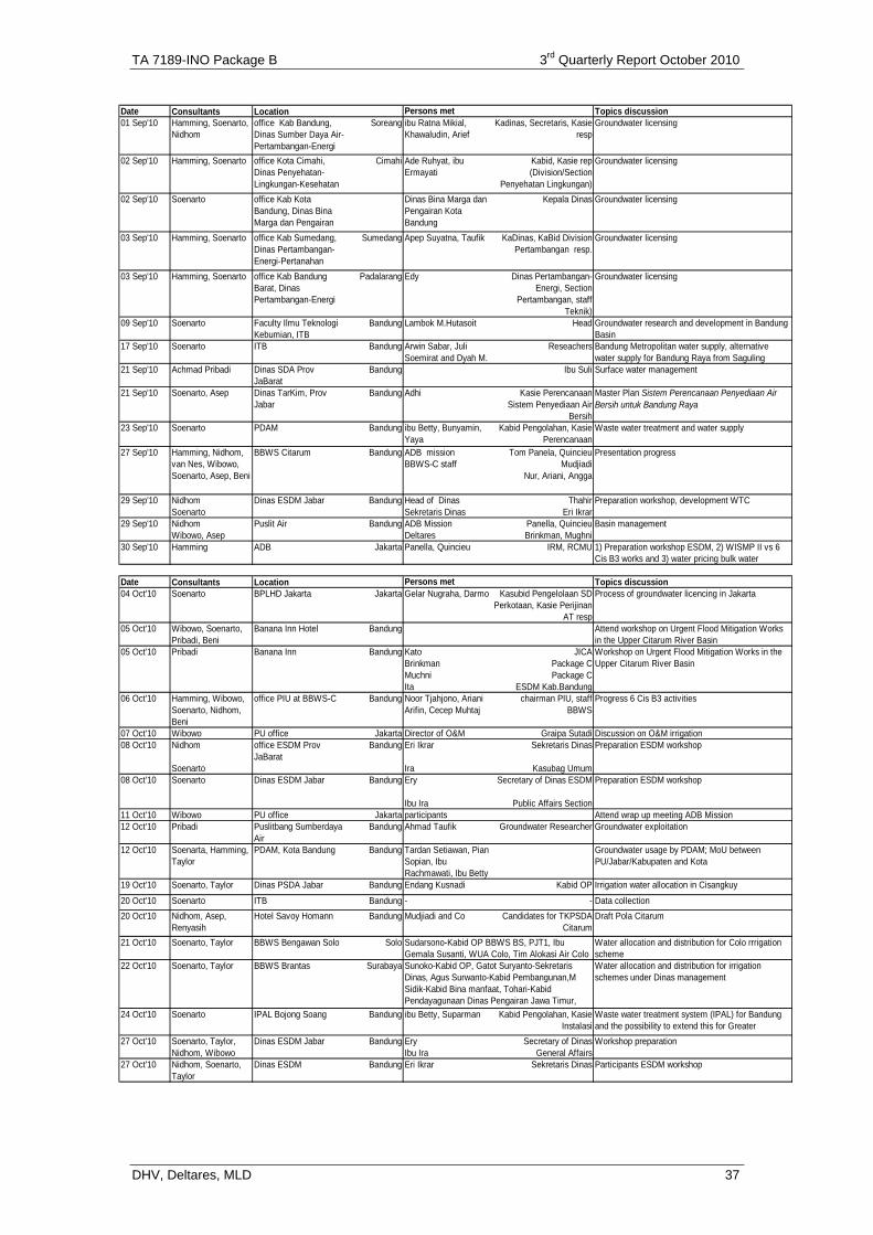
TA 7189-INO Package B 3rd Quarterly Report October 2010
DHV, Deltares, MLD 37
Date Consultants Topics discussion01 Sep'10 Hamming, Soenarto,
Nidhomoffice Kab Bandung, Dinas Sumber Daya Air-Pertambangan-Energi
Soreang ibu Ratna Mikial, Khawaludin, Arief
Kadinas, Secretaris, Kasie resp
Groundwater licensing
02 Sep'10 Hamming, Soenarto office Kota Cimahi, Dinas Penyehatan-Lingkungan-Kesehatan
Cimahi Ade Ruhyat, ibu Ermayati
Kabid, Kasie rep (Division/Section
Penyehatan Lingkungan)
Groundwater licensing
02 Sep'10 Soenarto office Kab Kota Bandung, Dinas Bina Marga dan Pengairan
Dinas Bina Marga dan Pengairan Kota Bandung
Kepala Dinas Groundwater licensing
03 Sep'10 Hamming, Soenarto office Kab Sumedang, Dinas Pertambangan-Energi-Pertanahan
Sumedang Apep Suyatna, Taufik KaDinas, KaBid Division Pertambangan resp.
Groundwater licensing
03 Sep'10 Hamming, Soenarto office Kab Bandung Barat, Dinas Pertambangan-Energi
Padalarang Edy Dinas Pertambangan-Energi, Section
Pertambangan, staff Teknik)
Groundwater licensing
09 Sep'10 Soenarto Faculty Ilmu Teknologi Kebumian, ITB
Bandung Lambok M.Hutasoit Head Groundwater research and development in Bandung Basin
17 Sep'10
21 Sep'10 Achmad Pribadi Dinas SDA Prov JaBarat
Bandung Ibu Suli Surface water management
21 Sep'10
23 Sep'10 Soenarto PDAM Bandung ibu Betty, Bunyamin, Yaya
Kabid Pengolahan, Kasie Perencanaan
Waste water treatment and water supply
27 Sep'10 BBWS Citarum Bandung ADB mission Tom Panela, Quincieu Presentation progressBBWS-C staff Mudjiadi
Nur, Ariani, Angga
29 Sep'10 Nidhom Dinas ESDM Jabar Bandung Head of Dinas Thahir Preparation workshop, development WTCSoenarto Sekretaris Dinas Eri Ikrar
29 Sep'10 Nidhom Puslit Air Bandung ADB Mission Panella, Quincieu Basin managementWibowo, Asep Deltares Brinkman, Mughni
30 Sep'10 Hamming ADB Jakarta Panella, Quincieu IRM, RCMU 1) Preparation workshop ESDM, 2) WISMP II vs 6 Cis B3 works and 3) water pricing bulk water
Date Consultants Topics discussion04 Oct'10 Soenarto BPLHD Jakarta Jakarta Gelar Nugraha, Darmo Kasubid Pengelolaan SD
Perkotaan, Kasie Perijinan AT resp
Process of groundwater licencing in Jakarta
05 Oct'10 Wibowo, Soenarto, Pribadi, Beni
Banana Inn Hotel Bandung Attend workshop on Urgent Flood Mitigation Works in the Upper Citarum River Basin
05 Oct'10 Pribadi Banana Inn Bandung Kato JICABrinkman Package CMuchni Package CIta ESDM Kab.Bandung
06 Oct'10 Hamming, Wibowo, Soenarto, Nidhom, Beni
office PIU at BBWS-C Bandung Noor Tjahjono, Ariani Arifin, Cecep Muhtaj
chairman PIU, staff BBWS
Progress 6 Cis B3 activities
07 Oct'10 Wibowo PU office Jakarta Director of O&M Graipa Sutadi Discussion on O&M irrigation08 Oct'10 Nidhom office ESDM Prov
JaBaratBandung Eri Ikrar Sekretaris Dinas Preparation ESDM workshop
Soenarto Ira Kasubag Umum08 Oct'10 Ery Secretary of Dinas ESDM
Ibu Ira Public Affairs Section11 Oct'10 Wibowo PU office Jakarta participants Attend wrap up meeting ADB Mission12 Oct'10 Pribadi Puslitbang Sumberdaya
AirBandung Ahmad Taufik Groundwater Researcher Groundwater exploitation
12 Oct'10 Soenarta, Hamming, Taylor
PDAM, Kota Bandung Bandung Tardan Setiawan, Pian Sopian, Ibu Rachmawati, Ibu Betty
Groundwater usage by PDAM; MoU between PU/Jabar/Kabupaten and Kota
19 Oct'10 Soenarto, Taylor Dinas PSDA Jabar Bandung Endang Kusnadi Kabid OP Irrigation water allocation in Cisangkuy
20 Oct'10 Soenarto ITB Bandung - - Data collection
20 Oct'10 Nidhom, Asep, Renyasih
Hotel Savoy Homann Bandung Mudjiadi and Co Candidates for TKPSDA Citarum
Draft Pola Citarum
21 Oct'10 Soenarto, Taylor BBWS Bengawan Solo Solo Water allocation and distribution for Colo rrrigation scheme
22 Oct'10 Surabaya
24 Oct'10 Soenarto IPAL Bojong Soang Bandung ibu Betty, Suparman Kabid Pengolahan, Kasie Instalasi
Waste water treatment system (IPAL) for Bandung and the possibility to extend this for Greater B d27 Oct'10 Ery Secretary of Dinas Workshop preparation
Ibu Ira General Affairs27 Oct'10 Nidhom, Soenarto,
TaylorDinas ESDM Bandung Eri Ikrar Sekretaris Dinas Participants ESDM workshop
Water allocation and distribution for irrigation schemes under Dinas management
Sudarsono-Kabid OP BBWS BS, PJT1, Ibu Gemala Susanti, WUA Colo, Tim Alokasi Air ColoSunoko-Kabid OP, Gatot Suryanto-Sekretaris Dinas, Agus Surwanto-Kabid Pembangunan,M Sidik-Kabid Bina manfaat, Tohari-Kabid Pendayagunaan Dinas Pengairan Jawa Timur,
Hamming, Nidhom, van Nes, Wibowo, Soenarto, Asep, Beni
Bandung Preparation ESDM workshop
Workshop on Urgent Flood Mitigation Works in the Upper Citarum River Basin
Location Persons met
Bandung
Soenarto, Taylor BBWS Brantas
Soenarto ITB
Soenarto, Asep Dinas TarKim, Prov Jabar
Soenarto Dinas ESDM Jabar
Soenarto, Taylor, Nidhom, Wibowo
Dinas ESDM Jabar
Location Persons met
Bandung Arwin Sabar, Juli Soemirat and Dyah M.
Reseachers Bandung Metropolitan water supply, alternative water supply for Bandung Raya from Saguling
Bandung Adhi Kasie Perencanaan Sistem Penyediaan Air
Bersih
Master Plan Sistem Perencanaan Penyediaan Air Bersih untuk Bandung Raya

TA 7189-INO Package B 3rd Quarterly Report October 2010
DHV, Deltares, MLD 38
8) Prepare drafts for water allocation ToR for Bulk Water Pricing is completed. Study will be carried out by a national economist and legal/institutional Sp and an international economist. 9) Organize workshop BBWSC Workshop planned for 18 January 2011. Draft agenda, list of participants prepared and sent to ADB for approval. Agenda is presented in Table 4.6. 10) Finalize report Final report completed for 70%. To be finalized by mid Jan'11 after BBWSC Workshop and final discussions with BBWSC.
4.3 DEVELOPMENTS AND ISSUES During the visit of the ADB mission visit to BBWSC in Bandung on 27 Sep’10, special attention was given to four issues: 1) WISIMP vs 6 Cis activities on water allocation irrigation Jatiluhur; 2) approach of DKI (Jakarta) government on groundwater management; 3) study on pricing bulk water supply; 4) database development on registration and licensing groundwater (RELI).
4.3.1 WISIMP activities on water allocation irrigation Jatiluhur BBWSC noted that some of the allocation work for irrigation with the Jatiluhur System might be carried out by the World Bank’s next project under the Water and Irrigation Sector Management Program (WISIMP). During WISMP I - Jatiluhur component, a System Planning report was prepared by KRC consultants. The report includes a water balance study for Jatiluhur irrigation and an irrigation management strategy. These were reviewed by B3 consultants (technical report ’Water Allocation Practices and Water Balance Jatiluhur, October 2010’). The B3 team had two meetings with staff from WISMP-PIP team (Vic Hobcroft and David Brown) to discuss WISIMP’s planned works under phase II. Follow up discussions between Word Bank, ADB and consultants are foreseen during next quarter to further discuss the works under the donor programs (WISIMP II).
4.3.2 DKI’s approach on groundwater management Consultants have visited the office of the BPLH DKI in Jakarta. In DKI (Jakarta) the Kota’s do not issue groundwater licenses unlike in Bandung-Soreang where the Kota’s/Districts do so. Reason is that the Kota’s in DKI only fulfill administrative functions and have no legislative power. In fact there is no parliament to endorse legislation. Therefore licensing, taxation as well as groundwater management are brought under one umbrella i.e. governor who has directed the licensing and groundwater management to the BPLH DKI and the taxation to the DISPENDA (Dinas Pendapatan Daerah). Last year the licensing and groundwater management was shifted from Dinas ESDM DKI to the BPLH DKI when the Dinas was abolished with the enactment of the PP38 on Distribution of Gov Affairs. The BPLHD is still developing to fulfill their new tasks. Follow up visits to the BPLHD DKI are planned during next quarter.
TA 7189-INO Package B 3rd Quarterly Report October 2010
DHV, Deltares, MLD 39
4.3.3 Pricing bulk water supply BBWSC requested ADB to carry out a bulk water pricing study. Reason is that it wants to get clarification on the water charge (service fee) for bulk water delivered to commercial users such as PAM and industry. Current price of Rp 180/m3 may be on the low side. Execution of the study is considered important for the BBWSC since the agency is the regulator for bulk water pricing in the basin. The Mission agreed to allocate resources for the study. ADB has requested consultants to prepare the ToR for the study. Consultants completed the draft ToR in November 2010. The study methodology will include service fee calculations reflecting the increased costs which are justified by a higher reliability in water supply and better water quality. Following the concerned legislation (PP 42, article 118), the methodology takes into account all costs related to the infrastructure (investment, replacement, O&M including energy, costs for further development). In line with PP 42, the Service Fee is also dependant on the purpose of water usage, the financial capacity of the users and the different classes of volumes supplied. The methodology will indicate present and future scenario’s of infrastructure development. The study will start in January 2011 and will last for 5 months. It will be carried out by two national specialists (economist and legal/institutional) and by one international consultant (economist).
4.3.4 Database development on registration, licensing groundwater
As was discussed in last quarter, due to the limitation of project resources, it has been proposed to cancel the preparation of groundwater management information system tools under TA 7189 INO. The work may be undertaken by the second project in the investment program
4.4 COMPARISON WATER ALLOCATION MECHANISMS In order to better place the Citarum River Basin in context, some meetings were held in October 2010 with operational officials of the Bengawan Solo and Brantas River Basin. The Bengawan Solo river is an inter-provincial river which originates in Central Java and crosses into East Java Province. Its head works are operated by PJTI. The Brantas River basin is located within East Java province and its headworks are also operated by PJTI. The intention was to explore how similarly or differently the annual water planning process was carried out and how similarly or differently the operation and monitoring of water distribution was undertaken also. It was concluded that in general the leading agencies in planning and surface water allocation are the BBWS-TKPSDA for Bengawan-Solo, the Prov Dinas for Brantas and the PJTII-SPKTPA for Citarum. Results of the study are summarized in Table 4.4

TA 7189-INO Package B 3rd Quarterly Report October 2010
DHV, Deltares, MLD 40
g gInstitutional Level
Activity
BBWS - Bengawan Solo BBWS - Brantas BBWS - CitarumP3A / Kabupaten
Operation headworks, river works,
PJTI PJTI PJTII
annual planning - P3A/Irr Com give recommendation on RTTG to Kab
- follows largely procedure BS, P3A/Irr Com assisted by Prov UPTDs
- P3A and staff PJII dicuss plan, recommendations on RTTG to Prov Irr Com
- Kab prepare plans based on previous year + deviatation
see BS, Kab are asssisted by Prov UPTDs (before Balai Prov)
- legalized in SK Bup = planting plan 1 year = RTTG
see BS, 16 SKs
Province - Prov Irr Commission collects plans, propose overall RTTG to Gub
- Dinas PSDA Prov assisted by PJTI (member TKPSDA) prepare one annual
ti l l i l thl
- Prov Irr Com prepares overall RTTG, propsed to Gub
- legalized in SK Gub
Basin - BBWS+TKSDA collect plan, review
- discussed in POKJA TKPSDA
- SPKTPA reviews SK, prepares release schedule
- BBWS+PJTI prepare operational plan 1 year, approved by TKPSDA
- overall plan approved by TKPSDA
- legalized via SK BBWS
Implementation - PJTI operates accordingly SK BBWS
see BS - PJTII operates accordingly SK PJTII
- frequent meetings TAA and P3A, 14 days, MoM on water that can be expected
- 10 days arrangements, scheduling
- P3As informs PJTI quickly when need for change in supply (rainfall, runoff), PJTI reacts immediately
Routine Monitoring
- carried out by Tim Allokasi Air (BBWS, PJTI, Dinas PSDA Kab)
- river gauging by PJTI, BBWS and Prov Dinas (website)
- monitoring flows using structures prim/sec
Issues - good interaction between farmers and PJTI
- plenty water availibility, seasonnal variations
- illegal pumping
- no drainage outflows
- low dry season flows - efficiency low, drainage discharge, distribution at field level does not follow Golongan
tertiary structures damaged - relatively high dry season flows
- lower emphasize on power generation
- most structures damaged
- high emphasize on power generation
Institutional Role
- BBWS-TKPSDA leading role in annual planning (SK BBWS), TAA active in meetings with P3As on bi-weekly adjustments
PJTII-SPKTPA leading roles in annual planning (SK PJTII), BBWS general coordination, PJTII staff is active in meetings with P3As
- operation driven by water availibility
- operation driven by water estimates, assuming water supply as requested
River Basin Organisation
- Prov Dinas leading role in calculations dam release, data with PJTI. Leading role in annual planning. BBWS general coordination (comparable with Citarum)
- legalized in SK Gub = planting plan 1 year = RTTG
- limited due to poor condition prim/sec/ter structures, perceived less need for monitoring due to excess water availibility
- frequent meetings PJTII staff with P3A/PPL, 14 days, on water that can be expected
- efficiency low, drainage discharge, distribution at field l l d t f ll
Table 4.4 - Comparison Study on Water Allocation for Three Basins
TA 7189-INO Package B 3rd Quarterly Report October 2010
DHV, Deltares, MLD 41
Summary proposed Projects for Groundwater Management Bandung-SoreangResponsibility Timing External
Funding1 Legislation Improve, synchronize legislation for
institutional rationalisation (law/MoU)National, provincial and district governments
within 1 year, if agreed
Develop Groundwater Management Plan Dinas ESDM West Java with Kota/Kabupatens
2 years
Develop supporting legislation for management plan
West Java Province and Kota/Kabupatens
by end of 2 years of plan
Review data needs, develop Dinas ESDM Kota/Kab 3 years - Review data needs (6 months)- Develop data capacity (2.5 years)- Establish data roles/coordination (1 year,
simultaneous)Data systems legislation Dinas ESDM Kota/Kab by end of Data
System project
Data System 3
2 Groundwater Management Plan
Project and action
4.5 ESDM WORKSHOP ON GROUNDWATER MANAGEMENT
On 02 November 2010 the ESDM Workshop on groundwater management was held at the premises of Dinas ESDM Prov Jawa Barat. The objective of the workshop was to discuss all possible steps to limit groundwater use, and conclude on what action could be taken in the near future. The program of the workshop comprised : 1. Overview of Activities Component B.3 of 6 Cis project by TL B.3 2. Current Groundwater Management by head of Dinas ESDM (Energy and Mineral
Resources, the agency responsible for groundwater management) 3. Legislation and Strategies Review (Public Policy Specialist B.3) 4. Groundwater Pricing (Economist B.3) 5. Critical conditions of groundwater abstraction, recharge, infiltration and
conjunctive use, alternative surface water resources (Basin Water Management Specialist B.1)
6. Best Practices and Proposals for action (Institutional Specialist B.3) 7. Discussion 8. Summary and Recommendations A total 46 participants attended the workshop. These were from ADB, Bappenas, Bappeda Prov. Jabar, ITB, Pusat Lingkungan Geologi (Bandung), Dinas ESDM Prov Jabar, BBWSC, PCMU - ICWRM, Dinas Kabupaten Bandung, Bandung Barat, Sumedang, Dinas Kota Bandung- Cimahi, Dinas Perindustrian, Kadin, BPLHD Prov. Jabar, KLH Kab Cimahi, BPLH Kota Bandung, Dinas PSDA Prov, Dinas Permukiman dan Perumahan Prov JaBarat, Dinas SDA Kab Bandung Barat, PDAM Kab Bandung, PDAM Kota Bandung, consultant 6 Cis D, Pabrik Textil PT. Kahatex, consultant Kwarsa Hexacon (partner KRC), LPE (Lembaga Penilitian Ekonomi) from UNPAD. A Workshop report is under preparation. Final conclusions are summarized in the Annex B. Tentatively three projects were identified to support effective groundwater management. Aims are the 1) synchronization of Legislation, 2) development of an updated Groundwater Plan and 3) development of a Data System.
Follow up activities will be discussed with Direktur ESDM next quarter including strategies and action points such as the preparation of MoUs.
TA 7189-INO Package B 3rd Quarterly Report October 2010
DHV, Deltares, MLD 42
Proposed revision in mm National consultantsMM MM MM MMcont inc rev differ
M Nidhom Azhari Public Policy Sp 12 8 11 3.0Zukairnan Institutional Sp 8 6 0 -6.0Pratolo Priambodo Information Mng Sp 4 4 0 -4.0Soenarto River Basin Sp 8 4 7.5 3.5Balance -3.5
4.6 REPORTS By the end of October 2010 the following reports were produced (no. 1-5): Table 4.5 Report on Key Policies and Strategies for Water Resources Management in
CRB (TA B3) Production Date
Submitted to
Submission Date
1 Review of Framework National Legislation for Groundwater Management Bandung and Water Allocation for Jatiluhur
26-May-10 ADB 30-Jun-10
2 Report on International Best Practice in Water Allocation
21-Jun-10 ADB, BBWSC
30-Jun-10
3 Report on Water Allocation Practices and Water Balance Jatiluhur
26-Aug-10 ADB, BBWSC
10-Nov-10
4 Report on Groundwater Issues in the Bandung Plain
17-Aug-10 ADB 27-Aug-10
5 Report on Groundwater Management in the Bandung Basin, Interim Report
15-Aug-10 ADB 27-Aug-10
6 Report ESDM Wokshop on groundwater management Bandung-Soreang
7 Review of Framework Local Legislation for Groundwater Management Bandung and Water Allocation for Jatiluhur
8 Report on Groundwater Issues in the Bandung Plain (updated version, see 4)
9 Final Report on Strategies and Action Plan Groundwater Management
10 Final Report on Strategies and Action Plan Surface Water Allocation Jatiluhur
Report
( )
under preparation
under preparation
under preparation
under preparation
under preparation
In addition, five reports will be completed during next quarter (no. 6-10) of which the two final reports with strategies and action plan on groundwater management in Bandung-Soreang and surface water allocation at Jatiluhur.
4.7 PERSONAL INPUTS Because of the changes in scope of work as discussed above, the personal inputs were changed as follows. This has been discussed with the review mission on 27 September in Bandung and again with ADB on a meeting on 30 September at ADB. .
TA 7189-INO Package B 3rd Quarterly Report October 2010
DHV, Deltares, MLD 43
4.8 PLANNING Activities during the period November 2010 - January 2011 will focuses on: 1) Preparation Draft proposals (draft final reports), completed by mid December
2010; 2) Organization of BBWSC Workshop on water allocation, 18 January 2011 (draft
agenda attached); 3) Preparation of Final proposals (final reports), completed by 3rd week January
2011; 4) Discussions with ESDM and BBWSC on follow up actions, MoUs in 3rd week of
January 2011.

TA 7189-INO Package B 3rd Quarterly Report October 2010
DHV, Deltares, MLD 44
WAKTU ACARA PEMBICARA
08.00 - 08.30 Pendaftaran / Registrasi Peserta (Registration)
08.30 - 08.40 Sambutan Pembukaan Ka BBWS Citarum (Head BBWS)
08.40 - 08.50 Sambutan / Pidato Kunci (Key Note) Perwakilan ADB (ADB Representative)
08.50 - 09.00 Penjelasan singkat tentang aktivitas 6 Ci's B3 (Overview) Alex Hamming (TA 6 Cis B3)
09.00 - 09:20Alokasi air dan Pola PSDA Citarum (Water allocation and Pola)
Asep TS (TA 6 Cis B1)
09.20 - 09.40 SOP Cascade 3 Waduk Ka Sub Dit Bendungan(SOP of the 3 Reservoirs Cascade)
09.40 - 10.00 Peran BBWS Citarum dalam alokasi air permukaan di Citarum hilir (Role of BBWS in Water Allocation)
Ka BBWS Citarum
10.30 - 10.50 Kajian Alokasi dan Distribusi Air Permukaan di Sistem Jatiluhur (Review Alocation & Distribution of Surface Water in the Jatiluhur System)
Yohanes W (TA 6 Cis B3)
10.50 - 11.10 Kajian Legislasi (Review Legislation) M.Nidhom A (TA 6 Ci's B3)
11.10 - 11.30 Pengalaman terbaik dan Strategi (Best Practice and Strategies)
Paul Taylor (TA 6 Cis B3)
11.30 - 12.30 Diskusi (Discussion) Moderator
12.30 - 12.50 Kesimpulan dan Rekomendasi (Summary and Recommendations)
Moderator
12.50 - 13.00 Penutupan (Closing) Ka BBWS Citarum (Head BBWS)
10.00 - 10.30 ISTIRAHAT (Coffee Break)
Selasa, 18 Januari 2011
P A P A R A N (Presentations)
I S O M A (Lunch Break)
JADWAL ACARA
WORKSHOP KEBIJAKAN dan PRAKTEK ALOKASI dan DISTRIBUSI
di Hotel SAVOY HOMANN, BANDUNG
AIR PERMUKAAN DI CITARUM HILIR
P A P A R A N (Presentations) Moderator
D I S K U S I dan P E N U T U P A N (Discussion and Closing)
Moderator
Table 4.6 - Program ESDM Workshop on Groundwater Management
TA 7189-INO Package B 3rd Quarterly Report October 2010
DHV, Deltares, MLD 45
5 PROJECT IMPLEMENTATION PACKAGE B The Inception Period was completed at the end of April, according to schedule three months after full mobilization, although this is two months later than originally envisaged. It is expected that the other outputs will be delivered approximately according to schedule, with Mid Term Report available in March 2011, and final report in November 2012. Draft Pola is envisaged in February 2011 (two months after originally planned date), draft Rencana per June 2012, although it should be emphasized that this depends on progress in establishment of the Basin Council, as reported in Chapter 2. Assignments of staff planned and realized is indicated in Annex A. All counterparts, both from DGWR and Spatial Planning, have been mobilized. A team of 11 counterparts has familiarized themselves with the project area, with the study team of consultants and with each other. However, their time is limited, and the expected joint operation of consultants, Balais, DGWR and DGSP cannot be fully realized. This reduces their ability to take over after the consultants finish their assignments. An operational budget in the Balais has become available, approximately amounting to Rp 250 M Rp per year for each Balai. For 2011 at least a similar amount is available, but much more is proposed (750 M Rp per year per Balai). This amount is required for
Organization and implementation of the Public Consultation Meetings (two for POLA and two for RENCANA, for each balai).
Support establishment and operation of the Basin Council (TKPSDA) Operational Budget for the counterparts
In September / October a review mission from ADB was held for Loan 2500 /2501 (SF), Integrated Citarum Water Resources Management Investment Program (ICWRMIP)– Periodic Financing Request 1 and TA 7189-INO. Concerning TA 7189 INO Package B the conclusions were as follows: OVERALL
It was agreed that new office space will be provided to Package B consultants It was confirmed that 2011 budgets from BBWS for Public Consultation
Meetings, support TKPSDA and counterparts are being proposed, which will include at least 250 M Rp from each unit per year.
Sub-component B.1 Mission is satisfied with progress to date. However, an important aspect of the
TA is developing capacity and ownership for Balai Besar to take a lead in the Pola and Rencana development process as well have skills to operate the models and to undertake effective basin planning and implementation activities once the TA closes. Careful monitoring and dialogue with the consultants and GOI is required to ensure that these outcomes are achieved.
Discussions are on-going about splitting the 6 Cis RBT in three as part of the new Keppres on delineation of RBT. The consultants recommend one WS, but if 3 WS necessary special arrangements should be made concerning coordination of the trans basin conveyances.
There is some question that as to whether the Pola will be completed and agreed to by the Basin Water Council in December 2010 as required in Law 7/2004. By that time a tri-partite meeting will be held to decide on how to continue with the Rencana.

TA 7189-INO Package B 3rd Quarterly Report October 2010
DHV, Deltares, MLD 46
DGWR is still undergoing reorganization and role of PJT II has been changed under PP7/2010 (see 2.2.2), Role sharing between BBWS, provinces, districts and PJT II has to be dealt with, and BBWS capacity building action plans depends on agreed roles and responsibilities (as reported under 2.4.1).
The TL and some staff of 6 Cis are also involved in Java Water Resources Strategic Study funded by the World Bank, and results should be shared by both projects. Groundwater should be integrated in the water balance.
Subcomponent B.2 Data acquisition concerning Census 2010 and satellite imagery from JAXA
(quality of the images because of clouds) are still major issues (see chapter 3). Extra GIS input for run-off zoning has been approved JSM will be integrated with Decision Support System under Package D It is essential that bulk water options and identified flood management options
are included in the spatial plans to be completed in 2010. Subcomponent B.3
Further review of Standard Operation Procedures for the Citarum Cascade will be done under the Dam Operation and Institutional Strengthening Project (DOISP) funded by World Bank
Coordination is needed to incorporate the findings from Package B.3 for Jatiluhur Irrigation System are included in the plans for WISMP II
Bulk water pricing was indicated as an important issue, especially to justify higher prices for Jakarta Bulk Water Supply supporting improvements of facilities as well as enhanced operation and maintenance, and some recommendations are required from the Package B consultants. It was agreed to include this as extra work to be done in 2011 under sub-component B.1.
The mission is pleased with groundwater management work that has been completed so far.
Due to limited resources it has been agreed to exclude the groundwater management information system tools,
The results will include recommendations for integration of existing systems already available at province and district level agencies.
The Workshop on Groundwater was approved with some comments. Based on the version of the Inception Report in April, we have submitted a proposed Variation Order 1 for the contract. After some minor changes concerning the staff required for the SOP evaluation for the three reservoirs of Citarum and supporting staff, on June 30 the final version has been submitted, and in August additional specifications were provided according to the standard formats of ADB. Unfortunately this Variation Order has not been endorsed yet by ADB Manila per 31 October 2010. Already several changes will be proposed in the next Variation Order, to be submitted as soon as VO1 is approved:
Extra GIS work for run-off protecting zones under B.2. This already has been approved as reported in chapter 3.
Adjustments in the work plan for B.3, already approved, as reported for B.3. Extra work for the bulk water pricing study under B.3, as proposed by the
review mission and reported in chapter 4. Additional inputs of GIS specialist and data collectors, because of extended
data collection after the PCM and delay of Pola Additional inputs (to be determined) because of splitting 6Cis RBT in three. Adjustments in the work plan for capacity building of RBO applying the role
sharing as proposed. Adjustments in the work plan for the Remote Sensing Specialist.
In Association with: DEMIS B.V. - EUROCONSULT MOTT MACDONALD - SIGNIFICANCE B.V. - PT GEO ISSEC - PT INDEC INTERNUSA PT MULTI AREA CONINDO - PT PPA CONSULTANTS - PT SUPRAHARMONIA CONSULTINDO - PT TERA BUANA MANGGALA JAYA PT TRANS INTRA ASIA - PT WASECO TIRTA - PT WIDYA GRAHA ASANA - PT WIRATMAN & ASSOCIATES
Annex - A
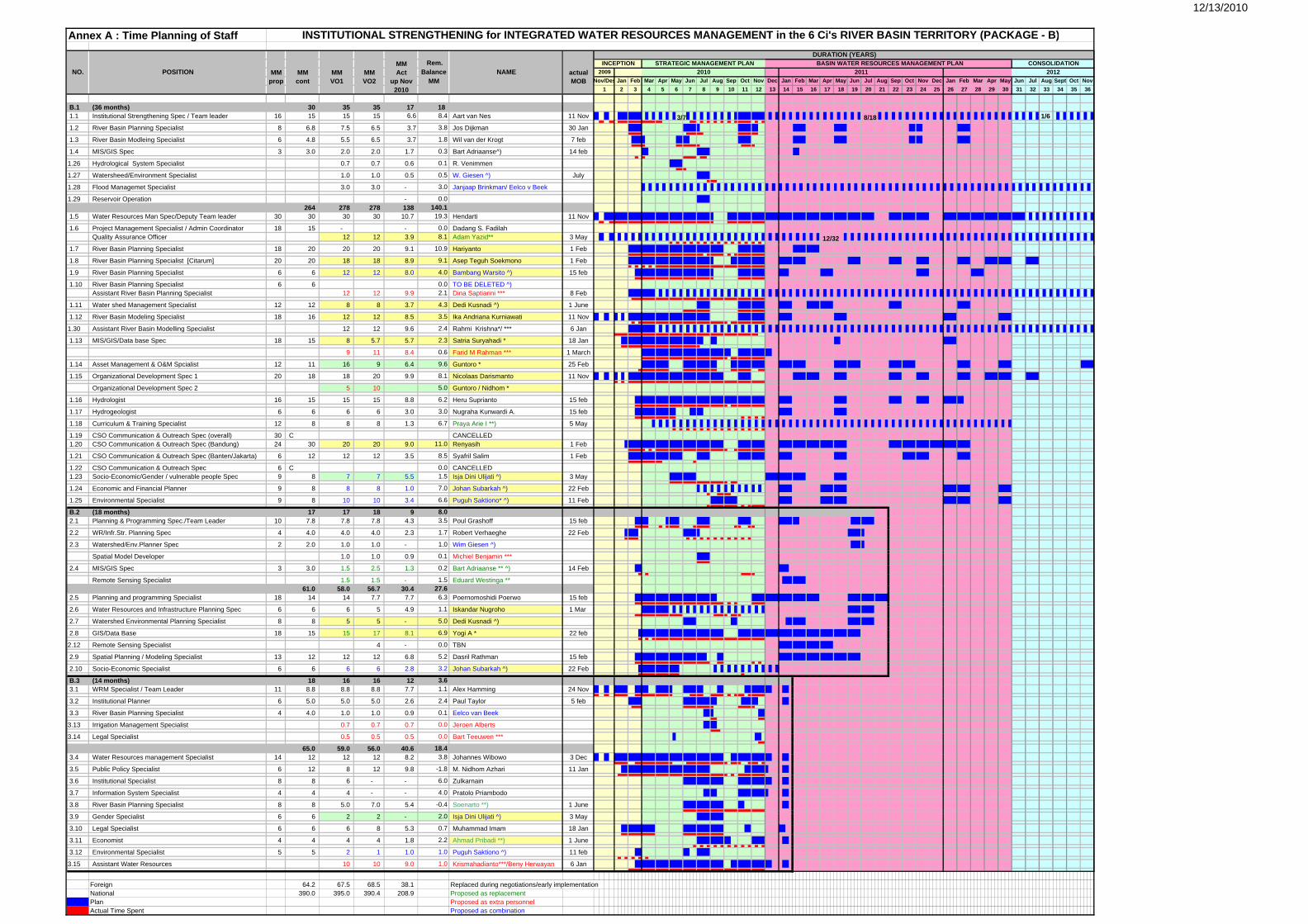
12/13/2010
Annex A : Time Planning of Staff
MMMM MM MM MM Act actual
prop cont VO1 VO2 up Nov MOB2010
B.1 (36 months) 30 35 35 17 18 1.1 Institutional Strengthening Spec / Team leader 16 15 15 15 6.6 8.4 Aart van Nes 11 Nov
1.2 River Basin Planning Specialist 8 6.8 7.5 6.5 3.7 3.8 Jos Dijkman 30 Jan
1.3 River Basin Modleing Specialist 6 4.8 5.5 6.5 3.7 1.8 Wil van der Krogt 7 feb
1.4 MIS/GIS Spec 3 3.0 2.0 2.0 1.7 0.3 Bart Adriaanse^) 14 feb
1.26 Hydrological System Specialist 0.7 0.7 0.6 0.1 R. Venimmen
1.27 Watersheed/Environment Specialist 1.0 1.0 0.5 0.5 W. Giesen ^) July
1.28 Flood Managemet Specialist 3.0 3.0 - 3.0 Janjaap Brinkman/ Eelco v Beek
1.29 Reservoir Operation - 0.0264 278 278 138 140.1
1.5 Water Resources Man Spec/Deputy Team leader 30 30 30 30 10.7 19.3 Hendarti 11 Nov
1.6 Project Management Specialist / Admin Coordinator 18 15 - - 0.0 Dadang S. FadilahQuality Assurance Officer 12 12 3.9 8.1 Adam Yazid** 3 May
1.7 River Basin Planning Specialist 18 20 20 20 9.1 10.9 Hariyanto 1 Feb
1.8 River Basin Planning Specialist [Citarum] 20 20 18 18 8.9 9.1 Asep Teguh Soekmono 1 Feb
1.9 River Basin Planning Specialist 6 6 12 12 8.0 4.0 Bambang Warsito ^) 15 feb
1.10 River Basin Planning Specialist 6 6 0.0 TO BE DELETED ^)Assistant River Basin Planning Specialist 12 12 9.9 2.1 Dina Saptiarini *** 8 Feb
1.11 Water shed Management Specialist 12 12 8 8 3.7 4.3 Dedi Kusnadi ^) 1 June
1.12 River Basin Modeling Specialist 18 16 12 12 8.5 3.5 Ika Andriana Kurniawati 11 Nov
1.30 Assistant River Basin Modelling Specialist 12 12 9.6 2.4 Rahmi Krishna*/ *** 6 Jan
1.13 MIS/GIS/Data base Spec 18 15 8 5.7 5.7 2.3 Satria Suryahadi * 18 Jan
9 11 8.4 0.6 Farid M Rahman *** 1 March
1.14 Asset Management & O&M Spcialist 12 11 16 9 6.4 9.6 Guntoro * 25 Feb
1.15 Organizational Development Spec 1 20 18 18 20 9.9 8.1 Nicolaas Darismanto 11 Nov
Organizational Development Spec 2 5 10 5.0 Guntoro / Nidhom *
1.16 Hydrologist 16 15 15 15 8.8 6.2 Heru Suprianto 15 feb
1.17 Hydrogeologist 6 6 6 6 3.0 3.0 Nugraha Kunwardi A. 15 feb
1.18 Curriculum & Training Specialist 12 8 8 8 1.3 6.7 Praya Arie I **) 5 May
1.19 CSO Communication & Outreach Spec (overall) 30 C CANCELLED 1.20 CSO Communication & Outreach Spec (Bandung) 24 30 20 20 9.0 11.0 Renyasih 1 Feb
1.21 CSO Communication & Outreach Spec (Banten/Jakarta) 6 12 12 12 3.5 8.5 Syafril Salim 1 Feb
1.22 CSO Communication & Outreach Spec 6 C 0.0 CANCELLED 1.23 Socio-Economic/Gender / vulnerable people Spec 9 8 7 7 5.5 1.5 Isja Dini Ulijati ^) 3 May
1.24 Economic and Financial Planner 9 8 8 8 1.0 7.0 Johan Subarkah ^) 22 Feb
1.25 Environmental Specialist 9 8 10 10 3.4 6.6 Puguh Saktiono* ^) 11 Feb
B.2 (18 months) 17 17 18 9 8.0 2.1 Planning & Programming Spec./Team Leader 10 7.8 7.8 7.8 4.3 3.5 Poul Grashoff 15 feb
2.2 WR/Infr.Str. Planning Spec 4 4.0 4.0 4.0 2.3 1.7 Robert Verhaeghe 22 Feb
2.3 Watershed/Env.Planner Spec 2 2.0 1.0 1.0 - 1.0 Wim Giesen ^)
Spatial Model Developer 1.0 1.0 0.9 0.1 Michiel Benjamin ***
2.4 MIS/GIS Spec 3 3.0 1.5 2.5 1.3 0.2 Bart Adriaanse ** ^) 14 Feb
Remote Sensing Specialist 1.5 1.5 - 1.5 Eduard Westinga **61.0 58.0 56.7 30.4 27.6
2.5 Planning and programming Specialist 18 14 14 7.7 7.7 6.3 Poernomoshidi Poerwo 15 feb
2.6 Water Resources and Infrastructure Planning Spec 6 6 6 5 4.9 1.1 Iskandar Nugroho 1 Mar
2.7 Watershed Environmental Planning Specialist 8 8 5 5 - 5.0 Dedi Kusnadi ^)
2.8 GIS/Data Base 18 15 15 17 8.1 6.9 Yogi A * 22 feb
2.12 Remote Sensing Specialist 4 - 0.0 TBN
2.9 Spatial Planning / Modeling Specialist 13 12 12 12 6.8 5.2 Dasril Rathman 15 feb
2.10 Socio-Economic Specialist 6 6 6 6 2.8 3.2 Johan Subarkah ^) 22 Feb
B.3 (14 months) 18 16 16 12 3.6 3.1 WRM Specialist / Team Leader 11 8.8 8.8 8.8 7.7 1.1 Alex Hamming 24 Nov
3.2 Institutional Planner 6 5.0 5.0 5.0 2.6 2.4 Paul Taylor 5 feb
3.3 River Basin Planning Specialist 4 4.0 1.0 1.0 0.9 0.1 Eelco van Beek
3.13 Irrigation Management Specialist 0.7 0.7 0.7 0.0 Jeroen Alberts
3.14 Legal Specialist 0.5 0.5 0.5 0.0 Bart Teeuwen ***
65.0 59.0 56.0 40.6 18.4 3.4 Water Resources management Specialist 14 12 12 12 8.2 3.8 Johannes Wibowo 3 Dec
3.5 Public Policy Specialist 6 12 8 12 9.8 -1.8 M. Nidhom Azhari 11 Jan
3.6 Institutional Specialist 8 8 6 - - 6.0 Zulkarnain
3.7 Information System Specialist 4 4 4 - - 4.0 Pratolo Priambodo
3.8 River Basin Planning Specialist 8 8 5.0 7.0 5.4 -0.4 Soenarto **) 1 June
3.9 Gender Specialist 6 6 2 2 - 2.0 Isja Dini Ulijati ^) 3 May
3.10 Legal Specialist 6 6 6 8 5.3 0.7 Muhammad Imam 18 Jan
3.11 Economist 4 4 4 4 1.8 2.2 Ahmad Pribadi **) 1 June
3.12 Environmental Specialist 5 5 2 1 1.0 1.0 Puguh Saktiono ^) 11 feb
3.15 Assistant Water Resources 10 10 9.0 1.0 Krismahadianto***/Beny Herwayan 6 Jan
Foreign 64.2 67.5 68.5 38.1 Replaced during negotiations/early implementationNational 390.0 395.0 390.4 208.9 Proposed as replacementPlan Proposed as extra personnelActual Time Spent Proposed as combination
INSTITUTIONAL STRENGTHENING for INTEGRATED WATER RESOURCES MANAGEMENT in the 6 Ci's RIVER BASIN TERRITORY (PACKAGE - B)
INCEPTION2009
Feb
3
Jan
2
NO. POSITION NAME
DURATION (YEARS)BASIN WATER RESOURCES MANAGEMENT PLAN
NovNov/Des
1 4
Mar
34
Oct
35
Apr
5 6
May Jun
7
Jul
8
Nov
12
Aug
9
Sep
10
2010Dec
13
Feb
15
2011Jan
14
Oct
11
Aug
21
Mar
16
Apr
17
May
18
Jun
19
Jul
20
Feb
27
Sep
22
Oct
23
Nov
24 25
Dec Jan
26 30 31
Sept
36
Jun Jul
32
Aug
CONSOLIDATION
2012
Rem. Balance
MM
STRATEGIC MANAGEMENT PLAN
Mar
28
Apr
29 33
May
3/7 8/18 1/6
12/32
In Association with: DEMIS B.V. - EUROCONSULT MOTT MACDONALD - SIGNIFICANCE B.V. - PT GEO ISSEC - PT INDEC INTERNUSA PT MULTI AREA CONINDO - PT PPA CONSULTANTS - PT SUPRAHARMONIA CONSULTINDO - PT TERA BUANA MANGGALA JAYA PT TRANS INTRA ASIA - PT WASECO TIRTA - PT WIDYA GRAHA ASANA - PT WIRATMAN & ASSOCIATES
Annex - B
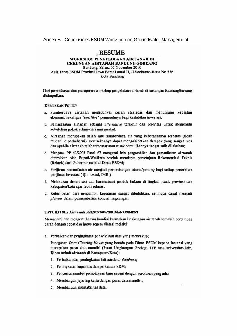
Annex B - Conclusions ESDM Workshop on Groundwater Management

In Association with: DEMIS B.V. - EUROCONSULT MOTT MACDONALD - SIGNIFICANCE B.V. - PT GEO ISSEC - PT INDEC INTERNUSA PT MULTI AREA CONINDO - PT PPA CONSULTANTS - PT SUPRAHARMONIA CONSULTINDO - PT TERA BUANA MANGGALA JAYA PT TRANS INTRA ASIA - PT WASECO TIRTA - PT WIDYA GRAHA ASANA - PT WIRATMAN & ASSOCIATES
Annex - C

Annex C
Reports submitted to ADB
Overall Package B
No Report name Date Abstract 1 Inception Report 30 April 2010 Overview of Activities to be
implemented, Issues and proposed solutions
2 Quarterly Report 1
10 May 2010 Overview of activities implemented during the first semester (Nov 2009 – April 2010)
3 Semi-Annual progress Report
July 2010 Overview of activities implemented during Nov 2009 – June 2010)
4 Quarterly Report 2
1 September 2010
Overview of activities implemented during period May – July 2010)
5 Quarterly Report 3
13 Dec 2010 Overview of activities implemented during period August – October 2010
Sub-Component B.1
No Report name Date Abstract 1 Review of SOP
for Citarum Reservoirs
25 Oct 2010 Result of a rapid assessment of Standard Operation procedures for the cascade of three reservoirs in the Citarum River, with impact on water supply, floods and electricity production.
Sub-Component B.2
No Report Name Date Abstract 1 Methodology
for spatial projections with JSM 2.1
October 2010 Documentation of Methodology: Describes the methodology for spatial projections using the Java Spatial Model version 2.1
2 JSM Explorer 2.1.0 User Manual
October 2010 Describes the user interface JSM explorer of the Java Spatial Model version 2.1
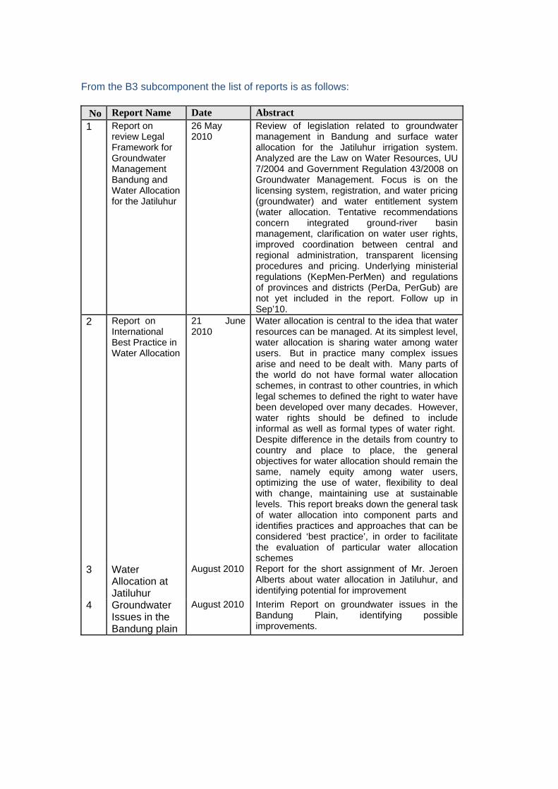
From the B3 subcomponent the list of reports is as follows:
No Report Name Date Abstract 1 Report on
review Legal Framework for Groundwater Management Bandung and Water Allocation for the Jatiluhur
26 May 2010
Review of legislation related to groundwater management in Bandung and surface water allocation for the Jatiluhur irrigation system. Analyzed are the Law on Water Resources, UU 7/2004 and Government Regulation 43/2008 on Groundwater Management. Focus is on the licensing system, registration, and water pricing (groundwater) and water entitlement system (water allocation. Tentative recommendations concern integrated ground-river basin management, clarification on water user rights, improved coordination between central and regional administration, transparent licensing procedures and pricing. Underlying ministerial regulations (KepMen-PerMen) and regulations of provinces and districts (PerDa, PerGub) are not yet included in the report. Follow up in Sep’10.
2 Report on International Best Practice in Water Allocation
21 June 2010
Water allocation is central to the idea that water resources can be managed. At its simplest level, water allocation is sharing water among water users. But in practice many complex issues arise and need to be dealt with. Many parts of the world do not have formal water allocation schemes, in contrast to other countries, in which legal schemes to defined the right to water have been developed over many decades. However, water rights should be defined to include informal as well as formal types of water right. Despite difference in the details from country to country and place to place, the general objectives for water allocation should remain the same, namely equity among water users, optimizing the use of water, flexibility to deal with change, maintaining use at sustainable levels. This report breaks down the general task of water allocation into component parts and identifies practices and approaches that can be considered ‘best practice’, in order to facilitate the evaluation of particular water allocation schemes
3 Water Allocation at Jatiluhur
August 2010 Report for the short assignment of Mr. Jeroen Alberts about water allocation in Jatiluhur, and identifying potential for improvement
4 Groundwater Issues in the Bandung plain
August 2010 Interim Report on groundwater issues in the Bandung Plain, identifying possible improvements.