Embed Size (px)
Citation preview
1 | P a g e
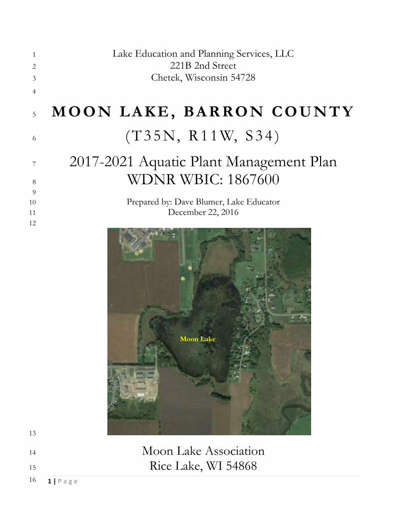
Lake Education and Planning Services, LLC 1
221B 2nd Street 2
Chetek, Wisconsin 54728 3
4
M O O N L A K E , BA R RO N C O U N T Y 5
( T 3 5 N, R 1 1 W, S 3 4 ) 6
2017-2021 Aquatic Plant Management Plan 7
WDNR WBIC: 1867600 8
9
Prepared by: Dave Blumer, Lake Educator 10
December 22, 2016 11
12
13
Moon Lake Association 14
Rice Lake, WI 54868 15
16
Moon Lake

2 | P a g e
1
3 | P a g e
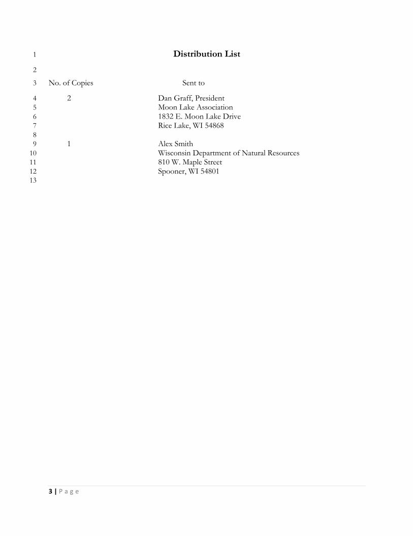
Distribution List 1
2
No. of Copies Sent to 3
2 Dan Graff, President 4
Moon Lake Association 5
1832 E. Moon Lake Drive 6
Rice Lake, WI 54868 7
8
1 Alex Smith 9
Wisconsin Department of Natural Resources 10
810 W. Maple Street 11
Spooner, WI 54801 12
13

4 | P a g e
1
5 | P a g e
Table of Contents 1
INTRODUCTION 11 2
MOON LAKE ASSOCIATION 13 3
PUBLIC PARTICIPATION AND STAKEHOLDER INPUT 14 4
OVERALL MANAGEMENT GOAL 16 5
WISCONSIN’S AQUATIC PLANT MANAGEMENT STRATEGY 18 6
SHALLOW LAKE MANAGEMENT CONSIDERATIONS 19 7
LAKE INVENTORY 21 8
PHYSICAL CHARACTERISTICS 21 9 CRITICAL HABITAT 23 10
WATER QUALITY 25 11
WATER CLARITY 26 12 PHOSPHORUS AND CHLOROPHYLL-A 26 13 TEMPERATURE AND DISSOLVED OXYGEN 27 14
FISHERIES AND WILDLIFE 29 15
FISHERIES 29 16 Aeration (Cornelius 2006) 30 17
WILDLIFE 31 18
ATTRIBUTES TO HELP MAINTAIN A HEALTHY LAKE AND WATERSHED 32 19
WETLANDS 32 20 SOILS 33 21 COARSE WOODY HABITAT (WOLTER 2012) 34 22 SHORELANDS 35 23
Protecting Water Quality 35 24 Natural Shorelands Role in Preventing AIS 36 25 Threats to Shorelands 36 26 Shoreland Preservation and Restoration 36 27
2014 WHOLE LAKE POINT INTERCEPT AQUATIC PLANT SURVEY 38 28
WARM-WATER FULL POINT-INTERCEPT AQUATIC PLANT SURVEY 38 29 WILD RICE 39 30
AQUATIC INVASIVE SPECIES 41 31
NON-NATIVE, AQUATIC INVASIVE PLANT SPECIES 41 32 Eurasian Watermilfoil 41 33 Purple Loosestrife 42 34 Japanese Knotweed 44 35 Reed Canary Grass 45 36 Curly-leaf Pondweed 46 37
NON-NATIVE AQUATIC INVASIVE ANIMAL SPECIES 47 38 Chinese Mystery Snails 47 39 Rusty Crayfish 48 40 Zebra Mussels 49 41
6 | P a g e
AIS PREVENTION STRATEGY 50 1
MANAGEMENT ALTERNATIVES 51 2
NO MANAGEMENT 51 3 HAND-PULLING/MANUAL REMOVAL 52 4 DIVER ASSISTED SUCTION HARVESTING 53 5 MECHANICAL REMOVAL 54 6
Mechanical Harvesting 54 7 Small-Scale Cutting with removal 55 8
BOTTOM BARRIERS AND SHADING 56 9 DREDGING 56 10 DRAWDOWN 57 11 BIOLOGICAL CONTROL 57 12
Types of Biological Controls 57 13 Native Plant Restoration 57 14
CHEMICAL CONTROL 57 15
MANAGEMENT DISCUSSION 59 16
AQUATIC PLANT HARVESTING 60 17 AQUATIC PLANT SURVEYING 62 18 AIS MONITORING 64 19 AERATION 64 20 FISH STOCKING 66 21 WATER QUALITY MONITORING 66 22 INSTALLATION OF A PUBLIC DOCK AT MOON LAKE PARK 66 23 SHORELAND EVALUATION AND IMPROVEMENT 67 24
AQUATIC PL ANT MANAGEMENT GOALS, OBJECTIV ES, AND ACTIONS (APP ENDIX F) 68 25
GOAL 1 - MAINTAIN A HEALTHY LAKE PLANT COMMUNITY 69 26 OBJECTIVE 1: OVER THE COURSE OF THE NEXT FIVE YEARS (2017-21) THE FOLLOWING MEASURES OF A 27 HEALTHY NATIVE AQUATIC PLANT COMMUNITY WILL BE MAINTAINED OR EXCEEDED: 69 28 OBJECTIVE 2: MEASURE THE IMPACTS OF ANNUAL HARVESTING ON NATIVE AQUATIC PLANTS IN THE LAKE. 69 29 OBJECTIVE 3: MEASURE THE FIVE YEAR IMPACT OF AQUATIC PLANT MANAGEMENT COMPLETED ON MOON 30 LAKE. 70 31
GOAL 2 - MANAGE AQUATIC PLANTS TO PROVIDE GREATER LAKE USE AND IMPROVE HABITAT 71 32 OBJECTIVE 1: ESTABLISH A COMMON USE NAVIGATION CHANNEL AROUND THE PERIMETER OF THE LAKE. 71 33 OBJECTIVE 2: ESTABLISH AN OPEN WATER NAVIGATION AREA IN THE CENTER OF MOON LAKE 71 34 OBJECTIVE 3: ESTABLISH RIPARIAN ACCESS LANES FROM PUBLIC ACCESS POINTS AND PROPERTY OWNERS ON 35 MOON LAKE 72 36 OBJECTIVE 4: WORK WITH THE RICE LAKE – LAKE PROTECTION AND REHABILITATION DISTRICT AND TOWN OF 37 RICE LAKE TO DUMP, PICK UP, AND DISPOSE OF HARVESTED AQUATIC VEGETATION FROM MOON LAKE 72 38 OBJECTIVE 4: PREPARE WNDR HARVESTING PERMIT APPLICATIONS TO SUPPORT ANNUAL HARVESTING OF 39 AQUATIC VEGETATION IN MOON LAKE. 72 40 Objective 5: Complete physical removal of aquatic plants in waters <3-ft deep and adjacent to private 41 property. 72 42
GOAL 3 – WORK TO PREVENT THE INTRODUCTION OF NEW AIS 73 43 OBJECTIVE 1 – REDUCE THE CHANCE THAT A NEW AIS IS INTRODUCED INTO MOON LAKE BY AQUATIC PLANT 44 HARVESTING ACTIVITIES. 74 45 OBJECTIVE 2 - REDUCE THE LIKELIHOOD THAT NEW AIS GOES UNDETECTED IN MOON LAKE. 74 46 OBJECTIVE 3 - IMPLEMENT A CLEAN BOATS CLEAN WATERS (CBCW) WATER CRAFT INSPECTION PROGRAM 47 ANNUALLY. 74 48
7 | P a g e
OBJECTIVE 4 – EDUCATE AND INFORM PROPERTY OWNERS AND LAKE USERS ABOUT AIS AND HOW TO 1 IDENTIFY THEM 74 2
GOAL 4 - MONITOR AND MAINTAIN WATER QUALITY 75 3 OBJECTIVE 1 – MONITORING WATER CLARITY AND NUTRIENT LEVELS (TOTAL PHOSPHORUS & CHLOROPHYLL 4 A) IN MOON LAKE ANNUALLY 75 5 OBJECTIVE 2 – COLLECT DISSOLVED OXYGEN AND TEMPERATURE PROFILES MONTHLY THROUGH THE ENTIRE 6 YEAR 75 7
GOAL 5 - RESTORE THE FISH COMMUNITY 76 8 OBJECTIVE 1 – IMPLEMENT MANAGEMENT ACTIONS THAT MAY MAINTAIN OR IMPROVE DISSOLVED OXYGEN 9 LEVELS IN THE LAKE THROUGHOUT THE SEASON 76 10 OBJECTIVE 2 – RE-INSTALL AN AERATION SYSTEM IN MOON LAKE 76 11 OBJECTIVE 3 – RE-STOCK MOON LAKE WITH FISH 77 12
GOAL 6 - IMPROVE PUBLIC RECREATIONAL ACCESS AND NATURE IMMERSION OPPORUNITIES FOR 13 COMMUNITY MEMBERS 78 14
OBJECTIVE 1 – WORK WITH THE CITY OF RICE LAKE AND OTHER ENTITIES TO IMPROVE PUBLIC ACCESS TO 15 MOON LAKE AT THE SOUTH END OF MOON LAKE PARK 79 16 OBJECTIVE 2 – WORK WITH RICE LAKE AREA SCHOOLS TO FIGURE OUT HOW MOON LAKE AND MOON LAKE 17 PARK CAN BE BETTER UTILIZED AS A NATURAL RESOURCE LEARNING TOOL 79 18 OBJECTIVE 3 – EXPLORE FUNDING PROGRAMS THAT MIGHT BE USED TO SUPPORT IMPROVED LAKE ACCESS 19 FOR RECREATIONAL ACTIVITIES, OUTDOOR LEARNING ACTIVITIES, AND HABITAT IMPROVEMENTS 79 20
GOAL 7 - EVALUATE AND IMPROVE THE SHORELAND AROUND MOON LAKE 80 21 OBJECTIVE 1: REDUCE THE AMOUNT OF SHORELAND WITHOUT A NATURAL BUFFER IN PLACE BY THROUGH 22 SHORELAND RESTORATION AND OTHER BEST MANAGEMENT PRACTICES. 80 23
GOAL 8 - ADAPTIVE MANAGEMENT 81 24 OBJECTIVE 1 – IMPLEMENT AS MANY OF THE RECOMMENDATIONS IN THIS APMP AS POSSIBLE OVER THE 25 NEXT FIVE YEARS WITH THE RESOURCES AVAILABLE TO THE MLA 81 26
IMPLEMENTATION AND EVALUATION 82 27
WISCONSIN DEPARTMENT OF NATURAL RESOURCES GRANT PROGRAMS 83 28
AIS PREVENTION AND CONTROL GRANTS 83 29 Education, Prevention and Planning Projects 83 30 Established Population Control Projects 84 31 Maintenance and Containment Projects 84 32
LAKE MANAGEMENT PLANNING GRANTS 84 33 Small Scale Lake Management Projects 85 34 Large Scale Lake Management Projects 85 35
LAKE PROTECTION GRANTS 86 36 Healthy Lakes Projects 86 37
RECREATIONAL BOATING FACILITIES (RBF) GRANTS 86 38 SPORT FISH RESTORATION (SFR) GRANTS 87 39 CITY OF RICE LAKE – CAPITAL IMPROVEMENT PLAN 87 40
WORKS CITED 88 41
42
8 | P a g e
Figures 1
2 Figure 1 – Moon, Rice, and Montanis Lakes (left) (Google Earth 2016); Rice Lake City Limits (right) 3 (City of Rice Lake 2016). 11 4 Figure 2 – Watershield (inset left) and Spiny Hornwort (inset right) in Moon Lake (Hatleli 2014) 15 5 Figure 3 – Photos from Moon Lake Park, circa 2005 (City of Rice Lake 2016) 16 6 Figure 4 – Site of Moon Lake Park and the old Rice Lake Municipal Airport – 1998 USGS aerial 7 photo (left); 2005 USGS aerial after closing (right) (Abandoned & Little-known Airfields: Northern 8 Wisconsin 2016) 17 9 Figure 5- Shallow Lake Alternative States and Stabilizing Mechanisms (Moss, Madgwick and 10 Phillips 1996) 20 11 Figure 6- Moon Lake and Municipal Boundaries (Hatleli 2014) 21 12 Figure 7: Watershed for Moon Lake, Barron County (Gruetzmacher 2016) 22 13 Figure 8 – Sediment type (left) and Watersheild (floating leaf plant) (right) (Hatleli 2014) 23 14 Figure 9 - Trophic status in lakes 25 15 Figure 10: Black and white Secchi disk 26 16 Figure 11: Total Phosphorus and Chlorophyll Graphs (limited data); Summer TSI Values for TP 17 (blue triangle) and Chlorophyll A (green square) (WDNR Lakes 2016) 27 18 Figure 12: Summer thermal stratification 28 19 Figure 13 – Moon Lake fish stiocking history (Cole 2016) 29 20 Figure 14 – 2005 WDNR Boom Shocking Survey results for bass and bluegills in Moon Lake (Cole 21 2016) 30 22 Figure 15 - Surface aspirating aeration system (Cornelius 2006) 31 23 Figure 16: Moon Lake Wetlands (Wetlands Inventory - Wisconsin 2016) 33 24 Figure 17 Hydrologic Soil Group Classification in the Moon Lake Watershed 34 25 Figure 18 Healthy, AIS Resistant Shoreland (left) vs. Shoreland in Poor Condition 37 26 Figure 19: Rake fullness of all plant species (Hatleli 2014). 39 27 Figure 20: Eurasian Watermilfoil 42 28 Figure 21: Purple Loosestrife 44 29 Figure 22: Japanese Knotweed 45 30 Figure 23: Reed Canary Grass 46 31 Figure 24: CLP Plants and Turions 47 32 Figure 25: Chinese Mystery Snails (not from Moon Lake) 48 33 Figure 26: Rusty Crayfish and identifying characteristics 49 34 Figure 27: Zebra Mussels 50 35 Figure 28: Aquatic vegetation manual removal zone 52 36 Figure 29: DASH - Diver Assisted Suction Harvest (Aquacleaner Environmental, 37 http://www.aquacleaner.com/index.html); Many Waters, LLC) 53 38 Figure 30 – 2014 Total Rake Fullness Values for all Point-intercept Survey Points (Hatleli 2014) 59 39 Figure 31 – Moon Lake Park in Rice Lake, WI on the northwest shore of Moon Lake (City of Rice 40 Lake 2016) 60 41 Figure 32 – Moon Lake Proposed Aquatic Plant Harvesting Map (LEAPS, Dec.2016) 61 42 Figure 33 – Aquarius Systems EH-220 Aquatic Plant Harvester with a 5-ft cutting blade and 210 cu.ft 43 cut material storage 62 44 Figure 34 – Aquatic Plant Species most likely to be negatively impacted by a harvesting program 45 (Hatleli 2014) 63 46 Figure 35 – Aquatic Plant Species that may increase as a result of a harvesting program (Hatleli 47 2014) 64 48 Figure 36 – Compressed air aeration system (Cornelius 2006) 65 49 Figure 37 – Public Restroom – Hillsboro, Oregon (left); Observation desk on a small outbuilding 50 (right) (FontanaLakeNC.com) 66 51

9 | P a g e
Figure 38 – Public fishing dock installed at Veterans Landing on Rice Lake (City of Rice Lake 2016)1 67 2
3 4
10 | P a g e
Tables 1
2 Table 1: Physical Characteristics of Moon Lake in Barron County 16 3 Table 2: Values to Measure the Health of the Native Aquatic Plant Community in Moon Lake 20 4 Table 3: AIS Monitoring Timetable 30 5 6
Appendices 7
8
Appendix A: NR 109 & 107 9 Appendix B: NR 19 10 Appendix C: Mechanical/Manual Aquatic Plant Control Application, Form 3200-113 11 Appendix D: 2017 Moon Lake Aquatic Plant Harvesting Plan 12 Appendix E: WDNR Lake Shoreland and Shallows Habitat Monitoring Field Protocol 13 Appendix F: Moon Lake Aquatic Plant Management Goals, Objectives, and Actions 14 Appendix G: Moon Lake Implementation and Funding Matrix 15
16
11 | P a g e
AQUAT I C P L A N T M A N AG E M E N T 1
P L A N - M O O N L A K E 2
PREPARED FOR THE MOON LAKE ASSOCIATION 3
INTRODUCTION 4
Moon Lake is a shallow, 84-acre seepage lake in central Barron County adjacent to Rice Lake and Lake 5 Montanis (Figure 1). Maximum depth varies between 6-8 feet depending on rainfall and groundwater and 6 nearly the entire surface of the lake is covered with aquatic vegetation during the summer, making lake use 7 difficult. In addition, a severe winterkill of fish occurred over the 2013-14 season which the lake has still not 8 recovered from. Moon Lake has a small watershed at about 310 acres and is not connected to either Rice or 9 Montanis lakes through surface water flow. The northwest shore of Moon Lake is included in the Rice Lake 10 city limits, therefore also making it also a part of the Rice Lake – Lake Protection and Rehabilitation District 11 (RL-LPRD). Moon Lake Park and Trail (Area 32, Figure 1) is a significant part of that portion of Moon Lake 12 that is included in the RL-LPRD. As a part of the RL-LPRD, the Moon Lake Association (MLA) has been 13 able to tap into resources available to the District to support its own management planning and 14 implementation. The presence of a City of Rice Lake (City) park increases the potential value of Moon Lake 15 as a community resource, a community resource that in the present state of things is being underutilized. This 16 document highlights what can be done to improve the current condition of the lake, increasing the 17 recreational uses of Moon Lake for the general public, which will in turn improve the resource for property 18 owners living on the lake. 19
20
21 Figure 1 – Moon, Rice, and Montanis Lakes (left) (Google Earth 2016); Rice Lake City Limits (right) 22
(City of Rice Lake 2016). 23
This Aquatic Plant Management Plan (APMP) focuses on the following management actions for the lake: 24 aquatic plant harvesting; aquatic plant monitoring; aquatic invasive species (AIS) monitoring; aeration; fish 25 stocking; water quality monitoring; installation of a public fishing dock and/or public small craft launching 26 dock; and shoreland evaluation and improvement. The success of these management actions requires buy-in 27

12 | P a g e
and support from the City, Wisconsin Department of Natural Resources (WDNR), the RL-LPRD, and of 1 course the MLA. Through the support of these entities, the goals, objectives and actions included in this 2 APMP will make Moon Lake a much more valuable resource now and into the future. 3
4
13 | P a g e
MOON LAKE ASSOCIATION 1
The Moon Lake Association is made up of property owners on the lake. There are 21 different property 2 owners on the lake including the City. While it has been in existence for many years, the MLA has never 3 become a “qualified” lake association as it relates to being eligible for WDNR surface water grants. A 4 qualified lake association has at least 25 members, charges a membership fee, and is incorporated under 5 Chapter 181 in Wis. Statures. Not all the property owners on the lake are members of the MLA so it is 6 difficult to reach the required 25 members, and they have never incorporated. 7 8 The MLA supports water quality testing on the lake as a part of the Citizen Lake Monitoring Network 9 (CLMN) and from 2001-2014 supported the installation and operation of an aerator in the lake. In 2014, the 10 MLA approached the RL-LPRD for support for completing an aquatic plant survey of the entire lake. Then 11 through the RL-LPRD a small-scale lake management planning grant was applied for on their behalf to 12 complete an APMP. In the last few years, membership in the MLA has increased as the recent activities have 13 given property owners some hope that something might be done to improve the conditions of the lake. 14
15
14 | P a g e
PUBLIC PARTICIPATION AND STAKEHOLDER INPU T 1
This current management planning effort on Moon Lake started in 2014 when the MLA completed a 2 whole-lake, point-intercept, aquatic plant survey of the entire lake. Members of the MLA met with the RL-3 LPRD in late 2013 and early 2014 to request funding support for the plant survey. The RL-LPRD and Town 4 of Rice Lake each donated $700 to the MLA and the survey was completed by Aquatic Plant and Habitat 5 Services, LLC (APHS) out of Black Rivers Falls, WI with assistance from members of the MLA. The MLA 6 then approached the RL-LPRD again to ask if they would sponsor a small-scale lake management planning 7 grant on behalf of the MLA so they could use the results of the aquatic plant survey to create an APMP for 8 the lake. 9
In August of 2015, a meeting of the MLA was held to discuss the results of the aquatic plant survey, the 10 concept of working through the RL-LPRD to apply for WDNR grant support, and just what an APMP 11 would do for the lake. More than 20 people were present at the meeting, reflecting the general interest 12 property owners have to get something done. During the meeting, the first activity was to have each member 13 in attendance at the meeting use a map of Moon Lake to indicate all of the areas of concern on the lake and 14 what each individual hoped would be accomplished with a management plan. Each member at the meeting 15 was instructed to work on the map without input from the people sitting around them. Once completed, the 16 results of this activity were discussed. The majority of respondents wanted to have Moon Lake once again 17 look like a lake with at least some open water in the middle of the lake. They were OK with dense aquatic 18 plant growth in the bays and around the edges of the lake, provided there was access to the open water. All 19 wanted to see fish back in the lake. None wanted to see the lake become algae dominated instead of plant 20 dominated. 21
Management alternatives were also discussed during this meeting. According to the results from the 2014 22 aquatic plant survey, the only AIS in the lake were reed canary grass on portions of the shore and a few places 23 with narrow-leaf cattails. Neither of these species is of particular concern and management for them is not 24 proposed. CLP and EWM are two AIS of much greater concern and neither was present in the lake in 2014. 25 The issues of excessive aquatic plant growth are related to several species of native aquatic plants that are 26 particularly dense in the lake: watershield and spiny hornwort (Figure 2). In most cases, the WDNR, who is 27 responsible for issuing permits for aquatic plant control, will not issues permits for chemical management of 28 native plants. Harvesting is usually permitted with an approved APMP, because harvesting typically reduces 29 nuisance and navigation issues caused by the plants, but does not kill the entire plant, allowing it to recover, 30 protecting the habitat. 31
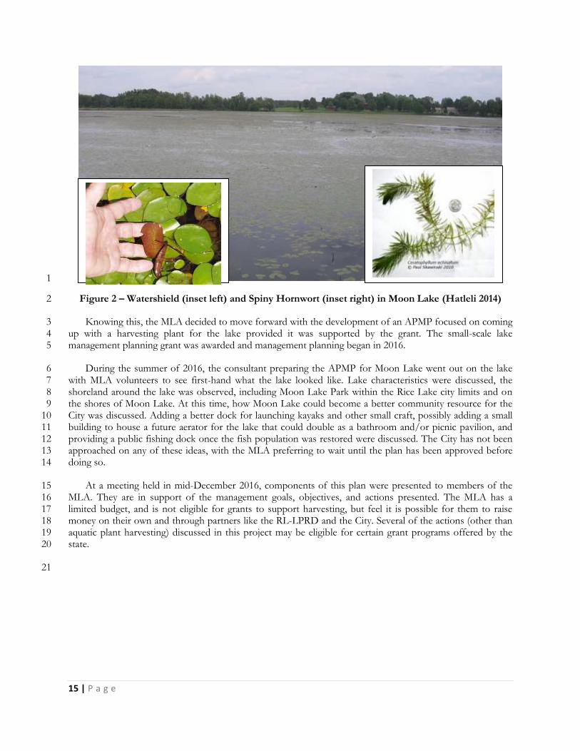
15 | P a g e
1
Figure 2 – Watershield (inset left) and Spiny Hornwort (inset right) in Moon Lake (Hatleli 2014) 2
Knowing this, the MLA decided to move forward with the development of an APMP focused on coming 3 up with a harvesting plant for the lake provided it was supported by the grant. The small-scale lake 4 management planning grant was awarded and management planning began in 2016. 5
During the summer of 2016, the consultant preparing the APMP for Moon Lake went out on the lake 6 with MLA volunteers to see first-hand what the lake looked like. Lake characteristics were discussed, the 7 shoreland around the lake was observed, including Moon Lake Park within the Rice Lake city limits and on 8 the shores of Moon Lake. At this time, how Moon Lake could become a better community resource for the 9 City was discussed. Adding a better dock for launching kayaks and other small craft, possibly adding a small 10 building to house a future aerator for the lake that could double as a bathroom and/or picnic pavilion, and 11 providing a public fishing dock once the fish population was restored were discussed. The City has not been 12 approached on any of these ideas, with the MLA preferring to wait until the plan has been approved before 13 doing so. 14
At a meeting held in mid-December 2016, components of this plan were presented to members of the 15 MLA. They are in support of the management goals, objectives, and actions presented. The MLA has a 16 limited budget, and is not eligible for grants to support harvesting, but feel it is possible for them to raise 17 money on their own and through partners like the RL-LPRD and the City. Several of the actions (other than 18 aquatic plant harvesting) discussed in this project may be eligible for certain grant programs offered by the 19 state. 20
21
16 | P a g e
OVERALL MANAGEMENT G OAL 1
In the last 10-15 years, Moon Lake has become overcome with aquatic vegetation covering nearly 100% 2 of the surface of the lake. At a maximum depth of 6-8 ft. the entire lake is considered littoral zone (area of the 3 lake with sufficient light penetration to grow plants). According to long-time residents on Moon Lake, there 4 used to be much more open water, with one resident stating that he taught his daughter how to waterski on 5 the lake (Graff 2016). 6
Up until a major fish winterkill over the 2013-14 winter which essentially wiped out the entire fish 7 population, Moon Lake was considered a good fishing lake for northern, bass, and panfish, being stocked by 8 the WDNR on a fairly regular basis with both largemouth bass and northern pike. Historically Moon Lake 9 has experienced periodic winterkills, and in 2001, property owners on the lake in cooperation with the 10 WDNR installed a surface aspirating aerator in the lake. Between 2001 and 2014, there was only one minor 11 winterkill in 2003-04. Unfortunately, over this time frame, the growth of aquatic vegetation has expanded. 12 The reasons for this are not easy to determine, but increased fertility caused by surface runoff into the lake 13 and a prolonged period of low water could have contributed. Since the severe winterkill over the 2013-14 14 season the fish population has not been restored. This is due in part because the existing aerator stopped 15 operating broke down near the end of the 2013-14 winter season and has not been repaired and re-installed. 16 Nuisance level aquatic plant growth that covers nearly 100% of the surface area of the lake makes lake use 17 nearly impossible for lake property owners and other lake users. The excessive aquatic plant growth and 18 subsequent decay each year under the ice likely contributes to the lack of oxygen that leads to winterkills. 19 Until something is done to reduce the issues caused by excessive plant growth, the MLA has not willing to 20 reinstall the aerator (Graff 2016). 21
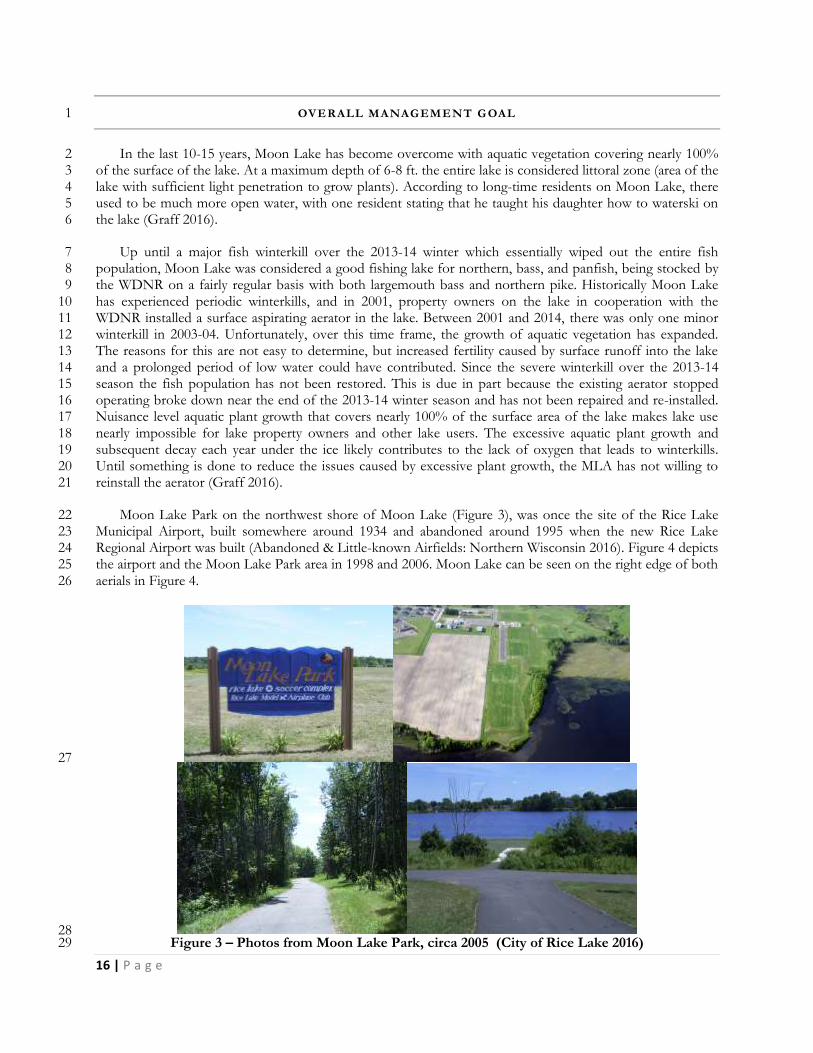
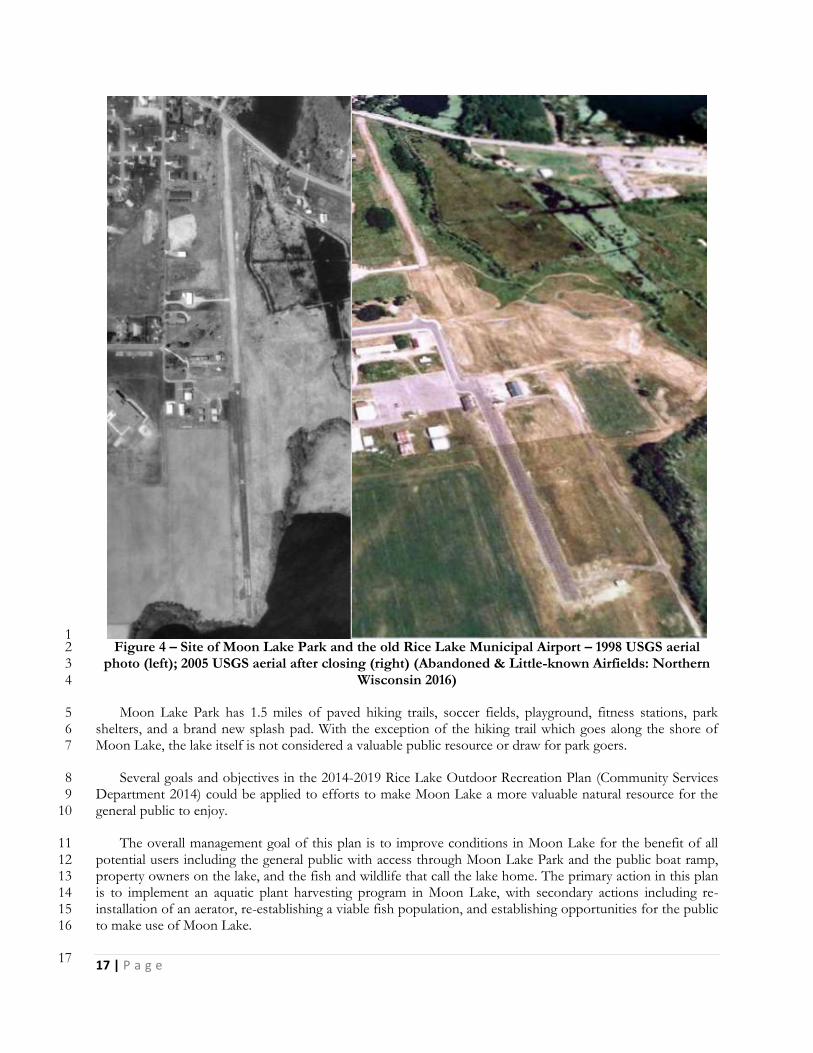
Moon Lake Park on the northwest shore of Moon Lake (Figure 3), was once the site of the Rice Lake 22 Municipal Airport, built somewhere around 1934 and abandoned around 1995 when the new Rice Lake 23 Regional Airport was built (Abandoned & Little-known Airfields: Northern Wisconsin 2016). Figure 4 depicts 24 the airport and the Moon Lake Park area in 1998 and 2006. Moon Lake can be seen on the right edge of both 25 aerials in Figure 4. 26
27
28 Figure 3 – Photos from Moon Lake Park, circa 2005 (City of Rice Lake 2016) 29
17 | P a g e
1 Figure 4 – Site of Moon Lake Park and the old Rice Lake Municipal Airport – 1998 USGS aerial 2
photo (left); 2005 USGS aerial after closing (right) (Abandoned & Little-known Airfields: Northern 3 Wisconsin 2016) 4
Moon Lake Park has 1.5 miles of paved hiking trails, soccer fields, playground, fitness stations, park 5 shelters, and a brand new splash pad. With the exception of the hiking trail which goes along the shore of 6 Moon Lake, the lake itself is not considered a valuable public resource or draw for park goers. 7
Several goals and objectives in the 2014-2019 Rice Lake Outdoor Recreation Plan (Community Services 8 Department 2014) could be applied to efforts to make Moon Lake a more valuable natural resource for the 9 general public to enjoy. 10
The overall management goal of this plan is to improve conditions in Moon Lake for the benefit of all 11 potential users including the general public with access through Moon Lake Park and the public boat ramp, 12 property owners on the lake, and the fish and wildlife that call the lake home. The primary action in this plan 13 is to implement an aquatic plant harvesting program in Moon Lake, with secondary actions including re-14 installation of an aerator, re-establishing a viable fish population, and establishing opportunities for the public 15 to make use of Moon Lake. 16
17
18 | P a g e
WISCONSIN’S AQUATIC PLANT MANAGEMENT STR ATEGY 1
The waters of Wisconsin belong to all people. Their management becomes a balancing act between the 2 rights and demands of the public and those who own property on the water’s edge. This legal tradition called 3 the Public Trust Doctrine dates back hundreds of years in North America and thousands of years in Europe. 4 Its basic philosophy with respect to the ownership of waters was adopted by the American colonies. The US 5 Supreme Court has found that the people of each state hold the right to all their navigable waters for their 6 common use, such as fishing, hunting, boating and the enjoyment of natural scenic beauty. 7
The Public Trust Doctrine is the driving force behind all management in Wisconsin lakes. Protecting and 8 maintaining that resource for all of Wisconsin’s people are at the top of the list in determining what is done 9 and where. In addition to the Public Trust Doctrine, two other forces have converged that reflect Wisconsin’s 10 changing attitudes toward aquatic plants. One is a growing realization of the importance of a strong, diverse 11 community of aquatic plants in a healthy lake ecosystem. The other is a growing concern over the spread of 12 AIS, such as EWM. These two forces have been behind more recent changes in Wisconsin’s aquatic plant 13 management laws and the evolution of stronger support for the control of invasive plants. 14
To some, these two issues may seem in opposition, but on closer examination they actually strengthen 15 the case for developing an Aquatic Plant Management Plan as part of a total lake management picture. 16 Planning is a lot of work, but a sound plan can have long-term benefits for a lake and the community living 17 on and using the lake. 18
The impacts of humans on Wisconsin’s waters over the past five decades have caused public resource 19 professionals in Wisconsin to evolve a certain philosophy toward aquatic plant management. This philosophy 20 stems from the recognition that aquatic plants have value in the ecosystem, as well as from the awareness 21 that, sometimes, excessive growth of aquatic plants can lessen our recreational opportunities and our aesthetic 22 enjoyment of lakes. In balancing these, sometimes competing objectives, the Public Trust Doctrine requires 23 that the State’s public resource professionals be responsible for the management of fish and wildlife resources 24 and their sustainable use to benefit all Wisconsin citizens. Aquatic plants are recognized as a natural resource 25 to protect, manage, and use wisely. 26
Aquatic plant protection begins with human beings. We need to work to maintain good water quality and 27 healthy native aquatic plant communities. The first step is to limit the amount of nutrients and sediment that 28 enter the lake. There are other important ways to safeguard a lake's native aquatic plant community. They may 29 include developing motor boat ordinances that prevent the destruction of native plant beds and reduce 30 shoreline erosion and sediment disturbance caused by boat wakes, limiting aquatic plant removal activities, 31 designating certain plant beds as critical habitat sites and preventing the spread of non-native, invasive plants, 32 such as EWM. 33
If plant management is needed, it is usually in lakes that humans have significantly altered. If we discover 34 how to live on lakes in harmony with natural environments and how to use aquatic plant management 35 techniques that blend with natural processes rather than resist them, the forecast for healthy lake ecosystems 36 looks bright. To assure no harm is done to the lake ecology, it is important that plant management is 37 undertaken as part of a long range and holistic plan. 38
In many cases, the development of long-term, integrated aquatic plant management strategies to identify 39 important plant communities and manage nuisance aquatic plants in lakes, ponds or rivers is required by the 40 State of Wisconsin. To promote the long-term sustainability of our lakes, the State of Wisconsin endorses the 41 development of APMPs and supports that work through various grant programs. 42
43
19 | P a g e
There are many techniques for the management of aquatic plants in Wisconsin. Often management may 1 mean protecting desirable aquatic plants by selectively hand pulling the undesirable ones. Sometimes more 2 intensive management may be needed such as using harvesting equipment, herbicides or biological control 3 agents. These methods require permits and extensive planning. Often using and Integrated Pest Management 4 (IPM) strategy that incorporates multiple management actions/alternatives works the best. 5
While limited management on individual properties is generally permitted, it is widely accepted that a lake 6 will be much better off if plants are considered on a whole lake scale. This is routinely accomplished by lake 7 organizations or units of government charged with the stewardship of individual lakes. 8
SHALLOW LAKE MANAGEMENT CONSIDERATIONS 9
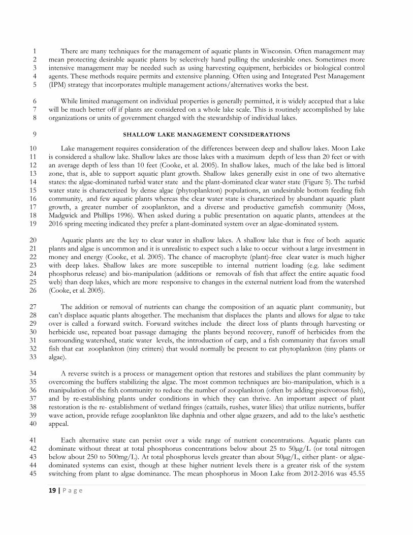
Lake management requires consideration of the differences between deep and shallow lakes. Moon Lake 10 is considered a shallow lake. Shallow lakes are those lakes with a maximum depth of less than 20 feet or with 11 an average depth of less than 10 feet (Cooke, et al. 2005). In shallow lakes, much of the lake bed is littoral 12 zone, that is, able to support aquatic plant growth. Shallow lakes generally exist in one of two alternative 13 states: the algae-dominated turbid water state and the plant-dominated clear water state (Figure 5). The turbid 14 water state is characterized by dense algae (phytoplankton) populations, an undesirable bottom feeding fish 15 community, and few aquatic plants whereas the clear water state is characterized by abundant aquatic plant 16 growth, a greater number of zooplankton, and a diverse and productive gamefish community (Moss, 17 Madgwick and Phillips 1996). When asked during a public presentation on aquatic plants, attendees at the 18 2016 spring meeting indicated they prefer a plant-dominated system over an algae-dominated system. 19
Aquatic plants are the key to clear water in shallow lakes. A shallow lake that is free of both aquatic 20 plants and algae is uncommon and it is unrealistic to expect such a lake to occur without a large investment in 21 money and energy (Cooke, et al. 2005). The chance of macrophyte (plant)-free clear water is much higher 22 with deep lakes. Shallow lakes are more susceptible to internal nutrient loading (e.g. lake sediment 23 phosphorus release) and bio-manipulation (additions or removals of fish that affect the entire aquatic food 24 web) than deep lakes, which are more responsive to changes in the external nutrient load from the watershed 25 (Cooke, et al. 2005). 26
The addition or removal of nutrients can change the composition of an aquatic plant community, but 27 can’t displace aquatic plants altogether. The mechanism that displaces the plants and allows for algae to take 28 over is called a forward switch. Forward switches include the direct loss of plants through harvesting or 29 herbicide use, repeated boat passage damaging the plants beyond recovery, runoff of herbicides from the 30 surrounding watershed, static water levels, the introduction of carp, and a fish community that favors small 31 fish that eat zooplankton (tiny critters) that would normally be present to eat phytoplankton (tiny plants or 32 algae). 33
A reverse switch is a process or management option that restores and stabilizes the plant community by 34 overcoming the buffers stabilizing the algae. The most common techniques are bio-manipulation, which is a 35 manipulation of the fish community to reduce the number of zooplankton (often by adding piscivorous fish), 36 and by re-establishing plants under conditions in which they can thrive. An important aspect of plant 37 restoration is the re- establishment of wetland fringes (cattails, rushes, water lilies) that utilize nutrients, buffer 38 wave action, provide refuge zooplankton like daphnia and other algae grazers, and add to the lake’s aesthetic 39 appeal. 40
Each alternative state can persist over a wide range of nutrient concentrations. Aquatic plants can 41 dominate without threat at total phosphorus concentrations below about 25 to 50µg/L (or total nitrogen 42 below about 250 to 500mg/L). At total phosphorus levels greater than about 50µg/L, either plant- or algae-43 dominated systems can exist, though at these higher nutrient levels there is a greater risk of the system 44 switching from plant to algae dominance. The mean phosphorus in Moon Lake from 2012-2016 was 45.55 45
20 | P a g e
µg/l. The lake is near the margin between moderately nutrient enriched (mesotrophic) and heavily nutrient 1 enriched (eutrophic). 2
Plant diversity also decreases at higher nutrient levels and filamentous algae can be common. Native 3 plants can become a nuisance at high nutrient concentrations as highly competitive species such as coontail 4 and water lilies become dominant. 5
6 Figure 5- Shallow Lake Alternative States and Stabilizing Mechanisms (Moss, Madgwick and 7
Phillips 1996) 8
Fortunately, Moon Lake is in the plant-dominated, clear water state and in-lake restoration is not needed. 9 It is, however, important to identify any switch mechanisms currently in operation and remove them. 10 External and internal nutrient sources should be reduced as much as possible (preferably to < 50 µg/L) to 11 buffer against a forward switch. The fisheries management strategy should be evaluated and plant 12 management only undertaken at levels necessary to maintain lake uses. A well-established plant community, 13 such as found in Moon Lake, can withstand moderate impacts without further active management; however, 14 the lakes and watershed should be monitored for changes and activities that might destabilize the system. 15
16
21 | P a g e
LAKE INVENTORY 1
In order to make recommendations for aquatic plant and lake management, basic information about the 2 water body of concern is necessary. A basic understanding of physical characteristics including size and depth, 3 critical habitat, water quality, water level, fisheries and wildlife, wetlands and soils is needed to make 4 appropriate recommendations for improvement. 5
PHYSICAL CHARACTERISTICS 6
Moon Lake is a seepage lake located in central Barron County, Wisconsin near Rice and Montanis lakes. 7 It is listed as having a surface area of 84 acres, although the total area fluctuates between 74 and 90 acres 8 depending on local rainfall and aquifer condition. The maximum depth ranges from 5 feet to 7 feet 9 depending on natural water level fluctuations. The maximum depth during a 2014 aquatic plant survey was 10 6.5 feet, but in 2016 after a very wet summer it was closer to 8-ft. The lake is situated with half of its shoreline 11 in the City and the other half in the Town of Rice Lake (Figure 6). The City owns a 61-acre parcel along the 12 northern and northwestern shoreline. Moon Lake Park, as this area is called, houses several soccer fields, 13 baseball diamonds, and a paved walking trail along the shores of the lake. The remaining shoreline of the lake 14 is in trust status, LLC status, or in private ownership (Hatleli 2014). 15
16
Figure 6- Moon Lake and Municipal Boundaries (Hatleli 2014) 17
The area of the lake that is part of the City is also considered a part of the RL-LPRD which has given the 18 MLA access to greater resources and even some financial support for management planning actions. 19
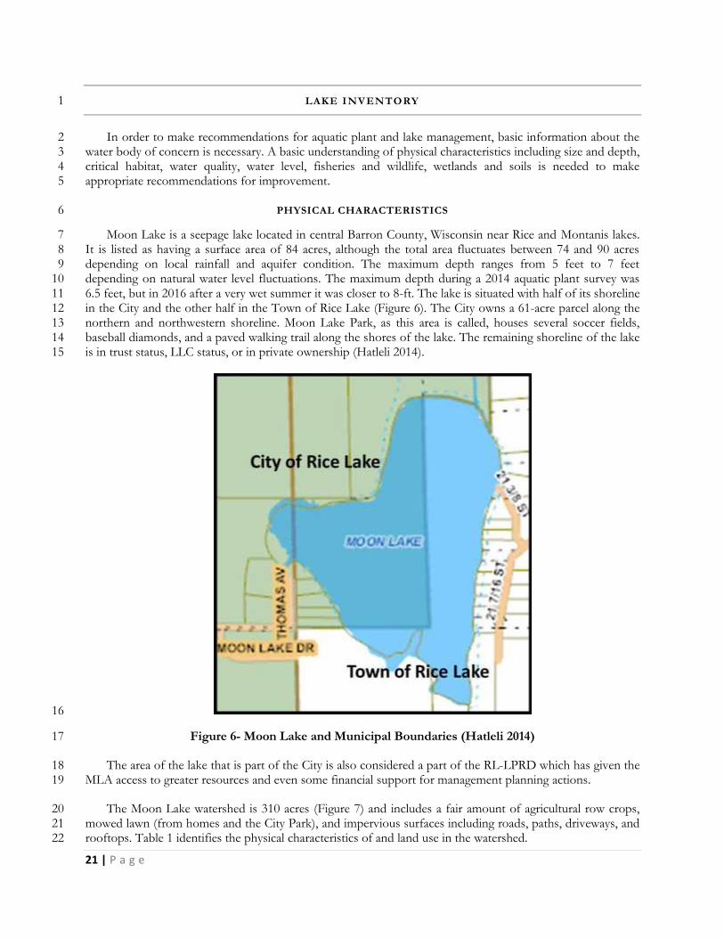
The Moon Lake watershed is 310 acres (Figure 7) and includes a fair amount of agricultural row crops, 20 mowed lawn (from homes and the City Park), and impervious surfaces including roads, paths, driveways, and 21 rooftops. Table 1 identifies the physical characteristics of and land use in the watershed. 22
22 | P a g e
1
Figure 7: Watershed for Moon Lake, Barron County (Gruetzmacher 2016) 2
3
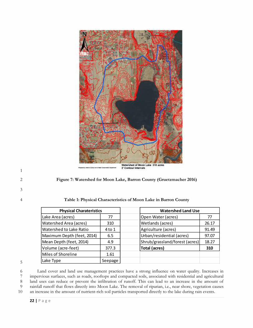
Table 1: Physical Characteristics of Moon Lake in Barron County 4
Lake Area (acres) 77 Open Water (acres) 77
Watershed Area (acres) 310 Wetlands (acres) 26.17
Watershed to Lake Ratio 4 to 1 Agriculture (acres) 91.49
Maximum Depth (feet, 2014) 6.5 Urban/residential (acres) 97.07
Mean Depth (feet, 2014) 4.9 Shrub/grassland/forest (acres) 18.27
Volume (acre-feet) 377.3 Total (acres) 310
Miles of Shoreline 1.61
Lake Type Seepage
Physical Charateristics Watershed Land Use
5
Land cover and land use management practices have a strong influence on water quality. Increases in 6 impervious surfaces, such as roads, rooftops and compacted soils, associated with residential and agricultural 7 land uses can reduce or prevent the infiltration of runoff. This can lead to an increase in the amount of 8 rainfall runoff that flows directly into Moon Lake. The removal of riparian, i.e., near shore, vegetation causes 9 an increase in the amount of nutrient-rich soil particles transported directly to the lake during rain events. 10
23 | P a g e
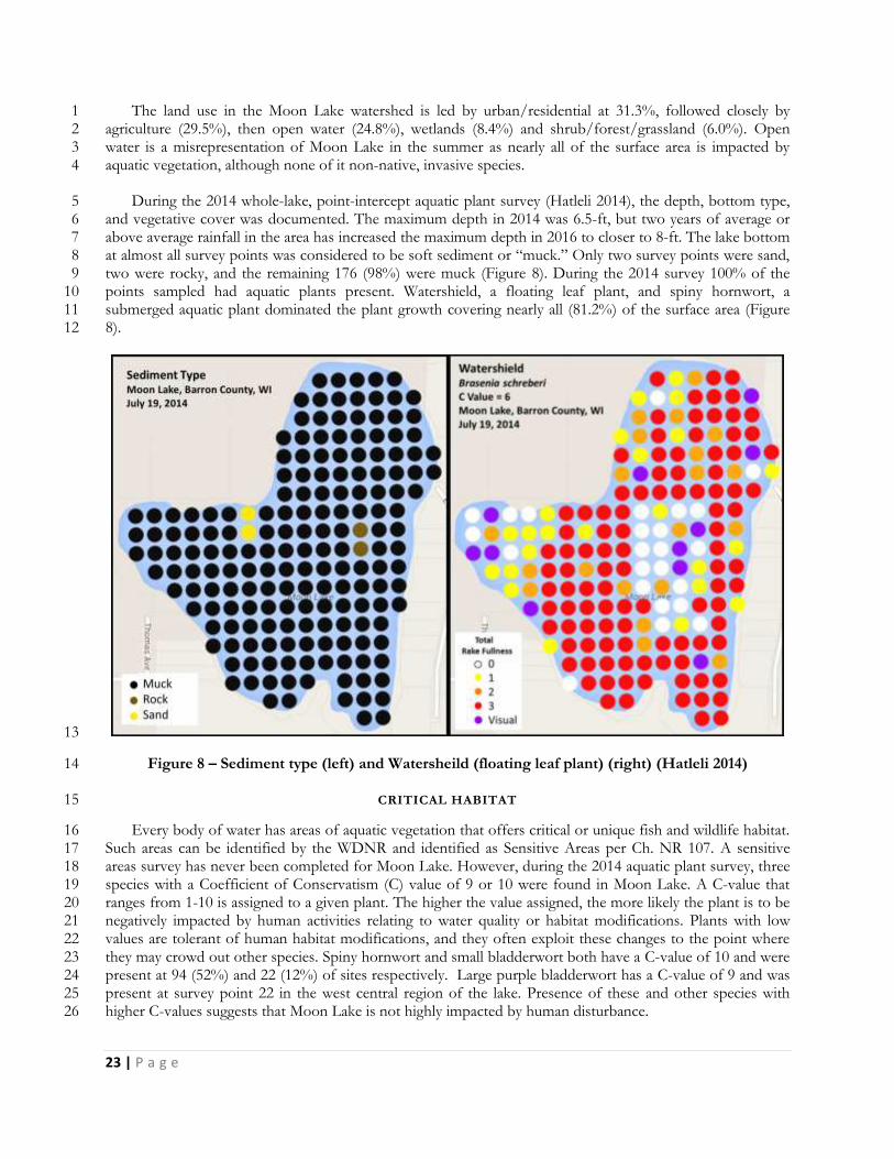
The land use in the Moon Lake watershed is led by urban/residential at 31.3%, followed closely by 1 agriculture (29.5%), then open water (24.8%), wetlands (8.4%) and shrub/forest/grassland (6.0%). Open 2 water is a misrepresentation of Moon Lake in the summer as nearly all of the surface area is impacted by 3 aquatic vegetation, although none of it non-native, invasive species. 4
During the 2014 whole-lake, point-intercept aquatic plant survey (Hatleli 2014), the depth, bottom type, 5 and vegetative cover was documented. The maximum depth in 2014 was 6.5-ft, but two years of average or 6 above average rainfall in the area has increased the maximum depth in 2016 to closer to 8-ft. The lake bottom 7 at almost all survey points was considered to be soft sediment or “muck.” Only two survey points were sand, 8 two were rocky, and the remaining 176 (98%) were muck (Figure 8). During the 2014 survey 100% of the 9 points sampled had aquatic plants present. Watershield, a floating leaf plant, and spiny hornwort, a 10 submerged aquatic plant dominated the plant growth covering nearly all (81.2%) of the surface area (Figure 11 8). 12
13
Figure 8 – Sediment type (left) and Watersheild (floating leaf plant) (right) (Hatleli 2014) 14
CRITICAL HABITAT 15
Every body of water has areas of aquatic vegetation that offers critical or unique fish and wildlife habitat. 16 Such areas can be identified by the WDNR and identified as Sensitive Areas per Ch. NR 107. A sensitive 17 areas survey has never been completed for Moon Lake. However, during the 2014 aquatic plant survey, three 18 species with a Coefficient of Conservatism (C) value of 9 or 10 were found in Moon Lake. A C-value that 19 ranges from 1-10 is assigned to a given plant. The higher the value assigned, the more likely the plant is to be 20 negatively impacted by human activities relating to water quality or habitat modifications. Plants with low 21 values are tolerant of human habitat modifications, and they often exploit these changes to the point where 22 they may crowd out other species. Spiny hornwort and small bladderwort both have a C-value of 10 and were 23 present at 94 (52%) and 22 (12%) of sites respectively. Large purple bladderwort has a C-value of 9 and was 24 present at survey point 22 in the west central region of the lake. Presence of these and other species with 25 higher C-values suggests that Moon Lake is not highly impacted by human disturbance. 26
24 | P a g e
Spiny hornwort, small bladderwort, and Farwell’s milfoil were once on the WDNR Natural Heritage 1 Inventory (NHI) list as “species of special concern.” Email correspondence with Julie Bleser of the WDNR 2 clarified that a comprehensive review of all species on the NHI list was done in 2010, resulting in the removal 3 of these three species from the list in February 2011 (Hatleli 2014). 4
Watershield, Large-leaf pondweed, Illinois pondweed, rushes and spikerush are all species identified in 5 Wisconsin Administrative Code NR 109 as “high value species-known to offer important values in specific 6 aquatic ecosystems.” Watershield was the most frequently occurring species in Moon Lake (146 sites, 81%) 7 while the remaining high value species were present in varying degrees of occurrence (Hatleli 2014). 8
A Natural Heritage Inventory data search for T35N, R11W indicates three communities on the working 9 list: Northern Sedge Meadow, Northern Wet Forest, and Open Bog (WDNR 2016). Although the NHI 10 search indicated there are endangered resources present, they are not legally protected so a full Endangered 11 Resources Review is not required. 12
During Barron County’s lake classification process in 1996, Moon Lake received an average 13 environmental attributes value of 2.5 out of 5.0 with 5.0 being the highest value. Moon Lake scored high (4) 14 as a wildlife lake, but low (1) as a wild lake. It was mid-range for the fishery and water clarity. It received a 15 slightly lower value of 2.4 out of 5.0 for social values with low values (1) for public use and motorized 16 recreation, and higher values (4,3,3) for lake size, public access, and non-motorized recreation. Overall Moon 17 Lake averaged 2.44 making it a Class 3 lake (Barron County Ordinances Governing Land Use and 18 Development 2014). Normally, this would mean a required setback for development of 100-ft, but since the 19 changes in state shoreline zoning laws, the setback for all lakes regardless of class is 75-ft from the ordinary 20 high water mark. 21
22
25 | P a g e
WATER QUALITY 1
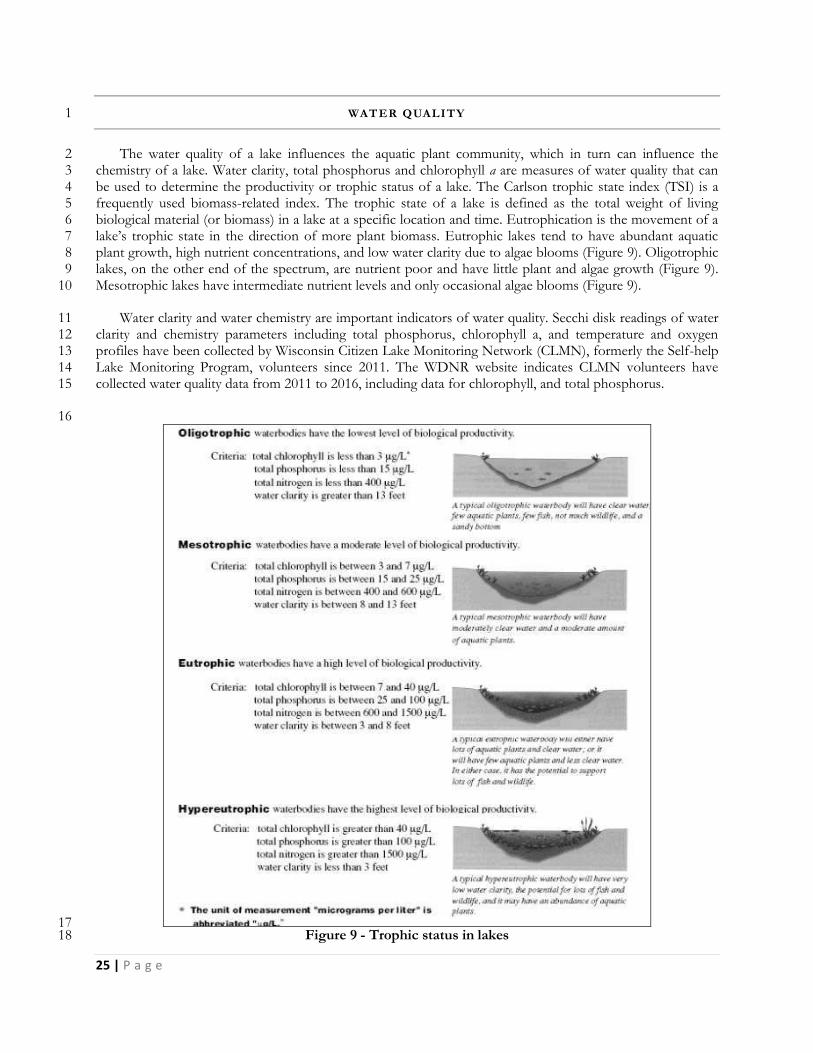
The water quality of a lake influences the aquatic plant community, which in turn can influence the 2 chemistry of a lake. Water clarity, total phosphorus and chlorophyll a are measures of water quality that can 3 be used to determine the productivity or trophic status of a lake. The Carlson trophic state index (TSI) is a 4 frequently used biomass-related index. The trophic state of a lake is defined as the total weight of living 5 biological material (or biomass) in a lake at a specific location and time. Eutrophication is the movement of a 6 lake’s trophic state in the direction of more plant biomass. Eutrophic lakes tend to have abundant aquatic 7 plant growth, high nutrient concentrations, and low water clarity due to algae blooms (Figure 9). Oligotrophic 8 lakes, on the other end of the spectrum, are nutrient poor and have little plant and algae growth (Figure 9). 9 Mesotrophic lakes have intermediate nutrient levels and only occasional algae blooms (Figure 9). 10
Water clarity and water chemistry are important indicators of water quality. Secchi disk readings of water 11 clarity and chemistry parameters including total phosphorus, chlorophyll a, and temperature and oxygen 12 profiles have been collected by Wisconsin Citizen Lake Monitoring Network (CLMN), formerly the Self-help 13 Lake Monitoring Program, volunteers since 2011. The WDNR website indicates CLMN volunteers have 14 collected water quality data from 2011 to 2016, including data for chlorophyll, and total phosphorus. 15
16
17 Figure 9 - Trophic status in lakes 18

26 | P a g e
WATER CLARITY 1
Water clarity is a measurement of how deep sunlight can penetrate into the waters of a lake. It can be 2 measured in a number of ways, the most common being an 8” disk divided into four sections, two black and 3 two white, lowered into the lake water from the surface by a rope marked in measurable increments (Figure 4 10). The water clarity reading is the point at which the Secchi disk when lowered into the water can no longer 5 be seen from the surface of the lake. Water color (like dark water stained by tannins from nearby bogs and 6 wetlands), particles suspended in the water column (like sediment or algae), and weather conditions (cloudy, 7 windy, or sunlight) can impact how far a Secchi disk can be seen down in the water. Some lakes have Secchi 8 disk readings of water clarity of just a few inches, while other lakes have conditions that allow the Secchi disk 9 to be seen for dozens of feet before it disappears from view. 10
11 Figure 10: Black and white Secchi disk 12
13 PHOSPHORUS AND CHLOROPHYLL-A 14
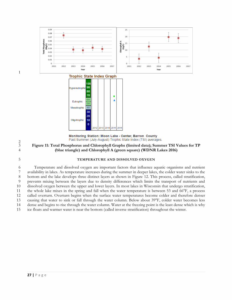
Phosphorus is an important nutrient for plant growth and is commonly the nutrient limiting plant 15 production in Wisconsin lakes. There are many sources of excess phosphorus to lake water including but not 16 limited to farm runoff, roadway runoff, failing septic systems, and decay of grass clippings, leaves, and other 17 lawn debris that end up in the lake. Chlorophyll-a is the green pigment found in plants and algae. The 18 chlorophyll-a concentration is used as a measure of the algal population in a lake. Values greater than 10µg/l 19 are considered indicative of eutrophic conditions and concentrations of 20µg/l or higher are associated with 20 algal blooms. Preference is given to the chlorophyll-a trophic state index for classification because it is the 21 most accurate at predicting algal biomass. Total phosphorus and chlorophyll-a data has been collected at the 22 Deep Hole since 2011. 23
The water quality of Moon Lake is considered “good” with a trophic state index value of 55 based on 24 satellite water clarity data (WDNR Lakes 2016). There are no Secchi disk readings of water clarity on record, 25 however personal communication with the Citizen Lake Monitoring Network volunteer for the lake suggests 26 that the Secchi disk nearly always went to bottom of the lake when readings were taken. The trophic state 27 index is related to the amount of algae in a lake, which is dependent on the amount of nutrients in a lake. 28 Higher levels of nutrients, especially phosphorus, generally lead to greater concentrations of algae, thereby 29 decreasing the water clarity. The mean phosphorus in Moon Lake from 2012-2016 was 45.55 µg/l (Figure 30 11). The mean chlorophyll-a (a measure of the amount of algae present) over the same time frame was 11.82 31 µg/l (Figure 11). The Wisconsin Trophic State Index (WTSI) value for chlorophyll-a in Moon Lake from 32 2012-2016 is 53.47. For Total Phosphorus over the same time frame it is 57.73 (Figure 11). WTSI values for 33 water clarity (based on satellite data), total phosphorus, and chlorophyll-a indicate that Moon Lake is 34 considered eutrophic, meaning it is relatively high in nutrients and supports high biomass. 35
27 | P a g e
1
2 Figure 11: Total Phosphorus and Chlorophyll Graphs (limited data); Summer TSI Values for TP 3
(blue triangle) and Chlorophyll A (green square) (WDNR Lakes 2016) 4
TEMPERATURE AND DISSOLVED OXYGEN 5
Temperature and dissolved oxygen are important factors that influence aquatic organisms and nutrient 6 availability in lakes. As temperature increases during the summer in deeper lakes, the colder water sinks to the 7 bottom and the lake develops three distinct layers as shown in Figure 12. This process, called stratification, 8 prevents mixing between the layers due to density differences which limits the transport of nutrients and 9 dissolved oxygen between the upper and lower layers. In most lakes in Wisconsin that undergo stratification, 10 the whole lake mixes in the spring and fall when the water temperature is between 53 and 66°F, a process 11 called overturn. Overturn begins when the surface water temperatures become colder and therefore denser 12 causing that water to sink or fall through the water column. Below about 39°F, colder water becomes less 13 dense and begins to rise through the water column. Water at the freezing point is the least dense which is why 14 ice floats and warmer water is near the bottom (called inverse stratification) throughout the winter. 15
28 | P a g e
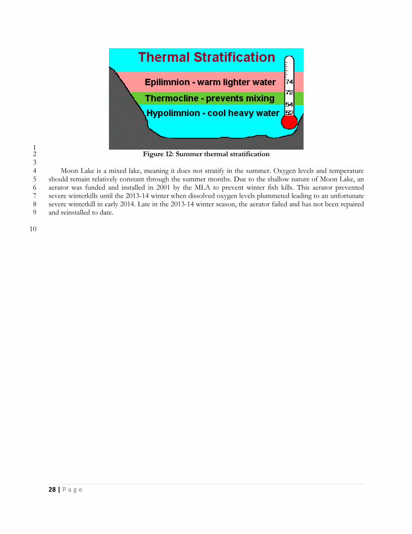
1 Figure 12: Summer thermal stratification 2
3 Moon Lake is a mixed lake, meaning it does not stratify in the summer. Oxygen levels and temperature 4
should remain relatively constant through the summer months. Due to the shallow nature of Moon Lake, an 5 aerator was funded and installed in 2001 by the MLA to prevent winter fish kills. This aerator prevented 6 severe winterkills until the 2013-14 winter when dissolved oxygen levels plummeted leading to an unfortunate 7 severe winterkill in early 2014. Late in the 2013-14 winter season, the aerator failed and has not been repaired 8 and reinstalled to date. 9
10
29 | P a g e
FISHERIES AND WILDLI FE 1
FISHERIES 2
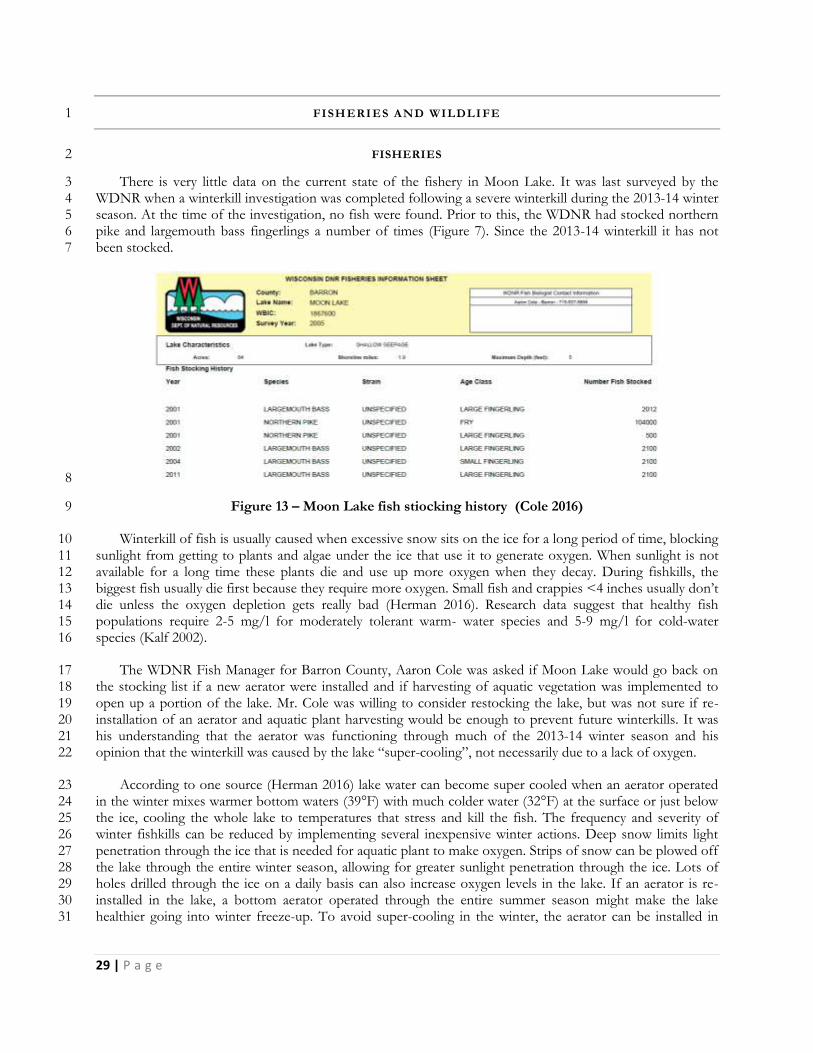
There is very little data on the current state of the fishery in Moon Lake. It was last surveyed by the 3 WDNR when a winterkill investigation was completed following a severe winterkill during the 2013-14 winter 4 season. At the time of the investigation, no fish were found. Prior to this, the WDNR had stocked northern 5 pike and largemouth bass fingerlings a number of times (Figure 7). Since the 2013-14 winterkill it has not 6 been stocked. 7
8
Figure 13 – Moon Lake fish stiocking history (Cole 2016) 9
Winterkill of fish is usually caused when excessive snow sits on the ice for a long period of time, blocking 10 sunlight from getting to plants and algae under the ice that use it to generate oxygen. When sunlight is not 11 available for a long time these plants die and use up more oxygen when they decay. During fishkills, the 12 biggest fish usually die first because they require more oxygen. Small fish and crappies <4 inches usually don’t 13 die unless the oxygen depletion gets really bad (Herman 2016). Research data suggest that healthy fish 14 populations require 2-5 mg/l for moderately tolerant warm- water species and 5-9 mg/l for cold-water 15 species (Kalf 2002). 16
The WDNR Fish Manager for Barron County, Aaron Cole was asked if Moon Lake would go back on 17 the stocking list if a new aerator were installed and if harvesting of aquatic vegetation was implemented to 18 open up a portion of the lake. Mr. Cole was willing to consider restocking the lake, but was not sure if re-19 installation of an aerator and aquatic plant harvesting would be enough to prevent future winterkills. It was 20 his understanding that the aerator was functioning through much of the 2013-14 winter season and his 21 opinion that the winterkill was caused by the lake “super-cooling”, not necessarily due to a lack of oxygen. 22
According to one source (Herman 2016) lake water can become super cooled when an aerator operated 23 in the winter mixes warmer bottom waters (39°F) with much colder water (32°F) at the surface or just below 24 the ice, cooling the whole lake to temperatures that stress and kill the fish. The frequency and severity of 25 winter fishkills can be reduced by implementing several inexpensive winter actions. Deep snow limits light 26 penetration through the ice that is needed for aquatic plant to make oxygen. Strips of snow can be plowed off 27 the lake through the entire winter season, allowing for greater sunlight penetration through the ice. Lots of 28 holes drilled through the ice on a daily basis can also increase oxygen levels in the lake. If an aerator is re-29 installed in the lake, a bottom aerator operated through the entire summer season might make the lake 30 healthier going into winter freeze-up. To avoid super-cooling in the winter, the aerator can be installed in 31
30 | P a g e
shallow water instead of the deep hole, and only operated when oxygen levels start to get low. This means 1 checking dissolved oxygen levels in the lake on a regular basis throughout the open and frozen water seasons. 2
This same source recommends a re-stocking program after a winterkill that releases larger, but fewer 3 adult fish back into the lake rather than large amounts of small fish. Stocking larger fish typically brings the 4 size structure of fish back into balance quicker than adding small fish. 5
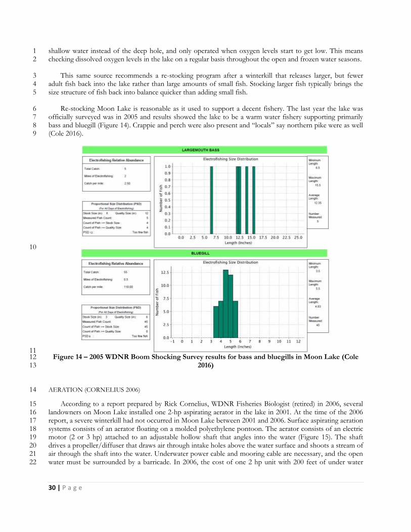
Re-stocking Moon Lake is reasonable as it used to support a decent fishery. The last year the lake was 6 officially surveyed was in 2005 and results showed the lake to be a warm water fishery supporting primarily 7 bass and bluegill (Figure 14). Crappie and perch were also present and “locals” say northern pike were as well 8 (Cole 2016). 9
10
11 Figure 14 – 2005 WDNR Boom Shocking Survey results for bass and bluegills in Moon Lake (Cole 12
2016) 13
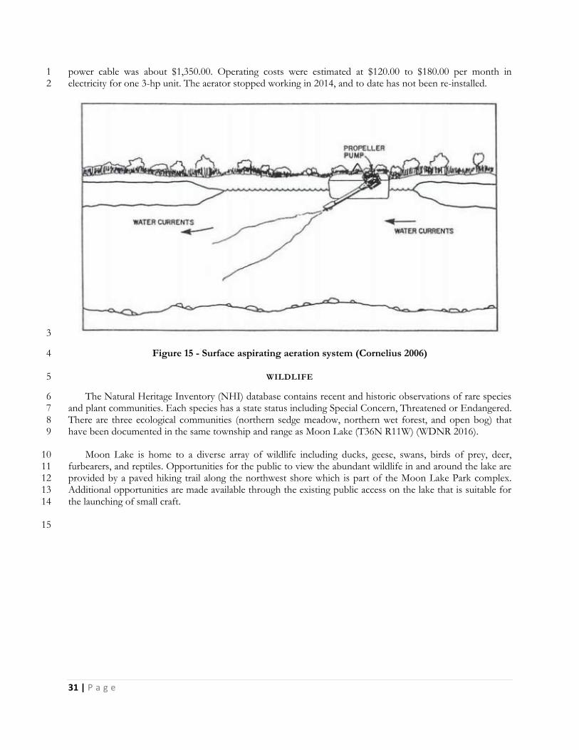
AERATION (CORNELIUS 2006) 14
According to a report prepared by Rick Cornelius, WDNR Fisheries Biologist (retired) in 2006, several 15 landowners on Moon Lake installed one 2-hp aspirating aerator in the lake in 2001. At the time of the 2006 16 report, a severe winterkill had not occurred in Moon Lake between 2001 and 2006. Surface aspirating aeration 17 systems consists of an aerator floating on a molded polyethylene pontoon. The aerator consists of an electric 18 motor (2 or 3 hp) attached to an adjustable hollow shaft that angles into the water (Figure 15). The shaft 19 drives a propeller/diffuser that draws air through intake holes above the water surface and shoots a stream of 20 air through the shaft into the water. Underwater power cable and mooring cable are necessary, and the open 21 water must be surrounded by a barricade. In 2006, the cost of one 2 hp unit with 200 feet of under water 22
31 | P a g e
power cable was about $1,350.00. Operating costs were estimated at $120.00 to $180.00 per month in 1 electricity for one 3-hp unit. The aerator stopped working in 2014, and to date has not been re-installed. 2
3
Figure 15 - Surface aspirating aeration system (Cornelius 2006) 4
WILDLIFE 5
The Natural Heritage Inventory (NHI) database contains recent and historic observations of rare species 6 and plant communities. Each species has a state status including Special Concern, Threatened or Endangered. 7 There are three ecological communities (northern sedge meadow, northern wet forest, and open bog) that 8 have been documented in the same township and range as Moon Lake (T36N R11W) (WDNR 2016). 9
Moon Lake is home to a diverse array of wildlife including ducks, geese, swans, birds of prey, deer, 10 furbearers, and reptiles. Opportunities for the public to view the abundant wildlife in and around the lake are 11 provided by a paved hiking trail along the northwest shore which is part of the Moon Lake Park complex. 12 Additional opportunities are made available through the existing public access on the lake that is suitable for 13 the launching of small craft. 14
15
32 | P a g e
ATTRIBUTES TO HELP M AINTAIN A HEALTHY LA KE AND WATERSHED 1
WETLANDS 2
A wetland is an area where water is at, near or above the land surface long enough to be capable of 3 supporting aquatic or hydrophytic vegetation and which has soils indicative of wet conditions. Wetlands have 4 many functions which benefit the ecosystem surrounding Moon Lake. Wetlands with a higher floral diversity 5 of native species support a greater variety of native plants and are more likely to support regionally scarce 6 plants and plant communities. Wetlands provide fish and wildlife habitat for feeding, breeding, resting, 7 nesting, escape cover, travel corridors, spawning grounds for fish, and nurseries for mammals and waterfowl. 8
Wetlands also provide flood protection within the landscape. Due to the dense vegetation and location 9 within the landscape, wetlands are important for retaining stormwater from rain and melting snow moving 10 towards surface waters and retaining floodwater from rising streams. This flood protection minimizes impacts 11 to downstream areas. Wetlands provide water quality protection because wetland plants and soils have the 12 capacity to store and filter pollutants ranging from pesticides to animal wastes. 13
Wetlands also provide shoreline protection to Moon Lake because shoreline wetlands act as buffers 14 between land and water. They protect against erosion by absorbing the force of waves and currents and by 15 anchoring sediments. This shoreline protection is important in waterways where boat traffic, water current, 16 and wave action cause substantial damage to the shore. Wetlands also provide groundwater recharge and 17 discharge by allowing the surface water to move into and out of the groundwater system. The filtering 18 capacity of wetland plants and substrates help protect groundwater quality. Wetlands can also stabilize and 19 maintain stream flows, especially during dry months. Aesthetics, recreation, education and science are also all 20 services wetlands provide. Wetlands contain a unique combination of terrestrial and aquatic life and physical 21 and chemical processes. 22
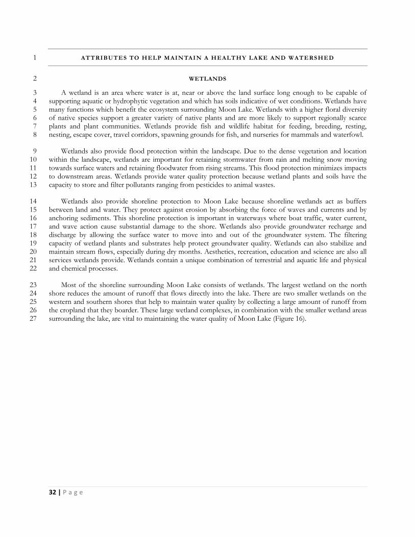
Most of the shoreline surrounding Moon Lake consists of wetlands. The largest wetland on the north 23 shore reduces the amount of runoff that flows directly into the lake. There are two smaller wetlands on the 24 western and southern shores that help to maintain water quality by collecting a large amount of runoff from 25 the cropland that they boarder. These large wetland complexes, in combination with the smaller wetland areas 26 surrounding the lake, are vital to maintaining the water quality of Moon Lake (Figure 16). 27
33 | P a g e
1 Figure 16: Moon Lake Wetlands (Wetlands Inventory - Wisconsin 2016) 2
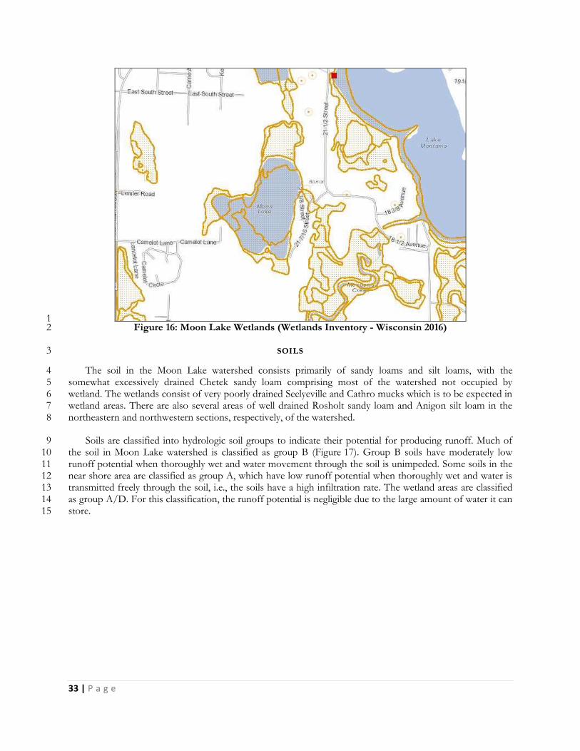
SOILS 3
The soil in the Moon Lake watershed consists primarily of sandy loams and silt loams, with the 4 somewhat excessively drained Chetek sandy loam comprising most of the watershed not occupied by 5 wetland. The wetlands consist of very poorly drained Seelyeville and Cathro mucks which is to be expected in 6 wetland areas. There are also several areas of well drained Rosholt sandy loam and Anigon silt loam in the 7 northeastern and northwestern sections, respectively, of the watershed. 8
Soils are classified into hydrologic soil groups to indicate their potential for producing runoff. Much of 9 the soil in Moon Lake watershed is classified as group B (Figure 17). Group B soils have moderately low 10 runoff potential when thoroughly wet and water movement through the soil is unimpeded. Some soils in the 11 near shore area are classified as group A, which have low runoff potential when thoroughly wet and water is 12 transmitted freely through the soil, i.e., the soils have a high infiltration rate. The wetland areas are classified 13 as group A/D. For this classification, the runoff potential is negligible due to the large amount of water it can 14 store. 15
34 | P a g e
1
Figure 17 Hydrologic Soil Group Classification in the Moon Lake Watershed 2
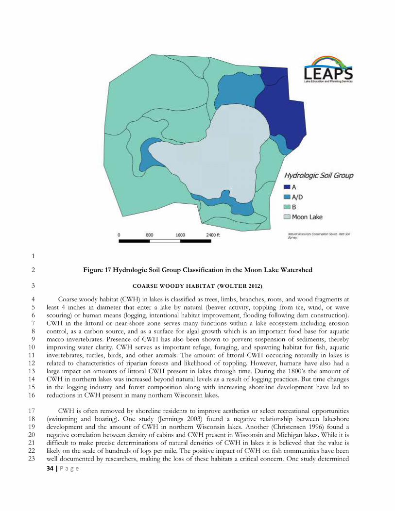
COARSE WOODY HABITAT (WOLTER 2012) 3
Coarse woody habitat (CWH) in lakes is classified as trees, limbs, branches, roots, and wood fragments at 4 least 4 inches in diameter that enter a lake by natural (beaver activity, toppling from ice, wind, or wave 5 scouring) or human means (logging, intentional habitat improvement, flooding following dam construction). 6 CWH in the littoral or near-shore zone serves many functions within a lake ecosystem including erosion 7 control, as a carbon source, and as a surface for algal growth which is an important food base for aquatic 8 macro invertebrates. Presence of CWH has also been shown to prevent suspension of sediments, thereby 9 improving water clarity. CWH serves as important refuge, foraging, and spawning habitat for fish, aquatic 10 invertebrates, turtles, birds, and other animals. The amount of littoral CWH occurring naturally in lakes is 11 related to characteristics of riparian forests and likelihood of toppling. However, humans have also had a 12 large impact on amounts of littoral CWH present in lakes through time. During the 1800’s the amount of 13 CWH in northern lakes was increased beyond natural levels as a result of logging practices. But time changes 14 in the logging industry and forest composition along with increasing shoreline development have led to 15 reductions in CWH present in many northern Wisconsin lakes. 16
CWH is often removed by shoreline residents to improve aesthetics or select recreational opportunities 17 (swimming and boating). One study (Jennings 2003) found a negative relationship between lakeshore 18 development and the amount of CWH in northern Wisconsin lakes. Another (Christensen 1996) found a 19 negative correlation between density of cabins and CWH present in Wisconsin and Michigan lakes. While it is 20 difficult to make precise determinations of natural densities of CWH in lakes it is believed that the value is 21 likely on the scale of hundreds of logs per mile. The positive impact of CWH on fish communities have been 22 well documented by researchers, making the loss of these habitats a critical concern. One study determined 23
35 | P a g e
that black crappie selected nesting sites that were usually associated with woody debris, silty substrate, warmer 1 water, and protected from wind and waves (Pope and Willis 1997). 2
Fortunately, remediation of this habitat type is attainable on many waterbodies, particularly where private 3 landowners and lake associations are willing to partner with county, state, and federal agencies. Large-scale 4 CWH projects are currently being conducted by lake associations and local governments with assistance from 5 the WDNR where hundreds of whole trees are added to the near-shore areas of lakes. For more information 6 on this process visit: http://dnr.wi.gov/topic/fishing/outreach/fishsticks.html (WDNR, Fish sticks: 7 Improving lake habitat 2016). 8
9 SHORELANDS 10
How the shoreline of a lake is managed can have big impacts on the water quality and health of that lake. 11 Natural shorelines prevent polluted runoff from entering lakes, help control flooding and erosion, provide 12 fish and wildlife habitat, may make it harder for AIS to establish themselves, muffle noise from watercraft, 13 and preserve privacy and natural scenic beauty. Many of the values lake front property owners appreciate and 14 enjoy about their properties - natural scenic beauty, tranquility, privacy, relaxation - are enhanced and 15 preserved with good shoreland management. And healthy lakes with good water quality translate into healthy 16 lake front property values. 17
Shorelands may look peaceful, but they are actually the hotbed of activity on a lake. 90% of all living 18 things found in lakes - from fish, to frogs, turtles, insects, birds, and other wildlife - are found along the 19 shallow margins and shores. Many species rely on shorelands for all or part of their life cycles as a source for 20 food, a place to sleep, cover from predators, and to raise their young. Shorelands and shallows are the 21 spawning grounds for fish, nesting sites for birds, and where turtles lay their eggs. There can be as much as 22 500% more species diversity at the water's edge compared to adjoining uplands. 23
Lakes are buffered by shorelands that extend into and away from the lake. These shoreland buffers 24 include shallow waters with submerged plants (like coontail and pondweeds), the water's edge where fallen 25 trees and emergent plants like rushes might be found, and upward onto the land where different layers of 26 plants (low ground cover, shrubs, trees) may lead to the lake. A lake's littoral zone is a term used to describe 27 the shallow water area where aquatic plants can grow because sunlight can penetrate to the lake bottom. 28 Shallow lakes might be composed entirely of a littoral zone. In deeper lakes, plants are limited where they can 29 grow by how deeply light can penetrate the water. 30
Shorelands are critical to a lake’s health. Activities such replacing natural vegetation with lawns, clearing 31 brush and trees, importing sand to make artificial beaches, and installing structures such as piers, can cause 32 water quality decline and change what species can survive in the lake. 33
PROTECTING WATER QUALITY 34
Shoreland buffers slow down rain and snow melt (runoff). Runoff can add nutrients, sediments, and 35 other pollutants into lakes, causing water quality declines. Slowing down runoff will help water soak 36 (infiltrate) into the ground. Water that soaks into the ground is less likely to damage lake quality and recharges 37 groundwater that supplies water to many of Wisconsin's lakes. Slowing down runoff water also reduces 38 flooding, and stabilizes stream flows and lake levels. 39
Shoreland wetlands act like natural sponges trapping nutrients where nutrient-rich wetland sediments and 40 soils support insects, frogs, and other small animals eaten by fish and wildlife. 41
42
36 | P a g e
Shoreland forests act as filters, retainers, and suppliers of nutrients and organic material to lakes. The tree 1 canopy, young trees, shrubs, and forest understory all intercept precipitation, slowing runoff, and contributing 2 to water infiltration by keeping the soil's organic surface layer well-aerated and moist. Forests also slow down 3 water flowing overland, often capturing its sediment load before it can enter a lake or stream. In watersheds 4 with a significant proportion of forest cover, the erosive force of spring snow melts is reduced as snow in 5 forests melts later than snow on open land, and melt water flowing into streams is more evenly distributed. 6 Shoreland trees grow, mature, and eventually fall into lakes where they protect shorelines from erosion, and 7 are an important source of nutrients, minerals and wildlife habitat. 8
NATURAL SHORELANDS ROLE IN PREVENTING AIS 9
In addition to removing essential habitat for fish and wildlife, clearing native plants from shorelines and 10 shallow waters can open up opportunities for invasive species to take over. Like tilling a home garden to 11 prepare it for seeding, clearing shoreland plants exposes bare earth and removes the existing competition (the 12 cleared shoreland plants) from the area. Nature fills a vacuum. While the same native shoreland plants may 13 recover and reclaim their old space, many invasive species possess "weedy" traits that enable them to quickly 14 take advantage of new territory and out-compete natives. 15
The act of weeding creates continual disturbance, which in turn benefits plants that behave like weeds. 16 The modern day practice of mowing lawns is an example of keeping an ecosystem in a constant state of 17 disturbance to the benefit of invasive species like turf grass, dandelions, and clover, all native to Europe. 18 Keeping shoreline intact is a good way to minimize disturbance and minimize opportunities for invasive 19 species to gain a foothold. 20
THREATS TO SHORELANDS 21
When a landowner develops a waterfront lot, many changes may take place including the addition of 22 driveways, houses, decks, garages, sheds, piers, rafts and other structures, wells, septic systems, lawns, sandy 23 beaches and more. Many of these changes result in the compaction of soil and the removal of trees and native 24 plants, as well as the addition of impervious (hard) surfaces, all of which alter the path that precipitation takes 25 to the water. 26
Building too close to the water, removing shoreland plants, and covering too much of a lake shore lot 27 with hard surfaces (such as roofs and driveways) can harm important habitat for fish and wildlife, send more 28 nutrient and sediment runoff into the lake, and cause water quality decline. 29
Changing one waterfront lot in this fashion may not result in a measurable change in the quality of the 30 lake or stream. But cumulative effects when several or many lots are developed in a similar way can be 31 enormous. A lake’s response to stress depends on what condition the system is in to begin with, but bit by 32 bit, the cumulative effects of tens of thousands of waterfront property owners "cleaning up" their shorelines, 33 are destroying the shorelands that protect their lakes. Increasing shoreline development and development 34 throughout the lake's watershed can have undesired cumulative effects. 35
SHORELAND PRESERVATION AND RESTORATION 36
If a native buffer of shoreland plants exists on a given property, it can be preserved and care taken to 37 minimize impacts when future lake property projects are contemplated. If a shoreline has been altered, it can 38 be restored. Shoreline restoration involves recreating buffer zones of natural plants and trees. Not only do 39 quality wild shorelines create higher property values, but they bring many other values too. Some of these are 40 aesthetic in nature, while others are essential to a healthy ecosystem. Healthy shorelines mean healthy fish 41
37 | P a g e
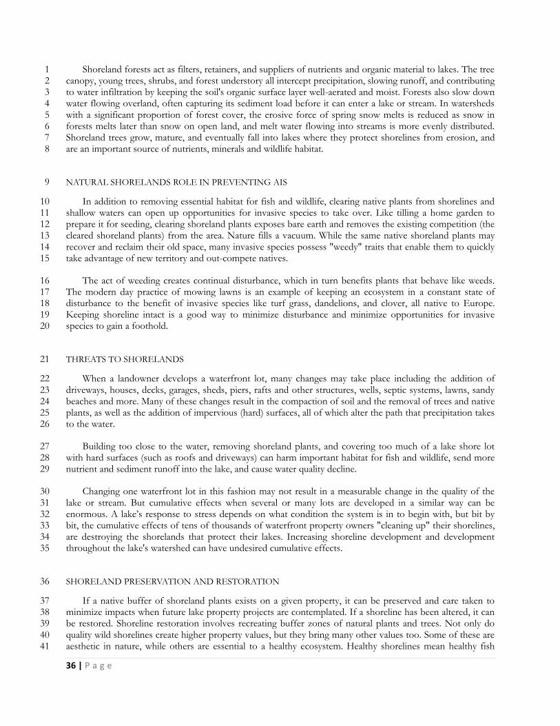
populations, varied plant life, and the existence of the insects, invertebrates and amphibians which feed fish, 1 birds and other creatures. Figure 18 shows the difference between a natural and unnatural shoreline adjacent 2 to a lake home. More information about healthy shorelines can be found at the following website: 3 http://wisconsinlakes.org/index.php/shorelands-a-shallows (last accessed 12-2-2016). 4
5
6 7
Figure 18 Healthy, AIS Resistant Shoreland (left) vs. Shoreland in Poor Condition 8
Much of the shoreline of Moon Lake is natural however where development is greater, improvements to 9 the shoreline would help maintain water quality in the lake. Turf grass, mowed lawns to the edge of the lake, 10 exposed earth, and rip rap increase the amount of runoff from roof tops, driveways, lawns and pathways to 11 the lake. The WDNR encourages the installation of relatively simple best management practices including rain 12 gardens, native plantings, and runoff diversion projects through its Healthy Lakes Initiative (WDNR, Healthy 13 Lakes Wisconsin 2016). 14
15
38 | P a g e
2014 WHOLE LAKE POINT INT ERCEPT AQUATIC PLANT SURVEY 1
In 2014, a whole lake point intercept aquatic plant survey was completed to create base data for the 2 aquatic plant community in Moon Lake. This survey also collected data on the dominant sediment type for 3 each of the points. 4
WARM-WATER FULL POINT-INTERCEPT AQUATIC PLANT SURVEY 5
All data in this section is taken from the 2014 Aquatic Plant Survey Report created by Aquatic Plant & 6 Habitat Services, LLC (Hatleli 2014). The Moon Lake point-intercept (PI) survey grid contains 181 points, 7 but one point was not surveyed due to inaccessibility caused by shallow water (less than 0.5ft). Moon Lake is 8 a seepage lake which means there are no inlets or outlets and the primary water source for Moon Lake is 9 precipitation. Seasonal changes in rainfall and snow melt can cause the depth and size of the lake to change 10 fairly quickly. At the time of this survey, the deepest point in Moon Lake was measured to be 6.5 feet while in 11 2016, was measured to be just over 8 feet deep. The shallow nature of Moon Lake produces a littoral zone 12 (area where plants area able to grow) that encompasses the entire lake (Figure 19). 13
The bottom type was surveyed at every site on the lake. At 176, or 98%, of the points collected the 14 sediment consisted of decomposing organic materials more commonly referred to as muck. The remaining 15 2% was made up of 1% rock, and 1% sand. 16
Plants were found growing at all 180 of the points surveyed. The entire lake had very dense vegetation 17 with average rake fullness of 2.79. At 151 points or 84%, the total rake fullness was 3 while only 8 points or 18 4% had a total rake fullness of 1. There were no points with total rake fullness less than 1 (Figure 19). 19
Plant diversity was remarkably high with a Simpson Diversity Index value of 0.83. Species richness was 20 also relatively high with 31 total species found growing in lake. Only three of these species were “visual only” 21 (meaning they could be seen within 6 ft. of the boat, but never appeared on the rake.) Richness at each 22 individual site tended to be quite high as a mean of 2.78 native species was found at each site. 23

39 | P a g e
1 Figure 19: Rake fullness of all plant species (Hatleli 2014). 2
The Floristic Quality Index (FQI) measures the impact of human development on an area’s aquatic 3 plants. The 124 species in the index are assigned a Coefficient of Conservatism (C) which ranges from 1-10. 4 The higher the value assigned, the more likely the plant is to be negatively impacted by human activities 5 relating to water quality or habitat modifications. Plants with low values are tolerant of human habitat 6 modifications, and they often exploit these changes to the point where they may crowd out other species. 7 The FQI is calculated by averaging the conservatism value for each native index species found in the lake 8 during the point-intercept survey, and multiplying it by the square root of the total number of plant species 9 (N) in the lake (FQI=(Σ(c1+c2+c3+…cn)/N)*√N). Statistically speaking, the higher the index value, the 10 healthier the lake’s macrophyte community is assumed to be. Nichols (Nichols 1999) identified four eco-11 regions in Wisconsin: Northern Lakes and Forests, Northern Central Hardwood Forests, Driftless Area and 12 Southeastern Wisconsin Till Plain. He recommended making comparisons of lakes within ecoregions to 13 determine the target lake’s relative diversity and health. The values generated on Moon Lake, which is in the 14 Northern Central Hardwood Forests Ecoregion, put Moon Lake above the mean for lakes in this region. 15
While these values show a healthy and diverse native plant community, there were three species which 16 account for 64% of this community, Watershield, spiny hornwort, and leafy pondweed. This suggests a fairly 17 homogenized population of plants. Of these three species, spiny hornwort has a conservatism value of 10, 18 and was present at 52% of the sites surveyed. This high conservatism value paired with the high frequency 19 suggests that the plant community in Moon Lake is not currently heavily impacted by human activity. 20
WILD RICE 21
Wild rice is an aquatic grass which grows in shallow water in lakes and slow flowing streams. This grass 22 produces a seed which is a nutritious source of food for wildlife and people. The seed matures in August and 23

40 | P a g e
September with the ripe seed dropping into the sediment, unless harvested by wildlife or people. It is a highly 1 protected and valued natural resource in Wisconsin. Only Wisconsin residents may harvest wild rice in the 2 state. According to the WDNR Surface Water Data Viewer, Moon Lake is not wild rice water. The 2014 3 whole-lake point-intercept, aquatic plant surveys confirm this designation, as no wild rice was found in this 4 survey, and it has never been found in any of the other survey work completed on the lake. 5
6
41 | P a g e
AQUATIC INVASIVE SPE CIES 1
Within Moon Lake, there is no evidence of non-native invasive plant species. As of 2009, it has been 2 documented that Chinese mystery snails are present within the lake, but the extent and viability of this 3 population is unknown at this time. The 2014, survey noticed the presence of reed canary grass and narrow-4 leaved cattail in the wetland areas that boarder Moon Lake, but these were not large monocultures that have 5 dominated the area. 6
NON-NATIVE, AQUATIC INVASIVE PLANT SPECIES 7
There is no indication of invasive plant species such as Eurasian water milfoil or CLP within the lake. 8 However in wetland areas surrounding the lake reed canary grass and Narrow-leaved cattail have been seen. 9 These populations are not dominating the wetlands they can be found in, so while they should be continually 10 monitored, they are not presenting a large threat to the wetland ecosystems they are present in. 11
EURASIAN WATERMILFOIL 12
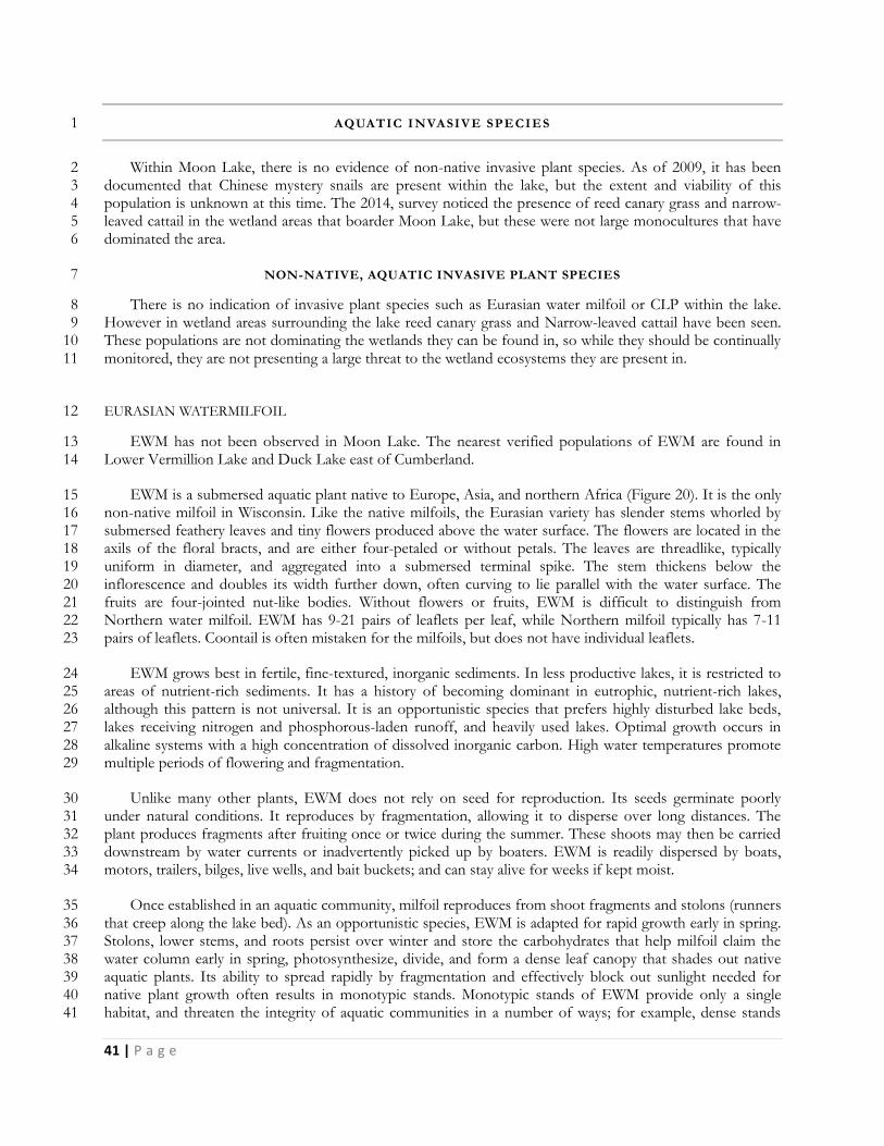
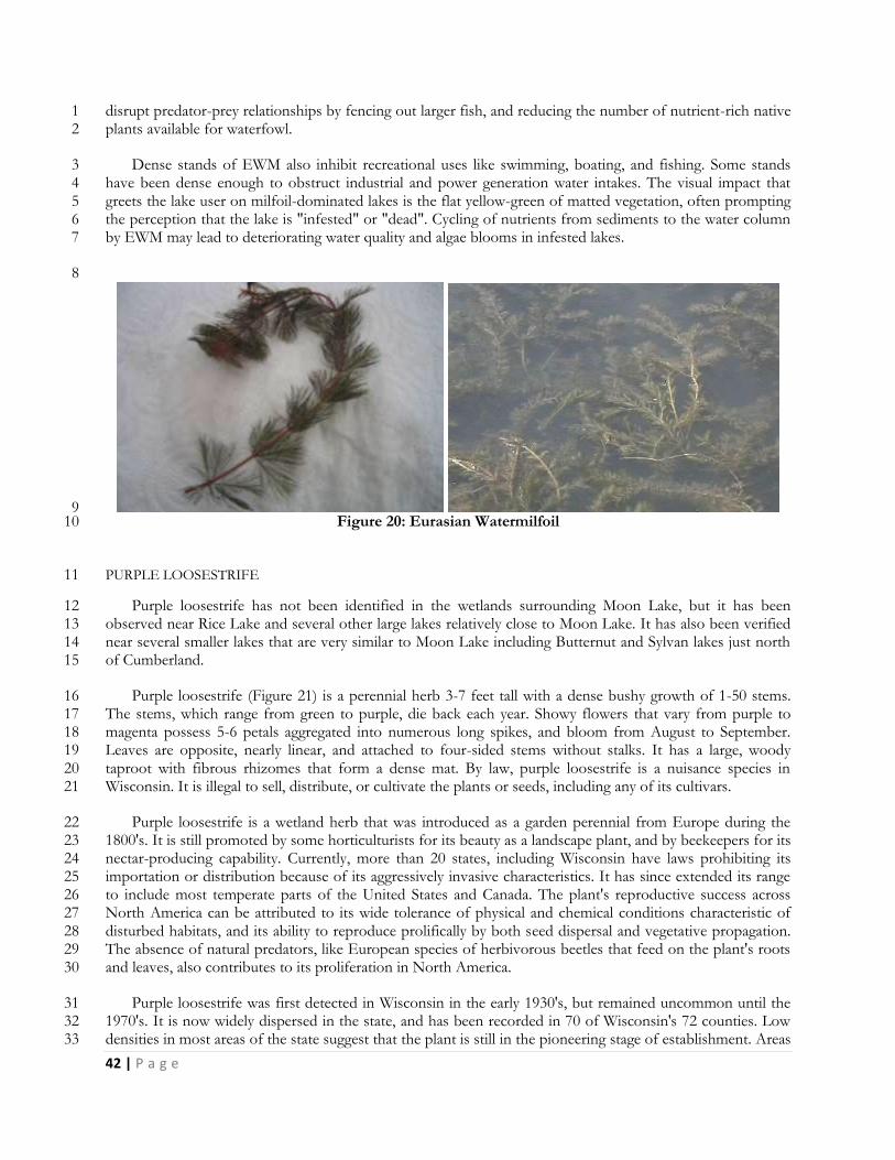
EWM has not been observed in Moon Lake. The nearest verified populations of EWM are found in 13 Lower Vermillion Lake and Duck Lake east of Cumberland. 14
EWM is a submersed aquatic plant native to Europe, Asia, and northern Africa (Figure 20). It is the only 15 non-native milfoil in Wisconsin. Like the native milfoils, the Eurasian variety has slender stems whorled by 16 submersed feathery leaves and tiny flowers produced above the water surface. The flowers are located in the 17 axils of the floral bracts, and are either four-petaled or without petals. The leaves are threadlike, typically 18 uniform in diameter, and aggregated into a submersed terminal spike. The stem thickens below the 19 inflorescence and doubles its width further down, often curving to lie parallel with the water surface. The 20 fruits are four-jointed nut-like bodies. Without flowers or fruits, EWM is difficult to distinguish from 21 Northern water milfoil. EWM has 9-21 pairs of leaflets per leaf, while Northern milfoil typically has 7-11 22 pairs of leaflets. Coontail is often mistaken for the milfoils, but does not have individual leaflets. 23
EWM grows best in fertile, fine-textured, inorganic sediments. In less productive lakes, it is restricted to 24 areas of nutrient-rich sediments. It has a history of becoming dominant in eutrophic, nutrient-rich lakes, 25 although this pattern is not universal. It is an opportunistic species that prefers highly disturbed lake beds, 26 lakes receiving nitrogen and phosphorous-laden runoff, and heavily used lakes. Optimal growth occurs in 27 alkaline systems with a high concentration of dissolved inorganic carbon. High water temperatures promote 28 multiple periods of flowering and fragmentation. 29
Unlike many other plants, EWM does not rely on seed for reproduction. Its seeds germinate poorly 30 under natural conditions. It reproduces by fragmentation, allowing it to disperse over long distances. The 31 plant produces fragments after fruiting once or twice during the summer. These shoots may then be carried 32 downstream by water currents or inadvertently picked up by boaters. EWM is readily dispersed by boats, 33 motors, trailers, bilges, live wells, and bait buckets; and can stay alive for weeks if kept moist. 34
Once established in an aquatic community, milfoil reproduces from shoot fragments and stolons (runners 35 that creep along the lake bed). As an opportunistic species, EWM is adapted for rapid growth early in spring. 36 Stolons, lower stems, and roots persist over winter and store the carbohydrates that help milfoil claim the 37 water column early in spring, photosynthesize, divide, and form a dense leaf canopy that shades out native 38 aquatic plants. Its ability to spread rapidly by fragmentation and effectively block out sunlight needed for 39 native plant growth often results in monotypic stands. Monotypic stands of EWM provide only a single 40 habitat, and threaten the integrity of aquatic communities in a number of ways; for example, dense stands 41
42 | P a g e
disrupt predator-prey relationships by fencing out larger fish, and reducing the number of nutrient-rich native 1 plants available for waterfowl. 2
Dense stands of EWM also inhibit recreational uses like swimming, boating, and fishing. Some stands 3 have been dense enough to obstruct industrial and power generation water intakes. The visual impact that 4 greets the lake user on milfoil-dominated lakes is the flat yellow-green of matted vegetation, often prompting 5 the perception that the lake is "infested" or "dead". Cycling of nutrients from sediments to the water column 6 by EWM may lead to deteriorating water quality and algae blooms in infested lakes. 7
8
9 Figure 20: Eurasian Watermilfoil 10
PURPLE LOOSESTRIFE 11
Purple loosestrife has not been identified in the wetlands surrounding Moon Lake, but it has been 12 observed near Rice Lake and several other large lakes relatively close to Moon Lake. It has also been verified 13 near several smaller lakes that are very similar to Moon Lake including Butternut and Sylvan lakes just north 14 of Cumberland. 15
Purple loosestrife (Figure 21) is a perennial herb 3-7 feet tall with a dense bushy growth of 1-50 stems. 16 The stems, which range from green to purple, die back each year. Showy flowers that vary from purple to 17 magenta possess 5-6 petals aggregated into numerous long spikes, and bloom from August to September. 18 Leaves are opposite, nearly linear, and attached to four-sided stems without stalks. It has a large, woody 19 taproot with fibrous rhizomes that form a dense mat. By law, purple loosestrife is a nuisance species in 20 Wisconsin. It is illegal to sell, distribute, or cultivate the plants or seeds, including any of its cultivars. 21
Purple loosestrife is a wetland herb that was introduced as a garden perennial from Europe during the 22 1800's. It is still promoted by some horticulturists for its beauty as a landscape plant, and by beekeepers for its 23 nectar-producing capability. Currently, more than 20 states, including Wisconsin have laws prohibiting its 24 importation or distribution because of its aggressively invasive characteristics. It has since extended its range 25 to include most temperate parts of the United States and Canada. The plant's reproductive success across 26 North America can be attributed to its wide tolerance of physical and chemical conditions characteristic of 27 disturbed habitats, and its ability to reproduce prolifically by both seed dispersal and vegetative propagation. 28 The absence of natural predators, like European species of herbivorous beetles that feed on the plant's roots 29 and leaves, also contributes to its proliferation in North America. 30
Purple loosestrife was first detected in Wisconsin in the early 1930's, but remained uncommon until the 31 1970's. It is now widely dispersed in the state, and has been recorded in 70 of Wisconsin's 72 counties. Low 32 densities in most areas of the state suggest that the plant is still in the pioneering stage of establishment. Areas 33
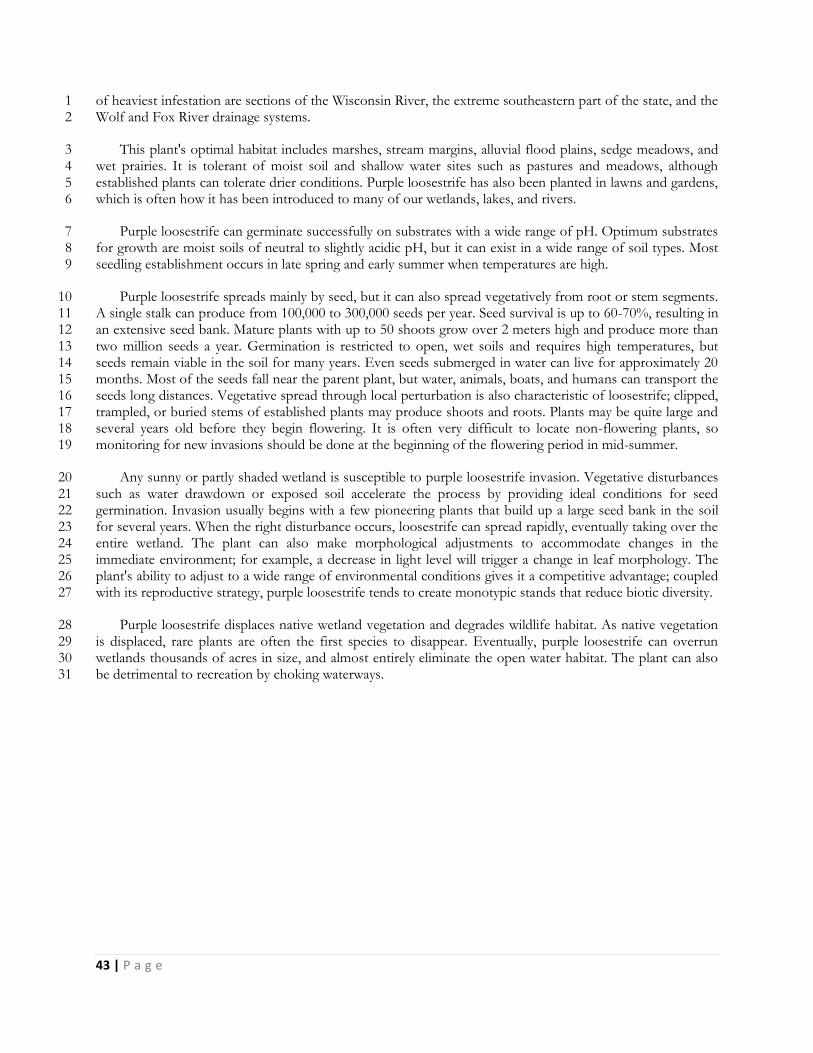
43 | P a g e
of heaviest infestation are sections of the Wisconsin River, the extreme southeastern part of the state, and the 1 Wolf and Fox River drainage systems. 2
This plant's optimal habitat includes marshes, stream margins, alluvial flood plains, sedge meadows, and 3 wet prairies. It is tolerant of moist soil and shallow water sites such as pastures and meadows, although 4 established plants can tolerate drier conditions. Purple loosestrife has also been planted in lawns and gardens, 5 which is often how it has been introduced to many of our wetlands, lakes, and rivers. 6
Purple loosestrife can germinate successfully on substrates with a wide range of pH. Optimum substrates 7 for growth are moist soils of neutral to slightly acidic pH, but it can exist in a wide range of soil types. Most 8 seedling establishment occurs in late spring and early summer when temperatures are high. 9
Purple loosestrife spreads mainly by seed, but it can also spread vegetatively from root or stem segments. 10 A single stalk can produce from 100,000 to 300,000 seeds per year. Seed survival is up to 60-70%, resulting in 11 an extensive seed bank. Mature plants with up to 50 shoots grow over 2 meters high and produce more than 12 two million seeds a year. Germination is restricted to open, wet soils and requires high temperatures, but 13 seeds remain viable in the soil for many years. Even seeds submerged in water can live for approximately 20 14 months. Most of the seeds fall near the parent plant, but water, animals, boats, and humans can transport the 15 seeds long distances. Vegetative spread through local perturbation is also characteristic of loosestrife; clipped, 16 trampled, or buried stems of established plants may produce shoots and roots. Plants may be quite large and 17 several years old before they begin flowering. It is often very difficult to locate non-flowering plants, so 18 monitoring for new invasions should be done at the beginning of the flowering period in mid-summer. 19
Any sunny or partly shaded wetland is susceptible to purple loosestrife invasion. Vegetative disturbances 20 such as water drawdown or exposed soil accelerate the process by providing ideal conditions for seed 21 germination. Invasion usually begins with a few pioneering plants that build up a large seed bank in the soil 22 for several years. When the right disturbance occurs, loosestrife can spread rapidly, eventually taking over the 23 entire wetland. The plant can also make morphological adjustments to accommodate changes in the 24 immediate environment; for example, a decrease in light level will trigger a change in leaf morphology. The 25 plant's ability to adjust to a wide range of environmental conditions gives it a competitive advantage; coupled 26 with its reproductive strategy, purple loosestrife tends to create monotypic stands that reduce biotic diversity. 27
Purple loosestrife displaces native wetland vegetation and degrades wildlife habitat. As native vegetation 28 is displaced, rare plants are often the first species to disappear. Eventually, purple loosestrife can overrun 29 wetlands thousands of acres in size, and almost entirely eliminate the open water habitat. The plant can also 30 be detrimental to recreation by choking waterways. 31
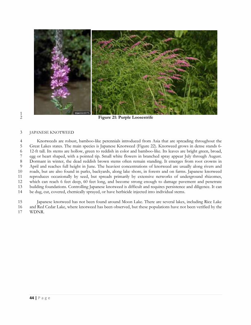
44 | P a g e
1 Figure 21: Purple Loosestrife 2
JAPANESE KNOTWEED 3
Knotweeds are robust, bamboo-like perennials introduced from Asia that are spreading throughout the 4 Great Lakes states. The main species is Japanese Knotweed (Figure 22). Knotweed grows in dense stands 6-5 12-ft tall. Its stems are hollow, green to reddish in color and bamboo-like. Its leaves are bright green, broad, 6 egg or heart shaped, with a pointed tip. Small white flowers in branched spray appear July through August. 7 Dormant in winter, the dead reddish brown stems often remain standing. It emerges from root crowns in 8 April and reaches full height in June. The heaviest concentrations of knotweed are usually along rivers and 9 roads, but are also found in parks, backyards, along lake shore, in forests and on farms. Japanese knotweed 10 reproduces occasionally by seed, but spreads primarily by extensive networks of underground rhizomes, 11 which can reach 6 feet deep, 60 feet long, and become strong enough to damage pavement and penetrate 12 building foundations. Controlling Japanese knotweed is difficult and requires persistence and diligence. It can 13 be dug, cut, covered, chemically sprayed, or have herbicide injected into individual stems. 14
Japanese knotweed has not been found around Moon Lake. There are several lakes, including Rice Lake 15 and Red Cedar Lake, where knotweed has been observed, but these populations have not been verified by the 16 WDNR. 17
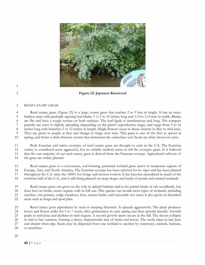
45 | P a g e
1
Figure 22: Japanese Knotweed 2
REED CANARY GRASS 3
Reed canary grass (Figure 23) is a large, coarse grass that reaches 2 to 9 feet in height. It has an erect, 4 hairless stem with gradually tapering leaf blades 3 1/2 to 10 inches long and 1/4 to 3/4 inch in width. Blades 5 are flat and have a rough texture on both surfaces. The lead ligule is membranous and long. The compact 6 panicles are erect or slightly spreading (depending on the plant's reproductive stage), and range from 3 to 16 7 inches long with branches 2 to 12 inches in length. Single flowers occur in dense clusters in May to mid-June. 8 They are green to purple at first and change to beige over time. This grass is one of the first to sprout in 9 spring, and forms a thick rhizome system that dominates the subsurface soil. Seeds are shiny brown in color. 10
Both Eurasian and native ecotypes of reed canary grass are thought to exist in the U.S. The Eurasian 11 variety is considered more aggressive, but no reliable method exists to tell the ecotypes apart. It is believed 12 that the vast majority of our reed canary grass is derived from the Eurasian ecotype. Agricultural cultivars of 13 the grass are widely planted. 14
Reed canary grass is a cool-season, sod-forming, perennial wetland grass native to temperate regions of 15 Europe, Asia, and North America. The Eurasian ecotype has been selected for its vigor and has been planted 16 throughout the U.S. since the 1800's for forage and erosion control. It has become naturalized in much of the 17 northern half of the U.S., and is still being planted on steep slopes and banks of ponds and created wetlands. 18
Reed canary grass can grow on dry soils in upland habitats and in the partial shade of oak woodlands, but 19 does best on fertile, moist organic soils in full sun. This species can invade most types of wetlands, including 20 marshes, wet prairies, sedge meadows, fens, stream banks, and seasonally wet areas; it also grows in disturbed 21 areas such as bergs and spoil piles. 22
Reed canary grass reproduces by seed or creeping rhizomes. It spreads aggressively. The plant produces 23 leaves and flower stalks for 5 to 7 weeks after germination in early spring and then spreads laterally. Growth 24 peaks in mid-June and declines in mid-August. A second growth spurt occurs in the fall. The shoots collapse 25 in mid to late summer, forming a dense, impenetrable mat of stems and leaves. The seeds ripen in late June 26 and shatter when ripe. Seeds may be dispersed from one wetland to another by waterways, animals, humans, 27 or machines. 28
29
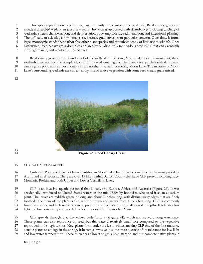
46 | P a g e
This species prefers disturbed areas, but can easily move into native wetlands. Reed canary grass can 1 invade a disturbed wetland in just a few years. Invasion is associated with disturbances including ditching of 2 wetlands, stream channelization, and deforestation of swamp forests, sedimentation, and intentional planting. 3 The difficulty of selective control makes reed canary grass invasion of particular concern. Over time, it forms 4 large, monotypic stands that harbor few other plant species and are subsequently of little use to wildlife. Once 5 established, reed canary grass dominates an area by building up a tremendous seed bank that can eventually 6 erupt, germinate, and recolonize treated sites. 7
Reed canary grass can be found in all of the wetland surrounding Moon Lake. For the most part, these 8 wetlands have not become completely overrun by reed canary grass. There are a few patches with dense reed 9 canary grass populations, most notably in the northern wetland bordering Moon Lake. The majority of Moon 10 Lake’s surrounding wetlands are still a healthy mix of native vegetation with some reed canary grass mixed. 11
12
13 Figure 23: Reed Canary Grass 14
CURLY-LEAF PONDWEED 15
Curly-leaf Pondweed has not been identified in Moon Lake, but it has become one of the most prevalent 16 AIS found in Wisconsin. There are over 15 lakes within Barron County that have CLP present including Rice, 17 Montanis, Poskin, and both Upper and Lower Vermillion lakes. 18
CLP is an invasive aquatic perennial that is native to Eurasia, Africa, and Australia (Figure 24). It was 19 accidentally introduced to United States waters in the mid-1880s by hobbyists who used it as an aquarium 20 plant. The leaves are reddish-green, oblong, and about 3 inches long, with distinct wavy edges that are finely 21 toothed. The stem of the plant is flat, reddish-brown and grows from 1 to 3 feet long. CLP is commonly 22 found in alkaline and high nutrient waters, preferring soft substrate and shallow water depths. It tolerates low 23 light and low water temperatures. It has been reported in all states but Maine. 24
CLP spreads through burr-like winter buds (turions) (Figure 24), which are moved among waterways. 25 These plants can also reproduce by seed, but this plays a relatively small role compared to the vegetative 26 reproduction through turions. New plants form under the ice in winter, making CLP one of the first nuisance 27 aquatic plants to emerge in the spring. It becomes invasive in some areas because of its tolerance for low light 28 and low water temperatures. These tolerances allow it to get a head start on and out-compete native plants in 29
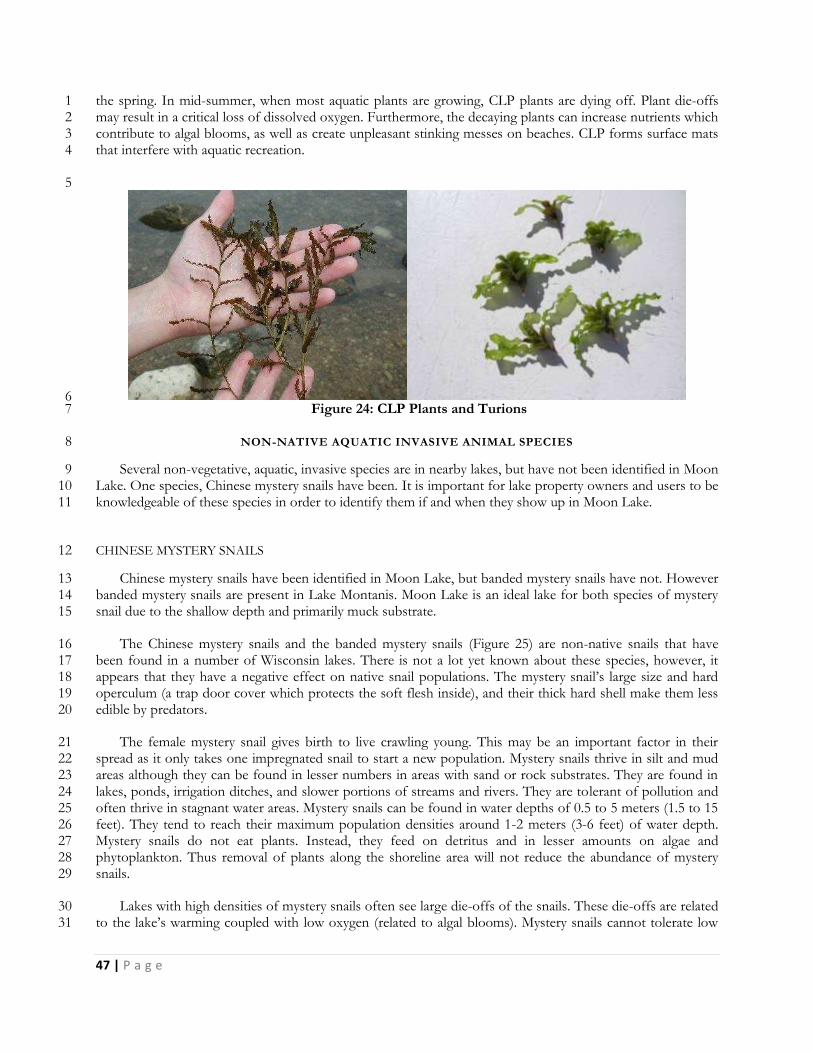
47 | P a g e
the spring. In mid-summer, when most aquatic plants are growing, CLP plants are dying off. Plant die-offs 1 may result in a critical loss of dissolved oxygen. Furthermore, the decaying plants can increase nutrients which 2 contribute to algal blooms, as well as create unpleasant stinking messes on beaches. CLP forms surface mats 3 that interfere with aquatic recreation. 4
5
6 Figure 24: CLP Plants and Turions 7
NON-NATIVE AQUATIC INVASIVE ANIMAL SPECIES 8
Several non-vegetative, aquatic, invasive species are in nearby lakes, but have not been identified in Moon 9 Lake. One species, Chinese mystery snails have been. It is important for lake property owners and users to be 10 knowledgeable of these species in order to identify them if and when they show up in Moon Lake. 11
CHINESE MYSTERY SNAILS 12
Chinese mystery snails have been identified in Moon Lake, but banded mystery snails have not. However 13 banded mystery snails are present in Lake Montanis. Moon Lake is an ideal lake for both species of mystery 14 snail due to the shallow depth and primarily muck substrate. 15
The Chinese mystery snails and the banded mystery snails (Figure 25) are non-native snails that have 16 been found in a number of Wisconsin lakes. There is not a lot yet known about these species, however, it 17 appears that they have a negative effect on native snail populations. The mystery snail’s large size and hard 18 operculum (a trap door cover which protects the soft flesh inside), and their thick hard shell make them less 19 edible by predators. 20
The female mystery snail gives birth to live crawling young. This may be an important factor in their 21 spread as it only takes one impregnated snail to start a new population. Mystery snails thrive in silt and mud 22 areas although they can be found in lesser numbers in areas with sand or rock substrates. They are found in 23 lakes, ponds, irrigation ditches, and slower portions of streams and rivers. They are tolerant of pollution and 24 often thrive in stagnant water areas. Mystery snails can be found in water depths of 0.5 to 5 meters (1.5 to 15 25 feet). They tend to reach their maximum population densities around 1-2 meters (3-6 feet) of water depth. 26 Mystery snails do not eat plants. Instead, they feed on detritus and in lesser amounts on algae and 27 phytoplankton. Thus removal of plants along the shoreline area will not reduce the abundance of mystery 28 snails. 29
Lakes with high densities of mystery snails often see large die-offs of the snails. These die-offs are related 30 to the lake’s warming coupled with low oxygen (related to algal blooms). Mystery snails cannot tolerate low 31
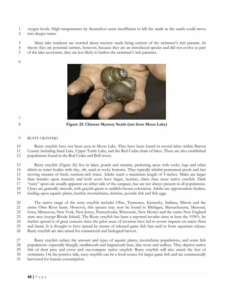
48 | P a g e
oxygen levels. High temperatures by themselves seem insufficient to kill the snails as the snails could move 1 into deeper water. 2
Many lake residents are worried about mystery snails being carriers of the swimmer’s itch parasite. In 3 theory they are potential carriers, however, because they are an introduced species and did not evolve as part 4 of the lake ecosystem, they are less likely to harbor the swimmer’s itch parasites. 5
6
7
Figure 25: Chinese Mystery Snails (not from Moon Lake) 8
RUSTY CRAYFISH 9
Rusty crayfish have not been seen in Moon Lake. They have been found in several lakes within Barron 10 County including Sand Lake, Upper Turtle Lake, and the Red Cedar chain of lakes. There are also established 11 populations found in the Red Cedar and Brill rivers. 12
Rusty crayfish (Figure 26) live in lakes, ponds and streams, preferring areas with rocks, logs and other 13 debris in water bodies with clay, silt, sand or rocky bottoms. They typically inhabit permanent pools and fast 14 moving streams of fresh, nutrient-rich water. Adults reach a maximum length of 4 inches. Males are larger 15 than females upon maturity and both sexes have larger, heartier, claws than most native crayfish. Dark 16 “rusty” spots are usually apparent on either side of the carapace, but are not always present in all populations. 17 Claws are generally smooth, with grayish-green to reddish-brown coloration. Adults are opportunistic feeders, 18 feeding upon aquatic plants, benthic invertebrates, detritus, juvenile fish and fish eggs. 19
The native range of the rusty crayfish includes Ohio, Tennessee, Kentucky, Indiana, Illinois and the 20 entire Ohio River basin. However, this species may now be found in Michigan, Massachusetts, Missouri, 21 Iowa, Minnesota, New York, New Jersey, Pennsylvania, Wisconsin, New Mexico and the entire New England 22 state area (except Rhode Island). The Rusty crayfish has been a reported invader since at least the 1930’s. Its 23 further spread is of great concern since the prior areas of invasion have led to severe impacts on native flora 24 and fauna. It is thought to have spread by means of released game fish bait and/or from aquarium release. 25 Rusty crayfish are also raised for commercial and biological harvest. 26
Rusty crayfish reduce the amount and types of aquatic plants, invertebrate populations, and some fish 27 populations--especially bluegill, smallmouth and largemouth bass, lake trout and walleye. They deprive native 28 fish of their prey and cover and out-compete native crayfish. Rusty crayfish will also attack the feet of 29 swimmers. On the positive side, rusty crayfish can be a food source for larger game fish and are commercially 30 harvested for human consumption. 31
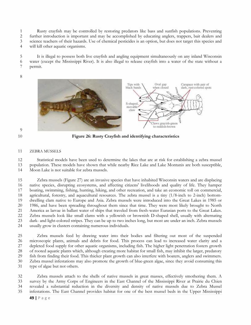
49 | P a g e
Rusty crayfish may be controlled by restoring predators like bass and sunfish populations. Preventing 1 further introduction is important and may be accomplished by educating anglers, trappers, bait dealers and 2 science teachers of their hazards. Use of chemical pesticides is an option, but does not target this species and 3 will kill other aquatic organisms. 4
It is illegal to possess both live crayfish and angling equipment simultaneously on any inland Wisconsin 5 water (except the Mississippi River). It is also illegal to release crayfish into a water of the state without a 6 permit. 7
8
9
Figure 26: Rusty Crayfish and identifying characteristics 10
ZEBRA MUSSELS 11
Statistical models have been used to determine the lakes that are at risk for establishing a zebra mussel 12 population. These models have shown that while nearby Rice Lake and Lake Montanis are both susceptible, 13 Moon Lake is not suitable for zebra mussels. 14
Zebra mussels (Figure 27) are an invasive species that have inhabited Wisconsin waters and are displacing 15 native species, disrupting ecosystems, and affecting citizens' livelihoods and quality of life. They hamper 16 boating, swimming, fishing, hunting, hiking, and other recreation, and take an economic toll on commercial, 17 agricultural, forestry, and aquacultural resources. The zebra mussel is a tiny (1/8-inch to 2-inch) bottom-18 dwelling clam native to Europe and Asia. Zebra mussels were introduced into the Great Lakes in 1985 or 19 1986, and have been spreading throughout them since that time. They were most likely brought to North 20 America as larvae in ballast water of ships that traveled from fresh-water Eurasian ports to the Great Lakes. 21 Zebra mussels look like small clams with a yellowish or brownish D-shaped shell, usually with alternating 22 dark- and light-colored stripes. They can be up to two inches long, but most are under an inch. Zebra mussels 23 usually grow in clusters containing numerous individuals. 24
Zebra mussels feed by drawing water into their bodies and filtering out most of the suspended 25 microscopic plants, animals and debris for food. This process can lead to increased water clarity and a 26 depleted food supply for other aquatic organisms, including fish. The higher light penetration fosters growth 27 of rooted aquatic plants which, although creating more habitat for small fish, may inhibit the larger, predatory 28 fish from finding their food. This thicker plant growth can also interfere with boaters, anglers and swimmers. 29 Zebra mussel infestations may also promote the growth of blue-green algae, since they avoid consuming this 30 type of algae but not others. 31
Zebra mussels attach to the shells of native mussels in great masses, effectively smothering them. A 32 survey by the Army Corps of Engineers in the East Channel of the Mississippi River at Prairie du Chien 33 revealed a substantial reduction in the diversity and density of native mussels due to Zebra Mussel 34 infestations. The East Channel provides habitat for one of the best mussel beds in the Upper Mississippi 35
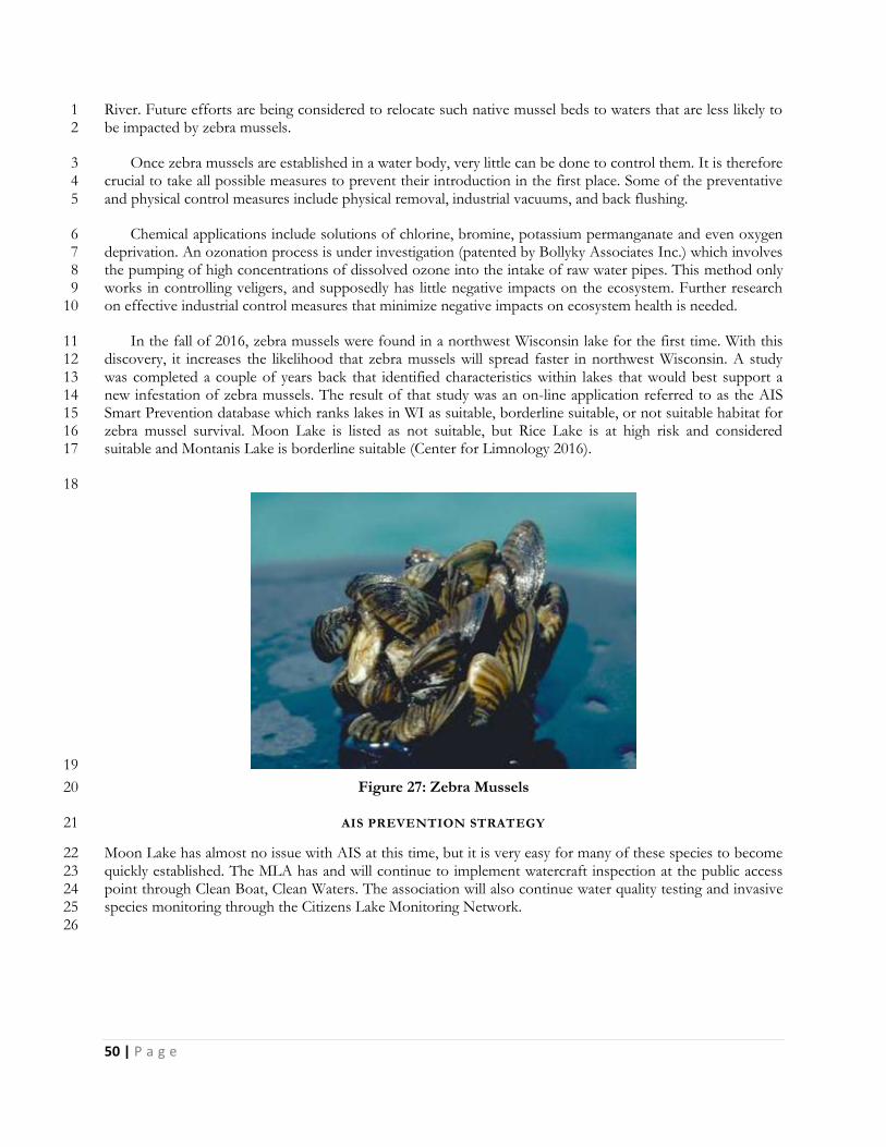
50 | P a g e
River. Future efforts are being considered to relocate such native mussel beds to waters that are less likely to 1 be impacted by zebra mussels. 2
Once zebra mussels are established in a water body, very little can be done to control them. It is therefore 3 crucial to take all possible measures to prevent their introduction in the first place. Some of the preventative 4 and physical control measures include physical removal, industrial vacuums, and back flushing. 5
Chemical applications include solutions of chlorine, bromine, potassium permanganate and even oxygen 6 deprivation. An ozonation process is under investigation (patented by Bollyky Associates Inc.) which involves 7 the pumping of high concentrations of dissolved ozone into the intake of raw water pipes. This method only 8 works in controlling veligers, and supposedly has little negative impacts on the ecosystem. Further research 9 on effective industrial control measures that minimize negative impacts on ecosystem health is needed. 10
In the fall of 2016, zebra mussels were found in a northwest Wisconsin lake for the first time. With this 11 discovery, it increases the likelihood that zebra mussels will spread faster in northwest Wisconsin. A study 12 was completed a couple of years back that identified characteristics within lakes that would best support a 13 new infestation of zebra mussels. The result of that study was an on-line application referred to as the AIS 14 Smart Prevention database which ranks lakes in WI as suitable, borderline suitable, or not suitable habitat for 15 zebra mussel survival. Moon Lake is listed as not suitable, but Rice Lake is at high risk and considered 16 suitable and Montanis Lake is borderline suitable (Center for Limnology 2016). 17
18
19
Figure 27: Zebra Mussels 20
AIS PREVENTION STRATEGY 21
Moon Lake has almost no issue with AIS at this time, but it is very easy for many of these species to become 22 quickly established. The MLA has and will continue to implement watercraft inspection at the public access 23 point through Clean Boat, Clean Waters. The association will also continue water quality testing and invasive 24 species monitoring through the Citizens Lake Monitoring Network. 25
26
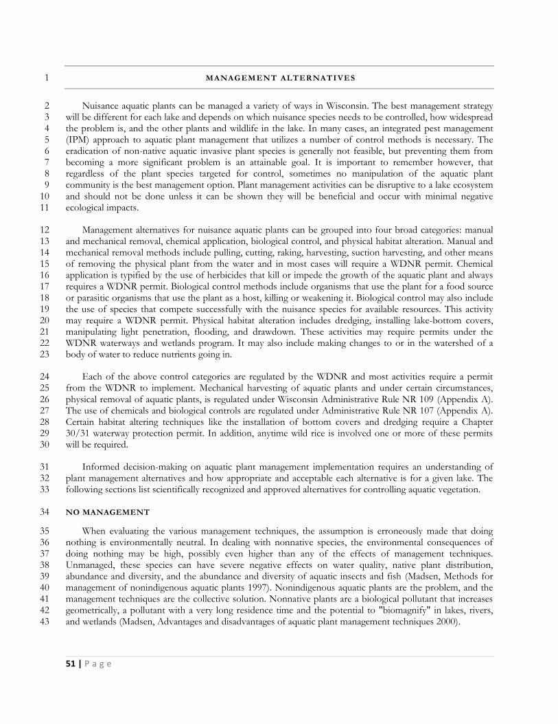
51 | P a g e
MANAGEMENT ALTERNATI VES 1
Nuisance aquatic plants can be managed a variety of ways in Wisconsin. The best management strategy 2 will be different for each lake and depends on which nuisance species needs to be controlled, how widespread 3 the problem is, and the other plants and wildlife in the lake. In many cases, an integrated pest management 4 (IPM) approach to aquatic plant management that utilizes a number of control methods is necessary. The 5 eradication of non-native aquatic invasive plant species is generally not feasible, but preventing them from 6 becoming a more significant problem is an attainable goal. It is important to remember however, that 7 regardless of the plant species targeted for control, sometimes no manipulation of the aquatic plant 8 community is the best management option. Plant management activities can be disruptive to a lake ecosystem 9 and should not be done unless it can be shown they will be beneficial and occur with minimal negative 10 ecological impacts. 11
Management alternatives for nuisance aquatic plants can be grouped into four broad categories: manual 12 and mechanical removal, chemical application, biological control, and physical habitat alteration. Manual and 13 mechanical removal methods include pulling, cutting, raking, harvesting, suction harvesting, and other means 14 of removing the physical plant from the water and in most cases will require a WDNR permit. Chemical 15 application is typified by the use of herbicides that kill or impede the growth of the aquatic plant and always 16 requires a WDNR permit. Biological control methods include organisms that use the plant for a food source 17 or parasitic organisms that use the plant as a host, killing or weakening it. Biological control may also include 18 the use of species that compete successfully with the nuisance species for available resources. This activity 19 may require a WDNR permit. Physical habitat alteration includes dredging, installing lake-bottom covers, 20 manipulating light penetration, flooding, and drawdown. These activities may require permits under the 21 WDNR waterways and wetlands program. It may also include making changes to or in the watershed of a 22 body of water to reduce nutrients going in. 23
Each of the above control categories are regulated by the WDNR and most activities require a permit 24 from the WDNR to implement. Mechanical harvesting of aquatic plants and under certain circumstances, 25 physical removal of aquatic plants, is regulated under Wisconsin Administrative Rule NR 109 (Appendix A). 26 The use of chemicals and biological controls are regulated under Administrative Rule NR 107 (Appendix A). 27 Certain habitat altering techniques like the installation of bottom covers and dredging require a Chapter 28 30/31 waterway protection permit. In addition, anytime wild rice is involved one or more of these permits 29 will be required. 30
Informed decision-making on aquatic plant management implementation requires an understanding of 31 plant management alternatives and how appropriate and acceptable each alternative is for a given lake. The 32 following sections list scientifically recognized and approved alternatives for controlling aquatic vegetation. 33
NO MANAGEMENT 34
When evaluating the various management techniques, the assumption is erroneously made that doing 35 nothing is environmentally neutral. In dealing with nonnative species, the environmental consequences of 36 doing nothing may be high, possibly even higher than any of the effects of management techniques. 37 Unmanaged, these species can have severe negative effects on water quality, native plant distribution, 38 abundance and diversity, and the abundance and diversity of aquatic insects and fish (Madsen, Methods for 39 management of nonindigenous aquatic plants 1997). Nonindigenous aquatic plants are the problem, and the 40 management techniques are the collective solution. Nonnative plants are a biological pollutant that increases 41 geometrically, a pollutant with a very long residence time and the potential to "biomagnify" in lakes, rivers, 42 and wetlands (Madsen, Advantages and disadvantages of aquatic plant management techniques 2000). 43
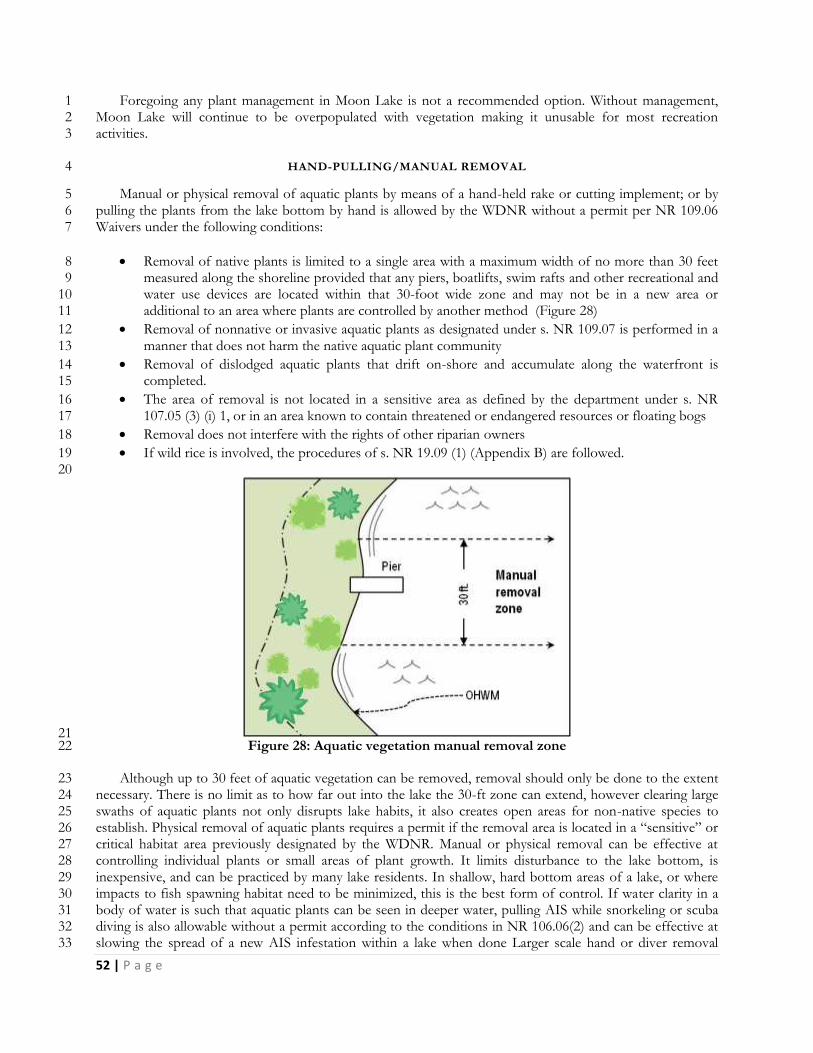
52 | P a g e
Foregoing any plant management in Moon Lake is not a recommended option. Without management, 1 Moon Lake will continue to be overpopulated with vegetation making it unusable for most recreation 2 activities. 3
HAND-PULLING/MANUAL REMOVAL 4
Manual or physical removal of aquatic plants by means of a hand-held rake or cutting implement; or by 5 pulling the plants from the lake bottom by hand is allowed by the WDNR without a permit per NR 109.06 6 Waivers under the following conditions: 7
Removal of native plants is limited to a single area with a maximum width of no more than 30 feet 8 measured along the shoreline provided that any piers, boatlifts, swim rafts and other recreational and 9 water use devices are located within that 30-foot wide zone and may not be in a new area or 10 additional to an area where plants are controlled by another method (Figure 28) 11
Removal of nonnative or invasive aquatic plants as designated under s. NR 109.07 is performed in a 12 manner that does not harm the native aquatic plant community 13
Removal of dislodged aquatic plants that drift on-shore and accumulate along the waterfront is 14 completed. 15
The area of removal is not located in a sensitive area as defined by the department under s. NR 16 107.05 (3) (i) 1, or in an area known to contain threatened or endangered resources or floating bogs 17
Removal does not interfere with the rights of other riparian owners 18
If wild rice is involved, the procedures of s. NR 19.09 (1) (Appendix B) are followed. 19 20
21 Figure 28: Aquatic vegetation manual removal zone 22
Although up to 30 feet of aquatic vegetation can be removed, removal should only be done to the extent 23 necessary. There is no limit as to how far out into the lake the 30-ft zone can extend, however clearing large 24 swaths of aquatic plants not only disrupts lake habits, it also creates open areas for non-native species to 25 establish. Physical removal of aquatic plants requires a permit if the removal area is located in a “sensitive” or 26 critical habitat area previously designated by the WDNR. Manual or physical removal can be effective at 27 controlling individual plants or small areas of plant growth. It limits disturbance to the lake bottom, is 28 inexpensive, and can be practiced by many lake residents. In shallow, hard bottom areas of a lake, or where 29 impacts to fish spawning habitat need to be minimized, this is the best form of control. If water clarity in a 30 body of water is such that aquatic plants can be seen in deeper water, pulling AIS while snorkeling or scuba 31 diving is also allowable without a permit according to the conditions in NR 106.06(2) and can be effective at 32 slowing the spread of a new AIS infestation within a lake when done Larger scale hand or diver removal 33
53 | P a g e
projects have had positive impacts in temporarily reducing or controlling AIS. Typically hand or diver 1 removal is used when AIS has been newly identified and still exists as single plants or isolated small beds, but 2 at least in one lake in New York State, it was used as a means to control a large-scale infestation of EWM. 3 One study (Kelting and Laxson 2010) reported that from 2004 to 2006 an “intensive management effort” 4 which involved “the selective removal of Eurasian water milfoil using diver hand harvesting of the entire 5 littoral zone of the lake at least twice each summer for three years” followed by three years of maintenance 6 management successfully reduced the overall distribution of EWM in the lake. 7
In Moon Lake, plants growing in some areas of the lake may be best managed by hand-pulling/manual 8 removal. However it is not suitable to manage the entire lake this with manual removal. 9
10 DIVER ASSISTED SUCTION HARVESTING 11
Diver assisted suction harvesting or DASH, as it is often called, is a fairly recent aquatic plant removal 12 technique. It is called "harvesting" rather than "dredging" because, although a specialized small-scale dredge is 13 used, bottom sediment is not removed from the system. The operation involves hand-pulling of the target 14 plants from the lake bed and inserting them into an underwater vacuum system that sucks up plants and their 15 root systems taking them to the surface. It requires water pumps on the surface (generally on a pontoon 16 system) to move a large volume of water to maintain adequate suction of materials that the divers are 17 processing (Figure 29). Only clean water goes through the pump. The material placed by the divers into the 18 suction hose along with the water is deposited into mesh bags on the surface with the water leaving through 19 the holes in the bag. The bags have a large enough 'mesh' size so that silts, clay, leaves and other plant 20 material being collected do not immediately clog them and block water movement. If a fish or other living 21 marine life is sucked into the suction hose it comes out the discharge unharmed and is returned to the body 22 of water. It can have some negative impacts to other nearby non-target plants if not done carefully, 23 particularly those plants that are perennials and expand their populations by sub-sediment runners (Eichler, et 24 al. 1993). 25
26
27
Figure 29: DASH - Diver Assisted Suction Harvest (Aquacleaner Environmental, 28 http://www.aquacleaner.com/index.html); Many Waters, LLC) 29
DASH would not be an effective method of management for Moon Lake. Because the idea behind 30 DASH removal is the selective nature, this is best suited for the removal of invasive aquatic plants. Being as 31 there are no aquatic invasive plants in Moon Lake, DASH removal would be incredibly expensive and 32 ineffective therefore this is not a recommended management strategy. 33
54 | P a g e
MECHANICAL REMOVAL 1
Mechanical management involves the use of devices not solely powered by human means to aid removal. 2 This includes gas and electric motors, ATV’s, boats, tractors, etc. Using these instruments to pull, cut, grind, 3 or rotovate aquatic plants is illegal in Wisconsin without a permit. DASH is also considered mechanical 4 removal. To implement mechanical removal of aquatic plants a Mechanical/Manual Aquatic Plant Control 5 Application is required annually. The application is reviewed by the WDNR and other entities and a permit 6 awarded if required criteria are met. Using repeated mechanical disturbance such as bottom rollers or 7 sweepers can be effective at control in small areas, but in Wisconsin these devices are illegal and generally not 8 permitted. 9
MECHANICAL HARVESTING 10
Large-scale mechanical harvesting is more traditionally used for control of CLP, but can be an effective 11 way overall plant biomass in a water body. It is typically used to open up channels through existing beds of 12 vegetation to improve access for both human related activities like boating, and natural activities like fish 13 distribution and mobility. 14
Mechanical harvesters are large machines which both cut and collect aquatic plants. Cut plants are 15 removed from the water by a conveyor belt system and stored on the harvester until disposal. A barge may be 16 stationed near the harvesting site for temporary plant storage or the harvester carries the cut weeds to shore. 17 The shore station equipment is usually a shore conveyor that mates to the harvester and lifts the cut plants 18 into a dump truck. Harvested weeds are disposed of in landfills, used as compost, or in reclaiming spent 19 gravel pits or similar sites. 20
Harvesting is usually performed in late spring, summer, and early fall when aquatic plants have reached or 21 are close to the water's surface. Harvesters can cut and collect several acres per day depending on weed type, 22 plant density, and storage capacity of the equipment. Harvesting speeds for typical machines range from 0.5 23 to 1.5 acres per hour. Depending on the equipment used, the plants are cut from three to five feet below the 24 water's surface in a swath 4 to 20 feet wide. Harvesting can be an excellent way to create open areas of water 25 for recreation and fishing access. 26
Timing is also important. The ideal time to harvest, in order to maximize the efficiency of the harvester, 27 is just before the aquatic plants break the surface of the lake. If the harvesting work is contracted, the 28 equipment should be inspected before and after it enters the lake. Since these machines travel from lake to 29 lake, they may carry plant fragments with them, and facilitate the spread of AIS from one body of water to 30 another. 31
Mechanical harvesting of aquatic plants has advantages and disadvantages (Washington 2016): 32
Advantages 33
Harvesting results in immediate open areas of water. 34
Removing plants from the water removes the plant nutrients, such as nitrogen and phosphorus, from 35 the system. (Harvesting aquatic plants is not an effective tool for reducing nutrient loads in a lake and 36 it is unlikely that any operational harvesting program will significantly impact the internal nutrient 37 balance of the system (Madsen, Advantages and disadvantages of aquatic plant management 38 techniques 2000). 39
Harvesting as aquatic plants are dying back for the winter can remove organic material and help slow 40 the sedimentation rate in a waterbody. 41
Since the lower part of the plant remains after harvest, habitat for fish and other organisms is not 42 eliminated. 43
55 | P a g e
Harvesting can be targeted to specific locations, protecting designated conservancy areas from 1 treatment. 2
Disadvantages 3
Harvesting is similar to mowing a lawn; the plant grows back and may need to be harvested several 4 times during the growing season. 5
There is little or no reduction in plant density with mechanical harvesting. 6
Off-loading sites and disposal areas for cut plants must be available. On heavily developed 7 shorelines, suitable off-loading sites may be few and require long trips by the harvester. 8
Some large harvesters are not easily maneuverable in shallow water or around docks or other 9 obstructions. 10
Significant numbers of small fish, invertebrates, and amphibians are often collected and killed by the 11 harvester. 12
Harvesting creates plant fragments which may increase the spread of invasive plant species such as 13 EWM throughout the waterbody. 14
Although harvesters collect plants as they are cut, not all plant fragments or plants may be picked up. 15 These may accumulate and decompose on shore. 16
Harvesters are expensive and require routine maintenance. 17
Harvesting may not be suitable for lakes with many bottom obstructions (stumps, logs) or for very 18 shallow lakes (3-5 feet of water) with loose organic sediments. 19
Harvesters brought into the waterbody from other locations need to be thoroughly cleaned and 20 inspected before being allowed to launch. Otherwise new exotic species could be introduced to the 21 waterbody. 22
23 Disposal sites are a key component when considering the mechanical harvesting of aquatic plants. The 24
sites must be on shore and upland to make sure the plants and their reproductive structures don’t make their 25 way back into the lake or to other lakes. The number of available disposal sites and their distance from the 26 targeted harvesting areas will determine the efficiency of the operation, in terms of time as well as cost. 27
Costs per acre vary with numbers of acres harvested, accessibility of disposal sites to the harvested areas, 28 density and species of the harvested plants, and whether a private contractor or public entity does the work. 29 Costs as low as $250 per acre have been reported. Private contractors generally charge $500 to $800 per acre. 30 The purchase price of harvesters ranges from $45,000 to $250,000. There are several harvester manufacturers 31 in the United States (including at least two in Wisconsin) and some lake groups may choose to operate and 32 purchase their own machinery rather than contracting for these services. 33
Prior to 2017, contracted harvesting services have not been readily available in NW Wisconsin. While 34 there are many companies offering contracted services in Minnesota, most will not contract across the border 35 into WI. There is at least one company out of northern Illinois that would consider offering services in NW 36 Wisconsin, but this has not happened yet. In 2017, a new company out of Chippewa Falls, WI will be offering 37 contracted harvesting services. The company owns two 5-ft Harvesters each with a capacity to hold about 38 220 cubic feet or 6,500 lbs. of cut vegetation on board. 39
Using contracted mechanical harvesting to manage the aquatic plants in Moon Lake is recommended to 40 provide greater access for fishing and boating, improve fishing and fish habitat, and to reduce build-up of 41 organic materials in the lake which may in time reduce the number and severity of winter fish kills. 42
SMALL-SCALE CUTTING WITH REMOVAL 43
There are a wide range of small-scale mechanical harvesting techniques, most of which involve the use of 44 boat mounted rakes, scythes, and electric cutters. As with all mechanical harvesting, removing the cut plants is 45 required. Commercial rakes and cutters range in prices from $200 for rakes to around $3000 for electric 46
56 | P a g e
cutters with a wide range of sizes and capacities. Using a weed rake or cutter that is run by human power is 1 allowed without a permit, but the use of any device that includes a motor, gas or electric, would require a 2 permit. Dragging a bed spring or bar behind a boat, tractor or any other motorized vehicle to remove 3 vegetation is also illegal without a permit. Although not truly considered mechanical management, incidental 4 plant disruption by normal boat traffic is a legal method of management. Active use of an area is often one of 5 the best ways for riparian owners to gain navigation relief near their docks. Most aquatic plants won’t grow 6 well in an area actively used for boating and swimming. It should be noted that purposefully navigating a boat 7 to clear large areas is not only potentially illegal it can also re-suspend sediments, encourage AIS growth, and 8 cause ecological disruptions. 9
Small-scale harvesting by human power would be an effective way for property owners on Moon Lake to 10 open up their boating lanes when done within the 30 foot corridor. Any sort of cutting and removal beyond 11 the 30 foot path or by any mechanical means does require a permit. Through information and training, 12 property owners will be instructed on proper physical removal methods. 13
14 BOTTOM BARRIERS AND SHADING 15
Physical barriers, fabric or other, placed on the bottom of the lake to reduce plant growth would 16 eliminate all plants, inhibit fish spawning, affect benthic invertebrates, and could cause anaerobic conditions 17 which may release excess nutrients from the sediment. Gas build-up beneath these barriers can cause them to 18 dislodge from the bottom and sediment can build up on them allowing vegetation to re-establish. Bottom 19 barriers are typically used for very small areas and provide only limited relief. Currently the WDNR does not 20 permit this type of control. 21
The general intention is to reduce light penetration in the water which in turns limits the depth at which 22 plants can grow. Typically dyes have been added to a small water body to darken the water. Bottom barriers 23 and attempts to further reduce light penetration in Moon Lake are not recommended. 24
25 DREDGING 26
Dredging is the removal of bottom sediment from a lake. Its success is based on altering the target plant’s 27 environment. It is not usually performed solely for aquatic plant management but rather to restore lakes that 28 have been filled in with sediment, have excess nutrients, inadequate pelagic and hypolimnetic zones, need 29 deepening, or require removal of toxic substances (Peterson 1982). In shallow lakes with excess plant growth, 30 dredging can make areas of the lake too deep for plant growth. It can also remove significant plant root 31 structures, seeds/turions, rhizomes, tubers, etc. In Collins Lake, New York the biomass of CLP remained 32 significantly lower than pre-dredging levels 10-yrs after dredging (Tobiessen, Swart and Benjamin 1992). 33 Dredging is very expensive, requires disposal of sediments, and has major environmental impacts. It is not a 34 selective procedure so it can’t be used to target any one particular species with great success except under 35 extenuating circumstances. Dredging at any level must be permitted by the WDNR if done through 36 mechanical means. Manual dredging of up to 100 cubic feet for may be done without a permit by property 37 owners if all criteria found in the WDNR’s exemption checklist (WDNR, Waterway protection Dredging 38 2016) are met. Dredging should not be performed for aquatic plant management alone. It is best used as a 39 multipurpose lake remediation technique (Madsen, Advantages and disadvantages of aquatic plant 40 management techniques 2000). 41
Dredging is not a recommended management action for Moon Lake, unless it is needed at the public 42 boat landing to enable the launch of a small aquatic plant harvester. 43
57 | P a g e
DRAWDOWN 1
Drawdown, like dredging, alters the plant environment by removing all water in a water body to a certain 2 depth, exposing bottom sediments to seasonal changes including temperature and precipitation. A winter 3 drawdown is a low cost and effective management tool for the long-term control of certain susceptible 4 species of nuisance aquatic plants. A winter drawdown controls susceptible aquatic plants by dewatering a 5 portion of the lake bottom over the winter, and subsequently exposing vascular plants to the combined effect 6 of freezing and desiccation (drying). The effectiveness of drawdown to control plants hinges on the 7 combined effect of the freezing and drying. If freezing and dry conditions are not sustained for 4-6 weeks, 8 the effectiveness of the drawdown may be diminished. 9
It is not possible to draw down Moon Lake as there are no outlets to manipulate the water level. 10
BIOLOGICAL CONTROL 11
Biological control involves using one plant, animal, or pathogen as a means to control a target species in 12 the same environment. The goal of biological control is to weaken, reduce the spread, or eliminate the 13 unwanted population so that native or more desirable populations can make a comeback. Care must be taken 14 however, to insure that the control species does not become as big a problem as the one that is being 15 controlled. A special permit is required in Wisconsin before any biological control measure can be introduced 16 into a new area. 17
TYPES OF BIOLOGICAL CONTROLS 18
There are several forms of biological control being used or researched. Currently the most commonly 19 used biological controls are milfoil weevils for the control of EWM and Galerucella beetles (G. calmariensis and 20 G. pusilla) for the control of purple loosestrife. It was thought at one time that the introduction of plant eating 21 carp could be successful in controlling invasive plants. It has since been shown that these carp can have a 22 severe negative impact on the lake’s ecosystem. These fish they can wipe out almost all of the plants in the 23 lakes they inhabit resulting in a ripple effect that disrupts and damages the entire lake system. Use of “grass 24 carp” as they are referred to in Wisconsin is illegal as there are many other environmental concerns including 25 what happens once the target species is destroyed, removal of the carp from the system, impacts to other fish 26 and aquatic plants, and preventing escapees into other lakes and rivers. Several pathogens or fungi are 27 currently being researched that when introduced by themselves or in combination with herbicide application 28 can effectively control EWM and lower the concentration of chemical used or the time of exposure necessary 29 to kill the plant (Sorsa, Nordheim and Andrews 1988). None of these have currently been approved for use in 30 Wisconsin and are not recommended for use in Moon Lake. 31
NATIVE PLANT RESTORATION 32
A healthy population of native plants might slow or prevent invasion of non-native aquatic plants. While 33 the goal of this plan is to remove some of the over abundant native vegetation in Moon Lake, it is important 34 to maintain some areas of healthy, undisturbed aquatic plants. Native plant restoration efforts are not needed 35 in Moon Lake at this time because there is a large community of native plants. 36
37 CHEMICAL CONTROL 38
Aquatic herbicides are granules or liquid chemicals specifically formulated for use in water to kill plants 39 or cease plant growth. Herbicides approved for aquatic use by the U.S. Environmental Protection Agency 40 (EPA) are considered compatible with the aquatic environment when used according to label directions. 41 Some individual states, including Wisconsin, also impose additional constraints on herbicide use. 42
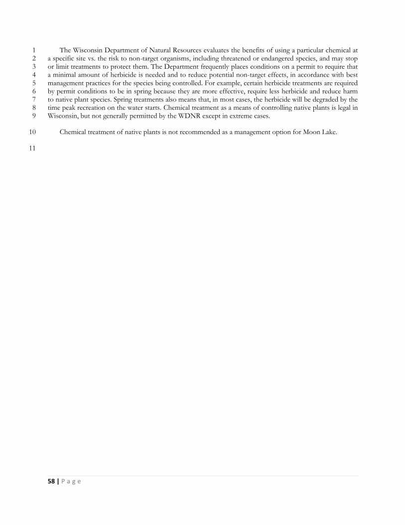
58 | P a g e
The Wisconsin Department of Natural Resources evaluates the benefits of using a particular chemical at 1 a specific site vs. the risk to non-target organisms, including threatened or endangered species, and may stop 2 or limit treatments to protect them. The Department frequently places conditions on a permit to require that 3 a minimal amount of herbicide is needed and to reduce potential non-target effects, in accordance with best 4 management practices for the species being controlled. For example, certain herbicide treatments are required 5 by permit conditions to be in spring because they are more effective, require less herbicide and reduce harm 6 to native plant species. Spring treatments also means that, in most cases, the herbicide will be degraded by the 7 time peak recreation on the water starts. Chemical treatment as a means of controlling native plants is legal in 8 Wisconsin, but not generally permitted by the WDNR except in extreme cases. 9
Chemical treatment of native plants is not recommended as a management option for Moon Lake. 10
11
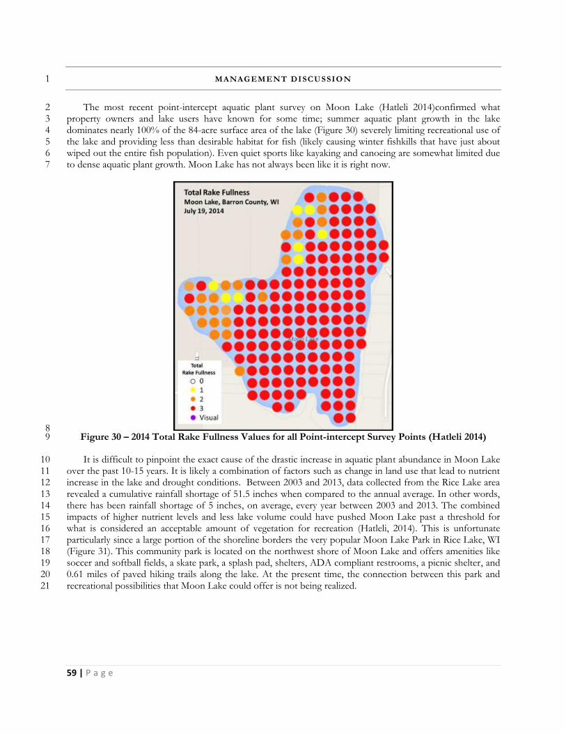
59 | P a g e
MANAGEMENT DISCUSSIO N 1
The most recent point-intercept aquatic plant survey on Moon Lake (Hatleli 2014)confirmed what 2 property owners and lake users have known for some time; summer aquatic plant growth in the lake 3 dominates nearly 100% of the 84-acre surface area of the lake (Figure 30) severely limiting recreational use of 4 the lake and providing less than desirable habitat for fish (likely causing winter fishkills that have just about 5 wiped out the entire fish population). Even quiet sports like kayaking and canoeing are somewhat limited due 6 to dense aquatic plant growth. Moon Lake has not always been like it is right now. 7
8 Figure 30 – 2014 Total Rake Fullness Values for all Point-intercept Survey Points (Hatleli 2014) 9
It is difficult to pinpoint the exact cause of the drastic increase in aquatic plant abundance in Moon Lake 10 over the past 10-15 years. It is likely a combination of factors such as change in land use that lead to nutrient 11 increase in the lake and drought conditions. Between 2003 and 2013, data collected from the Rice Lake area 12 revealed a cumulative rainfall shortage of 51.5 inches when compared to the annual average. In other words, 13 there has been rainfall shortage of 5 inches, on average, every year between 2003 and 2013. The combined 14 impacts of higher nutrient levels and less lake volume could have pushed Moon Lake past a threshold for 15 what is considered an acceptable amount of vegetation for recreation (Hatleli, 2014). This is unfortunate 16 particularly since a large portion of the shoreline borders the very popular Moon Lake Park in Rice Lake, WI 17 (Figure 31). This community park is located on the northwest shore of Moon Lake and offers amenities like 18 soccer and softball fields, a skate park, a splash pad, shelters, ADA compliant restrooms, a picnic shelter, and 19 0.61 miles of paved hiking trails along the lake. At the present time, the connection between this park and 20 recreational possibilities that Moon Lake could offer is not being realized. 21
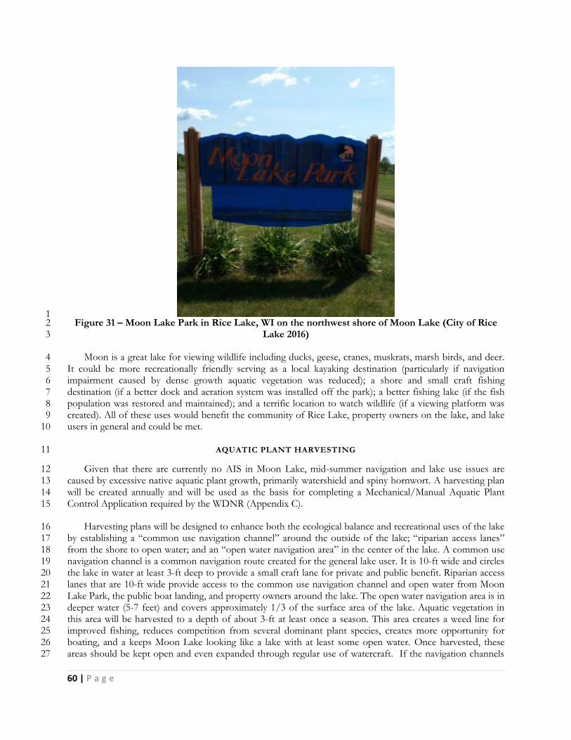
60 | P a g e
1 Figure 31 – Moon Lake Park in Rice Lake, WI on the northwest shore of Moon Lake (City of Rice 2
Lake 2016) 3
Moon is a great lake for viewing wildlife including ducks, geese, cranes, muskrats, marsh birds, and deer. 4 It could be more recreationally friendly serving as a local kayaking destination (particularly if navigation 5 impairment caused by dense growth aquatic vegetation was reduced); a shore and small craft fishing 6 destination (if a better dock and aeration system was installed off the park); a better fishing lake (if the fish 7 population was restored and maintained); and a terrific location to watch wildlife (if a viewing platform was 8 created). All of these uses would benefit the community of Rice Lake, property owners on the lake, and lake 9 users in general and could be met. 10
AQUATIC PLANT HARVESTING 11
Given that there are currently no AIS in Moon Lake, mid-summer navigation and lake use issues are 12 caused by excessive native aquatic plant growth, primarily watershield and spiny hornwort. A harvesting plan 13 will be created annually and will be used as the basis for completing a Mechanical/Manual Aquatic Plant 14 Control Application required by the WDNR (Appendix C). 15
Harvesting plans will be designed to enhance both the ecological balance and recreational uses of the lake 16 by establishing a “common use navigation channel” around the outside of the lake; “riparian access lanes” 17 from the shore to open water; and an “open water navigation area” in the center of the lake. A common use 18 navigation channel is a common navigation route created for the general lake user. It is 10-ft wide and circles 19 the lake in water at least 3-ft deep to provide a small craft lane for private and public benefit. Riparian access 20 lanes that are 10-ft wide provide access to the common use navigation channel and open water from Moon 21 Lake Park, the public boat landing, and property owners around the lake. The open water navigation area is in 22 deeper water (5-7 feet) and covers approximately 1/3 of the surface area of the lake. Aquatic vegetation in 23 this area will be harvested to a depth of about 3-ft at least once a season. This area creates a weed line for 24 improved fishing, reduces competition from several dominant plant species, creates more opportunity for 25 boating, and a keeps Moon Lake looking like a lake with at least some open water. Once harvested, these 26 areas should be kept open and even expanded through regular use of watercraft. If the navigation channels 27
61 | P a g e
or access lanes fill in again, they can be re-cut in the same year under the same harvesting permit that allowed 1 the initial cutting (Figure 32). However, if a harvested area fills in due to lack of use after initial harvesting, it 2 will likely not be harvested again in the same season. 3
4
Figure 32 – Moon Lake Proposed Aquatic Plant Harvesting Map (LEAPS, Dec.2016) 5
Mechanical harvesting of aquatic plants will only be completed in water 3-ft or greater in depth. 6 Harvesting in waters shallower than this can greatly disturb bottom sediments causing them to be re-7 suspended in the water column decreasing water quality. Bottom dwelling biota critical to the health of the 8 lake can also be negatively impacted. Damage to the harvester may also occur. In waters at or deeper than 3-9 ft, aquatic plants can be cut to the maximum depth of the harvester or two-thirds of the water column, 10 whichever is less. At off-loading sites, the operator will attempt to return game fish, turtles, and other wildlife 11 back to the water. Plant survey work in 2014 documented nearly 100% coverage of the 84-acre surface area 12 of the lake. In an effort to protect the existing health of the lake, harvesting of the navigation channel, 13 riparian access lanes, and open water navigation area will not exceed one-third (28 acres) of the total surface 14 area of the lake. This acreage does not include areas where aquatic vegetation is managed by physical means. 15
Having a plan to dispose of the vegetation harvested it extremely important for the success of a 16 harvesting program. Contracted services are much less expensive if the contractor does not have to dispose 17 of the vegetation as a part of the project. A portion of Moon Lake is within the boundaries of the RL-LPRD 18 who operates a large harvesting program on Rice Lake. The MLA has approached the RL-LPRD about using 19 their truck and claw to pick up vegetation temporarily piled near the public access site after harvest and take it 20 to their dump site in the Town of Oak Grove and they are open to this idea. 21
Clear-cutting of aquatic vegetation adjacent to riparian shoreline for the purpose of creating weed free 22 areas for swimming or other recreational purposes is not an acceptable use of the mechanical harvester and is 23
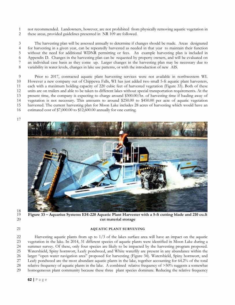
62 | P a g e
not recommended. Landowners, however, are not prohibited from physically removing aquatic vegetation in 1 these areas, provided guidelines presented in NR 109 are followed. 2
The harvesting plan will be assessed annually to determine if changes should be made. Areas designated 3 for harvesting in a given year, can be repeatedly harvested as needed in that year to maintain their function 4 without the need for additional WDNR permitting or fees. An example harvesting plan is included in 5 Appendix D. Changes in the harvesting plan can be requested by property owners, and will be evaluated on 6 an individual case basis as they come up. Larger changes in the harvesting plan may be necessary due to 7 variability in water levels, changes in lake use patterns, or with the introduction of new AIS. 8
Prior to 2017, contracted aquatic plant harvesting services were not available in northwestern WI. 9 However a new company out of Chippewa Falls, WI has just added two small 5-ft aquatic plant harvesters, 10 each with a maximum holding capacity of 220 cubic feet of harvested vegetation (Figure 33). Both of these 11 units are on trailers and able to be taken to different lakes without special transportation requirements. At the 12 present time, the company is expecting to charge around $300.00/hr. of harvesting time if hauling away of 13 vegetation is not necessary. This amounts to around $250.00 to $450.00 per acre of aquatic vegetation 14 harvested. The current harvesting plan for Moon Lake includes 28 acres of harvesting which would have an 15 estimated cost of $7,000.00 to $12,600.00 annually for one cutting. 16
17
18 Figure 33 – Aquarius Systems EH-220 Aquatic Plant Harvester with a 5-ft cutting blade and 210 cu.ft 19
cut material storage 20
AQUATIC PLANT SURVEYING 21
Harvesting aquatic plants from up to 1/3 of the lakes surface area will have an impact on the aquatic 22 vegetation in the lake. In 2014, 31 different species of aquatic plants were identified in Moon Lake during a 23 summer survey. Of these, only four species are likely to be impacted by the harvesting program proposed. 24 Watershield, Spiny hornwort, Leafy pondweed, and White waterlily are present in any abundance within the 25 larger “open water navigation area” proposed for harvesting (Figure 34). Watershield, Spiny hornwort, and 26 Leafy pondweed are the most abundant aquatic plants in the lake, together accounting for 64.2% of the total 27 relative frequency of aquatic plants in the lake. A combined relative frequency of >50% suggests a somewhat 28 homogeneous plant community because these three plant species dominate. Reducing the relative frequency 29
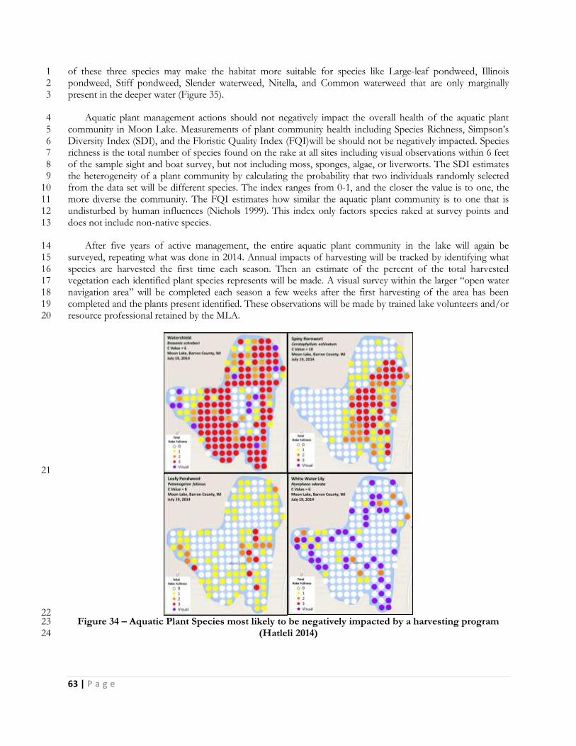
63 | P a g e
of these three species may make the habitat more suitable for species like Large-leaf pondweed, Illinois 1 pondweed, Stiff pondweed, Slender waterweed, Nitella, and Common waterweed that are only marginally 2 present in the deeper water (Figure 35). 3
Aquatic plant management actions should not negatively impact the overall health of the aquatic plant 4 community in Moon Lake. Measurements of plant community health including Species Richness, Simpson’s 5 Diversity Index (SDI), and the Floristic Quality Index (FQI)will be should not be negatively impacted. Species 6 richness is the total number of species found on the rake at all sites including visual observations within 6 feet 7 of the sample sight and boat survey, but not including moss, sponges, algae, or liverworts. The SDI estimates 8 the heterogeneity of a plant community by calculating the probability that two individuals randomly selected 9 from the data set will be different species. The index ranges from 0-1, and the closer the value is to one, the 10 more diverse the community. The FQI estimates how similar the aquatic plant community is to one that is 11 undisturbed by human influences (Nichols 1999). This index only factors species raked at survey points and 12 does not include non-native species. 13
After five years of active management, the entire aquatic plant community in the lake will again be 14 surveyed, repeating what was done in 2014. Annual impacts of harvesting will be tracked by identifying what 15 species are harvested the first time each season. Then an estimate of the percent of the total harvested 16 vegetation each identified plant species represents will be made. A visual survey within the larger “open water 17 navigation area” will be completed each season a few weeks after the first harvesting of the area has been 18 completed and the plants present identified. These observations will be made by trained lake volunteers and/or 19 resource professional retained by the MLA. 20
21
22 Figure 34 – Aquatic Plant Species most likely to be negatively impacted by a harvesting program 23
(Hatleli 2014) 24
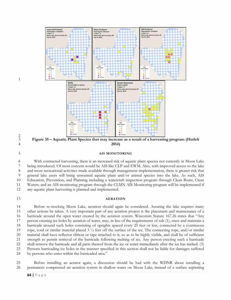
64 | P a g e
1
2 Figure 35 – Aquatic Plant Species that may increase as a result of a harvesting program (Hatleli 3
2014) 4
AIS MONITORING 5
With contracted harvesting, there is an increased risk of aquatic plant species not currently in Moon Lake 6 being introduced. Of most concern would be AIS like CLP and EWM. Also, with improved access to the lake 7 and more recreational activities made available through management implementation, there is greater risk that 8 general lake users will bring unwanted aquatic plant and/or animal species into the lake. As such, AIS 9 Education, Prevention, and Planning including a watercraft inspection program through Clean Boats, Clean 10 Waters; and an AIS monitoring program through the CLMN AIS Monitoring program will be implemented if 11 any aquatic plant harvesting is planned and implemented. 12
AERATION 13
Before re-stocking Moon Lake, aeration should again be considered. Aerating the lake requires many 14 other actions be taken. A very important part of any aeration project is the placement and maintenance of a 15 barricade around the open water created by the aeration system. Wisconsin Statute 167.26 states that “Any 16 person creating ice holes by aeration of water, may, in lieu of the requirements of sub (1), erect and maintain a 17 barricade around such holes consisting of uprights spaced every 25 feet or less, connected by a continuous 18 rope, cord or similar material placed 3 ½ feet off the surface of the ice. The connecting rope, and/or similar 19 material shall have reflector ribbon or tape attached to it, so as to be highly visible, and shall be of sufficient 20 strength to permit retrieval of the barricade following melting of ice. Any person erecting such a barricade 21 shall remove the barricade and all parts thereof from the ice or water immediately after the ice has melted. (3) 22 Persons barricading ice holes in the manner specified in this section shall not be liable for damages suffered 23 by persons who enter within the barricaded area.” 24
Before installing an aerator again, a discussion should be had with the WDNR about installing a 25 permanent compressed air aeration system in shallow water on Moon Lake, instead of a surface aspirating 26
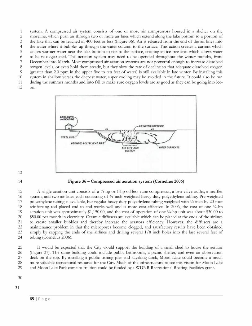
65 | P a g e
system. A compressed air system consists of one or more air compressors housed in a shelter on the 1 shoreline, which push air through two or more air lines which extend along the lake bottom to a portion of 2 the lake that can be reached in 400 feet or less (Figure 36). Air is released from the end of the air lines into 3 the water where it bubbles up through the water column to the surface. This action creates a current which 4 causes warmer water near the lake bottom to rise to the surface, creating an ice-free area which allows water 5 to be re-oxygenated. This aeration system may need to be operated throughout the winter months, from 6 December into March. Most compressed air aeration systems are not powerful enough to increase dissolved 7 oxygen levels, or even hold them steady, but they slow the rate of decline so that adequate dissolved oxygen 8 (greater than 2.0 ppm in the upper five to ten feet of water) is still available in late winter. By installing this 9 system in shallow verses the deepest water, super cooling may be avoided in the future. It could also be run 10 during the summer months and into fall to make sure oxygen levels are as good as they can be going into ice-11 on. 12
13
Figure 36 – Compressed air aeration system (Cornelius 2006) 14
A single aeration unit consists of a ¾-hp or 1-hp oil-less vane compressor, a two-valve outlet, a muffler 15 system, and two air lines each consisting of ¾ inch weighted heavy duty polyethylene tubing. Pre-weighted 16 polyethylene tubing is available, but regular heavy duty polyethylene tubing weighted with ½ inch by 20 foot 17 reinforcing rod placed end to end works well and is more cost-effective. In 2006, the cost of one ¾-hp 18 aeration unit was approximately $1,150.00, and the cost of operation of one ¾-hp unit was about $30.00 to 19 $50.00 per month in electricity. Ceramic diffusers are available which can be placed at the ends of the airlines 20 to create smaller bubbles and thereby increase the aerators efficiency. However, the diffusers are a 21 maintenance problem in that the micropores become clogged, and satisfactory results have been obtained 22 simply by capping the ends of the airlines and drilling several 1/8 inch holes into the last several feet of 23 tubing (Cornelius 2006). 24
It would be expected that the City would support the building of a small shed to house the aerator 25 (Figure 37). The same building could include public bathrooms, a picnic shelter, and even an observation 26 deck on the top. By installing a public fishing pier and kayaking dock, Moon Lake could become a much 27 more valuable recreational resource for the City. Much of the infrastructure to see this vision for Moon Lake 28 and Moon Lake Park come to fruition could be funded by a WDNR Recreational Boating Facilities grant. 29
30
31
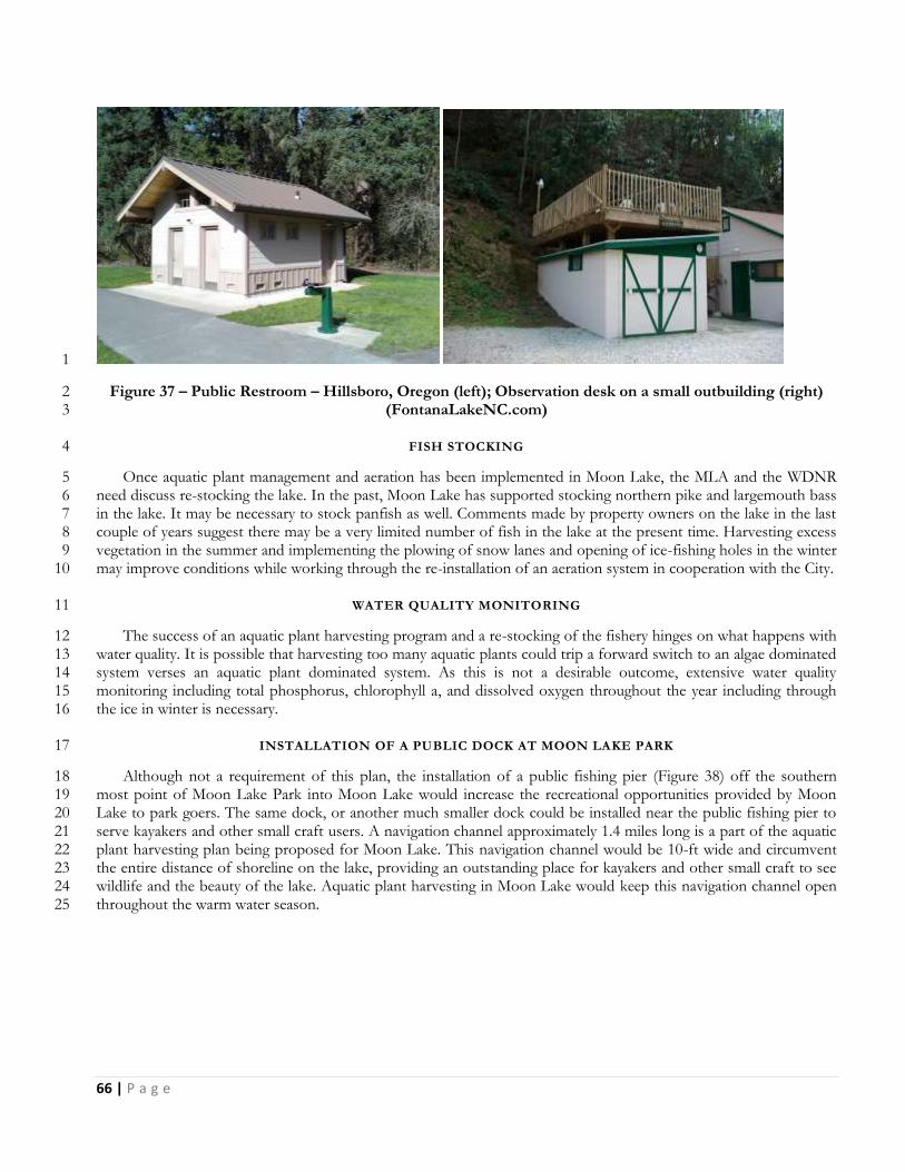
66 | P a g e
1
Figure 37 – Public Restroom – Hillsboro, Oregon (left); Observation desk on a small outbuilding (right) 2 (FontanaLakeNC.com) 3
FISH STOCKING 4
Once aquatic plant management and aeration has been implemented in Moon Lake, the MLA and the WDNR 5 need discuss re-stocking the lake. In the past, Moon Lake has supported stocking northern pike and largemouth bass 6 in the lake. It may be necessary to stock panfish as well. Comments made by property owners on the lake in the last 7 couple of years suggest there may be a very limited number of fish in the lake at the present time. Harvesting excess 8 vegetation in the summer and implementing the plowing of snow lanes and opening of ice-fishing holes in the winter 9 may improve conditions while working through the re-installation of an aeration system in cooperation with the City. 10
WATER QUALITY MONITORING 11
The success of an aquatic plant harvesting program and a re-stocking of the fishery hinges on what happens with 12 water quality. It is possible that harvesting too many aquatic plants could trip a forward switch to an algae dominated 13 system verses an aquatic plant dominated system. As this is not a desirable outcome, extensive water quality 14 monitoring including total phosphorus, chlorophyll a, and dissolved oxygen throughout the year including through 15 the ice in winter is necessary. 16
INSTALLATION OF A PUBLIC DOCK AT MOON LAKE PARK 17
Although not a requirement of this plan, the installation of a public fishing pier (Figure 38) off the southern 18 most point of Moon Lake Park into Moon Lake would increase the recreational opportunities provided by Moon 19 Lake to park goers. The same dock, or another much smaller dock could be installed near the public fishing pier to 20 serve kayakers and other small craft users. A navigation channel approximately 1.4 miles long is a part of the aquatic 21 plant harvesting plan being proposed for Moon Lake. This navigation channel would be 10-ft wide and circumvent 22 the entire distance of shoreline on the lake, providing an outstanding place for kayakers and other small craft to see 23 wildlife and the beauty of the lake. Aquatic plant harvesting in Moon Lake would keep this navigation channel open 24 throughout the warm water season. 25
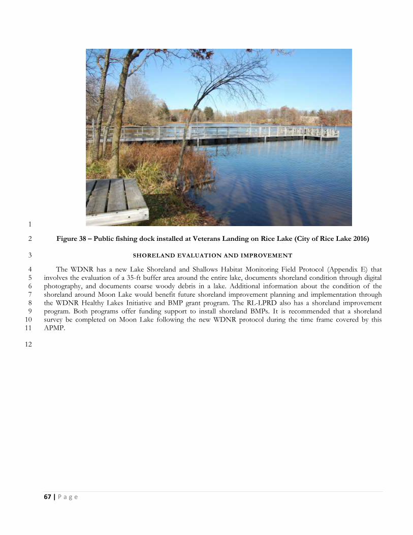
67 | P a g e
1
Figure 38 – Public fishing dock installed at Veterans Landing on Rice Lake (City of Rice Lake 2016) 2
SHORELAND EVALUATION AND IMPROVEMENT 3
The WDNR has a new Lake Shoreland and Shallows Habitat Monitoring Field Protocol (Appendix E) that 4 involves the evaluation of a 35-ft buffer area around the entire lake, documents shoreland condition through digital 5 photography, and documents coarse woody debris in a lake. Additional information about the condition of the 6 shoreland around Moon Lake would benefit future shoreland improvement planning and implementation through 7 the WDNR Healthy Lakes Initiative and BMP grant program. The RL-LPRD also has a shoreland improvement 8 program. Both programs offer funding support to install shoreland BMPs. It is recommended that a shoreland 9 survey be completed on Moon Lake following the new WDNR protocol during the time frame covered by this 10 APMP. 11
12
68 | P a g e
AQUATIC PLANT MANAGE MENT GOALS, OBJECTIV ES, AND ACTIONS ( APPENDIX F) 1
Moon Lake supports an aquatic plant community with a number of high value species, but at the present time, 2 does not support any significant fishery due to recent and severe winterkills. The lake does not have any aquatic 3 invasive plant species other than reed canary grass and narrow-leaf cattails along parts of the shore. These invasive 4 species will not be directly managed as a part of this APMP. Nuisance conditions and navigation impairment caused 5 by dense native plant growth occur throughout the open water season over the entire surface water area of the lake. 6 This APMP establishes the following eight goals for aquatic plant and other management planning, monitoring, and 7 surveying; and for increasing the value of Moon Lake to the surrounding community, lake users, and property 8 owners: 9
1. Monitor and Maintain a Healthy Lake Plant Community 10
2. Manage Aquatic Plants to provide Greater Lake Use and Improve Habitat 11
3. Prevent the Introduction of new AIS 12
4. Monitor and Maintain Water Quality 13
5. Restore the Fish Community 14
6. Improve Public Recreational Access and Nature Immersion Opportunities for 15
Community Members 16
7. Evaluate and Improve Shoreland 17
8. Implement Adaptive Management. 18
Each of these goals has several management objectives and associated actions to be implemented over the next 19 five years. 20
21

69 | P a g e
GOAL 1 - MAINTAIN A HEALTHY LAKE PLANT COMMUNITY 1
It is the goal of the management actions in this plan to maintain and protect the native aquatic plant community 2 in Moon Lake, causing no decline in the following measures of a healthy, diverse, and sustainable aquatic plant 3 community: Floristic Quality Index, Simpson’s Diversity Index, and total species richness including visuals. Aquatic 4 plant management actions will be completed in ways to minimize disruptive changes in the aquatic plant community 5 in the lake. 6
OBJECTIVE 1: OVER THE COURSE OF THE NEXT FIVE YEARS (2017-21) THE FOLLOWING MEASURES OF A 7 HEALTHY NATIVE AQUATIC PLANT COMMUNITY WILL BE MAINTAINED OR EXCEEDED: 8
Table 2: Values to Measure the Health of the Native Aquatic Plant Community in Moon Lake 9
All Plants 2014
Simpson’s Diversity Index (SDI) 0.83
Floristic Quality Index (FQI) 26.73
Total Species Richness including boat survey 31
10
i. Action Item: Implement aquatic plant management actions that will minimize disruption of the native 11 aquatic plant population and wildlife habitat. 12
a. No more than one-third (1/3) of the surface area of the lake (28 acres) will be harvested in any 13 single year. 14
b. Harvesting depth in any location will not exceed two-thirds (2/3) of the depth of the water 15 column. 16
c. Harvesting will not be completed in water <3-ft deep. 17
ii. Action Item: Determine appropriate management actions annually based on management and survey 18 results from the previous year. 19
a. Representatives from the MLA and/or a resource professional retained by the MLA will use 20 prior year management results and impacts identified by aquatic plant survey actions to propose 21 current year management actions. 22
OBJECTIVE 2: MEASURE THE IMPACTS OF ANNUAL HARVESTING ON NATIVE AQUATIC PLANTS IN THE 23 LAKE. 24
i. Action Item: During actual harvesting, trained MLA volunteers or a resource professional retained by 25 the MLA will identify as many individual species as possible removed by the harvesting and estimate 26 what percent of the total harvest each species represents. 27
ii. Action Item: Approximately three weeks after harvesting, trained MLA volunteers or a resource 28 professional retained by the MLA will visually inspect the harvested area from a boat and identify the 29 species present. 30

70 | P a g e
OBJECTIVE 3: MEASURE THE FIVE YEAR IMPACT OF AQUATIC PLANT MANAGEMENT COMPLETED ON 1 MOON LAKE. 2
i. Action Item: Repeat a whole lake, point-intercept, aquatic plant survey in 2021 using the same points 3 generated for the 2014 survey. 4
ii. Action Item: Review and revise the existing APM Plan in 2012 for implementation in 2022. 5
6
71 | P a g e
GOAL 2 - MANAGE AQUATIC PLANTS TO PROVIDE GREATER LAKE USE AND IMPROVE HABITAT 1
Management of native aquatic plants to provide improved navigation, open water, and riparian access to open 2 water is necessary in Moon Lake. By doing so, the lake will be made more valuable for fish and wildlife, provide the 3 local community with an opportunity to experience and appreciate nature, and make the lake more usable for property 4 owners and others to enjoy the lake. The best alternatives for completing this goal are manual removal and 5 mechanical harvesting. 6
Using contracted mechanical harvesting to manage the aquatic plants in Moon Lake is recommended to provide 7 greater access for fishing and boating, improve fishing and fish habitat, and to reduce build-up of organic materials in 8 the lake which may in time reduce the number and severity of winter fish kills. 9
Manual or physical removal is the recommended method to control plant growth around docks and in areas where 10 the water depth is shallower than 3 feet. For aquatic plant control in small, shallow lake areas adjacent to shore, it is 11 recommended that plant removal rakes and/or razors be used by riparian property owners. As mentioned in a 12 previous section, physical removal of aquatic plants is allowable without a permit within an area up to 30-ft wide near a 13 dock or along a shoreline used for recreational activities, provided the parts of the plant cut or pulled are removed 14 completely from the water and disposed of properly. By its very nature, physical removal is often a difficult and 15 daunting task, thus minimizing how much plant material is actually removed. Native plant removal should be limited 16 only to the amount needed to access open water areas or provide navigation and access lanes. Coarse woody habitat 17 (tree falls, logs, etc.) should be left in the water as it is a critical feature of lakes influencing fish behavior, spawning, 18 predator-prey interactions, growth, and species diversity. Research has shown that the growth of largemouth bass and 19 bluegill are positively correlated with coarse woody habitat in lakes and a whole lake removal of coarse woody habitat 20 led to the collapse of a yellow perch population (Radomski and Goeman 2001). 21
OBJECTIVE 1: ESTABLISH A COMMON USE NAVIGATION CHANNEL AROUND THE PERIMETER OF THE 22 LAKE. 23
i. Action Item: Through contracted harvesting services, a common use navigation channel approximately 24 1.4 miles long and 10-ft wide may be harvested and maintained around the perimeter of the lake. 25
a. The navigation channel will not be harvested prior to June 15th annually 26
b. The navigation channel may be harvested at a depth of up to 2-ft and will not be harvested in 27 water less than 3-ft deep 28
c. The navigation channel may be harvested more than once during a season 29
OBJECTIVE 2: ESTABLISH AN OPEN WATER NAVIGATION AREA IN THE CENTER OF MOON LAKE 30
i. Action Item: Through contracted harvesting services, an open water navigation area of approximately 31 26 acres in water 5-7 feet deep may be harvested and maintained in the center of the lake. 32
a. The open water navigation area will not be harvested prior to June 15th annually. 33
b. The open water area may be harvested at a depth of up to 3.5-ft. 34
c. The open water area may be harvested more than once during a season. 35

72 | P a g e
OBJECTIVE 3: ESTABLISH RIPARIAN ACCESS LANES FROM PUBLIC ACCESS POINTS AND PROPERTY 1 OWNERS ON MOON LAKE 2
i. Action Item: Through contracted harvesting services, riparian access lanes may be harvested and 3 maintained to allow access to lake property owners and users to the navigation channel and open water. 4
a. Riparian access lanes will not be harvested prior to June 15th annually. 5
b. Riparian access lanes will not be harvested in water <3-ft deep. 6
c. Riparian access lanes may be harvested more than once during a season. 7
OBJECTIVE 4: WORK WITH THE RICE LAKE – LAKE PROTECTION AND REHABILITATION DISTRICT AND 8 TOWN OF RICE LAKE TO DUMP, PICK UP, AND DISPOSE OF HARVESTED AQUATIC VEGETATION FROM 9 MOON LAKE 10
i. Action Item: Establish a partnership where the RL-LPRD uses its equipment to pick up harvested 11 vegetation from the Moon Lake public access and dispose of it at their dumping location. 12
a. Harvested aquatic vegetation will be temporarily unloaded at the Moon Lake public access 13 maintained by the Town of Rice Lake and removed within 3-days by the RL-LPRD. 14
b. Harvested aquatic vegetation will be discarded by the RL-LPRD at their dump site in the Town 15 of Oakland. 16
OBJECTIVE 4: PREPARE WNDR HARVESTING PERMIT APPLICATIONS TO SUPPORT ANNUAL HARVESTING 17 OF AQUATIC VEGETATION IN MOON LAKE. 18
i. Action Item: The MLA representatives or a resource professional retained by the MLA will complete 19 WDNR Mechanical/Manual Aquatic Plant Control Application (Form 3200-113) annually based on a 20 mechanical harvesting proposal prepared in February or March. 21
OBJECTIVE 5: COMPLETE PHYSICAL REMOVAL OF AQUATIC PLANTS IN WATERS <3-FT DEEP AND 22 ADJACENT TO PRIVATE PROPERTY. 23
i. Action Item: Property owners on Moon Lake will use physical removal methods to open areas of dense 24 vegetation near docks and adjacent to their property in so much as to gain access to the harvested 25 riparian access lanes and navigation channel. 26
27

73 | P a g e
GOAL 3 – WORK TO PREVENT THE INTRODUCTION OF NEW AIS 1
AIS can be transported via a number of vectors, but most invasions are associated with human activity. One of 2 the highest risk activities is implementing contracted aquatic plant harvesting on the lake. Harvesters owned by a 3 private contractor are undoubtedly being used to harvest AIS and native aquatic vegetation in the same season. Of 4 particular concern is CLP. Mechanical harvesting of CLP is one of the most accepted forms of AIS management. 5 CLP is an early season aquatic plant so will be harvested before any harvesting of natives plants is completed. CLP 6 fragments and turions (Figure 24) can easily become lodged in the many nooks and crannies of a harvester. It is less 7 likely that EWM will be carried in by contracted harvesting services since harvesting of EWM is not a readily 8 acceptable management action for control of EWM, but it is possible. It is recommended that the harvester brought 9 in by a contractor be inspected for prior harvesting remains by trained MLA volunteers and/or a resource 10 professional retained by the MLA before being launched into the lake 11
It is recommended that the MLA implement an AIS monitoring program. At least three times during the open 12 water season, trained volunteers should patrol the lake and shoreline looking for CLP, EWM, purple loosestrife, 13 Japanese knotweed, giant reed grass, zebra mussels, and other invasive species. Free support for this kind of 14 monitoring program is provided as a part of the UW-Extension Lakes/WDNR Citizen Lake Monitoring Network 15 (CLMN) AIS Monitoring Program. Any monitoring data collected should be recorded annually and submitted to the 16 WDNR SWIMS database. 17
It is further recommended that monitoring of the boat launch on Moon Lake be completed by volunteer and/or 18 paid inspectors following WDNR/UW-Extension Clean Boats, Clean Waters guidelines. All watercraft inspection 19 data collected should be submitted to the WDNR SWIMS database. It is recommended that the MLA participate in 20 the June Drain Campaign and Fourth of July Landing Blitz, two state-wide outreach efforts to remind boaters to 21 drain all water from their boats, livewells, and motors; and to highlight the dangers of transporting invasive species 22 that takes place on the Fourth of July, a high-boat traffic day. It is also recommended that the MLA continue to 23 maintain and update signage at the boat launch as necessary. 24
It is also recommended that all property owners be encouraged to learn about AIS and monitor their shoreline 25 and open water areas for new AIS. Table 3 shows the life stage of some invasive plant and animal species and the 26 best times of the open water season to monitor for them (Scholl 2006). If a suspect AIS is found, or even suspected, 27 it should be reported to the MLA, County, and WDNR resource personnel. 28
Table 3: AIS Monitoring Timetable (Scholl 2006) 29
30

74 | P a g e
OBJECTIVE 1 – REDUCE THE CHANCE THAT A NEW AIS IS INTRODUCED INTO MOON LAKE BY AQUATIC 1 PLANT HARVESTING ACTIVITIES. 2
i. Action Item: Inspect all harvesting equipment brought to the lake by a contractor prior to it being 3 launched into the lake. 4
a. Ask the contractor for a list of the lakes and aquatic plants harvested in the same year as MLA 5 contracts. 6
b. Ask and confirm the contractor’s harvester cleaning and disinfection protocol between jobs. 7
c. Ask for a signed document from the contractor that the harvesting equipment has been cleaned 8 and inspected prior to completing the job. 9
OBJECTIVE 2 - REDUCE THE LIKELIHOOD THAT NEW AIS GOES UNDETECTED IN MOON LAKE. 10
i. Action Item: Participate in and complete AIS monitoring actions through the Citizen Lake Monitoring 11 Network (CLMN) AIS Monitoring Program. 12
a. MLA volunteers or a resource professional retained by the MLA will complete AIS monitoring 13 of the lake and shoreline at least three times each open water season following CLMN AIS 14 Monitoring Guidelines. 15
b. AIS monitoring data will be entered into the WDNR SWIMS database annually. 16
OBJECTIVE 3 - IMPLEMENT A CLEAN BOATS CLEAN WATERS (CBCW) WATER CRAFT INSPECTION 17 PROGRAM ANNUALLY. 18
i. Action Item: Determine an appropriate amount of watercraft inspection time at the Moon Lake public 19 access to prevent introduction of AIS through transient boaters. 20
a. Participate in the WDNR June Drain Campaign and 4th of July landing Blitz annually. 21
b. Install updated AIS education signs at the Moon Lake public access and at the Walk-in Access 22 from Moon Lake Park. 23
OBJECTIVE 4 – EDUCATE AND INFORM PROPERTY OWNERS AND LAKE USERS ABOUT AIS AND HOW TO 24 IDENTIFY THEM 25
i. Action Item: Seek out AIS education events sponsored by other entities and/or sponsor AIS education 26 events and then encourage property owners on Moon Lake to attend. 27
ii. Action Item: Research AIS and lake stewardship materials with little or no cost to attain and distribute 28 to property owners at events including but not limited to Annual Meetings, Lake Fairs, Summer Picnic, 29 etc. 30
iii. Action Item: Report findings of suspect AIS to the MLA, Barron County, WDNR, and other Resource 31 entities. 32
33
75 | P a g e
GOAL 4 - MONITOR AND MAINTAIN WATER QUALITY 1
At the present time, Moon Lake is a plant dominated and fairly fertile body of water. The level of phosphorus in 2 the lake is bordering on eutrophic or nutrient rich. Chlorophyll a, which is a measurement of the amount of algae in 3 the water, is at present pretty low indicating that abundant aquatic plant growth, stimulated by clear water is using up 4 a majority of the available phosphorus before it can be used by algae. By removing a substantial amount of aquatic 5 vegetation, there is a risk that the harvesting could trigger a forward switch causing the lake to shift from plant 6 dominance and clear water to algae dominance and green water. This is not an acceptable outcome for this project, 7 so extensive water quality monitoring is necessary to track changes in water quality before they become irreversible. 8 In addition, it is expected that aquatic plant harvesting and other actions implemented through this APMP will 9 maintain or improve adequate dissolved oxygen (DO) levels in the lake throughout the year, but particularly under 10 the ice. Winter monitoring of nutrients and oxygen is highly recommended if any management is to occur. 11
OBJECTIVE 1 – MONITORING WATER CLARITY AND NUTRIENT LEVELS (TOTAL PHOSPHORUS & 12 CHLOROPHYLL A) IN MOON LAKE ANNUALLY 13
i. Action Item: Continue involvement in the WDNR/UWEX-Lakes CLMN Water Quality Monitoring 14 Program at the Center location in Moon Lake. 15
a. Collect Secchi Disk readings of water clarity and temperature at least monthly May through 16 October. 17
b. Make a request to the CLMN Program to move Moon Lake into the Expanded Monitoring 18 program which collects monthly total phosphorus samples from May to August; and monthly 19 chlorophyll a samples from June to August. 20
OBJECTIVE 2 – COLLECT DISSOLVED OXYGEN AND TEMPERATURE PROFILES MONTHLY THROUGH THE 21 ENTIRE YEAR 22
i. Action Item: Either through the CLMN Program or another program, DO profiles should be collected 23 at least monthly through the entire year (Jan.-Dec.) 24
ii. Action Item: When resources are available, increase total phosphorus and chlorophyll a sampling to 25 include September and October. 26
27

76 | P a g e
GOAL 5 - RESTORE THE FISH COMMUNITY 1
Despite having an aeration system operating in the lake, a severe winterkill over the 2013-14 winter season nearly 2 wiped out the entire fish population in Moon Lake. To date, the fish population in Moon Lake has not recovered. It 3 is thought that the winterkill was caused by super cooling of the lake water in the winter. Super cooling occurs when 4 warm bottom water in a shallow lake is mixed too rapidly with colder surface water just under the ice, creating undue 5 stress on the existing fish population. The super cooling in Moon Lake may have been caused by the surface 6 aspirating aeration system that was operated in the lake. Along with low oxygen levels to begin with, this undue stress 7 weakened and killed the fish. There may be ways to maintain or improve oxygen levels under the ice that would 8 reduce the potential for super cooling and/or low DO. Heavy snow cover that lasts well into the spring limits 9 production of DO by aquatic plant alive under the ice. Plowing snow-free lanes on the surface of the ice can increase 10 the amount of sunlight that gets to the plants under the ice. Lots of ice fishing holes can be drilled in the ice to 11 increase the transfer of oxygen in the air to the water. Removal of aquatic plants can reduce the amount of vegetation 12 that dies and decays under the ice using up available DO. 13
Aeration can again be installed, but a different system which may reduce the likelihood of super cooling could be 14 used. A compressed air system is often installed in shallow lakes and operated continuously, year round. By operating 15 the aerator in the late summer and fall, it may be possible to increase DO levels in the water before it freezes over. 16 By installing the aerator in shallow water, and only operating it when it is shown that DO levels are falling, it may be 17 possible to reduce the chance of super cooling. 18
Once aquatic plant harvesting has been implemented and aeration re-installed, re-stocking Moon Lake to restore 19 its former warm water fishery of bass, panfish, and northern pike can be completed. Restoring the fish population in 20 the lake will increase the recreational value of the lake for property owners, community members and other lake 21 users. 22
OBJECTIVE 1 – IMPLEMENT MANAGEMENT ACTIONS THAT MAY MAINTAIN OR IMPROVE DISSOLVED 23 OXYGEN LEVELS IN THE LAKE THROUGHOUT THE SEASON 24
i. Action Item: Implement aquatic plant harvesting actions in Goal 2 25
ii. Action Item: Plow snow-free lanes across the frozen surface of Moon Lake 26
a. Work with property owners on Moon Lake to identify a volunteer or a contractor who could 27 plow snow-free lanes on the ice once it is strong enough to drive on 28
iii. Action Item: Drill lots of holes through the ice when DO levels start to fall under the ice 29
a. When DO monitoring under the ice shows DO levels starting to drop, encourage property 30 owners and lake users to drill as many ice fishing holes as they can until ice conditions prevent 31 access. 32
OBJECTIVE 2 – RE-INSTALL AN AERATION SYSTEM IN MOON LAKE 33
i. Action Item: Work with the WDNR and City to determine logistics for re-installation of an aeration 34 system. 35
a. Determine the type and location of aeration to install, surface aspirating vs. compressed air 36
b. Determine support from the City and WDNR grant programs (Recreational Boating Facilities 37 and/or Sport Fish Restoration) for making improvements to Moon Lake Park that would 38 support an aeration system. 39

77 | P a g e
ii. Action Item: Install, operate, and maintain an Aeration System in Moon Lake 1
OBJECTIVE 3 – RE-STOCK MOON LAKE WITH FISH 2
i. Action Item: Work with the WDNR to determine an appropriate time to begin re-stocking fish into 3 Moon Lake 4
a. Discuss plans to complete aquatic plant harvesting and actions to improve DO including snow-5 free lanes, ice holes, and installation of an aeration system with the WDNR and how they 6 impact the decision to re-stock the lake. 7
ii. Action Item: Discuss options for re-stocking the lake with the WDNR including species, size, and 8 number to re-stock. 9
10

78 | P a g e
GOAL 6 - IMPROVE PUBLIC RECREATIONAL ACCESS AND NATURE IMMERSION OPPORUNITIES FOR 1 COMMUNITY MEMBERS 2
In its Outdoor Recreation Plan, the City’s lists several goals that improving the conditions in Moon Lake and 3 improving community access to the lake would help meet. The following four goals are on page 8 of the 2014-2019 4 Comprehensive Outdoor Recreation Plan: 5
To enhance the quality of life and encourage healthy lifestyles while reconnecting people, especially children, 6 to the outdoors through our parks and open spaces, natural areas, trails, and outdoor recreation programs. 7
To develop a stewardship ethic, protect our natural environment for sustainable conservation for our 8 community and generations to come. 9
To ensure all people the access to a safe, affordable and healthy way to experience and appreciate nature 10 while improving social and economic value to the City. 11
Provide a mix of affordable, quality outdoor recreation facilities, programs, and amenities at various scales 12 and development intensities which meet the needs of residents while taking advantage of tourism 13 opportunities. 14
15 Along with these four goals, the Outdoor Recreation Plan also lists the following objectives on page 9-10: 16
To provide a safe environment for play and physical activity and areas for active and passive recreation 17 opportunities that meet the needs of all age groups, cultures, and ethnicity within the community. 18
To improve and revitalize our parks as gathering places for our youth, families and adults to play, exercise, 19 relax, enjoy time with family and friends, and experience the natural environment. 20
To provide space for social interaction, health and wellness, and cultural diversity. 21
To obtain, when opportunities are feasible, sites for open green space, playgrounds, parks, trails, etc. 22
To provide opportunities for rural residents to enjoy the community's parks, natural resources, and 23 recreation areas. 24
To establish priorities for needed outdoor recreation facilities based on prominent outdoor recreation trends, 25 as well as existing recreational land distribution and existing and/or future deficiencies. 26
To raise awareness to help preserve and protect our natural resources within our parks and adjacent to, along 27 with the promotion of good conservation and stewardship practices. 28
To coordinate the community’s recreation program with other agencies, organizations, schools, other levels 29 of government and private enterprise to ensure maximum public benefit. 30
To ensure that all people have access and adequate parking to our water amenities and public recreation 31 areas. 32
To protect scenic values by managing billboards, signs, junkyards and other unsightly land uses and 33 practices. 34
To make improvements and modifications to accommodate Adaptive/ADA compliant facilities, play 35 structures and accessibility that meet the needs of the physically challenged including the elderly and disabled 36 that meet the American Disabilities Act standards. 37
To provide for the periodic review and updating of the city outdoor recreation plan so that it will reflect the 38 changing needs and trends of the community. 39
To provide for annual planning, programming and maintenance of park and recreation facilities throughout 40 the community with funding from the Capital Improvements Program (CIP), general obligation borrowing 41 and other funding sources private or public. 42
To create and promote alternative means of transportation within the City by the establishment of trails and 43 sidewalk connections for recreational and multimodal transportations activities. 44
45 Nearly all of the goals and objectives listed in the City Comprehensive Outdoor Recreation Plan can be 46
addressed at some level with the management actions and activities recommended in this APMP. Moon Lake is a 47

79 | P a g e
valuable natural resource within the city limits that is being under-utilized at the present time, due in part to the poor 1 condition of the lake. One of the property owners on Moon Lake is a well-respected and popular (with students) 2 Rice Lake High School biology teacher who encourages students to get involved in natural resource activities in the 3 community and surrounding area. 4
This APMP recommends that the MLA work with the City, Rice Lake High School, and other community 5 partners to determine how what is done in Moon lake can improve its value in the community. Through the efforts 6 of the MLA; support from WDNR grants and City outdoor recreation programs; and partnerships with the City, Rice 7 Lake High School, Rice Lake – Lake Protection and Rehabilitation District, and other community organizations 8 Moon Lake can be utilized as the valuable resource that it should be. 9
OBJECTIVE 1 – WORK WITH THE CITY OF RICE LAKE AND OTHER ENTITIES TO IMPROVE PUBLIC ACCESS 10 TO MOON LAKE AT THE SOUTH END OF MOON LAKE PARK 11
i. Action Item: Improve walk-in access and launching facilities for kayakers and users of other small craft; 12 wildlife enthusiasts; and small group learning opportunities off the south end of the Park. 13
ii. Action Item: Install a public fishing dock off the south end of the Park. 14
iii. Action Item: Build a bathroom/shelter/aeration storage shed at the south end of the Park 15
iv. Action Item: Build a road to, and a small parking area at the south end of the Park. Bring electricity to 16 the south end of the Park. 17
OBJECTIVE 2 – WORK WITH RICE LAKE AREA SCHOOLS TO FIGURE OUT HOW MOON LAKE AND MOON 18 LAKE PARK CAN BE BETTER UTILIZED AS A NATURAL RESOURCE LEARNING TOOL 19
i. Action Item: Discuss how Moon Lake and Moon Lake Park can be improved to provide outdoor 20 education opportunities for students and teachers. 21
OBJECTIVE 3 – EXPLORE FUNDING PROGRAMS THAT MIGHT BE USED TO SUPPORT IMPROVED LAKE 22 ACCESS FOR RECREATIONAL ACTIVITIES, OUTDOOR LEARNING ACTIVITIES, AND HABITAT 23 IMPROVEMENTS 24
i. Action Item: Evaluate how and if certain WDNR grant programs including the Recreational Boating 25 Facilities and Sport Fish Restoration can be used to increase the community value of Moon Lake. 26
ii. Action Item: Work with the City and Rice Lake – Lake Protection and Rehabilitation District funding 27 opportunities could be used to increase the community value of Moon Lake. 28
29

80 | P a g e
GOAL 7 - EVALUATE AND IMPROVE THE SHORELAND AROUND MOON LAKE 1
Once harvesting of aquatic plants in Moon Lake is started, there is a risk of causing the lake to go from plant 2 dominated clear water to algae dominated green water. Removal of aquatic plant may make more nutrients in the lake 3 available to grow algae. Reducing the amount of nutrients entering Moon Lake from its rather small watershed may 4 lessen the chance the lake switches over. One inexpensive way to reduce nutrients entering the lake is to make 5 shoreland improvements around the lake. There are many shoreland best management practices (BMPs) including 6 establishing buffer strips through no mowing, native plantings, shoreland restoration, installation of rain gardens, and 7 diversion of surface water runoff away from the lake that will reduce nutrient loading over time. 8
To maintain the quality and diversity of the Moon Lake, it is recommended that the MLA provide riparian 9 owners with educational materials on shoreland improvement and/or sponsor/promote shoreland improvement 10 training events. Not knowing where to begin with a shoreland restoration is often the main hurdle preventing 11 property owners from implementing a practice that would help improve the lake. General information on shoreland 12 restoration could be provided to all property owners in a newsletter and/or during public events. There are many 13 free, down-loadable on-line resources, and both free and low cost paper resources including guides, pamphlets, and 14 brochures available to help the average person work toward making improvements on their own properties. UW-15 Extension has offices in nearly every county in Wisconsin and offers these materials for free or at very low prices. 16 They also sponsor local workshops and/or training sessions, or can direct people to others who do. Local 17 greenhouses and landscaping companies often have shoreland restoration packages for specific project types 18 available to the public. 19
The WDNR has a new Lake Shoreland and Shallows Habitat Monitoring Field Protocol that involves the 20 evaluation of a 35-ft buffer area around the entire lake, documents shoreland condition through digital photography, 21 and documents coarse woody debris in a lake. Additional information about the condition of the shoreland around 22 Moon Lake would benefit future shoreland improvement planning and implementation through the WDNR Healthy 23 Lakes Initiative and BMP grant program. The RL-LPRD also has a shoreland improvement program. Both programs 24 offer funding support to install shoreland BMPs. It is recommended that a shoreland survey be completed on Moon 25 Lake following the new WDNR protocol during the time frame covered by this APMP. 26
OBJECTIVE 1: REDUCE THE AMOUNT OF SHORELAND WITHOUT A NATURAL BUFFER IN PLACE BY 27 THROUGH SHORELAND RESTORATION AND OTHER BEST MANAGEMENT PRACTICES. 28
i. Action Item: Complete a shoreland inventory of all developed properties to determine the amount of 29 shoreland that is not in a natural state. 30
ii. Action Item: Distribute shoreland improvement education and information materials to lake property 31 owners through the newsletter, webpage, and general mailings. 32
iii. Action Item: Host and/or sponsor lake events that encourage land owner participation in best 33 management practices. 34
iv. Action Item: Support property owners who wish to complete shoreland or habitat improvement 35 projects through the WDNR Healthy Lakes and RL-LPRD programs. 36
v. Action Item: Recognize property owners who participate in and/or complete shoreland restoration and 37 habitat improvement projects in the newsletter, on the webpage, in local news publications, and/or at 38 the site of the project. 39
40

81 | P a g e
GOAL 8 - ADAPTIVE MANAGEMENT 1
This APMP is a working document guiding management actions on Moon Lake over the next five years. This 2 plan will follow an adaptive management approach by evaluating results and adjusting actions on the basis of what 3 has been learned. This plan is therefore a living document, successively evolving and improving to meet 4 environmental, social, and economic goals, to increase scientific knowledge, and to reduce tensions among 5 stakeholders. If WDNR grant funds are used to support implementation of this APMP, the MLA and their retainers 6 will compile, analyze, and summarize management operations, public education efforts, and other pertinent data into 7 an annual report each year. The information will be presented to members of the MLA, the WDNR, and others 8 upon request. 9
OBJECTIVE 1 – IMPLEMENT AS MANY OF THE RECOMMENDATIONS IN THIS APMP AS POSSIBLE OVER THE 10 NEXT FIVE YEARS WITH THE RESOURCES AVAILABLE TO THE MLA 11
i. Action Item: Utilize the Implementation and Funding Matrix included with this APMP (Appendix G) 12 to prioritize and determine the timing for implementation of specific recommendations included in this 13 plan. 14
15
82 | P a g e
IMPLEMENTATION AND E VALUATION 1
This plan is intended to be a tool for use by the MLA to move forward with aquatic plant management actions 2 that will maintain the health and diversity of Moon Lake - its aquatic plant community, and the value of the lake to 3 the community. This plan is not intended to be a static document, but rather a living document that will be evaluated 4 on an annual basis and updated as necessary to ensure goals and community expectations are being met. 5 Implementation of as many of the actions in this plan as there are resources available is recommended. Funding to 6 support implementation of this plan may be obtained through diverse sources including WDNR grants, City funding, 7 Rice Lake – Protection and Rehabilitation District funding, community donations of time and money, and MLA dues 8 and fundraising. An Implementation and Funding Matrix is provided. 9
10
83 | P a g e
WISCONSIN DEPARTMENT OF NATURAL R ESOURCES GRANT PROGRAMS 1
There are several WDNR grant programs that may be able to assist the Sand Lake Management District in 2 implementing its new APMP. AIS grants are specific to actions that involve education, prevention, planning, and in 3 some cases implementation of AIS management actions. Lake Management Planning grants can be used to support a 4 broad range of management planning and education actions. Lake Protection grants can be used to help implement 5 approved management actions that would help to improve water quality. WDNR Healthy Lakes grants are part of 6 the Lake Protection program. 7
AIS PREVENTION AND CONTROL GRANTS 8
The AIS Prevention and Control grants are a cost-share effort by the WDNR to provide information and 9 education on types of existing and potential AIS in Wisconsin, the threats that invasive species pose to the state's 10 aquatic resources, and available techniques for invasive species control. These grants also assist in the planning and 11 implementation of projects that will prevent the introduction of invasive species into waters where they currently are 12 not present, controlling and reducing the spread of invasive species from waters where they are present, and 13 restoring native aquatic communities. 14
There are five AIS Prevention and Control grants subprograms: 15
Education, Prevention and Planning Projects (including Clean Boats Clean Waters) 16
Early Detection and Response Projects 17
Established Population Control Projects 18
Maintenance and Containment Projects 19
Research and Demonstration Projects 20 21
The MLA, with the RL-LPRD sponsoring may be eligible for Education, Prevention, and Planning; Clean Boats, 22 Clean Waters, and Maintenance and Containment grants. 23
EDUCATION, PREVENTION AND PLANNING PROJECTS 24
Education projects are intended to broaden the public's awareness and understanding of, and ability to identify, 25 AIS; the threats that AIS pose to the health of aquatic ecosystems; the measures to prevent the spread of AIS; and 26 the management practices used for control of AIS. Prevention projects are intended to prevent the introduction of 27 new AIS into a waterbody/wetland, or prevent the spread of an AIS population from one waterbody to another 28 unpopulated waterbody/wetland. Planning projects are intended to assist in the development of plans for the 29 prevention and control of AIS. Eligible projects include: 30
Educational programs including workshops, training sessions, or coordinated volunteer monitors. Projects 31 will be reviewed for consistency with the DNR’s statewide education strategy for controlling AIS including 32 the use of existing publications and outreach materials. 33
Development of AIS prevention and control plans 34
Monitoring, mapping, and assessing waterbodies for the presence of AIS or other studies that will aid in the 35 AIS prevention and control. 36
Watercraft inspection and education projects following the guidelines of the DNR’s Clean Boats, Clean 37 Waters program. 38
39 This subprogram is not intended to provide support for any management action that may be taken. 40
84 | P a g e
Funding Possibilities 1
Maximum amount of grant funding is 75% of the total project costs, not to exceed $150,000. Applications will be 2 separated into two classes: less than $50,000 in state funding and between $50,001 and $150,000 in state funding. 3 Clean Boats Clean Waters projects are limited to $4,000 per public boat launch facility but may be a component of a 4 larger project. 5
ESTABLISHED POPULATION CONTROL PROJECTS 6
Established population control grants are intended to assist applicants in eradicating or substantially reducing 7 established populations of AIS to protect and restore native species communities. Established populations are 8 defined as substantial reproducing populations of AIS that are not pioneer populations. Eligible projects include 9 activities recommended in a DNR-approved control plan including monitoring, education, and prevention activities. 10 Ineligible projects include the following: 11
Dredging 12
Chemical treatments or mechanical harvesting of aquatic plants to provide single season nuisance or 13 navigational relief. 14
Maintenance and operation of aeration systems and mechanical structures used to suppress aquatic plant 15 growth. 16
Structural facilities for providing boat washing stations. Equipment associated with boat washing facilities is 17 eligible if included in a management plan. 18
Funding Possibilities 19
Maximum amount of the grant funding is 75% of the total project costs, not to exceed $200,000. 20
MAINTENANCE AND CONTAINMENT PROJECTS 21
Maintenance and containment grants are intended to provide sponsors limited financial assistance for the ongoing 22 control of established AIS population without the assistance of an Established Population Control grant. These 23 projects are intended for waters where management activity has achieved the target level of control identified in an 24 approved plan that meets the criteria of s. NR 198.43, Wis. Adm. Code. Ongoing maintenance is needed to contain 25 these populations so they do not re-establish throughout the waterbody, spread to other waters, or impair navigation 26 and other beneficial uses of the waterbody. 27
Funding Possibilities 28
Maximum amount of grant funding will be determined by DNR based on the sponsor’s permit application fee, 29 specified monitoring and reporting requirements in the permit, or DNR-approved management plan. The maximum 30 grant amount shall not exceed the cost of the permit application fee. 31 32
LAKE MANAGEMENT PLANNING GRANTS 33
Lake management planning grants are intended to provide financial assistance to eligible applicants for the collection, 34 analysis, and communication of information needed to conduct studies and develop management plans to protect 35 and restore lakes and their watersheds. Projects funded under this subprogram often become the basis for 36 implementation projects funded with Lake Protection grants. There are two categories of lake management planning 37 grants: small-scale and large-scale. 38 39 The MLA, with the RL-LPRD sponsoring, may be eligible for either small or large scale lake management planning 40 grants to support planning and implementation of certain activities included in this document. 41
85 | P a g e
SMALL SCALE LAKE MANAGEMENT PROJECTS 1
Small-scale projects are intended to address the planning needs of lakes where education, enhancing lake 2 organizational capacity, and obtaining information on specific lake conditions are the primary project objectives. 3 These grants are well suited for beginning the planning process, conducting minor plan updates, or developing plans 4 and specification for implementing a management recommendation. Eligible projects include: 5
Collect and report chemical, biological, and physical data about lake ecosystems for a Tier I assessments, 6 Tier II diagnostic or Tier III project evaluation. 7
o Tier I if initial basic monitoring is needed to assess the general condition or health of the lake. 8 o Tier II if an assessment has been conducted and more detailed data collection is needed to diagnose 9
suspected problems and identify management options. 10 o Tier III if the monitoring and assessment will be used to evaluate the effectiveness of a recently 11
implemented project or lake management strategy. 12
Collecting and disseminating existing information about lakes for the purpose of broadening the 13 understanding of lake use, Lake Ecosystem conditions and lake management techniques. 14
Conducting workshops or trainings needed to support planning or project implementation. 15
Projects that will assist management units as defined in s. NR191.03 (4) & s. NR 190.003 (4) the formation 16 of goals and objectives for the management of a lake or lakes. 17
Funding Possibilities 18
Maximum amount of grant funding is 67% of the total project costs, not to exceed $3,000. 19
LARGE SCALE LAKE MANAGEMENT PROJECTS 20
Large-scale projects are intended to address the needs of larger lakes and lakes with complex and technical planning 21 challenges. The result will be a lake management plan; more than one grant may be needed to complete the plan. 22 Eligible projects include: 23
Collection of new or updated, physical, chemical and biological information about lakes or lake ecosystems. 24
Definition and mapping of Lake Watershed boundaries, sub-boundaries and drainage system components. 25
Descriptions and mapping of existing and potential land conditions, activities and uses within lake 26 watersheds that may affect the water quality of a lake or its ecosystem. 27
Assessments of water quality and of fish, aquatic life, and their habitat. 28
Institutional assessment of lake protection regulations - review, evaluation or development of ordinances and 29 other local regulations related to the control of pollution sources, recreational use or other human activities 30 that may impact water quality, fish and wildlife habitat, natural beauty or other components of the lake 31 ecosystem. 32
Collection of sociological information through surveys or questionnaires to assess attitudes and needs and 33 identify problems necessary to the development of a long-term lake management plan. 34
Analysis, evaluation, reporting and dissemination of information obtained as part of the planning project and 35 the development of management plans. 36
Development of alternative management strategies, plans and specific project designs, engineering or 37 construction plans and specifications necessary to identify and implement an appropriate lake protection or 38 improvement project. 39
Funding Possibilities 40
Maximum amount of grant funding is 67% of the total project costs, not to exceed $25,000. Multiple grants in 41 sequence may be used to complete a planning project, not to exceed $100,000 for each lake. The maximum grant 42 award in any one year is $50,000 for each lake. If phasing is necessary, all phases should be fully identified and a 43 timeline identified in the initial application. 44
86 | P a g e
1 LAKE PROTECTION GRANTS 2
Lake protection and classification grants assist eligible applicants with implementation of lake protection and 3 restoration projects that protect or improve water quality, habitat or the elements of lake ecosystems. There are four 4 basic Lake Protection subprograms: a) Fee simple or Easement Land Acquisition b) Wetland and Shoreline Habitat 5 Restoration c) Lake Management Plan Implementation d) Healthy Lakes Projects. 6 7 The MLA, with the RL-LPRD sponsoring, may be eligible for Healthy Lakes Projects. 8
HEALTHY LAKES PROJECTS 9
The Healthy Lakes grants are a sub-set of Plan Implementation Grants intended as a way to fund increased 10 installation of select best management practices (BMPs) on waterfront properties without the burden of developing a 11 complex lake management plan. Details on the select best practices can be found in the Wisconsin Healthy Lakes 12 Implementation Plan and best practice fact sheets. 13 14 Eligible best practices with pre-set funding limits are defined in the Wisconsin Healthy Lakes Implementation Plan, 15 which local sponsors can adopt by resolution and/or integrate into their own local planning efforts. By adopting the 16 Wisconsin Healthy Lakes Implementation Plan, your lake organization is immediately eligible to implement the 17 specified best practices. Additional technical information for each of the eligible practices is described in associated 18 factsheets. The intent of the Healthy Lakes grants is to fund shovel-ready projects that are relatively inexpensive and 19 straight-forward. The Healthy Lakes grant category is not intended for large, complex projects, particularly those that 20 may require engineering design. All Healthy Lake grants have a standard 2-year timeline. 21
Funding Possibilities 22
Maximum amount of grant funding is 75% of the total project cost, not to exceed $25,000. Grants run for a 2-year 23 time period. Maximum costs per practice are also identified in the Wisconsin Healthy Lakes Implementation Plan. 24 25
RECREATIONAL BOATING FACILITIES (RBF) GRANTS 26
These grants may be used by counties, towns, cities, villages, tribes, sanitary districts, public inland lake 27 protection and rehabilitation districts and qualified lake associations for recreational boating facility projects. Past 28 projects have included ramps and service docks to gain access to the water, feasibility studies, purchase of aquatic 29 weed harvesting equipment, navigation aids and dredging of waterway channels. Project under this grant program 30 may receive cost-sharing of up to 50% of the total project cost. Eligible projects include: 31
Channel dredging - Dredging of inland water channels for recreational boating (not more than once in ten 32 years). 33
Construction projects including: 34 o Facilities such as ramps and boarding docks required to gain access to the water. 35 o Harbors of refuge – structures such as bulkheads and breakwaters necessary to provide safe water 36
conditions. 37 o Dredging to provide safe water depths. Dredging of basins is an eligible activity only when it is 38
associated with project development. 39 o Support facilities include parking lots and signage, sanitary facilities, fencing and security lighting for 40
the convenience of boaters. 41
Feasibility studies - An investigation of the environmental, economic, and engineering aspects of a 42 recreational boating facility project to determine if the project may be successfully carried out. 43
Improvement and repair of locks - Cost of improvement and repair of locks and facilities that provide access 44 between waterways for operators of recreational watercrafts. 45
87 | P a g e
Navigation aids - Cost of aids to navigation and regulatory markers including the cost of appropriate ground 1 tackle. 2
Rehabilitation - Rehabilitation of capital improvements that are related to recreational boating facilities. 3
Trash skimming equipment - Acquisition of equipment to collect and remove floating trash and debris from 4 a waterway. 5
Weed harvesting equipment - Acquisition of equipment that is necessary to cut and remove aquatic plants. 6 SPORT FISH RESTORATION (SFR) GRANTS 7
These grants may be used to construct fishing piers and motorboat access projects. Eligible projects include new 8 boat ramp construction and renovations, development and renovation of parking lots, accessible paths, lighting and 9 restroom facilities; channel dredging and feasibility studies. Funding for this program comes from federal excise taxes 10 on fishing equipment and a portion of the federal gas tax. Counties, towns, cities, villages, tribes, sanitary districts, 11 public inland lake protection and rehabilitation districts, and qualified lake associations are eligible to apply for this 12 grant program. 13
Projects that have received funding from other federal grants are not eligible to receive sport fish restoration 14 grant funding. 15
CITY OF RICE LAKE – CAPITAL IMPROVEMENT PLAN 16
A Capital Improvement Plan (Program), or CIP, is a short-range plan, usually four to ten years, which identifies 17 capital projects and equipment purchases, provides a planning schedule and identifies options for financing the plan. 18 Essentially, the plan provides a link between a municipality, school district, parks and recreation department and/or 19 other local government entity and a comprehensive and strategic plan and the entity's annual budget. The City 20 develops a CIP plan regularly. Certain projects included in this APMP could potentially be funded through the City’s 21 CIP, assuming the City supports the project at all. 22
23
88 | P a g e
1
WORKS CITED 2
Abandoned & Little-known Airfields: Northern Wisconsin. 2016. www.airfields-freeman.com/WI/Airfields_WI_N.htm 3 (accessed December 2016). 4
"Barron County Ordinances Governing Land Use and Development." 2014. 5 http://www.co.barron.wi.us/misc%20docs/land%20use%20ordinance.pdf (accessed December 2016). 6
Center for Limnology, UW-Madison. Aquatic Invasive Species Smart Prevention. 2016. 7 http://www.aissmartprevention.wisc.edu/ (accessed December 2016). 8
Christensen, D.L., Hewig, B.R., Schindler, D. E., and Carpenter, S.R. "Impacts of lakeshore residential development 9 on coarse woody debris in north temperate lakes." Ecological Applications 6 (4), 1996: 1143-1149. 10
City of Rice Lake. 2016. www.ci.rice-lake.wi.us/ (accessed December 2016). 11 Cole, Aaron, interview by Dave Blumer. WDNR Fisheries Manager, Barron County (December 2016). 12 Community Services Department, Rice Lake. Comprehensive Outdoor Recreation Plan 2014-19. Comprehensive Plan, Rice 13
Lake: City of Rice Lake, 2014. 14 Cooke, D.G., E.B. Welch, S.A. Peterson, and S.A. and Nichols. Restoration and Management of Lakes and Reservoirs, Thrid 15
Edition. Boca Raton, FL: CRC Press, Taylor and Francis Group, 2005. 16 Cornelius, Rick. Decription and Summary of Lake aeration Projects to Prevent Fish Winterkill in Barron and Polk Counties, 17
WIsconsin. Barron: WDNR, 2006. 18 Eichler, L.W., R.T. Bombard, J.W. Sutherland, and C.W. Boylen. "Suction harvesting of Eurasian watermilfoil and its 19
effect on native plant communities." Journal of Aquatic Plant Management 31, 1993: 144-148. 20 Google Earth. December 2016. https://earth.google.com/ (accessed December 2016). 21 Graff, Dan, interview by Dave Blumer. MLA President (2016). 22 Gruetzmacher, Tyler. "Moon Lake Watershed Map." Barron, WI: Barron County, November 2016. 23 Hatleli, Sara. Aquatic Plant Survey Report, Moon Lake, Barron County. Taylor, WI: Aquatic Plant and Habitat Services, 24
LLC, 2014. 25 Herman, Nathan. Herman Brothers Blog. 2016. http://thediaryofalakenerd.blogspot.com/2014/04/winter-fish-kills-26
101.html (accessed December 2016). 27 Jennings, M.J., Emmons, E.E., Hatzenbeler, G.R., Edwards, C. and Bozek, M.A. "Is littoral habitat affected by 28
residential development and land use in watersheds of Wisconsin lakes?" Lake Reservoir Management, 19 (3), 29 2003: 272-279. 30
Kalf, J. Limnology - Inland Water Ecosystems. New Jersey: Prentice Hall, 2002. 31 Kelting, D.L., and C.L. Laxson. "Cost and effectiveness of hand harvesting to control the Eurasian watermilfoil 32
population in Upper Saranac Lake, New York." Journal of Aquatic Plant Management 48, 2010. 33 Madsen, J.D. Advantages and disadvantages of aquatic plant management techniques. Vicksburg, MS: US Army Corps of 34
Engineers Aquatic Plant Control Research Program, 2000. 35 Madsen, J.D. Methods for management of nonindigenous aquatic plants. New York: Springer, 1997. 36 Moss, B., J. Madgwick, and G. Phillips. A Guide to the Restoration of Nutrient Enriched Shallow Lakes. The Broads 37
Authority, 1996. 38 Nichols, S.A. "Floristic Quality Assessment of Wisconsin Lake Plant Communities wiht Example Applications." 39
Journal of Lake and Reservoir Management, 1999: 133-141. 40 Peterson, Spencer A. "Lake Restoration by Sediment Removal." Journal of the American Water Resources Association, 41
1982: 423-436. 42 Pope, K.L., and D.W. Willis. "environmental Characteristics of Black Crappie Nesting Sites in Two South Dakota 43
Waters." Ecology of Freshwater Fish, 1997: 183-189. 44 Radomski, P., and T.J. Goeman. "Consequences of Human Lakeshore Development on Emergent and Floating-Leaf 45
Abundance." North American Journal of Fisheries Management, 2001: 46-61. 46 Scholl, C. Aquatic Invasive Species: A Guide for Proactive and Reactive Management. Project # ASP-001-04, Rhinelander: 47
WDNR, 2006. 48
89 | P a g e
Sorsa, K.K., E.V. Nordheim, and J.H. Andrews. "Integrated control of Eurasian wataer milfoil by a fungal pathogen 1 and herbicide." Journal of Aquatic Plant Management 26, 1988: 12-17. 2
Tobiessen, P., J. Swart, and S. Benjamin. "Dredging to control curly-leaf pondweed: a decade later." Journal of Aquatic 3 Plant Management, 1992: 71-72. 4
Washington, State of. Aquatic Plant Management - Mechanical Harvesting. 2016. 5 http://www.ecy.wa.gov/programs/wq/plants/management/aqua026.html (accessed December 2016). 6
WDNR. Fish sticks: Improving lake habitat. 2016. http://dnr.wi.gov/topic/fishing/outreach/fishsticks.html (accessed 7 April 2016). 8
Healthy Lakes Wisconsin. 2016. http://healthylakeswi.com/ (accessed December 2016). 9 WDNR Lakes. 2016. http://dnr.wi.gov/lakes/lakepages/LakeDetail.aspx?wbic=1867600 (accessed November 2016). 10 WDNR. "Waterway protection Dredging." 2016. 11
http://dnr.wi.gov/topic/waterways/documents/permitExemptionChecklists/14-manualDredging.pdf 12 (accessed December 2016). 13
Wisconsin's Natural Heritage Inventory (NHI). 2016. http://dnr.wi.gov/topic/nhi/ (accessed December 2016). 14 Wetlands Inventory - Wisconsin. 2016. http://dnr.wi.gov/topic/wetlands/inventory.html (accessed November 2016). 15 Wolter, M. Lakeshore Woody Habitat in Review. Hayward, WI: Wisconsin Department of Natural Resources, 2012. 16
17

90 | P a g e
1
2 3
Appendix A 4
NR 109 and NR 107 5


Appendix B
NR 19


Appendix C
Mechanical/Manual Aquatic Plant Control Application, Form 3200-113


Appendix D
Moon Lake Aquatic Plant Harvesting Plan


Appendix E
Lake Shoreland and Shallows Habitat Monitoring Field Protocol


Appendix F Moon Lake Aquatic Plant Management Goals, Objectives, and Actions


Appendix G
Moon Lake Implementation and Funding Matrix


90 | P a g e
1
2 3
Appendix A 4
NR 109 and NR 107 5

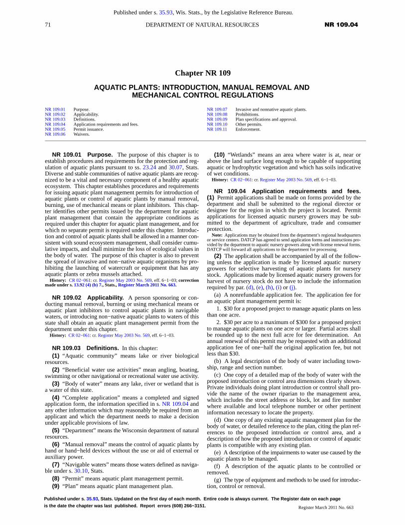
71 NR 109.04DEPARTMENT OF NATURAL RESOURCES
Published under s. 35.93, Wis. Stats., by the Legislative Reference Bureau.
Published under s. 35.93, Stats. Updated on the first day of each month. Entire code is always current. The Register date on each page
is the date the chapter was last published. Report errors (608) 266−3151. Register March 2011 No. 663
Chapter NR 109
AQUATIC PLANTS: INTRODUCTION, MANUAL REMOVAL AND MECHANICAL CONTROL REGULATIONS
NR 109.01 Purpose.NR 109.02 Applicability.NR 109.03 Definitions.NR 109.04 Application requirements and fees.NR 109.05 Permit issuance.NR 109.06 Waivers.
NR 109.07 Invasive and nonnative aquatic plants.NR 109.08 Prohibitions.NR 109.09 Plan specifications and approval.NR 109.10 Other permits.NR 109.11 Enforcement.
NR 109.01 Purpose. The purpose of this chapter is toestablish procedures and requirements for the protection and reg-ulation of aquatic plants pursuant to ss. 23.24 and 30.07, Stats.Diverse and stable communities of native aquatic plants are recog-nized to be a vital and necessary component of a healthy aquaticecosystem. This chapter establishes procedures and requirementsfor issuing aquatic plant management permits for introduction ofaquatic plants or control of aquatic plants by manual removal,burning, use of mechanical means or plant inhibitors. This chap-ter identifies other permits issued by the department for aquaticplant management that contain the appropriate conditions asrequired under this chapter for aquatic plant management, and forwhich no separate permit is required under this chapter. Introduc-tion and control of aquatic plants shall be allowed in a manner con-sistent with sound ecosystem management, shall consider cumu-lative impacts, and shall minimize the loss of ecological values inthe body of water. The purpose of this chapter is also to preventthe spread of invasive and non−native aquatic organisms by pro-hibiting the launching of watercraft or equipment that has anyaquatic plants or zebra mussels attached.
History: CR 02−061: cr. Register May 2003 No. 569, eff. 6−1−03; correctionmade under s. 13.92 (4) (b) 7., Stats., Register March 2011 No. 663.
NR 109.02 Applicability. A person sponsoring or con-ducting manual removal, burning or using mechanical means oraquatic plant inhibitors to control aquatic plants in navigablewaters, or introducing non−native aquatic plants to waters of thisstate shall obtain an aquatic plant management permit from thedepartment under this chapter.
History: CR 02−061: cr. Register May 2003 No. 569, eff. 6−1−03.
NR 109.03 Definitions. In this chapter:(1) “Aquatic community” means lake or river biological
resources.(2) “Beneficial water use activities” mean angling, boating,
swimming or other navigational or recreational water use activity.(3) “Body of water” means any lake, river or wetland that is
a water of this state.(4) “Complete application” means a completed and signed
application form, the information specified in s. NR 109.04 andany other information which may reasonably be required from anapplicant and which the department needs to make a decisionunder applicable provisions of law.
(5) “Department” means the Wisconsin department of naturalresources.
(6) “Manual removal” means the control of aquatic plants byhand or hand−held devices without the use or aid of external orauxiliary power.
(7) “Navigable waters” means those waters defined as naviga-ble under s. 30.10, Stats.
(8) “Permit” means aquatic plant management permit.(9) “Plan” means aquatic plant management plan.
(10) “Wetlands” means an area where water is at, near orabove the land surface long enough to be capable of supportingaquatic or hydrophytic vegetation and which has soils indicativeof wet conditions.
History: CR 02−061: cr. Register May 2003 No. 569, eff. 6−1−03.
NR 109.04 Application requirements and fees.(1) Permit applications shall be made on forms provided by thedepartment and shall be submitted to the regional director ordesignee for the region in which the project is located. Permitapplications for licensed aquatic nursery growers may be sub-mitted to the department of agriculture, trade and consumerprotection.
Note: Applications may be obtained from the department’s regional headquartersor service centers. DATCP has agreed to send application forms and instructions pro-vided by the department to aquatic nursery growers along with license renewal forms.DATCP will forward all applications to the department for processing.
(2) The application shall be accompanied by all of the follow-ing unless the application is made by licensed aquatic nurserygrowers for selective harvesting of aquatic plants for nurserystock. Applications made by licensed aquatic nursery growers forharvest of nursery stock do not have to include the informationrequired by par. (d), (e), (h), (i) or (j).
(a) A nonrefundable application fee. The application fee foran aquatic plant management permit is:
1. $30 for a proposed project to manage aquatic plants on lessthan one acre.
2. $30 per acre to a maximum of $300 for a proposed projectto manage aquatic plants on one acre or larger. Partial acres shallbe rounded up to the next full acre for fee determination. Anannual renewal of this permit may be requested with an additionalapplication fee of one−half the original application fee, but notless than $30.
(b) A legal description of the body of water including town-ship, range and section number.
(c) One copy of a detailed map of the body of water with theproposed introduction or control area dimensions clearly shown.Private individuals doing plant introduction or control shall pro-vide the name of the owner riparian to the management area,which includes the street address or block, lot and fire numberwhere available and local telephone number or other pertinentinformation necessary to locate the property.
(d) One copy of any existing aquatic management plan for thebody of water, or detailed reference to the plan, citing the plan ref-erences to the proposed introduction or control area, and adescription of how the proposed introduction or control of aquaticplants is compatible with any existing plan.
(e) A description of the impairments to water use caused by theaquatic plants to be managed.
(f) A description of the aquatic plants to be controlled orremoved.
(g) The type of equipment and methods to be used for introduc-tion, control or removal.
72 NR 109.04 WISCONSIN ADMINISTRATIVE CODE
Published under s. 35.93, Wis. Stats., by the Legislative Reference Bureau.
Published under s. 35.93, Stats. Updated on the first day of each month. Entire code is always current. The Register date on each page
is the date the chapter was last published. Report errors (608) 266−3151.Register March 2011 No. 663
(h) A description of other introduction or control methods con-sidered and the justification for the method selected.
(i) A description of any other method being used or intendedfor use for plant management by the applicant or on the area abut-ting the proposed management area.
(j) The area used for removal, reuse or disposal of aquaticplants.
(k) The name of any person or commercial provider of controlor removal services.
(3) (a) The department may require that an application for anaquatic plant management permit contain an aquatic plant man-agement plan that describes how the aquatic plants will beintroduced, controlled, removed or disposed. Requirements foran aquatic plant management plan shall be made in writing statingthe reason for the plan requirement. In deciding whether torequire a plan, the department shall consider the potential foreffects on protection and development of diverse and stable com-munities of native aquatic plants, for conflict with goals of otherwritten ecological or lake management plans, for cumulativeimpacts and effect on the ecological values in the body of water,and the long−term sustainability of beneficial water use activities.
(b) Within 30 days of receipt of the plan, the department shallnotify the applicant of any additional information or modifica-tions to the plan that are required. If the applicant does not submitthe additional information or modify the plan as requested by thedepartment, the department may dismiss the aquatic plant man-agement permit application.
(c) The department shall approve the aquatic plant manage-ment plan before an application may be considered complete.
(4) The permit sponsor may request an annual renewal in writ-ing from the department under s. NR 109.05 if there is no changeproposed in the conditions of the original permit issued.
History: CR 02−061: cr. Register May 2003 No. 569, eff. 6−1−03.
NR 109.05 Permit issuance. (1) The department shallissue or deny issuance of the requested permit within 15 workingdays after receipt of a completed application and approved planas required under s. NR 109.04 (3).
(2) The department may specify any of the following as condi-tions of the permit:
(a) The quantity of aquatic plants that may be introduced orcontrolled.
(b) The species of aquatic plants that may be introduced orcontrolled.
(c) The areas in which aquatic plants may be introduced orcontrolled.
(d) The methods that may be used to introduce or controlaquatic plants.
(e) The times during which aquatic plants may be introducedor controlled.
(f) The allowable methods used for disposing of or usingaquatic plants that are removed or controlled.
(g) Annual or other reporting requirements to the departmentthat may include information related to pars. (a) to (f).
(3) The department may deny issuance of the requested permitif the department determines any of the following:
(a) Aquatic plants are not causing significant impairment ofbeneficial water use activities.
(b) The proposed introduction or control will not remedy thewater use impairments caused by aquatic plants as identified as apart of the application in s. NR 109.04 (2) (e).
(c) The proposed introduction or control will result in a hazardto humans.
(d) The proposed introduction or control will cause significantadverse impacts to threatened or endangered resources.
(e) The proposed introduction or control will result in a signifi-cant adverse effect on water quality, aquatic habitat or the aquaticcommunity including the native aquatic plant community.
(f) The proposed introduction or control is in locations identi-fied by the department as sensitive areas, under s. NR 107.05 (3)(i) 1., except when the applicant demonstrates to the satisfactionof the department that the project can be conducted in a mannerthat will not alter the ecological character or reduce the ecologicalvalue of the area.
(g) The proposed management will result in significantadverse long−term or permanent changes to a plant community ora high value species in a specific aquatic ecosystem. High valuespecies are individual species of aquatic plants known to offerimportant values in specific aquatic ecosystems, including Pota-mogeton amplifolius, Potamogeton Richardsonii, Potamogetonpraelongus, Stuckenia pectinata (Potamogeton pectinatus), Pota-mogeton illinoensis, Potamogeton robbinsii, Eleocharis spp.,Scirpus spp., Valisneria spp., Zizania spp., Zannichellia palustrisand Brasenia schreberi.
(h) If wild rice is involved, the stipulations incorporated by LacCourte Oreilles v. Wisconsin, 775 F. Supp. 321 (W.D. Wis. 1991)shall be complied with.
(i) The proposed introduction or control will interfere with therights of riparian owners.
(j) The proposed management is inconsistent with a depart-ment approved aquatic plant management plan for the body ofwater.
(4) The department may approve the application in whole orin part consistent with the provisions of sub. (3). A denial shallbe in writing stating the reasons for the denial.
(5) (a) The department may issue an aquatic plant manage-ment permit on less than one acre in a single riparian area for a3−year term.
(b) The department may issue an aquatic plant managementpermit for a one−year term for more than one acre or more thanone riparian area. The permit may be renewed annually for up toa total of 3 years in succession at the written request of the permitholder, provided no modifications or changes are made from theoriginal permit.
(c) The department may issue an aquatic plant managementpermit containing a department−approved plan for a 3 to 5 yearterm.
(d) The department may issue an aquatic plant managementpermit to a licensed nursery grower for a 3−year term for the har-vesting of aquatic plants from a publicly owned lake bed or for a5−year term for harvesting of aquatic plants from privately ownedbeds with the permission of the property owner.
(6) The approval of an aquatic plant management permitdoes not represent an endorsement of the permitted activity, butrepresents that the applicant has complied with all criteria of thischapter.
History: CR 02−061: cr. Register May 2003 No. 569, eff. 6−1−03; reprinted torestore dropped language from rule order, Register October 2003 No. 574.
NR 109.06 Waivers. The department waives the permitrequirements under this chapter for any of the following:
(1) Manual removal or use of mechanical devices to controlor remove aquatic plants from a body of water 10 acres or less thatis entirely confined on the property of one person with the permis-sion of that property owner.
Note: A person who introduces native aquatic plants or removes aquatic plants bymanual or mechanical means in the course of operating an aquatic nursery as autho-rized under s. 94.10, Stats., on privately owned non−navigable waters of the state isnot required to obtain a permit for the activities.
(2) A riparian owner who manually removes aquatic plantsfrom a body of water or uses mechanical devices designed for cut-ting or mowing vegetation to control plants on an exposed lakebed that abuts the owner’s property provided that the removalmeets all of the following:
72−1 NR 109.11DEPARTMENT OF NATURAL RESOURCES
Published under s. 35.93, Wis. Stats., by the Legislative Reference Bureau.
Published under s. 35.93, Stats. Updated on the first day of each month. Entire code is always current. The Register date on each page
is the date the chapter was last published. Report errors (608) 266−3151. Register March 2011 No. 663
(a) 1. Removal of native plants is limited to a single area witha maximum width of no more than 30 feet measured along theshoreline provided that any piers, boatlifts, swimrafts and otherrecreational and water use devices are located within that 30−footwide zone and may not be in a new area or additional to an areawhere plants are controlled by another method; or
2. Removal of nonnative or invasive aquatic plants as desig-nated under s. NR 109.07 when performed in a manner that doesnot harm the native aquatic plant community; or
3. Removal of dislodged aquatic plants that drift on−shoreand accumulate along the waterfront.
(b) Is not located in a sensitive area as defined by the depart-ment under s. NR 107.05 (3) (i) 1., or in an area known to containthreatened or endangered resources or floating bogs.
(c) Does not interfere with the rights of other riparian owners.(d) If wild rice is involved, the procedures of s. NR 19.09 (1)
shall be followed.(4) Control of purple loosestrife by manual removal or use of
mechanical devices when performed in a manner that does notharm the native aquatic plant community or result in or encouragere−growth of purple loosestrife or other nonnative vegetation.
(5) Any aquatic plant management activity that is conductedby the department and is consistent with the purposes of this chap-ter.
(6) Manual removal and collection of native aquatic plants forlake study or scientific research when performed in a manner thatdoes not harm the native aquatic plant community.
Note: Scientific collectors permit requirements are still applicable.
(7) Incidental cutting, removal or destroying of aquatic plantswhen engaged in beneficial water use activities.
History: CR 02−061: cr. Register May 2003 No. 569, eff. 6−1−03.
NR 109.07 Invasive and nonnative aquatic plants.(1) The department may designate any aquatic plant as an inva-sive aquatic plant for a water body or a group of water bodies ifit has the ability to cause significant adverse change to desirableaquatic habitat, to significantly displace desirable aquatic vegeta-tion, or to reduce the yield of products produced by aquaculture.
(2) The following aquatic plants are designated as invasiveaquatic plants statewide: Eurasian water milfoil, curly leaf pond-weed and purple loosestrife.
(3) Native and nonnative aquatic plants of Wisconsin shall bedetermined by using scientifically valid publications and findingsby the department.
History: CR 02−061: cr. Register May 2003 No. 569, eff. 6−1−03.
NR 109.08 Prohibitions. (1) No person may distributean invasive aquatic plant, under s. NR 109.07.
(2) No person may intentionally introduce Eurasian watermilfoil, curly leaf pondweed or purple loosestrife into waters ofthis state without the permission of the department.
(3) No person may intentionally cut aquatic plants in public/navigable waters without removing cut vegetation from the bodyof water.
(4) (a) No person may place equipment used in aquatic plantmanagement in a navigable water if the person has reason to
believe that the equipment has any aquatic plants or zebra musselsattached.
(b) This subsection does not apply to equipment used inaquatic plant management when re−launched on the same body ofwater without having visited different waters, provided the re−launching will not introduce or encourage the spread of existingaquatic species within that body of water.
History: CR 02−061: cr. Register May 2003 No. 569, eff. 6−1−03.
NR 109.09 Plan specifications and approval.(1) Applicants required to submit an aquatic plant managementplan, under s. NR 109.04 (3), shall develop and submit the plan ina format specified by the department.
(2) The plan shall present and discuss each of the followingitems:
(a) The goals and objectives of the aquatic plant managementand protection activities.
(b) A physical, chemical and biological description of thewaterbody.
(c) The intensity of water use.(d) The location of aquatic plant management activities.(e) An evaluation of chemical, mechanical, biological and
physical aquatic plant control methods.(f) Recommendations for an integrated aquatic plant manage-
ment strategy utilizing some or all of the methods evaluated in par.(e).
(g) An education and information strategy.(h) A strategy for evaluating the efficacy and environmental
impacts of the aquatic plant management activities.(i) The involvement of local units of government and any lake
organizations in the development of the plan.(3) The approval of an aquatic plant management plan does
not represent an endorsement for plant management, but repre-sents that adequate considerations in planning the actions havebeen made.
History: CR 02−061: cr. Register May 2003 No. 569, eff. 6−1−03.
NR 109.10 Other permits. Permits issued under s. 30.12,30.20, 31.02 or 281.36, Stats., or under ch. NR 107 may containprovisions which provide for aquatic plant management. If a per-mit issued under one of these authorities contains the appropriateconditions as required under this chapter for aquatic plant man-agement, a separate permit is not required under this chapter. Thepermit shall explicitly state that it is intended to comply with thesubstantive requirements of this chapter.
History: CR 02−061: cr. Register May 2003 No. 569, eff. 6−1−03.
NR 109.11 Enforcement. (1) Violations of this chaptermay be prosecuted by the department under chs. 23, 30 and 31,Stats.
(2) Failure to comply with the conditions of a permit issuedunder or in accordance with this chapter may result in cancellationof the permit and loss of permit privileges for the subsequent year.Notice of cancellation or loss of permit privileges shall be pro-vided by the department to the permit holder.
History: CR 02−061: cr. Register May 2003 No. 569, eff. 6−1−03.


63 NR 107.04DEPARTMENT OF NATURAL RESOURCES
Published under s. 35.93, Wis. Stats., by the Legislative Reference Bureau.
Published under s. 35.93, Stats. Updated on the first day of each month. Entire code is always current. The Register date on each page
is the date the chapter was last published. Report errors (608) 266−3151. Register, December, 2000, No. 540
Chapter NR 107
AQUATIC PLANT MANAGEMENT
NR 107.01 Purpose.NR 107.02 Applicability.NR 107.03 Definitions.NR 107.04 Application for permit.NR 107.05 Issuance of permit.NR 107.06 Chemical fact sheets.
NR 107.07 Supervision.NR 107.08 Conditions of the permit.NR 107.09 Special limitation.NR 107.10 Field evaluation use permits.NR 107.11 Exemptions.
Note: Chapter NR 107 as it existed on February 28, 1989 was repealed and a newChapter NR 107 was created effective March 1, 1989.
NR 107.01 Purpose. The purpose of this chapter is toestablish procedures for the management of aquatic plants andcontrol of other aquatic organisms pursuant to s. 227.11 (2) (a),Stats., and interpreting s. 281.17 (2), Stats. A balanced aquaticplant community is recognized to be a vital and necessary compo-nent of a healthy aquatic ecosystem. The department may allowthe management of nuisance−causing aquatic plants with chemi-cals registered and labeled by the U.S. environmental protectionagency and labeled and registered by firms licensed as pesticidemanufacturers and labelers with the Wisconsin department ofagriculture, trade and consumer protection. Chemical manage-ment shall be allowed in a manner consistent with sound ecosys-tem management and shall minimize the loss of ecological valuesin the water body.
History: Cr. Register, February, 1989, No. 398, eff. 3−1−89; correction madeunder s. 13.93 (2m) (b) 7., Stats., Register, December, 2000, No. 540.
NR 107.02 Applicability. Any person sponsoring or con-ducting chemical treatment for the management of aquatic plantsor control of other aquatic organisms in waters of the state shallobtain a permit from the department. Waters of the state includethose portions of Lake Michigan and Lake Superior, and all lakes,bays, rivers, streams, springs, ponds, wells, impounding reser-voirs, marshes, watercourses, drainage systems and other groundor surface water, natural or artificial, public or private, within thestate or its jurisdiction as specified in s. 281.01 (18), Stats.
History: Cr. Register, February, 1989, No. 398, eff. 3−1−89; correction madeunder s. 13.93 (2m) (b) 7., Stats., Register, December, 2000, No. 540.
NR 107.03 Definitions. (1) “Applicator” means the per-son physically applying the chemicals to the treatment site.
(2) “Chemical fact sheet” means a summary of information ona specific chemical written by the department including generalaquatic community and human safety considerations applicable toWisconsin sites.
(3) “Department” means the department of natural resources.History: Cr. Register, February, 1989, No. 398, eff. 3−1−89.
NR 107.04 Application for permit. (1) Permit applica-tions shall be made on forms provided by the department and shallbe submitted to the district director for the district in which theproject is located. Any amendment or revision to an applicationshall be treated by the department as a new application, except asprovided in s. NR 107.04 (3) (g).
Note: The DNR district headquarters are located at:1. Southern — 3911 Fish Hatchery Road, Fitchburg 537112. Southeast — 2300 N. Dr. Martin Luther King Jr. Dr., Box 12436, Milwaukee
532123. Lake Michigan — 1125 N. Military Ave., Box 10448, Green Bay 543074. North Central — 107 Sutliff Ave., Box 818, Rhinelander 545015. Western — 1300 W. Clairemont Ave., Call Box 4001, Eau Claire 547026. Northwest — Hwy 70 West, Box 309, Spooner 54801
(2) The application shall be accompanied by:(a) A nonrefundable permit application fee of $20, and, for
proposed treatments larger than 0.25 acres, an additional refund-able acreage fee of $25.00 per acre, rounded up to the nearestwhole acre, applied to a maximum of 50.0 acres.
1. The acreage fee shall be refunded in whole if the entire per-mit is denied or if no treatment occurs on any part of the permittedtreatment area. Refunds will not be prorated for partial treatments.
2. If the permit is issued with the proposed treatment area par-tially denied, a refund of acreage fees shall be given for the areadenied.
(b) A legal description of the body of water proposed for treat-ment including township, range and section number;
(c) One copy of a detailed map or sketch of the body of waterwith the proposed treatment area dimensions clearly shown andwith pertinent information necessary to locate those properties, byname of owner, riparian to the treatment area, which may includestreet address, local telephone number, block, lot and fire numberwhere available. If a local address is not available, the homeaddress and phone number of the property owner may beincluded;
(d) A description of the uses being impaired by plants oraquatic organisms and reason for treatment;
(e) A description of the plant community or other aquaticorganisms causing the use impairment;
(f) The product names of chemicals proposed for use and themethod of application;
(g) The name of the person or commercial applicator, andapplicator certification number, when required by s. NR 107.08(5), of the person conducting the treatment;
(h) A comparison of alternative control methods and their fea-sibility for use on the proposed treatment site.
(3) In addition to the information required under sub. (2),when the proposed treatment is a large−scale treatment exceeding10.0 acres in size or 10% of the area of the water body that is 10feet or less in depth, the application shall be accompanied by:
(a) A map showing the size and boundaries of the water bodyand its watershed.
(b) A map and list identifying known or suspected land usepractices contributing to plant−related water quality problems inthe watershed.
(c) A summary of conditions contributing to undesirable plantgrowth on the water body.
(d) A general description of the fish and wildlife uses occur-ring within the proposed treatment site.
(e) A summary of recreational uses of the proposed treatmentsite.
(f) Evidence that a public notice of the proposed applicationhas been made, and that a public informational meeting, ifrequired, has been conducted.
1. Notice shall be given in 2 inch x 4 inch advertising formatin the newspaper which has the largest circulation in the areaaffected by the application.
2. The notice shall state the size of the proposed treatment, theapproximate treatment dates, and that the public may requestwithin 5 days of the notice that the applicant hold a public infor-mational meeting on the proposed application.
a. The applicant will conduct a public informational meetingin a location near the water body when a combination of 5 or moreindividuals, organizations, special units of government, or localunits of government request the meeting in writing to the applicant
64 NR 107.04 WISCONSIN ADMINISTRATIVE CODE
Published under s. 35.93, Wis. Stats., by the Legislative Reference Bureau.
Published under s. 35.93, Stats. Updated on the first day of each month. Entire code is always current. The Register date on each page
is the date the chapter was last published. Report errors (608) 266−3151.Register, December, 2000, No. 540
with a copy to the department within 5 days after the notice ismade. The person or entity requesting the meeting shall state aspecific agenda of topics including problems and alternatives tobe discussed.
b. The meeting shall be given a minimum of one weekadvance notice, both in writing to the requestors, and advertisedin the format of subd. 1.
(g) The provisions of pars. (a) to (e) shall be repeated onceevery 5 years and shall include new information. Annual modifi-cations of the proposed treatment within the 5−year period whichdo not expand the treatment area more than 10% and cover a simi-lar location and target organisms may be accepted as an amend-ment to the original application. The acreage fee submitted undersub. (2) (a) shall be adjusted in accordance with any proposedamendments.
(4) The applicant shall certify to the department that a copy ofthe application has been provided to any affected property own-ers’ association, inland lake district, and, in the case of chemicalapplications for rooted aquatic plants, to any riparian propertyowners adjacent to and within the treatment area.
(5) A notice of the proposed treatment shall be provided by thedepartment to any person or organization indicating annually inwriting a desire to receive such notification.
History: Cr. Register, February, 1989, No. 398, eff. 3−1−89.
NR 107.05 Issuance of permit. (1) The departmentshall issue or deny issuance of the requested permit between 10and 15 working days after receipt of an acceptable application,unless:
(a) An environmental impact report or statement is requiredunder s. 1.11, Stats. Notification to the applicant shall be in writingwithin 10 working days of receipt of the application and no actionmay be taken until the report or statement has been completed; or
(b) A public hearing has been granted under s. 227.42, Stats.(2) If a request for a public hearing is received after the permit
is issued but prior to the actual treatment allowed by the permit,the department is not required to, but may, suspend the permitbecause of the request for public hearing.
(3) The department may deny issuance of the requested permitif:
(a) The proposed chemical is not labeled and registered for theintended use by the United States environmental protectionagency and both labeled and registered by a firm licensed as a pes-ticide manufacturer and labeler with the Wisconsin department ofagriculture, trade and consumer protection;
(b) The proposed chemical does not have a current departmentaquatic chemical fact sheet;
(c) The department determines the proposed treatment will notprovide nuisance relief, or will place unreasonable restrictions onexisting water uses;
(d) The department determines the proposed treatment willresult in a hazard to humans, animals or other nontarget organ-isms;
(e) The department determines the proposed treatment willresult in a significant adverse effect on the body of water;
(f) The proposed chemical application is for waters beyond150 feet from shore except where approval is given by the depart-ment to maintain navigation channels, piers or other facilities usedby organizations or the public including commercial facilities;
(g) The proposed chemical applications, other than those con-ducted by the department pursuant to ss. 29.421 and 29.424,Stats., will significantly injure fish, fish eggs, fish larvae, essentialfish food organisms or wildlife, either directly or through habitatdestruction;
(h) The proposed chemical application is in a location knownto have endangered or threatened species as specified pursuant tos. 29.604, Stats., and as determined by the department;
(i) The proposed chemical application is in locations identifiedby the department as sensitive areas, except when the applicantdemonstrates to the satisfaction of the department that treatmentscan be conducted in a manner that will not alter the ecologicalcharacter or reduce the ecological value of the area.
1. Sensitive areas are areas of aquatic vegetation identified bythe department as offering critical or unique fish and wildlife habi-tat, including seasonal or lifestage requirements, or offering waterquality or erosion control benefits to the body of water.
2. The department shall notify any affected property owners’association, inland lake district, and riparian property owner oflocations identified as sensitive areas.
(4) New applications will be reviewed with considerationgiven to the cumulative effect of applications already approvedfor the body of water.
(5) The department may approve the application in whole orin part consistent with the provisions of subs. (3) (a) through (i)and (4). Denials shall be in writing stating reasons for the denial.
(6) Permits may be issued for one treatment season only.History: Cr. Register, February, 1989, No. 398, eff. 3−1−89; corrections in (3)
(g) and (h) made under s. 13.93 (2m) (b) 7., Stats., Register, December, 2000, No.540.
NR 107.06 Chemical fact sheets. (1) The departmentshall develop a chemical fact sheet for each of the chemicals inpresent use for aquatic nuisance control in Wisconsin.
(1m) Chemical fact sheets for chemicals not previously usedin Wisconsin shall be developed within 180 days after the depart-ment has received notice of intended use of the chemical.
(2) The applicant or permit holder shall provide copies of theapplicable chemical fact sheets to any affected property owners’association and inland lake district.
(3) The department shall make chemical fact sheets availableupon request.
History: Cr. Register, February, 1989, No. 398, eff. 3−1−89.
NR 107.07 Supervision. (1) The permit holder shallnotify the district office 4 working days in advance of each antici-pated treatment with the date, time, location, and proposed size oftreatment. At the discretion of the department, the advance notifi-cation requirement may be waived.
(2) Supervision by a department representative may berequired for any aquatic nuisance control project involving chem-icals. Supervision may include inspection of the proposed treat-ment area, chemicals, and application equipment before, duringor after treatment. The inspection may result in the determinationthat treatment is unnecessary or unwarranted in all or part of theproposed area, or that the equipment will not control the properdosage.
History: Cr. Register, February, 1989, No. 398, eff. 3−1−89.
NR 107.08 Conditions of the permit. (1) The depart-ment may stop or limit the application of chemicals to a body ofwater if at any time it determines that chemical treatment will beineffective, or will result in unreasonable restrictions on currentwater uses, or will produce unnecessary adverse side effects onnontarget organisms. Upon request, the department shall state thereason for such action in writing to the applicant.
(2) Chemical treatments shall be performed in accordancewith label directions, existing pesticide use laws, and permit con-ditions.
(3) Chemical applications on lakes and impoundments arelimited to waters along developed shoreline including publicparks except where approval is given by the department for proj-ects of public benefit.
(4) Treatment of areas containing high value species ofaquatic plants shall be done in a manner which will not result inadverse long−term or permanent changes to a plant community ina specific aquatic ecosystem. High value species are individualspecies of aquatic plants known to offer important values in spe-
65 NR 107.11DEPARTMENT OF NATURAL RESOURCES
Published under s. 35.93, Wis. Stats., by the Legislative Reference Bureau.
Published under s. 35.93, Stats. Updated on the first day of each month. Entire code is always current. The Register date on each page
is the date the chapter was last published. Report errors (608) 266−3151. Register, December, 2000, No. 540
cific aquatic ecosystems, including Potamogeton amplifolius,Potamogeton Richardsonii, Potamogeton praelongus, Potamo-geton pectinatus, Potamogeton illinoensis, Potamogeton robbin-sii, Eleocharis spp., Scirpus spp., Valisneria spp., Zizania aquat-ica, Zannichellia palustris and Brasenia schreberi.
(5) Treatment shall be performed by an applicator currentlycertified by the Wisconsin department of agriculture, trade andconsumer protection in the aquatic nuisance control categorywhenever:
(a) Treatment is to be performed for compensation by an appli-cator acting as an independent contractor for hire;
(b) The area to be treated is greater than 0.25 acres;(c) The product to be used is classified as a “restricted use pes-
ticide”; or(d) Liquid chemicals are to be used.(6) Power equipment used to apply liquid chemicals shall
include the following:(a) Containers used to mix and hold chemicals shall be con-
structed of watertight materials and be of sufficient size andstrength to safely contain the chemical. Measuring containers andscales for the purpose of measuring solids and liquids shall be pro-vided by the applicator;
(b) Suction hose used to deliver the chemical to the pump ven-turi assembly shall be fitted with an on−off ball−type valve. Thesystem shall also be designed to prevent clogging from chemicalsand aquatic vegetation;
(c) Suction hose used to deliver surface water to the pump shallbe fitted with a check valve to prevent back siphoning into the sur-face water should the pump stop;
(d) Suction hose used to deliver a premixed solution shall befitted with an on−off ball−type valve to regulate the dischargerate;
(e) Pressure hose used to discharge chemicals to the surfacewater shall be provided with an on−off ball−type valve. This valvewill be fitted at the base of the hose nozzle or as part of the nozzleassembly;
(f) All pressure and suction hoses and mechanical fittings shallbe watertight;
(g) Equipment shall be calibrated by the applicator. Evidenceof calibration shall be provided at the request of the departmentsupervisor.
(h) Other equipment designs may be acceptable if capable ofequivalent performance.
(7) The permit holder shall be responsible for posting thoseareas of use in accordance with water use restrictions stated on thechemical label, but in all cases for a minimum of one day, and withthe following conditions:
(a) Posting signs shall be brilliant yellow and conspicuous tothe nonriparian public intending to use the treated water from boththe water and shore, and shall state applicable label water userestrictions of the chemical being used, the name of the chemicaland date of treatment. For tank mixes, the label requirements ofthe most restrictive chemical will be posted;
(b) Minimum sign dimensions used for posting shall be 11inches by 11 inches or consistent with s. ATCP 29.15. The depart-ment will provide up to 6 signs to meet posting requirements.Additional signs may be purchased from the department;
(c) Signs shall be posted at the beginning of each treatment bythe permit holder or representing agent. Posting prior to treatmentmay be required as a permit condition when the department deter-mines that such posting is in the best interest of the public;
(d) Posting signs shall be placed along contiguous treatedshoreline and at strategic locations to adequately inform the pub-lic. Posting of untreated shoreline located adjacent to treatedshoreline and noncontiguous shoreline shall be at the discretion ofthe department;
(e) Posting signs shall be made of durable material to remainup and legible for the time period stated on the pesticide label forwater use restrictions, after which the permit holder or represent-ing agent is responsible for sign removal.
(8) After conducting a treatment, the permit holder shall com-plete and submit within 30 days an aquatic nuisance control reporton a form supplied by the department. Required information willinclude the quantity and type of chemical, and the specific size andlocation of each treatment area. In the event of any unusual cir-cumstances associated with a treatment, or at the request of thedepartment, the report shall be provided immediately. If treatmentdid not occur, the form shall be submitted with appropriate com-ment by October 1.
(9) Failure to comply with the conditions of the permit mayresult in cancellation of the permit and loss of permit privileges forthe subsequent treatment season. A notice of cancellation or lossof permit privileges shall be provided by the department to the per-mit holder accompanied by a statement of appeal rights.
History: Cr. Register, February, 1989, No. 398, eff. 3−1−89; correction in (7) (b)made under s. 13.93 (2m) (b) 7., Stats., Register, September, 1995, No. 477.
NR 107.09 Special limitation. Due to the significant riskof environmental damage from copper accumulation in sedi-ments, swimmer’s itch treatments performed with copper sulfateproducts at a rate greater than 10 pounds of copper sulfate per acreare prohibited.
History: Cr. Register, February, 1989, No. 398, eff. 3−1−89.
NR 107.10 Field evaluation use permits. When achemical product is considered for aquatic nuisance control anddoes not have a federal label for such use, the applicant shall applyto the administrator of the United States environmental protectionagency for an experimental use permit under section 5 of the fed-eral insecticide, fungicide and rodenticide act as amended (7 USC136 et seq.). Upon receiving a permit, the permit holder shallobtain a field evaluation use permit from the department and besubject to the requirements of this chapter. Department field eval-uation use permits shall be issued for the purpose of evaluatingproduct effectiveness and safety under field conditions and willrequire in addition to the conditions of the permit specified in s.NR 107.08 (1) through (9), the following:
(1) Treatment shall be limited to an area specified by thedepartment.
(2) The permit holder shall submit to the department a sum-mary of treatment results at the end of the treatment season. Thesummary shall include:
(a) Total chemical used and distribution pattern, includingchemical trade name, formulation, percent active ingredient, anddosage rate in the treated water in parts per million of active ingre-dient;
(b) Description of treatment areas including the character andthe extent of the nuisance present;
(c) Effectiveness of the application and when applicable, asummary comparison of the results obtained from past experi-ments using the same chemical formulation;
(d) Other pertinent information required by the department;and
(e) Conclusions and recommendations for future use.History: Cr. Register, February, 1989, No. 398, eff. 3−1−89.
NR 107.11 Exemptions. (1) Under any of the followingconditions, the permit application fee in s. NR 107.04 (2) (a) willbe limited to the basic application fee:
(a) The treatment is made for the control of bacteria on swim-ming beaches with chlorine or chlorinated lime;
(b) The treatment is intended to control algae or other aquaticnuisances that interfere with the use of the water for potable pur-poses;
66 NR 107.11 WISCONSIN ADMINISTRATIVE CODE
Published under s. 35.93, Wis. Stats., by the Legislative Reference Bureau.
Published under s. 35.93, Stats. Updated on the first day of each month. Entire code is always current. The Register date on each page
is the date the chapter was last published. Report errors (608) 266−3151.Register, December, 2000, No. 540
(c) The treatment is necessary for the protection of publichealth, such as the control of disease carrying organisms in sani-tary sewers, storm sewers, or marshes, and the treatment is spon-sored by a governmental agency.
(2) The treatment of purple loosestrife is exempt from ss. NR107.04 (2) (a) and (3), and 107.08 (5).
(3) The use of chemicals in private ponds is exempt from theprovisions of this chapter except for ss. NR 107.04 (1), (2), (4) and(5), 107.05, 107.07, 107.08 (1), (2), (8) and (9), and 107.10.
(a) A private pond is a body of water located entirely on theland of an applicant, with no surface water discharge or a dis-charge that can be controlled to prevent chemical loss, and withoutaccess by the public.
(b) The permit application fee will be limited to the non−re-fundable $20 application fee.
(4) The use of chemicals in accordance with label instructionsis exempt from the provisions of this chapter, when used in:
(a) Water tanks used for potable water supplies;(b) Swimming pools;(c) Treatment of public or private wells;(d) Private fish hatcheries licensed under s. 95.60, Stats.;(e) Treatment of emergent vegetation in drainage ditches or
rights−of−way where the department determines that fish andwildlife resources are insignificant; or
(f) Waste treatment facilities which have received s. 281.41,Stats., plan approval or are utilized to meet effluent limitations setforth in permits issued under s. 283.31, Stats.
History: Cr. Register, February, 1989, No. 398, eff. 3−1−89; corrections in (4)(d) and (f) made under s. 13.93 (2m) (b) 7., Stats., Register, December, 2000, No.540.

Appendix B
NR 19

157 NR 19.001DEPARTMENT OF NATURAL RESOURCES
File inserted into Admin. Code 8−1−2015. May not be current beginning 1 month after insert date. For current adm. code see:http://docs.legis.wisconsin.gov/code/admin_code
Register July 2015 No. 715
Chapter NR 19
MISCELLANEOUS FUR, FISH, GAME AND OUTDOOR RECREATION
Subchapter I — MiscellaneousNR 19.001 Definitions.NR 19.01 Approval deadlines.NR 19.02 Handling fees for certain approvals.NR 19.025 Waivers for an educational recreational activity.NR 19.03 Control of muskrats on cranberry marshes.NR 19.05 Release, importation and transportation of fish.NR 19.055 Drainage of water from boats and equipment required.NR 19.057 Bait dealer’s wild harvest permit required; criteria; records required.NR 19.058 Sport trolling.NR 19.06 Fish nets and traps.NR 19.09 Wild rice conservation.NR 19.11 Scientific collectors permits and scientific research licenses.NR 19.115 Fish, fur, game seals.NR 19.12 Tagging the carcasses of wild animals, birds and fish taken on Indian
reservations.NR 19.13 Disposition of deer accidentally killed by a motor vehicle.NR 19.25 Wild animal protection.NR 19.26 Season and restrictions for taking frogs.NR 19.27 Seasons, limits, restrictions on taking crayfish.NR 19.275 Turtles.NR 19.28 Taxidermy.NR 19.30 Criminal history checks; volunteer instructors.NR 19.40 Department authority to void local hunting, fishing and trapping ordi-
nances.NR 19.50 All−terrain vehicle and bowhunter, snowmobile and hunter educa-
tion program fee.NR 19.51 Wisconsin cooperative trapper education program fee.
NR 19.60 Feeding of wild animals.
Subchapter II — Wildlife RehabilitationNR 19.70 Purpose.NR 19.71 Definitions.NR 19.72 General wildlife rehabilitation provisions.NR 19.73 Licenses.NR 19.74 Application.NR 19.75 Examination.NR 19.76 Facility inspection.NR 19.77 Facility standards.NR 19.78 Care and treatment of wildlife.NR 19.79 Infectious disease reporting.NR 19.80 Record keeping and reporting.NR 19.81 Qualifications of sponsors.NR 19.82 Wildlife rehabilitation advisory committee.NR 19.83 Additional conditions.NR 19.84 Modifications.NR 19.85 Disclaimer.
Subchapter III — Permitting the Use of Natural Bodies of Water as FishFarmsNR 19.90 Purpose and applicability.NR 19.91 Definitions.NR 19.92 Natural body of water permit application fees.NR 19.93 Applicant permit procedures for use of natural bodies of water for fish
farms.NR 19.94 Department determinations.NR 19.95 Enforcement.
Note: Corrections made under s. 13.93 (2m) (b) 7., Stats., Register, January, 1999,No. 517; CR 03−029: renum. NR 19.75 through 19.84 to be NR 12.30 through 12.41Register December 2003 No. 576, eff. 1−1−04.
Subchapter I — Miscellaneous
NR 19.001 Definitions. (1) “Active service”, for pur-poses of s. 29.194, Stats., means full time employment as a mem-ber of the armed services and does not include annual summertraining by members of the national guard or reserves.
(1m) “Animal part or animal byproduct” has the meaninggiven in s. NR 10.001 (1r).
(2) “Application” means a written request for any approval ofa regulatory agency required as a condition of operating a businessin this state completed in the form required by and acceptable tothe department and accompanied by additional plans, informationand the appropriate fee.
(3) “Approval” means a license, permit or other form ofapproval required from the department to conduct business activi-ties in Wisconsin.
(4) “Bird feeding devices and structures” means any device orstructure that has the primary purpose of attracting or feedingbirds or small mammals.
(4m) “Business” means a building used primarily to carry outcommercial activities at which regular scheduled business hoursare maintained for employees and the public such as restaurantsand retail stores, but does not include associated lands, ware-houses, outbuildings or other buildings that are not normally opento the public.
(5) “Carcass” means the dead body of any animal includingthe head, hair, skin, plumage, skeleton, eggs, or any other partthereof.
Note: Milk is not considered to be a part of an animal carcass or an animal byprod-uct for the purposes of this chapter.
(5m) “Daily bag limit” as used in s. NR 19.275, means themaximum number of a turtle species or group of turtle specieswhich may be taken by a person each day.
(6) “Environmental consulting organization” means an indi-vidual or consortium of individuals funded to provide consultingservices including status assessment of wild animals and theirhabitats.
(6d) “Feed” has the meaning given in s. NR 10.001 (10).
(6h) “Feeding site” has the meaning given in s. NR 10.001(10c).
(6m) “Fish, fur, game seal” or “seal” means a numbered, non−reusable, locking device bearing the embossed inscription Fish,Fur, Game F−(number) which is issued by the department.
(7) “File” or “filed” means receipt by the department of a writ-ten notice, verified claim or other document.
(7m) “Hooking”, as used in s. NR 19.275, means any activitywhich utilizes a dull−pointed, metal, barbless hook attached to astaff to remove a turtle from a body of water.
(8) “In the process of being mounted” means, for the purposesof the sale of part or all of a private collection, as authorized by s.29.354, Stats., a physical process which includes taxidermy workaccomplished on the carcass, including at least removal of theskin.
(8g) “Live fish” means, for purposes of this chapter, any fishpossessed by a person that is handled or treated in a manner thatwill keep it alive, such as keeping it in water, or that is revived byplacement back into water. “Live fish” includes any minnow thatis possessed by a person for use as bait and that dies while the per-son who possesses it is on the water, bank or shore for the purposeof fishing, but only until the minnow is transported away fromwater, bank or shore where it died.
(8r) “Live fish eggs” means, for purposes of this chapter, fer-tilized or unfertilized fish eggs that are handled or treated in amanner likely to keep them alive or viable for the purpose of prop-agation.
(9) “Maintain records” means, for the purpose of s. 29.503 (5),Stats., to legibly prepare triplicate records and retain at least onecopy of each record at the place of business for inspection pur-poses.
158 NR 19.001 WISCONSIN ADMINISTRATIVE CODE
File inserted into Admin. Code 8−1−2015. May not be current beginning 1 month after insert date. For current adm. code see:http://docs.legis.wisconsin.gov/code/admin_code
Register July 2015 No. 715
(10) “Mount”, “mounted”, or “mounting” means, for the pur-poses of ss. 29.354 (3) and 29.506 (1), Stats., and this section, toprepare and preserve the head, skin or carcass in a lifelike manner.
(11) “Natural resources”, for purposes of s. 23.095, Stats.,includes wild rice growing in navigable lakes.
(12) “Navigable lake”, for the purpose of interpreting s.29.607, Stats., means a natural navigable lake or a flowage orpond, or portion of a flowage or pond, where the bed is in town,county, city, village, state or federal ownership.
(12e) “Owner−occupied residence” for the purpose of thissection means a dwelling or building devoted to human occu-pancy when used while feeding deer as a residence by the owner,members of the owner’s immediate family, or when used as a resi-dence by individuals as a rental property while feeding deer.
(12m) “Possession limit” as used in s. NR 19.275, means themaximum number of a turtle species or group of turtle specieswhich may be possessed by a person at any time.
(13) “Private collection” means, for the purposes of s. 29.354,Stats.:
(a) A privately owned collection mounted for the purpose ofdisplay, exhibition or personal use and does not include wild ani-mals mounted for the purpose of sale. In determining whether awild animal was mounted for the purpose of sale, at a minimum,factors to be considered are the intent of the owner at the time ofmounting, the length of time from mounting to sale, display or useof the mounted wild animal prior to sale, frequency of such salesby the owner and the reasons provided by the owner for the sale.This does not preclude the ultimate sale of a mount from a privatecollection.
(b) A mounted collection sold upon the death of the owner.
(13m) “Preserve” means, for the purposes of s. 29.506 (1),Stats., and this chapter, to treat or process the carcass of a wild ani-mal to prevent the carcass from decaying or spoiling for the pur-pose of mounting the carcass or parts of the carcass in a lifelikemanner.
(14) “Protected wild animals” means those animals for whicha closed season, bag limit, size limit or possession limit has beenprovided by statute or administrative rule, and includes:
(a) Nongame species unless specifically designated as unpro-tected by the department;
(b) Game fish, game animals, game birds and fur bearing ani-mals during closed seasons;
(c) Endangered and threatened species listed in ch. NR 27.
(15) “Records” means, for the purpose of s. 29.506 (7) (b),Stats., the taxidermist permit, sales forms, information records,records of deliveries and shipments, and the identification tag asdescribed in s. 29.506 (5) (b), Stats.
(15m) “Small mammals” mean all mammals other than bear,deer and elk.
(16) “Stationed”, for purposes of s. 29.194, Stats., meansresiding in Wisconsin in compliance with military orders.
(16m) “Turtle”, as used in this chapter, means a reptile havinghorny, toothless jaws and a body enclosed in a bony or leatheryshell into which the head, limbs and tail may be partially or fullywithdrawn, and includes parts of turtles and turtle eggs.
(17) “Unprotected wild animals” means those animals forwhich no closed season, bag limit, size limit or possession limithas been provided by statute or administrative rule.
(18) “Verified” means to confirm or establish by oath, nor-mally in the form of a notarized statement.
(19) “Wild animal” means any mammal, bird, fish, or othercreature of a wild nature endowed with sensation and the powerof voluntary motion.
History: Cr. Register, September, 1978, No. 273, eff. 10−1−78; r. and recr. Regis-ter, January, 1980, No. 289, eff. 2−1−80; cr. (5m) and am. (7), Register, August, 1980,No. 296, eff. 9−1−80; r. (2), (3), (4), (5) and (6), Register, January, 1984, No. 337, eff.2−1−84; renum. (1) to be (3), cr. (1), (2), (4) and (4m), Register, August, 1985, No.
356, eff 9−1−85; cr. (2m), Register, August, 1986, No. 368, eff. 9−1−86; cr. (2f), (3m),(3p), (3t), (5), (6) and (9), Register, March, 1987, No. 375, eff. 4−1−87; cr. (2e), Regis-ter, June, 1988, No. 390, eff. 7−1−88; renum. (1) to (9) to be (2) to (15) and (17) to(19), cr. (1) and (16), Register, October, 1988, No. 394, eff. 11−1−88; emerg. r. (4),eff. 10−16−89; cr. (6m), Register, March, 1990, No. 411, eff. 4−1−90; r. (4), Register,May, 1990, No. 413, eff. 6−1−90; cr. (5m), (7m), (12m) and (16m), Register, Febru-ary, 1997, No. 494, eff. 3−1−97; CR 04−078: cr. (1m), (4), (4m), (6d), (6h), (12e), and(15m) Register April 2005 No. 592, eff. 5−1−05; emerg. cr. (8g) and (8r), eff.11−2−07; CR 07−074: cr. (8g) and (8r) Register May 2008 No. 629, eff. 6−1−08; CR08−021: cr. (13m) Register November 2008 No. 635, eff. 12−1−08; CR 11−030: am.(5) Register February 2012 No. 674, eff. 3−1−12; correction in (2) made under s.13.92 (4) (b) 6., Stats., Register May 2013 No. 689.
NR 19.01 Approval deadlines. (1) GENERAL. Uponreceipt of an application for an approval required to conduct busi-ness activities under ch. 29, Stats., ss. 30.50 to 30.54, 350.12 and350.125, Stats., the department shall review and issue a decisionon the application within 10 business days unless a differentperiod is otherwise provided in subs. (2) to (6) or other statutes orrules.
(2) SPECIFIC APPROVAL DEADLINES. The following approvalswill be acted on as follows:
APPROVALS BUSINESS DAYS
(a) Commercial fishing licenses issued unders. 29.519, Stats.
50
(b) Approvals for falconry, wildlife rehabilita-tion and chemical control of birds and ani-mals under ss. 23.09, 29.053, 29.088 and29.601, Stats.
30
(c) Boat certificates of number and registra-tion under s. 30.52, Stats.
30
(d) Snowmobile registrations under ss. 350.12and 350.125, Stats.
30
(2m) APPROVAL TO REMOVE WILD ANIMALS CAUSING DAMAGE.
Permits to remove wild animals causing damage shall be issuedwithin 48 hours of receipt of a written complaint. Permits may begranted orally, but shall be confirmed in writing by the depart-ment.
(3) STANDARDS AND CONDITIONS. If the department requiresstandards or conditions to be met or complied with prior toissuance of an approval, the time periods for issuing an approvaldo not begin to run until the applicant has met such standards orconditions as determined by the department.
Example: An applicant for a wildlife exhibit, game, bird and animal farm, or deerfarm license is required to meet pen specifications or fencing requirements before thetime system for issuance of approvals begins to apply.
(4) WILDLIFE SURVEYS. If a survey of wildlife on the propertyis required, the time periods for issuing an approval do not applyuntil completion of that survey. The survey shall be completedwithin 30 business days from the time of year that, in the opinionof a professional department wildlife manager, is optimum fordetermining accurate wildlife populations. At the time the appli-cation is received, the department shall inform the applicant of thedate by which the survey will be completed.
(5) ENVIRONMENTAL IMPACT. If an environmental analysis,environmental impact report or environmental impact statementis required under ss. 1.11 and 23.11 (5), Stats., and ch. NR 150, thetime periods for issuing an approval do not apply until ss. 1.11 and23.11 (5), Stats., and ch. NR 150 have been complied with.
(6) OTHER APPROVALS. The time for an approval for an activityunder sub. (1) will not begin to run until other approvals for thatactivity are obtained.
History: Cr. Register, August, 1985, No. 356, eff. 9−1−85; cr. (2) (l) and (m), Reg-ister, July, 1987, No. 379, eff. 8−1−87; emerg. cr. (2) (n), eff. 9−21−88; cr. (2) (n), Reg-ister, January, 1989, No. 397, eff. 2−1−89; emerg. r. (2) (l) to (o), cr. (2m), eff.10−16−89; r. (2) (l) to (n), cr. (2m), Register, May, 1990, No. 413, eff. 6−1−90; CR05−031: r. (2) (b) to (h), renum. (2) (i), (j) and (k) to be (b), (c) and (d) and am. (c)and (d) Register November 2005 No. 599, eff. 12−1−05; CR 13−022: am. (5) RegisterMarch 2014 No. 699, eff. 4−1−14.
NR 19.02 Handling fees for certain approvals.(1) PURPOSE. This section establishes and describes handling
159 NR 19.025DEPARTMENT OF NATURAL RESOURCES
File inserted into Admin. Code 8−1−2015. May not be current beginning 1 month after insert date. For current adm. code see:http://docs.legis.wisconsin.gov/code/admin_code
Register July 2015 No. 715
fees which may be charged for processing requests for approvalsordered by mail, telephone or electronic means.
(2) APPLICABILITY. The provisions of this section apply tolicenses, permits, stamps and other approvals issued under theauthority of ch. 29, Stats., and offered by the department underextended issuance options and ordered by mail, telephone, orelectronic means.
(3) DEFINITIONS. As used in this section:
(a) “Approval” has the meaning in s. 29.001 (12), Stats.
(b) “Department” means the department of natural resources.
(c) “Extended issuance options” means the ability to obtain anapproval in person and by mail, telephone or electronic means.
(d) “Order” means a single request from a person for anapproval or approvals.
(4) FEE FOR HANDLING APPLICATIONS FOR CERTAIN APPROVALS.
(a) In addition to the obligation to pay all fees imposed under s.29.563, Stats., a person who orders an approval by mail, telephoneor electronic means is required to pay a handling fee establishedin accordance with this section for each order.
(b) The handling fee for each order shall be established by thedepartment based upon projected mailing costs, credit transactionfees, credit verification fees, personnel costs, telecommunicationscosts and lock box charges associated with processing the orderand may not exceed $5.00 per order.
(c) The handling fee under this section shall be establishedconsistent with par. (b) annually prior to April 1 by the secretaryof the department.
(d) An order submitted by mail, telephone, or electronic meanswithout payment of all associated fees required under s. 29.563,Stats., and the handling fee in a manner acceptable by the depart-ment is not a complete application for the approval and the orderwill be returned.
(e) If an application for an approval is denied, the handling feeis not refundable.
History: Cr. Register, July, 1996, No. 487, eff. 8−1−96; CR 04−020: am (2) and(3) (c) Register August 2004 No. 584, eff. 9−1−04; CR 05−086: am. (4) (b) RegisterJune 2006 No. 606, eff. 7−1−06.
NR 19.025 Waivers for an educational recreationalactivity. (1) PURPOSE. This section contains rules for the proce-dures required to apply to the department for a waiver of approv-als, applicable fees and other requirements pursuant to s. 29.197(2) and (5), Stats., for an educational, recreational and skills devel-opment activity that is sponsored or approved by the department.It further explains the reasonable conditions, limitations andrestrictions that will be necessary to allow for approval of thewaiver.
(2) DEFINITIONS. As used in this section:
(a) “Accompany” means be in immediate presence of the nov-ice participant.
(b) “Educational outdoor skills activity” means a course toteach novice participants how to hunt, trap or fish.
(c) “Mentor” means a person who is instructing or assistingwith teaching of the educational outdoor skills activity.
(d) “Novice participant” means for hunting any person who is10 years old or older, who has not received an approval autho-rizing hunting in any prior hunting license year, including a classB bear license, for the species that will be pursued in the specificeducational outdoor skills activity they desire to attend. For fish-ing, it means any person who is 5 years of age or older who hasless than 2 years of fishing experience.
(e) “Substantial loss of revenue” means a loss of fishing, trap-ping and hunting license fees from persons who are not noviceparticipants.
(3) GENERAL; CONDITIONS, LIMITATIONS AND RESTRICTIONS. (a)An applicant shall submit a request for a waiver at least 30 daysprior to a hunting or trapping event and 15 days before a fishing
event. The department may waive the 15 day period for fishingevents when the department determines it is not required to con-duct criminal history, character or background checks. All appli-cations shall be submitted on forms provided by the department.
(b) A written course outline shall be submitted along with therequest for waiver for approval by the department.
(c) There shall be a minimum of 4 hours of classroom and fieldinstruction prior to the hunting or fishing activity.
(d) A novice participant may not obtain more than one waiverof fees for the same hunting or fishing instructional activity.
(dm) If there are more novice participant applicants for a spe-cific educational outdoor skills activity event or location than thedepartment or applicant sponsoring the event is able to accommo-date, the department may select which of the novice participantapplicants will be allowed to participate. When making this selec-tion, the department shall give preference to those novice partici-pant applicants who have had the least previous exposure, asdetermined by the department, to that recreational activity or theleast opportunity to accompany others and learn about that recre-ational activity.
(e) Where applicable, written authorization from host land-owner shall be obtained and submitted with the application. Itshall include the legal description of the lands on which the activ-ity will be conducted. If department lands are to be used, the writ-ten approval of the property manager shall be obtained.
(f) Unless otherwise approved, the novice participants andmentors participating in the activity shall comply with all naturalresource rules and regulations.
(g) Waivers may not be issued that allow for the shooting ofwild animals or the catching of fish by a mentor or instructor.
(h) Novice participants may not be charged a fee whichexceeds the costs of materials used in the course, equipmentrental, meals and overnight accommodations.
(i) Upon receipt of information indicating prior illegal activityrelevant to a mentor’s ability to properly assist or instruct noviceparticipants, the department may make appropriate inquiry intocriminal history, character and background of mentoring appli-cants and determine their suitability for the proposed activity.
(j) One of the mentors shall carry the department approvedwaiver with list of participants during the educational recreationalactivity.
(k) Waivers under this section shall only apply to novice partic-ipants.
(L) The waiver of the approval and applicable fees will notresult in a substantial loss of revenue to the department.
Note: Applications may be obtained from any department office.
(4) SPECIAL HUNTING CONDITIONS, LIMITATIONS AND RESTRIC-TIONS. (a) During the field portion of the hunting activity a mentorshall accompany a novice participant.
(b) During hunting skills field activities the area shall beposted with a sign advising of the activity.
(c) At least one mentor shall be a certified hunter educationinstructor.
(d) Mentors shall have at least 5 years of hunting experience.
(5) SPECIAL FISHING CONDITIONS, LIMITATIONS AND RESTRIC-TIONS. (a) Except as provided in par. (b), the applicant, instructorsand mentors shall possess a valid fishing approval.
(b) Non−licensed mentors may be involved with assisting butwill need approvals if they take part in the actual fishing activityunless they are enrolled as a novice participant.
(6) STATE PARKS. Waivers may be issued that allow the follow-ing activities in state parks:
(a) Possession of loaded and uncased firearms.
(b) Possession of strung and uncased bows.
(c) Hunting or trapping on properties opened for the huntingof these species under s. 29.089 (1m), Stats.
160 NR 19.025 WISCONSIN ADMINISTRATIVE CODE
File inserted into Admin. Code 8−1−2015. May not be current beginning 1 month after insert date. For current adm. code see:http://docs.legis.wisconsin.gov/code/admin_code
Register July 2015 No. 715
(d) Use of unleashed dogs.
(7) EXEMPTIONS. This section does not apply to special hunt-ing events established under s. NR 10.01.
History: Cr. Register, July, 1997, No. 499, eff. 8−1−97; CR 06−012: am. (2) (d)Register December 2006 No. 612, eff. 2−1−07; CR 09−018: am. (3) (a) and (5) (a)Register February 2010 No. 650, eff. 3−1−10; CR 09−024: am. (2) (b), (d) and (e)Register May 2010 No. 653, eff. 6−1−10; CR 10−020: am. (2) (d), cr. (3) (dm) Regis-ter October 2010 No. 658, eff. 2−1−11; CR 13−108: am. (6) (c) Register August 2014No. 704, eff. 9−1−14.
NR 19.03 Control of muskrats on cranberrymarshes. (1) The owner or lessee of any improved cranberrymarsh area shall comply with s. 29.885, Stats.
(3) The provisions of this section shall not apply to any personor persons who own or are interested in a cranberry marsh situatedin the same area wherein said owners are the licensees of a musk-rat farm or in which such person or persons have an interest.
(4) The department or its authorized agents may assist anyowner or operator of improved cranberry marsh areas with theremoval of muskrats from areas that have been damaged, or arebeing damaged by such muskrats, wherein they believe that themuskrats can be taken alive and removed to other localitiesdeemed advisable by the department.
(5) Any such cranberry marsh areas where muskrats are beingcontrolled as provided in this section shall be open to the inspec-tion of the department or its authorized agents at any time.
History: 1−2−56; r. (2), Register, August, 1966, No. 128, eff. 9−1−66; renum.from WCD 19.03 to be NR 19.03, and am. (1), (4) and (5), Register, April, 1971, No.184, eff. 5−1−71; r. and recr. (1), Register, August, 1979, No. 284, eff. 9−1−79.
NR 19.05 Release, importation and transportationof fish. (1) No person, persons, firm or corporation may bringinto the state to introduce or release or cause to be introduced orreleased in any manner into the inland or outlying waters any fishor the eggs or spawn thereof, without first applying for in writingand receiving a written permit from the department or its dulyauthorized agents. The permit shall be granted only after thedepartment or its agents investigates and inspects the fish or theeggs or spawn thereof as it deems necessary to determine that theintroduction or release will not be detrimental in any manner to theconservation of the natural resources of the state. Inspection mayinclude removal of reasonable samples of fish and eggs for biolog-ical examination. The responsibility of licensees holding privatefish hatchery licenses is stated in ss. 29.735 and 29.736, Stats.
(2) Permits to import fish or eggs of the family Salmonidae(trout, char, salmon) shall be issued at no charge to a person whohas applied on a special form furnished by the department. Suchpermit will be issued only if the immediate source of fish or eggsis certified free of infectious hematopoietic necrosis, viral hemor-rhagic septicaemia, whirling disease, enteric redmouth and Cera-tomyxa shasta, except that eggs from wild stocks do not have tobe certified free of whirling disease. Certification shall be madein the state of origin and may be accomplished only by biologistsrecognized by the department as competent in diagnosis of fishdiseases. For informational purposes the source of fish or eggswill also be inspected for infectious pancreatic necrosis, kidneydisease and bacterial furunculosis. Inspecting biologists will sub-mit a written inspection report to the department. A copy of theimportation permit must accompany each shipment of fish oreggs.
(3) No person may transport live fish or live fish eggs awayfrom any inland or outlying water or its bank or shore, except:
(a) Live fish or live fish eggs being transported out of state incompliance with the United States Department of AgricultureAnimal and Plant Health Inspection Service’s regulations andorders.
(b) Live fish or live fish eggs that have been tested for ViralHemorrhagic Septicemia using methods approved by the depart-ment of agriculture, trade and consumer protection and that werefound to be free of the Viral Hemorrhagic Septicemia virus.
(c) Live fish or live fish eggs being transported with the priorwritten approval of the department, where the department hasdetermined that the proposed activity will not allow Viral Hemor-rhagic Septicemia virus to be transported to other waters.
(d) Live minnows being transported away from the waterwhere they were taken by a bait dealer who harvested the min-nows in compliance with a wild bait harvest permit issued unders. NR 19.057.
(e) Live minnows that were obtained from a Wisconsin baitdealer and subsequently possessed by the person while on aninland or outlying water, its bank or shore, if the minnows have notbeen exposed to water or fish from that inland or outlying water.
(f) Live minnows that were obtained from a Wisconsin baitdealer and subsequently possessed by the person while on aninland or outlying water, its bank or shore, if the minnows will beused for bait only on the same inland or outlying water, its bankor shore.
History: 1−2−56; am. (2), Register, October, 1969, No. 166, eff. 1−1−70; renum.from WCD 19.05 to be NR 19.05, and am. (1), (2) and (3), Register, April, 1971, No.184, eff. 5−1−71; r. and recr. Register, August, 1977, No. 260, eff. 9−1−77; CR03−030: am. (1) Register October 2003 No. 574, eff. 11−1−03; emerg. am. (title), cr.(3), eff. 11−2−07; EmR0808: emerg. cr. (3) (e) and (f), eff. 4−4−08; CR 07−074: am.(title), cr. (3) Register May 2008 No. 629, eff. 6−1−08.
NR 19.055 Drainage of water from boats and equip-ment required. (1) Except as provided in subs. (3) to (5), anyperson who removes a boat, boat trailer, boating equipment orfishing equipment from any inland or outlying water or its bankor shore shall drain all water from the boat, boat trailer, boatingequipment or fishing equipment, including water in any bilge, bal-last tank, bait bucket, live well or other container immediatelyafter removing the boat, boat trailer, boating equipment or fishingequipment from the water, bank or shore.
(2) Except as provided in subs. (3) and (4), no person maytransport over land from another state any boat, boat trailer, boat-ing equipment or fishing equipment for use on any water of thestate or its bank or shore unless the person drains all water fromthe boat, boat trailer, boating equipment or fishing equipment,including water in any bilge, ballast tank, bait bucket, live well orother container before entering the state.
(3) The department may exempt any boat, boat trailer, boatingequipment or fishing equipment in writing from sub. (1) or (2) ifit determines that it will not allow Viral Hemorrhagic Septicemiavirus to be transported to other waters.
(4) Subsections (1) and (2) do not apply to tanks or containersof potable drinking water or other beverages meant for humanconsumption.
(5) Subsection (1) does not apply to water in a container thatholds live bait minnows obtained from a Wisconsin bait dealer, ifthe container holds no other fish, contains 2 gallons or less ofwater, and is used to transport only live minnows that have notbeen exposed to water or fish from that inland or outlying wateror will be used for bait only on the same inland or outlying water,its bank or shore.
History: Emerg. cr. eff. 11−2−07; EmR0808: emerg. cr. (5), eff. 4−4−08; CR07−074: cr. Register May 2008 No. 629, eff. 6−1−08.
NR 19.057 Bait dealer’s wild harvest permitrequired; criteria; records required. (1) No bait dealer maytake minnows for use as bait from any inland or outlying waterunless the bait dealer possesses a wild harvest permit issued by thedepartment under this section and the bait dealer complies with allterms and conditions of the wild harvest permit. A bait dealer shallapply for a permit on forms available from the department. Appli-cations may be submitted no earlier than 30 days prior to the pro-posed starting date of harvesting. The department shall act on acomplete permit application within 10 business days after receipt,based on the criteria in sub. (2). Except as provided in sub. (5),permits shall be valid for the dates specified on the permit, not toexceed 30 days, and shall require compliance with all minnowcollecting requirements. A complete application shall include the
161 NR 19.09DEPARTMENT OF NATURAL RESOURCES
File inserted into Admin. Code 8−1−2015. May not be current beginning 1 month after insert date. For current adm. code see:http://docs.legis.wisconsin.gov/code/admin_code
Register July 2015 No. 715
applicant’s name, street address, bait dealer’s license number ifany, the specific water body where bait will be harvested, thetown, range and section where bait will be harvested, the speciesof bait that will be harvested, the maximum quantity of baitexpected to be harvested, and any other information required onthe application form.
Note: Permit application forms may be obtained at no charge from the Bureau ofFisheries Management, Department of Natural Resources, PO Box 7921, Madison,WI 53707−7921 or on the Internet at http://dnr.wi.gov/topic/fishing/vhs/vhs_wbh-permit.html.
Note: See s. NR 20.14 for general minnow collecting restrictions, s. NR 20.20 forcounty and statewide restrictions on waters, authorized methods, open seasons, sizelimits, bag limits and other restrictions, and s. NR 20.39 for permits authorizing theuse of non−standard minnow gear on inland waters.
(2) The department shall grant an application for a wild har-vest permit under this section if it determines that all of the follow-ing criteria are met, but the department may set specific conditionsin permits or deny applications when necessary to ensure com-pliance with this section and prevent or control the spread of theViral Hemorrhagic Septicemia virus or other invasive species. Bywritten notice mailed to the permittee’s last known address, thedepartment may revoke a permit to ensure compliance with thissection or to prevent or control the spread of the Viral Hemor-rhagic Septicemia virus or other invasive species.
(a) The applicant is a bait dealer who holds a bait dealer’slicense or is exempt under s. 29.509 (3), Stats., from the require-ment to hold a bait dealer’s license.
(b) Minnows may not be taken from Lake Michigan, GreenBay, Lake Superior, the Mississippi River, Lake Winnebago, theFox River from Lake Winnebago to Green Bay, or any bay, sloughor backwater of these waters, or any water connected to thesewaters, upstream to the first dam or other obstruction impassibleto fish, or from any other waters where the department has reasonto believe that the Viral Hemorrhagic Septicemia virus may bepresent, or where other invasive species may be present.
(c) Minnow gear and harvest and transport equipment shall bedisinfected after use to prevent the spread of the Viral Hemor-rhagic Septicemia virus and other invasive species.
(d) Minnows taken from inland or outlying waters may not begiven, sold or bartered to another person unless applicable fishhealth requirements specified by the department of agriculture,trade and consumer protection in ch. ATCP 10 have been met.
(3) Each permit holder shall maintain a clear, legible dailyrecord in the English language on forms available from the depart-ment of all minnows harvested from any inland or outlying water.The record shall include the water body of origin, the town, rangeand section where harvested, the species harvested, the date ofharvest, the quantity or volume harvested, the disposition, exceptthat retail sales to consumers need not be recorded, and any otherinformation required on the record form.
Note: Minnow harvest record forms may be obtained at no charge from the Bureauof Fisheries Management, Department of Natural Resources, PO Box 7921, Madi-son, WI 53707−7921 or on the Internet at http://dnr.wi.gov/topic/fishing/vhs/vhs_wbhpermit.html.
(4) No bait dealer may possess farm−raised fish whileengaged in the harvest of wild bait, or while transporting wild har-vested bait from the water where it was harvested to the bait deal-er’s business location or from the water where it was harvested tothe point of sale.
(5) Notwithstanding the 30−day limit in sub. (1), the depart-ment may issue a wild harvest permit that is valid for the datesspecified on the permit, which may exceed 30 days duration, if thepermit is for the harvest of minnows from a water of the statestocked with minnows by the applicant pursuant to a stocking per-mit under s. 29.736, Stats., or for the harvest of minnows from alake stocked with minnows by the applicant pursuant to a permitfor private management under s. 29.737, Stats. The departmentmay issue a wild harvest permit under this section in conjunctionwith a stocking permit or a permit for private management.
History: Emerg. cr. eff. 11−1−07; CR 07−074: cr. Register May 2008 No. 629, eff.6−1−08.
NR 19.058 Sport trolling. No operator of a boat mayengage in trolling, as defined in s. NR 20.03 (40), with the use ofdownriggers on outlying waters, as defined in s. 29.001 (63),Stats., without direct and immediate access to a wire cutter orother hand−held device on board capable of immediately severingany fishing line or cable being used in the water behind the boat.
History: CR 12−022: cr. Register May 2013 No. 689, eff. 6−1−13.
NR 19.06 Fish nets and traps. (1) It shall be unlawfulfor any person or persons to take, catch or kill fish or fish for fishof any species when such fish are being held in any fish net, fishholding net, fish trap, fish pond, either artificial or natural, or anystructure or net placed in any of the waters of the state by thedepartment or under its authority for the purpose of taking or hold-ing fish therein at any time, or for any person or persons to lift,molest, cut or destroy any fish net, fish holding net, fish trap, fishpond, or any structure or net placed in any of the waters of the stateby the department or under its authority for the purpose of takingor holding fish therein.
(2) It shall be unlawful for any person or persons to take,catch, capture or kill fish or pursue fish in any fishing operationswithin 500 feet above or 500 feet below any net, dam or weirwherein the state of Wisconsin is fishing or holding fish for com-mercial, scientific, or biological purposes, when the area is prop-erly posted by the department.
(3) No provisions in this section shall prohibit the department,its agents, deputy conservation wardens or representatives of thedivision of fish, game and enforcement of such department fromtaking any of the fish mentioned in any of the sections of this orderat any time or from lifting, setting, or transferring any nets orstructures used in holding or capturing fish, wherein they deem itadvisable and necessary to promote the department fish manage-ment program.
History: 1−2−56; am. (1), Register, December, 1960, No. 60, eff. 1−1−61; am. (1),Register, December, 1961, No. 72, eff. 1−1−62; renum from WCD 19.06 to be NR19.06 and am. (1), (2) and (3), Register, April, 1971, No. 184, eff. 5−1−71.
NR 19.09 Wild rice conservation. (1) REMOVAL OR
DESTRUCTION OF WILD RICE. (a) No person may remove or destroyby hand, mechanical or chemical means wild rice growing in navi-gable lakes unless the department has approved the removal ordestruction under par. (b).
(b) In addition to harvest in accordance with s. 29.607, Stats.,and subs. (2) to (8), the department may authorize by writtenapproval the removal of wild rice growing in navigable lakes upona finding that:
1. The wild rice resource in the navigable lake will not be sub-stantially affected. The department may consider cumulativeeffects of an approval on such a lake under this paragraph; and
2. The removal or destruction is necessary to allow reason-able access to the lake by the riparian owner.
(c) Persons requesting an approval under this subsection, shallapply on department forms and provide information requested bythe department.
Note: The forms may be obtained from department regional offices.
(2) A closed season is established for the harvesting or gather-ing of wild rice in the following described areas at all times exceptas hereinafter provided and it is unlawful for any person to harvestor gather wild rice in any manner or at any time during such closedseason.
(3) The secretary is authorized and directed, after determiningby investigation and study that the wild rice is ripe, to designatethe open season for harvesting or gathering wild rice in each of theareas described in sub. (4). The open season in any area may con-tinue in effect for not more than 60 days. The open season in anyarea as designated by the secretary pursuant to this subsectionshall be put into effect by posting of proper notice of the open sea-son on the shores of, and at places of public access to, the lakes and
162 NR 19.09 WISCONSIN ADMINISTRATIVE CODE
File inserted into Admin. Code 8−1−2015. May not be current beginning 1 month after insert date. For current adm. code see:http://docs.legis.wisconsin.gov/code/admin_code
Register July 2015 No. 715
streams in which the open season is effective at least 24 hoursbefore the beginning of the open season.
(4) There is no closed season for the harvesting of wild rice inany other area of the state of Wisconsin not herein described:
(a) Ashland county. All waters north of highway 2 includingoutlying waters.
(aa) Barron county. Bear lake, Beaver Dam lake and RedCedar lake.
(b) Bayfield county. Totogatic lake.
(c) Burnett county. Bashaw lake, Big Clam lake, Big Sandlake, Briggs lake, Gaslyn lake, Long lake, Mud lake, town of Oak-land, Mud lake, town of Swiss, Mud Hen lake, Spencer lake andTrade lake.
(d) Douglas county. In Allouez Bay in the city of Superior andMulligan lake.
(e) Forest county. Atkins lake, Riley lake, Big Rice lake andWabigon lake.
(f) Marinette county. Noquebay lake.
(g) Oneida county. Atkins lake, Big lake and Big lake thor-oughfare, Gary lake, Little Rice lake, Rice lake and Spur lake.
(h) Polk county. Balsam Branch, Big Round lake, East lake,Glenton lake, Little Butternut lake, Nye lake, Rice lake and WhiteAsh lake.
(i) Sawyer county. Musky Bay located in sections 10 and 11,T39N, R9W, on Big Lac Court Oreilles lake.
(j) Vilas county. Allequash lake, Little Rice lake, Nixon lake,Irving lake, Aurora lake, West Plum lake, Devine lake, West Eller-son lake, Micheys Mud lake, Frost lake, Rice lake, Sand lake andSugar Bush Chain.
(k) Washburn county. Bear lake, Gilmore lake, Little Mudlake, Long lake, Mud lake, Nancy lake, Rice lake, Spring lake andTranus lake.
(5) No person may harvest or gather any wild rice in any areaof the state of Wisconsin between sunset and the following 10:00a.m. central daylight time.
(6) No person may harvest or gather any wild rice in any navi-gable lake by the use of any method other than smooth, rounded,wooden rods or sticks not more than 38 inches in length and whichare held and operated by hand.
Note: Section 29.607, Stats., prohibits the use of any mechanical device in anywater of the state for harvesting or gathering wild rice.
(7) No person may harvest or gather any wild rice in any navi-gable lake by the use of any boat longer than 17 feet or greater than38 inches in width or by the use of any boat propelled by other thanmuscular power using only a push−pole or canoe paddle.
(8) (a) All licensed wild rice dealers shall file reports on formsfurnished by the department covering the license period with theDepartment of Natural Resources, Box 7924, Madison, 53707,prior to obtaining a wild rice dealer’s license.
(b) Such reports shall summarize the book records requiredand shall include the total number of transactions and the totalamount of wild rice bought, sold or processed during the periodcovered by such license.
(9) Nothing in the provisions of this section shall prohibitauthorized agents of the department from harvesting or gatheringwild rice in the performance of their official duties.
History: Cr. Register, July, 1960, No. 55, eff. 8−1−60; r. and recr. Register, July,1964, No. 103, eff. 8−1−64; renum. from WCD 19.09 to be NR 19.09 and am. (2),intro. par., (6) and (7), Register, April, 1971, No. 184, eff. 5−1−71; am. (2) (c), (k) and(m), Register, November, 1976, No. 251, eff. 12−1−76; am. (5), Register, April, 1978,No. 268, eff. 5−1−78; am. (1) (c), Register, December, 1978, No. 276, eff. 1−1−79;r. and recr. (2) (a) to (m), and am. (6), Register, August, 1979, No. 284, eff. 9−1−79;am. (2m) (c), Register, September, 1983, No. 333, eff. 10−1−83; emerg. cr. (2m) (aa),am. (2m) (c), (d), (g), (h) and (k), eff. 8−13−84; emerg. am. (3) eff. 8−27−84, cr. (2m)(aa), am. (2m) (c), (d), (e), (g), (h), (k) and (3), Register, May, 1985, No. 353, eff.6−1−85; r. (8), renum. (1) to (7) to be (2) to (9) and am. (6) and (7), cr. (1), Register,August, 1985, No. 356, eff. 9−1−85; am. (3), Register, July, 1987, No. 379, eff.8−1−87; am. (3), Register, July, 1988, No. 391, eff. 8−1−88.
NR 19.11 Scientific collectors permits and scientificresearch licenses. (1) DEFINITIONS. For the purposes ofimplementing ss. 29.614 and 169.25, Stats., and within this sec-tion, the following definitions apply:
(a) “Qualified natural person” or “person” means any individ-ual complying with s. 29.614, Stats., and this section, not includ-ing a corporation, partnership, cooperative, society, association orother organization.
(b) “Bonafide research program” means planned study andinvestigation undertaken to discover or establish facts or prin-ciples leading to increased, useful scientific knowledge.
(c) “Useful scientific knowledge” means new informationcontributing to the long−term well−being of wild animals andtheir habitats, or providing educational opportunities in the natu-ral sciences.
(2) APPLICABILITY. (a) Permits not required. Scientific col-lectors permits are not required for the collection of wild plants,unprotected wild animals taken legally, or wild animals obtainedfrom licensed game farms or fish hatcheries.
(b) Bird banding. Scientific collectors permits will be requiredfor trapping and banding protected nonmigratory upland gamebirds.
(c) Licenses. A person is not required to possess a separatehunting, fishing or trapping license while collecting under a scien-tific collector permit.
(d) Endangered species. Endangered or threatened wild ani-mals may be collected only under authority of endangered speciespermits issued by the department pursuant to s. 29.604, Stats., andch. NR 27.
(e) Tagging of fish. Scientific collectors permits are requiredto capture a wild fish, attach a tag to any part of it, and then torelease it back into waters of the state.
(3) PERMIT APPLICATIONS. (a) Forms. Applications for scien-tific collectors permits shall be made on application forms pro-vided by the department and include:
1. Name and address of the applicant;
2. Applicant’s personal description;
3. Purpose of the request;
4. Species and number of specimens to be collected;
5. Places and times when specimens are to be collected;
6. Method of collecting;
7. Place where collections will be kept; and
8. Such additional information as may be requested by thedepartment.
9. The period of the permit.
(b) Narrative proposal. All permit applications shall beaccompanied by a written proposal stating the objectives, justifi-cations, procedures, times and places of collection, application ofresults and sponsor, if any, of the project described in the applica-tion.
(4) PERMIT ISSUANCE. (a) Issuance. Permits shall be issuedin the name of the applicant. All agents of the permittee assistingin the permitted collections will be listed on the permit. Separatecopies of permits shall be signed and carried by each personnamed in the permit when that person is acting under it in theabsence of the permittee.
(b) Specimen materials. A permit will be issued for collectionsyielding preserved specimen materials only when such materialsare to be kept in a place and manner where students and the publichave access to them. Private collections to be kept in a manner notopen to the public will not be approved.
(c) Conditions. 1. ‘Contents.’ Permits will contain conditionsdeemed necessary by the department to protect the resources ofthe state and assure use of specimens taken are in compliance withs. 29.614, Stats.
163 NR 19.12DEPARTMENT OF NATURAL RESOURCES
File inserted into Admin. Code 8−1−2015. May not be current beginning 1 month after insert date. For current adm. code see:http://docs.legis.wisconsin.gov/code/admin_code
Register July 2015 No. 715
2. ‘Nonresidents.’ Permits issued to nonresidents will setforth conditions of removal of specimens from the state.
3. ‘Federal permits.’ a. Permits involving the capture, mark-ing, collection, possession or salvage of migratory birds or parts,nests or eggs of migratory birds will not be issued under this sec-tion until the applicant possesses a permit issued by the U.S. fishand wildlife service for that activity.
b. Permits under this section are not required for banding ormarking capture−and−release activities authorized under a permitissued by the U.S. fish and wildlife service.
4. ‘Size of collections.’ Permits will not be issued whichauthorize collections endangering the population of animals thecollection would draw from, or exceeding the number of animalsrequired to meet the permittee’s objectives.
5. ‘Unprotected species.’ Permits will not be issued for thecollection of protected species if unprotected species can be usedto accomplish the same purposes.
(5) PERMIT USAGE. (a) Disposition of specimens. 1. Livingunharmed specimens collected during the course of permittedactivities shall be returned to the wild at the point of capture,unless otherwise provided in the permit.
2. Any endangered or threatened species taken unintention-ally during the course of permitted activities shall be immediatelyreleased if unharmed.
3. Injured or dead wild animal specimens shall be immedi-ately turned over to the department employee named in the permitunless otherwise provided in the permit.
(b) Notification of department. Each permittee shall notify thedepartment employee named in the permit at least 48 hours priorto collecting of the time and place where specimens will be col-lected.
(c) Marked gear. All traps, nets and any other gear used forcapturing wild animals under terms of a permit shall be markedwith the permit number, name and address of the permittee.
(d) Trap and net tending. All traps, nets and other capture emp-tied by the permittee at least once each 24−hour period.
(e) Fishing gear restrictions. 1. ‘Gill nets.’ Gill nets may notbe used in inland waters unless specifically authorized by a per-mit.
2. ‘Buoys.’ All buoys and buoy staffs shall be marked andmaintained as required by the department. The permit number,name and address of the permittee shall be maintained in plain fig-ures on the bowl of the buoy.
3. ‘Sport fishing equipment.’ Hook and line fishing equip-ment and spearing equipment may not be possessed on a boatoperating under a permit without prior approval of the depart-ment.
(6) RECORDKEEPING AND ANNUAL REPORTS. (a) Records. Eachpermittee shall keep current records, in the English language, ofall collections under the permit. Records of collections shall bemade available to the department during normal business hours,or upon 8 hours notice at other times.
(b) Required reports. Permittees shall supply informationrequested by the department and annually file a complete andaccurate report on forms covering activities conducted underauthority of the permit. Unless otherwise provided in the permit,such reports shall be filed using a report form provided by thedepartment not later than January 10 of the year following expira-tion of the permit.
(c) Content. Annual reports by permittees shall include:
1. The common name, scientific name and number of eachspecies and type of specimen material collected;
2. The date and geographic location of each collection;
3. Disposition of collected specimens; and
4. Any other information requested by the department.
(7) DISPOSITION. Specimens collected under the authority ofthe scientific collector permit may be transferred to and possessedby an educational institution for exhibition or education purposesupon completion of the project or expiration of the permit. Envi-ronmental consulting organizations may retain specimens follow-ing permit expiration provided the specimens are marked in amanner prescribed by the department. An educational institutionor environmental consulting organization possessing specimensshall possess written proof of source, including the scientific col-lector permit number of the source and present that proof uponrequest by the department.
Note: Application forms for scientific collectors permits under this section maybe obtained from any department regional office. Federal permits for migratory birdsmay be obtained from the Special Agent in Charge, U.S. Fish and Wildlife Service,Federal Building, Fort Snelling, Twin Cities, MN 55111.
History: Cr. Register, April, 1966, No. 124, eff. 5−1−66; renum. from WCD 19.11to be NR 19.11, and am. (1) intro. par., (1) (h), (2) intro. par. and (2) (c), Register,April, 1971, No. 184, eff. 4−1−71; cr. (5) (e) and (6), Register, September, 1978, No.273, eff. 10−1−78; r. and recr. (2), r. (5) (a), Register, August, 1979, No. 284, eff.9−1−79; r. and recr. Register, November, 1981, No. 311, eff. 12−1−81; r. and recr. (2)(c), cr. (3) (a) 9., (4) (c) 3.b. and (7), am. (4) (c) 3., r. (6) (c) 3., renum. (6) (c) 4. and5. to 3. and 4., Register, August, 1986, No. 368, eff. 9−1−86; CR 03−030: am. (1)(intro.) Register October 2003 No. 574, eff. 11−1−03; CR 03−014: cr. (2) (e) RegisterOctober 2003 No. 575, eff. 4−1−04.
NR 19.115 Fish, fur, game seals. Fish, fur, game sealsshall be attached by or at the direction of the department to fish,fur or game articles which may be sold pursuant to s. 29.934 (1),Stats. Each seal shall be issued for a particular article only and noseal may be attached or assigned to any other article. No personmay possess or transfer any seal to another person except as inci-dental to the possession, purchase, sale, trade or transfer of thearticle of fish, fur, or game for which the seal was issued.
History: Cr. Register, March, 1990, No. 411, eff. 4−1−90.
NR 19.12 Tagging the carcasses of wild animals,birds and fish taken on Indian reservations. (1) (a) Eachauthorized person who has taken a protected wild animal, bird orfish on an Indian reservation, under provisions of the reservation’streaty rights during the off−reservation closed season for suchgame set by the department of natural resources, shall beforeremoving the carcass or part thereof of such animal, bird or fishfrom the reservation, contact and exhibit it during ordinary work-ing hours to a conservation warden of the department of naturalresources or to any tribal member authorized by the particulartribe and designated by the department of natural resources.
(b) The conservation warden or designated tribal member shallinspect all such carcasses, attach and lock a special lettered andnumbered tag to each carcass or part thereof, and maintain arecord book containing the following information: the date, thereservation, the name and address of the person being issued thetag, the species and description of the wild animal, bird or fishbeing tagged, the destination, and the name and address of the per-son issuing the tag. Such record book shall be exhibited to thedepartment of natural resources at reasonable hours for inspectionand duplication. Failure to maintain and exhibit such a recordbook containing the above information shall be sufficient causefor the department of natural resources to revoke the authority ofthe official to issue any more tags. The secretary of the departmentof natural resources may take such revocation action withoutrequiring that a hearing be held on the matter.
(c) The special lettered and numbered tag shall be distributedto the conservation warden or designated tribal member by thedepartment of natural resources at such times and in such numbersas it deems appropriate. During the off−reservation closed seasonfor such wild animal, bird or fish, no person shall remove any suchcarcass or part thereof from an Indian reservation without such atag being attached and locked. No person shall remove the tagprior to consumption of the animal, bird or fish carcass tagged.No endangered species shall be tagged. No person other than aconservation warden or designated tribal member shall haveunused tags in his or her possession.
164 NR 19.12 WISCONSIN ADMINISTRATIVE CODE
File inserted into Admin. Code 8−1−2015. May not be current beginning 1 month after insert date. For current adm. code see:http://docs.legis.wisconsin.gov/code/admin_code
Register July 2015 No. 715
(d) If a Wisconsin tribe has a tagging and registration systemsimilar to the department’s and an approved memorandum ofunderstanding with the department pertaining to the system, tag-ging requirements under this section may be waived by the depart-ment. Tribal tags shall be validated and affixed to the carcass.
History: Cr. Register, April, 1976, No. 244, eff. 5−1−76; CR 08−021: cr. (1) (d)Register November 2008 No. 635, eff. 12−1−08.
NR 19.13 Disposition of deer accidentally killed bya motor vehicle. (1) The driver of a motor vehicle involved ina vehicle−deer collision may have first priority to the deer killed.However, if the driver does not want to take possession of the deerit may be given to another party at the scene of the accident by thedepartment or its agents.
(2) If a driver collides with and kills 2 or more deer at one time,the driver is eligible to receive as many of these deer as the driverwishes.
(3) No vehicle−killed deer, or any parts thereof, may be soldor bartered by the individual to any other person at any time,except the head or hide, which may be disposed of pursuant to s.29.539, Stats. Vehicle−killed deer may be given to another personor to charitable organizations, except that spotted hides or velvetantler possession shall comply with sub. (4).
(4) Possession of vehicle−killed deer shall be limited to 90days. Pursuant to ss. 29.347 (3) and 29.349 (2), Stats., if the vehi-cle−killed deer is a spotted fawn or a deer with antlers in velvet andthe person who possesses the deer wants to retain the spotted hideor velvet antlers for more than 90 days, the person shall contact thedepartment for written authorization to retain the spotted hide orvelvet antlers before the end of the 90 day period. Written autho-rization to possess spotted hides and velvet antlers from a vehicle−killed deer does not allow sale or transfer to another.
(5) White deer may not be released by the department.
(6) No deer may be retained until it has been tagged asrequired under this section.
(7) Permits shall be issued and attached by the department orits agents for each deer released.
(8) The permit shall contain the following information:
(a) Name and address of permittee.
(b) Vehicle license number if deer given to driver involved inthe collision.
(c) Date of accident.
(d) Date of issuance.
(e) Identification of permittee as driver of vehicle, or other.
(f) Sex of deer and approximate weight.
(g) Location of kill as to county and deer management unit.
(h) Name of officer who issued permit carcass tag and thename and address of the officer’s agency.
(i) Statement that the permit is valid for a period of 90 daysafter the date of issuance.
(9) One copy of permit shall be issued to permittee, one copysent to the department, and one copy retained by issuing agency.
(10) Provisions of permit and restrictions shall be printed onthe back of the permit form.
(11) If a deer is not released pursuant to sub. (1), it may be soldby the department at the highest price obtainable or otherwise dis-posed of.
(12) The entrails or any other parts of deer killed in vehicle−deer collisions may not be disposed of on the highway right−of−way.
History: Cr. Register, June 1976, No. 246, eff. 7−1−76; am. Register, August,1994, No. 464, eff. 9−1−94; am. (3), Register, October, 1997, No. 502, eff. 11−1−97;CR 04−046: am. (4) and (5) Register September 2004 No. 585, eff. 10−1−04; CR05−031: am. (3) Register November 2005 No. 599, eff. 12−1−05; correction in (4)made under s. 13.92 (4) (b) 7., Stats., Register May 2013 No. 689.
NR 19.25 Wild animal protection. Unless engaged indog training or dog trials as authorized by the department in s. NR
17.001 (3) and (5), or other activity specifically authorized by thedepartment, a closed season is established and no person mayharass, disturb, pursue, shoot, trap, catch, take, or kill protectedwild animals by any means, except as described under s. NR 12.10(1) (b) 4.
History: Cr. Register, August, 1980, No. 296, eff. 9−1−80; correction made unders. 13.93 (2m) (b) 7., Stats., Register, October, 1997, No. 502; CR 01−006: am. Regis-ter August 2001 No. 548, eff. 9−1−01; CR 05−031: am. Register November 2005 No.599, eff. 12−1−05.
NR 19.26 Season and restrictions for taking frogs.(1) The open season for frogs runs from the Saturday nearest toMay 1 to December 31.
(2) No person may take frogs with the aid of a firearm or airgun.
(3) Possession limits for frogs are established in s. NR 16.12.History: Cr. Register, May, 2000, No. 533, eff. 6−1−00; CR 03−030: r. and recr.
Register October 2003 No. 574, eff. 11−1−03.
NR 19.27 Seasons, limits, restrictions on takingcrayfish. There is a closed season established for taking cray-fish except when taken during the open season by the followingmethods:
Animal and
locality
Openseason
(both datesinclusive)
Bag
limit
Size
limit Methods of taking
(1) Crayfish
All areasexceptWis.−Minn.boundarywaters. See s.NR 21.04(12)
Continuous None None Crayfish may be takenby hand, minnow seine,minnow dipnets orminnow traps, asdefined in s. NR 20.10,and by crayfish trapswith any entrance not toexceed 21/2 inches at itsgreatest diagonalmeasurement.
All traps used to takecrayfish shall be raisedand crayfish removed atleast once each dayfollowing the day setunless otherwiseauthorized by the districtdirector.
All traps shall be taggedwith a tag clearly bearingin the English languagethe name and address ofthe owner and trapper.
(4) ADDITIONAL RESTRICTIONS. (a) Crayfish. 1. ‘Prohibi-tions.’ No person may:
a. Use live crayfish as bait on the inland waters except on theMississippi river.
b. Possess live crayfish while on any inland waters of thestate, except the Mississippi river, unless that person is engagedin crayfish removal. Simultaneous possession of live crayfish andhook and line fishing equipment while on the inland waters,except the Mississippi river, shall be considered prima facie evi-dence of a violation of this subsection.
c. Place, deposit, throw or otherwise introduce live crayfishinto any waters of the state unless a permit authorizing introduc-tion has been issued by the department.
d. Take, possess or control a crayfish unless the person is inpossession of a valid approval which authorizes the hunting ofsmall game or which authorize fishing, unless otherwise exemptfrom the need to possess one of more of these approvals to huntor fish under ch. 29, Stats.
2. ‘Bait.’ a. Crayfish may not be taken with use of bait con-sisting of fish, including parts of fish lawfully taken, fish by−prod-ucts including fish meal or prepared parts of fish, except in thesame body of water from which the fish was obtained, or if the fish
165 NR 19.28DEPARTMENT OF NATURAL RESOURCES
File inserted into Admin. Code 8−1−2015. May not be current beginning 1 month after insert date. For current adm. code see:http://docs.legis.wisconsin.gov/code/admin_code
Register July 2015 No. 715
are minnows obtained from a Wisconsin bait dealer, or with writ-ten approval of the department.
b. Bait or parts of bait authorized in this subdivision may notbe deposited in the waters of this state unless they are enclosedwithin the trap.
3. ‘Floats or markers.’ Floats or markers used to locate trapsfor the taking of crayfish:
a. May not exceed 5 inches in size at its greatest dimension;
b. May not extend more than 4 inches above the surface of thewater.
c. Shall plainly and clearly display in the English language thename and address of the owner or operator; and
d. Shall be of a color other than orange or fluorescent color-ations.
4. ‘Traps.’ Crayfish traps placed in trout streams shall con-form to the dimensions of minnow traps described in s. NR 20.03(26) unless otherwise authorized by the department.
History: Cr. Register, December, 1982, No. 324, eff. 1−1−83; r. and recr. Register,June, 1984, No. 342, eff. 7−1−84; cr. (4) (a) 4., Register, December, 1984, No. 348,eff. 1−1−85; am. (1), Register, July, 1988, No. 391, eff. 8−1−88; am. (intro.), r. (3),Register, February, 1997, No. 494, eff. 3−1−97; correction in (4) (a) 4. made unders. 13.93 (2m) (b) 7., Stats., Register, September, 1999, No. 525; am. (intro.), r. (2) and(4) (b), Register, May, 2000, No. 533, eff. 6−1−00; emerg. am. (4) (a) 2. a., eff.11−2−07; CR 07−074: am. (4) (a) 2. a. Register May 2008 No. 629, eff. 6−1−08; CR09−018: cr. (4) (a) 1. d. Register February 2010 No. 650, eff. 3−1−10.
NR 19.275 Turtles. (1) APPLICABILITY. This sectionapplies to the taking and possession of turtles in Wisconsin, exceptfor the Wisconsin−Minnesota boundary waters and the Wiscon-sin−Iowa boundary waters, where the taking and possession ofturtles is governed by ss. NR 21.13 and 22.13, respectively.
(2) SEASONS; POSSESSION AND DAILY BAG LIMITS. No personmay take turtles except during the open seasons established in sub.(4). For the purpose of turtle harvest, the possession limits are thesame as the daily bag limits.
(3) ADDITIONAL RESTRICTIONS. No person may do any of thefollowing:
(a) Take, possess or control a turtle unless the person is in pos-session of a valid approval which authorizes the hunting of smallgame or which authorize fishing, unless otherwise exempt fromthe need to possess one of more of these approvals to hunt or fishunder ch. 29, Stats.
Note: The s. 29.228, Stats., fishing license exemption for nonresidents under age16 only applies to taking fish by hook and line. Therefore, any nonresident under age16 who takes turtles by hand, hooking or with hoop net turtle traps must possess avalid fishing or small game authorization.
(b) Take turtles by methods other than hoop net turtle traps thatcomply with par. (c), hand, hook, and line when in possession ofa fishing license, setline, or set or bank poles when in possessionof a setline or set or bank pole license used in compliance with s.NR 20.12, or hooking.
(c) Use a hoop net turtle trap to take turtles unless it complieswith all of the following criteria:
1. It is constructed with no less than 6 inch stretch measuremesh net as defined in s. NR 25.02 (28).
2. The net is nylon or other stretchable fabric. Wire may notbe used.
3. It is constructed with a funnel entrance at one or both endswhich are tied off to the sides or the opposite ends. The openingin the funnel may be round or oval.
4. It is designed and set so the closed sides sit horizontal inthe water.
Note: There is no restriction on the size of the trap itself or the number of hoopsused in its construction.
(d) Use a hoop net turtle trap unless it is placed on the bed ofthe stream, river, lake or pond so that a minimum of 2 inches ofthe trap is above the water’s surface.
(e) Use a hoop net turtle trap unless it is checked and theentrapped contents removed at least once each day.
(f) Place, use or tend more than 3 hoop net turtle traps.
(g) Use a hoop net turtle trap unless a stamped or engravedmetal tag, bearing the name and address of the operator of the trapin the English language, is attached in a manner that is visibleabove water and legible at all times.
(h) Place, use or tend a hoop net turtle trap or remove itsentrapped contents unless that person is the operator identified onthe trap tag.
(i) Use fish, including parts of fish, as bait except that fish andfish parts may be used as bait in the same body of water fromwhich the fish was obtained, or if the fish are minnows obtainedfrom a Wisconsin bait dealer, or with written approval of thedepartment.
(j) Place, set, or use a hoop net turtle trap within 200 feet of anyfishway, lock, or dam.
(k) Place, set or use any hook and line, setline or bank pole fortaking turtles in a manner or at any time during which these meth-ods are not allowed for taking fish under ss. NR 20.06 and 20.12.
(4) SEASONS AND LIMITS:
Turtle speciesOpen seasons
(both dates
inclusive)
Daily bag
and
possession
limit
Size limit
(a) Snapping turtle July 15 to Nov. 30
3 12 inch minimum16 inch maximumtop shell measuredfrom front to back
(b) Softshell turtle July 15 to Nov. 30
3 None
(bm) Blanding’s tur-tle
None 0 None
(c) All other turtlesnot listed asthreatened orendangered inch. NR 27
July 15 to Nov. 30
5 in total None
History: Cr. Register, February, 1997, No. 494, eff. 3−1−97; CR 06−011: am. (3)(a) Register September 2006 No. 609, eff. 4−1−07; emerg. cr. (3) (i), eff. 11−1−07;CR 07−074: cr. (3) (i) Register May 2008 No. 629, eff. 6−1−08; CR 09−018: am. (3)(a) Register February 2010 No. 650, eff. 3−1−10; CR 09−051: cr. (3) (j) and (k) Reg-ister June 2010 No. 654, eff. 7−1−10; CR 13−001: am. (3) (b) Register August 2013No. 692, eff. 9−1−13; CR 14−025: cr. (4) (bm) Register May 2015 No. 713, eff.6−1−15.
NR 19.28 Taxidermy. (1) TRANSPORTATION. Whenever apermitted taxidermist, or his or her agent, takes a wild animal car-cass into possession at a location other than the taxidermist’s placeof business, the records required by s. 29.506 (5) (b) and (6),Stats., shall be completed immediately and shall accompany thecarcass during transportation.
(2) POSSESSION. (a) If a permitted taxidermist holds wild ani-mal carcasses received in connection with his or her business pur-suant to the authorization in s. 29.506 (4), Stats., in the same stor-age area or freezer with personally acquired wild animalcarcasses, every wild animal carcass so held shall be tagged in themanner described in s. 29.506 (5) (b), Stats. Wild animal car-casses so tagged and stored may not be considered to be com-mingled.
(b) The authorization of s. 29.506 (4), Stats., does not apply towild animal carcasses acquired by a taxidermist for purposes notrelated to the business of taxidermy.
(3) MOUNTED COLLECTION OF A TAXIDERMIST. This sectiondoes not permit seizure of, nor prohibit possession or sale of a law-fully obtained wild animal carcass by a permitted taxidermistwhich is mounted or is in the process of being mounted for the pri-vate collection of a permitted taxidermist provided that the tag-ging and record keeping requirements and the commingling pro-hibitions of s. 29.506, Stats., have been complied with. Included
166 NR 19.28 WISCONSIN ADMINISTRATIVE CODE
File inserted into Admin. Code 8−1−2015. May not be current beginning 1 month after insert date. For current adm. code see:http://docs.legis.wisconsin.gov/code/admin_code
Register July 2015 No. 715
is any such wild animal carcass received by a permitted taxider-mist in connection with his or her business which has been aban-doned by the customer.
History: Cr. Register, March, 1987, No. 375, eff. 4−1−87.
NR 19.30 Criminal history checks; volunteerinstructors. Whenever application is made to the department bya person interested in becoming certified to instruct as a volunteerall−terrain vehicle, boating, bow hunter, hunter education, Wis-consin cooperative trapper education program or snowmobilesafety instructor, the bureau of law enforcement shall conduct acriminal history, character and background check on the appli-cant. Notwithstanding s. NR 19.025, the bureau of law enforce-ment shall conduct a background check on any person who appliesto serve as an angler or aquatic education instructor, or an educa-tional outdoor skills activity mentor. Upon becoming aware ofinformation indicating prior illegal activity, the department shallmake appropriate inquiry into criminal history and character ofinstructor or mentoring applicants and determine their suitabilityfor the proposed activity.
History: Cr. Register, July, 1996, No. 487, eff. 8−1−96; am. Register, September,1998, No. 513, eff. 10−1−98; CR 09−018: am. Register February 2010 No. 650, eff.3−1−10.
NR 19.40 Department authority to void local hunt-ing, fishing and trapping ordinances. (1) PURPOSE. Theserules are developed, pursuant to s. 227.11, Stats., to establish pro-cedures for determining when local ordinances should be voidedunder s. 29.038, Stats., because they have more than an incidentaleffect on hunting, fishing or trapping, or do not have public healthand safety as a primary purpose.
(2) DEFINITIONS. In this section:
(a) “Building devoted to human occupancy” has the meaningused in s. 941.20 (1) (d), Stats.
(b) “Undeveloped lands” has the meaning given in s. 943.13(1e) (cr), Stats.
(3) DEPARTMENT DETERMINATIONS. Department determina-tions related to the legality of local ordinances regulating hunting,fishing or trapping shall consider the following factors whendetermining the validity of a local ordinance. The listed factorsare not weighted and are factors which would favor a departmentdecision to void the ordinance.
(a) The extent to which the ordinance affects undevelopedlands or lands which are zoned agricultural, forestry, lowland con-servancy, upland conservancy or flood plain.
(b) The extent to which the department has received com-plaints about the ordinance.
(c) Whether the ordinance purports to directly regulate hunt-ing.
(d) Whether the ordinance requires a permit to discharge a fire-arm or a bow, whether a fee is charged which exceeds 150 percentof the issuance fee established by s. NR 19.02 (4) (b), creates ahigher fee for non−residents or requires a background check.
Note: At the current time, the fee established by s. NR 19.02 (4) (b) is $3.00.
(e) Whether the ordinance restricts the discharge of fine shotwhile the shooter is in or on the water more than 100 yards fromthe nearest developed shoreline, and shooting away from or paral-lel to that shoreline.
(f) Whether the ordinance prohibits the discharge of fine shotwhen on undeveloped lands which are more than 100 yards frombuildings devoted to human occupancy, and shooting away fromthe buildings.
(g) Whether the ordinance prohibits hunting, fishing or trap-ping on department property otherwise open to hunting, fishing ortrapping or on property leased by or under easement to the depart-ment for the purpose of hunting, fishing or trapping.
(h) Whether the ordinance prohibits the discharge of shotgunsor bows within all areas of the municipality.
(i) Whether the ordinance prohibits the discharge of bows.
(j) Whether existing state laws adequately address the localsafety concerns.
(k) Whether the ordinance prohibits fishing by individualslocated on public waters.
(L) Whether less restrictive alternatives are available toaddress a municipality’s safety concerns.
(m) Whether the ordinance prohibits live trapping.
(n) Whether the ordinance has no apparent health or safety pur-pose.
(4) EXCEPTION. This section does not apply to fishing raftssubject to regulation under s. 30.126, Stats.
(5) PROCEDURES. (a) Prior to holding a hearing to determinethe validity of a local ordinance under s. 29.038, Stats., the depart-ment shall mail the affected municipality a notice of the time andlocation of the hearing. The department shall also publish a classI notice under ch. 985, Stats., of the hearing in the county in whichthe municipality is located. The notice shall be given at least 30days prior to the date set for the hearing.
(b) Hearings shall be conducted to the extent possible in a man-ner consistent with s. 227.18 (1) and (2), Stats.
(c) The final decision shall be made by the secretary or the sec-retary’s designee.
(d) The decision shall be in writing and accompanied by find-ings of fact and conclusions of law.
(e) The department may void ordinances found to be in viola-tion of s. 29.038, Stats., in whole or in part, or as applied to certainareas, certain classes of persons, certain times of the year, or cer-tain circumstances.
History: Cr. Register, May, 2001, No. 545, eff. 6−1−01; correction in (2) (b) madeunder s. 13.92 (4) (b) 7., Stats., Register May 2013 No. 689.
NR 19.50 All−terrain vehicle and bowhunter, snow-mobile and hunter education program fee. The fee for theall−terrain vehicle and bowhunter, snowmobile and hunter educa-tion certification programs shall be $10.00 per student. Thedepartment may authorize the instructors to retain up to 50 percentof the fee to defray authorized expenses incurred locally to operatethe program based on the actual cost incurred to the instructor.The remaining funds shall be turned in to the department to defrayexpenses incurred to operate these programs during the year. Thefee for advanced hunter education courses shall only be theamount necessary, but not to exceed $50 per student. Onlyinstructors certified by the department to teach advanced educa-tion courses under this section may charge a fee for the advancededucation courses. The department may authorize specializedfees for Internet based all−terrain vehicle and snowmobile educa-tion certification programs pursuant to a memorandum of under-standing with entities managing these programs for the depart-ment. The specialized fee shall be in lieu of the $10.00 per studentfee and shall be sufficient to defray authorized operational costsof entities managing these programs for the department as well asoperational costs of the department.
History: CR 00−110: cr. Register April 2002 No. 556, eff. 5−1−02; emerg. am.eff. 10−3−05; CR 05−088: am. Register March 2006 No. 603, eff. 4−1−06; CR06−134: am. Register August 2007 No. 620, eff. 9−1−07.
NR 19.51 Wisconsin cooperative trapper educationprogram fee. The fee for the course of instruction under theWisconsin cooperative trapper education program shall be $12.00per student. The fee for correspondence trapper education certifi-cation program shall be $12.00 per student for correspondenceprograms that require in−state mailing of course materials andshall be $28.00 per student for correspondence programs thatrequire out−of−state mailing of course materials. In addition tothe fees established in this section, for correspondence courses,each student shall pay a $17.00 deposit that shall be refundedwhen the course materials are returned. The fee for a duplicatecopy of a trapper education course certificate of accomplishment
167 NR 19.71DEPARTMENT OF NATURAL RESOURCES
File inserted into Admin. Code 8−1−2015. May not be current beginning 1 month after insert date. For current adm. code see:http://docs.legis.wisconsin.gov/code/admin_code
Register July 2015 No. 715
is $2.75. The fee for advanced trapper education courses shall bethat amount needed to pay for the cost of the course, but not toexceed $50.00 per student. Only instructors who are certified bythe department to teach trapper education courses under s. 29.597,Stats., may charge a fee for a trapper education course establishedunder s. 29.597, Stats.
History: CR 07−015: cr. Register September 2007 No. 621, eff. 2−1−08; CR08−011: am. Register September 2008 No. 633, eff. 2−1−09.
NR 19.60 Feeding of wild animals. (1) GENERAL PRO-HIBITIONS. (a) No person may place, deposit or allow the place-ment of any material to feed or attract wild animals for non−hunt-ing purposes including recreational and supplemental feeding,except as provided in sub. (2) or (3), or as specifically authorizedin a permit or license issued under s. 29.614 (1) or 169.25 (1) (a),Stats., or s. NR 12.06 (11) or 12.10 (1).
Note: Section 29.614, Stats., states: Scientific collector permit. (1) Applicationfor a scientific collector permit shall be submitted to the department. The departmentmay issue a scientific collector permit if the department determines that the applicantis a natural person and is engaged in a bona fide program leading to increased, usefulscientific knowledge.
Note: Section 169.25, Stats., states: Scientific research license. (1) Issuance. (a)The department shall issue a scientific research license to any person who is engagedin a study or in research that the department determines will lead to increased, usefulscientific knowledge and who files a proper application and who pays the applicablefee.
(b) Any person placing feed to attract wild animals in violationof this section or s. NR 10.07 (2) or (2m) shall remove all feed orother material illegally placed or deposited when notified by thedepartment to do so.
(c) Landowners, lessees or occupants of any property wherefeed or other material in violation of this section or s. NR 10.07(2) or (2m) is present shall remove all feed or other material ille-gally placed or deposited upon notification by the department ofthe illegal activity if not otherwise removed in accordance withpar. (b).
(d) Except as authorized under sub. (3) (a) 1., no person mayplace feed in a feeder designed to deposit or replenish the feedautomatically, mechanically or by gravity.
(2) FEEDING DEER AUTHORIZED. (a) Affected area. This sub-section applies statewide, except for those counties where deerbaiting and feeding is prohibited under par. (b).
(b) Excluded area. Deer baiting and feeding is prohibited inentire counties where any of the following criteria apply:
1. A CWD−affected area has been established in the countyor a portion of the county, or
2. A CWD or bovine tuberculosis positive captive or free−roaming, domestic or wild animal has been confirmed afterDecember 31, 1997 from the county, or
3. The county or portion of the county is within a 10 mileradius of a captive or free−roaming, domestic or wild animal thathas been tested and confirmed to be positive for CWD or bovinetuberculosis after December 31, 1997.
(c) Inclusion of additional counties. 1. The department mayadd additional counties under par. (b) if they meet the criteriaestablished in par. (b) 1., 2. or 3.
2. The prohibitions and exemptions in this subsection shallbecome effective upon issuance of an order by the secretary of thedepartment and publication in the official state newspaper. Inaddition, a notice of the order shall be provided to newspapers,legislators and hunting license outlets in the area affected.
(d) Deer feeding. A person may place or deposit material tofeed or attract wild deer for recreational and supplemental feedingpurposes outside of the counties where deer feeding is prohibitedunder par. (b), but may not place or allow the placement of anyfeed material:
1. In excess of 2 gallons of feeding material within 50 yardsof any owner occupied residence or business.
2. More than 50 yards from an owner occupied residence orbusiness.
3. Within 100 yards from a roadway, as defined in s. 340.01(54), Stats., having a posted speed limit of 45 miles per hour ormore.
Note: Section 340.01 (54), Stats., “Roadway” means that portion of a highwaybetween the regularly established curb lines or that portion which is improved,designed or ordinarily used for vehicular travel, excluding the berm or shoulder. Ina divided highway, the term “roadway” refers to each roadway separately but not toall such roadways collectively.
4. That contains any animal part or animal byproduct.
5. Without the approval of the owner of the owner−occupiedresidence or business.
6. At a feeding site that the person knows or should haveknown is also being used by bear or elk. If the owner of the resi-dence or business is notified by the department or otherwisebecomes aware that bear or elk have been using a deer feeding site,the owner may not place or allow others to place any feed materialthat is accessible to deer, bear or elk within 50 yards of the owner−occupied residence or business for a period not less than 30 days.
(3) EXCEPTIONS. (a) This section does not prohibit any of thefollowing activities:
1. Material placed solely for the purpose of attracting andfeeding wild birds and small mammals when placed in bird feed-ing devices and structures at a sufficient height or design to pre-vent access by deer and only when the structures and devices areno further than 50 yards from a dwelling devoted to human occu-pancy unless authorized by the department. If the departmentdetermines that wild deer are utilizing bird feeding devices orstructures, the devices or structures shall be enclosed or elevatedhigher to prevent access by deer.
2. Feeding of wild animals, other than deer, elk or bear, byhand if:
a. Feed placed not more than 30 feet away from the personfeeding, and
b. The person feeding makes all reasonable attempts to cleanup the unconsumed feed before moving a distance greater than 30feet from the deposited feed.
3. Feed deposited by natural vegetation or found solely as aresult of normal agricultural or gardening practices.
4. Standing crops planted and left standing as wildlife foodplots that may be used by wild animals.
5. Feed material placed for deer or bear hunting or bear dogtraining as authorized under s. NR 10.07 (2m).
6. Feed material placed for trapping as specified in s. NR10.13.
7. The use of scents, provided the material is not accessiblefor consumption by deer or elk or scent placed in compliance withs. NR 10.07 (2) (b) 4.
8. Feed or bait material placed or used for fish, reptiles,amphibians or arthropods, provided the material is not accessibleto bear, deer or elk.
9. Feeding of deer as authorized under sub. (2).Note: These feeding rules do not apply to captive wild animals held and licensed
under ch. 169, Stats.History: CR 04−078: cr. Register April 2005 No. 592, eff. 5−1−05; CR 07−015:
cr. (2) (d) 6. Register September 2007 No. 621, eff. 10−1−07; CR 08−013: am. (2) (b)1., Register August 2008 No. 632, eff. 9−1−08; CR 14−071: am. (2) (b) 1. RegisterJuly 2015 No. 715, eff. 8−1−15.
Subchapter II — Wildlife Rehabilitation
NR 19.70 Purpose. This subchapter is adopted to estab-lish consistent standards for the rehabilitation of wildlife in Wis-consin. The intent is to ensure all persons engaged in wildliferehabilitation are qualified and provide humane care and housingfor wildlife being rehabilitated.
History: CR 03−029: cr. Register December 2003 No. 576, eff. 1−1−04.
NR 19.71 Definitions. In this subchapter:
168 NR 19.71 WISCONSIN ADMINISTRATIVE CODE
File inserted into Admin. Code 8−1−2015. May not be current beginning 1 month after insert date. For current adm. code see:http://docs.legis.wisconsin.gov/code/admin_code
Register July 2015 No. 715
(1) “Advanced license” means a wildlife rehabilitationlicense issued by the department to a person qualifying under s.NR 19.73 (1) and (3).
(2) “Basic license” means a wildlife rehabilitation licenseissued by the department to a person qualifying under s. NR 19.73(1) and (2).
(3) “Department” means the department of natural resources.
(4) “Euthanasia” means the humane killing of a wildlife inaccordance with the current American veterinary medical associ-ation standards contained in the 2000 Report of the AVMA Panelon Euthanasia.
Note: Copies of the 2000 Report of the AVMA Panel on Euthanasia, JAVA, Vol.218, No. 5, dated March 1, 2001, are available for inspection at the offices of the Sec-retary of State, 30 W. Mifflin Street, Madison, WI, the Legislative Reference Bureau,One E. Main Street, Madison, WI, or the department.
(5) “Facilities” means any equipment, housing or shelter usedfor wildlife rehabilitation.
(6) “Federal permit” means a special purpose permit issuedunder 50 CFR Part 13 and 50 CFR 21.27 by the United States fishand wildlife service for the rehabilitation of migratory birds andfederally endangered or threatened species.
(7) “Protective device” means a device that is designed to pre-vent the escape of an animal at the entrance of a primary enclo-sure.
(8) “Sponsor” means an advanced licensee who has volun-teered to mentor a basic licensee.
(9) “Sponsorship agreement” means a document that estab-lishes an advanced licensee as a sponsor for a basic licensee.
(10) “Volunteer” means any person, including interns, work-ing in a limited capacity subject to the limits under s. NR 19.73 (3)(d) and under the supervision of an advanced licensee on wildliferehabilitation activities.
(11) “Wildlife” means “wild animal” as defined in s. 169.01(37), Stats.
(12) “Wildlife rehabilitation” means “rehabilitate” as definedin s. 169.01 (30m), Stats.
(13) “Wildlife rehabilitation advisory committee” means agroup of volunteers appointed by the secretary or secretary’sdesignee to advise and provide recommendations about wildliferehabilitation to the department.
(14) “Wildlife rehabilitator” means a person authorized tocapture, receive, temporarily possess, transport or transferorphaned, sick or injured wildlife for the purpose of wildlife reha-bilitation under a valid license issued pursuant to this subchapter.
History: CR 03−029: cr. Register December 2003 No. 576, eff. 1−1−04; CR09−024: am. (10) Register May 2010 No. 653, eff. 6−1−10.
NR 19.72 General wildlife rehabilitation provisions.(1) The title to all wildlife and their offspring held under a wild-life rehabilitation license remains under the jurisdiction of thedepartment as described in s. 169.02, Stats., and may not be sold,traded or bartered without the consent of the department.
(2) The department may restrict wildlife rehabilitation of spe-cific wildlife species, either statewide or in certain geographicareas to control the spread of disease, to protect public health orto prevent harmful environmental impacts.
(3) The department may restrict wildlife species authorizedfor rehabilitation based on the facilities and qualifications of theapplicant or licensee.
(4) A wildlife rehabilitation license does not authorize thecapture, receipt, possession, transportation or transfer of wildlifefor any purpose other than wildlife rehabilitation.
(5) This license does not exempt the licensee from local ordi-nances that apply to activities authorized by this license.
(6) This license does not authorize the practice of veterinarymedicine as defined in s. 453.02 (6), Stats.
(7) The licensee shall display his or her license to departmentagents or other law enforcement agents upon request.
(8) Any costs incurred by the licensee for wildlife rehabilita-tion activities shall be the responsibility of the licensee.
(9) Unless specifically authorized by the department for edu-cational purposes, no person may place wildlife being rehabili-tated on public exhibit, in ways that may lead to inappropriateimprinting, socialization, habituation or stress.
(10) Wildlife being rehabilitated may not be transported out-side Wisconsin for release or any other purpose unless the licenseehas verbal, or written, permission from the department and pos-sesses a wildlife rehabilitation license pursuant to this subchapter.
(11) No person may import or accept wildlife for rehabilita-tion from outside Wisconsin unless he or she has verbal, or writ-ten, permission from the department and possesses a wildliferehabilitation license pursuant to this subchapter.
History: CR 03−029: cr. Register December 2003 No. 576, eff. 1−1−04.
NR 19.73 Licenses. (1) GENERAL RESTRICTIONS. (a)Requirements. No person may rehabilitate wildlife unless he orshe possesses a valid license pursuant to s. 169.24, Stats.
(b) Transferability. A rehabilitation license is not transferable.
(c) Reporting. The licensee shall notify the department within7 days of any change of name, address, telephone number, associ-ated federal permit status, substantial changes to facility, a deci-sion to discontinue as a sponsor or wildlife rehabilitation activitiesbefore license expiration.
(2) BASIC LICENSE. (a) Requirements. An applicant for a basiclicense shall meet all of the following requirements:
1. Possess a signed sponsorship agreement stating anadvanced licensee is willing to mentor the applicant’s wildliferehabilitation activities.
2. Possess a signed consulting veterinarian agreement statinga veterinarian, licensed to practice in Wisconsin or state of resi-dence, is willing to consult and assist with care and treatment ofwildlife being rehabilitated.
3. Pass an examination meeting the requirements of s. NR19.75.
4. Allow an inspection of facilities to assure that the appli-cant’s facilities meet the requirements of s. NR 19.77.
(b) Restrictions. Basic licensees may not possess any of thefollowing:
1. Federal migratory birds or federal or state endangered orthreatened species unless authorized by appropriate federal andstate permit.
2. Mammals belonging to the family cervidae (deer, elk, andmoose) or other harmful wild animals designated under s. 169.11,Stats.
3. Species of bird belonging to the order ciconiformes (vul-tures, bitterns and herons), falconiformes (hawks, eagles, harriers,osprey, kites and falcons) with the exception of American kestrel,the order Strigiformes (all owls), with the exception of saw−whetand screech owls or the families gruidae (cranes) or gavidae(loons).
(c) Euthanasia. Euthanasia may only be performed underdirect supervision of the sponsoring advanced licensee or consult-ing veterinarian.
(d) Volunteers. Basic licensees may not list volunteers on theirlicense.
(3) ADVANCED LICENSE. (a) Requirements. Applicants shallmeet all of the following requirements:
1. Possess a basic evaluation form signed by the applicant’sadvanced licensee sponsor stating that the applicant has been alicensed basic rehabilitator for a minimum of 2 years and has satis-factorily engaged in the practice of wildlife rehabilitation.
2. Possess a signed consulting veterinarian form stating a vet-erinarian, licensed to practice in Wisconsin or licensee’s state ofresidence, is willing to consult and assist with care and treatmentof wildlife being rehabilitated.
169 NR 19.77DEPARTMENT OF NATURAL RESOURCES
File inserted into Admin. Code 8−1−2015. May not be current beginning 1 month after insert date. For current adm. code see:http://docs.legis.wisconsin.gov/code/admin_code
Register July 2015 No. 715
3. Allow an inspection of facilities to assure that the appli-cant’s facilities meet the requirements of s. NR 19.77.
(b) Restrictions. Advanced licensees may not possess any ofthe following:
1. Species of wildlife not authorized by their license.
2. Federal migratory birds or federal or state endangered orthreatened species unless authorized by the appropriate federaland state permit.
(c) Euthanasia. Euthanasia may be performed by theadvanced licensee or consulting veterinarian.
(d) Volunteers. Volunteers may be authorized to assist with therehabilitation of wildlife under the authority of an advancedlicensee’s license provided that all of the following conditionsapply:
1. An updated list of volunteers assisting the advancedlicensee is retained by the advanced licensee, and shall be pro-vided to a department agent upon request.
2. Volunteers operating at a location other than the advancelicensee’s facility shall retain a copy of the advanced licensee’slicense which shall be provided to a department agent uponrequest.
3. Advanced licensees accept responsibility for the actionsand activities of volunteers and shall be responsible for any viola-tions by volunteers in violation of this chapter or ch. 169, Stats.
4. Advanced licensees that utilize volunteers that are notassisting with wildlife rehabilitation activities under the directsupervision of the advanced licensee shall be responsible for thevolunteers’ facilities meeting the standards defined in s. NR19.77.
Note: Wildlife rehabilitation sponsorship and veterinary agreements will be avail-able upon request at DNR Service Centers, by writing the Bureau of Wildlife Man-agement, PO Box 7921, 101 S. Webster St., Madison, WI 53707−7921 or by calling(608) 266−8204.
History: CR 03−029: cr. Register December 2003 No. 576, eff. 1−1−04; CR08−021: am. (3) (a) (intro.), r. (3) (e) Register November 2008 No. 635, eff. 12−1−08;CR 09−024: renum. (3) (a) 4. to be (3) (a) 3. Register May 2010 No. 653, eff. 6−1−10.
NR 19.74 Application. (1) A person desiring to rehabili-tate wildlife in Wisconsin shall submit all of the following infor-mation required by the department on an application form sup-plied by the department:
(a) A signed consulting veterinarian agreement from a veter-inarian who is willing to consult and assist applicant with care andtreatment of wildlife being rehabilitated.
(b) A signed sponsorship agreement from an advancedlicensee who has agreed to sponsor the basic applicant.
(c) For an advanced license applicant, a signed evaluationform from the advanced sponsor and consulting veterinarianwhich indicates compliance with s. NR 19.73 (3).
(d) Certification that the applicant has read and understandsthis subchapter and that the applicant agrees to comply with allprovisions of this subchapter.
(2) The department may issue the appropriate rehabilitationlicense to an individual possessing a valid rehabilitators license orpermit from another state or province, provided that the minimumrequirements of the basic or advanced rehabilitators licensesdescribed in this subchapter are met.
Note: Wildlife rehabilitation application, evaluation form, sponsorship agree-ment, and veterinary agreements will be available upon request at DNR Service Cen-ters, by writing the Bureau of Wildlife Management, PO Box 7921, 101 S. WebsterSt., Madison, WI 53707−7921 or by calling (608) 266−8204.
History: CR 03−029: cr. Register December 2003 No. 576, eff. 1−1−04.
NR 19.75 Examination. (1) A person desiring a basiclicense to rehabilitate wildlife in Wisconsin shall take a writtenexamination, provided and administered by the department, andscore 80 percent or greater.
(2) The examination shall be prepared by the wildlife rehabi-litation advisory committee and administered by a representativeof the department.
(3) An applicant failing to correctly answer at least 80 percentof the questions on the examination described in this section maynot be issued a license but may repeat the exam 30 days after theexamination was completed.
(4) The department shall provide an examination study guideand other information regarding wildlife rehabilitation to eachapplicant upon request.
Note: The wildlife rehabilitation study guide will be available upon request atDNR Service Centers, by writing the Bureau of Wildlife Management, PO Box 7921,101 S. Webster St., Madison, WI 53707−7921 or by calling (608) 266−8204.
History: CR 03−029: cr. Register December 2003 No. 576, eff. 1−1−04.
NR 19.76 Facility inspection. (1) By accepting alicense under this section a licensee consents to the facility inspec-tion requirements established in s. 169.37, Stats., by the depart-ment and its agents.
(2) An applicant for a license under this section shall allowinspection of the applicant’s facilities.
(3) Following an inspection, the department may do any of thefollowing:
(a) Remove any wildlife if it is in the best interest of the ani-mals until the facility complies with the standards established ins. NR 19.77.
(b) Deny the licensee or applicant the privilege to rehabilitatecertain species until licensee or applicant can prove that the reha-bilitation facilities are in compliance with this subchapter.
(c) Suspend a rehabilitation license for 30 days to allow alicensee’s facilities to be brought into compliance.
(d) Allow a licensee under this subchapter a specified periodof time to comply with s. NR 19.77 without revocation or suspen-sion of license privileges designated in this subchapter.
History: CR 03−029: cr. Register December 2003 No. 576, eff. 1−1−04.
NR 19.77 Facility standards. (1) GENERAL OPERATING
STANDARDS. Prior to engaging in wildlife rehabilitation activities,protocols for disease prevention and transmission, euthanasia,pharmaceutical use, pest control, carcass and biological waste dis-posal and adequate veterinary care shall be established by thelicensee and reviewed and signed by licensee’s consulting veter-inarian. Wildlife being rehabilitated shall be subject to all of thefollowing conditions:
(a) If suspected of having an infectious disease, be quarantinedin areas designated for that purpose.
(b) Be kept separated from human living quarters and activi-ties.
(c) Have no contact with captive wildlife licensed under ch.169, Stats., with the exception of other wildlife held under a reha-bilitation license.
(d) Have no contact with the general public unless specificallyauthorized by the department for educational purposes.
(e) Be kept in enclosures at all times, and have contact with thelicensee or designated volunteers only to the extent necessary toprovide adequate care and treatment.
(f) Not be tamed, used as pets, held with domestic animals orhabituated to humans.
(g) Be of compatible species when housed together, and notpose a threat to health or well−being of other wildlife in the sameenclosure.
(h) Be raised with other wild animals of the same species heldunder the authority of a rehabilitation license whenever appropri-ate and possible, to ensure proper species orientation.
(2) ENCLOSURE SIZE AND CONSTRUCTION. (a) Enclosures shallbe structurally sound, of sufficient strength for species involved,and maintained in good repair to prevent escape or injury to wild-life being rehabilitated.
(b) Enclosures shall be constructed to allow sufficient spacefor individual posture and social movements, unless medicaltreatment necessitates restricted mobility.
170 NR 19.77 WISCONSIN ADMINISTRATIVE CODE
File inserted into Admin. Code 8−1−2015. May not be current beginning 1 month after insert date. For current adm. code see:http://docs.legis.wisconsin.gov/code/admin_code
Register July 2015 No. 715
(c) All outdoor wildlife enclosures shall have protectivedevices at entrances and exits to prevent escapes.
(d) Enclosures shall be secured when unattended.
(e) No exposed sharp objects, ponds with steeply slopedbanks, toxic paints or sealants, poisonous vegetation or other haz-ardous items may be used in the construction of enclosures.
(f) Enclosures shall have visual barriers to restrict wildlife’sview of humans, domestic animals, and other species being reha-bilitated to reduce inappropriate imprinting, socialization, habitu-ation or stress.
(3) ENVIRONMENTAL CONDITIONS. (a) Ambient temperaturesshall be sufficient for species involved.
(b) Adequate ventilation by means of windows, doors, vents,fans or air conditioning shall be provided to protect wildlife healthand to minimize drafts, odors and condensation.
(c) Adequate lighting shall be provided by artificial or naturalmeans and cycled for appropriate photoperiod for speciesinvolved.
(d) Adequate shade, weatherproof shelters, nest boxes, per-ches and dens shall be provided to protect wildlife from inclementweather and direct sun.
(e) Wildlife being rehabilitated shall be gradually acclimatedbefore being exposed to extreme outdoor conditions.
(4) FOOD. (a) Adequate feeding schedules shall be main-tained for species involved unless medical treatment necessitatesrestricted food intake.
(b) All food shall be palatable, free of contamination, and ofsufficient quantity and nutritive value.
(c) Wildlife’s diets shall be supplemented with vitamins andminerals when necessary for species involved.
(d) Food receptacles shall be appropriately sized, easily acces-sible, kept sanitary and safe.
(5) WATER. (a) Fresh uncontaminated water for drinking shallbe provided at all times unless medical treatment necessitatesrestricted water intake.
(b) Water, separate from drinking water, shall be provided forspecies requiring bathing, swimming or misting unless medicaltreatment necessitates restricted water exposure.
(c) Water receptacles shall be appropriately sized, easilyaccessible, kept sanitary and safe.
(6) SANITATION. (a) Removal and disposal of wildlife foodwastes, feces and urine, bedding, carcasses, trash, garbage, anddebris from the enclosure and premises shall be performed fre-quently to maintain sanitary conditions and protect wildlife andhuman health.
(b) Cages, rooms, hard surfaced pens, kennels, runs, equip-ment, and food and water receptacles shall be sanitized betweeneach wildlife use to prevent disease transmission.
(c) Excess water shall be drained from enclosures and may notdrain into neighboring enclosures.
(d) Wildlife in enclosures shall be protected from contact withcleaning activities and chemicals.
History: CR 03−029: cr. Register December 2003 No. 576, eff. 1−1−04; CR08−021: am. (2) (f) Register November 2008 No. 635, eff. 12−1−08.
NR 19.78 Care and treatment of wildlife. (1) Anyorphaned, sick or injured wildlife, except endangered or threat-ened species, that the licensee determines is not capable of beingrehabilitated or having a reasonable chance of survival in the wildshall be treated under one of the following options:
(a) Euthanized.
(b) Turned over to the department.
(c) Disposed of as directed by the department.
(d) Retained for the purpose of long−term care at the directionof the department.
(2) A licensee shall notify the department within 48 hours ofreceipt of federal or state endangered or threatened species.
(3) State endangered or threatened species may be euthanizedand disposed of only under direction of the department.
(4) Federally endangered or threatened migratory birds mayonly be euthanized and disposed of under the direction of themigratory bird permit office, United States fish and wildlife ser-vice, and the department.
(5) Federally endangered or threatened mammals shall onlybe euthanized and disposed of under direction of the endangeredspecies permit office of the United States fish and wildlife serviceand the department.
(6) No licensee may keep any orphaned, sick or injured migra-tory bird for the purpose of rehabilitation, including birds notready for release prior to the onset of cold weather, longer than 180days unless an extension is granted by the migratory bird permitoffice of the United States fish and wildlife service, and the depart-ment for each individual case.
(7) No licensee may keep any orphaned, sick or injured wild-life for the purpose of rehabilitation, including wildlife not readyfor release prior to the onset of cold weather, longer than 180 daysunless an extension is granted by the department for each individ-ual case.
(8) When the licensee determines that the injured or sick wild-life have sufficiently recovered, or orphaned wildlife has maturedto an age where there is reasonable chance for survival in the wild,wildlife shall be released at an appropriate location with land-owner permission unless otherwise authorized by the department.
History: CR 03−029: cr. Register December 2003 No. 576, eff. 1−1−04; CR08−021: am. (2) Register November 2008 No. 635, eff. 12−1−08; CR 09−024: am.(4) Register May 2010 No. 653, eff. 6−1−10.
NR 19.79 Infectious disease reporting. A licensee orconsulting veterinarian shall report animal diseases as required bys. ATCP 10.02 if diagnosed in wildlife being rehabilitated and tothe department’s wildlife health program.
Note: The wildlife health program may be contacted by sending an e−mail to [email protected] or by calling (608) 266−8204.
History: CR 03−029: cr. Register December 2003 No. 576, eff. 1−1−04.
NR 19.80 Record keeping and reporting. (1) A wild-life rehabilitation license may not be renewed until the licenseehas submitted an annual report in accordance with s. 169.36 (10),Stats., and any additional required records that the department hasspecifically requested.
(2) An advanced licensee and a basic licensee shall provide acopy of the records required to be maintained for that license tothe department quarterly as follows:
(a) Quarterly submission of records shall be provided to thedepartment by April 30th, July 31st, October 31st and January31st each year, and shall consist of a copy of all required recordsmaintained during the 3 previous months.
(b) Records to be included in the quarterly report shall consistof complete records of all transactions or activity involving anywild animals of the following families:
1. Canidae (coyotes, foxes, wolves).
2. Ursidae (bears).
3. Mustelidae (badger, mink, otter, skunk).
4. Felidae (bobcat, lynx, cougars).History: CR 03−029: cr. Register December 2003 No. 576, eff. 1−1−04; correc-
tions made to (2) under s. 13.93 (2m) (b) 1., Stats., Register December 2003 No. 576.
NR 19.81 Qualifications of sponsors. Advanced licen-sees may volunteer to sponsor, or provide consultation and adviceto basic licensees. A person desiring to be an advanced sponsorshall do all of the following:
(1) Submit a request to the wildlife rehabilitation advisorycommittee established in s. NR 19.82 requesting designation as asponsor.
171 NR 19.93DEPARTMENT OF NATURAL RESOURCES
File inserted into Admin. Code 8−1−2015. May not be current beginning 1 month after insert date. For current adm. code see:http://docs.legis.wisconsin.gov/code/admin_code
Register July 2015 No. 715
(2) Have experience rehabilitating those wildlife specieswhich the basic licensee is authorized to possess.
History: CR 03−029: cr. Register December 2003 No. 576, eff. 1−1−04.
NR 19.82 Wildlife rehabilitation advisory commit-tee. (1) The secretary shall appoint persons experienced withwildlife biology, rehabilitation, law enforcement, and veterinarymedicine to a wildlife rehabilitation advisory committee.
(2) The wildlife rehabilitation advisory committee shall assistthe department with development of wildlife rehabilitation exam-inations, facility inspections, and recommendations which may beused in department decision making as it pertains to wildlife reha-bilitation activities.
History: CR 03−029: cr. Register December 2003 No. 576, eff. 1−1−04.
NR 19.83 Additional conditions. (1) Any licenseissued after January 1, 2004, is subject to requirements of thissubchapter.
(2) On January 1, 2004, all existing Wisconsin wildlife rehabi-litation permittees will be granted a provisional license for 2 years.After 2 years from the effective date of the provisional license,these provisional licensees may apply for a license pursuant to thissubchapter.
(3) An individual applying for a license pursuant to s. NR19.73 (2) and (3) shall take the examination and meet the require-ments established in s. NR 19.75.
History: CR 03−029: cr. Register December 2003 No. 576, eff. 1−1−04.
NR 19.84 Modifications. The department may amend oradd conditions to licenses issued under this subchapter at any timeif there is a risk to public health and human welfare or there is arisk to the health and welfare of the environment.
History: CR 03−029: cr. Register December 2003 No. 576, eff. 1−1−04.
NR 19.85 Disclaimer. The number of licenses issuedunder this subchapter may be restricted by the department basedon the need for wildlife rehabilitation. Possession and care of anywildlife under this subchapter does not create a property right tothe wildlife for the licensee.
History: CR 03−029: cr. Register December 2003 No. 576, eff. 1−1−04.
Subchapter III — Permitting the Use of NaturalBodies of Water as Fish Farms
NR 19.90 Purpose and applicability. (1) PURPOSE.
The purpose of this subchapter is to establish fees, criteria and pro-cedures to be used for permitting the use of natural bodies of wateras fish farms as required under s. 29.733 (2) (f), Stats.
(2) APPLICABILITY. The provisions of this subchapter areapplicable to:
(a) Fish farms and state−owned hatcheries located in or pro-posed to be located in freeze−out ponds.
(b) Natural bodies of water that were licensed as a private fishhatchery or licensed as a part of a private fish hatchery in 1997.
(c) A freeze−out pond or more than one freeze−out pond thatis proposed as a fish farm at the time of application and is locatedon the same contiguous parcel of property under the same owner-ship or leasehold.
(d) Bodies of water for which a person was issued a permitunder ss. 30.19, 30.195, or 31.04, Stats.
History: Cr. Register, April, 1999, No. 520, eff. 5−1−99; CR 03−030: renum. froms. NR 16.70 Register October 2003 No. 574, eff. 11−1−03; correction made under s.13.93 (2m) (b) 1., Stats., Register October 2003 No. 574; CR 13−001: cr. (2) (d) Reg-ister August 2013 No. 692, eff. 9−1−13.
NR 19.91 Definitions. In this subchapter:
(1) “Barrier equipped” means the placement of a structure ordevice which prevents the movement of fish or bait from a fishfarm to a natural body of water.
(1m) “Department fish hatching and rearing facilities” meansall fish hatching and rearing waterbodies owned by the depart-ment, or leased or controlled through a cooperative agreementbetween the property owner and the department and where thedepartment owns all the fish.
(2) “Freeze−out pond” has the meaning specified in s. 29.001(29), Stats.
(3) “Natural body of water” means any spring, stream, pond,lake, or wetland that was historically present in a natural state butmay have been physically altered over time.
(4) “Preexisting fish rearing facility” has the meaning speci-fied in s. 29.001 (64), Stats.
(5) “Transfer of permit” means the conveyance of a permitfrom one party to another as a result of change in ownership orleasehold interest of a fish farm.
(6) “Wetland” has the meaning specified under s. 23.32, Stats.Note: For purposes of this subchapter, a natural body of water does not include
an artificial wetland, as defined under s. NR 103.02 (1m) or any swale, bermed areaor excavation that is not located in a wetland, pond, lake, stream or spring that washistorically present in a natural state, if the artificial wetland, swale, bermed area orexcavation retains water as the result of human modification of the landscape or isconstructed of man−made materials.
History: Cr. Register, April, 1999, No. 520, eff. 5−1−99; CR 01−128: cr. (1m), am.(3) Register June 2002 No. 558, eff. 7−1−02; CR 03−030: renum. from s. NR 16.71Register October 2003 No. 574, eff. 11−1−03; correction made under s. 13.93 (2m)(b) 1., Stats., Register October 2003 No. 574; CR 13−001: am. (3) Register August2013 No. 692, eff. 9−1−13.
NR 19.92 Natural body of water permit applicationfees. Permit application fees for the use of natural bodies ofwater for fish farms shall be as follows:
(1) Permit applicants for the initial use of freeze−out ponds asfish farms shall pay a $500.00 non−refundable permit applicationfee.
(2) Permit applicants for permit transfers shall pay a non−refundable permit transfer fee of $100.00.
(3) Permit applicants for permit renewals shall pay a non−refundable permit renewal fee of $50.00.
History: Cr. Register, April, 1999, No. 520, eff. 5−1−99; CR 03−030: renum. froms. NR 16.72 Register October 2003 No. 574, eff. 11−1−03; correction made under s.13.93 (2m) (b) 1., Stats., Register October 2003 No. 574; CR 13−001: am. (intro.),r. (1), renum. (2) to (1), renum. (3) to (2) and am., cr. (3) Register August 2013 No.692, eff. 9−1−13.
NR 19.93 Applicant permit procedures for use ofnatural bodies of water for fish farms. (1) The deadline forpermits reauthorized under s. 29.733 (2) (b), Stats., was January1, 2003.
(2) For renewal of permits, the applicant shall submit a newapplication to the department not more than 16 months before theexpiration date of the permit granted under this chapter but not lessthan 2 months from the expiration date of the permit.
(3) Applications for permits under this subchapter shallinclude documents verifying all of the following:
(a) The land that is riparian to the body of water is owned,leased or controlled by the owners of the fish farm.
(b) None of the owners of the fish farm or of the riparian landsprovides access to the body of water to the public by means of aneasement or other right−of way or by means of a business open tothe public, except that the owners of the fish farm may allow fish-ing by the public for a fee.
(c) Documentation that the natural body of water may be afreeze−out pond or that the natural body of water is a preexistingfish rearing facility that is barrier equipped.
(d) Copies of any other permits or authorization required bych. 30 or 31, Stats., the Army corps of engineers and any other fed-eral, state or local laws and zoning ordinances.
(e) All applicants shall identify the water source and quantityused for the fish farm and whether there is any discharge to a waterof the state.
172 NR 19.93 WISCONSIN ADMINISTRATIVE CODE
File inserted into Admin. Code 8−1−2015. May not be current beginning 1 month after insert date. For current adm. code see:http://docs.legis.wisconsin.gov/code/admin_code
Register July 2015 No. 715
(f) Any other information requested by the department todetermine whether a permit would or would not be granted by thedepartment.
Note: Permit application forms are available from the Bureau of Fisheries Man-agement, 101 South Webster St., P.O. Box 7921, Madison, WI 53707.
(4) The department may issue a notice of intent to use a naturalbody of water as a fish hatching or rearing facility that was notbeing used as of January 1, 1998 by the department. The depart-ment shall comply with all provisions of s. NR 19.94 before it mayuse a natural body of water as a fish hatching or rearing facility.
History: Cr. Register, April, 1999, No. 520, eff. 5−1−99; CR 01−128: am. (1) Reg-ister June 2002 No. 558, eff. 7−1−02; CR 03−030: renum. from s. NR 16.73 RegisterOctober 2003 No. 574, eff. 11−1−03; corrections made under s. 13.93 (2m) (b) 1. and7., Stats., Register October 2003 No. 574; CR 13−001: am. (1), (2), (4) RegisterAugust 2013 No. 692, eff. 9−1−13.
NR 19.94 Department determinations. (1) Thedepartment shall issue a permit for use of a natural body of wateras a fish farm or as a part of a fish farm if all requirements of thissubchapter have been met and if the department determines thatno substantial public interest exists in the body of water and thatno public or private rights in the body of water will be adverselyimpacted. Among the factors considered, the following are indic-ative of public rights and interests including but not limited to:
(a) Plant and wild animal habitat or plant and wild animal pop-ulations.
(b) Threatened or endangered species or their habitat.
(c) Water quality related functional values or uses of wetlandsidentified in s. NR 103.03.
(d) Surface water quality standards identified in chs. NR 102,104, 105, 106 and 107 and minimum water quantity requirementsidentified in s. 31.02, Stats.
(e) The public’s right to navigate and associated incidents tonavigation including fishing, swimming, wading and canoeing.
(2) Fish farms may not introduce or propagate any non−nativefish species if the department has determined that having the fishin that particular self−contained fish rearing facility or preexistingfish rearing facility will pose a risk of being detrimental to thewaters of the state.
(3) Physical improvements or modifications to natural bodiesof water used as fish farms shall comply with all federal, state andlocal laws and ordinances.
(4) Permits approved under this subchapter may be trans-ferred to another party if the department determines that all condi-tions of this subchapter and s. 29.733, Stats., have been satisfied.
(5) The department shall issue or renew a permit issued unders. 29.733 (2) (a) and (b), Stats., for use of a natural body of wateras a fish farm or any part of a fish farm in a natural body of waterunless the department determines there has been a substantialadverse change affecting one or more of the criteria specified insubs. (1) (a) to (e), (2), or (3), or s. 29.734, Stats., resulting fromthe operation of the fish farm. The department shall consider thehistorical condition of the natural water body prior to the presenceand operation of the fish farm as part of their permit renewal deci-sion.
Note: Under this paragraph, historical conditions refer to known uses of the natu-ral body of water prior to the inception of the fish farm.
(6) The department shall deny a permit for use of a naturalbody of water as a fish farm or as part of a fish farm if the require-ments of this subchapter have not been met.
(6m) A single permit shall be issued for multiple natural bod-ies of water located on the same contiguous parcel of propertyunder the same ownership or leasehold.
(7) Upon receipt of a complete permit application, the depart-ment shall post notice of every application submitted to thedepartment on the department’s Internet Web site. The depart-ment may schedule a hearing or provide notice stating that it willproceed on the application without a hearing if no substantivewritten objections to issuance of the permit is received within 30days after publication or notice. The notice may be provided tonews media and other persons according to the procedures in s.NR 27.07 (1) (b) and (c). The department may provide notice toother persons as it deems appropriate. The department willassume the cost of publishing the notice.
History: Cr. Register, April, 1999, No. 520, eff. 5−1−99; CR 01−128: r. and recr.(5), cr. (6m) Register June 2002 No. 558, eff. 7−1−02; CR 03−030: renum. from s. NR16.74 Register October 2003 No. 574, eff. 11−1−03; corrections made under s. 13.93(2m) (b) 1. and 7., Stats., Register October 2003 No. 574; CR 13−001: am. (5), (7)Register August 2013 No. 692, eff. 9−1−13.
NR 19.95 Enforcement. The department may suspend orrevoke a permit issued under this subchapter subject to the provi-sions of s. 29.733 (2) (e), Stats. A fish farmer operating a fish farmin a natural body of water as defined in s. NR 19.91 (3) withouta valid permit under this subchapter may be penalized under s.29.971, Stats.
History: Cr. Register, April, 1999, No. 520, eff. 5−1−99; CR 01−128: am. RegisterJune 2002 No. 558, eff. 7−1−02; CR 03−030: renum. from s. NR 16.75 Register Octo-ber 2003 No. 574, eff. 11−1−03; corrections made under s. 13.93 (2m) (b) 1. and 7.,Stats., Register October 2003 No. 574.

Appendix C
Mechanical/Manual Aquatic Plant Control Application, Form 3200-113

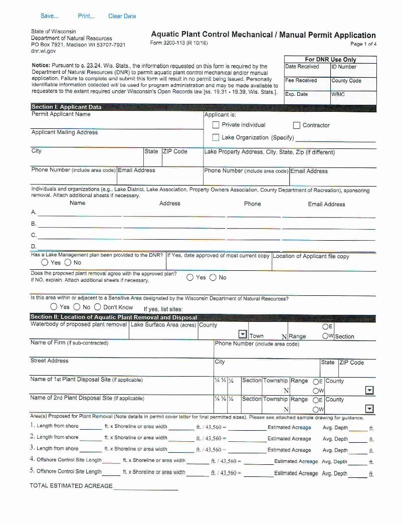
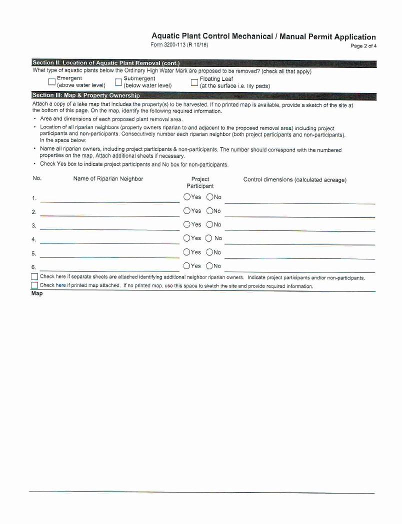

Appendix D
Moon Lake Aquatic Plant Harvesting Plan

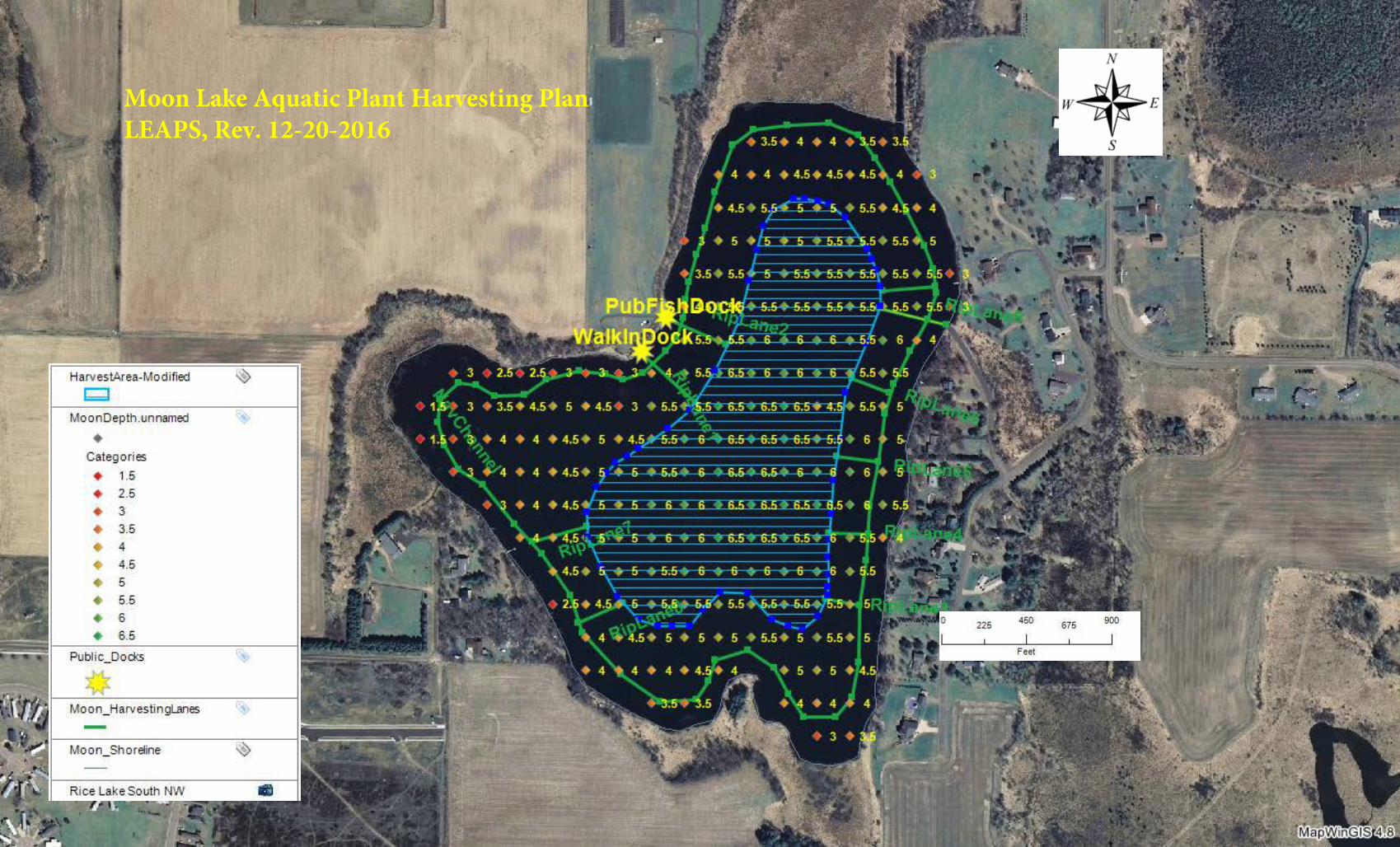
Moon Lake Aquatic Plant Harvesting PlanLEAPS, Rev. 12-20-2016
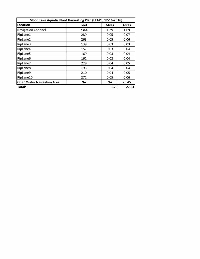
Location Feet Miles Acres
Navigation Channel 7344 1.39 1.69
RipLane1 289 0.05 0.07
RipLane2 263 0.05 0.06
RipLane3 139 0.03 0.03
RipLane4 157 0.03 0.04
RipLane5 169 0.03 0.04
RipLane6 162 0.03 0.04
RipLane7 229 0.04 0.05
RipLane8 195 0.04 0.04
RipLane9 210 0.04 0.05
RipLane10 271 0.05 0.06
Open Water Navigation Area NA NA 25.45
Totals 1.79 27.61
Moon Lake Aquatic Plant Harvesting Plan (LEAPS, 12-16-2016)

Appendix E
Lake Shoreland and Shallows Habitat Monitoring Field Protocol

0
DRAFT Lake Shoreland & Shallows Habitat Monitoring Field Protocol
Wisconsin Department of Natural Resources May 27, 2016
Contributors: Katie Hein1, Scott Van Egeren1, Patricia Cicero2, Paul Cunningham1, Kevin Gauthier1, Patrick Goggin3, Derek Kavanaugh4, Jodi Lepsch1, Dan McFarlane5, Kevin Olson1, Alex
Smith1, Buzz Sorge1, Shelly Thomsen1, Pamela Toshner1
Affiliations: 1Wisconsin Department of Natural Resources, 2Jefferson County Land and Water Conservation, 3University of Wisconsin Extension, 4Green Lake County Land and Water
Conservation, 5Waupaca County Land and Water Conservation
1
Contents Overview and Purpose .................................................................................................................................. 2
Requirements ................................................................................................................................................ 3
Equipment ..................................................................................................................................................... 4
Georeferenced Photos (Loop 1) .................................................................................................................... 5
Habitat Assessment (Loop 2) ........................................................................................................................ 6
Mapping Prior to Field Work ..................................................................................................................... 6
Quality Assurance – Determining High Water Level and Estimating Distances ....................................... 7
Defining an Assessment Boundary ........................................................................................................... 9
Riparian Buffer Zone ............................................................................................................................... 10
Percent Cover ...................................................................................................................................... 10
Human Structures in the Riparian Buffer Zone ................................................................................... 11
Runoff Concerns .................................................................................................................................. 11
Bank Zone................................................................................................................................................ 12
Bank Modifications and Erosion ......................................................................................................... 12
Littoral Zone ............................................................................................................................................ 12
Human Structures ............................................................................................................................... 12
Aquatic Plants ..................................................................................................................................... 12
Exposed Lake Bed Zone ........................................................................................................................... 13
Plants ................................................................................................................................................... 13
Disturbances ....................................................................................................................................... 13
Coarse Woody Habitat Inventory (Loop 3) ................................................................................................. 14
Coarse Woody Habitat Step by Step Instructions ................................................................................... 14
Estimating Diameter and Length of Coarse Woody Habitat ................................................................... 16
Definitions ................................................................................................................................................... 17
Riparian Buffer Zone Definitions ............................................................................................................. 17
Bank Zone Definitions ............................................................................................................................. 20
Littoral Zone Definitions ......................................................................................................................... 22
Sample Parcel Assessments ........................................................................................................................ 24
Time Estimate ............................................................................................................................................. 28
Data Sheets ................................................................................................................................................. 30
Appendix. Additional Parameters of Interest ............................................................................................. 33
2
Overview and Purpose
This guidance document provides a standard methodology for surveying, assessing, and
mapping habitat in lakeshore areas, including the Riparian Buffer, Bank, and Littoral Zones. This
survey will be conducted by county staff, consultants, Wisconsin Department of Natural
Resources (WDNR) staff, and other professionals and can be funded through the surface water
grant program (Lake Protection, River Protection, and Aquatic Invasive Species are authorized
by ss. 281.68, 281.69, 281.70, 281.71, 281.72, and 23.22(2)(c), Wis. Stats. and administered
under chapters NR 190, 191, 192, 195, and 198, Wis. Admin. Codes).
The data is being collected to provide important and useful information to local and regional resource managers, community stakeholders, and others who are interested in protecting and enhancing Wisconsin’s lakes. We anticipate that the data generated from this protocol will be used for:
Teaching and outreach
Identifying areas for protection or restoration
Targeting future Critical Habitat Designations within lakes
Creating lake management plans
Creating county comprehensive plans
Aiding management at the county level
Planning Aquatic Plant Management
Evaluating trends in lakeshore habitat over time (repeat survey every ~5 years)
Understanding trends in lake ecology (e.g., fish, wildlife, invasive species) Reporting tools that stem from this survey are currently under development. Examples of information to be gathered lake-wide include: percent cover of impervious surface, mowed lawn, or plants in the Riparian Buffer Zone, number of parcels with erosion concerns, total length of modified banks, density of human structures (piers, buildings, etc.), general distribution of floating and emergent aquatic plants, and density of coarse woody habitat. For each metric, a threshold identifying healthy habitat will be developed. This information may eventually be used for the WDNR Water Quality Report to Congress, which summarizes the condition of surface waters in Wisconsin. The time commitment to complete the protocol is reasonable for most Wisconsin lakes, although it will take substantial effort on lakes with long shorelines. We recommend conducting this protocol by circling the lake three times with two people in a small boat:
1. Loop 1 - Take georeferenced photos that slightly overlap 2. Loop 2 - Assess the riparian, bank, and littoral habitat by parcel 3. Loop 3 - Count and map all pieces of large woody habitat in water less than 2 feet deep
3
Loops 1 and 2 could be combined into a single lap if the team is able to take photos from a consistent perspective and track photo boundaries while also conducting the habitat assessment. Woody habitat should be inventoried separately because the team will need to get close to shore and use extreme focus to find all pieces of large woody habitat.
Requirements The habitat assessment should be conducted during the growing season at a date late
enough for plants to have leafed out and landowners to have landscaped their property, but before plants senesce and landowners store piers and other equipment for the winter.
The woody habitat survey could occur at a separate time; spring and fall provide optimal conditions with clear water and few aquatic plants in many lakes.
The same people should assess all properties on the lake.
The team should calibrate their eyes to recognize distances by physically measuring common distances with a tape measure or range finder (see Estimating Distance).
The team should calibrate their eyes to recognize log diameters using the wood calibration stick (see Estimating Diameter and Length of Coarse Woody Habitat).
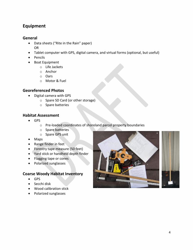
4
Equipment
General
Data sheets (“Rite in the Rain” paper) OR
Tablet computer with GPS, digital camera, and virtual forms (optional, but useful)
Pencils
Boat Equipment o Life Jackets o Anchor o Oars o Motor & Fuel
Georeferenced Photos Digital camera with GPS
o Spare SD Card (or other storage) o Spare batteries
Habitat Assessment
GPS o Pre-loaded coordinates of shoreland parcel property boundaries o Spare batteries o Spare GPS unit
Maps
Range finder in feet
Forestry tape measure (50 feet)
Yard stick or handheld depth finder
Flagging tape or cones
Polarized sunglasses
Coarse Woody Habitat Inventory
GPS
Secchi disk
Wood calibration stick
Polarized sunglasses
5
Georeferenced Photos (Loop 1) This is an opportunity to document shoreland habitat condition at a single point in time, and the results may be referred to years later. The entire shoreline should be photographed with slightly overlapping images that are taken from a vantage point ~50 feet from and perpendicular to shore. The water’s edge and understory vegetation 35 feet inland should be visible in the photo. Tree crowns may be partially cropped out of the photo.
Photographic Equipment A variety of cameras may be used:
1. Digital Camera with internal GPS – this option results in high quality, georeferenced photos. The latitude and longitude of the camera’s position when the photo was taken is stored with the photo, and locations can be uploaded directly to GIS.
2. Digital Camera and separate GPS unit – this option results in high quality photos that can be georeferenced with post-processing work. Manually adjust your camera’s clock so that it displays the same time as your GPS clock. The locations of individual photos can be derived by matching the date/time of each photo with the date/time of the location recorded by the GPS. Check to make sure that the date and time is recorded for each photo and that the GPS unit is continuously recording your path.
3. Smartphone with camera and georeferencing capacity – this option may result in lower photo quality depending on the phone, but has the ability to georeference each photo.
4. Tablet computer with internal GPS and camera – this option has the ability to georeference and store each photo. Check the quality of the camera.
Photo Tips If possible, photograph early in the morning or early in the evening to avoid harsh
sunlight conditions (or do half the lake in the morning and half in the evening to avoid backlit conditions).
Do not take photos into the sun.
Make sure the photo is level and in focus.
Increase the focal length (high f-stop) to improve depth of field (full frame in focus) or use auto settings with Landscape option.
Increase the shutter speed to prevent blur.
Avoid zooming in too close. Try to frame the water’s edge up to the canopy with sufficient detail for assessment.
Respect privacy: o Notify the lake association or local paper about the habitat survey in advance. o Do not take photos with people in them (weekday mornings are ideal). o Avoid taking photos too close to shore or into windows. o Listen and respect resident’s concerns. These photos will primarily be used for
shoreland habitat assessment and lake management plans, but will be a public record and may be used for additional purposes.
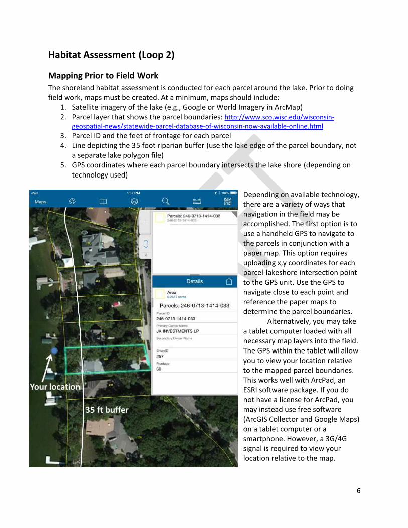
6
Habitat Assessment (Loop 2)
Mapping Prior to Field Work
The shoreland habitat assessment is conducted for each parcel around the lake. Prior to doing field work, maps must be created. At a minimum, maps should include:
1. Satellite imagery of the lake (e.g., Google or World Imagery in ArcMap) 2. Parcel layer that shows the parcel boundaries: http://www.sco.wisc.edu/wisconsin-
geospatial-news/statewide-parcel-database-of-wisconsin-now-available-online.html 3. Parcel ID and the feet of frontage for each parcel 4. Line depicting the 35 foot riparian buffer (use the lake edge of the parcel boundary, not
a separate lake polygon file) 5. GPS coordinates where each parcel boundary intersects the lake shore (depending on
technology used)
Depending on available technology, there are a variety of ways that navigation in the field may be accomplished. The first option is to use a handheld GPS to navigate to the parcels in conjunction with a paper map. This option requires uploading x,y coordinates for each parcel-lakeshore intersection point to the GPS unit. Use the GPS to navigate close to each point and reference the paper maps to determine the parcel boundaries. Alternatively, you may take a tablet computer loaded with all necessary map layers into the field. The GPS within the tablet will allow you to view your location relative to the mapped parcel boundaries. This works well with ArcPad, an ESRI software package. If you do not have a license for ArcPad, you may instead use free software (ArcGIS Collector and Google Maps) on a tablet computer or a smartphone. However, a 3G/4G signal is required to view your location relative to the map.
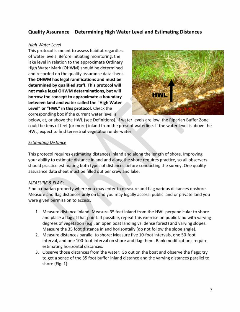
7
Quality Assurance – Determining High Water Level and Estimating Distances
High Water Level This protocol is meant to assess habitat regardless of water levels. Before initiating monitoring, the lake level in relation to the approximate Ordinary High Water Mark (OHWM) should be determined and recorded on the quality assurance data sheet. The OHWM has legal ramifications and must be determined by qualified staff. This protocol will not make legal OHWM determinations, but will borrow the concept to approximate a boundary between land and water called the “High Water Level” or “HWL” in this protocol. Check the corresponding box if the current water level is below, at, or above the HWL (see Definitions). If water levels are low, the Riparian Buffer Zone could be tens of feet (or more) inland from the present waterline. If the water level is above the HWL, expect to find terrestrial vegetation underwater.
Estimating Distance This protocol requires estimating distances inland and along the length of shore. Improving your ability to estimate distance inland and along the shore requires practice, so all observers should practice estimating both types of distances before conducting the survey. One quality assurance data sheet must be filled out per crew and lake. MEASURE & FLAG: Find a riparian property where you may enter to measure and flag various distances onshore. Measure and flag distances only on land you may legally access: public land or private land you were given permission to access.
1. Measure distance inland: Measure 35 feet inland from the HWL perpendicular to shore and place a flag at that point. If possible, repeat this exercise on public land with varying degrees of vegetation (e.g., an open boat landing vs. dense forest) and varying slopes. Measure the 35 foot distance inland horizontally (do not follow the slope angle).
2. Measure distances parallel to shore: Measure five 10-foot intervals, one 50-foot interval, and one 100-foot interval on shore and flag them. Bank modifications require estimating horizontal distances.
3. Observe those distances from the water: Go out on the boat and observe the flags; try to get a sense of the 35 foot buffer inland distance and the varying distances parallel to shore (Fig. 1).
HWL
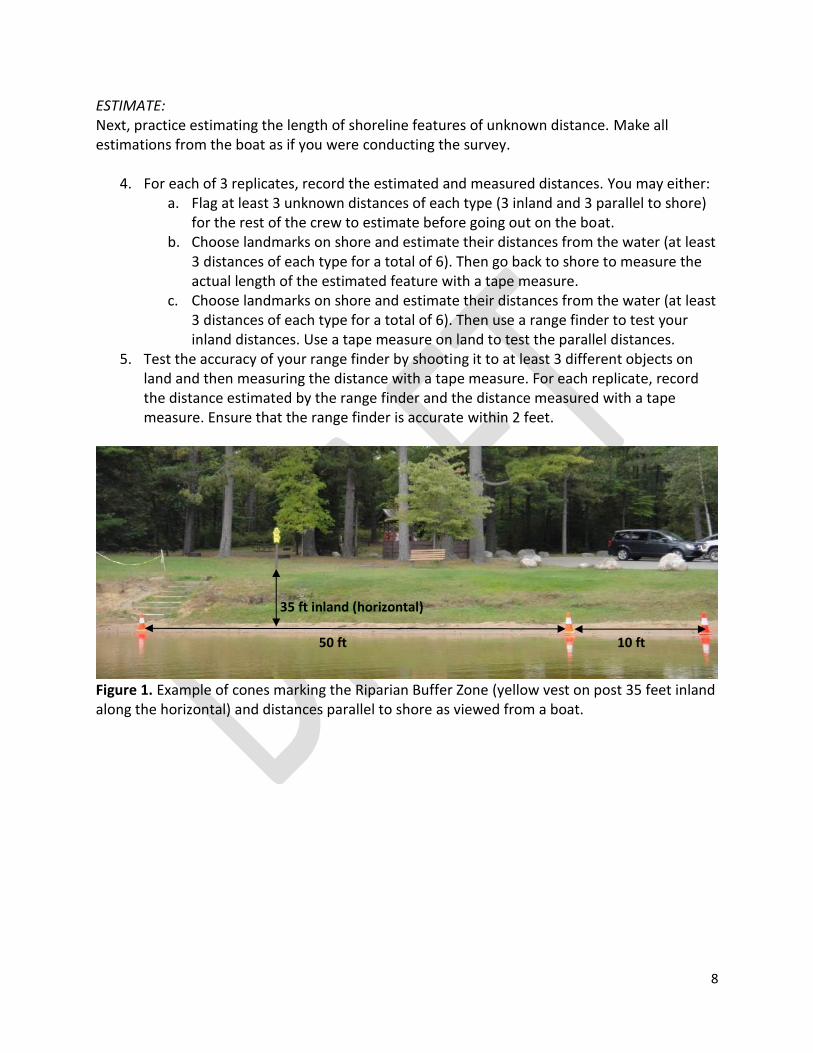
8
ESTIMATE: Next, practice estimating the length of shoreline features of unknown distance. Make all estimations from the boat as if you were conducting the survey.
4. For each of 3 replicates, record the estimated and measured distances. You may either: a. Flag at least 3 unknown distances of each type (3 inland and 3 parallel to shore)
for the rest of the crew to estimate before going out on the boat. b. Choose landmarks on shore and estimate their distances from the water (at least
3 distances of each type for a total of 6). Then go back to shore to measure the actual length of the estimated feature with a tape measure.
c. Choose landmarks on shore and estimate their distances from the water (at least 3 distances of each type for a total of 6). Then use a range finder to test your inland distances. Use a tape measure on land to test the parallel distances.
5. Test the accuracy of your range finder by shooting it to at least 3 different objects on land and then measuring the distance with a tape measure. For each replicate, record the distance estimated by the range finder and the distance measured with a tape measure. Ensure that the range finder is accurate within 2 feet.
Figure 1. Example of cones marking the Riparian Buffer Zone (yellow vest on post 35 feet inland along the horizontal) and distances parallel to shore as viewed from a boat.
35 ft inland (horizontal)
50 ft 10 ft
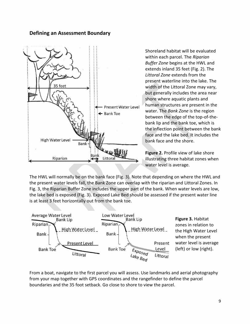
9
Defining an Assessment Boundary
Shoreland habitat will be evaluated within each parcel. The Riparian Buffer Zone begins at the HWL and extends inland 35 feet (Fig. 2). The Littoral Zone extends from the present waterline into the lake. The width of the Littoral Zone may vary, but generally includes the area near shore where aquatic plants and human structures are present in the water. The Bank Zone is the region between the edge of the top-of-the-bank lip and the bank toe, which is the inflection point between the bank face and the lake bed. It includes the bank face and the shore. Figure 2. Profile view of lake shore illustrating three habitat zones when water level is average.
The HWL will normally be on the bank face (Fig. 3). Note that depending on where the HWL and the present water levels fall, the Bank Zone can overlap with the riparian and Littoral Zones. In Fig. 3, the Riparian Buffer Zone includes the upper part of the bank. When water levels are low, the lake bed is exposed (Fig. 3). Exposed Lake Bed should be assessed if the present water line is at least 3 feet horizontally out from the bank toe.
Figure 3. Habitat zones in relation to the High Water Level when the present water level is average (left) or low (right).
From a boat, navigate to the first parcel you will assess. Use landmarks and aerial photography from your map together with GPS coordinates and the rangefinder to define the parcel boundaries and the 35 foot setback. Go close to shore to view the parcel.
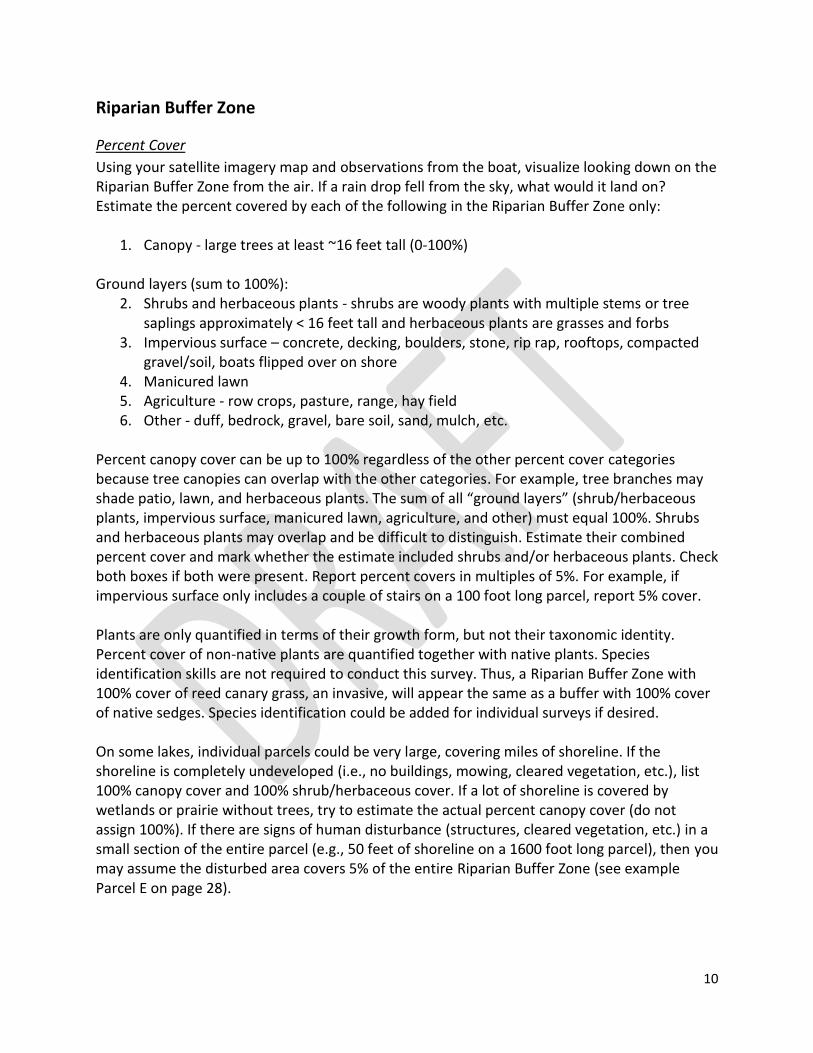
10
Riparian Buffer Zone
Percent Cover
Using your satellite imagery map and observations from the boat, visualize looking down on the Riparian Buffer Zone from the air. If a rain drop fell from the sky, what would it land on? Estimate the percent covered by each of the following in the Riparian Buffer Zone only:
1. Canopy - large trees at least ~16 feet tall (0-100%) Ground layers (sum to 100%):
2. Shrubs and herbaceous plants - shrubs are woody plants with multiple stems or tree saplings approximately < 16 feet tall and herbaceous plants are grasses and forbs
3. Impervious surface – concrete, decking, boulders, stone, rip rap, rooftops, compacted gravel/soil, boats flipped over on shore
4. Manicured lawn 5. Agriculture - row crops, pasture, range, hay field 6. Other - duff, bedrock, gravel, bare soil, sand, mulch, etc.
Percent canopy cover can be up to 100% regardless of the other percent cover categories because tree canopies can overlap with the other categories. For example, tree branches may shade patio, lawn, and herbaceous plants. The sum of all “ground layers” (shrub/herbaceous plants, impervious surface, manicured lawn, agriculture, and other) must equal 100%. Shrubs and herbaceous plants may overlap and be difficult to distinguish. Estimate their combined percent cover and mark whether the estimate included shrubs and/or herbaceous plants. Check both boxes if both were present. Report percent covers in multiples of 5%. For example, if impervious surface only includes a couple of stairs on a 100 foot long parcel, report 5% cover. Plants are only quantified in terms of their growth form, but not their taxonomic identity. Percent cover of non-native plants are quantified together with native plants. Species identification skills are not required to conduct this survey. Thus, a Riparian Buffer Zone with 100% cover of reed canary grass, an invasive, will appear the same as a buffer with 100% cover of native sedges. Species identification could be added for individual surveys if desired. On some lakes, individual parcels could be very large, covering miles of shoreline. If the shoreline is completely undeveloped (i.e., no buildings, mowing, cleared vegetation, etc.), list 100% canopy cover and 100% shrub/herbaceous cover. If a lot of shoreline is covered by wetlands or prairie without trees, try to estimate the actual percent canopy cover (do not assign 100%). If there are signs of human disturbance (structures, cleared vegetation, etc.) in a small section of the entire parcel (e.g., 50 feet of shoreline on a 1600 foot long parcel), then you may assume the disturbed area covers 5% of the entire Riparian Buffer Zone (see example Parcel E on page 28).
11
Human Structures in the Riparian Buffer Zone
Count the number of structures that are present within the Riparian Buffer Zone of the parcel.
Buildings (e.g., residence, shed, boathouse, garage, commercial building)
Boats (generally flipped upside down on shore for storage)
Fire pits (free standing or built in the ground)
Other – include written description (e.g., retaining wall), but avoid counting small objects that are easily moved (e.g., toys or lawn chairs)
Runoff Concerns
Look for changes to the land that would increase runoff into the lake (see list below). Record whether the runoff concern occurs within the Riparian Buffer Zone (“Present in Riparian”) or within the parcel but outside of the Riparian Buffer Zone (“Present out of Riparian”). If the runoff concern is present in the Riparian Buffer Zone, you do not need to search in detail outside of the Riparian Buffer Zone. You may still check both boxes if the concern occurs both in and out of the Riparian Buffer Zone. Record presence of:
Point sources (e.g., culverts, drain pipes, rain gutters, sump pumps, gray water outflow)
Channelized flow or gullies
Stairways, trails or roads leading directly to the Bank Zone (top of the bank lip)
Sloped lawn/soil (such that water runoff leads directly to the lake)
Bare soil
Sand/silt deposits
Other – include written description
12
Bank Zone
Bank Modifications and Erosion
Estimate the length (to the nearest 10 feet) of the following items if present. Train your eye to recognize 10 foot increments along the shoreline. You may also use the recorded shoreline length of the parcel to aid length estimation.
Vertical sea wall
Rip rap
Other erosion control structures (note what the material is under “Notes”)
Artificial beach
Slumping banks or bank erosion > 1 foot vertical bank face
Slumping banks or bank erosion < 1 foot vertical bank face
Littoral Zone
Human Structures
Count the number of human structures present within the Littoral Zone:
Piers
Boat lifts (count lifts with and without canopies the same)
Swim rafts/water trampolines (Do not count rafts beyond ~50 feet out into the water from shore. Rafts may be placed up to 200 feet from shore.)
Boat houses (over the water)
Marinas
Other – include written description
Aquatic Plants
Check the box if emergent and/or rooted floating aquatic plants are present within the Littoral Zone of the parcel. Plants growing only underwater (submergent) are not included in the survey because they may be difficult to observe. Check the box if there are obvious aquatic plant removal areas in the Littoral Zone of the parcel. Aquatic plant removal areas are generally demarcated by straight lines of cleared vegetation that are perpendicular to shore and adjacent to plant beds.
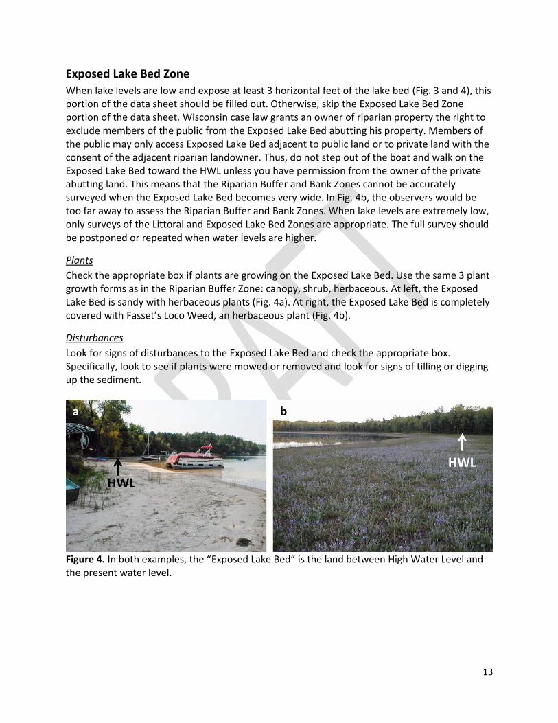
13
Exposed Lake Bed Zone
When lake levels are low and expose at least 3 horizontal feet of the lake bed (Fig. 3 and 4), this portion of the data sheet should be filled out. Otherwise, skip the Exposed Lake Bed Zone portion of the data sheet. Wisconsin case law grants an owner of riparian property the right to exclude members of the public from the Exposed Lake Bed abutting his property. Members of the public may only access Exposed Lake Bed adjacent to public land or to private land with the consent of the adjacent riparian landowner. Thus, do not step out of the boat and walk on the Exposed Lake Bed toward the HWL unless you have permission from the owner of the private abutting land. This means that the Riparian Buffer and Bank Zones cannot be accurately surveyed when the Exposed Lake Bed becomes very wide. In Fig. 4b, the observers would be too far away to assess the Riparian Buffer and Bank Zones. When lake levels are extremely low, only surveys of the Littoral and Exposed Lake Bed Zones are appropriate. The full survey should be postponed or repeated when water levels are higher.
Plants
Check the appropriate box if plants are growing on the Exposed Lake Bed. Use the same 3 plant growth forms as in the Riparian Buffer Zone: canopy, shrub, herbaceous. At left, the Exposed Lake Bed is sandy with herbaceous plants (Fig. 4a). At right, the Exposed Lake Bed is completely covered with Fasset’s Loco Weed, an herbaceous plant (Fig. 4b).
Disturbances
Look for signs of disturbances to the Exposed Lake Bed and check the appropriate box. Specifically, look to see if plants were mowed or removed and look for signs of tilling or digging up the sediment.
Figure 4. In both examples, the “Exposed Lake Bed” is the land between High Water Level and the present water level.
b a
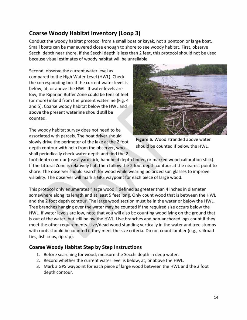
14
Figure 5. Wood stranded above water
should be counted if below the HWL.
Coarse Woody Habitat Inventory (Loop 3) Conduct the woody habitat protocol from a small boat or kayak, not a pontoon or large boat. Small boats can be maneuvered close enough to shore to see woody habitat. First, observe Secchi depth near shore. If the Secchi depth is less than 2 feet, this protocol should not be used because visual estimates of woody habitat will be unreliable. Second, observe the current water level as compared to the High Water Level (HWL). Check the corresponding box if the current water level is below, at, or above the HWL. If water levels are low, the Riparian Buffer Zone could be tens of feet (or more) inland from the present waterline (Fig. 4 and 5). Coarse woody habitat below the HWL and above the present waterline should still be counted. The woody habitat survey does not need to be associated with parcels. The boat driver should slowly drive the perimeter of the lake at the 2 foot depth contour with help from the observer, who shall periodically check water depth and find the 2 foot depth contour (use a yardstick, handheld depth finder, or marked wood calibration stick). If the Littoral Zone is relatively flat, then follow the 2 foot depth contour at the nearest point to shore. The observer should search for wood while wearing polarized sun glasses to improve visibility. The observer will mark a GPS waypoint for each piece of large wood. This protocol only enumerates “large wood,” defined as greater than 4 inches in diameter somewhere along its length and at least 5 feet long. Only count wood that is between the HWL and the 2 foot depth contour. The large wood section must be in the water or below the HWL. Tree branches hanging over the water may be counted if the required size occurs below the HWL. If water levels are low, note that you will also be counting wood lying on the ground that is out of the water, but still below the HWL. Live branches and non-anchored logs count if they meet the other requirements. Live/dead wood standing vertically in the water and tree stumps with roots should be counted if they meet the size criteria. Do not count lumber (e.g., railroad ties, fish cribs, rip rap).
Coarse Woody Habitat Step by Step Instructions
1. Before searching for wood, measure the Secchi depth in deep water. 2. Record whether the current water level is below, at, or above the HWL. 3. Mark a GPS waypoint for each piece of large wood between the HWL and the 2 foot
depth contour.
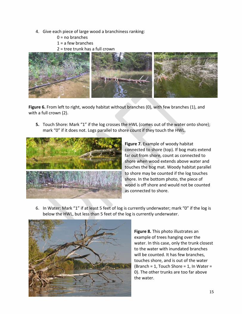
15
4. Give each piece of large wood a branchiness ranking: 0 = no branches 1 = a few branches 2 = tree trunk has a full crown
Figure 6. From left to right, woody habitat without branches (0), with few branches (1), and with a full crown (2).
5. Touch Shore: Mark “1” if the log crosses the HWL (comes out of the water onto shore); mark “0” if it does not. Logs parallel to shore count if they touch the HWL.
Figure 7. Example of woody habitat connected to shore (top). If bog mats extend far out from shore, count as connected to shore when wood extends above water and touches the bog mat. Woody habitat parallel
to shore may be counted if the log touches shore. In the bottom photo, the piece of wood is off shore and would not be counted as connected to shore.
6. In Water: Mark “1” if at least 5 feet of log is currently underwater; mark “0” if the log is
below the HWL, but less than 5 feet of the log is currently underwater. Figure 8. This photo illustrates an example of trees hanging over the water. In this case, only the trunk closest to the water with inundated branches will be counted. It has few branches, touches shore, and is out of the water (Branch = 1, Touch Shore = 1, In Water = 0). The other trunks are too far above the water.
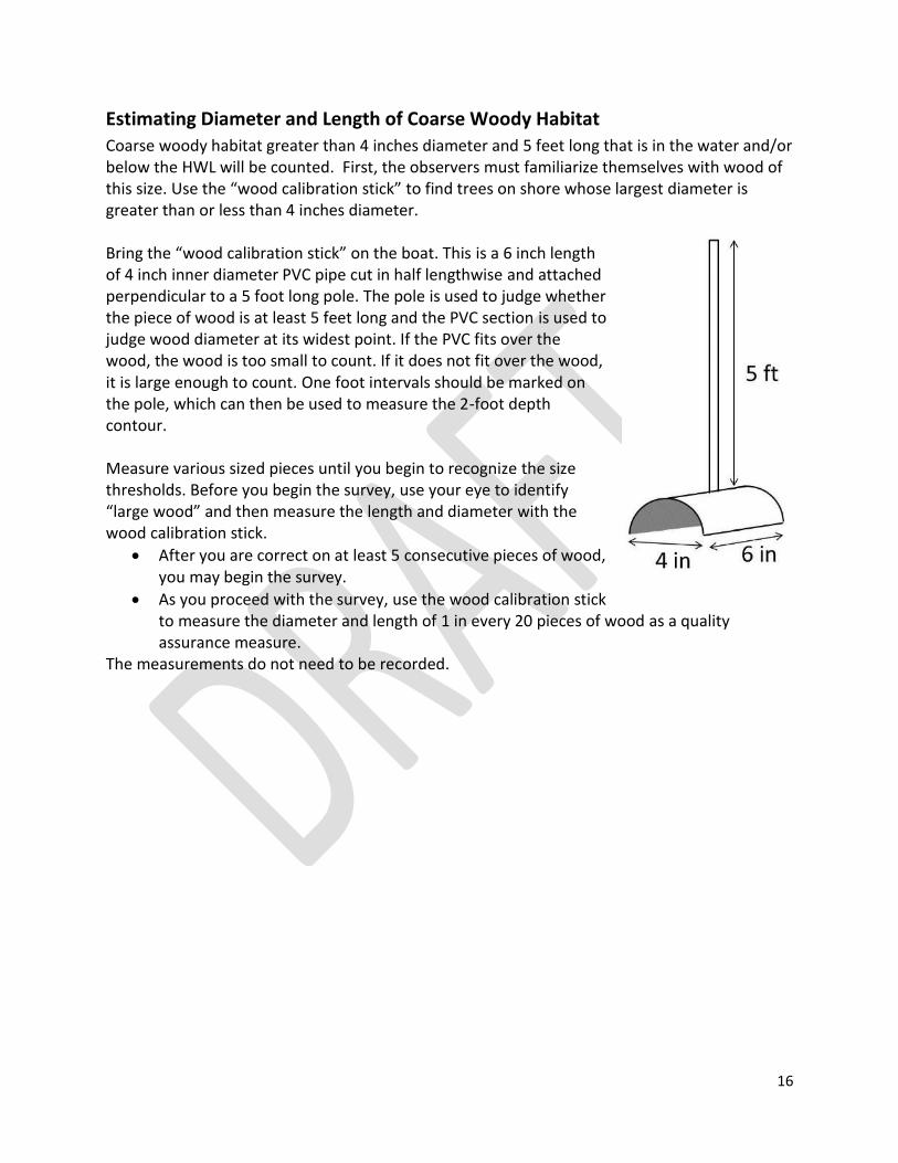
16
Estimating Diameter and Length of Coarse Woody Habitat
Coarse woody habitat greater than 4 inches diameter and 5 feet long that is in the water and/or below the HWL will be counted. First, the observers must familiarize themselves with wood of this size. Use the “wood calibration stick” to find trees on shore whose largest diameter is greater than or less than 4 inches diameter. Bring the “wood calibration stick” on the boat. This is a 6 inch length of 4 inch inner diameter PVC pipe cut in half lengthwise and attached perpendicular to a 5 foot long pole. The pole is used to judge whether the piece of wood is at least 5 feet long and the PVC section is used to judge wood diameter at its widest point. If the PVC fits over the wood, the wood is too small to count. If it does not fit over the wood, it is large enough to count. One foot intervals should be marked on the pole, which can then be used to measure the 2-foot depth contour. Measure various sized pieces until you begin to recognize the size thresholds. Before you begin the survey, use your eye to identify “large wood” and then measure the length and diameter with the wood calibration stick.
After you are correct on at least 5 consecutive pieces of wood, you may begin the survey.
As you proceed with the survey, use the wood calibration stick to measure the diameter and length of 1 in every 20 pieces of wood as a quality assurance measure.
The measurements do not need to be recorded.
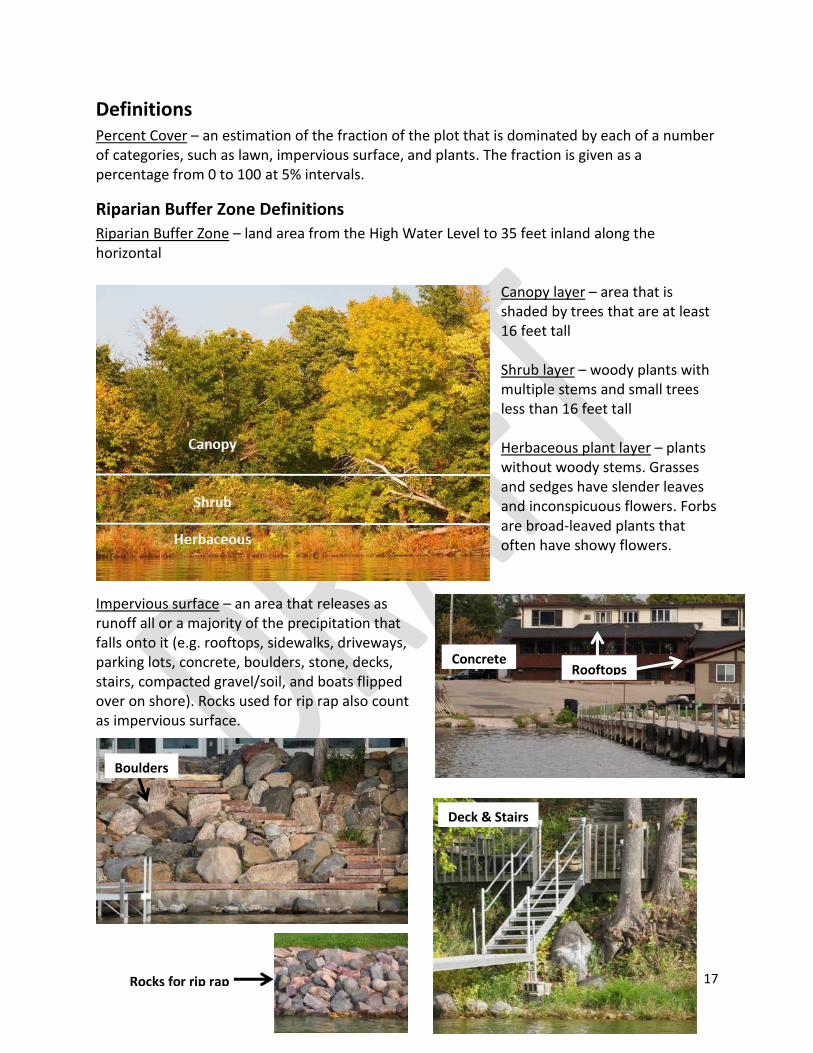
17
Definitions Percent Cover – an estimation of the fraction of the plot that is dominated by each of a number of categories, such as lawn, impervious surface, and plants. The fraction is given as a percentage from 0 to 100 at 5% intervals.
Riparian Buffer Zone Definitions
Riparian Buffer Zone – land area from the High Water Level to 35 feet inland along the horizontal
Canopy layer – area that is shaded by trees that are at least 16 feet tall Shrub layer – woody plants with multiple stems and small trees less than 16 feet tall Herbaceous plant layer – plants without woody stems. Grasses and sedges have slender leaves and inconspicuous flowers. Forbs are broad-leaved plants that often have showy flowers.
Impervious surface – an area that releases as runoff all or a majority of the precipitation that falls onto it (e.g. rooftops, sidewalks, driveways, parking lots, concrete, boulders, stone, decks, stairs, compacted gravel/soil, and boats flipped over on shore). Rocks used for rip rap also count as impervious surface.
Concrete Rooftops
Boulders
Rocks for rip rap
Deck & Stairs

18
Other Percent Cover – this category includes cover types that are not on the data sheet, such as bedrock, gravel, bare soil, sand, mulch, and dead plant material (duff)
Building – any roofed structure (house, cabin, shed, boathouse, garage, commercial)
Fire pit – circular
indentation in the
ground or portable
structure used for fires
Boats on shore – boats flipped upside down for storage in the Riparian Buffer Zone
Agriculture – agricultural fields planted in rows
or grasslands used for grazing livestock
Manicured lawn – grass that is mowed short
Bedrock
Gravel
Mulch
Duff
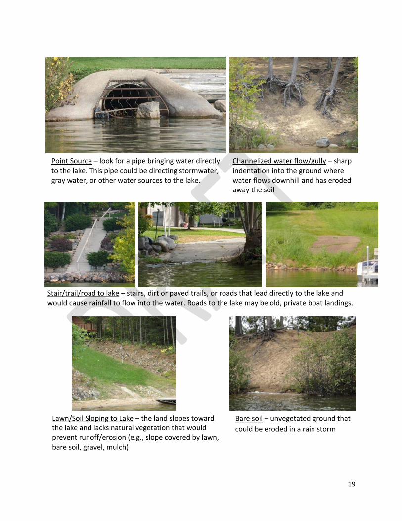
19
Stair/trail/road to lake – stairs, dirt or paved trails, or roads that lead directly to the lake and would cause rainfall to flow into the water. Roads to the lake may be old, private boat landings.
Point Source – look for a pipe bringing water directly to the lake. This pipe could be directing stormwater, gray water, or other water sources to the lake.
Channelized water flow/gully – sharp indentation into the ground where water flows downhill and has eroded away the soil
Lawn/Soil Sloping to Lake – the land slopes toward the lake and lacks natural vegetation that would prevent runoff/erosion (e.g., slope covered by lawn, bare soil, gravel, mulch)
Bare soil – unvegetated ground that
could be eroded in a rain storm
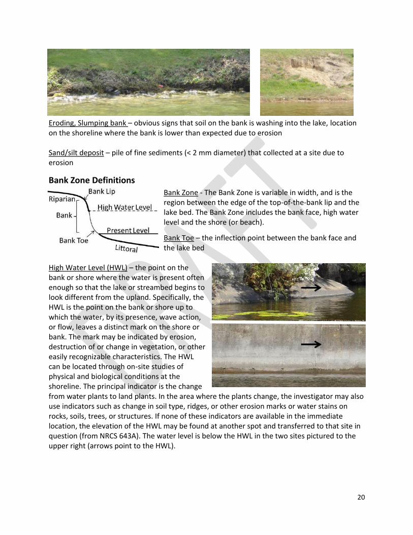
20
Eroding, Slumping bank – obvious signs that soil on the bank is washing into the lake, location on the shoreline where the bank is lower than expected due to erosion Sand/silt deposit – pile of fine sediments (< 2 mm diameter) that collected at a site due to erosion
Bank Zone Definitions
Bank Zone - The Bank Zone is variable in width, and is the region between the edge of the top-of-the-bank lip and the lake bed. The Bank Zone includes the bank face, high water level and the shore (or beach).
Bank Toe – the inflection point between the bank face and the lake bed
High Water Level (HWL) – the point on the bank or shore where the water is present often enough so that the lake or streambed begins to look different from the upland. Specifically, the HWL is the point on the bank or shore up to which the water, by its presence, wave action, or flow, leaves a distinct mark on the shore or bank. The mark may be indicated by erosion, destruction of or change in vegetation, or other easily recognizable characteristics. The HWL can be located through on-site studies of physical and biological conditions at the shoreline. The principal indicator is the change from water plants to land plants. In the area where the plants change, the investigator may also use indicators such as change in soil type, ridges, or other erosion marks or water stains on rocks, soils, trees, or structures. If none of these indicators are available in the immediate location, the elevation of the HWL may be found at another spot and transferred to that site in question (from NRCS 643A). The water level is below the HWL in the two sites pictured to the upper right (arrows point to the HWL).
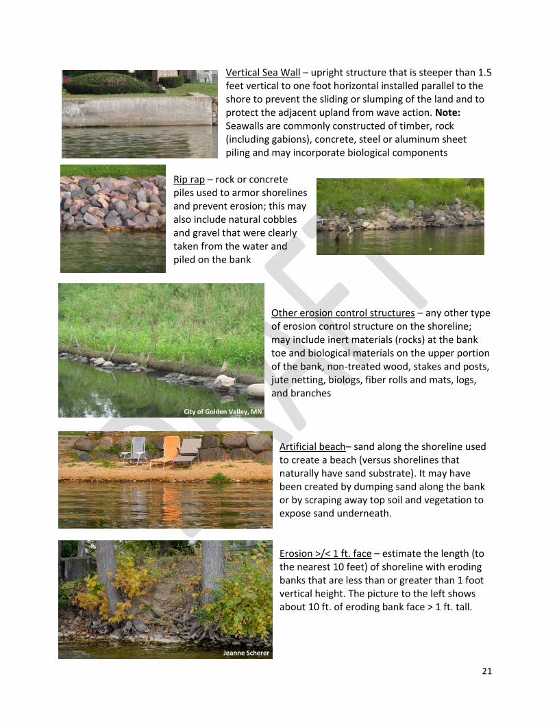
21
Vertical Sea Wall – upright structure that is steeper than 1.5 feet vertical to one foot horizontal installed parallel to the shore to prevent the sliding or slumping of the land and to protect the adjacent upland from wave action. Note: Seawalls are commonly constructed of timber, rock (including gabions), concrete, steel or aluminum sheet piling and may incorporate biological components
Rip rap – rock or concrete piles used to armor shorelines and prevent erosion; this may also include natural cobbles and gravel that were clearly taken from the water and piled on the bank
Other erosion control structures – any other type of erosion control structure on the shoreline; may include inert materials (rocks) at the bank toe and biological materials on the upper portion of the bank, non-treated wood, stakes and posts, jute netting, biologs, fiber rolls and mats, logs, and branches
Artificial beach– sand along the shoreline used to create a beach (versus shorelines that naturally have sand substrate). It may have been created by dumping sand along the bank or by scraping away top soil and vegetation to expose sand underneath. Erosion >/< 1 ft. face – estimate the length (to the nearest 10 feet) of shoreline with eroding banks that are less than or greater than 1 foot vertical height. The picture to the left shows about 10 ft. of eroding bank face > 1 ft. tall.
City of Golden Valley, MN
Jeanne Scherer
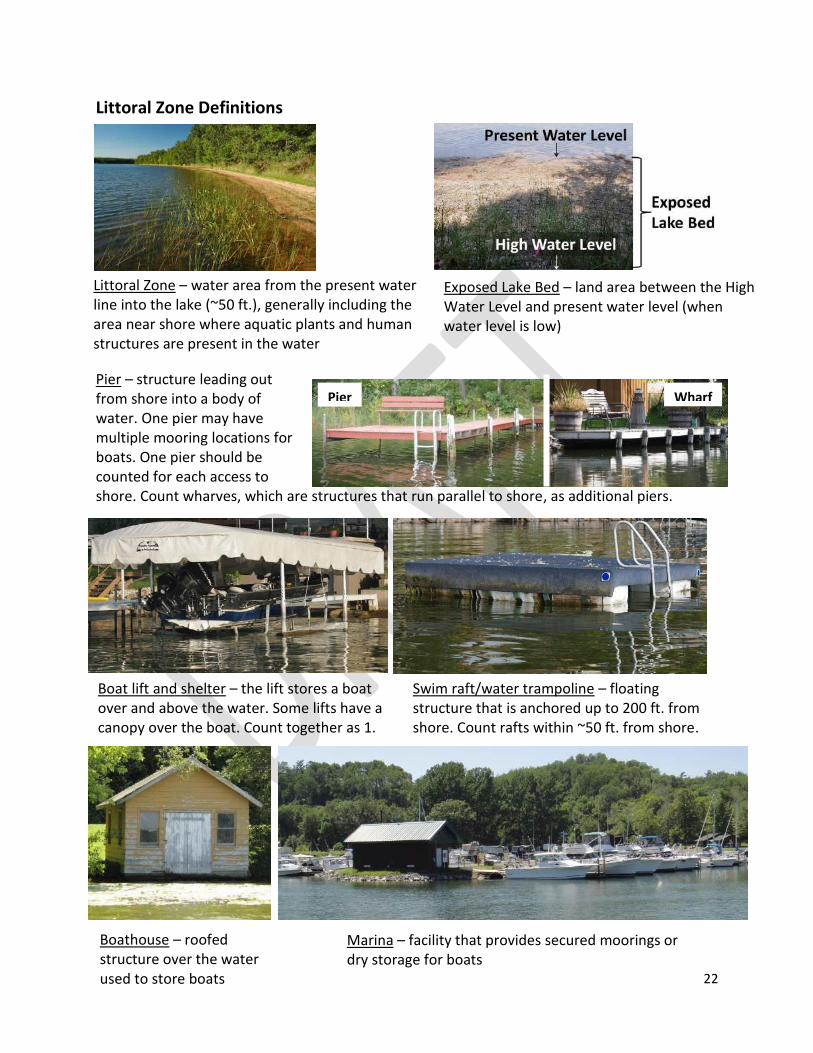
22
Littoral Zone – water area from the present water line into the lake (~50 ft.), generally including the area near shore where aquatic plants and human structures are present in the water
Exposed Lake Bed – land area between the High Water Level and present water level (when water level is low)
Littoral Zone Definitions
Pier – structure leading out from shore into a body of water. One pier may have multiple mooring locations for boats. One pier should be counted for each access to shore. Count wharves, which are structures that run parallel to shore, as additional piers.
©Frank Koshere
Boat lift and shelter – the lift stores a boat over and above the water. Some lifts have a canopy over the boat. Count together as 1.
Swim raft/water trampoline – floating structure that is anchored up to 200 ft. from shore. Count rafts within ~50 ft. from shore.
Boathouse – roofed structure over the water used to store boats
Marina – facility that provides secured moorings or dry storage for boats
Pier Wharf
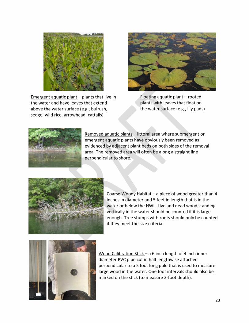
23
Removed aquatic plants – littoral area where submergent or emergent aquatic plants have obviously been removed as evidenced by adjacent plant beds on both sides of the removal area. The removed area will often be along a straight line perpendicular to shore.
Coarse Woody Habitat – a piece of wood greater than 4 inches in diameter and 5 feet in length that is in the water or below the HWL. Live and dead wood standing vertically in the water should be counted if it is large enough. Tree stumps with roots should only be counted if they meet the size criteria.
Wood Calibration Stick – a 6 inch length of 4 inch inner diameter PVC pipe cut in half lengthwise attached perpendicular to a 5 foot long pole that is used to measure large wood in the water. One foot intervals should also be marked on the stick (to measure 2-foot depth).
Emergent aquatic plant – plants that live in the water and have leaves that extend above the water surface (e.g., bulrush, sedge, wild rice, arrowhead, cattails)
Floating aquatic plant – rooted plants with leaves that float on the water surface (e.g., lily pads)
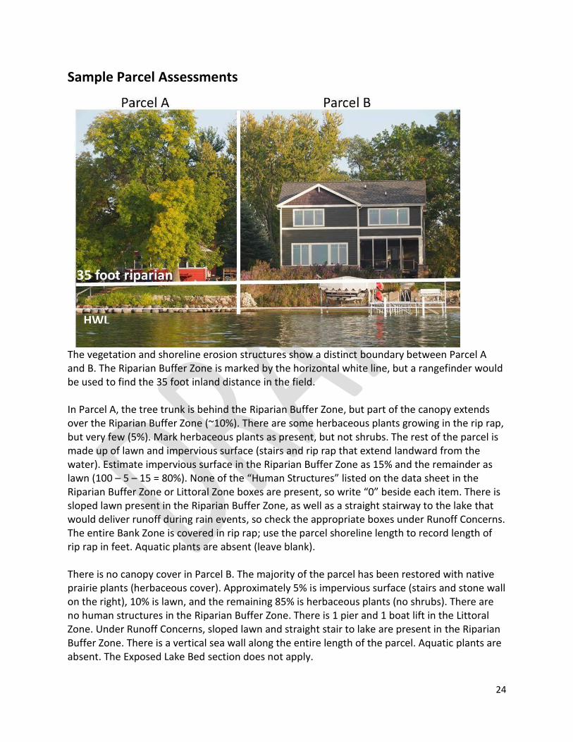
24
Sample Parcel Assessments
The vegetation and shoreline erosion structures show a distinct boundary between Parcel A and B. The Riparian Buffer Zone is marked by the horizontal white line, but a rangefinder would be used to find the 35 foot inland distance in the field. In Parcel A, the tree trunk is behind the Riparian Buffer Zone, but part of the canopy extends over the Riparian Buffer Zone (~10%). There are some herbaceous plants growing in the rip rap, but very few (5%). Mark herbaceous plants as present, but not shrubs. The rest of the parcel is made up of lawn and impervious surface (stairs and rip rap that extend landward from the water). Estimate impervious surface in the Riparian Buffer Zone as 15% and the remainder as lawn (100 – 5 – 15 = 80%). None of the “Human Structures” listed on the data sheet in the Riparian Buffer Zone or Littoral Zone boxes are present, so write “0” beside each item. There is sloped lawn present in the Riparian Buffer Zone, as well as a straight stairway to the lake that would deliver runoff during rain events, so check the appropriate boxes under Runoff Concerns. The entire Bank Zone is covered in rip rap; use the parcel shoreline length to record length of rip rap in feet. Aquatic plants are absent (leave blank). There is no canopy cover in Parcel B. The majority of the parcel has been restored with native prairie plants (herbaceous cover). Approximately 5% is impervious surface (stairs and stone wall on the right), 10% is lawn, and the remaining 85% is herbaceous plants (no shrubs). There are no human structures in the Riparian Buffer Zone. There is 1 pier and 1 boat lift in the Littoral Zone. Under Runoff Concerns, sloped lawn and straight stair to lake are present in the Riparian Buffer Zone. There is a vertical sea wall along the entire length of the parcel. Aquatic plants are absent. The Exposed Lake Bed section does not apply.
HWL
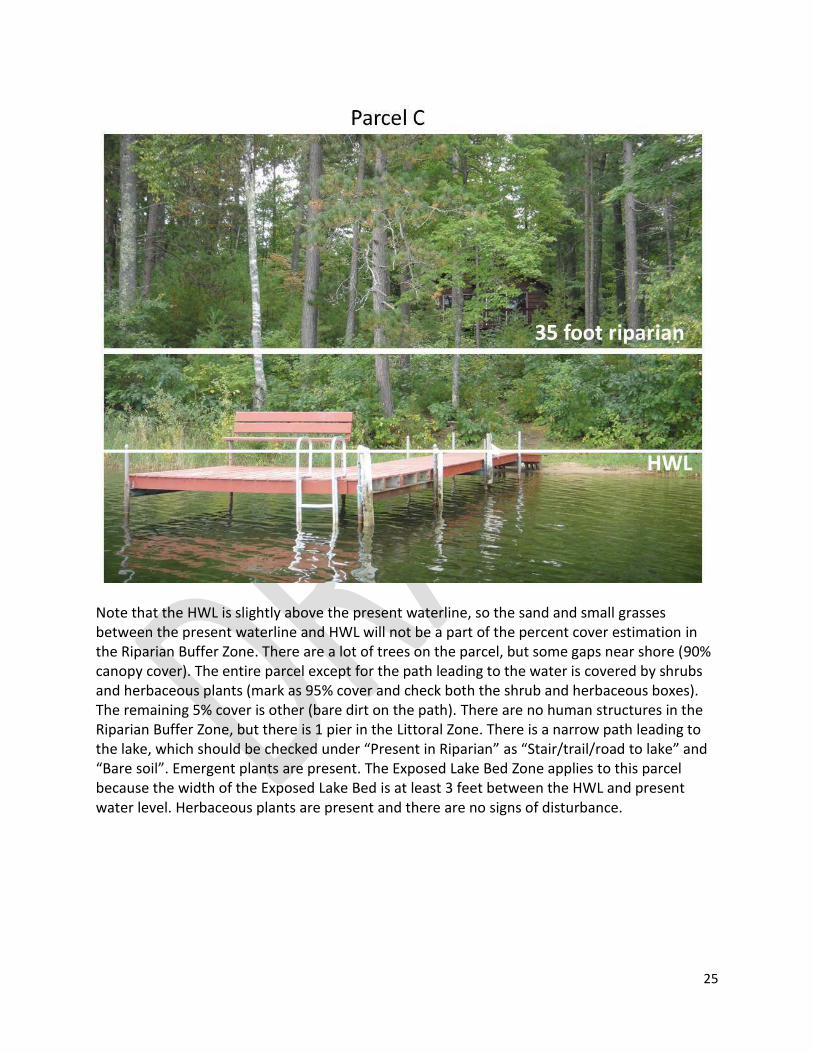
25
Note that the HWL is slightly above the present waterline, so the sand and small grasses between the present waterline and HWL will not be a part of the percent cover estimation in the Riparian Buffer Zone. There are a lot of trees on the parcel, but some gaps near shore (90% canopy cover). The entire parcel except for the path leading to the water is covered by shrubs and herbaceous plants (mark as 95% cover and check both the shrub and herbaceous boxes). The remaining 5% cover is other (bare dirt on the path). There are no human structures in the Riparian Buffer Zone, but there is 1 pier in the Littoral Zone. There is a narrow path leading to the lake, which should be checked under “Present in Riparian” as “Stair/trail/road to lake” and “Bare soil”. Emergent plants are present. The Exposed Lake Bed Zone applies to this parcel because the width of the Exposed Lake Bed is at least 3 feet between the HWL and present water level. Herbaceous plants are present and there are no signs of disturbance.
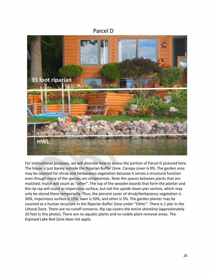
26
For instructional purposes, we will describe how to assess the portion of Parcel D pictured here. The house is just barely outside the Riparian Buffer Zone. Canopy cover is 0%. The garden area may be counted for shrub and herbaceous vegetation because it serves a structural function even though many of the species are ornamentals. Note the spaces between plants that are mulched; mulch will count as “other”. The top of the wooden boards that form the planter and the rip rap will count as impervious surface, but not the upside down pier section, which may only be stored there temporarily. Thus, the percent cover of shrub/herbaceous vegetation is 30%, impervious surface is 15%, lawn is 50%, and other is 5%. The garden planter may be counted as a human structure in the Riparian Buffer Zone under “Other”. There is 1 pier in the Littoral Zone. There are no runoff concerns. Rip rap covers the entire shoreline (approximately 20 feet in this photo). There are no aquatic plants and no visible plant removal areas. The Exposed Lake Bed Zone does not apply.
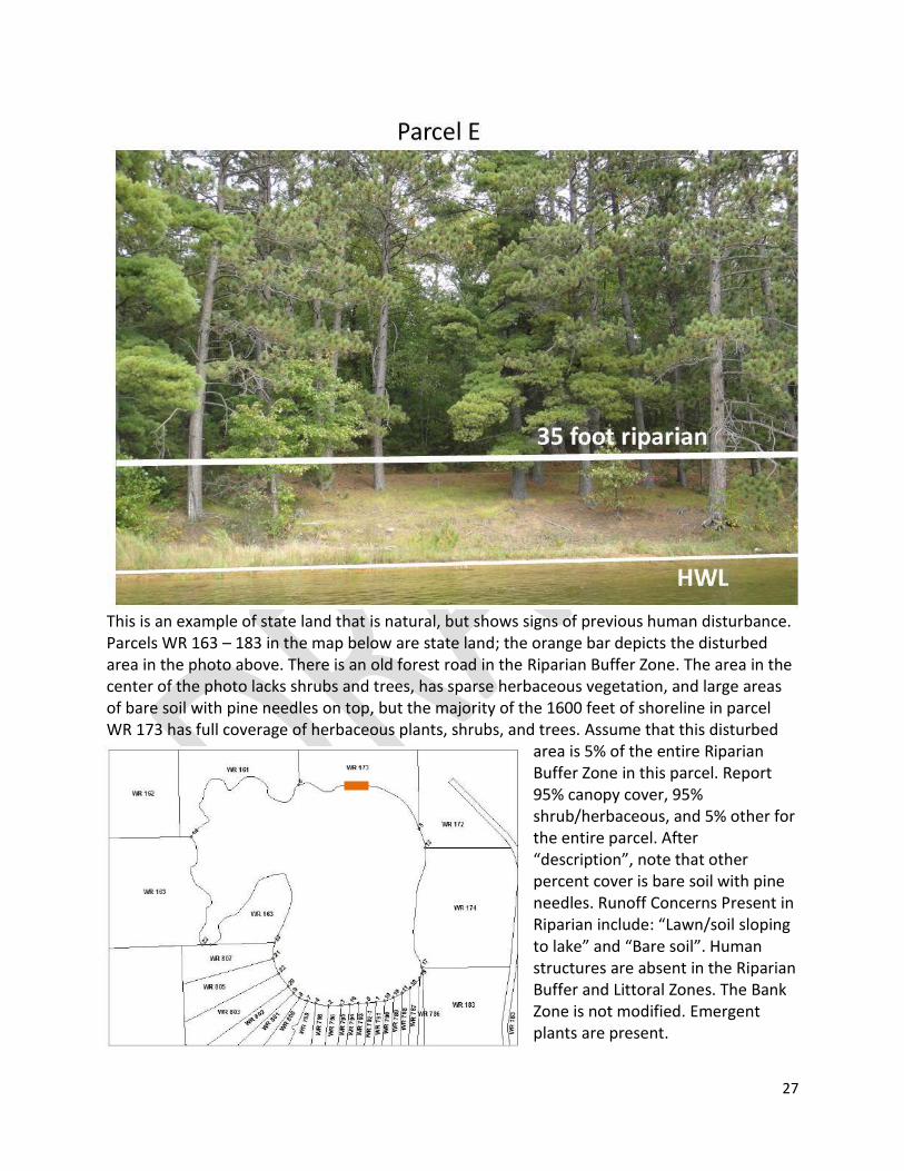
27
This is an example of state land that is natural, but shows signs of previous human disturbance. Parcels WR 163 – 183 in the map below are state land; the orange bar depicts the disturbed area in the photo above. There is an old forest road in the Riparian Buffer Zone. The area in the center of the photo lacks shrubs and trees, has sparse herbaceous vegetation, and large areas of bare soil with pine needles on top, but the majority of the 1600 feet of shoreline in parcel WR 173 has full coverage of herbaceous plants, shrubs, and trees. Assume that this disturbed
area is 5% of the entire Riparian Buffer Zone in this parcel. Report 95% canopy cover, 95% shrub/herbaceous, and 5% other for the entire parcel. After “description”, note that other percent cover is bare soil with pine needles. Runoff Concerns Present in Riparian include: “Lawn/soil sloping to lake” and “Bare soil”. Human structures are absent in the Riparian Buffer and Littoral Zones. The Bank Zone is not modified. Emergent plants are present.
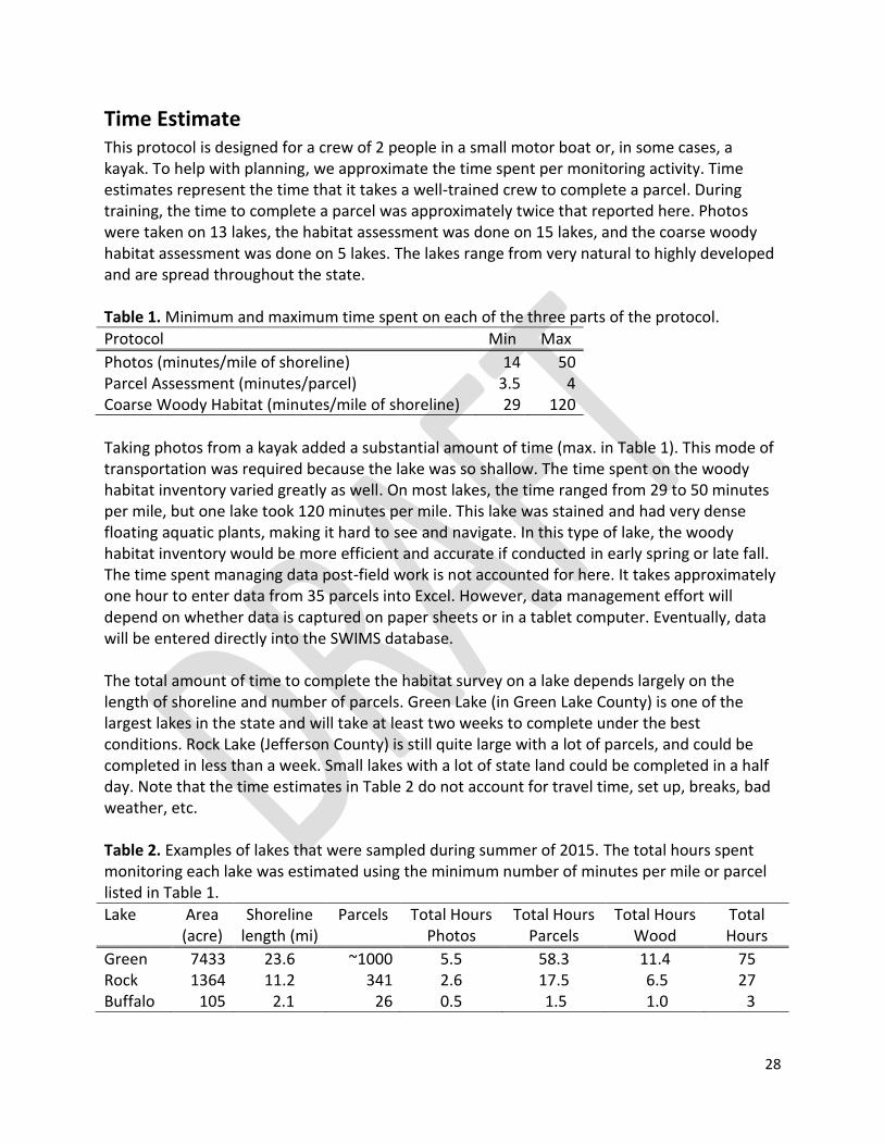
28
Time Estimate This protocol is designed for a crew of 2 people in a small motor boat or, in some cases, a kayak. To help with planning, we approximate the time spent per monitoring activity. Time estimates represent the time that it takes a well-trained crew to complete a parcel. During training, the time to complete a parcel was approximately twice that reported here. Photos were taken on 13 lakes, the habitat assessment was done on 15 lakes, and the coarse woody habitat assessment was done on 5 lakes. The lakes range from very natural to highly developed and are spread throughout the state. Table 1. Minimum and maximum time spent on each of the three parts of the protocol.
Protocol Min Max
Photos (minutes/mile of shoreline) 14 50 Parcel Assessment (minutes/parcel) 3.5 4 Coarse Woody Habitat (minutes/mile of shoreline) 29 120
Taking photos from a kayak added a substantial amount of time (max. in Table 1). This mode of transportation was required because the lake was so shallow. The time spent on the woody habitat inventory varied greatly as well. On most lakes, the time ranged from 29 to 50 minutes per mile, but one lake took 120 minutes per mile. This lake was stained and had very dense floating aquatic plants, making it hard to see and navigate. In this type of lake, the woody habitat inventory would be more efficient and accurate if conducted in early spring or late fall. The time spent managing data post-field work is not accounted for here. It takes approximately one hour to enter data from 35 parcels into Excel. However, data management effort will depend on whether data is captured on paper sheets or in a tablet computer. Eventually, data will be entered directly into the SWIMS database. The total amount of time to complete the habitat survey on a lake depends largely on the length of shoreline and number of parcels. Green Lake (in Green Lake County) is one of the largest lakes in the state and will take at least two weeks to complete under the best conditions. Rock Lake (Jefferson County) is still quite large with a lot of parcels, and could be completed in less than a week. Small lakes with a lot of state land could be completed in a half day. Note that the time estimates in Table 2 do not account for travel time, set up, breaks, bad weather, etc. Table 2. Examples of lakes that were sampled during summer of 2015. The total hours spent monitoring each lake was estimated using the minimum number of minutes per mile or parcel listed in Table 1.
Lake Area (acre)
Shoreline length (mi)
Parcels Total Hours Photos
Total Hours Parcels
Total Hours Wood
Total Hours
Green 7433 23.6 ~1000 5.5 58.3 11.4 75 Rock 1364 11.2 341 2.6 17.5 6.5 27 Buffalo 105 2.1 26 0.5 1.5 1.0 3
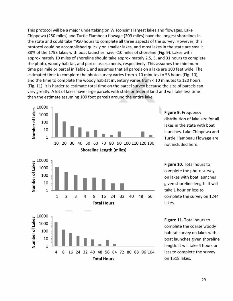
29
1
10
100
1000
10000
10 20 30 40 50 60 70 80 90 100 110 120 130
Nu
mb
er o
f La
kes
Shoreline Length (miles)
1
10
100
1000
10000
1 2 3 4 8 16 24 32 40 48 56
Nu
mb
er o
f La
kes
Total Hours
1
10
100
1000
10000
4 8 16 24 32 40 48 56 64 72 80 88 96 104
Nu
mb
er o
f La
kes
Total Hours
This protocol will be a major undertaking on Wisconsin’s largest lakes and flowages. Lake Chippewa (250 miles) and Turtle Flambeau flowage (209 miles) have the longest shorelines in the state and could take ~950 hours to complete all three aspects of the survey. However, this protocol could be accomplished quickly on smaller lakes, and most lakes in the state are small; 88% of the 1793 lakes with boat launches have <10 miles of shoreline (Fig. 9). Lakes with approximately 10 miles of shoreline should take approximately 2.5, 5, and 31 hours to complete the photo, woody habitat, and parcel assessments, respectively. This assumes the minimum time per mile or parcel in Table 1 and assumes that all parcels on a lake are 100 feet wide. The estimated time to complete the photo survey varies from < 10 minutes to 58 hours (Fig. 10), and the time to complete the woody habitat inventory varies from < 10 minutes to 120 hours (Fig. 11). It is harder to estimate total time on the parcel survey because the size of parcels can vary greatly. A lot of lakes have large parcels with state or federal land and will take less time than the estimate assuming 100 foot parcels around the entire lake.
Figure 9. Frequency
distribution of lake size for all
lakes in the state with boat
launches. Lake Chippewa and
Turtle Flambeau Flowage are
not included here.
Figure 10. Total hours to
complete the photo survey
on lakes with boat launches
given shoreline length. It will
take 1 hour or less to
complete the survey on 1244
lakes.
Figure 11. Total hours to
complete the coarse woody
habitat survey on lakes with
boat launches given shoreline
length. It will take 4 hours or
less to complete the survey
on 1518 lakes.
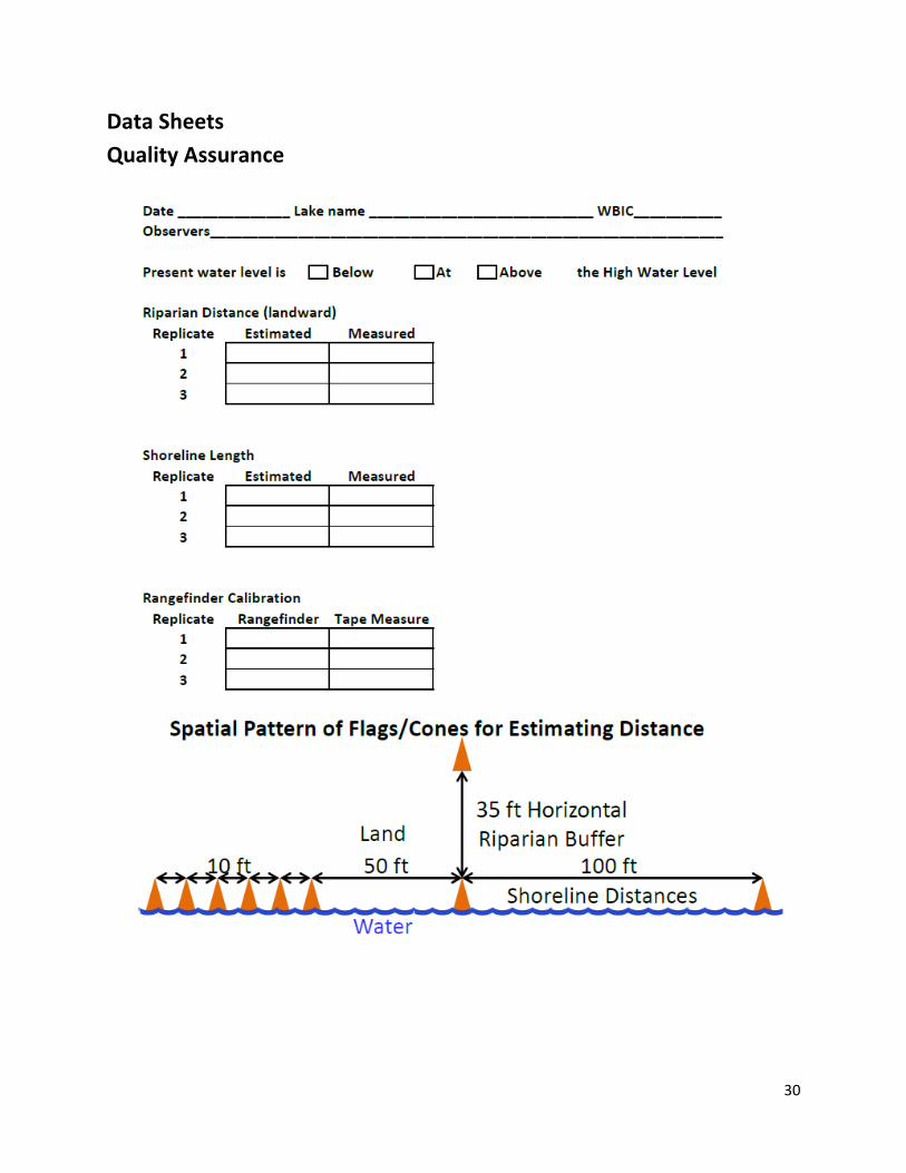
30
Data Sheets
Quality Assurance
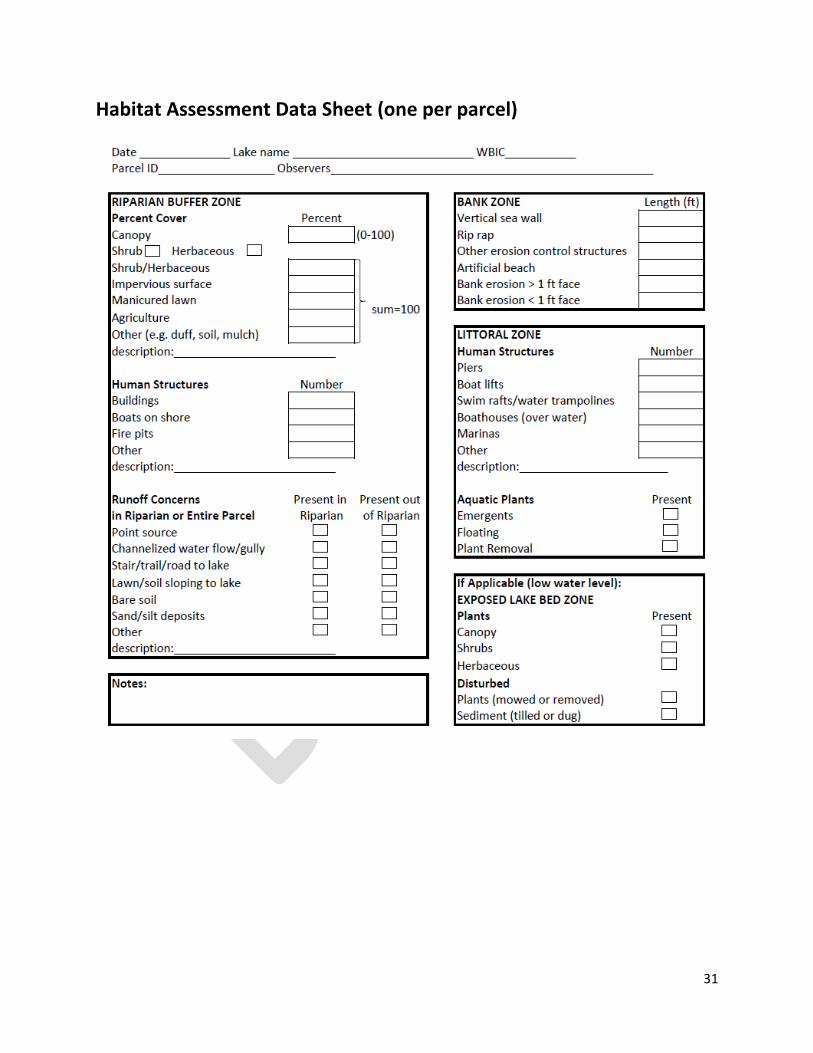
31
Habitat Assessment Data Sheet (one per parcel)
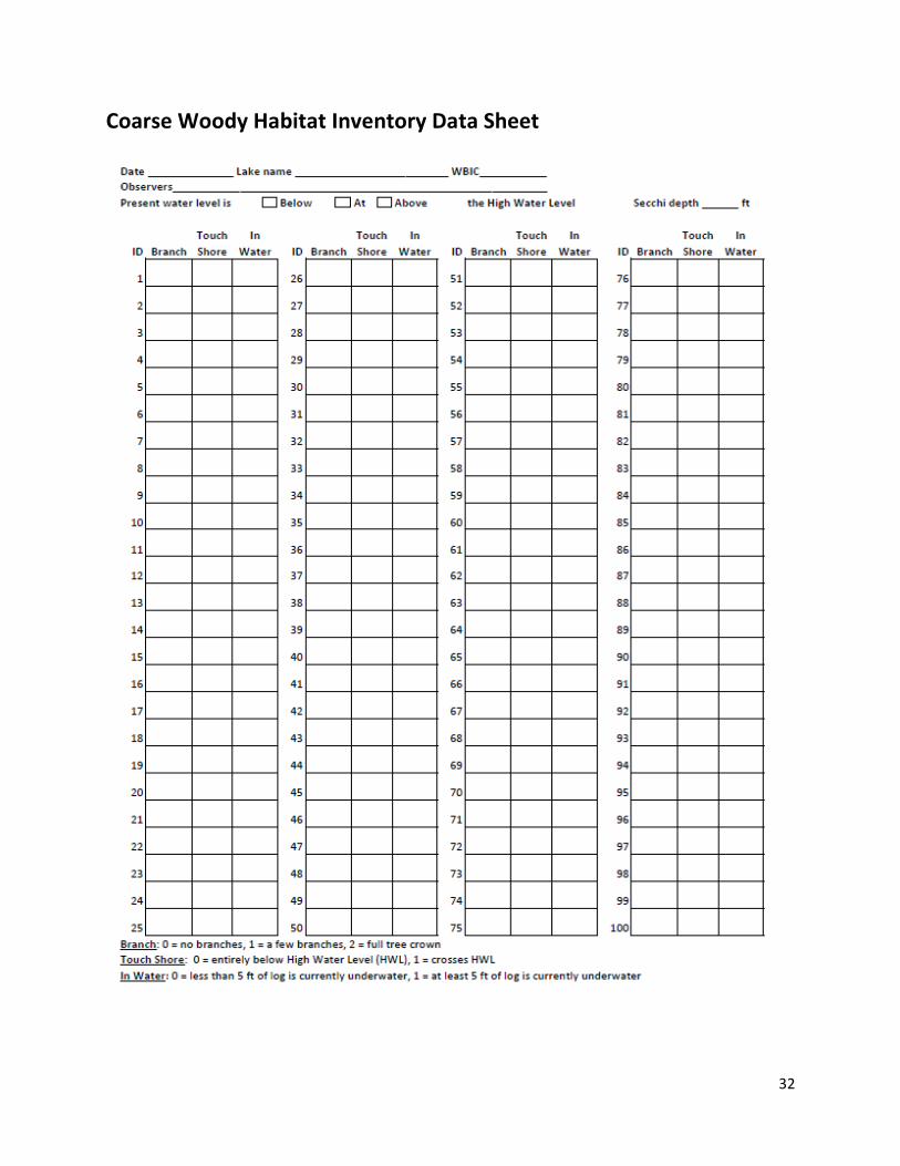
32
Coarse Woody Habitat Inventory Data Sheet
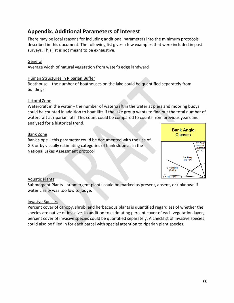
33
Appendix. Additional Parameters of Interest There may be local reasons for including additional parameters into the minimum protocols described in this document. The following list gives a few examples that were included in past surveys. This list is not meant to be exhaustive. General Average width of natural vegetation from water’s edge landward Human Structures in Riparian Buffer Boathouse – the number of boathouses on the lake could be quantified separately from buildings Littoral Zone Watercraft in the water – the number of watercraft in the water at piers and mooring buoys could be counted in addition to boat lifts if the lake group wants to find out the total number of watercraft at riparian lots. This count could be compared to counts from previous years and analyzed for a historical trend. Bank Zone Bank slope – this parameter could be documented with the use of GIS or by visually estimating categories of bank slope as in the National Lakes Assessment protocol
Aquatic Plants Submergent Plants – submergent plants could be marked as present, absent, or unknown if water clarity was too low to judge. Invasive Species Percent cover of canopy, shrub, and herbaceous plants is quantified regardless of whether the species are native or invasive. In addition to estimating percent cover of each vegetation layer, percent cover of invasive species could be quantified separately. A checklist of invasive species could also be filled in for each parcel with special attention to riparian plant species.

Appendix F Moon Lake Aquatic Plant Management Goals, Objectives, and Actions


68 | P a g e
AQUATIC PLANT MANAGE MENT GOALS, OBJECTIV ES, AND ACTIONS ( APPENDIX F) 1
Moon Lake supports an aquatic plant community with a number of high value species, but at the present time, 2 does not support any significant fishery due to recent and severe winterkills. The lake does not have any aquatic 3 invasive plant species other than reed canary grass and narrow-leaf cattails along parts of the shore. These invasive 4 species will not be directly managed as a part of this APMP. Nuisance conditions and navigation impairment caused 5 by dense native plant growth occur throughout the open water season over the entire surface water area of the lake. 6 This APMP establishes the following eight goals for aquatic plant and other management planning, monitoring, and 7 surveying; and for increasing the value of Moon Lake to the surrounding community, lake users, and property 8 owners: 9
1. Monitor and Maintain a Healthy Lake Plant Community 10
2. Manage Aquatic Plants to provide Greater Lake Use and Improve Habitat 11
3. Prevent the Introduction of new AIS 12
4. Monitor and Maintain Water Quality 13
5. Restore the Fish Community 14
6. Improve Public Recreational Access and Nature Immersion Opportunities for 15
Community Members 16
7. Evaluate and Improve Shoreland 17
8. Implement Adaptive Management. 18
Each of these goals has several management objectives and associated actions to be implemented over the next 19 five years. 20
21

69 | P a g e
GOAL 1 - MAINTAIN A HEALTHY LAKE PLANT COMMUNITY 1
It is the goal of the management actions in this plan to maintain and protect the native aquatic plant community 2 in Moon Lake, causing no decline in the following measures of a healthy, diverse, and sustainable aquatic plant 3 community: Floristic Quality Index, Simpson’s Diversity Index, and total species richness including visuals. Aquatic 4 plant management actions will be completed in ways to minimize disruptive changes in the aquatic plant community 5 in the lake. 6
OBJECTIVE 1: OVER THE COURSE OF THE NEXT FIVE YEARS (2017-21) THE FOLLOWING MEASURES OF A 7 HEALTHY NATIVE AQUATIC PLANT COMMUNITY WILL BE MAINTAINED OR EXCEEDED: 8
Table 2: Values to Measure the Health of the Native Aquatic Plant Community in Moon Lake 9
All Plants 2014
Simpson’s Diversity Index (SDI) 0.83
Floristic Quality Index (FQI) 26.73
Total Species Richness including boat survey 31
10
i. Action Item: Implement aquatic plant management actions that will minimize disruption of the native 11 aquatic plant population and wildlife habitat. 12
a. No more than one-third (1/3) of the surface area of the lake (28 acres) will be harvested in any 13 single year. 14
b. Harvesting depth in any location will not exceed two-thirds (2/3) of the depth of the water 15 column. 16
c. Harvesting will not be completed in water <3-ft deep. 17
ii. Action Item: Determine appropriate management actions annually based on management and survey 18 results from the previous year. 19
a. Representatives from the MLA and/or a resource professional retained by the MLA will use 20 prior year management results and impacts identified by aquatic plant survey actions to propose 21 current year management actions. 22
OBJECTIVE 2: MEASURE THE IMPACTS OF ANNUAL HARVESTING ON NATIVE AQUATIC PLANTS IN THE 23 LAKE. 24
i. Action Item: During actual harvesting, trained MLA volunteers or a resource professional retained by 25 the MLA will identify as many individual species as possible removed by the harvesting and estimate 26 what percent of the total harvest each species represents. 27
ii. Action Item: Approximately three weeks after harvesting, trained MLA volunteers or a resource 28 professional retained by the MLA will visually inspect the harvested area from a boat and identify the 29 species present. 30

70 | P a g e
OBJECTIVE 3: MEASURE THE FIVE YEAR IMPACT OF AQUATIC PLANT MANAGEMENT COMPLETED ON 1 MOON LAKE. 2
i. Action Item: Repeat a whole lake, point-intercept, aquatic plant survey in 2021 using the same points 3 generated for the 2014 survey. 4
ii. Action Item: Review and revise the existing APM Plan in 2012 for implementation in 2022. 5
6

71 | P a g e
GOAL 2 - MANAGE AQUATIC PLANTS TO PROVIDE GREATER LAKE USE AND IMPROVE HABITAT 1
Management of native aquatic plants to provide improved navigation, open water, and riparian access to open 2 water is necessary in Moon Lake. By doing so, the lake will be made more valuable for fish and wildlife, provide the 3 local community with an opportunity to experience and appreciate nature, and make the lake more usable for property 4 owners and others to enjoy the lake. The best alternatives for completing this goal are manual removal and 5 mechanical harvesting. 6
Using contracted mechanical harvesting to manage the aquatic plants in Moon Lake is recommended to provide 7 greater access for fishing and boating, improve fishing and fish habitat, and to reduce build-up of organic materials in 8 the lake which may in time reduce the number and severity of winter fish kills. 9
Manual or physical removal is the recommended method to control plant growth around docks and in areas where 10 the water depth is shallower than 3 feet. For aquatic plant control in small, shallow lake areas adjacent to shore, it is 11 recommended that plant removal rakes and/or razors be used by riparian property owners. As mentioned in a 12 previous section, physical removal of aquatic plants is allowable without a permit within an area up to 30-ft wide near a 13 dock or along a shoreline used for recreational activities, provided the parts of the plant cut or pulled are removed 14 completely from the water and disposed of properly. By its very nature, physical removal is often a difficult and 15 daunting task, thus minimizing how much plant material is actually removed. Native plant removal should be limited 16 only to the amount needed to access open water areas or provide navigation and access lanes. Coarse woody habitat 17 (tree falls, logs, etc.) should be left in the water as it is a critical feature of lakes influencing fish behavior, spawning, 18 predator-prey interactions, growth, and species diversity. Research has shown that the growth of largemouth bass and 19 bluegill are positively correlated with coarse woody habitat in lakes and a whole lake removal of coarse woody habitat 20 led to the collapse of a yellow perch population (Radomski and Goeman 2001). 21
OBJECTIVE 1: ESTABLISH A COMMON USE NAVIGATION CHANNEL AROUND THE PERIMETER OF THE 22 LAKE. 23
i. Action Item: Through contracted harvesting services, a common use navigation channel approximately 24 1.4 miles long and 10-ft wide may be harvested and maintained around the perimeter of the lake. 25
a. The navigation channel will not be harvested prior to June 15th annually 26
b. The navigation channel may be harvested at a depth of up to 2-ft and will not be harvested in 27 water less than 3-ft deep 28
c. The navigation channel may be harvested more than once during a season 29
OBJECTIVE 2: ESTABLISH AN OPEN WATER NAVIGATION AREA IN THE CENTER OF MOON LAKE 30
i. Action Item: Through contracted harvesting services, an open water navigation area of approximately 31 26 acres in water 5-7 feet deep may be harvested and maintained in the center of the lake. 32
a. The open water navigation area will not be harvested prior to June 15th annually. 33
b. The open water area may be harvested at a depth of up to 3.5-ft. 34
c. The open water area may be harvested more than once during a season. 35
72 | P a g e
OBJECTIVE 3: ESTABLISH RIPARIAN ACCESS LANES FROM PUBLIC ACCESS POINTS AND PROPERTY 1 OWNERS ON MOON LAKE 2
i. Action Item: Through contracted harvesting services, riparian access lanes may be harvested and 3 maintained to allow access to lake property owners and users to the navigation channel and open water. 4
a. Riparian access lanes will not be harvested prior to June 15th annually. 5
b. Riparian access lanes will not be harvested in water <3-ft deep. 6
c. Riparian access lanes may be harvested more than once during a season. 7
OBJECTIVE 4: WORK WITH THE RICE LAKE – LAKE PROTECTION AND REHABILITATION DISTRICT TO 8 PICK UP AND DISPOSE OF HARVESTED AQUATIC VEGETATION FROM MOON LAKE 9
i. Action Item: Establish a partnership where the RL-LPRD uses its equipment to pick up harvested 10 vegetation from the Moon Lake public access and dispose of it at their dumping location. 11
a. Harvested aquatic vegetation will be temporarily unloaded at the Moon Lake public access and 12 removed within 3-days by the RL-LPRD. 13
b. Harvested aquatic vegetation will be discarded by the RL-LPRD at their dump site in the Town 14 of Oakland. 15
OBJECTIVE 4: PREPARE WNDR HARVESTING PERMIT APPLICATIONS TO SUPPORT ANNUAL HARVESTING 16 OF AQUATIC VEGETATION IN MOON LAKE. 17
i. Action Item: The MLA representatives or a resource professional retained by the MLA will complete 18 WDNR Mechanical/Manual Aquatic Plant Control Application (Form 3200-113) annually based on a 19 mechanical harvesting proposal prepared in February or March. 20
OBJECTIVE 5: COMPLETE PHYSICAL REMOVAL OF AQUATIC PLANTS IN WATERS <3-FT DEEP AND 21 ADJACENT TO PRIVATE PROPERTY. 22
i. Action Item: Property owners on Moon Lake will use physical removal methods to open areas of dense 23 vegetation near docks and adjacent to their property in so much as to gain access to the harvested 24 riparian access lanes and navigation channel. 25
26

73 | P a g e
GOAL 3 – WORK TO PREVENT THE INTRODUCTION OF NEW AIS 1
AIS can be transported via a number of vectors, but most invasions are associated with human activity. One of 2 the highest risk activities is implementing contracted aquatic plant harvesting on the lake. Harvesters owned by a 3 private contractor are undoubtedly being used to harvest AIS and native aquatic vegetation in the same season. Of 4 particular concern is CLP. Mechanical harvesting of CLP is one of the most accepted forms of AIS management. 5 CLP is an early season aquatic plant so will be harvested before any harvesting of natives plants is completed. CLP 6 fragments and turions (Figure 24) can easily become lodged in the many nooks and crannies of a harvester. It is less 7 likely that EWM will be carried in by contracted harvesting services since harvesting of EWM is not a readily 8 acceptable management action for control of EWM, but it is possible. It is recommended that the harvester brought 9 in by a contractor be inspected for prior harvesting remains by trained MLA volunteers and/or a resource 10 professional retained by the MLA before being launched into the lake 11
It is recommended that the MLA implement an AIS monitoring program. At least three times during the open 12 water season, trained volunteers should patrol the lake and shoreline looking for CLP, EWM, purple loosestrife, 13 Japanese knotweed, giant reed grass, zebra mussels, and other invasive species. Free support for this kind of 14 monitoring program is provided as a part of the UW-Extension Lakes/WDNR Citizen Lake Monitoring Network 15 (CLMN) AIS Monitoring Program. Any monitoring data collected should be recorded annually and submitted to the 16 WDNR SWIMS database. 17
It is further recommended that monitoring of the boat launch on Moon Lake be completed by volunteer and/or 18 paid inspectors following WDNR/UW-Extension Clean Boats, Clean Waters guidelines. All watercraft inspection 19 data collected should be submitted to the WDNR SWIMS database. It is recommended that the MLA participate in 20 the June Drain Campaign and Fourth of July Landing Blitz, two state-wide outreach efforts to remind boaters to 21 drain all water from their boats, livewells, and motors; and to highlight the dangers of transporting invasive species 22 that takes place on the Fourth of July, a high-boat traffic day. It is also recommended that the MLA continue to 23 maintain and update signage at the boat launch as necessary. 24
It is also recommended that all property owners be encouraged to learn about AIS and monitor their shoreline 25 and open water areas for new AIS. Table 3 shows the life stage of some invasive plant and animal species and the 26 best times of the open water season to monitor for them (Scholl 2006). If a suspect AIS is found, or even suspected, 27 it should be reported to the MLA, County, and WDNR resource personnel. 28
Table 3: AIS Monitoring Timetable (Scholl 2006) 29
30

74 | P a g e
OBJECTIVE 1 – REDUCE THE CHANCE THAT A NEW AIS IS INTRODUCED INTO MOON LAKE BY AQUATIC 1 PLANT HARVESTING ACTIVITIES. 2
i. Action Item: Inspect all harvesting equipment brought to the lake by a contractor prior to it being 3 launched into the lake. 4
a. Ask the contractor for a list of the lakes and aquatic plants harvested in the same year as MLA 5 contracts. 6
b. Ask and confirm the contractor’s harvester cleaning and disinfection protocol between jobs. 7
c. Ask for a signed document from the contractor that the harvesting equipment has been cleaned 8 and inspected prior to completing the job. 9
OBJECTIVE 2 - REDUCE THE LIKELIHOOD THAT NEW AIS GOES UNDETECTED IN MOON LAKE. 10
i. Action Item: Participate in and complete AIS monitoring actions through the Citizen Lake Monitoring 11 Network (CLMN) AIS Monitoring Program. 12
a. MLA volunteers or a resource professional retained by the MLA will complete AIS monitoring 13 of the lake and shoreline at least three times each open water season following CLMN AIS 14 Monitoring Guidelines. 15
b. AIS monitoring data will be entered into the WDNR SWIMS database annually. 16
OBJECTIVE 3 - IMPLEMENT A CLEAN BOATS CLEAN WATERS (CBCW) WATER CRAFT INSPECTION 17 PROGRAM ANNUALLY. 18
i. Action Item: Determine an appropriate amount of watercraft inspection time at the Moon Lake public 19 access to prevent introduction of AIS through transient boaters. 20
a. Participate in the WDNR June Drain Campaign and 4th of July landing Blitz annually. 21
b. Install updated AIS education signs at the Moon Lake public access and at the Walk-in Access 22 from Moon Lake Park. 23
OBJECTIVE 4 – EDUCATE AND INFORM PROPERTY OWNERS AND LAKE USERS ABOUT AIS AND HOW TO 24 IDENTIFY THEM 25
i. Action Item: Seek out AIS education events sponsored by other entities and/or sponsor AIS education 26 events and then encourage property owners on Moon Lake to attend. 27
ii. Action Item: Research AIS and lake stewardship materials with little or no cost to attain and distribute 28 to property owners at events including but not limited to Annual Meetings, Lake Fairs, Summer Picnic, 29 etc. 30
iii. Action Item: Report findings of suspect AIS to the MLA, Barron County, WDNR, and other Resource 31 entities. 32
33

75 | P a g e
GOAL 4 - MONITOR AND MAINTAIN WATER QUALITY 1
At the present time, Moon Lake is a plant dominated and fairly fertile body of water. The level of phosphorus in 2 the lake is bordering on eutrophic or nutrient rich. Chlorophyll a, which is a measurement of the amount of algae in 3 the water, is at present pretty low indicating that abundant aquatic plant growth, stimulated by clear water is using up 4 a majority of the available phosphorus before it can be used by algae. By removing a substantial amount of aquatic 5 vegetation, there is a risk that the harvesting could trigger a forward switch causing the lake to shift from plant 6 dominance and clear water to algae dominance and green water. This is not an acceptable outcome for this project, 7 so extensive water quality monitoring is necessary to track changes in water quality before they become irreversible. 8 In addition, it is expected that aquatic plant harvesting and other actions implemented through this APMP will 9 maintain or improve adequate dissolved oxygen (DO) levels in the lake throughout the year, but particularly under 10 the ice. Winter monitoring of nutrients and oxygen is highly recommended if any management is to occur. 11
OBJECTIVE 1 – MONITORING WATER CLARITY AND NUTRIENT LEVELS (TOTAL PHOSPHORUS & 12 CHLOROPHYLL A) IN MOON LAKE ANNUALLY 13
i. Action Item: Continue involvement in the WDNR/UWEX-Lakes CLMN Water Quality Monitoring 14 Program at the Center location in Moon Lake. 15
a. Collect Secchi Disk readings of water clarity and temperature at least monthly May through 16 October. 17
b. Make a request to the CLMN Program to move Moon Lake into the Expanded Monitoring 18 program which collects monthly total phosphorus samples from May to August; and monthly 19 chlorophyll a samples from June to August. 20
OBJECTIVE 2 – COLLECT DISSOLVED OXYGEN AND TEMPERATURE PROFILES MONTHLY THROUGH THE 21 ENTIRE YEAR 22
i. Action Item: Either through the CLMN Program or another program, DO profiles should be collected 23 at least monthly through the entire year (Jan.-Dec.) 24
ii. Action Item: When resources are available, increase total phosphorus and chlorophyll a sampling to 25 include September and October. 26
27

76 | P a g e
GOAL 5 - RESTORE THE FISH COMMUNITY 1
Despite having an aeration system operating in the lake, a severe winterkill over the 2013-14 winter season nearly 2 wiped out the entire fish population in Moon Lake. To date, the fish population in Moon Lake has not recovered. It 3 is thought that the winterkill was caused by super cooling of the lake water in the winter. Super cooling occurs when 4 warm bottom water in a shallow lake is mixed too rapidly with colder surface water just under the ice, creating undue 5 stress on the existing fish population. The super cooling in Moon Lake may have been caused by the surface 6 aspirating aeration system that was operated in the lake. Along with low oxygen levels to begin with, this undue stress 7 weakened and killed the fish. There may be ways to maintain or improve oxygen levels under the ice that would 8 reduce the potential for super cooling and/or low DO. Heavy snow cover that lasts well into the spring limits 9 production of DO by aquatic plant alive under the ice. Plowing snow-free lanes on the surface of the ice can increase 10 the amount of sunlight that gets to the plants under the ice. Lots of ice fishing holes can be drilled in the ice to 11 increase the transfer of oxygen in the air to the water. Removal of aquatic plants can reduce the amount of vegetation 12 that dies and decays under the ice using up available DO. 13
Aeration can again be installed, but a different system which may reduce the likelihood of super cooling could be 14 used. A compressed air system is often installed in shallow lakes and operated continuously, year round. By operating 15 the aerator in the late summer and fall, it may be possible to increase DO levels in the water before it freezes over. 16 By installing the aerator in shallow water, and only operating it when it is shown that DO levels are falling, it may be 17 possible to reduce the chance of super cooling. 18
Once aquatic plant harvesting has been implemented and aeration re-installed, re-stocking Moon Lake to restore 19 its former warm water fishery of bass, panfish, and northern pike can be completed. Restoring the fish population in 20 the lake will increase the recreational value of the lake for property owners, community members and other lake 21 users. 22
OBJECTIVE 1 – IMPLEMENT MANAGEMENT ACTIONS THAT MAY MAINTAIN OR IMPROVE DISSOLVED 23 OXYGEN LEVELS IN THE LAKE THROUGHOUT THE SEASON 24
i. Action Item: Implement aquatic plant harvesting actions in Goal 2 25
ii. Action Item: Plow snow-free lanes across the frozen surface of Moon Lake 26
a. Work with property owners on Moon Lake to identify a volunteer or a contractor who could 27 plow snow-free lanes on the ice once it is strong enough to drive on 28
iii. Action Item: Drill lots of holes through the ice when DO levels start to fall under the ice 29
a. When DO monitoring under the ice shows DO levels starting to drop, encourage property 30 owners and lake users to drill as many ice fishing holes as they can until ice conditions prevent 31 access. 32
OBJECTIVE 2 – RE-INSTALL AN AERATION SYSTEM IN MOON LAKE 33
i. Action Item: Work with the WDNR and City to determine logistics for re-installation of an aeration 34 system. 35
a. Determine the type and location of aeration to install, surface aspirating vs. compressed air 36
b. Determine support from the City and WDNR grant programs (Recreational Boating Facilities 37 and/or Sport Fish Restoration) for making improvements to Moon Lake Park that would 38 support an aeration system. 39

77 | P a g e
ii. Action Item: Install, operate, and maintain an Aeration System in Moon Lake 1
OBJECTIVE 3 – RE-STOCK MOON LAKE WITH FISH 2
i. Action Item: Work with the WDNR to determine an appropriate time to begin re-stocking fish into 3 Moon Lake 4
a. Discuss plans to complete aquatic plant harvesting and actions to improve DO including snow-5 free lanes, ice holes, and installation of an aeration system with the WDNR and how they 6 impact the decision to re-stock the lake. 7
ii. Action Item: Discuss options for re-stocking the lake with the WDNR including species, size, and 8 number to re-stock. 9
10

78 | P a g e
GOAL 6 - IMPROVE PUBLIC RECREATIONAL ACCESS AND NATURE IMMERSION OPPORUNITIES FOR 1 COMMUNITY MEMBERS 2
In its Outdoor Recreation Plan, the City’s lists several goals that improving the conditions in Moon Lake and 3 improving community access to the lake would help meet. The following four goals are on page 8 of the 2014-2019 4 Comprehensive Outdoor Recreation Plan: 5
To enhance the quality of life and encourage healthy lifestyles while reconnecting people, especially children, 6 to the outdoors through our parks and open spaces, natural areas, trails, and outdoor recreation programs. 7
To develop a stewardship ethic, protect our natural environment for sustainable conservation for our 8 community and generations to come. 9
To ensure all people the access to a safe, affordable and healthy way to experience and appreciate nature 10 while improving social and economic value to the City. 11
Provide a mix of affordable, quality outdoor recreation facilities, programs, and amenities at various scales 12 and development intensities which meet the needs of residents while taking advantage of tourism 13 opportunities. 14
15 Along with these four goals, the Outdoor Recreation Plan also lists the following objectives on page 9-10: 16
To provide a safe environment for play and physical activity and areas for active and passive recreation 17 opportunities that meet the needs of all age groups, cultures, and ethnicity within the community. 18
To improve and revitalize our parks as gathering places for our youth, families and adults to play, exercise, 19 relax, enjoy time with family and friends, and experience the natural environment. 20
To provide space for social interaction, health and wellness, and cultural diversity. 21
To obtain, when opportunities are feasible, sites for open green space, playgrounds, parks, trails, etc. 22
To provide opportunities for rural residents to enjoy the community's parks, natural resources, and 23 recreation areas. 24
To establish priorities for needed outdoor recreation facilities based on prominent outdoor recreation trends, 25 as well as existing recreational land distribution and existing and/or future deficiencies. 26
To raise awareness to help preserve and protect our natural resources within our parks and adjacent to, along 27 with the promotion of good conservation and stewardship practices. 28
To coordinate the community’s recreation program with other agencies, organizations, schools, other levels 29 of government and private enterprise to ensure maximum public benefit. 30
To ensure that all people have access and adequate parking to our water amenities and public recreation 31 areas. 32
To protect scenic values by managing billboards, signs, junkyards and other unsightly land uses and 33 practices. 34
To make improvements and modifications to accommodate Adaptive/ADA compliant facilities, play 35 structures and accessibility that meet the needs of the physically challenged including the elderly and disabled 36 that meet the American Disabilities Act standards. 37
To provide for the periodic review and updating of the city outdoor recreation plan so that it will reflect the 38 changing needs and trends of the community. 39
To provide for annual planning, programming and maintenance of park and recreation facilities throughout 40 the community with funding from the Capital Improvements Program (CIP), general obligation borrowing 41 and other funding sources private or public. 42
To create and promote alternative means of transportation within the City by the establishment of trails and 43 sidewalk connections for recreational and multimodal transportations activities. 44
45 Nearly all of the goals and objectives listed in the City Comprehensive Outdoor Recreation Plan can be 46
addressed at some level with the management actions and activities recommended in this APMP. Moon Lake is a 47
79 | P a g e
valuable natural resource within the city limits that is being under-utilized at the present time, due in part to the poor 1 condition of the lake. One of the property owners on Moon Lake is a well-respected and popular (with students) 2 Rice Lake High School biology teacher who encourages students to get involved in natural resource activities in the 3 community and surrounding area. 4
This APMP recommends that the MLA work with the City, Rice Lake High School, and other community 5 partners to determine how what is done in Moon lake can improve its value in the community. Through the efforts 6 of the MLA; support from WDNR grants and City outdoor recreation programs; and partnerships with the City, Rice 7 Lake High School, Rice Lake – Lake Protection and Rehabilitation District, and other community organizations 8 Moon Lake can be utilized as the valuable resource that it should be. 9
OBJECTIVE 1 – WORK WITH THE CITY OF RICE LAKE AND OTHER ENTITIES TO IMPROVE PUBLIC ACCESS 10 TO MOON LAKE AT THE SOUTH END OF MOON LAKE PARK 11
i. Action Item: Improve walk-in access and launching facilities for kayakers and users of other small craft; 12 wildlife enthusiasts; and small group learning opportunities off the south end of the Park. 13
ii. Action Item: Install a public fishing dock off the south end of the Park. 14
iii. Action Item: Build a bathroom/shelter/aeration storage shed at the south end of the Park 15
iv. Action Item: Build a road to, and a small parking area at the south end of the Park. Bring electricity to 16 the south end of the Park. 17
OBJECTIVE 2 – WORK WITH RICE LAKE AREA SCHOOLS TO FIGURE OUT HOW MOON LAKE AND MOON 18 LAKE PARK CAN BE BETTER UTILIZED AS A NATURAL RESOURCE LEARNING TOOL 19
i. Action Item: Discuss how Moon Lake and Moon Lake Park can be improved to provide outdoor 20 education opportunities for students and teachers. 21
OBJECTIVE 3 – EXPLORE FUNDING PROGRAMS THAT MIGHT BE USED TO SUPPORT IMPROVED LAKE 22 ACCESS FOR RECREATIONAL ACTIVITIES, OUTDOOR LEARNING ACTIVITIES, AND HABITAT 23 IMPROVEMENTS 24
i. Action Item: Evaluate how and if certain WDNR grant programs including the Recreational Boating 25 Facilities and Sport Fish Restoration can be used to increase the community value of Moon Lake. 26
ii. Action Item: Work with the City and Rice Lake – Lake Protection and Rehabilitation District funding 27 opportunities could be used to increase the community value of Moon Lake. 28
29
80 | P a g e
GOAL 7 - EVALUATE AND IMPROVE THE SHORELAND AROUND MOON LAKE 1
Once harvesting of aquatic plants in Moon Lake is started, there is a risk of causing the lake to go from plant 2 dominated clear water to algae dominated green water. Removal of aquatic plant may make more nutrients in the lake 3 available to grow algae. Reducing the amount of nutrients entering Moon Lake from its rather small watershed may 4 lessen the chance the lake switches over. One inexpensive way to reduce nutrients entering the lake is to make 5 shoreland improvements around the lake. There are many shoreland best management practices (BMPs) including 6 establishing buffer strips through no mowing, native plantings, shoreland restoration, installation of rain gardens, and 7 diversion of surface water runoff away from the lake that will reduce nutrient loading over time. 8
To maintain the quality and diversity of the Moon Lake, it is recommended that the MLA provide riparian 9 owners with educational materials on shoreland improvement and/or sponsor/promote shoreland improvement 10 training events. Not knowing where to begin with a shoreland restoration is often the main hurdle preventing 11 property owners from implementing a practice that would help improve the lake. General information on shoreland 12 restoration could be provided to all property owners in a newsletter and/or during public events. There are many 13 free, down-loadable on-line resources, and both free and low cost paper resources including guides, pamphlets, and 14 brochures available to help the average person work toward making improvements on their own properties. UW-15 Extension has offices in nearly every county in Wisconsin and offers these materials for free or at very low prices. 16 They also sponsor local workshops and/or training sessions, or can direct people to others who do. Local 17 greenhouses and landscaping companies often have shoreland restoration packages for specific project types 18 available to the public. 19
The WDNR has a new Lake Shoreland and Shallows Habitat Monitoring Field Protocol that involves the 20 evaluation of a 35-ft buffer area around the entire lake, documents shoreland condition through digital photography, 21 and documents coarse woody debris in a lake. Additional information about the condition of the shoreland around 22 Moon Lake would benefit future shoreland improvement planning and implementation through the WDNR Healthy 23 Lakes Initiative and BMP grant program. The RL-LPRD also has a shoreland improvement program. Both programs 24 offer funding support to install shoreland BMPs. It is recommended that a shoreland survey be completed on Moon 25 Lake following the new WDNR protocol during the time frame covered by this APMP. 26
OBJECTIVE 1: REDUCE THE AMOUNT OF SHORELAND WITHOUT A NATURAL BUFFER IN PLACE BY 27 THROUGH SHORELAND RESTORATION AND OTHER BEST MANAGEMENT PRACTICES. 28
i. Action Item: Complete a shoreland inventory of all developed properties to determine the amount of 29 shoreland that is not in a natural state. 30
ii. Action Item: Distribute shoreland improvement education and information materials to lake property 31 owners through the newsletter, webpage, and general mailings. 32
iii. Action Item: Host and/or sponsor lake events that encourage land owner participation in best 33 management practices. 34
iv. Action Item: Support property owners who wish to complete shoreland or habitat improvement 35 projects through the WDNR Healthy Lakes and RL-LPRD programs. 36
v. Action Item: Recognize property owners who participate in and/or complete shoreland restoration and 37 habitat improvement projects in the newsletter, on the webpage, in local news publications, and/or at 38 the site of the project. 39
40
81 | P a g e
GOAL 8 - ADAPTIVE MANAGEMENT 1
This APMP is a working document guiding management actions on Moon Lake over the next five years. This 2 plan will follow an adaptive management approach by evaluating results and adjusting actions on the basis of what 3 has been learned. This plan is therefore a living document, successively evolving and improving to meet 4 environmental, social, and economic goals, to increase scientific knowledge, and to reduce tensions among 5 stakeholders. If WDNR grant funds are used to support implementation of this APMP, the MLA and their retainers 6 will compile, analyze, and summarize management operations, public education efforts, and other pertinent data into 7 an annual report each year. The information will be presented to members of the MLA, the WDNR, and others 8 upon request. 9
OBJECTIVE 1 – IMPLEMENT AS MANY OF THE RECOMMENDATIONS IN THIS APMP AS POSSIBLE OVER THE 10 NEXT FIVE YEARS WITH THE RESOURCES AVAILABLE TO THE MLA 11
i. Action Item: Utilize the Implementation and Funding Matrix included with this APMP (Appendix G) 12 to prioritize and determine the timing for implementation of specific recommendations included in this 13 plan. 14
15

Appendix G
Moon Lake Implementation and Funding Matrix

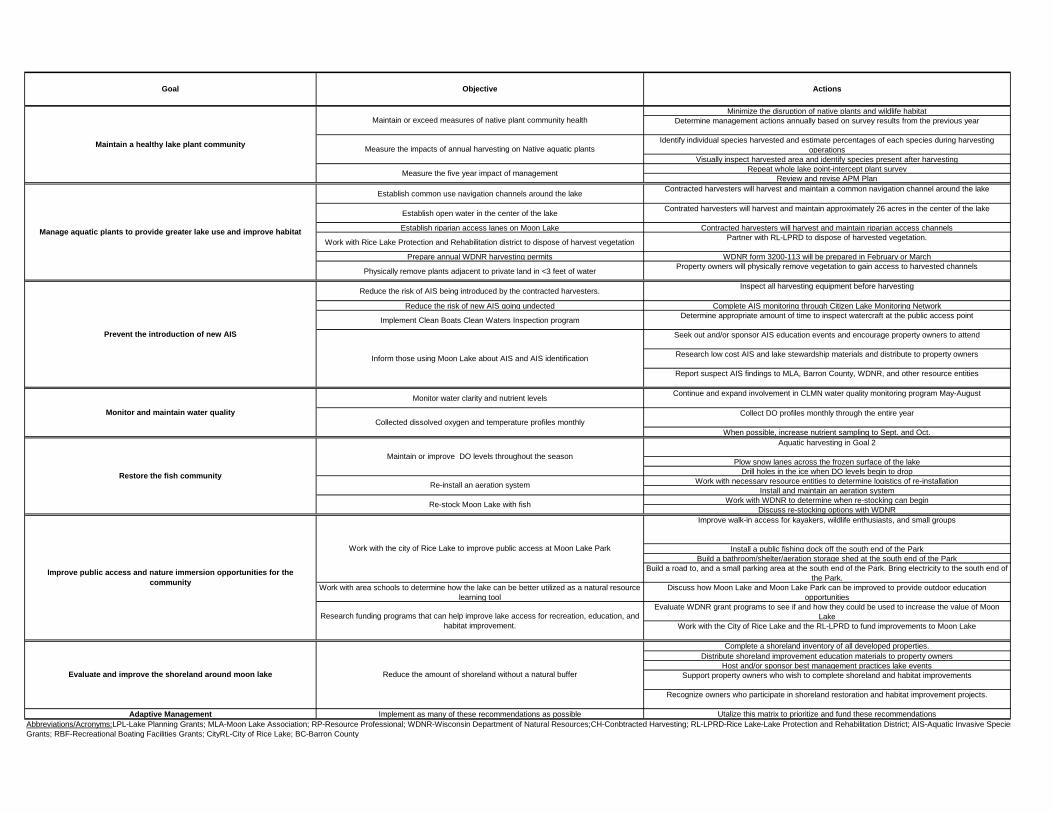
Minimize the disruption of native plants and wildlife habitat
Determine management actions annually based on survey results from the previous year
Identify individual species harvested and estimate percentages of each species during harvesting
operations
Visually inspect harvested area and identify species present after harvesting
Repeat whole lake point-intercept plant survey
Review and revise APM Plan
Establish common use navigation channels around the lake Contracted harvesters will harvest and maintain a common navigation channel around the lake
Establish open water in the center of the lakeContrated harvesters will harvest and maintain approximately 26 acres in the center of the lake
Establish riparian access lanes on Moon Lake Contracted harvesters will harvest and maintain riparian access channels
Work with Rice Lake Protection and Rehabilitation district to dispose of harvest vegetationPartner with RL-LPRD to dispose of harvested vegetation.
Prepare annual WDNR harvesting permits WDNR form 3200-113 will be prepared in February or March
Physically remove plants adjacent to private land in <3 feet of waterProperty owners will physically remove vegetation to gain access to harvested channels
Reduce the risk of AIS being introduced by the contracted harvesters.Inspect all harvesting equipment before harvesting
Reduce the risk of new AIS going undected Complete AIS monitoring through Citizen Lake Monitoring Network
Implement Clean Boats Clean Waters Inspection programDetermine appropriate amount of time to inspect watercraft at the public access point
Seek out and/or sponsor AIS education events and encourage property owners to attend
Research low cost AIS and lake stewardship materials and distribute to property owners
Report suspect AIS findings to MLA, Barron County, WDNR, and other resource entities
Monitor water clarity and nutrient levelsContinue and expand involvement in CLMN water quality monitoring program May-August
Collect DO profiles monthly through the entire year
When possible, increase nutrient sampling to Sept. and Oct.
Aquatic harvesting in Goal 2
Plow snow lanes across the frozen surface of the lake
Drill holes in the ice when DO levels begin to drop
Work with necessary resource entities to determine logistics of re-installation
Install and maintain an aeration system
Work with WDNR to determine when re-stocking can begin
Discuss re-stocking options with WDNR
Improve walk-in access for kayakers, wildlife enthusiasts, and small groups
Install a public fishing dock off the south end of the Park
Build a bathroom/shelter/aeration storage shed at the south end of the Park
Build a road to, and a small parking area at the south end of the Park. Bring electricity to the south end of
the Park.
Work with area schools to determine how the lake can be better utilized as a natural resource
learning tool
Discuss how Moon Lake and Moon Lake Park can be improved to provide outdoor education
opportunities
Evaluate WDNR grant programs to see if and how they could be used to increase the value of Moon
Lake
Work with the City of Rice Lake and the RL-LPRD to fund improvements to Moon Lake
Complete a shoreland inventory of all developed properties.
Distribute shoreland improvement education materials to property owners
Host and/or sponsor best management practices lake events
Support property owners who wish to complete shoreland and habitat improvements
Recognize owners who participate in shoreland restoration and habitat improvement projects.
Adaptive Management Implement as many of these recommendations as possible Utalize this matrix to prioritize and fund these recommendations
Prevent the introduction of new AIS
Monitor and maintain water quality
Restore the fish community
Objective ActionsGoal
Improve public access and nature immersion opportunities for the
community
Evaluate and improve the shoreland around moon lake
Abbreviations/Acronyms:LPL-Lake Planning Grants; MLA-Moon Lake Association; RP-Resource Professional; WDNR-Wisconsin Department of Natural Resources;CH-Conbtracted Harvesting; RL-LPRD-Rice Lake-Lake Protection and Rehabilitation District; AIS-Aquatic Invasive Species Grants; CBCW-Clean Boats, Clean Waters; CLMN-Citizen Lake Monitoring Network; SFR-Sportfish Restoration
Grants; RBF-Recreational Boating Facilities Grants; CityRL-City of Rice Lake; BC-Barron County
Maintain or exceed measures of native plant community health
Measure the impacts of annual harvesting on Native aquatic plants
Measure the five year impact of management
Inform those using Moon Lake about AIS and AIS identification
Collected dissolved oxygen and temperature profiles monthly
Maintain or improve DO levels throughout the season
Re-install an aeration system
Re-stock Moon Lake with fish
Work with the city of Rice Lake to improve public access at Moon Lake Park
Research funding programs that can help improve lake access for recreation, education, and
habitat improvement.
Reduce the amount of shoreland without a natural buffer
Maintain a healthy lake plant community
Manage aquatic plants to provide greater lake use and improve habitat
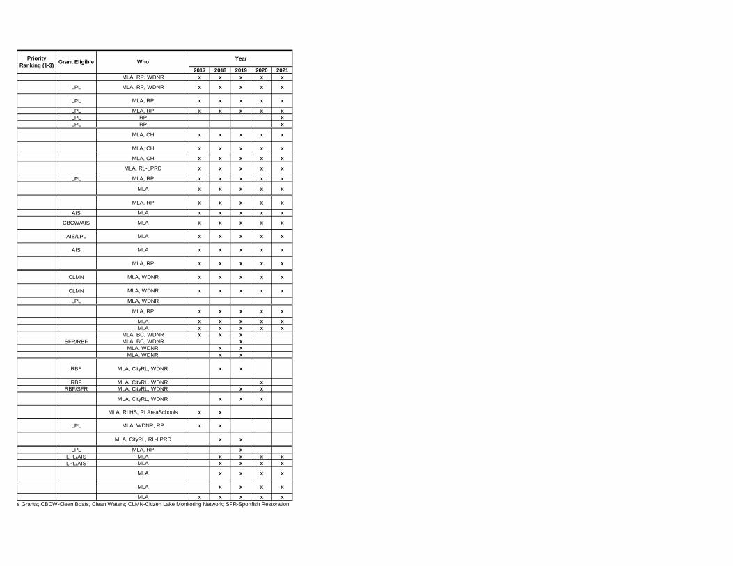
Year
2017 2018 2019 2020 2021
MLA, RP, WDNR x x x x x
LPL MLA, RP, WDNR x x x x x
LPL MLA, RP x x x x x
LPL MLA, RP x x x x x
LPL RP x
LPL RP x
MLA, CH x x x x x
MLA, CH x x x x x
MLA, CH x x x x x
MLA, RL-LPRD x x x x x
LPL MLA, RP x x x x x
MLA x x x x x
MLA, RP x x x x x
AIS MLA x x x x x
CBCW/AIS MLA x x x x x
AIS/LPL MLA x x x x x
AIS MLA x x x x x
MLA, RP x x x x x
CLMN MLA, WDNR x x x x x
CLMN MLA, WDNR x x x x x
LPL MLA, WDNR
MLA, RP x x x x x
MLA x x x x x
MLA x x x x x
MLA, BC, WDNR x x x
SFR/RBF MLA, BC, WDNR x
MLA, WDNR x x
MLA, WDNR x x
RBF MLA, CityRL, WDNR x x
RBF MLA, CityRL, WDNR x
RBF/SFR MLA, CityRL, WDNR x x
MLA, CityRL, WDNR x x x
MLA, RLHS, RLAreaSchools x x
LPL MLA, WDNR, RP x x
MLA, CityRL, RL-LPRD x x
LPL MLA, RP x
LPL/AIS MLA x x x x
LPL/AIS MLA x x x x
MLA x x x x
MLA x x x x
MLA x x x x x
Grant Eligible WhoPriority
Ranking (1-3)
Abbreviations/Acronyms:LPL-Lake Planning Grants; MLA-Moon Lake Association; RP-Resource Professional; WDNR-Wisconsin Department of Natural Resources;CH-Conbtracted Harvesting; RL-LPRD-Rice Lake-Lake Protection and Rehabilitation District; AIS-Aquatic Invasive Species Grants; CBCW-Clean Boats, Clean Waters; CLMN-Citizen Lake Monitoring Network; SFR-Sportfish Restoration
Grants; RBF-Recreational Boating Facilities Grants; CityRL-City of Rice Lake; BC-Barron County

68 | P a g e
AQUATIC PLANT MANAGE MENT GOALS, OBJECTIV ES, AND ACTIONS ( APPENDIX F) 1
Moon Lake supports an aquatic plant community with a number of high value species, but at the present time, 2 does not support any significant fishery due to recent and severe winterkills. The lake does not have any aquatic 3 invasive plant species other than reed canary grass and narrow-leaf cattails along parts of the shore. These invasive 4 species will not be directly managed as a part of this APMP. Nuisance conditions and navigation impairment caused 5 by dense native plant growth occur throughout the open water season over the entire surface water area of the lake. 6 This APMP establishes the following eight goals for aquatic plant and other management planning, monitoring, and 7 surveying; and for increasing the value of Moon Lake to the surrounding community, lake users, and property 8 owners: 9
1. Monitor and Maintain a Healthy Lake Plant Community 10
2. Manage Aquatic Plants to provide Greater Lake Use and Improve Habitat 11
3. Prevent the Introduction of new AIS 12
4. Monitor and Maintain Water Quality 13
5. Restore the Fish Community 14
6. Improve Public Recreational Access and Nature Immersion Opportunities for 15
Community Members 16
7. Evaluate and Improve Shoreland 17
8. Implement Adaptive Management. 18
Each of these goals has several management objectives and associated actions to be implemented over the next 19 five years. 20
21
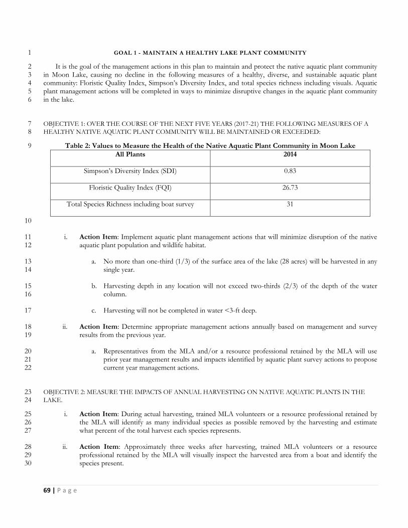
69 | P a g e
GOAL 1 - MAINTAIN A HEALTHY LAKE PLANT COMMUNITY 1
It is the goal of the management actions in this plan to maintain and protect the native aquatic plant community 2 in Moon Lake, causing no decline in the following measures of a healthy, diverse, and sustainable aquatic plant 3 community: Floristic Quality Index, Simpson’s Diversity Index, and total species richness including visuals. Aquatic 4 plant management actions will be completed in ways to minimize disruptive changes in the aquatic plant community 5 in the lake. 6
OBJECTIVE 1: OVER THE COURSE OF THE NEXT FIVE YEARS (2017-21) THE FOLLOWING MEASURES OF A 7 HEALTHY NATIVE AQUATIC PLANT COMMUNITY WILL BE MAINTAINED OR EXCEEDED: 8
Table 2: Values to Measure the Health of the Native Aquatic Plant Community in Moon Lake 9
All Plants 2014
Simpson’s Diversity Index (SDI) 0.83
Floristic Quality Index (FQI) 26.73
Total Species Richness including boat survey 31
10
i. Action Item: Implement aquatic plant management actions that will minimize disruption of the native 11 aquatic plant population and wildlife habitat. 12
a. No more than one-third (1/3) of the surface area of the lake (28 acres) will be harvested in any 13 single year. 14
b. Harvesting depth in any location will not exceed two-thirds (2/3) of the depth of the water 15 column. 16
c. Harvesting will not be completed in water <3-ft deep. 17
ii. Action Item: Determine appropriate management actions annually based on management and survey 18 results from the previous year. 19
a. Representatives from the MLA and/or a resource professional retained by the MLA will use 20 prior year management results and impacts identified by aquatic plant survey actions to propose 21 current year management actions. 22
OBJECTIVE 2: MEASURE THE IMPACTS OF ANNUAL HARVESTING ON NATIVE AQUATIC PLANTS IN THE 23 LAKE. 24
i. Action Item: During actual harvesting, trained MLA volunteers or a resource professional retained by 25 the MLA will identify as many individual species as possible removed by the harvesting and estimate 26 what percent of the total harvest each species represents. 27
ii. Action Item: Approximately three weeks after harvesting, trained MLA volunteers or a resource 28 professional retained by the MLA will visually inspect the harvested area from a boat and identify the 29 species present. 30

70 | P a g e
OBJECTIVE 3: MEASURE THE FIVE YEAR IMPACT OF AQUATIC PLANT MANAGEMENT COMPLETED ON 1 MOON LAKE. 2
i. Action Item: Repeat a whole lake, point-intercept, aquatic plant survey in 2021 using the same points 3 generated for the 2014 survey. 4
ii. Action Item: Review and revise the existing APM Plan in 2012 for implementation in 2022. 5
6

71 | P a g e
GOAL 2 - MANAGE AQUATIC PLANTS TO PROVIDE GREATER LAKE USE AND IMPROVE HABITAT 1
Management of native aquatic plants to provide improved navigation, open water, and riparian access to open 2 water is necessary in Moon Lake. By doing so, the lake will be made more valuable for fish and wildlife, provide the 3 local community with an opportunity to experience and appreciate nature, and make the lake more usable for property 4 owners and others to enjoy the lake. The best alternatives for completing this goal are manual removal and 5 mechanical harvesting. 6
Using contracted mechanical harvesting to manage the aquatic plants in Moon Lake is recommended to provide 7 greater access for fishing and boating, improve fishing and fish habitat, and to reduce build-up of organic materials in 8 the lake which may in time reduce the number and severity of winter fish kills. 9
Manual or physical removal is the recommended method to control plant growth around docks and in areas where 10 the water depth is shallower than 3 feet. For aquatic plant control in small, shallow lake areas adjacent to shore, it is 11 recommended that plant removal rakes and/or razors be used by riparian property owners. As mentioned in a 12 previous section, physical removal of aquatic plants is allowable without a permit within an area up to 30-ft wide near a 13 dock or along a shoreline used for recreational activities, provided the parts of the plant cut or pulled are removed 14 completely from the water and disposed of properly. By its very nature, physical removal is often a difficult and 15 daunting task, thus minimizing how much plant material is actually removed. Native plant removal should be limited 16 only to the amount needed to access open water areas or provide navigation and access lanes. Coarse woody habitat 17 (tree falls, logs, etc.) should be left in the water as it is a critical feature of lakes influencing fish behavior, spawning, 18 predator-prey interactions, growth, and species diversity. Research has shown that the growth of largemouth bass and 19 bluegill are positively correlated with coarse woody habitat in lakes and a whole lake removal of coarse woody habitat 20 led to the collapse of a yellow perch population (Radomski and Goeman 2001). 21
OBJECTIVE 1: ESTABLISH A COMMON USE NAVIGATION CHANNEL AROUND THE PERIMETER OF THE 22 LAKE. 23
i. Action Item: Through contracted harvesting services, a common use navigation channel approximately 24 1.4 miles long and 10-ft wide may be harvested and maintained around the perimeter of the lake. 25
a. The navigation channel will not be harvested prior to June 15th annually 26
b. The navigation channel may be harvested at a depth of up to 2-ft and will not be harvested in 27 water less than 3-ft deep 28
c. The navigation channel may be harvested more than once during a season 29
OBJECTIVE 2: ESTABLISH AN OPEN WATER NAVIGATION AREA IN THE CENTER OF MOON LAKE 30
i. Action Item: Through contracted harvesting services, an open water navigation area of approximately 31 26 acres in water 5-7 feet deep may be harvested and maintained in the center of the lake. 32
a. The open water navigation area will not be harvested prior to June 15th annually. 33
b. The open water area may be harvested at a depth of up to 3.5-ft. 34
c. The open water area may be harvested more than once during a season. 35
72 | P a g e
OBJECTIVE 3: ESTABLISH RIPARIAN ACCESS LANES FROM PUBLIC ACCESS POINTS AND PROPERTY 1 OWNERS ON MOON LAKE 2
i. Action Item: Through contracted harvesting services, riparian access lanes may be harvested and 3 maintained to allow access to lake property owners and users to the navigation channel and open water. 4
a. Riparian access lanes will not be harvested prior to June 15th annually. 5
b. Riparian access lanes will not be harvested in water <3-ft deep. 6
c. Riparian access lanes may be harvested more than once during a season. 7
OBJECTIVE 4: WORK WITH THE RICE LAKE – LAKE PROTECTION AND REHABILITATION DISTRICT AND 8 TOWN OF RICE LAKE TO DUMP, PICK UP, AND DISPOSE OF HARVESTED AQUATIC VEGETATION FROM 9 MOON LAKE 10
i. Action Item: Establish a partnership where the RL-LPRD uses its equipment to pick up harvested 11 vegetation from the Moon Lake public access and dispose of it at their dumping location. 12
a. Harvested aquatic vegetation will be temporarily unloaded at the Moon Lake public access 13 maintained by the Town of Rice Lake and removed within 3-days by the RL-LPRD. 14
b. Harvested aquatic vegetation will be discarded by the RL-LPRD at their dump site in the Town 15 of Oakland. 16
OBJECTIVE 4: PREPARE WNDR HARVESTING PERMIT APPLICATIONS TO SUPPORT ANNUAL HARVESTING 17 OF AQUATIC VEGETATION IN MOON LAKE. 18
i. Action Item: The MLA representatives or a resource professional retained by the MLA will complete 19 WDNR Mechanical/Manual Aquatic Plant Control Application (Form 3200-113) annually based on a 20 mechanical harvesting proposal prepared in February or March. 21
OBJECTIVE 5: COMPLETE PHYSICAL REMOVAL OF AQUATIC PLANTS IN WATERS <3-FT DEEP AND 22 ADJACENT TO PRIVATE PROPERTY. 23
i. Action Item: Property owners on Moon Lake will use physical removal methods to open areas of dense 24 vegetation near docks and adjacent to their property in so much as to gain access to the harvested 25 riparian access lanes and navigation channel. 26
27
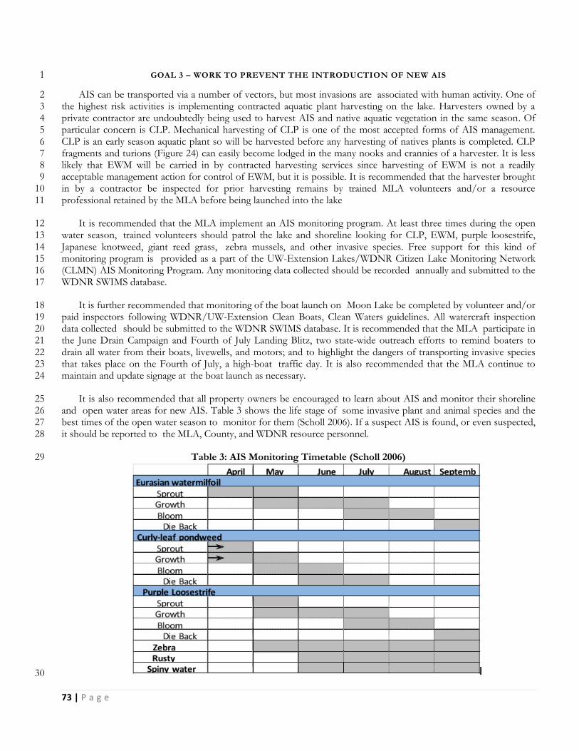
73 | P a g e
GOAL 3 – WORK TO PREVENT THE INTRODUCTION OF NEW AIS 1
AIS can be transported via a number of vectors, but most invasions are associated with human activity. One of 2 the highest risk activities is implementing contracted aquatic plant harvesting on the lake. Harvesters owned by a 3 private contractor are undoubtedly being used to harvest AIS and native aquatic vegetation in the same season. Of 4 particular concern is CLP. Mechanical harvesting of CLP is one of the most accepted forms of AIS management. 5 CLP is an early season aquatic plant so will be harvested before any harvesting of natives plants is completed. CLP 6 fragments and turions (Figure 24) can easily become lodged in the many nooks and crannies of a harvester. It is less 7 likely that EWM will be carried in by contracted harvesting services since harvesting of EWM is not a readily 8 acceptable management action for control of EWM, but it is possible. It is recommended that the harvester brought 9 in by a contractor be inspected for prior harvesting remains by trained MLA volunteers and/or a resource 10 professional retained by the MLA before being launched into the lake 11
It is recommended that the MLA implement an AIS monitoring program. At least three times during the open 12 water season, trained volunteers should patrol the lake and shoreline looking for CLP, EWM, purple loosestrife, 13 Japanese knotweed, giant reed grass, zebra mussels, and other invasive species. Free support for this kind of 14 monitoring program is provided as a part of the UW-Extension Lakes/WDNR Citizen Lake Monitoring Network 15 (CLMN) AIS Monitoring Program. Any monitoring data collected should be recorded annually and submitted to the 16 WDNR SWIMS database. 17
It is further recommended that monitoring of the boat launch on Moon Lake be completed by volunteer and/or 18 paid inspectors following WDNR/UW-Extension Clean Boats, Clean Waters guidelines. All watercraft inspection 19 data collected should be submitted to the WDNR SWIMS database. It is recommended that the MLA participate in 20 the June Drain Campaign and Fourth of July Landing Blitz, two state-wide outreach efforts to remind boaters to 21 drain all water from their boats, livewells, and motors; and to highlight the dangers of transporting invasive species 22 that takes place on the Fourth of July, a high-boat traffic day. It is also recommended that the MLA continue to 23 maintain and update signage at the boat launch as necessary. 24
It is also recommended that all property owners be encouraged to learn about AIS and monitor their shoreline 25 and open water areas for new AIS. Table 3 shows the life stage of some invasive plant and animal species and the 26 best times of the open water season to monitor for them (Scholl 2006). If a suspect AIS is found, or even suspected, 27 it should be reported to the MLA, County, and WDNR resource personnel. 28
Table 3: AIS Monitoring Timetable (Scholl 2006) 29
30
74 | P a g e
OBJECTIVE 1 – REDUCE THE CHANCE THAT A NEW AIS IS INTRODUCED INTO MOON LAKE BY AQUATIC 1 PLANT HARVESTING ACTIVITIES. 2
i. Action Item: Inspect all harvesting equipment brought to the lake by a contractor prior to it being 3 launched into the lake. 4
a. Ask the contractor for a list of the lakes and aquatic plants harvested in the same year as MLA 5 contracts. 6
b. Ask and confirm the contractor’s harvester cleaning and disinfection protocol between jobs. 7
c. Ask for a signed document from the contractor that the harvesting equipment has been cleaned 8 and inspected prior to completing the job. 9
OBJECTIVE 2 - REDUCE THE LIKELIHOOD THAT NEW AIS GOES UNDETECTED IN MOON LAKE. 10
i. Action Item: Participate in and complete AIS monitoring actions through the Citizen Lake Monitoring 11 Network (CLMN) AIS Monitoring Program. 12
a. MLA volunteers or a resource professional retained by the MLA will complete AIS monitoring 13 of the lake and shoreline at least three times each open water season following CLMN AIS 14 Monitoring Guidelines. 15
b. AIS monitoring data will be entered into the WDNR SWIMS database annually. 16
OBJECTIVE 3 - IMPLEMENT A CLEAN BOATS CLEAN WATERS (CBCW) WATER CRAFT INSPECTION 17 PROGRAM ANNUALLY. 18
i. Action Item: Determine an appropriate amount of watercraft inspection time at the Moon Lake public 19 access to prevent introduction of AIS through transient boaters. 20
a. Participate in the WDNR June Drain Campaign and 4th of July landing Blitz annually. 21
b. Install updated AIS education signs at the Moon Lake public access and at the Walk-in Access 22 from Moon Lake Park. 23
OBJECTIVE 4 – EDUCATE AND INFORM PROPERTY OWNERS AND LAKE USERS ABOUT AIS AND HOW TO 24 IDENTIFY THEM 25
i. Action Item: Seek out AIS education events sponsored by other entities and/or sponsor AIS education 26 events and then encourage property owners on Moon Lake to attend. 27
ii. Action Item: Research AIS and lake stewardship materials with little or no cost to attain and distribute 28 to property owners at events including but not limited to Annual Meetings, Lake Fairs, Summer Picnic, 29 etc. 30
iii. Action Item: Report findings of suspect AIS to the MLA, Barron County, WDNR, and other Resource 31 entities. 32
33

75 | P a g e
GOAL 4 - MONITOR AND MAINTAIN WATER QUALITY 1
At the present time, Moon Lake is a plant dominated and fairly fertile body of water. The level of phosphorus in 2 the lake is bordering on eutrophic or nutrient rich. Chlorophyll a, which is a measurement of the amount of algae in 3 the water, is at present pretty low indicating that abundant aquatic plant growth, stimulated by clear water is using up 4 a majority of the available phosphorus before it can be used by algae. By removing a substantial amount of aquatic 5 vegetation, there is a risk that the harvesting could trigger a forward switch causing the lake to shift from plant 6 dominance and clear water to algae dominance and green water. This is not an acceptable outcome for this project, 7 so extensive water quality monitoring is necessary to track changes in water quality before they become irreversible. 8 In addition, it is expected that aquatic plant harvesting and other actions implemented through this APMP will 9 maintain or improve adequate dissolved oxygen (DO) levels in the lake throughout the year, but particularly under 10 the ice. Winter monitoring of nutrients and oxygen is highly recommended if any management is to occur. 11
OBJECTIVE 1 – MONITORING WATER CLARITY AND NUTRIENT LEVELS (TOTAL PHOSPHORUS & 12 CHLOROPHYLL A) IN MOON LAKE ANNUALLY 13
i. Action Item: Continue involvement in the WDNR/UWEX-Lakes CLMN Water Quality Monitoring 14 Program at the Center location in Moon Lake. 15
a. Collect Secchi Disk readings of water clarity and temperature at least monthly May through 16 October. 17
b. Make a request to the CLMN Program to move Moon Lake into the Expanded Monitoring 18 program which collects monthly total phosphorus samples from May to August; and monthly 19 chlorophyll a samples from June to August. 20
OBJECTIVE 2 – COLLECT DISSOLVED OXYGEN AND TEMPERATURE PROFILES MONTHLY THROUGH THE 21 ENTIRE YEAR 22
i. Action Item: Either through the CLMN Program or another program, DO profiles should be collected 23 at least monthly through the entire year (Jan.-Dec.) 24
ii. Action Item: When resources are available, increase total phosphorus and chlorophyll a sampling to 25 include September and October. 26
27
76 | P a g e
GOAL 5 - RESTORE THE FISH COMMUNITY 1
Despite having an aeration system operating in the lake, a severe winterkill over the 2013-14 winter season nearly 2 wiped out the entire fish population in Moon Lake. To date, the fish population in Moon Lake has not recovered. It 3 is thought that the winterkill was caused by super cooling of the lake water in the winter. Super cooling occurs when 4 warm bottom water in a shallow lake is mixed too rapidly with colder surface water just under the ice, creating undue 5 stress on the existing fish population. The super cooling in Moon Lake may have been caused by the surface 6 aspirating aeration system that was operated in the lake. Along with low oxygen levels to begin with, this undue stress 7 weakened and killed the fish. There may be ways to maintain or improve oxygen levels under the ice that would 8 reduce the potential for super cooling and/or low DO. Heavy snow cover that lasts well into the spring limits 9 production of DO by aquatic plant alive under the ice. Plowing snow-free lanes on the surface of the ice can increase 10 the amount of sunlight that gets to the plants under the ice. Lots of ice fishing holes can be drilled in the ice to 11 increase the transfer of oxygen in the air to the water. Removal of aquatic plants can reduce the amount of vegetation 12 that dies and decays under the ice using up available DO. 13
Aeration can again be installed, but a different system which may reduce the likelihood of super cooling could be 14 used. A compressed air system is often installed in shallow lakes and operated continuously, year round. By operating 15 the aerator in the late summer and fall, it may be possible to increase DO levels in the water before it freezes over. 16 By installing the aerator in shallow water, and only operating it when it is shown that DO levels are falling, it may be 17 possible to reduce the chance of super cooling. 18
Once aquatic plant harvesting has been implemented and aeration re-installed, re-stocking Moon Lake to restore 19 its former warm water fishery of bass, panfish, and northern pike can be completed. Restoring the fish population in 20 the lake will increase the recreational value of the lake for property owners, community members and other lake 21 users. 22
OBJECTIVE 1 – IMPLEMENT MANAGEMENT ACTIONS THAT MAY MAINTAIN OR IMPROVE DISSOLVED 23 OXYGEN LEVELS IN THE LAKE THROUGHOUT THE SEASON 24
i. Action Item: Implement aquatic plant harvesting actions in Goal 2 25
ii. Action Item: Plow snow-free lanes across the frozen surface of Moon Lake 26
a. Work with property owners on Moon Lake to identify a volunteer or a contractor who could 27 plow snow-free lanes on the ice once it is strong enough to drive on 28
iii. Action Item: Drill lots of holes through the ice when DO levels start to fall under the ice 29
a. When DO monitoring under the ice shows DO levels starting to drop, encourage property 30 owners and lake users to drill as many ice fishing holes as they can until ice conditions prevent 31 access. 32
OBJECTIVE 2 – RE-INSTALL AN AERATION SYSTEM IN MOON LAKE 33
i. Action Item: Work with the WDNR and City to determine logistics for re-installation of an aeration 34 system. 35
a. Determine the type and location of aeration to install, surface aspirating vs. compressed air 36
b. Determine support from the City and WDNR grant programs (Recreational Boating Facilities 37 and/or Sport Fish Restoration) for making improvements to Moon Lake Park that would 38 support an aeration system. 39
77 | P a g e
ii. Action Item: Install, operate, and maintain an Aeration System in Moon Lake 1
OBJECTIVE 3 – RE-STOCK MOON LAKE WITH FISH 2
i. Action Item: Work with the WDNR to determine an appropriate time to begin re-stocking fish into 3 Moon Lake 4
a. Discuss plans to complete aquatic plant harvesting and actions to improve DO including snow-5 free lanes, ice holes, and installation of an aeration system with the WDNR and how they 6 impact the decision to re-stock the lake. 7
ii. Action Item: Discuss options for re-stocking the lake with the WDNR including species, size, and 8 number to re-stock. 9
10
78 | P a g e
GOAL 6 - IMPROVE PUBLIC RECREATIONAL ACCESS AND NATURE IMMERSION OPPORUNITIES FOR 1 COMMUNITY MEMBERS 2
In its Outdoor Recreation Plan, the City’s lists several goals that improving the conditions in Moon Lake and 3 improving community access to the lake would help meet. The following four goals are on page 8 of the 2014-2019 4 Comprehensive Outdoor Recreation Plan: 5
To enhance the quality of life and encourage healthy lifestyles while reconnecting people, especially children, 6 to the outdoors through our parks and open spaces, natural areas, trails, and outdoor recreation programs. 7
To develop a stewardship ethic, protect our natural environment for sustainable conservation for our 8 community and generations to come. 9
To ensure all people the access to a safe, affordable and healthy way to experience and appreciate nature 10 while improving social and economic value to the City. 11
Provide a mix of affordable, quality outdoor recreation facilities, programs, and amenities at various scales 12 and development intensities which meet the needs of residents while taking advantage of tourism 13 opportunities. 14
15 Along with these four goals, the Outdoor Recreation Plan also lists the following objectives on page 9-10: 16
To provide a safe environment for play and physical activity and areas for active and passive recreation 17 opportunities that meet the needs of all age groups, cultures, and ethnicity within the community. 18
To improve and revitalize our parks as gathering places for our youth, families and adults to play, exercise, 19 relax, enjoy time with family and friends, and experience the natural environment. 20
To provide space for social interaction, health and wellness, and cultural diversity. 21
To obtain, when opportunities are feasible, sites for open green space, playgrounds, parks, trails, etc. 22
To provide opportunities for rural residents to enjoy the community's parks, natural resources, and 23 recreation areas. 24
To establish priorities for needed outdoor recreation facilities based on prominent outdoor recreation trends, 25 as well as existing recreational land distribution and existing and/or future deficiencies. 26
To raise awareness to help preserve and protect our natural resources within our parks and adjacent to, along 27 with the promotion of good conservation and stewardship practices. 28
To coordinate the community’s recreation program with other agencies, organizations, schools, other levels 29 of government and private enterprise to ensure maximum public benefit. 30
To ensure that all people have access and adequate parking to our water amenities and public recreation 31 areas. 32
To protect scenic values by managing billboards, signs, junkyards and other unsightly land uses and 33 practices. 34
To make improvements and modifications to accommodate Adaptive/ADA compliant facilities, play 35 structures and accessibility that meet the needs of the physically challenged including the elderly and disabled 36 that meet the American Disabilities Act standards. 37
To provide for the periodic review and updating of the city outdoor recreation plan so that it will reflect the 38 changing needs and trends of the community. 39
To provide for annual planning, programming and maintenance of park and recreation facilities throughout 40 the community with funding from the Capital Improvements Program (CIP), general obligation borrowing 41 and other funding sources private or public. 42
To create and promote alternative means of transportation within the City by the establishment of trails and 43 sidewalk connections for recreational and multimodal transportations activities. 44
45 Nearly all of the goals and objectives listed in the City Comprehensive Outdoor Recreation Plan can be 46
addressed at some level with the management actions and activities recommended in this APMP. Moon Lake is a 47

79 | P a g e
valuable natural resource within the city limits that is being under-utilized at the present time, due in part to the poor 1 condition of the lake. One of the property owners on Moon Lake is a well-respected and popular (with students) 2 Rice Lake High School biology teacher who encourages students to get involved in natural resource activities in the 3 community and surrounding area. 4
This APMP recommends that the MLA work with the City, Rice Lake High School, and other community 5 partners to determine how what is done in Moon lake can improve its value in the community. Through the efforts 6 of the MLA; support from WDNR grants and City outdoor recreation programs; and partnerships with the City, Rice 7 Lake High School, Rice Lake – Lake Protection and Rehabilitation District, and other community organizations 8 Moon Lake can be utilized as the valuable resource that it should be. 9
OBJECTIVE 1 – WORK WITH THE CITY OF RICE LAKE AND OTHER ENTITIES TO IMPROVE PUBLIC ACCESS 10 TO MOON LAKE AT THE SOUTH END OF MOON LAKE PARK 11
i. Action Item: Improve walk-in access and launching facilities for kayakers and users of other small craft; 12 wildlife enthusiasts; and small group learning opportunities off the south end of the Park. 13
ii. Action Item: Install a public fishing dock off the south end of the Park. 14
iii. Action Item: Build a bathroom/shelter/aeration storage shed at the south end of the Park 15
iv. Action Item: Build a road to, and a small parking area at the south end of the Park. Bring electricity to 16 the south end of the Park. 17
OBJECTIVE 2 – WORK WITH RICE LAKE AREA SCHOOLS TO FIGURE OUT HOW MOON LAKE AND MOON 18 LAKE PARK CAN BE BETTER UTILIZED AS A NATURAL RESOURCE LEARNING TOOL 19
i. Action Item: Discuss how Moon Lake and Moon Lake Park can be improved to provide outdoor 20 education opportunities for students and teachers. 21
OBJECTIVE 3 – EXPLORE FUNDING PROGRAMS THAT MIGHT BE USED TO SUPPORT IMPROVED LAKE 22 ACCESS FOR RECREATIONAL ACTIVITIES, OUTDOOR LEARNING ACTIVITIES, AND HABITAT 23 IMPROVEMENTS 24
i. Action Item: Evaluate how and if certain WDNR grant programs including the Recreational Boating 25 Facilities and Sport Fish Restoration can be used to increase the community value of Moon Lake. 26
ii. Action Item: Work with the City and Rice Lake – Lake Protection and Rehabilitation District funding 27 opportunities could be used to increase the community value of Moon Lake. 28
29

80 | P a g e
GOAL 7 - EVALUATE AND IMPROVE THE SHORELAND AROUND MOON LAKE 1
Once harvesting of aquatic plants in Moon Lake is started, there is a risk of causing the lake to go from plant 2 dominated clear water to algae dominated green water. Removal of aquatic plant may make more nutrients in the lake 3 available to grow algae. Reducing the amount of nutrients entering Moon Lake from its rather small watershed may 4 lessen the chance the lake switches over. One inexpensive way to reduce nutrients entering the lake is to make 5 shoreland improvements around the lake. There are many shoreland best management practices (BMPs) including 6 establishing buffer strips through no mowing, native plantings, shoreland restoration, installation of rain gardens, and 7 diversion of surface water runoff away from the lake that will reduce nutrient loading over time. 8
To maintain the quality and diversity of the Moon Lake, it is recommended that the MLA provide riparian 9 owners with educational materials on shoreland improvement and/or sponsor/promote shoreland improvement 10 training events. Not knowing where to begin with a shoreland restoration is often the main hurdle preventing 11 property owners from implementing a practice that would help improve the lake. General information on shoreland 12 restoration could be provided to all property owners in a newsletter and/or during public events. There are many 13 free, down-loadable on-line resources, and both free and low cost paper resources including guides, pamphlets, and 14 brochures available to help the average person work toward making improvements on their own properties. UW-15 Extension has offices in nearly every county in Wisconsin and offers these materials for free or at very low prices. 16 They also sponsor local workshops and/or training sessions, or can direct people to others who do. Local 17 greenhouses and landscaping companies often have shoreland restoration packages for specific project types 18 available to the public. 19
The WDNR has a new Lake Shoreland and Shallows Habitat Monitoring Field Protocol that involves the 20 evaluation of a 35-ft buffer area around the entire lake, documents shoreland condition through digital photography, 21 and documents coarse woody debris in a lake. Additional information about the condition of the shoreland around 22 Moon Lake would benefit future shoreland improvement planning and implementation through the WDNR Healthy 23 Lakes Initiative and BMP grant program. The RL-LPRD also has a shoreland improvement program. Both programs 24 offer funding support to install shoreland BMPs. It is recommended that a shoreland survey be completed on Moon 25 Lake following the new WDNR protocol during the time frame covered by this APMP. 26
OBJECTIVE 1: REDUCE THE AMOUNT OF SHORELAND WITHOUT A NATURAL BUFFER IN PLACE BY 27 THROUGH SHORELAND RESTORATION AND OTHER BEST MANAGEMENT PRACTICES. 28
i. Action Item: Complete a shoreland inventory of all developed properties to determine the amount of 29 shoreland that is not in a natural state. 30
ii. Action Item: Distribute shoreland improvement education and information materials to lake property 31 owners through the newsletter, webpage, and general mailings. 32
iii. Action Item: Host and/or sponsor lake events that encourage land owner participation in best 33 management practices. 34
iv. Action Item: Support property owners who wish to complete shoreland or habitat improvement 35 projects through the WDNR Healthy Lakes and RL-LPRD programs. 36
v. Action Item: Recognize property owners who participate in and/or complete shoreland restoration and 37 habitat improvement projects in the newsletter, on the webpage, in local news publications, and/or at 38 the site of the project. 39
40

81 | P a g e
GOAL 8 - ADAPTIVE MANAGEMENT 1
This APMP is a working document guiding management actions on Moon Lake over the next five years. This 2 plan will follow an adaptive management approach by evaluating results and adjusting actions on the basis of what 3 has been learned. This plan is therefore a living document, successively evolving and improving to meet 4 environmental, social, and economic goals, to increase scientific knowledge, and to reduce tensions among 5 stakeholders. If WDNR grant funds are used to support implementation of this APMP, the MLA and their retainers 6 will compile, analyze, and summarize management operations, public education efforts, and other pertinent data into 7 an annual report each year. The information will be presented to members of the MLA, the WDNR, and others 8 upon request. 9
OBJECTIVE 1 – IMPLEMENT AS MANY OF THE RECOMMENDATIONS IN THIS APMP AS POSSIBLE OVER THE 10 NEXT FIVE YEARS WITH THE RESOURCES AVAILABLE TO THE MLA 11
i. Action Item: Utilize the Implementation and Funding Matrix included with this APMP (Appendix G) 12 to prioritize and determine the timing for implementation of specific recommendations included in this 13 plan. 14
15


![3.3 Aquatic Resources - California State Water Resources ... · Section 3.3.5 [Aquatic Resources] Potential Impacts and Mitigation. 3.3.2.1 Aquatic Species Numerous aquatic species](https://img.pdfslide.us/doc/110x75/5fdf05efaeffa42ca171b579/33-aquatic-resources-california-state-water-resources-section-335-aquatic.jpg)