Embed Size (px)
Citation preview

National Transportation Safety Board Washington, DC 20594
Marine Accident Brief
Accident No.: DCA-09-CM-001
Vessel: U.S. commercial fishing vessel Katmai, official number 918779, overall length 92.2 feet, registered length 73.3 feet, beam 26 feet, 148 gross register tons, 101 net tons, built 1987
Accident Type: Sinking Location: Bering Sea, 120 miles west of Adak, Aleutian Islands, Alaska
(Amchitka Pass)
Date: October 21–22, 2008 Time: About midnight1
Owner/Operator: Katmai Fisheries, Inc., Seattle, Washington2
Property Damage: $1.5 million (estimated market value) Complement: 11 (master, factory foreman, 9 crewmembers)
Injuries: 7 fatalities, no injuries
E PLUR IBUS UNUM
NAT
I ON
AL TRA S PORTATIO
N
B OARDSAFE T Y
N
Background
About midnight on October 21–22, 2008, during a severe storm, the U.S. commercial fishing vessel Katmai (figure 1) sank in the Bering Sea. The vessel was carrying about 120,000 pounds (53.57 long tons3) of frozen cod—twice the maximum weight addressed in the Katmai’s 1996 stability report. Of the 11 crewmembers on board, 4 were rescued, the bodies of 5 were recovered, and 2 remain missing and are presumed dead. National Transportation Safety Board (NTSB) investigators participated in a formal U.S. Coast Guard Marine Board of Investigation into the sinking, conducted on October 27–28, 2008, in Anchorage, Alaska, and on November 3 and December 10, 2008, in Seattle, Washington. Before the marine board convened,
1 Times in this marine accident brief are given in Aleutian daylight time (universal coordinated time [UTC]
minus 9 hours), the time zone at the accident site. No vessel records survived the accident, and the exact time of the sinking is unknown. The times of other key events in the accident are also estimated. Discrepancies between survivors’ testimony about the timing of events and the times recorded on relevant radio or electronic communications were resolved in favor of the recorded times.
2 The company is no longer in business. 3 One long ton = 2,240 pounds.
NTSB/MAB-11/03
NTSB and Coast Guard investigators examined one of the vessel’s two liferafts, which had been taken to Anchorage after it was recovered.
Figure 1. Fishing vessel Katmai motoring through Ballard locks in Seattle (undated Seattle Times photo). White cylindrical structure (net reel) at stern was later removed when vessel was refitted for cod fishing. Katmai was the only vessel owned and operated by Katmai Fisheries, Inc.
The marine board published its report in April 2010.4,5 This NTSB marine accident brief6 includes some of the 31 recommendations made to the Coast Guard by the Marine Board of Investigation, and these recommendations are noted in their respective subject areas. The Marine
4 Marine Board of Investigation into the Circumstances Surrounding the Sinking of the F/V Katmai in
the Amchitka Pass, North Pacific Ocean, on October 22, 2008, with Multiple Loss of Life (Washington, DC: U.S. Department of Homeland Security, U.S. Coast Guard, April 26, 2010).
5 Times in the marine board’s report are given as either UTC or Alaska daylight time (UTC minus 8 hours), which was the time on the Alaska mainland at the time of the accident. As noted earlier, times in this NTSB accident brief are given in Aleutian daylight time, which is 1 hour earlier than Alaska daylight time. Thus, the times stated in the NTSB and Coast Guard reports do not necessarily agree.
6 An NTSB marine accident brief, described in 49 Code of Federal Regulations (CFR) 845.40(b), provides only the facts, conditions, and circumstances relating to an accident sufficient for the NTSB to determine the probable cause of a major marine casualty, as required by 49 CFR 850.30(e), when the Coast Guard conducts an investigation on behalf of the NTSB.
2 NTSB/MAB-11/03
Board of Investigation report, which includes all 31 recommendations and the Commandant’s action on those recommendations, can be found in the NTSB’s Docket Management System.7
Accident Narrative
On October 2, 2008, the Katmai departed Adak Island, where it had delivered processed fish to the freighter Coastal Trader, to continue fishing for Pacific cod in the waters of the western Aleutian Islands. The vessel, part of the head-and-gut fleet8 based in Seattle, deployed baited cod pots on long fishing lines (longlines) to gather its catch. By the evening of October 21, the Katmai had caught and processed 120,000 pounds of cod and was traveling through Amchitka Pass on its way to Dutch Harbor, Alaska, to deliver the frozen fish. On board were the master, a chief engineer, a deck boss, a factory foreman, two deckhands, and five fish processors. Most of the crewmembers were asleep.
According to the National Weather Service forecast office in Anchorage, an intensifying storm was moving into the Aleutian Islands from the southwest, and a hurricane-force wind warning had been issued at 1500 on October 20 for the night of October 21. The master told the marine board that he received forecasts of the storm from the vessel’s SkyMate® vessel monitoring service (VMS) 2 or 3 days before the sinking.9 National Weather Service data indicated that at the time of the accident, winds were from the east at 60–70 knots; the air temperature was 38◦ F; the water temperature was 43◦ F; the wave height was 20–30 feet; and prevailing conditions were rain with no icing.
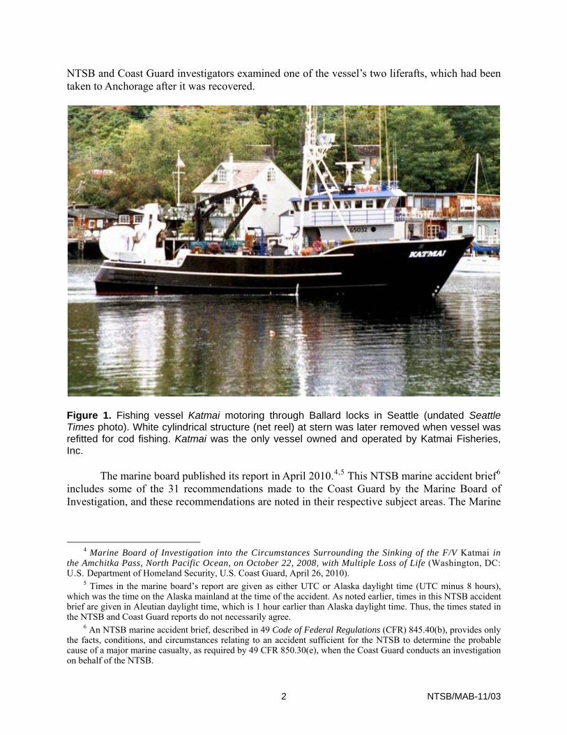
Despite severe weather predictions and the exposed location of the Katmai, the master chose to continue fishing. The master told the marine board that, at about 0200 on October 21, the Katmai had completed fishing operations and crewmembers had begun to store their gear in preparation for the return to Dutch Harbor. At 0500, when the engineer assumed the bridge watch in the pilothouse, the master said he told the engineer that before the approaching storm hit, the Katmai had to make about 7.5 knots to reach Tanaga Island, in the Andreanof Islands about 50 miles east of the Katmai’s location (figure 2). The master did not instruct the engineer, who was the master’s relief, that he was to be awakened if progress were slower than 7.5 knots. After that conversation, the master, who had been at the helm for 22 hours, said that he went to bed for about 6 hours. When the master resumed the watch in the pilothouse at about 1100, he realized that the Katmai had been making only 3.5–4 knots over the previous 6 hours. At the time, according to the master, the vessel was near Semisopochnoi Island (figure 2). Had the master
7 Please see <http://dms.ntsb.gov/public%2F47000-47499%2F47487%2F450803.pdf>. 8 The head-and-gut fleet is so named because workers (processors) remove the head and guts of the catch before
the fish are frozen and stored in a vessel’s hold. The Katmai was classified as a fishing vessel, not as a fish processing vessel. Fishing vessels are defined by U.S. law (46 United States Code [U.S.C.] 2101) as vessels that commercially engage in the catching, taking, or harvesting of fish, or in activities that can reasonably be expected to result in the catching, taking, or harvesting of fish. Fish-processing vessels are defined as vessels that commercially prepare fish or fish products other than by gutting, decapitating, gilling, skinning, shucking, icing, freezing, or brine chilling. All fishing vessels and fish-processing vessels less than 5,000 gross register tons are exempt from Coast Guard inspection.
9 The VMS installed on the Katmai allowed fishery regulators to track where the vessel fished. The VMS also provided regular weather forecasts and e-mail capabilities. The Katmai master said that he used the e-mail function to communicate with the company’s operations manager and for personal messages.
3 NTSB/MAB-11/03
recognized that the vessel was in danger from the oncoming storm, he could have sought shelter in the lee of Semisopochnoi Island.
Figure 2. Area of Bering Sea where Katmai sank, with detail showing accident site, Amchitka Pass, and nearby islands.
The master said that they “weren’t as far along as I wanted to be when [the storm] hit,” so “we got off the edge out in the deeper water and didn’t worry about making good time … we’ll worry about making time when the weather lets up.” At 1440 on October 21, the master sent an e-mail to the Katmai’s owner that the vessel was advancing slowly and that the wind was blowing at 45–50 knots. At 1500, according to records, the master e-mailed the fishing vessel Blue Ballard, working in the same fishery about 60 miles away, that the Katmai “was getting
4 NTSB/MAB-11/03
beat up.” At 1730, the Katmai master reported by e-mail to the Blue Ballard that the weather was bad. The masters of the fish-processing vessels Courageous and Patricia Lee, which were also operating about 60 miles from the Katmai, testified to the severity of the storm that entered Amchitka Pass on October 21. Both masters, whose vessels were larger than the Katmai, chose to find shelter while the storm passed. The master of the Courageous said his vessel experienced 100-knot winds and more than 20-foot seas while in a sheltered location during the storm.
Sometime after 2200, the Katmai lost steering.10 The master told investigators that it was raining, that the seas were running about 25 feet, and that the vessel was listing to port because of 80 mph winds from starboard. The master said that after the Katmai lost steering, he sent the engineer to investigate, then immediately began sending distress calls using the vessel’s radios on frequencies 4125 and 2182 kilohertz (kHz). He received no response.11 At the time, the Katmai was over 1,000 nautical miles west of Coast Guard communications station (COMSTA) Kodiak. According to the Coast Guard, the frequency 2182-kHz distress signal had an estimated effective range of 1,000 miles and may not have reached COMSTA Kodiak. The Katmai’s broadcast on frequency 4125 kHz had an estimated effective range of 1,500 miles. The Coast Guard recorded a Mayday call on that frequency at 2226, but the recorded transmission did not include a vessel name, a location, or the nature of the emergency. During the accident investigation, the master identified the voice on the Mayday recording as his. A correct distress call includes the vessel name, call sign, location, and any other information that may facilitate a rescue, such as vessel description, length, color, type, and number of people on board.
After attempting to send distress calls on the Katmai’s single-sideband radios, the master tried to report the vessel’s situation on channel 16 (156.8 megahertz [MHz]) of its very-high-frequency (VHF) radio, again with no response. The maximum communication range of a VHF radio is about 60 nautical miles, depending on the radio’s transmission power. At 2315, using the vessel’s VMS, the master sent an e-mail to the Blue Ballard to report that the Katmai had lost steering. The master told the marine board that he sent the e-mail hoping that the Blue Ballard would report the Katmai’s difficulty to the Coast Guard, though he did not specifically ask the Blue Ballard to do so. The Blue Ballard did not contact the Coast Guard until after the sinking (see “Emergency Response” section).12
To investigate the steering loss, the engineer went to the lazarette (the aftmost compartment in the ship’s hull, which held motors, hydraulic pumps, and other steering gear) and
10 The time of the steering loss was estimated from the record of communications described in the following paragraphs. In preliminary interviews on October 24, the master and one of the crewmembers stated that the steering loss happened “around midnight.” The discrepancy could result from the ship’s clocks not being set to Aleutian daylight time or to faulty memory.
11 It is uncertain whether other vessels in the vicinity were monitoring frequencies 4125 and 2182 kHz. Even if they were, the Coast Guard report suggested that the radio signals might not have reached the vessels because of a phenomenon called the “skip zone”—a gap, or “zone of silence”⎯between where the first part of a radio wave (the ground wave) ends and where the second part (the sky wave) reflects back to earth off the ionosphere.
12 The marine board recommended that the Coast Guard ensure that commercial fishing vessels that operate beyond the boundary line have emergency means to communicate, such as a satellite telephone or an appropriate component of the Global Maritime Distress Safety System (GMDSS). The Coast Guard Commandant concurred with this recommendation, indicating that this issue would be included in an ongoing fishing vessel safety rulemaking.
5 NTSB/MAB-11/03
noted that the watertight door to the space was open and that the space had flooded.13 According to the master, the engineer closed the watertight door, reported the flooded lazarette to the master, and then went to the engineroom to start the bilge pump to dewater the lazarette. At 2329, the master sent a second e-mail to the Blue Ballard, reporting that the Katmai’s lazarette was flooded. The engineer started the bilge pump and reported to the master that the water level in the lazarette was dropping. Meanwhile, one of the deckhands stated that several inches of water had accumulated in the processing space on the main deck.
While the engineer attempted to dewater the lazarette, the master ordered crewmembers, except for the engineer, to don immersion suits.14 When it appeared that the flooding in the lazarette was under control, the master had crewmembers remove their immersion suits. The vessel then took a starboard list, and the master ordered a deckhand to check the engineroom. The deckhand stated that, when he reached the engineroom, it was flooded 1–2 feet above the deck plates. The master ordered crewmembers to again don immersion suits and to prepare the liferafts for abandoning ship.
The flooding progressed, with the vessel continuing to list to starboard and trim down by the stern. About 5 minutes after the vessel had listed to starboard, the master called “Mayday” on his single-sideband radios and ordered the crew to abandon ship. The deck boss said that before abandoning ship, he noticed that the aft watertight door from the deck to the processing space was open. He did not close the door. A deckhand said that he overheard the master and the engineer say that the aft deck of the Katmai was submerged and that water was entering the processing space.
The master said that a few minutes before abandoning the vessel, he manually activated its emergency position-indicating radio beacon (EPIRB). Judging from the times e-mails were sent from the Katmai and the time the Coast Guard received the Katmai EPIRB’s alert (0007 on October 22), the vessel sank about midnight on October 21–22.15 The vessel’s last known position, reported by the VMS at 2234, was latitude 51°58.89′ N, longitude 179°21.54′ W. The water depth at that location is about 9,200 feet. No attempt has been made to locate the wreck.
The engineer was last seen leaving the pilothouse without an immersion suit on. The master believes that he was headed to the engineroom, and the engineer is believed to have gone down with the vessel. Seven crewmembers, including the master, abandoned the Katmai into a 15-person liferaft deployed off the starboard bow. Three of the crewmembers in the 15-person liferaft were lost at sea when, according to the master, the heavy seas “threw everyone from the raft … it just kept flipping on us and flipping on us and flipping on us.” The master said that he carried the EPIRB into the liferaft when he abandoned the vessel, and that the EPIRB was thrown out of the liferaft when it overturned the first time.
13 Details of the Katmai’s construction are given in the “Vessel Information” section. 14 Coast Guard regulations at 46 CFR 160.171-11(d) require immersion suits to be designed so that wearers can
don them in 2 minutes after reading the instructions. 15 The master estimated that the vessel sank 30–35 minutes after “the steering first went out.” That testimony
does not agree with the Coast Guard having recorded the Mayday call at 2226, with the time e-mails were sent to the Blue Ballard, or with the time the Coast Guard received the EPIRB alert.
6 NTSB/MAB-11/03
The two liferafts used on the Katmai were manufactured in 1980 (15-person) and 1994 (10-person). Requirements for post-1997 manufactured liferafts are more stringent for ballast and stability than previously manufactured liferafts and are manufactured with ballast pockets to resist overturning due to wind and waves. Pre-1997 liferafts remain acceptable if maintained in serviceable condition, including periodic inflation testing. Katmai’s liferafts were last serviced and tested in November 2007 (15-person) and December 2007 (10-person). The master said that the crew would right the raft by pulling on the straps on the bottom. He said that the raft rolled “a lot.” He continued, “It was an all-night ordeal … and every time it was a struggle to get back on.”
The 15-person liferaft was not recovered. None of the three crewmembers who witnesses said were going to abandon the vessel into the 10-person liferaft survived, and only two bodies were recovered. Those three crewmembers were last seen on the starboard deck in immersion suits, according to testimony given at the marine board, and it is not known whether they actually boarded the 10-person liferaft. The 10-person liferaft was recovered and examined by Coast Guard and NTSB investigators in Anchorage on October 23, 2008. The carbon dioxide (CO2) bottle used to inflate the buoyancy chambers was missing from the liferaft. However, video footage of the search and rescue showed the liferaft floating at sea, mostly inflated, indicating that the CO2 bottle had been attached to the liferaft and been discharged. The hose that led from the CO2 bottle to the liferaft was removed and sent to the NTSB materials laboratory in Washington, DC, for examination.
The hose consisted of a Teflon liner wrapped with multiple layers of stainless-steel braid. The NTSB laboratory determined that the hose was stretched about 5 inches longer than its original length of 31 inches (+/–0.5 inch) and was most significantly damaged at the end that would have been attached to an inflation valve on the liferaft. Pressure testing revealed a large leak in the Teflon liner, and microscopic analysis showed that “the rupture was due to tensile mechanical overload by shear yielding.” The examination suggested that the hose had previously been connected to an inflation valve assembly.16
Emergency Response
Distress Calls
The United States Mission Control Center (USMCC), operated by the National Oceanic and Atmospheric Administration (NOAA), first received a 406-MHz alert from the EPIRB
16 The marine board made several recommendations concerning the design and age of the liferafts that were
permitted to be carried on board the Katmai, including determining if an age limit should be applied to liferafts or if older liferafts should be modified to be more seaworthy. The Commandant did not concur with these recommendations, stating that having reached an arbitrary age was insufficient justification for requiring replacement. Similar marine board recommendations were issued dealing with immersion suits, and the Commandant also did not concur with these. The Coast Guard indicated that it would publish a “lessons learned” document which would describe the benefits of selecting liferafts that provide greater protection and survivability in extreme environments such as the conditions in which the Katmai was operating and call attention to servicing and testing guidance published in Navigation and Vessel Inspection Circular (NVIC) 01-08, Shipboard Inspection and Testing of Immersion Suits.
7 NTSB/MAB-11/03

registered to the Katmai at 2350 on October 21.17 At 0007 on October 22, the Coast Guard’s North Pacific search-and-rescue coordinator (NPSC) in Juneau received the alert from the USMCC. The EPIRB signal did not indicate the exact location of the Katmai, but when contacted, the vessel owner reported that it was fishing near Adak Island.18
At 0016, the Coast Guard radio station in Kodiak began calling the Katmai on single-sideband radio frequencies 4125 and 2182 kHz, saying that it had received a signal from the vessel’s EPIRB. At 0054, the Blue Ballard, which had heard the radio calls, reported to the NPSC that it had received e-mails from the Katmai reporting a loss of steering and a flooded lazarette. At 0142, COMSTA Kodiak issued an urgent marine information broadcast alerting vessels in the area to look out for the Katmai and any survivors.
Search and Rescue
At 0222 on October 22, the Coast Guard requested the cutter Acushnet to move 500 miles from its patrol in the Bering Sea to the accident scene, but the vessel was unable to respond because of the weather. Between 0310 and 0319, two rescue aircraft—an HH-60 Jayhawk helicopter and an HC-130 airplane19—launched from Air Station Kodiak to the accident site, a distance of 1,013 nautical miles.20 The Coast Guard’s HC-130 aircraft arrived on scene at 0720 on October 22 and dropped two liferafts. At 0840, an Air National Guard HC-130 launched from Kulis Alaska Air National Guard Base in Anchorage, 1,100 nautical miles from the accident site. At 0905, the Acushnet got under way toward the accident site. About the same time, a good Samaritan vessel in the accident area, the fish processor Patricia Lee, diverted course to assist in the search-and-rescue effort after receiving a call from the Coast Guard.
17 A commercial fishing industry vessel more than 36 feet long is required by 46 CFR 25.26-5 to carry an
automatically activated 406-MHz EPIRB that is mounted so it will float free if the vessel sinks. Automatic EPIRBs can also be activated manually.
18 The Katmai’s EPIRB was not equipped with an optional global positioning system (GPS) receiver and therefore broadcast only an identifying code, not the vessel’s location. EPIRBs are registered in a database maintained by NOAA. When a distress signal is received from an EPIRB that is not equipped with GPS, it is necessary to call the contact numbers listed on the EPIRB registration document to learn the vessel’s location or wait until the location can be triangulated by orbiting satellites. As a result of the Coast Guard and NTSB investigation of the sinking of the fishing vessel Lady Mary, the NTSB recommended to the Federal Communications Commission that EPIRBs on commercial vessels required to carry 406-MHz emergency position-indicating radio beacon be mandated to broadcast vessel position data when activated (Safety Recommendation M-10-1). The recommendation letter can be found on the NTSB’s website at <http://www.ntsb.gov>.
19 The HH-60 Jayhawk is a twin-engine, medium-range search-and-rescue helicopter. Its cruise speed is 140 knots, and its maximum speed is 180 knots. At cruise speed, the HH-60 has a range of about 700 nautical miles. The HC-130 is an extended-range search-and-rescue version of the C-130 Hercules aircraft. Its cruise speed is 290 knots, and its maximum speed is 330 knots. At cruise speed, the C-130 has a range of about 4,500 nautical miles.
20 At 0035 on October 22, the NPSC had ordered the launch of an HC-130 aircraft and an HH-60 Jayhawk helicopter from Cold Bay, a forward air station 177 miles north of Dutch Harbor. Crew availability and mechanical problems delayed the launches, which were eventually made from Kodiak.
8 NTSB/MAB-11/03

The HH-60 Jayhawk arrived on scene at 0926.21 At 0939, the Coast Guard launched another HC-130 from Air Station Kodiak. At 1134, the fish-processing vessel Courageous reported to the Coast Guard that it was en route to the accident site. At 1204, the crew of the HH-60 Jayhawk recovered one body. By that time, the Courageous and Patricia Lee were on scene and in the process of recovering four bodies (one by the Courageous and three by the Patricia Lee). All the deceased were wearing immersion suits. At 1528, the crew of the HH-60 Jayhawk rescued the four survivors from the Katmai’s 15-person liferaft. At 1634, a second Air National Guard HC-130 arrived on scene to participate in the search and rescue.
On October 23, the Patricia Lee and the Courageous recovered debris from the Katmai, including the vessel’s 10-person liferaft and its EPIRB. The Patricia Lee transferred the debris and bodies it had recovered to the Courageous, which transported them to the town of Adak, on Adak Island. The Courageous reached Adak about 1700 on October 23.
The Coast Guard searched for 124 hours and covered 4,871 square miles of the Bering Sea for the two missing Katmai crewmembers using the HH-60 Jayhawk helicopter, the two Coast Guard HC-130 aircraft, the two Air National Guard HC-130s, an Air Force Pave Hawk search-and-rescue helicopter that had flown from Anchorage, and the cutter Acushnet (which arrived on scene at 2310 on October 23). The Coast Guard suspended search-and-rescue operations at 0836 on October 26, with the two crewmembers still missing.
As required by 46 CFR 4.06, the four survivors were tested for drugs.22 The deck boss tested positive for marijuana. Results were negative for the others. Blood and urine specimens were obtained from the five recovered bodies and tested for controlled substances and alcohol. All results were negative.
Master’s Experience
The 40-year-old master did not hold a Coast Guard merchant mariner license and was not required to be licensed because the Katmai was less than 200 gross tons (46 CFR 15.805). He stated to the marine board that he had no formal training in vessel stability. He told the marine board that he had been involved in the fishing industry since the age of three, when he fished with his father, and that he had started in the commercial fishing industry as a deckhand from
21 The HH-60 traveled 1,013 nautical miles from Kodiak in bad weather in just over 6 hours—an average speed
of about 169 knots. 22 Title 46 CFR 4.06 requires that after a serious marine incident, “each individual engaged or employed on
board the vessel who is directly involved in the incident” be tested for alcohol within 2 hours and for illicit drug use within 32 hours “unless precluded by safety concerns directly related to the incident.” Title 46 CFR 16.113 specifies testing for marijuana, cocaine, opiates, phencyclidine, and amphetamines. Alcohol testing is not required more than 8 hours after a serious marine incident, defined at 46 CFR 4.03-2 as (a) a marine casualty or accident that results in any of the following: (1) one or more deaths, (2) injury that requires medical treatment beyond first aid and renders the individual unfit to perform routine duties, (3) property damage exceeding $100,000, (4) actual or constructive total loss of an inspected vessel, or (5) actual or constructive total loss of any uninspected vessel that exceeds 100 gross tons; (b) the discharge of 10,000 or more gallons of oil into U.S. waters; or (c) the release of a reportable substance into the environment of the United States.
9 NTSB/MAB-11/03
1984–1985. He first served as master of a fishing vessel in 1989. Until he became master of the Katmai, he had never served as master on board a vessel more than 58 feet long.
The master fished primarily in Alaskan waters but had spent a few seasons fishing for albacore and crab off Washington and Oregon. He first served on a fishing vessel in the Aleutian Islands in 1996, when he worked initially as a deckhand and later as master of the 58-foot, longline commercial fishing vessel Hunter. He first served as the Katmai master from July–October 2003, fishing for shrimp from the Aleutian Islands to southeast Alaska. On June 4, 2008, he was again hired as master of the Katmai to fish for Pacific cod in the Aleutian Islands. At the time of the accident, he was serving as master on the Katmai under a 60-day employment contract signed on August 29, 2008.
Fatigue
When asked, the master could not provide details of his 72-hour sleep-rest history. He told the marine board that his activity depended on the tides and fishing. He said that he was typically at the helm for 16–18 hours a day, with breaks of no more than half an hour, and that he never got more than 6 hours of sleep at one time. The master also reported that on the morning of October 21 he had been at the helm for 22 hours when the engineer relieved him of navigation duties.
Sleep loss (sleep deprivation) and sustained wakefulness have been chronic problems in the fishing vessel industry.23 Sleep loss can result in performance degradation or variability or both, affecting decision-making, vigilance, reaction time, memory, psychomotor coordination, and information processing.24
During marine board questioning, the Katmai master said he felt fatigued during the accident voyage, but he said, “You get used to it.” His fatigue could most likely be attributed to not getting enough sleep each day and to excessive wakefulness, particularly on October 19 and 20, when he may have been awake for 22 hours.
Vessel Information
The Katmai, constructed of welded steel, was built as a shrimp trawler in 1987 by Patti Shipyard in Pensacola, Florida. The vessel, originally named the Queen of the Universe, was sold in 1992 and renamed the Amy S, then sold in 1993 to Katmai Fisheries, Inc., which renamed it the Katmai. In 1995, the vessel was brought to Seattle, where a new pilothouse was added and the electrical systems, deck equipment, fishing equipment, generators, and main
23 Committee on Fishing Vessel Safety, National Research Council, Fishing Vessel Safety: Blueprint for a National Program (Washington, DC: National Academies Press, 1991), pp. 117–118.
24 A general discussion of research and findings on sleep deprivation and loss and human performance can be found in K. Boff and J. Lincoln, eds., Engineering Data Compendium, Human Perception and Performance, vol. III (Wright-Patterson Air Force Base, Ohio: Armstrong Aerospace Medical Research Laboratory, 1988), sections 10.801-806 and 10.809-811. Also see, M. Mallis, S. Banks, and D. Dinges, “Aircrew Fatigue, Sleep Need, and Circadian Rhythmicity,” in E. Salas and D. Maurino, eds., Human Factors in Aviation, 2nd ed. (Burlington, Massachusetts: Academic Press, 2010), pp. 401–436.
10 NTSB/MAB-11/03
engines were rebuilt. After the modification, an inclining test was conducted to determine the vessel’s lightweight displacement25 and the location of the center of gravity, and a stability report was issued (see next section).
In 1998, the trawl winches and net reel were removed to fit the vessel for shrimp fishing in Hawaii using a longline and pots, and, according to the vessel owner, a stability test was performed to determine changes to the vessel’s lightweight displacement and center of gravity location. The only copy of the results of the stability test was lost with the ship. In 2007, the vessel’s shrimp-processing machinery was replaced with equipment for processing cod. In December 2007, a Coast Guard fishing vessel examiner from Sector Seattle conducted a voluntary dockside safety examination of the Katmai and issued a decal.26
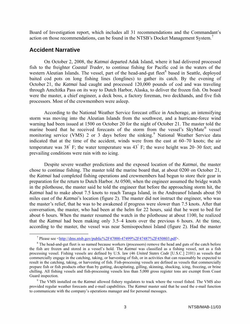
As modified, the Katmai had a main deck and two upper decks—a superstructure deck and a pilothouse (figure 3). The forward part of the superstructure deck contained crew quarters. The pilothouse contained three helm stations and various electronic and navigation equipment (VMS, radar, radios, sonar, GPS units, color plotter, computer and monitor, alarm panel, engine controls, compasses, and so forth). The steering system, according to survey reports, was electrohydraulic, consisting of hoses, valves, and two steering pumps driven by 5-horsepower motors. The aft superstructure deck was the fishing deck, where fishing operations were performed and fishing equipment was stored.
The main deck was divided into crew quarters, an enclosed fish-processing space, and a shelter deck. The fish-processing space held equipment such as plate freezers, chiller tank, sinks, conveyors, sorting machine, air-conditioning system, and refrigerator/freezer. A tube directed fish from the fishing deck into the processing space.27 Manually operated watertight doors allowed access forward to the crew accommodation area and galley and aft to the shelter deck. The shelter deck contained equipment and fishing gear. A watertight door on the shelter deck led to the lazarette, which was accessible by ladder.
Five watertight transverse bulkheads below the main deck divided the hull into forward freshwater tanks, engineroom, freezer hold, fuel tanks, and lazarette. The freshwater tank in the forepeak had a 1,378 gallon capacity. Next to it was a storeroom and work area with a 2,703-gallon freshwater tank below it. The engineroom contained two Cummins model NT855 six-cylinder, 300-horsepower diesel propulsion engines that powered the vessel’s two propellers. Three diesel generators provided the ship’s power at 208 volts. Outboard of the engineroom were four wing tanks holding fuel oil, hydraulic oil, and lubrication oil. The freezer hold could be accessed through a hatch in the floor of the fish-processing space. The processed fish was frozen, packed
25 “Lightweight” means a vessel’s displacement without cargo, fuel, lubricating oil, ballast water, fresh water
and feedwater in tanks, ice, consumable stores, fishing gear, and persons and their effects. 26 The Coast Guard does not have authority to inspect commercial fishing industry vessels. In the absence of
inspection authority, the Coast Guard has instituted an education and outreach program that includes voluntary dockside examinations to check safety equipment such as liferafts and fire extinguishers; the examinations do not address a vessel’s material condition or watertight integrity. Vessel operators are advised in writing of deficiencies, but no citations are issued. Vessels that successfully complete a voluntary dockside examination are issued an examination decal to be installed on a pilothouse window. The decals are not required by law to be displayed.
27 The investigation did not determine whether or how the tube could be closed from the sea.
11 NTSB/MAB-11/03
in bags that each contained 45 pounds of finished product, and stacked in the hold. The lazarette contained two hydraulic rams that positioned the rudders. The space also contained two refrigeration compressors and two hydraulic steering pumps as well as a portable dewatering pump.
Figure 3. Profile and internal spaces of Katmai (top) and layout below main deck (bottom). Drawing based on illustration in vessel’s 1996 stability report, recent vessel photographs, and testimony before marine board.
Stability
Marine Safety Center Analysis
The Coast Guard Marine Safety Center (MSC) in Washington, D.C., investigated possible accident scenarios by reviewing witness testimony, the Katmai’s 1996 stability report, and vessel drawings. In addition, the MSC assessed the vessel’s stability against the standards at 46 CFR,
12 NTSB/MAB-11/03

Subchapter C (uninspected vessels), Part 28 (requirements for commercial fishing industry vessels), Subpart E (stability). Although those standards are not strictly applicable because they apply only to commercial fishing vessels longer than 79 feet (46 CFR 28.500), as listed on their certificates of documentation (46 CFR 28.50), the regulations at 46 CFR have been used by the MSC as a reasonable standard for post-casualty stability reviews for small fishing vessels similar to the Katmai.
The MSC found that the Katmai’s 1996 stability report generally met the requirements of 46 CFR 28.530 for providing guidance to the Katmai master. The MSC reviewed the 11 loading conditions in the stability report and the vessel’s estimated condition before the sinking and found that several loading conditions did not meet the intact stability28 standards at 46 CFR 28.575 for severe wind and roll. None of the conditions examined met the damage stability29 standards at 46 CFR 28.580, primarily because of a lack of watertight subdivision in the processing space.
The MSC’s model selected as the vessel’s downflooding points (the lowest external openings that could not be closed watertight) an engineroom air vent next to the entrance to the crew’s quarters and the fish tube that led from the fishing deck to the processing space. Although a surviving crewmember testified that the aft watertight door into the processing space was left open, the MSC did not treat that as a downflooding point because the door should have been kept closed during normal operations. The MSC modeling analysis concluded that the Katmai would not have remained afloat in the event of uncontrolled flooding into the processing space, whether through the aft watertight door or through downflooding from the fish tube opening in the overhead of the processing space.
The MSC noted that the 1996 stability report contained loading guidance but did not specify the limits of frozen cargo that could be carried on the Katmai. The MSC concluded that an operator might, therefore, have assumed that the cargo hold could be completely filled. According to the stability report, the maximum weight of frozen cargo evaluated in developing the stability report was 60,000 pounds (26.79 long tons). As was noted earlier, the master said that the vessel had about 120,000 pounds (53.57 long tons) of frozen cargo on board at the time of the accident, about 27 long tons more than the maximum load addressed in the stability report. A Katmai crewmember who worked in the processing space said the frozen fish were packed in cases weighing about 45 pounds, which were then stored in the fish hold. About 2,600 cases of frozen fish were on board when the Katmai sank. Based on the location of the fish hold and the load carried, the MSC concluded that the vessel had more aft trim than any condition evaluated in the Katmai’s stability report and that in calm water, this loading would have provided a minimum freeboard30 of only 4 inches slightly aft of amidships.
MSC calculations also showed that the vessel had undersized drainage of the exposed deck, as compared with the criteria at 46 CFR 28.555. The marine board concluded that the Katmai had only about 1.6 square feet (240 square inches) of freeing ports (openings in the
28 Intact stability is a naval architecture term referring to how an intact, or undamaged, vessel will respond when heeled over in calm conditions.
29 Damage stability is an assessment of the effects of opening various combinations of watertight compartments to the sea.
30 Freeboard is the vertical distance from the waterline to the uppermost continuous watertight deck.
13 NTSB/MAB-11/03
bulwarks that allow water to drain off the decks). Based on the length (21 feet) of the shelter deck aft of the processing space, the Katmai should have had 10 square feet of freeing ports per side, or a total of 20 square feet (2,880 square inches). Having less than 10 percent of the freeing port to meet the criteria of 46 CFR 28.555 meant that water would accumulate on deck more readily, thereby degrading stability of the Katmai due to a) additional weight on deck, decreasing reserve buoyancy; b) shifting the longitudinal center of gravity aft, decreasing aft freeboard; and c) adding free surface which in effect raises the center of gravity.
A survivor stated that in severe weather, the shelter deck often became swamped with water that was sometimes waist-high. As noted earlier, a deckhand stated that before the Katmai sank, he overheard the master and chief engineer say that the aft (shelter) deck was under water and that water was entering the processing space. After loss of steering, the engineer reported that the watertight door to the lazarette was discovered open. The MSC reported that in the severe weather experienced before the sinking, it is reasonable to assume that waves were repeatedly breaking over the aft bulwarks and onto the Katmai’s shelter deck. Water collecting on the shelter deck would have drastically reduced the vessel’s stability; further, because the watertight door into the processing space was located there, the accumulating water would also have greatly increased the risk of flooding into the processing space had that door been left open. The Katmai’s reduced freeboard and aft trim would have further increased the potential that the vessel would take on water.
Voluntary Standards
Before Congress passed the Commercial Fishing Industry Vessel Safety Act of 1988 (Title 46 U.S.C., chapter 45), the Coast Guard published Navigation and Inspection Circular (NVIC)31 5-86,32 which recommends that vessel builders, marine surveyors, insurance underwriters, fishing vessel owners, operators, industry associations, and other interested parties adopt and implement voluntary vessel standards for U.S. uninspected commercial fishing vessels. NVIC 5-86 recommends that fishing vessel masters be provided with stability information so that they can easily assess whether a vessel is safely loaded. The NVIC also suggests providing precalculated loading conditions.
NVIC 5-86 and a Coast Guard-sponsored safety training video33 advocate providing vessel operators with the information necessary to help safely load their fishing vessels. They also emphasize the need to maintain up-to-date stability information when a vessel changes fishery and when weight is added or removed. An additional reminder was available to the owner and master of the Katmai to keep the stability information up to date in the “General Provisions” section of the Katmai’s August 1996 stability report, which states: “The stability report is to be updated when equipment is added, or the fishing operations are changed.” The Katmai’s stability
31 The Coast Guard uses NVICs to disseminate information and advisory material to the marine industry. Although the NVIC guidance is not enforceable, the industry usually makes an effort to comply with it. NVICs are sometimes used to disseminate information that will subsequently be proposed as regulations.
32 Voluntary Standards for U.S. Uninspected Commercial Fishing Vessels, NVIC 5-86 (Washington, DC: U.S. Department of Transportation, U.S. Coast Guard, 1986).
33 “Fishing Vessel Stability: Operational Practices,” video recording (Sitka, Alaska: University of Alaska Sea Grant Marine Advisory Program and Alaska Marine Safety Education Association, 2006).
14 NTSB/MAB-11/03

report was not up to date at the time of the accident; the vessel had undergone structural and fishing equipment changes since it was originally built as a Gulf of Mexico shrimp trawler in 1987.
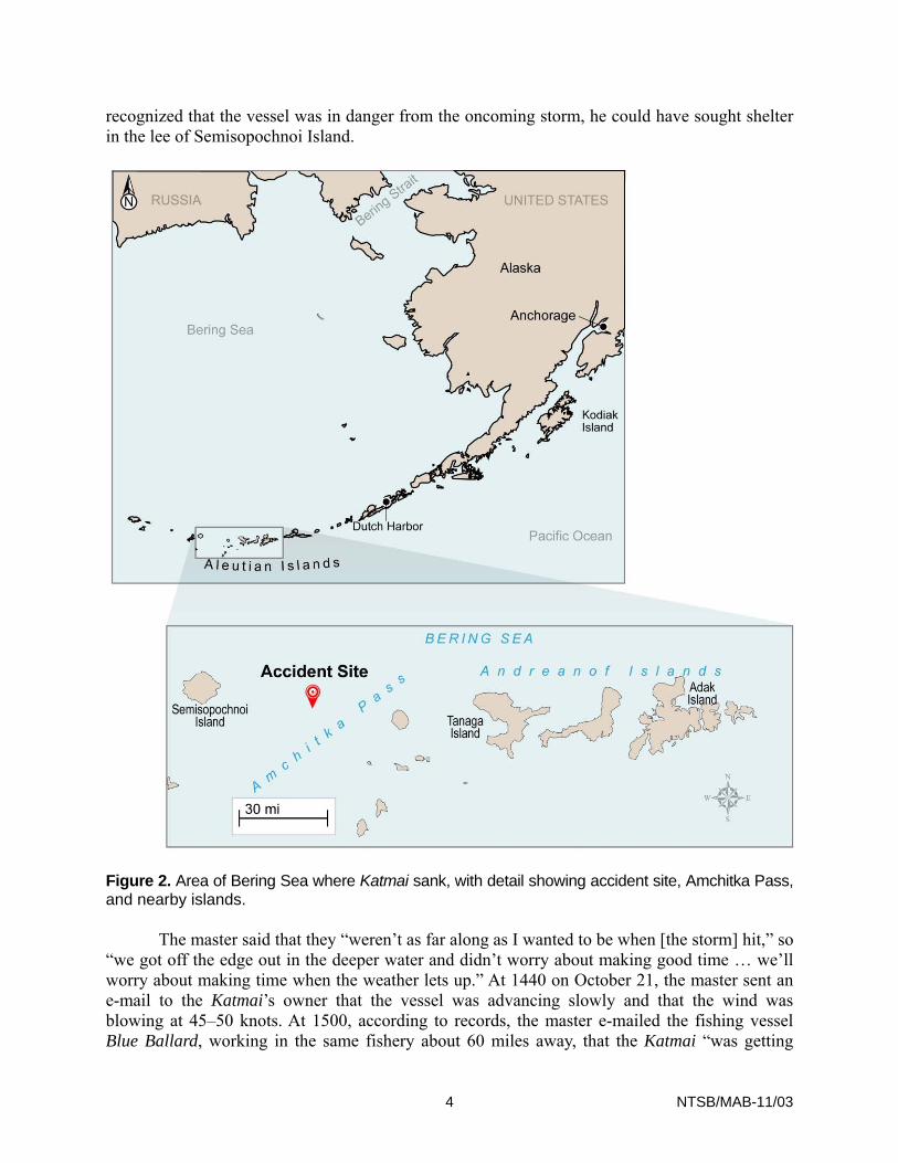
Stability analyses of the Katmai were conducted in October 1993 and July 1996 after the processing space and new pilothouse, respectively, were added. The Katmai’s latest stability report did not account for modifications made in 1998 or thereafter and did not account for the change in fishery from shrimp to Pacific cod. For instance, the stability report for the Katmai should have accounted for the weight of the cod pots kept on the fishing deck (figure 4). Testimony indicated that 420–450 cod pots were on the deck, weighing 37–43 pounds each. That, and other weight changes, meant that the precalculated loading conditions described in NVIC 5-86 and provided in the stability report for the Katmai master’s use were inaccurate and therefore should not have been used. The wind profile of the cod pots should also have been accounted for in the stability report, as it increased the area subject to beam winds, necessitating an additional measure of stability. Ultimately, this additional sail area would likely have reduced the maximum cargo load allowed. The postaccident stability assessment conducted by the MSC showed that—with the wind area for the cod pots included—the Katmai did not meet the severe wind and roll stability criteria of 46 CFR 28.575 in all loading conditions described in the stability report.
Figure 4. Cod pots on Katmai’s fishing deck, looking aft (Katmai Fisheries, Inc., photograph).
NVIC 5-86 addresses the risks of water on deck, especially for smaller vessels. It points out that water on deck contributes to added displacement, increases the height of the vertical
15 NTSB/MAB-11/03

center of gravity, adds free surface effect, and may increase roll angles. NVIC 5-86 further states that smaller vessels with low freeboard, such as the Katmai, perform worse in severe weather and face a higher probability of flooding when water is trapped on deck. Although the guidance in NVIC 5-86 would have required a total freeing port area of about 2,880 square inches, the Katmai had an effective freeing port area of 240–360 square inches, according to the MSC report.
would have been enlarged, making it less likely that water would accumulate on the shelter deck.
i resulted in decreased stability, which was even more critical in light of the severe weather.
Stability Standards
to-date stability information is unimportant for vessels less than 79 feet long, such as the Katmai.
The company that owned the Katmai was responsible for ensuring that appropriate stability guidance was provided to the master and that the master understood the guidance along with any other recommended or prohibited practices, such as maintaining watertight integrity. It was also the owner’s responsibility to ensure that the vessel construction was in keeping with the best guidance available, NVIC 5-86. Had the owner done this, the freeing ports
It was also the master’s responsibility to review the stability information provided and ensure that he understood it completely. Had he done so, he would have noted that the information was not up to date. If the master had reviewed the provided loading conditions, he would have noted that loading cargo in excess of 60,000 pounds was not addressed. Overloading the Katma
No mandatory stability standards applied to the Katmai. The Commercial Fishing Industry Vessel Safety Act of 1988, at 46 U.S.C. 4502(d)(1), required that the Coast Guard develop regulations for the operational stability of vessels either built after December 31, 1989, or substantially altered after December 31, 1989, in a manner affecting their operational stability. As a result, regulations were issued in 1991, at 56 Federal Register (FR) 40393 (August 14, 1991), for vessels 79 feet or longer.34 At that time, the Coast Guard indicated that it would later establish stability standards for smaller vessels. However, in the 19 years since then, no such standards have been issued. This lack of standards may lead owners to infer that up-
The 1988 act established the Commercial Fishing Industry Vessel Safety Advisory Committee (CFIVSAC), consisting of industry representatives, which advises the Coast Guard on the safe operation of vessels, including matters relating to navigation safety; safety equipment and procedures; marine insurance; vessel design, construction, maintenance, and operation; and personnel qualifications and training.35 In 1995, the CFIVSAC formed a Stability Subcommittee, which developed recommended stability standards for commercial fishing vessels less than 79 feet long. In 2003, the Coast Guard started a rulemaking project to establish stability standards applicable to vessels less than 79 feet; and, in March 2008, the Coast Guard published an Advance Notice of Proposed Rulemaking (ANPRM), at 73 FR 16815 (March 31, 2008),
34 Refers to the length noted on a vessel’s certificate of documentation or certificate of number, which differs
from the vessel’s overall length (46 CFR 28.50). 35 Renamed the Commercial Fishing Safety Advisory Committee in 2010 (46 U.S.C. 4508).
16 NTSB/MAB-11/03

indicati
stability information following major modification or when fishing operations changed. The
t agreed with the intent of the recommendation and stated that the issue was being project on commercial fishing vessel safety.
ity to require licenses for masters of commercial fishing industry vessels over 30 feet in length. The Commandant concurred with the intent o
chitect. Had the CFIVSAC recommendation for stability training been adopted by the Coast Guard and applied to vessels less tha
mmended that the Coast Guard seek authority to require vessel masters and owners to receive stability training. The Commandant concurred but stated the belief that aut
tion, navigation, fire fighting and
ng its intention to develop stability standards for such vessels; however, the ANPRM did not propose any stability standards.
The marine board recommended requiring fishing vessel owners to revise
Commandanconsidered as part of an ongoing regulatory
Training
The Commercial Fishing Industry Vessel Safety Act of 1988 does not require the training or licensing of crewmembers in any of the areas addressed in the statute. Unlike inspected vessels in commercial service, licensing is required only for the largest uninspected fishing industry vessels. Vessels over 200 gross register tons are subject to 46 U.S.C. 8304, implementing “The Officers’ Competency Certificates Convention, 1936.” The convention requires those serving as master, mate, or engineering watchstander to be licensed officers. No requirement exists for crew size or complement or for training or qualification of crewmembers on uninspected fishing industry vessels, other than the training required to obtain officer licenses; officers account for only a small minority of persons engaged in commercial fishing. The marine board recommended that the Coast Guard seek author
f this recommendation and noted past unsuccessful attempts to receive this authority. The Commandant is considering ways to readdress the issue.
The 1988 act required the development of standards for operating stability but was silent on requirements, in 46 U.S.C. 4502(d)(1), that those in the fishing industry have the requisite background to understand the risks of improper loading and lack of watertight integrity or to understand how to interpret and use stability information. In 2005, the CFIVSAC recommended that the Coast Guard establish a three-tiered stability training requirement for both vessel masters and owners addressing the following: (1) basic stability terms and concepts, (2) specific stability risks associated with an identified fishery, and (3) vessel-specific training that would include the master’s review of the vessel’s stability information with a naval ar
n 79 feet in length, both the Katmai master and the owner would have had a much better understanding of the importance of stability and watertight integrity.
The marine board reco
hority already existed for such required training and that the issue would be addressed in an ongoing regulatory project.
Subsequent to publication of the marine board report, the Coast Guard Authorization Act of 2010 (Public Law 111-281), signed by the president in October 2010, addresses the issue of stability familiarity, in 46 U.S.C. 4502(g)(1), by requiring that the Coast Guard develop regulations for training individuals in charge of operating commercial fishing vessels. Such training must address seamanship, stability, collision preven
17 NTSB/MAB-11/03

prevention, damage controlweather. As of June 2011, the Coast Guard
, personal survival, emergency medical care, emergency drills, and had not announced any rulemaking initiatives in
respons
y can be compromised by deterioration of the hull and exposed decks (the watertight envelope), hull and deck openings (doors,
sels. New vessels over 79 feet long must obtain load line certificates, requiring an annual survey to verify the condition of the hull an
were open. The marine board also recommended that guidance be developed on proper maintenance of
s. The Commandant concurred with the intent of these recommendations and ould be considered in an ongoing regulatory project and that a “lessons
learned
e to its new authority to develop training regulations.
Watertight Integrity
Watertight integrity is a vessel’s resistance to the introduction of unwanted water into the hull, and control of fluids within the hull. Vessel designs maximize watertight integrity by locating the hull openings so as to minimize water entry and also by providing a means for needed openings to be properly closed. Watertight integrity also concerns restricting the movement of unintentional water within the vessel using watertight bulkheads and decks, high-water alarms, and bilge dewatering systems. A vessel’s watertight integrit
hatches, and ventilators), and internal watertight bulkheads. In addition, watertight integrity can be compromised by crewmembers who do not properly close openings to maintain the watertight integrity of internal spaces or the watertight envelope.
On the Katmai, the deck boss reported to the marine board that the watertight door to the processing space was physically deficient because light could be seen through the door when closed. In his testimony to the marine board, the master stated that the engineer reported that the door to the lazarette was open when he investigated loss of steering. The watertight door to the fish processing space was also discovered open after loss of steering. Watertight doors that are open or ineffective can allow water to enter the vessel and, depending on the internal integrity of decks and bulkheads, lead to progressive flooding. The Coast Guard Authorization Act of 2010 institutes new requirements concerning the watertight integrity of ves
d openings. Vessels less than 79 feet long must be examined every 2 years to verify the physical condition of the hull, openings, and internal structure. At this time, it is unknown how or when the Coast Guard will implement this new statutory authority.
The marine board recommended installation of devices to indicate the position of watertight doors and alarms that would provide visual and audible notification when the doors were open. Such alarms, if they had been installed on the Katmai, would have allowed the master to realize that the watertight doors to the lazarette and the processing space
watertight doorstated that the issues w
” document would include guidance on maintenance of watertight doors.
18 NTSB/MAB-11/03

Inspe
to the Coast G
classified Safety Recommendation M-87-64 “Closed—Acceptable Alternate Action” on the grounds that the Coast G
l for improving safety in the fishing industry and reducing loss of life and that, under a Coast Guard inspect sign, constru riodic
ction
In its 1987 safety study,36 the NTSB made the following safety recommendation uard:
Seek legislative authority to require that all uninspected commercial fishing vessels be certified and periodically inspected by the Coast Guard or its recognized representative to ensure that the vessels meet all applicable federal safety standards. (M-87-64)
The NTSB has reiterated the recommendation four times, as a result of its investigations of a series of fatal accidents from 1987–1991 involving uninspected vessels in the Alaska fishing fleet.37 In November 1992, the Coast Guard, stating that “the material condition of the vessel and equipment was a direct cause for over 85 percent of the known vessel-related casualties,” submitted a plan to Congress to require the inspection of all federally documented commercial fishing industry vessels.38 The plan recommended a risk-based inspection program dependent on a vessel’s length rather than on whether it was defined as a fishing vessel, fish processing vessel, or fish tender vessel. Congress subsequently did not grant legislative authority to the Coast Guard for its proposed inspection plan. On August 20, 1993, the NTSB
uard’s submittal of the plan had fulfilled the intent of the recommendation. The NTSB noted that it considered the Coast Guard’s action “an important first step” toward improving commercial fishing vessel safety and further, that “an effective validation or oversight program is the only way to ensure that fishing vessels meet the intended safety standards.”
As a result of its investigation into the 2008 sinking of the fish processing vessel Alaska Ranger,39 the NTSB reexamined the safety history of uninspected commercial fishing vessels. The NTSB noted in its investigation report that mandatory inspections are essentia
ion regime, fishing industry vessels could be subject to requirements for dection, machinery, safety equipment, and stability; receive initial and pe
ninspected Commercial Fishing Vessel Safety, Safety Study NTSB/SS-87/02 (Washington, DC:36 U National
Transportation Safety Board, 1987). 37 (a) Capsizing and Sinking of the U.S. Fishing Vessel Uyak II in the Gulf of Alaska Near Kodiak Island,
Alaska, November 5, 1987, Marine Accident Report NTSB/MAR-88/08 (Washington, DC: National Transportation Safety Board, 1988). (b) Sinking of the U.S. Fishing Vessel Wayward Wind in the Gulf of Alaska, Kodiak Island, Alaska, January 18, 1988, Marine Accident Report NTSB/MAR-89/01 (Washington, DC: National Transportation Safety Board, 1989). (c) Capsizing and Sinking of the Fish Processing Vessel Aleutian Enterprise in the Bering Sea, March 22, 1990, Marine Accident Report NTSB/MAR-92/03 (Washington, DC: National Transportation Safety Board, 1992). (d) Capsizing and Sinking of the U.S. Fishing Vessel Sea King Near Astoria, Oregon, January 11, 1991, Marine Accident Report NTSB/MAR-92/05 (Washington, DC: National Transportation Safety Board, 1992).
38 See Report to Congress for the Inspection of Commercial Fishing Industry Vessels (Washington, DC: U.S. Coast Guard, November 12, 1992), p. 5. The recommendations in this plan were required by the Commercial Fishing Industry Vessel Safety Act of 1988.
39 Sinking of U.S. Fish Processing Vessel Alaska Ranger, Bering Sea, March 23, 2008, Marine Accident Report NTSB/MAR-09/05 (Washington, DC: National Transportation Safety Board, 2009).
19 NTSB/MAB-11/03

examin of the Alaska
ecommendation in December 2009, stating,
fforts to gain this necessary authority.
did not adopt the Coast Guard’s recommendation to reclassify commercial fishing industry vessels as “inspected,” as requested in the inspection plan submitted 18 yea
ed concern for safety within the commercial fishing industry and because commercial fishing was categorized by the U.S. Department of Labor,
Statistics, as the most dangerous occupation in America for 2007, 2008, and orum in Washington, DC, on October 13 and 14, 2010, to
exam
Background
The International Maritime Organization (IMO) developed international standards for safe ship management in the 1980s, following a number of serious marine casualties caused by
ations; and not be modified without prior approval. As a result of its investigation Ranger sinking, the NTSB made the following recommendation to the Coast Guard:
Seek legislative authority to require that all commercial fishing vessels be inspected and certificated by the Coast Guard to ensure that the vessels provide an appropriate level of safety to those on board. (M-09-10)
The Coast Guard responded to this r
We concur with this recommendation. We believe that inspection and certification of commercial fishing industry vessels would improve the level of safety of the vessels and to those who work on them. We have long sought the legislative authority to bring fishing vessels under an inspection regime. In one of our more comprehensive attempts, we requested the authority to implement an inspection and certification scheme for commercial fishing vessels based on a 1992 Report to Congress for the Inspection of Commercial Fishing Industry Vessels. That request, as with several others preceding it, was not granted.
Consequently, the NTSB classified Safety Recommendation M-09-10 “Open—Acceptable Response” and encouraged the Coast Guard to continue its e
Although Congress
rs ago, the Coast Guard Authorization Act of 2010 requires mandatory dockside examination of fishing vessels that operate more than 3 miles from the coastline. This requirement falls short of the Coast Guard’s 1992 inspection plan recommendations because, under 46 U.S.C. 3302(b), commercial fishing industry vessels are still exempt from inspection requirements, which would include requirements for machinery, electrical systems, licensing of crewmembers, and minimum complement, among others.
NTSB Safety Forum
Because of the NTSB’s continu
Bureau of Labor2009, the NTSB held a public f
ine issues related to commercial fishing industry safety. The forum addressed the history of safety issues and regulations, vessel-related safety issues, resource management influences on safety, lifesaving equipment, and training. Information gathered during this forum will assist the NTSB in developing future recommendations.
Safety Management Systems
20 NTSB/MAB-11/03

human or organizational errors. The IMO standards led to development of the International Safety Management (ISM) code, the purpose of which is “to provide an international standard for the safe management and operation of ships and for pollution prevention” and to establish safety management systems (SMS) for individual vessels. The ISM code was adopted in 1993; in 1998, it became mandatory for passenger ships, tankers, and high-speed craft under chapter IX of the International Convention for Safety of Life at Sea (SOLAS).40 The ISM code was
w in 1996 and required by Coast Guard implementing regulations (33 CFR Part 96), which became effective in January 1998. Vessels in U.S. domestic service, includi herefore are not required to have SMS.
SM
tion and a safe working environment on board the type of vessel for which the system is developed.
le regulations.
certified. As of December 2009, 364 U.S. domestic vessels are registered in the voluntary program, none of
operators who wish to voluntarily implement an SMS, the
tal protection in compliance with relevant international and flag state
d amongst shore and shipboard personnel,
incorporated into U.S. la
ng commercial fishing industry vessels, are not subject to SOLAS and t41
S Requirements
According to 33 CFR 96.230, an SMS should accomplish the following:
• Establish practices that ensure safe vessel opera
• Establish and implement safeguards against identified risks. • Continuously improve safety management skills of personnel ashore and aboard
vessels, to include preparing for safety and environmental protection emergencies. • Ensure compliance with applicab
Operators of vessels not required to comply with the ISM code, such as the owners of the Katmai, can voluntarily meet the standards and have their SMSs 42
which are involved in commercial fishing.
In its NVIC guidance to vessel Coast Guard states that the following requirements should be documented:
• Procedures and related instructions for ensuring the safe operation of ships and environmenlegislation,
• Defined levels of authority and lines of communication between an
• Procedures for reporting accidents and nonconformities within the provisions of the ISM code,
• Procedures for preparing and responding to emergencies, and
40 SOLAS is an international treaty addressing the safety of passenger vessels and commercial ships over 500 gross tons (according to the International Tonnage Convention) on international voyages. The first version of the treaty was adopted in 1914 in response to the sinking of RMS Titanic.
41 U.S.-registered vessels that engage in foreign voyages are, however, required to meet the requirements at 33 CFR Part 96.
42 Guidance Regarding Voluntary Compliance with the International Management Code for the Safe Operation of Ships and for Pollution Prevention (International Safety Management [ISM] Code), NVIC 5-99 (Washington, DC: U.S. Department of Transportation, U.S. Coast Guard, 1999).
21 NTSB/MAB-11/03
22 NTSB/MAB-11/03
d foreign, and in 2010 placed it on its Most Wanted List of Transportation Safety Improvements,
believes that all domestic vessel operators should develop, implement, and maintain a systematic and documented SMS to improve their safety practices and minimize risk.” With th
anual and the master had access to and applied it, issues relevant to the accident would have been brought to the master’s attention, including the vessel’s current
lescence and inaccuracy of stability reports and the master’s responsibility for understanding and following them; severe weather policy; emergency communication practice
progressive flooding and sinking. Contributing to the accident was the master’s decision to continue fishing operations during the approach of severe weather rather
an seeking shelter and to load twice the amount of cargo addressed in the vessel’s stability report. Also contributing to the accident was the owner’s failure to ensure that the stability
ter was current and that the master understood it and operated the vessel accordingly.
Adopted: September 13, 2011
• Procedures for conducting internal audits and management reviews.
The NTSB has long supported the adoption of SMSs on board ships, both domestic an
saying, “The NTSB
e NTSB’s adoption of a new Most Wanted List in June 2011, SMS is one of 10 issues the NTSB intends to highlight in the coming year to raise public awareness and support for action.
Safety Policy
The Katmai did not operate under an SMS, nor was it required to. An SMS for the Katmai would have documented the vessel owner’s policies and operational and emergency procedures; specified the responsibilities of the owner or operator, manager, and master; and outlined procedures for reviews, audits, and correction of failures to adhere to procedures or regulations. Such procedures are compiled in a safety management manual and kept on board the vessel, with checklists supplied for critical areas. Had the owner of the Katmai developed a safety management m
configuration; the obso
s and protocols; crew training and documentation of that training; and the maintenance of watertight integrity.
Probable Cause
The National Transportation Safety Board determines that the probable cause of the sinking of the Katmai was the loss of the vessel’s watertight integrity because watertight doors from the main deck to the processing space and the lazarette were left open by the crew at a time when the vessel was overloaded and navigating in severe weather, which allowed water to enter the vessel resulting in
th
information provided to the mas