Embed Size (px)
Citation preview

Commemorative publication 175 years swisstopo Commemorative publication 175 years swisstopo 2013
swisstopo – The Landscape Memory of Switzerland
swisstopo
where
knowing
Schweizerische EidgenossenschaftConfédération suisseConfederazione SvizzeraConfederaziun svizra
Swiss Confederation
Federal Office of Topography swisstopowww.swisstopo.ch

Aletsch Glacier/Konkordiaplatz
(Canton Valais): Relief shading from
the digital height model swissALTI3D
‘This commemorative publication will take you on a fascinating journey through time!’
Jean-Philippe Amstein, Director of the Federal Office of Topography swisstopo

Contents
Welcoming speech by Ueli Maurer, President of the Swiss Confederation
and Head of the Federal Department of Defence, Civil Protection and Sport DDPS 2
Introduction by Jean-Philippe Amstein, Director of the Federal Office of Topography swisstopo 3
Nation/state
Yesterday: Pioneer effort in turbulent times 15
Today: Switzerland has increased in size 16
Tomorrow: Bridging the gap to neighbors 18
City/living
Yesterday: The Office of Topography’s flying team 21
Today: Geoinformation is keeping up with the times 22
Tomorrow: Making the right decisions 24
Mountains/leisure
Yesterday: Ups and downs in the mountains 27
Today: Where humans and chamois meet 28
Tomorrow: The alpine region is changing 30
Glaciers/water
Yesterday: When the Ice Age reigned in Switzerland 33
Today: Water makes a difference – to the economy and the people 34
Tomorrow: When climate gets out of hand 36
Underground/resources
Yesterday: The heart of the Alps 39
Today: When rocks and minerals are worth their weight in gold 40
Tomorrow: The future is under ground 42
The Federal Office
Yesterday: Heading towards the digital age 44
Today: Good people work well 46
Tomorrow: swisstopo is on the move 48

2
Welcoming speech
Dear Readers
The birth of our Federal Office of Topography
was on January 1, 1838, when it was known as
the Swiss Topographic Bureau. At that time
Switzerland was not yet organized in its present
Confederation from 1848, thus making swisstopo
older than Switzerland – yet an inseparable
part of it. Before swisstopo was founded, a few
independent efforts were initiated by cantons,
notably Bern and Basel, which wanted to survey
their territories at their own expense. Little by
little the conviction grew that something in
that direction needed to be undertaken on the
national level. Even during those days, the
significance of an organization representing
the entire country was evident.
Being a division of armasuisse, the Federal
Office of Topography is also a part of the Federal
Department of Defence, Civil Protection and
Sport and fulfills military as well as civil tasks.
swisstopo is the competence center for
geoinformation in Switzerland. In my opinion,
experience, competence and quality are
characteristics that swisstopo may without any
doubt claim for itself. For 175 years now,
swisstopo has been the landscape memory of
Switzerland, documenting its topographic
development and carrying out surveys for various
applications, also in particular for national
defence. Then as well as today, swisstopo
produces maps and geodata for both military
and administrative purposes.
In the course of time, the assignments didn’t
decrease but increased instead. Unchanged is the
vital issue of safety – but also important is
the groundwork for spatial planning and
development, nature conservation and environ-
mental protection, sports and leisure activities,
resources and energy supply. The population
density is rising: more and more people live in our
country. They all have needs and expectations.
The products and services from swisstopo help us
find good solutions and meet those challenges
affecting all of us.
President of the Swiss Confederation
Ueli Maurer, Head of the Federal Department
of Defence, Civil Protection and Sport DDPS
‘In my opinion, experience,
competence and quality are
characteristics that swisstopo may
without any doubt claim for itself.’
‘Products and services
from swisstopo help
us find good solutions
and meet those
challenges affecting
all of us.’

3
Introduction
Yesterday, today, tomorrow
As Director of swisstopo since 2006, I am in
a sense standing at the helm of a vessel that has
been underway since 1838. During this time it
has not only seen a lot, but it has also successfully
steered into many a new port. We have and
still are reaping great acclaim from all sides. And
this is no coincidence: I am convinced that we
have earned this recognition because we do good
work and we treat each other respectfully –
employees, superiors, clients and partners. I am
proud to hold this office.
For this anniversary edition, both of my
predecessors and I met and talked about ‘the old
days’. We saw some things coming, others we
didn’t. Probably none of us ever imagined that
the Internet would become so vast and have
such an impact in this short period of time. The
pace of development in communications
technology still amazes us today. More than ever
swisstopo needs flexibility and the necessary
leeway, not only to fulfill its mandate, but also to
be successful in the market – especially in such
a dynamic environment.
Anniversary celebrations are popular occasions
for looking back and reviewing the past.
We will do the same on the following pages – but
we are going a step further: we will not only
remember the past, but also highlight the
present and the future. What challenges will
swisstopo face today? And what is waiting for us
tomorrow?
With this commemorative publication we
would like to show the enormous importance of
the function approaching swisstopo as the
‘landscape memory of Switzerland’. We want
to take you, Dear reader, on a fascinating journey
through time. We would like to express our
thanks to all who have contributed to our
accomplishments and who support us today so
that, also in the future, we can say: ‘swisstopo –
knowing where’.
Jean-Philippe Amstein
Director of the Federal Office of Topography
swisstopo
‘My predecessors and I recently
met and talked about ‘the old days’.
We saw some things coming,
others we didn’t. The pace of
development in communications
technology still amazes us today.’
‘You don’t receive
recognition without
reason, you earn it.
We do it with good
work and by treating
each other respect-
fully.’

4
Geoinformation from swisstopo this infrastructure. It is our job
is the reference and basis for to maintain it at the required quality
numerous decisions made by and at a reasonable cost, and
political organizations, the economy to sustain it for future generations.
as well as society and the scientific
community. Thanks to the foresight
of our previous generation,
Switzerland can today fall back on
Reference for the nation and society.

5
Ho
use
of
par
liam
ent,
Ber
n. N
atio
nal
Map
24
3, c
oo
rdin
ates
2 6
00
42
5 /
1 19
9 4
95

6
Planning for today and tomorrow and 3-D models can be used to
requires reliable information. document complex situations and
Surveying and geological data to actively shape the future.
describe the position, condition,
use and legal relationship of
our living space. Various products
derived from this geoinformation
such as aerial photographs, maps
Living space for today and tomorrow.

7
Bo
ule
vard
des
Ph
iloso
ph
es, G
enèv
e. N
atio
nal
Map
27
0, c
oo
rdin
ates
2 5
00
29
0 /
1 11
6 9
30

8
Because nature cannot protect professional and leisure activities
itself from mankind, mechanisms with both consideration and
are necessary to promote the respect.
co-existence of man and nature.
Thanks to digital and printed
geoinformation, we can relate to
our environment and approach
Co-existence of man and nature.

9
Rig
i Ku
lm, C
anto
n S
chw
yz. N
atio
nal
Map
23
5, c
oo
rdin
ates
2 6
79
52
1 / 1
212
27
3

10
Changes in our environment documenting it for posterity.
occur on a daily and subtle basis. We can now find out how it once
Sometimes they only become was – and how it might be some
evident when viewed from a day.
temporal distance. Being the
landscape memory of Switzerland,
swisstopo has been surveying
the landscape for 175 years and
Making the past and the future visible.

11
Mo
rter
atsc
h G
laci
er, C
anto
n o
f G
riso
ns.
Nat
ion
al M
ap 2
68
, co
ord
inat
es 2
791
68
0 /
1 14
5 0
05

12
Nature provides Switzerland with knowledge which can often only
raw materials above and under the be gained through the interpretation
ground. Moreover, the underground of geoinformation. Geodata from
of our country is increasingly swisstopo can for example also be
being used for traffic routes and used for establishing a solar cadaster
energy production. Exploiting or for exploiting hydro and
the underground, searching for geothermal energy.
and conserving resources requires
Exploiting and protecting resources.

13
Trem
ola
, Go
tth
ard
Pas
s, C
anto
n T
icin
o. N
atio
nal
Map
26
5, c
oo
rdin
ates
2 6
86
70
0 /
1 15
5 9
30

14
The rectified aerial photographs
SWISSIMAGE from swisstopo cover
the entire area of Switzerland
at a consistent quality. The heart of
Swiss politics is shown here: the
House of parliament.
‘Even in the digital world where everything must happen quickly, quality is still indispensable.’
Kathy Riklin, Dr. Sc. nat. ETH, member of the National Council

15
Nation/state – yesterday
Pioneer effort in turbulent times
Turbulent times prevailed in September 1832 when the
engineer Guillaume-Henri Dufour took over the Office of the
Quartermaster-General.
He had been named Chief of the General Staff
already the previous year. At that time Switzer-
land was not yet organized as a federal state.
The cantons formed a loose legislative assembly
called ‘Tagsatzung’ which met from time to time
and had commissioned trigono metric surveys
already a few years after the Helvetic Republic
was founded in 1798. These surveys should serve
as the premise for a map of the entire country
and make the represented geographic space
‘tangible’. The significance of maps for security
and military command had already been
recognized during the Napoleonic era. However,
financial means as well as clear leadership were
missing.
32 years of hard work
The newly named Quartermaster-General
Guillaume-Henri Dufour was also in charge of
producing the Swiss map – a project which would
occupy him for the next 32 years. Under his
supervision, the first nationwide network of
triangles, the survey network, was developed.
First of all, the length of one side had to be
known. This ‘baseline’ was surveyed in the
‘Grosses Moos’ between Walperswil and Sugiez.
It was 13 kilometers long, and by using angle
measurements was then transposed to the side
Chasseral – Rötifluh measuring 38 kilometers.
Just before the observations were finished in the
fall 1834, they ran out of funds and the
‘Tagsatzung’ refused to make further means
available. Two senior staff members then
contributed an advance of eight Louisdor from
their personal funds. As the story goes, some
of the employees even had to pawn their watches
to pay their way home!
All good things …
All the surveyors troubles and efforts were
finally crowned with success: Dufour founded
the ‘Federal Topographic Bureau’ which went
into production at the beginning of 1838.
Between 1845 and 1865, the Topographic Map
of Switzerland at the scale of 1:100,000 was
published. This so-called Dufour Map was the
first official work of maps representing all
of Switzerland. It was honored by numerous
international awards and established the
worldwide reputation of the Federal Office of
Topography.
The cost of a map
Did you know that a copper engraver’s
labor was used to calculate the cost of
the first Dufour maps in 1848 and
amounted to 6 or 7 Swiss francs? In
today’s terms, a single map would now
cost CHF 80! Several price reductions
were required over the years to make
the Dufour map affordable also for
the ordinary citizen. Now they can be
viewed free of charge with the
geoportal supported by the federal
administration and printed. Today, a
sheet of the National Map at the scale
of 1:100,000 – the successor of the
Dufour map – costs CHF 14.

16
Nation/state – today
Switzerland has increased in size
Switzerland’s national boundary is 1958.73 kilometers long
and is shared with five neighboring countries. Even though we are
in the midst of globalization, each nation must know the exact
course of its sovereign boundary.
The national boundary is at the same time
a cantonal, district, municipal and a private
property boundary. Therefore, the identification
for each type of boundary must be identical
in the cadastral survey. Boundaries that are clearly
defined by coordinates provide legal security
and guarantee the right of property – both for
the state as well as for private citizens.
New coordinates for Switzerland
The prerequisite for working with coordinates
is a geodetic reference frame into which the
coordinates can be adjusted. The reference frame
that has been used in Switzerland for the past
100 years is called LV03 and is based on control
points surveyed during that time. Today, however,
coordinates are determined with satellite-assisted
survey methods such as GPS (Global Positioning
System). Comparing the results from this
method to those from the national survey (LV)
from 1903, differences up to two meters can
occur. Therefore, swisstopo decided to modernize
Switzerland’s more than a century old reference
frame.
The new geodetic reference frame, called
LV95, was observed between 1989 and 1995
using satellite-assisted survey methods. It
provides a fundamental network that guarantees
the accuracy of position and height for all
of Switzerland to the centimeter. In fact, the
accuracy of the LV95 network is approx.
100 times greater than that of the LV03 network,
a precision that even allows the detection of
tectonic movements. Based on these new
coordinates, the area of Switzerland has increased
by 0.3 square kilometers.
The national boundary markers are monumented by swisstopo together with our
neighboring countries and are witnesses of the past and present, like the one on
the Monte Generoso (Canton Ticino).
7000 witnesses of history
Did you know that over 7000 markers line
the Swiss national boundary? They are regularly
controlled, maintained and renovated. Many
of these markers are minor historical monuments,
some of which date from the 16th century.
They constitute a part of our cultural heritage
and are witnesses of history.
17
The national boundaries are changing
There are other reasons why Switzerland
has become larger: watersheds often pass over
glaciers, and when these melt, the course of
national boundaries is also involved. When a new
chairlift was built to the Furggsattel in 2003
in Zermatt, the construction permit had to be
obtained from Italy since the top station was on
Italian territory. However, the top station now
lies on Swiss territory because the Theodul glacier
has in the meantime receded.
GPS observations in front of the Muttsee hut (Canton Glarus). Nation-wide, high-precision
GPS surveys can be carried out thanks to the new national surveying network LV95, the
permanently operated reference stations of the Automated GPS Network of Switzerland
(AGNES) and the positioning service swipos established and operated by swisstopo.
André Blattmann,
Commander-in-Chief of the Armed Forces
‘I primarily associate “swisstopo” with topo-
graphic maps. They are of paramount importance
to our jobs. It isn’t presumptuous to claim
that Switzerland makes the best maps. Being the
“landscape memory”, they so to speak store
our spatial knowledge and are a true and exact
representation of the topography. As far as maps
are concerned, quality is first and foremost –
and it has its price.
Especially important to the armed forces are of
course those maps specifically tailored to military
needs. We are also grateful to the domain
Military Cartography which provides us with the
geodata that we need. The time series of
settlement development indicate quite clearly
that the deployment of security forces and
especially the armed forces needs to be modified.
Should administrative data from the public
sector be accessible to anyone? Being liberal-
minded, I support the easy access to public
data – however, only if the security of Switzerland
and its institutions or its citizens is not
endangered.’

18
Nation/state – tomorrow
Bridging the gap to neighbors
After two years under construction, everyone was very pleased with the
inauguration festivities of the Hochrhein Bridge in mid-December 2004.
It connects the Swiss and German parts of the village Laufenburg.
Actually, the bridge had already been finished
much earlier, but it was unfortunately impassable:
the height of the access to the bridge on the
German side was calculated 54 centimeters too
low. The reason for this embarrassing mishap
was, among others, the fact that both countries
use different parameters for determining their
heights. The water level of the Mediterranean Sea
is the reference for Switzerland’s height system,
whereas Germany uses the North Sea for its
reference. This difference of 27 centimeters was
of course a known value, but regrettably the
responsible engineer used the opposite sign to
correct it. Therefore, the access on the German
side had to be raised by 54 centimeters to make
the bridge traversable.
Uniform coordinates on both sides of
the boundary
The case ‘Hochrhein Bridge’ clearly illustrates
what can happen when neighboring countries
use different reference systems for working
with geodata. Only their universal consistency will
guarantee that uniform data are used on both
sides of the boundary. This is also paramount for
the railway network, e.g. to ensure that the
different sections on both sides match exactly.
Switzerland lies in the center of Europe – an
‘island’ that really isn’t one, considering
the numerous connections to our neighbors.
Internationally compatible geodata are more
important today than ever, and this requires a
uniform reference frame for coordinates.
For this reason, the European Union introduced
the European Terrestrial Reference System 1989
(ETRS89). Practically all European countries
are in the process of adjusting their coordinates
to ETRS89, as is Switzerland through the
implementation of its reference frame LV95.
The Hochrhein Bridge in Laufenburg (Canton Aargau). With the help of internationally
uniform coordinates from the national survey, bridges connect across and even past
borders.
Geodetic instruments, …
Theodolite 1837 Levelling instrument
1865

19
INSPIRE: Switzerland is taking part – with
swisstopo as coordinating center
INSPIRE is an E.U. directive for establishing a
European geodata infrastructure. This will
primarily be implemented for supporting the
environmental policy in Europe. At the same time
it should facilitate future access to geodata:
geodata should be easily available (via Internet),
at a uniform standard and at minimal cost – or
even free of charge. Switzerland is not obliged to
participate in INSPIRE, however, the directive is
being applied in the interest of our own country,
for example in matters concerning environmental
protection. Therefore, swisstopo operates a
National Point of Contact for INSPIRE on the E.U.
level.
Geodata and privacy
Protecting the right to privacy has
not played a major role in processing
geodata up to now. Today, however,
‘geodata and privacy’ is a current topic
of discussion: localization services
using mobile communications and
satellite navigation systems are gaining
significance. Location-based services
can not only be used to find various
businesses such as hotels or other
service providers, but they can also be
used to determine the position of
certain persons. In many cases that
might be a blessing – and in others
maybe not. swisstopo adheres to the
federal data protection specifications
which guarantee the right to privacy
for its citizens.
… from the theodolite to permanent GPS stations
Theodolite 1930 Levelling instrument GPS receiver 1998 Tachymeter 2010 GPS antenna 2012
1965

20
The combination of a 2-D
national map with the data set
swissBuildings3D from the landscape
model provides unusual perspec-
tives. The data from swisstopo are
flexible and serve to visualize our
living space in various applications.
‘Geoinformation helps us to visualize our living space.’
Michèle Künzler, Council member of Canton Geneva, Department of Interior, Mobility and Environment

21
City/living – yesterday
The Office of Topography’s flying team
The first attempts at taking photographs for surveying purposes were
undertaken by the Office of Topography in 1913 from a balloon.
Since flying with aircraft was still in its infancy,
a military captive balloon from the Swiss balloon
company came into use, carrying an Austrian
test camera. For obvious reasons this vehicle was
soon nick-named the ‘federal or heavenly
sausage’. Despite an enormous investment of
time and personnel, these first efforts were not
very successful.
The Office of Topography has its own
flight crew
New attempts were initiated in 1922 with aircraft
from the Swiss flight squad which was called
into life during the First World War. The results
were satisfactory and thus the Federal Office
of Topography decided to engage its own
permanent flight crew. The first aircraft flew more
than 1000 hours in over 800 flights, and the
operators were able to collect thousands of aerial
photographs to revise the Siegfried Map and to
create the new National Map Series.
Those magnificent topographers and
their flying machines
The Office of Topography acquired its first
airplane in 1935. The Messerschmitt BFW-M-18d
was built under license at the Federal Construc-
tion Plant in Thun at the cost of CHF 90,000.
It was equipped with respect to the wishes of the
survey pilots and was considered as one of
the most modern surveying aircraft of its time.
The Messerschmitt proved worthwhile and
worked optimally until it was retired from service
at the end of 1949.
Accomplishments and tragedies
The ensuing developments brought not only
more sophisticated surveying methods, but also
increasing demands on the aircraft. Tragedies
were regrettably unavoidable: over the years, a
number accidents cost the lives of pilots and
crew members. Indeed, on February 19, 1952, one
of the three Beechcraft C-45 of the Office of
Topography shattered on the flanks of the
Galmihorn and all four passengers lost their lives.
On July 24, 1957 the Cadastral Survey – which
at that time ran its own flight service – was also
struck by a tragic accident. An unsuccessful
emergency landing cost the life of the camera
operator, and both the pilot and technician
suffered injuries. In 1954 this independent flight
service was abolished and its function delegated
to the Swiss Air Force. This decision was worth it:
up until the present day swisstopo aircraft are
flown by airforce pilots.
The first observation
aircraft was a ‘Zepp’ which had an opening
in the floor for making
vertical photographs.
The oblique photo-
graphs were taken
by leaning overboard
the aircraft with a
hand-held camera.

22
City/living – today
Geoinformation is keeping up with the times
The Swiss federal geodata portal www.geo.admin.ch was launched
in 2010. It provides public access to a wealth of geoinformation from
the most important walks of life.
For the first time the federal administration
used the so-called ‘cloud computing’ technology
for realizing this project. The application and
data are no longer stored in a local or in-house
server but literally in a cloud in the Internet.
swisstopo had a pioneering role in the application
of this breakthrough technology, clearing the
path for other federal offices in using this modern
method.
Geodata have become mobile
Today, many people want to be able to use
geodata en route, that is, on mobile end devices.
Their numbers are increasing: already at the end
of 2014 there could be more web surfers using
mobile devices than conventional equipment.
Geodata can be used on smart phones and
tablets with the mobile versions of ‘Swiss Map
Mobile’ and ‘mobile.map.geo.admin.ch’.
Making decisions based on geoinformation
The geoportal is popular: more than 20,000 hits
are registered daily for the map viewer alone.
It can be used to view, print and download
geodata for further applications. Besides data for
leisure activities and hiking maps, information
such as contaminated waste sites, hazard maps
and cadastral maps are in great demand
when dealing with real estate and property
ownership. This is not surprising when taking into
consideration that 80% of all decisions we
make are of a spatial nature and have something
to do with geoinformation.
Expanding reality with
geoinformation helps
to orient oneself,
as shown here in a
mobile application.

23
Looking at the future with information
from the past
Geodata serve as the basis for sustainable urban
planning and for promoting rural and urban
areas. They are indispensable for spatial and
landscape planning, for optimal land use and for
developing mobility concepts. Documenting
past developments such as various aspects of
urbanization and overdevelopment is fundamen-
tal for drawing conclusions concerning the
future advancement of our living space and
environment. Based on known values and givens,
we can show what a specific region might look
like some day. In its function as the ‘landscape
memory’ of Switzerland, swisstopo is document-
ing these developments as a time series. The
result is an animated illustration – in the form of
maps from different epochs – showing how
Switzerland has changed in the course of time.
Knowing what’s allowed
Together with the cantons, swisstopo is
compiling the most important restrictions that
apply to land ownership (PLR cadastre).
Switzerland is one of the first countries to provide
the public with a systematically built up
PLR- cadastre that is also easy to understand.
Information from different sources is collected
and centrally published.
Michèle Künzler, Council member of
Canton Geneva, Department of Interior,
Mobility and Environment
‘Already today geoinformation plays a major
role in making a host of decisions, an interaction
that will continue to grow. In order to make
the right decisions, we have to understand what
we are talking about – and this holds true not
only for specialists but for laypersons as well.
Uniform and high-quality data are just as
important as an open architecture and universal
interfaces. Anyone should be able to access
data and work with them, even if they are not
specialists. User interfaces and functionalities
must be user-friendly and compatible with mobile
technologies.
I see the development of our biosphere and
its continual change as a kind of stream – it isn’t
static. We can not only use geoinformation to
localize particular points or places, it also
allows us to visualize movement – for instance
for innovative traffic and mobility concepts.
The constructive and seminal collaboration of
our administration with swisstopo has enjoyed a
long tradition in Geneva. We will continue to
tackle and master future challenges together.’

24
City/living – tomorrow
Making the right decisions
The increasing demand for geodata and its availability is posing new
challenges for swisstopo. The amount of data as well as the number of
sources is growing.
More and more data is being used more often
and more intensively – not only by specialists
familiar with geoinformation systems, but also by
people from other walks of life as well as by
private users. Consequently, the importance of
user-friendliness is gaining ground: representa-
tions and visualizations of data and their
applications have to be easy to handle.
Conflict between ‘public service’ and
operating efficiency
The trend is clear: in the future, more data will
be used through direct services rather than data
carriers – more frequently and spontaneously
on mobile devices. Geodata from different
sources will be combined and networked. For
example, spatial planners can get an on-the-spot
idea of what a particular solution might look
like. Three-dimensional analyses will become
standard because most geographical information
systems are based on 3-D models. The develop-
ment of an official 3-D land ownership cadastre is
also being investigated.
The call for ‘open data’ is becoming louder:
Clients not only want to be able to look at
geodata, they want to use them for their own
applications – and if possible free of charge.
As a provider of geodata and geo-services,
swisstopo is caught in the conflict between
‘public service’ and economic cost, an issue
relating to customers, the office itself as well the
federal administration. How much should
good data and services cost? How should the
development of new products and the frequent
updates of existing data be financed? There
are many possibilities – but do they make sense
economically?
Consolidating the needs of man and
environment
The increasing use of geodata is directly
correlated with the development of our society:
an growing number of people exist on a limited
amount of space. We have to lay the foundations
to meet our needs in the fields of safety, living,
working, traffic and leisure. Together with
the cantons, swisstopo manages and coordinates
activities in cadastral surveying pertaining to
the legal guarantee of property ownership and its
detailed representation. Topics such as environ-
A selection of swisstopo surveying aircraft …
1913: 1924–1927: 1929–1936: 1935–1949: 1952–1957: 1967–1993:
Captive balloon Zepp LZ C-II BFW-M-18c BFW-M-18d Percival Prince Grand Commander
from the Military 680 FL
Airship Division

25
mental protection and the conservation of
natural resources are likewise dealt with. We
need sustainable spatial planning and mobility
concepts – and the knowledge of how our
living space is changing, for example through
climate change.
In order to make the right decisions, we have
to know what is where – above and below the
earth’s surface. Information can be obtained
from geodata and from topographic maps from
the last 175 years, available to the public at
swisstopo. Being the ‘landscape memory’ of
Switzerland, swisstopo is documenting the
past and establishing foundations for shaping the
future – including future generations.
Solar cadastre: knowing where the sun shines
Power supply in our increasingly ‘electrified’
society is one of the great challenges of our
times. Whereas the sources of fossil energy are
slowly drying up, the demand for renewable
energy is rising. To be able to use this potential,
one has to know where it is. The solar cadastre is
an inventory of all rooftops of a city, municipality
or region with respect to their potential for
producing heat and electricity from solar energy,
including solar radiation calculated by independ-
ent experts. Solar cadastres can be calculated
using the high-resolution surface model from
swisstopo or one of the 3-D city models. Other
factors such as the inclination and orientation of
roofs, shadows cast by other buildings, vegeta-
tion or surrounding terrain are also included in
this project.
The solar power plant and two wind turbines on Mont Soleil (Canton Bern) can be seen
on an aerial photograph from SWISSIMAGE.
since 1993:
Super King Air 350C
since 1976:
Twin Otter DHC-6-300

26
The challenging topography in
Switzerland can only really be
appreciated in the high-precision
height model swissALTI3D. In winter,
hikers should preferably orient
themselves by means of the routes
described in the Snowshoe and
Ski Tour maps.
‘In the Alpine region we encroach on an area of conflict between exploitation and protection. swisstopo helps us in finding solutions.’
Frank-Urs Müller, President of the Swiss Alpine Club SAC

27
Mountains/leisure – yesterday
Ups and downs in the mountains
Seen from a distance, our proud mountain peaks appear to
us as monuments of eternity. However, the figure indicating their
height above sea level is by no means carved in stone: snow, ice
and modern surveying methods lead to changes – sometimes
with consequences.
The height of the ‘Repère Pierre du Niton’ in
the port of Geneva, which serves as the ‘mother
of all height references in Switzerland’, was
redefined to 373.6 meters above sea level. This
value is still used as the reference for all heights
in Switzerland.
Switzerland is lowered by 3.26 meters
Already Dufour had adopted this boulder as the
reference height for his maps, however, with a
height of 376.86 meters. With the introduction of
a new height reference, Switzerland was
practically degraded by 3.26 meters – which had
consequences for many proud peaks who lost
their 3000-meter status.
Pizzo Centrale’s destiny
Pizzo Centrale, the highest peak in the Gotthard
Massif, was on record with a height of 3003
meters until the last edition of the Siegfried Map
in 1936. When the summit of Pizzo Centrale
was surveyed and determined as a new
trigonometric point in 1874, a 1.6-meter iron pipe
had been mounted in a pillar of stacked up rocks
(cairn) and its height was actually determined
to be 3004.6 meters. It was only thanks to this
circumstance that the Pizzo retained its
3000-meter status even after the ‘Repère Pierre
du Niton’ was redefined and all heights reduced
by 3.26 m. However, the glee didn’t last forever:
during a general maintenance inspection in
1984, the rock pillar was dismantled and the iron
pipe was replaced by a bronze bolt. This act
practically ‘decapitated’ the Pizzo Centrale and
from then on it was degraded to a ‘profane hill’
of merely 2999.2 meters.
The peak Mönch has grown
That mountains not only shrink but can actually
grow is illustrated by the Mönch: in 1935 its
height was determined to be 4099 meters. In
1993 new observations were carried out using
state-of-the-art aerial photogrammetry – and
lo and behold!: the result was 4107 meters,
which not only provoked heated discussions in
Grindelwald among the mountain guides but
also triggered international news coverage. And
the Office of Topography was also confronted
with the situation. In their free time, a group
of swisstopo employees climbed to the summit of
the Mönch at the end of August 1997 and
redetermined the height of the peak using GPS
technology. Their findings confirmed the new
height from 1993. The bottom line is: not only
snow and ice have altered the topographic height
of the Mönch, but also surveying techniques;
for decades the old height values had just been
copied.

28
Mountains/leisure – today
Where humans and chamois meet
Formerly cartography was instrumental mainly in the service of national
defense, in the meanwhile the tourist industry has greater demands as
to content, precision and up-to-dateness of the products.
Today, hardly anyone goes hiking or on a ski
or snow-shoe tour without serious preparation.
An up-to-date map – be it on paper or digital –
is a must.
Being mindful of fauna and flora
With the increasing exploitation of mountains
for leisure and sport, exact maps are becoming
more important also for other themes such as
nature and game conservation. Being in the
mountains today not only means looking out for
oneself, but also looking out for and respecting
fauna and flora. Snow-shoe hikers, for example,
can adapt perfectly to the gentle slopes in
forests or along the timber line. These sensitive
areas used to remain mostly undisturbed – along
with their inhabitants such as various types of
grouse and chamois.
Mountaineers and nature lovers are invading
these alpine areas where exploitation and
protection are in conflict: consideration is called
for. Therefore, all existing wildlife and nature
sanctuaries as well as protected zones are marked
in snow-shoe and ski tour maps. The Federal
Office for the Environment (FOEN) provides
swisstopo with the data to update the maps, and
these are compared to the most recent trail
guides in collaboration with mountain guides
from the Swiss Alpine Club (SAC).
Still a great team: cartography and alpinism
Speaking of the Swiss Alpine Club: there is
no getting around the SAC when talking about
surveying and mapping the Alps. Since its
founding in 1863, the SAC has been a key player
for swisstopo – and the teamwork is as close
as ever. The claim that the topographic survey of
the Alps was promoted through mountain
climbing is entirely justified, and seen from this
angle, there is definitely mutual interaction
between cartography and alpinism. Incidentally,
by far not all mountain guides or tourists are
equipped with electronic devices such as GPS:
the training program for mountain guides still
includes learning how to read maps – and it’s a
good idea to have both along. And by the way, a
printed maps works even without electricity.
A nation of hikers
According to a survey ‘Wandern in der
Schweiz 2008’ (Hiking in Switzerland
in 2008), at least a third of the
Swiss population hikes at least once in
a while. The possibilities are immense:
the Swiss hiking network consists
of a total of 62,000 km of marked
paths. The Hiking Maps from swisstopo
are still the most popular source of
information: 70% of the respondents
indicated that they used the maps.

29
Movement in the Alps
Did you know that the Alpine uplift has not
yet come to an end? Repeated observations of
the first order levelling network have shown
that the mountain ranges in the Alps are growing
by up to 1.5 millimeters a year with respect to
the Central Plateau. In addition, permanent GPS
observations on control points indicate that
Switzerland as a whole is being uplifted by
another millimeter with respect to the European
lowlands. The uplift is caused on the one hand
by the collision between the African and Eurasian
continental plates, and on the other hand by
long-term isostatic movements to compensate
decompression due to glacial melting and
erosion.
Frank-Urs Müller, Chief Justice of Canton
Solothurn, President of the Swiss Alpine Club
SAC
‘The changes in the Alps are a major issue
for the Swiss Alpine Club SAC. Glacial melting
has a direct impact on various routes and
consequently on maps and guides describing
these routes. The documentation of these
changes in the Alps as well as the quality and
up-to-dateness of the data are vital to us – they
are the key to safety. We have to know what is
where, not only for the safety of hikers and
climbers, but also in the interest of the environ-
ment – wildlife sanctuaries, for instance, come
to mind.
Should there be a charge for the data? I think
that they should be made public and accessible to
everyone free of charge. However, if third
parties use these data for their own applications
to earn money, they should cost something.
Quality has its price.
Being the landscape memory of Switzerland,
swisstopo documents our past as well as
the development of the habitat in which we live.
This not only has a nostalgic aspect for me:
it enables us to anticipate future developments
and adjust to changes.’
A carefully planned
and coordinated route
is essential in sensitive
regions, especially in
protected zones such
as here in Sörenberg
(Canton Lucerne).

30
Mountains/leisure – tomorrow
The alpine region is changing
The increasing exploitation of the alpine region also has an impact on
the demands of modern visualization and representation techniques.
With the aid of digital landscape and height
models, various applications and situations can
be visualized to create impressive and easily
comprehensible images. In planning infra-
structures for the tourist industry such as lifts or
buildings, architects and planners can use these
models to see how the objects can be incorporat-
ed in the landscape. The objects can be viewed
from all sides to obtain a better idea of what
the finished product will look like. This also
applies to structures used in energy production
such as wind turbines or dams.
This kind of spatial representation is important
not only for specialists, but also for the layman,
since not everyone who uses geodata for making
decisions is an engineer. Also politicians,
administrators, business people, and thousands
of nature lovers and recreational sports
enthusiasts benefit from these applications.
Particularly the graphic 3-D height models from
swisstopo are popular for calculating profiles or
slope inclinations.
Height models for (almost) any purpose
Representing the topography on a map
has always been a true challenge. Because of its
mountainous landscape, Switzerland has of
course been fertile ground for developing
innovative solutions for years. During the 1990s,
the digital height model DHM25 was derived
from the height information in the topographic
maps 1:25,000. The most recent generation
height model, swissALTI3D, was developed in the
year 2000 and is available for all of Switzerland
since 2013. Aerial laser scanning was used
to develop this newest model. For comparison:
whereas the mesh size for the DHM25 is a
full 25 meters, the one for swissALTI3D is only
2 meters.
Surface and height models describe the
three-dimensional form of the earth’s surface,
with or without vegetation or built-up areas.
Their range of application is wide: calculating
profiles, simulating avalanches, building relief
models, making visibility studies, site planning,
visualizing landscapes, etc. Three-dimensional
visualizations are derived from height models.
Examples are panoramas showing the view
from a selected point in Switzerland, or simulated
3-D flights through a particular area.
A 3-D visualization of the alpine foothills around Gruyères (Canton Fribourg) using
geodata from the Topographic Landscape Model swissTLM3D.

31
Knowing how it was – and how it might
once be
The future has already commenced. Today we
are talking about 4-D models which include the
dimension ‘time’: how did an area or situation
develop in the past? And what might happen
in the course of the next year or even decades?
In times of climate change, such questions
are crucial – for the tourist industry as well as for
nature conservation and disaster control. For,
if the environment is changing, man must adapt.
New standards for modernizing the
national survey
Since 2010, the Topographic Landscape Model
TLM is being developed in view of the long-term
and extensive modernization of the national
survey. It represents the landscape with all its
natural and artificial objects, in three dimensions
and at a very high resolution. This data is the
foundation for various digital applications, and at
the same time the basis for the newest genera-
tion of national topographic maps. The data
is derived to a large part automatically, assuring
that they are captured only once but can be used
repeatedly and efficiently.
A series of map titles documents the development in design and content
1950 1958 1980 1993 2014
First edition of the First edition of the National Map with National Map with Ski Tour Map is
National Map with National Map with Ski Routes on Syntosil Ski Routes is changed complemented with
Ski Routes Ski Routes with a (synthetic material) to Ski Tour Map snowshoe routes
blue title cover

32
New insights into the past, such
as the ice domes in the Upper Rhine
Valley (Canton of Grisons) on the
map of the last ice age maximum,
can be gained through interpreting
the current geological situation.
‘Just keep your eyes open, the past is visible.’
Christian Schlüchter, Prof. of Geology, in the ‘TagesAnzeiger’ from March 26, 2010

33
Glaciers/water – yesterday
When the Ice Age reigned in Switzerland
About 19,000 to 25,000 years ago, at the peak of the last ice age,
large parts of Switzerland were covered by hundreds of meters of ice.
At that time there were already people living
in Central Europe, also in Switzerland. Evidence
for this is the discovery of human bones in caves
in the Jura Mountains in the Canton of Basel-
Land, an area which was not iced over during the
last glacial period.
A new ice age map for Switzerland
Glacier research has provided answers to what
it might have looked like in Switzerland during
the last ice age. The first map of the glacial
period published in Switzerland was the so-called
Jäckli Map from the 1950s. This same map
was integrated in the Atlas of Switzerland as
Sheet No. 9. Since then, glacier research has won
some important new insights, primarily through
precise field surveys and new dating methods.
Therefore, swisstopo decided to publish a
new ice age map in collaboration with renowned
glaciologists. The GeoMap 500 entitled
‘Switzerland during the maximum of the last ice
age’ at the scale 1:500,000 appeared in 2009.
The secret of the ice domes
The most significant change with respect to the
previous map is the reconstruction of so-called
ice domes, mighty ice shells with a height of
up to 3000 meters above sea level, to the south
of the main Alpine ridge, in particular in the
Inn Valley, the Upper Rhine Valley, the uppermost
region of the Rhone Valley and in the Matter
Valley. When they were first discovered, there
was no explanation to their existence.
A comparison with today’s precipitation records
sheds more light on the subject: In contrast to
today’s predominant west to southwest wind
directions, pronounced Foehn winds in ancient
times brought enormous amounts of precipitation
from the Mediterranean region to the southern
side of the Alps and deposited it on their
southern flanks.
Based on the reconstruction of the extent of
glaciers, conclusions can be drawn regarding the
atmospheric circulation during the height of
the last ice age. This map is also a major
contribution to discussions about climate-related
environmental changes in the most recent history
of the earth.
Cartographic gags
Cartography is a fairly straight-forward
and rather sober occupation, which,
however, doesn’t mean that carto-
graphers don’t have a sense of humor.
An exceptional gag was the ‘fish’,
masterly engraved in a coordinate
cross near the shores of a marshy lake.
The camouflaged fish made it
through all of the proof-readings, but
finally got caught in the net of the next
update and had to be thrown out …

34
Glaciers/water – today
Water makes a difference – to the economy and the people
Did you know that 6% of Europe’s fresh water supply is found
in Switzerland?
This small country with its glaciers, rivers, streams
and lakes is Europe’s water reserve. The sources
of the Rhine, Rhone, Ticino and Inn Rivers are
all in the Alps from where they flow towards four
different oceans and seas. The Rheinfall in
Schaffhausen measuring 150 meters in width and
23 in height is Europe’s largest waterfall. There
are more than 1500 lakes in Switzerland, among
them the two largest ones, the Lake of Constance
and the Lake of Geneva, both of which we share
with our neighbors. The Lake of Geneva is in fact
the largest fresh water supply of the continent.
Dams under observation
Water is an important natural resource in
Switzerland and is of economic significance, not
only for the tourist industry and the water
supply but also for the production of electricity.
Currently, 56% of the water power goes into
the production of electricity. More than 200 dams
and barrages are under the supervision of the
confederacy. Just like tunnels and bridges, dams
have to be permanently monitored in order
to detect the slightest indication of slips and
subsidence, rock and ice displacements or
tectonic movements of the earth’s crust. swisstopo
is one of the institutions that carry out monitoring
as a part of its program of engineering surveys.
For these special surveys, engineers at the
Office of Topography developed classical geodetic
surveying methods at the beginning of the
20th century. During the 1990s, swisstopo once
again acted as a pioneer by ‘anchoring’
monitoring control points in geologically stable
areas using GPS (Global Positioning System)
surveying methods.
Safeguarding the supply of electricity
The data and results from swisstopo are not only
used for monitoring existing dams, they also
serve as a basis for constructing new ones.
‘Lagobianco’, ‘Linthal2015’ and ‘Nant de Drance’
are currently being built as subterranean pump
storage plants which will also guarantee
an optimal supply of power in the future.
About 4% of the hydroelectric power plants in
Switzerland are pump storage plants. Water is
pumped from a low-lying source up to a higher
artificial lake where it is stored for the production
of electricity. This is an ideal method for
compensating the supply and demand of the
electricity grid. Geodetic, topographic and
geological bases, reference data as well as models
are essential for both the planning and construct-
ing of these structures.
35
Water: a resource and a hazard
Water is a valuable resource, but it also carries
with it the potential hazard of flooding. For this
reason the water gauges of rivers and lakes
are permanently monitored. Relevant for these
observations carried out with levelling instru-
ments are the control points of the national
vertical control network of swisstopo. Using these
points as a reference for installing their staff
gauges, the Hydrology Division at the Federal
Office for the Environment (FOEN) can determine
all of the water gauges in Switzerland with an
accuracy of half a centimeter. An interesting
aside: levelling has been used since antiquity for
height determination and, despite GPS surveying
techniques, it remains unparalleled for determin-
ing relative precision.
Kathy Riklin, Dr. Sc. nat. ETH, member of the
National Council
‘When I think of “swisstopo”, the first thing that
comes to my mind is quality maps. I was already
confronted by these during school when we
learned to read maps for orienteering. Even today
I prefer a printed map. I place great value on
detailed accuracy, something I miss in products
from other suppliers because they are sometimes
fairly abstract. Even in the digital world, where
everything has to go fast and information has
to be available at all times and all places, quality is
still indispensable.
That’s why the high-quality data and products
from swisstopo are an important issue for me.
We depend on them for orienting ourselves on
mountain tours, for educational purposes at
schools, just as we need them in spatial planning,
for accurate ownership structures in real estate,
and of course for the national control survey
itself.
We can’t do without swisstopo. I wish that
our Federal Office of Topography will continue to
assert itself in the future, especially in view of
the conflicting interests of availability and quality,
expenses and earnings, service for the common
good and profitability.’
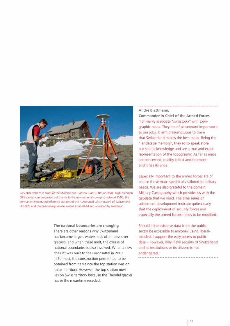
High-precision GPS observations in the three-dimensional control network for the
pump storage plant ‘Linthal2015’ (Canton Glarus).

36
Glaciers/water – tomorrow
When climate gets out of hand
The climate is changing – and Switzerland is also affected,
as temperature tables from the last century show.
The reason for climate change is the increase of
the greenhouse effect in the earth’s atmosphere,
and we humans are to blame. Year after year the
production of CO (carbon dioxide) has increased: ²in 2010 it was almost 32 billion tons worldwide.
Glaciers are shrinking
Climate change causes a rise in the earth’s
temperatures and an increase in heavy precipita-
tion. The rising temperatures are literally closing
in on glaciers: since 1850, at their peak level
of approx. 1600 km², the iced-over areas have
decreased by around 600 km². This means
that the total area has decreased by about a third
during the last 150 years. The Laboratory of
Hydraulics, Hydrology and Glaciology (VAW) at
the Federal Institute of Technology in Zurich
(ETHZ) compiles annual glacier monitoring from
geodata gathered by swisstopo on special
survey flights.
Geodata for prevention and damage control
Floods, storms, landslips, forest fires, and
snow and rock avalanches are the most prevalent
natural hazards in Switzerland. Climate change
has a direct influence on the extent and frequency
of extreme climatic incidents. Even though there
is no absolute safeguard against these, their risk
and damage potential can be reduced. swisstopo
provides data for compiling damage profiles,
forecasts and hazard maps, among others in the
form of digital terrain models, aerial photographs
and geological maps. With this information,
specialists can, for instance, combine the
potentially endangered landslide layers taken
from the Geological Atlas of Switzerland with the
slope inclinations from the Digital Height Model
DHM to obtain first indications for mapping
potentially hazardous landslips.
Safety – even tomorrow
A mountainous country such as Switzerland is
subjected to a multitude of natural hazards.
With data and products from swisstopo, risks can
be ascertained and their negative consequences
reduced, thereby ensuring sustainable spatial
development.
Interpreting the
past from the
present – the
development of
the map of the Manuscript map Separating valley Constructing Distinguishing Masking rock under
last ice age glacier and firn areas contour lines on between ‘thick’ ‘thick’ firn
the valley glacier and ‘thin’ firnmaximum

37
‘We don’t wait, we start!’
Should a natural disaster occur, fast and easy
access to the newest aerial photos right after the
incident is essential for dealing with it. Often a
survey flight has to take place within a very short
time in order to document the situation and
assess the damage in the disaster area. swisstopo
has two of its own aircraft, each with a high-
resolution camera on board. The cameras and
their operators are always on standby for
emergency response. In case of large-scale
disasters, the old pilots’ proverb is still legitimate
for the swisstopo flight service: ‘We don’t wait,
we start!’. Of course the aircraft, pilots, cameras
and observers are not only on duty for natural
disasters. Their daily work consists of collecting
data used in national surveying as well as for
the production of the nationwide orthophoto
SWISSIMAGE.
No damage assessment without reference data: aerial photograph of Wiler
in the Lötschental (Canton Valais) before and after the storm in October 2011.
Incorporating relief Fitting relief shading
shading (for valley (transition valley
glacier) glacier – firn) and
lettering
38
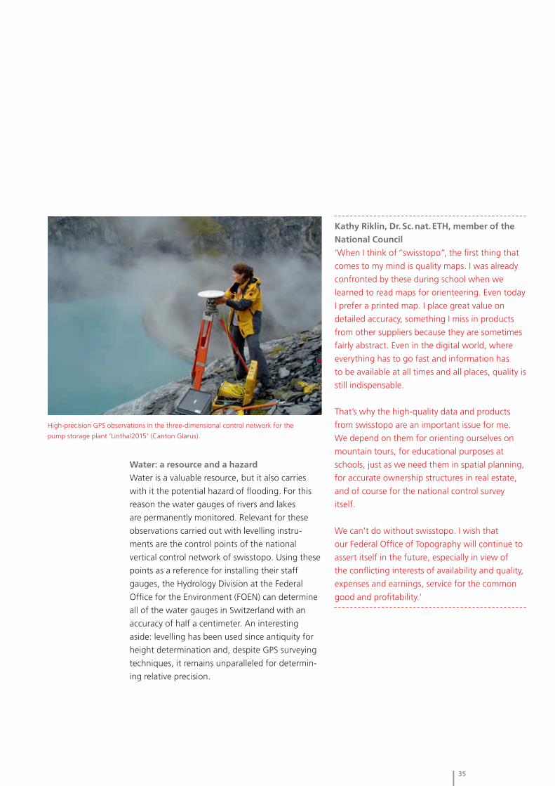
Whereas transportation routes used
to lead from the north into Ticino
in the south over the Gotthard Pass,
underground passages are of more
significance today. The geologic
maps from swisstopo provide
information about the traversed
regions. In addition, the image
shows relative movements (in
mm per year) of a few LV95 control
points monitored over the past
20 years together with the range of
uncertainty of these movements.
‘The Gotthard is an ambivalent place where the past and the future meet.’
Excerpt from the introduction to the themed exhibition ‘Sasso San Gottardo’

39
Underground/resources – yesterday
The heart of the Alps
Not all that long ago the Gotthard was thought to be the highest
mountain in the world. This honor – albeit that the Gotthard is a pass
and not a mountain – was bestowed by Julius Cesar.
He considered the Lepontine Alps (including
the Gotthard massif) to be the highest elevations
in the Alps. This Latin idea remained uncontested
for centuries. Of course we know better today.
Even though the Gotthard has long since been
dethroned as the highest mountain in the world,
there remains something special about it: it is
considered the heart of the Alps. The cornerstone
for its reputation as a significant traffic route was
laid already in the year 1200 when the Schöllenen
Gorge was made passable. Subsequently, the
Gotthard Pass quickly developed into one of the
major Alpine passages.
A challenge for surveying
In Faido in 1997, the first surveying pillar was
built for the 57-km-long Gotthard Base Tunnel,
the longest railway tunnel in the world. Following
the instructions from surveying engineers, the
miners worked their way through the Gotthard
Massif for 17 years. They also relied on geodata
and models from swisstopo. The main break-
through was celebrated on October 15, 2010. The
north and south tunnels met at a hand’s breadth:
8 cm in width and 1 cm in height. The capacity
of highly modern geodetic survey methods
and the quality of the required geodata provided
by swisstopo were once again underscored by
this successful operation.
From ‘hard as granite’ to ‘soft as butter’
The Gotthard Base Tunnel also posed a particular
challenge for geologists: the miners had to drill
through different layers of rock that they
described as ‘hard as granite and soft as butter’.
Geological base data from swisstopo such as
maps, bores and profiles were instrumental
for mastering these challenges as well. And even
though the construction project in itself is
finished, the job continues. Special geodetic
surveying stations were installed for a number of
dams and barrages along the Vorderrhein
(Anterior Rhine). From long-term monitoring
observations on these stations, possible
movements or changes due to the construction of
the tunnel can be registered.
A site of myths and legends
On August 25, 2012 the themed
exhibition ‘Sasso San Gottardo’ was
opened. The challenges facing us
today in dealing with our resources are
the subject of this exhibition located
in the galleries and caverns of a former
underground fortress – illustrated by
water, weather and climate, mobility
and habitat, energy and safety. The
initiators and proprietors of the
theme world, the Sasso San Gottardo
Foundation, consider the Gotthard
to be ‘a site of myths and sagas, of
legends and national identity, where
man built the Devil’s Bridge and
nature presents its elemental force’.
swisstopo acknowledges the
Gotthard’s prominence with the map
‘Sasso San Gottardo’ from the series
‘Once and Today’.
40
Underground/resources – today
When rocks and minerals are worth their weight in gold
Whether for toothpaste, coffee cups, smart phones or computers:
mineral resources are a key part in the production of a variety of articles
we use in daily life.
And our consumption is on the rise: since 1950
mankind has used more natural resources than in
its entire history.
Billion-dollar industry with raw material
from Switzerland
The rock and minerals used in Switzerland’s
domestic construction industry comes mainly
from its own open rock quarries. The supply
of table salt and special clays also comes mostly
from mines in Switzerland. Interest in the
occurrence of raw materials spurred the
production of the first geological maps. These
provide detailed information about the distribu-
tion and nature of rocks and soil close to the
earth’s surface. The different types of rocks are
distinguished through their formation, color
and composition.
Today, specialists consult geological maps
from swisstopo for finding large occurrences of
different materials such as gravel, sand, calcium
and marl as well as natural stones. These
are the natural resources used in cement, brick
and plaster factories, in sand and gravel
plants and in other branches of the construction
industry. These manufacturing processes
accumulate to a billion-dollar market and are
the backbone of the Swiss construction industry,
providing a significant contribution to the
economy.
Gold in Switzerland?
When speaking of raw material and mining,
one question is often asked: Is there a natural
occurrence of gold in Switzerland? The answer is
yes, but only in very small quantities. And these
are more relevant to the tourist industry than
to the economy. The oldest known gold deposits
in Switzerland are probably those in the valleys
and rivers around the Napf. There are reports that
already Helvetians and Romans were looking
for gold in the Napf area. The largest gold finds in
Switzerland are actually not from natural gold
veins but – completely unromantic – from the slag
of waste incineration plants: each year approx.
250 kilograms of gold worth over 10 million Swiss
francs are recovered from waste.

41
‘Urban Mining’: raw material for today
and tomorrow
On behalf of swisstopo, the Swiss Geotechnical
Commission keeps an inventory of the natural
occurrence of raw materials in Switzerland. In
addition to these classical, primary raw materials,
secondary raw materials are gaining significance.
Large cities are todays ‘modern mines’. Winning
raw material from the demolition and dismantling
of buildings and infrastructures and recycling
them as secondary raw material or in road
construction is called ‘urban mining’. As a
supplement to the classical primary raw materials,
these secondary materials will play a major
role in warranting the supply. The occurrence of
raw materials can be documented with the aid
of geodata from swisstopo – because you have to
know where they are before you can use them.
Renzo Simoni, Dr. Sc. techn., civil engineer ETH,
Chief Executive of AlpTransit Gotthard AG
‘The term “landscape memory” brings to my
mind the immense changes in our habitat during
the last decades which can be reconstructed
and visualized using older maps. Thanks to
topographic maps we can also follow mutations
in nature – for example glacial melting, the extent
of forests, or modifications in the flow of rivers.
swisstopo is a key player in our project AlpTransit
Gotthard. Without the geodetic models from
swisstopo, the 57-km-long base tunnel under the
Alps could never have been realized with such
a high accuracy. And considering a construction
time of more than 20 years, the time series
derived from the geodata were also eminent for
this project.
As far as I’m concerned, the Swiss national
maps can still be considered to be the best in the
world. And thanks to the outstanding quality
of swisstopo products, I have never experienced
any unpleasant surprises with geodata, either
professionally or privately.’
Geologic outcrop in
a stone quarry is a
witness of the past:
geology students are
introduced to the
history of the origins
of rock.

42
Underground/resources – tomorrow
The future is under ground
If we live under ground one day, as many science fiction movies
suggest, remains to be seen – yet one thing is clear: managing the deep
underground is becoming more relevant, for instance for geothermal
energy or for long-term storage.
Underground energy for heat and electricity
After the nuclear disaster in Fukushima in 2011,
the Federal Council and Parliament resolved
to harness renewable energies for supplying
power in the near future. Geothermal energy is
one of these. There are different methods for
exploiting underground heat, for example,
geothermal probes combined with heat pumps
for heating buildings. These probes are normally
installed at depths up to 400 meters.
Electricity can also be harnessed from the
underground. However, this requires drilling
down to 2000 to 5000 meters, since the required
temperatures of over 100 °C can only be
found at those depths. It is assumed that in the
long term, a significant proportion of the
electricity used in Switzerland can be supplied by
geothermal energy. Together with other
renewable energies, Switzerland would not have
to rely as heavily on imports but instead become
more energy independent.
Visualizing the underground with
geological 3-D models
The underground can not only be used to
supply heat and electricity but also as a depository
for waste material. Traffic routes are built
underground, and groundwater is tapped. The
greater the exploitation of the underground,
the more important it is to resolve certain issues:
To whom does the underground belong?
Where are conflicts in its use – and where are
which resources? To answer these and other
questions and to coordinate the exploration and
use of the underground, the Geological Survey
at swisstopo establishes three-dimensional
geological models for visualizing the complex
circumstances in the underground. These
3-D models are based on geological maps, natural
outcrops, drilling cores and seismic data.
Folding of the Alps as a geological journey in time
15 million years ago

43
Research at the rock laboratory Mont Terri
swisstopo operates the Mont Terri rock laboratory
near St-Ursanne, where a research program
has been running since 1996. An international
research team is investigating the characteristics
of opaline clay 300 meters into the mountain.
The Swiss Federal Council declared this type of
formation as the preferred host rock for storing
highly radioactive waste material. Mont Terri
also serves as a laboratory for non-nuclear
research such as CO storage, shale gas and ²geothermal energy. Since 2011, an exhibition in
the visitors’ center provides information about
the activities of the laboratory and answers
questions concerning the long-term depository.
Researchers from the Federal
Institute for Geosciences and
Natural Resources in Hannover,
Germany (Bundesanstalt für
Geowissenschaften und Rohstoffe
BGR), make a boring in the Rock
Laboratory Mont Terri (Canton Jura)
to extract opaline clay cores.
today in 15 million years
Jura Central Plateau Alps

44
The Federal Office – yesterday
Heading towards the digital age
When Francis Jeanrichard became Director of swisstopo in 1981, it was
called ‘Federal Office of Topography’ and had about 150 employees.
One of his major challenges was the introduction of computer-assisted
cartography and the digitization of topographic maps in the 1980s.
The first GPS satellite receivers were tested for
the national control survey in 1987, and in the
same year, swisstopo purchased four geodetic
receivers and introduced operational GPS
surveying. The new GPS reference network for
the national control survey (LV95) was established
during a number of observation campaigns.
In 1989, the first digitized map revision was
tested on Sheet 1168, Langnau im Emmental, at
the scale 1:25,000. In 1992, several computers
were acquired for revising thematic maps, and
an in-house network (LAN) as well as an exposing
device were installed. At the turn of the year
2000/01, engraving on glass was finally replaced
by digital cartography.
‘When are we going to jump on the
bandwagon?’
The last 25 years have witnessed rapid develop-
ment not only in technology, but swisstopo
has also experienced far-reaching changes in a
short time. In his term of office from 1998 to
2005, Erich Gubler dealt with the fusion of
swisstopo and the Cadastral Survey, and the
launch of COGIS (Coordination, Geo-Information
and Services in the federal administration).
Technological development offered and still offers
new possibilities – but also challenges, not
least the cost. Of burning interest was always the
question: When do we jump in with new
technologies? Once GPS was introduced, it
became clear for swisstopo: ‘Now it’s interesting:
this is the technology of the future!’
Management with a performance mandate
and the right instinct
The responsible managers at swisstopo had
the right instinct for potential technologies, then
as well as now, and invested resources and
time accordingly. Flexibility has always been
written in capital letters at swisstopo. With the
start of FLAG (management with a performance
mandate and a global budget) in 1997, swisstopo
seized the necessary elbowroom to fulfill its
legal mandate as well as to keep up with the free
market enterprise. With FLAG, swisstopo was
able to prioritize its tasks, and the global budget
made it possible to implement financial means
where most needed.
‘swisstopo has a legal
and binding mandate.
Just because screws
were selling better
than nails didn’t
mean that we would
start producing only
screws.’ Francis Jeanrichard,
Director of swisstopo
1981–1998
Witnesses to history in a conversation. Two former and the present Director of swisstopo.
From left to right: Jean-Philippe Amstein, Erich Gubler, Francis Jeanrichard

45
Present on the Internet
The triumph of the Internet also had far-reaching
consequences for swisstopo. The website
swisstopo.ch was introduced in 1997. Further
websites for different topics followed, such as:
‘cadastre.ch’, the portal to the official cadastral
survey, the PLR cadastre and land register; or
‘geologieportal.ch’ for the information platform
to the world of geology in Switzerland. By the
way, our office adopted its current name from its
website: the term ‘swisstopo’ was chosen for the
Internet address because it was conventional in
all languages in Switzerland. Since 2002,
‘swisstopo’ is the abbreviation for the still official
designation ‘Federal Office of Topo graphy’.
The new geoinformation act: a milestone
On July 1, 2008, the new Geoinformation Act
(GeoIG) came into force. For the first time in its
history and as one of the first countries in
Europe, Switzerland has a modern legal basis with
future prospects. The aim is to make the most
recent geodata available for broad application by
administrative authorities, the economy, society
and science – sustainably, quickly and easily
accessible, at an adequate quality and affordable
prices. Geodata from the federal administration
are publicly accessible and can be used by
anyone as long as there are no conflicting public
or private interests. The Geoinformation Act is the
legal basis for all activities at swisstopo.
‘You can make good
products with good
people – and if you
make good products,
you get good people.’
Dr. Erich Gubler,
Director of swisstopo
1998–2005

46
The Federal Office – today
Good people work well
In the year of its anniversary in 2013, approx. 350 employees are
pursuing their various tasks at swisstopo. Today, as then, they account
for swisstopo’s most important asset.
With their professional expertise and personal
commitment,they warrant the high quality of the
products and services also in the future.
The rapidly developing market for geodata
requires not only a high degree of flexibility, but
also a good amount of innovation: if you want
to be at the forefront, you have to recognize
trends and potential developments early on and
act on them. Or in other words: you have to
know what clients want before they themselves
know. This is only feasible with good people
and the corresponding leeway made possible by
FLAG, i.e. management with a performance
mandate and a global budget.
Interesting tasks – and perspectives
swisstopo is seen as a ‘dynamic institute’ and
an attractive employer offering interesting tasks
and perspectives for qualified and motivated
personnel. More than a third of the employees
follow a part-time work schedule. Some share
a position and others work from home one
day a week. The often-cited work-life balance is
an important topic at swisstopo – for all levels:
modern work schedules are popular for all
employees, even on the management level.
Drawing motivation from that which
comes into being
Periodical personnel surveys confirm that a large
part of the employees is satisfied with the
working conditions and atmosphere at swisstopo.
Not only the working environment acts
motivating: swisstopo is and always has been a
production facility. Those who work there take
part in the development of innovative products
and create something that has a market value.
The spirit of the times is also influential: today,
geodata is an extremely valuable commodity. And
its value is steadily increasing with the growing
individualization of applications on the Internet.
Exciting projects and long-term perspectives open
The future begins with today's youth. What are their prospects?
Lukas Bögli, Aljoscha Keller, Lena Strauss, Yaël Breuleux, Thashvitha Midge Mathur,
First-year appren- Second-year fourth-year appren- Second-year ap- Bavanantharajah, First-year
tice, geomatician apprentice, geoma- tice, cartography prentice, commercial Fourth-year apprentice, print
majoring in tician majoring in ‘One day I would like business apprentice, technology
cartography geoinformation to travel around the ‘I chose this computer sciences ‘I like working in a
‘In my job I can be ‘I love the diversified world through maps.’ profession because ‘My strong suit as team and appreciate
creative as well as and challenging tasks it is very versatile.’ a computer scientist: the teamwork at
engage in technical in geoinformatics.’ being helpful and swisstopo.’
work.’ working precisely.’
47
up for those who are involved with geoinforma-
tion. The reputation of swisstopo as a compe-
tence center for geoinformation has been carried
far out into the world and also contributes to
a good working atmosphere: the staff is proud of
its work – and of its employer.
Vigorous and savvy apprentices at swisstopo
About 30 young people are completing their
vocational training as geomaticians, IT specialists,
printing technicians and print media specialists,
or commercial employees. Apprentice positions
for geomaticians are popular: the attractive
combination of technology and design is very
appealing. The number of apprentices engaged
by swisstopo amounts to 8%, which is clearly
above the average of 4% to 5% for the federal
administration.
The vocational teachers at swisstopo profess
a high degree of motivation and responsibility
among their students. The young people trust
their abilities and their instructors. They know
about the market – and also that they will not be
the only ones to have to assert themselves. Many
are aware of their further education even during
their apprenticeship. A life of continuous learning
is already self-understood for many: ‘We don’t
have one profession – we have several’.
Vocational teachers at swisstopo
‘We not only want to help our apprentices in
learning a solid profession, we also want to
promote their creative and innovative potential.
Education and performance are of course
significant, however, we also value the attitude
and conduct that these young people show
towards their work and their clients. Our
apprentices should take responsibility for their
jobs and what they do. We can show them
the meaning of good management and how they
can creatively and effectively meet problems and
challenges.
Practical experience is highly rated in the
training program. Our prospective professionals
should know how the market works and be
able to perceive trends and demands. Those who
do their training here aren’t restricted to
their “own four walls” but gain in-depth access to
all domains of swisstopo. No wonder that our
apprentices are known for “being on the ball” in
our profession. And their opportunities in the job
market are accordingly.
We have come to know and appreciate
our apprentices as being interested, alert and
motivated. They reason critically and want to
achieve their goals. The training at swisstopo is
their first big step in their professional lives.’
Stefan Arn, Michael Pfanner, Marlyse Ritter,
Heinz Weber
Valon Fazlija,
First-year
apprentice, print
media specialist
‘My favorite job is
with the folding
machine because
there you have to be
extremely precise.’

48
The Federal Office – tomorrow
swisstopo is on the move
Since the Geoinformation Act came into force in 2008, perspectives
have changed: in addition to commercial point of view, the economic
use has come into focus.
Geoinformation should be available for a wide
range of applications and generate added value.
swisstopo is caught in the conflict between
‘public service’ and returns: Should good data
and their maintenance (upkeep and harmoniza-
tion) cost something? And if so, how much?
Today geodata can be viewed and printed as
maps and plans under geo.admin.ch. Yet the call
for ‘open data’ is becoming louder: especially
corporations are demanding that not only access
to geoinformation and geodata should be
inexpensive or even free of charge, but also their
acquisition for different applications.
The future is mobile
swisstopo is on the move – and is being moved:
technological revolutions and advancements in
society will pose challenges for swisstopo also in
the future. Mobile technologies are going to play
an even greater role – coupled with expectations
by users. Already many expect that changes are
captured immediately, published and viewable
on smart phones or tablets. At this time, most of
the geodata at swisstopo are updated in a 6-year
cycle. Is this too slow for our dynamic society?
Promote collaboration, master complexities,
exploit leeway
Challenges can also be found in other domains.
One of our major concerns is about promoting
collaboration – between the federal administra-
tion and the cantons, between various kinds
of professions, different cultures and mentalities.
swisstopo wants to do its part to meet the
expectations of the numerous geoinformation
user communities – thereby keeping cultural
diversity alive.
Furthermore, developments of vectorized maps
and models for 3-D and 4-D representations and
analyses are pending on the technical level.
The impact of partnerships and ‘crowd sourcing’
will continue to grow, in that external and private
offices will also collect and process geodata,
thus increasing the complexity factor. Freedom
and leeway will become more important
than ever: managing human resources must
include the most modern methods and not rest
on personnel figures.
Knowing where – in the future as well!
Approximately 80% of all decisions made by the
public have to do with geoinformation. It
constitutes the basis for planning, enactments
and decisions of all kinds – in the administration
just as in politics, the economy and science and in
the private sector. The products and services
from swisstopo provide indispensable information
for making decisions and allow a glimpse into
the future: ‘swisstopo – knowing where’ stands
for swisstopo’s legal mandate and its visions, for
the next 25 years and beyond.

Schweizerische EidgenossenschaftConfédération suisseConfederazione SvizzeraConfederaziun svizra
Swiss Confederation
Federal Office of Topography swisstopowww.swisstopo.ch
Federal Office of Topography swisstopo
Seftigenstrasse 264, CH-3084 Wabern
phone +41 31 963 21 11, fax +41 31 963 24 59
Imprint
© 2013 Federal Office of Topography swisstopo
Edition: 6000 copies in German, 1500 copies in French,
500 in Italian and 3000 in English.
swisstopo thinks ecologically: all versions of the
commemorative booklet are available as a PDF under
www.swisstopo.ch/175.
Design: Atelier Ursula Heilig SGD
Text: escribo/Claudia Fahlbusch
Printed by swisstopo
Photos and illustrations: Béatrice Devènes (p. 2–13, 44);
others swisstopo
Title image: Region around Bern represented as a journey in
time with products from swisstopo. From the base data of the
Dufour Map to the National Map to the aerial photograph.