Embed Size (px)
Citation preview

S.Wexford RWS (Ballykelly)
Water Framework Directive
Groundwater Monitoring Programme
Site Information
S.Wexford RWS (Ballykelly) is a borehole used as part of a public water supply. The borehole has an abstraction rate of 150 m³/day.
ImagePath1: S.Wexford RWS
(Ballykelly)\IE_SE_G_064_26_00
9_A_(800_x_600).jpg
August 2011
Wexford

Final Borehole Depth (m): ---
Site Use: Drinking Water (PWS)
RBD: SERBD
Northing: 115427
County: Wexford
EU Reporting Code: IE_SE_G_064_26_009
GWB Name: Fardystown
GWB Code: IE_SE_G_064
Drinking Water Code: 3300PUB1314
Site Name: S.Wexford RWS (Ballykelly)
Water Quality Monitoring Network:
Hydrometric Area: 12
Ownership: Wexford County Council
Site Comments:
---
SITE INFORMATION
Screen Interval (m bgl): ---
Potential Yield (m³/day): 2000
Top of Casing (m agl): ---
Abstraction Rate (m³/d): 150 Ground Elevation (m OD): 19.5
Upper Casing Diameter (mm):
---
Upper Casing Bottom Depth (m bgl) :
---
Monitoring Point Type: BH
Specific Capacity (m³/d/m):
--- Comments on Monitoring
Site:
It occurs on a townland boundary of Ballykelly and Ballyfinoge and is also referred to as PW18 or Ballyfinoge New. The adjacent borehole abstracts approximately 350m³/day. This old borehole abstracts from a confined gravel unit.
WELL INFORMATION
Total Drilled Depth (m bgl): --- Depth to Bedrock (m bgl): ---
Lower Casing Diameter (mm):
---
Lower Casing Bottom Depth (m bgl):
---
Static Water Level (m bgl): ---
SITE DIRECTIONS
Location and Access Information:
Located 5.6 km west of Rosslare. The site is 300 m south of the junction between the N25 and the R 739
Additional Comments: ---
Townland: BALLYKELLY
Water Level Monitoring Network:
Easting: 304683
Open Hole Interval (m bgl): ---
Level Flow
Surveillance Operational (Point) Operational (Diffuse)
Borehole Log Available:
NN
N N Y
---
Scheme Name: Fardystown Regional/South
Number of Abstraction Points in the Scheme:
10
Scheme Summary:The borehole is one of 10 boreholes in the Fardystown Well field (9000-10000m³/day total). Eight of the ten boreholes are pumping at any one time. Another borehole from the well field is also included in the EPA network - see S.Wexford (Rathmacknee).
Source Report Available
Y
Source Report Info:Source Report available for the Fardystown Wellfield from WYG.
Screen Type (PVC,Steel,other):
--- Screen Slot Size (mm): ---
Grout Type (cement,bentonite):
--- Grouted above (m bgl): --- Grout Volume Injected (m³):
---
Gravel Pack Interval (m bgl):
--- Gravel Pack Volume (m³): ---
Page 2 of 5
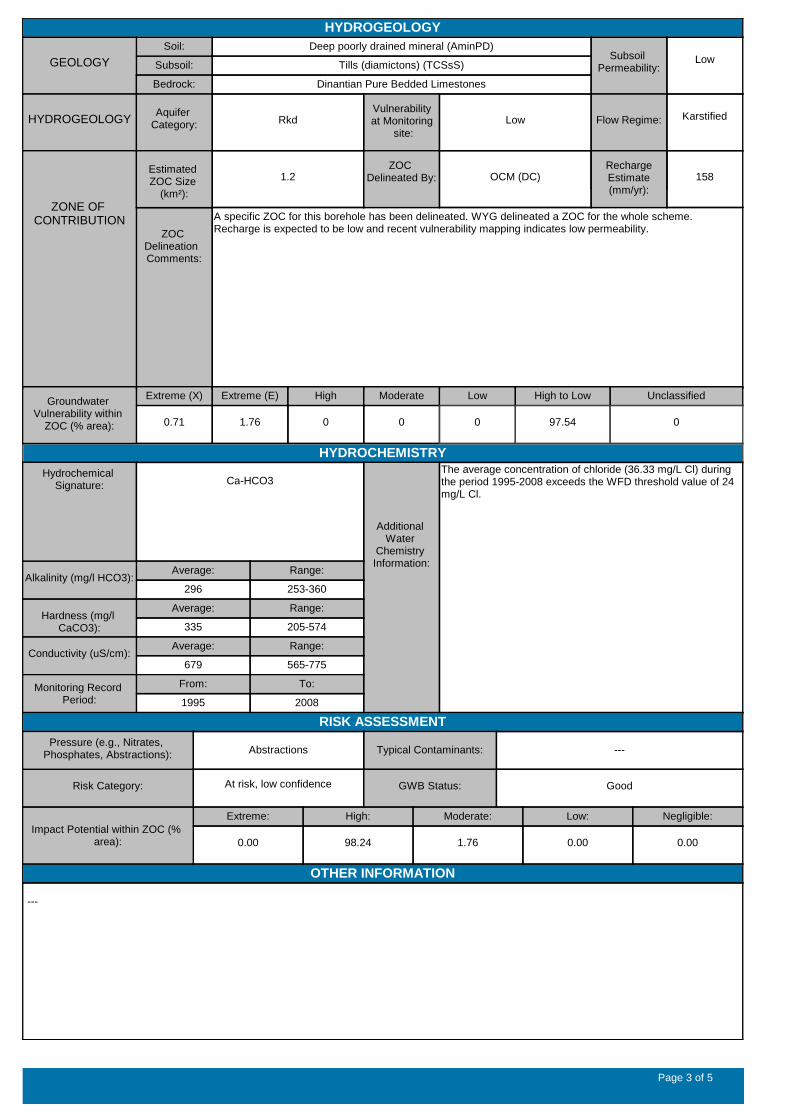
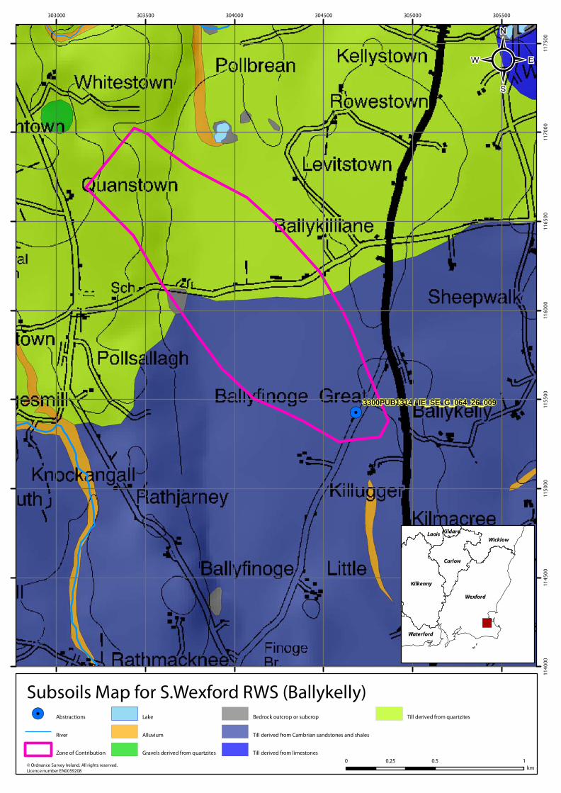
Subsoil: Tills (diamictons) (TCSsS)
Soil: Deep poorly drained mineral (AminPD)
ZOC Delineation Comments:
A specific ZOC for this borehole has been delineated. WYG delineated a ZOC for the whole scheme. Recharge is expected to be low and recent vulnerability mapping indicates low permeability.
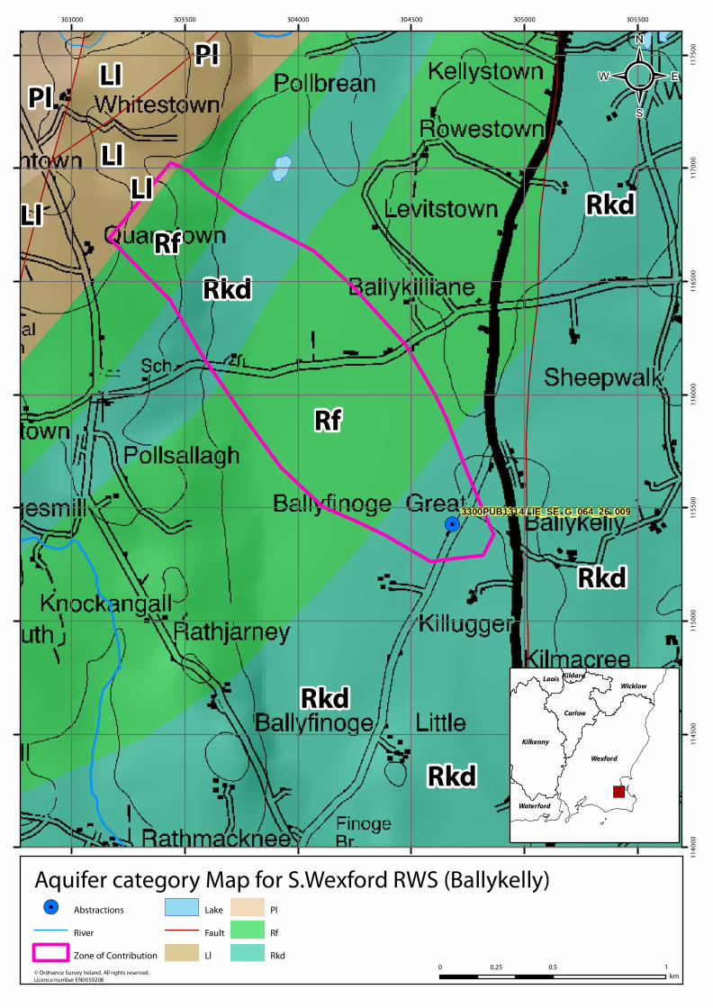
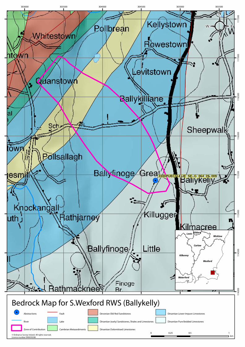
HYDROGEOLOGY
GEOLOGY
Bedrock: Dinantian Pure Bedded Limestones
Subsoil Permeability:
Low
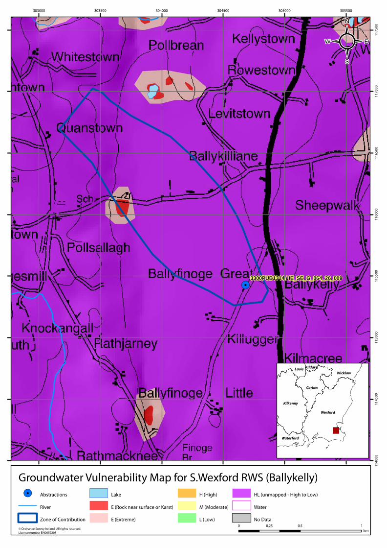
HYDROGEOLOGYVulnerability at Monitoring
site:
LowAquifer
Category: Rkd Flow Regime: Karstified
ZONE OF CONTRIBUTION
Estimated ZOC Size
(km²):
1.2
Recharge Est (mm/yr):
158
HYDROCHEMISTRY
Additional Water
Chemistry Information:
The average concentration of chloride (36.33 mg/L Cl) during the period 1995-2008 exceeds the WFD threshold value of 24 mg/L Cl.
ZOC Delineated By: OCM (DC)
Recharge Estimate(mm/yr):
Average:
296Alkalinity (mg/l HCO3):
Range:
253-360
Average:
335Hardness (mg/l
CaCO3):
Range:
205-574
Average:
679Conductivity (uS/cm):
Range:
565-775
From:
1995
Monitoring Record Period:
To:
2008
RISK ASSESSMENT
Risk Category: At risk, low confidence
Typical Contaminants: ---
GWB Status: Good
Pressure (e.g., Nitrates, Phosphates, Abstractions): Abstractions
Extreme (X)
0.71
Groundwater Vulnerability within
ZOC (% area):
Extreme (E)
1.76
High
0
Moderate
0
Low
0
Unclassified
0
Extreme:
0.00
Impact Potential within ZOC (% area):
High:
98.24
Moderate:
1.76
Low:
0.00
Negligible:
0.00
Hydrochemical Signature: Ca-HCO3
High to Low
97.54
OTHER INFORMATION
---
Page 3 of 5

Borehole Housing
Borehole Piping
Sampling Point
Page 4 of 5

Data Summary Sheet - July 2011
Disclaimer: The data in this document are based on the best available information and understanding at time of writing. Neither
the Environmental Protection Agency, nor the individual bodies supplying data for this document and accompanying maps will
be responsible for any loss or damage from the use or interpretation of these data.
Rock Unit Geology Map: GSI, 2009
Aquifer Type Map: GSI, 2009
Groundwater Vulnerability Map: GSI, 2009
Soils & Subsoils Type: Teagasc, 2007
Recharge Map: GSI, 2009
Impact Potential Map: EPA, 2009
Risk Assessment Map: EPA WFD Risk Assessment, 2006
Groundwater Body Status: EPA WFD Status Assessment, 2008
Water Quality Data: EPA WFD Monitoring, 2008
Groundwater Threshold Values
Groundwater threshold values for selected parameters:
Nitrate - General Chemical Test/ Drinking Water Test (37.5 mg/I N03)
Ammonium - Drinking Water Test (0.175 mg/I N) / Surface Water Test (0.065 mg/l N)
Molybdate Reactive Phosphorus (MRP) - Surface Water Test (0.035 mg/I P)
Chloride -Saline/Intrusive Test (24 mg/I) / Drinking Water Test (175 mg/I Cl)
Electrical Conductivity -Saline/Intrusive Test (800 µS/cm) / Drinking Water Test (1,875 µS/cm)
Further information on groundwater threshold values is contained in the Groundwater Regulations (S.I. No.9 of 2010).
General Downgradient Distances
General Downgradient Distances (XL) applied to boreholes sourced in bedrock aquifers are constrained to estimate approximate
limits based on data at the GSl. ln some cases they may be higher or lower depending on local conditions.
It is assumed that groundwater downgradient of a spring cannot flow back up to the spring, however a precautionary 30m buffer
is generally applied which allows for instances where pumping under dry weather periods may induce a drawdown or where the
ground may be sloping toward the spring from the downgradient side.
Rk, Rkd, Lk 225 m
Lm 150 m
Ll, PI 60 m
Prepared by WYG Date:
Prepared by Date:
Prepared by Date:
Prepared by Date:
Prepared by OCM (DC) Date: Feb 2011
Version 0:
Version 1:
Version 2:
Version 3:
Version 4:
Page 5 of 5

!.
!.
3300PUB1314 / IE_SE_G_064_26_009
303000 303500 304000 304500 305000 305500
114
00
011
45
00
115
00
011
55
00
116
00
011
65
00
117
00
011
75
00
© Ordnance Survey Ireland. All rights reserved. Licence number EN0059208
Location Map for S.Wexford RWS (Ballykelly)
0 0.5 10.25km
!. Abstractions
Zone of Contribution
River
Lake
")
Wexford
Kilkenny
Carlow
WicklowLaois
Waterford
Kildare
²
!.
!.
Rf
Rkd
Rkd
Rf
Rkd
Rkd
Ll
Rkd
LlPl
Rkd
LlLl
Pl
3300PUB1314 / IE_SE_G_064_26_009
303000 303500 304000 304500 305000 305500
114
00
011
45
00
115
00
011
55
00
116
00
011
65
00
117
00
011
75
00
© Ordnance Survey Ireland. All rights reserved. Licence number EN0059208
Aquifer category Map for S.Wexford RWS (Ballykelly)
0 0.5 10.25km
!. Abstractions
River
Zone of Contribution
Lake
Fault
Ll
Pl
Rf
Rkd
²
")
Wexford
Kilkenny
Carlow
WicklowLaois
Waterford
Kildare
!.
!.
3300PUB1314 / IE_SE_G_064_26_009
303000 303500 304000 304500 305000 305500
114
00
011
45
00
115
00
011
55
00
116
00
011
65
00
117
00
011
75
00
© Ordnance Survey Ireland. All rights reserved. Licence number EN0059208
Bedrock Map for S.Wexford RWS (Ballykelly)
0 0.5 10.25km
!. Abstractions
River
Zone of Contribution
Fault
Lake
Cambrian Metasediments
Devonian Old Red Sandstones
Dinantian (early) Sandstones, Shales and Limestones
Dinantian Dolomitised Limestones
Dinantian Lower Impure Limestones
Dinantian Pure Bedded Limestones
²
")
Wexford
Kilkenny
Carlow
WicklowLaois
Waterford
Kildare
!.
!.
3300PUB1314 / IE_SE_G_064_26_009
303000 303500 304000 304500 305000 305500
114
00
011
45
00
115
00
011
55
00
116
00
011
65
00
117
00
011
75
00
© Ordnance Survey Ireland. All rights reserved. Licence number EN0059208
Groundwater Vulnerability Map for S.Wexford RWS (Ballykelly)
0 0.5 10.25km
!. Abstractions
River
Zone of Contribution
Lake
E (Rock near surface or Karst)
E (Extreme)
H (High)
M (Moderate)
L (Low)
HL (unmapped - High to Low)
Water
No Data
²
")
Wexford
Kilkenny
Carlow
WicklowLaois
Waterford
Kildare
!.
!.
3300PUB1314 / IE_SE_G_064_26_009
303000 303500 304000 304500 305000 305500
114
00
011
45
00
115
00
011
55
00
116
00
011
65
00
117
00
011
75
00
© Ordnance Survey Ireland. All rights reserved. Licence number EN0059208
Subsoils Map for S.Wexford RWS (Ballykelly)
0 0.5 10.25km
!. Abstractions
River
Zone of Contribution
Lake
Alluvium
Gravels derived from quartzites
Bedrock outcrop or subcrop
Till derived from Cambrian sandstones and shales
Till derived from limestones
Till derived from quartzites
²
")
Wexford
Kilkenny
Carlow
WicklowLaois
Waterford
Kildare

!.
!.
3300PUB1314 / IE_SE_G_064_26_009
303000 303500 304000 304500 305000 305500
114
00
011
45
00
115
00
011
55
00
116
00
011
65
00
117
00
011
75
00
© Ordnance Survey Ireland. All rights reserved. Licence number EN0059208
Soils Map for S.Wexford RWS (Ballykelly)
0 0.5 10.25km
!. Abstractions
River
Zone of Contribution
Acid Deep Well Drained Mineral
Acid Deep Poorly Drained Mineral
Acid Shallow Well Drained Mineral
Acid Shallow Poorly Drained Mineral
Basic Deep Well Drained Mineral
Basic Shallow Well Drained Mineral
Basic Shallow Poorly Drained Mineral
Mineral Alluvium
Lake
²
")
Wexford
Kilkenny
Carlow
WicklowLaois
Waterford
Kildare