Embed Size (px)
Citation preview
RepoRt ContRibutoRs:
Alan briggs
Robin Chinnery
Laura Colman
Dr David Dolan
Dr sue Graham-taylor
Jenni Howlett
Cheryl-Anne McCann
brooke Mandy
Gina pickering (project Manager)
Rosemary Rosario
Alison storey
Dr Richard Walley oAM
A CoLLAboRAtiVe pRoJeCt bY:
LAtituDe CReAtiVe seRViCesHeRitAGe AnD ConseRVAtion pRoFessionALsnAtionAL tRust (WA)
Swan and Helena Rivers Management FrameworkHeritage Audit and Statement of Significance• FINAL REPORT • 26 FEbRuARy 2009
PREPAREd FOR ThE EAsTERN METROPOLITAN REgIONAL COuNCIL ON bEhALF OF
AcknowledgementsThe consultants acknowledge the assistance received from the Councillors, staff and residents of the Town of Bassendean, Cities of Bayswater, Belmont and Swan and the Eastern Metropolitan Regional Council (EMRC), including Ruth Andrew, Dean Cracknell, Sally De La Cruz, Daniel Hanley, Brian Reed and Rachel Thorp; Bassendean, Bayswater, Belmont and Maylands Historical Societies, Ascot Kayak Club, Claughton Reserve Friends Group, Ellis House, Foreshore Environment Action Group, Friends of Ascot Waters and Ascot Island, Friends of Gobba Lake, Maylands Ratepayers and Residents Association, Maylands Yacht Club, Success Hill Action Group, Urban Bushland Council, Viveash Community Group, Swan Chamber of Commerce, Midland Brick and the other community members who participated in the heritage audit community consultation. Special thanks also to Anne Brake, Albert Corunna, Frances Humphries, Leoni Humphries, Oswald Humphries, Christine Lewis, Barry McGuire, May McGuire, Stephen Newby, Fred Pickett, Beverley Rebbeck, Irene Stainton, Luke Toomey, Richard Offen, Tom Perrigo and Shelley Withers for their support in this project.
The views expressed in this document are the views of the authors and do not necessarily represent the views of the EMRC.
All images featured in this report were photographed by Gina Pickering unless otherwise stated.
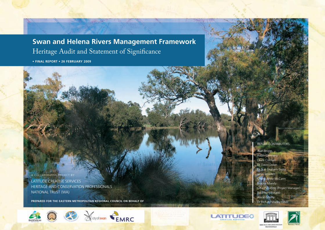
Cover image: View upstream, near Barker’s Bridge.

Swan and Helena RiveRS ManageMent FRaMewoRk HeRitage audit and StateMent oF SigniFicance
Contentsexecutive summary ................................... i
1.0 introduction to the Report .............11.1 Preamble 11.2 The Brief 11.3 The study area 11.4 Heritage listings 11.5 Method 21.6 Thematic approach 21.7 Report format 31.8 Limitations 3
2.0 statement of significance ..............4
3.0 A summary of Recommendations ..6
4.0 A Defined study Area ....................84.1 Indicators and Limitations 8
5.0 over-arching ’’meta’’ themes ........145.1 River of Life 145.2 Power of the Landscape 145.3 Sustainability 14
6.0 understanding the Rivers .............176.1 A Spiritual Force 186.2 A Changing Landscape 196.3 The River of Dreams 216.4 The River for Life 226.5 A River for the Future 25
7.0 natural Heritage Values ...............277.1 Geological Heritage 277.2 Formation of the Swan
and Helena Rivers 277.3 Landscape Attributes 287.4 Bushland Values 287.5 Fragile Vegetation 287.6 Habitat Values 297.7 Biodiversity 297.8 Acid Sulphate Soils 307.9 Natural Vegetation 317.10 Comparative analysis 31
8.0 Aboriginal Values .........................328.1 Audit of Registered Aboriginal
Sites 328.2 Aboriginal Themes 33
9.0 Historic Values .............................349.1 Historic Overview 349.1.1 Exploration, Aboriginal
contact and settlement 349.1.2 Transport, Industry and Services 359.1.3 Gold boom, Prosperity and
Subdivision 369.1.4 Institutions 379.1.5 Recreation 389.2 Historic Significance 419.2.1 Exploration, Aboriginal
contact and early settlement 419.2.2 Transport, Industry and Services 419.2.3 Gold Boom, Prosperity and
Subdivision 419.2.4 Institutions 419.2.5 Recreation 42
10.0 oral Histories ...............................4310.1 Oral history assets 43
11.0 Consultation ................................4511.1 Community Consultation 4511.2 Non-Indigenous Consultation
Process 4511.2.1 Table of Consultation Sessions 4511.2.2 Outcomes 4511.2.3 A Recreational Focus 4611.2.4 Table of Typical Recreational
Activities 4611.2.5 Excerpts from Oral Histories 4611.3 Aboriginal Consultation 4711.3.1 A Response to Proposed Trails 4711.3.2 Nyoongar Consultations
Transcripts 48
12.0 Appendices ..................................5312.1 Footnotes 5312.2 Bibliography 5412.3 The Project Brief 5712.4 Audit Reports within the
Boundaries of the Swan and Helena River Study Area 63
12.4.1 Audit of Identified Natural Heritage 63
12.4.2 Audit of Identified Aboriginal Heritage Sites 75
12.4.3 Audit of Identified Heritage Places 85
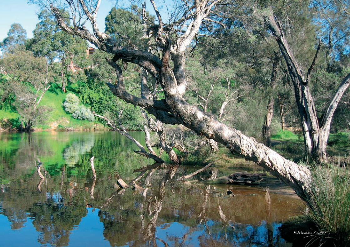
Fish Market Reserve.
i
Swan and Helena RiveRS ManageMent FRaMewoRk HeRitage audit and StateMent oF SigniFicance
Executive SummaryThe Swan River and Helena Rivers (the Rivers) offer an iconic landscape locally and internationally recognised for its natural, cultural and historic values. The Rivers and surrounding plains have been vital in sustaining the Nyoongar people for approximately 40,000 years, while providing an important historic, economic and recreational focus for Western Australia in more recent times.
This document provides a Statement of Significance for the Rivers, based on an audit of recorded natural, Aboriginal and historic sites over a defined section of the river, to provide input into the route, themes and interpretation of the Swan and Helena Rivers Regional Recreation Path.
The report was commissioned by the Eastern Metropolitan Regional Council (EMRC), in response to a recommendation contained in the ‘Swan and Helena Rivers Management Framework Report’ (SHRMF), prepared by Hassell Ltd in 2007.
The boundaries of the study are defined by four precincts identified by the SHRMF that extend from Windan Bridge near the city, east to Middle Swan Road and Whiteman Bridge, and south to Roe Highway. The majority of the study area is included within the boundaries of the City of Bayswater, City of Belmont, City of Swan and the Town of Bassendean.
This Statement of Significance has been prepared on the basis of the model used by the United Nations Educational, Scientific and Cultural Organisation (UNESCO) for the purpose of establishing World Heritage Listings.
As a response to the method employed by UNESCO, the Statement of Significance for the Rivers presents an integrated review that places natural, Indigenous and historic values side by side. While this has the great advantage of presenting a holistic view, it has been technically complex, due to the different ways in which significance is generally assessed by the three environments.
The process for developing the Statement of Significance for the Rivers included the following:
Preparation of an audit of heritage values and •places for the natural, Indigenous and historic environments;
Community consultation conducted in each of the •four participating local authority areas;
Identification of available oral histories that would •provide personal insight into the history of the Rivers; and
Preparation of maps to show the location of the •identified heritage places and provide guidance for future interpretation.
The study takes the approach of a hierarchy of themes, resulting in a series of overarching themes that are considered to define the significance of the Rivers.
The “meta” or overarching themes for the significance of the River as defined in this report are:
River of life •
Power of the landscape •
Sustainability •
These themes are expanded and explained in the following report.
The primary outcomes of the report are the Statement of Significance and Recommendations. These are as follows:
ii
Swan and Helena RiveRS ManageMent FRaMewoRk HeRitage audit and StateMent oF SigniFicance
statement of significance The waterways and surrounds of the Swan River and Helena Rivers (hereafter called the Rivers), in the study area bounded by Windan Bridge, Whiteman Bridge, Roe Highway and Middle Swan Road are based on a distinctive geological formation with an evolved ecosystem. Having been used intensively by humans for millennia, the defined area is characterised by a diverse range of heritage values. Many of the individual places along the Rivers are themselves of specific heritage value, but outstanding value attaches to the overall landscape that has evolved over time. Thus the Statement of Significance identifies this area of the Rivers as a cultural landscape with natural and cultural heritage significance for the following reasons:
the Rivers’ landscape demonstrates the ending of the Gondwanaland period due to the break up of the Indian and Australian tectonic plates following rifting along the Darling fault line;
the Rivers were formed by the mythological serpent the Waugyl according to Nyoongar tradition, and have continuing cultural importance related to past and contemporary Nyoongar culture;
the Rivers’ environment is home to rare and priority flora listed on international and state based registers;
archaeological discoveries in the river valley have extended the scientific knowledge of the great antiquity (at least 40 thousand years) of continuous human habitation in Australia;
in 1829, the erroneous belief that the Rivers provided rich arable land, led to the establishment of the Swan River Colony, the first free (non-convict) colonial settlement in Australia;
the Rivers link the scarp to the city and determined both the location of Western Australia’s first three towns, Perth, Fremantle and Guildford, and the form of land allocation and distribution in the colony;
the Rivers provided Perth’s first transport and communication corridor and demonstrate access to the upper reaches and downstream to Fremantle;
the Rivers provide evidence of changing livelihoods, lifestyles and sustenance for all humans who have lived there over thousands of years;
the changing use of the Rivers for industrial purposes from 1829 to the present demonstrate evidence of innovation and change in technology and industry;
the Rivers and their banks have been used for passive and active recreation including swimming, boating, walking, bird-watching, horse racing and picnics, and are linked to international sporting events including The Avon Descent White Water Race;
the Rivers provide evidence of changing and contrasting systems of understanding, use and abuse, management and mismanagement;
the Rivers demonstrate notions and understanding of personal, social and environmental wellbeing and malady; and
the Rivers provide the opportunity for the development of greater understanding between people through the challenges of their conservation and rehabilitation as both a physical resource and a spiritual place.
authenticity
When assessed as a cultural landscape, the nominated areas of the Swan and Helena Rivers and surrounds exhibit a high degree of authenticity. Its historical trajectory can be seen in the present day landscape, and the associated Nyoongar values continue from ancient times until today as much as the changing environment allows.
As this Statement of Significance is for a nominated cultural landscape, it is not appropriate to consider the authenticity of every natural or cultural component. However, a comprehensive list included with this statement details historical, Aboriginal and natural areas, places and sites within the limits of the information available in 2008.
The dynamic relationship between the Rivers and the landscapes that have developed around them is a powerful one stretching across geological time to the present.
The extent of spiritual autonomy of the river as well as spiritual connection to the river and changes in usage by the Nyoongar and European cultures is reflected in the physical characteristics of different sections of the river and their evolution.
Traditional usage of the environment ranges from food gathering, to campsites, ceremonial and spiritual uses and is linked to the Rivers themselves and their surrounds.
While European settlement led to the development of farms, townships, transport, governance and industry, the land use patterns also indicate social and economic change over approximately 40,000 years.
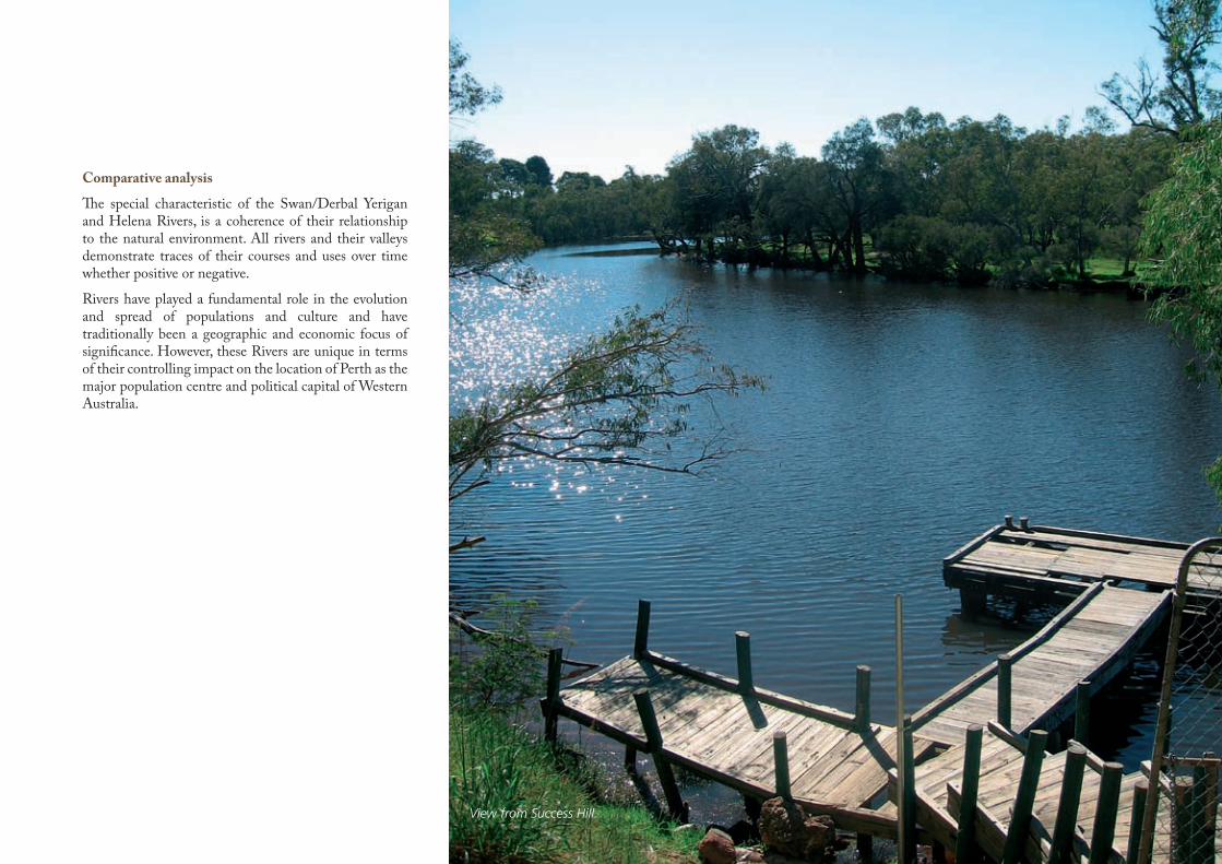
comparative analysis
The special characteristic of the Swan/Derbal Yerigan and Helena Rivers, is a coherence of their relationship to the natural environment. All rivers and their valleys demonstrate traces of their courses and uses over time whether positive or negative.
Rivers have played a fundamental role in the evolution and spread of populations and culture and have traditionally been a geographic and economic focus of significance. However, these Rivers are unique in terms of their controlling impact on the location of Perth as the major population centre and political capital of Western Australia.
View from Success Hill.
iv
Swan and Helena RiveRS ManageMent FRaMewoRk HeRitage audit and StateMent oF SigniFicance
Recommendations A number of recommendations have resulted from undertaking the audit process and developing the statement of significance.
These recommendations aim to support the conservation of the Rivers’ environment, the future development of an interpretation plan and subsequent interpretive directions for the Rivers landscape, and should be implemented during the next 1-2 years to be consistent with the SHRMF which is endorsed by EMRC’s member Councils.
Recommendation:1. That the Eastern Metropolitan Regional Council adopt the Statement of Significance as a guiding document for future decision making.
Recommendation:2. That the EMRC promotes the concept of a centrally located Centre for the Rivers on the River, which is open every day and orientated to tourists and WA residents, that encompasses the understandings of the Rivers significance as indicated in this report to the broader community. The Centre should be managed by an appropriate authority.
Recommendation:3. The natural heritage of the Swan and Helena Rivers should play an important role in encouraging environmental awareness and stewardship of the area’s natural heritage values.
Recommendation:4. In order to achieve overall better management of the bushland, a coordinated approach is required across all levels of government with extensive community input being encouraged.
Recommendation:5. The interpretation of historic heritage sites along the Swan and Helena Rivers should take a thematic approach based on the themes identified in this study, that is Exploration, Aboriginal contact and early settlement; Transport, Industry and Services; Gold Boom, Prosperity and Subdivision; Institutions and Recreation. Together, these themes provide a framework for demonstrating the role the Rivers have played in the settlement and development of the city from 1829.
Recommendation:6. The interpretation of the story of human settlement along the Rivers must take account of the shared experiences of Indigenous and non-Indigenous people and should, where appropriate, include aspects of both co-operation and conflict. Wherever possible, stories should be told from both perspectives.
Recommendation:7. Consultation with representatives of the Nyoongar community should be on-going to ensure that the large numbers of closed and open sites in the study area are respected and protected.
Recommendation:8. Preparation of interpretation should reflect the contrasting long history of the Nyoongar occupation and the continuing history interlinked with recent settlers along the Rivers.
Recommendation:9. Preparation for interpretation of historic heritage places should include consultation with relevant community groups and the local authority. Interpretive material should be prepared and checked by an interpretation professional to ensure that it is historically accurate and culturally appropriate.
Recommendation:10. A coherent integrated program of interpretation of cultural and heritage values should be developed, utilising a range of interpretative strategies, capable of being expanded to encompass the whole of the river system.
Recommendation:11. Development of trail interpre-tation of various kinds should be approached as part of a coherent interpretation program, communicating River themes as well as identifying places of local interest, their relationship to and impact on the Rivers.
Recommendation:12. Proposed and existing interpretive centres and facilities should conserve and interpret relic bushland areas serving as fauna refuges providing habitats and shore line buffers within each of the precincts. There are several extensive areas that may contribute to environmental awareness through land or water based educational and interpretive tours promoting natural heritage along with Indigenous and European values.
Recommendation:13. The preparation of interpre-tation material for any of the areas identified through this study should involve further consultation with local communities.
Recommendation:14. It is important that the integrity of significant bushland is not compromised through intersection by active dual-use paths and trails. Proposed trails should have hard boundaries, and need to be directed towards the land side of the bushland, not the foreshore, to ensure that habitats and refuges are not disaggregated.
v
Swan and Helena RiveRS ManageMent FRaMewoRk HeRitage audit and StateMent oF SigniFicance
Recommendation:15. Trails involving any form of infrastructure (eg signage, pathways) must be environmentally friendly and sensitive to Indigenous cultural issues understood through consultation and research.
Recommendation:16. Any infrastructure or physical works for trails and other interpretation purposed should be the subject of Section 18 applications under the Aboriginal Heritage Act (1972) in order to minimise risk of cultural conflict or legal action during or after construction.
Recommendation:17. A photographic record of the Rivers’ banks should be carried out in a similar format to Google Street, to provide a more informed visual archive of the riverbanks.
Recommendation:18. Regeneration and rehabilitation plans should be developed for specific areas where they don’t already exist with protective measures and appropriate methods.
Recommendation:19. Further consideration should be given to improving the links between bushland and other foreshore sites, thereby adding depth to corridors along both sides of the rivers. This should include planning for future acquisition or transfer to the reserve system to subsequent encouragement of natural regeneration.
Recommendation:20. Where acquisition of additional foreshore is not feasible, regeneration of endemic plant species to achieve sustainable natural growth should be encouraged.
Recommendation:21. Specific precinct recommend-ations included in the audit section should be implemented.
Recommendation:22. All significant historic heritage places should be conserved in accordance with Burra Charter principles. Where places have been included on the Heritage Council’s Register of Heritage Places, their conservation and interpretation should involve consultation with the Heritage Council of WA.
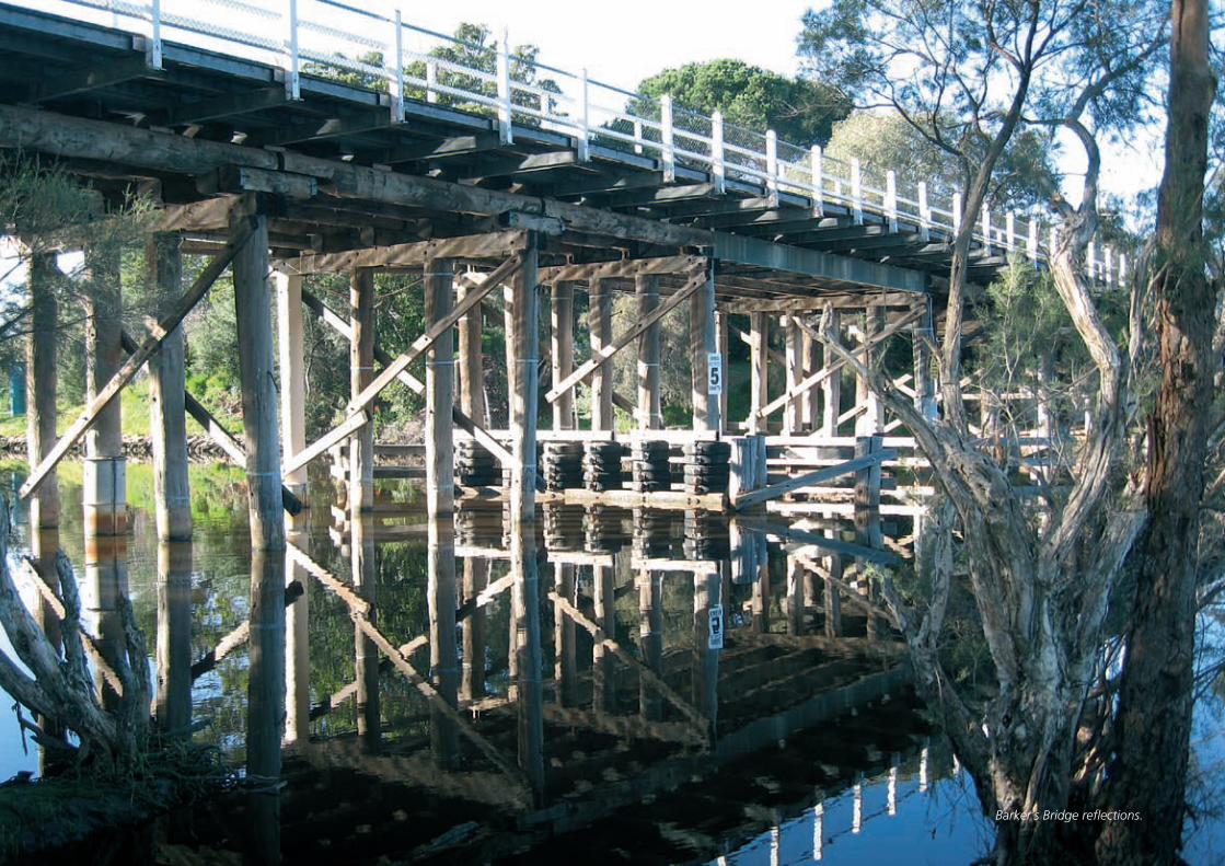
Barker’s Bridge reflections.
1
1
Swan and Helena RiveRS ManageMent FRaMewoRk HeRitage audit and StateMent oF SigniFicance
This document provides for the first time a Statement of Significance for the Swan and Helena Rivers, based on an audit of recorded natural, Aboriginal and historic sites over a defined section of the river. In 2008, there is greater sensitivity to Indigenous Australia, to the natural and heritage values of the Rivers and an increased emphasis on local and international heritage tourism. This report seeks to contribute to a greater understanding of our shared heritage.
tHe BRieF 1.2 This report was commissioned by the Eastern Metropolitan Regional Council (EMRC) in response to the recommendation contained in the ‘Swan and Helena Rivers Management Framework Report’ (SHRMF), prepared by Hassell Ltd in 2007, that a Statement of Significance be prepared to provide input into the route, themes and interpretation of the Swan and Helena Rivers Regional Recreation Path.
The requirements of the study were to produce a Statement of Significance that incorporated an audit of heritage values within the study area, prepared through a process of consultation carried out in each of the participating local government areas. The brief also required the identification of existing oral histories and that the heritage features be presented graphically (in
digital format) as a guide to future interpretation of the study area.
The Brief for this project is included at Appendix 12.3 to this report.
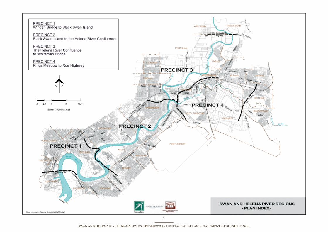
tHe Study aRea1.3 The boundaries of the study are defined by four precincts identified by the SHRMF that extend from Windan Bridge near the city, east to Middle Swan Road and Whiteman Bridge, and south to Roe Highway. Precinct 1 extends from Windan Bridge to Black Swan Island, Precinct 2 from Black Swan Island to the Helena River Confluence, Precinct 3 from the Helena River Confluence to Whiteman Bridge and Precinct 4 from Kings Meadow to Roe Highway. The precinct boundaries are illustrated graphically on figures included in this report on pages 9 and 61.
The majority of the study area is included within the boundaries the City of Bayswater, City of Belmont, City of Swan and the Town of Bassendean. Representatives of these local authorities have been involved in the project.
HeRitage liStingS 1.4 The Swan River (including the Helena River) was entered
on the Aboriginal Sites Register in 1997, identifying its importance not only to the Nyoongar people but also to the State of Western Australia. As a result of its listing, the Swan River is protected under the provisions of the Aboriginal Heritage Act (1972).
In 2004 the Swan River was named Perth’s first official heritage icon as part of the 175th anniversary of the founding of the Swan River Colony.
Along the banks of the river there are many historic sites and places that have been entered on the Heritage Council of Western Australia’s (HCWA) Register of Heritage Places and are therefore protected under the Heritage of Western Australia Act (1990). In addition there are many places that have been classified by the National Trust of Australia (WA) or included on the Municipal Inventories of the participating local authorities.
There are a number of places of natural heritage significance within the study area that have been listed in the Directory of Important Wetlands in Australia and are protected under the Commonwealth Environment Protection and Biodiversity Act (1999).
Details of these individual listings are included in the audits for the natural, Indigenous and the historic environments at Appendices 12.4.1, 12.4.2 and 12.4.3 of this report.
introduction to the Report1.0 PReaMBle 1.1
The Swan River and Helena Rivers offer an iconic landscape locally and internationally recognised for its natural, cultural and historic values. The Rivers and surrounding plains have been vital in sustaining the Nyoongar people for approximately 40,000 years, while providing an important historic, economic and recreational focus for Western Australia in more recent times.
2
Swan and Helena RiveRS ManageMent FRaMewoRk HeRitage audit and StateMent oF SigniFicance
MetHod1.5 This Statement of Significance has been prepared on the basis of the model used by the United Nations Educational, Scientific and Cultural Organisation (UNESCO) for the purpose of establishing World Heritage Listings.
In view of the unquestioned historic and cultural significance of the Rivers, and the size and complexity of the study area which is much greater than most listed heritage places, the team decided that an adequate Statement of Significance required more than a compilation of values and associations collated from an audit. The audits of heritage and cultural values recognised in the different formal listings covered a wide range, and inevitably certain values were widely present and shared across Indigenous and colonial cultures (represented by the places identified in the Indigenous and historic heritage audits). For example, use of the Rivers for transport, and as a food resource etc. People visiting any section of the Rivers, experience their environment as a whole without necessarily separating in their minds the elements which are conventionally categorised for official purposes as natural, Indigenous, or historic / (post-) colonial.
It was therefore felt that an adequate Statement of Significance had to take a unified approach, and this was the reason for seeking to identify, explicate and illustrate some broad “meta” (or overarching) themes as well as collating and grouping values which are represented by specific places within the study area.
It was also felt necessary to distinguish those themes and values which seem particular or striking for the Rivers under study here, from those which apply to most if not all rivers (e.g.: transport corridor/barrier, fish and irrigation, among others). The question was asked: what makes these Rivers of regional, state, national (and potentially international) significance?
To answer this question it was necessary to think beyond compilations of values as identified through an audit type process. One member of the study team has been involved during 2006 in a UNESCO-sponsored education program involving the World Heritage values of the Seine and Loire Rivers, and drew attention to the ways these are understood in UNESCO documentation as having distinctive universal significance as well as local meanings like all river systems and valleys. The Loire valley, for example, has many of the attributes of other French and European rivers, but is seen as unique for the extent of its surviving wild sections and the unmatched glories of its Renaissance architecture (e.g.: many chateaux, including Chambord). The idea was to ask, and test, whether the Rivers being studied here also had unique or distinctive values and cultural meanings of their own.
tHeMatic aPPRoacH 1.6 As a response to the method employed by UNESCO, the Statement of Significance for the Rivers suggested in this report, presents an integrated review that places natural, Indigenous and historic values side by side. While this has the great advantage of presenting a holistic view, it has been technically complex, due to the different ways in which significance is generally assessed by the three environments.
The study takes the approach of a hierarchy of themes, resulting in a series of overarching themes that are considered to define the significance of the river in a holistic way. The following document provides the technical support for this approach.
The “meta” or overarching themes for the Significance of the Rivers as defined in this report are:
River of life •Power of the landscape •Sustainability •
These themes have been derived from a consideration of the sub-themes identified within the three environments as follows:
natural environment Themes landscape attributes•Bushland values•Habitat values •Biodiversity values•
indigenous Heritage Themes Habitation•Mythological Sites•ceremonial Sites•natural Features•Burial Places •
Historic Heritage Themes exploration, aboriginal contact and •early settlement transport, industry and Services•gold Boom, Prosperity and Subdivision•institutions•Recreation•
The themes generated by the three audits all demonstrate the primary or overarching themes. The Statement of Significance included in this report draws this out in greater detail, however the central concept presented through this review is the significance of the Rivers in sustaining life.
The Rivers define the landscape in which we live, take us physically from the scarp to the ocean and spiritually from the beginning of time to the present. The significance of the Rivers includes values associated with spirituality, geology and biodiversity as well as the individual and shared histories of Indigenous and non–Indigenous people.
Above all this report identifies the outstanding qualities of the Rivers in order for these to be conserved, interpreted, appreciated and enjoyed for generations to come.
3
Swan and Helena RiveRS ManageMent FRaMewoRk HeRitage audit and StateMent oF SigniFicance
RePoRt FoRMat1.7 This report has been organised on the basis of the process outlined for assessment of places for World Heritage Listing with some minor adaptations to address the requirements of the project brief. The report comprises the following sections:executive Summary introductionPart 1
Statement of Significance•Summary of Recommendations•a defined Study area•overarching “meta” themes•understanding the Rivers•
Part 2natural Heritage values •aboriginal values•Historic values•
Part 3oral History •consultation•
appendicesBibliography•The Project Brief•audit Reports within the Boundaries of the •Swan and Helena River Study areaaudit of identified natural Heritage •audit of identified aboriginal Heritage Sites•audit of identified Historic Places •
The purpose of Part 1 of this report is to present the overall findings of the study. This includes the Statement of Significance for the Rivers and recommendations for future conservation and interpretation of the identified heritage values in the context of the proposed future use of the river for recreational purposes, including the development of trails. This overview has been informed by the material presented in Part 2 of the report.
Part 2 presents a summary of the findings of audits of the natural, Indigenous and historic environments in the form of thematic overviews that link the places identified in the audits to the themes identified for each audit. This information informs the Statement of Significance and Recommendations presented in Part 1.
Part 3 of the report presents supporting information requested in the Project Brief. It provides summary reports on available oral histories and the consultation carried out as part of the project.
Finally the audits for the three environments are presented in table form in the appendices to this report. This material is also presented graphically on pages 10-13.
liMitationS 1.8 The Heritage Audit and Statement of Significance for the Swan and Helena Rivers (the Rivers) has been prepared on the basis of available documentary resources (See Bibliography Appendix A). Primary and secondary sources have been used. While all care has been taken, the authors cannot accept responsibility for errors in secondary source material.
The audit of places of Historic Significance has used as a basis existing heritage lists including Municipal Inventories, National Trust records and documentation prepared by the Heritage Council of Western Australia (HCWA). While this has been reviewed through the consultation process, the consultants cannot take responsibility for information that may be found subsequently about the places identified in the audit.
All three audits provide summaries of information only. Further information is available for the majority places in site specific documents referred to throughout this text.
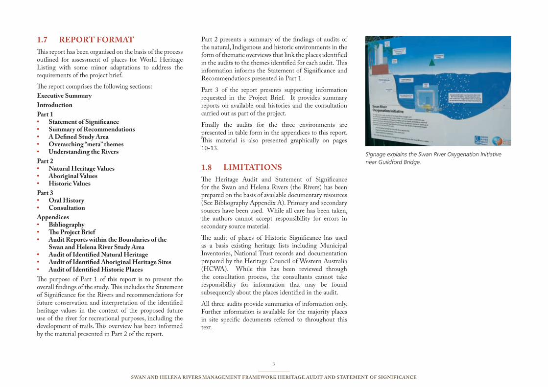
Signage explains the Swan River Oxygenation Initiative near Guildford Bridge.
24
Swan and Helena RiveRS ManageMent FRaMewoRk HeRitage audit and StateMent oF SigniFicance
statement of significance2.0 The waterways and surrounds of the Swan River and Helena Rivers (hereafter called the Rivers), in the study area bounded by Windan Bridge, Whiteman Bridge, Roe Highway and Middle Swan Road are based on a distinctive geological formation with an evolved ecosystem. Having been used intensively by humans for millennia, the defined area is characterised by a diverse range of heritage values. Many of the individual places along the Rivers are themselves of specific heritage value, but outstanding value attaches to the overall landscape that has evolved over time. Thus the Statement of Significance identifies this area of the Rivers as a cultural landscape with natural and cultural heritage significance for the following reasons:
the Rivers’ landscape demonstrates the ending of the Gondwanaland period due to the break up of the Indian and Australian tectonic plates following rifting along the Darling fault line;
the Rivers were formed by the mythological serpent the Waugyl according to Nyoongar tradition, and have continuing cultural importance related to past and contemporary Nyoongar culture;
the Rivers’ environment is home to rare and priority flora listed on international and state based registers;
archaeological discoveries in the river valley have extended the scientific knowledge of the great antiquity (at least 40 thousand years) of continuous human habitation in Australia;
in 1829, the erroneous belief that the Rivers provided rich arable land, led to the establishment of the Swan River Colony, the first free (non-convict) colonial settlement in Australia;
the Rivers link the scarp to the city and determined both the location of Western Australia’s first three towns, Perth, Fremantle and Guildford, and the form of land allocation and distribution in the colony;
the Rivers provided Perth’s first transport and communication corridor and demonstrate access to the upper reaches and downstream to Fremantle;
the Rivers provide evidence of changing livelihoods, lifestyles and sustenance for all humans who have lived there over thousands of years;
the changing use of the Rivers for industrial purposes from 1829 to the present demonstrate evidence of innovation and change in technology and industry;
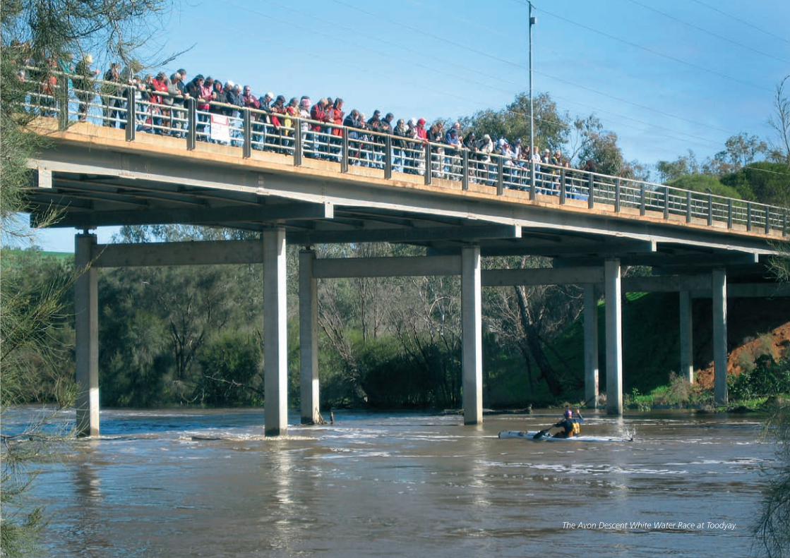
the Rivers and their banks have been used for passive and active recreation including swimming, boating, walking, bird-watching, horse racing and picnics, and are linked to international sporting events including The Avon Descent White Water Race;
the Rivers provide evidence of changing and contrasting systems of understanding, use and abuse, management and mismanagement;
the Rivers demonstrate notions and understanding of personal, social and environmental wellbeing and malady; and
the Rivers provide the opportunity for the development of greater understanding between people through the challenges of their conservation and rehabilitation as both a physical resource and a spiritual place.
authenticity
When assessed as a cultural landscape, the nominated areas of the Swan and Helena Rivers and surrounds exhibit a high degree of authenticity. Its historical trajectory can be seen in the present day landscape, and the associated Nyoongar values continue from ancient times until today as much as the changing environment allows.
As this Statement of Significance is for a nominated cultural landscape, it is not appropriate to consider the authenticity of every natural or cultural component. However, a comprehensive list included with this statement details historical, Aboriginal and natural areas, places and sites within the limits of the information available in 2008.
The dynamic relationship between the Rivers and the landscapes that have developed around them is a powerful one stretching across geological time to the present.
The extent of spiritual autonomy of the river as well as spiritual connection to the river and changes in usage by the Nyoongar and European cultures is reflected in the physical characteristics of different sections of the river and their evolution.
PART 1

Traditional usage of the environment ranges from food gathering, to campsites, ceremonial and spiritual uses and is linked to the Rivers themselves and their surrounds.
While European settlement led to the development of farms, townships, transport, governance and industry, the land use patterns also indicate social and economic change over approximately 40,000 years.
comparative analysis
The special characteristic of the Swan/Derbal Yerigan and Helena Rivers is a coherence of their relationship to the natural environment. All rivers and their valleys demonstrate traces of their courses and uses over time whether positive or negative.
Rivers have played a fundamental role in the evolution and spread of populations and culture and have traditionally been a geographic and economic focus of significance. However, these Rivers are unique in terms of their controlling impact on the location of Perth as the major population centre and political capital of Western Australia.
View to Point Reserve Jetty.
36
Swan and Helena RiveRS ManageMent FRaMewoRk HeRitage audit and StateMent oF SigniFicance
A summary of Recommendations3.0 A number of recommendations have resulted from undertaking the audit process and developing the statement of significance.These recommendations aim to support the conservation of the Rivers’ environment, the future development of an interpretation plan and subsequent interpretive directions for the Rivers landscape, and should be implemented during the next 1-2 years to be consistent with the SHRMF which is endorsed by EMRC’s member Councils.
Recommendation:1. That the Eastern Metropolitan Regional Council adopt the Statement of Significance as a guiding document for future decision making.
Recommendation:2. That the EMRC promotes the concept of a centrally located Centre for the Rivers on the River, which is open every day and orientated to tourists and WA residents, that encompasses the understandings of the Rivers significance as indicated in this report to the broader community. The Centre should be managed by an appropriate authority.
Recommendation:3. The natural heritage of the Swan and Helena Rivers should play an important role in encouraging environmental awareness and stewardship of the area’s natural heritage values.
Recommendation:4. In order to achieve overall better management of the bushland, a coordinated approach is required across all levels of government with extensive community input being encouraged.
Recommendation:5. The interpretation of historic heritage sites along the Swan and Helena Rivers should take a thematic approach based on the themes identified in this study, that is Exploration,
Aboriginal contact and early settlement; Transport, Industry and Services; Gold Boom, Prosperity and Subdivision; Institutions and Recreation. Together, these themes provide a framework for demonstrating the role the Rivers have played in the settlement and development of the city from 1829.
Recommendation:6. The interpretation of the story of human settlement along the Rivers must take account of the shared experiences of Indigenous and non-Indigenous people and should, where appropriate, include aspects of both co-operation and conflict. Wherever possible, stories should be told from both perspectives.
Recommendation:7. Consultation with representatives of the Nyoongar community should be on-going to ensure that the large numbers of closed and open sites in the study area are respected and protected.
Recommendation:8. Preparation of interpretation should reflect the contrasting long history of the Nyoongar occupation and the continuing history interlinked with recent settlers along the Rivers.
Recommendation:9. Preparation for interpretation of historic heritage places should include consultation
with relevant community groups and the local authority. Interpretive material should be prepared and checked by an interpretation professional to ensure that it is historically accurate and culturally appropriate.
Recommendation:10. A coherent integrated program of interpretation of cultural and heritage values should be developed, utilising a range of interpretative strategies, capable of being expanded to encompass the whole of the river system.
Recommendation:11. Development of trail interpret-ation of various kinds should be approached as part of a coherent interpretation program, communicating River themes as well as identifying places of local interest, their relationship to and impact on the Rivers.
Recommendation:12. Interpretive centres and facilities should be developed to conserve and interpret relic bushland areas serving as fauna refuges providing habitats and shore line buffers within each of the precincts. There are several extensive areas that may contribute to environmental awareness through land or water based educational and interpretive tours promoting natural heritage along with Indigenous and European values.
7
Swan and Helena RiveRS ManageMent FRaMewoRk HeRitage audit and StateMent oF SigniFicance
Recommendation:13. The preparation of interpret-ation material for any of the areas identified through this study should involve further consultation with local communities.
Recommendation:14. It is important that the integrity of significant bushland is not compromised through intersection by active dual-use paths and trails. Proposed trails should have hard boundaries, and need to be directed towards the land side of the bushland, not the foreshore, to ensure that habitats and refuges are not disaggregated.
Recommendation:15. Trails involving any form of infrastructure (eg signage, pathways) must be environmentally friendly and sensitive to Indigenous cultural issues understood through consultation and research.
Recommendation:16. Any infrastructure or physical works for trails and other interpretation purposed should be the subject of Section 18 applications under the Aboriginal Heritage Act (1972) in order to minimise risk of cultural conflict or legal action during or after construction.
Recommendation:17. A photographic record of the Rivers’ banks should be adopted in a similar format to Google Street, to provide a more informed visual archive of the riverbanks.
Recommendation:18. Regeneration and rehabilitation plans should be developed for specific areas where they don’t already exist with protective measures and appropriate methods.
Recommendation:19. Further consideration should be given to improving the links between bushland and other foreshore sites, thereby adding depth to corridors along both sides of the rivers. This should include planning for future acquisition or transfer to the reserve system to subsequent encouragement of natural regeneration.
Recommendation:20. Where acquisition of additional foreshore is not feasible, regeneration of endemic plant species to achieve sustainable natural growth should be encouraged.
Recommendation:21. Specific precinct recommend-ations included in the audit section should be implemented.
Recommendation:22. All significant historic heritage places should be conserved in accordance with Burra Charter principles. Where places have been included on the Heritage Council’s Register of Heritage Places, their conservation and interpretation should involve consultation with the Heritage Council of WA.
48
Swan and Helena RiveRS ManageMent FRaMewoRk HeRitage audit and StateMent oF SigniFicance
A Defined study Area4.0 indicatoRS and liMitationS4.1
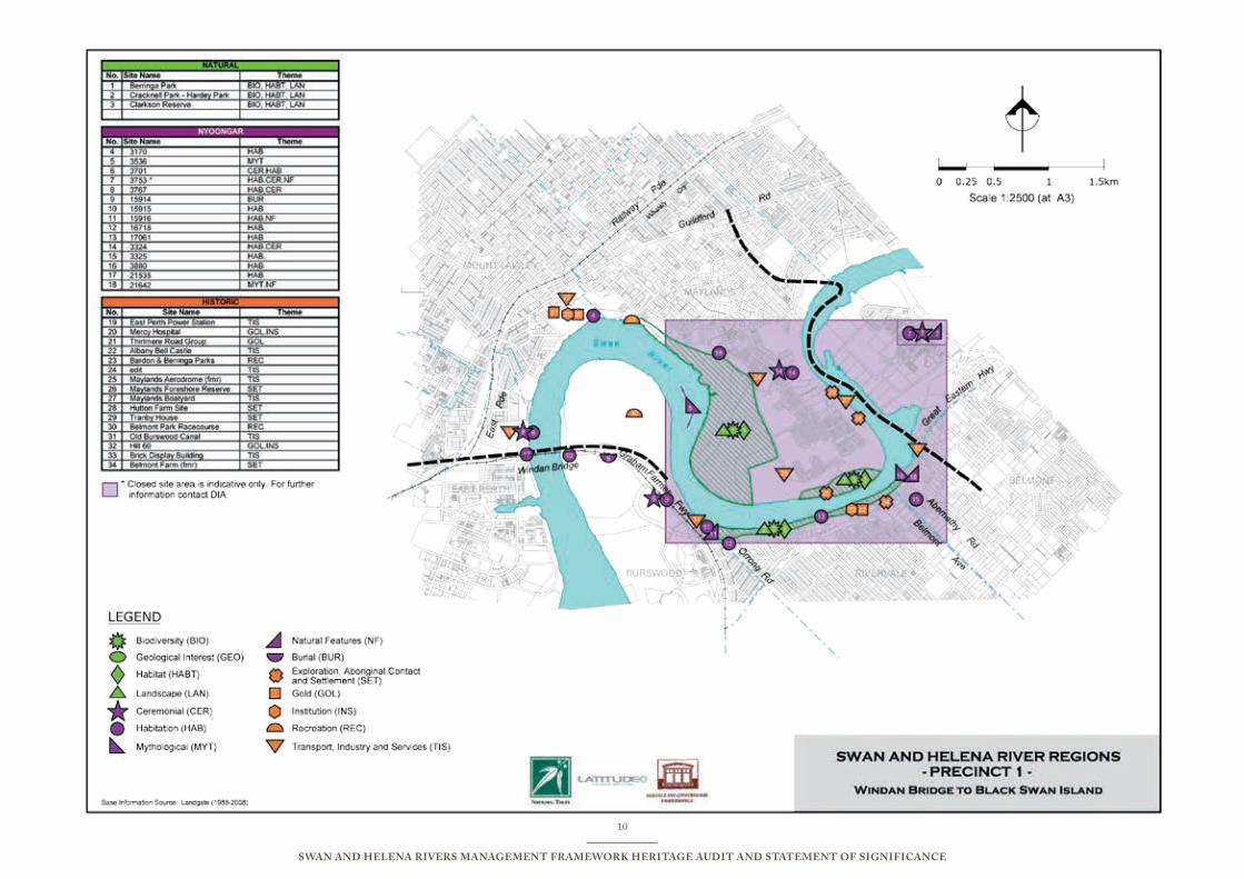
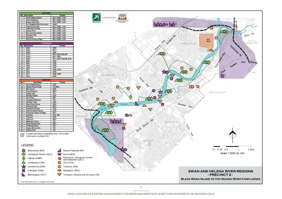
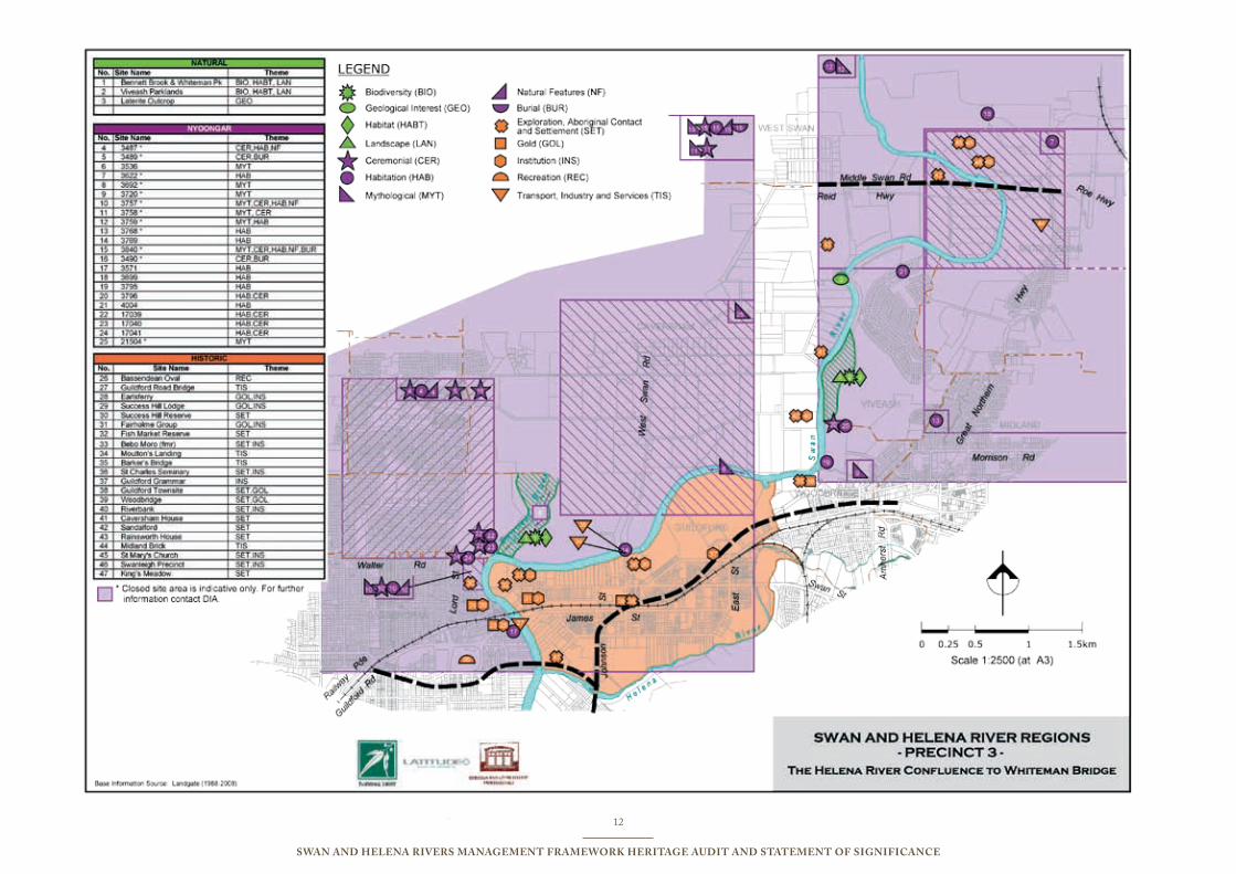
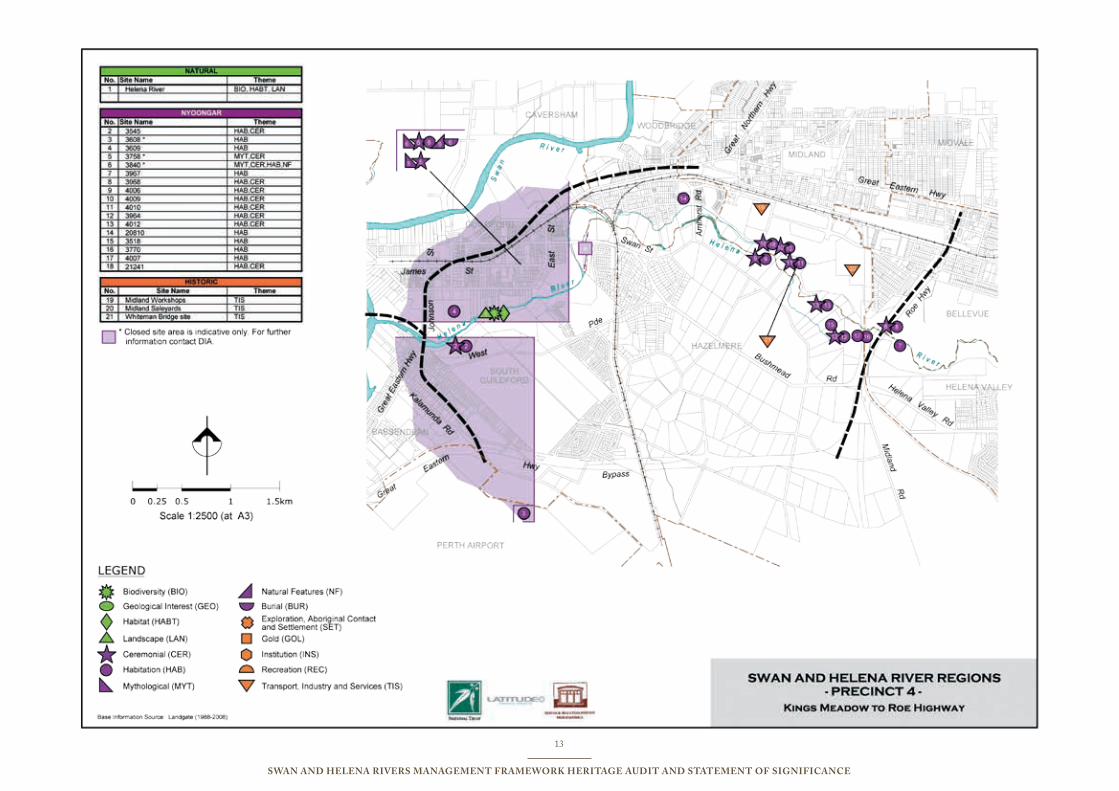
A range of maps has been produced to indicate the important natural and cultural heritage sites and places revealed by the audit process undertaken for this report. The maps are based on four precincts determined by the Swan River Trust and correspond to the same precinct approach adopted in the Swan and Helena River Management Framework Report (2007).
The sites and places included on these maps have been identified by undertaking audits of existing heritage lists and data bases. The audit and collation of historic sites drew on listings backed by WA legislation including the Heritage Council of Western Australia (HCWA) database which incorporates places from the former Register of the National Estate (now dormant) and National Trust (WA) classified places as well as places on municipal inventories. The accuracy of the audits undertaken reflects the lists at the time of the audit. However, because the valuing of heritage changes over time, the lists which are in all cases ‘works-in-progress’, will also change over time. In the early stages of compiling the state register, historic sites were often not seen in relation to each other, or as part of the overall landscape of the River and its catchments. These issues do not represent a limitation of accuracy but they indicate the changing nature of heritage values and of the processes by which lists are compiled, and this evolution must be taken into consideration in future planning. The Register of Heritage Places, developed and maintained by the Heritage Council, is likely to eventually include twice as many places as are registered at the time of writing. Municipal Inventories are inconsistent between local government areas, and subject to regular revision. In addition, a small number of extra historic sites including
Swanleigh Precinct and St Mary’s Church have been included in the audit because of their historic importance to the Rivers overview.
Further, there are additional considerations associated with the identification of Aboriginal cultural sites through the Department of Indigenous Affairs’ (DIA) Aboriginal Sites Register. From an Aboriginal and legislative perspective (Aboriginal Heritage Act 1972) a site is a site even if it has not been recorded, and many sites are only first recorded through the process of seeking development approvals in relevant areas. In addition, many important Aboriginal sites which are considered culturally significant are restricted because of the sensitive nature of their cultural significance and are thus closed sites whose documentation is not freely available. No audit will ever be final, but what has been identified through the audit process can inform a range of conservation and interpretation activities on conceptual and thematic levels.
The maps show that the river has been a magnet for human activity as well as being a prime determining environmental feature. The maps also identify significant places and define a range of cultural and historic themes.
By ilustrating the ways in which natural and cultural heritage places are distributed through the region, contrasting histories of use, abuse and ways of life can be better understood. Some of these activities will be common to most or all riverine environments, while some are peculiar to this river.
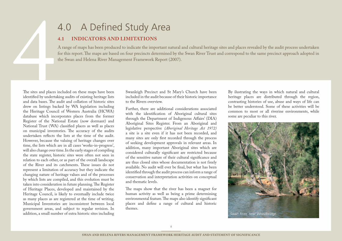
Swan River, near Woodbridge.
9
Swan and Helena RiveRS ManageMent FRaMewoRk HeRitage audit and StateMent oF SigniFicance
10
Swan and Helena RiveRS ManageMent FRaMewoRk HeRitage audit and StateMent oF SigniFicance
11
Swan and Helena RiveRS ManageMent FRaMewoRk HeRitage audit and StateMent oF SigniFicance
12
Swan and Helena RiveRS ManageMent FRaMewoRk HeRitage audit and StateMent oF SigniFicance
13
Swan and Helena RiveRS ManageMent FRaMewoRk HeRitage audit and StateMent oF SigniFicance
5
14
Swan and Helena RiveRS ManageMent FRaMewoRk HeRitage audit and StateMent oF SigniFicance
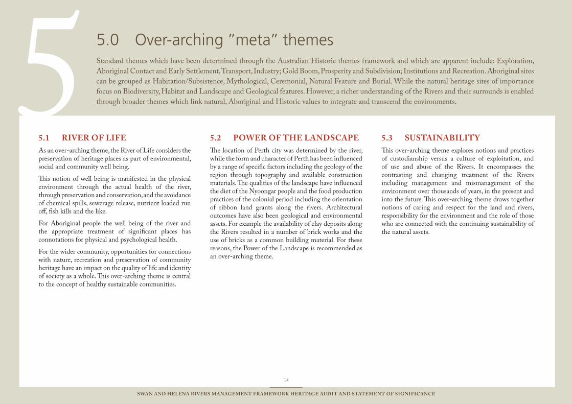
RiveR oF liFe5.1 As an over-arching theme, the River of Life considers the preservation of heritage places as part of environmental, social and community well being.
This notion of well being is manifested in the physical environment through the actual health of the river, through preservation and conservation, and the avoidance of chemical spills, sewerage release, nutrient loaded run off, fish kills and the like.
For Aboriginal people the well being of the river and the appropriate treatment of significant places has connotations for physical and psychological health.
For the wider community, opportunities for connections with nature, recreation and preservation of community heritage have an impact on the quality of life and identity of society as a whole. This over-arching theme is central to the concept of healthy sustainable communities.
PoweR oF tHe landScaPe5.2 The location of Perth city was determined by the river, while the form and character of Perth has been influenced by a range of specific factors including the geology of the region through topography and available construction materials. The qualities of the landscape have influenced the diet of the Nyoongar people and the food production practices of the colonial period including the orientation of ribbon land grants along the rivers. Architectural outcomes have also been geological and environmental assets. For example the availability of clay deposits along the Rivers resulted in a number of brick works and the use of bricks as a common building material. For these reasons, the Power of the Landscape is recommended as an over-arching theme.
SuStainaBility5.3 This over-arching theme explores notions and practices of custodianship versus a culture of exploitation, and of use and abuse of the Rivers. It encompasses the contrasting and changing treatment of the Rivers including management and mismanagement of the environment over thousands of years, in the present and into the future. This over-arching theme draws together notions of caring and respect for the land and rivers, responsibility for the environment and the role of those who are connected with the continuing sustainability of the natural assets.
over-arching ’’meta’’ themes5.0 Standard themes which have been determined through the Australian Historic themes framework and which are apparent include: Exploration, Aboriginal Contact and Early Settlement, Transport, Industry; Gold Boom, Prosperity and Subdivision; Institutions and Recreation. Aboriginal sites can be grouped as Habitation/Subsistence, Mythological, Ceremonial, Natural Feature and Burial. While the natural heritage sites of importance focus on Biodiversity, Habitat and Landscape and Geological features. However, a richer understanding of the Rivers and their surrounds is enabled through broader themes which link natural, Aboriginal and Historic values to integrate and transcend the environments.
The Avon Descent White Water Race at Toodyay.
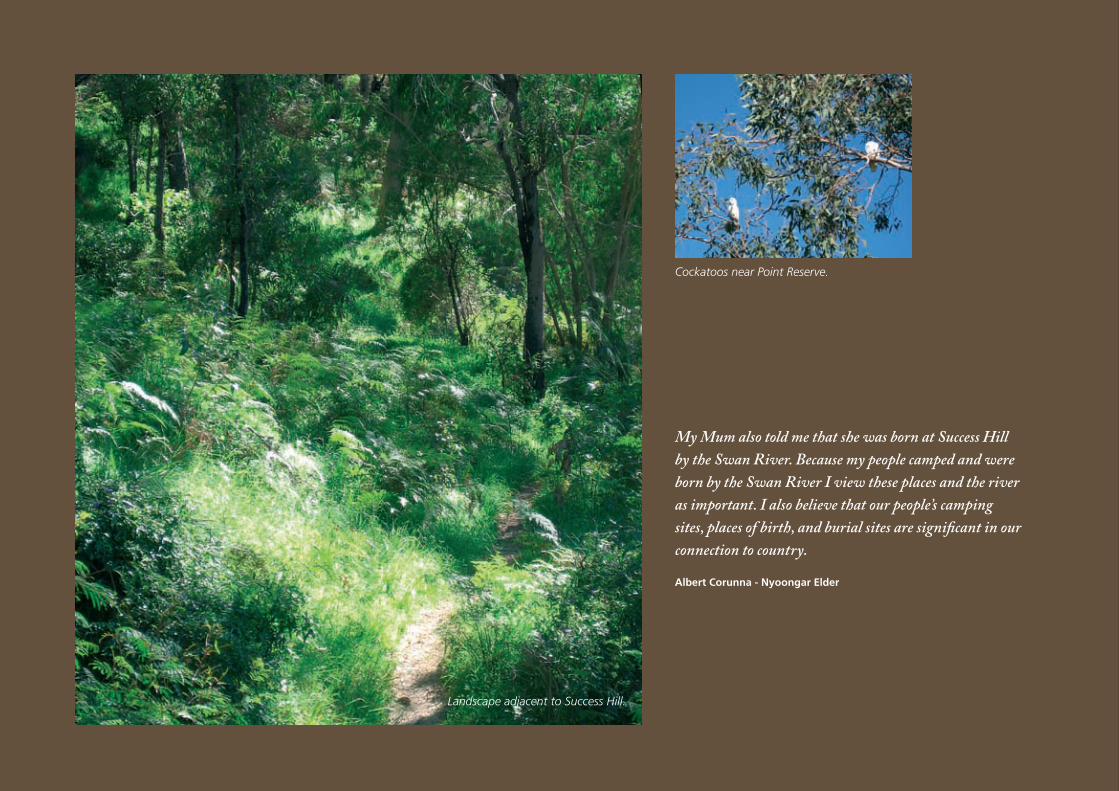
My Mum also told me that she was born at Success Hill by the Swan River. Because my people camped and were born by the Swan River I view these places and the river as important. I also believe that our people’s camping sites, places of birth, and burial sites are significant in our connection to country.
Albert Corunna - Nyoongar Elder
Landscape adjacent to Success Hill.
Cockatoos near Point Reserve.
6For an historically very short and recent time, the region around the Rivers has been home to a vastly greater number of people, as the location of the metropolis of Perth. An understanding of the natural and cultural heritage significance of the Swan and Helena Rivers can only be achieved by placing the variety of heritage sites identified through the present study in a broad environmental and historical context. The Nyoongar and settler peoples have developed associations with local places, and left their marks on the landscape – for better and worse.
The Swan River drains the Avon and Swan Coastal Catchment. The lower reaches of the river are wide and in parts deep, while the upper reaches are characteristically narrow.
The Avon River contributes the majority of the freshwater flow to the Swan, and becomes the Swan River at Walyunga National Park, approximately 30 kilometres north of Perth. The Helena River is a tributary of the Swan River, rising east of Mount Dale it flows north west where it is dammed at Mundaring Weir, passing through the western edge of the Darling Scarp before joining the Swan River at the southern boundary of Guildford. The areas of the Swan and Helena Rivers included in this project extend from Windan Bridge in the west, to Middle Swan Road and Whiteman Bridge and South to Roe Highway. The Swan River flows through a
landscape defined by five local government authorities including the City of Swan, Town of Bassendean, City of Belmont, City of Bayswater and Shire of Mundaring. Ownership of individual properties that make up the area is varied and includes state and local government as well as private individuals. The rivers and their banks are public property.
Landscapes within the study include natural, man-made, suburban, urban, industrial, parkland recreational and rural uses. The bushland corridor features aesthetic, biodiversity and landscape values and is home to rare flora and unique fauna.
The natural and cultural heritage significance of the section of the Rivers defined for the present study cannot be isolated from an understanding of the Rivers systems and their surrounds for their entire length. For example, the centre of the City of Perth lies outside this defined area which encompasses certain suburbs, but the location and character of the Perth metropolis is clearly one of the most significant outcomes of the landscape form, and expressions of the history, of the riverine zone as a whole including the study area.
This audit of heritage values needs, and aims, to go beyond mere listing and categorisation of places which have been recognised for their relevance as part of the local story and their ability to demonstrate aspects of it. A satisfactory understanding requires an effort to
comprehend whether there are any natural and cultural heritage values that are particular to these Rivers, and transcend local significance, to indicate rarity or uniqueness at a national or even (potentially) world heritage level.
Rediscovery of the long-term human history of the Rivers has played an important role in expanding recognition of the antiquity of Indigenous culture in Australia. We know that for millennia, the Nyoongar inhabitants of this part of the valley and Rivers cared for the land and sustained their lives through six seasons which reflected the rhythms of flora and fauna. The Nyoongar culture relied on both natural environments of the Rivers and surrounding plains. The entire water system including the Swan and Helena Rivers, the swamps and the underground water are directly related to and formed by the Waugyl, who [it is said] still today inhabits the Swan River according to Nyoongar culture.
With the arrival of additional European explorers and Swan Colony settlers, the river took on importance to a new group of people who brought with them existing cultural practices which impacted on the Rivers, the swamps and the adjacent land. Changing use and abuse of the Rivers has impacted on the ecological health of the riverine systems, with implications for the physical, psychological and spiritual health and well-being of humans.
understanding the Rivers6.0 Gnarla Wirn Keap: Keap Wirn (Our Spiritual Water: Our Water of Spirit) referred to as Derbal Yerrigan, Bilya Maal and more recently by the Dutch as Swaarte Swanne Rivier and by the British as the Swan River, is an important Aboriginal cultural area created by the mythological serpent like creature Waugyl, and defined by Nyoongar people and practices from the present to approximately 40,000 years ago.
17
Swan and Helena RiveRS ManageMent FRaMewoRk HeRitage audit and StateMent oF SigniFicance
18
Swan and Helena RiveRS ManageMent FRaMewoRk HeRitage audit and StateMent oF SigniFicance
For the first time since ancient time, the Rivers took on new names and a new identity which was framed by adaptations of imported British and European practices of agriculture, transport, communication, waste disposal and industry.
The Rivers witnessed the emergence of an introduced or adapted sense of landscape which the new arrivals attempted, often unsuccessfully, to force onto the land surrounding the Rivers in an attempt to produce food and wealth.
Although the traditional culture was severely violated, many Nyoongar practices and values associated with the Rivers and adjacent land continue through to contemporary times. There was violence between Nyoongar and European communities over usage of land and water, thus the Rivers landscape was the site and witness of conflict and murder between Nyoongar locals and new settlers.
From 1829 European settlement made an enormous impression on the landscape through clearing of land, agricultural practices and the placement of farms and the township of Guildford. The Swan was the first and most important artery for colonial Western Australia’s communication, transport and trade. The European impact on the landscape was substantial and still strongly influences urban location, development and form as well as road infrastructure.
Along with sustaining both ancient and contemporary communities, the Rivers have played a part in pleasure and leisure activities both on the water and along the banks – including at least one internationally recognised sporting event.
Scientific value attaches to a revolutionary oxygenation initiative unique in Australia, introduced to the estuarine environment of the Swan River near Guildford Bridge to improve ecological conditions. While there are two similar plants on the Canning River, the Swan based pilot plant is considered cutting edge technology for introducing oxygen to a River system in an estuarine environment.
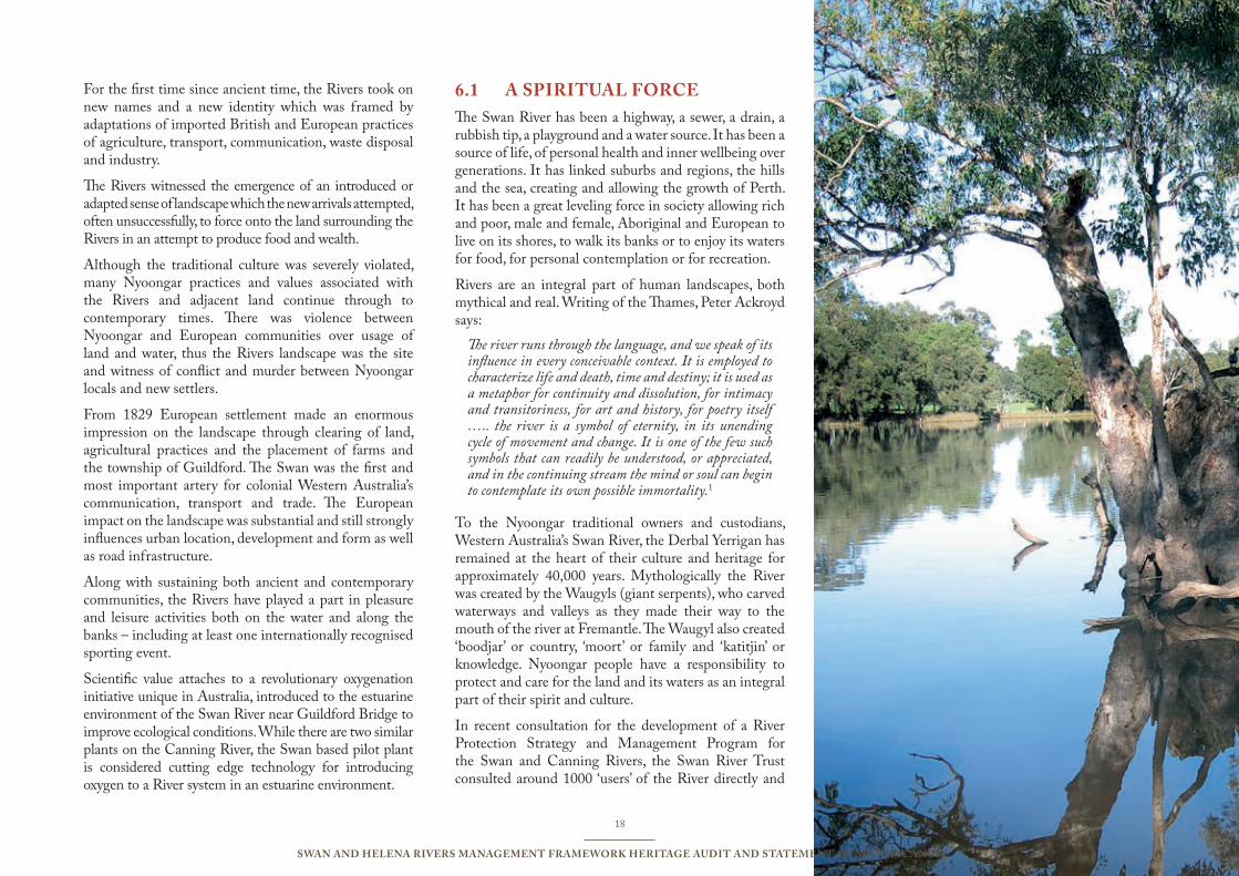
a SPiRitual FoRce6.1 The Swan River has been a highway, a sewer, a drain, a rubbish tip, a playground and a water source. It has been a source of life, of personal health and inner wellbeing over generations. It has linked suburbs and regions, the hills and the sea, creating and allowing the growth of Perth. It has been a great leveling force in society allowing rich and poor, male and female, Aboriginal and European to live on its shores, to walk its banks or to enjoy its waters for food, for personal contemplation or for recreation.
Rivers are an integral part of human landscapes, both mythical and real. Writing of the Thames, Peter Ackroyd says:
The river runs through the language, and we speak of its influence in every conceivable context. It is employed to characterize life and death, time and destiny; it is used as a metaphor for continuity and dissolution, for intimacy and transitoriness, for art and history, for poetry itself ….. the river is a symbol of eternity, in its unending cycle of movement and change. It is one of the few such symbols that can readily be understood, or appreciated, and in the continuing stream the mind or soul can begin to contemplate its own possible immortality.1
To the Nyoongar traditional owners and custodians, Western Australia’s Swan River, the Derbal Yerrigan has remained at the heart of their culture and heritage for approximately 40,000 years. Mythologically the River was created by the Waugyls (giant serpents), who carved waterways and valleys as they made their way to the mouth of the river at Fremantle. The Waugyl also created ‘boodjar’ or country, ‘moort’ or family and ‘katitjin’ or knowledge. Nyoongar people have a responsibility to protect and care for the land and its waters as an integral part of their spirit and culture.
In recent consultation for the development of a River Protection Strategy and Management Program for the Swan and Canning Rivers, the Swan River Trust consulted around 1000 ‘users’ of the River directly and
19
Swan and Helena RiveRS ManageMent FRaMewoRk HeRitage audit and StateMent oF SigniFicance
approximately 10,000 indirectly2. The most frequently mentioned community values were the ecological health of the waterways and river banks, along with beliefs and behaviour (identity, spirituality, culture and responsibility) and community benefit including community wellbeing, amenity, aesthetics, activity, access, water use and development. There was also an expressed desire to increase general cultural knowledge and awareness and link it with Indigenous traditional knowledge.
This Study has the potential to play a key role in increasing knowledge and understanding of all values of the Swan River, particularly the role of the River as a spiritual force for all Western Australians.
a cHanging landScaPe 6.2 The area under review is a significant part of the 280 km Swan/Avon River that extends from near Wikepin to the sea at Fremantle. The Swan and Helena River Precincts are part of a much larger catchment area - the Swan/Canning catchment area covers more than 2000 square kilometres. The Swan River is an outstanding physical feature and the study area is of geological and landscape importance.
The estuary of the Swan River lies in a river valley drowned by the sea about 6000 years ago when the sea level rose to slightly above its present level. Since the formation of the river channel the sea level has risen and fallen many times, modifying the shape and size of the estuary and the location of its mouth. Shell beds from four of these transgressions are found around the River today including one at Caversham.3 Evidence of an older estuary under Guildford was revealed by the work of George Kendrick who examined fossil shells exposed by dredging near the Helena River confluence. The shells were dated at around 6600 years ago. The presence of marine species of fossils indicates that the period saw a reduced volume of river discharge and hence a drier climate than at present. The Swan Estuary received less
winter flooding and the slightly higher sea level allowed greater tidal exchange.4
The Nyoongar people lived through periods of climate change and sea level rises and falls for around 40,000 years before the arrival of Europeans. They lived at one with their land and waters and observations by early European explorers confirmed their presence and their traditional activities such as firing the bush, crossing the River, camping along the River banks, getting water from springs, hunting and fishing. Kangaroos, possums, fish such as cobblers, swans, pelicans, ducks, emus, wild turkeys, cockatoos, pigeons, quail, frogs, grubs, zamia fruit and yams made for a plentiful and varied diet.
The registered Nyoongar sites in the Swan and Helena River Precincts provide a limited glimpse of what was and remains a deep Nyoongar connection with the River. The 60 sites recorded cover habitation/subsistence, mythology and ceremony, natural features and burial grounds.
The Nyoongar people fired the landscape in managing their lands. However the European use of the natural landscape has transformed it. The pure air, the fertility of the soils along the Swan River, the beauty of the landscape and the availability of fresh water springs were among the reasons for the settlement of the Swan River colony. Captain Stirling used all these arguments, along with the availability of building materials and the communication advantages, in defending his choice of Perth as the site for the capital.
From the earliest days of settlement when flat bottomed boats had to be manhandled over the Heirisson flats, that part of the River covered by the Swan and Helena River Study Area formed a vital transport route between Perth and the agricultural areas to be developed past Guildford. The first changes made to the natural environment were channels cut for navigation – in 1831 the first channel made Burswood into an island and when that was relatively unsuccessful, the second was cut in 1834. In
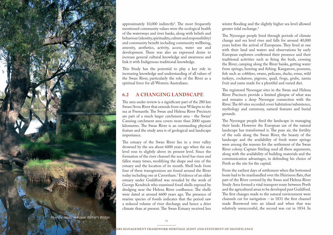
Riverine landscape near Barker’s Bridge.
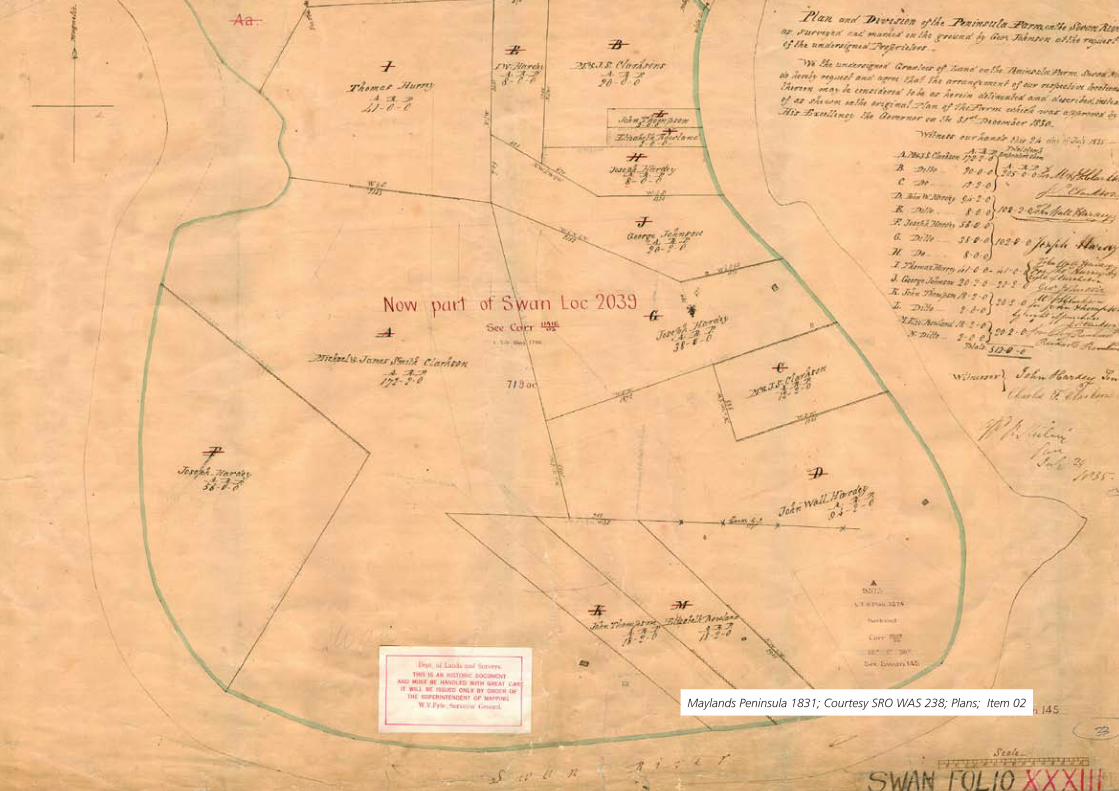
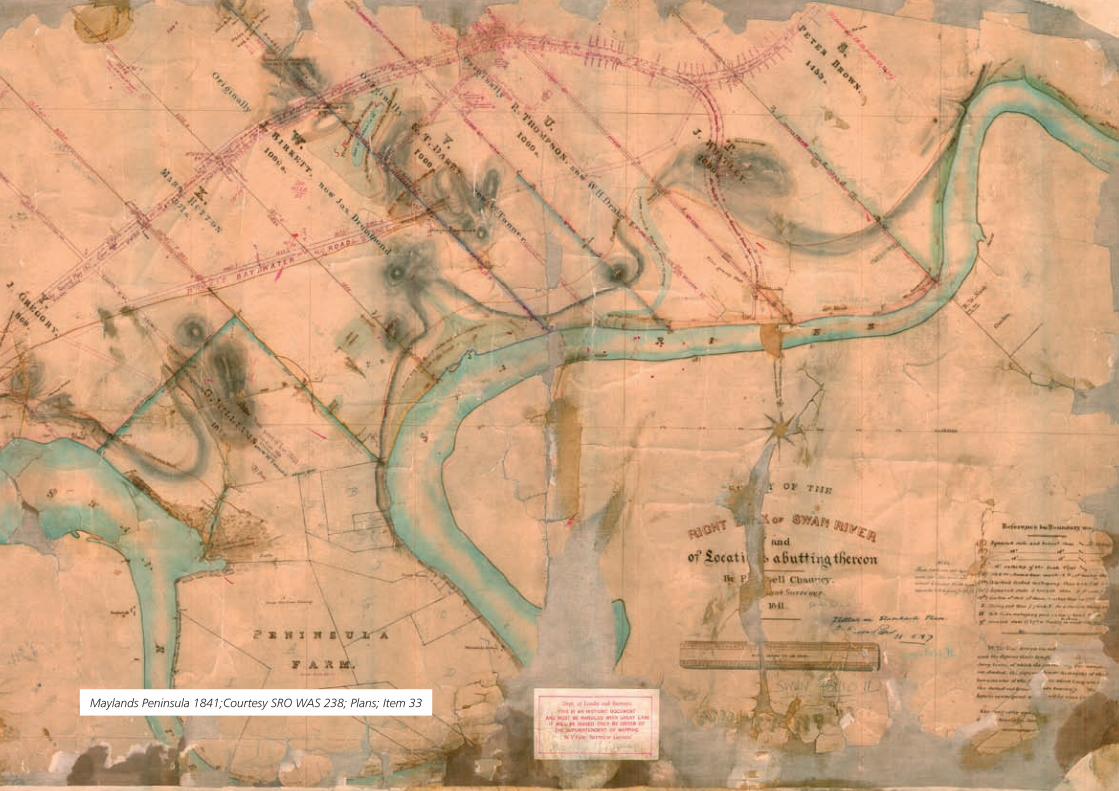
Maylands Peninsula 1831; Courtesy SRO WAS 238; Plans; Item 02
21
Swan and Helena RiveRS ManageMent FRaMewoRk HeRitage audit and StateMent oF SigniFicance
fact for many years after settlement, the River was the main means of transport, with tracks across the plains almost impassible.
Clays along the banks of the River between Perth and Guildford were vital for brick-making, the waters of the River were used by industry, both as part of the industrial processes and for the disposal of waste. The shell beds were dredged by Swan Portland Cement for industrial purposes and the River and its banks were ‘corrected’ and ‘beautified’. Roads and bridges were built as the population increased along with the need for easier access and the growth in car ownership. The landscape has been extensively altered and the River sediments attest to the activities that have taken place both around its banks and in the broader catchments. However, there are some remaining remnants, some areas rich in biodiversity that must be protected.
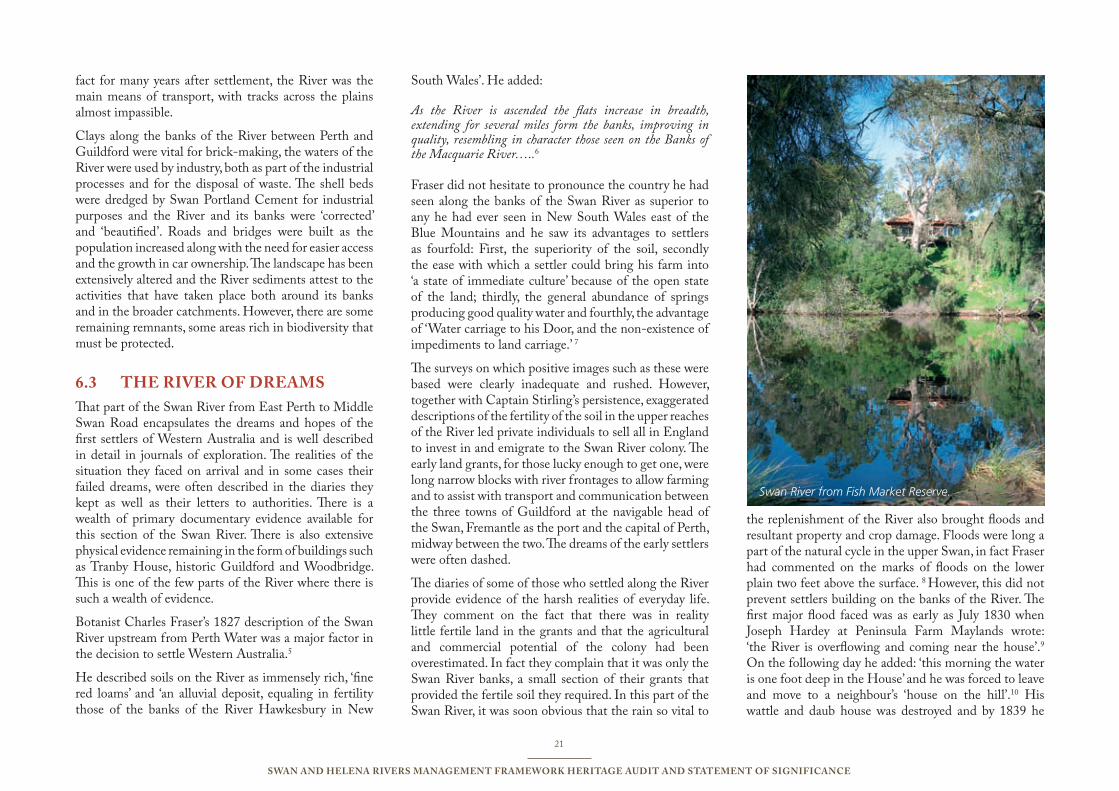
tHe RiveR oF dReaMS6.3 That part of the Swan River from East Perth to Middle Swan Road encapsulates the dreams and hopes of the first settlers of Western Australia and is well described in detail in journals of exploration. The realities of the situation they faced on arrival and in some cases their failed dreams, were often described in the diaries they kept as well as their letters to authorities. There is a wealth of primary documentary evidence available for this section of the Swan River. There is also extensive physical evidence remaining in the form of buildings such as Tranby House, historic Guildford and Woodbridge. This is one of the few parts of the River where there is such a wealth of evidence.
Botanist Charles Fraser’s 1827 description of the Swan River upstream from Perth Water was a major factor in the decision to settle Western Australia.5
He described soils on the River as immensely rich, ‘fine red loams’ and ‘an alluvial deposit, equaling in fertility those of the banks of the River Hawkesbury in New
South Wales’. He added:
As the River is ascended the flats increase in breadth, extending for several miles form the banks, improving in quality, resembling in character those seen on the Banks of the Macquarie River…..6
Fraser did not hesitate to pronounce the country he had seen along the banks of the Swan River as superior to any he had ever seen in New South Wales east of the Blue Mountains and he saw its advantages to settlers as fourfold: First, the superiority of the soil, secondly the ease with which a settler could bring his farm into ‘a state of immediate culture’ because of the open state of the land; thirdly, the general abundance of springs producing good quality water and fourthly, the advantage of ‘Water carriage to his Door, and the non-existence of impediments to land carriage.’ 7
The surveys on which positive images such as these were based were clearly inadequate and rushed. However, together with Captain Stirling’s persistence, exaggerated descriptions of the fertility of the soil in the upper reaches of the River led private individuals to sell all in England to invest in and emigrate to the Swan River colony. The early land grants, for those lucky enough to get one, were long narrow blocks with river frontages to allow farming and to assist with transport and communication between the three towns of Guildford at the navigable head of the Swan, Fremantle as the port and the capital of Perth, midway between the two. The dreams of the early settlers were often dashed.
The diaries of some of those who settled along the River provide evidence of the harsh realities of everyday life. They comment on the fact that there was in reality little fertile land in the grants and that the agricultural and commercial potential of the colony had been overestimated. In fact they complain that it was only the Swan River banks, a small section of their grants that provided the fertile soil they required. In this part of the Swan River, it was soon obvious that the rain so vital to
the replenishment of the River also brought floods and resultant property and crop damage. Floods were long a part of the natural cycle in the upper Swan, in fact Fraser had commented on the marks of floods on the lower plain two feet above the surface. 8 However, this did not prevent settlers building on the banks of the River. The first major flood faced was as early as July 1830 when Joseph Hardey at Peninsula Farm Maylands wrote: ‘the River is overflowing and coming near the house’.9 On the following day he added: ‘this morning the water is one foot deep in the House’ and he was forced to leave and move to a neighbour’s ‘house on the hill’.10 His wattle and daub house was destroyed and by 1839 he
Swan River from Fish Market Reserve.
22
Swan and Helena RiveRS ManageMent FRaMewoRk HeRitage audit and StateMent oF SigniFicance
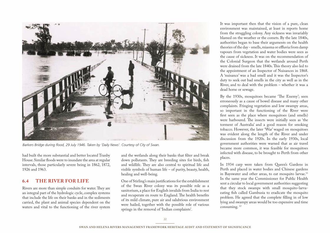
had built the more substantial and better located Tranby House. Similar floods were to inundate the area at regular intervals, those particularly severe being in 1862, 1872, 1926 and 1963.
tHe RiveR FoR liFe6.4 Rivers are more than simple conduits for water. They are an integral part of the hydrologic cycle, complex systems that include the life on their banks and in the sediments carried, the plant and animal species dependent on the waters and vital to the functioning of the river system
and the wetlands along their banks that filter and break down pollutants. They are breeding sites for birds, fish and wildlife. They are also central to spiritual life and visible symbols of human life – of purity, beauty, health, healing and well-being.
One of Stirling’s main justifications for the establishment of the Swan River colony was its possible role as a sanitorium, a place for English invalids from India to rest and recuperate en route to England. The health benefits of its mild climate, pure air and salubrious environment were hailed, together with the possible role of various springs in the removal of ‘Indian complaints’.
It was important then that the vision of a pure, clean environment was maintained, at least in reports home from the struggling colony. Any sickness was invariably blamed on the weather or the comets. By the late 1840s, authorities began to base their arguments on the health theories of the day - smells, miasma or effluvia from damp vapours from vegetation and water bodies were seen as the cause of sickness. It was on the recommendation of the Colonial Surgeon that the wetlands around Perth were drained from the late 1840s. This theory also led to the appointment of an Inspector of Nuisances in 1868. A ‘nuisance’ was a bad smell and it was the Inspector’s duty to seek out bad smells in the city as well as in the River, and to deal with the problem – whether it was a dead horse or sewage.
By the 1930s, mosquitoes became ‘The Enemy’; seen erroneously as a cause of bowel disease and many other complaints. Fringing vegetation and low swampy areas, so important in the functioning of the River were first seen as the place where mosquitoes (and smells) were harboured. The insects were initially seen as ‘the torment of Australia’ and a good reason for smoking tobacco. However, the later ‘War’ waged on mosquitoes was evident along the length of the River and under discussion from the 1920s. In the early 1930s, local government authorities were warned that as air travel became more common, it was feasible for mosquitoes infected with disease, to be brought to Perth from other places.
In 1934 carp were taken from Queen’s Gardens in Perth and placed in water bodies and Chinese gardens in Bayswater and other areas, to eat mosquito larvae.11 In the same year the Commissioner for Public Health sent a circular to local government authorities suggesting that they stock swamps with small mosquito-larva-eating fish called Gambusia to eradicate the mosquito problem. He agreed that the complete filling in of low lying and swampy areas would be too expensive and time consuming. 12
Barkers Bridge during flood, 29 July 1946. Taken by ‘Daily News’. Courtesy of City of Swan.
Maylands Peninsula 1841;Courtesy SRO WAS 238; Plans; Item 33
24
Swan and Helena RiveRS ManageMent FRaMewoRk HeRitage audit and StateMent oF SigniFicance
For the next 20 years, many thousands of these small, exotic fish were used by local governments along the River, particularly in the study area, and at the same time wetlands were drained and ditches filled in an effort to eradicate the problem. In October 1936 for instance, 18,000 gambusia were released into 30 drains, swamps and waterholes in Belmont to rid the district of the mosquito menace13. The gambusia may well have eaten mosquito larvae but they also ate the larvae of fish native to the River. They remain a problem in the River today.
Along with the fear of what were seen as the human health problems arising from the ‘foul deposits’ in the shallow waters along the shores, came a desire to beautify the River. River works began in earnest from 1903 with reclamation works, the construction of jetties, reclamation of land along the foreshores and the deepening of channels. It was all part of the basis for a cleaner and thus healthier city and aimed to correct the limitations of nature. Again that part of the River from East Perth to Middle Swan exemplifies the government and community attitudes to the River.
The area lies between what were seen as two natural barriers – the low lying Heirisson Islands and mud flats and the difficult to navigate upper reaches of the Swan.
The area from the Causeway to Maylands was described in 1925 as:
anything but a beauty spot and algae is growing there to such an extent that instead of the Swan River being a beauty spot and a natural feature of which Western Australia may be proud, it is fast developing into a nuisance. Water in the backwash of the Causeway at present is nearly as thick as mud, and the algae is growing to such an extent that during the hot evenings it gives off a most offensive odour. That marshy part of the foreshore is a breeding ground for mosquitoes and is by no means a healthy or picturesque spot.14
The legislation embodied in the Swan River Improvement Act 1925 was framed on the belief that algae would not
grow in water deeper than five feet and the idea was to dredge the River to achieve this depth in line with a plan drawn up. Improvement was seen in terms of reclamation of the foreshore, particularly in the vicinity of the Causeway and towards Maylands. It was also planned to build a ‘fine boulevard’ around the River as far as Maylands.
Dredging works and the required land resumption over next forty years were all based on this legislation. The engineering works failed to bring an instant reduction in either the smell, or the amount of mud or algae, and the raking of algae remained a costly business for local authorities. In 1928 for instance, eight tons of weed per day were raked out of the river at East Perth. River training activities to straighten meanders and facilitate access were carried on in the area of Guildford throughout the 1970s.
The edges might then have been ‘cleaner’ and straighter, but that made little real difference to the water quality. Industry was gradually established along the banks of the Swan and waste channelled into the River. The Government itself had been responsible for the worst and most enduring causes of pollution in its establishment of both the sewerage treatment facilities on the banks of the River at Burswood (1912) and the East Perth Power Station (1916) on the other side of the River. Other major pollution sources in the area under consideration were the Midland Abattoirs and the Midland Workshops.
In 1929, the Government announced that the filter beds would be closed and replaced by an ocean outfall over the next few years. From 1934 there was a reduction in complaints about algae and smell, but by this time the River was being polluted by growing industry and filled in with rubbish to protect health, create new land and to provide room for recreation, both in the River and on its banks for the growing population of Perth. Initial complaints relating to the pollution of the River related to very visual waste, and waste that had an impact on the growing riverside recreation such as swimming and boating activities.
Pollution sources included the stock holding paddocks along the Helena River, the blood, manure and dead animals around the Midland Abattoirs site, sewage from the Midland Railway Workshops, trade wastes from the Sanitarium Health Food Company and Industrial Extracts plant at Belmont, the oil pollution, ash beds and general spillages from the Power Station and Gas Works at East Perth. The River Pollution Survey Report of 20 September 1955 gives an indication of the extent of the problem at the Gas Works:
In the morning, with an outgoing tide and a light SE wind, oil film covered practically the whole surface of the water from the northern end of the Causeway Island to the Bunbury Railway Bridge, with heavier concentrations close inshore along the right bank. Along this bank a dirty high water mark can be distinctly seen on the rushes, and closer to the Gasworks, rushes and natural growth bordering the river have been killed by oils and tars, etc. The river banks here are black with oil and tar scum.15
The area under consideration provides a good opportunity to document and assess changing types of and attitudes to pollution. The Old Women’s Home at Woodbridge provided directly discharged septic tank effluent for many years, Cuming Smith’s effluent drain in Bassendean provided acid discharges, Maylands aerodrome discharged septic tank, sullage waters, surface stormwater and oily washings from the tarmac.14 Several major landfill sites were established to provide fill for what were seen as swampy riverside areas that encouraged mosquito breeding. Although now closed, these rehabilitated sites, as well as the now restored major drains to the River, provide evidence of changing practices and could be used for educational purposes.
The Swan River Conservation Act, 1958 provided a more formal process for regulating and monitoring such pollution and industry was licensed to discharge a range of waste into the River, however the nature of pollution was constantly debated and challenged. In 1988 the

25
Swan and Helena RiveRS ManageMent FRaMewoRk HeRitage audit and StateMent oF SigniFicance
Swan River Trust Act established a body with broader planning, protection and management functions in respect of the Swan and Canning Rivers.
Scientific understanding grew slowly and the emphasis changed from the visual and human health impacts of pollution to the impact on the River itself. It is now well understood by scientists, although not as well by the community, that although the River may appear to be clean, pure and pristine, the legacy of our treatment and mistreatment of the waterway is held in the sediments for possibly generations to come and is visible in the population decline in priority species such as the Western School Prawn, Perth Herring and Cobbler.
Since the 1980s there has been a slow move towards balancing human demands and requirements with the needs of the River system itself for health and life. There has also been a growth in understanding of the importance of biodiversity, the vital role of wetlands and plant and animal species to the effective functioning of the River. This has required new approaches, new understanding and new legislation.
The threat of climate change and possible impacts on the Swan River could see a range of ecological and cultural changes, including a renewed emphasis on human health. A recent Swan River Trust Report concludes that global warming could bring changes in the distribution and density of fringing vegetation and increasing and ongoing problems associated with eutrophication such as algal blooms and fish kills.16 Physical changes in the Swan and Canning Rivers could include ‘reductions in and changing patterns of runoff and riverine discharge, increased tidal amplitude (storm surges) and elevated water temperatures’.17 The Report also points to possible cultural implications including impacts on Nyungah (sic) heritage sites.18 To this must be added possible impacts on places with broad cultural heritage significance. It is suggested that health threats could be exacerbated, with increases in mosquitoes tolerant to warm and somewhat saline conditions as well as increased water temperatures
and the generation of acid sulphate acidity having the potential to mobilise many toxic substances in the water.19
a RiveR FoR tHe FutuRe6.5 The rise of great civilizations has depended on the successful management of waters. Rivers have always been of immense significance to human settlements, but at the same time are generally seen by historians and the community alike as a backdrop to a place rather than as a force shaping the process of change. A study such as this undertaken for EMRC is vital to the future of the Swan River. It highlights the importance of understanding the process of change in the context of the time. It highlights too the need for treating the River and its catchment as a whole.
The Rivers’ landscape is regulated by Commonwealth legislation and State legislation that includes the Environmental Protection Act 1986, the Aboriginal Heritage Act 1972, the Western Australian Planning Commission Act 1994 and the Swan and Canning Rivers Management Act 2006 which came into effect in September 2007. Many historical and cultural sites have been protected by the Heritage Council of WA and the Department of Indigenous Affairs, but at the local government level, municipal inventories and town planning schemes have been inconsistent in their effectiveness. In 2006 the WA Planning Commission instigated heritage provisions and the Eastern Metropolitan Regional Council has implemented a Master Plan for Planning and Management of the nominated area, as detailed in the SHRMF.
The Precincts under consideration have been impacted since the arrival of the first European explorers. They make up an area about which we have a great amount of relevant knowledge that should be used and built on to assist in helping the community to consider and be involved in managing the River for the future. Indigenous knowledge and the connection of Indigenous people to the River are important and must be valued and integrated into future management strategies. The environmental impacts of
our past management practices, with their engineering focus is now well understood. The area is a green corridor that is unique in Australia, however it is a corridor that needs to be protected and enhanced as it is under pressure, particularly in the face of future climate change.
Clearing, grazing, dredging and landfilling has destroyed tidal mudflats and marshes and led to the loss of habitat and other riparian function, the introduction of invasive species, and the erosion of riverbanks and foreshores. Sedges and rushes for instance assist in removing nutrients from run off and river water, stabilizing riverbanks and protecting them from erosion from boat wash, river flow and surface water run-off. However, the little foreshore native vegetation remaining is not in good condition with a most significant human impact being weed invasion, including grass species. Sedges are not well represented except in a few places such as Berringa Reserve Maylands where they are in dense stands, Baigup Wetlands, Bayswater and Ascot Island foreshore and along the Coolgardie main drain Garvey Park, Ascot. This loss of native vegetation has meant that there is a loss of connectivity between sites.20
Recent studies have indicated that nutrients from activities in the catchments and contaminants such as heavy metals from sources such as yacht clubs, marinas and slipways need to be reduced, sediment loads minimized, oxygen levels increased and foreshores and riverbanks protected and rehabilitated, particularly in some areas where boat wake impacts on the banks.21 The Swan-Canning Cleanup Program (SCCP) was launched in 1994 as a key management strategy to deal with elevated nutrient levels, the main cause of regular algal blooms. The second phase began in 1999 and in 2008 SCCP was replaced by the Healthy Rivers Program. The Study area has contributed to nutrient pollution, in particular to the phosphorus load from agricultural land uses. The Healthy Rivers program is building on the achievements of the Swan-Canning Cleanup Program by tackling sources of nutrients such as nitrogen and phosphorus, before they enter the waterways.
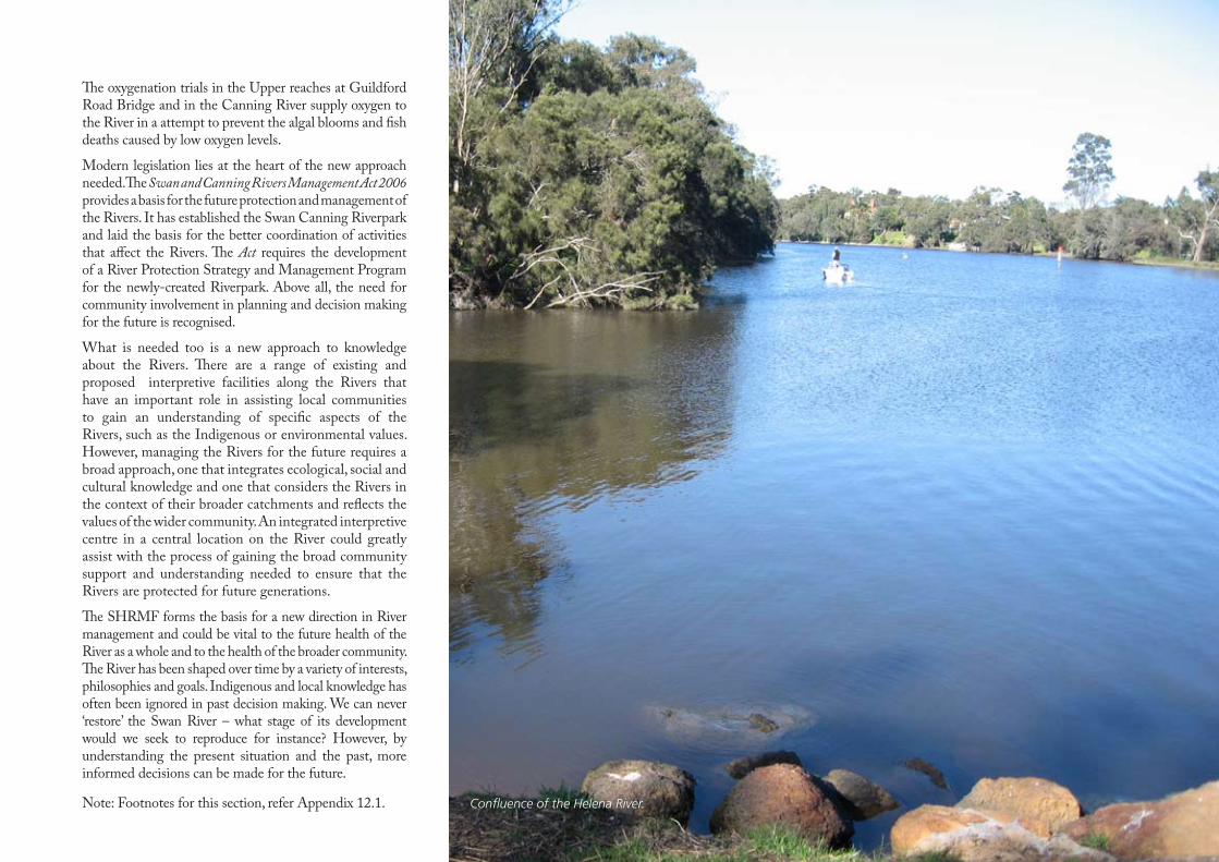
The oxygenation trials in the Upper reaches at Guildford Road Bridge and in the Canning River supply oxygen to the River in a attempt to prevent the algal blooms and fish deaths caused by low oxygen levels.
Modern legislation lies at the heart of the new approach needed. The Swan and Canning Rivers Management Act 2006 provides a basis for the future protection and management of the Rivers. It has established the Swan Canning Riverpark and laid the basis for the better coordination of activities that affect the Rivers. The Act requires the development of a River Protection Strategy and Management Program for the newly-created Riverpark. Above all, the need for community involvement in planning and decision making for the future is recognised.
What is needed too is a new approach to knowledge about the Rivers. There are a range of existing and proposed interpretive facilities along the Rivers that have an important role in assisting local communities to gain an understanding of specific aspects of the Rivers, such as the Indigenous or environmental values. However, managing the Rivers for the future requires a broad approach, one that integrates ecological, social and cultural knowledge and one that considers the Rivers in the context of their broader catchments and reflects the values of the wider community. An integrated interpretive centre in a central location on the River could greatly assist with the process of gaining the broad community support and understanding needed to ensure that the Rivers are protected for future generations.
The SHRMF forms the basis for a new direction in River management and could be vital to the future health of the River as a whole and to the health of the broader community. The River has been shaped over time by a variety of interests, philosophies and goals. Indigenous and local knowledge has often been ignored in past decision making. We can never ‘restore’ the Swan River – what stage of its development would we seek to reproduce for instance? However, by understanding the present situation and the past, more informed decisions can be made for the future.
Note: Footnotes for this section, refer Appendix 12.1. Confluence of the Helena River.
7
27
Swan and Helena RiveRS ManageMent FRaMewoRk HeRitage audit and StateMent oF SigniFicance
geological HeRitage7.1 The Swan River meanders across the Perth Basin, a geological structure formed following rifting along the Darling Fault line (the surface expression is known as the Darling Scarp) that caused the break-up of the Indian and Australian tectonic plates ending the Gondwanaland period. As India drifted northwards the structure was filled with about 15 kilometres of sediments originating from the Yilgarn Craton during the late Permian (290 to 250M yrs) through to Cretaceous (about 120M yrs) periods. Widespread uplift and erosion occurred during this period, with subsequent formation of sedimentary rocks which were more recently overlain with further erosion, Aeolian, alluvial and colluvial deposits of clays, silts, clayey sand and sand. The formation of limestone during recent periods of marine activity during interglacial periods of rising and falling sea levels adds to the geological diversity of the area. Note that there was no recent glacial formation in Western Australia. Climatic changes have been limited to changes in sea levels, temperatures and rainfall. Over the past 10,000 years, these more recent events have given rise to the Swan Coastal Plain which is a relatively thin veneer (up to 60 metres depth) extending approximately 1,000 long by 15 kilometres wide running north and south of Perth. The flow of the river precincts being studied is generally through Pinjarra Plain/Playford Clay surface geological formations passing through Bassendean and Spearwood dune systems.
FoRMation oF tHe Swan 7.2 and Helena RiveRS
With rifting and the Yilgarn Craton rising, many old rivers ceased flowing to the western and southern oceans. New rivers formed along the rift valleys cutting back into the plateau bringing a flush of sediments onto the coastal plain. The Avon on the Darling Plateau is noted as having captured an older river system and flows through a rift in the escarpment to the foothills to a junction with Ellen Brook near Walyunga National Park. The ongoing river was named Swan River as it flowed through alluvial soils of an older river onto and across the Swan Coastal Plain.
Brearley (2005) refers to evidence supporting the early occurrence of the Swan River being 20-30 metres lower approximately 10,000 years ago and that sea levels rose during the last interglacial period 8,000 - 4,000 years ago (the Holocene marine transgression). There is evidence of a rich and diverse marine-estuarine fauna.
The current alignment of the rivers has been forged over recent time and river training has maintained this. There are several minor catchments contributing to the Swan River and many of these carry nutrient loads that impact on the health of the river22.
An interesting exposure of the geologic Guildford Formation occurs in Precinct Three where there is a
prominent exposure along the western bank of the Swan River. The exposed beds occur at a bend in the river, a reflection of its hardness, and reveal “aspects of the fluviatile phase of the Guildford Formation.” The exposed section rises some 10-15 metres from its base at river level and according to Gozzard (2007), comprises “cross-stratified conglomerate with inter-bedded pods and lenses of cross-stratified sandstone. The conglomerate is clast-supported and comprises fine-to-coarse-grained gravel with some small cobbles predominantly of sub-angular to rounded vein quartz, black and brown lateritic nodules, as well as some granite and dolerite in a coarse-grained sand and silty sand matrix. The pebbles in the conglomerate are clearly derived from Archaean rocks of the nearby Darling Range”. Gozzard describes the impressive overlying layer of clay as more than 6m thick and extending to the top of the section. It is grey, mottled yellowish brown, massive, structure-less and contains a few thin pebbly and gritty layers similar to those in the underlying sandstone”.
natural Heritage Values7.0 The audit of the natural significance of the precincts was determined through a review of reports and planning studies as well as field inspections which are detailed in Appendix 12.4.1. This research determined the significance of the natural heritage associated with the precincts.
PART 2
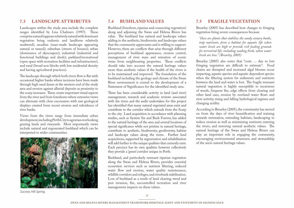
28
Swan and Helena RiveRS ManageMent FRaMewoRk HeRitage audit and StateMent oF SigniFicance
landScaPe attRiButeS7.3 Landscapes within the study area include the complete ranges identified by Lisa Chalmers (1997). These comprise natural (appears relatively natural with dominant vegetation being endemic and landform relatively unaltered); arcadian (man-made landscape appearing natural or tamed); suburban (streets of houses); urban (dominance of skyscrapers); industrial (industrial and functional buildings and sheds); parkland/recreational (open space with recreation facilities and infrastructure); and rural (broad acre blocks with low residential density and having agricultural practices).
The landscape through which both rivers flow is flat with occasional higher banks where incisions have been made through high sand dunes at the western end of the study area and erosion against alluvial deposits as proximity to the scarp increases. These create important visual aspects from the river and from foreshores where extensive views can alternate with close encounters with raw geological displays created from recent erosion and subsidence of river banks.
Views from the rivers range from immediate urban development, including Perth City to agrarian overlooking grazing lands and vineyards. Most importantly views include natural and regenerated bushland which can be interpreted to wider communities.
BuSHland valueS7.4 Bushland (foreshore, riparian and connecting vegetation) along and adjoining the Swan and Helena Rivers has value. The bushland has natural and landscape values adding to the aesthetic, biodiversity and landscape values that the community appreciates and is willing to support. However, there are conflicts that arise through different perceptions of bushland appearance, erosion control, management of river ways and retention of scenic vistas from neighbouring properties. These conflicts should take into account the natural heritage values more than aesthetic values if the health of the rivers is to be maintained and improved. The foundation of the bushland including the geology and climate of the Swan River environment is central to the development of a Statement of Significance for the identified study area.
There has been considerable activity in land (and river) management, research and academic reviews associated with the rivers and the audit undertaken for this project has identified that many natural vegetated areas exist and contribute to the corridor which extends from the Scarp to the city. Land acquisition in accordance with planning studies, such as System Six and Bush Forever, has added to the natural heritage of the area and several locations of special significance while not pristine in natural heritage, contribute to aesthetic, biodiversity, geodiversity, habitat and landscape values along the rivers. Further land acquisitions, supported by regeneration and rehabilitation will add further to the unique qualities that currently exist. Each precinct has its own qualities however collectively they provide a ‘green’ corridor unique in Perth.
Bushland, and particularly remnant riparian vegetation along the Swan and Helena Rivers, provides essential ecosystem services such as nutrient filtering, reduced water flow and erosion, water quality maintenance, wildlife corridors and refuges, and riverbank stabilisation. Loss of bushland as a result of land clearing, weed and pest invasion, fire, uncontrolled recreation and river management impacts on these values.
FRagile vegetation7.5 Brearley (2005) has described how changes in fringing vegetation bring severe consequences because
“these are plants that stabilize the sandy estuary banks, trap nutrients, form a habitat for aquatic life when water levels are high or provide rich feeding grounds for terrestrial life, including wading birds, when water levels are low.” (Brearley, 2005)
Brearley (2005) also notes that “costs … due to lost fringing vegetation are difficult to estimate”. Food chains are disrupted and increased algal blooms occur impacting, aquatic species and aquatic dependent species when the filtering system for sediments and nutrients between the land and water is lost. The fragile remnant natural vegetation is highly susceptible to incursions of weeds, frequent fire, edge effects from clearing and other land uses, erosion by overland water flows and river activity, rising and falling hydrological regimes and changing acidity.
According to Brearley (2005), the community has moved on from the days of river beautification and training towards restoration, extending habitats, landscaping to reduce erosion as well as minimising nutrients entering the rivers, and restoring natural aesthetic values. The natural heritage of the Swan and Helena Rivers can play an important role in engaging the community, encouraging environmental awareness and stewardship of the area’s natural heritage values.
Success Hill Spring.

29
Swan and Helena RiveRS ManageMent FRaMewoRk HeRitage audit and StateMent oF SigniFicance
HaBitat valueS7.6 Bushland provides habitat and food sources for a range of fauna, terrestrial and aquatic, that may be restricted or transient to a particular locale. In a natural way it provides climate mitigation and controls erosion through its physical impact on sunlight and wind, rain and overland water flows, as well as reducing tidal and wave impacts along shore lines.
Bushland has an aesthetic value for landowners, people in transit and people participating in a range of recreation opportunities that are provided including picnicking, social gatherings, sporting activities ranging from sports codes, fishing and running to passive activities such as walking and bird watching. Bushland also provides a screening environment so that land based activities may be either secluded or hidden from view. The foreshore vegetation provides a corridor for fauna along which migration may take place as nomadic animals move between sites to forage, breed or extend their range. Each of these values represents an attribute for the greater Perth community and interference will raise concern with different sectors of the community.
Cormorants nest in a riverside sheoak overhanging the slow river near Guildford. A Briggs.
BiodiveRSity7.7 The Swan Complex vegetation community edges the entire foreshore within the study area with vegetation ranging from fringing woodlands of flooded gum (Eucalyptus rudis) and swamp paperbark (Melaleuca rhaphiophylla) with localised occurrences of low forests of salt tolerant swamp sheoak (Casuarina obesa) and paperbark (Melaleuca cuticularis). There are occurrences of emergent shore rush (Juncus kraussii) and pale rush (Juncus pallidus) that together with Sarcocornia complex and Halosarcia complex provide essential protection from erosion and habitat for water birds. Invasion of Typha species has impacted some of these areas. Although it is an invasive species, it does provide enhanced habitat for water birds and amphibian fauna.
Other vegetation communities within the study area include the Guildford Complex (Belmont, Redcliffe, Caversham) which includes a mixture of tall open forests of marri (Corymbia calohylla), wandoo (Eucalyptus wandoo) and jarrah (Eucalyptus marginata); Bassendean Complex (Belmont and Bassendean) on drier land which includes woodlands of jarrah, sheoak (Allocasuarina fraseriana) and banksia species to sedge lands on the moister and lower sites; and Southern Complex (South Guildford and Caversham) which includes jarrah, marri and banksia species with a fringing woodland of flooded gum and swamp paperbark.
According to the Department of Environment and Conservation (DEC) a number of rare and priority species have been identified within or near the study area. Rare species are considered to be in danger of extinction, rare or otherwise in need of special protection, whereas Priority species are defined as poorly known species. Priority categories are arranged to give an indication of the priority for undertaking further studies based on the number of known sites, and the degree of threat to those populations. Priority Four species are considered rare and require monitoring. DEC policy determines that the locations of these species cannot be provided in
detail and the actual locations of the identified species may require field confirmation.
Importantly, from the DEC investigation, two species have been recorded as Rare Flora:
Conospermun undalatum (common name - Wavy-Leafed Smokebush) – This plant was declared as Rare Flora under the Western Australian Wildlife Conservation Act 1950 in 1997 and is currently ranked as Vulnerable under World Conservation (IUCN 1994) Red List criteria due to its occurrence over an area of less than 20,000km2, populations being severely fragmented and a continuing decline in area and quality of habitat. A Recovery Plan has been written by DEC for Wavy-Leafed Smokebush, and it records the plant occurrence as only twenty populations contain extent plants.
Trithuria occidentalis (also scientifically known as Hydatella dioica) (common names - Swan Hydatella and one-sexed Hydatella). A Recovery Plan has not been prepared for Swan Hydatella at this time.
Priority one SpeciesCarex tereticaulis (sedge), Hydrocotle striata
Priority two speciesPhyllangium palustre
A further eight species have been identified as Priority Three, and three species as Priority Four. The identification of these Rare and Priority species make the bushland and adjoining land very important in a biodiversity perspective.
In all cases, this makes the conservation and protection of remnant native bushland along the foreshores of the Swan and Helena Rivers essential and that any planned activity that might impact on the bushland should be referred to DEC for review prior to any activity taking place. In planning, any proposed walkways and trails should be directed around remnant bushland to provide the greatest opportunity for its protection rather than division.
30
Swan and Helena RiveRS ManageMent FRaMewoRk HeRitage audit and StateMent oF SigniFicance
Exotic species have been mentioned above and have been introduced through dumping and landfill as well as transfer by water, wind and wildlife. Predominant introduced species include buffalo and kikuyu grass, African Lovegrass, Watsonia and a range of eucalyptus species including Spotted Gum (E. maculata) and Lemon-scented Gum (E. citriodora).
Exotic species in general represent a significant threat to natural heritage through competition for light, nutrients and space, as well as influencing the changing habitats for native fauna. The exotic species threat exists for the remaining vegetation along the Swan and Helena Rivers which, due to their exposure and susceptibility, are becoming increasingly vulnerable to invasion.
acid SulPHate SoilS7.8 Acid sulphate soils (ASS) are naturally occurring soils and sediments containing iron sulphides, most commonly pyrite. When ASS are exposed to air the iron sulphides in the soil react with oxygen and water to produce a variety of iron compounds and sulfuric acid. Initially a chemical reaction, the process is accelerated by soil bacteria. The resulting acid can release other substances, including heavy metals, from the soil and into the surrounding environment.
ASS are a natural component of the landscape and may be found in a variety of waterlogged soil types. These include dark organic rich soils and muds, peaty wetland soils, some pale grey sands (Bassendean sands and Spearwood sands), ‘coffee rock’ (cemented iron and/or organic rich sands) found below the watertable. ASS in Western Australia commonly occur in low lying wetlands, back-swamps, estuaries, salt marshes and tidal flats but are not constrained to coastal areas. When left undisturbed these soils are relatively harmless however when exposed through soil disturbance or lowering of the water table they release acid sulphates. Indications are that the full extent of the Swan and Helena Rivers has high to moderate risk of release of ASS.
According to Australian Online Coastal Information (2008) some known adverse impacts of ASS in coastal lowlands include poor water quality (e.g. dissolved metal contaminants, low pH levels and anoxic and hypoxic events), fish kills and pathogens in fish assemblages, loss of critical habitat areas, aquaculture production, fish stocks, wetland biodiversity and amenity, acid erosion of infrastructure and the need for rehabilitation of disturbed areas.
The public health implications of disturbing acid sulfate soils are not well understood. However, acidified coastal wetlands may provide predator-free habitat for species of mosquito that transmit arboviruses (e.g. Ross River Fever). Acid dust mobilised during ploughing and construction activities may also cause dermatitis and eye irritation.
The following changes in biophysical parameters may indicate that a coastal waterway is affected by acid leaching from pyritic sediments low water column pH levels (e.g. <4 in immediate area of impact); a dramatic reduction in water column dissolved oxygen concentrations. Monosulfidic black oozes (MBOs) in particular can cause rapid and severe anoxic and hypoxic events; excess of sulfate in the water column - chloride/sulfate ratios are often <3 in acid affected streams, whereas chloride/sulfate ratios of seawater in a dilution series with rainwater range from ~5 to 7; iron staining in coastal tributaries and increased dissolved aluminium, iron and potentially arsenic concentrations; extremely clear water where all sediments have settled out due to the flocculating ability of aluminium; red lesions on fish caused by ‘red-spot’ disease; increased incidence of fish kills; the presence of acid tolerant vegetation. (Acid tolerant water plant species belong mainly to the genera Nymphaea and Eleocharis. Species from this genera can complete lifecycles at pH levels less than 3 without any apparent negative impact. Other acid tolerant species include the introduced and noxious mosquito fish (Gambusia holbrooki); and a longer term reduction of fish and benthic invertebrate populations.
31
Swan and Helena RiveRS ManageMent FRaMewoRk HeRitage audit and StateMent oF SigniFicance
natuRal vegetation7.9 The fringing vegetation extending the full length of the Swan and Helena Rivers within the study area comprises a significant natural heritage corridor linking the Scarp to the City. While there are some areas such as Cracknell Park to Hardey Park, Ascot Raceway and Archer Street that require improvement by regeneration or restoration the audit identified that apart from increasing the depth (and the structure, density and diversity in others) of the corridor in some areas, opportunity exists for fauna to migrate along the corridor. This provides an excellent opportunity for further conservation and interpretation of natural heritage values in the region.
There are some very good relic bushland areas such as Berringa Park and Bennett Brook serving as refuges along the river providing habitats and shore line buffers within each of the precincts. Similarly there are several extensive areas such as Ashfield Flats, Bennett Brook-Whiteman Park area and Kidman Avenue flats that may contribute to environmental awareness through development of interpretive centres and facilities forming part of land or water based educational and interpretive tours promoting natural heritage along with Indigenous and European values.
Appropriate management needs to be based on a sound and accurate understanding of the ecology and functioning of the river and its hinterland. Therefore ongoing research into both the river’s ecology and management techniques is important and the East Metropolitan Regional Council should liaise with the Swan River Trust to support further research, including into the potential impacts of climate change on the river and its management.
Management of the reserves, vegetation and habitats along the river should be in line with best practice principles and expressed in reserve management plans. Where no reserve management plan exists, or where existing plans are out of date these should be prepared
or revised as a priority. Preparation or revision of management plans should include input from all relevant stakeholders, including the Swan River Trust and the community, especially where community are important stakeholders in identifying priorities and involved in implementation.
As well as management planning for specific sites, overall planning, whether through the River Protection Strategy, the Local Biodiversity Strategy for the Town of Bassendean and Cities of Bayswater and Belmont and the Swan Riverside Regional Park, needs to consider linkages, including rebuilding natural heritage linkages that are currently missing. Any interpretation planning, including trails, infrastructure and centres should adequately incorporate interpretation of natural heritage values.
It is important that the integrity of the bushland is not compromised by inappropriate development. Proposed trails, for instance, need to be directed towards the land side of the bushland, not the foreshore, to ensure that habitats and refuges are not disaggregated. This also ensures that hard boundaries will be provided against which future management decisions may be made and protective measures put in place, such as regeneration and rehabilitation, and exclusion of motorized mowers.
It is also important that having defined and established hard boundaries to the corridors and bushland areas further consideration be given to improving the links between bushland sites and adding depth to corridors along both sides of the rivers. This should include planning for future acquisition or transfer to the reserve system to subsequent encouragement of natural regeneration, and where this is not able to be facilitated, adopting regeneration with endemic plant species to achieve sustainable natural growth. These measures will bring about enrichment of the existing natural heritage of the area.
coMPaRative analySiS7.10 Compared to other capital cities, Perth (and the four precincts in particular) has an excellent natural corridor from the Scarp to the City. Brisbane has a similar river environment where the city centre is located at distance upstream from the mouth of the river. Brisbane has considerable development to the foreshore below the city. Above the city considerable bush corridors and open spaces have been retained. Melbourne and Sydney have their cities located closer to the river mouths and in both cases there is considerable development along the foreshore above the city. Natural vegetation surrounding the Perth rivers is specific and therefore significant to the area, while the study area above Perth city retains accessible (from the land and the river) aesthetic and landscape values that enhance the retained natural bushland areas and corridors. It is these values that set the study area bushland apart from what is found in other cities and adding to its significance.
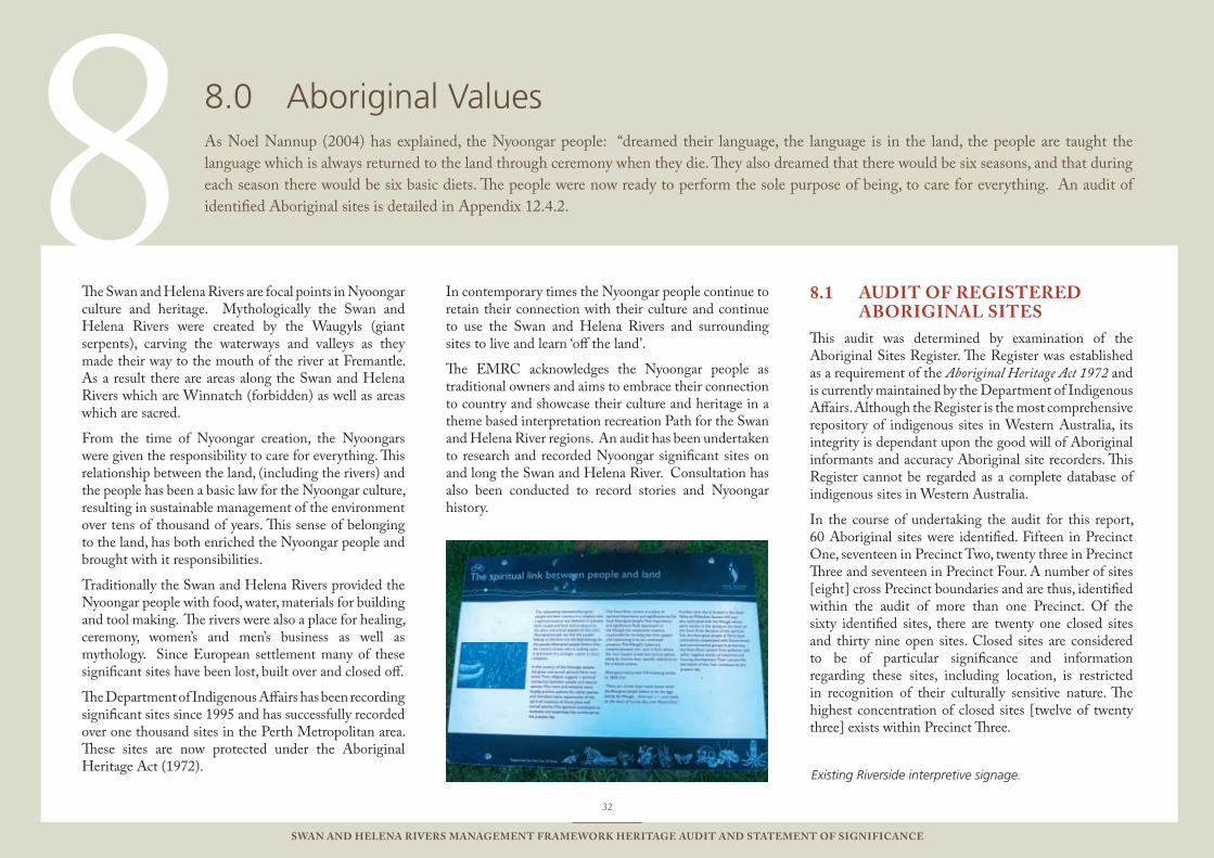
8
32
Swan and Helena RiveRS ManageMent FRaMewoRk HeRitage audit and StateMent oF SigniFicance
The Swan and Helena Rivers are focal points in Nyoongar culture and heritage. Mythologically the Swan and Helena Rivers were created by the Waugyls (giant serpents), carving the waterways and valleys as they made their way to the mouth of the river at Fremantle. As a result there are areas along the Swan and Helena Rivers which are Winnatch (forbidden) as well as areas which are sacred.
From the time of Nyoongar creation, the Nyoongars were given the responsibility to care for everything. This relationship between the land, (including the rivers) and the people has been a basic law for the Nyoongar culture, resulting in sustainable management of the environment over tens of thousand of years. This sense of belonging to the land, has both enriched the Nyoongar people and brought with it responsibilities.
Traditionally the Swan and Helena Rivers provided the Nyoongar people with food, water, materials for building and tool making. The rivers were also a place for healing, ceremony, women’s and men’s business as well as mythology. Since European settlement many of these significant sites have been lost, built over and closed off.
The Department of Indigenous Affairs has been recording significant sites since 1995 and has successfully recorded over one thousand sites in the Perth Metropolitan area. These sites are now protected under the Aboriginal Heritage Act (1972).
In contemporary times the Nyoongar people continue to retain their connection with their culture and continue to use the Swan and Helena Rivers and surrounding sites to live and learn ‘off the land’.
The EMRC acknowledges the Nyoongar people as traditional owners and aims to embrace their connection to country and showcase their culture and heritage in a theme based interpretation recreation Path for the Swan and Helena River regions. An audit has been undertaken to research and recorded Nyoongar significant sites on and long the Swan and Helena River. Consultation has also been conducted to record stories and Nyoongar history.
audit oF RegiSteRed 8.1 aBoRiginal SiteS
This audit was determined by examination of the Aboriginal Sites Register. The Register was established as a requirement of the Aboriginal Heritage Act 1972 and is currently maintained by the Department of Indigenous Affairs. Although the Register is the most comprehensive repository of indigenous sites in Western Australia, its integrity is dependant upon the good will of Aboriginal informants and accuracy Aboriginal site recorders. This Register cannot be regarded as a complete database of indigenous sites in Western Australia.
In the course of undertaking the audit for this report, 60 Aboriginal sites were identified. Fifteen in Precinct One, seventeen in Precinct Two, twenty three in Precinct Three and seventeen in Precinct Four. A number of sites [eight] cross Precinct boundaries and are thus, identified within the audit of more than one Precinct. Of the sixty identified sites, there are twenty one closed sites and thirty nine open sites. Closed sites are considered to be of particular significance and information regarding these sites, including location, is restricted in recognition of their culturally sensitive nature. The highest concentration of closed sites [twelve of twenty three] exists within Precinct Three.
Aboriginal Values8.0 As Noel Nannup (2004) has explained, the Nyoongar people: “dreamed their language, the language is in the land, the people are taught the language which is always returned to the land through ceremony when they die. They also dreamed that there would be six seasons, and that during each season there would be six basic diets. The people were now ready to perform the sole purpose of being, to care for everything. An audit of identified Aboriginal sites is detailed in Appendix 12.4.2.
Existing Riverside interpretive signage.
33
Swan and Helena RiveRS ManageMent FRaMewoRk HeRitage audit and StateMent oF SigniFicance
aBoRiginal tHeMeS8.2 The identified Aboriginal Heritage Sites have been categorised into five themes for the purpose of the audit. Those themes are Habitation, Mythological, Ceremonial, Natural Features and Burial Places. The themes are a reflection of the Department of Indigenous Affairs categorisation of sites, however, an aim of this project is to establish the groundwork for eventual interpretation trails in the river area and this was also a factor in the thematic development. Many of the identified sites represent more than one thematic group. For example, a natural spring represents both a natural feature and a subsistence resource.
Habitation sites are those whose use is formerly or currently associated with the basic needs of food and shelter. A hunting site, for example, would represent this thematic group. Artefact sites, in which tools used in the course of habitation and subsistence were identified, are captured in this group. The Swan Foreshore is reported to have been used as a fishing place by Aboriginal people who camped in the area and those who lived nearby.23 The abundant food and water of the river made this place an important centre of habitation and subsistence activities.
Mythological sites are those whose use is formerly or currently associated with mythological events. The Waugyl mythological saga details the creation of the waterways as the Waugyl journeyed towards the ocean. As a consequence the metropolitan river system is central to many Nyoongar mythological beliefs and ceremonial practices. Due to the sensitive cultural nature of these sites many of them are closed with little information about specific beliefs or locations available to the public.
Ceremonial sites are those places which were formerly or are currently associated with ceremonial practices. Ceremonies are often connected to mythological beliefs or events but that is not always the case. The Bennett Brook, Eden Hill Rd [3487] site is, among other things,
a meeting place. There are no recorded mythological associations with the site but it is not inconceivable that other ceremonies, a welcoming ceremony for example, might have been carried out at this place. Artefact sites have also been categorised as ceremonial sites because they are often used in ceremonies and it is not always known which artefacts were or were not used for this purpose. The artefacts identified at the Wall St [3324] site were stained with ochre and are likely to have been used for ceremonial purposes. In the course of this audit one of the Aboriginal informants also spoke of mud patches along the river as resources used for in ceremonial purposes, although perhaps being not the sites of the ceremonies themselves.
Scarred trees are particularly difficult to categorise because so little can be discerned about their purpose if no ethnographic information exists. Scarred trees can be the result of bowl or shield manufacture, honey gathering, burials or simply as a marker. The Maylands Scarred Tree [3520] identified in Precinct Two represents such a place. It is a natural feature which has been modified by Indigenous people for an unknown purpose. Due to the emphasis placed upon the ceremonial associations of scarred tree by an indigenous informant, these trees have been categorised as ceremonial for the purposes of this audit.
Natural features represent those sites which are of significance but which exist independently of human intervention. Such sites can represent resources for subsistence or ceremonial practices – the river itself is a natural feature – however, a natural feature might also represent a marker. The Sandringham Natural Spring identified in Precinct One, is another such feature in this case, a source of water for subsistence purposes.
A number of Aboriginal burial places were also identified by the audit. Although an Indigenous informant stated that it is unlikely that burials would occur very close to the river, a number of people are reputed to have been buried in the area. The previously mentioned informant
also stated a belief that the spirit of the deceased would attach itself to any person who moves them from where they were buried. The burial place of Windan the wife of Yellagonga is particularly important for historical reasons. However, this place as with all burial sites is of significance to Aboriginal people for personal and spiritual reasons.
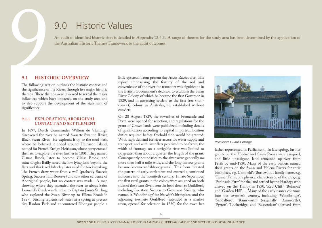
9Pensioner Guard Cottage.
34
Swan and Helena RiveRS ManageMent FRaMewoRk HeRitage audit and StateMent oF SigniFicance
HiStoRic oveRview9.1 The following section outlines the historic context and the significance of the Rivers through five major historic themes. These themes were reviewed to reveal the major influences which have impacted on the study area and to also support the development of the statement of significance.
exPloRation, aBoRiginal 9.1.1 contact and SettleMent
In 1697, Dutch Commander Willem de Vlamingh discovered the river he named Swaarte Swanne Rivier, Black Swan River. He explored it up to the mud flats, where he believed it ended around Heirisson Island, named for French Ensign Heirisson, whose party crossed the flats to explore the river further in 1801. They named Clause Brook, later to become Claise Brook, and mineralogist Bailly noted the low lying land beyond the flats and thick reddish clay later used for brick-making. The French drew water from a well (probably Success Spring, Success Hill Reserve) and saw other evidence of Aboriginal people, but no contact was made. A map showing where they ascended the river to about Saint Leonard’s Creek was familiar to Captain James Stirling, who explored the Swan River up to Ellen’s Brook in 1827. Stirling replenished water at a spring at present day Bardon Park and encountered Noongar people a
little upstream from present day Ascot Racecourse. His report emphasising the fertility of the soil and convenience of the river for transport was significant in the British Government’s decision to establish the Swan River Colony, of which he became the first Governor in 1829, and in attracting settlers to the first free (non-convict) colony in Australia, i.e. established without convicts.
On 28 August 1829, the townsites of Fremantle and Perth were opened for selection, and regulations for the grant of Crown lands were publicized, including details of qualification according to capital imported, location duties required before freehold title would be granted. With high demand for river access for water supply and transport, and with river flats perceived to be fertile, the width of frontage on a navigable river was limited to no greater than about a quarter the length of the grant. Consequently boundaries to the river were generally no more than half a mile wide, and the long narrow grants became known as ‘ribbon grants’. This form dictated the pattern of early settlement and exerted a continued influence into the twentieth century. In late September, the first rural grants in the colony were assigned on both sides of the Swan River from the head down to Guildford, including Location Sixteen to Governor Stirling, who named it ‘Woodbridge’ for his wife’s birthplace, and the adjoining townsite Guildford (intended as a market town, opened for selection in 1830) for the town her
father represented in Parliament. In late spring, further grants on the Helena and Swan Rivers were assigned, and little unassigned land remained up-river from Perth by mid-1830. Many of the early owners named their grants on the Swan and Helena Rivers for their birthplace, e.g. Camfield’s ‘Burrswood’, family name, e.g. ‘Tanner Farm’, or a physical characteristic of the area, e.g. ‘Peninsula Farm’ for the land settled by the Hardeys who arrived on the Tranby in 1830, ‘Red Cliff ’, ‘Belmont’ and ‘Garden Hill’. . Many of the early names continue into the twentieth century, including ‘Woodbridge’, ‘Sandalford’, ‘Rainsworth’ (originally ‘Rainworth’), ‘Pyrton’, ‘Lockeridge’ and ‘Bassendean’ (derived from
Historic Values9.0 An audit of identified historic sites is detailed in Appendix 12.4.3. A range of themes for the study area has been determined by the application of the Australian Historic Themes Framework to the audit outcomes.
35
Swan and Helena RiveRS ManageMent FRaMewoRk HeRitage audit and StateMent oF SigniFicance
‘Bassindean’, which in turn derived from ‘Bassingdean’).
Agricultural development of the more fertile land by the rivers was important to the colony’s survival, but was hindered by early grant assignment and resultant lack of land for later arrivals. Much land was held by absentee landowners or reserved for government use, some of which was later assigned. There was a shortage of fertile land, climate and soil conditions were unfamiliar, and a shortage of labour, relieved when convict transportation commenced in 1850. A depot for ticket-of-leave men was established at Guildford and subsequently four cottages to accommodate Pensioner Guards were built at Bassendean.
Government correspondence, letters and diaries of early settlers document some of the contacts with the Aboriginal people who traditionally frequented the area of the Swan and Helena Rivers. They were increasingly displaced from much of the land, rivers and wetlands by European settlement and agricultural development. They record varied interaction with Nyoongar people including some employment, e.g. as shepherds, some conflicts, and some places especially frequented and significant to them including Success Hill Reserve and parts of Guildford.
tRanSPoRt, induStRy and 9.1.2 SeRviceS
In 1831, to enable flat bottomed boats to sail up the river, a canal (Old Burswood Canal) was constructed across Burswood Peninsula, which was superseded by a canal at Claisebrook in 1839. Early landing places along the river included Whatley Cove (Claughton Reserve). A ferry operated from a landing at the end of Bridge Street, Guildford, to the opposite bank below Cleikum Inn. From there, a track ran to Perth on the approximate route of Guildford Road and another led north to Ellen’s Brook. In 1833, a road was marked out on the east side of the river, closer to it and more winding the than present
day Great Northern Highway. People who wanted to travel along the east side of the river waded across the river flats or crossed the river by ferry to a landing at John Hancock’s Mermaid Inn at Belmont Farm, then followed the track to the Helena River and Guildford, which was the forerunner of Great Eastern Highway. In 1843, completion of the Causeway facilitated road traffic between Guildford and Perth via Burswood.
Guildford developed as a river port where freight to and from the hinterland was transferred to road transport. Stores were located near the public landing at the end of Meadow Street, including A. M. Moulton (Rose Cottage, Moulton’s Landing), and there were small landings at rural properties. From 1857 to 1883, Solomon Cook introduced steam power to the Swan River with a service between Perth and Guildford for goods and passengers, including race-goers to Perth Race Course (present day Ascot Racecourse). The river remained the primary transport route until completion of the Eastern Railway from Fremantle to Guildford in 1881, which led to the demise of Guildford as a port. The single track railway bridge at West Guildford was later converted to a road bridge after a new double track railway bridge was built alongside.
The first substantial bridge in the colony was built over the Helena River in 1835. The first bridge over the Swan River above the Causeway was built by Samuel Moore at Middle Swan in 1844, to connect his properties at each side of the river. In 1853-54, convicts under Lieutenant DuCane built the Swan River Bridge (Barker’s Bridge) by the public landing, and Aboriginal prisoners worked on building a new bridge over the Helena River. The latter was badly damaged by the 1862 floods and rebuilt. In the mid-1880s, the first Guildford Road Bridge was built over the Swan River at West Guildford, replaced in 1905, and in 1937. Garratt Road Bridge connecting Bayswater and Belmont was opened in 1935, and is an important road link between the eastern and western sides of the river, as well as the longest bridge of its type in WA.
Work on a branch railway line from Bayswater to Busselton was halted in 1887, but the section already completed provided an artery toward the foreshore and encouraged establishment of Walkenden’s Brickworks (Gobba Lake). Race-goers travelled by rail to Bayswater, then walked to the river to cross via ferry or the footbridge that was built in 1891. In the late 1890s, the railway line was extended over the river to Ascot Racecourse, and hence became known as the Racecourse Line, which is commemorated by a plaque in Mathieson Road.
Brickworks and potteries developed using clay deposits by the river included Whiteman’s Bricks at Middle Swan (later under Midland Brick), Maylands Brickworks, and Sugar’s Brickworks, Sydney Pottery Works (later Courtlands) and Westralian Pottery Co. Ltd., subsequently H. L. Brisbane and Wunderlich (Brisbane and Wunderlich Park Building) and then Bristile (Old Bristile Kilns) at Belmont. River transport played a significant role, and the Racecourse Line transported coal to the latter companies until it closed in 1956.
Two boat building yards are known to have operated on the Swan River above Perth. In 1895-c. 1904, Jeremiah Asquith had a boatyard at the foot of Anstey Street, West Guildford (Bassendean). In 1899, two boats were built at Guildford by John Lyons, whose boat shed and slipway are believed to have been by the river about 100 yards downstream from Guildford Bridge. There appear to have been relatively few boat yards on the river above Perth. In 2008, Maylands Boatyard is the only remaining boat maintenance facility on this part of the river.
The Midland Railway opened for traffic in 1895, with its southern terminal and railway workshops about three miles east of Guildford near the junction of roads to the Upper Swan and York, from which the name Midland Junction derived. In 1902, work commenced on Western Australian Government Railway (WAGR) Workshops at Midland Junction, which were initially steam powered. These came into operation from 1904, as buildings were progressively completed.
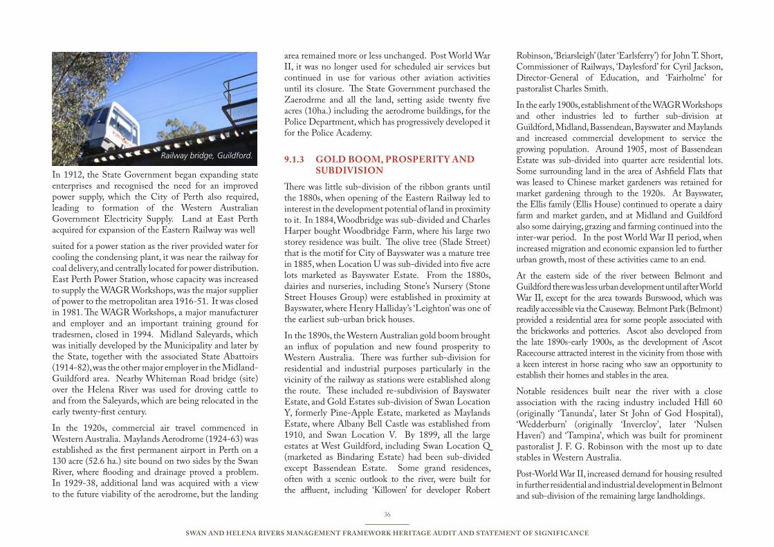
36
Swan and Helena RiveRS ManageMent FRaMewoRk HeRitage audit and StateMent oF SigniFicance
In 1912, the State Government began expanding state enterprises and recognised the need for an improved power supply, which the City of Perth also required, leading to formation of the Western Australian Government Electricity Supply. Land at East Perth acquired for expansion of the Eastern Railway was well
suited for a power station as the river provided water for cooling the condensing plant, it was near the railway for coal delivery, and centrally located for power distribution. East Perth Power Station, whose capacity was increased to supply the WAGR Workshops, was the major supplier of power to the metropolitan area 1916-51. It was closed in 1981. The WAGR Workshops, a major manufacturer and employer and an important training ground for tradesmen, closed in 1994. Midland Saleyards, which was initially developed by the Municipality and later by the State, together with the associated State Abattoirs (1914-82), was the other major employer in the Midland-Guildford area. Nearby Whiteman Road bridge (site) over the Helena River was used for droving cattle to and from the Saleyards, which are being relocated in the early twenty-first century.
In the 1920s, commercial air travel commenced in Western Australia. Maylands Aerodrome (1924-63) was established as the first permanent airport in Perth on a 130 acre (52.6 ha.) site bound on two sides by the Swan River, where flooding and drainage proved a problem. In 1929-38, additional land was acquired with a view to the future viability of the aerodrome, but the landing
area remained more or less unchanged. Post World War II, it was no longer used for scheduled air services but continued in use for various other aviation activities until its closure. The State Government purchased the Zaerodrme and all the land, setting aside twenty five acres (10ha.) including the aerodrome buildings, for the Police Department, which has progressively developed it for the Police Academy.
gold BooM, PRoSPeRity and 9.1.3 SuBdiviSion
There was little sub-division of the ribbon grants until the 1880s, when opening of the Eastern Railway led to interest in the development potential of land in proximity to it. In 1884, Woodbridge was sub-divided and Charles Harper bought Woodbridge Farm, where his large two storey residence was built. The olive tree (Slade Street) that is the motif for City of Bayswater was a mature tree in 1885, when Location U was sub-divided into five acre lots marketed as Bayswater Estate. From the 1880s, dairies and nurseries, including Stone’s Nursery (Stone Street Houses Group) were established in proximity at Bayswater, where Henry Halliday’s ‘Leighton’ was one of the earliest sub-urban brick houses.
In the 1890s, the Western Australian gold boom brought an influx of population and new found prosperity to Western Australia. There was further sub-division for residential and industrial purposes particularly in the vicinity of the railway as stations were established along the route. These included re-subdivision of Bayswater Estate, and Gold Estates sub-division of Swan Location Y, formerly Pine-Apple Estate, marketed as Maylands Estate, where Albany Bell Castle was established from 1910, and Swan Location V. By 1899, all the large estates at West Guildford, including Swan Location Q (marketed as Bindaring Estate) had been sub-divided except Bassendean Estate. Some grand residences, often with a scenic outlook to the river, were built for the affluent, including ‘Killowen’ for developer Robert
Robinson, ‘Briarsleigh’ (later ‘Earlsferry’) for John T. Short, Commissioner of Railways, ‘Daylesford’ for Cyril Jackson, Director-General of Education, and ‘Fairholme’ for pastoralist Charles Smith.
In the early 1900s, establishment of the WAGR Workshops and other industries led to further sub-division at Guildford, Midland, Bassendean, Bayswater and Maylands and increased commercial development to service the growing population. Around 1905, most of Bassendean Estate was sub-divided into quarter acre residential lots. Some surrounding land in the area of Ashfield Flats that was leased to Chinese market gardeners was retained for market gardening through to the 1920s. At Bayswater, the Ellis family (Ellis House) continued to operate a dairy farm and market garden, and at Midland and Guildford also some dairying, grazing and farming continued into the inter-war period. In the post World War II period, when increased migration and economic expansion led to further urban growth, most of these activities came to an end.
At the eastern side of the river between Belmont and Guildford there was less urban development until after World War II, except for the area towards Burswood, which was readily accessible via the Causeway. Belmont Park (Belmont) provided a residential area for some people associated with the brickworks and potteries. Ascot also developed from the late 1890s-early 1900s, as the development of Ascot Racecourse attracted interest in the vicinity from those with a keen interest in horse racing who saw an opportunity to establish their homes and stables in the area.
Notable residences built near the river with a close association with the racing industry included Hill 60 (originally ‘Tanunda’, later St John of God Hospital), ‘Wedderburn’ (originally ‘Invercloy’, later ‘Nulsen Haven’) and ‘Tampina’, which was built for prominent pastoralist J. F. G. Robinson with the most up to date stables in Western Australia.
Post-World War II, increased demand for housing resulted in further residential and industrial development in Belmont and sub-division of the remaining large landholdings.
Railway bridge, Guildford.
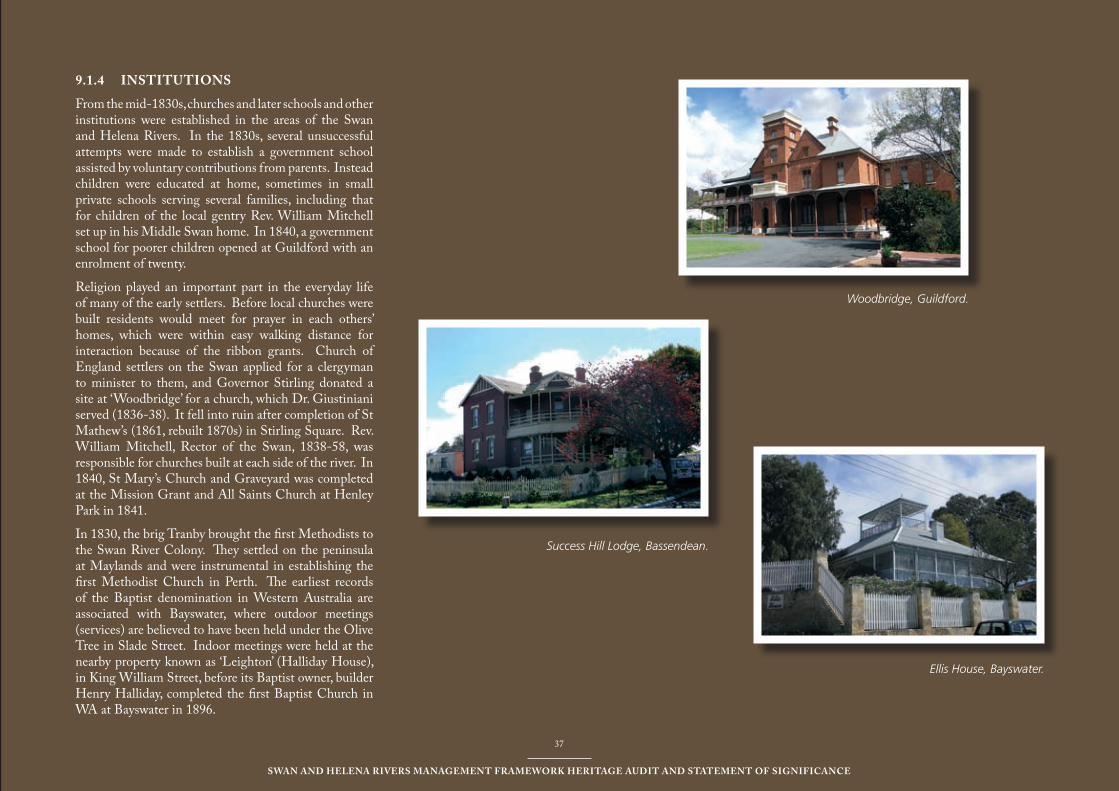
37
Swan and Helena RiveRS ManageMent FRaMewoRk HeRitage audit and StateMent oF SigniFicance
37
Swan and Helena RiveRS ManageMent FRaMewoRk HeRitage audit and StateMent oF SigniFicance
Woodbridge, Guildford.
Ellis House, Bayswater.
inStitutionS9.1.4
From the mid-1830s, churches and later schools and other institutions were established in the areas of the Swan and Helena Rivers. In the 1830s, several unsuccessful attempts were made to establish a government school assisted by voluntary contributions from parents. Instead children were educated at home, sometimes in small private schools serving several families, including that for children of the local gentry Rev. William Mitchell set up in his Middle Swan home. In 1840, a government school for poorer children opened at Guildford with an enrolment of twenty.
Religion played an important part in the everyday life of many of the early settlers. Before local churches were built residents would meet for prayer in each others’ homes, which were within easy walking distance for interaction because of the ribbon grants. Church of England settlers on the Swan applied for a clergyman to minister to them, and Governor Stirling donated a site at ‘Woodbridge’ for a church, which Dr. Giustiniani served (1836-38). It fell into ruin after completion of St Mathew’s (1861, rebuilt 1870s) in Stirling Square. Rev. William Mitchell, Rector of the Swan, 1838-58, was responsible for churches built at each side of the river. In 1840, St Mary’s Church and Graveyard was completed at the Mission Grant and All Saints Church at Henley Park in 1841.
In 1830, the brig Tranby brought the first Methodists to the Swan River Colony. They settled on the peninsula at Maylands and were instrumental in establishing the first Methodist Church in Perth. The earliest records of the Baptist denomination in Western Australia are associated with Bayswater, where outdoor meetings (services) are believed to have been held under the Olive Tree in Slade Street. Indoor meetings were held at the nearby property known as ‘Leighton’ (Halliday House), in King William Street, before its Baptist owner, builder Henry Halliday, completed the first Baptist Church in WA at Bayswater in 1896.
Success Hill Lodge, Bassendean.
38
Swan and Helena RiveRS ManageMent FRaMewoRk HeRitage audit and StateMent oF SigniFicance
Some early settlers were concerned for the Aboriginal people and others in the colony less fortunate than themselves and supported the formation of the Western Australian Missionary Society (later Australian Missionary Society) in England in 1835. Its aim was to establish a Christian Mission to the Aborigines and destitute settlers in the colony, and Dr. Giustiniani was selected to conduct it. In 1836, part of Swan Location 12 at Middle Swan was purchased for the purpose, becoming known as the Mission Grant. After Dr. Giustiniani departed in 1838, there was little progress in the Mission to the Aborigines. In 1874-75, Swan Boys Orphanage (Swanleigh Hostel) was established on part of the Mission Grant.
In the 1840s, the aim of ‘civilising’ and educating Aboriginal people was the rationale for a government programme providing funding assistance for special schools for Aboriginal children. In 1841, the schoolmaster at Guildford, Abraham Jones, formerly a catechist to Dr. Giustiniani, established such a school for Aboriginal children employed in the town and district, who attended classes in the evening after work. Their fatigue at the end of the day, the scattered nature of the population, and the death of eleven of the twenty three children from influenza mitigated against the school, which apparently closed not long after withdrawal of the government grant in late 1843. From 1843 to 1850, Rev. Postlewaite’s school provided for settlers’ children and Aboriginal children at Upper Swan.
The Roman Catholic Bishop, Dr. Brady, returned to the colony in 1836, with priests, nuns and catechists recruited to establish missions to the Aboriginal people. Fr. Powell and a catechist established a Mission at Guildford, but hardship overcame them and they returned to Perth. Most of the few Catholics in the district were poor labourers, and a Catholic Church was not built at Guildford until 1859. The only Mission to survive was that of the Benedictines at New Norcia. In 1849, Bishop Serra was appointed coadjutor, but Brady
disputed his authority, filed lawsuits against him and suspended him. In 1850, Serra withdrew from Perth to Guildford, Brady took possession of the mission at New Norcia and the Benedictines also took refuge at Guildford, where they stayed until 1852, in three rented cottages. One is believed to have been a cottage at Captain Pratt’s ‘Bebo Moro’, which was later integrated into St. Vincent’s Hostel, a Catholic Aged Care hostel, where some old olive trees are reputed to have been planted by the Benedictines. Another is believed to be Welbourne House (1840).
In 1895, Charles Harper established a private school at ‘Woodbridge’ for his children and nearby affluent families. In 1900, a separate school building was erected as more permanent accommodation. The Church of England acquired the premises and land in 1910, and the school became Guildford Grammar School. The School Chapel (1914), the only building in Australia by the eminent English architect Sir Walter Tapper, was built by the site of the 1836 church. Some headstones and memorials from the old churchyard have been preserved near the Chapel.
Prevailing opinion considered the best location for a hospital or institution was near the ocean or river where fresh breezes and an attractive environment would benefit patients or so-called inmates. In the inter-war and post-World War II period, a number of large Federation period buildings in the metropolitan area were converted to such purposes. Lockeridge Hotel (1896) became a private hospital, then a Salvation Army’s Men’s Home in the inter-war period, and a private hospital in the 1960s. The Sisters of St John of God purchased Hill 60 overlooking the river at Belmont for the St John of God Hospital and convent that they developed there. The Mercy Sisters acquired ‘Killowen’ overlooking the Maylands Peninsula, which became St Anne’s Nursing Home, a private hospital that continues as Mercy Hospital. During World War II, the Old Women’s Home was transferred from Fremantle to ‘Woodbridge’, which
continued to be so used until the 1960s. The Catholic Church purchased ‘Garden Hill’, the large residence built in 1898, for Colonial Surgeon, Dr. Waylen, to establish St Charles’ Seminary. With extensive grounds in a semi-rural environment by the river and convenient to transport, it was well suited for the first seminary in this State and the fifth in Australia.
In the 1950s, the State government purchased a number of large residences for institutional purposes, including ‘Earlsferry’ and the nearby ‘Fairholme’ property for use by the Child Welfare Department. They were converted for institutional use to provide for intellectually disabled children, with ‘Earlsferry’ becoming a home for intellectually disabled girls. The government also purchased ‘Dear Brutus’ (‘Tampina’), where the Mentally Incurable Children’s Association cared for children with disabilities. In 1964, the government acquired ‘Wedderburn’ (‘Invercloy’) for the same purpose, and it was renamed ‘Nulsen Haven’ after the Minister for Health, Emil Nulsen. In the 1960s, ‘Welbourne House’ was purchased and included in the ‘Fairholme’ site.
In 1960, the government purchased ‘Pyrton’, where the buildings were demolished and Riverbank Detention Centre for boys was built. In the late twentieth century, changing practices led to closure of many institutions including ‘Nulsen Haven’ and ‘‘Earlsferry’ whose large grounds were sub-divided, and the surviving grand residences, mostly returned to private ownership and residential uses.
RecReation9.1.5
In 1829, large areas of land were reserved for government purposes but it is not known how much, if any, was intended for recreation. Until the late nineteenth century, there was little formal development of recreation areas other than in Perth, where the public garden was established in the mid-1840s and a small number of other recreation grounds and reserves thereafter.

39
Swan and Helena RiveRS ManageMent FRaMewoRk HeRitage audit and StateMent oF SigniFicance
Nonetheless, as early settlers in the area of the Swan and Helena Rivers became established in the 1830s, they began to find some time for leisure and recreation, including visiting nearby neighbours or going in to Guildford, where ploughing matches were popular. In 1834, the first agricultural show in the colony was held at Guildford, and agricultural shows continued there until the early 1900s, when the need for a larger site saw the Royal Agricultural Society relocate to Claremont. The first thoroughbred horse race in the colony was between Stirling’s ‘Margonette’ and Brockman’s ‘Margeaux’ at the Races and Ploughing Match held in Guildford in 1836.
In 1848, the first horse race in the Belmont area of the Swan and Helena River was held four miles out from Perth on the flats at J. W. Hardey’s ‘Grove Farm’, where Perth Racecourse was established in the 1850s under the Western Australian Turf Club (est. 1852). In the late 1890s, the gold boom brought prosperity and increased interest in horse racing. The racecourse was upgraded, including new buildings, and renamed Ascot Racecourse, and hotels were built nearby to cater to visitors, including Ascot Hotel (later Ascot Inn). The initially unregistered racecourse developed at Burswood in 1899, was registered in 1902, and continues as Belmont Park in 2008. It is the only survivor of a number of unregistered racecourses developed in the metropolitan area around the turn of the century.
In the late 1890s and early 1900s, the government set aside land for reserves for the purpose of recreation in the city, suburbs and towns, reflecting the concept of parks and green spaces as the lungs of the city and the need for recreation areas for the populace. This preceded the ‘Garden City’ movement that influenced later development. Early reserves in the area included those at Bassendean, where the site of the oval was set aside for government requirements in 1902, and designated a recreation reserve in 1904. In the pre-World War I period, the riverfront land initially known as Bassendean Recreation Reserve (later Pickering Park) was also
developed, including training facilities comprising a clay running track and ladder stand for the fire brigade.
In the early twentieth century, the growth of population in Maylands, Bayswater, Bassendean, Guildford and Midland Junction saw the river become increasingly popular for recreation, including picnics on the foreshore, swimming and boating. This encouraged the development of facilities to cater to picnickers and boaters, but such ventures were often not as successful as their developers had hoped and anticipated. This is evidenced by the frequent changes in proprietor of the Lockeridge Hotel (Success Hill Lodge), and Ascot Hotel, which despite its proximity to the racecourse and considerable patronage on race days was not a resounding success overall.
In the early 1900s, swimming in the river was a popular pastime. Bathing sheds were erected at various places along the foreshore, and swimming clubs were formed. These included the Bayswater Swimming Club, which held competitions at the end of Slade Street and at Garratt Road in the pre-World War I period. Guildford Swimming Club hosted inter-club competitions at Point Reserve, Bassendean, and the jetty by Guildford Recreation Ground. The highlight was the annual ‘Swim through Guildford’, a two mile race starting near Barker’s Bridge, that attracted male and female competitors of all ages from as far away as Geraldton. This was the only competitive event officially open to women before formation of a women’s club in the Guildford district in 1924. At Hawksburn Road, Belmont, a bathing shed was erected in 1907, which was replaced by two new architect designed sheds (male and female) in 1912. In the 1920s, Belmont Young Men’s Club (est. 1919) erected a jetty, distance markers were fixed in the river, and a path was made to the sheds. Swimming and rowing competitions were held at Hawksburn Road Baths, which were upgraded with construction of an additional jetty post-World War II. Youths enjoyed jumping into the river from jetties and bridge, including Garratt Road Bridge. In 1959, the Bayswater Swimming
Club was reconstituted and two jetties, 50 m. apart, were built to provide swimming facilities in the area between Milne Street and the Garratt Road Bridge where Hinds Reserve was being developed. The most renowned swimmer from the area was Evelyn de Lacy, Australia’s first female Olympian, who competed at the Berlin Olympics in 1936, and the Empire Games in Sydney in 1938, and later became a well known swimming coach in New South Wales.
Much of the foreshore in the area was not formally designated as reserves and developed as such until the post-World War II period, which was also when clubs such as Maylands Yacht Club and Maylands Rowing Club were established by the river. Recreation areas and parks were frequently developed on low lying land or waste land considered unsuitable for other uses and land previously used for other purposes such as waste disposal sites or brickworks that rendered it unsuitable for other forms of redevelopment. For example, Berringa Park and Bardon Park, once part of the large area that comprised Joseph Hardey’s ‘Peninsula Farm’, were later the site of a rubbish dump, before the parks were developed. Hinds Reserve was a swampy site that was used for sanitary infill in the 1960s, which paved the way for the reclaimed land to become parkland and an appreciated community facility. In the early twenty-first century, these and other parks and reserves along the foreshore continue in use.
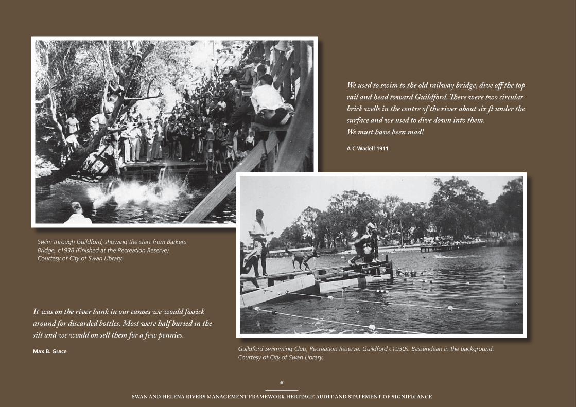
40
Swan and Helena RiveRS ManageMent FRaMewoRk HeRitage audit and StateMent oF SigniFicance
40
Swan and Helena RiveRS ManageMent FRaMewoRk HeRitage audit and StateMent oF SigniFicance
Swim through Guildford, showing the start from Barkers Bridge, c1938 (Finished at the Recreation Reserve). Courtesy of City of Swan Library.
Guildford Swimming Club, Recreation Reserve, Guildford c1930s. Bassendean in the background. Courtesy of City of Swan Library.
We used to swim to the old railway bridge, dive off the top rail and head toward Guildford. There were two circular brick wells in the centre of the river about six ft under the surface and we used to dive down into them. We must have been mad!
A C Wadell 1911
It was on the river bank in our canoes we would fossick around for discarded bottles. Most were half buried in the silt and we would on sell them for a few pennies.
Max b. grace
41
Swan and Helena RiveRS ManageMent FRaMewoRk HeRitage audit and StateMent oF SigniFicance
HiStoRic SigniFicance9.2 The Swan and Helena Rivers above Heirisson Island are of historic significance for their role in the exploration and early settlement of the Swan River Colony. The initial French exploration in 1801, and subsequently Captain James Stirling’s expedition in 1827, and the discovery of clay deposits, fertile soil and fresh water, were significant incentives in the British Government’s decision to establish the first free colony in Australia on the Swan River with Stirling as the first Governor in 1829. The following section summarises the significance of the Rivers in the context of the historic overview.
exPloRation, aBoRiginal 9.2.1 contact and eaRly SettleMent
The Swan and Helena Rivers are of historic significance because the establishment of the Swan River Colony in 1829, was based largely on Captain James Stirling’s observations of fertile agricultural land along the river foreshores. This observation proved somewhat inaccurate, as the fertile land did not extend far and was not similar to the arable land the settlers were accustomed to in England.
The quality of land for agriculture, the availability of fresh water and the capacity of the river to provide access to the hinterland, were significant factors determining the form of land allocation and distribution in the Swan River Colony, as ribbon grants with river frontages as a premium. These factors also determined the location of the first towns, including Guildford near the confluence of the Swan and Helena Rivers, which was opened for selection in 1830.
The Swan and Helena Rivers are of significance as the place where explorers and early settlers encountered Aboriginal people. Aboriginal people living near the river were displaced by European settlement and agriculture. Early contact experiences varied. In the early years of settlement Aboriginal people were employed as shepherds
and the like and a school was established for Aboriginal children at Guildford in 1841. The introduction of European diseases such as influenza had a serious impact on the Aboriginal people of the area, the disease killing half the 23 children enrolled at the school.
tRanSPoRt, induStRy and 9.2.2 SeRviceS
The Swan River is of historic significance because it provided the main transport route for the Swan River Colony, and with the port at Guildford serving the hinterland, provided transport for goods to markets at Perth and Fremantle, until the opening of the railway between Guildford and Fremantle in 1881.
The rich clay deposits along the Swan and Helena Rivers allowed the establishment of brickworks from Maylands to Middle Swan from the mid- nineteenth century to the present day (2008). There played a significant role in the development of Perth and surrounding areas by providing materials for construction as well as business and employment opportunities.
The upper reaches of the Swan River are historically important for providing suitable locations for industry close to river transport and water for power and waste disposal. Major industrial sites along the river included the East Perth Power Station, Western Australian Railway Workshops at Midland Junction and Midland Saleyards and Abattoirs.
gold BooM, PRoSPeRity and 9.2.3 SuBdiviSion
The 1890s gold boom, and the resulting influx of population, had a significant effect on land settlement along the Swan and Helena Rivers leading to subdivision and the first wave of suburban development. The opening of the Fremantle to Guildford Railway in 1881 resulted in residential development near the stations
with development tending to cluster on land between the railway and the river.
For the first time the aesthetic qualities of land along the river were significant in influencing the choice of sites. Mansions with extensive grounds were established along the river by industrial leaders, senior public servants, successful pastoralists, and some who had made their fortunes on the gold fields, with some of those in the area of Belmont having stables associated with the development of the racing industry that developed.
inStitutionS 9.2.4
The significance of the river as the main route for transport and communications in the Swan River Colony resulted in it having a pivotal role in many aspects of life including the establishment of the major institutions of a new society. The settlement of the Hardey brothers, together with the group of Methodists who arrived on the Tranby in 1830, on the peninsula at Bayswater resulted in the introduction of the Methodist Church. The first Baptist services were held nearby in Bayswater in the 1890s. Places along the river were similarly important to the other Christian denominations, including the establishment of an Anglican Church on land donated by Governor Stirling from his ‘Woodbridge’ estate. Of great significance was the establishment of the Mission Grant in 1836, on land to the north of the river at Middle Swan (Yule Avenue), which was the first recorded aim to establish a Christian Mission for Aboriginal people and destitute settlers. This site, known as ‘Swanleigh Hostel’, remains in the ownership of the Anglican Church.
There are a number of sites along the river that have played a significant role in the development of education in the State. The development of Guildford Grammar School from 1910, on land near ‘Woodbridge’ where Charles Harper established a school in 1895, is significant as one of the State’s prestigious private boys’ schools. The area was also home to possibly one
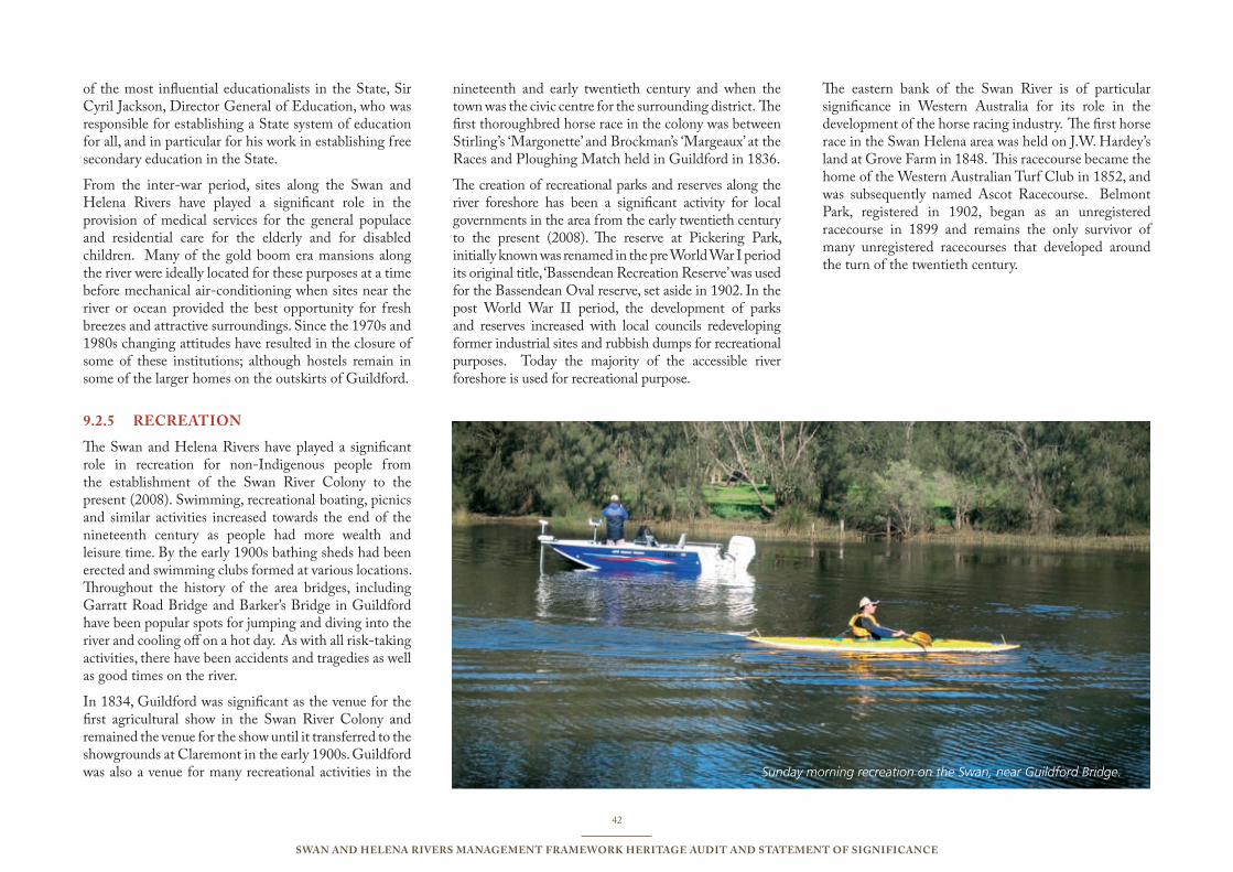
42
Swan and Helena RiveRS ManageMent FRaMewoRk HeRitage audit and StateMent oF SigniFicance
of the most influential educationalists in the State, Sir Cyril Jackson, Director General of Education, who was responsible for establishing a State system of education for all, and in particular for his work in establishing free secondary education in the State.
From the inter-war period, sites along the Swan and Helena Rivers have played a significant role in the provision of medical services for the general populace and residential care for the elderly and for disabled children. Many of the gold boom era mansions along the river were ideally located for these purposes at a time before mechanical air-conditioning when sites near the river or ocean provided the best opportunity for fresh breezes and attractive surroundings. Since the 1970s and 1980s changing attitudes have resulted in the closure of some of these institutions; although hostels remain in some of the larger homes on the outskirts of Guildford.
RecReation9.2.5
The Swan and Helena Rivers have played a significant role in recreation for non-Indigenous people from the establishment of the Swan River Colony to the present (2008). Swimming, recreational boating, picnics and similar activities increased towards the end of the nineteenth century as people had more wealth and leisure time. By the early 1900s bathing sheds had been erected and swimming clubs formed at various locations. Throughout the history of the area bridges, including Garratt Road Bridge and Barker’s Bridge in Guildford have been popular spots for jumping and diving into the river and cooling off on a hot day. As with all risk-taking activities, there have been accidents and tragedies as well as good times on the river.
In 1834, Guildford was significant as the venue for the first agricultural show in the Swan River Colony and remained the venue for the show until it transferred to the showgrounds at Claremont in the early 1900s. Guildford was also a venue for many recreational activities in the
nineteenth and early twentieth century and when the town was the civic centre for the surrounding district. The first thoroughbred horse race in the colony was between Stirling’s ‘Margonette’ and Brockman’s ‘Margeaux’ at the Races and Ploughing Match held in Guildford in 1836.
The creation of recreational parks and reserves along the river foreshore has been a significant activity for local governments in the area from the early twentieth century to the present (2008). The reserve at Pickering Park, initially known was renamed in the pre World War I period its original title, ‘Bassendean Recreation Reserve’ was used for the Bassendean Oval reserve, set aside in 1902. In the post World War II period, the development of parks and reserves increased with local councils redeveloping former industrial sites and rubbish dumps for recreational purposes. Today the majority of the accessible river foreshore is used for recreational purpose.
The eastern bank of the Swan River is of particular significance in Western Australia for its role in the development of the horse racing industry. The first horse race in the Swan Helena area was held on J.W. Hardey’s land at Grove Farm in 1848. This racecourse became the home of the Western Australian Turf Club in 1852, and was subsequently named Ascot Racecourse. Belmont Park, registered in 1902, began as an unregistered racecourse in 1899 and remains the only survivor of many unregistered racecourses that developed around the turn of the twentieth century.
Sunday morning recreation on the Swan, near Guildford Bridge.
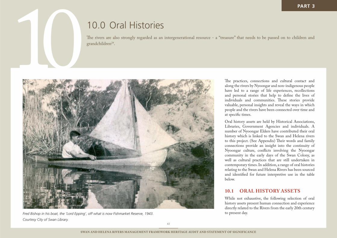
10
43
Swan and Helena RiveRS ManageMent FRaMewoRk HeRitage audit and StateMent oF SigniFicance
The practices, connections and cultural contact and along the rivers by Nyoongar and non-indigenous people have led to a range of life experiences, recollections and personal stories that help to define the lives of individuals and communities. These stories provide valuable, personal insights and reveal the ways in which people and the rivers have been connected over time and at specific times.
Oral history assets are held by Historical Associations, Libraries, Government Agencies and individuals. A number of Nyoongar Elders have contributed their oral history which is linked to the Swan and Helena rivers to this project. (See Appendix) Their words and family connections provide an insight into the continuity of Nyoongar culture, conflicts involving the Nyoongar community in the early days of the Swan Colony, as well as cultural practices that are still undertaken in contemporary times. In addition, a range of oral histories relating to the Swan and Helena Rivers has been sourced and identified for future interpretive use in the table below.
oRal HiStoRy aSSetS10.1 While not exhaustive, the following selection of oral history assets present human connection and experience directly related to the Rivers from the early 20th century to present day.Fred Bishop in his boat, the ‘Lord Epping’, off what is now Fishmarket Reserve, 1943.
Courtesy City of Swan Library.
PART 3
oral Histories10.0 The rivers are also strongly regarded as an intergenerational resource - a “treasure” that needs to be passed on to children and grandchildren24.
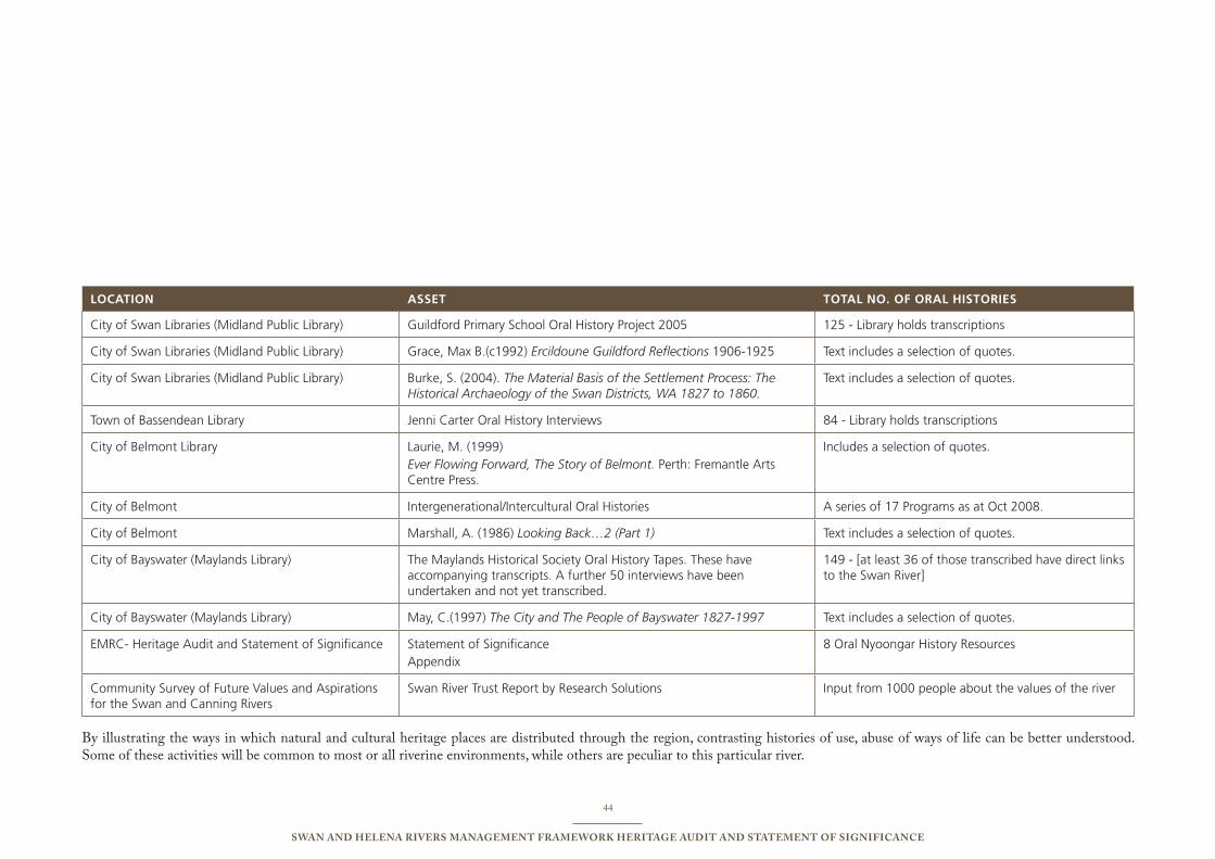
44
Swan and Helena RiveRS ManageMent FRaMewoRk HeRitage audit and StateMent oF SigniFicance
LOCATION AssET TOTAL NO. OF ORAL hIsTORIEs
City of swan Libraries (Midland public Library) Guildford primary school oral History project 2005 125 - Library holds transcriptions
City of swan Libraries (Midland public Library) Grace, Max b.(c1992) Ercildoune Guildford Reflections 1906-1925 text includes a selection of quotes.
City of swan Libraries (Midland public Library) burke, s. (2004). The Material Basis of the Settlement Process: The Historical Archaeology of the Swan Districts, WA 1827 to 1860.
text includes a selection of quotes.
town of bassendean Library Jenni Carter oral History interviews 84 - Library holds transcriptions
City of belmont Library Laurie, M. (1999)Ever Flowing Forward, The Story of Belmont. perth: Fremantle Arts Centre press.
includes a selection of quotes.
City of belmont intergenerational/intercultural oral Histories A series of 17 programs as at oct 2008.
City of belmont Marshall, A. (1986) Looking Back…2 (Part 1) text includes a selection of quotes.
City of bayswater (Maylands Library) the Maylands Historical society oral History tapes. these have accompanying transcripts. A further 50 interviews have been undertaken and not yet transcribed.
149 - [at least 36 of those transcribed have direct links to the swan River]
City of bayswater (Maylands Library) May, C.(1997) The City and The People of Bayswater 1827-1997 text includes a selection of quotes.
eMRC- Heritage Audit and statement of significance statement of significanceAppendix
8 oral nyoongar History Resources
Community survey of Future Values and Aspirations for the swan and Canning Rivers
swan River trust Report by Research solutions input from 1000 people about the values of the river
By illustrating the ways in which natural and cultural heritage places are distributed through the region, contrasting histories of use, abuse of ways of life can be better understood. Some of these activities will be common to most or all riverine environments, while others are peculiar to this particular river.
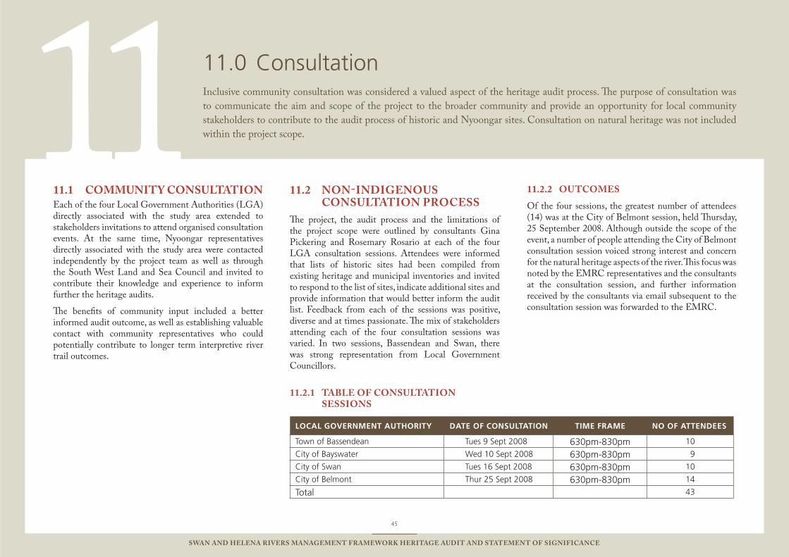
11
45
Swan and Helena RiveRS ManageMent FRaMewoRk HeRitage audit and StateMent oF SigniFicance
Consultation11.0 Inclusive community consultation was considered a valued aspect of the heritage audit process. The purpose of consultation was to communicate the aim and scope of the project to the broader community and provide an opportunity for local community stakeholders to contribute to the audit process of historic and Nyoongar sites. Consultation on natural heritage was not included within the project scope.
coMMunity conSultation 11.1 Each of the four Local Government Authorities (LGA) directly associated with the study area extended to stakeholders invitations to attend organised consultation events. At the same time, Nyoongar representatives directly associated with the study area were contacted independently by the project team as well as through the South West Land and Sea Council and invited to contribute their knowledge and experience to inform further the heritage audits.
The benefits of community input included a better informed audit outcome, as well as establishing valuable contact with community representatives who could potentially contribute to longer term interpretive river trail outcomes.
non-indigenouS 11.2 conSultation PRoceSS
The project, the audit process and the limitations of the project scope were outlined by consultants Gina Pickering and Rosemary Rosario at each of the four LGA consultation sessions. Attendees were informed that lists of historic sites had been compiled from existing heritage and municipal inventories and invited to respond to the list of sites, indicate additional sites and provide information that would better inform the audit list. Feedback from each of the sessions was positive, diverse and at times passionate. The mix of stakeholders attending each of the four consultation sessions was varied. In two sessions, Bassendean and Swan, there was strong representation from Local Government Councillors.
taBle oF conSultation 11.2.1 SeSSionS
LOCAL gOvERNMENT AuThORITy dATE OF CONsuLTATION TIME FRAME NO OF ATTENdEEs
town of bassendean tues 9 sept 2008 630pm-830pm 10
City of bayswater Wed 10 sept 2008 630pm-830pm 9
City of swan tues 16 sept 2008 630pm-830pm 10
City of belmont thur 25 sept 2008 630pm-830pm 14
total 43
outcoMeS11.2.2
Of the four sessions, the greatest number of attendees (14) was at the City of Belmont session, held Thursday, 25 September 2008. Although outside the scope of the event, a number of people attending the City of Belmont consultation session voiced strong interest and concern for the natural heritage aspects of the river. This focus was noted by the EMRC representatives and the consultants at the consultation session, and further information received by the consultants via email subsequent to the consultation session was forwarded to the EMRC.
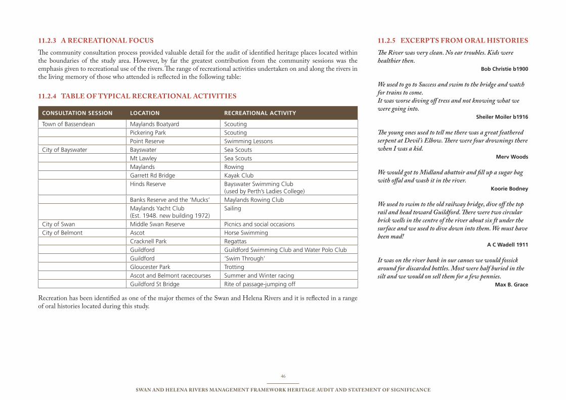
46
Swan and Helena RiveRS ManageMent FRaMewoRk HeRitage audit and StateMent oF SigniFicance
a RecReational FocuS11.2.3
The community consultation process provided valuable detail for the audit of identified heritage places located within the boundaries of the study area. However, by far the greatest contribution from the community sessions was the emphasis given to recreational use of the rivers. The range of recreational activities undertaken on and along the rivers in the living memory of those who attended is reflected in the following table:
taBle oF tyPical RecReational activitieS11.2.4
CONsuLTATION sEssION LOCATION RECREATIONAL ACTIvITy
town of bassendean Maylands boatyard scouting
pickering park scouting
point Reserve swimming Lessons
City of bayswater bayswater sea scouts
Mt Lawley sea scouts
Maylands Rowing
Garrett Rd bridge Kayak Club
Hinds Reserve bayswater swimming Club (used by perth’s Ladies College)
banks Reserve and the ‘Mucks’ Maylands Rowing Club
Maylands Yacht Club (est. 1948. new building 1972)
sailing
City of swan Middle swan Reserve picnics and social occasions
City of belmont Ascot Horse swimming
Cracknell park Regattas
Guildford Guildford swimming Club and Water polo Club
Guildford ‘swim through’
Gloucester park trotting
Ascot and belmont racecourses summer and Winter racing
Guildford st bridge Rite of passage-jumping off
Recreation has been identified as one of the major themes of the Swan and Helena Rivers and it is reflected in a range of oral histories located during this study.
exceRPtS FRoM oRal HiStoRieS11.2.5
The River was very clean. No ear troubles. Kids were healthier then. bob Christie b1900
We used to go to Success and swim to the bridge and watch for trains to come.It was worse diving off tress and not knowing what we were going into. sheiler Moiler b1916
The young ones used to tell me there was a great feathered serpent at Devil ’s Elbow. There were four drownings there when I was a kid. Merv Woods
We would got to Midland abattoir and fill up a sugar bag with offal and wash it in the river. Koorie bodney
We used to swim to the old railway bridge, dive off the top rail and head toward Guildford. There were two circular brick wells in the centre of the river about six ft under the surface and we used to dive down into them. We must have been mad! A C Wadell 1911
It was on the river bank in our canoes we would fossick around for discarded bottles. Most were half buried in the silt and we would on sell them for a few pennies. Max b. grace

47
Swan and Helena RiveRS ManageMent FRaMewoRk HeRitage audit and StateMent oF SigniFicance
aBoRiginal conSultation11.3 The total number of Nyoongar representatives who have contributed to the process as at 10 November 2008 has exceeded the expectation outlined in the scope of consultation. The Nyoongar heritage audit and consultation has been undertaken by Cheryl-Anne McCann, Indigenous Cultural Heritage Planning Coordinator Perth Region NRM (formally SCC), Brooke Mandy and Gina Pickering with guidance and advice from Dr Richard Walley and in association with the MAALI Foundation (Chair, Bev Rebbeck). Some of the Nyoongar elders who were known to be directly linked to the study area were contacted directly by Gina Pickering on advice from Dr Richard Walley. Other Nyoongar representatives who are registered Native Title Claimants within the Perth Metropolitan area responded to a written invitation to contribute to the project extended via the South West Land and Sea Council. The invitation to contribute through the consultation process to the project has been extended to those with a direct connection, to the Swan and Helena Rivers. Consultation has been undertaken on a one-or-one basis. The Nyoongar contributors include:
Albert Corunna1.
Barry McGuire 2.
May McGuire 3.
Leoni Humphries4.
Frances Humphries 5.
Oswald Humphries6.
Fred Pickett7.
Irene Stainton 8.
Each of the Nyoongar respondents has contributed to this project a unique personal context which highlights the continuing cultural connection to the river held by the Nyoongar community.
The Helena River is listed as a Closed Site on the Aboriginal Sites Register.
a ReSPonSe to PRoPoSed tRailS11.3.1
Nyoongar Elders were invited by the consultants to respond to the ‘priority trails’ proposed in the Transplan Pty Ltd and Kulbardi Hill Consulting document Perth’s Eastern Region Swan River Trails Project, 2007.
While encouraging greater understanding and appreciation of the river and its foreshores, the Elders highlighted some culturally sensitive locations to avoid and emphasised adherence to due process regarding the protection of Aboriginal sites.
Recommendations included avoiding culturally sensitive locations south west of Garrett Road bridge, at AP Hinds Reserve and particularly south east of Guildford Road Bridge as well as in the vicinity of Helena River.
In addition, the close proximity of trails to the rivers edge raised concerns. It was indicated that the waterways should not be disturbed in anyway out of respect for Creative Being, Waugyl25.
It was also indicated that before any development of proposed trails could be undertaken, that full consultation with Aboriginal informants would be required in accordance with Section 18 of the Aboriginal Heritage Act 197226 to consider whether consent should be given to the use of the land for the purpose sought While this level of consultation is outside the scope of this project, it was specifically indicated for the proposed trail near the confluence of the Swan and Helena Rivers.
48
Swan and Helena RiveRS ManageMent FRaMewoRk HeRitage audit and StateMent oF SigniFicance
nyoongaR conSultationS 11.3.2 tRanScRiPtS
Members of the Nyoongar community have contributed valuable cultural and experiential insights during consultation sessions undertaken for this project. Their contributions have expanded the understanding and significance of the Rivers.
consultation with albert corunna to inform the Statement of Significance for the Swan and Helena Rivers, as told to gina Pickering 18 august 2008.
My name is Albert Corunna I am an elder of Perth. I am one of the applicants of the successful Native Title claim over the Perth metropolitan area. The Swan River and the Helena River are significant waterways to me because they hold cultural association with my ancestors, the Dreamtime stories and the struggle for Native Title recognition.
albert corunna’s relation to Midgegooroo and yagan
The old people long gone now passed down stories to me, about our family who lived along these rivers. Stories of Yagan were also told which are not documented in a library.
I gave some of these oral stories as evidence in The Federal Court for Native title. This is how I became an applicant for Native Title as per Native Title Legislation. I was urged by my family and extended families to fight for our Native Title Rights. I also believe that my ancestral spirits selected me, guided, and helped me in the Native Title process, as well as, to look after country.
Midgegooroo
Midgegooroo is my Great Great Grandfather. I was told he had more than one wife. All of his wives children were brothers and sisters. Midgegooroo was the father of Yagan and my Great Grandmother Fanny. My Great
Grandmother Fanny was the mother of Munderan my Grandmother.
Grandmother Munderan I believe was born in 1864. She gave birth to my mum Adeline Wilkes in 1898. I was told Grandmother’s biological father was a white businessman Scrivener from the Guildford district.
capture of great great grandfather Midgegooroo
Colonial troopers captured Great Great Grandfather Midgegooroo while he was in the company of his five-year-old son during a walk near the Helena River. I disagree with the historical accounts suggesting that Great Great Grandfather Midgegooroo was a Wanted Man. I believe that if he had been wanted he wouldn’t have risked endangering his son. If he knew he was wanted he would have been in the company of his warriors. I believe he did not commit any crime to warrant his arrest. I also believe that at the time of Great Great Grandfather Midgegooroo capture he would have already been of elderly age.
I know that after he was taken Great Great Grandfather Midgegooroo was executed by a firing squad, against a door in Perth without a trial. To this day I don’t know what happened to Great Great Grandfather Midgegooroo’s 5 year old son.
One of the reasons why I view the Helena River as a significant place is because this is the place where Great Great Grandfather Midgegooroo spent his last days of happiness with his people.
why the Helena River is significant to albert corunna
In the olden days the Helena River was abundant with life and the water flowed without interruption. Back then no Mundaring weir was present to mess with the flow. I also consider the Helena River and Swan River are sacred sites.
I know the Helena River and Swan River are important
because of its beginning connected with the Dreamtime Waugyl (a snakelike creator). I was told the Dreamtime Waugyl was the creator of the river systems in Perth. During the Dreamtime the Waugyl moved across the landscapes of Perth and as he moved the waterways were created which included the Swan River. This is the way the rivers were made as told by my old people.
The Helena River is also important to me because we talked about country near the river for the 2003 Metropolitan Native Title claim. A number of sites near the rivers were chosen for the claimant’s Federal Court hearings. Hearings happened at the Helena River between Roe highway and Military Rd in Midland. Another court hearing was held near Meadows oval where the Helen River enters the Swan River. At both these places I acted as the legal representative for our Native Title claim. The Helena River and the Swan River are important for it is near these rivers that evidence for connection to our country was made.
why the Swan River is significant to albert corunna
The Swan River is important to me because my old people lived near the river. It is also the place where Yagan was killed. The Swan River is also associated with my father’s adolescence and his experience as a stolen generation.
Success Hill (located near the Swan River)
I remember Mum Adeline Wilkes telling me that Success Hill was where they camped. My Grandmother Munderan and my Grandfather Edward Wilkes had their campsite at Success Hill with Mum and the family. My Mum also told me that she was born at Success Hill by the Swan River. Because my people camped and were born by the Swan River I view these places and the river as important. I also believe that our people’s camping sites, places of birth, and burial sites are significant in our connection to country.
49
Swan and Helena RiveRS ManageMent FRaMewoRk HeRitage audit and StateMent oF SigniFicance
Last year in 2007 on my Mother’s birthday, I took my youngest son and my oldest grandson to the Swan River near Success Hill. We all held a water lily that each of us put into the river. We then gathered sand from the river and water from the nearby spring. The sand and water was then taken to Mum’s burial place at Guildford Cemetery. We sprinkled the sand and the spring water on her grave. The Swan River was important in this special ceremony that was done in remembrance of my Mum and her connection with her birthing place and life.
This year in 2008 on my Mum’s birthday I took my eldest son, his youngest son and my great granddaughter. Again we paid tribute to my Mum by throwing water lilies into the Swan River near Success Hill. My great granddaughter’s water lily travelled upstream, the rest of our lilies went down stream. This year, as it was crowded with people watching the White Water Race Descent we travelled up stream to collect sand and spring water to take to my mother’s grave.
Success Hill near the Swan River was also one of the places visited to hear the Native Title Claimants. A lawyer acted for us on the Native Title issues. I also gave evidence at this site given my mum’s important association. I presented a 1901 historical photograph of my Great Grand Mother Fanny and my mother’s sister Louise. Writing on the photograph also identified Fanny of Guildford and Louise of Guildford. This photograph was given as an exhibit to record our connection to country as required by Native Title legislation.
Swan native and Half cast Mission
The Swan Native and Half Cast Mission also located near the Swan River is the place where my father the late Arthur Corunna (Sr) was sent to after being taken away. Dad told me he was brought down from Corunna Downs’s station located in Marble Bar. My father arrived in Perth in 1906. He said the white man didn’t consider him full blood that’s why he was taken. Some of his other siblings stayed on at Corunna Downs because they were considered full blood.
My Dad was a born Pilbara man. He understood the importance of respecting country. He told me that it took him a while before he had the courage to swim in the Swan River. He felt it custom to let the country know him, especially the Waugyl. At first he said he would stand by the river’s edge. After a while he would dip his feet in. When he felt it was right, he then swam in the river. I believe Dad did this out of respect for the Waugyl and the new country that he was taken to.
yagan’s link to a sacred site
The Federal Court sitting for native title in Perth also convened near an ancient sacred site to the east of where the West Swan Road enters the Great Northern Highway [M 172]. I presented evidence handed down to me from my Mum who said they were eye witnesses accounts of how Yagan and Keats died including the events leading up to this happening and after. I gave all this detail evidence to the Federal Court. Yagan died by the Swan River on the 11 July 1833. Yagan’s place of death is believed to not be far from the ancient sacred site.
This year in 2008 on the anniversary of Yagan’s death, several family members including myself payed tribute to him. That night after paying our respects I had a dream like I was travelling back in time. In my dream I went back and Yagan travelled forward. I remember in the dream that we were happy together. For me this meant that Yagan was happy with what we did for his anniversary.
continuing culture
Today I still connect with my mother’s country because I live in Perth. My children, their children and my Great Grandchildren have all been born in Perth as well as live here. I live not far from the Helena River and the Swan River. My family and I often walk along the Helena River following the tracks from Mundaring down to Koongamia. I believe the old people’s spirits are still protecting the landscapes. I see it important for us to help in the protecting these river sites.
When we go to the rivers one of the customs is to throw sand in to let the Waugyl know we are here. This is a sign of respect which our Ancestors can see we are doing the right thing. All of these stories are why the Helena River and Swan River are significant to me.
consultation with Fred Pickett to inform the Statement of Significance for the Swan and Helena Rivers as told to gina Pickering and Brooke Mandy 29 September 2008.
Fred Pickett’s great great grandmother, Balbuk was born on what is now known as Heirisson Island. His family has connections from the southwest of Western Australia and as far north as Darwin. His grandmother Mary Josephine Minamerra [sic] was firstly married to John Pickett and them to George Blurton.
At the second meeting with Fred Pickett, he indicated two important areas that should not be disturbed by trails. The first features a mud patch, and the mud continues to be used for ceremonial purposes ‘painting on ourselves and keeping the bad away’.
The location of this place is riverside of Roeburne’s Place, Ascot on the eastern side of the Redcliffe Bridge. Fred Pickett described this as dangerous spot, however he indicated that raised timber pathways would be acceptable as a way of traversing the area.
The second place is an important swamp area and on the north western side of the Redcliffe Bridge to Memorial Drive, Bayswater.
He said it was important to keep the swamps, because of the turtles and birds and fish and that in contemporary times at certain times of the year traditional gathering still occurred in these areas. Although there is the problem of permits and restricted access to these places as much of the river area is fenced of.
50
Swan and Helena RiveRS ManageMent FRaMewoRk HeRitage audit and StateMent oF SigniFicance
Fred Pickett said that as a teenage boy he knew the location of the women’s areas and birthing place and drinking water on the Burswood Peninsular. He also indicated that the swampy part of the Burswood Peninsular had been a very important food source that was rich in bird eggs, duck eggs, and turtles. He indicated that turtles and tortoises were a delicious food source.
He also said that it would not have been the practice to bury people next to the river because the ground was too wet. Mr Pickett spoke of the spiritual importance of hollowed trees and scarred trees, however it was noted that most of these had been removed in the course of urban development. For this reason any such trees which still remain, are of particular significance.
Fred indicated that at low tide a sand bar would make it possible for Nyoongar people to walk across the river where the Windan Bridge is now situated, and that there were camping grounds on both sides. The reason for this crossing was to collect food and stores.
Fred indicated that there was also a camp at Pickering Park Bassendean and that Ochre was to be found near East Perth Hospital. He indicated that local, metropolitan sources of ochre are no longer accessible due to privatisation of the land. Mr Pickett also stated that an ancestor of his was buried outside of the perimeter of East Perth Cemetery.
The swampy area which is now the Burswood Golf Course was an important camping ground when Fred was young. Many family groups would camp at different points around the peninsula, making use of its resources. The families were forced out of this area when the land was privatised and fenced off in the 1940s. For this reason metropolitan camping areas recorded in the DIA database are no longer in use.
His Father Arnold Pickett would pick grapes in the Swan Valley. He would walk to work from what is now Koongamia to the vineyards. Fred indicated there was a spring not far from where he currently lives.
The Pickett family continues to picnic south of the Guildford Bridge and catch bream, but not in a traditional way. Fred indicated that in the same area up until 1946, jilgees, marron turtles and tortoises were available in this area. He and his two brothers and Father then had to go bush so the boys were not taken. Fred indicated that a trail should come over the Garrett St Bridge.
He also explained how there was a seminary – Hallow Wood Grove – at Yule St Middle Swan and land in this vicinity of Jane Brook had been given back to the Aboriginal people by the church.
Fred said he had letters from the Catholic Church regarding this matter. [While this aspect is outside the scope of this work, the consultants recommend that this matter would be valuable to pursue as part interpretation plan research.]
Mr Pickett explained that the history of the Nyoongar people was recorded in stone by cultural groups from the north and that spiritual people from those areas continue to watch over the Perth area.
consultation with oswald, Frances and leoni Humphries to inform the Statement of Significance for the Swan and Helena Rivers, as told to cheryl-anne Mccann 19 September 2008
Bassendean, Guildford and the Swan Valley are areas that are significant to the Humphries Family, who today are still finding out about their culture and traditional family ties. Frances Humphries was born and lived in and around precincts 2, 3 and 4. Oswald her husband is also a Nyoongar man and has spent most of his life in the Perth metropolitan area. Oswald noted that Ascot River race course was known to the Nyoongars as place where the fighting Waugyl’s were seen. It was said that the Waugyls looked like they were fighting each other but they were mating. It was also noted that it was
against the law to see the Waugyls mating and if you did you would end up with heart problems and die. Frances, Oswald and Leoni understood that a camping ground was located where the Burswood casino is now situated. Frances and Oswald also said that Success was also an old camping ground and Snake Lake near Maida Vale bridge use to be an old soak. Oswald also believed that Balbuk Way (off Victoria Park Drive Exit) was the birth place of legendary Nyoongar Balbuk.
consultation with May and Barry Mcguire to inform the Statement of Significance for the Swan and Helena Rivers, as told to cheryl-anne Mccann 19 September 2008
To the McGuires, the Swan and Helena Rivers are very significant.
The McGuire/Stack family ancestors have lived in the Swan Valley (precincts 3 and 4) for many years. To Mrs May McGuire and her son Barry McGuire, the Swan and Helena Rivers are very significant. Mrs McGuire’s father and grandfathers were born along the Bennett Brook extension (Waugyl Bend). Mrs McGuire was born in New Norcia and Walter McGuire grew up in the Guildford/Claremont area.
Success Hill had a cave under it where the Waugyl lives. Barry and May also said that May’s Dad was swimming across the river away from Success Hill when he got a cramp and stood up on a log that was under him to rest. The other men that were swimming ahead of May’s Dad shouted out to him, and asked him what he was doing and what was wrong. May’s Dad replied, “I have a cramp and am resting on this log”. The men then looked at each other and said that there was no log out there. May’s Dad swam to shore and later on they went back there to find the log. There was no log there, and they believe that May’s Dad was standing on the Waugyl that lived under Success Hill.
Warrnduliar [in the vicinity of Bardon Park] is the place
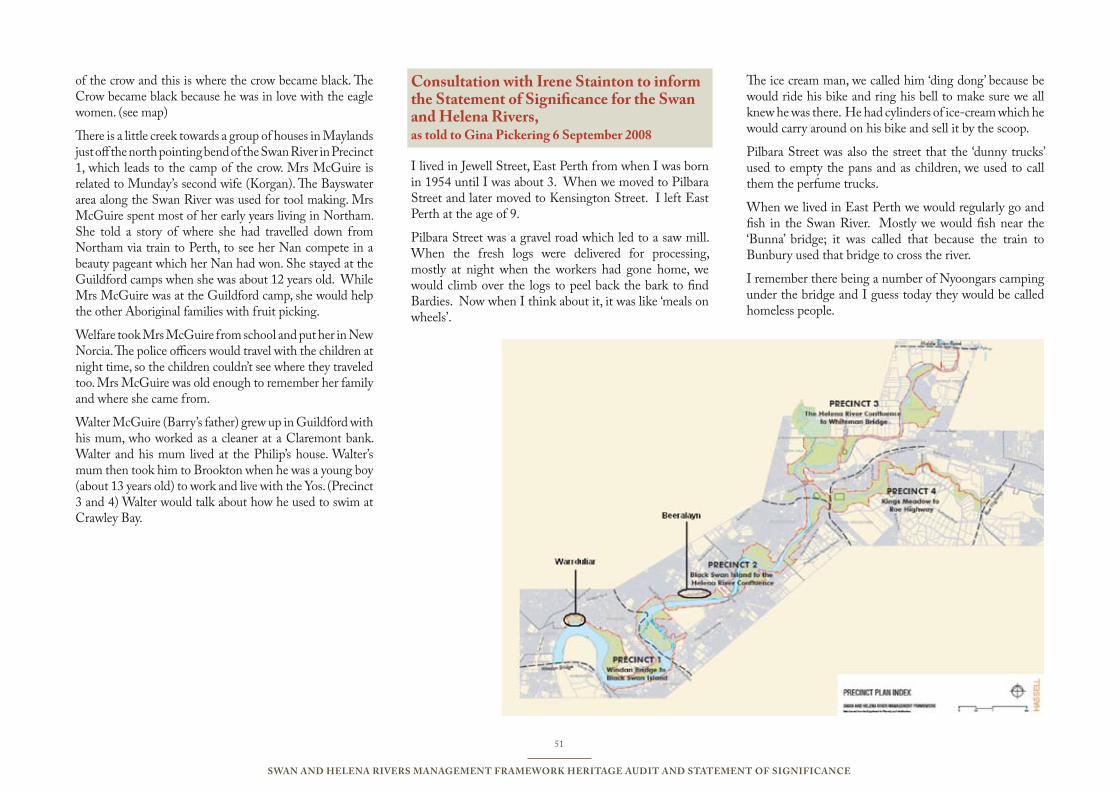
51
Swan and Helena RiveRS ManageMent FRaMewoRk HeRitage audit and StateMent oF SigniFicance
of the crow and this is where the crow became black. The Crow became black because he was in love with the eagle women. (see map)
There is a little creek towards a group of houses in Maylands just off the north pointing bend of the Swan River in Precinct 1, which leads to the camp of the crow. Mrs McGuire is related to Munday’s second wife (Korgan). The Bayswater area along the Swan River was used for tool making. Mrs McGuire spent most of her early years living in Northam. She told a story of where she had travelled down from Northam via train to Perth, to see her Nan compete in a beauty pageant which her Nan had won. She stayed at the Guildford camps when she was about 12 years old. While Mrs McGuire was at the Guildford camp, she would help the other Aboriginal families with fruit picking.
Welfare took Mrs McGuire from school and put her in New Norcia. The police officers would travel with the children at night time, so the children couldn’t see where they traveled too. Mrs McGuire was old enough to remember her family and where she came from.
Walter McGuire (Barry’s father) grew up in Guildford with his mum, who worked as a cleaner at a Claremont bank. Walter and his mum lived at the Philip’s house. Walter’s mum then took him to Brookton when he was a young boy (about 13 years old) to work and live with the Yos. (Precinct 3 and 4) Walter would talk about how he used to swim at Crawley Bay.
consultation with irene Stainton to inform the Statement of Significance for the Swan and Helena Rivers, as told to gina Pickering 6 September 2008
I lived in Jewell Street, East Perth from when I was born in 1954 until I was about 3. When we moved to Pilbara Street and later moved to Kensington Street. I left East Perth at the age of 9.
Pilbara Street was a gravel road which led to a saw mill. When the fresh logs were delivered for processing, mostly at night when the workers had gone home, we would climb over the logs to peel back the bark to find Bardies. Now when I think about it, it was like ‘meals on wheels’.
The ice cream man, we called him ‘ding dong’ because be would ride his bike and ring his bell to make sure we all knew he was there. He had cylinders of ice-cream which he would carry around on his bike and sell it by the scoop.
Pilbara Street was also the street that the ‘dunny trucks’ used to empty the pans and as children, we used to call them the perfume trucks.
When we lived in East Perth we would regularly go and fish in the Swan River. Mostly we would fish near the ‘Bunna’ bridge; it was called that because the train to Bunbury used that bridge to cross the river.
I remember there being a number of Nyoongars camping under the bridge and I guess today they would be called homeless people.
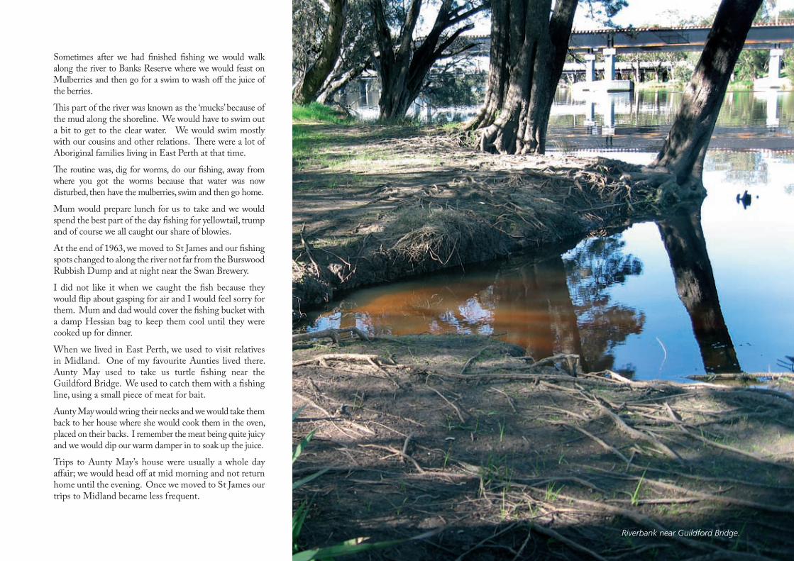
Riverbank near Guildford Bridge.
Sometimes after we had finished fishing we would walk along the river to Banks Reserve where we would feast on Mulberries and then go for a swim to wash off the juice of the berries.
This part of the river was known as the ‘mucks’ because of the mud along the shoreline. We would have to swim out a bit to get to the clear water. We would swim mostly with our cousins and other relations. There were a lot of Aboriginal families living in East Perth at that time.
The routine was, dig for worms, do our fishing, away from where you got the worms because that water was now disturbed, then have the mulberries, swim and then go home.
Mum would prepare lunch for us to take and we would spend the best part of the day fishing for yellowtail, trump and of course we all caught our share of blowies.
At the end of 1963, we moved to St James and our fishing spots changed to along the river not far from the Burswood Rubbish Dump and at night near the Swan Brewery.
I did not like it when we caught the fish because they would flip about gasping for air and I would feel sorry for them. Mum and dad would cover the fishing bucket with a damp Hessian bag to keep them cool until they were cooked up for dinner.
When we lived in East Perth, we used to visit relatives in Midland. One of my favourite Aunties lived there. Aunty May used to take us turtle fishing near the Guildford Bridge. We used to catch them with a fishing line, using a small piece of meat for bait.
Aunty May would wring their necks and we would take them back to her house where she would cook them in the oven, placed on their backs. I remember the meat being quite juicy and we would dip our warm damper in to soak up the juice.
Trips to Aunty May’s house were usually a whole day affair; we would head off at mid morning and not return home until the evening. Once we moved to St James our trips to Midland became less frequent.
12
53
Swan and Helena RiveRS ManageMent FRaMewoRk HeRitage audit and StateMent oF SigniFicance
FootnoteS12.1 1 Ackroyd Peter, Thames: sacred river, London, 2007, p. 82 Swan River Trust, River Protection Strategy and Management Program for the Swan and Canning Rivers, Consultation Summary, June 2008. 3 Brearley Anne, Earnest Hodgkin’s Swanland, UWA Press 2005, p. 714 Kendrick George W, ‘Middle Holocene marine molluscs from near Guildford, Western Australia, and evidence for climate change’, in Journal of the Royal Society of Western Australia, Vol 59, Part 4, June 1977, pp. 97-103.5 Charles Fraser, ‘Observations on the soil, &c, &c, of the banks of Swan River’, 1827, Western Australian Exploration, Vol 1 1826-1835, Hesperian Press, Carlisle, 20056 ibid., p 447 ibid.8 ibid.9 Diary of Joseph Hardey 1830-1839, in Hardey Papers, SLWA, MN64, 566A/2 10 ibid.11 West Australian, 11 May 1934 12 West Australian, 28 July 193413 West Australian, 24 October 193614 WAPD, Vol 73, 1925, p. 249015 Swan River Pollution Survey, 20 September 1955 Cons 4075, File 96/60, SROWA16 Swan River Reference Committee, Report by the Sub Committee on Pollution of the Swan River, Perth 195517 Swan River Trust, Potential Impacts of Climate Change on the Swan and Canning Rivers, December 2008. Prepared for the Swan River Trust by the Technical Advisory Panel. 18 ibid., p 4719 ibid., p 5220 ibid.21 Swan River Trust, Swan and Canning Rivers Foreshore Assessment and Management Strategy, March 200822 Swan River Trust, Tributyltin and Heavy Metal Survey in the Swan River: Sediment and Mussel Tissue Quality, January 200823 Baines, P., Ethnographic Reports Natural Gas Laterals Perth Metropolitan Area. (South and East.), 1984.24 http://portal.environment.wa.gov.au/pls/portal/docs/PAGE/ADMIN_SRT/REPORTS/VALUES%20REPORT%20FINAL%20LO%20RES.PDF25 Personal conversation with Irene Stainton, 23 October, 200826 http://www.dia.wa.gov.au/Documents/HeritageCulture/Resources/Section%2018%20guidelines%202008.pdf
Appendices12.0
54
Swan and Helena RiveRS ManageMent FRaMewoRk HeRitage audit and StateMent oF SigniFicance
BiBliogRaPHy12.2
Published
Ackroyd, Peter, Thames: sacred river, London, 2007.Appleyard, R. T. and Manford, T. The Beginning: European Discovery and Early Settlement of the Swan River, Western Australia, Nedlands, 1979.Baines, P., Ethnographic Reports Natural Gas Laterals Perth Metropolitan Area. (South and East), 1984.Battye, J. S., Cyclopedia of Western Australia, The Cyclopedia Company, Perth, 1913, Fasc. Ed. Hesperian Press, Carlisle, Western Australia, 1985.Bourke, D. F.. The History of the Catholic Church in Western Australia Archdiocese of Perth, Perth, 1979. Bourke, M. J., On The Swan: A History of the Swan District Western Australia, University of Western Australia Press, Nedlands, 1987. Brearley, A., Swanland Estuaries and Coastal Lagoons of South-western Australia, University of Western Australia Press, Perth, 2005. Burton, Canon A., The Story of the Swan District 1843-1938, J. Muhling, Perth, 1938.Burton Jackson, J. L.. Not An Idle Man: A Biography of John Septimus Roe Western Australia’s first Surveyor-General (1797-1878), M. B. Roe, West Swan, 1982.Cameron, J. M. R. (ed.), The Millendon Memoirs: George Fletcher Moore’s Western Australian Diaries and Letters, 1830-1841 Hesperian Press, Carlisle, 2006.Carter, J., Bassendean: A Social History 1829-1979, Bassendean Town Council, Bassendean, 1986.Crowley, F. K, Australia’s Western Third: A History of Western Australia from the first settlements to modern times, Melbourne, Macmillan & Co. Ltd.,c1959.Local Government Authority Files relevant to river management– Perth City Council, Bassendean, Bayswater, Swan, Belmont.Cusack, S. F. ‘Racing in Western Australia’ in Early Days Vol. 2, Part 19, 1936.Department of Lands and Surveys, Exploration Diaries 1827-1871, Battye Library PR 5441.Dickson, Rod, They Kept This State Afloat: Shipbuilders, Boatbuilders and Shipwrights of Western Australia 1829-1929, Hesperian Press, Carlisle, 1998. Edmonds, Leigh, The Vital Link: A History of Main Roads, Western Australia, 1926-1996, University of Western Australia Press, Nedlands, 1997.Erickson, Rica (ed.), Bicentennial Dictionary of Western Australia, University of Western Australia Press, Nedlands, 1988.Government Department Files relating to river management in the Survey area – Public Works Department, Fisheries, Swan River Conservation Board.Gozzard, J. R., Geology and Landforms of the Perth Region, Perth: Geological Survey of Western Australia, 2007.Grace, Max B., “Ercildoune” Guildford Recollections 1906-1925, Access Press, Northbridge, 1992. Hallam Sylvia J, ‘Aboriginal Resource Usage along the Swan River’, in John J. (Ed), Swan River Estuary: Ecology and Management, Curtin University, WA 1987, pp 21-33. Hardey Joseph, Diary 1830-1839, Battye Library 566A/2.Johnston, Ruth, W. L. Brockman: A Portrait, Darelle Publications, Nedlands, 1982.Johnston, Ruth, The Tranby Hardeys, Parmelia Publishing Pty Ltd, Barrow Farm, Serpentine, 1988.Joske, Prue, Dearest Isabella: The life and letters of Isabella Ferguson 1819-1910 University of Western Australia Press, Nedlands, 1989.Kendrick, George W., ‘Middle Holocene marine molluscs from near Guildford, Western Australia, and evidence for climate change’, in Journal of the Royal Society of Western Australia, Vol 59, Part 4, June 1977, pp. 97-103.Laurie, M., Ever Flowing Forward: The Story of Belmont, City of Belmont, Cloverdale, 1999. Le Page, J. S. H., Building a State: The Story of the Public Works Department of Western Australia 1829-1985, Water Authority of Western Australia, Leederville, 1986.May, C., Changes They’ve Seen: The City and the People of Bayswater 1827-1997, Advanced Press Pty Ltd, Bassendean, 2006.Nind, Michael, ‘Henry Camfield’s “Burrswood” and what became of it: A history of Burswood Island’ in Early Days, Vol. 9, Part 5, 1987.Ogle, Nathaniel, The Colony of Western Australia: A Manual for Emigrants to that Settlement, First Ed. 1839, Fasc. RWAHS and John Ferguson, St Ives, New South Wales, 1977. Seddon. G. Swan River Landscapes, University of Western Australia Press, Nedlands, 1970.Stannage, C. T. (Ed.), A New History of Western Australia, University of Western Australia Press, Nedlands, 1981.
55
Swan and Helena RiveRS ManageMent FRaMewoRk HeRitage audit and StateMent oF SigniFicance
Statham, Pamela (Compiler), The Tanner Letters: A Pioneer Saga of Swan River and Tasmania, 1831-1845, University of Western Australia Press, Nedlands, 1981.Statham-Drew, Pamela, James Stirling, Admiral and Founding Governor of Western Australia, University of Western Australia Press, Crawley, 2003. Swan Catchment Council, The Swan Region Strategy for Natural Resource Management, Swan Catchment Council, Midland, 2004.Swan River Pollution Survey, 20 September 1955 Cons 4075, File 96/60, SROWA Swan River Reference Committee, Report by the Sub Committee on Pollution of the Swan River, Perth 1955.Swan River Trust, Community Survey of Future Values and Aspirations for the Swan and Canning Rivers, September 2007. Swan River Trust (prepared for the Swan River Trust by the Technical Advisory Panel), Potential Impacts of Climate Change on the Swan and Canning Rivers, December 2008. Swan River Trust, Swan and Canning Rivers Foreshore Assessment and Management Strategy, March 2008.Swan River Trust, Tributyltin and Heavy Metal Survey in the Swan River: Sediment and Mussel Tissue Quality, January 2008.Tanner W., The Tanner letters: A Pioneer saga of Swan River and Tasmania 1831-1845, compiled and researched by Pamela Statham, UWA Press 1981Thiel, P.W. H. & Co. Twentieth Century Impressions of Western Australia, Perth, 1901, Fasc. Ed. Hesperian Press, Carlisle, Western Australia, 2000. Tomlinson, Jenny, Born Winners Born Losers: A History of thoroughbred breeding and racing in Western Australia since 1833, Reeve Books, Perth, 1990. Western Australia Parliamentary DebatesThe West Australian other
Belmont Historical Society Belmont Historic Sites, Belmont City Council, to commemorate the opening of the Belmont Historical Society Museum, 1988. City of Belmont, Revised Municipal Heritage Inventory, City of Belmont, December, 2007.City of Bayswater 2006 Municipal Heritage Inventory, City of Bayswater, October, 2006.Considine & Griffiths Architects Pty Ltd with Robin Chinnery, Historian, ‘Hill 60 76 Great Eastern Highway Rivervale, Conservation Plan’, prepared for S. S. Chang Architects, on behalf of Rivervale Concepts Pty Ltd, April 2003. Hassell Ltd, ‘Swan and Helena River Management Framework’, prepared for the Eastern Metropolitan Regional Council, September 2007.Heritage Council of Western Australia, Swan River Heritage Trail.Bayswater Historical Society, Historic River Trail, City of Bayswater. Heritage and Conservation Professionals, ‘Historic Buildings, Meadow Street, Guildford, Conservation Plan’, prepared for the Shire of Swan, July 1997.Heritage and Conservation Professionals ‘Peninsula Farm (Tranby) Maylands, Conservation Plan’, prepared for the National Trust of Australia, November 2005.Heritage and Conservation Professionals, ‘Fairholme, Old Fairholme and Welbourne House, Conservation Plan,’ prepared for the Disability Services Commission, February 1999.Heritage and Conservation Professionals, Interpretation panels, Hardey Road, prepared by for the City of Bayswater.Midland Brick, DVD, 1946-2006, provided by Midland Brick.Norton, G., and Griffin, P. ‘Conservation Plan for Colonial Sites on the City of Bayswater Foreshore’, prepared for the City of Bayswater, 2004. Richards, Oline et al, ‘WA Police Reserve Maylands Peninsula, Conservation Plan’, prepared for BMA & WA Police Department, October 1995.Town of Bassendean Municipal Heritage Inventory, Town of Bassendean, November, 2005.
56
Swan and Helena RiveRS ManageMent FRaMewoRk HeRitage audit and StateMent oF SigniFicance
websites and online databases
www.swan.wa.gov.au, 15/9/2008www.mercycare.com.au, 20/09/2008ascotinn.com.au/history.htm, 01/10/2008HCWA Online Database No 3318, East Perth Power Station.HCWA Online Database No 2429, Albany Bell Castle HCWA Online Database No 2410, Maylands BrickworksHCWA Online Database No 2412, Maylands Aerodrome (fmr)HCWA Online Database No 2411, Tranby HouseHCWA Online Database No 3570, Old Burswood CanalHCWA Online Database No 4490, Hill 60HCWA Online Database No 3260, Halliday House Heritage Centre HCWA Online Database No 140, Pensioner Guard CottageHCWA Online Database No 3123, Tampina HCWA Online Database No 868, Old Bristile Kilns HCWA Online Database No 7403, Bassendean OvalHCWA Online Database No 14558, Guildford Road Bridge HCWA Online Database No 9201, Success Hill LodgeHCWA Online Database No 128, EarlsferryHCWA Online Database No 2466 Fairholme Group HCWA Online Database No 2476, Moulton’s Landing and Moulton’s House (fmr)HCWA Online Database No 2477, St Charles Seminary HCWA Online Database No 2487, Guildford Grammar & School Chapel HCWA Online Database No 2528, Woodbridge HCWA Online Database No 2496, St Mary’s Church and Graveyard HCWA Online Database No 14470, Swanleigh PrecinctHCWA Online Database No 3273, Midland Railway Workshopshttp://www.dia.wa.gov.au/Documents/HeritageCulture/Resources/Section%2018%20guidelines%202008.pdfconsultation
Consultation meetings: Bassendean: 09.09.08, Bayswater: 10.09.08, Swan: 16.09.08, Belmont: 25.09.08.Information provided by Friends of Gobba Lake
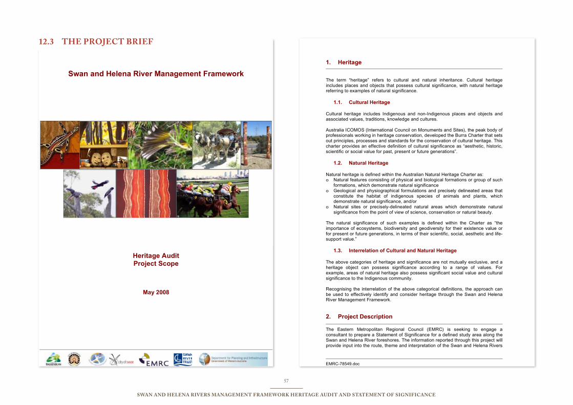
57
Swan and Helena RiveRS ManageMent FRaMewoRk HeRitage audit and StateMent oF SigniFicance
Swan and Helena River Management Framework
Heritage Audit Project Scope
May 2008
EMRC-78549.doc
1. Heritage
The term “heritage” refers to cultural and natural inheritance. Cultural heritage includes places and objects that possess cultural significance, with natural heritage referring to examples of natural significance.
1.1. Cultural Heritage
Cultural heritage includes Indigenous and non-Indigenous places and objects and associated values, traditions, knowledge and cultures. Australia ICOMOS (International Council on Monuments and Sites), the peak body of professionals working in heritage conservation, developed the Burra Charter that sets out principles, processes and standards for the conservation of cultural heritage. This charter provides an effective definition of cultural significance as “aesthetic, historic, scientific or social value for past, present or future generations”.
1.2. Natural Heritage
Natural heritage is defined within the Australian Natural Heritage Charter as: o Natural features consisting of physical and biological formations or group of such
formations, which demonstrate natural significance o Geological and physiographical formulations and precisely delineated areas that
constitute the habitat of indigenous species of animals and plants, which demonstrate natural significance, and/or
o Natural sites or precisely-delineated natural areas which demonstrate natural significance from the point of view of science, conservation or natural beauty.
The natural significance of such examples is defined within the Charter as “the importance of ecosystems, biodiversity and geodiversity for their existence value or for present or future generations, in terms of their scientific, social, aesthetic and life-support value.”
1.3. Interrelation of Cultural and Natural Heritage
The above categories of heritage and significance are not mutually exclusive, and a heritage object can possess significance according to a range of values. For example, areas of natural heritage also possess significant social value and cultural significance to the Indigenous community. Recognising the interrelation of the above categorical definitions, the approach can be used to effectively identify and consider heritage through the Swan and Helena River Management Framework.
2. Project Description
The Eastern Metropolitan Regional Council (EMRC) is seeking to engage a consultant to prepare a Statement of Significance for a defined study area along the Swan and Helena River foreshores. The information reported through this project will provide input into the route, theme and interpretation of the Swan and Helena Rivers
tHe PRoject BRieF12.3
58
Swan and Helena RiveRS ManageMent FRaMewoRk HeRitage audit and StateMent oF SigniFicance
EMRC-78549.doc
Regional Recreation Path. Completion of the Swan and Helena Rivers Regional Recreation Path is a key strategy recommended within the Swan and Helena Rivers Management Framework Report (2007) prepared for the EMRC on behalf of its member Councils. A map of the study area is attached for reference (Attachment 1). The project will produce a Statement of Significance incorporating the parameters set out in this project brief, including:
∞ Audit of heritage values within the study area; ∞ Community input through consultation processes conducted in each of the
local government areas (4); ∞ Identification of existing oral histories; and
∞ Identification and mapping of heritage features, values and places to guide future interpretation of the study area, cross referenced to the full report.
It is a strong preference that the mapping is in a digital format (through GPS logging) that can be fully integrated with Council GIS systems. Attachment 2 lists the Member Council’s GIS requirements. Should this present any difficulties, this should be indicated and additional support can be arranged.
3. Project Objectives
Project objectives are to:
1. Identify heritage areas along the foreshore of the Swan and Helena Rivers;
2. Engage with stakeholders to gain appreciation of the significance of heritage areas and values along the foreshore of the Swan and Helena Rivers;
3. Identify links between heritage areas and values to create and theme a regional recreation and heritage trail; and
4. Collate information to inform an interpretation plan for the regional recreation and heritage trail.
4. Project Proposal
Consultants are invited to submit a Project Proposal to EMRC which details the manner in which they intend to deliver the project and demonstrates their ability to meet the project requirements, including reporting. At a minimum, project proposals should demonstrate having researched and understood the brief and include the following:
∞ Activities and the stages involved in meeting the requirements; ∞ Implementation schedule/time line for meeting the requirements; ∞ Performance indicators which accurately measure attainment of the stages; ∞ A progress payment schedule aligned to the proposed stages; ∞ Members of the project team, their role, task and time allocation, skills,
relevant experience and qualifications. ∞ A detailed quotation showing a breakdown of fees and
expenses/disbursements. ∞ A short list of clients (up to 6) for whom their organisation has completed
relevant assignments plus the contact details of two referees. ∞ Resource requirements of EMRC including use of venue, staff support with
mapping fieldwork, consultation costs.
EMRC-78549.doc
5. Partner Projects
There are a number of existing projects and initiatives that identify stakeholders and will yield information relevant to a heritage audit of the Swan and Helena Rivers.
5.1. Social Value
∞ The Swan Catchment Council through the Indigenous Natural Resource Management Advisory Group will continue to document Indigenous sites and stories of the Swan Region through the Indigenous Cultural Heritage Program in 2008-2012.
∞ The Swan Catchment Council Indigenous Natural Resource Management Advisory Group will be developing Indigenous Trails along the Swan River in 2008.
∞ Bassendean Oral History Project (note: obtain more details from Maxine Laurie).
∞ The EMRC Indigenous consultation process at Red Hill Waste Management Facility.
∞ City of Swan Indigenous engagement in Swan Regional Park guided by the Swan Indigenous Reference Group.
∞ EMRC Indigenous engagement in Blackadder Creek catchment project.
5.2. Historical Value
∞ Dr Sue Graham-Taylor, through the inaugural Battye Fellowship, is producing a history of the Swan River, commencing with Perth Waters with potential to include some aspects of Eastern Reaches in near future.
6. Parameters
Time
The project comprises of two stages and will commence in June 2008 and be completed by November 2008. Stage 1 It is envisaged that Stage 1 will involve:
o Initial discussions and a project initiation meeting; o Determining the scope of the project; o Preliminary background desktop research; o Commence identification and mapping of key natural, cultural and
heritage areas in the study area; o Initial consultation with heritage and environmental agencies; o Initial consultation with Indigenous agencies and organisations; and o Preparation of a draft Statement of Significance.
Stage 2 It is envisaged that Stage 2 will involve:
o Engage in community consultation with Indigenous and non-Indigenous stakeholders to gain an appreciation of the significance of heritage areas and values along the foreshore of the Swan and Helena Rivers;
59
Swan and Helena RiveRS ManageMent FRaMewoRk HeRitage audit and StateMent oF SigniFicance
EMRC-78549.doc
o Identify links between heritage areas and values to create and theme a regional recreation path;
o Collate information to inform an interpretation plan for the regional recreation path; and
o Develop mapping of heritage and cultural values within the study area.
Cost
The project budget is up to $70,000 (GST exclusive) inclusive of all costs. The budget allocated to Stage 1 is 30% (2007/2008) and Stage 2 is 70% (2008/09). Payment milestones will be mutually agreed by the Consultant and the EMRC, with no less than 20% due on receipt of the final project outputs. It is recommended that a draft payment schedule be included in the proposal submitted. Quality Standards
∞ Audit will meet standards set out by ICOMOS Burra Charter and the Australian Natural Heritage Charter.
∞ Audit will provide ongoing opportunity for local community input and involvement.
Scope – Stage 1 The project WILL:
∞ Draw on physical, documentary, oral and other evidence to develop a Statement of Significance for cultural and natural heritage of the study area.
∞ The Statement of Significance will include an audit of the aesthetic, historical, social and scientific heritage values of the study area, in specific:
o Aesthetic Values:
Include reference to landscape character, viewscapes and identification of key features that contribute to the landscape character, context and sense of place for the precincts within the study area, including any significant non-conforming features.
o Historical Values:
Document the key historical values of the places within the study area, including indigenous and post-settlement values and places related to people, events, uses and activities. This should draw on documentary records including MHIs, Local, State and National Government records, National Trust records, Library Local Studies history collections, interest groups and other resources.
o Scientific Values:
For the purposes of this study, features of scientific value due to rarity, quality, representativeness or identified conservation significance should be included in the Statement of Significance.
o Social Values;
Monitor existing programs targeting Indigenous engagement.
EMRC-78549.doc
Briefly identify the ‘qualities for which a place has become a focus of spiritual, political, national or other cultural sentiment either to a majority or a minority group’. (Burra Charter).
o Natural Values
Document major habitats and vegetation communities along the foreshores within the study area. This will not require extensive vegetation mapping and can draw upon existing sources and information to provide a context for this component of the Statement of Significance.
∞ Identify existing oral history recordings and/or transcripts relevant to the study area.
∞ Interrogate relevant databases related to Indigenous sites of significance.
∞ Prepare a Statement of Significance for cultural and natural heritage of the study area to guide future interpretation of a regional recreational and heritage trail, specifically:
o Identify key natural and built features, places and viewscapes, on or adjacent to the river, that should be considered in the development of an interpretation plan.
o Identify any social, religious/spiritual or other cultural or heritage-related constraints on works to protect and stabilise the river foreshore or develop a regional recreation and heritage trail through the study area.
o Identify linking themes and relationships between cultural and natural heritage features, places, viewscapes and precincts.
The project will NOT: ∞ Develop an Interpretation Plan or signage Scope – Stage 2
∞ Undertake activities using appropriate consultation protocols to engage the community (both Indigenous and non-Indigenous) in the identification of heritage features, places, viewscapes and precincts and in development of the Statement of Significance.
∞ Develop regional mapping of cultural and natural heritage features, places, viewscapes and precincts to guide development of a regional recreation path.
∞ Identify any significant heritage values or places within the study area at risk of loss or damage.
∞ Develop recommendations to retain and enhance key features identified in the Statement of Significance.
∞ Allocate one day for travel along the study area (possibly by boat) during which a presentation is to be made to the Steering Group.
Comparative Priority
Parameter Comparative Priority
Time Low Cost High Quality Standards Medium Scope High
60
Swan and Helena RiveRS ManageMent FRaMewoRk HeRitage audit and StateMent oF SigniFicance
EMRC-78549.doc
7. Milestones
Milestone Deadline
Stage 1
1. Project brief developed May 2008
2. Consultant engaged June 2008
3. Project initiation June 2008
4. Preliminary research June 2008
5. Commence consultation June 2008
Stage 2
6. Broad community consultation (Indigenous & non-Indigenous)
July/August 2008
7. Identify links between heritage areas August 2008
8. Develop mapping August 2008
9. Draft report received September/October 2008
10. Final report received November 2008
8. Project Outcomes
Statement of Cultural and Natural Heritage Significance The project will result in a Statement of Significance that will recognise the range of heritage values within the study area. The heritage audit undertaken to develop the Statement of Significance will yield information of interest to a range of stakeholders and projects. Guidance for Regional Recreational Path The project will identify key features, places and viewscapes and linking themes between these that can inform the development of an interpretation plan for a regional recreational and heritage trail. The identification of assets and consideration of their significance will also inform the location of the regional recreation path including areas the path can be extended to provide for enhanced interpretation of heritage areas, and those locations where heritage values may present constraints to trail development or other works.
9. Project Reporting and Management
The project will be coordinated in consultation with the Swan River Trust, Town of Bassendean, City of Bayswater, City of Belmont and the City of Swan through the Swan and Helena River Steering Group. A project sub-working party will be formed by representatives nominated by the Swan and Helena River Steering Group to review specific project outcomes to ensure their applicability to local governments and acceptability by statutory authorities. The consultant will be required to attend meetings, report to and act on the advice of members of the sub-working party. The consultant will also be required to share
EMRC-78549.doc
information with the consultant undertaking the Regional Recreation Path consultancy to inform determination of path route envelope/s. EMRC will provide administrative support to the sub-working party and assist the consultants in organisation of community consultation activities. The consultant will be required to:
∞ Attend three meetings with the sub-working group.
∞ Attend one meeting with the Regional Recreation Path Consultant. The project outcomes, particularly the Statement of Significance, should be formatted to enable individual member Councils to easily extract information and supporting documents related to their respective area. The final report should be provided in digital format (MS Word compatible) and in hard copy (5 unbound and 1 unbound).
10. Submission of Proposal Consultants should provide a written proposal which must be received by Friday 6 June 2008 at the EMRC offices located at 226 Great Eastern Highway, Belmont WA 6104. Further information Naomi Rakela – Senior Project Coordinator (Environmental) Direct: (08) 9424 2273 Mobile: 0417 904 300 Email: [email protected]
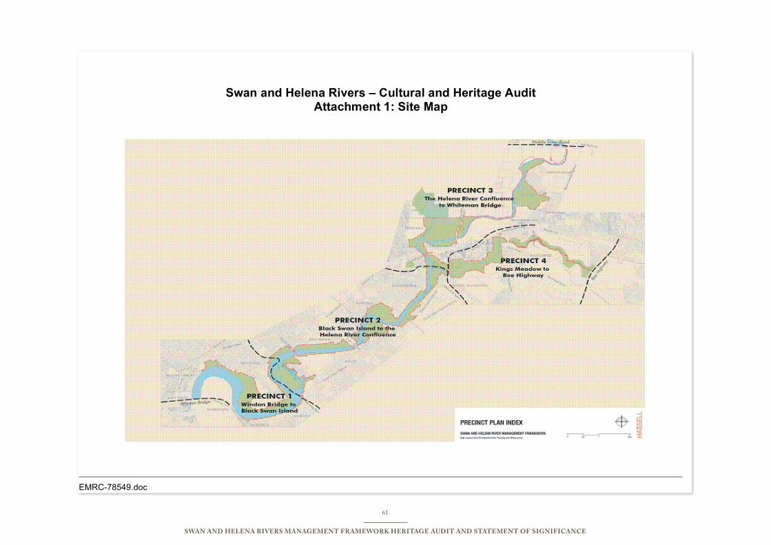
61
Swan and Helena RiveRS ManageMent FRaMewoRk HeRitage audit and StateMent oF SigniFicance
EMRC-78549.doc
Swan and Helena Rivers – Cultural and Heritage Audit Attachment 1: Site Map
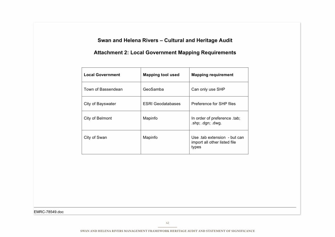
62
Swan and Helena RiveRS ManageMent FRaMewoRk HeRitage audit and StateMent oF SigniFicance
EMRC-78549.doc
Swan and Helena Rivers – Cultural and Heritage Audit
Attachment 2: Local Government Mapping Requirements
Local Government
Mapping tool used
Mapping requirement
Town of Bassendean
GeoSamba
Can only use SHP
City of Bayswater
ESRI Geodatabases
Preference for SHP files
City of Belmont
Mapinfo
In order of preference .tab;
.shp; .dgn; .dwg.
City of Swan
Mapinfo
Use .tab extension - but can
import all other listed file types
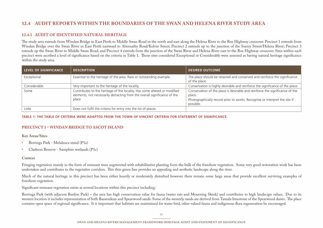
63
Swan and Helena RiveRS ManageMent FRaMewoRk HeRitage audit and StateMent oF SigniFicance
audit RePoRtS witHin tHe BoundaRieS oF tHe Swan and Helena RiveR Study aRea12.4
audit oF identiFied natuRal HeRitage12.4.1
The study area extends from Windan Bridge in East Perth to Middle Swan Road in the north and east along the Helena River to the Roe Highway crossover. Precinct 1 extends from Windan Bridge over the Swan River in East Perth eastward to Abernathy Road/Kelvin Street; Precinct 2 extends up to the junction of the Surrey Street/Helena River; Precinct 3 extends up the Swan River to Middle Swan Road; and Precinct 4 extends from the junction of the Swan River and Helena River east to the Roe Highway crossover. Sites within each precinct were ascribed a level of significance based on the criteria in Table 1. Those sites considered Exceptional or Considerable were assessed as having natural heritage significance within the study area.
LEvEL OF sIgNIFICANCE dEsCRIPTION dEsIREd OuTCOME
exceptional essential to the heritage of the area. Rare or outstanding example. the place should be retained and conserved and reinforce the significance of the place.
Considerable Very important to the heritage of the locality. Conservation is highly desirable and reinforce the significance of the place.
some Contributes to the heritage of the locality. Has some altered or modified elements, not necessarily detracting from the overall significance of the place
Conservation of the place is desirable and reinforce the significance of the place. photographically record prior to works. Recognise or interpret the site if possible.
Little Does not fulfil the criteria for entry into the list of places.
TAbLE 1: ThE TAbLE OF CRITERIA WERE AdAPTEd FROM ThE TOWN OF vINCENT CRITERIA FOR sTATEMENT OF sIgNIFICANCE.
PRecinct 1 – windan BRidge to aScot iSland
key areas/Sites
Berringa Park - Melaleuca stand (P1a)•
Clarkson Reserve - Samphire wetlands (P1c)•
context
Fringing vegetation mainly in the form of remnant trees augmented with rehabilitative planting form the bulk of the foreshore vegetation. Some very good restoration work has been undertaken and contributes to the vegetative corridors. This thin green line provides an appealing and aesthetic landscape along the river.
Much of the natural heritage in this precinct has been either heavily or moderately disturbed however there remain some large areas that provide excellent surviving examples of foreshore vegetation.
Significant remnant vegetation exists at several locations within this precinct including:
Berringa Park (with adjacent Bardon Park) – the area has high conservation value for fauna (water rats and Mourning Skink) and contributes to high landscape values. Due to its western location it includes representation of both Bassendean and Spearwood sands. Some of the westerly sands are derived from Tamala limestone of the Spearwood dunes. The place contains open space of regional significance. It is important that habitats are maintained for water bird, other valued fauna and indigenous flora regeneration be encouraged.
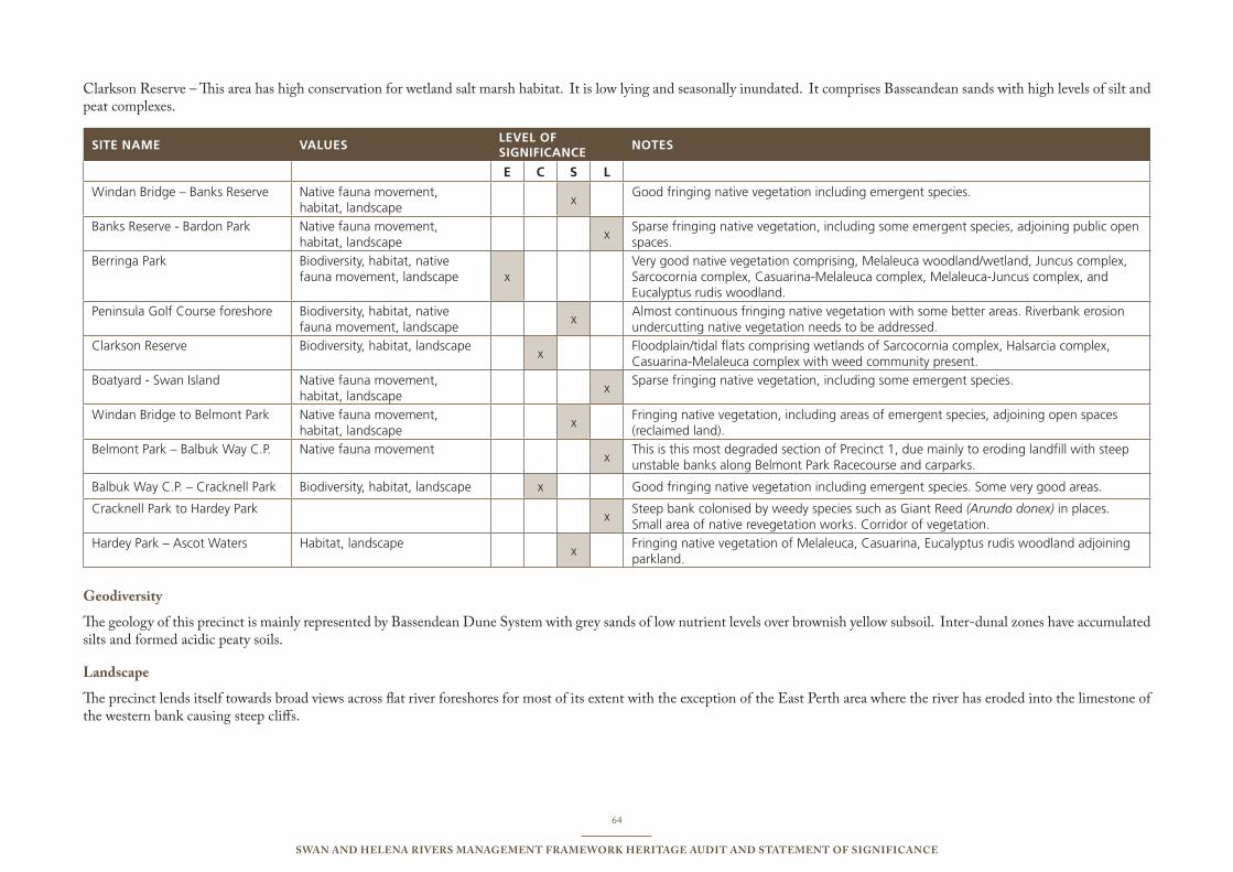
64
Swan and Helena RiveRS ManageMent FRaMewoRk HeRitage audit and StateMent oF SigniFicance
Clarkson Reserve – This area has high conservation for wetland salt marsh habitat. It is low lying and seasonally inundated. It comprises Basseandean sands with high levels of silt and peat complexes.
sITE NAME vALuEsLEvEL OF sIgNIFICANCE
NOTEs
E C S L Windan bridge – banks Reserve native fauna movement,
habitat, landscape x
Good fringing native vegetation including emergent species.
banks Reserve - bardon park native fauna movement, habitat, landscape
xsparse fringing native vegetation, including some emergent species, adjoining public open spaces.
berringa park biodiversity, habitat, native fauna movement, landscape x
Very good native vegetation comprising, Melaleuca woodland/wetland, Juncus complex, sarcocornia complex, Casuarina-Melaleuca complex, Melaleuca-Juncus complex, and eucalyptus rudis woodland.
peninsula Golf Course foreshore biodiversity, habitat, native fauna movement, landscape
x Almost continuous fringing native vegetation with some better areas. Riverbank erosion undercutting native vegetation needs to be addressed.
Clarkson Reserve biodiversity, habitat, landscape x
Floodplain/tidal flats comprising wetlands of sarcocornia complex, Halsarcia complex, Casuarina-Melaleuca complex with weed community present.
boatyard - swan island native fauna movement, habitat, landscape
xsparse fringing native vegetation, including some emergent species.
Windan bridge to belmont park native fauna movement, habitat, landscape
x Fringing native vegetation, including areas of emergent species, adjoining open spaces (reclaimed land).
belmont park – balbuk Way C.p. native fauna movement x
this is this most degraded section of precinct 1, due mainly to eroding landfill with steep unstable banks along belmont park Racecourse and carparks.
balbuk Way C.p. – Cracknell park biodiversity, habitat, landscape x Good fringing native vegetation including emergent species. some very good areas.
Cracknell park to Hardey park x
steep bank colonised by weedy species such as Giant Reed (Arundo donex) in places. small area of native revegetation works. Corridor of vegetation.
Hardey park – Ascot Waters Habitat, landscape x
Fringing native vegetation of Melaleuca, Casuarina, eucalyptus rudis woodland adjoining parkland.
geodiversity
The geology of this precinct is mainly represented by Bassendean Dune System with grey sands of low nutrient levels over brownish yellow subsoil. Inter-dunal zones have accumulated silts and formed acidic peaty soils.
landscape
The precinct lends itself towards broad views across flat river foreshores for most of its extent with the exception of the East Perth area where the river has eroded into the limestone of the western bank causing steep cliffs.
65
Swan and Helena RiveRS ManageMent FRaMewoRk HeRitage audit and StateMent oF SigniFicance
Biodiversity
The precinct has a range of biodiversity extending from well preserved Melaleuca wetlands and samphire flats to open park land. Fringing vegetation exists along the foreshores with exceptions at Belmont and Ascot raceway properties where only sparse vegetation has been retained or replanted.
Habitat
The Melaleuca stands at Berringa Park provide essential habitat for a comprehensive range of fauna including frog species, land and water birds, fish and mammals. The site also provides flora sanctuary from which future migration of plants can be achieved, a seed bank of naturally occurring species that have in many places along the river been replaced with exotic/imported plant species.
The foreshore from Cracknell Park to Hardy Park provides a good example of remnant vegetation of high storey trees with understorey serving as a fauna corridor and a natural buffer between the river and urban development. Areas have been rehabilitated to maintain the landscape impact and these add to the existing corridor effect.
The samphire flats at Clarkson Reserve provide good representation of endemic flora and provide a natural habitat and feeding area for a range of amphibians, waterbirds and other opportunistic fauna.
RecoMMendationS PRecinct 1:
R1.1. Consideration should be given to the creation of formal “A” Class conservation nature reserves to increase the protection of these identified areas;
R1.2. Recreation trails, where considered essential, should be established beyond the fringing vegetation line;
R1.3. Rehabilitation of the foreshore along the Belmont raceway property should be undertaken to reduce and control erosion and create vegetative corridors linking existing vegetation.
R1.4 The dual use access way at Berringa Park should remain as currently located and no additional interpretive trails established within the bushland area to ensure that the conservation values are maintained.
66
Swan and Helena RiveRS ManageMent FRaMewoRk HeRitage audit and StateMent oF SigniFicance
PRecinct 2 – aScot iSland to Helena RiveR junction
key areas:
Black Swan Island (P2a) - fringing vegetation, potential restoration•
Ascot wetlands (P2b) – intact samphire and Melaleuca/Juncus complexes•
Baigup Wetlands (P2c) - fringing vegetation and extensive natural area•
Eric Singleton Bird Sanctuary (P2d) – wetlands and linkages•
Wyatt Road Flats (P2e) – samphire•
Waterview Parade/Garvey Park site (P2f ) – Melaleuca stand•
Ron Courtney island (P2g) – fringing vegetation and Flooded gum stands•
Ashfield Flats (P2h) – expansive site of mixed vegetation and areas for rehabilitation•
Kidman Avenue Flats (P2i) – mosaic of samphire/Melaleuca/Flooded gum•
context
This precinct holds several key areas of natural heritage that contribute to the biodiversity of the foreshore. By providing a range of habitats along the foreshore the sites facilitate fauna community development and movement. There are opportunities for constructive rehabilitation and interpretation.
Each of the identified areas represents a very limited number of bushland areas on the Swan Estuary that is naturally vegetated and having high conservation value in providing habitat for fauna and linkage between other areas of bushland.
Significant remnant vegetation exists at several locations within this precinct including:
Baigup and Ascott Wetlands – while not extensive in area the combined are north and south bank locations of the river downstream from Garrett Road Bridge represent significant habitats of salt marsh, melaleuca and sheoak with landscape features including vegetated wetlands, creek, estuary and vegetated uplands. The area includes Bassendean soils over both Guildford Formation (north) and alluvial colluvial deposits (south). The area is listed in the Directory of Important Wetlands in Australia and is protected under the Commonwealth Environment Protection and Biodiversity Conservation Act (1999). It is important that habitats are maintained for water bird and indigenous flora be encouraged.
Ashfield Flats – represent an extensive area of isolated reserved land containing natural bushland and former cleared rural land situated on Bassendean Sands. It is recorded in the Directory of Important Wetlands in Australia (Swan River). There has been significant disturbance through previous land uses however the place has significance for aquatic habitat (frogs and transient birds) and an isolated refuge for fauna set amongst a fully developed urban environment. The southeastern area has potential for future conservation and interpretation.
Kidman Avenue Flats (Swan River Backwater) – while understorey species have largely been replaced with introduced species the floodplain provides a good habitat and refuge for many species of birds including swamp hen, reed warbler and sacred kingfishers. The area contributes to open space of significance at the confluence of the Helena and Swan Rivers. There is no recorded significant flora at the place.
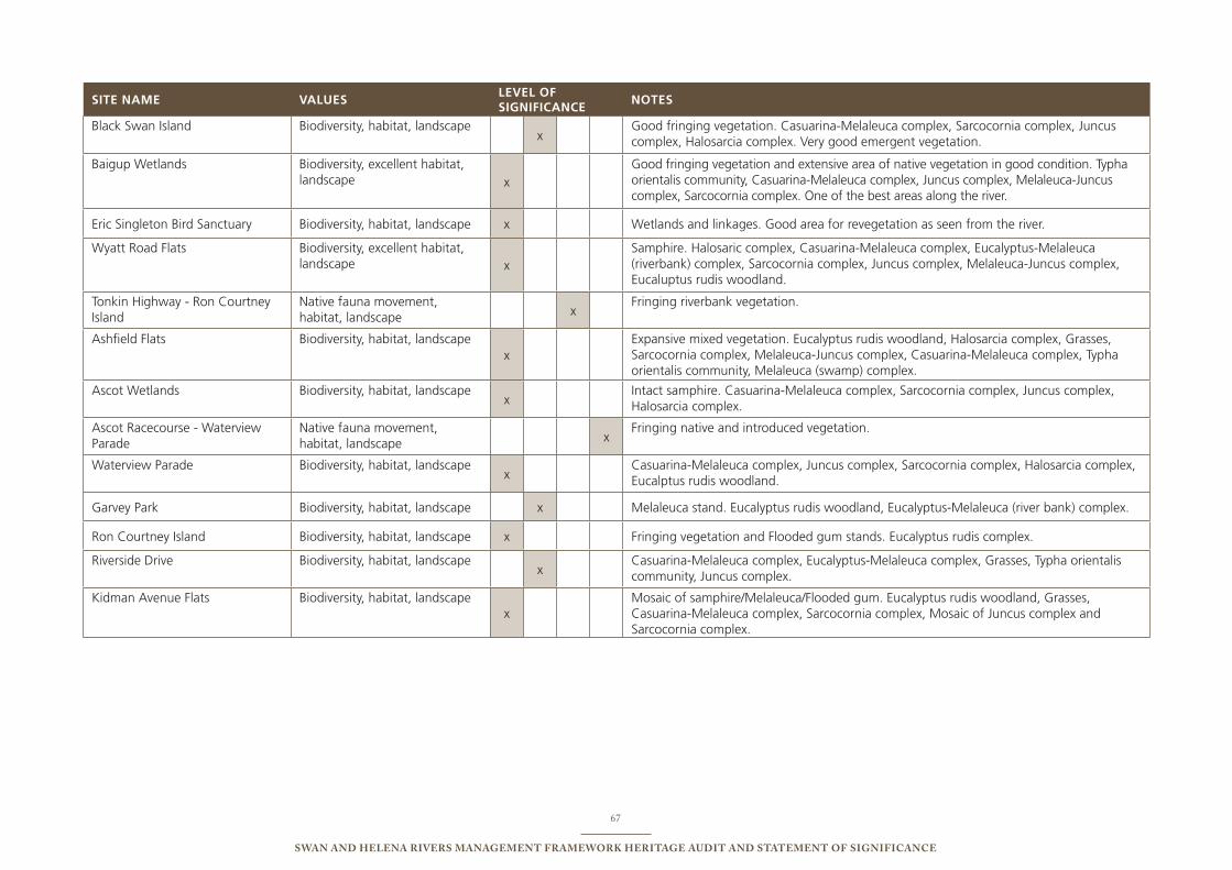
67
Swan and Helena RiveRS ManageMent FRaMewoRk HeRitage audit and StateMent oF SigniFicance
sITE NAME vALuEsLEvEL OF sIgNIFICANCE
NOTEs
black swan island biodiversity, habitat, landscapex
Good fringing vegetation. Casuarina-Melaleuca complex, sarcocornia complex, Juncus complex, Halosarcia complex. Very good emergent vegetation.
baigup Wetlands biodiversity, excellent habitat, landscape x
Good fringing vegetation and extensive area of native vegetation in good condition. typha orientalis community, Casuarina-Melaleuca complex, Juncus complex, Melaleuca-Juncus complex, sarcocornia complex. one of the best areas along the river.
eric singleton bird sanctuary biodiversity, habitat, landscape x Wetlands and linkages. Good area for revegetation as seen from the river.
Wyatt Road Flats biodiversity, excellent habitat, landscape x
samphire. Halosaric complex, Casuarina-Melaleuca complex, eucalyptus-Melaleuca (riverbank) complex, sarcocornia complex, Juncus complex, Melaleuca-Juncus complex, eucaluptus rudis woodland.
tonkin Highway - Ron Courtney island
native fauna movement, habitat, landscape x
Fringing riverbank vegetation.
Ashfield Flats biodiversity, habitat, landscapex
expansive mixed vegetation. eucalyptus rudis woodland, Halosarcia complex, Grasses, sarcocornia complex, Melaleuca-Juncus complex, Casuarina-Melaleuca complex, typha orientalis community, Melaleuca (swamp) complex.
Ascot Wetlands biodiversity, habitat, landscapex
intact samphire. Casuarina-Melaleuca complex, sarcocornia complex, Juncus complex, Halosarcia complex.
Ascot Racecourse - Waterview parade
native fauna movement, habitat, landscape x
Fringing native and introduced vegetation.
Waterview parade biodiversity, habitat, landscapex
Casuarina-Melaleuca complex, Juncus complex, sarcocornia complex, Halosarcia complex, eucalptus rudis woodland.
Garvey park biodiversity, habitat, landscape x Melaleuca stand. eucalyptus rudis woodland, eucalyptus-Melaleuca (river bank) complex.
Ron Courtney island biodiversity, habitat, landscape x Fringing vegetation and Flooded gum stands. eucalyptus rudis complex.
Riverside Drive biodiversity, habitat, landscapex
Casuarina-Melaleuca complex, eucalyptus-Melaleuca complex, Grasses, typha orientalis community, Juncus complex.
Kidman Avenue Flats biodiversity, habitat, landscapex
Mosaic of samphire/Melaleuca/Flooded gum. eucalyptus rudis woodland, Grasses, Casuarina-Melaleuca complex, sarcocornia complex, Mosaic of Juncus complex and sarcocornia complex.
68
Swan and Helena RiveRS ManageMent FRaMewoRk HeRitage audit and StateMent oF SigniFicance
geodiversity
The soil types are generally of Bassendean Sands over the Guildford Formation with pockets of peat, heavy clays and river silt deposits evident in the low lying areas. At Ashfield, the flats consist of dark brown high clay content soil on light brown soil.
landscape
Viewed from the river there are mainly natural and arcadian landscapes. Parklands and recreational landscapes are also distributed along this precinct.
Biodiversity
There is a range of biodiversity extending along this precinct ranging from emergent endemic reeds, samphire flats, Melaleuca and Flooded gum stands. This provides a source for future regeneration of natural areas and the biodiversity of the precinct.
Habitat
This precinct holds a considerable range of habitat along the foreshore and in some areas extending away from the river for some distance. The natural areas provide protective habitat as well as a range of foraging opportunities.
RecoMMendationS PRecinct 2:
R2.1 Active rehabilitation and regeneration of native plant species be encouraged.
R2.2 Protection of bushland from invasion of imported plant species and stock be continued.
R2.3 Encourage regeneration of native species in Kidman Flats Reserve and minimise activities to those compatible with conservation.
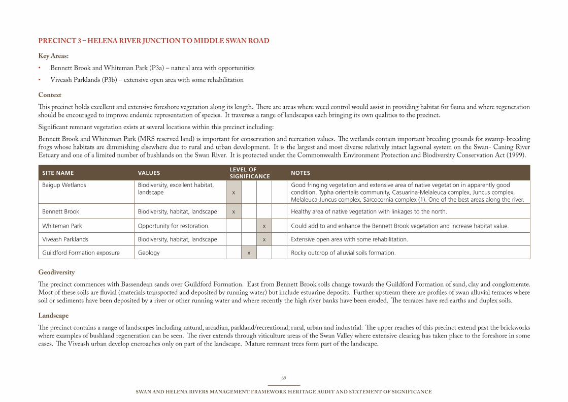
69
Swan and Helena RiveRS ManageMent FRaMewoRk HeRitage audit and StateMent oF SigniFicance
PRecinct 3 – Helena RiveR junction to Middle Swan Road
key areas:
Bennett Brook and Whiteman Park (P3a) – natural area with opportunities•
Viveash Parklands (P3b) – extensive open area with some rehabilitation•
context
This precinct holds excellent and extensive foreshore vegetation along its length. There are areas where weed control would assist in providing habitat for fauna and where regeneration should be encouraged to improve endemic representation of species. It traverses a range of landscapes each bringing its own qualities to the precinct.
Significant remnant vegetation exists at several locations within this precinct including:
Bennett Brook and Whiteman Park (MRS reserved land) is important for conservation and recreation values. The wetlands contain important breeding grounds for swamp-breeding frogs whose habitats are diminishing elsewhere due to rural and urban development. It is the largest and most diverse relatively intact lagoonal system on the Swan- Caning River Estuary and one of a limited number of bushlands on the Swan River. It is protected under the Commonwealth Environment Protection and Biodiversity Conservation Act (1999).
sITE NAME vALuEsLEvEL OF sIgNIFICANCE
NOTEs
baigup Wetlands biodiversity, excellent habitat, landscape x
Good fringing vegetation and extensive area of native vegetation in apparently good condition. typha orientalis community, Casuarina-Melaleuca complex, Juncus complex, Melaleuca-Juncus complex, sarcocornia complex (1). one of the best areas along the river.
bennett brook biodiversity, habitat, landscape x Healthy area of native vegetation with linkages to the north.
Whiteman park opportunity for restoration. x Could add to and enhance the bennett brook vegetation and increase habitat value.
Viveash parklands biodiversity, habitat, landscape x extensive open area with some rehabilitation.
Guildford Formation exposure Geology x Rocky outcrop of alluvial soils formation.
geodiversity
The precinct commences with Bassendean sands over Guildford Formation. East from Bennett Brook soils change towards the Guildford Formation of sand, clay and conglomerate. Most of these soils are fluvial (materials transported and deposited by running water) but include estuarine deposits. Further upstream there are profiles of swan alluvial terraces where soil or sediments have been deposited by a river or other running water and where recently the high river banks have been eroded. The terraces have red earths and duplex soils.
landscape
The precinct contains a range of landscapes including natural, arcadian, parkland/recreational, rural, urban and industrial. The upper reaches of this precinct extend past the brickworks where examples of bushland regeneration can be seen. The river extends through viticulture areas of the Swan Valley where extensive clearing has taken place to the foreshore in some cases. The Viveash urban develop encroaches only on part of the landscape. Mature remnant trees form part of the landscape.

70
Swan and Helena RiveRS ManageMent FRaMewoRk HeRitage audit and StateMent oF SigniFicance
Biodiversity
The remnant vegetation, principally Flooded gum, along the extent of the foreshore vegetation is in relatively good condition. It was noted that from Bennett Brook upstream there appeared to be older remnant vegetation along the foreshore. There appears to be little regeneration of native plant species. Bennett Brook and its immediate surrounds contain excellent fringing vegetation leading back into Melaleuca stands. There are extensive cleared areas alongside the river that form part of Whiteman Park. The understorey vegetation has been cleared below the few remnant stands of Flooded gum remaining on the properties and pastures have been established.
Habitat
The fringing vegetation provides a corridor of habitat along this component of the study. Several nesting Cormorants with offspring in the nests as well as ducks with broods of ducklings were observed. The foreshore reeds, where present, provide habitat for water birds, frogs and turtles.
The extension of Whiteman Park and the connection along Bennett Brook provide an additional land corridor that is complementary to that provided by the Swan River.
RecoMMendationS: PRecinct 3
R3.1 Active rehabilitation and regeneration of native plant species be encouraged
R3.2 Protection of bushland from invasion of imported plant species and stock be continued
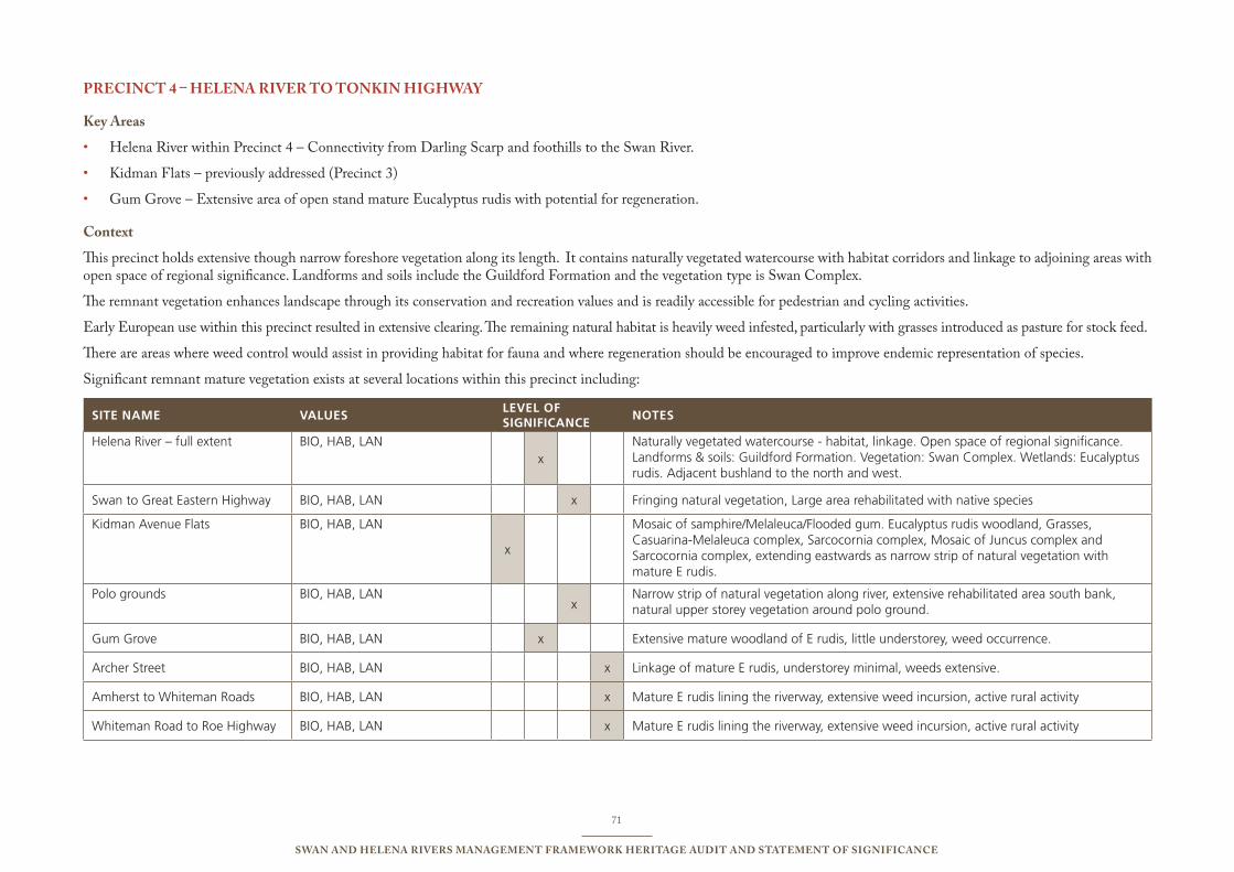
71
Swan and Helena RiveRS ManageMent FRaMewoRk HeRitage audit and StateMent oF SigniFicance
PRecinct 4 – Helena RiveR to tonkin HigHway
key areas
Helena River within Precinct 4 – Connectivity from Darling Scarp and foothills to the Swan River.•
Kidman Flats – previously addressed (Precinct 3)•
Gum Grove – Extensive area of open stand mature Eucalyptus rudis with potential for regeneration.•
context
This precinct holds extensive though narrow foreshore vegetation along its length. It contains naturally vegetated watercourse with habitat corridors and linkage to adjoining areas with open space of regional significance. Landforms and soils include the Guildford Formation and the vegetation type is Swan Complex.
The remnant vegetation enhances landscape through its conservation and recreation values and is readily accessible for pedestrian and cycling activities.
Early European use within this precinct resulted in extensive clearing. The remaining natural habitat is heavily weed infested, particularly with grasses introduced as pasture for stock feed.
There are areas where weed control would assist in providing habitat for fauna and where regeneration should be encouraged to improve endemic representation of species.
Significant remnant mature vegetation exists at several locations within this precinct including:
sITE NAME vALuEsLEvEL OF sIgNIFICANCE
NOTEs
Helena River – full extent bio, HAb, LAnx
naturally vegetated watercourse - habitat, linkage. open space of regional significance. Landforms & soils: Guildford Formation. Vegetation: swan Complex. Wetlands: eucalyptus rudis. Adjacent bushland to the north and west.
swan to Great eastern Highway bio, HAb, LAn x Fringing natural vegetation, Large area rehabilitated with native species
Kidman Avenue Flats bio, HAb, LAn
x
Mosaic of samphire/Melaleuca/Flooded gum. eucalyptus rudis woodland, Grasses, Casuarina-Melaleuca complex, sarcocornia complex, Mosaic of Juncus complex and sarcocornia complex, extending eastwards as narrow strip of natural vegetation with mature e rudis.
polo grounds bio, HAb, LAnx
narrow strip of natural vegetation along river, extensive rehabilitated area south bank, natural upper storey vegetation around polo ground.
Gum Grove bio, HAb, LAn x extensive mature woodland of e rudis, little understorey, weed occurrence.
Archer street bio, HAb, LAn x Linkage of mature e rudis, understorey minimal, weeds extensive.
Amherst to Whiteman Roads bio, HAb, LAn x Mature e rudis lining the riverway, extensive weed incursion, active rural activity
Whiteman Road to Roe Highway bio, HAb, LAn x Mature e rudis lining the riverway, extensive weed incursion, active rural activity
72
Swan and Helena RiveRS ManageMent FRaMewoRk HeRitage audit and StateMent oF SigniFicance
geodiversity
This precinct lies beyond, westward, of the Darling Scarp/Range and the Foothills complexes. It is largely comprised of the Pinjarra Plains Guildford Formation, which consists mainly of alluvial clays.
The precinct has previously and variously been mined for clay, loam and sand.
landscape
The precinct contains a range of landscapes including natural, arcadian, parkland/recreational, rural, urban and industrial. The precinct has excellent landscape values, predominantly as a result of the meandering of the river and the remnant mature vegetation of E rudis.
Biodiversity
The remnant vegetation, principally E rudis, along the extent of the foreshore vegetation is in relatively good condition. There are examples where community groups and government agencies have carried out regeneration and rehabilitation within the precinct. There are extensive cleared areas alongside the river that impact on the reserved areas through invasion by uncontrolled weed species prevalent on those properties including castor, fig and pasture grasses. The understorey vegetation has been cleared below the few remnant stands of E rudis remaining on the properties and pastures established. Grazing continues to impact on regeneration of native species.
There are occurrences of Melaleuca raphiophylla and Corymbia calophylla (red gum) towards the eastern end of the precinct. Both are represented in the reserved areas.
Habitat
The mature E rudis and fringing vegetation provides a corridor of habitat along the length of this precinct linking the Darling Scarp and the Foothills to the Swan River.
The remnant vegetation along the river corridor provides habitat for migratory fauna and extends into adjoining vegetated areas in the area.
RecoMMendationS PRecinct 4:
4.1. Continue active pursuit of land to add to the corridor
4.2. Actively manage the reserved land to encourage regeneration of natural species.
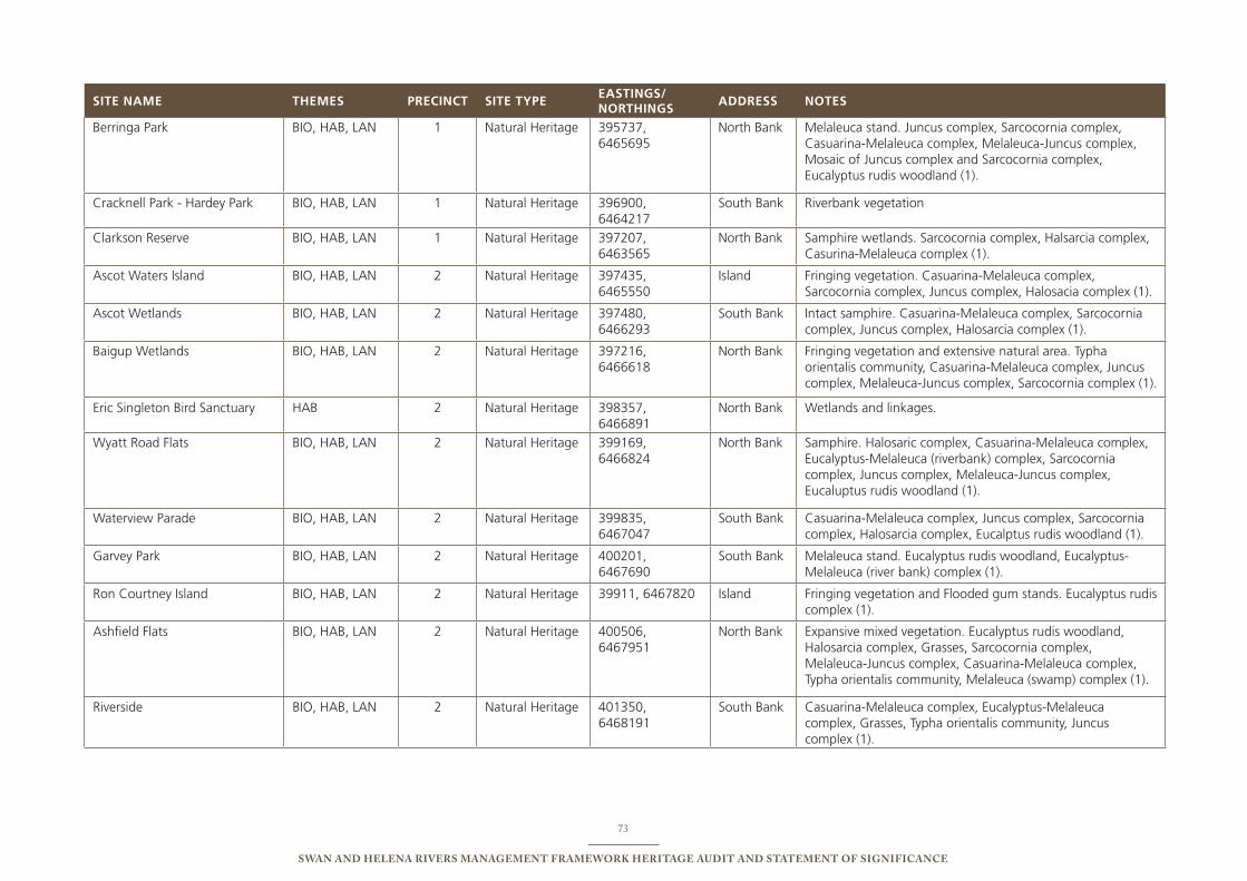
73
Swan and Helena RiveRS ManageMent FRaMewoRk HeRitage audit and StateMent oF SigniFicance
sITE NAME ThEMEs PRECINCT sITE TyPEEAsTINgs/ NORThINgs
AddREss NOTEs
berringa park bio, HAb, LAn 1 natural Heritage 395737, 6465695
north bank Melaleuca stand. Juncus complex, sarcocornia complex, Casuarina-Melaleuca complex, Melaleuca-Juncus complex, Mosaic of Juncus complex and sarcocornia complex, eucalyptus rudis woodland (1).
Cracknell park - Hardey park bio, HAb, LAn 1 natural Heritage 396900, 6464217
south bank Riverbank vegetation
Clarkson Reserve bio, HAb, LAn 1 natural Heritage 397207, 6463565
north bank samphire wetlands. sarcocornia complex, Halsarcia complex, Casurina-Melaleuca complex (1).
Ascot Waters island bio, HAb, LAn 2 natural Heritage 397435, 6465550
island Fringing vegetation. Casuarina-Melaleuca complex, sarcocornia complex, Juncus complex, Halosacia complex (1).
Ascot Wetlands bio, HAb, LAn 2 natural Heritage 397480, 6466293
south bank intact samphire. Casuarina-Melaleuca complex, sarcocornia complex, Juncus complex, Halosarcia complex (1).
baigup Wetlands bio, HAb, LAn 2 natural Heritage 397216, 6466618
north bank Fringing vegetation and extensive natural area. typha orientalis community, Casuarina-Melaleuca complex, Juncus complex, Melaleuca-Juncus complex, sarcocornia complex (1).
eric singleton bird sanctuary HAb 2 natural Heritage 398357, 6466891
north bank Wetlands and linkages.
Wyatt Road Flats bio, HAb, LAn 2 natural Heritage 399169, 6466824
north bank samphire. Halosaric complex, Casuarina-Melaleuca complex, eucalyptus-Melaleuca (riverbank) complex, sarcocornia complex, Juncus complex, Melaleuca-Juncus complex, eucaluptus rudis woodland (1).
Waterview parade bio, HAb, LAn 2 natural Heritage 399835, 6467047
south bank Casuarina-Melaleuca complex, Juncus complex, sarcocornia complex, Halosarcia complex, eucalptus rudis woodland (1).
Garvey park bio, HAb, LAn 2 natural Heritage 400201, 6467690
south bank Melaleuca stand. eucalyptus rudis woodland, eucalyptus-Melaleuca (river bank) complex (1).
Ron Courtney island bio, HAb, LAn 2 natural Heritage 39911, 6467820 island Fringing vegetation and Flooded gum stands. eucalyptus rudis complex (1).
Ashfield Flats bio, HAb, LAn 2 natural Heritage 400506, 6467951
north bank expansive mixed vegetation. eucalyptus rudis woodland, Halosarcia complex, Grasses, sarcocornia complex, Melaleuca-Juncus complex, Casuarina-Melaleuca complex, typha orientalis community, Melaleuca (swamp) complex (1).
Riverside bio, HAb, LAn 2 natural Heritage 401350, 6468191
south bank Casuarina-Melaleuca complex, eucalyptus-Melaleuca complex, Grasses, typha orientalis community, Juncus complex (1).
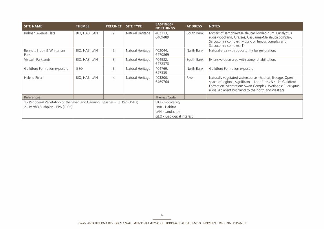
74
Swan and Helena RiveRS ManageMent FRaMewoRk HeRitage audit and StateMent oF SigniFicance
sITE NAME ThEMEs PRECINCT sITE TyPEEAsTINgs/ NORThINgs
AddREss NOTEs
Kidman Avenue Flats bio, HAb, LAn 2 natural Heritage 402113, 6469489
south bank Mosaic of samphire/Melaleuca/Flooded gum. eucalyptus rudis woodland, Grasses, Casuarina-Melaleuca complex, sarcocornia complex, Mosaic of Juncus complex and sarcocornia complex (1).
bennett brook & Whiteman park
bio, HAb, LAn 3 natural Heritage 402044, 6470869
north bank natural area with opportunity for restoration.
Viveash parklands bio, HAb, LAn 3 natural Heritage 404932, 6472378
south bank extensive open area with some rehabilitation.
Guildford Formation exposure Geo 3 natural Heritage 404769, 6473351
north bank Guildford Formation exposure
Helena River bio, HAb, LAn 4 natural Heritage 403200, 6469764
River naturally vegetated watercourse - habitat, linkage. open space of regional significance. Landforms & soils: Guildford Formation. Vegetation: swan Complex. Wetlands: eucalyptus rudis. Adjacent bushland to the north and west (2).
References themes Code
1 - peripheral Vegetation of the swan and Canning estuaries - L.J. pen (1981)2 - perth’s bushplan - epA (1998)
bio - biodiversityHAb - HabitatLAn - LandscapeGeo - Geological interest

75
Swan and Helena RiveRS ManageMent FRaMewoRk HeRitage audit and StateMent oF SigniFicance
audit oF identiFied aBoRiginal HeRitage SiteS12.4.2
dia audit of aboriginal Heritage Sites within the four precincts of the eMRc project
This audit was determined by examination of the Aboriginal Sites Register. The Register was established as a requirement of the Aboriginal Heritage Act 1972 and is currently maintained by the Department of Indigenous Affairs. Although the Register is the most comprehensive repository of indigenous sites in Western Australia, its integrity is dependant upon the good will of Aboriginal informants and accuracy Aboriginal site recorders. This Register cannot be regarded as a complete database of indigenous sites in Western Australia.
Blue text indicates a site which is shared by more than one precinct
Status
i – interim. These places have not yet been assessed by the Aboriginal Cultural Material Committee.
S – Stored data. These places have been assessed as “not a site” under ss.5&39(2) of the Aboriginal Heritage Act 1972 by the Aboriginal Cultural Material Committee.
P – Permanent. These places have been assessed as “a site” under ss.5&39(2) of the Aboriginal Heritage Act 1972, by the Aboriginal Cultural Material Committee.
access
c – Indicates that access to a site is restricted due to the culturally sensitive nature of the place. Any site information, including the site location, must be obtained through direct contact with the relevant Aboriginal people.
o – Indicates that information regarding the site, including its location, is unrestricted.
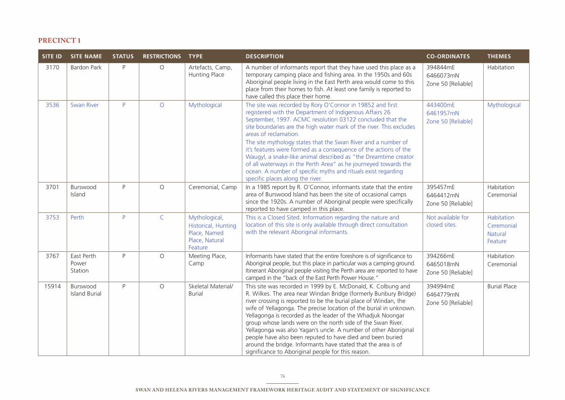
76
Swan and Helena RiveRS ManageMent FRaMewoRk HeRitage audit and StateMent oF SigniFicance
PRecinct 1
sITE Id sITE NAME sTATus REsTRICTIONs TyPE dEsCRIPTION CO-ORdINATEs ThEMEs
3170 bardon park p o Artefacts, Camp, Hunting place
A number of informants report that they have used this place as a temporary camping place and fishing area. in the 1950s and 60s Aboriginal people living in the east perth area would come to this place from their homes to fish. At least one family is reported to have called this place their home.
394844me 6466073mn Zone 50 [Reliable]
Habitation
3536 swan River p o Mythological the site was recorded by Rory o’Connor in 19852 and first registered with the Department of indigenous Affairs 26 september, 1997. ACMC resolution 03122 concluded that the site boundaries are the high water mark of the river. this excludes areas of reclamation.the site mythology states that the swan River and a number of it’s features were formed as a consequence of the actions of the Waugyl, a snake-like animal described as “the Dreamtime creator of all waterways in the perth Area” as he journeyed towards the ocean. A number of specific myths and rituals exist regarding specific places along the river.
443400me 6461957mn Zone 50 [Reliable]
Mythological
3701 burswood island
p o Ceremonial, Camp in a 1985 report by R. o’Connor, informants state that the entire area of burswood island has been the site of occasional camps since the 1920s. A number of Aboriginal people were specifically reported to have camped in this place.
395457me 6464412mn Zone 50 [Reliable]
HabitationCeremonial
3753 perth p C Mythological, Historical, Hunting place, named place, natural Feature
this is a Closed sited. information regarding the nature and location of this site is only available through direct consultation with the relevant Aboriginal informants.
not available for closed sites.
HabitationCeremonialnatural Feature
3767 east perth power station
p o Meeting place, Camp
informants have stated that the entire foreshore is of significance to Aboriginal people, but this place in particular was a camping ground. itinerant Aboriginal people visiting the perth area are reported to have camped in the “back of the east perth power House.”
394266me 6465018mn Zone 50 [Reliable]
HabitationCeremonial
15914 burswood island burial
p o skeletal Material/burial
this site was recorded in 1999 by e. McDonald, K. Colbung and R. Wilkes. the area near Windan bridge (formerly bunbury bridge) river crossing is reported to be the burial place of Windan, the wife of Yellagonga. the precise location of the burial in unknown. Yellagonga is recorded as the leader of the Whadjuk noongar group whose lands were on the north side of the swan River. Yellagonga was also Yagan’s uncle. A number of other Aboriginal people have also been reputed to have died and been buried around the bridge. informants have stated that the area is of significance to Aboriginal people for this reason.
394994me 6464779mn Zone 50 [Reliable]
burial place
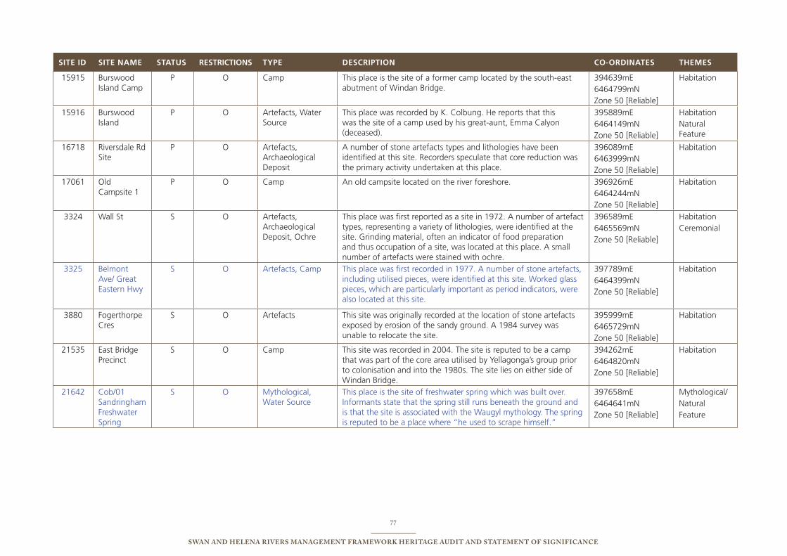
77
Swan and Helena RiveRS ManageMent FRaMewoRk HeRitage audit and StateMent oF SigniFicance
sITE Id sITE NAME sTATus REsTRICTIONs TyPE dEsCRIPTION CO-ORdINATEs ThEMEs
15915 burswood island Camp
p o Camp this place is the site of a former camp located by the south-east abutment of Windan bridge.
394639me 6464799mn Zone 50 [Reliable]
Habitation
15916 burswood island
p o Artefacts, Water source
this place was recorded by K. Colbung. He reports that this was the site of a camp used by his great-aunt, emma Calyon (deceased).
395889me 6464149mn Zone 50 [Reliable]
Habitationnatural Feature
16718 Riversdale Rd site
p o Artefacts, Archaeological Deposit
A number of stone artefacts types and lithologies have been identified at this site. Recorders speculate that core reduction was the primary activity undertaken at this place.
396089me 6463999mn Zone 50 [Reliable]
Habitation
17061 old Campsite 1
p o Camp An old campsite located on the river foreshore. 396926me 6464244mn Zone 50 [Reliable]
Habitation
3324 Wall st s o Artefacts, Archaeological Deposit, ochre
this place was first reported as a site in 1972. A number of artefact types, representing a variety of lithologies, were identified at the site. Grinding material, often an indicator of food preparation and thus occupation of a site, was located at this place. A small number of artefacts were stained with ochre.
396589me 6465569mn Zone 50 [Reliable]
HabitationCeremonial
3325 belmont Ave/ Great eastern Hwy
s o Artefacts, Camp this place was first recorded in 1977. A number of stone artefacts, including utilised pieces, were identified at this site. Worked glass pieces, which are particularly important as period indicators, were also located at this site.
397789me 6464399mn Zone 50 [Reliable]
Habitation
3880 Fogerthorpe Cres
s o Artefacts this site was originally recorded at the location of stone artefacts exposed by erosion of the sandy ground. A 1984 survey was unable to relocate the site.
395999me 6465729mn Zone 50 [Reliable]
Habitation
21535 east bridge precinct
s o Camp this site was recorded in 2004. the site is reputed to be a camp that was part of the core area utilised by Yellagonga’s group prior to colonisation and into the 1980s. the site lies on either side of Windan bridge.
394262me 6464820mn Zone 50 [Reliable]
Habitation
21642 Cob/01 sandringham Freshwater spring
s o Mythological, Water source
this place is the site of freshwater spring which was built over. informants state that the spring still runs beneath the ground and is that the site is associated with the Waugyl mythology. the spring is reputed to be a place where “he used to scrape himself.”
397658me 6464641mn Zone 50 [Reliable]
Mythological/ naturalFeature
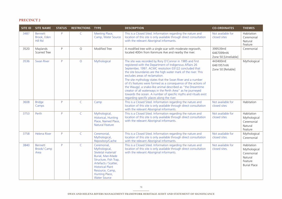
78
Swan and Helena RiveRS ManageMent FRaMewoRk HeRitage audit and StateMent oF SigniFicance
PRecinct 2
sITE Id sITE NAME sTATus REsTRICTIONs TyPE dEsCRIPTION CO-ORdINATEs ThEMEs
3487 bennett brook, eden Hill Rd
p C Meeting place, Camp, Water source
this is a Closed sited. information regarding the nature and location of this site is only available through direct consultation with the relevant Aboriginal informants.
not available for closed sites
HabitationCeremonialnatural Feature
3520 Maylands scarred tree
p o Modified tree A modified tree with a single scar with moderate regrowth, located 400m from Kenmure Ave and nearby the river.
399539me 6467099mn Zone 50 [unreliable]
Ceremonial
3536 swan River p o Mythological the site was recorded by Rory o’Connor in 1985 and first registered with the Department of indigenous Affairs 26 september, 1997. ACMC resolution 03122 concluded that the site boundaries are the high water mark of the river. this excludes areas of reclamation.the site mythology states that the swan River and a number of it’s features were formed as a consequence of the actions of the Waugyl, a snake-like animal described as “the Dreamtime creator of all waterways in the perth Area” as he journeyed towards the ocean. A number of specific myths and rituals exist regarding specific places along the river.
443400me 6461957mn Zone 50 [Reliable]
Mythological
3608 bridge Camps
p C Camp this is a Closed sited. information regarding the nature and location of this site is only available through direct consultation with the relevant Aboriginal informants.
not available for closed sites
Habitation
3753 perth p C Mythological, Historical, Hunting place, named place, natural Feature
this is a Closed sited. information regarding the nature and location of this site is only available through direct consultation with the relevant Aboriginal informants.
not available for closed sites
HabitationMythologicalCeremonialnatural Feature
3758 Helena River p C Ceremonial, Mythological, Repository/Cache
this is a Closed sited. information regarding the nature and location of this site is only available through direct consultation with the relevant Aboriginal informants.
not available for closed sites.
MythologicalCeremonial
3840 bennett brook/ Camp Area
p C Ceremonial, Mythological, skeletal material/burial, Man-Made structure, Fish trap, Artefacts / scatter, Historical plant Resource, Camp, Hunting place, Water source
this is a Closed sited. information regarding the nature and location of this site is only available through direct consultation with the relevant Aboriginal informants.
not available for closed sites.
HabitationMythologicalCeremonialnatural Featureburial place
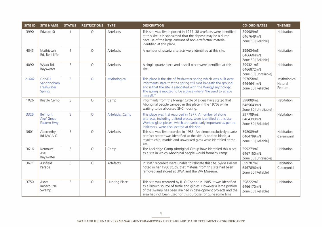
79
Swan and Helena RiveRS ManageMent FRaMewoRk HeRitage audit and StateMent oF SigniFicance
sITE Id sITE NAME sTATus REsTRICTIONs TyPE dEsCRIPTION CO-ORdINATEs ThEMEs
3990 edward st i o Artefacts this site was first reported in 1975. 38 artefacts were identified at this site. it is speculated that the deposit may be a dump because of the large amount of non-artefactual material identified at this place.
399989me 6467649mn Zone 50 [Reliable]
Habitation
4043 Mathieson Rd, Redcliffe
s o Artefacts A number of quartz artefacts were identified at this site. 399634me 6466604mn Zone 50 [Reliable]
Habitation
4090 Wyatt Rd, bayswater
s o Artefacts A single quartz piece and a shell piece were identified at this site.
399321me 6466872mn Zone 50 [unreliable]
Habitation
21642 Cob/01 sandringham Freshwater spring
s o Mythological this place is the site of freshwater spring which was built over. informants state that the spring still runs beneath the ground and is that the site is associated with the Waugyl mythology. the spring is reputed to be a place where “he used to scrape himself.”
397658me 6464641mn Zone 50 [Reliable]
Mythologicalnatural Feature
1026 bristile Camp s o Camp informants from the nyngar Circle of elders have stated that Aboriginal people camped in this place in the 1970s while waiting to be allocated sHC housing.
398089me 6465649mn Zone 50 [unreliable]
Habitation
3325 belmont Ave/ Great eastern Hwy
s o Artefacts, Camp this place was first recorded in 1977. A number of stone artefacts, including utilised pieces, were identified at this site. Worked glass pieces, which are particularly important as period indicators, were also located at this site.
397789me 6464399mn Zone 50 [Reliable]
Habitation
3601 Abernethy Rd nW A-C
s o Artefacts this site was first recorded in 1983. An almost exclusively quartz artefact scatter was identified at the site. A backed blade, a myolite chip, marble and unworked glass were identified at the site.
398089me 6464799mn Zone 50 [Reliable]
HabitationCeremonial
3616 Kenmure Ave, bayswater
s o Camp the Lockridge Camp Aboriginal Group have identified this place as a site in which Aboriginal people would formerly camp.
399279me 6467150mn Zone 50 [unreliable]
Habitation
3671 Ashfield parade
s o Artefacts in 1987 recorders were unable to relocate this site. sylvia Hallam noted in her 1986 study, that material from this site had been removed and stored at uWA and the WA Museum.
399787me 6467896mn Zone 50 [Reliable]
HabitationCeremonial
3750 Ascot Racecourse swamp
s o Hunting place this site was recorded by R. o’Connor in 1985. it was identified as a known source of turtle and gilgies. However a large portion of the swamp has been drained in development projects and the area had not been used for this purpose for quite some time.
398222me 6466170mn Zone 50 [Reliable]
Habitation
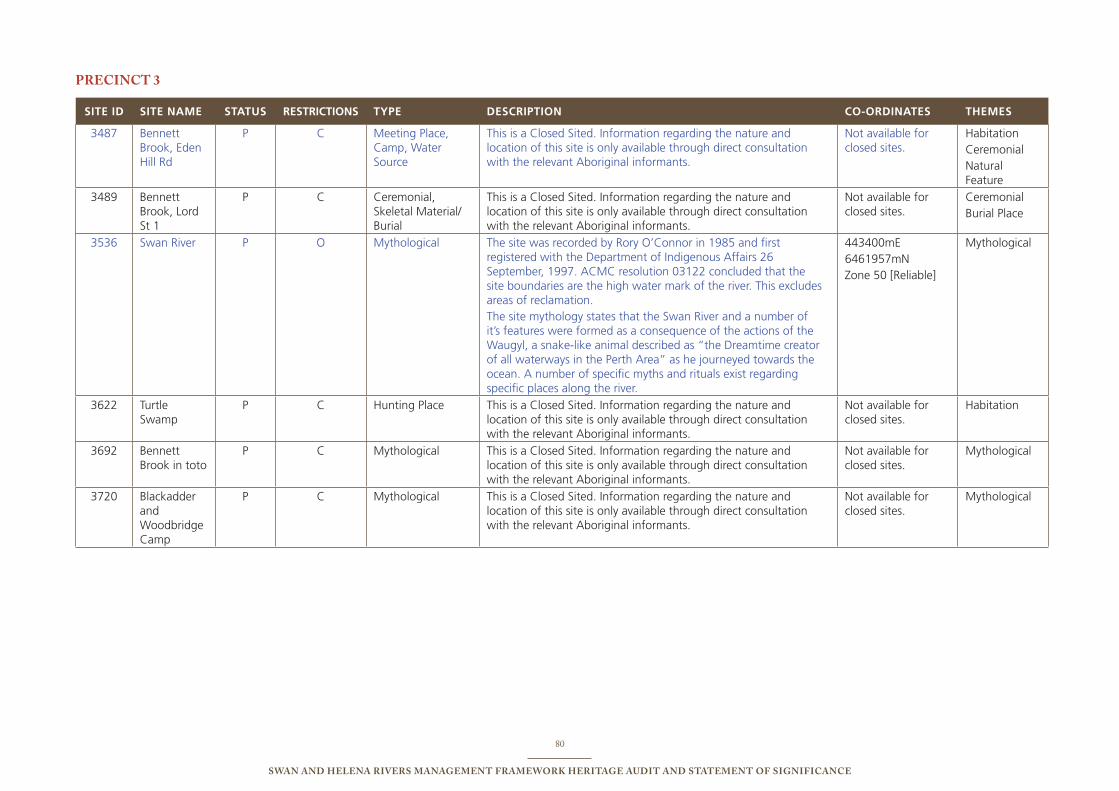
80
Swan and Helena RiveRS ManageMent FRaMewoRk HeRitage audit and StateMent oF SigniFicance
PRecinct 3
sITE Id sITE NAME sTATus REsTRICTIONs TyPE dEsCRIPTION CO-ORdINATEs ThEMEs
3487 bennett brook, eden Hill Rd
p C Meeting place, Camp, Water source
this is a Closed sited. information regarding the nature and location of this site is only available through direct consultation with the relevant Aboriginal informants.
not available for closed sites.
HabitationCeremonialnatural Feature
3489 bennett brook, Lord st 1
p C Ceremonial, skeletal Material/burial
this is a Closed sited. information regarding the nature and location of this site is only available through direct consultation with the relevant Aboriginal informants.
not available for closed sites.
Ceremonialburial place
3536 swan River p o Mythological the site was recorded by Rory o’Connor in 1985 and first registered with the Department of indigenous Affairs 26 september, 1997. ACMC resolution 03122 concluded that the site boundaries are the high water mark of the river. this excludes areas of reclamation.the site mythology states that the swan River and a number of it’s features were formed as a consequence of the actions of the Waugyl, a snake-like animal described as “the Dreamtime creator of all waterways in the perth Area” as he journeyed towards the ocean. A number of specific myths and rituals exist regarding specific places along the river.
443400me 6461957mn Zone 50 [Reliable]
Mythological
3622 turtle swamp
p C Hunting place this is a Closed sited. information regarding the nature and location of this site is only available through direct consultation with the relevant Aboriginal informants.
not available for closed sites.
Habitation
3692 bennett brook in toto
p C Mythological this is a Closed sited. information regarding the nature and location of this site is only available through direct consultation with the relevant Aboriginal informants.
not available for closed sites.
Mythological
3720 blackadder and Woodbridge Camp
p C Mythological this is a Closed sited. information regarding the nature and location of this site is only available through direct consultation with the relevant Aboriginal informants.
not available for closed sites.
Mythological
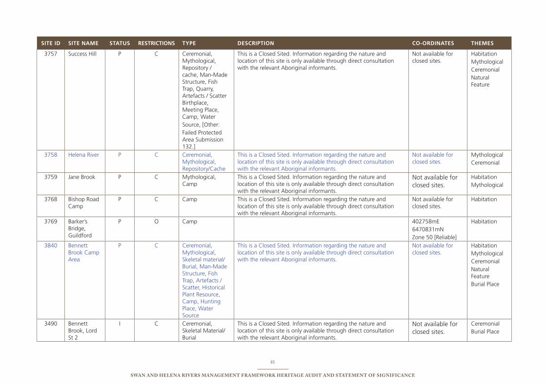
81
Swan and Helena RiveRS ManageMent FRaMewoRk HeRitage audit and StateMent oF SigniFicance
sITE Id sITE NAME sTATus REsTRICTIONs TyPE dEsCRIPTION CO-ORdINATEs ThEMEs
3757 success Hill p C Ceremonial, Mythological, Repository / cache, Man-Made structure, Fish trap, Quarry, Artefacts / scatter birthplace, Meeting place, Camp, Water source, [other: Failed protected Area submission 132.]
this is a Closed sited. information regarding the nature and location of this site is only available through direct consultation with the relevant Aboriginal informants.
not available for closed sites.
HabitationMythologicalCeremonialnatural Feature
3758 Helena River p C Ceremonial, Mythological, Repository/Cache
this is a Closed sited. information regarding the nature and location of this site is only available through direct consultation with the relevant Aboriginal informants.
not available for closed sites.
MythologicalCeremonial
3759 Jane brook p C Mythological, Camp
this is a Closed sited. information regarding the nature and location of this site is only available through direct consultation with the relevant Aboriginal informants.
not available for closed sites.
HabitationMythological
3768 bishop Road Camp
p C Camp this is a Closed sited. information regarding the nature and location of this site is only available through direct consultation with the relevant Aboriginal informants.
not available for closed sites.
Habitation
3769 barker’s bridge, Guildford
p o Camp 402758me 6470831mn Zone 50 [Reliable]
Habitation
3840 bennett brook Camp Area
p C Ceremonial, Mythological, skeletal material/burial, Man-Made structure, Fish trap, Artefacts / scatter, Historical plant Resource, Camp, Hunting place, Water source
this is a Closed sited. information regarding the nature and location of this site is only available through direct consultation with the relevant Aboriginal informants.
not available for closed sites.
HabitationMythologicalCeremonialnatural Featureburial place
3490 bennett brook, Lord st 2
i C Ceremonial, skeletal Material/burial
this is a Closed sited. information regarding the nature and location of this site is only available through direct consultation with the relevant Aboriginal informants.
not available for closed sites.
Ceremonialburial place
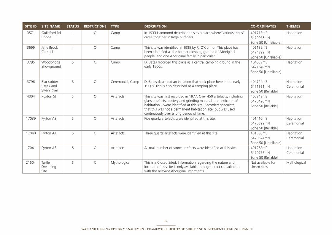
82
Swan and Helena RiveRS ManageMent FRaMewoRk HeRitage audit and StateMent oF SigniFicance
sITE Id sITE NAME sTATus REsTRICTIONs TyPE dEsCRIPTION CO-ORdINATEs ThEMEs
3571 Guildford Rd bridge
i o Camp in 1933 Hammond described this as a place where”various tribes” came together in large numbers.
401713me 6470068mn Zone 50 [unreliable]
Habitation
3699 Jane brook Camp 1
i o Camp this site was identified in 1985 by R. o’Connor. this place has been identified as the former camping ground of Aboriginal people, and one Aboriginal family in particular.
406139me 6474899mn Zone 50 [unreliable]
Habitation
3795 Woodbridge showground
s o Camp D. bates recorded this place as a central camping ground in the early 1900s.
404639me 6471649mn Zone 50 [unreliable]
Habitation
3796 blackadder Creek and swan River
s o Ceremonial, Camp D. bates described an initiation that took place here in the early 1900s. this is also described as a camping place.
404724me 6471991mn Zone 50 [Reliable]
HabitationCeremonial
4004 Roxton st s o Artefacts this site was first recorded in 1977. over 450 artefacts, including glass artefacts, pottery and grinding material – an indicator of habitation – were identified at this site. Recorders speculate that this was not a permanent habitation site, but was used continuously over a long period of time.
405348me 6473426mn Zone 50 [Reliable]
Habitation
17039 pyrton A3 s o Artefacts Five quartz artefacts were identified at this site. 401410me 6470899mn Zone 50 [Reliable]
HabitationCeremonial
17040 pyrton A4 s o Artefacts three quartz artefacts were identified at this site. 401390me 6470874mn Zone 50 [unreliable]
HabitationCeremonial
17041 pyrton A5 s o Artefacts A small number of stone artefacts were identified at this site. 401268me 6470775mn Zone 50 [Reliable]
HabitationCeremonial
21504 turtle Dreaming site
s C Mythological this is a Closed sited. information regarding the nature and location of this site is only available through direct consultation with the relevant Aboriginal informants.
not available for closed sites.
Mythological
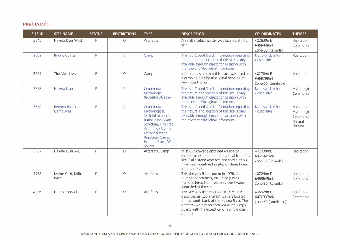
83
Swan and Helena RiveRS ManageMent FRaMewoRk HeRitage audit and StateMent oF SigniFicance
PRecinct 4
sITE Id sITE NAME sTATus REsTRICTIONs TyPE dEsCRIPTION CO-ORdINATEs ThEMEs
3545 Helena River West p o Artefacts A small artefact scatter was located at this site.
402839me 6469449mn Zone 50 [Reliable]
HabitationCeremonial
3608 bridge Camps p C Camp this is a Closed sited. information regarding the nature and location of this site is only available through direct consultation with the relevant Aboriginal informants.
not available for closed sites.
Habitation
3609 the Meadows p o Camp informants state that this place was used as a camping area by Aboriginal people until very recent times.
402789me 6469799mn Zone 50 [unreliable]
Habitation
3758 Helena River p C Ceremonial, Mythologial, Repository/Cache
this is a Closed sited. information regarding the nature and location of this site is only available through direct consultation with the relevant Aboriginal informants.
not available for closed sites.
MythologicalCeremonial
3840 bennett brook Camp Area
p C Ceremonial, Mythological, skeletal material/burial, Man-Made structure, Fish trap, Artefacts / scatter, Historical plant Resource, Camp, Hunting place, Water source
this is a Closed sited. information regarding the nature and location of this site is only available through direct consultation with the relevant Aboriginal informants.
not available for closed sites.
HabitationMythologicalCeremonialnatural Feature
3967 Helena River A-C p o Artefacts, Camp in 1983 schwede obtained an age of 29,000 years for stratified material from this site. Flake stone artefacts and formal tools have been identified in sites of these types in these areas.
407339me 6469449mn Zone 50 [Reliable]
Habitation
3968 Melon Glch, Milit. base
p o Artefacts this site was fist recorded in 1978. A number of artefacts, including pieces manufactured from fossilised chert were identified at the site.
407240me 6469649mn Zone 50 [Reliable]
HabitationCeremonial
4006 Hump paddock p o Artefacts this site was first recorded in 1979. it is described as two artefact scatters located on the south bank of the Helena River. the artefacts were manufactured using lumpy quartz with the exception of a single glass artefact.
405929me 6470337mn Zone 50 [unreliable]
HabitationCeremonial

84
Swan and Helena RiveRS ManageMent FRaMewoRk HeRitage audit and StateMent oF SigniFicance
sITE Id sITE NAME sTATus REsTRICTIONs TyPE dEsCRIPTION CO-ORdINATEs ThEMEs
4009 Railway Dump p o Artefacts this site was first identified in 1979. Artefacts identified at the site were manufactured using lumpy quartz and brown beer bottle bases.
406117me 6470444mn Zone 50 [Reliable]
HabitationCeremonial
4010 Metro Meats p o Artefacts this site was first recorded in 1979. Quartz backed blades, glass scrapers and adzes were identified at the site.
406259me 6470309mn Zone 50 [Reliable] HabitationCeremonial
HabitationCeremonial
3964 power Lagoon i o Artefacts this site was first identified in 1979. A number of artefacts, including glass pieces were identified at the site.
406739me 6469549mn Zone 50 [Reliable]
HabitationCeremonial
4012 trough and Dead sheep paddock
i o Artefacts this site was first recorded in 1979. All artefacts identified at this site, except a single quartz piece, were manufactured using glass.
406551me 6469871mn Zone 50 [Reliable]
HabitationCeremonial
20810 Woodbridge primary school/ isolated Finds
i o isolated Artefacts A small number of isolated artefacts were identified at this place. these include an artefact which might have been a manuport – used for tool manufacture, or a muller – used for grinding.
405130me 6470951mn Zone 50 [Reliable]
Habitation
3518 Dinner Camp s o Camp this site was identified by informants as a dinner camp used by Aboriginal people for cooking and eating tripe they obtained from the nearby abattoir. the camp was reportedly used until the 1950s and pre-dates the Abattoir Camp site.
406639me 6469649mn Zone 50 [unreliable]
Habitation
3770 Abattoirs Camp s o Camp this place was identified in 1989 as a camping place used until the early 1980s. All core members of the family group which used this place were said to be deceased or moved from the area at the time of the survey.
406989me 6469549mn Zone 50 [Reliable]
Habitation
4007 Helena spring West
s o Artefacts this site was first recorded in 1979. Glass artefacts were identified at the site.
406906me 6469549mn Zone 50 [unreliable]
Habitation
21241 isolated Finds s o isolated Finds A number of glass artefact, including cores (evidence of tool manufacture), were identified at this site.
406030me 6470491mn Zone 50 [Reliable]
Habitation
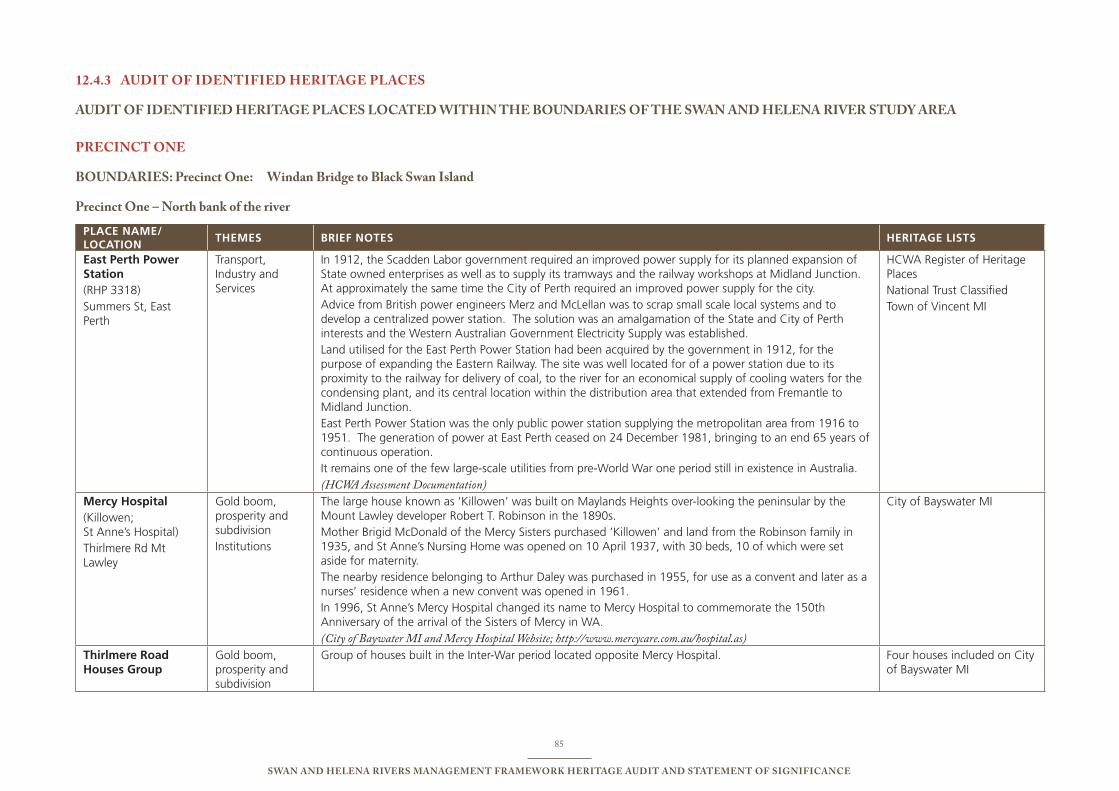
85
Swan and Helena RiveRS ManageMent FRaMewoRk HeRitage audit and StateMent oF SigniFicance
audit oF identiFied HeRitage PlaceS12.4.3
audit oF identiFied HeRitage PlaceS located witHin tHe BoundaRieS oF tHe Swan and Helena RiveR Study aRea
PRecinct one
BoundaRieS: Precinct one: windan Bridge to Black Swan island
Precinct one – north bank of the river
PLACE NAME/ LOCATION
ThEMEs bRIEF NOTEs hERITAgE LIsTs
East Perth Power Station (RHp 3318)summers st, east perth
transport, industry and services
in 1912, the scadden Labor government required an improved power supply for its planned expansion of state owned enterprises as well as to supply its tramways and the railway workshops at Midland Junction. At approximately the same time the City of perth required an improved power supply for the city. Advice from british power engineers Merz and McLellan was to scrap small scale local systems and to develop a centralized power station. the solution was an amalgamation of the state and City of perth interests and the Western Australian Government electricity supply was established. Land utilised for the east perth power station had been acquired by the government in 1912, for the purpose of expanding the eastern Railway. the site was well located for of a power station due to its proximity to the railway for delivery of coal, to the river for an economical supply of cooling waters for the condensing plant, and its central location within the distribution area that extended from Fremantle to Midland Junction. east perth power station was the only public power station supplying the metropolitan area from 1916 to 1951. the generation of power at east perth ceased on 24 December 1981, bringing to an end 65 years of continuous operation. it remains one of the few large-scale utilities from pre-World War one period still in existence in Australia.(HCWA Assessment Documentation)
HCWA Register of Heritage places national trust Classifiedtown of Vincent Mi
Mercy hospital(Killowen; st Anne’s Hospital)thirlmere Rd Mt Lawley
Gold boom, prosperity and subdivision institutions
the large house known as ‘Killowen’ was built on Maylands Heights over-looking the peninsular by the Mount Lawley developer Robert t. Robinson in the 1890s.Mother brigid McDonald of the Mercy sisters purchased ‘Killowen’ and land from the Robinson family in 1935, and st Anne’s nursing Home was opened on 10 April 1937, with 30 beds, 10 of which were set aside for maternity. the nearby residence belonging to Arthur Daley was purchased in 1955, for use as a convent and later as a nurses’ residence when a new convent was opened in 1961. in 1996, st Anne’s Mercy Hospital changed its name to Mercy Hospital to commemorate the 150th Anniversary of the arrival of the sisters of Mercy in WA. (City of Baywater MI and Mercy Hospital Website; http://www.mercycare.com.au/hospital.as)
City of bayswater Mi
Thirlmere Road houses group
Gold boom, prosperity and subdivision
Group of houses built in the inter-War period located opposite Mercy Hospital. Four houses included on City of bayswater Mi
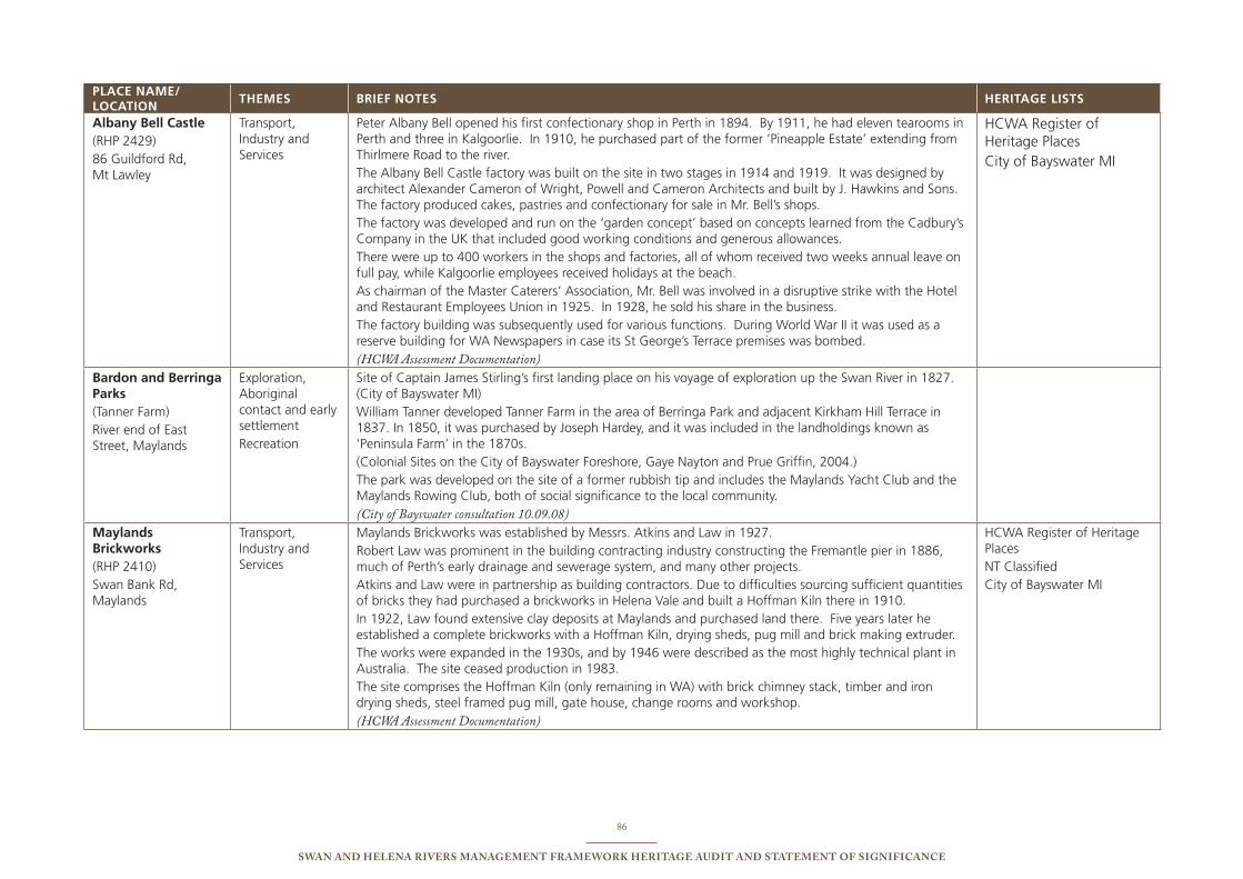
86
Swan and Helena RiveRS ManageMent FRaMewoRk HeRitage audit and StateMent oF SigniFicance
PLACE NAME/ LOCATION
ThEMEs bRIEF NOTEs hERITAgE LIsTs
Albany bell Castle (RHp 2429)86 Guildford Rd, Mt Lawley
transport, industry and services
peter Albany bell opened his first confectionary shop in perth in 1894. by 1911, he had eleven tearooms in perth and three in Kalgoorlie. in 1910, he purchased part of the former ‘pineapple estate’ extending from thirlmere Road to the river.the Albany bell Castle factory was built on the site in two stages in 1914 and 1919. it was designed by architect Alexander Cameron of Wright, powell and Cameron Architects and built by J. Hawkins and sons. the factory produced cakes, pastries and confectionary for sale in Mr. bell’s shops.the factory was developed and run on the ‘garden concept’ based on concepts learned from the Cadbury’s Company in the uK that included good working conditions and generous allowances. there were up to 400 workers in the shops and factories, all of whom received two weeks annual leave on full pay, while Kalgoorlie employees received holidays at the beach.As chairman of the Master Caterers’ Association, Mr. bell was involved in a disruptive strike with the Hotel and Restaurant employees union in 1925. in 1928, he sold his share in the business. the factory building was subsequently used for various functions. During World War ii it was used as a reserve building for WA newspapers in case its st George’s terrace premises was bombed. (HCWA Assessment Documentation)
HCWA Register of Heritage placesCity of bayswater Mi
bardon and berringa Parks(tanner Farm)River end of east street, Maylands
exploration, Aboriginal contact and early settlementRecreation
site of Captain James stirling’s first landing place on his voyage of exploration up the swan River in 1827. (City of bayswater Mi)William tanner developed tanner Farm in the area of berringa park and adjacent Kirkham Hill terrace in 1837. in 1850, it was purchased by Joseph Hardey, and it was included in the landholdings known as ‘peninsula Farm’ in the 1870s. (Colonial sites on the City of bayswater Foreshore, Gaye nayton and prue Griffin, 2004.)the park was developed on the site of a former rubbish tip and includes the Maylands Yacht Club and the Maylands Rowing Club, both of social significance to the local community. (City of Bayswater consultation 10.09.08)
Maylands brickworks(RHp 2410)swan bank Rd, Maylands
transport, industry and services
Maylands brickworks was established by Messrs. Atkins and Law in 1927. Robert Law was prominent in the building contracting industry constructing the Fremantle pier in 1886, much of perth’s early drainage and sewerage system, and many other projects. Atkins and Law were in partnership as building contractors. Due to difficulties sourcing sufficient quantities of bricks they had purchased a brickworks in Helena Vale and built a Hoffman Kiln there in 1910. in 1922, Law found extensive clay deposits at Maylands and purchased land there. Five years later he established a complete brickworks with a Hoffman Kiln, drying sheds, pug mill and brick making extruder. the works were expanded in the 1930s, and by 1946 were described as the most highly technical plant in Australia. the site ceased production in 1983. the site comprises the Hoffman Kiln (only remaining in WA) with brick chimney stack, timber and iron drying sheds, steel framed pug mill, gate house, change rooms and workshop. (HCWA Assessment Documentation)
HCWA Register of Heritage places nt ClassifiedCity of bayswater Mi
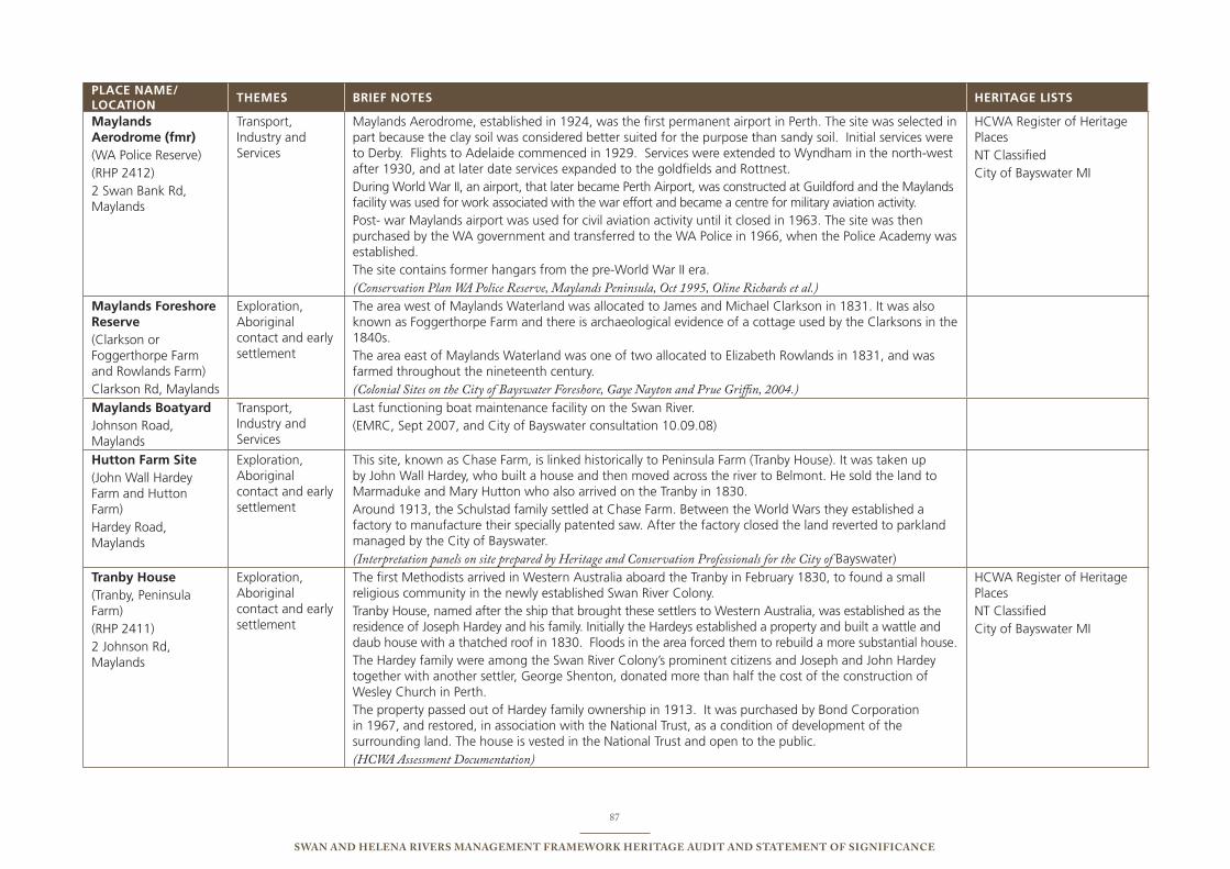
87
Swan and Helena RiveRS ManageMent FRaMewoRk HeRitage audit and StateMent oF SigniFicance
PLACE NAME/ LOCATION
ThEMEs bRIEF NOTEs hERITAgE LIsTs
Maylands Aerodrome (fmr)(WA police Reserve)(RHp 2412)2 swan bank Rd, Maylands
transport, industry and services
Maylands Aerodrome, established in 1924, was the first permanent airport in perth. the site was selected in part because the clay soil was considered better suited for the purpose than sandy soil. initial services were to Derby. Flights to Adelaide commenced in 1929. services were extended to Wyndham in the north-west after 1930, and at later date services expanded to the goldfields and Rottnest. During World War ii, an airport, that later became perth Airport, was constructed at Guildford and the Maylands facility was used for work associated with the war effort and became a centre for military aviation activity. post- war Maylands airport was used for civil aviation activity until it closed in 1963. the site was then purchased by the WA government and transferred to the WA police in 1966, when the police Academy was established.the site contains former hangars from the pre-World War ii era. (Conservation Plan WA Police Reserve, Maylands Peninsula, Oct 1995, Oline Richards et al.)
HCWA Register of Heritage places nt ClassifiedCity of bayswater Mi
Maylands Foreshore Reserve (Clarkson or Foggerthorpe Farm and Rowlands Farm)Clarkson Rd, Maylands
exploration, Aboriginal contact and early settlement
the area west of Maylands Waterland was allocated to James and Michael Clarkson in 1831. it was also known as Foggerthorpe Farm and there is archaeological evidence of a cottage used by the Clarksons in the 1840s. the area east of Maylands Waterland was one of two allocated to elizabeth Rowlands in 1831, and was farmed throughout the nineteenth century. (Colonial Sites on the City of Bayswater Foreshore, Gaye Nayton and Prue Griffin, 2004.)
Maylands boatyardJohnson Road, Maylands
transport, industry and services
Last functioning boat maintenance facility on the swan River. (eMRC, sept 2007, and City of bayswater consultation 10.09.08)
hutton Farm site (John Wall Hardey Farm and Hutton Farm) Hardey Road, Maylands
exploration, Aboriginal contact and early settlement
this site, known as Chase Farm, is linked historically to peninsula Farm (tranby House). it was taken up by John Wall Hardey, who built a house and then moved across the river to belmont. He sold the land to Marmaduke and Mary Hutton who also arrived on the tranby in 1830. Around 1913, the schulstad family settled at Chase Farm. between the World Wars they established a factory to manufacture their specially patented saw. After the factory closed the land reverted to parkland managed by the City of bayswater. (Interpretation panels on site prepared by Heritage and Conservation Professionals for the City of bayswater)
Tranby house(tranby, peninsula Farm)(RHp 2411)2 Johnson Rd, Maylands
exploration, Aboriginal contact and early settlement
the first Methodists arrived in Western Australia aboard the tranby in February 1830, to found a small religious community in the newly established swan River Colony.tranby House, named after the ship that brought these settlers to Western Australia, was established as the residence of Joseph Hardey and his family. initially the Hardeys established a property and built a wattle and daub house with a thatched roof in 1830. Floods in the area forced them to rebuild a more substantial house. the Hardey family were among the swan River Colony’s prominent citizens and Joseph and John Hardey together with another settler, George shenton, donated more than half the cost of the construction of Wesley Church in perth. the property passed out of Hardey family ownership in 1913. it was purchased by bond Corporation in 1967, and restored, in association with the national trust, as a condition of development of the surrounding land. the house is vested in the national trust and open to the public. (HCWA Assessment Documentation)
HCWA Register of Heritage places nt ClassifiedCity of bayswater Mi
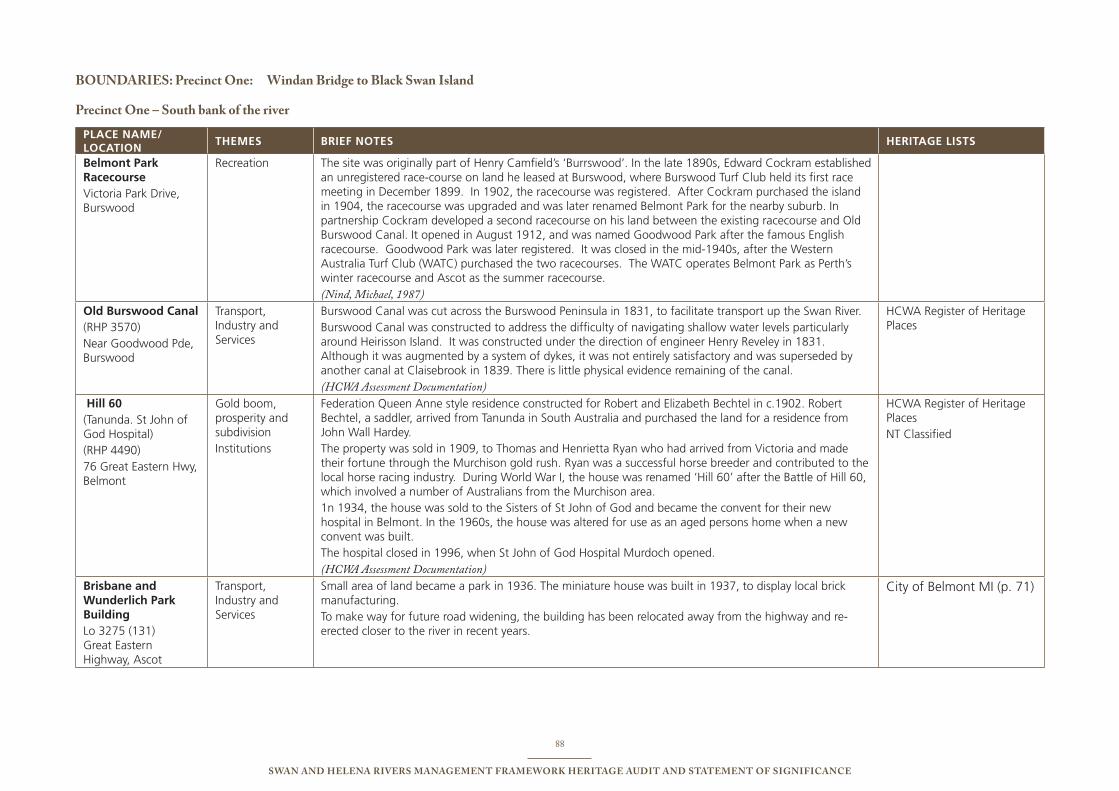
88
Swan and Helena RiveRS ManageMent FRaMewoRk HeRitage audit and StateMent oF SigniFicance
BoundaRieS: Precinct one: windan Bridge to Black Swan island
Precinct one – South bank of the river
PLACE NAME/ LOCATION
ThEMEs bRIEF NOTEs hERITAgE LIsTs
belmont Park RacecourseVictoria park Drive, burswood
Recreation the site was originally part of Henry Camfield’s ‘burrswood’. in the late 1890s, edward Cockram established an unregistered race-course on land he leased at burswood, where burswood turf Club held its first race meeting in December 1899. in 1902, the racecourse was registered. After Cockram purchased the island in 1904, the racecourse was upgraded and was later renamed belmont park for the nearby suburb. in partnership Cockram developed a second racecourse on his land between the existing racecourse and old burswood Canal. it opened in August 1912, and was named Goodwood park after the famous english racecourse. Goodwood park was later registered. it was closed in the mid-1940s, after the Western Australia turf Club (WAtC) purchased the two racecourses. the WAtC operates belmont park as perth’s winter racecourse and Ascot as the summer racecourse. (Nind, Michael, 1987)
Old burswood Canal(RHp 3570)near Goodwood pde, burswood
transport, industry and services
burswood Canal was cut across the burswood peninsula in 1831, to facilitate transport up the swan River.burswood Canal was constructed to address the difficulty of navigating shallow water levels particularly around Heirisson island. it was constructed under the direction of engineer Henry Reveley in 1831. Although it was augmented by a system of dykes, it was not entirely satisfactory and was superseded by another canal at Claisebrook in 1839. there is little physical evidence remaining of the canal. (HCWA Assessment Documentation)
HCWA Register of Heritage places
hill 60(tanunda. st John of God Hospital)(RHp 4490)76 Great eastern Hwy, belmont
Gold boom, prosperity and subdivisioninstitutions
Federation Queen Anne style residence constructed for Robert and elizabeth bechtel in c.1902. Robert bechtel, a saddler, arrived from tanunda in south Australia and purchased the land for a residence from John Wall Hardey. the property was sold in 1909, to thomas and Henrietta Ryan who had arrived from Victoria and made their fortune through the Murchison gold rush. Ryan was a successful horse breeder and contributed to the local horse racing industry. During World War i, the house was renamed ‘Hill 60’ after the battle of Hill 60, which involved a number of Australians from the Murchison area.1n 1934, the house was sold to the sisters of st John of God and became the convent for their new hospital in belmont. in the 1960s, the house was altered for use as an aged persons home when a new convent was built. the hospital closed in 1996, when st John of God Hospital Murdoch opened. (HCWA Assessment Documentation)
HCWA Register of Heritage places nt Classified
brisbane and Wunderlich Park buildingLo 3275 (131) Great eastern Highway, Ascot
transport, industry and services
small area of land became a park in 1936. the miniature house was built in 1937, to display local brick manufacturing. to make way for future road widening, the building has been relocated away from the highway and re-erected closer to the river in recent years.
City of belmont Mi (p. 71)
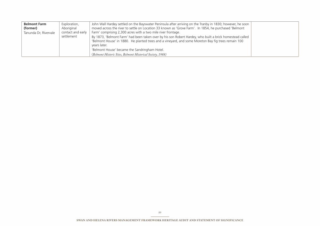
89
Swan and Helena RiveRS ManageMent FRaMewoRk HeRitage audit and StateMent oF SigniFicance
belmont Farm (former) tanunda Dr, Rivervale
exploration, Aboriginal contact and early settlement
John Wall Hardey settled on the bayswater peninsula after arriving on the tranby in 1830; however, he soon moved across the river to settle on Location 33 known as ‘Grove Farm’. in 1854, he purchased ‘belmont Farm’ comprising 2,300 acres with a two mile river frontage. by 1873, ‘belmont Farm’ had been taken over by his son Robert Hardey, who built a brick homestead called ‘belmont House’ in 1880. He planted trees and a vineyard, and some Moreton bay fig trees remain 100 years later. ‘belmont House’ became the sandringham Hotel. (Belmont Historic Sites, Belmont Historical Society, 1988)
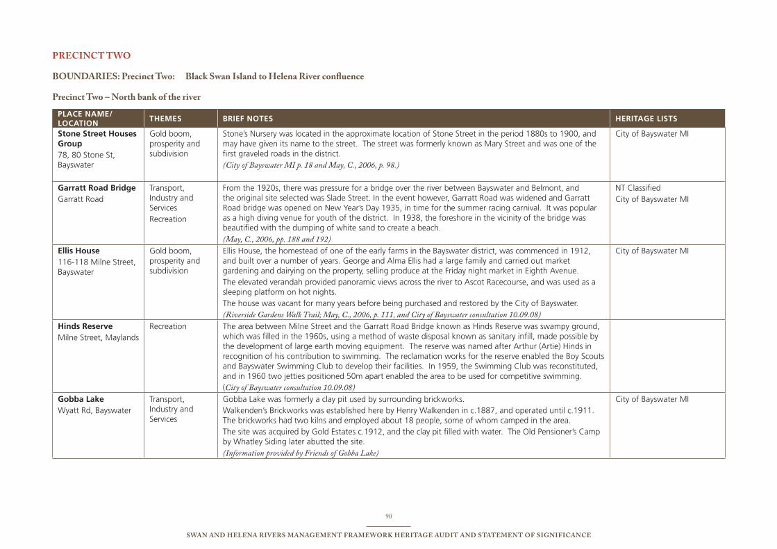
90
Swan and Helena RiveRS ManageMent FRaMewoRk HeRitage audit and StateMent oF SigniFicance
PRecinct two
BoundaRieS: Precinct two: Black Swan island to Helena River confluence
Precinct two – north bank of the river
PLACE NAME/ LOCATION
ThEMEs bRIEF NOTEs hERITAgE LIsTs
stone street houses group 78, 80 stone st, bayswater
Gold boom, prosperity and subdivision
stone’s nursery was located in the approximate location of stone street in the period 1880s to 1900, and may have given its name to the street. the street was formerly known as Mary street and was one of the first graveled roads in the district. (City of Bayswater MI p. 18 and May, C., 2006, p. 98.)
City of bayswater Mi
garratt Road bridgeGarratt Road
transport, industry and services Recreation
From the 1920s, there was pressure for a bridge over the river between bayswater and belmont, and the original site selected was slade street. in the event however, Garratt Road was widened and Garratt Road bridge was opened on new Year’s Day 1935, in time for the summer racing carnival. it was popular as a high diving venue for youth of the district. in 1938, the foreshore in the vicinity of the bridge was beautified with the dumping of white sand to create a beach. (May, C., 2006, pp. 188 and 192)
nt ClassifiedCity of bayswater Mi
Ellis house116-118 Milne street, bayswater
Gold boom, prosperity and subdivision
ellis House, the homestead of one of the early farms in the bayswater district, was commenced in 1912, and built over a number of years. George and Alma ellis had a large family and carried out market gardening and dairying on the property, selling produce at the Friday night market in eighth Avenue. the elevated verandah provided panoramic views across the river to Ascot Racecourse, and was used as a sleeping platform on hot nights. the house was vacant for many years before being purchased and restored by the City of bayswater. (Riverside Gardens Walk Trail; May, C., 2006, p. 111, and City of Bayswater consultation 10.09.08)
City of bayswater Mi
Hinds ReserveMilne street, Maylands
Recreation the area between Milne street and the Garratt Road bridge known as Hinds Reserve was swampy ground, which was filled in the 1960s, using a method of waste disposal known as sanitary infill, made possible by the development of large earth moving equipment. the reserve was named after Arthur (Artie) Hinds in recognition of his contribution to swimming. the reclamation works for the reserve enabled the boy scouts and bayswater swimming Club to develop their facilities. in 1959, the swimming Club was reconstituted, and in 1960 two jetties positioned 50m apart enabled the area to be used for competitive swimming. (City of Bayswater consultation 10.09.08)
gobba Lake Wyatt Rd, bayswater
transport, industry and services
Gobba Lake was formerly a clay pit used by surrounding brickworks. Walkenden’s brickworks was established here by Henry Walkenden in c.1887, and operated until c.1911. the brickworks had two kilns and employed about 18 people, some of whom camped in the area. the site was acquired by Gold estates c.1912, and the clay pit filled with water. the old pensioner’s Camp by Whatley siding later abutted the site. (Information provided by Friends of Gobba Lake)
City of bayswater Mi
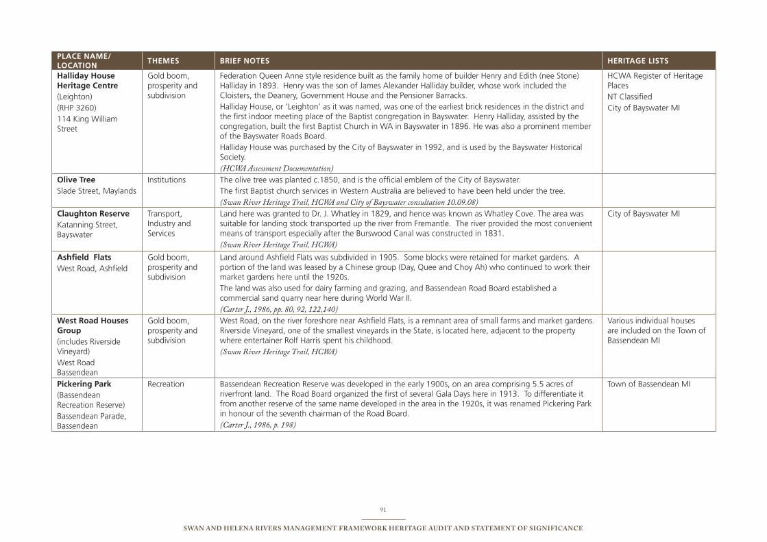
91
Swan and Helena RiveRS ManageMent FRaMewoRk HeRitage audit and StateMent oF SigniFicance
PLACE NAME/ LOCATION
ThEMEs bRIEF NOTEs hERITAgE LIsTs
halliday house heritage Centre (Leighton)(RHp 3260)114 King William street
Gold boom, prosperity and subdivision
Federation Queen Anne style residence built as the family home of builder Henry and edith (nee stone) Halliday in 1893. Henry was the son of James Alexander Halliday builder, whose work included the Cloisters, the Deanery, Government House and the pensioner barracks. Halliday House, or ‘Leighton’ as it was named, was one of the earliest brick residences in the district and the first indoor meeting place of the baptist congregation in bayswater. Henry Halliday, assisted by the congregation, built the first baptist Church in WA in bayswater in 1896. He was also a prominent member of the bayswater Roads board. Halliday House was purchased by the City of bayswater in 1992, and is used by the bayswater Historical society. (HCWA Assessment Documentation)
HCWA Register of Heritage places nt Classified City of bayswater Mi
Olive Tree slade street, Maylands
institutions the olive tree was planted c.1850, and is the official emblem of the City of bayswater.the first baptist church services in Western Australia are believed to have been held under the tree. (Swan River Heritage Trail, HCWA and City of Bayswater consultation 10.09.08)
Claughton ReserveKatanning street, bayswater
transport, industry and services
Land here was granted to Dr. J. Whatley in 1829, and hence was known as Whatley Cove. the area was suitable for landing stock transported up the river from Fremantle. the river provided the most convenient means of transport especially after the burswood Canal was constructed in 1831. (Swan River Heritage Trail, HCWA)
City of bayswater Mi
Ashfield FlatsWest Road, Ashfield
Gold boom, prosperity and subdivision
Land around Ashfield Flats was subdivided in 1905. some blocks were retained for market gardens. A portion of the land was leased by a Chinese group (Day, Quee and Choy Ah) who continued to work their market gardens here until the 1920s. the land was also used for dairy farming and grazing, and bassendean Road board established a commercial sand quarry near here during World War ii. (Carter J., 1986, pp. 80, 92, 122,140)
West Road houses group (includes Riverside Vineyard)West Road bassendean
Gold boom, prosperity and subdivision
West Road, on the river foreshore near Ashfield Flats, is a remnant area of small farms and market gardens. Riverside Vineyard, one of the smallest vineyards in the state, is located here, adjacent to the property where entertainer Rolf Harris spent his childhood. (Swan River Heritage Trail, HCWA)
Various individual houses are included on the town of bassendean Mi
Pickering Park(bassendean Recreation Reserve)bassendean parade, bassendean
Recreation bassendean Recreation Reserve was developed in the early 1900s, on an area comprising 5.5 acres of riverfront land. the Road board organized the first of several Gala Days here in 1913. to differentiate it from another reserve of the same name developed in the area in the 1920s, it was renamed pickering park in honour of the seventh chairman of the Road board.(Carter J., 1986, p. 198)
town of bassendean Mi
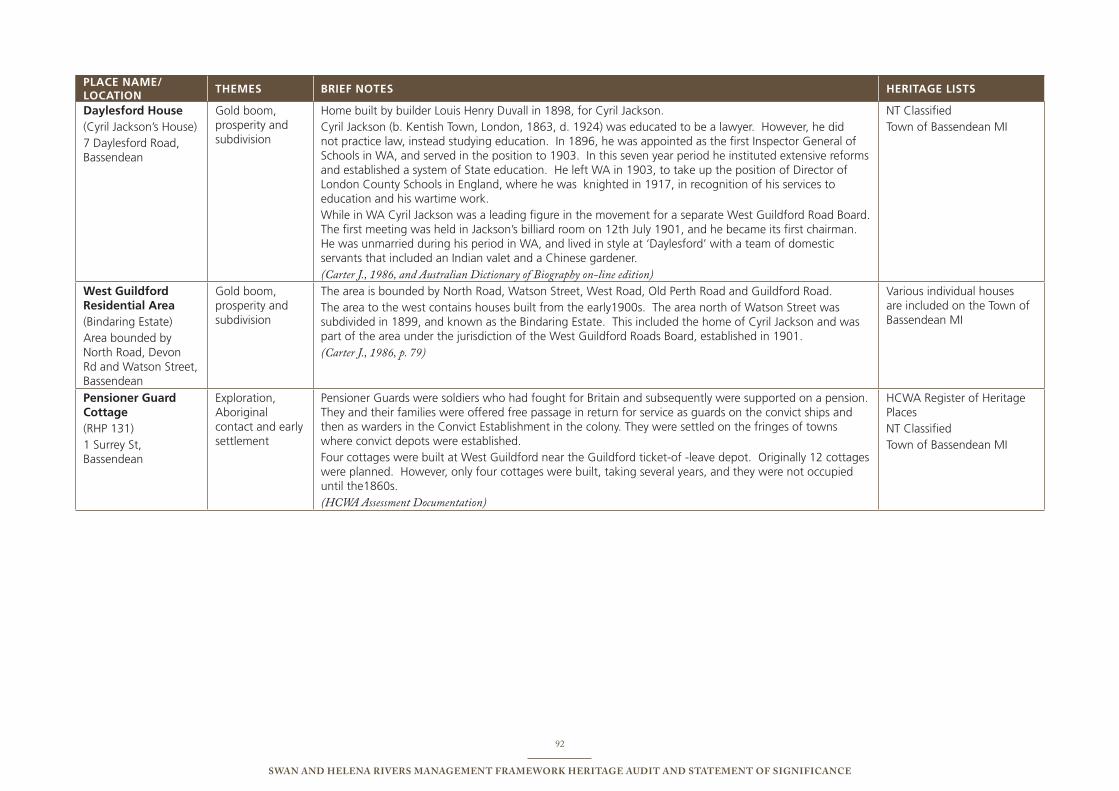
92
Swan and Helena RiveRS ManageMent FRaMewoRk HeRitage audit and StateMent oF SigniFicance
PLACE NAME/ LOCATION
ThEMEs bRIEF NOTEs hERITAgE LIsTs
daylesford house (Cyril Jackson’s House)7 Daylesford Road, bassendean
Gold boom, prosperity and subdivision
Home built by builder Louis Henry Duvall in 1898, for Cyril Jackson. Cyril Jackson (b. Kentish town, London, 1863, d. 1924) was educated to be a lawyer. However, he did not practice law, instead studying education. in 1896, he was appointed as the first inspector General of schools in WA, and served in the position to 1903. in this seven year period he instituted extensive reforms and established a system of state education. He left WA in 1903, to take up the position of Director of London County schools in england, where he was knighted in 1917, in recognition of his services to education and his wartime work. While in WA Cyril Jackson was a leading figure in the movement for a separate West Guildford Road board. the first meeting was held in Jackson’s billiard room on 12th July 1901, and he became its first chairman. He was unmarried during his period in WA, and lived in style at ‘Daylesford’ with a team of domestic servants that included an indian valet and a Chinese gardener.(Carter J., 1986, and Australian Dictionary of Biography on-line edition)
nt Classifiedtown of bassendean Mi
West guildford Residential Area(bindaring estate)Area bounded by north Road, Devon Rd and Watson street, bassendean
Gold boom, prosperity and subdivision
the area is bounded by north Road, Watson street, West Road, old perth Road and Guildford Road. the area to the west contains houses built from the early1900s. the area north of Watson street was subdivided in 1899, and known as the bindaring estate. this included the home of Cyril Jackson and was part of the area under the jurisdiction of the West Guildford Roads board, established in 1901. (Carter J., 1986, p. 79)
Various individual houses are included on the town of bassendean Mi
Pensioner guard Cottage(RHp 131)1 surrey st, bassendean
exploration, Aboriginal contact and early settlement
pensioner Guards were soldiers who had fought for britain and subsequently were supported on a pension. they and their families were offered free passage in return for service as guards on the convict ships and then as warders in the Convict establishment in the colony. they were settled on the fringes of towns where convict depots were established. Four cottages were built at West Guildford near the Guildford ticket-of -leave depot. originally 12 cottages were planned. However, only four cottages were built, taking several years, and they were not occupied until the1860s. (HCWA Assessment Documentation)
HCWA Register of Heritage places nt Classifiedtown of bassendean Mi
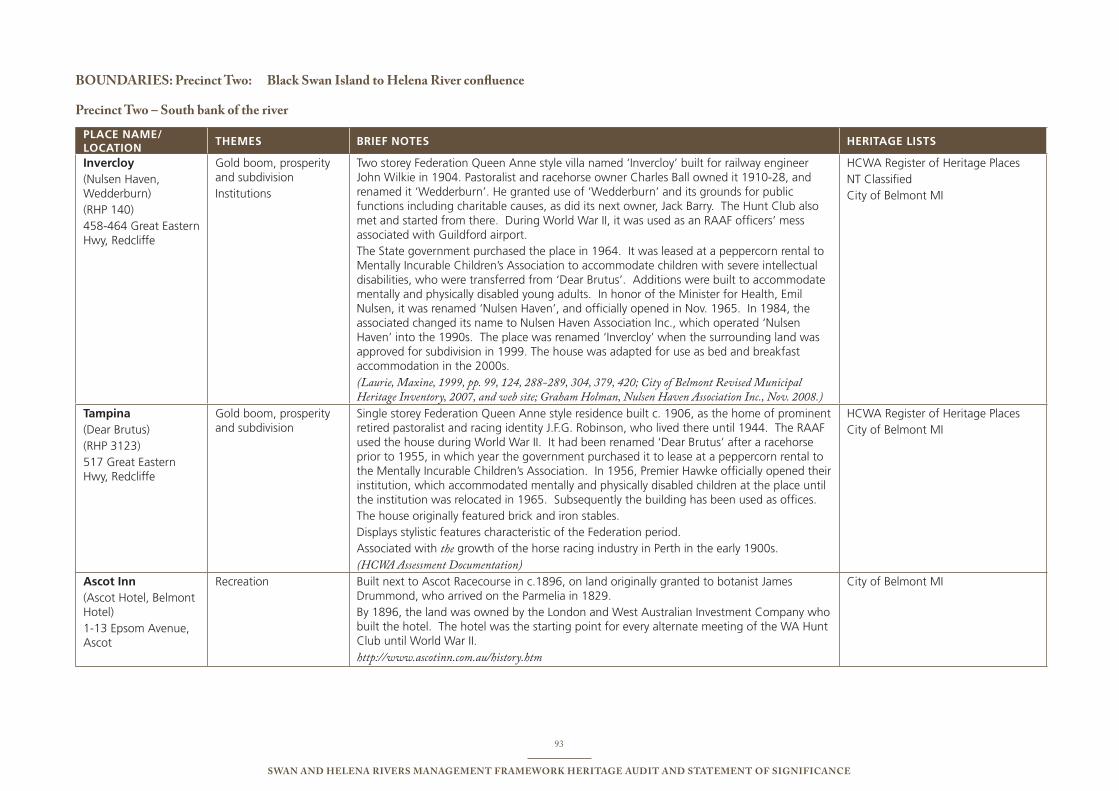
93
Swan and Helena RiveRS ManageMent FRaMewoRk HeRitage audit and StateMent oF SigniFicance
BoundaRieS: Precinct two: Black Swan island to Helena River confluence
Precinct two – South bank of the river
PLACE NAME/ LOCATION
ThEMEs bRIEF NOTEs hERITAgE LIsTs
Invercloy(nulsen Haven, Wedderburn)(RHp 140)458-464 Great eastern Hwy, Redcliffe
Gold boom, prosperity and subdivisioninstitutions
two storey Federation Queen Anne style villa named ‘invercloy’ built for railway engineer John Wilkie in 1904. pastoralist and racehorse owner Charles ball owned it 1910-28, and renamed it ‘Wedderburn’. He granted use of ‘Wedderburn’ and its grounds for public functions including charitable causes, as did its next owner, Jack barry. the Hunt Club also met and started from there. During World War ii, it was used as an RAAF officers’ mess associated with Guildford airport. the state government purchased the place in 1964. it was leased at a peppercorn rental to Mentally incurable Children’s Association to accommodate children with severe intellectual disabilities, who were transferred from ‘Dear brutus’. Additions were built to accommodate mentally and physically disabled young adults. in honor of the Minister for Health, emil nulsen, it was renamed ‘nulsen Haven’, and officially opened in nov. 1965. in 1984, the associated changed its name to nulsen Haven Association inc., which operated ‘nulsen Haven’ into the 1990s. the place was renamed ‘invercloy’ when the surrounding land was approved for subdivision in 1999. the house was adapted for use as bed and breakfast accommodation in the 2000s. (Laurie, Maxine, 1999, pp. 99, 124, 288-289, 304, 379, 420; City of Belmont Revised Municipal Heritage Inventory, 2007, and web site; Graham Holman, Nulsen Haven Association Inc., Nov. 2008.)
HCWA Register of Heritage places nt ClassifiedCity of belmont Mi
Tampina (Dear brutus)(RHp 3123)517 Great eastern Hwy, Redcliffe
Gold boom, prosperity and subdivision
single storey Federation Queen Anne style residence built c. 1906, as the home of prominent retired pastoralist and racing identity J.F.G. Robinson, who lived there until 1944. the RAAF used the house during World War ii. it had been renamed ‘Dear brutus’ after a racehorse prior to 1955, in which year the government purchased it to lease at a peppercorn rental to the Mentally incurable Children’s Association. in 1956, premier Hawke officially opened their institution, which accommodated mentally and physically disabled children at the place until the institution was relocated in 1965. subsequently the building has been used as offices. the house originally featured brick and iron stables. Displays stylistic features characteristic of the Federation period. Associated with the growth of the horse racing industry in perth in the early 1900s. (HCWA Assessment Documentation)
HCWA Register of Heritage places City of belmont Mi
Ascot Inn(Ascot Hotel, belmont Hotel) 1-13 epsom Avenue, Ascot
Recreation built next to Ascot Racecourse in c.1896, on land originally granted to botanist James Drummond, who arrived on the parmelia in 1829.by 1896, the land was owned by the London and West Australian investment Company who built the hotel. the hotel was the starting point for every alternate meeting of the WA Hunt Club until World War ii. http://www.ascotinn.com.au/history.htm
City of belmont Mi
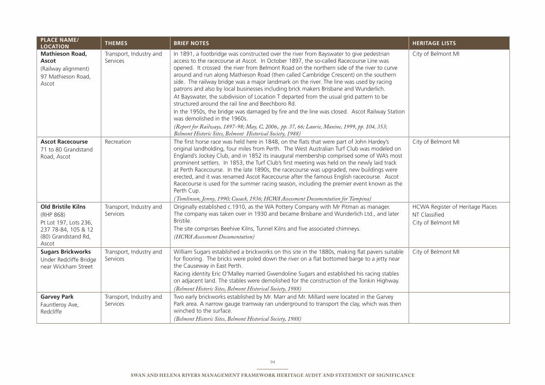
94
Swan and Helena RiveRS ManageMent FRaMewoRk HeRitage audit and StateMent oF SigniFicance
PLACE NAME/ LOCATION
ThEMEs bRIEF NOTEs hERITAgE LIsTs
Mathieson Road, Ascot(Railway alignment)97 Mathieson Road, Ascot
transport, industry and services
in 1891, a footbridge was constructed over the river from bayswater to give pedestrian access to the racecourse at Ascot. in october 1897, the so-called Racecourse Line was opened. it crossed the river from belmont Road on the northern side of the river to curve around and run along Mathieson Road (then called Cambridge Crescent) on the southern side. the railway bridge was a major landmark on the river. the line was used by racing patrons and also by local businesses including brick makers brisbane and Wunderlich. At bayswater, the subdivision of Location t departed from the usual grid pattern to be structured around the rail line and beechboro Rd. in the 1950s, the bridge was damaged by fire and the line was closed. Ascot Railway station was demolished in the 1960s. (Report for Railways, 1897-98; May, C, 2006,. pp. 37, 66; Laurie, Maxine, 1999, pp. 104, 353; Belmont Historic Sites, Belmont Historical Society, 1988)
City of belmont Mi
Ascot Racecourse71 to 80 Grandstand Road, Ascot
Recreation the first horse race was held here in 1848, on the flats that were part of John Hardey’s original landholding, four miles from perth. the West Australian turf Club was modeled on england’s Jockey Club, and in 1852 its inaugural membership comprised some of WA’s most prominent settlers. in 1853, the turf Club’s first meeting was held on the newly laid track at perth Racecourse. in the late 1890s, the racecourse was upgraded, new buildings were erected, and it was renamed Ascot Racecourse after the famous english racecourse. Ascot Racecourse is used for the summer racing season, including the premier event known as the perth Cup.(Tomlinson, Jenny, 1990; Cusack, 1936; HCWA Assessment Documentation for Tampina)
City of belmont Mi
Old bristile Kilns (RHp 868)pt Lot 197, Lots 236, 237 78-84, 105 & 12 (80) Grandstand Rd, Ascot
transport, industry and services
originally established c.1910, as the WA pottery Company with Mr pitman as manager. the company was taken over in 1930 and became brisbane and Wunderlich Ltd., and later bristile.the site comprises beehive Kilns, tunnel Kilns and five associated chimneys. (HCWA Assessment Documentation)
HCWA Register of Heritage places nt ClassifiedCity of belmont Mi
sugars brickworksunder Redcliffe bridge near Wickham street
transport, industry and services
William sugars established a brickworks on this site in the 1880s, making flat pavers suitable for flooring. the bricks were poled down the river on a flat bottomed barge to a jetty near the Causeway in east perth. Racing identity eric o’Malley married Gwendoline sugars and established his racing stables on adjacent land. the stables were demolished for the construction of the tonkin Highway. (Belmont Historic Sites, Belmont Historical Society, 1988)
City of belmont Mi
garvey Park Fauntleroy Ave, Redcliffe
transport, industry and services
two early brickworks established by Mr. Marr and Mr. Millard were located in the Garvey park area. A narrow gauge tramway ran underground to transport the clay, which was then winched to the surface. (Belmont Historic Sites, Belmont Historical Society, 1988)
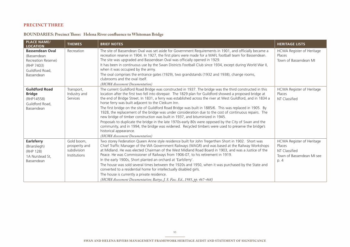
95
Swan and Helena RiveRS ManageMent FRaMewoRk HeRitage audit and StateMent oF SigniFicance
PRecinct tHRee
BoundaRieS: Precinct Three: Helena River confluence to whiteman Bridge
PLACE NAME/ LOCATION
ThEMEs bRIEF NOTEs hERITAgE LIsTs
bassendean Oval(bassendean Recreation Reserve)(RHp 7403)Guildford Road, bassendean
Recreation the site of bassendean oval was set aside for Government Requirements in 1901, and officially became a recreation reserve in 1904. in 1927, the first plans were made for a WAFL football team for bassendean. the site was upgraded and bassendean oval was officially opened in 1929. it has been in continuous use by the swan Districts Football Club since 1934, except during World War ii, when it was occupied by the army.the oval comprises the entrance gates (1929), two grandstands (1932 and 1938), change rooms, clubrooms and the oval itself. (HCWA Assessment Documentation)
HCWA Register of Heritage placestown of bassendean Mi
guildford Road bridge (RHp14558)Guildford Road, bassendean
transport, industry and services
the current Guildford Road bridge was constructed in 1937. the bridge was the third constructed in this location after the first two fell into disrepair. the 1829 plan for Guildford showed a proposed bridge at the end of bridge street. in 1831, a ferry was established across the river at West Guildford, and in 1834 a horse ferry was built adjacent to the Cleikum inn. the first bridge on the site of Guildford Road bridge was built in 1885/6. this was replaced in 1905. by 1928, the replacement of the bridge was under consideration due to the cost of continuous repairs. the new bridge of timber construction was built in 1937, and bituminized in 1945. proposals to duplicate the bridge in the late 1970s-early 80s were opposed by the City of swan and the community, and in 1994, the bridge was widened. Recycled timbers were used to preserve the bridge’s historical appearance.(HCWA Assessment Documentation)
HCWA Register of Heritage placesnt Classified
Earlsferry(briarsliegh)(RHp 128)1A nurstead st, bassendean
Gold boom, prosperity and subdivisioninstitutions
two storey Federation Queen Anne style residence built for John tregerthen short in 1902. short was Chief traffic Manager of the WA Government Railways (WAGR) and was based at the Railway Workshops at Midland. He was elected Chairman of the West Midland Road board in 1903, and was a Justice of the peace. He was Commissioner of Railways from 1906-07, to his retirement in 1919. in the early 1900s, short planted an orchard at ‘earlsferry’. the house was sold several times between the 1920s and 1950, when it was purchased by the state and converted to a residential home for intellectually disabled girls. the house is currently a private residence. (HCWA Assessment Documentation; Battye, J. S. Fasc. Ed., 1985, pp. 467-468)
HCWA Register of Heritage places nt Classifiedtown of bassendean Mi see p. 4
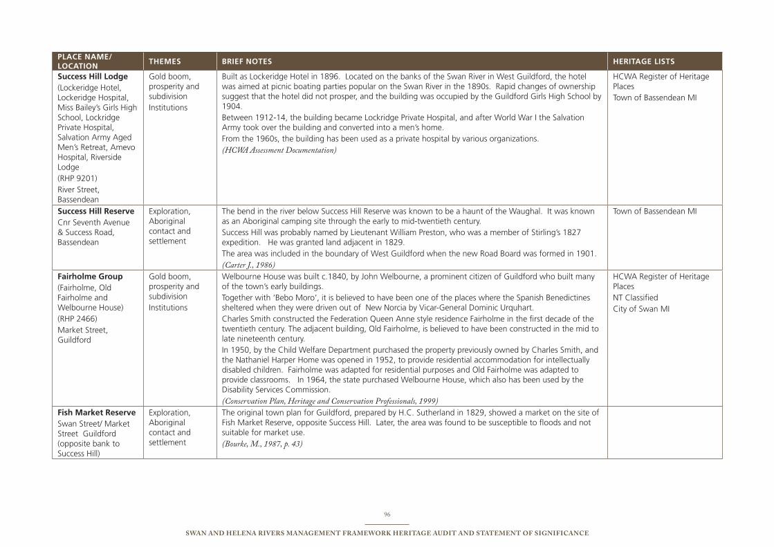
96
Swan and Helena RiveRS ManageMent FRaMewoRk HeRitage audit and StateMent oF SigniFicance
PLACE NAME/ LOCATION
ThEMEs bRIEF NOTEs hERITAgE LIsTs
success hill Lodge(Lockeridge Hotel, Lockeridge Hospital, Miss bailey’s Girls High school, Lockridge private Hospital, salvation Army Aged Men’s Retreat, Amevo Hospital, Riverside Lodge (RHp 9201)River street, bassendean
Gold boom, prosperity and subdivisioninstitutions
built as Lockeridge Hotel in 1896. Located on the banks of the swan River in West Guildford, the hotel was aimed at picnic boating parties popular on the swan River in the 1890s. Rapid changes of ownership suggest that the hotel did not prosper, and the building was occupied by the Guildford Girls High school by 1904. between 1912-14, the building became Lockridge private Hospital, and after World War i the salvation Army took over the building and converted into a men’s home. From the 1960s, the building has been used as a private hospital by various organizations. (HCWA Assessment Documentation)
HCWA Register of Heritage places town of bassendean Mi
success hill Reserve Cnr seventh Avenue & success Road, bassendean
exploration, Aboriginal contact and settlement
the bend in the river below success Hill Reserve was known to be a haunt of the Waughal. it was known as an Aboriginal camping site through the early to mid-twentieth century. success Hill was probably named by Lieutenant William preston, who was a member of stirling’s 1827 expedition. He was granted land adjacent in 1829. the area was included in the boundary of West Guildford when the new Road board was formed in 1901. (Carter J., 1986)
town of bassendean Mi
Fairholme group (Fairholme, old Fairholme and Welbourne House)(RHp 2466)Market street, Guildford
Gold boom, prosperity and subdivisioninstitutions
Welbourne House was built c.1840, by John Welbourne, a prominent citizen of Guildford who built many of the town’s early buildings. together with ‘bebo Moro’, it is believed to have been one of the places where the spanish benedictines sheltered when they were driven out of new norcia by Vicar-General Dominic urquhart.Charles smith constructed the Federation Queen Anne style residence Fairholme in the first decade of the twentieth century. the adjacent building, old Fairholme, is believed to have been constructed in the mid to late nineteenth century. in 1950, by the Child Welfare Department purchased the property previously owned by Charles smith, and the nathaniel Harper Home was opened in 1952, to provide residential accommodation for intellectually disabled children. Fairholme was adapted for residential purposes and old Fairholme was adapted to provide classrooms. in 1964, the state purchased Welbourne House, which also has been used by the Disability services Commission. (Conservation Plan, Heritage and Conservation Professionals, 1999)
HCWA Register of Heritage places nt Classified City of swan Mi
Fish Market Reserveswan street/ Market street Guildford (opposite bank to success Hill)
exploration, Aboriginal contact and settlement
the original town plan for Guildford, prepared by H.C. sutherland in 1829, showed a market on the site of Fish Market Reserve, opposite success Hill. Later, the area was found to be susceptible to floods and not suitable for market use. (Bourke, M., 1987, p. 43)
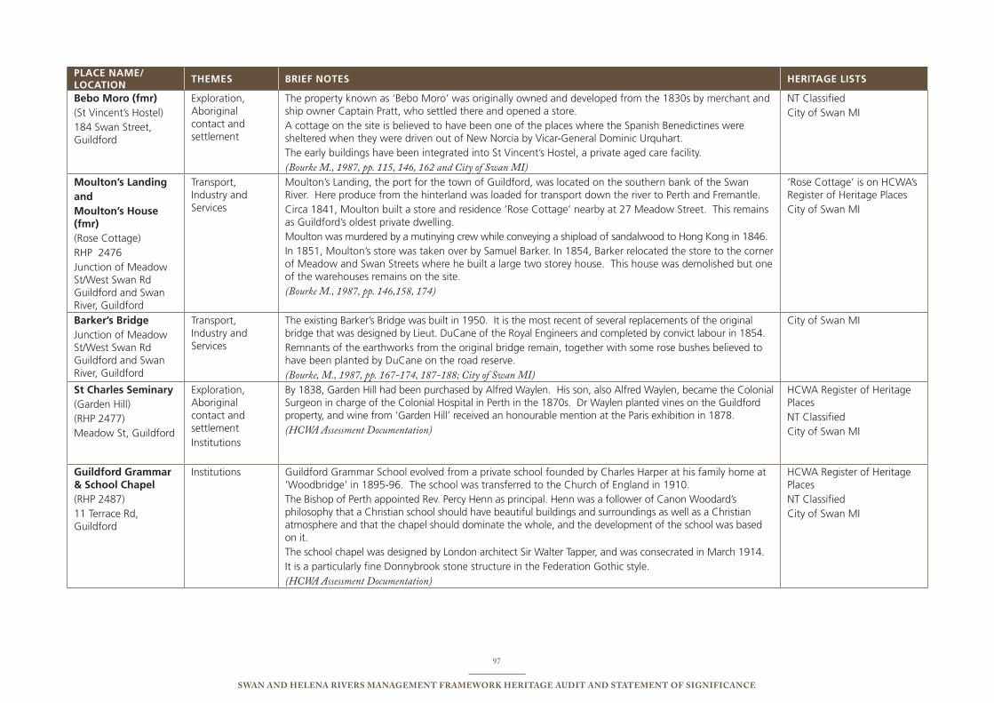
97
Swan and Helena RiveRS ManageMent FRaMewoRk HeRitage audit and StateMent oF SigniFicance
PLACE NAME/ LOCATION
ThEMEs bRIEF NOTEs hERITAgE LIsTs
bebo Moro (fmr) (st Vincent’s Hostel)184 swan street, Guildford
exploration, Aboriginal contact and settlement
the property known as ‘bebo Moro’ was originally owned and developed from the 1830s by merchant and ship owner Captain pratt, who settled there and opened a store.A cottage on the site is believed to have been one of the places where the spanish benedictines were sheltered when they were driven out of new norcia by Vicar-General Dominic urquhart. the early buildings have been integrated into st Vincent’s Hostel, a private aged care facility. (Bourke M., 1987, pp. 115, 146, 162 and City of Swan MI)
nt ClassifiedCity of swan Mi
Moulton’s LandingandMoulton’s house (fmr)(Rose Cottage)RHp 2476Junction of Meadow st/West swan Rd Guildford and swan River, Guildford
transport, industry and services
Moulton’s Landing, the port for the town of Guildford, was located on the southern bank of the swan River. Here produce from the hinterland was loaded for transport down the river to perth and Fremantle. Circa 1841, Moulton built a store and residence ‘Rose Cottage’ nearby at 27 Meadow street. this remains as Guildford’s oldest private dwelling. Moulton was murdered by a mutinying crew while conveying a shipload of sandalwood to Hong Kong in 1846. in 1851, Moulton’s store was taken over by samuel barker. in 1854, barker relocated the store to the corner of Meadow and swan streets where he built a large two storey house. this house was demolished but one of the warehouses remains on the site. (Bourke M., 1987, pp. 146,158, 174)
‘Rose Cottage’ is on HCWA’s Register of Heritage places City of swan Mi
barker’s bridgeJunction of Meadow st/West swan Rd Guildford and swan River, Guildford
transport, industry and services
the existing barker’s bridge was built in 1950. it is the most recent of several replacements of the original bridge that was designed by Lieut. DuCane of the Royal engineers and completed by convict labour in 1854. Remnants of the earthworks from the original bridge remain, together with some rose bushes believed to have been planted by DuCane on the road reserve. (Bourke, M., 1987, pp. 167-174, 187-188; City of Swan MI)
City of swan Mi
st Charles seminary (Garden Hill)(RHp 2477)Meadow st, Guildford
exploration, Aboriginal contact and settlementinstitutions
by 1838, Garden Hill had been purchased by Alfred Waylen. His son, also Alfred Waylen, became the Colonial surgeon in charge of the Colonial Hospital in perth in the 1870s. Dr Waylen planted vines on the Guildford property, and wine from ‘Garden Hill’ received an honourable mention at the paris exhibition in 1878. (HCWA Assessment Documentation)
HCWA Register of Heritage places nt Classified City of swan Mi
guildford grammar & school Chapel (RHp 2487)11 terrace Rd, Guildford
institutions Guildford Grammar school evolved from a private school founded by Charles Harper at his family home at ‘Woodbridge’ in 1895-96. the school was transferred to the Church of england in 1910.the bishop of perth appointed Rev. percy Henn as principal. Henn was a follower of Canon Woodard’s philosophy that a Christian school should have beautiful buildings and surroundings as well as a Christian atmosphere and that the chapel should dominate the whole, and the development of the school was based on it. the school chapel was designed by London architect sir Walter tapper, and was consecrated in March 1914.it is a particularly fine Donnybrook stone structure in the Federation Gothic style. (HCWA Assessment Documentation)
HCWA Register of Heritage places nt Classified City of swan Mi

98
Swan and Helena RiveRS ManageMent FRaMewoRk HeRitage audit and StateMent oF SigniFicance
PLACE NAME/ LOCATION
ThEMEs bRIEF NOTEs hERITAgE LIsTs
Woodbridge (RHp 2528)third Av, West Midland
exploration, Aboriginal contact and settlementGold boom, prosperity and subdivision
the site originally formed part of sir James stirling’s ‘Woodbridge’. stirling’s original house that was described as a cottage ornée, was located in the grounds of the adjacent Governor stirling High school, which also occupies part of stirling’s original grant. in c. 1883, Charles Harper purchased the portion of the estate known as the ‘Woodbridge Farm’, which had been developed for agricultural use, including wheat growing. From the 1880s to early 1920s, the place was the centre of the diverse business and agricultural operations of the Harper family, who built the substantial two storey residence designed by architect J.W. Wright in 1884.the building was subsequently used as a preparatory school under Cecil priestley, a government home for aged women, and for special high school classes. it is now owned and managed by the national trust and is open to the public. (HCWA Assessment Documentation)
HCWA Register of Heritage placesnt Classified City of swan Mi
Riverbank detention Centre (former)(pyrton) 130 Hamersley Road, Caversham
exploration, Aboriginal contact and settlementinstitutions
Riverbank Detention Centre was opened in 1960. the site was part of one of the earliest land holdings granted in the swan district. by 1837, it was owned by edward Hamersley, who developed it as his ‘pyrton’ estate. in the 1850s, the land was developed as a vineyard and by 1857, a residence had been constructed. the land was subdivided in the 1940s, and the property at that stage was onwed by market gardener Rafaelle Masolini. the state government acquired the property in 1957, as the site for construction of a reformatory for boys. in 1959, the ‘pyrton’ buildings were demolished, and Riverbank Detention Centre was developed and opened in 1960. the place was superseded by banksia Hill Detention Centre at Canning Vale in 1997, although the Riverbank facility remained in used for male adults until c.2001.(HCWA Assessment Documentation Draft)
Caversham house141 Caversham Ave, Caversham
exploration, Aboriginal contact and settlement
the earliest section of Caversham House dates from the 1850s. there are significant olive trees on the property. Caversham estate was one of the areas subdivided between 1900 and the early 1920s. the area was subsequently settled by immigrants from southern europe (especially Yugoslavia) who established small farms and vineyards.(City of Swan MI; Bourke, M., 1987, p. 285)
City of swan Mi
sandalford Residence (& Winery)3210 Middle swan Rd, Caversham
exploration, Aboriginal contact and settlement
sandalford Homestead was built on swan Location L, which was granted to John septimus Roe, the first surveyor General of WA, in 1829. the property was leased to tenants until Roe’s grandson, John Frederick ‘Fred’ Roe, went to live there in 1900. He cleared land for market gardens and vine growing, and had great success with table grapes and dried fruit. During World War ii, he began making wine there, and this industry has continued to flourish.(Burton Jackson, J. L., 1982, pp. 174-175)the house was constructed in c. 1870, and extended in c. 1900. the original section has a steeply pitched roof and decorative valance. Later sections are higher with corbelled chimneys.(City of Swan MI)
City of swan Mi
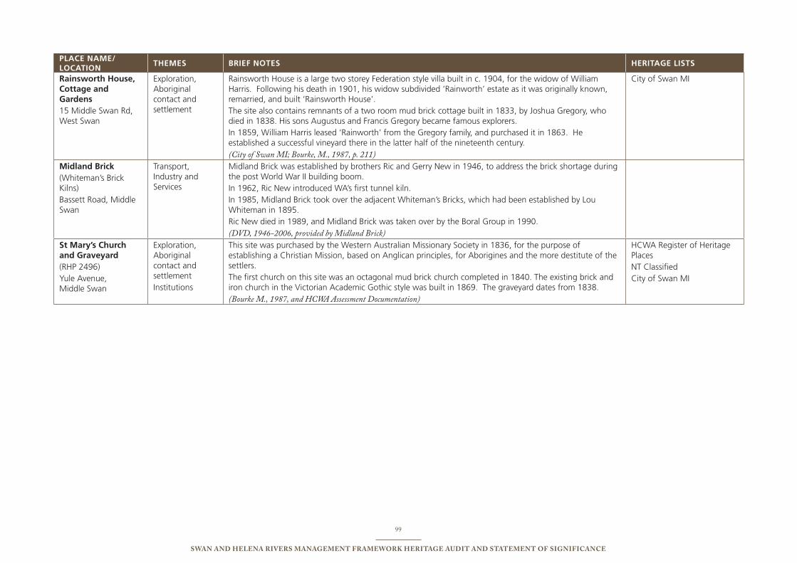
99
Swan and Helena RiveRS ManageMent FRaMewoRk HeRitage audit and StateMent oF SigniFicance
PLACE NAME/ LOCATION
ThEMEs bRIEF NOTEs hERITAgE LIsTs
Rainsworth house, Cottage and gardens15 Middle swan Rd, West swan
exploration, Aboriginal contact and settlement
Rainsworth House is a large two storey Federation style villa built in c. 1904, for the widow of William Harris. Following his death in 1901, his widow subdivided ‘Rainworth’ estate as it was originally known, remarried, and built ‘Rainsworth House’. the site also contains remnants of a two room mud brick cottage built in 1833, by Joshua Gregory, who died in 1838. His sons Augustus and Francis Gregory became famous explorers. in 1859, William Harris leased ‘Rainworth’ from the Gregory family, and purchased it in 1863. He established a successful vineyard there in the latter half of the nineteenth century. (City of Swan MI; Bourke, M., 1987, p. 211)
City of swan Mi
Midland brick(Whiteman’s brick Kilns) bassett Road, Middle swan
transport, industry and services
Midland brick was established by brothers Ric and Gerry new in 1946, to address the brick shortage during the post World War ii building boom. in 1962, Ric new introduced WA’s first tunnel kiln. in 1985, Midland brick took over the adjacent Whiteman’s bricks, which had been established by Lou Whiteman in 1895. Ric new died in 1989, and Midland brick was taken over by the boral Group in 1990. (DVD, 1946-2006, provided by Midland Brick)
st Mary’s Church and graveyard (RHp 2496)Yule Avenue, Middle swan
exploration, Aboriginal contact and settlementinstitutions
this site was purchased by the Western Australian Missionary society in 1836, for the purpose of establishing a Christian Mission, based on Anglican principles, for Aborigines and the more destitute of the settlers. the first church on this site was an octagonal mud brick church completed in 1840. the existing brick and iron church in the Victorian Academic Gothic style was built in 1869. the graveyard dates from 1838.(Bourke M., 1987, and HCWA Assessment Documentation)
HCWA Register of Heritage places nt Classified City of swan Mi
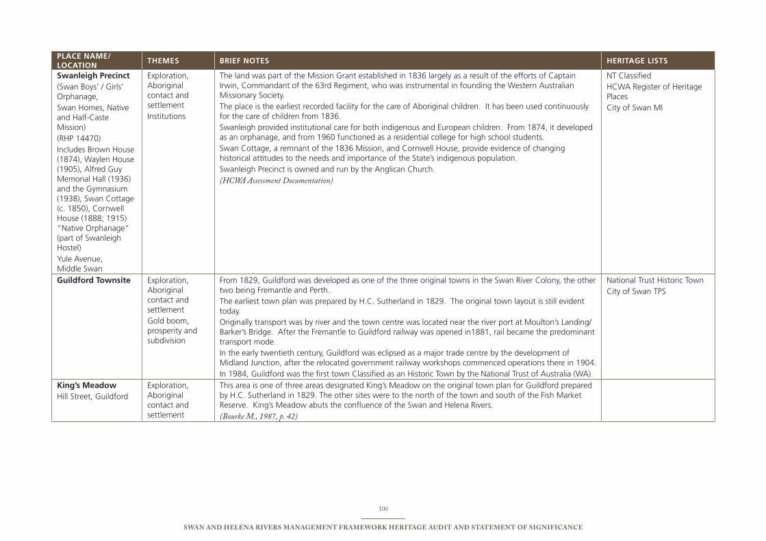
100
Swan and Helena RiveRS ManageMent FRaMewoRk HeRitage audit and StateMent oF SigniFicance
PLACE NAME/ LOCATION
ThEMEs bRIEF NOTEs hERITAgE LIsTs
swanleigh Precinct(swan boys’ / Girls’ orphanage,swan Homes, native and Half-Caste Mission) (RHp 14470)includes brown House (1874), Waylen House (1905), Alfred Guy Memorial Hall (1936) and the Gymnasium (1938), swan Cottage (c. 1850), Cornwell House (1888; 1915) “native orphanage” (part of swanleigh Hostel)Yule Avenue, Middle swan
exploration, Aboriginal contact and settlementinstitutions
the land was part of the Mission Grant established in 1836 largely as a result of the efforts of Captain irwin, Commandant of the 63rd Regiment, who was instrumental in founding the Western Australian Missionary society. the place is the earliest recorded facility for the care of Aboriginal children. it has been used continuously for the care of children from 1836. swanleigh provided institutional care for both indigenous and european children. From 1874, it developed as an orphanage, and from 1960 functioned as a residential college for high school students.swan Cottage, a remnant of the 1836 Mission, and Cornwell House, provide evidence of changing historical attitudes to the needs and importance of the state’s indigenous population. swanleigh precinct is owned and run by the Anglican Church.(HCWA Assessment Documentation)
nt Classified HCWA Register of Heritage placesCity of swan Mi
guildford Townsite exploration, Aboriginal contact and settlementGold boom, prosperity and subdivision
From 1829, Guildford was developed as one of the three original towns in the swan River Colony, the other two being Fremantle and perth. the earliest town plan was prepared by H.C. sutherland in 1829. the original town layout is still evident today. originally transport was by river and the town centre was located near the river port at Moulton’s Landing/ barker’s bridge. After the Fremantle to Guildford railway was opened in1881, rail became the predominant transport mode. in the early twentieth century, Guildford was eclipsed as a major trade centre by the development of Midland Junction, after the relocated government railway workshops commenced operations there in 1904. in 1984, Guildford was the first town Classified as an Historic town by the national trust of Australia (WA).
national trust Historic town City of swan tps
King’s Meadow Hill street, Guildford
exploration, Aboriginal contact and settlement
this area is one of three areas designated King’s Meadow on the original town plan for Guildford prepared by H.C. sutherland in 1829. the other sites were to the north of the town and south of the Fish Market Reserve. King’s Meadow abuts the confluence of the swan and Helena Rivers. (Bourke M., 1987, p. 42)

101
Swan and Helena RiveRS ManageMent FRaMewoRk HeRitage audit and StateMent oF SigniFicance
PRecinct FouR
BoundaRieS: Precinct Four: kings Meadow to Roe Highway
PLACE NAME/ LOCATION
ThEMEs bRIEF NOTEs hERITAgE LIsTs
Midland Railway Workshops (RHp 3273)Yelverton Drive, Midland & Woodbridge
transport, industry and services
the West Australian Government Railway (WAGR) Workshops opened in Fremantle in 1886. in 1902, work commenced on the new site at Midland Junction. the Midland workshops were operating by 1904. From 1904, until their closure in 1994, the Workshops were responsible for the manufacture and maintenance of track and rolling stock in WA. the place was a major employer and training ground for apprentices in numerous trades. (HCWA Assessment Documentation)
HCWA Register of Heritage places nt ClassifiedCity of swan Mi
Midland saleyardsLot 14241 Clayton street, Midland
transport, industry and services
Midland saleyards have operated since 1911, at first as the municipal saleyards, and then as the state government’s saleyards for livestock. the site comprises animal holding pens, loading ramps, administrative and staff facilities. Midland Abattoirs was developed on the adjoining site from 1914. the saleyards and abattoirs was the second largest employer in Midland for more than 50 years. (HCWA Assessment Documentation Draft)
City of swan Mi
Whiteman Road bridge (site)Whiteman Road west of the Midland saleyards
transport, industry and services
site of a timber bridge (not extant) over the Helena River, which was used as a droving route for cattle to and from the saleyards.
City of swan Mi

102
Swan and Helena RiveRS ManageMent FRaMewoRk HeRitage audit and StateMent oF SigniFicance