Embed Size (px)
Citation preview

SUSTAINABLE COASTALRESOURCES MANAGEMENT
FOR FIJI
A Background Paper prepared for theFiji National Workshop on Integrated Coastal Management:
April 9-11, 2002Suva, Fiji

1
SUSTAINABLE COASTAL RESOURCES
MANAGEMENT FOR FIJI
A Background Paper prepared for theFiji National Workshop on Integrated Coastal Management:
April 9-11, 2002,Suva, Fiji

2
I. INTRODUCTION
There are a number of important initiatives to address the sustainable development andconservation of coastal resources throughout the island countries and provinces of the WesternPacific, including the South Pacific, the Philippines and Indonesia. Coastal managers based inthese sites unfortunately do not have the opportunity to share their lessons learned with eachother, nor with government agencies at different levels. Yet such interaction is essential for thecommunication of ideas and lessons that can lead to the success of integrated coastalmanagement projects.
A practitioner learning network is emerging in the region, primarily incorporating managers ofconservation sites. This network of site managers recognizes that for their ambitious effort to besustainable, lessons must be effectively communicated and integrated into the mainstream ofgovernment activities and programs. The Institute of Applied Science (IAS) at the University ofthe South Pacific (USP) is working in partnership with the University of Rhode Island CoastalResources Center and the Government of Fiji to hold a workshop at the national level that willprovide a valuable opportunity for exchanging information on lessons learned about successfulsite management to date. The meeting will also examine the potential for government andcitizen support for a sustainable and replicable coastal program, and whether such an initiative isappropriate at this time for Fiji.
The overall project, funded by the David and Lucile Packard Foundation, incorporates anexamination of experiences in two provinces in the central Philippines, and the nation of Fiji.This work will complement an on-going, similar initiative in North Sulawesi, Indonesia. Allthree locations have successful local site projects on-going and all recognize the need for moregovernment involvement in linking together individual, site-based projects.
This paper provides important background information for the Sustainable Coastal ResourcesManagement Workshop scheduled for April 9-11, 2002. Section I indicates the importance ofcoastal resources in the past, present and future well-being of Fiji. Section II points out thatthere are some important early initiatives as well as pending legal and policy proposals thatreveal how many different groups and government offices are coming to similar conclusionsabout important next steps in creating a framework and viable local programs to care for coastalareas and communities. Section III examines the special area of the Coral Coast in more detail, aregion which shares many of the problems and concerns of other coastal areas, including smalloutlying islands. Several important initiatives are described as well as how coastal managementmight look in Fiji at this scale. The final section offers some reflections on possible directionsfor Fiji to consider taking in the near and medium term.
3
II. FIJI IS A COASTAL NATION
A. Coastal Resources are an Important Basis for Stability and SustainedGrowth
Coastal areas are of vital importance to Fiji society and its national development. Most of theurban centers and a vast majority of villages are located on the shore, along with much of thepopulation, agriculture, industry and commerce. Income from tourism and fisheries is directlytied to the condition and productivity of critical ecosystems and shoreline features such as coralreefs, beaches, seagrass beds and mangroves.
The Fiji Strategic Development Plan for 2002 – 2004 (August, 2001 review draft) produced bythe Ministry of National Planning focuses mainly on short term measures for "rebuildingconfidence for stability and growth" in Fiji. However, this document also looks ahead byclearly stating that:
"Government's commitment to sustainable economic growth means that growth must notbe allowed to lead to the long term degradation of the environment." [para. 34] Further,"The proper management of the environment and sustainable use of its natural resourcesis critical for the sustainable development of Fiji's largely natural resource basedeconomy" [para 12.67].Marine resources need to be managed "in a way that maximizes resource owner andcommunity benefit whilst ensuring bio-diversity and conservation issues are taken fullyinto account" [para 9-30].Finally, "Protecting the environment is closely linked to disaster management andmitigation. The effects of many disasters (e.g. floods) can be reduced by taking betteraccount of the environmental risks of development" [para. 34].
The Environment section of the Strategy also mentions the need for minimizing the degradationof natural resources, enacting the Sustainable Development Bill, and raising public awareness onenvironmental issues.
This section reviews the importance of the coast to the traditional village and rural life of Fiji, itsrole in sustaining the current economy, and further contributions toward sustainable developmentof the country.
i. Traditional Economy
Around 90% of Fiji’s 800,000 people may be considered coastal dwellers. Despite increasingurbanisation 54% of the population is rural (Leslie and Ratukalou 2001). Local communities,especially in rural areas, are still heavily dependent on subsistence utilisation of natural resourcesfor their livelihood.
4
Agriculture
Subsistence agriculture contributes between 30-40% of total agricultural GDP and is ofsignificant importance to local villages and communities. Subsistence agriculture is practiced allover Fiji and based upon a mixture of staple root crops (dalo, cassava, yams, sweet potato) andtree crops (bananas, breadfruit, mangos and other fruit trees) and vegetables. It provides a sourceof nutritional benefits and through the selling of surplus crops, income (MAFF 1999).
Fisheries
The inshore fishery is of vital importance to the rural sector. Most of Fiji’s coastal villages andsettlements rely on subsistence fishing for a large part of their protein intake, however, there is alack of detailed information on this fishery. If the estimated volume of the subsistence fisherycould be sold at current domestic prices it would be worth nearly F$50 million (Watling andChape 1992). In 1999 it is estimated that 17,800 metric tonnes (finfish and non- finfish) werecaught and consumed by subsistence fishermen. This volume represents twice the size of theartisanal fishery (MAFF 1999).
Mangrove Resources
A large proportion of Fiji's coastal villages have access to and utilise mangrove areas. Thesecommunities have a significant dependence on mangroves. Mangrove areas provide crabs,prawns, fish, molluscs and other fisheries as well as an important source of firewood, buildingmaterials, dyes, medicines and a variety of other uses. The direct and indirect benefits are freeand self-sustaining thus are important determinants of the quality of life of many coastalcommunities (Watling 1985).
ii. Existing Economic Sectors
Fiji’s economy is largely dominated by sugar and tourism although private investment hascontinued largely in construction, tourism, other agriculture, forestry and the garment industry.The dependence of Fiji's economy on natural resources and the environment is still an overridingfeature. Most of the socio-economic activities are located on the coast including tourism,fisheries, agriculture, industry, and infrastructure.
Tourism
Tourism, which is mainly private sector driven, has grown significantly over the years and hasnow become Fiji’s largest gross foreign exchange earner. The tourism industry is highly focussedon the western region of Fiji in Nadi, the Mamanuca Islands, and the Coral Coast, and has greatpotential to deliver economic benefits to rural Fijians.
In 1999 it contributed approximately 16% of GDP and 22% of foreign exchange. Tourismprovides employment directly and indirectly to around 40,000 people. The sector relies heavilyon the state of coastal areas and proper management of coastal uses. Recently, a number of newhotels have been built in the country and most of the major resorts are situated on the coast.Ecotourism is also an important and growing form of tourism. Visitor arrivals have recorded a
5
steady growth reaching a record level of 409,000 in 1999 then declining to 294,070 in 2000 as aresult of the coup. Visitor arrivals have begun to increase again in 2001 in which they reached348,014 (Ministry of National Planning 2001).
Agriculture
Agriculture accounts for the largest sector of Fiji’s economy, accounting for 43% of foreignexchange and contributes 19% of Fiji’s GDP. It provides around 40% of total employment(MAFF 1999). The main agricultural activities are concentrated on Viti Levu and Vanua Levuwhere much of the suitable land is under cultivation for commercial crops such as sugar cane andsubsistence crops. There is limited land suitable for expanding agricultural opportunities.
Sugar is still the backbone of the agricultural economy with annual production in 2000 at 0.33million tons. The industry generated sales revenue in excess of $280 million in 2000. It is alsoresponsible for the employment of around 25% of Fiji’s labour force and contributed around14% of total of foreign exchange (Ministry of National Planning 2001). Root crops and yaqonaare expanding as export crops. Production of dalo for export in 1999 was 8058 tonnes earning$8.8 million. In 1999, 245 tonnes of yaqona were exported. (MAFF 1999).
Commercial Fishing
In 1999 the domestic commercial catch of fresh and frozen finfish was around 5102 tonnes worth$16.9 million and for non- finfish approximately 4870 tonnes worth $6.2 million. Main speciescaught include several inshore finfish species, mangrove crab, prawns and bivalves.
In 1999 it is estimated that $F87.5 million worth of sashimi tuna and $7 million of loin productwere exported to mainly Japan and United States markets. PAFCO exported canned and lointuna to the value of $F15.9 million. Export of aquarium fish was worth $519,000. (MAFF 1999).
Manufacturing
Manufacturing is now a significant part of the economy contributing 15% of GDP andemploying around 28,000 people. Main components of the sector are textiles, clothing andfootwear, beverage and tobacco production, food processing, and wood-based industries. Thetextile, clothing and footwear industries experienced major growth in 1999 contributing around25% of total exports, however output fell sharply in 2000 as a results of the political crisis(Ministry of National Planning 2001).
6
iii. Future Economic Growth and Sustainable Use of Coastal Resources
The Fiji Strategic Development Plan for 2002 – 2004 sets the stage for future investments ininfrastructure, capacity building and resource management which need to be in place to takeadvantage of opportunities while also improving quality of life and avoiding degradation of theenvironment over the long term.
Tourism is a sector which is now recovering and has good growth potential. One part of thevision is to link tourism with other parts of the economy including horticulture, floriculture,fisheries and aquaculture" [para. 10.8]. For example, success in the fresh tuna export tradedepends on the availability of international flights to market destination [para 9.24].
There is untapped potential for the development of small and medium scale businesses byindigenous Fijians for the tourism industry such as handicrafts, ecotourism ventures, diving, andother water sports. "Community-based tourism projects that are well designed and managed canbring about substantial economic benefits to the local population, particularly to the resourceowners. In addition, ecotourism also promotes the conservation of Fiji's biodiversity, indigenousFijian culture and tradition, and the natural environment" [para 10.13].
Development of the fisheries sector could include export of an expanded variety of fresh fish,cultured seaweed and other marine products such as giant clams and cultured black pearls. Thesector is expected to grow 1.7-2.5% given the expanding tuna industry and the provision offishing equipment. Some of the investment barriers include limited shore based facilities andrural infrastructure and there is a key concern about the need to improve how marine productsare handled to avoid losses, and to permit Fiji to benefit from a greater number of value-addingsteps and processes (Ministry of National Planning 2001).
Diversification of high value niche crops and traditional food crops is also needed as sugar caneproduction declines. Rural to urban migration "has resulted in significant urban developmentand encroachment onto first class arable land" as well as generated a number of spilloverproblems such as water pollution, draining of wetlands and flooding.
B. Fiji’s Coastal Habitats and Ecosystems are of National andInternational Significance
Fiji's coastal environment is made up of an assemblage of resources including coral reefs,mangroves, beaches, and forests. These resources form the basis of Fijian culture, employment,and food supply and therefore need to be well maintained for future generations (Strategic Plan).In addition, tourists travel thousands of miles to enjoy Fiji’s National Heritage.

7
Coral Reefs
Coral reefs are found associated with all the islands of Fiji. There are approximately 1000 coralreefs in Fiji and many types exist including barrier, fringing and platform reefs. Two types ofbarrier reefs are found: oceanic ribbon reefs that enclose lagoons or areas of normal sea andwhich are entirely oceanic such as the Great Sea Reef which extends for over 200 km; andbarrier reefs which are separated from the mainland by a relatively narrow lagoon such as offSuva. Exposed fringing reefs are found from Natadola to Serua , southwest Viti Levu. Platformreefs are common inside the Great Sea Reef of the northern coast of Vanua Levu (Watling andChape 1992).
Apart from providing protection to the coast and serving as a critical habitat, coral reefs alsoprovide a number of products to the economy and local population in Fiji. These includefisheries including trochus and beche de mer, coral, and handicrafts such as jewelry.
Fiji’s reefs are considered to be in good condition except those near the large urban centreswhich are subject to urban pollution, heavy gleaning, and coastal development. Most reefs aremoderately to heavily fished. Reefs near villages are subject to subsistence and artisanal fishingand this has caused reduction of target fish species, giant clams, trochus and beche de mer inmany areas. Many reefs also are affected by crown of thorns starfish outbreaks and coralbleaching. In urban areas pollution from sewage waste, industries, and poor land use has alsoimpacted the reefs. Outside urban areas pollution is confined to immediate vicinity of touristresorts and villages. Coral harvesting also occurs for use in septic systems, curio trade, andaquarium trade. Fiji is currently the second largest exporter of live reef products for the marineaquarium trade. Impact and sustainability of collection are an ongoing topic of debate (Cumminget al. 2002).
No formal or established system of MPAs exists to date in Fiji. However, a growing network ofvillage-managed MPAs is in place and is based on Fiji’s strong tradition of customary marinetenure. Various NGOs, research groups and private-sector operators are working together to raisemarine awareness and promote establishment of MPAs (Cumming et al. 2002).
Mangroves
The extent of Fiji’s mangroves is around 42,000 hectares (385 sq km). Nine different species ofmangroves exist in Fiji (Watling and Chape 1992). Just over 90% of the mangroves are on VitiLevu and Vanua Levu, with the largest stands located in the deltaic areas of the Rewa, Ba, andNadi Rivers on Viti Levu and the Labasa River on Vanua Levu (Ellison In Press a). The Ba,Labasa, and Rewa deltas combined support 28% of the national resource, however, they arelightly affected by development pressure (Gray 1993). The Suva-Navua mangroves and the NadiBay mangroves are, on the other hand, considered the most threatened because of their location(Watling 1985).
Fiji’s mangrove flora is relatively simple consisting of four exclusively mangrove species, aunique mangrove hybrid, and four predominantly mangrove species. It is dominated by three‘true mangroves’ from the family Rhizophoraceae: Bruguiera gymnorrhiza (dogo in Fijian),Rhizophora stylosa and Rhizophora samoensis (both tiri).

8
Mangroves are extremely important to local communities that utilise mangroves for a range ofuses such as firewood, construction materials, tools, medicines, dyes, and other products. Theyare also important for the sustenance of coastal fisheries , the principal recipients being thecoastal users. Mangrove-associated molluscs, prawns, crabs, mangrove lobsters, and around 70species of finfish are commonly caught in mangrove areas and sold at local markets or on theroadside throughout Fiji (Lal 1991). Mangrove areas are also important for fuelwood production,shoreline protection, areas for sewage processing, and areas for science and education.
Most mangrove areas are in fairly good condition except around urban and peri-urban areaswhere they are heavily utilised for subsistence use. Major threats are future reclamation anddevelopment, overexploitation, and pollution (Watling 1985). A management plan was drawn upin 1985 and is referred to by the Lands and Survey Department when assessing applications forreclamation of mangrove areas. Approximately 18,019 ha of mangroves are included underforestry protection forests (Department of Forestry 1997).
Seagrass Beds
Many seagrass beds exist throughout Fiji; within reef system five species of seagrass have beenidentified. However, there has not been any inventory of extent. Seagrass beds apart from theirecological importance such as nurseries for juvenile fish, provide areas where local communitiesglean for shellfish and other marine organisms. Fiji in 2001 became a part of a Global SeagrassMonitoring Program, SeagrassNet, and has set up a site off Suva that will be monitored for twoyears.
Beaches & Dunes
Beaches are found off many of the coasts of the larger islands of Viti Levu and Vanua Levuexcept where the major river deltas are located. They are most well developed where there is afringing reef to provide carbonate material and limited input of sediment. Beaches are also foundon most shores of the smaller islands. They are especially important for the tourist industry.Being a highly dynamic environment, beach erosion is continually occurring.
The only major accretion of sand forming dunes is at the mouth of the Sigatoka River.
Coastal Forests
Coastal forests are well developed on the wet sides of the Viti Levu and Vanua Levu and on thehigh smaller islands. They provide local communities with a source of firewood, constructionmaterial, medicine, garlands and food. Tourists also utilise the coastal forests and the mountainsbehind the coastal plains for hiking or to visit waterfalls. They also provide ecological functionssuch as shade, protection from wind, sand and salt spray, erosion and flood control, and soilimprovement. Common important species found in these forests include Cocos nucifera(coconut), Hibiscus tiliaceus (vau), Pandanus tectorius (vadra), Calophyllum inophyllum (dilo),Morinda citrifolia (kura) and Inocarpus fagifer (ivi) (Thaman 1991).
9
C. Coastal Areas are Threatened by Overuse and Degradation
The Fiji Strategic Development Plan for 2002 – 2004 identifies a number of issues of seriousconcern for the country as a whole, including:
• The loss of biodiversity• Inappropriate solid waste management• Mismanagement of chemical wastes• Pollution of air and water ways• Land degradation• Modification of sensitive habitats• Unsustainable exploitation of living and non-living habitats• Climate change• Increase in the number of invasive plant and animal species which threaten Fiji's
native species
These issues are largely the result of increasing coastal populations, rapid coastal development,and increasing utilisation of coastal resources and have resulted in various impacts on coastalenvironment including soil erosion and land degradation, loss of habitat and biodiversity, anddegradation of near shore habitats (Pitman et al 2001). This has been aided by the absence of aunified environmental policy in Fiji.
Causes of degradation of coastal habitats include inappropriate agricultural activities, mining,sewage pollution, inappropriate solid waste disposal, fishing activities, use of destructive fishingpractices, beach sand mining, building of jetties and groynes, commercial harvesting of coral,soil erosion and siltation, improper disposal of industrial waste, and natural hazards such asclimate change and sea level rise and hurricanes. The absence of consistent monitoring of thecoastal zone makes it difficult to assess the extent and pervasiveness of pollution and degradationin Fiji (Fiji Tourism Development Plan).
Agricultural Activities
The expansion of agriculture in marginal hills and steep areas and inappropriate land usepractices have led to soil erosion and land degradation which has an adverse effect on foodproduction potential and on coastal areas as a result of siltation (Ministry of National Planning2001).

10
Overfishing & Overexploitation of Stocks
The overexploitation of inshore fisheries is now becoming a concern, particularly the selling ofundersized fish and crustaceans and cutting of mangroves. This is thought to be a result of pooreducation and short-term monetary gain (Ministry of National Planning 2001).
Sewage & Other Types of Pollution
The main sewage problems occur in urban (and is some cases rural) areas that are not sewered.Widespread seepage of waste from septic tanks into creeks leads to increased nutrients in coastalwaters, potentially damaging reefs and seagrass beds and increased risk of disease. Insufficienttreatment and inappropriate siting of sewage outfalls has also led to unacceptably high faecalcoliform levels in some areas (Watling and Chape 1992).
Effluent from sugar mills contains sugar and soil and has a high BOD (organic matter whichuses oxygen dissolved in water as it decays). This results in reduction of dissolved oxygen levelsin receiving waters causing damage to the environment including fish kills. Effluent fromindustries in urban areas such as food processing factories, breweries, and paint manufacturersalso discharge effluent into coastal waters reducing water quality (Watling and Chape 1992).
Solid Waste Disposal
Not a single refuse dump is currently managed to acceptable standards and all are located incoastal areas, often in mangrove areas. Solid waste is also commonly thrown into waterways andcoastal waters (Ministry of National Planning 2001).
Soil erosion
It is clear that high rates of erosion are occurring (Watling and Chape 1992). A study conductedin 1998 provided quantitative soil loss for the Rewa, Ba, Sigatoka and Nadi watersheds. It wasfound that soil loss was between 2.2 mm/year (Rewa watershed) to 5.4 mm/year (Nadiwatershed) (Leslie and Ratukalou 2001b).
Climate Change and Sea Level Rise
The impacts of climate change are likely to affect agriculture, coastal, and water resources. Coralbleaching has been widespread in Fiji waters since 2000 due to high ocean temperatures. Sealevel rise would increase the risk of flooding and inundation of coastal areas (Ministry ofNational Planning 2001).

11
III. FIJI IS RESPONDING TO THE COASTAL MANAGEMENTCHALLENGE
A. All the Key Actors Recognize the Value of an Integrated Approach toCoastal Management
The Strategic Development Plan incorporates a number of concerns for coastal resourcecondition and sustainable use
The Environment section of the current Strategic Development Plan sets out three strategies forhelping Fiji move ahead: raising public awareness and changing public attitudes onenvironmental issues, enforcing existing legislation, and enactment of the SustainableDevelopment Bill, which sets out a much-needed comprehensive framework for policy, planningand decision-making including the preparation of a policy paper and implementation strategy forcoastal management.
According to the Strategic Development Plan, much needs to be and can be done in the mediumterm to address the interconnected issues of rural-urban migration [para. 5.4], reducing thebacklog of water and sewage infrastructure projects [Executive Summary para 14], landdevelopment decisions [para. 5.5] and near-shore marine resources [para 9.26]. This highlightsthe interrelationships among these issues, and implies the need for the sectoral agencies to workclosely with each other and with the cities, towns and villages most affected by the problems.
Coastal management has been proposed as a crucial part of Fiji's environment policy andmanagement capability since 1992
Among the early examples of an integrated approach to addressing the problems of overuse ofcoastal resources can be found in Watling’s 1985 Mangrove Management Plan for Fiji .
Coastal management as a term and a necessity was featured in the 1992 Environment, Fiji: TheNational State of the Environment Report by Watling et.al. Since its publication Fijian andregional environmental policy analysts and advocates have devoted a decade of hard work inorder to identify issues, suggest policies and recommend implementation options forenvironmental management and biodiversity conservation of which coastal management isincluded.
Recent legislation and studies reinforce these early conclusions
Fiji as a signatory of the international Convention on Biological Diversity has committed itself toan integrated approach to coastal management. The need for integrated coastal management isclearly recognized within the Sustainable Development Bill with it listing Integrated ResourceManagement Policy as the first of seven required national policies, and a Sustainable CoastalManagement policy at the top of the list of elements within that overall topic.The National Biodiversity Strategy and Action Plan is the first of the policy statements to beprepared as called for by the Sustainable Development Bill, and closest to making its waythrough the Government of Fiji review process. This focuses on conserving the genetic, species

12
and ecosystem diversity of the country. The guiding principles and many of the measuresrequired to put the policy in place encompass site-based integrated coastal resourcesmanagement.
The Climate Change Vulnerability and Adaptation Assessment also recommends a number ofcoastal management measures to enable Fiji to successfully address the wide ranging impactsforeseen in the climate change scenarios. These include carefully considering a range of coastalprotection options, including discouraging development in high risk areas.
B. Positive Steps taken in Selected Areas Demonstrate the Potential forSuccessfully Addressing Fiji’s Coastal Development Challenges
i. Introduction
Many commendable efforts have already been taken to address coastal issues in Fiji, evenwithout the full benefits of a consolidated national environmental legal and administrativeframework. Although sometimes small in scale, lessons may be learned from these coastalefforts as well as models being tested for other natural resources in Fiji such as forestry andwatersheds. Some of these efforts are summarised here. There are others as well as new projectsabout to commence.
ii. Summary of Existing Programs
Locally Managed Marine Areas
A great deal of work is currently taking place in Fiji with coastal villages toward theestablishment of Locally Managed Marine Areas, or LMMAs. These are defined as marine areasfor which a management plan has been developed by a village or group of villages, usuallyincluding a no-harvest area. The concept draws upon the strengths of the community-basedapproach to resource management and traditional practices. These ‘tabu’ areas are not part of anyformal marine protected area designation under national law.
The need for such programs evolved in the last decade because of the increasing belief amongregular marine harvesters in many areas of Fiji that marine resources are in decline.
MacuataAs early as 1992 traditional Fijian chiefs in Macuata closed their fishing grounds in an attempt tocounter this perceived decline due to overharvesting. Such an intervention was based on theFijian tradition of closing a specified reef area in times of stress such as the death of a chief.Seasonal bans during breeding times are also practiced. More recently there have also beenrestrictions placed on the types of technology used (gill nets, spear guns).Verata, TailevuThe results of the Macuata experiment were not monitored and for some years there was nosystematic work in communities to address the problem of declining subsistence marine resourcestocks. In 1996, work began in Verata Tikina with the University of the South Pacific and local
13
group SPACHEE supported by a United States government program known as the BiodiversityConservation Network. A series of environmental awareness activities were held at both thevillage and tikina levels. In a subsequent tikina meeting the following actions were approved:
• suspension of issuing commercial fishing licenses to outsiders• ban on turtle and coral harvesting• limit on size of gill nets used (minimum 3 inches)• ban on use of "duva"• consideration of declaring "tabu" marine areas
These decisions were strongly encouraged and supported by the traditional chief, na Ratu maiVerata, and reported to the Tailevu Provincial Council Meeting.
A subsequent two-week workshop in Verata systematically assessed threats to marineenvironment health and developed further actions to meet them such as pollution monitoring andreduction and the declaration of a sea-grass bed and coral reef "tabu" in one village, Ucunivanua.An innovative aspect of the workshop was to train participants to monitor indicator speciesidentified by the community, for example "kaikoso" in villages with extensive sea-grass beds.The monitoring results, which have shown a roughly 300% annual rise in "kaikoso" in the "tabu"areas and 100% annual increase in nearby harvested area, have been reported to tikina meetingsand encouraged other village to establish "tabu" areas. There are now nine "tabu" areas coveringseveral important marine species in Verata.
Ono, KadavuDuring this period people in Ono, Kadavu had approached various marine conservation groupsabout their interest in declaring a portion of their reef that contained two deep "blue holes" as amarine park. The South Pacific Program of the international Worldwide Fund for Nature(WWF) has worked with the people of Ono to assess the biodiversity in the proposed area and toseek formal governmental declaration of a marine protected area.
Cuvu Tikina, NadrogaIn 1999, the Foundation for the Peoples of the South Pacific introduced the Coral Gardensproject to help communities in Fiji rehabilitate degraded coral reef habitats. The initial projectarea is Cuvu tikina in Nadroga province and includes working with a major resort. A TikinaEnvironment Committee has been formed and a number of activities have been undertaken toaddress threats including the declaration of four “tabu” areas.
Namara, TailevuThe Women in Fisheries Network is also working on marine conservation in the Namara area ofTailevu province and has held workshops on marine conservation that will likely lead to thedevelopment of "tabu" areas.
14
Other sites in FijiReports of the successes these projects has attracted interest in other Fijian villages and ingovernment departments. Many villages have approached agencies to assist them in thedeclaration of "tabu" areas while others are undoubtedly taking initiatives on their own.Workshops have been held in the Votua area of Ba and in Gau which have led to theestablishment of "tabu" areas. Discussions have also been held in Namatakula/Navutulevu/Naboutini/Votualailai villages in Nadroga/Serua about declaring "tabu" areas. Many of thevillages in these areas are already planting mangroves with the assistance ofOISCA/USP/SPACHEE to improve their marine resources. The four villages of the MuaivusoPeninsula on the far side of Suva Harbour have also held discussions and have asked for amarine management planning workshop to be held. A similar stage has been reached in work inTikina Wai in Nadroga with WWF. Other international organisations such as the MarineAquarium Council and the International Marine Alliance are also operating in Fiji and interestedin this concept of locally-managed marine areas.
Collaborations with tourism resortsAnother important actor in marine protection is the tourism industry. The Fiji DiversAssociation has been active and certain resorts such as the Cousteau Resort and Namenalala arewell-known for their efforts. Resorts are also seeking ways to work with nearby communities toestablish protected areas in Beqa and Kadavu.
Department of Fisheries involvementThe Fisheries Department took an active role in these efforts and extension officers have oftentaken part in workshops. This has led to the establishment of a community-based conservationsection in the department and convening of an action group to discuss how best to integrateLMMA work into a national governmental effort.
The learning networkSuch efforts in Fiji and elsewhere in the Pacific have attracted international interest and fundingto help these initiatives as well as a new effort to encourage different agencies to work togetherto learn about how best to implement locally-managed marine areas. USP is the regional focalpoint for this project and in 2001 facilitated the establishment of a discussion/action group calledFiji-LMMA.
Members of the different agencies meet regularly to discuss their initiatives and also form workteams to jointly execute workshops previously done single-handed by the individual groups. Theteam held meetings in Nakasaleka tikina and Daku, Kadavu in October, 2001 and the lattervillage has also established a "tabu" area. Similar discussions have also taken place in Gunuvillage, Naviti, Yasawas.
The groundswell of effort to help communities better manage their marine resources isheartening. Its breadth of actors and their willingness to work together suggest that, given aconducive regulatory environment and focused use of resources, a major turn-around is possiblein the decline of the inshore marine resources. As government moves toward return ofregulatory control of "i qoliqoli" to their "i taukei" the presence of an organised network to assistvillage, tikina and provincial authorities to make responsible marine resource utilisationdecisions will be especially critical.
15
Tourism Forum Environment Sub-Committee & Coral Cay Project
During the 2000 Fiji Tourism Forum an Environment Sub-Committee was appointed to discussenvironmental issues related to tourism. The committee was made up of representatives ofgovernment agencies, NGOs and the private sector. Three resolutions were outlined for the sub-committee to action. These were:
Resolution 1 - The implementation of the Coral Cay Conservation ProgrammeResolution 2 -That all development proposals involving exploitation or extraction ofnatural resources are discussed in open forums with representation of all stakeholders andresults of EIA are made publicResolution 3 - Priorities lie in development of environmental protection laws and policiesand environmental education for stakeholders
The Coral Cay Conservation project is led by Coral Cay Conservation Ltd. (CCC), a privatescientific tourism expeditions firm based in Great Britain. They have released a very detailedreport where volunteer divers surveyed marine habitats in the Mamanuca Island group, an areawest of Nadi. The project was carried out with the collaboration of the Ministry of Tourism,which has a specialist working on these projects in order to advance the Tourism DevelopmentPlan, and the Fiji Visitors Bureau. However, the Coral Cay leaders admit, "the community workcompleted during the pilot phase of the MCRCP was inevitably limited", which was a keyconcern expressed about the outsider-driven approach.
CCC was invited in 2001 by stakeholders in the Mamanuca Islands to implement a pilot projectwith the aim of collecting information on marine life in the Mamanucas. Data were gatheredfrom a wide range of geographical locations and habitat types using baseline transects to maphabitats and Reef Check methods to assess reef health. The project showed a range ofdetrimental human related and natural factors that would reduce the attractiveness of reefs totourists. These included a mass coral bleaching event that occurred in 2000, storm damage, andcrown of thorns starfish infestations. Human related impacts included sedimentation, coraldamages from divers or anchors, increased nutrient load, collection of aquarium species andlitter. Most of the sites surveyed have been significantly impacted and are currently in poorcondition using coral cover as the criterion.
Recommendations made relating to the conservation and sustainable management of the reefsinclude the establishment of multiple use marine protected areas, the establishment of aMamanuca Coastal Zone Management Group, conservation education programs, and a programto monitor reef health and fishing activities. The Ministry of Tourism has subsequently signedwith CCC for the second phase of the project to start in 2002.
16
Guidelines for Good Logging Practices & Sustainable Forestry
A Fiji National Code of Logging Practice was developed in 1990 by the Department of Forestryand includes guidelines to reduce environmental impact of forestry activities. It comprises ofrecommended widths of buffer strips on the sides of water courses, seasonal logging restrictions,and fire precautions. It also includes advice on planning for logging operations, operationalrequirements, and safety requirements. This is now being revised as monitoring of activitiesindicate that some forestry activities are still having negative impacts on the environment.
The Research Division of the Forestry Department also designed and implemented the NaturalForest Management Pilot Project which aimed at improving guidelines for indigenous forestmanagement and involving forest owners more in management decisions and practices. Theproject was carried out between 1991 and 1994 near Nakavu village, Namosi Province. Theproject was used to illustrate to forest owning communities, the timber industry and governmentthe practicality of sustainable logging and natural regeneration. Various field activities werecarried out including the training of landowners in various aspects of implementation of forestmanagement.
A management scheme was then proposed containing a list of operations which arerecommended for logging. These included:
§ Demarcation of logging area and compartments§ Implementation of pre-harvest inventory (a new step)§ Decision on logging and logging intensity§ Selection and marking of trees for controlled selection logging (only part of the total volume
is cut & not only removal of best trees)§ Design of road system§ Preparation of logging/management plan§ Implementation of controlled selection logging§ Supervision and compartment closure until the next cut (prevents current practice of
relogging areas only a few years after first cut)
Landowners benefit because the new scheme has a more stable income from royalties, loggingjobs and management jobs. They also actively participate in the pre-harvest inventory, treeselection and logging from which they become more aware of sustainable forest management. Inaddition the selective cutting and improved logging practices leave the forest structure moreintact leading to a better supply of culturally important non-timber products and improvedquality of creek water and most probably less soil runoff (Vlelter 1995).
Landuse Planning
The Land Resource Planning and Development Department of the Ministry of Agriculture hasbeen involved in land use planning as part of a sustainable forestry/sustainable land managementproject in Drawa, Vanua Levu, an area of virgin forest. The project is the operational phase ofthe sustainable forestry management guidelines developed at Nakavu. A Sustainable ForestManagement Working Committee was set up and included representatives from the ForestryDepartment, GTZ (Pacific German Regional Forestry Project), Land Use Planning, NLTB, FAB,
17
Department of Environment, Landowners Committee, Cooperative Department and Fiji ForestsIndustry. The Land Use Planning Section is assisting in the land use planning particularly forincreasing commercial agricultural use of land for the planting of dalo and yaqona , a majorcause of deforestation. They are also responsible for creating awareness on sustainable farmingmethods.
Field operations commenced in 1999 with boundary demarcation and pre-harvest inventory bylandowners. Participatory Rural Appraisal workshops have already been carried out in the areato determine the needs and wants of the local communities. The workshops revealed a commongoal of the Drawa block landowners, the participation of landowners in all stages of the loggingoperations of their forests and the need for training and awareness. Community awareness hasalso been conducted as well as business training of landowners. Sustainable forestry and landuse management plans are currently being formulated by stakeholders (Fung 2001).
Inshore Fisheries Management
The Fisheries Department has recently established a Conservation Unit which will work withcommunities to help them manage their marine resources and establish marine reserves. Italready manages a marine protected area around its research station in Makogai. It also assistsother marine projects with the replenishment of fishing areas with depleted resources such astrochus and vasua.
The Fisheries Department has also completed a FAO funded project on the survey of selectedtraditional i qoliqoli (fishing areas). The main objective of the project was to enable thedepartment to strengthen inshore fisheries management by enhancing the role of the traditional iqoliqoli system. By strengthening the traditional system of fisheries management it will lead toan increase in participation of communities in the fisheries sector, strengthen their capacity tomanage fisheries, enhance food security and improve the social and economic position of thetraditional i qoliqoli owners. The study used six fishing areas to assess how the traditional iqoliqoli system of management could strengthen inshore fisheries management. The fishingareas surveyed include Bua (beche de mer exploitation), Tavua (dynamite use), Malomalo (coralharvesting), Galoa (live fish trade), and Kiuva (seaweed farming).
It was found that most of the subsistence fishing was carried out by women and the small-scalecommercial fishing often by the men. Commercial fishing was conducted inside i qoliqoliboundaries by license holders by diving or using gillnets. The amount of money paid bycommercial fishers to obtain the ‘letter of consent’ from the i qoliqoli owners, however, is notstandard and ranged from FJD$50 to FJD$1,000. Most people indicated a decrease in marineresources in their fishing area, however, few had knowledge of marine management techniquesapart from declaring a tabu on an area. Due to lack of awareness of national fisheries regulations,adherence to these rules was selective. Although most villages had Fish Wardens, they lack theresources to monitor fishing activities. Except for two of the villages that had village committeesto make decisions on matters pertaining to their i qoliqoli there seemed to be little consultationbetween the villagers and those concerned with the management of their marine resources. Mostvillagers felt that village-level management plans formulated with consultation of all i qoliqolqimembers would be the best way to improve their ability to manage their i qoliqoli (Langi et al.2002).
18
Further to this study, the department is planning a scientific study of the marine ecosystems,marine habitats and fisheries resources that exist in all of the 410 i qoliqoli.
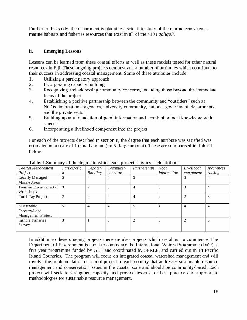
ii. Emerging Lessons
Lessons can be learned from these coastal efforts as well as these models tested for other naturalresources in Fiji. These ongoing projects demonstrate a number of attributes which contribute totheir success in addressing coastal management. Some of these attributes include:1. Utilizing a participatory approach2. Incorporating capacity building3. Recognizing and addressing community concerns, including those beyond the immediate
focus of the project4. Establishing a positive partnership between the community and “outsiders” such as
NGOs, international agencies, university community, national government, departments,and the private sector
5. Building upon a foundation of good information and combining local knowledge withscience
6. Incorporating a livelihood component into the project
For each of the projects described in section ii, the degree that each attribute was satisfied wasestimated on a scale of 1 (small amount) to 5 (large amount). These are summarised in Table 1.below:
Table. 1.Summary of the degree to which each project satisfies each attributeCoastal ManagementProject
Participation
CapacityBuilding
Communityconcerns
Partnerships GoodInformation
Livelihoodcomponent
Awarenessraising
Locally ManagedMarine Areas
5 4 4 5 4 3 4
Tourism EnvironmentalWorkshops
3 2 3 4 3 3 4
Coral Cay Project 2 2 2 4 4 2 3
SustainableForestry/LandManagement Project
5 4 4 5 4 4 4
Inshore FisheriesSurvey
3 1 3 2 3 2 3
In addition to these ongoing projects there are also projects which are about to commence. TheDepartment of Environment is about to commence the International Waters Programme (IWP), afive year programme funded by GEF and coordinated by SPREP, and carried out in 14 PacificIsland Countries. The program will focus on integrated coastal watershed management and willinvolve the implementation of a pilot project in each country that addresses sustainable resourcemanagement and conservation issues in the coastal zone and should be community-based. Eachproject will seek to strengthen capacity and provide lessons for best practice and appropriatemethodologies for sustainable resource management.
19
C. The Various National Proposals to Address Fiji’s Coastal Environmental Challenges have not yet led to an Effective Response
i. Introduction
The past decade has generated a number of important, overarching assessments and proposalswhich potentially complement the many efforts to address coastal environmental issues invillages and within individual economic sectors in Fiji. More recently, an increasing number ofministries and departments have sought to become more involved in national-localcollaborations. Further progress is needed at the national legal framework and administrativelevels to create a solid basis for enabling the most promising approaches and examples to beapplied more widely throughout the country and more consistently across all of the sectors whichneed to contribute to conserving coastal ecosystems and wisely developing coastal resources.
In addition, very little has been done by government to integrate environmental considerationsinto the economic planning process. The current decision-making process involves the sectoraldevelopment of policy papers that go through Central Planning office. If the policy has economicimplications it must be first considered by the Economic Strategy Committee, which hasemerged as the key policy formulating committee (Figure of present decision-makingframework). The decision-making process has thus dealt almost exclusively with economicissues without the integration of social and environmental issues. As a result the focus has beenon short to medium term development policies and strategies which creates a bias against theenvironment because they do not take into account environment protection which is visible onlyin the long-term (ESCAP Report 1998).
ii. The National Integrated Coastal Management Initiative is set within a BroaderEnvironmental Framework
The continuing debate on creating an environmental policy framework for Fiji is greatly enrichedby the action oriented projects described in Section II B which are able to overcome this lack ofpolicy. The number and diversity of local initiatives and pilot projects gives Fiji a rich source ofinformation about how tangible progress can be made. However, Fiji has not enactedframework-enabling legislation or have the full complement of institutional resources forsuccessful environmental policy, planning, regulation, and implementation.
Many good studies have been carried out and policy proposals developed, but relatively few ofthese have reached the stage where needed approvals and resources have been mobilized to putthe recommendations into action.
Mangrove managementIn 1985, a Mangrove Management Plan for Fiji was prepared, which contains a characterization,policies and maps of mangrove location, types, and use zones for the main islands including VitiLevu, Vanua Levu, Ovalau, Gau and Kadavu. This document is still used for decision-makingon foreshore reclamation of mangroves by the Lands and Survey Department.
20
The National State of the Environment Report for FijiThis key document prepared in 1992 remains the most recent and most referenced overview ofenvironmental trends and issues. It has not been updated, although more recent information onmany of the specific topics is available and have been compiled as sectoral databases. A separatevolume containing a proposal for national environmental policy was also prepared at the time,and led eventually to the preparation of the Sustainable Development Bill. The report, TheNational Environment Strategy for Fiji, includes an institutional analysis which wasaccompanied by a more detailed assessment and proposal for a new environmental law.
The Sustainable Development BillThese proposals are embodied in the "Sustainable Development Bill" the original version ofwhich was completed in late 1996. The Department of Environment coordinated thedevelopment of the original Bill, however, it has been extensively reviewed and reworked. Thecurrent strategy is to enact the less controversial components first and these have been combinedand are under final review. Even though the entire Bill is still far from adoption, most nationaladministrative departments and experts use this as the de facto environmental managementframework for Fiji.
Among the main provisions of the proposal which are of particular importance to coastalresources management, the Bill calls for the establishment of a National Council for SustainableDevelopment and the creation of 13 national policy statements, including "sustainable coastalmanagement".
Each ministry will be required to create its own environment management unit to formulate thepolicy statement, a natural resources inventory and resource management plan for resourcesunder its jurisdiction, and conduct internal environmental audits. Firms with more than 50employees must create environmental committees.
A formal legal framework for conducting environmental impact assessments (EIA) will becreated. Currently such reports are voluntary. A list of projects subject to an EIA includes manytypes of coastal development. It also requires that any commercial or industrial class of facilitythat discharges or generates pollutants must adopt a Code of Environmental Practice. Thefacilities must then periodically submit environmental audits to demonstrate compliance. Acorps of Environmental Inspectors would be appointed to enforce codes and requirements.
An Environmental Trust Fund would be created to support debt for nature swaps, biodiversityprograms, studies and plans. The Bill also proposes creating an Environmental Register topublish documents, public notices and codes of environmental practice. In addition, national"state of the environment" reports would be produced, and an overall National EnvironmentStrategy and a National Resource Management Plan will be formulated. Coastal resourceswould be featured in these documents.
A National Resources Management Unit is to be created that would prepare and maintain anational resource inventory including a Coastal Sensitivity Analysis and a national resourcemanagement plan which identifies appropriate uses for all natural resources, including "theconservation of biodiversity" and "the maintenance and enhancement of coastal areas, naturalstreams, rivers and water supplies".
21
Concern has been expressed about the feasibility of establishing such a modern publicadministrative structure for environment, with its budgetary and administrative implications. Astudy by the United Nations Economic and Social Commission for Asia and the Pacific, ESCAP(1998), states:
….the almost insignificant government funding of the Department of the Environmentclearly shows that the environment still holds a rather minor position in nationaldevelopment priorities. The Department of the Environment needs to be adequatelystaffed, both in numbers and qualifications, otherwise there will be little point inproceeding with the Sustainable Development Bill.
The Sustainable Development Bill includes relatively few references to the provincial and localstructures where some of the promising tangible steps in sustainable management are currentlyunderway. Fortunately, a number of ministries are already placing increasing emphasis oncommunity- based approaches in areas of critical concern.
Integrating Environmental Considerations into Economic Decision-making.Even more recently (1998), the United Nations Economic and Social Commission for Asia andthe Pacific, ESCAP, prepared an analysis on the Integrating Environmental Considerations intoEconomic Decision-making Processes at the National Level in Fiji. The report recommendedthat for government to effectively integrate environmental concerns into economic decision-making a combination of revised institutional and legal instruments with a comprehensivesystem of economic incentives, disincentives and educational and public awareness programneed to be implemented. The implementation of the Sustainable Development Bill wasconsidered a critical starting point.
The report also discusses examples of intersectoral conflict, especially land use conflicts,probably the most widely recognised example in Fiji. Because of the lack of a national land-usemaster plan prime agricultural land has often been wasted on developments such as housing andindustrialisation when poorer agricultural land could have been used.
22
iii. Selected Sectors are Now Beginning to Address Key Coastal Management Issues inPartnership with Local Entities
The management of coastal resources in Fiji naturally involves many government agencies(Appendix A). In the absence of an overarching framework, at times responsibilities may seemto be overlapping or conflicting. Fiji's successes to date appear to have been achieved throughactivities in some of the sectoral programs. The Sustainable Development Bill draft continuesbeing used as an ad hoc framework, with various departments already working to prepare policyproposals that will be required under the draft bill.
The Tourism Department, Department of Environment and Land Resources Planning andDevelopment Resource Planning Department have already drafted statements based on the Bill,and the Department of Environment prepared a proposal to initiate a programme to conservebiodiversity. The April 2002 workshop will also be a step in this direction.
Ministry of Tourism
The Fiji Tourism Development Plan 1998-2005, prepared by the Ministry of Tourism andTransport of Fiji, Deloitte and Touche, and the Tourism Council of the South Pacific calls for theadoption of the Sustainable Development Bill and for establishing a coastal zone managementprogram. It is an example of a government department taking into account sustainability and theimportance of the environment when developing a plan for an economic sector. The planidentifies weaknesses and hindrances to the tourism industry as well as opportunities forimproving tourism in the country and actions that should be taken.
Actions that should be undertaken include:§ Establishment of Tourism Development Areas where land ownership issues have been
resolved and development is planned appropriately§ Development of new resorts using Fiji style of design§ The government facilitating private investment§ Preservation of the environment through the Sustainable Development Bill and development
of a set of environmental standards for hotels and resorts§ Strengthening of the Ministry of Tourism and Transport and Fiji Visitors Bureau§ Closer collaboration within government departments that play a role in tourism
The plan also emphasizes the need for proper planning for tourism expansion and thedevelopment of guidelines including :§ Review of current planning legislation such as that within the Town Planning Act that
provides regulations for density, minimum site area, building height and parking fordifferent locations and types of accommodation
§ Coastal development requirements such as the 30 meter set back from High Water Mark forall coastal developments
§ Requirements for developers regarding sustainable water supply, proper surface drainage,proper sewerage system, waste disposal methods, electricity supply and energy efficiency,and road access
§ Need for Environmental and Social Impact Assessments for developments

23
§ Appropriate architectural, landscape design and site planning
A whole section of the plan is assigned to conservation and environmental protection due to theindustry being closely linked to the state of the natural environment. Recommendations include:§ The proper disposal of sewage to protect coastal waters§ The introduction of a Green Code that would encourage the improvement of environmental
standards of tourism operators and provide a marketing bonus to those resorts that subscribeto it. The Green Code would aim to avoid waste, promote proper waste disposal methods andthe conservation of water and energy
§ Reviewing the carrying capacity of small island resorts§ Strict enforcement of planning procedures for hotels and resorts§ Public awareness campaigns creating awareness of the fragility of coastal areas§ Integrated Coastal Zone Management so that cross-sectoral issues can be addressed§ The establishment of marine parks that tourist could access
The Ministry also has developed the Fiji Ecotourism and Village-based Tourism Policy andStrategy for Fiji which provides a platform for the development of small and medium touristenterprises by indigenous Fijians. The document addresses the increasing demand forecotourism, the need to involve more rural communities in tourism, the need to reduce negativeeconomic and socio-cultural impacts of tourism, and the promotion of environmentally friendlyforms of tourism. It also provides principles for ecotourism development in Fiji so that activitiesoccur in a more coordinated manner. Recommendations for implementation of the policy includethe formation of an Ecotourism Committee, the development of standards for ecotourismdevelopments, incentives for ecotourism development, and the need for integrated planning atthe village level.
Department of Land Resources Planning & Development, Ministry of Agriculture, Sugar andLand Resettlement
During 2001, a National Rural Land Use Policy Statement was prepared by the Department ofLand Resources, Planing and Development following a review of rural land use in Fiji. This wasrecommended by many previous documents as a priority of Fiji since there is no existing ruralland use policy or national land use plan. The lack of a rural land use plan is a major constraintfor wise resource allocation and management in the rural sector and is of critical importance as itcovers all land based resources such as forests, minerals, rivers and streams, and agriculture. Inaddition, the current administrative and institutional framework responsible for resourceallocation and management is highly sectoralised and coordination between agencies is lacking.These factors have constrained the development process and in many cases promotedunsustainable resource use.
The aim of the rural land use policy is to manage land for sustainable uses, balance productionand protection, create diversity and leave an enhanced heritage for future generations. Theprimary rural land issues were summarised as:• Population increase has placed pressure on the land resulting in land degradation and soil
erosion• Soil loss rates are well above what is economically acceptable
24
• Because of poor application of land husbandry practices the impacts from natural disasterssuch as droughts and flooding are becoming increasingly more acute
• Serious under resourcing by Government for line ministries responsible for land resources• Poor awareness of the interdependence of conservation and development
The adoption of a rural land use policy that incorporates multiple-use between agriculture,forestry, tourism, biodiversity conservation, urbanization etc can avoid planning conflicts and actas a standard and guide on which to make more effective decisions. One of the principles ofimportance when developing a policy is that land use decisions are based on whole watershedland management planning.
Within the statement various national policies are proposed including:1. Increased public awareness that land resources are interdependent and must be managed in
an integrated way and responsibility of individuals and communities for preventing landdegradation
2. A regulatory framework for the protection and sustainable management of rural landresources
Other recommendations arising from the review study which led to the policy include:• The establishment of a National Land Use Council to oversee all aspects of land resources
development and management at the national level• The establishment of land use planning groups at the provincial or divisional level that would
operate at an intermediate level between land husbandry committees and nationalgovernment (Leslie and Ratukalou 2001).
Department of Environment
The Fiji Biodiversity Strategy and Action Plan, FBSAP, was prepared through the Department ofEnvironment and is the result of the work of six technical groups, six community workshops anda steering committee. The strategy focuses on conserving the genetic, species and ecosystemdiversity of the country. It has six areas of focus:
• Community support – awareness, involvement and ownership• Improving our knowledge• Developing protected areas• Species conservation• Control of invasive species• Capacity building and strengthening
The strategy observes that Fiji has only a 'rudimentary' system of protected areas and that it istime to create a 'Sites of National Significance Program' that would provide legal protection andestablish management plans. It also reiterates the need to build human and institutional capacity:
The current administrative framework for biodiversity conservation in Fiji is poorlydeveloped with ill-defined responsibilities, a lack of capacity and severe fundingconstraints.
25
The FBSAP envisages a major `step-change’ from the current predominantly passiveapproach based on resource management for extractive purposes with little inherentbiodiversity management capacity, to an active, `hands on’ management with adequatedomestic technical capacity.
Recognizing the importance but limitations of external donor funding of the initiative, theFBSAP envisages the Government’s main initial contribution will be:
• to endorse the FBSAP as Government’s policy on biodiversity planning andmanagement
• put in place the required legislative and administrative framework• to develop a national capacity for biodiversity management with trained specialists
and• to address the issues of a rapidly increasing requirement for recurrent funding for
biodiversity management.
Finally, the proposal recommends moving away from the 'command and lead mode' andrecognizes the role of provincial authorities, civic organizations, land and fishing rights ownersand the private sector. It builds upon existing initiatives, listing 104 ongoing and new projects tocarry out 19 objectives.
Because Fiji is a signatory to the UN Framework Convention on Climate Change it is obliged toprovide a National Communication document that includes information on climate changevulnerability and adaptation implementation policies and strategies. These requirements weresupported by the Pacific Islands Climate Change Assistance Programme (PICCAP) based at theDepartment of Environment, thus a Climate Change Vulnerability and Adaptation Assessmentfor Fiji was carried out using Viti Levu as a case study. A number of personnel were involved inthe assessment including SOPAC, the Departments of Agriculture and Lands, and USP.
This document provides information and data on the implications of climate change on foursectors: agriculture, coastal resources, human health and water resources. Anticipated impacts ofclimate change and sea level rise on the coast of Viti Levu include:• shoreline erosion• increased storm damage and flooding• salinity intrusion into water tables• increased salinity of rivers• disappearance of wetlands and• possible reef destruction due to increased sea surface temperatures.
Adaptation strategies identified include :§ improved understanding of coastal dynamics through data collection exercises and
monitoring programs. Structural or bio-engineered coastal protection projects require sitespecific data and analysis before being considered
§ examination of coastal protection options for reducing erosion risk§ land use planning§ protection of mangroves and reefs which are a natural protection system§ adequate pollution control, to prevent reef die-off§ use of setbacks from the shoreline and low-lying areas in the construction of buildings and
26
§ mangrove replanting in degraded areas.
iv. Conclusions
It seems clear that many of the ingredients needed for building Fiji's capability to sustainablymanage its coastal resources are close at hand. Fiji's major issues are understood well enough tojustify key decisions and set priorities for the near and medium term. Site based initiatives andoverall policy proposals are well articulated, and the follow-up work of a number of ministriesare all providing some direction toward a practical approach. The absence of a formal legalframework is not a major hindrance for making some significant progress in the near term.
Not all of the conditions needed for progress are present in the right amount. Most of theprojects which are underway on the ground reflect donor or funder priorities and interests, ratherthan being shaped by an overall Fijian strategy to cover all of the priority needs. While theremay be a number of useful projects underway, these seem to be single purpose and opportunistic.There is not yet a unifying focal program within a Fijian program that has sufficient core fundsto enable it to leverage and shape the direction of the many potential sources of assistance.
A number of actors within the government sector are demonstrating their willingness to carry outcollaborative activities. It is likely that everyone would benefit from initiatives that provide thecatalyst and reasons for different sectors to work together. Such activities could be designedthen used as the basis for fund raising and buy-in by a range of donor groups.
The following section uses a specific example, the Coral Coast of Viti Levu, to help explore whyand how a common agenda and unifying framework for meeting the coastal management needsof a province might be formulated.
III. HOW MIGHT COASTAL MANAGEMENT WORK IN FIJI?THE EXAMPLE OF THE CORAL COAST
Why use a case study?
One of the emerging conclusions from the work in specific places as well as the national policyproposals and assessments is the value in preparing plans and solving problems using amplecommunity and stakeholder involvement. This means that many of the specific policies andimplementation actions will need to carefully reflect local conditions, aspirations and capacity.A complementary conclusion is that an overarching legal framework is required to back up sitebased decisions with fairness, transparency and the rule of law, as well as technical and humanresources that a village or tikina by itself could never mobilize.
The question becomes one of discovering how this might work and what path can be followedstarting right now to build up these respective local and national capabilities, while workproceeds, hopefully at a quicker pace, to set the needed supporting legal and administrativemechanisms in place.

27
Coastal resources are very important to the current and future development of the Coral Coast.The reef ecosystem and shore offers an exceptionally important natural environment which hasvalue for traditional use forms, the current economy and for innovative sustainable uses that cancontinue to contribute to social and economic well-being. The issues faced in the area are salientto villagers, investors, visitors, fishers, researchers, non-governmental organizations and publicagencies, thus there is a constituency for new ways to address and solve problems. A variety ofefforts are already underway to address individual concerns, as well as several good examples ofcollaboration across agencies, communities and economic sectors, as well as among the levels ofgovernment. It seems well worth the effort to look closer at this special area to see how effortsto solve its problems might lead to the discovery of mechanisms and processes that could befruitfully employed throughout the country.
A. The Coral Coast Presents Many of the Issues as well as PromisingSolutions for Achieving Sustainable Forms of Coastal Resource Use
The Coral Coast represents an almost full range of coastal issues encountered in Fiji, for exampletourism, improper methods of disposal of solid waste, sewage pollution, depletion of fisheries,coral harvesting, coastal erosion, storm surge and flooding, siltation of rivers and coastal areas asa result of soil erosion inland, some agriculture and forestry, and sand mining. It also representsan area with a wide range of experiences in environmental planning and management; manyenvironment-related workshops have been held in many of the villages, marine protected areashave been set up in one tikina, waste management projects have been undertaken, mangrovereplanting efforts are fairly widespread, the issue of coastal erosion has been addressed in onevillage, and some of the hotels have been involved in environmental clean up campaigns andmonitor their water and environment for pollution.
These efforts provide in miniature a compilation of available information about resources, issues,current interventions and successes, and proposals for action for a geographic area that can beused as a basis of a National Policy Paper.
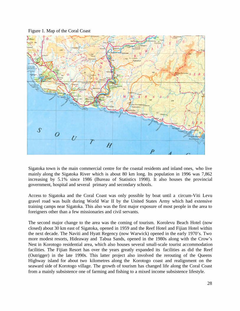
The Coral Coast (Figure 1) is situated on the south western coast of Viti Levu and is the longestchain of fringing reefs in Fiji. It is a major tourism area with a number of large hotels and smallertourism operators spread out along the coast. It encompasses the coastal areas of the province ofNadroga-Navosa from the village of Navutulevu through till the Fijian Hotel at Rukurukulevuvillage.
28
Figure 1. Map of the Coral Coast
Sigatoka town is the main commercial centre for the coastal residents and inland ones, who livemainly along the Sigatoka River which is about 80 km long. Its population in 1996 was 7,862increasing by 5.1% since 1986 (Bureau of Statistics 1998). It also houses the provincialgovernment, hospital and several primary and secondary schools.
Access to Sigatoka and the Coral Coast was only possible by boat until a circum-Viti Levugravel road was built during World War II by the United States Army which had extensivetraining camps near Sigatoka. This also was the first major exposure of most people in the area toforeigners other than a few missionaries and civil servants.
The second major change to the area was the coming of tourism. Korolevu Beach Hotel (nowclosed) about 30 km east of Sigatoka, opened in 1959 and the Reef Hotel and Fijian Hotel withinthe next decade. The Naviti and Hyatt Regency (now Warwick) opened in the early 1970’s. Twomore modest resorts, Hideaway and Tabua Sands, opened in the 1980s along with the Crow’sNest in Korotogo residential area, which also houses several small-scale tourist accommodationfacilities. The Fijian Resort has over the years greatly expanded its facilities as did the Reef(Outrigger) in the late 1990s. This latter project also involved the rerouting of the QueensHighway island for about two kilometres along the Korotogo coast and realignment on theseaward side of Korotogo village. The growth of tourism has changed life along the Coral Coastfrom a mainly subsistence one of farming and fishing to a mixed income subsistence lifestyle.
29
The tarsealing of the main road in the early 1970s made travel to Nadi and Suva much moreconvenient. Sigatoka town expanded considerably at about this time with new shops and movietheatres, but except for some tourist shops, has returned to its sleepy nature since then. A newsports stadium and modern bridge across the Sigatoka River are recent developments.
The Sigatoka sand dune area, which has been declared Fiji's first National Park, is a major touristattraction. Another tourist attraction is the Tavuni Hill Fort, a fortified site occupied by Tonganimmigrants to Fiji and located a few miles inland from Sigatoka on the east side of the river. TheKula Bird Park is located in a valley inland from the Outrigger Reef Resort. The Kalevu CulturalFacility built near the Fijian Resort, an attempt by the Fijian resort landowners to further benefitfrom tourism, has had an “up and down” history. A major government ecotourism effort,Waikatakata, including waterfalls and hot springs inland from Votualailai failed due to landdisputes. There are also a few small restaurants along the coast and a village dive operation.
Besides tourism, agriculture is an important industry with vegetable farming in the SigatokaValley and sugar cane near the coast. Vegetables are sold to the municipal markets, to hotels, andin the larger cities. The sugar cane is transported by light rail to Cuvu, where the local companyoffices are, and then to Lautoka for milling. Industry is almost non-existent, there is a smalljuice-making facility in Sigatoka town and a coconut furniture-making facility near Naevuevuvillage.
B. “Sun, Sea, Reefs”
The Coral Coast has a number of physical characteristics which make it attractive to tourists aswell as local populations. These include a mile climate, a variety of natural habitats, and anumber of interesting natural and cultural features. There are few constraints to developments,such as cyclones.
i. Climate
Temperature is relatively consistent due to the ocean ranging from a low of 18oC during thecoolest months (July-August) to a high of 32oC during the warmest months (January andFebruary) . Rainfall is highly variable and mainly orographic often falling in heavy, brief localshowers. In addition, Fiji experiences a distinct wet season (November to April) and a dryseason. Annual rainfall for the area is expected to be between 2000 and 3000 mm. Thepredominant winds are the trade winds from the east to southeast, which are generally light tomoderate in strength. Tropical cyclones which occur from November to April can cause highwinds and have caused widespread damage in the area in the past (Pitman et al 2001).
Storm surge, which is a temporary rise in the level of the sea caused either by very lowatmospheric pressure that causes the water level to rise or the piling up of water against a coastdriven by strong winds (both associated with cyclones), occur on the Coral Coast. The mostrecent was in early 2001 which resulted in flooding of coastal areas and damage as a result of
30
huge waves. It is recommended to design infrastructure for protection against inundation at alevel of 3.3 metres above mean sea level to protect against a 1:50 year event (Reidel and Byrne1989).
ii. Natural Habitats
Coral ReefsThe well developed fringing reefs of the Coral Coast extend almost unbroken for 63 km and havea seaward extension of 500 to 1000 meters. The only major gap is at the mouth of the SigatokaRiver. Where creeks descend from the hills the reef is broken by passages of 100 to 300 metersacross (Coral Reefs of the World). The fringing reef has a shallow tidally submerged platformwhich is interspersed with moats and channels. Beyond the platform is a consolidated reef crest.The shallow lagoon-like nature of the reef-flat permits snorkeling at high tide. The reefs at Cuvu,Korolevu, Namatakula, Komave and Malevu have been described in detail by Morton and Raj(1980).
Beaches & DunesThe reefs are backed by beautiful white carbonate sand beaches. The unconsolidated sedimentsmaking up the beaches are a mix of terrigenous, calcareous and other shallow water marinesediments. Active sand transport is mainly due to the west and longshore drift (Pitman et al2001).
At the mouth of the Sigatoka River, terrigenous sands have built up into high dunes where scenicand educational walks are done.
Lagoons & Coastal WatersAlong the Coral Coast the lagoon is fairly narrow due to the 200 meter isobath being only around1 km offshore. Average depth of the lagoon is around 2 meters making it suitable for swimming,snorkeling, and fishing. Bathymetric surveys conducted by SOPAC indicate that the passagesand reef areas can attain depths of around 200m that drop to around 800 meters offshore. Watertemperature is always above 20oC with summer maximum around 30oC. Tides are semi-diurnalwith neap tides having a mean range of 0.9 m and spring tides 1.3 m (Ryland 1981).
Marine water quality is fairly good. Few studies, however, have been carried out along thisstretch of coast. Studies by USP conducted in the lagoon offshore from the Outrigger Resortindicate that nutrient levels often are higher than acceptable limits and faecal coliform levels attimes may exceed acceptable levels after heavy rains, especially at the mouths of creeks andnearshore waters.
MangrovesMangroves are present only adjacent to a few villages along the coast to the east of Sigatoka.Votualailai, Tagaqe, Vatukarasa, and Korotogo have mangrove areas and mangroves werereported to be present adjacent to Namatakula, Komave, Navola, and Malevu in the past.Mangroves are more commonly found to the west of Sigatoka and occur in the villages ofYadua, Naevuevu, and Rukurukulevu.
31
Creeks & RiversStreams and rivers dissect the coast in many sections along the Coral Coast.
Coastal ForestsThe coastal areas east of Sigatoka front the Southern Coastal Range of mountains where coastalforest occurs. A logging concession area, Navutulevu, is active in the Coral Coast area. In 1997,3,608 m3 of timber was harvested from the area.
iii. Natural & Archaeological Features
There are a number of natural features along the Coral Coast that are attractive to the tourismindustry. These include limestone caves in several places, waterfalls at Biausevu and inland fromVotualailai and also hot springs near the latter waterfall. There are also a number ofarchaeological sites such as the lapita pottery within the sand dunes and Tavuni Hill Fort nearSigatoka.
C. Village Life and the Tourism Economy
i. Villages & Population Characteristics
Within the Coral Coast area being studied are 4 coastal tikinas. These include Komave, Korolevui Wai, Conua, and Cuvu. Within these tikinas are around 18 coastal villages and an additional 4settlements. The largest village is Cuvu with 560 people and the smallest is Sila with 73 people.
District Village Population
Conua Tikina Korotogo 380 (2002)Malevu 203Vatukarasa 450
Cuvu Tikina Yadua 336 (1999)Rukurukulevu 249Sila 73Tore 106Naevuevu 324Cuvu 560Hanahana 89Voua 350
Komave Tikina Komave 200 (2002)Navola 100Vucilevu 158Namatakula 300
Korolevu i Wai Tikina Votua 260 (2002)Votualailai 154Tagaqe 260
32
Namada 300
All residents of these villages are indigenous Fijians. There is also a tikina of 8 villages close toSigatoka town, which is about two kilometers from the river mouth. Settlements at Korotogo,Votua, Cuvu, and Korolevu have built up mainly to house people working in the tourismindustry. The Indo-Fijian population along the coast is concentrated in the sugar cane growingarea from Korotogo to Cuvu and the town of Sigatoka (population in 1996 was 7862).
Most of the indigenous people are Methodist by religion. In the 1995 provincial profile ofNadroga province 73.4% of the population were Methodist, 8.6% Catholic, 8.3% Assemblies ofGod, and 5.8% Seventh Day Adventist.
All the major villages have a village nurse. In most of the villages, many households still utilisepit toilets as compared to septic tanks. Only in Vucilevu and Votua did most households haveseptic tanks.
Between Namatakula and Sigatoka there are 3 village primary schools, one in Namatakula (RatuFilise), one in Navola, and one in Tagaqe (Tagaqe District School). There are also severalprimary and secondary schools in the Sigatoka and Cuvu areas. Literacy rate is very high.
ii. Utilities
All the major villages between Namatakula and Sigatoka have electricity supplied by the FijiElectricity Authority, although not all houses have electricity, and piped water. The 8 majorvillages west of Sigatoka all have electricity and piped water.
Transportation is by road either by bus or carrier. The major Queens Highway that links Suvawith Nadi runs parallel to the coast and through or fairly near most of the villages on the CoralCoast. The highway was upgraded and sealed in the 1970s.
In almost all villages a few households have telephones and a few have video sets. Radio isprobably the most widespread means of communication. TV transmission was extended to theCoral Coast in 1994.
iii. Economic Sectors
TourismThe Coral Coast is one of the major tourist destinations in the country. It began with the openingof the Korolevu Beach Hotel in 1959 and experienced significant growth in the 1970s after thesealing of the Queens Highway. Along the Coral Coast there are 7 major hotels/resorts and anumber of smaller guesthouses and backpacker accommodation. Dispersed between these touristdevelopments are villages. These villages own land on which the resorts/hotels are located, areemployed at the hotels, often provide entertainment at the hotels, and some host tourists in their
33
villages. In many villages, at least one member of each household will be employed in thetourism industry. Thus tourism is the main income earner and economic activity on the CoralCoast for the local indigenous people. It provides financial benefits and leads to an improvedstandard of living. The resorts often provide assistance to villages when needed.
FishingThe fringing reefs are important sources of subsistence fish and shellfish for all the coastalvillages, however very few are involved in commercial fishing. A survey of the subsistence andartisanal fisheries in Namatakula village in 1993 estimated the frequency of fishing in thevillage. It was estimated that 28 people fished 3-7 times/wk, 22 people 1-2 times/wk, 4 morethan once a month, and 7 less than once a month. The length of a fishing trip ranged from 0 to 4hours and the habitats most fished were the outer reef edge, inner lagoon, estuary and on theedge of the mangroves. Methods most commonly used were spear, handlines, collecting and gillnets. Target species included emperors (sabutu, kabatia), octopus, rockcod, trochus, Siganids,Carangids, prawns, the mangrove jack, crescent perch, and parrotfish (Rawlinson et al. 1994),kabatia, kawakawa, sabutu,tivitivi, sevou, ta, ulavi, kasala, kawago, cawaki, kanace, kuita,damu, donu,nuqa, salala, and parrot fish. The only villages that issue licences for commercialfishing are Komave (1), Vatukarasa (1) and Korotogo (3). Namatakula and Namada sell theirexcess fish.
Coral HarvestingCoral harvesting is carried out in 3 villages along the coral coast. In Komave it is limited andonly individuals sell the coral to Walt Smith International. In Namada coral harvesting isextensive, starting back in 1998 and is a main income source with households earning around$200 per week. In Vatukarasa it is also extensive. Both villages sell the coral to Walt SmithInternational, a company based in Lautoka.
Land UseThe logging and planting of hardwood continues today in the forested inland areas of TikinaKorolevu i Wai. In the 1970s a sawmill was in operation inland from Tagaqe.
The land along the Coral Coast is mostly hilly with only small areas of agriculture potential.People in the villages have small plantations mainly of root and tree crops that meet theirsubsistence needs. The Sigatoka Valley, however, extends about 80 km inland and has fertileplains which are under intensive use by small-scale vegetable and sugar cane farmers earning itthe name the “Salad Bowl of Fiji”. Sugar cane is also planted starting to the west of Korotogovillage, mainly by Indo-Fijian lease holders. Around 20% of the employed villagers in Cuvutikina work in the cane farms.
Mineral ExtractionLimited sand and gravel extraction is carried out within a number of villages includingNamatakula, Komave, Votualalai, and Vatukarasa. This is mainly used to construct houses andseawalls. In the past extensive gravel extraction occurred at Tagaqe Village and presumablyothers to upgrade the Queens Highway in the 1950s, 1960s and 1970s (Pittman et al 2001).
34
D. Coral Coast Issue Profile
As part of this project a survey of coastal villages from Namatakula to Korotogo was undertaken.Major findings from this survey and a review of information on Cuvu tikina villages arehighlighted in the sections that follow.
i. Environmental Issues: Resource Degradation
Coral HarvestingCoral harvesting for the aquarium trade occurs in 3 villages in the study area. Live rock (reefrock covered with coralline algae and associated fauna and flora) is removed from the reef asblocks 15-35 cm in diameter usually by iron bars. Collectors gather from areas predetermined bythe chief. Impacts of coral harvesting includes breakage of non-target species, potentialdestruction of coral population, potential reduction of reef topography and conflicts with tourismoperators.
Deterioration of Coral Reefs & OverfishingDeath of coral is a problem encountered by many of the villages. The main causes are thought tobe siltation from upland erosion, sale of coral, and flooding and freshwater input. Fish abundanceis reported to be declining in some villages and some intertidal species are becoming rare. Theuse of traditional fish poisons may also be a factor. In the villages of Cuvu tikina, the decline inabundance of marine life is also attributed to the use of undersized nets, illegal fishing byoutsiders, and modern fishing methods such as diving and spearfishing.
Deterioration of Coastal Water QualityDeteriorating water quality seems to be a major concern for many of the villages and is oftenblamed on the nearby hotels disposing of their solid waste and sewage waste into the ocean.However, the continued dependence of most of the villages on pit toilets and septic tanks out ofwhich sewage waste may leach during heavy rains and the location of pig pens close to the oceanin many of the villages probably also contributes to sewage pollution in the coastal waters.
Coastal ErosionCoastal erosion is one of the more serious concerns for the villages along the Coral Coast atpresent, especially for those east of Sigatoka. All villages except Namada and Korotogo, both ofwhich have the highway between the village and the shore, indicated that coastal erosion was amajor problem especially during storm surge. These storm surges damage existing seawalls,wash away houses, and cause extensive erosion of shoreline.
PollutionThe disposal of rubbish in the village and on the coast is mentioned in all villages. This is mainlyplastics, tin cans, and other non-biodegradable solid waste. Due to there being no formal rubbishcollection villagers often dispose of rubbish along the coastline assuming that the ocean willremove it. Siltation is also a problem in Namatakula, Komave, Navola, Tagaqe, Vatukarasa andKorotogo especially during heavy rain. Votua and Votualailai also mentioned that the disposal of
35
rubbish from nearby hotels and sewage disposal from the Votua Housing via a small stream are amajor cause of pollution in their coastal waters.
Overgrowth of AlgaeThe overgrowth of algae, especially Sargassum species, is mentioned to be a problem in allvillages east of Sigatoka except Votua, Votualailai and Korotogo. The excessive growth of algaesmothers coral and is thought to be due to elevated nutrients in the waters, siltation, and higherocean temperatures.
LoggingLogging is still carried out upriver of Komave, Navola and Votua villages and on the slopesabove Tagaqe and Namada. The logging is primarily pine and is thought to be a major cause ofsoil erosion. Deforestation and burning were also problems in Cuvu tikina.
FloodingFlooding during heavy rains is another major concern of the villages along the Coral Coast. Intwo villages, Votualailai and Korotogo, the construction of the Queens Highway has contributedto the flooding in the village. In Korotogo the road is higher than the village and inappropriatelyconstructed culverts lead to flooding in the village during heavy rain.Other ProblemsOther issues include piped water becoming dirty during heavy rain, the depletion of fish in SoviBay and nearby rivers as a result of sand extraction, the use of chemicals for prawn and eelfishing, and the loss of mangroves and coastal forests.
ii. Socio-economic Issues
CrimeThe level of crime in areas along the Coral Coast has increased over recent years, especially inthe area between Malevu Village and the Korotogo area. This area has a number of hotels andresorts fairly close to several villages. As a result of the increasing crime a police post was builtin Korotogo. The business community have also become involved in curbing crime by involvingthe local youth in sports. For example the Outrigger Resort last year sponsored the Navosa rugbyteam (Verebalavu pers. comm.).
Social changes of tourismApart from the negative impacts tourism may have on the environment such as pollution ofcoastal waters from hotel sewage and chemical waste, tourism also has negative social impactson local communities on the Coral Coast including changes in cultural attitudes, reliance on hotelemployment rather than pursuing education, and new diseases. In Cuvu tikina the increase in thenumber of villagers employed at the hotel has led to a change in diet as a result of people buyingfood from the store as compared to the past where food was obtained from the ocean and forests.Of course, tourism also provides extensive employment opportunities and a large amount ofmoney to the owners of hotel leases.

36
iii. Institutional & Legal Issues
Conflicting coastal resource management optionsThe absence of cross-sectoral planning often leads to conflict among coastal resource uses. Acommon intersectoral conflict is present on the Coral Coast. This is between land-based activitiesand coastal resources. Sedimentation and flooding caused by poorly managed and designedland-based activities such as agriculture and logging threatens the productivity of coastalecosystems.
Severe upland erosion resulting from poor logging practices behind a major resort led to thesiltation of the resort water supply and impacted on tourism activities such as hiking andfreshwater swimming (ESCAP 1998). There is also currently conflict between tourism and coralharvesting activities in certain areas as a result of degradation of coral reefs caused by coralharvesting.
The resolution of such problems can only be possible through a coordinated effort of manydepartments including NLTB, Forestry, Fisheries, Environment, and Tourism.
Conflict within resource owning institutionsConflict on the management of marine resources has resulted within one tikina as a result ofsome members choosing to exploit the reefs for economic gain and others wanting to stop theactivity and use the resources in a sustainable way.
Lack of legislationAs already mentioned, many of the environmental and social problems that exist are partly due tothe lack of appropriate and effective legislation and policy. Examples are the lack of legislationrequiring an EIA for development projects and the lack of a national policy to control andmonitor coral harvesting.
Interpretation of Marine Tenure SystemResort owners, particularly in the past, often laid claim to the marine environment fronting theirland and would often not allow nearby villagers to cross the beach or use the lagoon. Recently,the local communities are now claiming that they have accessibility rights to lagoon and reefareas and that tourist operators should pay them to use these areas for recreation. This has led toconflict in some instances.
C. Promising Initiatives
The Coral Coast has many examples of promising initiatives by government agencies, NGOs,village communities, hotels, and other organisations.
i. Mangrove Replanting

37
The Coral Coast is leading the way in Fiji in mangrove replanting to improve fisheries andaddress coastal erosion. Villages involved include Namatakula, Vucilevu, Korotogo, Yadua andTagaqe District School. The efforts are currently been led by a Japanese environmental group,the Organization for Industrial, Spiritual, and Cultural Advancement (OISCA) working togetherwith a local group CYDA and carried out by village groups, schools or visiting Japanesevolunteers. In the past the South Pacific Action Committee for Human Ecology & Environment(SPACHEE) and USP also carried out mangrove replanting in the area. Mangrove replanting isalso being organised at other sites outside of the Coral Coast.
ii. Village Marine Resource Management
A number of marine resource management activities are being carried out or are pendingincluding bans on coral harvesting, restrictions on fishing, monitoring of beche de mer fishing,and discussions on setting up a tabu area in Korolevu i Wai Tikina. Only Votua villageoriginally had an Environmental Committee. However, Tikinas Komave, Korolevu i Wai, andCuvu have established Environment Committees.
iii. Marine Awareness Workshops
In the past awareness workshops on coastal and marine issues have been conducted along theCoral Coast by USP (Namatakula and Navutulevu), Ministry of Tourism, Department ofEnvironment, FAB, WWF (Lomawai Tikina west of Coral Coast) and FSP (Cuvu Tikina).Villages indicated that awareness programs on conservation of their coastal resources are greatlyneeded.
iv. The Coral Gardens Initiative: Cuvu Bay Restoration Project
The Foundation for the Peoples of the South Pacific is carrying out a community basedconservation programme in Cuvu Tikina dealing with issues of conservation, management andrestoration of coral reef resources . The initiative involves the local communities and theShangri-La Fijian Resort in environmental awareness and marine resource management andintroduces active coral planting methods for habitat enhancement as well as assistance indeveloping sustainable income generating incentives.
The Cuvu Tikina Council adopted the Coral Gardens Project in July of 1999 and appointed anenvironment committee to act on environmental issues within the tikina. A series of PLA(Participatory Learning & Action) workshops were conducted for the eight villages in the tikina.These workshops identified the major environmental concerns of the area and managementaction plans were formulated. Issues identified included overfishing, freshwater flooding ofCuvu Bay, high levels of nutrient runoff, hydrology problems caused by the present resortcauseway crossing, and infestation of crown of thorns starfish. Action plans included the settingaside of four tabu areas for the tikina and the establishment of a marine park for the Fijian Hotel.A youth group has also undergone training in Awareness Community Theatre (ACT) to promoteenvironmental education for communities, schools and resorts in the nearby vicinity. Anotherproject focuses on improving waste disposal methods. Other sections of the plan recommend a

38
ban on destructive fishing methods, size limits for certain species, erosion control in farms andgardens, and reforestation of the hillsides (Billings, 2002)
v. Coastal Processes and Erosion at Tagaqe Village, Coral Coast, Fiji Islands
The South Pacific Applied Geoscience Commission (SOPAC) was requested by the MineralResources Department of Fiji to investigate the causes of the coastal erosion at Tagaqe andrecommend the most appropriate management strategy to minimize the impact of coastalerosion. Methods used included review of baseline data, past activities in the area, bathymetricsurveys, current measurements, and the analysis of aerial photographs.
The village is located 20km east of Sigatoka and is eroding at an increasing rate. Three areas ofconcern were identified by the analysis of aerial photos:1. The Tagaqe village beach has eroded 30-40m since 1951.2. The Tagaqe river mouth has changed course over the years.3. The adjacent area west of Tagaqe village has eroded approximately 10m since 1951, and
may be a threat to the Queens Highway in the future.A number of causes of coastal erosion were identified including:• Natural causes such as a naturally high mobility of the shoreline at some locations, cyclones
and storms, variations in wind and wave conditions causing cycles of erosion and/oraccretion, changes in sea level, and changes in the natural supply of sand to the coast
• Human-related causes such as building too close to the shore, construction of verticalseawalls , removal of beach sand, dredging of lagoon sediments and coral reefs including reefblasting, disruption of natural sand movement by groynes, removal of mangroves, andchanging river channel direction
Recommendations to reduce erosion and mitigate problems in Tagaqe village included:§ Non-structural solutions are the preferred approach for dynamic coastal sites such as this§ Nourish and stabilize the shoreline with vegetation such as mangroves§ Village physical development, infrastructure and tourism siting strategy should adopt
building at least 30m back from the high tide water mark§ Partial or full seawalls to protect existing structures, such as the village beachfront and the
burial site are measures of last resort, and are not a preferred long term solution§ Placing of sediment settling mats to slow down water movement and settling out sediment in
priority locations(Pitman et al. 2001)
vi. Tourism Workshops
As part of Resolution 3 of the Environment Sub-committee of the Tourism Forum, a Tourismand Environment Awareness Campaign was launched as a first step in developing environmentalawareness and education for the tourism industry. The first phase involved village and schoolworkshops and consultation with local backpacker operators. The workshops were carried out in40 villages, 29 schools and 19 backpacker facilities, and involved discussions regarding thebenefits of tourism and the need to conserve the natural environment and promote sustainabledevelopment. The workshops were conducted in tourism 'hot spots" along the Coral Coast,
39
Vatulele, Malolo and Yasawa Group of islands from June to November 2001. The workshopswere conducted in the Fijian language and later in English at schools by a team of personnelfrom Fiji Visitors Bureau, Environment Consultants, Police, Roko Tui Saravanua andDepartment of Health.
Specific objectives were:1. Discuss the economic, social, cultural and environmental benefits of tourism2. Highlight economic, social, cultural and environmental problems affecting tourism3. Discuss the role of the communities and schools in maintaining the environment for a viable
tourist industry in Fiji
Issues highlighted in the workshop that affect tourism included crimes committed on tourists,land and fisheries disputes amongst landowners or between landowners and the tourist operators,rights of access to land leased by tourist operators, and rights to determine activities of touristoperators within their customary fishing grounds.
The importance of coastal habitats, such as coral reefs, sea grass beds, mangroves, and coastalforests, were also highlighted in the workshops as were environmental issues such as destructionof coral reefs through coral extraction, use of destructive fishing methods, destruction ofmangroves, deforestation, excessive fertiliser use on land, use of pesticides and other chemicals,and sewage pollution.
The second phase started in December 2001 and involved the use of TV and radio to broadcasttourism and environment information.
vii. Environmental Impact Assessment – Natadola Marine Resort
Natadola Beach is of international quality and has been recognized as having potential fordevelopment as a major tourist resort. Sanasana village lies adjacent to Natadola Beach. Thesevillagers are important landowners and rely heavily upon the marine resources for subsistence,cash crops and the selling of shells to tourists. Off Sanasana village is Navo Island, a limestoneisland of national archaeological and cultural significance. It is proposed for the Natadola MarineResort to be located on 300 ha of state and native lease land adjacent to the village and the beach.Current plans include 4 hotels, condominiums, an international standard golf course and amarina.
An EIA was thus commissioned by the Fiji Government to review the competing demands forNatadola, their environmental impacts and make recommendations that will protect theenvironment, interests of local residents, current users of the beach and the economic well beingof Fiji. Environmental Consultants Fiji was appointed to carry out the EIA.
Significant issues identified included the impact on Sanasana village community, public access,provision of worker accommodation, and the fate of Natadola Beach Resort and tourist train.
Potential negative effects of the development include:
40
• Changes to Sanasana village and villager’s lifestyle such as loss of privacy, loss of access totraditional land for growing crops and reduction of productivity of i qoliqoli.
• Modifications of marine environment and coastal processes such as increase in suspendedsediment from construction works and physical damage to reefs from reef walking andanchors.
• Adverse effects resulting from the demand for workers housing• Loss of public access• Damage to archaeological sites
Positive impacts include:• A major contribution to Fijian economy• Significant social and economic opportunities for Sanasana villagers• Protection of beach vegetation and improvement in water quality• Provision of public facilities at beach
Key recommendations put forward to ensure that the resort has minimum impact on existingphysical and social environment include:• Marina does not proceed until further investigations are completed to ensure no adverse
effects on marine environment will result• A buffer between the beach berm and resort facilities is established• No continuous solid structures are built in any foreshore location• A bond be required from the developer to cover government's potential environmental and
financial liability• The developer prepares an environmental management plan that includes monitoring• The developer assists the people of Sanasana village prepare for the development• Government be proactive in planning for workers accommodation
It should be noted though that the most important aspect of an EIA is not just the process andcarrying out an EIA but what results from the EIA. For example recommendations of an EIA areonly useful if for example the Town and Country Planning or other agency includes these indevelopment approval conditions and enforces these during the construction and operationsphases of the development (Environmental Consultants Fiji. 1999).
viii. Sustainable Land Management – Bemana,
The Land Use section of the Department of Land Resources Planning and Development haveconducted Participatory Rural Appraisal (PRA) workshops in Bemana Tikina, Nadroga toidentify the problems faced by the communities, identify resources available and understand thesociocultural and economic needs of the people. It also included a physical appraisal of theresources available. The main aim, however, was to developing a PRA- derived land use plan forthe area. Recommendations were also made on the sustainable development of resources such asland, forests and the tore (lake) so as to improve the standard of living in this rural area.
It was found that agriculture was the main source of income for the villages in the tikina.Problems in the tikina include:

41
§ lack of infrastructure such as roading and access§ lack of agricultural implements and high costs of inputs§ lack of arable land§ river bank erosion§ lack of entrepreneurship§ no fixed market§ increase in social problems due to population increase
The land use plan identified the resources available and their potential such as replanting of kuta,fish and prawn farming, watermelon farming, pine plantations, logging of indigenous forest,cattle raising, and small scale tourism (Department of Land Resources Planning andDevelopment 2001).
ix. Sigatoka Sand Dunes National Park (SSDNP)
In 1988, the Government of Fiji decreed the Sigatoka Sand Dunes as Fiji’s first National Park. Itis an area of outstanding landscape, biological interest, and one of the most importantarchaeological sites in the Pacific. It is the burial ground of more than 100 people dating backnearly 2000 years ago. The National Trust of Fiji currently manages the park.
The Sigatoka Sand Dunes are located directly west of the mouth of the Sigatoka River. Thedunes cover an area measuring approximately five kilometers by up to one kilometer forming ateardrop-shaped expanse of sand. At their highest point the dunes rise to an elevation of 50meters above sea level. They are known both locally and internationally for their unique naturalvegetation, dramatic landforms, and extensive archaeological sites.
It is suggested that dune formation begun around 4-5,000 years ago. Extensive archaeologicaldeposits are present including charcoal, carbonised tree remains, pottery, and human bones.Threats to the dunes include wind erosion, sea erosion, sand mining, and human disturbance suchas recreation and educational visits. The dunes are located on freehold land and a large block ofState land.
In 1997, the National Trust opened a Visitor Centre and an associated network of marked trailsmanaged by two rangers at the western end of the dunes. This has proved an effective measurefor controlling public access within the National Park. However, there are no similar controls inplace at the eastern end of the dunes which are easily accessible from Club Masa and Kulukuluvillage. An obstacle to effective management is that the dunes fall on both private and publiclyowned land. Recommendations have been made to initiate an ongoing monitoring program tomonitor erosion of the dunes and develop a management plan to alleviate the human-inducedimpact on the dunes as well as make it a more marketable destination for visitors such asimprovement of tracks, provision of interpretations along track (Wood, et al. 1998).
42
The SSDNP offers visitors a naturally and historically significant experience with spectacularviews and an enjoyable walk. Tourists, locals, and school excursions often visit the dunes. Otheractivities include horseriding, swimming, and training.
G. Lessons Learned/Future Ideas
Many of the lessons learned nationally also apply to the Coral Coast. An emerging realization inthe tourism industry is the importance of maintaining a healthy environment to sustain thetourism operation and willingness to work with and support communities and NGOs in doing so.
The Shangri-La Fijian and Outrigger Reef resort stand out in their effort. Among other projectsboth are looking at novel methods to lessen waste entering the marine environment. Taking thelead in appropriate technology transfer is a key role that can well be played by industry. Theseinnovations are timely as there is widespread feeling that along the Coral Coast shores areeroding, fish are disappearing and coral reefs are in poor shape. These declines may be a reasonso many communities are seeking help for coastal rejuvenation.
It is perhaps a critical time to gather data and explain reasons for these changes. The Coral Coasthas undergone extensive development in the last 30-35 years. It is past time to determine if thecarrying capacity of its ecosystems have been overwhelmed and what steps are needed to avoidexperiences such as Jamaica in which tourism development has often led to reef destruction andthen tourism decline.
43
IV. TOWARDS AN INTEGRATED COASTAL MANAGEMENTAPPROACH
As illustrated through this Background Paper, the current approach to managing Fiji’s preciouscoastal and marine resources is a combination of sectoral government policies and local levelinitiatives. These initiatives are important and in some cases achieving significant, positiveresults but they are clearly not sufficient. In too many places coastal people are getting poorer,not benefiting from development, and resources continue to degrade and decline at an alarmingrate.
The causes for this are several.
Mechanisms to sustain and expand already proven approaches to conservation andsustainable marine and coastal use are insufficient : As demonstrated in the backgroundpaper, there are multiple small scale coastal management “success” stories in Fiji. With thenotable exception of a Department of Fisheries’ commitment to work with villages to create 200LMMAs, sustained programs to build upon and extend the lessons from successful initiatives arelacking.
Tangible demonstrations as to how integrated coastal management approaches canpositively contribute to the conservation and sustainable use of Fiji’s resources atsignificant scales are limited. While there are small scale success stories, there are as yet nodemonstrations of how the ICM approach can contribute at a significant scale. Hence itis difficult to realistically assess “what it will take” and “what benefits can be realized” in Fijithrough the use of such an approach in geographicareas of concern.
Capacity and experience in integrated coastalplanning and management is limited in Fiji.Despite interest in integrated approaches, capacity islacking both within government and other key sectorsof Fijian society on the methods for ICM.
A policy framework for advancing coastal management at either the national, district oreven local level is lacking. While a number of more integrated policy initiatives are underconsideration, mechanisms are lacking whereby feedback to and coordination among agenciescan occur. This situation is perhaps most evident and challenging where government andtraditional institutions attempt to work together on marine and coastal issues.
It is neither possible nor desirable to address these issues all at once. Rather, it is the challengeof this workshop to begin to define realistic next steps that can propel the nation forward towardsmeeting the goal of integrated coastal management….to improve the quality of life of humancommunities which depend on coastal resources while maintaining the biological diversity andproductivity of coastal ecosystems.
ICM is a continuous and dynamicprocess that unites government andthe community, sciences andmanagement, and sectoral andpublic interest in preparing andimplementing an integratedmanagement plan for the protectionand development of coastalecosystems and resources

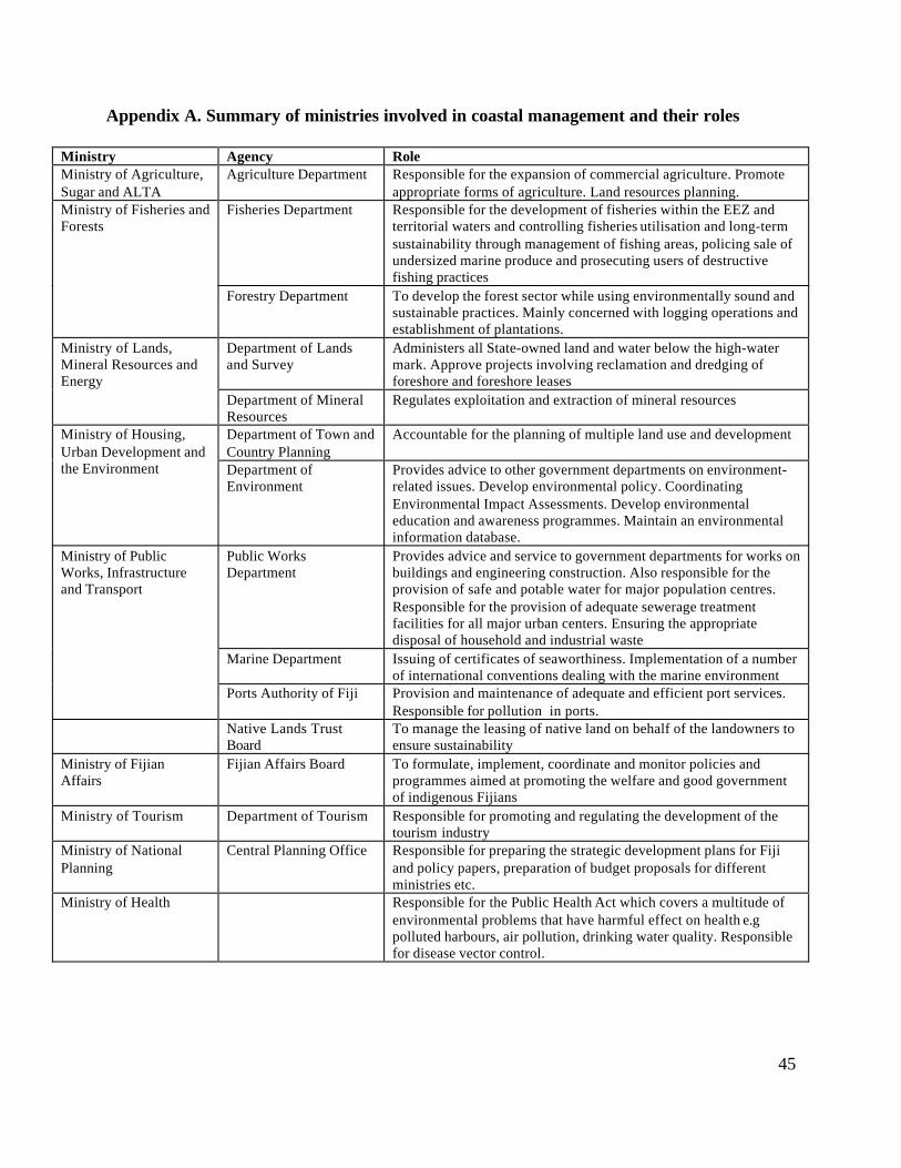
45
Appendix A. Summary of ministries involved in coastal management and their roles
Ministry Agency RoleMinistry of Agriculture,Sugar and ALTA
Agriculture Department Responsible for the expansion of commercial agriculture. Promoteappropriate forms of agriculture. Land resources planning.
Fisheries Department Responsible for the development of fisheries within the EEZ andterritorial waters and controlling fisheries utilisation and long-termsustainability through management of fishing areas, policing sale ofundersized marine produce and prosecuting users of destructivefishing practices
Ministry of Fisheries andForests
Forestry Department To develop the forest sector while using environmentally sound andsustainable practices. Mainly concerned with logging operations andestablishment of plantations.
Department of Landsand Survey
Administers all State-owned land and water below the high-watermark. Approve projects involving reclamation and dredging offoreshore and foreshore leases
Ministry of Lands,Mineral Resources andEnergy
Department of MineralResources
Regulates exploitation and extraction of mineral resources
Department of Town andCountry Planning
Accountable for the planning of multiple land use and developmentMinistry of Housing,Urban Development andthe Environment Department of
EnvironmentProvides advice to other government departments on environment-related issues. Develop environmental policy. CoordinatingEnvironmental Impact Assessments. Develop environmentaleducation and awareness programmes. Maintain an environmentalinformation database.
Public WorksDepartment
Provides advice and service to government departments for works onbuildings and engineering construction. Also responsible for theprovision of safe and potable water for major population centres.Responsible for the provision of adequate sewerage treatmentfacilities for all major urban centers. Ensuring the appropriatedisposal of household and industrial waste
Marine Department Issuing of certificates of seaworthiness. Implementation of a numberof international conventions dealing with the marine environment
Ministry of PublicWorks, Infrastructureand Transport
Ports Authority of Fiji Provision and maintenance of adequate and efficient port services.Responsible for pollution in ports.
Native Lands TrustBoard
To manage the leasing of native land on behalf of the landowners toensure sustainability
Ministry of FijianAffairs
Fijian Affairs Board To formulate, implement, coordinate and monitor policies andprogrammes aimed at promoting the welfare and good governmentof indigenous Fijians
Ministry of Tourism Department of Tourism Responsible for promoting and regulating the development of thetourism industry
Ministry of NationalPlanning
Central Planning Office Responsible for preparing the strategic development plans for Fijiand policy papers, preparation of budget proposals for differentministries etc.
Ministry of Health Responsible for the Public Health Act which covers a multitude ofenvironmental problems that have harmful effect on health e.gpolluted harbours, air pollution, drinking water quality. Responsiblefor disease vector control.
46
References
Billings, G. 2002. The Coral Gardens Initiative: Cuvu Bay Restoration Project. FSP.
Blong, R. 1994 Natural perils and integrated hazard assessment in Fiji. Blong and AssociatesDenistone, NSW.
Bureau of Statistics. 1998. Census96 Results: Population Size, Growth and Structure. StatisticalNews 18. Bureau of Statistics, Government of Fiji.
Cumming, R.L., Aalbersberg, W.G.L., Lovell, E.R., Sykes, H. and Vuki, V.C. 2002. Coral Reefsof the Fiji Islands: Current Issues. Unpublished paper.
Department of Forestry. 1997. Department of Forestry Annual Report 1997. Department ofForestry, Fiji.
Department of Land Resources Planning and Development. 2001. Land Use Planning Report onBemana Tikina. Land Use Section, Department of Land Resources Planning and Development.Government of Fiji.
Environmental Consultants Fiji. 1999. Environmental Impact Assessment of the NatadolaMarine Resort. Government of Fiji.
ESCAP. 1998. Integrating Environmental Considerations into Economic Decision-makingProcesses at the National Level in Fiji. ESCAP
Fung, C. The people of Drawa block.: Needs and Wants: A Participatory Rural Approach.SPC/GTZ – Pacific German Regional Forestry Project.
Langi, V. Qauqau, A. and Korovulavula, J. 2002. Assessment and Enhancement of CustomaryMarine Tenure in Fiji: Community Marine Resource Use and Management: Summary of thefindings of a Fiji Fisheries Department – FAO Survey of the Traditional Qoliqoli owners inselected areas of Fiji. Fiji Fisheries Department, Suva.
Leslie, D. and Ratukalou, I. 2001. National Rural Land Use Policy Statement.
Leslie, D. and Ratukalou, I. 2001b. Review of Rural Land Use in Fiji: Opportunities for the NewMillenium.
Ministry of Agriculture, Fisheries, Forests and ALTA. 1999. Annual Report for the Year 1999.MAFF, Government of Fiji.
Ministry of National Planning. 2001. Draft Strategic Development Plan 2002-2004 “RebuildingConfidence for Stability and Growth”. Ministry of National Planning Fiji.
Morton, J. and Raj, U. 1980. The Shore Ecologyof Suva and South Viti Levu.
47
Pitman, C. Chung, Q. and Smith, R. 2001. Coastal Processes and Erosion at Tagaqe Village,Coral Coast Fiji Islands. 2001. SOPAC.
Rawlinson, N.J.F., Milton, D.A., Blaber, S.J.M., Sesewa, A. and Sharma, S.P. 1994. A survey ofthe subsistence and artisanal fisheries in rural areas of Viti Levu, Fiji. ACIAR Monograph No.35.
Reidel & Byrne. 1989. Saweni Resort Development: Storm Surge and Beach Stability AnalysisJune 1989 report No R321, Victoria, Australia
Ryland, J.S. 1981. Reefs of Southwest Viti Levu and their Tourism Potential. Proceedings of theFourth International Coral Reef Symposium Vol1. Manila.
Thaman, R.R. 1991. Batiri kei Baravi: The Ethnobotany of Pacific Island Coastal Plants.
Vlelter, J. 1995. Natural Forest Management Pilot Project. Silvicultural Research Division,Department of Forestry. GTZ Regional Forestry Project South Pacific. Technical Report 27.
Watling, D. 1985. A Mangrove Management Plan for Fiji. Fiji Government and South PacificCommission.
Watling, D. and Chape, S. (eds.) 1992. Environment Fiji - The National State of the EnvironmentReport. IUCN, Gland, Switzerland.
Wood, S., Marshall, Y. and Crosby, A. 1998. Mapping Sigatoka, Site VL 16/1. The 1992 FieldSeason and its Implications. Report Prepared for the Fiji Museum and the New Zealand HighCommission, Suva.


![WELCOME [1.cdn.edl.io] · PDF file• UCLA (15) same as LY ... • Berklee College of Music (2) same as LY ... (x 5187), and Elizabeth Rieken (x 5073)](https://img.pdfslide.us/doc/110x75/5aa412577f8b9ac8748b695c/welcome-1cdnedlio-ucla-15-same-as-ly-berklee-college-of-music.jpg)