Embed Size (px)
Citation preview
v.2, 8 July 2008
SURFACE WEATHERING OF GRANITE BOULDERS IN BLUE TIER FOREST RESERVE – BRIEF PRELIMINARY REPORT P.D. McIntosh, Forest Practices Authority, Hobart, Tasmania J. Field, Consultant, Kayena, Tasmania D. Dwyer, Consultant, Kayena, Tasmania OBSERVATIONS AND DISCUSSION On 5 July 2008 we investigated the various surface markings of boulders on Mt Michael and Australia Hill, Blue Tier Forest Reserve, to determine which were produced by natural weathering and which were human in origin. This brief report gives our preliminary findings. A more detailed account will be written later. Seven types of markings were observed on boulders:
• Rills >30 cm long and c. 10 cm wide • Circular depressions >10 cm diameter on horizontal surfaces • Drillholes 4 cm diameter • Circular depressions 8–10 cm wide and 1–2 cm deep, regularly spaced at c. 30
cm between centres • Linear depressions >20 cm long • Short linear depressions often 5–20 cm long and <1 cm deep • Inscriptions
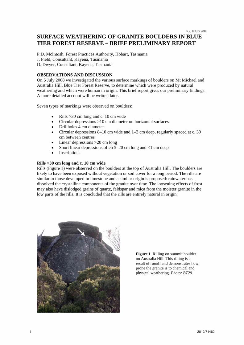
Rills >30 cm long and c. 10 cm wide Rills (Figure 1) were observed on the boulders at the top of Australia Hill. The boulders are likely to have been exposed without vegetation or soil cover for a long period. The rills are similar to those developed in limestone and a similar origin is proposed: rainwater has dissolved the crystalline components of the granite over time. The loosening effects of frost may also have dislodged grains of quartz, feldspar and mica from the moister granite in the low parts of the rills. It is concluded that the rills are entirely natural in origin.
Figure 1. Rilling on summit boulder on Australia Hill. This rilling is a result of runoff and demonstrates how prone the granite is to chemical and physical weathering. Photo: BT29.
1 2012/71462
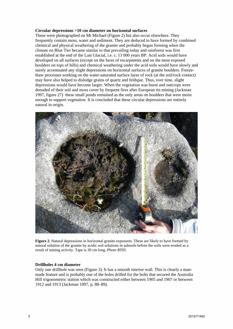
Circular depressions >10 cm diameter on horizontal surfaces These were photographed on Mt Michael (Figure 2) but also occur elsewhere. They frequently contain moss, water and sediment. They are deduced to have formed by combined chemical and physical weathering of the granite and probably began forming when the climate on Blue Tier became similar to that prevailing today and rainforest was first established at the end of the Last Glacial, i.e. c. 13 000 years BP. Acid soils would have developed on all surfaces (except on the faces of escarpments and on the most exposed boulders on tops of hills) and chemical weathering under the acid soils would have slowly and surely accentuated any slight depressions on horizontal surfaces of granite boulders. Freeze-thaw processes working on the water-saturated surface layer of rock (at the soil/rock contact) may have also helped to dislodge grains of quartz and feldspar. Thus, over time, slight depressions would have become larger. When the vegetation was burnt and outcrops were denuded of their soil and moss cover by frequent fires after European tin mining (Jackman 1997, figure 27) these small ponds remained as the only areas on boulders that were moist enough to support vegetation. It is concluded that these circular depressions are entirely natural in origin.
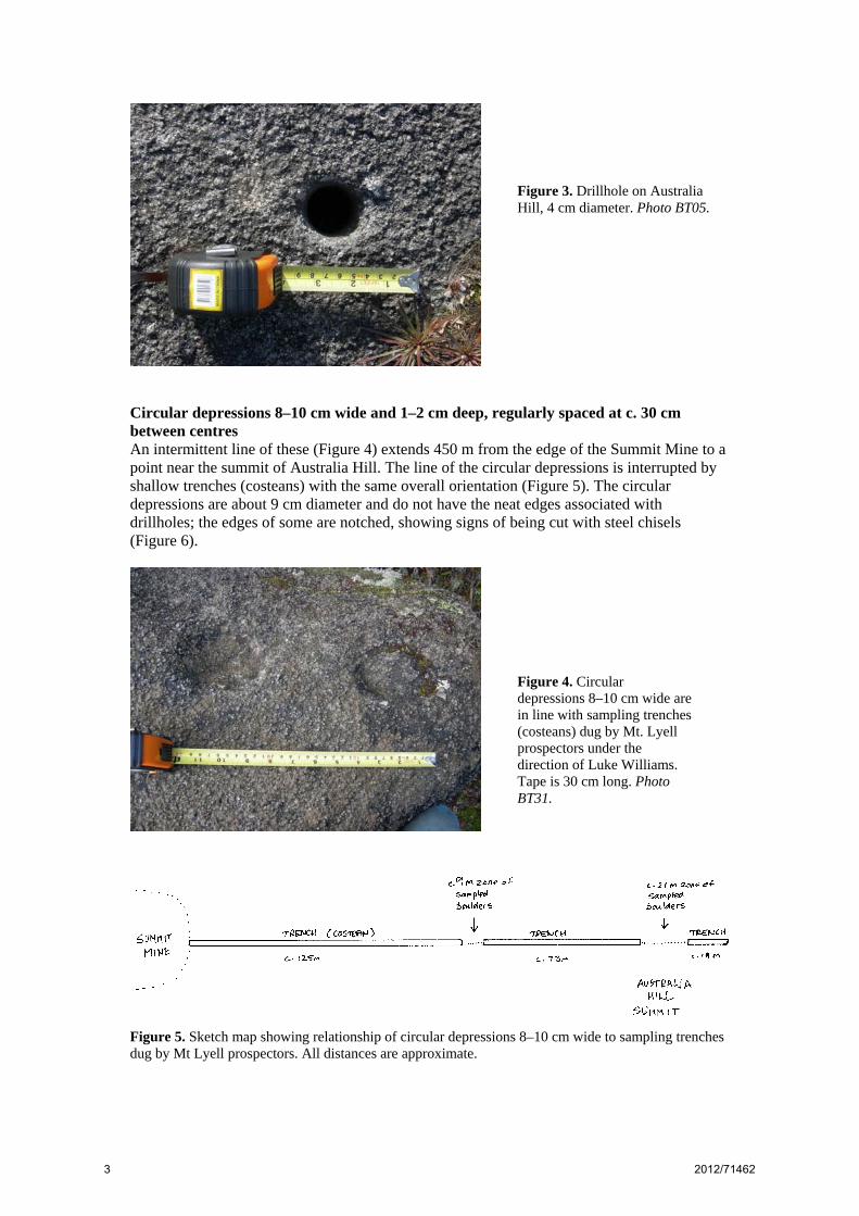
Figure 2. Natural depressions in horizontal granite exposures. These are likely to have formed by natural solution of the granite by acidic soil solutions in subsoils before the soils were eroded as a result of mining activity. Tape is 30 cm long. Photo BT05. Drillholes 4 cm diameter Only one drillhole was seen (Figure 3). It has a smooth interior wall. This is clearly a man-made feature and is probably one of the holes drilled for the bolts that secured the Australia Hill trigonometric station which was constructed either between 1905 and 1907 or between 1912 and 1913 (Jackman 1997, p. 88–89).
2 2012/71462
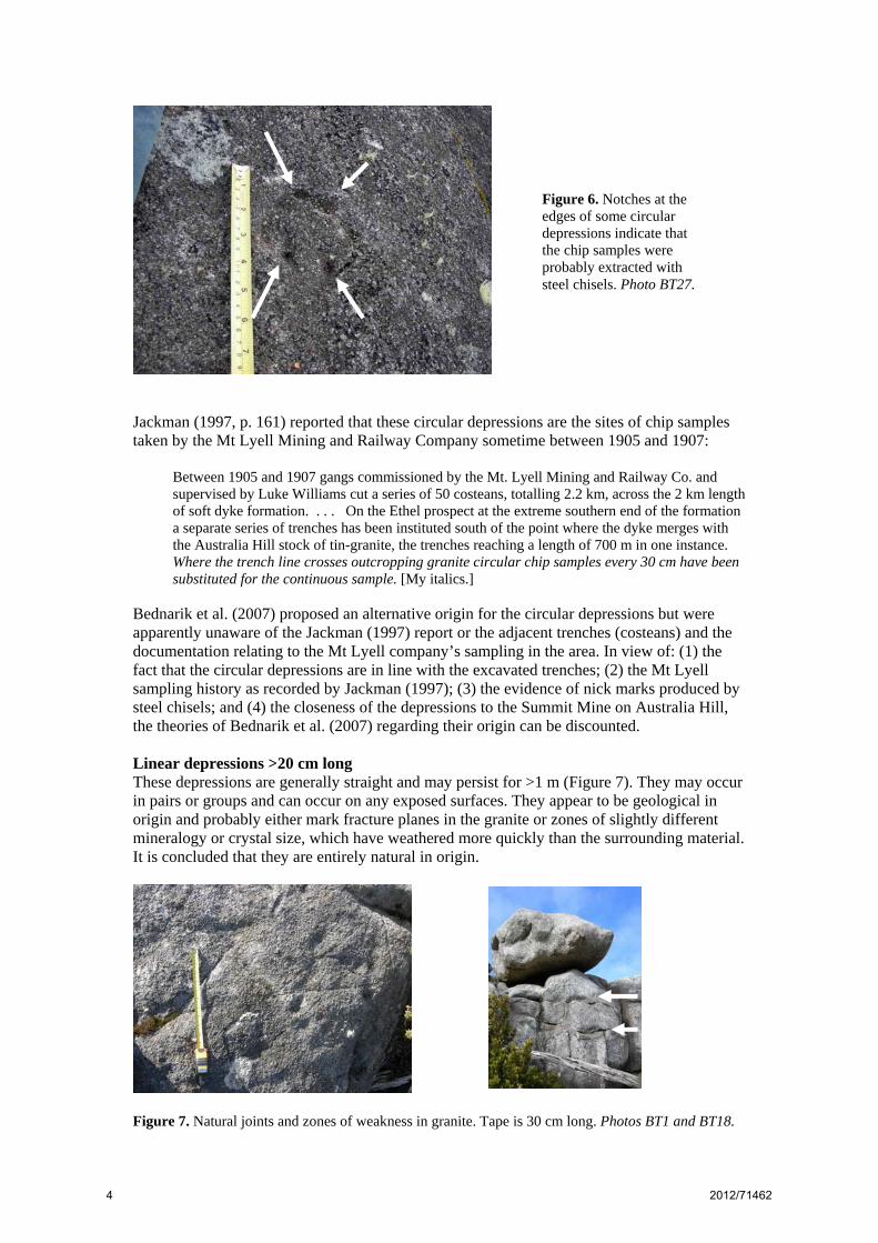
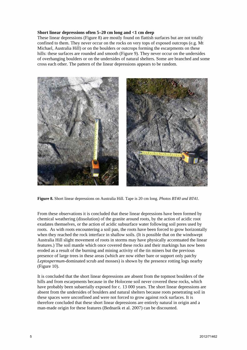
Circular depressions 8–10 cm wide and 1–2 cm deep, regularly spaced at c. 30 cm between centres An intermittent line of these (Figure 4) extends 450 m from the edge of the Summit Mine to a point near the summit of Australia Hill. The line of the circular depressions is interrupted by shallow trenches (costeans) with the same overall orientation (Figure 5). The circular depressions are about 9 cm diameter and do not have the neat edges associated with drillholes; the edges of some are notched, showing signs of being cut with steel chisels (Figure 6).
Figure 5. Sketch map showing relationship of circular depressions 8–10 cm wide to sampling trenches dug by Mt Lyell prospectors. All distances are approximate.
Figure 4. Circular depressions 8–10 cm wide are in line with sampling trenches (costeans) dug by Mt. Lyell prospectors under the direction of Luke Williams. Tape is 30 cm long. Photo BT31.
Figure 3. Drillhole on Australia Hill, 4 cm diameter. Photo BT05.
3 2012/71462
Jackman (1997, p. 161) reported that these circular depressions are the sites of chip samples taken by the Mt Lyell Mining and Railway Company sometime between 1905 and 1907:
Between 1905 and 1907 gangs commissioned by the Mt. Lyell Mining and Railway Co. and supervised by Luke Williams cut a series of 50 costeans, totalling 2.2 km, across the 2 km length of soft dyke formation. . . . On the Ethel prospect at the extreme southern end of the formation a separate series of trenches has been instituted south of the point where the dyke merges with the Australia Hill stock of tin-granite, the trenches reaching a length of 700 m in one instance. Where the trench line crosses outcropping granite circular chip samples every 30 cm have been substituted for the continuous sample. [My italics.]
Bednarik et al. (2007) proposed an alternative origin for the circular depressions but were apparently unaware of the Jackman (1997) report or the adjacent trenches (costeans) and the documentation relating to the Mt Lyell company’s sampling in the area. In view of: (1) the fact that the circular depressions are in line with the excavated trenches; (2) the Mt Lyell sampling history as recorded by Jackman (1997); (3) the evidence of nick marks produced by steel chisels; and (4) the closeness of the depressions to the Summit Mine on Australia Hill, the theories of Bednarik et al. (2007) regarding their origin can be discounted. Linear depressions >20 cm long These depressions are generally straight and may persist for >1 m (Figure 7). They may occur in pairs or groups and can occur on any exposed surfaces. They appear to be geological in origin and probably either mark fracture planes in the granite or zones of slightly different mineralogy or crystal size, which have weathered more quickly than the surrounding material. It is concluded that they are entirely natural in origin.
Figure 7. Natural joints and zones of weakness in granite. Tape is 30 cm long. Photos BT1 and BT18.
Figure 6. Notches at the edges of some circular depressions indicate that the chip samples were probably extracted with steel chisels. Photo BT27.
4 2012/71462
Short linear depressions often 5–20 cm long and <1 cm deep These linear depressions (Figure 8) are mostly found on flattish surfaces but are not totally confined to them. They never occur on the rocks on very tops of exposed outcrops (e.g. Mt Michael, Australia Hill) or on the boulders or outcrops forming the escarpments on these hills: these surfaces are rounded and smooth (Figure 9). They never occur on the undersides of overhanging boulders or on the undersides of natural shelters. Some are branched and some cross each other. The pattern of the linear depressions appears to be random.
Figure 8. Short linear depressions on Australia Hill. Tape is 20 cm long. Photos BT40 and BT41. From these observations it is concluded that these linear depressions have been formed by chemical weathering (dissolution) of the granite around roots, by the action of acidic root exudates themselves, or the action of acidic subsurface water following soil pores used by roots. As with roots encountering a soil pan, the roots have been forced to grow horizontally when they reached the rock interface in shallow soils. (It is possible that on the windswept Australia Hill slight movement of roots in storms may have physically accentuated the linear features.) The soil mantle which once covered these rocks and their markings has now been eroded as a result of the burning and mining activity of the tin miners but the previous presence of large trees in these areas (which are now either bare or support only patchy Leptospermum-dominated scrub and mosses) is shown by the presence rotting logs nearby (Figure 10). It is concluded that the short linear depressions are absent from the topmost boulders of the hills and from escarpments because in the Holocene soil never covered these rocks, which have probably been subaerially exposed for c. 13 000 years. The short linear depressions are absent from the undersides of boulders and natural shelters because roots penetrating soil in these spaces were unconfined and were not forced to grow against rock surfaces. It is therefore concluded that these short linear depressions are entirely natural in origin and a man-made origin for these features (Bednarik et al. 2007) can be discounted.
5 2012/71462
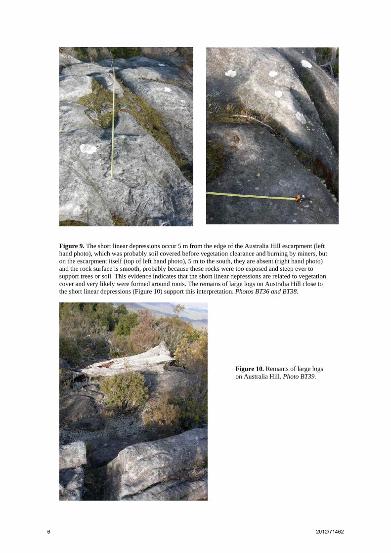
Figure 9. The short linear depressions occur 5 m from the edge of the Australia Hill escarpment (left hand photo), which was probably soil covered before vegetation clearance and burning by miners, but on the escarpment itself (top of left hand photo), 5 m to the south, they are absent (right hand photo) and the rock surface is smooth, probably because these rocks were too exposed and steep ever to support trees or soil. This evidence indicates that the short linear depressions are related to vegetation cover and very likely were formed around roots. The remains of large logs on Australia Hill close to the short linear depressions (Figure 10) support this interpretation. Photos BT36 and BT38.
Figure 10. Remants of large logs on Australia Hill. Photo BT39.
6 2012/71462
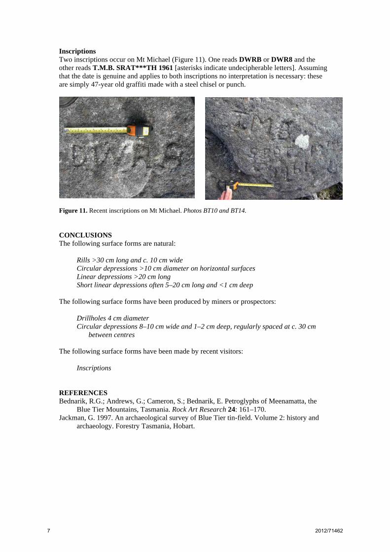
Inscriptions Two inscriptions occur on Mt Michael (Figure 11). One reads DWRB or DWR8 and the other reads T.M.B. SRAT***TH 1961 [asterisks indicate undecipherable letters]. Assuming that the date is genuine and applies to both inscriptions no interpretation is necessary: these are simply 47-year old graffiti made with a steel chisel or punch.
Figure 11. Recent inscriptions on Mt Michael. Photos BT10 and BT14. CONCLUSIONS The following surface forms are natural:
Rills >30 cm long and c. 10 cm wide Circular depressions >10 cm diameter on horizontal surfaces Linear depressions >20 cm long Short linear depressions often 5–20 cm long and <1 cm deep
The following surface forms have been produced by miners or prospectors:
Drillholes 4 cm diameter Circular depressions 8–10 cm wide and 1–2 cm deep, regularly spaced at c. 30 cm
between centres The following surface forms have been made by recent visitors:
Inscriptions REFERENCES Bednarik, R.G.; Andrews, G.; Cameron, S.; Bednarik, E. Petroglyphs of Meenamatta, the
Blue Tier Mountains, Tasmania. Rock Art Research 24: 161–170. Jackman, G. 1997. An archaeological survey of Blue Tier tin-field. Volume 2: history and
archaeology. Forestry Tasmania, Hobart.
7 2012/71462