Embed Size (px)
Citation preview
42
Surface Scanning-New Perspectives for Archaeological Data Management and Methodology
Bernd Breuckmann,1 Pablo Arias Cabal,2 Nicolas Mélard,3 Roberto Ontañón Peredo,2 Andreas Pastoors,4
Luis César Teira Mayolini,2 Pedro Ángel Fernandez Vega,5 and Gerd-Christian Weniger4
1Breuckmann GmbH, Meersburg. Germany. 2Universidad de Cantabria, Santander. Spain.
3 Institut National du Patrimoine and C2RMF, Paris. France. 4Neanderthal Museum, Mettmann. Germany.
5Museo de Prehistoria y Arqueología de Cantabria, Santander. Spain.
Abstract Documentation and publication of palaeolithic objects such as lithic artifacts, bone tools or mobile art has been done for decades mainly by drawings. These drawings are an indispensable part of scientific research and methodology. Teaching drawing techniques is even integrated into the educational program at the university level. Although creating a drawing is very time-consuming and requires training, it has not been replaced by photography. Taking a picture of a palaeolithic object is obviously even more difficult than making a drawing. To visualize all relevant scientific features of an object in just one shot is not possible. The cost/performance ratio for drawings is therefore better than for photography. Photos are used mainly to present objects to a broad public. Within the scientific community drawings are the most frequent medium of information transfer. Surface scanning of palaeolithic objects has the potential to replace drawings as a medium for scientific information transfer. Polygon meshes are of high scientific value because they allow an objective record of the object and its digital measuring. Once recorded, the digital data file can be transferred via internet and allows direct access to objects. Prehistoric archaeology will have to adapt to this new recording technology and in the future data bases like NESPOS that allow world wide access. Keywords: surface scanning, archaeological data management, documentation of palaeolithic artifacts, NESPOS 1 STATE OF THE ART Drawings have the advantage that they follow defined conventions and document the technical status of an object. This facilitates their sensing, allows quick visual comparison of various items, and provides information to be put into a larger scientific context. The sensing of drawings of lithic artifacts works at even higher speed than exploring the originals themselves. Items of mobile art are different, however. They present more complex visual information than lithic artifacts and are therefore still the field of specialised illustrators. An obvious problem of scientific drawings is a loss of objectivity. Ultimately, each drawing is an individual interpretation. By skilfully removing or adding minor features, the unambiguousness of an item can be manipulated. This is often the case when, for instance, a decision between geofact and artifacts has to be made. Another problem is the reduction of complex artifacts into a 2D-format by drawing them. In particular, pieces of mobile art display a great variety of forms, from bas-relief to sculpture. In many cases, the tracing of engravings displaying different line thickness and line depth is important for understanding a depiction. The
same is true for rock art. Drawings do not allow direct access to these details. Drawings have another disadvantage. They are difficult for the scientific community to use in the secondary analytical process. Usually, drawings are published in papers or books as the main medium of diffusion. In most cases, this presentation only allows a reduced application. Formats are small and the metric of items is difficult to record. All kinds of metric analyses such as calculation of areas, angles, or distances are not possible, and therefore the comparison of objects is difficult. This is why researchers are looking for alternatives. Various laser scan applications have been tested recently.1, 3D-surface scanners can cover a wide range
1T. Barnett et al., “3D-laser Scanning for Recording and Monitoring Rock Art Erosion,” International Newsletter on Rock Art 41 (2005): 25; Q. Borderie et al., “3D Modeling of Paleolithic Tools” paper presented at the Workshop on Archaeology and Computers, Vienna, Austria, November 3–4, 2004; . Slizewski and P. Semal, “Experiences with Low and High Cost 3D Surface Scanners,” Quartär 56 (2009): 131; T. A. Summer and A. Riddle, “A Virtual Paleolithic: Assays in
Surface Scanning
43
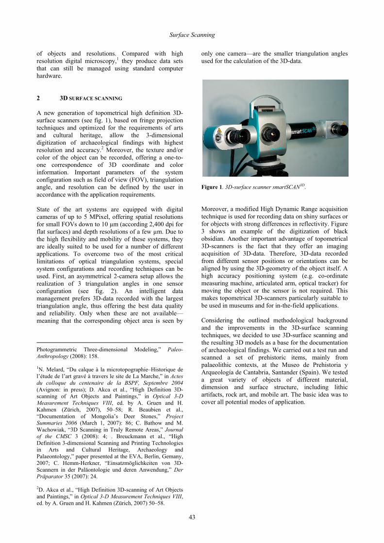
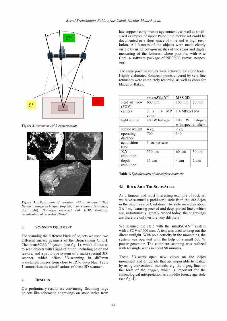
of objects and resolutions. Compared with high resolution digital microscopy,1 they produce data sets that can still be managed using standard computer hardware. 2 3D SURFACE SCANNING A new generation of topometrical high definition 3D-surface scanners (see fig. 1), based on fringe projection techniques and optimized for the requirements of arts and cultural heritage, allow the 3-dimensional digitization of archaeological findings with highest resolution and accuracy.2 Moreover, the texture and/or color of the object can be recorded, offering a one-to-one correspondence of 3D coordinate and color information. Important parameters of the system configuration such as field of view (FOV), triangulation angle, and resolution can be defined by the user in accordance with the application requirements. State of the art systems are equipped with digital cameras of up to 5 MPixel, offering spatial resolutions for small FOVs down to 10 µm (according 2,400 dpi for flat surfaces) and depth resolutions of a few µm. Due to the high flexibility and mobility of these systems, they are ideally suited to be used for a number of different applications. To overcome two of the most critical limitations of optical triangulation systems, special system configurations and recording techniques can be used. First, an asymmetrical 2-camera setup allows the realization of 3 triangulation angles in one sensor configuration (see fig. 2). An intelligent data management prefers 3D-data recorded with the largest triangulation angle, thus offering the best data quality and reliability. Only when these are not available—meaning that the corresponding object area is seen by
Photogrammetric Three-dimensional Modeling,” Paleo-Anthropology (2008): 158. 1N. Melard, “Du calque à la microtopographie–Historique de l’étude de l’art gravé à travers le site de La Marche,” in Actes du colloque du centenaire de la BSPF, Septembre 2004 (Avignon: in press); D. Akca et al., “High Definition 3D-scanning of Art Objects and Paintings,” in Optical 3-D Measurement Techniques VIII, ed. by A. Gruen and H. Kahmen (Zürich, 2007), 50–58; R. Beaubien et al., “Documentation of Mongolia’s Deer Stones,” Project Summaries 2006 (March 1, 2007): 86; C. Bathow and M. Wachowiak, “3D Scanning in Truly Remote Areas,” Journal of the CMSC 3 (2008): 4; . Breuckmann et al., “High Definition 3-dimensional Scanning and Printing Technologies in Arts and Cultural Heritage, Archaeology and Palaeontology,” paper presented at the EVA, Berlin, Gemany, 2007; C. Hemm-Herkner, “Einsatzmöglichkeiten von 3D-Scannern in der Paläontologie und deren Anwendung,” Der Präparator 35 (2007): 24. 2D. Akca et al., “High Definition 3D-scanning of Art Objects and Paintings,” in Optical 3-D Measurement Techniques VIII, ed. by A. Gruen and H. Kahmen (Zürich, 2007) 50–58.
only one camera—are the smaller triangulation angles used for the calculation of the 3D-data.
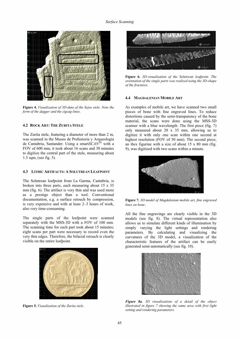
Figure 1. 3D-surface scanner smartSCAN3D. Moreover, a modified High Dynamic Range acquisition technique is used for recording data on shiny surfaces or for objects with strong differences in reflectivity. Figure 3 shows an example of the digitization of black obsidian. Another important advantage of topometrical 3D-scanners is the fact that they offer an imaging acquisition of 3D-data. Therefore, 3D-data recorded from different sensor positions or orientations can be aligned by using the 3D-geometry of the object itself. A high accuracy positioning system (e.g. co-ordinate measuring machine, articulated arm, optical tracker) for moving the object or the sensor is not required. This makes topometrical 3D-scanners particularly suitable to be used in museums and for in-the-field applications. Considering the outlined methodological background and the improvements in the 3D-surface scanning techniques, we decided to use 3D-surface scanning and the resulting 3D models as a base for the documentation of archaeological findings. We carried out a test run and scanned a set of prehistoric items, mainly from palaeolithic contexts, at the Museo de Prehistoria y Arqueología de Cantabria, Santander (Spain). We tested a great variety of objects of different material, dimension and surface structure, including lithic artifacts, rock art, and mobile art. The basic idea was to cover all potential modes of application.
Bernd Breuckmann, Pablo Arias Cabal, Nicolas Mélard, et al.
44
Figure 2. Asymmetrical 2-camera setup.
Figure 3. Digitization of obsidian with a modified High Dynamic Range technique. (top left): conventional 2D-image; (top right): 2D-image recorded with HDR; (bottom): visualization of recorded 3D-data. 3 SCANNING EQUIPMENT For scanning the different kinds of objects we used two different surface scanners of the Breuckmann GmbH: The smartSCAN3D system (see fig. 1), which allows us to scan objects with HighDefinition, including color and texture, and a prototype system of a multi-spectral 3D-scanner, which offers 3D-scanning in different wavelength ranges from close to IR to deep blue. Table 1 summarizes the specifications of these 3D-scanners. 4 RESULTS Our preliminary results are convincing. Scanning large objects like schematic engravings on stone steles from
late copper / early bronze age contexts, as well as small-sized examples of upper Paleolithic mobile art could be documented in a short space of time and at high reso-lution. All features of the objects were made clearly visible by using polygon meshes of the scans and digital measuring of the features, where possible, with Arte Core, a software package of NESPOS (www. nespos. org). The same positive results were achieved for stone tools. Highly elaborated Solutrean points covered by very fine retouches were completely recorded, as well as cores for blades or flakes.
smartSCAN3D MSS-3D field of view (FOV)
600 mm 100 mm 50 mm
camera 2 x 1.4 MP color
1.4 MPixel b/w
light source 100 W halogen 100 W halogen with spectral filters
sensor weight 4 kg 2 kg operating distance
700 340
acquisition time
1 sec per scan
X,Y-resolution
350 µm 60 µm 30 µm
depth resolution
15 µm 4 µm 2 µm
Table 1. Specifications of the surface scanners. 4.1 ROCK ART: THE SEJOS STELE
As a famous and most interesting example of rock art we have scanned a prehistoric stele from the site Sejos in the mountains of Cantabria. The stele measures about 3 x 1 m, featuring pecked and deep graved lines, which are, unfortunately, greatly eroded today; the engravings are therefore only visible very diffusely. We scanned the stele with the smartSCAN3D system with a FOV of 600 mm. A tent was used to keep out the direct sunlight. With no electricity in the mountains, the system was operated with the help of a small 600 W power generator. The complete scanning was realized with 40 single scans in about 90 minutes. These 3D-scans open new views on the Sejos monument and on details that are impossible to realize by using conventional methods, e.g. the zigzag-lines or the form of the dagger, which is important for the chronological interpretation as a middle bronze age stele (see fig. 4).
Surface Scanning
45
Figure 4. Visualization of 3D-data of the Sejos stele. Note the form of the dagger and the zigzag-lines. 4.2 ROCK ART: THE ZURITA STELE
The Zurita stele, featuring a diameter of more than 2 m, was scanned in the Museo de Prehistoria y Arqueología de Cantabria, Santander. Using a smartSCAN3D with a FOV of 600 mm, it took about 16 scans and 30 minutes to digitize the central part of the stele, measuring about 1.5 sqm, (see fig. 5). 4.3 LITHIC ARTIFACTS: A SOLUTREAN LEAFPOINT
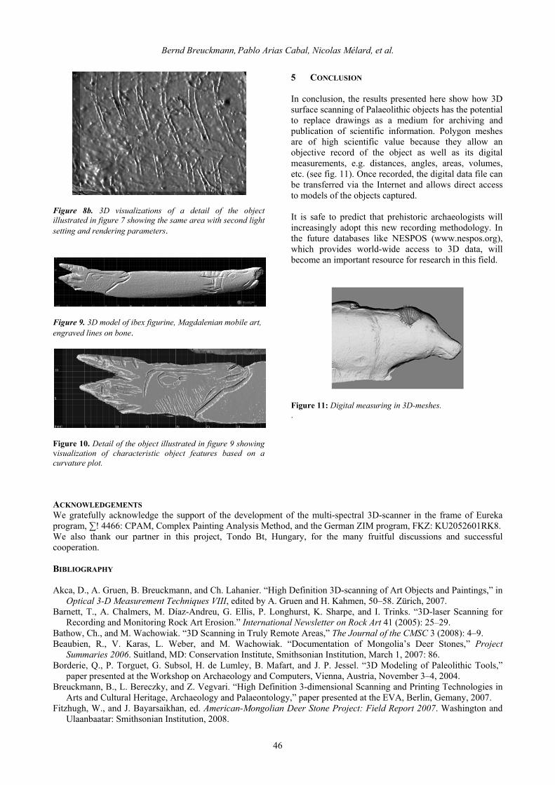
The Solutrean leafpoint from La Garma, Cantabria, is broken into three parts, each measuring about 15 x 35 mm (fig. 6). The artifact is very thin and was used more as a prestige object than a tool. Conventional documentation, e.g. a surface retouch by compression, is very expensive and with at least 2–3 hours of work, also very time-consuming. The single parts of the leafpoint were scanned separately with the MSS-3D with a FOV of 100 mm. The scanning time for each part took about 15 minutes; eight scans per part were necessary to record even the very thin edges. Therefore, the bifacial retouch is clearly visible on the entire leafpoint.
Figure 5. Visualization of the Zurita stele.
Figure 6. 3D-visualization of the Solutrean leafpoint. The orientation of the single parts was realized using the 3D-shape of the fractures. 4.4 MAGDALENIAN MOBILE ART
As examples of mobile art, we have scanned two small pieces of bone with fine engraved lines. To reduce distortions caused by the semi-transparency of the bone material, the scans were done using the MSS-3D scanner with a blue wavelength. The first piece (fig. 7) only measured about 20 x 35 mm, allowing us to digitize it with only one scan within one second at highest resolution (FOV of 50 mm). The second piece, an ibex figurine with a size of about 15 x 80 mm (fig. 9), was digitized with two scans within a minute.
Figure 7. 3D model of Magdalenian mobile art, fine engraved lines on bone. All the fine engravings are clearly visible in the 3D models (see fig. 8). The virtual representation also allows us to simulate different kinds of illumination by simply varying the light settings and rendering parameters. By calculating and visualizing the curvatures of the 3D model, a visualization of the characteristic features of the artifact can be easily generated semi-automatically (see fig. 10).
Figure 8a. 3D visualizations of a detail of the object illustrated in figure 7 showing the same area with first light setting and rendering parameters.
Bernd Breuckmann, Pablo Arias Cabal, Nicolas Mélard, et al.
46
Figure 8b. 3D visualizations of a detail of the object illustrated in figure 7 showing the same area with second light setting and rendering parameters.
Figure 9. 3D model of ibex figurine, Magdalenian mobile art, engraved lines on bone.
Figure 10. Detail of the object illustrated in figure 9 showing visualization of characteristic object features based on a curvature plot.
5 CONCLUSION
In conclusion, the results presented here show how 3D surface scanning of Palaeolithic objects has the potential to replace drawings as a medium for archiving and publication of scientific information. Polygon meshes are of high scientific value because they allow an objective record of the object as well as its digital measurements, e.g. distances, angles, areas, volumes, etc. (see fig. 11). Once recorded, the digital data file can be transferred via the Internet and allows direct access to models of the objects captured. It is safe to predict that prehistoric archaeologists will increasingly adopt this new recording methodology. In the future databases like NESPOS (www.nespos.org), which provides world-wide access to 3D data, will become an important resource for research in this field.
Figure 11: Digital measuring in 3D-meshes. .
ACKNOWLEDGEMENTS We gratefully acknowledge the support of the development of the multi-spectral 3D-scanner in the frame of Eureka program, ∑! 4466: CPAM, Complex Painting Analysis Method, and the German ZIM program, FKZ: KU2052601RK8. We also thank our partner in this project, Tondo Bt, Hungary, for the many fruitful discussions and successful cooperation. BIBLIOGRAPHY Akca, D., A. Gruen, B. Breuckmann, and Ch. Lahanier. “High Definition 3D-scanning of Art Objects and Paintings,” in
Optical 3-D Measurement Techniques VIII, edited by A. Gruen and H. Kahmen, 50–58. Zürich, 2007. Barnett, T., A. Chalmers, M. Díaz-Andreu, G. Ellis, P. Longhurst, K. Sharpe, and I. Trinks. “3D-laser Scanning for
Recording and Monitoring Rock Art Erosion.” International Newsletter on Rock Art 41 (2005): 25–29. Bathow, Ch., and M. Wachowiak. “3D Scanning in Truly Remote Areas,” The Journal of the CMSC 3 (2008): 4–9. Beaubien, R., V. Karas, L. Weber, and M. Wachowiak. “Documentation of Mongolia’s Deer Stones,” Project
Summaries 2006. Suitland, MD: Conservation Institute, Smithsonian Institution, March 1, 2007: 86. Borderie, Q., P. Torguet, G. Subsol, H. de Lumley, B. Mafart, and J. P. Jessel. “3D Modeling of Paleolithic Tools,”
paper presented at the Workshop on Archaeology and Computers, Vienna, Austria, November 3–4, 2004. Breuckmann, B., L. Bereczky, and Z. Vegvari. “High Definition 3-dimensional Scanning and Printing Technologies in
Arts and Cultural Heritage, Archaeology and Palaeontology,” paper presented at the EVA, Berlin, Gemany, 2007. Fitzhugh, W., and J. Bayarsaikhan, ed. American-Mongolian Deer Stone Project: Field Report 2007. Washington and
Ulaanbaatar: Smithsonian Institution, 2008.

Surface Scanning
47
Hemm-Herkner, Ch. “Einsatzmöglichkeiten von 3D-Scannern in der Paläontologie und deren Anwendung,” Der Präparator 35 (2007): 24–28.
Mélard, N. “Du calque à la microtopographie—Historique de l’étude de l’art gravé à travers le site de La Marche,” in Actes du colloque du centenaire de la BSPF, Septembre 2004 (Avignon, in press).
Slizewski, A., and P. Semal. “Experiences with Low and High Cost 3D Surface Scanners,” Quartär 56 (2009): 131–138.
Sumner, T. A., and A. Riddle. “A Virtual Paleolithic: Assays in Photogrammetric Three-dimensional Modeling,” PaleoAnthropology (2008): 158–169.
Wasklewicz, T., D. Staley, H. Volker, and D. Whitley. “Terrestrial 3D Laser Scanning: A New Method for Recording Rock Art,” International Newsletter on Rock Art 41 (2005): 16–25.