Embed Size (px)
Citation preview
Proceedings World Geothermal Congress 2010 Bali, Indonesia, 25-29 April 2010
Surface Exploration of a Viable Geothermal Resource in Mbeya Area, SW Tanzania Part II: Geochemistry
Michael Kraml1, Taramaeli T. Mnjokava2, Jacob W. Mayalla3, Kato Kabaka4 and GEOTHERM working group 1 BGR, Hannover, Germany, now at: Sterr-Kölln & Partner, Freiburg, Germany
2 GST, Dodoma, Tanzania; 3 MEM, Dar es Salaam, Tanzania; 4 TANESCO, Dar es Salaam Tanzania
Keywords: Isotope geochemistry, fluid, REE, carbon dioxide, helium, Songwe hot springs, Mbeya area, Tanzania
ABSTRACT
In addition to the geological investigations presented in Part I (Delvaux et al., this volume), fluid and gas samples were taken for reservoir characterization and hydrological assessment of (at least two) geothermal systems in Mbeya area, SW Tanzania, i.e. the Northern Ngozi-Songwe and the Southern Kiejo-Mbaka system.
Sampled fluids included cold surface waters as well as hot springs which were analyzed for chemical and isotopic composition. Gas samples were taken from a CO2 producing well and from bubbling cold and hot springs which were also analyzed chemically and isotopically. Additionally, free gas phases were sampled using the copper tube technique for noble gas analyses.
The integrated data set of the Northern Ngozi-Songwe system including geophysical measurements (Part III: Kalberkamp et al., this volume) resulted in a conceptual model which allows siting of exploration wells for proving the predicted reservoir in the subsurface.
1. INTRODUCTION
Songwe hot springs are situated in Mbeya area, SW Tanzania which is the most thermally active area in Tanzania with impressive surface manifestations incl. 150 million tons of travertine deposits (Hochstein et al., 2000).
In previous studies a related high-enthalpy geothermal system was postulated further upstream of Songwe outflow but could not be located so far (Hochstein et al., 2000; Mnzava et al., 2004; DECON et al., 2005). From this starting point the exploration was focussed to put up a conceptual model with suggestion of exploration wells in order to reach the pre-feasibility status.
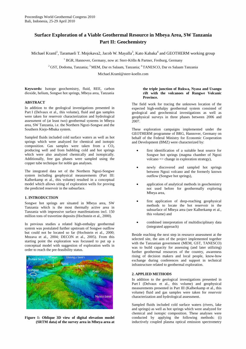
Figure 1: Oblique 3D view of digital elevation model (SRTM data) of the survey area in Mbeya area at
the triple junction of Rukwa, Nyasa and Usangu rift with the volcanoes of Rungwe Volcanic Province.
The field work for tracing the unknown location of the expected high-enthalpy geothermal system consisted of geological and geochemical investigations as well as geophysical surveys in three phases between 2006 and 2007.
These exploration campaigns implemented under the GEOTHERM programme of BRG, Hannover, Germany on behalf of the Federal Ministry for Economic Cooperation and Development (BMZ) were characterized by:
• first identification of a suitable heat source for Songwe hot springs (magma chamber of Ngozi volcano => change in exploration strategy),
• newly discovered and sampled hot springs between Ngozi volcano and the formerly known outflow (Songwe hot springs),
• application of analytical methods in geochemistry not used before for geothermally exploring Mbeya area,
• first application of deep-reaching geophysical methods to locate the hot reservoir in the subsurface of Mbeya area (see Kalberkamp et al., this volume) and
• combined interpretation of multidisciplinary data (integrated approach)
Beside reaching the next step in resource assessment at the selected site, the aim of the project implemented together with the Tanzanian government (MEM, GST, TANESCO) was to build capacity for assessing (and later utilizing) further geothermal resources of the country, awareness rising of decision makers and local people, know-how exchange during conferences and support in technical infrastructure related to geothermal exploration.
2. APPLIED METHODS
In addition to the geological investigations presented in Part I (Delvaux et al., this volume) and geophysical measurements presented in Part III (Kalberkamp et al., this volume) fluid and gas samples were taken for reservoir characterization and hydrological assessment.
Sampled fluids included cold surface waters (rivers, lake and springs) as well as hot springs which were analyzed for chemical and isotopic composition. These analyses were conducted by applying the following methods: (i) inductively coupled plasma optical emission spectrometry
Kraml et al.
(ICP-OES), (ii) inductively coupled plasma mass spectrometry (ICP-MS), (iii) thermal ionization mass spectrometry (TIMS) etc. Gas samples were taken from a CO2 producing well and from bubbling cold and hot springs which were analyzed for chemical and isotopic compositions by gas chromatography (GC) and isotope ratio mass spectrometry (GC-IRMS). Additionally, free gas phases were sampled using the copper tube technique for noble gas isotopic analyses.
3. RESULTS OF GEOCHEMICAL ANALYSES
In the following the results from chemical and isotopic composition of analyzed fluid and gas samples are presented.
3.1 Fluid chemistry
Nearly all analyzed fluid samples are peripheral waters. Only Lake Ngozi water and Ivuna spring water (the latter analysed by Makundi & Kifua 1985) plot in the Cl-SO4-HCO3 ternary diagram very close to the field of mature geothermal brines. Igogwe river water plotting between geothermal brines and peripheral waters can be explained by a mixture of Lake Ngozi water and diluted ground water (see also Figure 2).
However, the composition of the NaCl-rich water of Ivuna spring can be explained e.g. by admixture of Cl-rich interstitial brines without existing localised magmatic heat source in the subsurface (compare also Hochstein et al. 2000 and Figure 7).
The second sample which plots close to the field of “geothermal waters” is Lake Ngozi water. The high elevated caldera lake (1965m a.s.l.) is characterized by highest solute content of all analysed samples from the Northern system with an electric conductivity of 5.3mS/cm although the water is diluted by rain water (precipitation of 1900mm/year). Therefore a hydrothermal seepage has to be postulated (compare also section “Isotope hydrology” below).
Lake Ngozi water plots in the partially equilibrated field and Songwe hot springs, Malambo hot spring and Ngozi water are on the same line pointing to a genetic relation and higher reservoir temperatures than the Southern (Mampulo, Kilambo) system(s) (Figure 8). Lake Ngozi water can be explained by an equilibrated hydrothermal solution diluted with meteoric water which shifts the data point from the full equilibration line towards the Mg corner. Mahombe and Songwe hot spring fluids are even more diluted (immature waters). If Ibayi and Udindilwa fluids also belong to the Ngozi-Songwe system, they may be at least partly re-equilibrated at lower temperatures.
Another trend in Figure 8 is defined by dissolution of (alkali-)basaltic rocks (Inyala, Iyela, Swaya, Shongo, Ikumbi warm springs in case of the Northern system) caused by the CO2-rich fluids (immature waters). Therefore those immature waters are not suitable for geothermometry.
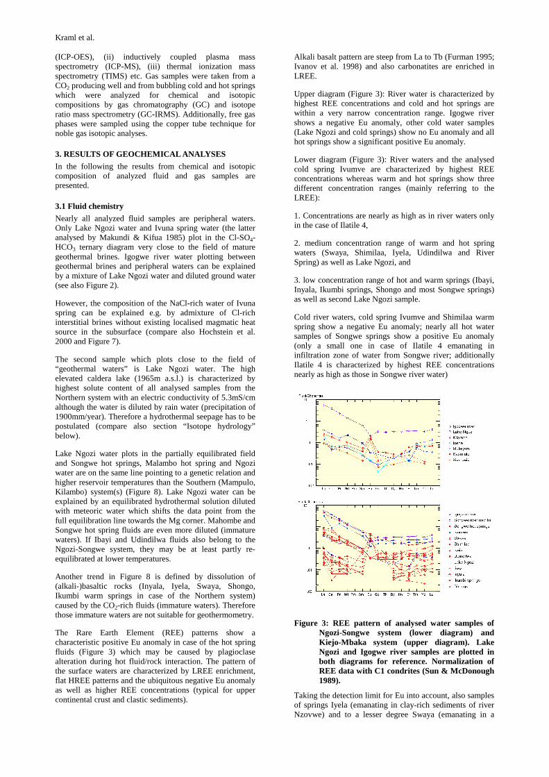
The Rare Earth Element (REE) patterns show a characteristic positive Eu anomaly in case of the hot spring fluids (Figure 3) which may be caused by plagioclase alteration during hot fluid/rock interaction. The pattern of the surface waters are characterized by LREE enrichment, flat HREE patterns and the ubiquitous negative Eu anomaly as well as higher REE concentrations (typical for upper continental crust and clastic sediments).
Alkali basalt pattern are steep from La to Tb (Furman 1995; Ivanov et al. 1998) and also carbonatites are enriched in LREE.
Upper diagram (Figure 3): River water is characterized by highest REE concentrations and cold and hot springs are within a very narrow concentration range. Igogwe river shows a negative Eu anomaly, other cold water samples (Lake Ngozi and cold springs) show no Eu anomaly and all hot springs show a significant positive Eu anomaly.
Lower diagram (Figure 3): River waters and the analysed cold spring Ivumve are characterized by highest REE concentrations whereas warm and hot springs show three different concentration ranges (mainly referring to the LREE):
1. Concentrations are nearly as high as in river waters only in the case of Ilatile 4,
2. medium concentration range of warm and hot spring waters (Swaya, Shimilaa, Iyela, Udindilwa and River Spring) as well as Lake Ngozi, and
3. low concentration range of hot and warm springs (Ibayi, Inyala, Ikumbi springs, Shongo and most Songwe springs) as well as second Lake Ngozi sample.
Cold river waters, cold spring Ivumve and Shimilaa warm spring show a negative Eu anomaly; nearly all hot water samples of Songwe springs show a positive Eu anomaly (only a small one in case of Ilatile 4 emanating in infiltration zone of water from Songwe river; additionally Ilatile 4 is characterized by highest REE concentrations nearly as high as those in Songwe river water)
Figure 3: REE pattern of analysed water samples of Ngozi-Songwe system (lower diagram) and Kiejo-Mbaka system (upper diagram). Lake Ngozi and Igogwe river samples are plotted in both diagrams for reference. Normalization of REE data with C1 condrites (Sun & McDonough 1989).
Taking the detection limit for Eu into account, also samples of springs Iyela (emanating in clay-rich sediments of river Nzovwe) and to a lesser degree Swaya (emanating in a
Kraml et al.
clay-rich pool) exhibit a negative Eu anomaly whereas samples Main Springs ER, Inyala, Shongo and Ikumbi may be characterized by a positive Eu anomaly. Samples Udindilwa and Ibayi are characterized by a flat pattern in the medium concentration range (i.e. a significant positive Eu anomaly is excluded), possibly reflecting partial re-equilibration in a local upper crustal reservoir at lower temperatures (originally present positive Eu anomaly is smoothing out).
It can be concluded that the concentration ranges and occurrence of more or less pronounced positive Eu anomalies can be used as indication for mixing of hot ascending fluid with cold surface waters (see also below).
Ngozi-Songwe fluids belong to an old geothermal system (low B/Cl ratio). This is in accordance with the high age of Songwe travertine (see Delvaux et al., this volume). Also the fluids of the Southern system seem to belong to an old geothermal system.
Beside REE there are additional tracers (i.e. conservative elements showing linear correlations) which indicate that mixing processes might have occurred.
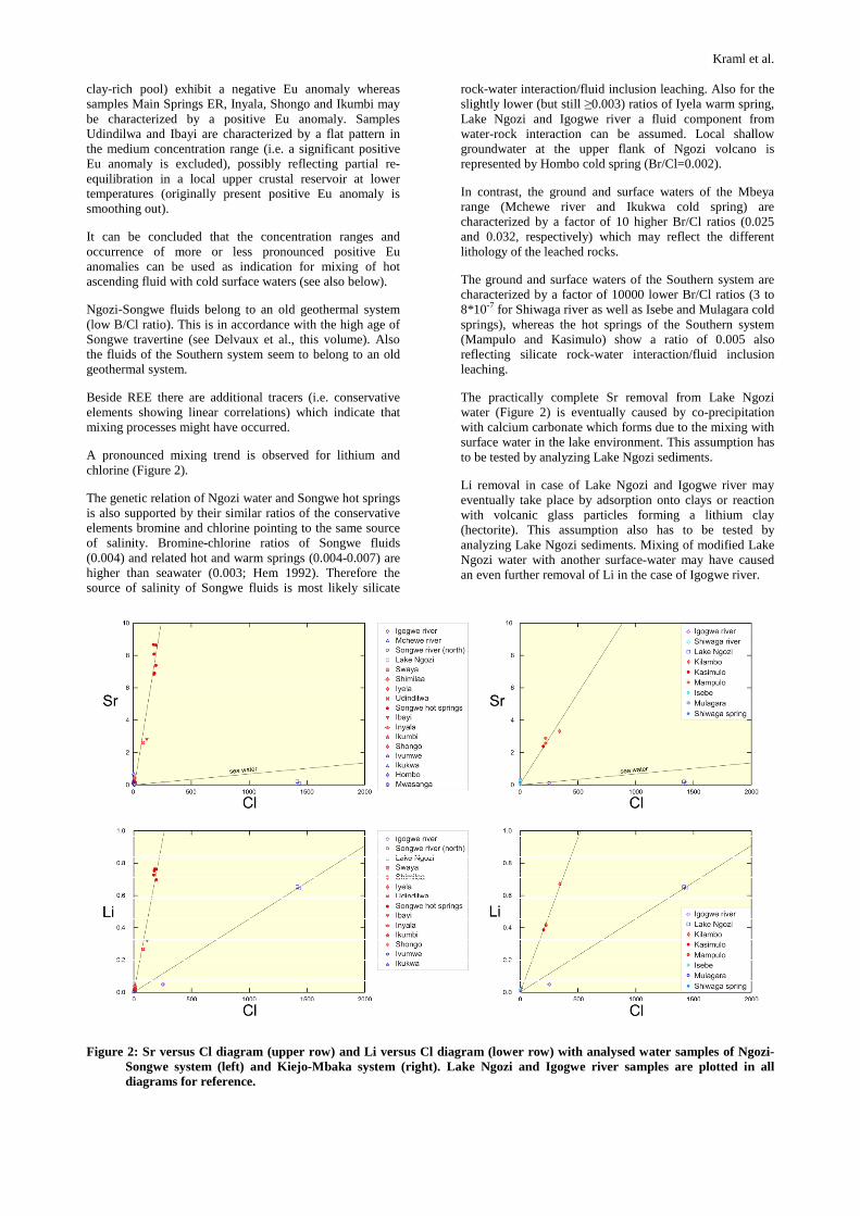
A pronounced mixing trend is observed for lithium and chlorine (Figure 2).
The genetic relation of Ngozi water and Songwe hot springs is also supported by their similar ratios of the conservative elements bromine and chlorine pointing to the same source of salinity. Bromine-chlorine ratios of Songwe fluids (0.004) and related hot and warm springs (0.004-0.007) are higher than seawater (0.003; Hem 1992). Therefore the source of salinity of Songwe fluids is most likely silicate
rock-water interaction/fluid inclusion leaching. Also for the slightly lower (but still ≥0.003) ratios of Iyela warm spring, Lake Ngozi and Igogwe river a fluid component from water-rock interaction can be assumed. Local shallow groundwater at the upper flank of Ngozi volcano is represented by Hombo cold spring (Br/Cl=0.002).
In contrast, the ground and surface waters of the Mbeya range (Mchewe river and Ikukwa cold spring) are characterized by a factor of 10 higher Br/Cl ratios (0.025 and 0.032, respectively) which may reflect the different lithology of the leached rocks.
The ground and surface waters of the Southern system are characterized by a factor of 10000 lower Br/Cl ratios (3 to 8*10-7 for Shiwaga river as well as Isebe and Mulagara cold springs), whereas the hot springs of the Southern system (Mampulo and Kasimulo) show a ratio of 0.005 also reflecting silicate rock-water interaction/fluid inclusion leaching.
The practically complete Sr removal from Lake Ngozi water (Figure 2) is eventually caused by co-precipitation with calcium carbonate which forms due to the mixing with surface water in the lake environment. This assumption has to be tested by analyzing Lake Ngozi sediments.
Li removal in case of Lake Ngozi and Igogwe river may eventually take place by adsorption onto clays or reaction with volcanic glass particles forming a lithium clay (hectorite). This assumption also has to be tested by analyzing Lake Ngozi sediments. Mixing of modified Lake Ngozi water with another surface-water may have caused an even further removal of Li in the case of Igogwe river.
Figure 2: Sr versus Cl diagram (upper row) and Li versus Cl diagram (lower row) with analysed water samples of Ngozi-Songwe system (left) and Kiejo-Mbaka system (right). Lake Ngozi and Igogwe river samples are plotted in all diagrams for reference.

Kraml et al.
3.2 Isotopic composition of fluids (incl. isotope hydrology)
Tritium analyses indicate that already the surface waters of Lake Ngozi and Igogwe river are characterized by a low T content of about one Tritium Unit [TU] and all analysed thermal waters are (at least almost) T-free. This could indicate that the mean residence time of the deep reservoir fluid is >50 years and that even the analysed surface waters of Lake Ngozi and Igogwe river contain a significant amount of those T-free waters. The latter finding is in agreement with the high solute content of those two samples (compare section fluid chemistry above and stable isotope composition below). From simple linear mixing calculations based on chlorine content, the fluid which mixes with water from a leakage of Lake Ngozi to result in Igogwe river water should have a Cl content of 4.6ppm and 0.956 TU. If the flow rate of Igogwe river at the sampling site is roughly 1.5m3/s (Kato Kabaka oral communication) than the leak in the southern flank of Lake Ngozi would be in the order of 260 l/s. Since Igogwe river is tributary to Kiwira river, this observation has implications for the salinity budget of the Southern system down to Lake Nyasa. The leak may occur in localised form (fault?) because e.g. Shiwaga river which is also originating from the southern flank of Ngozi is characterized by a low solute content (Cl = 2.3ppm).
Figure 4: Stable isotopic composition (δ18O, δD) of analysed water samples. Data of the southern area (Lumbila, Kiwira, Songwe south, Mbaka and Lufirio rivers, Rungwe rain and Lake Nyasa) are taken from Branchu et al. (2005).
The results of the stable isotope composition are presented in Figure 4. It is evident that the northern Songwe-Ngozi fluids are characterized by more depleted isotopic compositions than the ones from the southern Kiejo-Mbaka system. This could indicate that the recharge originates mainly from higher elevated areas in case of the Northern system whereas a significant contribution of precipitation from lower elevated areas has to be postulated for the Southern system. This is in agreement with overall hydrological situation described in CCKK (1982), i.e. main precipitation and infiltration in the more arid northern area on the high elevated rift shoulders and Poroto mountains including Ngozi volcano.
However, evaporation alone is not sufficient to explain very high salinity of Lake Ngozi samples (relatively low potential evaporation due to high elevation and cloud cover conditions). Therefore, a hydrothermal seepage has to be postulated. This is in accordance with the findings of Delalande et al. (2008b) for some Mbaka lakes.
3.3 Gas species and isotopic composition
CO2 is the major gas component of Songwe and most other hot springs (except Swaya, Ikumbi and Kilambo; Figure 5) and has predominantly a volcanic origin (Figure 6).
Figure 5: Diagram CO2 versus N2 of analysed gases for Southern system (upper diagram) and Northern system (lower diagram). Note deviations of simple mixture between volcanic and atmospheric gases in case of the Northern system.
The major atmospheric gas component in case of Kilambo hot spring may be due to contamination during sampling (Figure 5). Please note that gas flow rate in case of Swaya and Ikumbi was very low that soil gas (e.g. CO2 from plant root respiration and atmospheric gas) could significantly contribute to the gas sample (Figure 6).
The major gases are simple mixtures of volcanic CO2 and atmospheric gases (Figure 5; note higher atmospheric gas content in case of sampling during end of wet season => sample Mampulo). Especially for the Southern system this mixing effect explains the composition of major gas species completely.
Figure 6: Carbon isotopic composition of CO2 for Ngozi-Songwe system (left diagram) and for Kiejo-Mbaka system (right diagram) (data range for different gas sources are from a compilation in Griesshaber-Schmahl 1990).
Noble gas data are presented in Figure 7. The isotopic compositions are characterized by 3He/4He and 4He/20Ne ratios showing mixing between crustal, atmospheric and mantle components. Some samples highlight mixing of mantle derived gases with a crustal component that can dominate the isotopic signatures. This Ivuna-Kalambo trend does not mix back to the atmosphere, but somewhere along the atmosphere-mantle mixing array, suggesting that interaction with a crustal component occurred after mixing

Kraml et al.
between atmosphere and the magma-derived fluids, in approximately constant proportions (Pik et al. 2006).
Figure 7: 4He/20Ne versus R/Ra diagram with all analyzed samples of the Northern system (orange symbols) and Southern system (pink symbols). The black symbols represent data of Pik et al. (2006).
Udindilwa and Ibayi with R/Ra <1 are lacking Neon and can therefore not be plotted in the diagram. However, it is evident that both samples show a nearly as high crustal component than Ivuna spring which is caused by aging within Precambrian basement rocks. Additionally, those two samples are characterized by high He concentrations which can also be explained with abundant 4He uptake by α-decay within the comparably long residence time in e.g. U-rich crystalline basement rocks (local reservoirs => partly re-equilibrated fluids; see Figure 8).
The reported He isotopic ratios are equivalent to up to nearly pure mantle helium (warm spring Swaya after correction for atmospheric component). The mantle helium component is a further indicator that one component of the gas composition is clearly of volcanic origin and that the Southern system in general has a pronounced crustal component (in accordance with more radiogenic Sr isotopic composition of Southern system travertines).
3.5 Reservoir temperatures
For constraining the reservoir temperatures, three types of geothermometers have been applied:
1. solute geothermometer
2. gas geothermometer
3. isotope geothermometer
Results of solute geothermometry presented in Figure 8 are summarized below (see also extended discussion in Mnjokava 2007):
1. For Songwe geothermal system it is evident that the slow equilibrating geothermometers point to reservoir temperatures of >200°C as mentioned by previous authors (e.g. Hochstein et al. 2000; Branchu et al. 2005) and the fast equilibrating geothermometers give temperatures of around 100°C which may reflect local conditions in the subsurface of the springs. The progress in this study is the finding of a likely genetic relation of Songwe and Ngozi fluids. Even the data point of the diluted water of Ngozi caldera lake is situated in the partially equilibrated field and plots on the
same line than the more diluted Songwe and Mahombe samples (Figure 8).
In contrast to the Songwe springs, the Southern system(s) are characterized by reservoir temperatures significantly below 200°C.
Unfortunately, multiple mineral equilibria and mixing models (Mnjokava 2007) are not applicable for further constraining the reservoir temperatures. One reason is that the high CO2 content may be responsible for rapid dissolution of silicate minerals and especially at low temperatures the waters therefore tend to equilibrate with amorphous silica. This trend is also observed for fluids >50°C in case of the Southern system. In contrast, the fluids >50°C of the Ngozi-Songwe system tend to equilibrate with chalcedony (closest approximated in case of hottest Songwe spring Ilatile 4).
2. Methane/ethane gas geothermometer (Darling & Talbot 1991) gives temperatures similar to Na/K solute geothermometer which supports these findings at least for Mampulo hot spring of the Southern system. The June 2006 gas geothermometry results could be reproduced with the second sample series taken from Mampulo (= Kandete) spring in November 2006 yielding a mean reservoir temperature of 160°C.
The gases of Udindilwa were not used for geothermometry because they may not be purely of thermogenic origin, i.e. a 4.4 times higher CH4 concentration was found in gas sample of 47.0°C hot spring Udindilwa-1 (C1/[C2+C3] = 1063) than in the one from 65.7°C hot spring Udindilwa-2 (C1/[C2+C3] = 338) due to a higher proportion of admixed surface water from the swamp in which the springs emanate.
The used gas samples have δ13C(CH4) values relatively close to those of Kiejo CO2 well (-26.7‰ PDB) and low C1/(C2+C3) ratios. However, even in the case of the used gas samples one cannot be sure that the CH4 of all samples was produced at depth by high-temperature synthesis. Especially missing δ13C(CH4) values for sample “Main Springs East Ridge” do not allow for an sufficient assessment of the hydrocarbon formation conditions.
The application of the CH4/CO2 gas geothermometer is not useful in the case of samples from hot springs and therefore the calculated temperatures of >300°C for all samples (except Ibayi) are not meaningful for characterizing the reservoir conditions.
Since air contamination present in all samples leads to oxidation of reducing gas species like H2 and admixture of atmospheric Ar, the CO2/Ar – H2/Ar gas geothermometers cannot be applied.
3. The carbon isotope geothermometer always gives significant higher temperatures than those encountered in the deep wells (Allen & Darling 1992). Therefore, also those temperatures are not reflecting relevant reservoir conditions.
Temperatures of >200°C as predicted for the Northern system applying solute geothermometers would cause an intense alteration which could be detected by geophysical methods revealing the resistivity structure of the subsurface. The results of those successful measurements are presented in Kalberkamp et al., (this volume).

Kraml et al.
Figure 8: Na-K-Mg ternary diagram with analysed water samples of Ngozi-Songwe system (left) and Kiejo-Mbaka system (right). Additional data of Ivuna spring were taken from Makundi & Kifua (1985). Lake Ngozi and Igogwe river samples are plotted in both diagrams for reference.
CONCLUSIONS
Ngozi-Songwe geothermal system
1. From volcanological investigations it is evident that the trachytic magma chamber of Ngozi volcano (as suggested for the first time within this project) provides an ideal heat source which was replenished in the Holocene.
2. Tectonic investigations (Delvaux et al., this volume) have shown that the fluid flow is fault controlled (fracture permeability). Preferred flow paths are along open faults belonging to the major Rift trend (long-living, often reactivated, continuous faults). An integrated flow of up to 75 l/s for Songwe hot springs, equivalent to 10 MWth natural heat loss (Hochstein et al. 2000), qualify them as the most prominent outflow of the geothermal system in the northern part of the investigated area. However, other (for the first time within this project) sampled individual warm and hot springs (with exception of Shimilaa) are characterized by low flow rates and are practically tritium-free. The mean residence time of >50 years and the low flow rates indicate that the permeabilities are not very high which is typical for the East African Rift.
3. First isotope hydrological investigations for the northern part of the Mbeya area done within this project have shown that the recharge is from high elevated areas between 1800 and 2200m a.s.l. (e.g. Ngozi volcano itself and related high Poroto mountains). This excludes especially for Udindilwa hot spring in Usangu basin a significant component of local recharge (in agreement with evidence from tritium analysis).
Fluid chemistry suggests a hydrothermal seepage affecting Lake Ngozi water and a relation of Ngozi water, Songwe and Mahombe hot spring fluids having equilibrated at >200°C mainly within volcanic rocks (Figure 8). This relation was proposed for the first time within this project. Hot spring fluids Udindilwa (at Usangu scarp) and Ibayi (at Lupa fault) may have at least partly re-equilibrated in non-volcanic host rocks (compatible with He isotopic evidence) at temperatures in those local reservoirs of <200°C.
4. Mineralogical investigations of an altered basement xenolith (Ubendian gneiss) within a suite of numerous collected unaltered gneiss xenoliths suggest a reservoir
within the lowest part of the Ngozi volcanic sucession which is compatible with Sr isotope investigations of travertine as well as warm and hot spring fluids, done for the first time within this project. It is known from first U/Th dating of Songwe travertine within this project that the geothermal system existed long before the major caldera forming eruption that it was a justified assumption to find a direct sample of the seal (clay cap) formed by high-temperature alteration. However, such a xenolith sample could not be found. Therefore, indirect evidence from deep reaching geophysical investigations (resistivity methods TEM & MT) applied for the first time in Mbeya area was used to detect the seal as well as locating the reservoir in depth and to pin down its lateral extension (Kalberkamp et al., this volume).
From above mentioned geological and geochemical evidence an upflow was proposed at Ngozi volcano and a main outflow in W to NW direction mainly to Songwe and also Mahombe hot springs (see Delvaux et al., this volume). Both areas are characterized by massive travertine deposits. A major part of the travertine is believed to have formed during former humid phases (lake level highstands) also on high elevated areas due to the higher hydraulic head than today.
This conceptual model is supported by geophysical investigations. The detected resistivity structure is compatible with a high-enthalpy reservoir in the proposed area (see Kalberkamp et al., this volume)
In summary, geological investigations and geochemical analyses of the thermal waters, gases and the associated travertine deposits, together with geophysical surveys allowed for proposing a consistent geothermal model for the Ngozi-Songwe part of the Rungwe Volcanic Province.
Kiejo-Mbaka geothermal system
1. From volcanological data it can be concluded that the primitive melts erupting at recently active Kiejo volcano (last lava flow 200 years ago; Harkin 1955) are ascending from great depth within a conduit or along prominent faults (Mbede et al. 2006) and therefore much less suitable as sustainable heat source than magma chambers. The role of Rungwe magma chamber as potential heat source of the Southern system has to be investigated in the future.
Kraml et al.
2. Most prominent permeable structure is the Mbaka fault allowing reasonable high flow rates (Kilambo hot springs: 20-40 l/s; Hochstein et al. 2000). Springs and gases emanate at sites mainly where disconnected faults of recently reactivated conjugate set of faults (Usangu and Basement tend) are crossing the Mbaka fault (see Delvaux et al., this volume). Tritium analyses in connection with 3He and CFC (chlorofluorocarbon) analyses could further constrain permeabilities and clarify the recharge conditions. In this context, it could be of utmost importance to trace active faults in the frame of a micro-seismicity survey.
3. Abundant recharge feeding the reservoir of the hot springs is from elevations between 1000 and 1600m a.s.l.. The hydrology of the Southern system is intensively studied e.g. by Delalande et al. (2005, 2008a,b). Solute and gas geothermometers indicate reservoir temperatures of significantly below 200°C (medium-enthalpy).
4. With available data no conclusive conceptual model regarding the location of the heat source and related upflow zone (geothermal reservoir) can be presented for the Southern system. Therefore all possibilities should be tested with deep reaching resistivity methods. A first geophysical reconnaissance survey should cover the whole area between Rungwe caldera and Mbaka fault (including measurements inside the caldera) as well as between Kiejo and Mbaka fault. Drilling into the Mbaka fault zone without the results of the suggested geophysical survey is not recommended due to the high risk for missing the major reservoir(s), if existing.
The existence of at least two major geothermal systems in Mbeya area noted already in former studies could be further constrained and characterized by geological geochemical and hydrological investigations.
For the first time we proposed a suitable heat source (trachytic magma chamber of Ngozi volcano) for driving the Songwe geothermal system in the northern part of the investigated area. This has lead to the detection of additional, formerly unknown springs in the area between Ngozi volcano and Songwe springs. The analyses of those samples complemented the isotope hydrology data set which so far only existed for the Southern system and enhanced the data base for interpreting the fluid and gas geochemistry (including noble gases). The isotope hydrology and geochemistry data show a clear distinction between the Northern and Southern system and higher predicted reservoir temperatures for the Northern system.
Detailed tectonic investigations revealed that the fluid flow is fault controlled (fracture permeability; Delvaux et al., this volume). A connection of the volcanic and geothermal activity as well as climate could be established in space and time.
The up to >80°C waters of hot springs must ascent from a minimum depth of >1500m if a normal geothermal gradient of the rift is assumed. An even greater depth results from evidence found for cooling by mixing with cold groundwater and conductive cooling in case of low flow rate of individual springs.
A predicted reservoir temperature (Na/K geothermometer) of around 230°C for the Northern Songwe-Ngozi system would imply a locally enhanced geothermal gradient of around 95°C/km which should be easily detectable by deep gradient wells (below groundwater aquifer). The high-enthalpy reservoir fluids could be utilized most likely by a
cost-effective single-flash power plant (direct steam turbine).
Other independent gas and isotope geothermometry (e.g. CO2/Ar-H2/Ar and δ18O sulfate-water) for confirming the results of the solute geothermometry should be tried only if suitable samples can be detected and taken in the future (e.g. hydrothermal seepages with unaltered reservoir gas composition at the bottom of Lake Ngozi). However, this would require a very high logistical effort with long-term observation of only periodically occurring gas emanations, a complete bathymetric and temperature survey as well as professional divers trained in hydrothermal fluid and gas sampling in up to >80m water depth. From our experience collected during the field survey in June/July 2007 this time-consuming campaign would be best implemented within a scientific research project.
Although there are strong indications for a potential high temperature reservoir at the location and depth shown, the localised reservoir seems to be relatively small. Therefore we recommend some five additional magnetotelluric and TEM soundings extending two magnetotelluric profiles southwards in order to proof the interpretation and to help delineating the lateral extension of the proposed reservoir, before assigning locations for exploratory wells. Because of the steep and hardly accessible terrain there, special effort has to be spent for these measurements.
It is not recommended to extend the surface exploration to the area of Ivuna hot spring at Lake Rukwa because there are no indications for a viable geothermal system in the subsurface.
In Rungwe-Kiejo area e.g. Mbaka fault could be a further exploration target but due to unfavourable heat sources and lower predicted reservoir temperatures the geothermal potential of the Southern system is expected to be significantly smaller than in Ngozi-Songwe area (Northern system).
However, the predicted reservoir temperatures for the Kiejo-Mbaka system would be more than sufficient for a binary power plant (medium-enthalpy resource).
Additional to power generation –not only in Rungwe-Kiejo area– alternative projects for direct use of the heat would be beneficial for the local people (e.g. drying of agricultural products and cement slabs).
ACKNOWLEDGEMENT
We highly appreciated the support and expertise of the dedicated personnel of the Geological Survey of Tanzania (GST), the Ministry for Energy and Minerals of Tanzania (MEM), the Tanzania Electric Supply Co. Ltd. (TANESCO), the Federal Institute for Geosciences and Natural Resources (BGR) and numerous local helpers in the field. Additionally we appreciated the fruitful cooperation with UNU-GTP for capacity building within specialized six months training courses for Jacob Mayalla (geology) and Taramaeli Mnjokava (geochemistry) as well as the fruitful cooperation with the Royal Museum for Central Africa, Tervuren, Belgium related to the geological context in Mbeya area.
This work was carried out within the framework of the GEOTHERM technical cooperation programme, implemented by the German Federal Institute for Geosciences and Natural Resources (BGR) on behalf of the

Kraml et al.
Federal Ministry for Economic Cooperation and Development (BMZ) under contact no. 2002.2061.6.
REFERENCES
Branchu, P., Bergonzini, L., Delvaux, D., Batist, M., Golubev V., Benedetti M. & Klerk, J. (2005): Tectonic, climatic and hydrothermal control on sedimentation and water chemistry of northern Lake Malawi (Nyasa), Tanzania. - Journal of African Earth Science 43: 433- 446.
CCKK Carl Bro, Cowiconsult & Kampsax-Krüger (1982): Water Master Plans for Iringa, Ruvuma and Mbeya Regions.- United Republic of Tanzania, Danish International Development Agency – DANIDA, Volume 3 (Summary); Volume 6 (Selected Maps), Volume 9 (Hydrogeology), Volume 10B (Hydrogeological Data, Borehole Data).
DECON, SWECO & Inter-Consult (2005): Tanzanian Rural Electrification Study. Technical Report on Geothermal Power. Activity 1.4.1, Dar es Salaam, Tanzania, 22pp. plus 24 appendices.
Delalande, M., Bergonzini, L., Beal, F., Garcin, Y., Majule, A. & Williamson, D. (2005): Contribution à la détection des pertes souterraines du Lac Masoko (Tanzanie): evidences isotopiques (18O, D). - Hydrological Sciences Journal -Journal des Sciences Hydrologiques 50(5): 867-880.
Delalande, M., Bergonzini, L., & Massault, M. (2008a): Mbaka lakes isotopic (18O and 2H) and water balances: discussion on the used atmospheric moisture compositions. - Isotopes in Environmental and Health Studies 44(1): 71-82.
Delalande, M., Bergonzini, L., Branchu, P., Filly, A. & Williamson, D. (2008b): Hydroclimatic and geothermal controls on the salinity of Mbaka Lakes (SW Tanzania): Limnological and paleolimnological implications. -Journal of Hydrology 2008 (in press).
Delvaux, D., Kraml, M., Sierralta, M., Wittenberg, A., Mayalla, J.W., Kabaka, K., Makene, C. and GEOTHERM working group (2010): Surface exploration of a viable geothermal resource in Mbeya area, SW Tanzania. Part I: Geology, Proceedings, World Geothermal Congress 2010, Bali, Indonesia 25 – 29 April, this volume.
Ebinger, C.J., Deino, A.L., Tesha, A.L., Becker, T. & Ring, U. (1993a): Tectonic controls on rift basin morphology: evolution of the northern Malawi (Nyasa) Rift, Journal of Geophysical Research, 98, No. B10: 17,821-17,836.
Ebinger, C., Klerkx, J., Delvaux, D. & Wüest, A. (1993b): Evaluation of Natural Hazards in the Northern Part of the Malawi Rift (Tanzania), Mus. roy. Afr. centr., Tervuren (Belg.), Dépt. Géol. Min., Rapp. ann. 1991-1992: 83-86.
Furman, T. (1995): Melting of metasomatized subcontinental lithosphere: undersaturated mafic lavas from Rungwe, Tanzania. - Contrib. Mineral. Petrol. 122: 97-115.
Griesshaber-Schmahl, E. (1990): Helium and Carbon Isotope Systematics in Groundwaters from W.Germany and E.Africa. - Dissertation University of Cambridge, 211 pp.
Harkin, D.A. (1955): The Sarabwe Lava Flow, Kiejo, Rungwe District. - Tanganyika Notes 40: 20-23.
Hem, J.D. (1992): Study and interpretation of the chemical characteristics of natural water. - U.S. Geological Survey Water-Supply Paper 2254, 263pp. (3rd edition).
Hochstein, M.P., Temu, E.B & Moshy, C.M.A. (2000): Geothermal Resources of Tanzania, Proceedings, World Geothermal Congress 2000, Kyushu-Tohoku, Japan May 28 - June 10, 2000: 1233-1237.
Ivanov, A.V., Rasskazov, S.V., Boven, A., Andre, L., Maslovskaya, M.N. & Temu, E.B. (1998): Late Cenozoic Alkaline-Ultrabasic and Alkaline Basaltic Magmatism of the Rungwe Province, Tanzania. - Petrology 6(3): 208-229.
Kalberkamp, U., Schaumann, G., Ndonde, P.B., Chiragwile, S.A., Mwano, J.M. and GEOTHERM working group (2010): Surface exploration of a viable geothermal resource in Mbeya area, SW Tanzania. Part III: Geophysics, Proceedings, World Geothermal Congress 2010, Bali, Indonesia 25 – 29 April, this volume.
Makundi, J.S. & Kifua, G.M. (1985): Geothermal features of the Mbeya prospect in Tanzania. - Trans. Geothermal Resources Council, Transactions 9(1): 451-454.
Mbede, E., Yanda, P., Mbegha, A., Marobhe, I., Maboko, M. & Ferdinand, W. (2006): Seismic and associated risks in the areas surrounding the Rungwe Volcanic Province, southern Tanzania, Abstract Volume, First COSTECH Scientific and Technological Conference, Dar es Salaam, Tanzania, 24 – 26 May, 2006, Abstract A43, p.63.
Mnjokava, T.T. (2007): Interpretation of Exploration Geochemical Data for Geothermal Fluids from the Geothermal Field of the Rungwe Volcanic Area, SW-Tanzania.- UNU-GTP Reykjavík, Iceland, Reports 2007, Number 14: 303-332
Mnzava, L.J., Mayo, A.W. & Katima, J.H.Y. (2004): In search of geothermal energy power potential in Tanzania: the role of geophysics. In: Geo-Environment, WIT Press, 25-36.
Pik, R., Marty, B. & Hilton, D.R. (2006): How many mantle plumes in Africa? The geochemical point of view. - Chemical Geology 226: 100-114.
Sun, S.S. & McDonough, W.F. (1989): Chemical and isotopic systematics of oceanic basalts: implications for mantle composition and processes. - In: A.D. Saunders & M.J. Norry (Eds.) Magmatism in oceanic basins. Geol. Soc. Lond. Spec. Pub., p. 313-345.