Embed Size (px)
Citation preview
Supporting Documentation E.Potential Nourishment Sand Sources (RHDHV, 2020b)
REPORT
Stockton Coastal Management
Program
Potential Nourishment Sand Sources
Supporting Document E
Client: City of Newcastle
Reference: PA2395-RHDHV-CN-PL-0009
Status: S0/P01.01
Date: 11/05/2020

P r o j e c t r e l a t e d
11/05/2020 SUPPORTING DOCUMENT E PA2395-RHDHV-CN-PL-0009 i
HASKONING AUSTRALIA PTY LTD.
Level 14
56 Berry Street
NSW 2060 North Sydney
Water
Trade register number: ACN153656252
+61 2 8854 5000
+61 2 9929 0960
royalhaskoningdhv.com
T
F
E
W
Document title: Stockton Coastal Management Program
Document short title: Supporting Document E
Reference: PA2395-RHDHV-CN-PL-0009
Status: P01.01/S0
Date: 11/05/2020
Project name: Stockton Coastal Management Program
Project number: PA2395
Author(s): Pat Lawless
Drafted by: Pat Lawless
Checked by: Nat Patterson
Date / initials: NP 4/5/2020
Approved by: Greg Britton
Date / initials: GB 4/5/2020
Classification
Project related
Disclaimer
No part of these specifications/printed matter may be reproduced and/or published by print, photocopy, microfilm or by
any other means, without the prior written permission of Haskoning Australia PTY Ltd.; nor may they be used, without
such permission, for any purposes other than that for which they were produced. Haskoning Australia PTY Ltd.
accepts no responsibility or liability for these specifications/printed matter to any party other than the persons by
whom it was commissioned and as concluded under that Appointment. The integrated QHSE management system of
Haskoning Australia PTY Ltd. has been certified in accordance with ISO 9001:2015, ISO 14001:2015 and ISO
45001:2018.
P r o j e c t r e l a t e d
11/05/2020 SUPPORTING DOCUMENT E PA2395-RHDHV-CN-PL-0009 ii
Table of Contents
1 Introduction 4
2 Terrestrial Sources 4
2.1 Local Quarries 4
2.2 Sydney Tunnelling Spoil Opportunities 8
2.3 Sand backpassing from Stockton Bight using Beach Scraping 11
2.4 Sand backpassing from Stockton Bight with Sand Shifter 15
2.5 Beach Scraping within the Stockton CMP Area 18
2.6 Swansea Channel Dredged Material 20
3 Marine Sources 21
3.1 Dredging of Offshore Sand Sources 21
3.2 Port of Newcastle – Area E 22
3.3 Sand Bypassing from Nobbys Beach 24
4 Hunter River Sources 25
4.1 South Arm 25
4.2 North Arm 26
5 Beach Nourishment Concept Approval Pathway 27
6 Summary of Potential Sand Sources 28
7 References 33
Table of Tables
Table 1: Native and borrowed sand physical properties and calculated Overfill Factors 6
Table 2: Local Quarry Licensed Extractive Capacity 7
Table 3 Traffic light assessment of potential sand sources: 29
Table of Figures
Figure 1: Stockton quarries - sand product PSDs 5
Figure 2: Isolines of the adjusted overfill ratio (RA) for values of φ mean differences and φ sorting
ratio (Shore Protection Manual 1984) 6
Figure 3: WHT tunneling sites nominated for unconfined sea disposal of terrestrial tunnel spoil 9
P r o j e c t r e l a t e d
11/05/2020 SUPPORTING DOCUMENT E PA2395-RHDHV-CN-PL-0009 iii
Figure 4: Reserves comprising the Worimi Conservation Lands 14
Figure 5: Example submerged sand extraction unit 16
Figure 6: Sand backpassing schematic for Sand Shifter 16
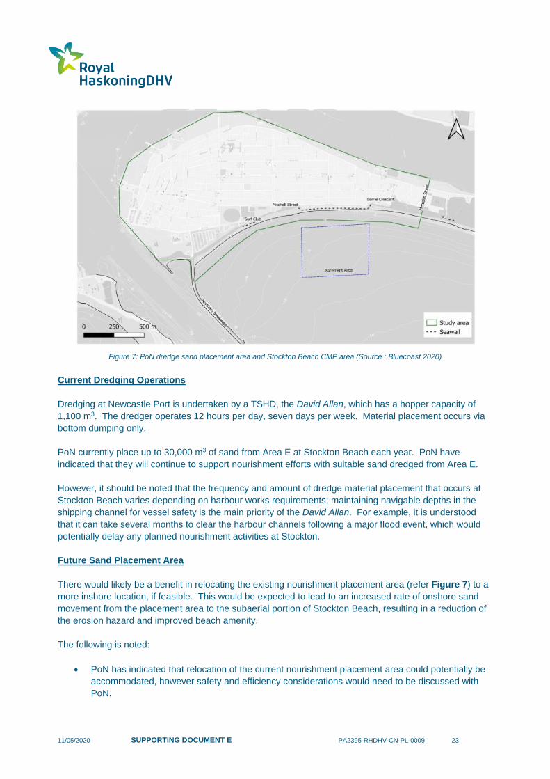
Figure 7: PoN dredge sand placement area and Stockton Beach CMP area (Source : Bluecoast
2020) 23
11/05/2020 SUPPORTING DOCUMENT E PA2395-RHDHV-CN-PL-0009 4
1 Introduction
It is evident that one of the key drivers of the coastal risk at Stockton Beach is a long-term net sediment
deficit (underlying recession). In addition, future shoreline recession is predicted to occur as a result of
climate change sea level rise.
Beach nourishment has been considered in detail as a potential coastal management strategy to address
the recession hazard. A wide range of potential sand sources have been considered as part of the
Stockton CMP process, including:
• Terrestrial sources, including:
• local quarries;
• Sydney tunnelling spoil opportunities;
• sand backpassing from Stockton Bight using beach scraping;
• sand backpassing from Stockton Bight with Sand Shifter;
• beach scraping within the Stockton CMP Area; and,
• Swansea Channel dredged material;
• Marine sources, including:
• offshore sand sources;
• Port of Newcastle – Area E; and,
• sand bypassing from Nobbys Beach;
• Hunter River sources, including:
• South Arm; and,
• North Arm.
An overview of each of the above potential sand sources is provided in Sections 2, 3 & 4 below, including
assessment of the feasibility, opportunities and constraints for each source. Details regarding a potential
concept approval for the placement of nourishment material at Stockton Beach are provided in Section 5
A ‘traffic light’ assessment of each sand source is provided in Section 6 References are provided in
Section 7.
It should be noted that further details regarding potential sand sources will be provided in the Sand
Management Plan (SMP), which is identified as an action within the Stockton CMP. The SMP will provide
a summary document of information regarding sand for future beach nourishment at Stockton.
2 Terrestrial Sources
2.1 Local Quarries
Material Properties (Previous Assessment)
RHDHV (2016a) investigated sand sources for the dune restoration over the revetment at Stockton SLSC,
which included consultation with several local sand quarries to assess the suitability of available products
against material acceptance criteria. Local sand quarries contacted as part of these investigations
included:
• Macka's Sand and Soil Supplies;
11/05/2020 SUPPORTING DOCUMENT E PA2395-RHDHV-CN-PL-0009 5
• Boral Stockton Sand Quarry; and
• Sibelco Sand Quarry in Salt Ash (Note: Sibelco only carry a maximum of 2,500 tonnes of their
3060 product at any one time, and orders greater than this will incur longer lead times).
Material data sheets relating to available products were provided by each of the quarries and assessed by
RHDHV engineers.
Considering that all locally sourced terrestrial sands are quarried from the windblown dunes of Stockton
Bight and are further processed (i.e. washed and screened), it is unlikely that these terrestrial sands would
contain any contaminants, organic matter, excessive fines or excessive coarse material, or colour
incompatibilities following placement. Therefore, the key criterion determining the compatibility of these
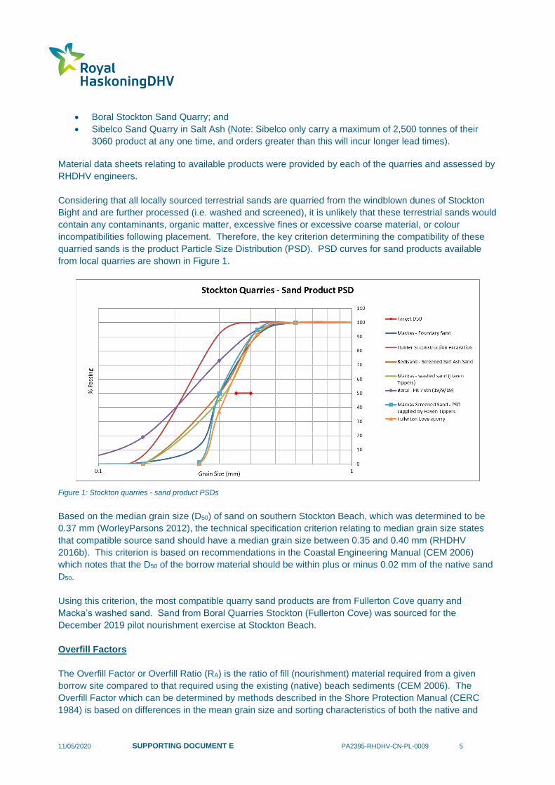
quarried sands is the product Particle Size Distribution (PSD). PSD curves for sand products available
from local quarries are shown in Figure 1.
Figure 1: Stockton quarries - sand product PSDs
Based on the median grain size (D50) of sand on southern Stockton Beach, which was determined to be
0.37 mm (WorleyParsons 2012), the technical specification criterion relating to median grain size states
that compatible source sand should have a median grain size between 0.35 and 0.40 mm (RHDHV
2016b). This criterion is based on recommendations in the Coastal Engineering Manual (CEM 2006)
which notes that the D50 of the borrow material should be within plus or minus 0.02 mm of the native sand
D50.
Using this criterion, the most compatible quarry sand products are from Fullerton Cove quarry and
Macka’s washed sand. Sand from Boral Quarries Stockton (Fullerton Cove) was sourced for the
December 2019 pilot nourishment exercise at Stockton Beach.
Overfill Factors
The Overfill Factor or Overfill Ratio (RA) is the ratio of fill (nourishment) material required from a given
borrow site compared to that required using the existing (native) beach sediments (CEM 2006). The
Overfill Factor which can be determined by methods described in the Shore Protection Manual (CERC
1984) is based on differences in the mean grain size and sorting characteristics of both the native and

11/05/2020 SUPPORTING DOCUMENT E PA2395-RHDHV-CN-PL-0009 6
nourishment (borrowed) sands. Overfill Factors calculated for several of the potential quarry sand sources
using methods outlined in the CERC (1984) have been provided in Table 1 and Figure 2.
Table 1: Native and borrowed sand physical properties and calculated Overfill Factors
Sand Source Mφ1 σφ2 Overfill Factor (RA)
Native Sand 1.30 phi3 0.7 phi3 -
Haven Tipper (Macka’s
washed fine dune sand) 1.64 phi 0.46 phi 4.0
Haven Tippers (Macka’s
screened sand) 1.74 phi 0.23 phi >10 (unstable)
Fullerton Cove 1.6 phi 0.42 phi 3.5 1 Mean grain size (phi scale) 2 Sorting (phi scale) 3 Obtained from WorleyParsons (2012), excluding sample T3D.
Figure 2: Isolines of the adjusted overfill ratio (RA) for values of φ mean differences and φ sorting ratio (Shore Protection Manual
1984)
CEM (2006) recommends that for a sand nourishment project, ideally a nourishment (borrow) sand should
have an overfill ratio of 1 to 1.05 relative to the native sand. However, CEM (2006) also notes that this
may not always be possible and as a rule of thumb if the median grain size of the borrow sand is within
0.02 mm of the native sand median grain size it is considered compatible.
Pelican
Hunter St
excavation
Macka’s Washed
Macka’s
Screened
Fullerton Cove
11/05/2020 SUPPORTING DOCUMENT E PA2395-RHDHV-CN-PL-0009 7
Previous assessments of terrestrial sand sources found that the median grain size was generally finer
than the native sand requiring 2 to 3 times as much sand to retain each 1 m3 on the beach. An Overfill
Factor of approximately 2.5 has therefore been adopted for terrestrial sand nourishment at Stockton
Beach, however this would need to be reviewed on a case by case basis during any future nourishment
works in consideration of the material properties of proposed sand nourishment material.
Other Local Quarry Sources
In addition to the three local quarry sources noted previously (Boral Stockton, Macka’s Sand & Soil, and
Sibelco), other local quarry sources that could potentially supply nourishment sand for Stockton Beach
include:
• Newcastle Sand (Williamtown); and,
• Redisands (Salt Ash).
A compatibility assessment of the above sand sources has not been undertaken. However, it is noted that
these products are sourced from the Stockton sand dunes and are likely to be similar to the products
assessed by RHDHV in 2016. This would need to be confirmed as part of any detailed nourishment
design. However, for the purpose of the current assessment, it is considered reasonable to assume that
the above products would have similar material properties as other local quarry sources.
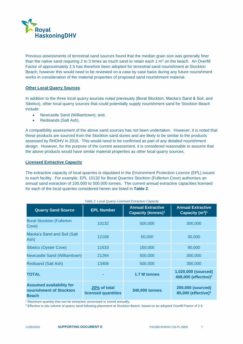
Licensed Extractive Capacity
The extractive capacity of local quarries is stipulated in the Environment Protection Licence (EPL) issued
to each facility. For example, EPL 10132 for Boral Quarries Stockton (Fullerton Cove) authorises an
annual sand extraction of 100,000 to 500,000 tonnes. The current annual extractive capacities licensed
for each of the local quarries considered herein are listed in Table 2.
Table 2: Local Quarry Licensed Extractive Capacity
Quarry Sand Source EPL Number Annual Extractive
Capacity (tonnes)1
Annual Extractive
Capacity (m3)1
Boral Stockton (Fullerton
Cove) 10132 500,000 300,000
Macka’s Sand and Soil (Salt
Ash) 12108 50,000 30,000
Sibelco (Oyster Cove) 11633 150,000 90,000
Newcastle Sand (Williamtown) 21264 500,000 300,000
Redisand (Salt Ash) 13406 500,000 300,000
TOTAL - 1.7 M tonnes 1,020,000 (sourced)
408,000 (effective)2
Assumed availability for
nourishment of Stockton
Beach
20% of total
licensed quantities 340,000 tonnes
200,000 (sourced)
80,000 (effective)2
1 Maximum quantity that can be extracted, processed or stored annually. 2 Effective in situ volume of quarry sand following placement at Stockton Beach, based on an adopted Overfill Factor of 2.5.
11/05/2020 SUPPORTING DOCUMENT E PA2395-RHDHV-CN-PL-0009 8
Based on preliminary enquiries made with Boral Stockton (Fullerton Cove), it is understood that annual
extractive operations are typically within around 15,000 tonnes of the upper licensed limit of
500,000 tonnes. For the purpose of the assessment undertaken herein, it has been assumed that up to
around 20% of the current annual combined extractive capacity of 1.7 million tonnes could be secured for
terrestrial sand nourishment at Stockton Beach (refer Table 2). This would require detailed negotiations
with each quarry to secure such a substantial portion of their licensed quantities, confirmation that suitable
products can be made available, and (potentially) modifications to the existing EPLs.
Therefore, it has been assumed that local quarry sources are currently capable of supplying
340,000 tonnes annually for the purpose of nourishing Stockton Beach, which is equivalent to a supplied
volume of around 200,000 m3. Based on the adopted Overfill Factor of 2.5, the effective quantity of
nourishment sand that could be placed on Stockton Beach is around 80,000 m3 per year.
Costs
A cost rate of $80/m3 was adopted in the CBA to supply and place quarry sands using land-based plant.
2.2 Sydney Tunnelling Spoil Opportunities
Background
There is a potential to source tunnel spoil from the Western Harbour Tunnel (WHT) and other Sydney
tunnel spoil projects for the purpose of beach nourishment.
It should be noted that sea disposal of terrestrially generated material is not common in Australia, with
most material disposal occurring to land. Where this has involved material that is potentially suitable for
beach nourishment purposes, such as Sydney Sandstone and Hawkesbury Sandstone, this could be
considered as a series of missed opportunities. For example, future Sydney Metro and Cross-Harbour
Tunnel projects are expected to generate several million m3 of such material. While re-use of this material
for nourishment purposes was briefly considered, it was not pursued further, likely due to the absence of a
clearly defined, approved, alternative disposal pathway.
Concerns were raised in 2017 by the Sydney Coordination Office (SCO) regarding the cumulative impacts
of proposed developments in and around White Bay and the Rozelle precinct, which included several
tunnelling projects (WHT, Sydney Metro West and WestConnex Stage 3b). A Cumulative Traffic Working
Group (CTWG) was established to jointly discuss management of all Sydney tunnel spoil, mostly around
traffic implications related to land-based disposal of tunnel spoil. The working group comprised members
of the following organisations:
• Transport for NSW;
• Urban Growth;
• Sydney Coordination Office;
• RMS (Network Sydney);
• RMS (Western Harbour Tunnel Project);
• RMS (WestConnex Stage 3b – Rozelle Interchange Project);
• Sydney Metro (Metro West); and,
• Port Authority of NSW.
The CTWG developed a shortlist of several potential mitigation options for the traffic implications, which
included offshore disposal of terrestrially generated material.
11/05/2020 SUPPORTING DOCUMENT E PA2395-RHDHV-CN-PL-0009 9
Upcoming/Current Potential Opportunities
Some upcoming major tunnelling projects with the potential to generate significant quantities of material
that would be suitable for nourishment at Stockton Beach include:
• Sydney Metro (Metro West), noting:
o Tendering for construction of the 24 km Sydney Metro West metro line was launched on
April 7 2020.
o One of the tunnelling contracts associated with the tender is from Sydney Olympic Park to
The Bays, with the ability to load tunnel boring machine (TBM) material at White Bay.
o It is anticipated that tunnelling operations will commence around the end of 2022.
o It is understood that the tunnelling works will generate around 2 million m3 of Hawkesbury
Sandstone.
o The extra-over cost to transport this material to Newcastle is likely to be in the order of up
to around $10 per m3, subject to commercial negotiations.
• Western Harbour Tunnel (WHT), noting:
o Tunnel spoil from the WHT project is mostly going to land.
o Following the work of the CTWG as outlined above, a sea dumping permit was obtained
from the Commonwealth for the unconfined sea disposal of sandstone material from two
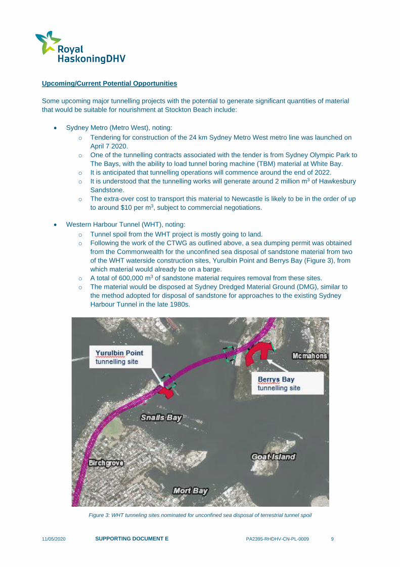
of the WHT waterside construction sites, Yurulbin Point and Berrys Bay (Figure 3), from
which material would already be on a barge.
o A total of 600,000 m3 of sandstone material requires removal from these sites.
o The material would be disposed at Sydney Dredged Material Ground (DMG), similar to
the method adopted for disposal of sandstone for approaches to the existing Sydney
Harbour Tunnel in the late 1980s.
Figure 3: WHT tunneling sites nominated for unconfined sea disposal of terrestrial tunnel spoil
11/05/2020 SUPPORTING DOCUMENT E PA2395-RHDHV-CN-PL-0009 10
• WestConnex Stage 3b – Rozelle Interchange Project, noting:
o tunnelling works commenced in early 2020;
o the Rozelle Interchange tunnels are located mainly in Hawkesbury sandstone; and,
o tunnelling is being largely carried out by roadheader machines that use a rotating head to
slowly excavate the rock.
Tunnelling material is generated by either roadheader or TBM. Typically, TBM material is characterised
by a narrower and ‘finer’ grading curve than roadheader material and may be generally better suited to
beach nourishment applications. Furthermore, it is understood that tunnelling Contractors have the ability
to adjust their machines to alter grading curves, which could enable tunnelling operations to be potentially
optimised to generate the most suitable material for beach nourishment. However, Contractors would
ideally be informed of this requirement prior to Tender because it can influence the types of machines
used for the project and overall costs.
In general, while further investigation would be necessary, it is considered that tunnel spoil would be
suitable for nourishment of Stockton Beach provided it is placed in the nearshore, regardless of whether
the material is generated by TBM or roadheader methods. Based on assessment of grading curves for
roadheader material associated with Sydney tunneling projects, typical roadheader material comprises
around 10% fines (material less than 75 microns, i.e. silts and clays) and up to cobble size and greater.
While this grading is not directly compatible with native material at Stockton Beach, it would not be
financially justifiable to wash and screen the tunnel spoil prior to placement. In any case, this is not
considered to be essential since if roadheader material, for example, was placed in the nearshore:
• fines would be transported out of the active coastal zone into deeper water, as they are not
compatible with coastal processes (wave and current energy) in the nearshore;
• sand sized material would remain within the active coastal zone as required to satisfy nourishment
objectives;
• larger fractions including cobbles would be expected to remain in the vicinity of the placement
area over the medium to longer-term, noting that this material:
o may provide some beneficial rocky reef function;
o cannot become a navigation hazard, an issue for trawling or significantly modify wave
transformation unless by design;
o would likely break down over time to form additional sand sized material.
Approvals Pathway
It must be noted that the proponents of these tunneling projects, for certainty, have pursued other means
of tunnel spoil disposal that are currently approvable. It is likely that the proponents would be generally
open to the idea of the beneficial reuse of tunnel spoil for nourishment but only if it did not delay their
project or incur additional cost.
It is likely the best opportunity for existing projects (such as WHT and WestConnex) may now lie with
Contractors, but Contractors are unlikely to take on the risk of obtaining an approval for reuse of the
material for beach nourishment.
It is considered that the most feasible and effective approvals pathway would involve a government
agency obtaining a ‘concept approval’ for the placement of nourishment material at Stockton Beach. The
following is noted:

11/05/2020 SUPPORTING DOCUMENT E PA2395-RHDHV-CN-PL-0009 11
• The concept approval would include a range of criteria that must be met for the nourishment
project to proceed (e.g. properties of the proposed nourishment material).
• The concept approval would ideally apply to any future significant sand sourcing opportunities,
including tunneling projects, Hunter River dredging, Newcastle redevelopment sites, and any
other potential sources.
• The Beach Nourishment Concept Approval Pathway is discussed further in Section 5.
• Having a concept approval for placement of suitable nourishment material at Stockton Beach is
considered to be essential to ensure current and future opportunities to beneficially re-use
tunneling material or materials from other sources are not missed. Accordingly, it is
recommended that the obtaining of a concept approval should be pursued as an immediate
action. This could be progressed by any suitably resourced, tasked and funded Public Authority.
2.3 Sand backpassing from Stockton Bight using Beach Scraping
Overview
RHDHV, building on previous work by WorleyParsons (2012), have assessed the option of sand
backpassing from the northern end of Stockton Bight using beach scraping techniques.
WorleyParsons (2012) considered the use of sand from within the Newcastle LGA as well as sand from
further north within the Port Stephens LGA. For beach scraping to be contained within the
Newcastle LGA, the length of beach suitable for scraping is limited to approximately 1 km. This 1 km
stretch of beach extending south from the LGA boundary (including part of Stockton Centre frontage) has
been identified as the optimum location for beach scraping for the following reasons:
• the long-term beach behaviour in this area is stable to slightly prograding;
• the distance to transport the material is minimised therefore lowering costs;
• negotiations and approvals are minimised as the activities are contained within the Newcastle
LGA;
• the wide dunes in this area mean that recession of the dune face due to scraping would not be
expected to significantly impact the natural and built environments. The narrowest dune width is
currently approximately 250 m (to the closest built assets within Stockton Centre) at the southern
end of the 1km stretch of beach.
Further north, within the Port Stephens LGA, the beach and dune system of Stockton Bight is some 30 km
long with a bare sand beach-dune width of around 600 m and dune elevations of 20 m. This area includes
the Worimi Conservation Lands and National Park and Wildlife Service (NPWS) land, with further
consultation required to negotiate use of this resource. The approvals process would be critical to the
feasibility of this sand source. Relevant consents and approvals would need to be obtained to borrow
sand from this area. This is discussed further below.
It is noted that the sand in the back dunes is likely to be less compatible due to the fineness of the sand as
this is generally aeolian transported material. The proposed sand extraction is limited to scraping from
within the tidal/wave runup zone which should be more compatible. This would likely lead to a level of
recession of the dune face at the extraction site.
Methodology
The option involves land-based beach scraping equipment (Wheel Tractor Scrapers) excavating material
from Stockton Bight and transporting it along the beach to the southern areas requiring nourishment. The
Wheel Tractor Scrapers are self-loading machines with on-board storage (17 to 26 m3 capacity).
11/05/2020 SUPPORTING DOCUMENT E PA2395-RHDHV-CN-PL-0009 12
The beach scraping could be undertaken with say four 17.5 m3 tractors operating, for a round trip of
approximately 1 km and 10 mins/trip.
Typically, scraping depth is limited to 0.2 to 0.3 m to minimise environmental impacts. Beach levels also
need to recover before additional scraping can be undertaken. With a typical beach width of say 30 m (of
trafficable sand between low water and the extent of wave runup) and a beach length of 600 m (i.e. CN
managed land contained within the Newcastle LGA north of Mitchell Street revetment) the area would
need to be scraped 10 times (to a depth of 0.2 m) to achieve 36,000 m3. That is, each scraping exercise
could yield 3,600 m3 of sand.
Permissibility
There are a range of land zoning and other regulatory considerations that would need to be addressed to
facilitate the use of sand from Stockton Bight for beach nourishment purposes. Preliminary consultation
has been undertaken with several stakeholders including DPIE – Crown Lands, Port Stephens Council
and NPWS, as outlined below:
Feedback from Crown Lands regarding coastal management/protection works:
The information is specific to Crown land in zones 1, 2, 3 and 4 of the Stockton CMP and seaward of the
2025 coastal hazard line (as provided by CN, email dated 16 April 2020).
• CN is required to undertake development on Crown reserves and Crown land in accordance with
the relevant planning legislation.
• Public foreshore land immediately seaward of the 2025 hazard line at Stockton, zones 1, 2, 3 and
4, is Crown land under the management of CN - being Crown Reserve 79066, gazetted 9 Nov
1956. The reserve purpose is for: public recreation, additional purpose ‘port facilities and
services’.
• Under the Crown Land Management Act 2016 (CLM Act) CN has authority to manage the Crown
reserve in accordance with the reserve purpose or any purpose incidental or ancillary to the
reserve purpose, or for a purpose specified in a plan of management for the reserve. Where these
conditions are satisfied, CN does not generally need to seek additional approvals under the CLM
Act for works undertaken by CN on the reserve.
• Under new arrangements under the CLM Act, refer Division 3.4, CN is authorised to manage its
dedicated or reserved Crown land as if it were public land under the Local Government Act 1993
(LG Act). Noting there are transitional arrangements in place until 30 June 2021 and more
information is provided in the attached ‘Transition guide for Crown land managers- local councils’.
Under these new arrangements, CN is to prepare and adopt a plan of management (PoM) for the
reserve by 20 June 2021. After the adoption of the PoM, CN will be directly responsible for the
care, control and management of the reserve as carried out in accordance with the PoM prepared
under the LG Act.
• Where works are to occur on Crown land not under the management of CN, for example beach
nourishment or beach scraping works that are located on submerged Crown land below mean
high water mark and outside of reserve 79066, then a form of tenure under the CLM Act will be
required before the works can be carried out. Further details will need to be provided to determine
the tenure that is appropriate to the works. Beach scraping works have generally required a
Crown land licence at other locations, refer attached ‘Licensing of Crown land—guidelines’ for
more information.

11/05/2020 SUPPORTING DOCUMENT E PA2395-RHDHV-CN-PL-0009 13
• The Native Title Act 1993 (Cth) needs to be considered by CN in the preparation of the PoM and
any subsequent development on reserve 79066.
• The bed and banks of waterways below mean high water mark (MHWM) are typically Crown
Waterway across much of the state (there are exceptions, for example those waterways managed
under the Ports and Maritime Administration Act 1995 e.g. Newcastle Port). Where actions are
considered or proposed in, on or adjacent to Crown land, boundaries may need to be
identified/verified by survey. Works and proposals should not rely on retaining structures or
fencing as evidence of land boundaries.
Aboriginal Land Rights Act 1983 (ALR Act)
• The department advised CN (letter dated 17 November 2017), that there are incomplete
Aboriginal land claims (ALCs) made under the ALR Act on Crown land in the Stockton CMP area.
This advice was specific to Crown land in the vicinity of Barrie Crescent, refer Table 1 below.
There are three other incomplete ALCs in the southern zones of the Stockton CMP area, refer
Table 2.
• Crown Lands’ ALC Unit has completed the investigation of ALC 5720/1933/19564. The
investigation indicates these ALCs are not claimable as the land was likely to be needed for an
essential public purpose. Crown Lands anticipate these ALCs should be determined by 30 June
2020. We have not undertaken any investigation of ALC 6602/19468/19579 at this stage, but will
commence an investigation of 19468 and 19579 shortly. In terms of ALC 6602, it is very likely the
land will not be claimable as it is a waterway. As a result, it would not be unreasonable to proceed
with planning for any works in this area, pending determination at some future point.
Feedback from Port Stephens Council regarding sand extraction within the Port Stephens LGA:
• The DPI land as well as Worimi Conservation Lands (WCL) are zoned as E1 National Parks and
Nature Reserves.
• The Defence Housing Australia (DHA) land at Rifle Range is classified as E2 Environmental
Conservation.
• Under the provisions of Port Stephens LEP2013, extractive industries are not permissible within
E1 and E2 zones and the sourcing of sand is therefore not permissible.
• Furthermore, Clause 7(3) of State Environmental Planning Policy (Mining, Petroleum Production
and Extractive Industries) 2007 states that extractive industries may be carried out with consent
on land where development for the purposes of agriculture or industry can be undertaken with
consent, or on land that is part of a waterway, estuary in the coastal zone or coastal waters that
are not within an environmental conservation zone. As the E1 and E2 zones do not permit
agriculture or industrial development, and the land is zoned for environmental conservation, sand
extraction would not be permissible in these areas.
• Under the provisions of Port Stephens LEP2013, extractive industries are permissible in RU1
Primary Production and RU2 Rural Landscape zones. Several commercial sand mines are
currently operating along the foreshore areas that could potentially provide the sand required for
the proposed rehabilitation activities (refer Section 2.1 for discussion of local quarries as a
potential sand source).
Feedback from DPIE regarding Worimi Conservation Lands:
• The WCL covers 4029 hectares, comprising 1812 hectares of national park, 881 hectares of state
conservation area and 1336 hectares of regional park (Figure 4).
• Throughout 2005 and 2006, Worimi Local Aboriginal Land Council (LALC) representatives and an
Aboriginal Negotiating Panel of Worimi Traditional Owners negotiated the Lease Agreement for

11/05/2020 SUPPORTING DOCUMENT E PA2395-RHDHV-CN-PL-0009 14
the WCL with the Minister for the Environment. Once the Lease was agreed and entered into, the
land was granted to the Worimi LALC under the Aboriginal Land Rights Act 1983 and gazetted in
2007 under the National Parks and Wildlife Act 1974 (NPW Act) as Worimi National Park, Worimi
State Conservation Area and Worimi Regional Park.
• The intertidal zone extending to the mean low water mark was gazetted as part of Worimi
Regional Park under Part 4 of the NPW Act, and therefore not returned to Aboriginal ownership.
The Lease Agreement commits NPWS to managing the intertidal zone as part of the WCL
• Sand extraction in all these classifications of reserve is prohibited either under the NPW Act and
Regulations or is contrary to the objectives and provisions of the existing statutory Plan of
Management.
Figure 4: Reserves comprising the Worimi Conservation Lands
The following land zoning applies for parts of Stockton Bight located within the Newcastle LGA:
• DHA land at Fort Wallace is classified as E2 Environmental Conservation;
• the Hunter Water site is classified as SP2 Sewerage systems; and,
• Stockton Centre is classified as SP2 Health Services Facility.
For each of these zonings, extractive industries are prohibited under Newcastle LEP 2012. For this
reason, the beach scraping activities and quantities described were limited to the 600m frontage north of
the Mitchell Street revetment up to the Hunter Water boundary. This constraint would need to be
addressed by CN to enable beach scraping to occur further north.
Cost
A unit cost rate of $20/m3 is estimated for this backpassing option.
11/05/2020 SUPPORTING DOCUMENT E PA2395-RHDHV-CN-PL-0009 15
Summary
For the purpose of the present assessment to inform the Stockton CMP, it has been assumed that a
maximum of two to three scraping exercises could be undertaken each year, based on allowing four to six
months between scraping exercises for the borrow area to recover. This equates to an annual maximum
supply of 20,000 m3 to 30,000 m3 from this source. This is likely to fall well short of the volume
requirements under the various management options.
A unit cost rate of $20/m3 could be adopted for this backpassing option.
Furthermore, it should be noted that the existing narrow beach widths would limit beach access for
machinery at certain locations. Some areas may only be trafficable at very low tides with calm seas (e.g.
Mitchell Street revetment frontage). This would effectively increase the down time for machinery, extend
project timeframes and increase costs. Road access may therefore be necessary to transport the material
to the southern side of Mitchell Street revetment. This limitation may make this option only feasible for
transporting sand to the areas north of Mitchell Street revetment.
Overall, it is considered that the feasibility of this backpassing option is constrained by:
• the maximum quantity of material that can be regularly sourced from the borrow area;
• existing land zoning and regulatory provisions, particularly within the Port Stephens LGA; and,
• machinery access south of Mitchell Street.
2.4 Sand backpassing from Stockton Bight with Sand Shifter
RHDHV have assessed the option of backpassing sand from north of the Stockton township frontage
using a submerged sand shifter system (refer Figure 5). Similar systems are currently operated at Noosa,
Lakes Entrance Victoria, Mooloolaba and Bribie Island.
This sand backpassing option involves collection of sand using a submerged sand extraction unit buried
under the sea floor with shore based pumping equipment at the northern end of the Newcastle LGA
(prograding area) and pumping the material southwards, through approximately 3 km of land-based,
buried HDPE pipeline with outlets onto the beach to the north of Mitchell Street revetment and terminating
at the southern end of Mitchell Street revetment (refer Figure 6).

11/05/2020 SUPPORTING DOCUMENT E PA2395-RHDHV-CN-PL-0009 16
Figure 5: Example submerged sand extraction unit
Figure 6: Sand backpassing schematic for Sand Shifter

11/05/2020 SUPPORTING DOCUMENT E PA2395-RHDHV-CN-PL-0009 17
Water supply for these systems is generally via a directionally drilled water intake line extending from the
beach to 100 m offshore or from a river source if feasible. At Stockton the most cost-effective option may
be to source the water from the Hunter River rather than an offshore intake.
The temporary sand backpassing system was priced by RHDHV on the basis of a 100,000 m3/year
system to achieve a total nourishment of 500,000 m3 over its 5-year life, followed by the installation of a
permanent system (NB: a 85,000 m3/year system was allowed for, although larger systems may be
necessary based on the latest understanding of recession rates; Bluecoast (2020) estimated an annual
nourishment volume requirement of up to 200,000 m3/year).
These significant sand extraction volumes would inevitably lead to adverse impacts at the borrow site.
Monitoring of the performance of the nourishment provided by the temporary system would enable further
refinement of the permanent system capacity and design.
Based on the current understanding of sediment transport processes at Stockton Beach, the sand
discharged to the south of Mitchell Street revetment, would be expected to move southward nourishing
Zone 1 and 2 of the Stockton frontage via the net southerly sediment transport regime (refer Figure 6).
Conversely, sand discharged to the north of Mitchell St revetment, would be expected to move northward
nourishing Zone 4 to 7 of the Stockton frontage via the net northerly sediment transport regime. Sand
could also be pumped onto beaches at intermediate locations on an as needs basis. The sand is
assumed to initially be evenly distributed with 50,000 m3/year to each of the southern and northern ends of
Mitchell Street revetment. This breakdown can be monitored and adjusted as required within this flexible
system.
Backpassing would likely be regarded initially on a trial basis, with monitoring and flexibility to modify the
strategy to achieve optimum outcomes. Comprehensive monitoring of any backpassing together with
flexible reactive response in terms of the back-passing location, rate and method are essential.
Costs
The estimated costs are set out below for this backpassing option.
For a trial diesel system (100,000 m3/year capacity over a 5-year contract):
Capital Cost:
Mobilisation $ 1.5M
Demobilisation $ 0.3M
Total $ 1.8M
Recurring Costs
Operating costs $360,000/year ($30,000/month)
Unit rate for sand $700,000/year ($7/m3 for 100,000 m3/year)
Power $200,000 ($2/m3)
Total $1.26M/year for 5 years
For a permanent electrical system (85,000 m3/year capacity):
Capital Cost: $4.5M
Recurring Costs: $8/m3 (operating costs including maintenance, power and unit rate for
sand)
11/05/2020 SUPPORTING DOCUMENT E PA2395-RHDHV-CN-PL-0009 18
Summary
For the purpose of the present assessment to inform the Stockton CMP, it has been assumed that a trial
diesel system (100,000 m3/year capacity over a 5-year contract) would initially operate as per the details
set out above. This would deliver 500,000 m3 of nourishment over the first five years at an average cost
rate of around $16/m3.
A permanent system with an appropriate pumping capacity would then be installed, based on annual
pumping requirements. A cost rate of around $10/m3 (including capital and recurring costs) could be
adopted for this option. However, further investigations would be required to assess the feasibility of
pumping systems able to keep pace with the Bluecoast high estimated recession rates of
200,000 m3/year.
These volumes would inevitably lead to adverse impacts at the borrow site, which would require further
investigations.
As such, it is considered that this backpassing option may be constrained by:
• the maximum quantity of material that can be sourced from the borrow area without yielding
adverse impacts;
• existing land zoning and regulatory provisions, although noting that sand would be sourced within
the Newcastle LGA which would be expected to simplify the approvals process; and,
• pumping capacity of the permanent system, which may struggle to achieve maximum required
rates of 200,000 m3/year, subject to further investigations.
2.5 Beach Scraping within the Stockton CMP Area
Overview
Beach scraping involves the movement of small to medium quantities of sand from the lower part of the
littoral beach zone to the dune system using mechanical means. Beach scraping is undertaken to
augment the natural processes of building the subaerial portion of the beach profile. Beach scraping
activities are undertaken on a periodic basis at numerous beaches along the NSW coast with successful
outcomes being observed.
Periodic beach scraping practices aim to increase the volume of sand in the subaerial portion of the beach
profile at locations which are vulnerable to episodic erosion. This measure is primarily to enhance coastal
protection through building the upper profile and dune system while at the same time improving beach
amenity. It is not a nourishment activity as it does not introduce additional sand into the beach profile,
rather it is a redistribution of existing material within the profile.
Beach scraping is undertaken as a maintenance activity when sand is available in the intertidal zone. It
must be noted that beach scraping does not address long-term recession or sand loss from the beach
profile.
Beach Scraping at Stockton
Beach scraping is included as a management action in the Newcastle CZMP. CN have developed a
scraping strategy for Stockton Beach that utilises material from within the Stockton CMP Area, i.e. from
the breakwater in the south to Corroba Oval in the north.

11/05/2020 SUPPORTING DOCUMENT E PA2395-RHDHV-CN-PL-0009 19
RHDHV (2018) estimated that a total sand volume of around 14,000 m3 could be scraped from the lower
profile to the upper dune face for a single project within the Stockton CMP Area, based on a scraping
depth of 0.2 m.
The timing of beach scraping activities needs to account for a number of factors, including:
• seasonal variation in coastal processes and resulting beach profile fluctuations;
• potential threats to resident beach fauna (i.e. nesting birds and intertidal species);
• seasonality in beach usage and access; and,
• favourable conditions for dune vegetation planting.
The rate at which sand can be transferred for the rebuilding of the foredune is naturally limited by the rate
of onshore movement of sand into the swash zone, i.e. availability of borrow material. The duration of
scraping exercises is also highly dependent on the number and type of machinery used to undertake the
works.
RHDHV (2018) noted that beach scraping at Stockton Beach would be best performed during Spring
when the probability of significant erosion events is lower, to avoid peak tourist or residential recreational
periods over summer and to maximise the period of natural rebuilding following the beach scraping before
the following autumn and winter (when there is a greater probability of storm events). It is estimated that
at least two scraping campaigns could be undertaken across all proposed areas during Spring.
Costs
Based on data provided by CN, it is understood that a cost of $7.20 was incurred for a 2017 beach
scraping campaign at Stockton associated with the SLSC revetment works.
Carley (2010) noted that due to competitive tendering and depending on the degree of difficulty, beach
scraping rates could potentially range from $6.20 to $12.50/m3 (adjusted to 2020 prices). For budgeting
purposes, an average rate of $9.30 could be adopted for beach scraping works.
Approvals Pathway
State Environmental Planning Policy (SEPP) (Infrastructure) 2007 and the recently introduced
SEPP (Coastal Management) 2018 both have provisions for activities such as beach scraping to be
undertaken by a public authority without development consent. The works are therefore classified as an
activity under Part 5 of the Environmental Planning and Assessment Act 1979 (EP&A Act).
In accordance with Subdivision 1 under Part 5 of the EP&A Act, CN has been defined as the determining
authority as the activity is to be carried out on behalf of CN. As the works are considered to have a
greater than minimal but not significant impact, a Review of Environmental Factors (REF) was required to
ensure compliance with Part 5 of the EP&A Act. The REF is detailed in RHDHV (2018).
CN has previously consulted with the DPIE – Crown Lands (Lands) to determine the necessary approvals
for beach scraping as it would occur within Crown Land. CN was advised that the site is within Crown
Reserve R79066 for Public Recreation and Other Purposes: Port Facilities and Services and CN is the
Trust Manager of the Reserve. As such, DPIE’s formal approval for NCC to undertake beach scraping
works in this locality is not required. Lands advised that CN’s modification of its planning assessment
11/05/2020 SUPPORTING DOCUMENT E PA2395-RHDHV-CN-PL-0009 20
would suffice, enabling CN to undertake and maintain urgent coastal protection works at Stockton Beach,
under their LEP.
Summary
Beach scraping using material sourced from within the Stockton CMP Area is a permitted activity for the
ongoing coastal management of Stockton Beach. Beach scraping is a relatively low cost activity (around
$9.30/m3) that can be implemented with success to enhance coastal protection through building the upper
profile and dune system. Short-term beach amenity benefits may also be realised.
However, it must be noted that beach scraping does not address long-term recession or sand loss from
the beach profile. As such, it is not an adequate standalone measure for addressing the long-term
sediment budget deficit at Stockton Beach.
Furthermore, a constraint of beach scraping is that the timing of this activity is limited to fair-weather
periods when sand is available in the intertidal zone. Spring months are considered to be most feasible
for this purpose.
2.6 Swansea Channel Dredged Material
Dredging in Swansea Channel is regularly undertaken by Lands to maintain navigability of the channel.
Investigations were made into the possibility of utilising material from previous Swansea Channel dredging
campaigns, which is currently stored at the Belmont Sand Stockpile site. Lands have provided sediment
testing results and analysis of the sand from the channel.
The mean particle size of the stockpiled sand ranged between 0.209 to 0.411 mm depending where it has
been dredged from in the channel. Review of the analysis indicates that approximately 70% of the 25
samples have physical properties within the technical specification criterion relating to median grain size
for the nourishment material. Generally, the other samples had a finer median grain size (<0.35mm)
meaning that the sand would be more readily mobilised either by wave action or aeolian transport.
Accordingly, the nourishment sand would be more rapidly moved from the nourishment area than the
native sediment.
The degree of compatibility is considered acceptable if the material is coarser than the technical
specification criterion relating to median grain size of the nourishment material. It is noted that an
inspection of the material undertaken by a potential contractor observed that there was a large amount of
shell in the sand. This matter is a potential issue in terms of beach amenity and not the technical
performance of the material.
An overfill ratio of 2.0 was determined for dredged material from Swansea Channel, which is slightly better
than quarry sands which are characterised by an overfill ratio of 2.5. However, it is noted that the high
shell content may have skewed this result. Overall, based on the particle size distribution and overfill
ratios, dredged material from Pelican is considered to be slightly more compatible than quarry sands.
However, dredged material from Pelican is not considered to be a financially viable option for nourishment
of Stockton Beach due to the transport involved with costs exceeding $100/m3 for sand supplied to site.
11/05/2020 SUPPORTING DOCUMENT E PA2395-RHDHV-CN-PL-0009 21
3 Marine Sources
3.1 Dredging of Offshore Sand Sources
General Information
While noting that offshore marine sand sources are not currently available, there may be opportunities to
access these sources into the future. For the purpose of the Stockton CMP, it has been assumed that the
offshore marine source could be accessed by a Trailing Suction Hopper Dredger (TSHD) method.
A TSHD is a self-propelled ship which is mainly used for dredging loose and soft soils such as sand,
gravel, silt or clay. TSHDs have a hull in the shape of a conventional ship and are both highly seaworthy
and able to operate without any form of mooring or spud. They are equipped with either single or twin
(one on each side) trailing suction pipes. A pump system sucks up a mixture of sand or soil and water
and discharges it into the ‘hopper’ or hold of the vessel.
The hopper can be emptied in a nearshore location by opening the doors or valves in the hopper bottom
(“bottom dumping”), by using the dredging pump to deliver material to shore through a floating pipeline, or
by projecting material towards the shore using a special bow jet. This latter method of placement is
commonly referred to as “rainbowing”, whereby sand is sprayed in a high arc towards the deposition
location, resembling a sand-coloured rainbow.
The above full suite of placement methods would ideally be used to create the desired beach profile. This
is termed ‘profile nourishment’ and seeks to create the natural beach profile from the outset so as to
minimise cross-shore redistribution of the placed sand.
The measure of size of a TSHD is the hopper capacity, which may range from a few hundred cubic metres
to over 40,000 m³.
Further details regarding TSHD methodologies, plant and costs are provided in RHDHV (2020).
Key Assumptions for TSHD
For the purpose of nourishing Stockton Beach, it is assumed that adequate and appropriate offshore sand
sources (borrow areas):
• are available within 7.5 nautical mile sailing distance of the site;
• comprise areas where no rock or wrecks are shown on Admiralty Charts; and,
• contain minimal amounts of fines1 (<2%), noting that grain size at the borrow area would need to
be established by sampling.
The Geological Survey of NSW (GSNSW) are currently undertaking a desktop review of potential offshore
sand sources. However, field survey work (low-powered seismic surveying and sediment coring) would
be needed to verify the results. The estimated cost to undertake this survey is around $2 million, and it is
understood that GSNSW currently does not have the financial capacity to do this.
Cost Estimates for TSHD
1 Fines is the collective term given to particle sizes less than 0.075mm (75 microns) and comprise silts and clays.

11/05/2020 SUPPORTING DOCUMENT E PA2395-RHDHV-CN-PL-0009 22
Detailed cost estimates for offshore sand sources at Stockton Beach are provided in RHDHV (2020).
Cost rates (including mobilisation/demobilisation) adopted for mass nourishment options in the CBA
(Bluecoast, 2020) were as follows:
• Initial mass nourishment campaign - $17/m3;
• Maintenance nourishment campaigns - $19/m3.
It should be noted that economic efficiencies may be available if maintenance nourishment activities were
undertaken on a regular basis (say, annually) by smaller vessels that undertake similar scale operations at
other locations in Australia. In particular, there may be opportunities to secure low mobilisation and
demobilisation costs if the maintenance nourishment campaigns could be coupled with other dredging
operations.
Regulatory Constraints
Offshore sand extraction is currently prohibited under the Offshore Minerals Act 1999. This is a key
constraint related to offshore marine sand sources and must be addressed as a matter of urgency for this
option to be viable.
Furthermore, should offshore sand extraction become a viable option then the role of DPIE - Crown Lands
and any requirement to issue a licence under the Crown Land Management Act 2016 would need to be
further investigated. It could be expected that a license would be required under the Crown Land
Management Act 2016.
Any offshore sand extraction would also need to be discussed directly with the Harbour Master as it
relates to the creation of potential navigational hazards, with consideration of the Ports and Maritime
Administration Regulation 2012.
Furthermore, an assessment of environmental impact would need to be undertaken in accordance with
the EP&A Act and the Environment Protection and Biodiversity Conservation Act 1999 (EPBC Act).
3.2 Port of Newcastle – Area E
Background
In 2014, the NSW Government granted a 98-year lease to PoN which included the management of
792 hectares of land within the port, the right to manage the commercial use of the shipping channel and
the obligation to maintain the shipping channel and navigational infrastructure, including the breakwaters,
for the benefit of commercial shipping. The State retains ownership of the port including all land, the
channel and breakwaters.
As a result of the obligation to maintain channel depths for the safe navigation of commercial vessels, PoN
dispose of sand material dredged from Area E (the port entrance) at the location described in the Coastal
Protection Regulation 2011 Notification of Concurrence for ‘Dredging of Area E and disposal offshore at
Stockton Beach’, issued by the (then) NSW Office of Environment and Heritage. The nourishment
placement area is directly in front of the Mitchell Street revetment as indicated in Figure 7. Channel
infilling in Area E comprises sand transported from outside the entrance under wave action and flood tide.
11/05/2020 SUPPORTING DOCUMENT E PA2395-RHDHV-CN-PL-0009 23
Figure 7: PoN dredge sand placement area and Stockton Beach CMP area (Source : Bluecoast 2020)
Current Dredging Operations
Dredging at Newcastle Port is undertaken by a TSHD, the David Allan, which has a hopper capacity of
1,100 m3. The dredger operates 12 hours per day, seven days per week. Material placement occurs via
bottom dumping only.
PoN currently place up to 30,000 m3 of sand from Area E at Stockton Beach each year. PoN have
indicated that they will continue to support nourishment efforts with suitable sand dredged from Area E.
However, it should be noted that the frequency and amount of dredge material placement that occurs at
Stockton Beach varies depending on harbour works requirements; maintaining navigable depths in the
shipping channel for vessel safety is the main priority of the David Allan. For example, it is understood
that it can take several months to clear the harbour channels following a major flood event, which would
potentially delay any planned nourishment activities at Stockton.
Future Sand Placement Area
There would likely be a benefit in relocating the existing nourishment placement area (refer Figure 7) to a
more inshore location, if feasible. This would be expected to lead to an increased rate of onshore sand
movement from the placement area to the subaerial portion of Stockton Beach, resulting in a reduction of
the erosion hazard and improved beach amenity.
The following is noted:
• PoN has indicated that relocation of the current nourishment placement area could potentially be
accommodated, however safety and efficiency considerations would need to be discussed with
PoN.

11/05/2020 SUPPORTING DOCUMENT E PA2395-RHDHV-CN-PL-0009 24
• The existing nourishment placement area was previously nominated under a Part 5 Approval at a
time when PoN was operating as Newcastle Port Corporation (NPC) and able to issue such
approvals. A Review of Environmental Factors (REF) was also prepared. The existing approval
and REF would need to be revisited and modified if the nourishment placement area was to
change.
• Any changes to the nourishment placement area would need to consider the latest understanding
of sediment transport processes, to ensure that the material placement will allow onshore
movement of sand to nourish high priority areas.
Opportunities
There is the potential for CN to enter into a mutually beneficial commercial arrangement with PoN for the
delivery of an annual increment of sand (e.g. in the order of 112,000 m3/year, which was noted in
Bluecoast (2020) to be the long-term volumetric rate of sand loss over the full profile within the Stockton
CMP Area). This could provide significant cost savings in mobilisation costs and potentially the cost rates
for material placement.
However, there may be limited scope to increase PoN’s current dredging operations to a level that can
meet the significant volume requirements for nourishment of Stockton Beach, while also satisfying the
ongoing requirements to maintain navigable depths in the Port. Further discussions with PoN are required
to investigate these possibilities, both technically and strategically. For example, it may be prudent to
consider acquiring an alternative dredger with a larger capacity than the David Allan and also rainbowing
capabilities for inshore sand placement. In addition, a larger dredger would be able to undertake Port
maintenance operations more rapidly than can occur at present. This would potentially lead to
opportunities to dredge other areas within the Port and further upstream for placement at Stockton Beach,
including the North Arm of the Hunter River, subject to obtaining the necessary approvals (refer Section
4.2).
Larger PoN capital dredging campaigns in the entrance area could also be used to nourish Stockton
Beach on an opportunistic basis. For example, in 2009, PoN dredged approximately 130,000 m3 of clean
marine sand from the mouth of the Hunter River and placed the material offshore of Stockton Beach.
However, this would be subject to material availability, obtaining the necessary approvals, engagement
with the proponent (noting that this may not be PoN), and commercial factors.
3.3 Sand Bypassing from Nobbys Beach
Sand bypassing from Nobbys Beach was assessed in WorleyParsons (2012) and has been further
investigated by RHDHV. The features of the sand bypassing system included a Slurry Systems Marine
submarine sandshifter unit to recover sand (38 m3/hour) and a transfer pipeline (160 mm OD HDPE)
beneath the shipping channel and an inline booster (located near the Stockton Memorial), and five outlets
across the Mitchell Street revetment frontage.
WorleyParsons (2012) noted that the pipe work required to transport sand would need to cross the main
shipping channel into Newcastle Harbour would require complex infrastructure to implement the scheme
without disrupting ongoing shipping activities. Furthermore, there would be a high risk of damage to and
failure of such a pipeline with maintenance dredging activities undertaken in the channel by PoN.
The assessment found this option to be not viable for capital nourishment due to insufficient sand reserves
and high risk. While the modest sand reserves at Nobbys Head may be able to satisfy maintenance
nourishment requirements, this option was noted to be cost prohibitive and high risk.
11/05/2020 SUPPORTING DOCUMENT E PA2395-RHDHV-CN-PL-0009 25
4 Hunter River Sources
Reworked marine sand from the inner and outer sand barriers of the Stockton embayment extend 10 km
upstream in the Hunter River (WorleyParsons 2012). Throughout most of the estuary, these marine sands
are overlain by silts and clays, which is the primary maintenance dredge material and is not suitable for
beach nourishment purposes. An exception to this is the entrance area, where maintenance dredging
involves sand (i.e. Area E, refer Section 3.2).
In general, capital dredging in the Hunter River for port development would be expected to generate
potentially significant quantities of marine sand suitable for the nourishment of Stockton Beach.
Sand sources from the South Arm and North Arm of the Hunter River are considered below.
4.1 South Arm
General Information
Sand sources in the South Arm of the Hunter River could be accessed by a Cutter Suction Dredger (CSD)
method.
A CSD is a stationary dredger which makes use of a rotating cutter head at the suction inlet to loosen the
material to be dredged. The dredged material is usually sucked up by a wear-resistant centrifugal pump
and discharged either through a pipeline to the shore (more typical) or into barges.
A CSD operates by swinging about a central working spud using two fore sideline wires leading from the
lower end of the ladder to anchors. By pulling on alternate sides the dredger clears an arc of cut, and then
moves forward by pushing against the working spud using a spud carriage. A generally smooth bottom
can be achieved, and accurate profiles and side slopes are able to be dredged.
The size of a CSD is measured by the diameter of the suction pipe and by the installed machinery power.
Pipe diameters generally range from 100 mm to 1,500 mm, and booster stations are utilised to improve
productivity over longer pumping distances. Through consideration of site conditions and industry
knowledge, four pipe diameters ranging from 500 mm to 900 mm and use of between one and three
boosters have been selected to undertake comparative analysis of efficiency and cost for a CSD to supply
nourishment sand to Stockton Beach from the South Arm.
Further details regarding CSD methodologies, plant and costs are provided in RHDHV (2020).
Cost Estimates for CSD
Detailed cost estimates for accessing sand sources in the South Arm for nourishment at Stockton Beach
are provided in RHDHV (2020). Cost rates (including mobilisation/demobilisation) adopted for mass
nourishment options in the CBA (Bluecoast, 2020) were as follows:
• Initial mass nourishment campaign - $25/m3;
• Maintenance nourishment campaigns - $30/m3.
Material Availability
11/05/2020 SUPPORTING DOCUMENT E PA2395-RHDHV-CN-PL-0009 26
It is assumed that adequate and appropriate sand sources are available within the South Arm of the
Hunter River below the Tourle Street Bridge for the purpose of nourishing Stockton Beach. It should be
noted that the control of fines (material <75 microns) and grain size would be subject to the levels in
available Soil Reports, with limited options to search for cleaner sand.
The availability of sand reserves in the South Arm would be on an opportunistic basis, dependant on
activities of port developers as part of future port expansion.
Nevertheless, significant quantities of sand could be generated in one-off dredging campaigns that would
be of value to Stockton Beach nourishment efforts. Furthermore, mutually beneficial commercial
arrangements may be possible for CN and developers due to the close proximity of the South Arm to
Stockton Beach, and complementary project objectives.
For example, it is understood that the proposed Newcastle GasDock LNG import terminal project would
require capital dredging of around 4.0 million m3 material, a substantial proportion of which is likely to be
sand. The NSW Government has granted the GasDock project the status of Critical State Significant
Infrastructure (CSSI), in recognition of its potential for securing the state’s economic future. Subject to
receiving all regulatory and planning approvals, and other commercial considerations, the project is
anticipated to begin operations in the first half of 2021.
Furthermore, it should be noted that major dredging activities in the South Arm upstream of the navigable
port waters would be expected to result in a range of additional benefits including:
• facilitating further development of this part of the Port; and,
• potentially acting as a sediment trap and reducing maintenance dredging requirements.
Regulatory Constraints
As noted for the Sydney tunnelling opportunities (Section 2.2), it is considered to be essential to have a
concept approval in place for the placement of suitable nourishment material at Stockton Beach using
opportunistic sources, including sand reserves in the South Arm. This is discussed further in Section 4.1.
A pre-existing concept approval would reduce the risk of missing out on future significant sand sourcing
opportunities in the South Arm.
4.2 North Arm
Overview
There are also potentially significant sand reserves in the North Arm of the Hunter River, which have the
advantage of being closer to Stockton Beach. In particular, areas along the western bank of the North
Arm, from Walsh Point to Stockton Bridge, should be considered in further detail as part of the SMP.
While sand reserves are also available north of Stockton Bridge, the environmental sensitivities in this
section of the river would necessitate a more rigorous environmental assessment and approvals process,
particularly in regard to the Ramsar listed wetland area. The potential impacts of dredging in areas south
of the bridge would also need to be assessed in detail, however this process would likely be more
straightforward due to the relatively disturbed waterway in this area.
11/05/2020 SUPPORTING DOCUMENT E PA2395-RHDHV-CN-PL-0009 27
It is understood that there have been several commercial development prospects involving dredging of the
North Arm in the past, however RHDHV is not aware of any current proposals to develop this area.
Cost Considerations
Given the close proximity of the North Arm to Stockton Beach, dredging operations would be expected to
attract lower mobilisation/demobilisation and dredging costs compared to similar operations in the South
Arm.Mutually beneficial commercial arrangements may be possible for CN and developers due to the
close proximity of the North Arm to Stockton Beach, and complementary project objectives.
Dredging of the North Arm may also provide synergies with PoN operations (e.g. reduced maintenance
dredging in the lower port). Further consultation with PoN is required to explore these possibilities further.
This could involve consideration of an alternative dredger that services the complementary objectives of
CN and PoN as discussed in Section 3.2.
Regulatory Constraints
As noted above, detailed environmental assessments would be required to obtain an approval for major
dredging activities in the North Arm. However, this is not considered to be a major constraint for this sand
source, particularly if dredge footprints were confined to areas south of Stockton Bridge.
As noted previously, it is considered to be essential to have a pre-existing concept approval in place for
the placement of nourishment material at Stockton Beach using opportunistic sand sources, which would
include sand reserves in the North Arm. Such an approval could be used to facilitate opportunistic
dredging of the North Arm in collaboration with a future development proposal, as part of a mutually
beneficial arrangement with PoN, and/or stand-alone project(s) carried out for the sole purpose of
nourishing Stockton Beach. This is discussed further in Section 5
There may also be an opportunity for PoN to expand the current Part 5 approval for Area E dredging and
placement at Stockton Beach, to include other dredge areas in the estuary such as the North Arm.
5 Beach Nourishment Concept Approval Pathway
State Environment Planning Policies (SEPPs) are drafted by the NSW State Government and apply to
issues and developments of state significance. The SEPP relevant to beach nourishment works at
Stockton is SEPP (Coastal Management) 2018. Under Clause 19(2) of SEPP (Coastal Management)
2018, a public authority may carry out coastal protection works without development consent if the works
are:
(i) identified in the relevant certified coastal management program, or (ii) beach nourishment, or (iii) the placing of sandbags for a period of not more than 90 days, or (iv) routine maintenance works or repairs to any existing coastal protection works
Beach nourishment at Stockton can therefore be undertaken without development consent (i.e. approval
under Part 5 of the EP&A Act requiring the preparation of an REF or EIS).
Clause 19(2) of SEPP (Coastal Management) 2018 prevails over SEPP (State and Regional
Development) 2011 and SEPP (Infrastructure) 2007.
11/05/2020 SUPPORTING DOCUMENT E PA2395-RHDHV-CN-PL-0009 28
In accordance with Clause 5.1 under Part 5 of the EP&A Act, a determining authority is defined as:
…a Minister or public authority and, in relation to any activity, means the Minister or public authority by or
on whose behalf the activity is or is to be carried out or any Minister or public authority whose approval is
required in order to enable the activity to be carried out.
CN would therefore be a determining authority for the beach nourishment as the activity is to be carried
out on behalf of CN. As additional approvals will be required from other public authorities, these public
authorities are also determining authorities e.g. Department of Planning, Industry and Environment (Crown
Lands licence for elements of the proposed works that are below the MHWM) and Department of Primary
Industries (Fisheries Permit).
Preparation of an REF or, if significant impacts are anticipated, an EIS could be prepared and approved
(or “approved in principle”) by the determining authorities based on an assessment of one or a number of
potential sources of the material.
6 Summary of Potential Sand Sources
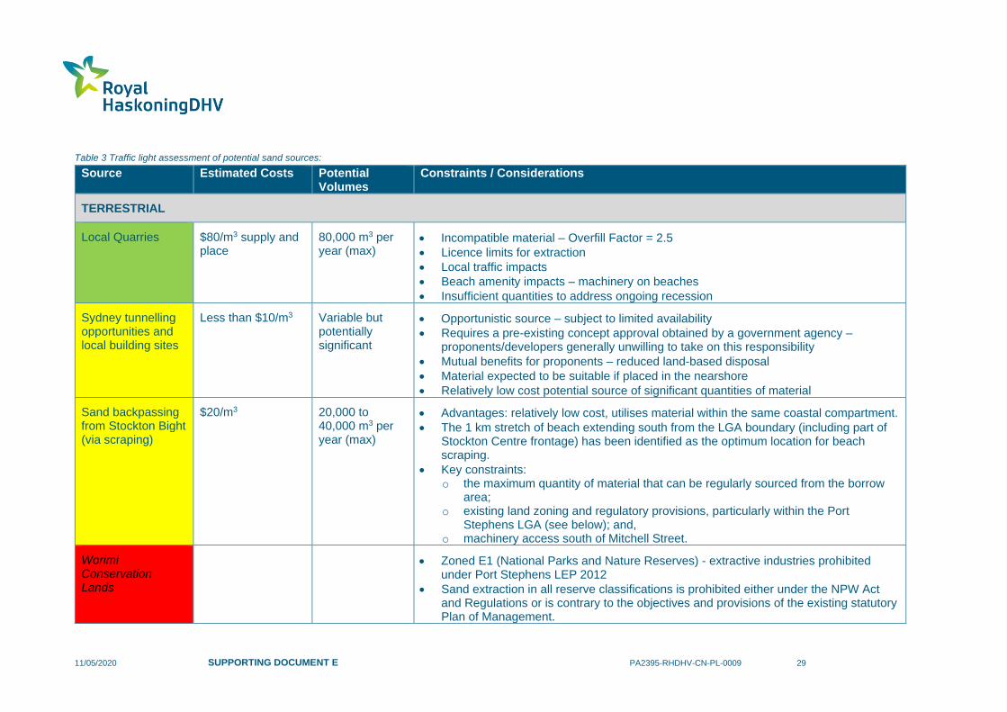
A traffic light assessment of each potential sand source is provided in Table 3, where:
• red - currently unfeasible,
• yellow - potentially feasible but dependant on individual factors / approval processes / costs; and
• green - currently feasible within existing approvals.
This assessment did not consider approvals required for material placement which are assumed to be
feasible for each source.
11/05/2020 SUPPORTING DOCUMENT E PA2395-RHDHV-CN-PL-0009 29
Table 3 Traffic light assessment of potential sand sources:
Source Estimated Costs Potential Volumes
Constraints / Considerations
TERRESTRIAL
Local Quarries
$80/m3 supply and place
80,000 m3 per year (max)
• Incompatible material – Overfill Factor = 2.5
• Licence limits for extraction
• Local traffic impacts
• Beach amenity impacts – machinery on beaches
• Insufficient quantities to address ongoing recession
Sydney tunnelling opportunities and local building sites
Less than $10/m3 Variable but potentially significant
• Opportunistic source – subject to limited availability
• Requires a pre-existing concept approval obtained by a government agency – proponents/developers generally unwilling to take on this responsibility
• Mutual benefits for proponents – reduced land-based disposal
• Material expected to be suitable if placed in the nearshore
• Relatively low cost potential source of significant quantities of material
Sand backpassing from Stockton Bight (via scraping)
$20/m3 20,000 to 40,000 m3 per year (max)
• Advantages: relatively low cost, utilises material within the same coastal compartment.
• The 1 km stretch of beach extending south from the LGA boundary (including part of Stockton Centre frontage) has been identified as the optimum location for beach scraping.
• Key constraints: o the maximum quantity of material that can be regularly sourced from the borrow
area; o existing land zoning and regulatory provisions, particularly within the Port
Stephens LGA (see below); and, o machinery access south of Mitchell Street.
Worimi Conservation Lands
• Zoned E1 (National Parks and Nature Reserves) - extractive industries prohibited under Port Stephens LEP 2012
• Sand extraction in all reserve classifications is prohibited either under the NPW Act and Regulations or is contrary to the objectives and provisions of the existing statutory Plan of Management.

11/05/2020 SUPPORTING DOCUMENT E PA2395-RHDHV-CN-PL-0009 30
Source Estimated Costs Potential Volumes
Constraints / Considerations
DHA Land (Fort Wallace, Rifle Range)
• Zoned E2 - extractive industries prohibited under Newcastle LEP 2012 (Fort Wallace) and Port Stephens LEP 2012 (Rifle Range)
Hunter Water Site • Zoned SP2 Sewerage systems – extractive industries prohibited under Newcastle LEP 2012
Stockton Centre • Zoned SP2 Health Services Facility - extractive industries prohibited under Newcastle LEP 2012
Sand backpassing from Stockton Bight (via sand shifter)
$16/m3 (initial trial system)
$10/m3 (permanent system)
100,000 m3/year pumping systems are common
• Advantages: o relatively low cost; o utilises material within the same coastal compartment; o flexible pumping rates.
• Key constraints: o the maximum quantity of material that can be sourced from the borrow area
without yielding adverse impacts; o existing land zoning and regulatory provisions, although noting that sand would be
sourced within the Newcastle LGA which would be expected to simplify the approvals process; and,
o pumping capacity of the permanent system, which may struggle to achieve maximum required rates of 200,000 m3/year, subject to further investigations.
Beach Scraping – within immediate areas
$9.30/m3 Small – 14,000 m3 per project
• Currently permitted activity for the ongoing coastal management of Stockton Beach.
• Relatively low cost.
• Can be implemented with success to enhance coastal protection through building the upper profile and dune system.
• Short-term beach amenity benefits may also be realised.
• Does not address long-term recession or sand loss from the beach profile – i.e. not a nourishment activity.
• The timing of this activity is limited to fair-weather periods when sand is available in the intertidal zone. Spring months are considered to be most feasible for this purpose.
11/05/2020 SUPPORTING DOCUMENT E PA2395-RHDHV-CN-PL-0009 31
Source Estimated Costs Potential Volumes
Constraints / Considerations
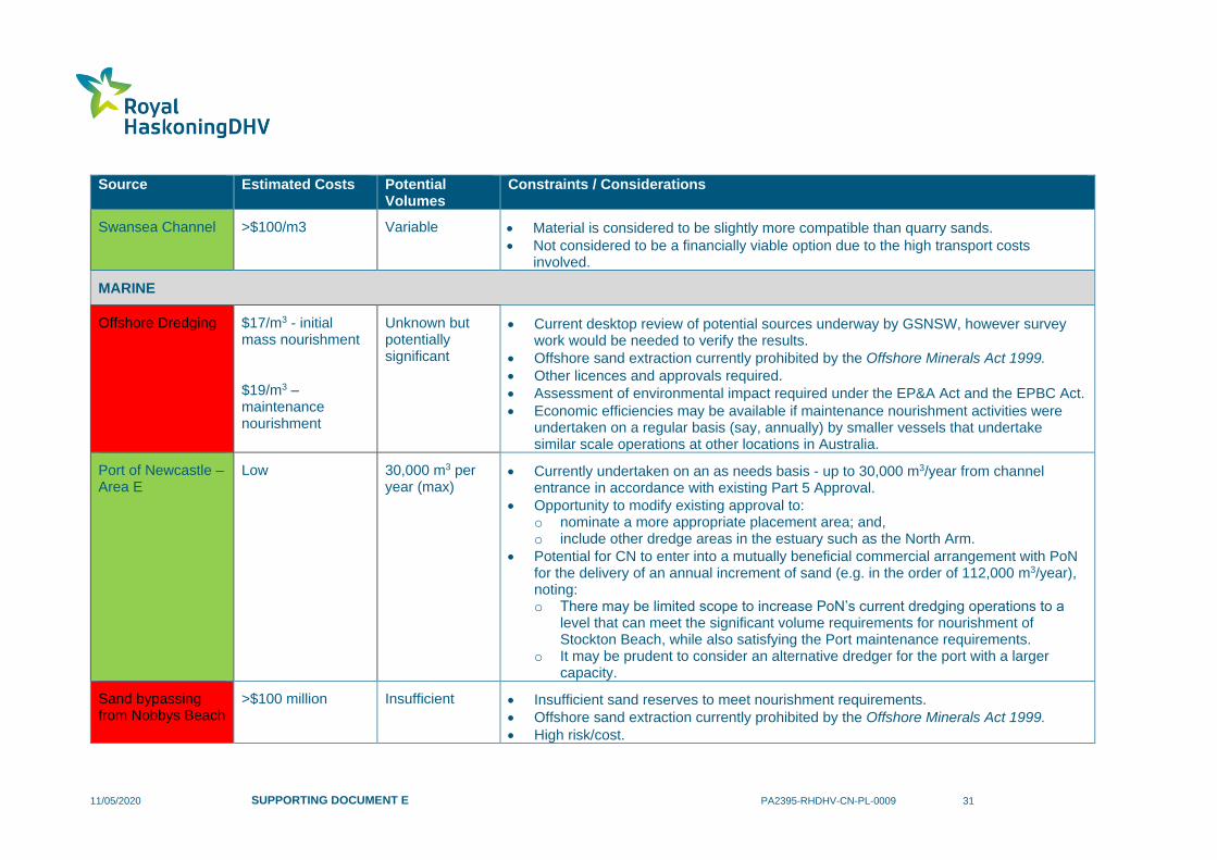
Swansea Channel >$100/m3 Variable • Material is considered to be slightly more compatible than quarry sands.
• Not considered to be a financially viable option due to the high transport costs involved.
MARINE
Offshore Dredging $17/m3 - initial mass nourishment
$19/m3 – maintenance nourishment
Unknown but potentially significant
• Current desktop review of potential sources underway by GSNSW, however survey work would be needed to verify the results.
• Offshore sand extraction currently prohibited by the Offshore Minerals Act 1999.
• Other licences and approvals required.
• Assessment of environmental impact required under the EP&A Act and the EPBC Act.
• Economic efficiencies may be available if maintenance nourishment activities were undertaken on a regular basis (say, annually) by smaller vessels that undertake similar scale operations at other locations in Australia.
Port of Newcastle – Area E
Low 30,000 m3 per year (max)
• Currently undertaken on an as needs basis - up to 30,000 m3/year from channel entrance in accordance with existing Part 5 Approval.
• Opportunity to modify existing approval to: o nominate a more appropriate placement area; and, o include other dredge areas in the estuary such as the North Arm.
• Potential for CN to enter into a mutually beneficial commercial arrangement with PoN for the delivery of an annual increment of sand (e.g. in the order of 112,000 m3/year), noting: o There may be limited scope to increase PoN’s current dredging operations to a
level that can meet the significant volume requirements for nourishment of Stockton Beach, while also satisfying the Port maintenance requirements.
o It may be prudent to consider an alternative dredger for the port with a larger capacity.
Sand bypassing from Nobbys Beach
>$100 million Insufficient • Insufficient sand reserves to meet nourishment requirements.
• Offshore sand extraction currently prohibited by the Offshore Minerals Act 1999.
• High risk/cost.
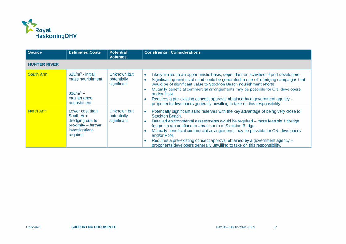
11/05/2020 SUPPORTING DOCUMENT E PA2395-RHDHV-CN-PL-0009 32
Source Estimated Costs Potential Volumes
Constraints / Considerations
HUNTER RIVER
South Arm $25/m3 - initial mass nourishment
$30/m3 – maintenance nourishment
Unknown but potentially significant
• Likely limited to an opportunistic basis, dependant on activities of port developers.
• Significant quantities of sand could be generated in one-off dredging campaigns that would be of significant value to Stockton Beach nourishment efforts.
• Mutually beneficial commercial arrangements may be possible for CN, developers and/or PoN.
• Requires a pre-existing concept approval obtained by a government agency – proponents/developers generally unwilling to take on this responsibility
North Arm Lower cost than South Arm dredging due to proximity – further investigations required
Unknown but potentially significant
• Potentially significant sand reserves with the key advantage of being very close to Stockton Beach.
• Detailed environmental assessments would be required – more feasible if dredge footprints are confined to areas south of Stockton Bridge.
• Mutually beneficial commercial arrangements may be possible for CN, developers and/or PoN.
• Requires a pre-existing concept approval obtained by a government agency – proponents/developers generally unwilling to take on this responsibility.

11/05/2020 SUPPORTING DOCUMENT E PA2395-RHDHV-CN-PL-0009 33
7 References
Bluecoast (2020), Cost benefit analysis for Stockton Beach coastal management program,
prepared for City of Newcastle.
Carley J.T., Coghlan A.R. Blacka M.J and Cox R. J. (2010) Development of a Proposal and
Environmental Assessment of Beach Scraping—New Brighton and South Golden Beach.
Technical Report 2008/19, February 2010.
CEM (2006), Coastal Engineering Manual, U.S. Army Engineer Research and Development
Center, Coastal and Hydraulics Laboratory, Vicksburg, MS.
CERC (1984), Shore Protection Manual, Coastal Engineering Research Center. Waterways
Experiment Station, US Army Corps of Engineers, Vicksburg, Mississippi.
RHDHV (2016a). Stockton Coastal Protection, Review of Environmental Factors (REF);
prepared by Royal HaskoningDHV for Newcastle City Council.
RHDHV (2016b). Stockton Coastal Protection, Technical Specification; prepared by Royal
HaskoningDHV for Newcastle City Council.
RHDHV (2018), Stockton Beach – Beach Scraping, Review of Environmental Factors,
prepared for City of Newcastle, 18 April 2018.
RHDHV (2020), Technical Note: RHDHV input information for a Cost Benefit Analysis for
Stockton Beach – Final, 27 April 2020.
WorleyParsons (2012), Stockton Beach Sand Scoping and Funding Feasibility Study,
prepared for City of Newcastle. Report No. 301015-02514, April.
Royal HaskoningDHV is an independent, international engineering and project management consultancy
with over 138 years of experience. Our professionals deliver services in the fields of aviation, buildings,
energy, industry, infrastructure, maritime, mining, transport, urban and rural development and water.
Backed by expertise and experience of 6,000 colleagues across the world, we work for public and private
clients in over 140 countries. We understand the local context and deliver appropriate local solutions.
We focus on delivering added value for our clients while at the same time addressing the challenges that
societies are facing. These include the growing world population and the consequences for towns and
cities; the demand for clean drinking water, water security and water safety; pressures on traffic and
transport; resource availability and demand for energy and waste issues facing industry.
We aim to minimise our impact on the environment by leading by example in our projects, our own
business operations and by the role we see in “giving back” to society. By showing leadership in
sustainable development and innovation, together with our clients, we are working to become part of the
solution to a more sustainable society now and into the future.
Our head office is in the Netherlands, other principal offices are in the United Kingdom, South Africa and
Indonesia. We also have established offices in Thailand, India and the Americas; and we have a long
standing presence in Africa and the Middle East.
royalhaskoningdhv.com