Embed Size (px)
Citation preview
I I
I
I
December 1, 2009
Ms. Jennifer Surber Environmental Specialist BrownfieldsNoluntaiy Cleanup Section Hazardous Waste Program ¥issouri Depaitment of Natural Resources 1038 E. Elm Jefferson City, MO 65101
RE: Letter Report for Supplemental Offsite Investigation Former Sporlan Valve Company Plant No. 1 611 East Seventh Street Washington, Missouri ENVIRON Project No. 19-15953A
Dear Ms. Surber:
€ NV I RO N
II
RECEIVED
DEC 0 4 ?1109 Hazan.JV .......... ,.. .... ,i:.. rrut;i ram
MO Dept. of Natural Resource~
ENVIRON International Corporation (ENVIRON), on behalf of Sporlan Valve Company, is submitting this letter report regarding the supplemental offsite investigation activities performed in September at the fmmer Sporlan Valve Company Plant No. 1 facility located at 611 East Seventh Street in Washington, Missouri (site). Included in this submittal are the results of recent soil and groundwater sampling activities for three newly installed wells and groundwater sampling for existing wells.
The objective of this supplemental investigation was to define the extent of impact by chlorinated volatile organics in soil and perched water at the smface of bedrock south (downgradient) of the site. Per discussions during our June 24, 2009, meeting, the objective was to delineate the constituents of concern to concentrations equal to or less than the Tier 1 residential land use scenario RBTLs for indoor inhalation of vapor emissions from groundwater as provided in the Missouri Risk-Based Corrective Action Technical Guidance document dated April 2006, including June 2006 and June 2008 updates (MRBCA Document).
The activities consisted of collecting soil samples during installation of three soil borings subsequently completed as monitoring wells, and obtaining groundwater samples from the tlu·ee newly installed monitming wells and from existing monitoring wells. These activities were conducted in accordance with the Supplemental Ojfsite Investigation Work Plan submitted to the MDNR on August 21 , 2009, and Work Plan for Ojfsite Groundwater Investigation submitted to the MDNR on Febrna1y 18, 2008. Soil and groundwater analytical results from this investigation will be provided to the City of Washington and the owners of residences adjacent to the newly installed soil bming/well locations (Appendix E).
13723 Riverport Drive, Suite 201 , Maryland Heights, Missouri 63043 3 14.5 13. 1973/314.51 3.195 1 (f)/www.environcorp.com
I
I
I I I I
I I
Ms. Jennifer Surber - MDNR Supplemental Ojfsite Investigation Former Sporlan Valve Company Plant No. 1
SCOPE OF WORK
Page 2 of6 December], 2009
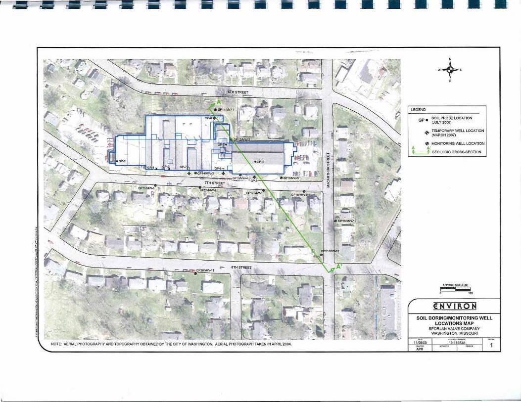
On September 17, 18, and 22, three soil borings were advanced and completed as permanent monitoring wells; two in the City of Washington-owned right-of-way along MacAtthur Street, and one in the City of Washington-owned right-of-way along East 8111 Street (see Figure 1). The soil borings were performed using a track-mounted direct push rig operated by Roberts Environmental Drilling of Millstadt, Illinois.
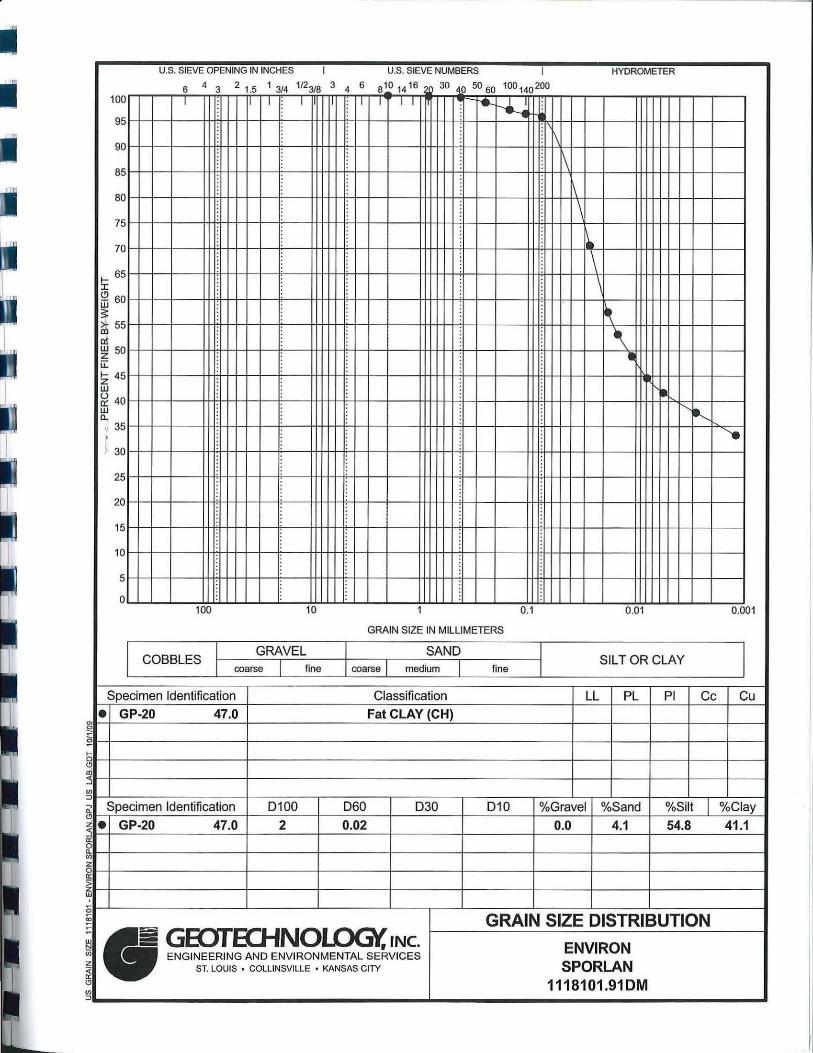
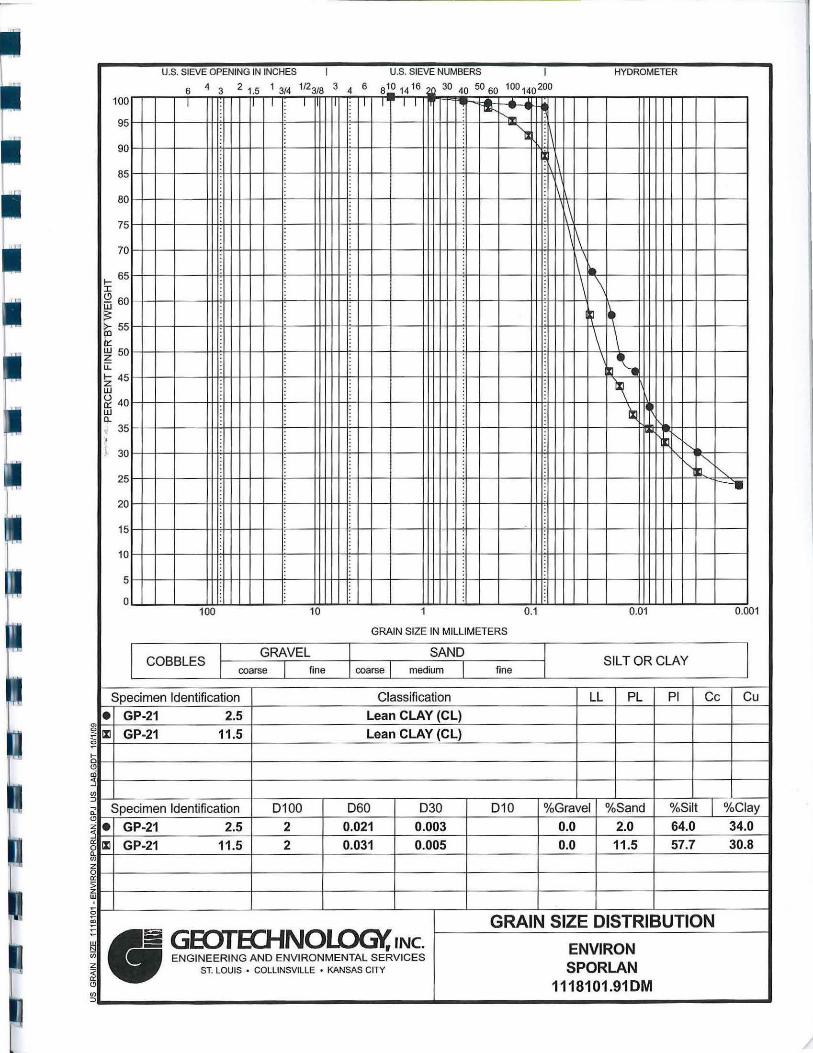
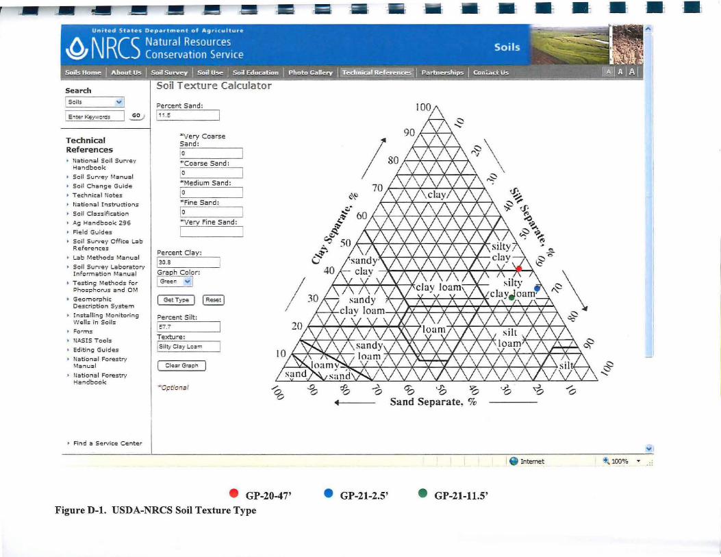
Each soil boring was advanced to probe refusal. Three soil samples were collected at each soil 1boring location consisting of one surface soil [O to 3 feet below ground surface (bgs)] sample, hne sample at a depth conesponding to the basement floor of each residence (approximately 10 \o 12 feet bgs); and one sample near the total depth of the boring. Soils from each boring were field screened with a photoionization detector (PID) to assess relative volatile organic compound (VOC) impact. Soil samples were submitted to Pace Analytical Services, Inc. (Pace) for analysis of VOCs using EPA Method 5035/8260. In addition to the soil samples collected for chemical analysis, three soil samples (MW-11: 47 feet; MW-12: 2.5 feet; and MW-12: 11.5 feet) were ~ollected and submitted to Geotechnology, Inc. for grain size analysis to aid the determination of soil type for the site as described in Appendix 0 of the MRBCA Document.
Each soil boring was subsequently completed as a pe1manent groundwater monitoring well to the total depth of the boring to allow the collection of groundwater samples and determination of depth to groundwater. A 5 foot length of 2 inch diameter polyvinyl chloride (PVC) well screen and associated riser was installed in each soil boring and equipped with a flush mount well protector at the surface. Following installation, each monitoring well was developed to remove any sediment and allow the collection of groundwater samples representative of the fo1mation being monitored (i.e. the saturated soils above the bedrock surface). Development consisted of purging at least three times the well casing volume plus three times the saturated volume of the well sand pack, or purging until no water was present in the well (i.e. well purged dry) due to slow recharge rates. During this event, all wells went dry before the desired purge volumes were reached. Prior to collection of groundwater samples, the wells were allowed to stabilize for 24 hours following development.
On September 22 and 23, 2009, the three newly installed offsite wells (MW-10, MW-11, and MW-12) and the existing wells (MW-2 through MW-9) were purged with a peristaltic pump a minimum of three well volumes prior to sampling using low-flow sampling procedures. MW-1 was not sampled because the well was dry. A flow through cell and multiple-parameter water quality meter was used to measure water quality parameters (pH, turbidity, dissolved oxygen, conductivity, temperature, and reduction/oxidation potential) during purging. Groundwater samples were submitted to Pace for analysis of VOCs using EPA Method 8260.
The top of the new well (MW-10 through MW-12) casing elevations were then surveyed and depth-to-water measurements were obtained from all wells (after development and before sampling).
I II I I I I I
I I
I
I
i
Ms. Je1111(fer Surber- MDNR Supplemental Offsite 111vestigatio11 Former Sporla11 Valve Company Plant No. 1
Page 3 of6 December 1, 2009
Purge water from the wells and soil cuttings were containerized and stored along the west interior building wall for subsequent disposal.
RESULTS
Geology and Hydrogeology
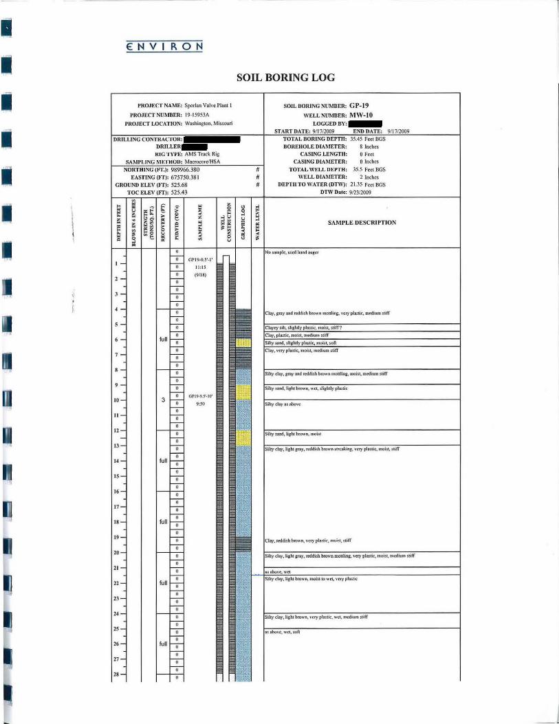
Predominantly clay and silty clay soils, with lenses of sandy silty clay, were encountered to the total depth of each soil boring, which was consistent with observations from prior investigations. ,Soil borings were completed to auger refusal 1 which was encountered at depths ranging from ppproximately 36 to 49 feet bgs. Boring and well constrnction logs are provided as Appendix A. 'rhe grain size analysis laboratory report is provided as Appendix B.
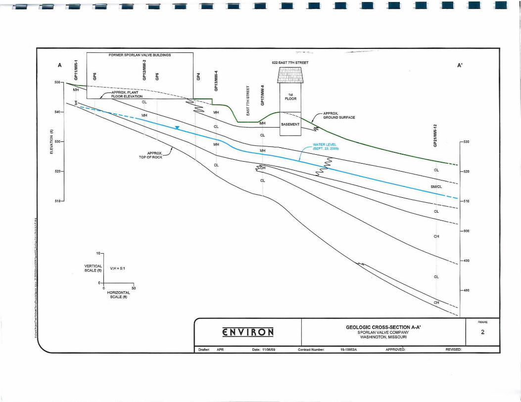
Figure 2 shows a generalized geologic cross-section depicting the topography, generalized soil lithology, and shallow groundwater level for the site and areas downgradient of the site.
Based on the Unified Soil Classification System (USCS), each of the soil samples was identified as clay, and more specifically the laboratory identified one soil sample as highly plastic clay (CH) and two soil samples as silty clays (CL). The laboratory soil type classifications match the field soil type classifications. However, using the United States Department of Agriculture, Natmal Resource Conservation Service soil texture classification system as presented in the MRBCA Document, only the clay (CH) sample is classified as silty clay or Soil Type 3 (clayey), and the two silty clay (CL) samples are classified as silty clay loam or Soil Type 2 (silty) (see Figure D-1 , Appendix B).
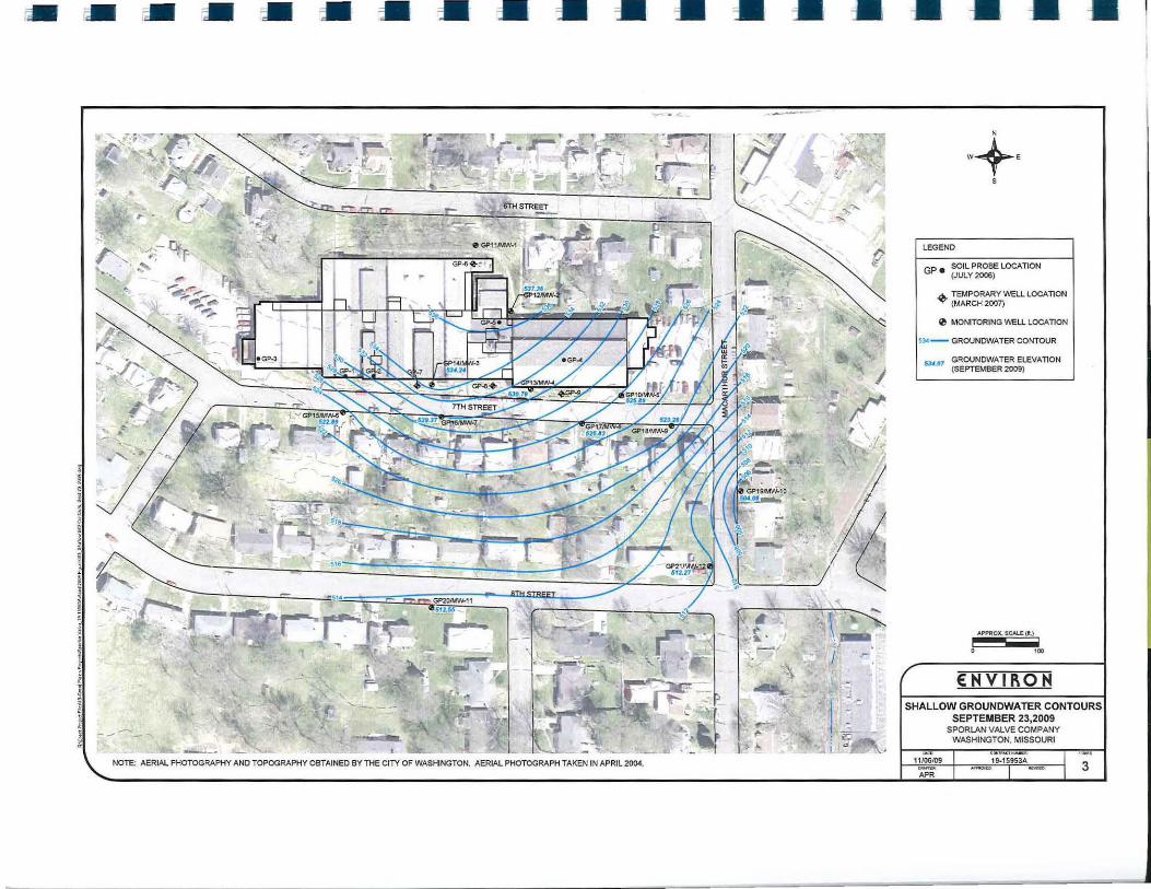
The depth to groundwater measured in the wells ranged from approximately 7.57 feet bgs (MW-9) to 21.35 feet bgs (MW-I 0). Figure 3 shows contours of the shallow groundwater smface based on groundwater elevations measured on September 23, 2009. As shown on this figure, the shallow groundwater surface slopes primarily to the south with a southwesterly component on western p01tions of the site and a southeasterly to easterly component on eastern portions of the site, and generally mimics the surface and top of bedrock topography at the site. These conditions are generally consistent with those observed during previous investigations.
Soil Sample Results
Soil sample results from this supplemental investigation are summarized on Table 1. The laborato1y rep01ts are provided in Appendix C.
All analytical results were below the respective detection limits. Therefore, all results are less than lowest Default Tier 1 Target Levels (DTLs) for all soil types in the MRBCA Document.
1 Soil boring auger refusal is presumed to be the bedrock surface. No references regarding the actual depth of bedrock have been reviewed. Rock coring has not been performed to confitm the bedrock surface.
I
I
I
I I
I I I I
I I I I I I I
Ms. Jennifer Surber - MDNR Supplemental Offsite Investigation Former Sporlan Valve Company Plant No. 1
Groundwater Sample Results
Page 4 o/6 December 1, 2009
Results from the September 2009 sampling of existing wells and newly installed offsite monitoring wells are summarized on Tables 2A and 2B. The indoor inhalation of vapor emissions RBTLs for a residential and non-residential land use scenarios for Soil Types 2 (silty) and 3 (clayey) specified in the MRBCA Document are also provided for comparison. The laboratory repmts are provided in Appendix D.
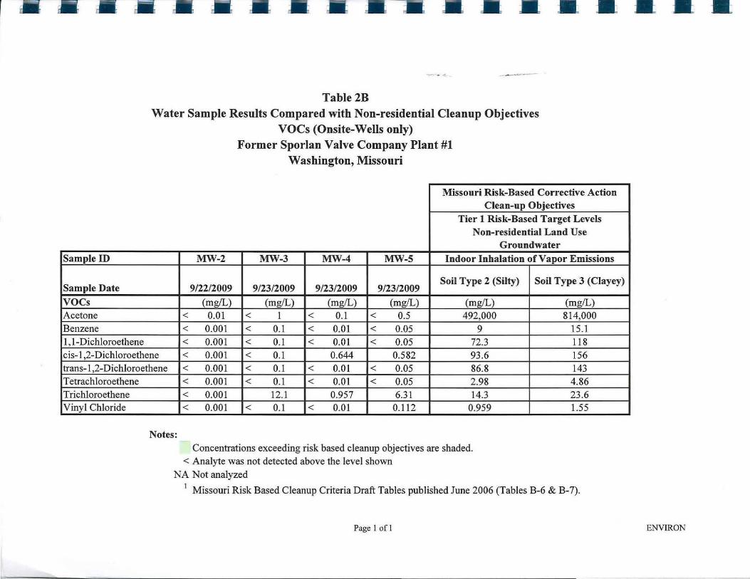
TCE concentrations detected in groundwater samples from onsite wells (MW-2 through MW-5) .do not exceed the indoor inhalation of vapor emissions from groundwater RBTLs for a non-7·esidential land use scenario at any well location.
TCE concentrations detected in groundwater samples do not exceed indoor inhalation of vapor emissions from groundwater RBTLs for a residential land use scenario at any well location, except the following:
• Onsite wells MW-3 and MW-5 exceed the Soil Type 3 RBTL [4.49 milligrams per liter (mg/L)];
• Offsite well MW-8 exceeds the Soil Type 3 RBTL; and
• Offsite wells MW-7 and MW-9 only exceed the Soil Type 2 RBTL (2.74 mg/L).
Vinyl chloride was not detected at a concentration that exceeds the indoor inhalation of vapor emissions from groundwater RBTL for either Soil Type 2 (0.183 mg/L) or Soil Type 3 (0.297 mg/L) for a residential land use scenario at any well location except MW-8 (0. 771 mg/L ).
Constituent concenh·ations are stable in onsite and offsite wells; however, constituent concentrations in MW-2 (onsite), MW-6 (offsite), and MW-7 (offsite) are h·ending downward based upon last three groundwater monitoring events (July 2008, July 2009 and September 2009) (an additional groundwater monitoring occun-ed for MW-2 on May 2007).
For purposes of delineation, TCE was only detected in newly installed wells MW-10, MW-11, and MW-12 at concentrations approximately one order of magnitude or more below the Tier 1 RBTLs for indoor inhalation of vapor emissions from groundwater for Soil Type 2 for a residential land use scenario.
CONCLUSIONS
ENVIRON performed a supplemental offsite soil and groundwater investigation at the fotmer Sporlan Valve Plant No. 1. The investigation included performing three soil borings advanced to refusal (presumed bedrock smface), collection of surface and subsurface soil samples, installation of permanent groundwater monitoring wells and collection of groundwater samples from new and existing wells. Based on the field observations and analytical results, ENVIRON concludes the following:
I
I I I I I I I
I
I I I I I
Ms. Jennifer Surber - MDNR Supplemental Ojfsite Investigation Former Spar/an Valve Company Plant No. 1
Page 5 of6 December 1, 2009
• Consistent with prior investigations, no offsite soil impacts exceeding DTLs were identified during the investigation. No further soil investigation is necessary to delineate the extent of soil impact.
• TCE was only detected in newly installed wells MW-10, MW-11, and MW-12 at concentrations approximately one order of magnitude or more below than the Tier 1 RBTLs for indoor inhalation of vapor emissions from groundwater for Soil Type 2 for a residential land use scenario. These three wells therefore define the extent of offsite groundwater impact downgradient of the facility based upon the potentially complete vapor intrnsion pathway, and no further groundwater investigation is necessaty to delineate the extent of groundwater impact.
• Consistent with prior investigations, TCE concentrations in offsite shallow groundwater exceed the indoor inhalation of vapor emissions RBTLs for Soil Types 2 or 3 for a residential land use scenario (Table 2A) in MW-7, MW-8, and MW-9. In addition, the vinyl chloride concentration in MW-8 exceeds the indoor inhalation of vapor emissions RBTLs for Soil Type 3 for a residential land use scenario. No other constituent concentrations exceed their respective RBTLs. Although RBTLs for the "indoor inhalation of vapor emissions from groundwater" were exceeded in select offsite wells, no target constituents were detected above soil gas RBTLs for "indoor inhalation of vapor emissions from soil vapor" in sub-slab soil gas samples from four residences along the southern side of East Seventh Street (604, 612, 616, and 622 E. Seventh Street).
Quarterly groundwater monitoring will continue with the next groundwater sampling event scheduled for December 2009.
-ooOoo-
I
I
I
I
I
I
I
I I
I
I
I I
I I
I I
Ms . .Je1111ifer Surber - MDNR S11pple111e11tal Offsite Investigation Former Sporlan Valve Company Plant No. 1
If you have any questions, please feel free to call
Very trnly yours,
:Principal I
Manager
Page 6 o/6 December 1, 2009
tABLES Table 1: Table 2A: Table 2B:
Soil Sample Results Compared with Residential Cleanup Objectives Water Sample Results Compared with Residential Cleanup Objectives Water Sample Results Compared with Non-residential Cleanup Objectives
FIGURES Figure 1: Figure 2: Figure 3:
Soil and Groundwater Sampling Locations Geologic Cross-section A-A' Shallow Groundwater Contour Map (September 23, 2009)
APPENDICES Appendix A: Boling and Well Construction Logs Appendix B: Soil Grain Size Sampling Laboratory Rep011s Appendix C: Soil Sampling Laboratory Rep011s Appendix D: Groundwater Sampling Laborat01y Repo11s Appendix E: November 2009 Soil and Groundwater Data Transmittal Letters to Prope1ty
Owners
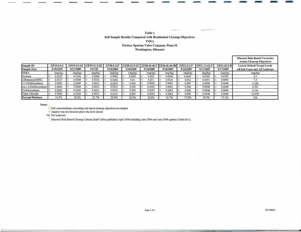
Sa mple ID GP19-0.5-l GP19-9.5-IO GP19-31.5-32' Sa mple Date 9/18/2009 9/ 1712009 9/17109
voe s (mg/Im) (mt•/lcP) (m PikP)
Acetone < 0.0253 < 0.0 196 < 0.0204 2-Butanone(MEK) < 0.0127 < 0.0098 < 0.0102
1. 1-Dichloroethene < 0.0063 < 0.0049 < 0.0051
- -
Table 1 Soil Sample Results Compared with Residential Cleanup Objectives
voes
GP20-1.5-2' 9/18/2009
(m!!lk!!)
< 0.0405
< 0.0202
< 0.0101
Former Sporlan Valve Company Plant #I Washington, Missouri
GP20-12.5-13' GP20-46-46.S' GPZ0-46-46.SR 9/18/2009 9/18/2009 9/18/2009
(m<'ik<') (m l!!k!!) (mg/kg)
< 0.0201 < 0.022 < 0.0246
< 0.01 < 0.011 < 0.0 123
< 0.005 < 0.0055 < 0.0061
GP21-2-2.5' 9/18/2009
(mg/kg)
< 0.0241 < 0.012 < 0.006
cis-12-Diehloroethene < 0.0063 < 0.0049 < 0.0051 < 0.0101 < 0.005 < 0.0055 < 0.0061 < 0.006 Trichloroethene Vinyl Chloride
Percent Moisture
Notes:
< 0.0063 < 0.0049 < 0.0051 < 0.0101 < < 0.0063 < 0.0049 < 0.005 1 < 0.0101 <
14.5% 18.6% 23.7% 22.6%
Soil concentrations exceeding risk based cleanup objectives are shaded. < Analyte was not detected above the level shown
NA Not analyzed
0.005 < 0.0055 < 0.0061 < 0.006 0.005 < 0.0055 < 0.0061 < 0.006
20.9% 19.9% 21.7% 17.6%
1 Missouri Risk Based Cleanup Criteria Draft Tables published April 2006 including June 2006 and June 2008 updates (Table B-1 ).
Page I of I
Missouri R isk-Based Corrective Action C lean-up Objectives
GP21-ll-11.5' GP2J-46.5-4 1 Lowest Defa ult Target Levels
9/17/2009 9/17/2009 All Soil Tvnes and All Pathways
(m g/kg) ( m!!lkc:) (m c:/lcc:)
< 0.0183 < 0.0 193 4.2
< 0.0091 < 0.0096 7.3
< 0.0046 < 0.0048 0.108
< 0.0046 < 0.0048 0.521
< 0.0046 < 0.0048 0.141
< 0.0046 < 0.0048 0.0192
19.5% 17.1% NA
ENVIRON
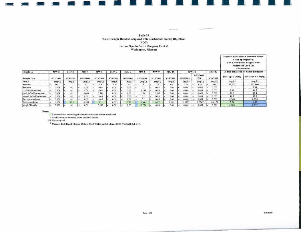
- - - • • • • • Tablc2A
Water Sample Results Compared with Residential Cleanup Objectives voes
Former Sporlan Valve Company Plant #1 Washington, Missouri
• • -----
Somolc ID MW-2 MW-3 MW-4 MW-5 MW-6 MW- 7 MW- 8 MW-9 MW-JO MW-ll MW-12
Som pie Date voes Acetone Benzene 1.1-Dichlorocthenc cis- I .2-Dichloroethcne trans-1.2-Dichloroethene Tetra.chloroethcnc Trichloroethene Vinyl Chloride
Notes:
912212009 9/23/2009 9123/2009 9/23/2009 9/23/2009 (m,,/L) (ml!/L) (m,,/L) (m,,/L) (ml!/L)
< 0.01 < 1 < 0.1 < 0.5 < 0.01 < 0.001 < 0. 1 < 0.01 < 0.05 < 0.001 < 0.001 < 0.1 < 0.01 < 0.05 < 0.001 < 0.001 < 0.1 0.644 0.582 0.001 < 0.001 < 0.1 < 0.01 < 0.05 < 0.001 < 0.001 < 0.1 < 0.01 < 0.05 < 0.001 < 0.001 12.1 0.957 6.31 0.023 < 0.001 < 0.1 < 0.01 0.112 < 0.001
Concentrations exceedins risk based cleanup objectives are shaded. < Analyte was not detected above the level shown
NA Not analyzed
9/23/2009 9/23/2009 9/23/2009 (m,,/L) (ml!/L) (m,,/L)
< 0,5 < I < 0.5 < 0.05 < 0.1 < 0.05 < 0.05 0. 153 < 0.05 < 0.05 1.38 0.243 < 0.05 < 0.1 < o.os < 0.01 < 0.1 < 0.05
3.59 8.44 4.07 < 0.05 0.771 < 0.05
1 Missouri Risk Based Cleanup Criteria Draft Tables published June 2006 (Tables B-3 & B-4).
Pn cc l ofl
9123/2009 9/23/2009 9/23/2009 OUP 9/23/2009
(ml!/L) (m,,/L) (m,,/L) (ml!/L) < 0.1 < 0.01 < 0.01 < 0.01 < 0.01 < 0.001 < 0.001 < 0.001 < 0.01 < 0.001 < 0.001 < 0.001 < 0.01 < 0.001 < 0.001 < 0.001 < 0.01 < 0.001 < 0.00 1 < 0.001 < 0.01 < 0.001 < 0.001 < 0.001
0.289 0.0755 0.0747 0.0173 < 0.0 1 < 0.001 < 0.001 < 0.00 1
• • • • •
Miuouri Risk-Based Correct.ive Action Oun-up Objectivts
Tier 1 Risk-Based Target Levels Resid•ntiol Lond Use
Groundwater Indoor Jnhalat ion of Vapor Emissions
Soil Type 2 (Silty) Soil Type 3 (Oayey)
(mdL) (moll .\
61.200 101.000 2 2.88
8.99 14.7 11.6 19.4 10.8 17.8
0.568 0.928 2.74 4.49 0.183 0.297
ENVIRON
• •• • • •••••••
Sample ID
Sample Date
voes Acetone Benzene 1, 1-Dichloroethene
Table 2B Water Sample Results Compared with Non-residential Cleanup Objectives
VOCs (Onsite-Wells only) Former Sporlan Valve Company Plant #1
Washington, Missouri
Missouri Risk-Based Corrective Action Clean-up Objectives
Tier 1 Risk-Based Target Levels Non-residential Land Use
Groundwater MW-2 MW-3 MW-4 MW-5 Indoor Inhalation of Vapor Emissions
9/22/2009 9/23/2009 9/23/2009 9/23/2009 Soil Type 2 (Silty) Soil Type 3 (Clayey)
(mg/L) (mg/L) (mg/L) (mg/L) (mg/L) (mg/L) < 0.01 < 1 < 0.1 < 0.5 492,000 814,000 < 0.001 < 0.1 < 0.01 < 0.05 9 15.1 < 0.001 < 0.1 < 0.01 < 0.05 72.3 118
cis-1 ,2-Dichloroethene < 0.001 < 0.1 0.644 0.582 93.6 156 trans-1 ,2-Dichloroethene Tetrachloroethene Trichloroethene Vinyl Chloride
Notes:
< 0.001 < 0.1 < 0.01 < 0.05 86.8 < 0.001 < 0.1 < 0.01 < 0.05 2.98 < 0.001 12.1 0.957 6.31 14.3 < 0.001 < 0.1 < 0.01 0.112 0.959
Concentrations exceeding risk based cleanup objectives are shaded. < Analyte was not detected above the level shown
143 4.86 23 .6 1.55
NA Not analyzed 1 Missouri Risk Based Cleanup Criteria Draft Tables published June 2006 (Tables B-6 & B-7).
Page 1 of I ENVIRON
• • • • --
NOTE: AERIAL PHOTOGRAPHY AND TOPOGRAPHY OBTAINED BY THE crrv OF WASHINGTON. AERIAL PHOTOGRAPH TAKEN IN APRIL 2004.
• • •
LEGEND
GP e SOIL PROBE LOCATION (JULY 2006)
~ TEMPORARY WELL LOCATION (MARCH 2007)
0 MONITORING WELL LOCATION A A" -t__j GEOLOGIC CROSS-SECTION
APPROX. SCALE (IL) I ...
ENVIRON SOIL BORING/MONITORING WELL
LOCATIONS MAP
11/06/09 ....... APR
SPORLAN VALVE COMPANY WASHINGTON. MISSOURI
19-15953A
•
--- - - - - •• FORMER SPORlAN VALVE BUILDINGS
A ~ ~ 622 EAST 7lH STREET A'
~ :::: c;i ,.
a: '° a: "' ... "- "- "- ~ (!) (!) (!) (!) (!)
550 "' ------------ a: ti; "i' APPROX. PLANT ---- (!) w ;: --- ~ :::: 1st Fl.OCR ELEVATION ;::: .,
Fl.OCR
~ CL l: a:
t;: (!) ,_ 540
.,
~" ~ -- APPROX. -- GROUND SURFACE
MH BASEMENT
€ ~ z CL ~ g 530 530
~ "-(!)
w
---520 CL 520
---510 510
---500
CH
"l=, --- 490
VERTICAL SCALE(:) V:H = 5:1
0 50 HORIZONTAL
480
SCALE(ft)
------FIGURE
€NVll\ON GEOLOGIC CROSS-SECTION A-A'
SPORLAN VALVE COMPANY 2 WASHINGTON. M ISSOURI
Drafter: APR Date: 11/06/09 Contrad Number: 19-15953A APPROVED: REVISED:
- - - - • • • • • • • • •
NOTE: AERIAL PHOTOGRAPHY AND TOPOGRAPHY OBTAINED BY THE CITY OF WASHINGTON. AERIAL PHOTOGRAPH TAKEN IN APRIL 2004.
• • •
LEGEND
GP e SOIL PROSE LOCATION (JULY 2006)
~ TEMPORARY WELL LOCATION (MARCH 2007)
0 MONITORING WELL LOCATION
53'1 - GROUNDWATER CONTOUR
GROUNDWATER ELEVATION (SEPTEMBER 2009)
APPROX. SCALE (ll) I I
0 100
E:NV ll\ ON
•
SHALLOW GROUNDWATER CONTOURS SEPTEMBER 23,2009
11106/09
APR
SPORLAN V ALVE COMPANY WASHINGTON, MISSOURI
19-15953A 3
I I
I I
I I
I I
-
Ms. Jennifer Surber - MDNR Supplemental Offsite Investigation Former Spartan Valve Company Plant No. 1
I
I
\
December 1, 2009
APPENDIX A
Boring and Well Construction Logs
I
I I
I I I
\ I
t
II
€NV I RON
PROJECT NAME: Sporlan Valve Plant I
PROJECT NUMBER: 19-15953A
PROJ ECT LOCATION: Washington. Missouri
DRILLING CO NTRACTO R:
DRJLLF.R-RIG TYPE: AMS Track Rig
SAMP LING METHOD: Macrocore/HSA
NORTffiNG (FT.): 989966.380
EASTING (FT): 675750.38 1
GROUND ELEV (FT): 525.68 TOC ELEV (FT): 525.43
ti ::i = ~~ u
~ i!: i!: ... ~~ i!: i::
~ .. z .. i;;g ...
0 .. ... ..
3
JO
11
12
13
14
15
16
17
18
19
20
21
22
23
24
25
26
27
28
g ~ 0 > !::. ..
"' e > 0 l5 u ... ;;:: ..
full
3
full
full
full
full
"' ~ z !:l .. ~ "'
GPl9·0.5'- I'
I l: IS (9/18)
GPl9·9.S-10'
~:50
z 0
... 5
... ::>
~~ "' 0 u
SOIL BORING LOG
" 0 _, !:! = .. ~ "
If If #
_, "' > "" _, .. "' ... ~
SOLL BOR ING NUJIIBER: GP-19 W ELLNUJIIBER: MW-JO
LOGGED D\' : •••• STARTDATE: 9/17/2009 END DATE: 9/17/2009
TOTAL BO RI NG DEPTH: 35.45 Feet DGS
DOREllOLE DIAJllETER:
CASING LENGTH: 8 Inches 0 Feet
CASING DIAMETER: 0 Inches
TOTAL WELL DEPTH: 35.5 Feet OGS
WELL DIAJllETER: 2 Inches DEl'Tll TO WATER (DTW): 21.35 Feet BGS
DT W Date: 912312009
SAMPLE D ESCRIPTION
No sam1>lt , wed h11ncl ftug<"r
Clay, gray and rtddish brown mouling_, ''"'Y plastic, medium s1ifT
Clayey sill, slightly plllsiic·, moist, stiff?
Clay, plastic, moist, medium sliff
Sil ty sand, SliJ hlly phuliC'~ moist, soft
Clay, \'Cry plBStic', moist, medium stiff
Silty clay, 8'*Y and ttddish brown mottlinr, moist. mtdiu.m s1ifT
Silty sand, li1h1 brown, wtt, slirhtly pla:."tic
Silly d ay H flbo\'C
Silly sand, li&hl brown, moist
Sihy clay, lirh1 gniy, rcdcli$h brown stttakin1. \•t ry plastic, moist, stiff
Clay, rtddish brown, \'ffY plas.lic, moist, stiff
Silty d1y, li1hl rray, mtdisb brown ma1ding, vny plastic, moist, medium stiff
Silty clay, Jighl brown, moist 10 wtt, YC'ry pla.s!ic
Silly day, lighl brown, vtry plastic. wet, medium sliff
• ENV I RON
PROJECT NAJ\IE: Sporlan Valve Pla111 I
PROJECT NUl\lBER: 19-15953A
PROJECT LOCATION: Washinglon, Missouri
DRILLING C ONTRACTOR:
DRJLLER:-RlG TYP E: AMS Track Rig
SAMPLING METHOD: Macrocore/HSA
NORTHING (FT,): 989788.516 EASTING (Ff): 675274. 777
GROUND ELEV (}"T): 524.58 TOC ELEV (FT): 524.33
"' ... "' 5 ,.., "' = ... !:! iS ...... ~ "' ~g
~ :c ~~ ... "' .. " .,,g
"' 0 Q -' ..
\ 2
3
4
s
6
8
9
10
II
12
13
14
IS
16
17
18
19
20
2 1
22
23
24
2S
g >-" ~ 0 v ::!
2.5
full
full
full
full
full
~ 0 t:. e ~ .. 0
"' ~ z "' -' .. :< < "'
GP20-IS·2'
8:50
GP20.12.5'-13'
9 :15
z 0
:l g ~~ ~ v
SOIL BORING LOG
SOIL BORING NUMBER: GP-20 WELL NUl\IBER: MW-11
LOGGED BY:
START DATE: 9/1 8/2009 END DATE:
TOTAL DORING DEPTH: 49 Feel BOS
DO REH OLE DIA~JETER: 8 Inches CASING LENGTH: 0 Feel
CASING DIAMETER: O Inches
# TOTAL WEl.LDEPTH: 49 l'eel BGS
# WELL DIAMETER: 2 Inches
# DEPTH TO WATER (DTW): 11.78 Feel BGS DTW Dale: 9/23/2009
-' g ~ -' ~ v
ii! " SAMPLE DESCRIPTION
~ "' ... <
C-' 11:
Silty clay, l ight brown, non-plastic, slightly moist, slightly s1iff
Silty clay. lighl brown. reddish brown mouling, Fc02 nodules, plastic, slighLly mois1, slightly stiff
Clay, liglu brown, reddish brown mottling, Fc02 nodules. plastic, moist, s tiff
Sandy silty clay, fine 10 med. Sand, light brown. reddish brown and dark brown mottling. slightly plastic, mois1. soft
Cla · as above
Sand sil clay as above Silty clay. light brown. reddish brown mo11led. vny plastic. moist slightly stiff
Silty clay, light brown, reddish brown mottling. plastic, moist, slightly stiff
As abo,·e. sti ff
Silty clay. light brown to brown. plastic. moist. sligh1ly s1iff. Fc01 nodules
As above. wet
Clay light brown. reddish brown mouling, plastic . wet. stiff
Silty clay, light brown. reddish brown mortling. plastic. wet, slightly stiff
~ I
ENVIRON
PROJECT NAME: Sporlan Valve Plant I
PROJECT NUMBER: 19-15953A
PROJECT LOCATION: Washington, Missouri
DRILLING CONTRACTOR: DRILLER:--
RIG TYPE: AMS Track Rig
SOIL BORING LOG
SOIL BORING NUMBER: GP-21 WELLNUl\ffiER: MW-12
LOGGED BY:···· STARTDATE: 9117/2009
TOTAL BORING D EPTH: BOREHOLE DIAMETER :
CASING LENGTH:
END DATE: 9/18/2009
49 Feet BGS 8 Inches
0 Feel SAMPLING METHOD: Geoprobe Macrocore/HSA CASING DIAMETER: 0 Inches
NORTHING (FT.): 989852.290 EASTING (FT): 6757 10.283
G~OUND ELEV (FT): 523.47 \ TOC ELEV (FT): 523.22
2
3
4
5
6
7
8
9
10
tl
12
13
J4
15
16
17
18
19
3.5
full
full
full
full
0
0
0
0
0
0
0
0
0
0
0
0
0
0
0
0
0
0
0
0
0
0
0
0
0
0
0
0
0
0
0
0
0
0
0
0
0
0
0
GP2 l -2'-2.5'
12:30
(9118)
GP21 -2.5'
for Grain Size
GP21-1 l'- 11.5'
15:00
GP21- 1 l.5-12"
for Grain Size
TOTAL WELL DEPTH: 49 Feel BGS WELL DIAMETER: 2 Inches
DEPTH TO WATER (DTW): 10.95 Feel BGS
DTW Date: 9/23/2009
SAMPLE DESCRIPTION
Silly clay, lighl brown, light gray mollling, non-plastic, dry, stiff
Silly clay, lighl gray, reddish brown mottling, plastic, moisl, s1iff
Sandy silly clay, lighl brown, reddish brown a nd lig)u gray mott ling, plastic, moisl, s1iff
approximately 211 fine sand lense
Silly clay, light grayish brown, reddish brown to brown mottling, very plaslic, moist, slighlly sliff
Sandy silry clay, lighl brown, lighl gray and reddish brown mottled, moist, plastic, soil
Silly c lay, light brown, lighl gray and reddish brown mottling, plastic, moisl, sliff
I 0 Clay, light brown, light gray and reddish brown mottling, plastic, moist, sti ff 20
0 II 0
I 21 0
0 22 fu ll
0 Clay, light brown, reddish brown mottling, plastic, moist, very st iff
I 0
23 0
0 24
0 I' 0
I 25 0
0 26 full
0
I 0 27
0
0 28
0
I 29: 0
0
0 30 full
0
I 0 31
0
0 32
0 S ilty clay, light bro\\11, reddish brown and gray mottling, plastic, moist, stiff
I 0 33
0 WCI, soA
0 34 full
0
I 0 35
0
0 36
0 Sil ty clay, light gray and reddish brown mott ling, plastic, moist, slight ly stiff
I 0 37
0
0 S il ty clay, Light br0\\11, slightly plast ic, wet, son 38 full
I 0
0 Silty clay, light brown, gray and rcddisl• brown 1nott ling, plastic, very moist, s1·iff 39
0
0 40
0 S ilty clay, light brown, gray and reddish bro\\11 mottling, plastic, very moist, son
I 0 41
0
0 42 full
~ 0
0 43
0
0 as above, Fe02 nodules, plastic, moist, stiff 44
0 S ilty clay, light brown, light gray motlling, plastic, moist, slightly stiff
0 45
0
46 3.0 0
0
0 GP2 1-46.5'-47' Clay, light br0\\11, light gray mottling, plastic, moist, st iff 47
0 16: 10
0 48
0
0 Probe refusal at 48.S n ., Auger refusal at 49 n ., End of boring 49
ENVIRON
SOIL BORING LOG KEY
I - FILL
I GRAVEL
L. SAND AND GRAVEL
- SAND
CLAYEY SAND
SILTY SAND
SANDY SILT
~ SANDY SILTY CLAY
SILT
CLAYEY SILT
CLAY AND GRAVEL
SILTY CLAY
I I CLAY
- LOAM/PEAT
TOPSOIUCONCRETE
WELL CONSTRUCTION KEY
WELL SCREEN
FILTER PACK SAND
RS:IJTnllllTS:/~~n· IT
I I
I
I
I I
r
I
I ' I
I I i I I ..
I I I
I I ..
I
I I I I I
Ms. Je1111ifer Surber - MDNR S11ppleme11ta/ Offsite /11vestigatio11 Former Sporla11 Valve Company Plant No. 1 December 1, 2009
APPENDIXB
Soil Grain Size Sampling Laboratory Reports
I I
I l l
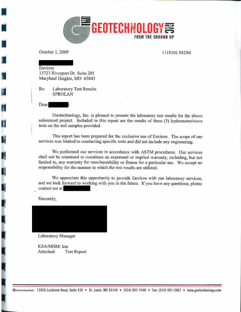
October 1, 2009
Environ 13723 Riverport Dr. Suite 201 Maryland Heights, MO 63043
Re: Laboratory Test Results SPROLAN
--• c-:» FROM THE GROUND UP
l l 18101.91DM
Geotechnology, Inc. is pleased to present the laboratory test results for the above referenced project. Included in this report are the results of three (3) hydrometer/sieve tests on the soil samples provided.
This rep011 has been prepared for the exclusive use of Environ. The scope of our services was limited to conducting specific tests and did not include any engineering.
We performed our services in accordance with ASTM procedures. Om services shall not be construed to constitute an expressed or implied warranty, including, but not limited to, any wairnnty for merchantability or fitness for a paiticular use. We accept no responsibility for the manner in which the test results are utilized.
We appreciate this opp01tunity to provide Environ with our laboratory services, and we look forward to working with you in the future. If you have any questions, please contact me at
Sincerely,
Laboratory Manager
KSA/MHM: ksa Attached: Test Rep011
@ pmroMro.")f}cdfoJl!tl 11816 Lackland Road, Suite 150 • St. Louis, MO 63146 • (314) 997-7440 • Fax: (314) 997-2067 • www.geotechnology.com
,,
1.
UJ :J
&
U.S. SIEVE OPENING IN INCHES
6 4 3 2 1.5 1 3/4 1/23/8 100 I II I I
: 95
90
85
80
75
70
f- 65 J:
~ 60 tiJ ~ ~ 55 aS ~ 50 u:: ~ 45 w ~ 40 w a.. \' 35 . ~ 30
25
20
15
10 :
5
0 100 10
COBBLES I GRAVEL
I coarse fine
Specimen Identification
• GP-20 47.0
Specimen Identification 0100
I
3
I
U.S. SIEVE NUMBERS I HYDROMETER
4 6 810 14 16 30 40 50 60 100140 200
I I I I .. -~ ~~ - . I : \ I\
\ \ \
• \
~
' I ' •..._ ........ ~c-.
1 0.1 0.01
GRAIN SIZE IN MILLIMETERS
SAND I SILT OR CLAY coarse medium fine I
Classification LL PL Pl Cc
Fat CLAY (CH)
060 030 010 %Gravel %Sand %Silt I •• GP-20 47.0 2 0.02 0.0 4.1 54.8 z :) cc 0 CL UJ z li1 ~ w '
0
;;;
• GEOTECHNOLOGY, INC. ENGINEERING AND ENVIRONMENTAL SERVICES
ST. LOUIS • COLLINSVILLE • KANSAS CITY
GRAIN SIZE DISTRIBUTION
ENVIRON SPORLAN
1118101.91DM
"e
0.001
Cu
%Clay
41.1
U.S. SIEVE OPENING IN INCHES I U.S. SIEVE NUMBERS I HYDROMETER
6 4 3 2 1.5 1 3/4 1/23/8 3 4 6 810 14 16 30 40 50 60 100140200
100 I II I I II II I I I I ~ .1: I~ w... t--:
95 "ii
90
85 =~ i\ :
80 ,\ 75
\ \ 70 :
' I- 65
\ • \ \ J:
Q 60 w
I~ ~ ~ ~ 55 Ir: ~ 50 ' ri \.. u::: ~ 45
~ w ~ 40 w ~ I Q.
\ 35 ~~ . r'--1'..
' 30 '['-.. " II. ~ 25 ~
20
15
10 :
5
0 100 10 1 0.1 0.01 0.001
GRAIN SIZE IN MILLIMETERS
COBBLES GRAVEL SAND I
SILT OR CLAY I coarse fine coarse medium fine
Specimen Identification Classification LL PL Pl Cc Cu
• GP-21 O>
2.5 Lean CLAY (CL) e 0
Ill GP-21 11 .5 Lean CLAY (CL)
..., n. Cl z
Specimen Identification 0100 060 030
•• :) a:: 0 n. (/)
z ~ ~ w
0 ;;;
Ill
GP-21
GP-21
•
2.5 2 0.021 0.003
11.5 2 0.031 0.005
GEOTECHNOLOGY, INC. ENGINEERING AND ENV IRONMENTA L S ERV ICES
ST. LOUIS • COLLINSVILLE • KANSAS CITY
010 %Gravel %Sand %Silt I %Clay
0.0 2.0 64.0 34.0
0.0 11.5 57.7 30.8
GRAIN SIZE DISTRIBUTION
ENVIRON SPORLAN
1118101 .91DM
Search
I Soils v I f Ent;;< .V.:;wcrds I ~
Technical References • Nat ional Se il Sur:ey
Handbook
• Soil Sur.·ey Manual
• Soil Change Guide
• Technical Notes
• National Instructions
• Soil Classification
• A g Handbook 296
• Field Guides
• Soil Sur1ey Office Lab References
• Lab Method;; Manual
• Soil Survey Laboratory Infomu1tion Manual
• Testing Methods for Pho.aphorus a nd OM
• Geomorphic Description S1st<?m
• In..talling Monitoring Wells in Soils
• Forms
• ri;..srs Tools
• Editing Guides
r~ational Forestry Manua l
• rl ational Forestry Handbook
• Find a Service Center
Soil Texture Calculator
Percent Sand: j 11.5
"Very Coarse Sand: jo "Coarse Sand:
fa %Medium Sand: jo ~Fine Sand:
"'Very Fine Sand :
Percent Clay:
f:w.s Graph Color: f Gr!!€n v j
[ Get Ty<>!> I [ R~t I Percent S ilt:
Texture: j sil~;Clay Loam
[ Cl""' Gmoh
~optional
• GP-20-47'
Figure D-1. USDA-NRCS Soil Texture Type
>o ~ ·~ ~ Sand Separate, %
• GP-21-2.5' • GP-21-11.5'
·-
._r. 0
-
e Internet
- ·-- •
v
~ 100% • ...