Embed Size (px)
Citation preview
SUPERFAULTS AND PSEUDOTACHYLYTES: EVIDENCE OF CATASTROPHIC EARTH MOVEMENTS
Timothy L. Clarey, Ph.D., Independent Scholar, 2878 Oaklawn Park, Saginaw, MI 48603, USA, Steven A. Austin, Ph.D., Cedarville University, 251 N. Main St., Cedarville, OH 45314, USA Stephen Cheung, BSc., Calgary Rock and Material Services, Inc., #3, 3610-29th St. N.E., Calgary, Alberta T1Y5Z7, Canada Raymond Strom, Ch.T., Calgary Rock and Material Services, Inc., #3, 3610-29th St. N.E., Calgary, Alberta T1Y5Z7, Canada KEYWORDS: superfault, pseudotachylyte, cataclasite, black fault rock, subduction, catastrophic plate tectonics, supercritical fluid.
ABSTRACT
Superfaults often exhibit an unusual rock called pseudotachylyte, and together these two features are critical to our understanding of catastrophic tectonics. Superfaults are rapid-moving, single-slip displacement surfaces involving very large offsets with the moving-block side of the fault being unconfined or unpinned during rapid gravity offset. Pseudotachylyte is the dark-colored, metamorphic silicate glass formed by frictional melting upon the superfault surface at temperature exceeding 1000 oC, and often displaying distinctive isotropic or cryptocrystalline optical properties. Pseudotachylyte is understood to be evidence of high-speed rock movement during superquakes, where displacements occurred much faster than during modern magnitude 9 earthquakes. Superfaults, pseudotachylyte and superquakes are interpreted as support for global catastrophic tectonic activity. Hand specimens and field data were collected from Homestake Shear Zone in central Colorado, and from the Pasagshak Thrust, Kodiak Island, Alaska. Thin-section analysis shows the presence of glass melt and/or aphanitic black rocks containing pseudotachylyte, and the development of numerous pressure solution surfaces within cataclasite rocks. Cross-cutting relationships support repeated episodes of fault movement and subsequent melt development at both sites. Data gathered from the Homestake Shear Zone supports rapid catastrophic Earth movements during the formation of the North American continent on Day 3 of the Creation Week. Evidence from the Pasagshak Thrust supports the subduction model of catastrophic plate tectonics, with the fault being active during and after Noah’s Flood.
Proceedings of the Seventh International Conference on Creationism. Pittsburgh, PA: Creation Science Fellowship
INTRODUCTION
Since its creation, Earth has experienced two episodes of greatly increased geologic activity. The first occurrence was during Creation Week when God commanded the dry land to appear (Gen. 1:9), and the second event occurred during the upheaval associated with the Flood of Noah (Gen. 7-8). Snelling (2009) has described catastrophic movements within the Earth’s crust during Day 3 of Creation Week, when the continents were brought forth from beneath the ocean. Austin et al. (1994) modeled rapid horizontal plate displacement exceeding one meter per second, a central notion for their theory of catastrophic plate tectonics (CPT).
Here we seek to understand the process of catastrophic tectonics by studying extraordinary faults that quickly accomplished extreme topographic and geologic change. We describe two examples of faults that produced melted rock. First, we examined an ancient shearing process in continental crustal rocks in central Colorado. Second, we examined a subduction zone setting at Kodiak Island, Alaska. Both locations document, in outcrop and in thin-section, evidence that melted rock was generated by catastrophic displacement within faults.
Our field work was completed over the course of two summers in Colorado and Alaska. Clarey collected samples and additional structural orientation data to define the extent of the PST within the Homestake Shear Zone Colorado and along the Pasagshak Thrust, Kodiak Island, Alaska. Rock samples from each site were sent to Calgary Rock and Materials Services, Inc. for petrographic thin-section preparation and macro-thin section images.
DEFINITIONS
The term “superfault” was defined by Spray (1997) as unconstrained fault possessing very large displacement (> 100 m) and very rapid movement (> 0.1 m/s) during a single-slip event. We think of a superfault as having one block upon the fault surface that is displaced in an unconfined or unpinned way through the agency of simple gravity. Geologists have now recognized gravity-driven superfaults associated with coherent rock slides, collapse of impact craters, and development of calderas (Spray, 1997). Although extraterrestrial impacts and caldera formation may have occurred throughout history, these processes are more sporadic and are not tied directly to specific events as described in the Bible. In contrast, intact rock slides and large movements of the Earth’s crust seem to have occurred primarily at two junctures in Earth’s history -- Creation and the Flood.
Perhaps the concept of a “superfault” is best understood by contrast with the notion of a “regular fault.” A modern magnitude 9 earthquake occurs on a “regular fault” with displacement distance less than 20 meters and a displacement rate of less than 0.1 meter per second. During the two-minute displacement event, friction on the fault generates heat. On the “regular fault” not enough heat is produced and retained within the interface to allow it to reach at least 1000 oC, a
minimum temperature needed to melt rock. Instead, the thermal conductivity of the rock around the fault allows the heat of friction to be transferred away from the surface. Rocks are converted to powder along the “regular fault” surface. However, a two-minute event on a “superfault” might have more than ten times the displacement distance and more than ten times the heat generation, allowing rocks to melt. The resulting “superquake” would be extraordinary, like none on Earth that humans have witnessed in historic times.
The term “pseudotachylyte” (here abbreviated PST) was first used by Shand (1916) to describe dark, aphanitic veins and dike-like intrusions in the Vredefort impact structure, South Africa. Although PST was first associated with impact structures, it is commonly used as an indicator of high-velocity rock movement. Spray (1995; 1998) has further defined the term to include frictional melting during rapid fault movement. He spun two pieces of granite against each other on a flat interface at 1000 rpm for 2 seconds at a force of 0.5 kN, causing temperatures at the interface to reach at least 1000 oC, and creating PST (Spray, 1995). Spray concluded that PST is a special type of cataclasite rock that contains some frictional melt. He found that PST is generated by seismogenic faulting in the brittle, upper 10-15 km of the crust, and can be used to infer past behavior of faults, confirming their ancient and catastrophic movement (Spray, 1995).
Superfaults, and associated PST, have been documented at many locations around the world in the past few decades including Japan (Ikesawa et al., 2003; Shimanda et al., 2004; Okamato et al., 2007), the Italian Alps (Menegon, et al., 2007), Scotland (Thornberry and Magloughlin, 2001; Fabbri and Coromina (2003), New Zealand ( Barker, 2004), Australia, (Camacho et al., 1995), Canada ( Davidson et al., 2003; O’Brien and van der Pluijm, 2012), and within the United States at sites in Alaska (Rowe et al., 2005, Arizona (Goodwin, 1999), California (McNulty, 1995), Colorado (Shaw and Allen, 2007), and Maine (Price, 2011).
One of the more recently described superfaults is the Heart Mountain Fault System (HMFS) in northwestern Wyoming, as described by Beutner and Gerbi (2005) and Clarey (2013, this volume). It has been called Earth’s largest rockslide. Thin layers of carbonate ultracataclasite rock, or PST, were identified in some of the HMFS breccia, confirming the catastrophic interpretation for this fault system (Colgan and Beutner, 1998; Craddock et al., 2012). This fault probably developed late in the Flood (or earliest post-Flood) after most of the Flood sedimentation was complete. Movement was primarily focused on a single detachment within the Bighorn Dolomite. Beutner and Gerbi (2005) presented evidence supporting their claim that volcanic fluid became trapped within the dolomite, turning the carbonate rock to supercritical, high-pressure, carbon dioxide. They argue that this mechanism allowed frictionless rock movement down a low-angle slope (1-3 degrees), spreading kilometer-thick, individual carbonate blocks over an area of 3400 km2 at rates approaching 150 km/hr (Beutner and Gerbi, 2005). Clarey (2012) has further reported on the smaller South Fork Fault System that overlaps with the HMFS, describing its catastrophic development as a superfault.
In addition, there have been several more recent, and smaller, post-Flood, coherent rock slides documented, including the Langtang slide in Nepal (Scott and Drever, 1953; Masch et al., 1985), totaling 15 km3 in volume, and the Koefels slide in the Tyrolean Alps, Austria (Erismann et al., 1977), totaling 3 km3 in volume. The Langtang slide moved along a single, basal glide plane, or detachment, resulting in the formation of a 1-3-cm-thick silicic glass melt horizon. Similarly, the Koefels slide produced a 3-cm-thick frictional melt layer along a secondary slip surface during its movement. Both of these slides are estimated to have moved at rates approaching 50 m/sec (Erismann et al., 1977; Spray, 1997). The melt zone produced during these two more recent slides has been described as pseudotachylyte (Spray, 1995; 1998).
MECHANICS OF SUPERFAULTS
The mechanics of how displacement rates exceeded one meter per second on superfaults is a fascinating matter for continued discussion and speculation. We suggest three principles that can direct our thinking:
(1) Superfaults are self-lubricated. As friction of the fault surface generates heat faster than conduction can remove it, the fault surface weakens, becomes ductile, and melts. Silicate rock exceeding 1000 oC forms low-viscosity fluid. Once the melt is formed, friction is greatly reduced and the unconfined block goes into runaway, accelerating to terminal velocity. We can imagine a shear-thinning rheology as the silicate melt is deformed generating more heat.
(2) Superfaults shear as liquefied slurry of supercritical carbon dioxide. The role of CO2 in fault dynamics appears well documented in the Heart Mountain Fault where dolomite dominates the bedding-plane fault surface. As proposed by Beutner and Gerbi (2005), dolomite on the fault surface decomposed to its three components: CaO, MgO and CO2. Because the Heart Mountain rockslide is 1 km thick, the pressure at the base of the slide caused CO2 to exist as a supercritical fluid. The viscosity of supercritical CO2 is very low, resembling a gas. The CaO and MgO existed during faulting as nanoparticles dispersed within supercritical CO2, together forming a slurry (Rowe et al., 2010). Particles within the slurry prevent fluid escape by blocking the porosity, and tend to sustain the slurry in liquefied condition as rock is being sheared within the fault. Silicate lapilli (glassy pellets spun with gas holes) occur within the Heart Mountain fault surface (Beutner and Gerbi, 2005) indicating temperature exceeding 1000 oC.
(3) Superfaults shear as liquefied slurry of supercritical water. Subduction faults allow a seafloor plate to descend into the mantle of the Earth. In a catastrophic superfault scenario, ocean sediment, ground water and ocean water descend rapidly placing ocean sediment and water into extreme conditions. At just 400 oC and 280 bars pressure (equivalent depth of 3 km) seawater is at its critical point (Koschinsky, et al., 2008). As friction upon a subduction thrust fault generates melted silicate rocks, associated seawater becomes supercritical. Entering the supercritical domain, seawater expands three times its original volume, loses its viscosity, deposits salts, and reacts corrosively with silicate
minerals on the fault (Hovland et al., 2006). A slurry is produced upon the fault surface. Perhaps most significant to fault dynamics is the expansion effect (supercritical water is 0.3 g/cm3) which pressurizes and exerts tension on fault rocks. Buoyancy and pressure of the supercritical slurry could force it upward on the fault surface faster than the subducted block of the fault is descending. Both melted silicate rock and supercritical water slurry make catastrophic plate subduction possible.
We need to take these principles of superfaulting into the field to see if a case can be made. Supercritical carbon dioxide or supercritical water no longer exists on these faults, but the residues of these slurries, either nanoparticles or melts, should be diagnostic.
HOMESTAKE SHEAR ZONE -- DISCUSSION
Snelling (2009) has proposed rapid development and assembly of the continents during Day 3 of Creation Week. Evidence for catastrophic movement between segments of the North American continent can be observed within the Homestake Shear Zone, a Proterozoic-age, wrench fault system in the Colorado Mineral Belt of central Colorado (Figure 1; Tweto and Sims, 1963; Warner, 1978). Reactivation of the Colorado Mineral Belt (CMB) during the Phanerozoic Laramide Orogeny (Late Cretaceous through Early Tertiary Periods) has enriched the CMB with various ore deposits from magmatic and hydrothermal activity (Tweto and Sims, 1963). The Homestake Shear Zone (HSZ) is located in the middle of the CMB and cuts across the northern end of the Sawatch Range north of Leadville, Colorado (Figure 1; Shaw and Allen, 2007).
The Homestake Shear Zone (HSZ) has been mapped as a northeast-trending, anastomosing system within ancient crustal, cataclastic gneisses (Tweto, 1974). The HSZ is one of the principal features of the Colorado Mineral Belt, a system of plutons and mineral deposits running diagonally across Colorado (Shaw and Allen, 2007). Shaw et al. (2001) have interpreted at least two episodes of deformation for the HSZ, which have been conventionally dated at 1.7 Ga and 1.4 Ga. The first deformation event created isoclinal nappe folding and NW-SE-directed shortening. This event has been tied to the assembly of the North American continent (Laurentia) conventionally dated between 1.8 and 1.6 Ga (Karlstrom and Bowring, 1988). Deformation is interpreted to have been achieved under high temperature (>500o C,) ductile conditions and plastic flow (Shaw and Allen, 2007). Whereas, the second deformation, based on cross-cutting relations and dated at 1.4 Ga, produced an extensive array of PST-bearing faults within the gneisses, as movement along the HSZ was reactivated. The second event is interpreted as occurring under lower temperature conditions (~300-500o C) involved brittle deformation and faulting, producing NE-trending mylonitic and cataclastic shear zones and pseudotachylyte (Shaw et al., 2001; Shaw and Allen, 2007).
Pseudotachylyte (PST) veins were first reported in the HSZ by Tweto and Sims (1963) and later described by Allen (1994). PST at the HSZ is found in thin veins, less than a few cm in thickness, and extending 6-7 km along a series of northeast-trending faults on the north side of
Homestake Creek. The PST is interpreted by Shaw and Allen (2007) to have developed near the brittle/ductile transition at mid-levels in the crust and at temperatures of 350-450 oC. Eight individual PST veins can be followed for over 7 km along strike with each fault zone less than 5-15 m wide (Allen et al., 2002).
HOMESTAKE SHEAR ZONE --RESULTS
Seventeen hand samples of potential PST-bearing rocks were collected and field data gathered from the gneisses along a traverse near Homestake Creek Road, north of Leadville, Colorado (Figure 2). Three of the samples were determined to contain PST after preliminary thin-section examination. Allen et al. (2002) described the PST at this location as occurring in a wide variety of forms: 1) as fault veins <1mm to 10 cm thick, 2) as injection veins, branching at high angles to the faults, and 3) as irregularly-shaped deposits of PST representing pockets of melt <1 cm to 10 cm thick. We found the PST to be in brown-colored streaks less than 1-2 cm thick. Wall rocks surrounding the PST at this location are reportedly dominated by quartz-rich and mica-poor, fine to medium-grained, gray migmatitic, semi-pelitic gneisses (Allen et al., 2002). We found ample biotite present in our samples by contrast.
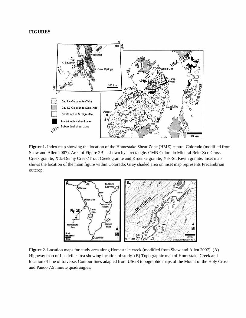
The PST is found in brown to dark gray to black aphanitic rock with distinct linear geometries, suggesting it is caused by coseismic faulting (Figure 3; Allen et al., 2002). A strong foliation is developed in the quartzofeldspathic gneiss or migmatite (Figure 3). The frictional melt is thought to be generated by the breakdown of biotite and muscovite and to some extent, feldspar (Allen et al., 2002). Figures 4 and 5 contain thin-section images of the PST found along a traverse across the Homestake Shear Zone (Figure 2b).
Figures 4a and 4b illustrate the glass melt (PST) found in rocks at the Homestake site. Figure 4a is a plane-polarized image showing a fine-grained horizontally laminated matrix with a more coarse (colorless), vertical structure running through it. The matrix material is all glass, as evidenced by the cross-polarized image which is non-birefringent (implies an amorphous material) (Figure 4b). The development of glass indicates significant temperatures (at least 1000 oC) were reached during movement.
Figure 4c is a plane-polarized image showing a leached orthoclase feldspar grain embedded in a mass of quartz. The top of the image contains well-foliated biotite. Note the “harder” feldspar minerals are undergoing chemical alteration in this image while the “softer” biotite minerals are unaffected.
Figure 4d is a cross-polarized micrograph image of quartz showing an elongate crenulated (foliated) texture. This indicates mild to moderate metamorphism in this sample. Note that some of the quartz grains have undergone recrystallization, precipitating as polycrystalline grains with euhedral surfaces. This deformation probably occurred during the higher temperature, ductile event that created the foliation.
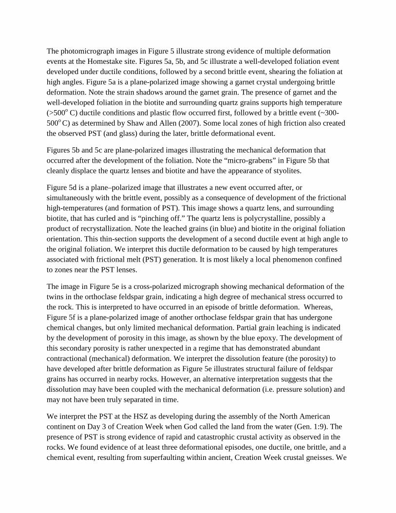
The photomicrograph images in Figure 5 illustrate strong evidence of multiple deformation events at the Homestake site. Figures 5a, 5b, and 5c illustrate a well-developed foliation event developed under ductile conditions, followed by a second brittle event, shearing the foliation at high angles. Figure 5a is a plane-polarized image showing a garnet crystal undergoing brittle deformation. Note the strain shadows around the garnet grain. The presence of garnet and the well-developed foliation in the biotite and surrounding quartz grains supports high temperature (>500o C) ductile conditions and plastic flow occurred first, followed by a brittle event (~300-500o C) as determined by Shaw and Allen (2007). Some local zones of high friction also created the observed PST (and glass) during the later, brittle deformational event.
Figures 5b and 5c are plane-polarized images illustrating the mechanical deformation that occurred after the development of the foliation. Note the “micro-grabens” in Figure 5b that cleanly displace the quartz lenses and biotite and have the appearance of styolites.
Figure 5d is a plane–polarized image that illustrates a new event occurred after, or simultaneously with the brittle event, possibly as a consequence of development of the frictional high-temperatures (and formation of PST). This image shows a quartz lens, and surrounding biotite, that has curled and is “pinching off.” The quartz lens is polycrystalline, possibly a product of recrystallization. Note the leached grains (in blue) and biotite in the original foliation orientation. This thin-section supports the development of a second ductile event at high angle to the original foliation. We interpret this ductile deformation to be caused by high temperatures associated with frictional melt (PST) generation. It is most likely a local phenomenon confined to zones near the PST lenses.
The image in Figure 5e is a cross-polarized micrograph showing mechanical deformation of the twins in the orthoclase feldspar grain, indicating a high degree of mechanical stress occurred to the rock. This is interpreted to have occurred in an episode of brittle deformation. Whereas, Figure 5f is a plane-polarized image of another orthoclase feldspar grain that has undergone chemical changes, but only limited mechanical deformation. Partial grain leaching is indicated by the development of porosity in this image, as shown by the blue epoxy. The development of this secondary porosity is rather unexpected in a regime that has demonstrated abundant contractional (mechanical) deformation. We interpret the dissolution feature (the porosity) to have developed after brittle deformation as Figure 5e illustrates structural failure of feldspar grains has occurred in nearby rocks. However, an alternative interpretation suggests that the dissolution may have been coupled with the mechanical deformation (i.e. pressure solution) and may not have been truly separated in time.
We interpret the PST at the HSZ as developing during the assembly of the North American continent on Day 3 of Creation Week when God called the land from the water (Gen. 1:9). The presence of PST is strong evidence of rapid and catastrophic crustal activity as observed in the rocks. We found evidence of at least three deformational episodes, one ductile, one brittle, and a chemical event, resulting from superfaulting within ancient, Creation Week crustal gneisses. We
interpret the PST as having developed during the brittle event as Shaw and Allen (2007) concluded, but that the heat generated caused renewed, localized ductile deformation and possibly simultaneous chemical alteration.
PASAGSHAK THRUST ZONE -- DISCUSSION
The presence of pseudotachylyte (PST) on Kodiak Island, Alaska was first reported by Rowe et al. (2005). They documented some of the thickest PST lenses in the world, with individual layers exceeding 30 cm. The PST is developed in a fossil subduction zone within rocks conventionally dated as Jurassic through Eocene-age along the southeastern edge of Kodiak Island (Figure 6). The geologic setting is analogous to the modern Aleutian Trench subduction system (Rowe et al., 2005). PST is exposed for 3.5 km in shear zones within mylonite along the coastline of Pasagshak Point. Faulting that produced the PST is interpreted to have occurred at 12-14 km depth and 230-260oC (Byrne, 1984; Vrolijk et al., 1988). Subsequent erosion and the resulting exhumation have exposed the PST.
Meneghini et al. (2010) refer to the pseudotachylyte layers as black fault rock (BFR) and subdivided the PST-bearing rocks into the field classifications of: 1) grain-supported black fault rock, and 2) aphanitic black fault rock. The aphanitic BFR is described as a gray-black to blue-black rock devoid of foliation, possessing a concoidal fractured pattern, and exhibiting a satin, chert-like luster. The grain-supported BFR is described as possessing the same satin luster, but is composed of very fine angular grains (up to 1mm) within an aphanitic matrix. The grain-supported BFR also exhibits a weakly-developed fabric, paralleling the adjacent cataclasite.
Meneghini et al. (2010) also divided the microtextures of each type of BFR into two subcategories: 1) granular microtexture, and 2) crystalline microtexture. Their crystalline texture was found to contain quartz and feldspar grains of 1-2 micrometers in length and interstitial chlorite and the clay illite of 1 micrometer in length (Meneghini et al., 2010, their Figure 6). They defined their granular microtexture as a dark gray, tightly-packed matrix of subrounded quartz and feldspar grains mostly less than 1 micrometer, but up to 3 micrometers in length, containing less chlorite and illite and a noticeably finer, overall grain size compared to the crystalline texture. They also observed that the grain-supported black rock was found to contain only the granular microtexure, whereas the aphanitic black rock contains both granular and crystalline microtextures. The majority of the PST at Pasagshak Point displays the crystalline microtexture of the black fault rock (Meneghini et al., 2010).
Meneghini et al. (2010) and Rowe et al. (2005) reported that the basal contact of the black fault rock (BFR) is often planar and sharp, cross-cutting at low angles across the adjacent cataclasite rocks (Figures 7a and 7c). In contrast, they both reported that the upper contact of the BFR is less planar and commonly contains flow structures, similar to flame structures, and injections into the overlying rocks of the hanging wall (Figure 7d).
Rowe et al. (2005) and Meneghini et al. (2010) interpret the cataclasite host rock at Pasagshak Point to be derived from the turbidite deposits of a fossil subduction zone. Although they found that the black fault rocks contained higher levels of plagioclase feldspar and sodium oxide compared to the surrounding cataclasites, their chemical analyses demonstrated that the PST and associated BFR share a very similar mineralogy with the cataclasite host rocks. They concluded that the PST developed after the formation of the cataclasites, and that the PST (BFR) originated from the cataclasite rocks at the expense of plagioclase, thus enriching the melt with feldspar (Meneghini et al., 2010). This conclusion contrasts with the most common method of PST development, the selective melting of phyllosilicate minerals (such as biotite at the Homestake Shear Zone, above).
PASAGSHAK THRUST ZONE – RESULTS
Twenty-six hand samples and associated field observations were collected from the pseudotachylyte-bearing (PST) and surrounding cataclasite rocks along a traverse on the southern coast of Pasagshak Point (Figure 6). Black fault rock (BFR), containing pseudotachylyte, was observed in linear bands > 30 cm in thickness (Fig 7a). The majority of the samples were collected from the aphanitic BFR, giving the highest opportunity to observe PST.
In many locations along the Pasagshak Peninsula, two bands of BFR were observed running subparallel to one another (Figure 7a). Most of the aphanitic BFR was observed to be black to gray to dark brown with numerous orthogonal fractures spaced a few millimeters to a few centimeters apart, giving the appearance of coal (Figures 7a and 7b). Some of the aphanitic BFR layers were observed to have white calcite filling the fractures at both a high angle to the layering and orthogonal to the layering. This fracture-fill was usually less than 3 mm thick. The grain-supported BFR layers exhibited less orthogonal fracturing and looked slightly “sandy.” These layers were black to gray and commonly showed some internal fabric or layering as described by Meneghini et al. (2010).
In places, the BFR layers run nearly parallel to the foliation in the adjacent brown-colored cataclasite Figure 7a). In other locations, the BFR cuts across the cataclasite foliation at a low angle (Figure 7c). Injections were also commonly observed along the upper boundary of the BFR layers as noted by Meneghini et al. (2010) and Rowe et al. (2005) (Figure 7d). Christie Rowe reported that these injections are often “reminiscent of structures formed by the interaction of two fluid layers of different viscosity” (C.D. Rowe, pers. comm., 2010). She also found no evidence of any macroscopic-scale brittle deformation in the surrounding cataclasite to accommodate these intrusions. These injections are strong evidence that ductile deformation was occurring simultaneously with BFR formation (and the resulting PST). This contrasts with the development of PST in the Homestake Shear Zone above, where the PST developed in a primarily brittle regime.
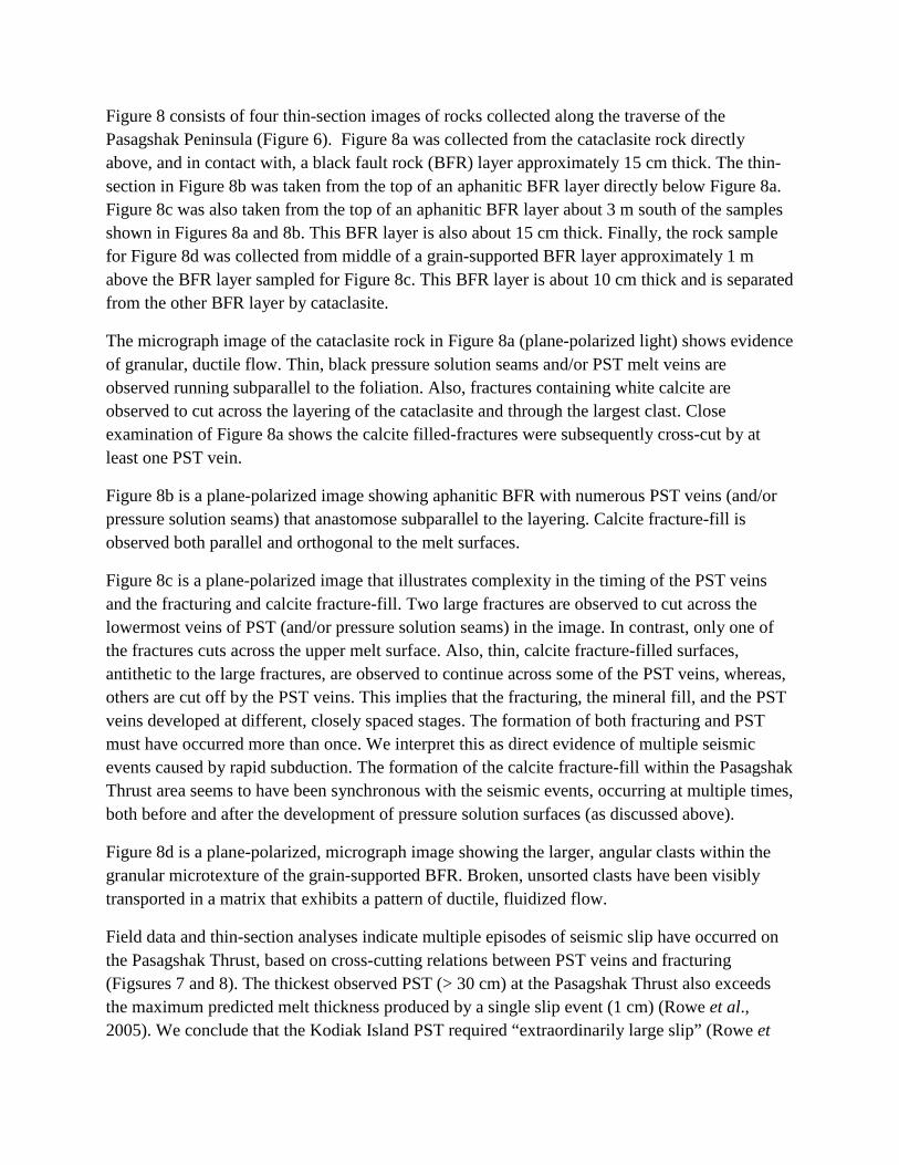
Figure 8 consists of four thin-section images of rocks collected along the traverse of the Pasagshak Peninsula (Figure 6). Figure 8a was collected from the cataclasite rock directly above, and in contact with, a black fault rock (BFR) layer approximately 15 cm thick. The thin-section in Figure 8b was taken from the top of an aphanitic BFR layer directly below Figure 8a. Figure 8c was also taken from the top of an aphanitic BFR layer about 3 m south of the samples shown in Figures 8a and 8b. This BFR layer is also about 15 cm thick. Finally, the rock sample for Figure 8d was collected from middle of a grain-supported BFR layer approximately 1 m above the BFR layer sampled for Figure 8c. This BFR layer is about 10 cm thick and is separated from the other BFR layer by cataclasite.
The micrograph image of the cataclasite rock in Figure 8a (plane-polarized light) shows evidence of granular, ductile flow. Thin, black pressure solution seams and/or PST melt veins are observed running subparallel to the foliation. Also, fractures containing white calcite are observed to cut across the layering of the cataclasite and through the largest clast. Close examination of Figure 8a shows the calcite filled-fractures were subsequently cross-cut by at least one PST vein.
Figure 8b is a plane-polarized image showing aphanitic BFR with numerous PST veins (and/or pressure solution seams) that anastomose subparallel to the layering. Calcite fracture-fill is observed both parallel and orthogonal to the melt surfaces.
Figure 8c is a plane-polarized image that illustrates complexity in the timing of the PST veins and the fracturing and calcite fracture-fill. Two large fractures are observed to cut across the lowermost veins of PST (and/or pressure solution seams) in the image. In contrast, only one of the fractures cuts across the upper melt surface. Also, thin, calcite fracture-filled surfaces, antithetic to the large fractures, are observed to continue across some of the PST veins, whereas, others are cut off by the PST veins. This implies that the fracturing, the mineral fill, and the PST veins developed at different, closely spaced stages. The formation of both fracturing and PST must have occurred more than once. We interpret this as direct evidence of multiple seismic events caused by rapid subduction. The formation of the calcite fracture-fill within the Pasagshak Thrust area seems to have been synchronous with the seismic events, occurring at multiple times, both before and after the development of pressure solution surfaces (as discussed above).
Figure 8d is a plane-polarized, micrograph image showing the larger, angular clasts within the granular microtexture of the grain-supported BFR. Broken, unsorted clasts have been visibly transported in a matrix that exhibits a pattern of ductile, fluidized flow.
Field data and thin-section analyses indicate multiple episodes of seismic slip have occurred on the Pasagshak Thrust, based on cross-cutting relations between PST veins and fracturing (Figsures 7 and 8). The thickest observed PST (> 30 cm) at the Pasagshak Thrust also exceeds the maximum predicted melt thickness produced by a single slip event (1 cm) (Rowe et al., 2005). We conclude that the Kodiak Island PST required “extraordinarily large slip” (Rowe et
al., 2005) and occurred in “repeated seismic slip pulses” (Meneghini et al 2010), documenting catastrophic subduction.
CONCLUSIONS
Superfaults and superfaults containing pseudotachylyte are some of the strongest preserved lines of evidence for catastrophic seismic activity. Both examples described in this paper confirm that catastrophic superfaulting has occurred at two critical times in Earth history. Each location contains indicators of frictional, high temperature activity. Glassy melts, pressure solution features, and mineral evidence for high temperature metamorphism are observed. Outcrop and petrographic evidence from both sites also document multiple episodes of fault movement and subsequent melt development. We interpret the Kodiak Island pseudotachylyte as conclusive evidence that rapid subduction and catastrophic plate tectonic (CPT) activity occurred during the Flood event. Similarly, we interpret the Homestake Shear Zone pseudotachylyte as evidence that rapid movement and superfaulting occurred as a consequence of the assembly of North America during Creation Week.
ACKNOWLEDGEMENTS
We thank Brad D. Pretzer for his work on the figures and help as Clarey’s field assistant. We also thank Mike Phelps for his guidance in Alaska and his camaraderie. Likewise, we thank Christie Rowe for her helpfulness and willingness to share rocks and directions. Francesca Meneghini and Casey Moore are acknlowledged for their willingness to share ideas and directions. The other authors thank Steve Austin for his encouragement to study superfaults and for his logistical support of Clarey’s trip to Alaska. We are indebted to Calgary Rock and Materials Services, Inc., for their willingness to cut thin-sections and perform geochemical analyses, as necessary. We could not have completed this research without their support and the time allotted to Stephen Cheung. We wish to thank John Whitmore of Cedarville University for allowing Clarey to use his microscope and for his assistance in imaging some of the thin-sections. Funding for this project came from the Institute for Creation Research and National Creation Science Foundation Grant 2009-001. We also wish to thank Henry Morris, III and John Morris for their encouragement and support.
REFERENCES
Allen, J.L. (1994). Stratigraphic variations, fault rocks, and tectonics associated with brittle reactivation of the Homestake shear zone, central Colorado [Ph.D. dissert.], Lexington: University of Kentucky, 294 p.
Allen, J.L., O’Hara, K.D., and Moecher, D.P. (2002). Structural geometry and thermal history of pseudotachylyte from the Homestake shear zone, Sawatch Range, Colorado, Geological Society of America Field Guide 3: science at the highest level, D. Lageson, E.A. Erslev, & J.F. Magloughlin, Editors, Geological Society of America, Boulder, Colorado: 17-32.
Austin, S. A., Baumgardner, J.R., Humphreys, D.R., Snelling, A.A., Vardiman, L., and Wise K.P. (1994). Catastrophic plate tectonics: a global flood model of Earth history, Proceedings of the Third International Conference on Creationism, Technical Symposium Sessions, R. E. Walsh, Editor, Creation Science Fellowship, Inc., Pittsburgh, PA: 609-621.
Barker, S.L.L. (2005). Pseudotachylyte-generating faults in central Otago, New Zealand, Tectonophysics, 397: 211-223.
Beutner, E.C., and Gerbi, G.P. (2005). Catastrophic emplacement of the Heart Mountain block slide, Wyoming and Montana, USA, Geological Society of America Bulletin 117 (5/6): 724-735.
Byrne, T. (1984). Early deformation in mélange terranes of the Ghost Rocks Formation, Kodiak Islands, Alaska, Melanges: their nature, origin and significance, L.A. Raymond, Editor, Geological Society of America Special Paper 198: 21-51.
Camacho, A., Vernon, R.H., and Fitz Gerald, J.D. (1995). Large volumes of anhydrous pseudotachylyte in the Woodroffe Thrust, eastern Musgrave Ranges, Australia, Journal of Structural Geology, 17(3): 371-383.
Clarey, T.L. (2012). South Fork Fault as a gravity slide: its break-away, timing and emplacement, northwestern Wyoming, U.S.A., Rocky Mountain Geology, 47(1): 55-79.
Clarey, T.L. (2013). South Fork and Heart Mountain faults: examples of catastrophic, gravity-driven “overthrusts,” northwest Wyoming, U.S.A., this volume, Proceedings of the Seventh International Conference on Creationism, Technical Symposium Sessions, M. Horstmeyer, Editor, Creation Science Fellowship, Pittsburgh, PA.
Colgan, J.P., and Beutner, E.C. (1998). Heart Mountain faulting and the emplacement of intrusive rocks at Painter Gulch, near White Mountain, NW Wyoming, Geological Society of America Abstracts with Programs, 30(6).
Craddock, J.P., Geary, J., and Malone, D.H. (2012). Vertical injectites of detachment carbonate ultracataclasite at White Mountain, Heart Mountain detachment, Wyoming, Geology, 40(5):463-466.
Davidson, C., Davis, K.J., Bailey, C.M., Tape, C.H., Singleton, J., and Singer, B. (2003). Age, origin, and significance of brittle faulting and pseudotachylyte along the Coast shear zone, Prine Rupert, British Columbia, Geology, 31(1): 43-46.
Erismann, T.H., Heuberger, H., and Preuss, E. (1977). Der Bimstein von Kofels (Tirol); ein Bergsturz “Frictionit,” Tschermaks Mineralogische und Petrographische Mitteilungen, 24: 67-119.
Fabbri, O., and Coromina, G. (2003). Comparative study of pseudotachylyte-bearing and pseudotachylyte free fault zones from various tectonic regimes, Geophysical Research Abstracts, 5: 11856.
Goodwin, L.B. (1999). Controls on pseudotachylyte formation during tectonic exhumation in the South Mountains metamorphic core complex, Arizona, Exhumation processes: normal faulting, ductile flow and erosion, U. Ring, M.T. Brandon, G.S. Lister, and S.D. Willett, Editors, Geological Society, London, Special Publications 154, pp. 325-342.
Hovland, M., Fichler, C., Rueslåtten, H., and Johnsen, H. (2006). Deep-rooted piercement structures in deep sedimentary basins — Manifestations of supercritical water generation at depth?, Journal of Geochemical Exploration 89: 157–160.
Ikesawa, E., Sakaguchi, A., and Kimura, G. (2003). Pseudotachylyte from an ancient
accretionary complex: evidence for melt generation during seismic slip along a master decollement?, Geology, 31(7): 637-640.
Karlstrom, K.E., and Bowring, S.A. (1988). Early Proterozoic assembly of tectonostratigraphic terranes in southwestern North America, Journal of Geology, 96: 561-576.
Koschinsky, A., Garbe-Schönberg, D., Sander, S., Schmidt, K., Gennerich, H., and Strauss, H. (2008). Hydrothermal venting at pressure-temperature conditions above the critical point of seawater, 5°S on the Mid-Atlantic Ridge, Geology, 36(8):615-618.
Masch, L., Wenk, H.R., and Preuss, E. (1985). Electron microscopy study of hyalomylonites-
evidence for frictional melting in landslides, Tectonophysics 115: 131-160.
McNulty, B.A. (1995). Pseudotachylyte generated in the semi-brittle and brittle regimes, Bench Canyon shear zone, central Sierra Nevada, Journal of Structural geology, 17(11): 1507-1521.
Meneghini, F., DiToro, G., Rowe, C.D., Moore, J.C., Tsutsumi, A., and Yamaguchi, A. (2010). Record of mega-earthquakes in subduction thrusts: The black fault rocks of Pasagshak Point (Kodiak Island, Alaska), Geological Society of America Bulletin 122(7/8): 1280-1297.
Menegon, L., Di Toro, G., and Pennacchioni, G. (2007). Cyclic production of pseudotachylyte at the brittle/ductile transition: evidence for a large-scale fault asperity, Geophysical Research Abstracts, 9: 06930.
O’Brien, T.M., and van der Pluijm, B.A. (2012). Timing of Iapetus Ocean rifting from Ar geochronology of pseudotachylytes in the St. Lawrence rift system of southern Quebec, Geology, 40(5): 443-446.
Okamoto, S., Kimura, G, Yamaguchi, A., Yamaguchi, H., and Kusuba, Y. (2007). Generation depth of the pseudotachylyte from an out-of-sequence thrust in accretionary prism- geothermobarometric evidence, Scientific Drilling, Special Issue No. 1, pp. 47-50.
Price, N.A. (2011). Using heterogeneous quartz CPO data to interpret the deformation of a shear zone at the base of the seismogenic zone, Geological Society of America abstracts with programs, 43(5): 648.
Rowe, C.D., Moore, J.C., Meneghini, F., and McKeirnan, A.W. (2005). Large-scale pseudotachylytes and fluidized cataclasites from an ancient subduction thrust fault, Geology, 33 (12): 937-940.
Rowe, C.D., Miller, J., Fagereng, A., and Mapani, B. (2010). Frictional decarbonation during earthquakes; textures and minerals in carbonate fault rock preserve evidence of supercritical CO2-H2O-rock interaction, Geological Society of America Abstracts with Programs, 42(5): 423.
Scott, J.S., and Drever, H.I. (1953). Frictional fusion along a Himalayan thrust, Royal Society of Edinburgh Proceedings, 65: 121-142.
Shand, S.J. 1916. The pseudotachylyte of Parijs (Orange Free State) and its relation to “trap-shotten gneiss” and “flinty crush-rock,” Quaternary Journal of the Geological Society of London, 72: 198-221.
Shaw, C.A., and Allen, J. L. (2007). Field rheology and structural evolution of the Homestake shear zone, Colorado, Rocky Mountain Geology, 42 (1): 31-56.
Shaw, C.A., Karlstrom, K.E., Williams, M.L., Jercinovic, M.J., and McCoy, A.M. (2001). Electron-microprobe monazite dating of ca. 1.71-1.63 Ga and ca. 1.45-1.38 Ga deformation in the Homestake shear zone, Colorado: Origin and early evolution of a persistent intercontinental tectonic zone, Geology 29: 739-742.
Shimada, K., Tanaka, T., Obara, T., and Niizato, T. (2004). Occurrence of mylonite zones andpseudotachylyte veins around the base of the upper crust: an example from the southern Hidaka metamorphic belt, Samani area, Hokkaido, Japan, Earth Planets Space, 56: 1217-1223.
Snelling, A. A. (2009). Earth’s Catastrophic Past: Geology, Creation & the Flood, Institute for Creation Research, Dallas, TX.
Spray, J. G. (1995). Pseudotachylyte controversy: Fact or friction?, Geology 23: 1119-1122.
Spray, J. G. (1997). Superfaults, Geology 25: 579-582.
Spray, J. G., (1998), Localized shock- and friction-induced melting in response to hypervelocity impact, Meteorites: Flux with Time and Impact Effects, M.M. Grady, R. Hutchison, G.J.H. McCall, and D.A. Rothery, Editors, Geological Society, London, Special Publications 140, pp. 195-204.
Thornberry, T.L., and Magloughlin, J.F. (2001). Conditions accompanying pseudotachylyte formation, Outer Hebrides fault zone, Scotland, Geological Society of America abstracts with programs, 33 (6): 61-0.
Tweto, O. (1974). Geologic map and sections of the Holy Cross quadrangle, Eagle, Lake, Pitkin, and Summit counties, Colorado, U.S. Geological Survey Miscellaneous Investigations I-830, Scale 1:24,000, 2 sheets.
Tweto, O., and Sims, P.K. (1963). Precambrian ancestry of the Colorado mineral belt, Geological Society of America Bulletin, 74: 991-1014.
Vrolijk, P., Myers, G., and Moore, J.C. (1988). Warm fluid migration along tectonic melanges in the Kodiak accretionary complex, Alaska, Journal of Geophysical Research 93: 10,313-10,324.
Warner, L.A. (1978). The Colorado lineament: a middle Precambrian wrench fault system, Geological Society of America Bulletin 89: 161-171.
FIGURES
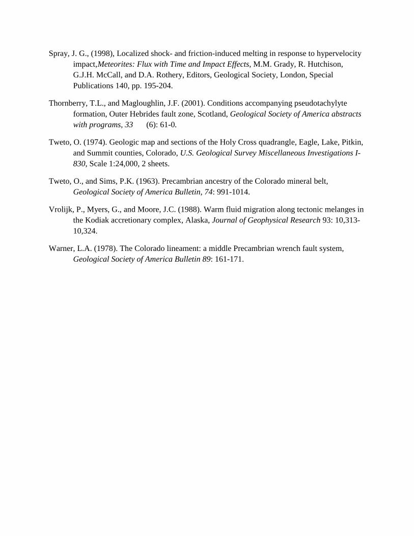
Figure 1. Index map showing the location of the Homestake Shear Zone (HMZ) central Colorado (modified from Shaw and Allen 2007). Area of Figure 2B is shown by a rectangle. CMB-Colorado Mineral Belt; Xcc-Cross Creek granite; Xdc-Denny Creek/Trout Creek granite and Kroenke granite; Ysk-St. Kevin granite. Inset map shows the location of the main figure within Colorado. Gray shaded area on inset map represents Precambrian outcrop.
Figure 2. Location maps for study area along Homestake creek (modified from Shaw and Allen 2007). (A) Highway map of Leadville area showing location of study. (B) Topographic map of Homestake Creek and location of line of traverse. Contour lines adapted from USGS topographic maps of the Mount of the Holy Cross and Pando 7.5 minute quadrangles.
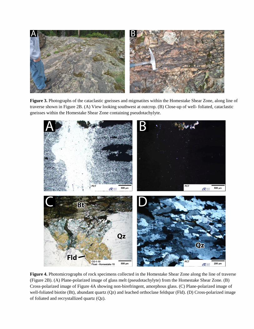
Figure 3. Photographs of the cataclastic gneisses and migmatites within the Homestake Shear Zone, along line of traverse shown in Figure 2B. (A) View looking southwest at outcrop. (B) Close-up of well- foliated, cataclastic gneisses within the Homestake Shear Zone containing pseudotachylyte.
Figure 4. Photomicrographs of rock specimens collected in the Homestake Shear Zone along the line of traverse (Figure 2B). (A) Plane-polarized image of glass melt (pseudotachylyte) from the Homestake Shear Zone. (B) Cross-polarized image of Figure 4A showing non-birefringent, amorphous glass. (C) Plane-polarized image of well-foliated biotite (Bt), abundant quartz (Qz) and leached orthoclase feldspar (Fld). (D) Cross-polarized image of foliated and recrystallized quartz (Qz).
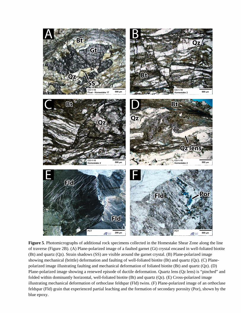
Figure 5. Photomicrographs of additional rock specimens collected in the Homestake Shear Zone along the line of traverse (Figure 2B). (A) Plane-polarized image of a faulted garnet (Gt) crystal encased in well-foliated biotite (Bt) and quartz (Qz). Strain shadows (SS) are visible around the garnet crystal. (B) Plane-polarized image showing mechanical (brittle) deformation and faulting of well-foliated biotite (Bt) and quartz (Qz). (C) Plane-polarized image illustrating faulting and mechanical deformation of foliated biotite (Bt) and quartz (Qz). (D) Plane-polarized image showing a renewed episode of ductile deformation. Quartz lens (Qz lens) is “pinched” and folded within dominantly horizontal, well-foliated biotite (Bt) and quartz (Qz). (E) Cross-polarized image illustrating mechanical deformation of orthoclase feldspar (Fld) twins. (F) Plane-polarized image of an orthoclase feldspar (Fld) grain that experienced partial leaching and the formation of secondary porosity (Por), shown by the blue epoxy.
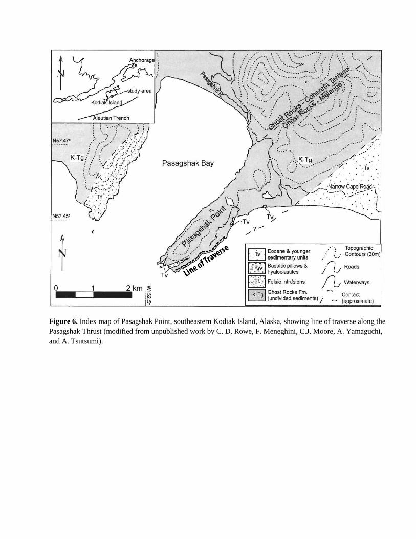
Figure 6. Index map of Pasagshak Point, southeastern Kodiak Island, Alaska, showing line of traverse along the Pasagshak Thrust (modified from unpublished work by C. D. Rowe, F. Meneghini, C.J. Moore, A. Yamaguchi, and A. Tsutsumi).
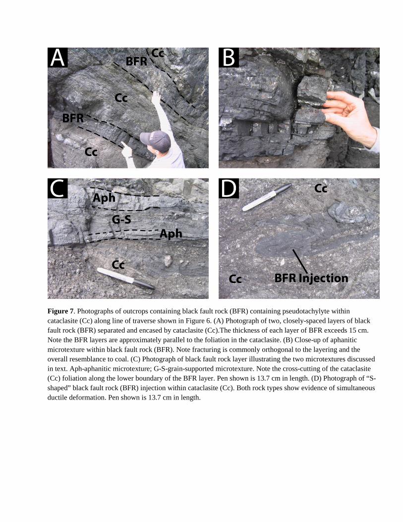
Figure 7. Photographs of outcrops containing black fault rock (BFR) containing pseudotachylyte within cataclasite (Cc) along line of traverse shown in Figure 6. (A) Photograph of two, closely-spaced layers of black fault rock (BFR) separated and encased by cataclasite (Cc).The thickness of each layer of BFR exceeds 15 cm. Note the BFR layers are approximately parallel to the foliation in the cataclasite. (B) Close-up of aphanitic microtexture within black fault rock (BFR). Note fracturing is commonly orthogonal to the layering and the overall resemblance to coal. (C) Photograph of black fault rock layer illustrating the two microtextures discussed in text. Aph-aphanitic microtexture; G-S-grain-supported microtexture. Note the cross-cutting of the cataclasite (Cc) foliation along the lower boundary of the BFR layer. Pen shown is 13.7 cm in length. (D) Photograph of “S-shaped” black fault rock (BFR) injection within cataclasite (Cc). Both rock types show evidence of simultaneous ductile deformation. Pen shown is 13.7 cm in length.
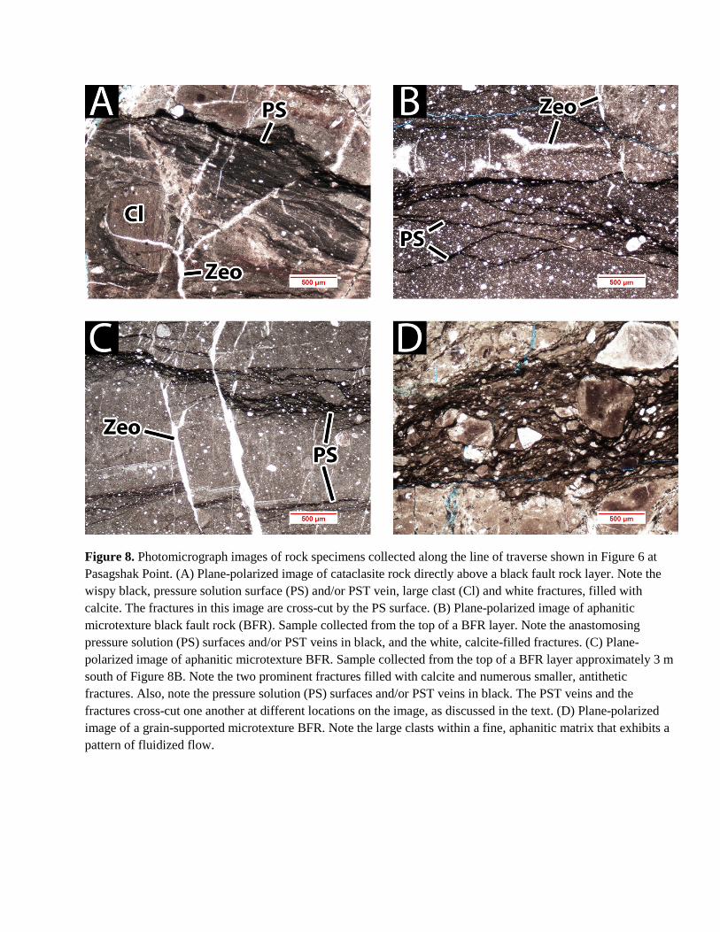
Figure 8. Photomicrograph images of rock specimens collected along the line of traverse shown in Figure 6 at Pasagshak Point. (A) Plane-polarized image of cataclasite rock directly above a black fault rock layer. Note the wispy black, pressure solution surface (PS) and/or PST vein, large clast (Cl) and white fractures, filled with calcite. The fractures in this image are cross-cut by the PS surface. (B) Plane-polarized image of aphanitic microtexture black fault rock (BFR). Sample collected from the top of a BFR layer. Note the anastomosing pressure solution (PS) surfaces and/or PST veins in black, and the white, calcite-filled fractures. (C) Plane-polarized image of aphanitic microtexture BFR. Sample collected from the top of a BFR layer approximately 3 m south of Figure 8B. Note the two prominent fractures filled with calcite and numerous smaller, antithetic fractures. Also, note the pressure solution (PS) surfaces and/or PST veins in black. The PST veins and the fractures cross-cut one another at different locations on the image, as discussed in the text. (D) Plane-polarized image of a grain-supported microtexture BFR. Note the large clasts within a fine, aphanitic matrix that exhibits a pattern of fluidized flow.