Embed Size (px)
Citation preview
SUNLAND-TUJUNGA-LAKE VIEW TERRACE-
SHADOW HILLS-EAST LA TUNA CANYON
Community Plan
TABLE OF CONTENTS
ACTIVITY LOG
COMMUNITY MAPS
COMMUNITY PLAN
I. Introduction
II. Function of the Community Plan
III. Land Use Policies and Programs
IV. Coordination Opportunities for Public Agencies
V. Urban Design
www.lacity.org/PLN (General Plans)
A Part of the General Plans - City of Los Angeles
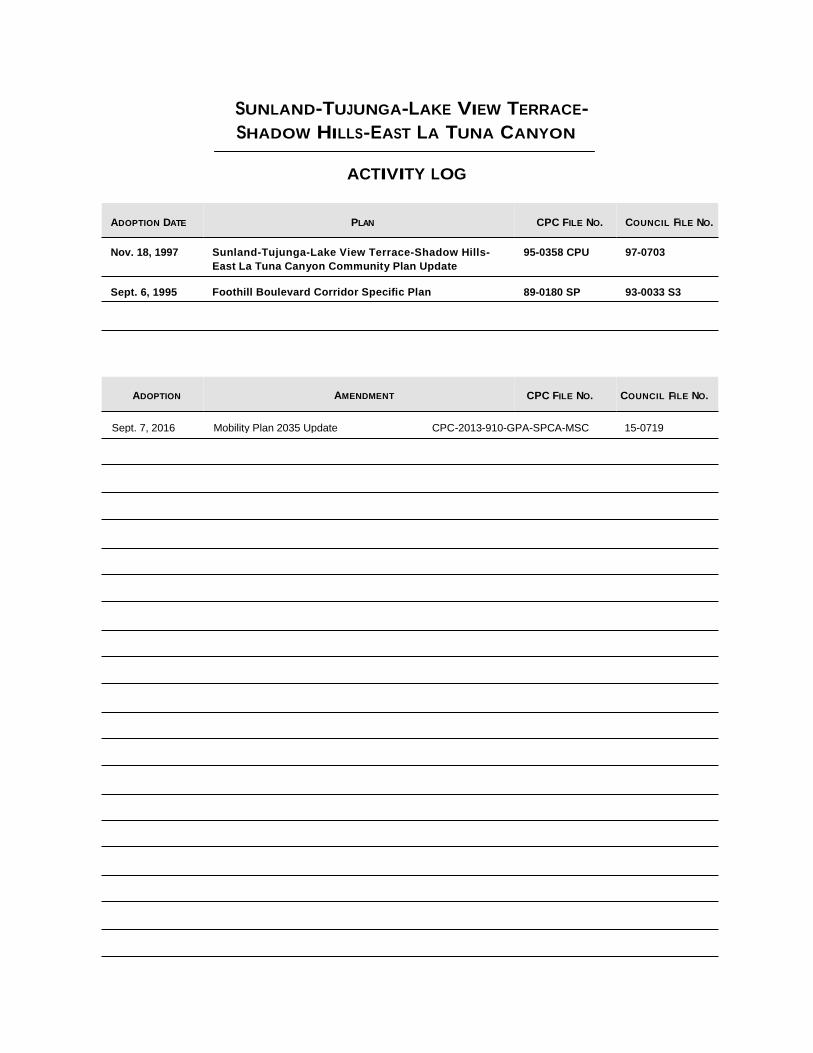
SUNLAND-TUJUNGA-LAKE VIEW TERRACE-
SHADOW HILLS-EAST LA TUNA CANYON
ACTIVITY LOG
ADOPTION DATE
Nov. 18, 1997
Sept. 6, 1995
ADOPTION
PLAN
Sunland-Tujunga-Lake View Terrace-Shadow Hills-
East La Tuna Canyon Community Plan Update Foothill Boulevard Corridor Specific Plan
AMENDMENT
CPC F LE NO.
95-0358 CPU
89-0180 SP CPC F LE NO.
COUNCIL ILE NO.
97-0703
93-0033 S3 COUNCIL ILE NO.
I F
I F
Sept. 7, 2016 Mobility Plan 2035 Update CPC-2013-910-GPA-SPCA-MSC 15-0719
SUNLAND-TUJUNGA-LAKE VIEW TERRACE-
SHADOW HILLS-EAST LA TUNA CANYON
Community Plan
Chapter I
INTRODUCTION
COMMUNITY BACKGROUND
PLAN AREA The Sunland-Tujunga-Lake View Terrace-Shadow Hills-East La Tuna Canyon
Community Plan Area lies in the northeast quadrant of the City of Los
Angeles. It is approximately fifteen miles from downtown Los Angeles.
Surrounding areas include: the Angeles National Forest, Little Tujunga
Canyon, Big Tujunga Canyon, Kagel Canyon, the Deukmejian Wilderness
Park, and portion of the Verdugo Mountains. The community lies adjacent
to the cities of Glendale and Burbank, and to the Los Angeles communities
of Sun Valley and Arleta-Pacoima.
According to the 1990 U.S. Census, the Sunland-Tujunga-Lake View
Terrace-Shadow Hills-East La Tuna Canyon community had a population of
52,919 and a housing stock of 19,305 dwelling units.
The street pattern in the Sunland-Tujunga-Lake View Terrace-Shadow Hills-
East La Tuna Canyon plan area includes a grid oriented on the primary
compass points in the flatlands of Sunland and Tujunga, a grid oriented on
the diagonal in most of Lake View Terrace, and a curvilinear pattern in the
surrounding hillside areas and Shadow Hills. The 210 (Foothill) Freeway
and Foothill Boulevard both bisect the area from southeast to northwest.
Big Tujunga Canyon Road and Sunland Boulevard project through the area
in a southwesterly direction. La Tuna Canyon Road bisects the Verdugo
Mountains from east to west.
Hansen Dam Park, Orcas Park, Verdugo Hills High School, and the
Verdugo Hills Golf Course are situated within the plan area. Tujunga
Canyon Wash and natural resource preserve areas are also located in the
community, as are flood plains draining into the region from the San Gabriel
Mountains.
The planning area is predominately comprised of open space/vacant land
with Low Density Residential stretching across the center. Foothill
Boulevard provides a shallow corridor of commercial land with
concentrations of multiple family residential intermixed with commercial
uses.
SUNLAND-TUJUNGA
I-1
The Foothill Boulevard Corridor Specific Plan was established in 1995 to
ensure that land uses and development in the Corridor occur in a manner
that is compatible with or compliments the surrounding community. The
intent of the Specific Plan is to have Foothill Boulevard function as a vibrant
commercial area with multiple-family housing opportunities.
COMMUNITY HISTORY Originally inhabited by Tuhunga Indians, commonly called Gabrielinos, the
Sunland-Tujunga-Lake View Terrace-Shadow Hills-East La Tuna Canyon
area was first developed in the 1880s. Sunland was developed from 2,300
acres of the original Rancho Tujunga tract, initially subdivided in 1884. This
area was promoted as a health community, named Monte Vista. When the
housing market boom of the 1880s ended, area residents planted orchards
and vineyards. The Western Empire group came in 1910 and the Little
Lands Colony followed in 1913. The "Little Landers" as they were called,
established a farm cooperative on the last 273 acres of the old Spanish
Land Grant, which is now the community of Tujunga. Incorporated in 1925,
the City of Tujunga voted to consolidate into the City of Los Angeles on
January 5, 1932.
Bolton Hall is the most significant structure in the area both for its
architectural style and its cultural importance. Bolton Hall was the civic and
cultural center of the community for the first half of the 20th Century. The
McGroarty building, which is now an art center, is another influential
architectural and cultural landmark. The area possesses numerous
architecturally significant homes, many built with stone and rock from the
Tujunga Wash.
COMMUNITY The State of California requires citizen participation in the preparation of the
PARTICIPATION General Plan. Government Code Section 65351 reads "During the
preparation or amendment of the General Plan, the planning agency shall provide opportunities for involvement of citizens, public agencies, public
utility companies, and civic, education, and other community groups,
through public hearings and any other means the city or county deems
appropriate."
Community participation occurred through focus group meetings and
through the open house and pubic hearing process to assist in identifying
community issues and formulating land use policies and objectives.
COMMUNITY ISSUES AND OPPORTUNITIES
The following summarizes the most significant planning and land use issues
and opportunities identified in the community.
RESIDENTIAL Issues
• Need to preserve single family neighborhoods.
• Need to preserve and enhance existing housing stock.
• Need to limit expansion of multi-family designated areas.
SUNLAND-TUJUNGA
I-2
• Need for more affordable housing.
• Need for regulation of hillside development.
• Need for housing, jobs and services in mutual proximity.
Opportunities
• Citizen awareness and active participation in community affairs.
• Access and proximity to employment.
• Potential for residential and mixed use development along commercial
corridors.
• Undeveloped or underdeveloped land allowing opportunities for clustered
development.
• Potential for establishing design guidelines for new residential development.
COMMERCIAL Issues
• Lack of continuity of complementary uses and cohesiveness along
commercial frontages.
• Unsightliness of new construction due to the lack of landscaping,
architectural character and scale.
• Need to support and maintain the existing commercial environment
along Foothill Boulevard and Commerce Avenue.
• Inadequate transition between commercial and residential uses.
• Lack of a cohesive and pedestrian- oriented identity.
Opportunities
• Establish appropriate transitions between commercial and residential
uses.
• Create pedestrian-friendly shopping areas through use of street trees,
benches, convenient parking/access, and maintaining retail frontage at ground level.
• Upgrade commercial areas on Foothill Boulevard and Commerce
Avenue through the Foothill Boulevard Specific Plan.
• Create an arts-oriented neighborhood on Commerce Avenue featuring
antique shops, cafes, artist studios and live/work space.
• Foster access and proximity to employment throughout the plan area. TRANSPORTATION Issues
• Need for the preservation, maintenance, and management of the streets and freeways network in the community.
SUNLAND-TUJUNGA
I-3
• Need to provide adequate funding for transportation management and for
the efficient operation of the transportation network.
Opportunities
• Potential to prevent traffic circulation problems in the area by ensuring
street improvements and parking for multiple-family housing where existing infrastructure is inadequate.
• Use of public transit and other alternative means of transportation
through the implementation of transportation demand management programs.
NEIGHBORHOOD CHARACTER
Issues
• Scale, density, and character of buildings that complement surrounding uses.
• Effects of residential development on commercial corridors.
• New hillside buildings blocking views or presenting an unsightly view from below.
• The need to preserve and rehabilitate areas with sensitivity to the
character of established neighborhoods.
Opportunities
• Efforts aimed at preservation of the low density, rural character and of
the equestrian lifestyle.
• Potential development of large parcels provide opportunities to enhance
community identity.
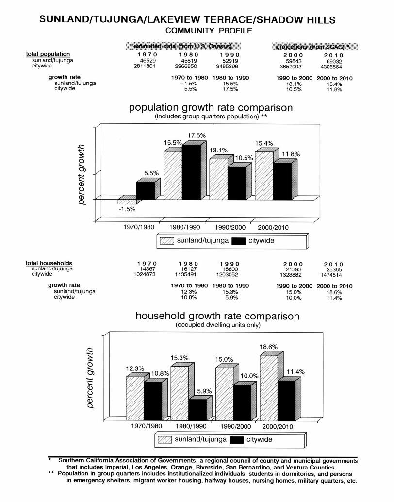
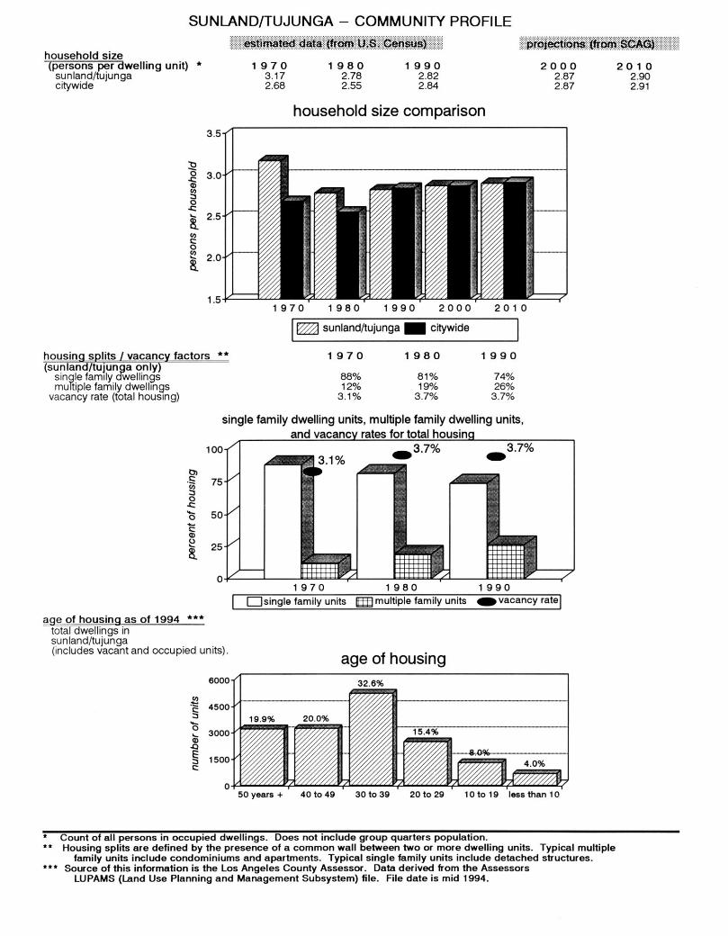
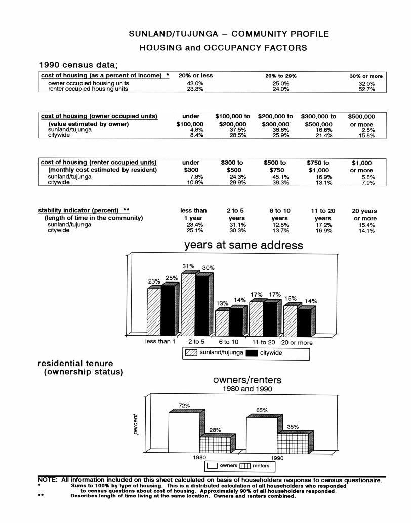
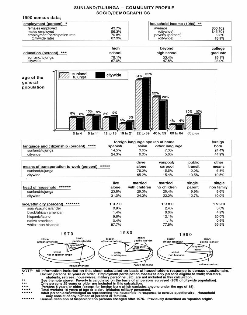
COMMUNITY PROFILE
The Community Profile provides an overview of population, housing and socio/demographics for the Sunland-Tujunga-Lake View Terrace-Shadow Hills-East La Tuna Canyon Community Plan Area and compares it to the rest of the City. The following tables contain the statistical data for previous census dates and rates of growth.
SUNLAND-TUJUNGA
I-4
Chapter II
FUNCTION OF THE COMMUNITY PLAN
Chapter 2 of the Plan Text contains the statutory requirement for the
Community Plan outlining the mandatory elements that must be addressed.
The Chapter contains the explanations of the Role, Purpose, and
Organization of the Community Plan. Chapter 2 shows the relationship to
other General Plan elements and provides for Plan Monitoring and
Consistency.
STATUTORY REQUIREMENTS
California State law (Government Code Section 65300) requires that each
city prepare and adopt a comprehensive, long-term general plan for its
development. It must contain seven mandatory elements including land
use, circulation, housing, conservation, open space, noise, and safety. In
the City of Los Angeles thirty-five Community Plans comprise the City's
Land Use Element.
State of California law requires that the Land Use Element be prepared as
part of the City's General Plan, and that the Land Use Element be correlated
with the Circulation Element.
The Land Use Element has the broadest scope of the General Plan
elements required by the State. Since it regulates how land is to be
utilized, many of the issues and policies contained in all other plan
elements are impacted and/or impact this element.
Government Code Section 65302(a) requires a land use element which
designates the proposed general distribution and general location and extent
of uses of the land for housing, business, industry, open space, including
agriculture, natural resources, recreation, and enjoyment of scenic beauty,
education, public buildings and grounds, solid waste disposal facilities, and
other categories of public and private uses of land. The land use element
shall include a statement of the standards of population density and building
intensity recommended for the various districts and other territory covered
by the Plan.
The Sunland-Tujunga-Lake View Terrace-Shadow Hills-East La Tuna Canyon
Plan consists of this text and the accompanying map. The Community
Plan text states the goals, objectives, policies and programs. The
Community Plan Map, footnotes and legend outline the arrangement and
intensities of land uses, the street system, and the locations and
characteristics of public service facilities.
SUNLAND-TUJUNGA
II-1
ROLE OF THE COMMUNITY PLAN
The General Plan is the fundamental policy document of the City of Los
Angeles. It defines the framework by which the City's physical and
economic resources are to be managed and utilized over time. Decisions
by the City with regard to the use of its land, design and character of
buildings and open spaces, conservation of existing and provision of new
housing, provision of supporting infrastructure and public and human
services, protection of environmental resources, protection of residents from
natural and man-caused hazards are guided by the Plan.
The Community Plan is intended to promote an arrangement of land uses,
streets, and services which will encourage and contribute to the economic,
social and physical health, safety, welfare and convenience of the people
who live and work in the community. The plan is also intended to guide
development in order to create a healthful and pleasant environment. Goals,
objectives, policies and programs are created to meet the existing and
future needs and desires of the community through the year 2010. The plan
is intended to coordinate development among the various parts of the City
of Los Angeles and adjacent municipalities in a fashion both beneficial and
desirable to the residents of the community.
The General Plan clarifies and articulates the City's intentions with respect
to the rights and expectations of the general public, property owners, and
prospective investors and business interests. Through the Community Plan,
the City can inform these groups of its goals, policies and development
standards, thereby communicating what is expected of City government
and the private sector to meet its objectives.
The Community Plan ensures that sufficient land is designated which
provides for the housing, commercial, employment, educational,
recreational, cultural, social and aesthetic needs of the residents of the plan
area. The Plan identifies and provides for the maintenance of any significant
environmental resources within the Plan Area. The Plan also seeks to
enhance community identity and recognizes unique neighborhoods within
the Plan Area.
PURPOSE OF THE COMMUNITY PLAN
The last comprehensive update of the Sunland-Tujunga-Lake View Terrace-
Shadow Hills-East La Tuna Canyon Community Plan was completed in
1980. Since that time, considerable growth has occurred, new issues have
emerged, and new community objectives regarding the management of new
development and community preservation have evolved. Consequently, it is
necessary to update the Community Plan to not only reflect current
conditions, but to accurately reflect the prevailing visions and objectives of
the area's residents and property and business owners. The Plan sets forth
objectives, policies, and programs, and designates a potential population
capacity of approximately 72,330, which is larger than is anticipated to be
built during the life of the Plan (2010).
SUNLAND-TUJUNGA
II-2
This Community Plan sets forth goals to maintain the community’s
individuality by:
• Preserving and enhancing the positive characteristics of existing
residential neighborhoods while providing a variety of compatible new
housing opportunities.
• Improving the function, design and economic vitality of the commercial
corridors.
• Preserving and enhancing the positive characteristic of existing uses
which provide the foundation for community identity, such as scale,
height, bulk, setbacks and appearance.
• Planning the remaining commercial and industrial development
opportunity sites for needed job producing uses that improves the
economic and physical condition of the community.
ORGANIZATION AND CONTENT OF COMMUNITY PLAN
This plan sets forth goals, objectives, policies, and programs that pertain to
Sunland-Tujunga-Lake View Terrace-Shadow Hills-East La Tuna Canyon.
Broader issues, goals, objectives, and policies are provided by the Citywide
General Plan Framework.
The Plan is organized and formatted to facilitate periodic updates. The
State recommends that the entire plan be comprehensively reviewed every
five years to reflect new conditions, local attitudes, and technological
advances.
The principal method for the implementation of the Land Use Map is the
Zoning Ordinance. The City's Zoning Map must be updated to remain
consistent with the adopted Land Use Map. Together, the Zoning Ordinance
and the Zoning Map will identify specific types of land use, intensity of use
and development standards applicable to specific areas and parcels of land
within the community.
RELATIONSHIP TO OTHER GENERAL PLAN ELEMENTS
The City of Los Angeles has the responsibility to maintain and implement
the City's General Plan. Since State Law requires that the General Plan
have internal consistency, the Community Plan must be consistent with the
other Elements and components of the General Plan.
The General Plan Framework is a long range, citywide, comprehensive
growth strategy. It is a special element of the general plan which looks to
the future as required by law and replaces Concept Los Angeles and the
Citywide Elements (adopted in 1974). Because it looks at the city as a
whole, the Framework provides a citywide context within which local
planning takes place. Both the benefits and challenges of growth are
shared.
SUNLAND-TUJUNGA
II-3
Because it is citywide, the Framework cannot anticipate every detail.
Therefore, the community plans must be looked to for final determinations
as to boundaries, land use categories, intensities and heights that fall within
the ranges described by the Framework.
The Citywide General Plan Framework Element neither overrides nor
supersedes the Community plans. The Framework is flexible, suggesting
a range of uses within its land use definitions. Precise determinations are
made in the Community Plans.
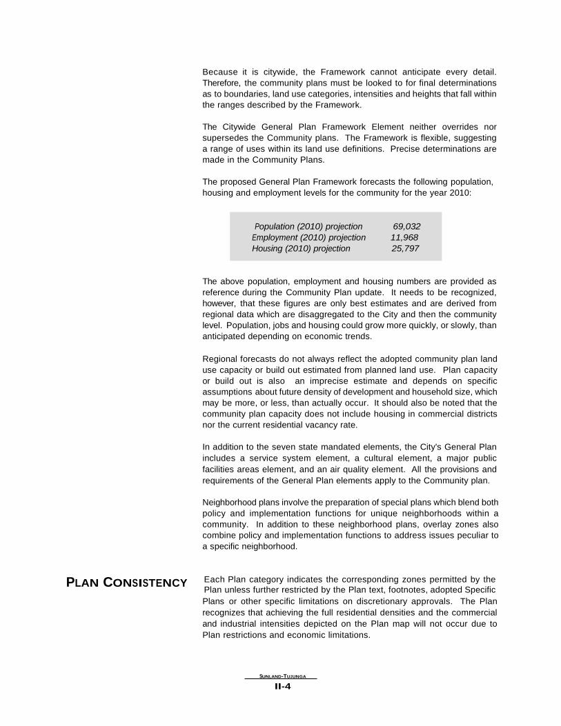
The proposed General Plan Framework forecasts the following population,
housing and employment levels for the community for the year 2010:
Population (2010) projection 69,032
Employment (2010) projection 11,968
Housing (2010) projection 25,797
The above population, employment and housing numbers are provided as
reference during the Community Plan update. It needs to be recognized,
however, that these figures are only best estimates and are derived from
regional data which are disaggregated to the City and then the community
level. Population, jobs and housing could grow more quickly, or slowly, than
anticipated depending on economic trends.
Regional forecasts do not always reflect the adopted community plan land
use capacity or build out estimated from planned land use. Plan capacity
or build out is also an imprecise estimate and depends on specific
assumptions about future density of development and household size, which
may be more, or less, than actually occur. It should also be noted that the
community plan capacity does not include housing in commercial districts
nor the current residential vacancy rate.
In addition to the seven state mandated elements, the City's General Plan
includes a service system element, a cultural element, a major public
facilities areas element, and an air quality element. All the provisions and
requirements of the General Plan elements apply to the Community plan.
Neighborhood plans involve the preparation of special plans which blend both
policy and implementation functions for unique neighborhoods within a
community. In addition to these neighborhood plans, overlay zones also
combine policy and implementation functions to address issues peculiar to
a specific neighborhood.
PLAN CONSISTENCY Each Plan category indicates the corresponding zones permitted by the
Plan unless further restricted by the Plan text, footnotes, adopted Specific
Plans or other specific limitations on discretionary approvals. The Plan
recognizes that achieving the full residential densities and the commercial
and industrial intensities depicted on the Plan map will not occur due to
Plan restrictions and economic limitations.
SUNLAND-TUJUNGA
II-4
For each plan category, the Plan permits all identified corresponding zones,
as well as those zones which are more restrictive, as referenced in Section
12.23 of the Los Angeles Municipal Code (LAMC). Any subsequent action
that modifies the Plan or any monitoring review that results in changes to
the Plan must make new Plan consistency findings at the time of the
decision.
City actions on most discretionary projects require a finding that the action
is consistent or in conformance with the General Plan. In addition to the
required general finding, decision-makers acting on certain projects in the
Plan area shall refer to each of the applicable additional findings that the
Plan identifies as programs in Chapter 3 of the Plan. To further substantiate
the consistency findings, decision makers may cite other programs, policies
or objectives which would be furthered by a proposed project. In addition,
Chapter 5 of the Plan requires a decision maker to make a finding of
conformance with applicable design standards for discretionary projects.
PLAN MONITORING The Plan has a land use capacity greater than the projected development
likely to occur during the Plan period. During the life of the Plan, growth will
be monitored and reported in the City’s Annual report on Growth and
Infrastructure, which will be submitted to the City Planning Commission,
Mayor, and City Council. In the fifth year following Plan adoption (and every
five years thereafter), the Director shall report to the Commission on the
relationship between population, employment, and housing growth and plan
capacities. If growth has occurred faster than projected, a revised
environmental analysis will be prepared and appropriate changes
recommended to the Community Plan and zoning. These Plan and zoning
changes, and any related moratoria or interim control ordinances, shall be
submitted to the Planning Commission, Mayor, and City Council as
specified in the LAMC.
SUNLAND-TUJUNGA
II-5
Chapter III
LAND USE POLICIES AND PROGRAMS
Chapter 3 contains Goals, Objectives, Policies, and Programs for all
appropriate land use issues, such as residential, commercial, and industrial,
as well as public and institutional service system categories. The Planning
Department has responsibility for the goals, objectives, policies, and the
initiation and direct implementation of the programs contained in Chapter 3. RESIDENTIAL Residential land use patterns vary greatly according to local conditions in
the areas which comprise the Sunland-Tujunga-Lake View Terrace-Shadow
Hills-East La Tuna Canyon Community Plan. Topography, population
characteristics, housing markets, age of housing and degree of existing
development have a great influence on the density of development
throughout the community. Much of the existing density in the community
was established by natural controls such as topography, large amounts of
existing available land and infrastructure.
There have been varying degrees of pressure for development in the Plan
area. Some new development has been inconsistent with existing
development. Some areas have experienced development pressure for
higher density housing.
Some vacant land has been left undeveloped or underdeveloped, creating
opportunity areas that require sensitive consideration so that their
development becomes an asset to the community. Existing land use
patterns, infrastructure, street systems, urban design, architectural features,
and historical resources should be considered when new development
occurs. Other opportunities are afforded to rehabilitate the housing stock
and create additional livable units.
Historically, the majority of the community was planned for residential
purposes. The 1980 Plan designated more than half of the total land area
for residential use (58.6%). The Plan policies provide for the preservation of
existing residential neighborhoods throughout the community, retaining
single family and multi-family areas.
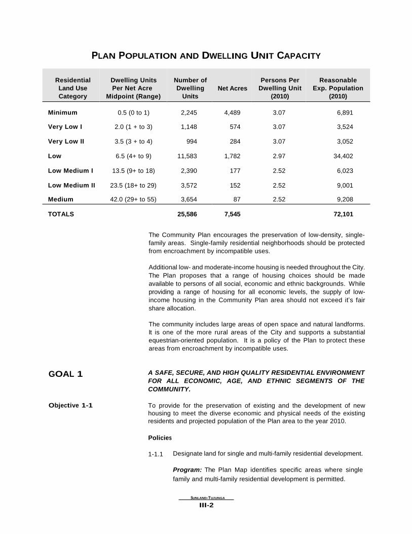
The Plan designates residential land use densities as indicated in the
following table. The table depicts the reasonable expected population and
dwelling unit count for the year 2010, using the midpoint of the range for the
dwelling units per net acre category. The midpoint represents a reasonable
factor to use, as new development within each category is not likely to
occur at one or the other extreme of the range, but rather throughout the
entire range.
SUNLAND-TUJUNGA
III-1
PLAN POPULATION AND DWELLING UNIT CAPACITY
Residential
Land Use
Category Minimum Very Low I Very Low II Low Low Medium I Low Medium II Medium
Dwelling Units
Per Net Acre Midpoint (Range)
0.5 (0 to 1)
2.0 (1 + to 3)
3.5 (3 + to 4)
6.5 (4+ to 9)
13.5 (9+ to 18)
23.5 (18+ to 29)
42.0 (29+ to 55)
Number of
Dwelling
Units
2,245
1,148
994
11,583
2,390
3,572
3,654
Net Acres
4,489
574
284
1,782
177
152
87
Persons Per
Dwelling Unit
(2010)
3.07
3.07
3.07
2.97
2.52
2.52
2.52
Reasonable
Exp. Population
(2010)
6,891
3,524
3,052
34,402
6,023
9,001
9,208 TOTALS 25,586 7,545 72,101
The Community Plan encourages the preservation of low-density, single-
family areas. Single-family residential neighborhoods should be protected
from encroachment by incompatible uses.
Additional low- and moderate-income housing is needed throughout the City.
The Plan proposes that a range of housing choices should be made
available to persons of all social, economic and ethnic backgrounds. While
providing a range of housing for all economic levels, the supply of low-
income housing in the Community Plan area should not exceed it’s fair
share allocation.
The community includes large areas of open space and natural landforms.
It is one of the more rural areas of the City and supports a substantial
equestrian-oriented population. It is a policy of the Plan to protect these
areas from encroachment by incompatible uses.
GOAL 1 Objective 1-1
A SAFE, SECURE, AND HIGH QUALITY RESIDENTIAL ENVIRONMENT
FOR ALL ECONOMIC, AGE, AND ETHNIC SEGMENTS OF THE
COMMUNITY. To provide for the preservation of existing and the development of new
housing to meet the diverse economic and physical needs of the existing
residents and projected population of the Plan area to the year 2010.
Policies
1-1.1 Designate land for single and multi-family residential development.
Program: The Plan Map identifies specific areas where single
family and multi-family residential development is permitted.
SUNLAND-TUJUNGA
III-2
1-1.2 Protect existing single family residential neighborhoods from
encroachment by higher density residential and other incompatible
uses.
Program: The Plan Map identifies areas where only single-family
residential development is permitted; it protects these areas from
encroachment by designating, where appropriate, transitional
residential densities which serve as buffers. Expansion of multiple-
family land use designation in the Plan should be restricted.
1-1.3 Require that new single and multi-family residential development be
designed in accordance with the Urban Design Chapter.
Program: The Plan includes an Urban Design Chapter which
outlines Design Standards for residential development.
1-1.4 The City should promote neighborhood preservation in existing
residential neighborhoods.
Program: The Neighborhood Preservation Program, administered
by the City’s Housing Department provides financial resources to
rehabilitate single-family homes and multi-family rental housing.
Program: Homeowners’ Encouragement Loan Program (HELP),
administered by the Housing Department, provides rehabilitation
loans to owners of small residential buildings (one to four units) to
correct code violations and assist handicapped homeowners.
Program: Residential land use categories, zone changes,
subdivisions, parcel maps, variances, conditional uses, specific
plans, community and neighborhood revitalization programs for
residential projects shall be consistent with Plan recommendations. Objective 1-2 To locate new housing in a manner which reduces vehicular trips and which
increases accessibility to services and facilities.
Policies
1-2.1 Locate higher residential densities near commercial centers, and
major bus routes where public service facilities, utilities, and
topography will accommodate this development.
Program: The Plan designates lands for higher residential densities
within and adjacent to transit convenient locations.
1-2.2 Locate senior citizen housing projects in neighborhoods within
reasonable walking distance of health and community facilities,
services, and public transportation.
Program: The Plan designates lands for higher residential densities
which could accommodate senior citizen housing within transit
convenient locations and pedestrian oriented areas.
SUNLAND-TUJUNGA
III-3
Objective 1-3 To preserve and enhance the varied and distinct residential character and
integrity of existing single and multi-family neighborhoods.
Policies
1-3.1 Consider factors such as neighborhood character and identity,
compatibility of land uses, impacts on livability, impacts on
services and public facilities, impacts on traffic levels, and
environmental impacts when changes in residential densities are
proposed.
Program: The decision-maker should adopt a finding which
addresses these factors as part of any decision relating to changes
in planned residential densities.
1-3.2 Seek a high degree of architectural compatibility and landscaping
for new infill development to protect the character and scale of
existing residential neighborhoods.
Program: The Plan includes Design Guidelines which establish
design standards for residential development to implement this
policy.
1-3.3 Preserve existing views of hillside and mountainous areas.
Program: Retention of the low density rural character of the
community and height limitations, scenic highway designations,
implementation of the Citywide Hillside Ordinance and the 15%
Slope Density Ordinance will contribute to the preservation of
these views. Objective 1-4 To preserve and enhance structures that have a distinctive and significant
historical character.
Policies
1-4.1 Protect and encourage reuse of the area’s historic resources.
Program: Protect the City’s Historic/Cultural Monuments in the
community and seek future designation for appropriate additional
sites. Objective 1-5 To promote and insure the provision of adequate housing for all persons
regardless of income, age or ethnic background.
Policies
1-5.1 Promote greater individual choice in type, quality, and location of
housing.
Program: Establishment of residential design standards, allocation
of lands for a variety of residential densities, and the promotion of
housing in mixed-use projects.
SUNLAND-TUJUNGA
III-4
Program: Develop incentives for the construction of residential
projects in conjunction with new commercial projects to encourage
mixed-use development.
1-5.2 Promote housing in mixed use projects in transit intensive
locations.
Program: Provide a bonus in floor area and height for such
projects. Objective 1-6 To limit residential density and minimize grading in hillside areas.
Policies
1-6.1 Ensure the availability of adequate sewers, drainage facilities, fire
protection services and facilities and other public utilities to support
development within the hillside areas.
Program: A decision-maker should adopt a finding which
addresses the availability of these services and utilities as part of
any decision relating to hillside residential development.
1-6.2 Consider the steepness of the topography and the suitability of the
geology in any proposal for development within the Plan area.
Program: The Plan designates hillside areas in the Minimum and
Very Low Densities of the General Plan land use designations and
corresponding zones.
Program: Continue implementation of the Citywide Hillside
Ordinance and the 15% Slope Density Ordinance.
1-6.3 Require that grading be minimized to reduce the effects on
environmentally sensitive areas.
Program:Compliance with the California Environmental Quality Act
(CEQA) requires that local and state governmental agencies
consider and disclose potential environmental effects of a project
before rendering a decision, and provide methods to mitigate those
impacts. Objective 1-7 To insure compatibility between equestrian and other uses found in the RA
Zone.
Policies
1-7.1 Place a high priority on the preservation of horsekeeping areas.
Program: A decision-maker involved in a discretionary review
should make a finding that the zone variance, conditional use, or
subdivision does not endanger the preservation of horsekeeping
uses within the Community.
SUNLAND-TUJUNGA
III-5
Objective 1-8 To promote and protect the existing rural, single-family equestrian oriented
neighborhoods in RA zoned areas and “K” Districts. To caution against
possible precedent-setting actions including zone variance, conditional use,
or subdivision that might endanger the preservation of horsekeeping uses.
Policies
1-8.1 Protect existing single-family equestrian oriented neighborhoods
and horsekeeping districts from encroachment by higher density
residential and other incompatible uses.
Program: New development within these areas should be designed
to encourage and protect the equestrian keeping lifestyle.
1-8.2 Horsekeeping areas should be developed at Minimum to Very Low
densities appropriate to such use.
Program: The Plan Map identifies areas for lower residential
densities.
1-8.3 New horsekeeping districts should be expanded where appropriate
and feasible.
Program: The Plan Map identifies lower density residential areas
appropriate for such districts. Objective 1-9 To provide adequate wastewater collection in existing residential
neighborhoods.
Policies
1-9.1 Upgrade the wastewater collection system to mitigate existing
deficiencies.
Program: Develop procedures to eliminate septic tanks in existing
residential neighborhoods.
COMMERCIAL The commercial land use pattern is mainly strip commercial along Foothill
Boulevard, with nodes of varying sizes at specific intersections. The
traditional strip commercial development with limited parking to the rear and
with buildings which have been built up to the sidewalk has given way in
some locations to newer mini-malls with parking in front of the buildings,
adjacent to the street.
The area along Foothill Boulevard between Langmuir Avenue and Wyngate
Street should be encouraged to develop as a Community Center serving on
a community-wide basis. This area contains the Municipal Building, Library,
and Fire Station - all community-serving governmental uses. The existing
K-Mart Store provides a larger retail radius for citizens living throughout the
Plan area.
SUNLAND-TUJUNGA
III-6
The Foothill Boulevard Corridor Specific Plan was created to ensure that
land uses and development in the corridor occur in a manner that is
compatible and compliments the surrounding community. One purpose of
the Specific Plan is to create a vibrant commercial environment along
Foothill Boulevard and Commerce Avenue by encouraging appropriate uses,
building design, landscaping, screening of unsightly views, minimizing
uninteresting blank walls, and proper site designs. The Specific Plan also
establishes coordinated and comprehensive standards for parking, vehicle
and pedestrian circulation, outdoor storage, building height, building design,
building mass, landscape, and signs. GOAL 2 A STRONG AND COMPETITIVE COMMERCIAL SECTOR WHICH BEST
SERVES THE NEEDS OF THE COMMUNITY THROUGH MAXIMUM
EFFICIENCY AND ACCESSIBILITY WHILE PRESERVING THE UNIQUE
CHARACTER OF THE COMMUNITY. Objective 2-1 To conserve and strengthen viable commercial development in the
community and to provide additional opportunities for new commercial
development and services.
Policies
2-1.1 New commercial uses should be located primarily in existing
established commercial areas or existing shopping centers.
Program: The Community Plan retains commercial land use
designations to conform with existing commercial centers.
2-1.2 Require that projects be designed and developed to achieve a high
level of quality, distinctive character, and compatibility with existing
uses and developed in accordance with design standards.
Program: The Plan includes an Urban Design chapter which
establishes Design Standards for commercial development which
addresses this policy.
Program: The Foothill Boulevard Corridor Specific Plan establishes
standards and guidelines for commercial development. Objective 2-2 To enhance the community identity in distinctive commercial districts.
Policies
2-2.1 Improve security and parking standards in commercial areas.
Program: The Plan includes an Urban Design component which
establishes Design Standards for commercial development to
implement this policy.
2-2.2 Require that mixed-use projects be designed with commercial
uses on the ground floor and developed to achieve a high level of
quality, distinctive character, and compatibility with existing uses.
SUNLAND-TUJUNGA
III-7
Program: The Plan includes an Urban Design component which
implements this policy in its Design Standards for mixed use
projects.
2-2.3 Require that any proposed development be designed to enhance
and be compatible with adjacent development.
Program: Continue the implementation of the Foothill Boulevard
Corridor Specific Plan and implement conformance with applicable
design standards identified in the Design Guidelines of the Plan.
2-2.4 Preserve community character, scale and architectural diversity.
Program: Consider the formation of a Business Improvement
District(s) along Foothill Boulevard.
Program: The Plan Map establishes height limits. Design
standards for commercial areas are included in the Design
Guidelines of the Plan.
2-2.5 Create a vibrant commercial environment along Commerce Avenue
by encouraging an arts-oriented neighborhood commercial corridor
featuring antique shops, cafes, artist studios, and live/work space.
Program: Consider the establishment of a Los Angeles
Neighborhood Initiative (LANI) district.
Program: Continue the implementation of the Foothill Boulevard
Corridor Specific Plan and implement conformance with applicable
design standards identified in the Design Guidelines of the Plan. Objective 2-3 To enhance the appearance of commercial districts.
Policies
2-3.1 Improve the landscaping of commercial properties.
Program: Implementation of the Design Policies established in the
Urban Design Chapter.
2-3.2 Landscaped corridors should be created and enhanced through the
planting of street trees.
Program: Consider the formation of a business improvement
district along Foothill Boulevard.
Program: The Urban Design standards include a section which
establishes guidelines for community design and landscaping.
These guidelines are intended to serve as a reference to other City
Department and public agencies and any private entities who
participate in projects which involve improvements to public spaces
and rights-of-ways including streetscape and landscaping.
SUNLAND-TUJUNGA
III-8
2-3.3 Require that any proposed development be designed to enhance
and be compatible with adjacent development.
Program: Implement conformance with applicable design
standards identified in the Design Guidelines of the Plan.
2-3.4 Improve safety and aesthetics of parking areas in commercial
areas.
Program: Design standards for parking areas established in the
Design Guidelines implement this policy.
INDUSTRIAL The Sunland-Tujunga-Lake View Terrace-Shadow Hills-East La Tuna Canyon
Community Plan, has one of the lowest concentrations of
industrially designated land in the city, occupying approximately 29 acres
or less than 1% of the entire area. Although the percentage of land use is
low, industrial uses provide needed employment opportunities and economic
benefits and should be encouraged when impacts to surrounding land uses
can be mitigated. GOAL 3 SUFFICIENT LAND FOR A VARIETY OF INDUSTRIAL USES WITH
MAXIMUM EMPLOYMENT OPPORTUNITIES FOR THE COMMUNITY’S
WORKFORCE WHICH ARE SAFE FOR THE ENVIRONMENT AND
WHICH HAVE MINIMAL ADVERSE IMPACT ON ADJACENT USES. Objective 3-1 To provide for the retention of existing industrial uses and promote future
industrial development which contributes to job opportunities and minimizes
environmental and visual impacts.
Policies
3-1.1 The City should utilize land use, zoning, and financial incentives to
preserve the economic viability of the Plan’s existing industries.
Program: The Community Plan provides for the retention of
existing industrial development.
3-1.2 Require that projects be designed and developed to achieve a high
level of quality, distinctive character, and compatibility with existing
uses in accordance with design standards.
Program: The Plan includes an Urban Design component which
establishes Design Standards for industrial development to
implement this policy.
3-1.3 Adequate mitigation should be achieved through design treatments
and compliance with environmental protection standards, for
industrial uses where they adjoin residential neighborhoods and
commercial uses.
SUNLAND-TUJUNGA
III-9
Program: The Plan establishes design standards for industrial
development. The decision-maker for specific projects should
condition any approval with these in mind. Environmental protection
standards and health and safety requirements are enforced by other
public agencies. Objective 3-2 To encourage the conservation and strengthening of viable industrial
development throughout the plan area.
Policies
3-2.1 Industrially planned parcels located in predominantly industrial
areas should be protected from development by other uses which
do not support the industrial economic base of the City and the
community.
Program: The Community Plan and City's Planning and Zoning
Code administered by the Department of City Planning and the
Department of Building and Safety contain provisions to maintain
industrially designated areas for industrial uses.
PUBLIC AND INSTITUTIONAL LAND USE
Public facilities such as fire stations, libraries, schools, parks, flood control
channels, power transmission lines, as shown on the Community Plan map
are to be developed in substantial conformance with the standards of need,
site area, design and general locations identified in the Service Systems
Element and the Safety Element of the General Plan. Such development
shall be sequenced and timed to provide an efficient and adequate balance
between land use and public services. In addition, Open Space (OS) and
Public Facilities (PF) zones have been enacted to reflect both current and
future public uses in the Community Plan area.
There is a continued need for modernizing of public facilities in order to
improve services and accommodate changes in the Community Plan area.
However, the amenities and environmental quality of the community must
be adequately protected. Cost and equitable distribution are major issues
in the provisions of public facilities. It is essential that priorities be
established and new and different sources of revenue be found.
Furthermore, public and private development must be fully coordinated, in
order to avoid expensive duplication and to assure a balance among needs,
services and costs.
The Plan intends to utilize the location, characteristics, and timing of public
facility and utility development as a tool in achieving planned land use
patterns. Further, the intent is to achieve economy and efficiency in the
provision of services and facilities consistent with standards for
environmental quality.
SUNLAND-TUJUNGA
III-10
RECREATION AND PARK FACILITIES
In the Community Plan area, public parks and recreation areas are managed
by the City of Los Angeles Recreation and Parks Department. The City
classifies parks according to three types: Regional, Community, and
Neighborhood. GOAL 4
Objective 4-1
ADEQUATE RECREATION AND PARK FACILITIES WHICH MEET THE
NEEDS OF THE RESIDENTS IN THE COMMUNITY. To conserve, maintain and better utilize existing recreation and park
facilities which promote the recreational experience.
Policies
4-1.1 Preserve and improve the existing recreational facilities and park
space.
Program: These sites area designated in the Open Space (OS)
Zone, which provides such protection.
4-1.2 Better utilization and development of recreational facilities at
existing parks.
Program: The Los Angeles Unified School District, and the City’s
Department of Recreation and Parks should develop programs to
fully utilize each of their respective sites. Objective 4-2
To provide facilities for specialized recreational needs within the community,
with consideration given to utilizing existing public lands such as flood
control channels, utility easements, or Department of Water and Power
property.
Policies
4-2.1 Flood control channels and other appropriate public lands should be
considered for open space purposes. Hiking, bicycle and
equestrian trails in the area should connect these facilities with the
local and regional system.
Program: Implement the proposed hiking, bicycle, and equestrian
Objective 4-3 trails shown on the Community Plan Map.
To expand and improve local parks throughout the Plan area on an
accelerated basis, as funds and land become available.
Policies
4-3.1 Develop new neighborhood and community parks to help offset the
Community Plan areas parkland deficiency for its current population
and its projected year 2010 population.
SUNLAND-TUJUNGA
III-11
Program: The Plan proposes six new Neighborhood and two
Community Parks.
OPEN SPACE In the Community Plan area, open space areas exist which are not part of
the City's Department of Recreation and Parks land inventory. Open space
is important due to its role in both physical and environmental land use
protection. Open space locations in the community include the Tujunga
Wash, Angeles National Forest, the Verdugo Mountains, and the former
Lopez Canyon Landfill site now known as Lopez Canyon Restoration
Project.
Open Space is generally defined as land which is essentially free of
structures and buildings or is natural in character and which functions in one
or more of the following ways:
1. Recreational and educational opportunities.
2. Scenic, cultural and historic values.
3. Public health and safety.
4. Preservation and creation of community identity.
5. Rights-of-way for utilities and transportation facilities.
6. Preservation of natural resources or ecologically important areas.
The Plan designates most of the Tujunga Wash as a Natural Resource
Preserve, to be utilized primarily for flood control purposes and secondarily
for open space and recreational purposes. The Plan also recognizes the
Conservation Plan identification of the Tujunga Wash as a rock and gravel
resource area.
The objective of the classification and designation process required by the
Surface Mining and Reclamation Act of 1975 is to assist local government
in preserving for the future essential mineral resources that otherwise might
be unavailable when needed. The State Mining and Geology Board has
classified the Tujunga Wash area as a “Mineral Resource Zone - 2" which
indicates significant mineral deposits are present. The natural resource
preserve designation used in this plan is consistent with the objective of the
Surface Mining and Reclamation Act in that it is intended to preclude
development that would prevent future mining. The need to mine in the
wash is not anticipated during the life of this plan and it is the intent of the
plan to prohibit such mining through the year 2025.
The Plan designates the former Lopez Canyon Landfill Site as Open Space.
The State of California requirements for closing a landfill site involve
preparation of a postclosure maintenance plan. This plan mandates that the
site be maintained and monitored for not less than thirty (30) years after the
last shipment of waste to the site. The plan requires the detection and
monitoring of methane gas and its migration underground during this time.
In addition, a 30-year restoration project, entailing slope stabilization and
landscaping, is proposed for the site. Closed organic waste landfill sites in
SUNLAND-TUJUNGA
III-12
the County of Los Angeles have not been reused for residential purposes.
The Plan proposes that the site be designated a future recreational area.
The Plan designates Stonehurst Avenue, La Tuna Canyon Road, Lopez
Canyon Road, Wentworth Street, Big Tujunga Canyon Road, Sunland
Boulevard and the Foothill Freeway as Scenic Highways. Scenic Highways
are roadways which merit special controls for the protection and
enhancement of scenic resources. The land area visible from, and normally
contiguous to a Scenic Highway is known as a Scenic Corridor. The Plan
proposes that protective land use controls be established for these
corridors. GOAL 5 A COMMUNITY WITH SUFFICIENT OPEN SPACE IN BALANCE WITH
NEW DEVELOPMENT TO SERVE THE RECREATIONAL,
ENVIRONMENTAL, HEALTH AND SAFETY NEEDS OF THE
COMMUNITY AND TO PROTECT ENVIRONMENTAL AND AESTHETIC
RESOURCES. Objective 5-1 To preserve existing open space resources and where possible develop new
open space.
Policies
5-1.1 Encourage the retention of passive and visual open space which
provides a balance to the urban development of the Community.
Program: The Plan Map designates areas to be preserved for open
space.
5-1.2 Protect significant environmental resources from environmental
hazards.
Program: The Plan Map designates areas for open space.
Program: Implementation of State and Federal environmental laws
and regulations such as The California Environmental Quality Act
(CEQA), the National Environmental Protection Act (NEPA), the
Clean Air Quality Act, and the Clean Water Quality Act.
Program: Implementation of SCAG's and SCAQMD's Regional Air
Quality Management Plan, and SCAG's Growth Management Plan.
Program: A minimum 100-foot buffer zone should be designated
from the top of channel bank for all riparian habitats.
Program: Projects that affect wetlands or natural waterways should
comply with requirements of the California Department of Fish and
Game and U.S. Army Corps of Engineers.
5-1.3 Accommodate active park lands, and other open space uses in
areas designated and zoned as Open Space.
SUNLAND-TUJUNGA
III-13
Program: The Plan Map designates lands for open space as
appropriate.
5-1.4 Preserve as much of remaining undeveloped hillside land, as
feasible, for open space and recreational uses.
Program: The City should encourage continuing efforts by the
County, State and Federal agencies to acquire vacant lands for
publicly-owned open space.
5-1.5 Protect Scenic Corridors by establishing development controls in
harmony with each corridor’s individual scenic character.
Program: Plans for the development of Scenic Corridors should be
prepared and implemented. The plans should include:
1. Roadway design;
2. Location and development of view sites and recreational
areas;
3. Controls on use and intensity of use of lands within
and/or adjacent to the Scenic Corridor;
4. Prohibition and/or control of signs and billboards; and
5. Location of other necessary public facilities.
SCHOOLS In the Sunland-Tujunga-Lake View Terrace-Shadow Hills-East La Tuna
Canyon Plan area, public schools are administered by the Los Angeles
Unified School District (LAUSD). There are seven elementary schools, one
middle school, and one high school.
The Plan encourages shared use of existing school facilities for the general
public after hours and on weekends. School grounds should be made
available so as to facilitate after hour recreational uses.
GOAL 6 APPROPRIATE LOCATIONS AND ADEQUATE FACILITIES FOR
SCHOOLS TO SERVE THE NEEDS OF THE EXITING AND FUTURE
POPULATION.
Objective 6-1 To site schools in locations complimentary to existing land uses,
recreational opportunities and community identity.
Policies
6-1.1 Encourage compatibility in school location, site layout and
architectural design with adjacent land uses and community
character and, as appropriate, use schools to create a logical
transition and buffer between different uses.
SUNLAND-TUJUNGA
III-14
Program: The decision-maker involved in discretionary review of
proposed schools should make a finding which supports the
application of this policy.
6-1.2 Site schools in a manner which complements existing single family
and multiple family residential neighborhoods.
Program: The decision-maker involved in a discretionary review of
proposed schools should make a finding which supports the
application of this policy.
6-1.3 Proximity to noise sources should be avoided whenever possible or
the school design should buffer classrooms from such noise.
Program: Implement appropriate provisions of the City's Noise
Element.
Program: Incorporate noise mitigation measures to reduce adverse
environmental impacts in order to comply with CEQA.
LIBRARIES
GOAL 7
Objective 7-1
The Community Plan area is currently served by the Sunland-Tujunga
Branch Library. In 1995, a 10,500 square-foot library was constructed,
replacing the existing 4,500 square-foot library. Library area needed for the
Community Plan should be approximately 26,000 square feet. ENSURE THAT ADEQUATE LIBRARY FACILITIES ARE PROVIDED FOR
THE COMMUNITY’S RESIDENTS. To encourage the City's Library Department to provide adequate library
service which responds to the needs of the community.
Policies
7-1.1 Provide construction of new libraries when the need is identified and
funding is available.
Program: The community and the City have identified the need for
a new library in the Lake View Terrace area. Funds are now being
identified and several sites are being considered.
7-1.2 Encourage flexibility in siting libraries in mixed-use projects,
shopping malls, pedestrian-oriented areas, office buildings, and
similarly accessible facilities.
Program: Through the inclusion of this policy the Plan supports
such utilization when the Library Department and decision-makers
review and approve sites for new libraries.
SUNLAND-TUJUNGA
III-15
POLICE PROTECTION
The City of Los Angeles Police Department's Foothill Division Station
provides police protection services for area's residents. As of 1990, the
Foothill Division provides only one police officer per 868 residents. Based
on the national standard of 4 officers per 1,000 population, the Community
Plan area is grossly underpolicied and its geographic isolation further
intensifies the problem. Officers who patrol the community are based at the
Foothill station located some distance away. There is a need for a
substation in the community available to officers on a 24-hour basis where
administrative tasks could be performed without driving back to Foothill
headquarters. GOAL 8
Objective 8-1
A COMMUNITY WITH ADEQUATE POLICE FACILITIES AND SERVICES
TO PROTECT THE COMMUNITY’S RESIDENTS FROM CRIMINAL
ACTIVITY, REDUCE THE INCIDENCE OF CRIME AND PROVIDE OTHER
NECESSARY LAW ENFORCEMENT SERVICES. To provide adequate police facilities and personnel to correspond with
population and service demands in order to provide adequate police
protection.
Policies
8-1.1 Consult with the Police Department as part of the review of new
development projects and proposed land use changes to determine
law enforcement needs and demands.
Program: The decision-maker should include a finding as to the
impact on police protection service demands of the proposed
project or land use change. Currently, the Police Department is
consulted with regard to the impacts of plan amendments on law
enforcement needs and demands by the plan amendment review
process of the General Plan Advisory Board. Objective 8-2 To increase the community's and the Police Department's ability to
minimize crime and provide security for all residents, buildings, sites, and
open spaces.
Policies
8-2.1 Insure that landscaping around buildings be placed so as not to
impede visibility.
Program: Discretionary land use reviews and approvals by the
Department of City Planning with consultation from the Los Angeles
Police Department.
8-2.2 Insure adequate lighting around residential, commercial, and
industrial buildings in order to improve security.
SUNLAND-TUJUNGA
III-16
Program: Discretionary land use reviews and approvals by the
Department of City Planning with consultation from the Los Angeles
Police Department.
8-2.3 Insure that recreational facilities in multiple-family residential
complexes are designed to provide adequate visibility security.
Program: Discretionary land use reviews and approvals by the
Department of City Planning with consultation from the Los Angeles
Police Department.
FIRE
PROTECTION
GOAL 9
Objective 9-1
Fire protection services for the Community Plan area are provided by the
Los Angeles City Fire Department. The Community Plan area has two City
Fire Stations - Fire Station No. 24 and Fire Station No. 74. Station No. 24
is located at 9411 Wentworth Street and Station No. 74 is located at 777
Foothill Boulevard. PROTECT THE COMMUNITY THROUGH A COMPREHENSIVE FIRE AND
LIFE SAFETY PROGRAM. To ensure that fire facilities and fire protection services are sufficient for the
existing and future population and land use.
Policies
9-1.1 Coordinate with the Fire Department as part of the review of
significant development projects and General Plan Amendments
affecting land use to determine the impact on service demands.
Program: Require a decision maker to include a finding as to the
impact on fire service for all Plan amendments within 5 years of
Plan adoption.
This coordination with the Fire Department is currently in effect for
projects which are subject to the subdivision process and for plan
amendments which must be reviewed by the General Plan Advisory
Board which includes representation from the Fire Department.
TRANSPORTATION
TRANSPORTATION The community is not adequately provided with an appropriate range of
IMPROVEMENT AND transportation improvements and programs. This circumstance may be MITIGATION
PROGRAM [TIMP] partially the result of the area’s historical geographic isolation from other
portions of the City. For example, the community is not connected to the
ATSAC system of signalization, the City does not operate a DASH service,
no Metrorail or Metrolink lines are existing (or planned), no transit centers
are existing (or planned), and there are no Transportation Management
Associations.
The Transportation Improvement and Mitigation Program [TIMP], was
prepared for the Sunland-Tujunga-Lake View Terrace-Shadow Hills-East La
SUNLAND-TUJUNGA
III-17
Tuna Canyon Community Plan through an analysis of the land use impacts
on transportation. The TIMP establishes a program of specific measures
which are recommended to be undertaken during the anticipated life of the
Community Plan.
The TIMP document provides an implementation program for the circulation
needs of the Plan area: roadway improvements, roadway redesignations,
and bus service improvements. Additional transportation improvement
recommendations are paratransit or shuttle bus service, and transportation
system management improvements such as the Automated Traffic
Surveillance and Control (ATSAC) system. Other proposals include peak
hour parking restrictions, the creation of neighborhood traffic control plans,
and a transportation demand management program which includes creating
bikeways, forming transportation management associations, a trip reduction
ordinance, and continued participation by the City in regional transportation
management programs.
The TIMP establishes a program of specific measures which are
recommended to be undertaken during the life of the Community Plan. Due
consideration should be given to individual recommendations regarding any
potential adverse impacts on existing commercial activities in the immediate
area. Any proposed Capital Improvements, specifically street widenings,
signing and striping improvements and prohibitions on peak hour parking
should be weighed against the preservation of the commercial viability of the
immediate areas impacted by the proposed mitigation measures. PUBLIC The Los Angeles County Metropolitan Transportation Authority (MTA)
TRANSPORTATION operates 5 regularly scheduled bus transit lines serving the area.
Scheduled bus service (both local and express) is run predominantly on Foothill Boulevard. Sunland Boulevard and several streets in the Lake View
Terrace area are also served.
The City of Los Angeles Department of Transportation (LADOT) operates
“Cityride”, a city-wide demand-responsive paratransit program for senior
citizens aged 65 or older and persons with mobility impairments. Cityride
registrants may obtain a low-cost book of transit scrip each quarter which
can be exchanged for MTA monthly bus passes and discounts on taxi,
private lift-van and Cityride lift-van Dial-A-Ride services. GOAL 10
Objective 10-1
DEVELOP A PUBLIC TRANSIT SYSTEM THAT IMPROVES MOBILITY
WITH CONVENIENT ALTERNATIVES TO AUTOMOBILE TRAVEL. To encourage improved local and express bus service throughout the
Community Plan area, and encourage park-and-ride facilities to interface
with freeways, high occupancy vehicle (HOV) facilities, and rail facilities.
Policies
10-1.1 Coordinate with MTA and LADOT to improve express and local bus
service to and within the Community Plan area.
SUNLAND-TUJUNGA
III-18
Program: Transit improvements (TIMP):
Use of a community-based shuttle to serve Foothill Boulevard and
adjacent residential areas.
10-1.2 Encourage the provision of safe, attractive and clearly identifiable
transit stops with user friendly design amenities.
Program: The Plan includes an Urban Design chapter that outlines
design guidelines for transit stops.
10-1.3 Encourage the expansion of programs aimed at enhancing the
mobility of senior citizens, disabled persons, and the transit-
dependent population.
Program: Transit improvements (TIMP):
Use of a community-based shuttle to serve Foothill Boulevard and
adjacent residential areas.
10-1.4 Coordinate with MTA and LADOT to develop an intermodal public
transportation plan to implement linkages to rail service.
Program: Restructure existing bus lines to provide more direct
service to the Sylmar/San Fernando Metrolink Station.
Program: Develop new local service to connect with the Burbank
Metrolink Station.
Program: Develop a community-based shuttle to serve the Foothill
Boulevard Park and Ride lot. TRANSPORTATION It is the City's objective that the traffic level of service (LOS) on the street
DEMAND system in the community not exceed LOS E. Transportation Demand MANAGEMENT
(TDM) Management (TDM) is a program designed to encourage people to change
their mode of travel from single occupancy vehicles to other transportation
modes. People are given incentives to utilize TDM measures such as public
transit, ridesharing, modified work schedules, van pools, telecommuting, and non-motorized transportation modes such as the bicycle.
A TRANSPORTATION DEMAND MANAGEMENT (TDM) PROGRAM
1. The City should implement a bikeways development program as
specified in the Plan as part of an overall transportation demand
management.
2. The City should encourage the formation of Transportation
Management Associations (TMA's) in order to assist employers in
creating and managing trip reduction programs.
3. Participation in Regional Transportation Management Programs. The
City will continue to participate in local and regional TDM programs
being implemented by other agencies and adjacent jurisdictions and
SUNLAND-TUJUNGA
III-19
coordinate its TDM program with those of other communities, agencies
and jurisdictions.
4. TDM Ordinance. The Citywide Ordinance on TDM and trip reduction
measures will continue to be implemented for the Community Plan
area. This Ordinance calls for several measures to be taken in
developments to achieve trip reduction targets (LADOT is responsible
for monitoring the current Citywide TDM Ordinance.) GOAL 11
Objective 11-1
ENCOURAGE ALTERNATIVE MODES OF TRANSPORTATION TO THE
USE OF SINGLE OCCUPANT VEHICLES (SOV) IN ORDER TO REDUCE
VEHICULAR TRIPS. To pursue transportation management strategies that can maximize vehicle
occupancy, minimize average trip length, and reduce the number of vehicle
trips.
Policies
11-1.1 Encourage non-residential development to provide employee
incentives for utilizing alternatives to the automobile (i.e., carpools,
vanpools, buses, flex time, telecommuting, bicycles, and walking,
etc.).
Program: TDM Ordinance (TIMP):
The Citywide Ordinance on TDM and trip reduction measures will
continue to be implemented for the Community Plan area. This
Ordinance calls for several measures to be taken by non-resident
developments to achieve necessary trip reduction targets.
11-1.2 Require that proposals for major new non-residential development
projects include submission of a TDM Plan to the City.
Program: The decision-maker should include TDM Plans in
approval of projects.
TRANSPORTATION
SYSTEM
MANAGEMENT (TSM)
Transportation System Management (TSM) is the optimization of the
transportation system by improving traffic flow with low capital cost projects
and minor construction that can be implemented in a short time frame.
TSM incorporates features such as computer based traffic signal timing
facilities, intersection improvements, preferential parking areas for high
occupancy vehicles, park and ride facilities, anti-gridlock measures, and
parking management programs.
There are currently 25 signalized street intersections in the study area. The
City intends to extend implementation of the ATSAC system, currently
controlling approximately half of the traffic signals in the city, throughout the
entire city within the next 10 years. This includes the 25 signals within the
study area.
SUNLAND-TUJUNGA
III-20
GOAL 12
Objective 12-1
A WELL MAINTAINED, SAFE, EFFICIENT FREEWAY AND STREET
NETWORK. To ensure that the Community Plan area’s signalized intersections are
integrated with the City's Automated Traffic Surveillance and Control
(ATSAC) system by the year 2010.
Policies
12-1.1 Install ATSAC equipment when funding becomes available. ATSAC
is a computerized system that directs traffic control operations
based on the data collected at each signalized intersection.
Program: Transportation Systems Management (TSM) Strategies
(TIMP)
Automated Traffic Surveillance and Control [TIMP]:
ATSAC is recommended to be installed by the year 2010 at all new
and existing traffic signals.
12-1.2 Signalize problem intersections to provide increased capacity and
improve safety.
Program: Additional analysis should be undertaken to determine
if the installation of a traffic signal is warranted at Foothill Boulevard
and Saluda Avenue.
Program: Undertake an operational study to assess whether left
turn signals are warranted at Foothill Boulevard and Tujunga
Canyon Boulevard.
FREEWAYS AND STREETS
The roadway system in the Sunland and Tujunga area follows a grid pattern
oriented along the primary compass points while in the Lake View Terrace
area the grid is oriented diagonally. In the Shadow Hills and La Tuna
Canyon areas the street system is generally irregular and curvilinear.
Foothill Boulevard parallels the Foothill Freeway and runs through the length
of Sunland, Tujunga and Lake View Terrace. The entire portion of Foothill
Boulevard within the Community Plan boundary has been relinquished by
the State of California to the City, and a repair project is being undertaken
for paving, traffic signal synchronization, landscaping, street lighting
improvements and installation of wheelchair ramps.
The Community Plan area is served by the Foothill Freeway (I-210) which
bisects the area from southeast to northwest. Arterials that are designated
as B o u l e v a r d s on the Plan include a portion of Van Nuys
Boulevard. Avenues include Foothill Blvd., Sunland Blvd., Honolulu Avenue, La
Tuna Canyon Road, Terra Bella Street, Wentworth Street, Big Tujunga
SUNLAND-TUJUNGA
III-21
Canyon Road, and portions of Apperson Street, Osborne Street, Van Nuys
Boulevard, and Tujunga Canyon Boulevard.
Streets should be developed in accordance with standards and criteria
contained in the M o b i l i t y P l a n , a n element of the General Plan
and the City's Standard Street Dimensions except where environmental
issues and planning practices warrant alternate standards consistent with
street capacity requirements.
GOAL 13
Objective 13-1
TO THE EXTENT FEASIBLE AND CONSISTENT WITH THE MOBILITY PLAN
2035'S AND COMMUNITY PLANS’ POLICIES PROMOTING MULTI-MODAL
TRANSPORTATION AND SAFETY, A SYSTEM OF FREEWAYS, AND
STREETS THAT PROVIDES A CIRCULATION SYSTEM WHICH
SUPPORTS EXISTING, APPROVED, AND PLANNED LAND USE
WHILE MAINTAINING A DESIRED LEVEL OF SERVICE AT
INTERSECTIONS.
To the extent feas ible and consistent wi th the Mobi l i ty Plan 2035's and the Community Plans ' pol ic ies promot ing mult i -modal t ransportat ion and safety, comply with Citywide performance standards for acceptable levels of service (LOS) and insure that necessary road access and street improvements are provided to accommodate traffic
generated by new development.
Policies 13-1.1 To the extent feasible and consistent with the Mobility Plan 2035's and
the Community Plans' policies promoting multi-modal transportation
(e.g., walking, bicycling, driving, and taking public transit) and safety,
maintain a satisfactory LOS for streets that should not exceed LOS
"D" for Boulevards, Avenues, and Collector Streets. If existing levels of
service are LOS "E" or LOS “F” on a portion of a arter ial or collector
street, then the level of service for future growth should be
maintained at LOS “E” if feasible and consistent with the Mobility
Plan.
Program: Improve, to their designated standard specifications,
substandard segments of those arterials which are expected to
experience heavy traffic congestion by the year 2010. (This
program should be consistent with community goals and desires
with respect to street widenings).
Program: Highway Improvements (TIMP) (to be implemented to the extent
feasible and consistent with the Mobility Plan) 1. Proposed roadway extensions (unfunded):Big Tujunga
Canyon Road from Oro Vista Avenue to Foothill Boulevard, is
proposed to be located along the southeastern boundary of the
Tujunga Wash. When constructed, this should relieve some
of the through-traffic now utilizing residential sections of Oro Vista
Avenue.
2. Roadway restriping: Restripe Foothill Boulevard to provide an
additional peak hour travel lane and prohibit street parking in the
peak hour.
3. Roadway widening:Widen Tujunga Canyon Boulevard from two
lanes to four lanes between Honolulu Avenue/La Tuna
Canyon Road and Foothill Boulevard.
13-1.2 Street dedications shall be developed in accordance with standards
and criteria contained in the Mobility Plan, an
SUNLAND-TUJUNGA
III-22
Element of the General Plan and the City's Standard Street
Dimensions, except where environmental issues and
planning practices warrant alternate standards consistent with
capacity requirements.
Program: Implementation of the Mobility Plan supports this policy.
13-1.3 New development projects shall be designed to minimize
disturbance to existing flow with proper ingress and egress to
parking.
Program: Decision-makers should require that new development
projects incorporate adequate driveway access to prevent auto
queuing. Objective 13-2 To ensure that the location, intensity and timing of development is
consistent with the provision of adequate transportation infrastructure
utilizing the City's streets standards.
Policies
13-2.1 No increase in density and intensity shall be effectuated by zone
change, variance, conditional use, parcel map or subdivision unless
it is determined that the transportation system can accommodate
the increased traffic generated by the project.
Program: The decision-maker should adopt a finding which
addresses this factor as part of any decision.
Program: The decision-maker should require that new development
projects incorporate TSM and/or TDM programs and/or transit
improvements consistent with the Citywide Land Use-
Transportation Policy.
13-2.2 Driveway access points onto arterials, and collector streets
should be limited in number and be located to insure the smooth
and safe flow of vehicles and bicycles.
Program: The decision-maker should require that new development
projects incorporate such considerations.
NON-MOTORIZED TRANSPORTATION
The Plan provides for various modes of non-motorized
transportation/circulation such as equestrian and bicycle riding. The
M o b i l i t y Plan 2035 identifies a backbone bicycle n e t w o r k and
support routes through the Community Plan area. The Community Plan
establishes policies and standards to facilitate the development of a
bicycle route system which is intended to compliment other transportation
modes.
SUNLAND-TUJUNGA
III-23
The Citywide Major Equestrian and Hiking Trails Plan identifies existing and
proposed equestrian trails in the community and establishes trail standards
and criteria. Existing equestrian trails are identified on the Community Plan
Map. A system of trails is proposed, with the Hansen Dam area serving as
a focal point, which will serve both recreational and circulation needs. The
system should incorporate elements of the Rim of the Valley Corridor to
connect important natural, historical and recreational areas. The Rim of the
Valley Corridor is an interlocking system of hiking and equestrian trails
connecting parks and open space lands around the San Fernando and La
Crescenta Valleys. GOAL 14
Objective 14-1
A SYSTEM OF SAFE, EFFICIENT AND ATTRACTIVE BICYCLE,
PEDESTRIAN AND EQUESTRIAN FACILITIES. To promote an adequate system of safe bikeways for commuter, school and
recreational use.
Policies
14-1.1 Plan for and encourage funding and construction of bicycle
facilities connecting residential neighborhoods to schools, open
space areas and employment centers.
Program: The Plan map identifies existing and proposed bicycle
facilities. The Mobility Plan addresses concerns regarding
bicycle use issues.
14-1.2 Identify bicycle facilities along arterials in the community.
Program: The City should implement the Mobility Plan.
14-1.3 Assure that local bicycle facilities are linked with the facilities
of neighboring areas of the City.
Program: The Plan map identifies bicycle facilities which link
with the bicycle facilities of adjacent communities.
14-1.4 Encourage the provision of changing rooms, showers, and bicycle
storage at new and existing non-residential developments and
public places.
Program: Through the inclusion of this policy in the Plan text, the
Plan supports the provision of bicycle facilities particularly in
pedestrian- oriented areas. This policy should be considered by
decision makers when reviewing projects requiring discretionary
action. Objective 14-2 To provide for the maintenance, linkage and development of equestrian trails
for recreational use.
Policies
SUNLAND-TUJUNGA
III-24
14-2.1 Designate existing and proposed equestrian trails on the Plan Map
as the community’s backbone trail system to connect equestrian
areas together to form a major trails system.
Program: The Plan Map depicts these trails and districts.
14-2.2 Existing unimproved roads should be considered for future
equestrian trail inclusion when they are located in “equestrian” (“K”)
districts and in “RA” zoned areas that are developed in an
equestrian oriented manner.
Program: Equestrian trails may occupy a part of street rights-of-
way, being substituted for sidewalks along one side of the roadway.
14-2.3 Encourage the development of equestrian trails through residential
areas appropriate for horsekeeping.
Program: All future subdivisions should provide access to the
equestrian trail system in these areas.
Program: Equestrian trails may occupy a part of street rights-of-
way, being substituted for sidewalks along one side of the roadway.
14-2.4 Existing trails should be protected from encroachment by
incompatible land uses. New trails should be expanded where
appropriate and feasible.
Program: Implement the proposed equestrian trails shown on the
Community Plan Map.
Program: Implement the standards and criteria as indicated in the
Major Equestrian and Hiking Trails Plan.
PARKING
GOAL 15
Objective 15-1
The Plan recommends that efforts be made to develop City-owned (off-
street) parking facilities in the Community Plan area so that an adequate
supply of parking can be provided to meet the demand. City-owned parking
lots should be located in or near commercial areas. A SUFFICIENT SYSTEM OF WELL-DESIGNED AND CONVENIENT ON-
STREET PARKING FACILITIES THROUGHOUT THE PLAN AREA. To provide parking in appropriate locations in accord with Citywide standards
and community needs.
Policies
15-1.1 Consolidate parking, where appropriate, to eliminate the number of
ingress and egress points onto arterials.
Program: The Plan contains an Urban Design chapter which
outlines guidelines for parking facilities.
SUNLAND-TUJUNGA
III-25
15-1.2 New parking lots and garages should be developed in accordance
with design standards.
Program: The Plan contains an Urban Design Chapter which
outlines guidelines for parking facilities.
HISTORIC AND CULTURAL RESOURCES
This section provides a basis for preserving, enhancing, and maintaining
sites and structures which have been deemed architecturally and historically
significant. The City has designated two sites in the Community as Historic
Cultural Monuments. These are Bolton Hall and McGroarty Home, which
are identified on the Plan map. GOAL 16
Objective 16-1
PRESERVATION AND RESTORATION OF CULTURAL RESOURCES,
NEIGHBORHOODS, AND LANDMARKS WHICH HAVE HISTORICAL
AND/OR CULTURAL SIGNIFICANCE. To ensure that the community's historically significant resources are
protected, preserved, and/or enhanced.
Policies
16-1.1 Encourage the preservation, maintenance, enhancement, and reuse
of existing historically significant buildings and the restoration of
original facades.
Program: Continue identification of appropriate City designated
historic and cultural monuments and preservation of those existing.
Program: Consider the need to establish a Historic Preservation
Overlay Zone. Objective 16-2 To encourage private owners of historic properties/resources to conserve the
integrity of such resources.
Policies
16-2.1 Assist private owners of existing and future historic resources to
maintain and/or enhance their properties in a manner that will
preserve the integrity of such resources in the best possible
condition.
Program: Adherence to the City's historic properties preservation
ordinances and Cultural Heritage Board requirements for
preservation and design. Implementation of design standards
contained in the Urban Design chapter.
Program: Utilize City historic properties restoration programs which
provide funding for renovating and/or reusing historic structures.
SUNLAND-TUJUNGA
III-26
Chapter IV
COORDINATION OPPORTUNITIES FOR
PUBLIC AGENCIES
Chapter 4 identifies actions which are recommended to be promoted by the
City through the appropriate city departments and through other agencies
including Federal, State and private sector entities to further the goals of the
Plan. These are objectives or goals that the Planning Department does not
have control over, but which involve issues that should be identified in the
community plan and which help to reinforce the intent of the goals and
objectives found in Chapter 3. RECREATION AND
PARK FACILITIES 1. The City Department of Recreation and Parks should work within the
Los Angeles Unified School District to develop a program for shared
use of school sites for both educational and recreation and park opportunities.
2. Encourage continuing efforts by County, State, and Federal agencies
to acquire vacant land for publicly-owned open space.
3. Ensure that parks are adequately illuminated for safe use at night, as
appropriate.
4. Coordinate with the Department of Recreation and Parks and the
Police Department to insure adequate police patrols and "defensible
space", where feasible, in the design of recreation and park facilities.
5. Promote the supervision of park activities and enforcement of codes
restricting illegal activity.
6. Improve the utilization and development of recreational facilities at
existing parks, as needed, and as funds become available.
7. Coordinate with City Departments, neighboring cities, and County,
State, and Federal agencies to utilize existing public lands such as
flood control channels, utility easements, and Department of Water
and Power properties for such recreational uses as hiking, biking, and
horseback riding where possible.
8. Plan and design the expansion of existing facilities and the acquisition
of new sites to minimize the displacement of housing and the
relocation of the residents.
9. Target the provisions of park and recreation facilities in areas with the
greatest deficiencies.
10. Pursue resources to activate land that could be used for public
recreation.
SUNLAND TUJUNGA
IV-1
SCHOOLS Consider large vacant parcels as a first alternative to accommodate the
demand for new schools, if they are needed, prior to the displacement of
existing uses. LIBRARIES 1. Seek additional resources to maintain and expand library services to
satisfy service demands to the Year 2010.
2. Develop a Citywide policy for locating non-English language permanent
collections.
3. Support the efforts of the Library Department and the Sunland-Tujunga-
Lake View Terrace-Shadow Hills-East La Tuna Canyon community to
increase the service levels of the libraries so they are appropriate for
the population. POLICE PROTECTION Support and encourage community-based crime prevention efforts such as
Neighborhood Watch, regular interaction and coordination with existing
community based policing, foot and bicycle patrols, and regular
communication with neighborhood and civic organizations. FIRE PROTECTION
HISTORIC
PRESERVATION
Ensure that an adequate number and type of fire station and fire service
personnel are maintained by periodically evaluating population growth, level
of service, (response time and staffing) and fire hazards in the City. Assist private owners of historic properties/resources to maintain and/or
enhance their properties in a manner that will conserve the integrity of such
resources in the best possible condition. HOUSING 1. Locate senior citizen housing projects in neighborhoods within
reasonable walking distance of health and community facilities,
services, and public transportation.
2. Maintain and preserve the character and integrity of existing
neighborhoods and encourage participation in self-help preventive
maintenance to promote neighborhood conservation, beautification,
and rehabilitation.
3. Improve the coordination of public services to support neighborhood
conservation activities.
4. Ensure that the location of low and moderate income housing is
equitably distributed throughout the Plan area predicated on a fair
share basis in relationship to all other planning areas.
5. Encourage new and alternative housing concepts, as well as
alternative materials and methods of construction, which are
compatible with City Codes.
SUNLAND TUJUNGA
IV-2
6. Allow for the assembly and trade of public land in order to encourage
the construction of housing in appropriate locations within the Plan
area.
7. Ensure that the development of housing units and emergency shelters
is appropriately located.
8. Encourage the development of housing types intended to meet the
special needs of senior citizens and the physically challenged. INDUSTRIAL 1. Encourage and assist economic revitalization and reuse of older
industrial properties for industrial uses through City, State, and Federal
programs.
2. Assist in the aggregation of smaller, older sites to facilitate
revitalization or reuse, where appropriate. UTILITIES Install utilities underground through assessment districts or other funding,
when feasible. EMPLOYMENT 1. Encourage businesses to participate in job training programs for local
residents.
2. Develop employment opportunities for a wide range of jobs, skills, and
wages.
3. Encourage and assist economic revitalization and the reuse of older
industrial properties for industrial uses through City, State and Federal
programs.
PUBLIC
TRANSPORTATION 1. Coordinate with the Metropolitan Transportation Authority (MTA) to
improve local bus service to and within the Community Plan area.
2. Coordinate with the City of Los Angeles Department of Transportation
(LADOT) to improve commuter bus service and initiate community-
based shuttle service.
3. Encourage the expansion of transit programs, wherever feasible, aimed
at enhancing the mobility of senior citizens, disabled persons, and the
transit-dependent population. NON-MOTORIZED Encourage funding and construction of bicycle facilites connecting
TRANSPORTATION
NATURAL DISASTERS
neighborhoods to schools, open space areas, and employment centers.
Natural disasters such as the 1971 Sylmar-San Fernando and the 1994
Northridge earthquakes, floods, and fires have and will continue to impact
the Sunland-Tujunga-Lake View Terrace-Shadow Hills-East La Tuna Canyon
community. City government, other governmental agencies, the private
SUNLAND TUJUNGA
IV-3
sector, disaster relief agencies, and the citizens of the community should
be encouraged to work together to minimize the impacts of a disaster in
terms of land development practices, providing essential services, preventing
transportation and communication blockages and to ensure that recovery
will proceed as expeditiously as possible. EARTHQUAKE The 1994 Northridge earthquake damaged portions of the Sunland-Tujunga-
PREPAREDNESS Lake View Terrace-Shadow Hills-East La Tuna Canyon area. The
magnitude 6.8 (Richter Scale) earthquake caused extensive and widespread property damage to residences, businesses, nonprofit organizations, public
facilities, and infrastructure including freeways, water lines, power lines, and
natural gas lines. Recovery and rebuilding efforts have already begun
following the Northridge earthquake and will continue over the next several
years.
The Community Redevelopment Agency of the City of Los Angeles (CRA),
as directed by the City Council in July 1994, established an Earthquake
Disaster Assistance Program redevelopment plan. In the Community Plan
area, the project area extends along Foothill Boulevard from Van Nuys
Boulevard to Kagel Canyon Street. The five-year Plan provides disaster and
recovery assistance in helping the community to rehabilitate from the effects
of the January 1994 Northridge earthquake. The Project facilitates the
redevelopment of properties; develops and implements job revitalization job
creation, retention, and training; and encourages business attraction,
retention, and expansion. The Plan requires that these redevelopment
activities be consistent with the existing community plan but does not
modify or broaden in any way existing City development and land use
controls.
SUNLAND TUJUNGA
IV-4
Chapter V
URBAN DESIGN
The Sunland-Tujunga-Lake View Terrace-Shadow Hills-East La Tuna Canyon
Community Plan is made up of neighborhoods with distinctive
characteristics. The purpose of this chapter is to lay out policies and
standards for multiple residential, commercial and industrial projects, and
for community design. This chapter is divided into three sections. The
Design Policies section is directed at individual projects. The Community
Design and Landscaping Guidelines section is directed at a community’s
use of streetscape improvements and landscaping in public spaces and
rights-of-way. The Special and Unique Design Features section is directed
at scenic highways.
The purpose of the document is to provide standards, designs, and
guidelines to carry out the policies of this chapter for individual projects. It
is intended for use by City staff in reviewing plans for development prior to
the issuance of building permits.
The Design Policies in this chapter establish the minimum level of design
that shall be observed in multiple-residential, commercial and industrial
projects within the entire Plan Area. They also address design issues for
parking and landscaping. The administration of the policies and standards found in this chapter can
be accomplished with the establishment of Community Design Overlay
Districts (CDO’S), or Pedestrian-Oriented Districts (POD’s), per the
Supplemental Use District Section of the Zoning Code LAMC (Section
13.00).
GOALS AND PURPOSES
These design policies and standards are to ensure that residential,
commercial and industrial projects and public spaces and rights-of-way
incorporate specific elements of good design. The intent is to promote a
stable and pleasant environment. In commercial corridors, the emphasis is
on the provision and maintenance of the visual continuity of streetscapes and
the creation of an environment that encourages pedestrian and economic
activity. In multiple-family residential areas, the emphasis is on the
promotion of architectural design that enhances the quality-of-life, living
conditions and neighborhood pride.
The Design Policies in this chapter do not supersede the Design Provisions
within the Foothill Boulevard Corridor Specific Plan. All projects within the
Specific Plan boundary shall conform to the design requirements identified
in the Specific Plan. These policies are complimentary to those
implemented in the Specific Plan.
SUNLAND-TUJUNGA
V-1
DESIGN POLICIES FOR INDIVIDUAL PROJECTS
COMMERCIAL Site Planning
Structures shall be oriented toward the main commercial street where a
parcel is located and shall avoid pedestrian/ vehicular conflicts by:
1. Locating surface parking to the rear of structures.
2. Minimizing the number of driveways providing access from
arter ia ls .
3. Maximizing retail and commercial service uses along street level
frontages of commercial developments.
4. Providing front pedestrian entrances for businesses fronting on main
commercial streets.
5. Providing through-arcades from the front of buildings to rear parking for
projects with frontages.
6. Providing landscaping strips between driveways and walkways which
access the rear of properties.
7. Providing speed bumps for driveways paralleling walkways for more
than 50 linear feet.
8. Requiring site plans which include ancillary structures, service areas,
pedestrian walkways, vehicular paths, loading areas, drop off and
landscaped areas.
9. Providing where feasible, the undergrounding of new utility service.
Height and Building Design
The mass, proportion and scale of all new buildings and remodels shall be
at a pedestrian scale. The design of all proposed projects shall be
articulated to provide variation and visual interest, and enhance the
streetscape by providing continuity and avoiding opportunities for graffiti.
Building materials shall be employed to provide relief to untreated portions
of exterior building facades. The purpose of these provisions is to ensure
that a project does not result in large sterile expanses of building walls, is
designed in harmony with the surrounding neighborhood, and create a stable
environment with a pleasant and desirable character. Accordingly, the
following policies are proposed:
1. Limiting height of structures to that required in the Specific Plan.
2. Requiring the use of articulations, recesses, surface perforations
and/or porticoes to break up long, flat building facades and free
standing walls.
SUNLAND-TUJUNGA
V-2
3. Providing accenting and complementary building materials to building
facades.
4. Maximizing the applications of architectural features or articulations to
building facades.
5. Designating architecturally untreated facades for signage.
6. Screening of mechanical and electrical equipment from public view.
7. Screening of all rooftop equipment and non-architectural building
appurtenances from public view.
8. Requiring the enclosure of trash areas for all projects.
Parking Structures
Parking structures shall be integrated with the design of the buildings they
serve through:
1. Designing parking structure exteriors to match the style, materials and
color of the main building.
2. Landscaping to screen parking structures not architecturally integrated
with the main building(s).
3. Utilizing decorative walls and landscaping to buffer residential uses
from parking structures.
4. Maximizing commercial uses on ground floors.
Surface Parking Landscaping
1. Requiring landscaping of surface parking lots as required in the
Specific Plan.
2. Providing a landscaped buffer along public streets and/or adjoining
residential uses.
Light and Glare
1. Installing on-site lighting along all pedestrian walkways and vehicular
access ways.
2. Shielding and directing on-site lighting onto driveways and walkways,
directed away from adjacent residential uses. MULTIPLE
RESIDENTIAL Site Planning
All multiple residential projects of five or more units shall be designed
around a landscaped focal point or courtyard to serve as an amenity for
residents. Toward that goal, the following policies are proposed:
SUNLAND-TUJUNGA
V-3
1. Providing a pedestrian entrance at the front of each project.
2. Requiring useable open space for outdoor activities, especially for
children.
Design
The design of all buildings shall be of a quality and character that improves
community appearances by avoiding excessive variety and monotonous
repetition. Achievement of this can be accomplished through:
1. Requiring the use of articulations, recesses, surface perforations
and/or porticoes to break up long, flat building facades.
2. Utilizing complementary building materials on building facades.
3. Incorporating varying design to provide definition for each floor.
4. Integrating building fixtures, awnings, security gates, into design of
building(s).
5. Screening of all roof top equipment and building appurtenances from
adjacent properties.
6. Requiring decorative, masonry walls to enclose trash.
Parking Structures
Parking structures shall be integrated with the design of the buildings they
serve through:
1. Designing parking structure exteriors to match the style, materials and
color of the main building.
2. Landscaping to screen parking structures not architecturally integrated
with the main building.
3. Utilizing decorative walls and/or landscaping to buffer residential uses
from parking structures. INDUSTRIAL Structures
1. Designing the site and building(s) to convey visual interest and to be
visually compatible with adjacent uses.
2. Treating large expanses of blank walls and tilt-up concrete walls visible
from the public right-of-way with contrasting complementary colors,
building plane variation, murals, planters and/or other landscape
elements to create visual interest.
3. Screening of mechanical and electrical equipment from public view.
SUNLAND-TUJUNGA
V-4
4. Screening of all rooftop equipment and building appurtenances from
public view.
5. Requiring the enclosure of trash areas for all projects.
6. Requiring freestanding walls to conform to the requirements of Section
A.2b above.
Lighting
Directing exterior lighting onto the project site and locating flood lighting so
as not to impact any surrounding residential uses.
COMMUNITY DESIGN AND LANDSCAPING STANDARS
In addition to the establishment of Design Standards for individual projects,
a community’s identity can be enhanced through improvements to the
streetscape and landscaping of public spaces and rights-of-way. It is the
intent of this section to establish a set of guidelines that will serve to
improve the environment, both aesthetically and physically, as opportunities
in the Community Plan area occur which involve public improvements or
other public and/or private projects that affect public spaces and rights-of-
way.
A sense of entry should be created for the community from adjacent cities
and communities, that serves to define boundaries, edges, and unique
attributes. Public spaces and rights- of-way should capitalize on existing
physical access to differentiate the community as a unique place in the
City.
The presence or absence of street trees is an important ingredient in the
aesthetic quality of an area. Consistent use of appropriate street trees
provides shade during hot summer months, emphasizes sidewalk activity
by separating vehicle and pedestrian traffic, and creates an area-wide
identity which distinguishes neighborhoods within the Community Plan area
from each other.
The following improvements are recommended:
ENTRYWAY
IMPROVEMENTS Provide improvements along principal streets and at major identified
intersections and edges which clearly distinguish these locations as major
streetscapes and entries. Such improvements may include elements such
as signage, landscaping, vertical pylons and/or other distinctive treatments.
STREETSCAPE 1. Provide for coordinated streetscape design at identified entries to the
Plan Area that includes street lighting, street furniture, and
sidewalk/crosswalk improvements in the public right-of-way.
2. Establish a comprehensive streetscape and landscape improvement
program for identified corridors and districts that will set standards and
priorities for the selection and installation of the following:
SUNLAND-TUJUNGA
V-5
a. Street trees
b. Street lighting
c. Streetscape elements (sidewalk/cross walk paving, street
furniture)
d. Public signage
3. Identify locations for, and develop landscaped median strips within
commercial streets, provided that there is adequate space, traffic flow,
site access, and the proper street cross section to insert the medians. STREET TREES Select species which:
1. Enhance the pedestrian character, and convey a distinctive high
quality visual image for the streets.
2. Are drought and smog tolerant, and fire resistant.
3. Complement the existing street trees.
Establish a hierarchy for street trees which shall include:
1. Major Accent Trees. These trees should be located at entry location,
intersections, and activity centers.
2. Street Trees. Select specific species to be the common tree for street
frontages. A single flowering species may be selected for all
residential neighborhoods and commercial districts or different species
selected to distinguish one neighborhood, district, or street from
another. In residential neighborhoods, the trees should be full, to
provide shade and color. In commercial districts, the trees should
provide shade, but be more transparent to promote views of store fronts
and signs.
3. Ornamental or Special Plantings. At special areas along street
frontages, such as linkages to pedestrian walkways and plazas and
outdoor dining areas, ornamental trees providing shade and color
should be utilized to emphasize and focus attention on those places. STREET FURNITURE Install street furniture that encourages pedestrian activity or physical and
visual access to buildings and which is aesthetically pleasing, functional
and comfortable. Street furniture may include such elements as bus and
pedestrian benches, bus shelters, kiosks, trash receptacles, newspaper
racks, bicycle racks, public telephones, landscaped planters, drinking
fountains, and bollards. Priority should be given to pedestrian-oriented
areas.
1. Install new street lights in commercial districts which are attractively
designed, and compatible with facades and other street furniture, to
SUNLAND-TUJUNGA
V-6
provide adequate visibility, security, and a festive night time
environment.
2. Establish a consistent street lighting type utilizing a light standard that
is compatible with the overall street furniture and graphics/signage
program.
3. Any new street lighting or pedestrian lighting system built in the public
right-of-way must be designed to currently adopted City standards.
Equipment must be tested and approved by the Bureau of Street
Lighting.
4. New lighting systems will be designed to minimize glare and “light
trespass”.
5. No new or replacement street tree shall be planted closer than 20' from
an existing or proposed streetlight. Exceptions will be considered by
the Bureau of Street Lighting after reviewing mature tree
characteristics.
6. All new or replacement lighting systems require due process. Street
lighting is installed through the formation of special assessment
districts. Where any increase in special assessment is anticipated,
public hearings are required.
7. Ornamental or historic poles can not be removed without the prior
approval of the City’s Cultural Affairs Commission. SIDEWALKS/PAVING 1. Repave existing sidewalks and crosswalks where feasible and
appropriate with brick pavers, concrete, or other safe, non-slip
materials to create a distinctive pedestrian environment; and, for
crosswalks, to visually and physically differentiate these from vehicle
travel lanes and promote continuity between pedestrian sidewalks.
2. Develop sidewalk “pull-outs” at intersections, where they do not
adversely impact traffic flow or safety, by extending the sidewalk to the
depth of a parking stall to accommodate landscaping and street
furniture and reduce the crosswalk width. SIGNAGE 1. Establish a consistent design for all public signage, including fixture
type, lettering, colors, symbols, and logos designed for specific areas
or pathways.
2. Provide for distinctive signage which identifies principal entries to
unique neighborhoods, historic structures, and public buildings and
parks.
3. Assure that public signage complements and does not detract from
adjacent commercial and residential uses.
4. Provide for signage which uniquely identifies the principal commercial
areas.
SUNLAND-TUJUNGA
V-7
PUBLIC OPEN SPACE
AND PLAZAS Establish public open space standards that will guide the design of new
public plazas and open spaces. These standards should include the
following:
1. Consideration of the siting of open space to maximize pedestrian
accessibility and circulation.
2. Solar exposure or protection.
3. Adjacency to pedestrian routes and other open spaces.
4. Appropriate plant and hardscape materials.
SPECIAL AND UNIQUE DESIGN FEATURES
SCENIC HIGHWAYS The Plan designates scenic highways which merit special controls for
protection and enhancement of scenic resources. Stonehurst Avenue, La
Tuna Canyon Road, Lopez Canyon Road, Wentworth Street, Big Tujunga
Canyon Road, Sunland Boulevard and the Foothill Freeway are designated
as Scenic Highways on the City’s Scenic Highways Plan. These highways
offer views of the San Gabriel Mountains, the Verdugo Mountains, the
Tujunga Wash, Hansen Dam, and horse ranches.
The preservation and protection of these scenic corridors should be an
integral part of the design of buildings and structures that are concentrated
adjacent to or near these highways in order to maintain their existing,
panoramic scenic views. Height restrictions, landscaping buffers, special
landscape treatments, tree height limits, and sign controls may need to be
imposed by discretionary land use decision-makers and by the Department
of Building and Safety in order to maintain the integrity of these scenic
highways.
Plans for development of the Scenic Corridors indicated in this Plan should
also be prepared and implemented. These plans should include:
1. Roadway design.
2. Location and development of view sites and recreational areas.
3. Controls on use and intensity of use of lands within and/or adjacent to
the Scenic Corridor.
4. Prohibition and/or control of signs and billboards.
5. Location of other necessary public facilities.
SUNLAND-TUJUNGA
V-8
RICHARD RIORDAN, Mayor
James Kenneth Hahn, City Attorney
Rick Tuttle, Controller
CITY COUNCIL
John Ferraro, President
Richard Alarcon
Richard Alatorre Hal Bernson
Laura Chick
Michael Feuer
Ruth Galanter
Jackie Goldberg
Mike Hernandez
Nate Holden
Cindy Miscikowski Mark Ridley-Thomas
Rudy Svorinich, Jr.
Joel Wachs Rita Walters
CITY PLANNING COMMISSION
Peter M. Weil, President Robert L. Scott, Vice-President
Marna Schnabel
Nicholas H. Stonnington
Jorge Jackson
DEPARTMENT OF CITY PLANNING
Con Howe, Director of Planning
Franklin Eberhard, Deputy Director
Gordon B. Hamilton, Deputy Director
Robert H. Sutton, Deputy Director
COMMUNITY PLAN UPDATE
COMMUNITY PLANNING Jack Sedwick, Principal City Planner
Frank Fielding, Senior City Planner
Phil Garofalo, City Planner
Ron Maben, City Planner
Joey Vasquez, City Planning Associate
GEOGRAPHIC INFORMATION SYSTEMS
Paul Burns, GIS Supervisor I
Carmen Miraflor, GIS Supervisor I
Daniel Garcia, GIS Specialist
Cecelia Hernandez, GIS Specialist
PUBLICATION
Gary Booher, City Planner
Jae H. Kim, Planning Assistant Nelson Larios, Clerk Typist
P:\DIVISION\Commplan\PlnBk-PA\WPC Formatted Text\Sunland-Tujunga CPU.wpd
Updated May 2001